Embed Size (px)
Citation preview
TS 10H - Land Consolidation II
Tayfun CAY and Fatih ISCAN
Application of Fuzzy Logic in Land Consolidation Activities
FIG Congress 2010
Facing the Challenges – Building the Capacity
Sydney, Australia, 11-16 April 2010
1/18
Application of Fuzzy Logic in Land Consolidation Activities
Tayfun CAY and Fatih ISCAN, TURKEY
Key words: Land consolidation, land reallocation, landholding, interview, fuzzy logic
SUMMARY
One of the most important steps of land consolidation projects is land reallocation studies. In
Turkey, the reallocation studies of land consolidation projects are made according to farmer
preferences (interviews). In addition to an interview-based land reallocation model, previous
optimization studies have also used mathematical models for the reallocation procedure.
Recently, the fuzzy logic method, which can model the human mindset and be used where it
is impossible to create other forms of mathematical models, has also been applied to the field
of geomatics engineering, as well as in other branches of engineering.
This study examined the applicability of a fuzzy logic method at the reallocation stage of land
consolidation study where development of an accurate mathematical model was not possible.
The results obtained from the fuzzy logic-based land reallocation model were compared with
those obtained from the interview-based land reallocation model.
Arazi Düzenleme Çalışmalarında Bulanık Mantık Uygulaması
Anahtar Kelimeler: Arazi düzenleme, dağıtım, işletme, mülakat, bulanık mantık
ÖZET
Arazi düzenleme projelerinin en önemli adımlarından biri dağıtım çalışmalarıdır. Türkiye’de
arazi toplulaştırma projelerinde dağıtım işlemleri çiftçi tercihlerine (mülakat) göre
yapılmaktadır. Ayrıca, mülakata dayalı dağıtım modelinin yanında birçok bilimsel
araştırmalarda dağıtım işlemi için matematik modellere dayalı optimizasyon çalışmaları da
yapılmıştır. Ancak, dağıtım işlemi için kesin bir matematiksel model bulunmadığı için çok
farklı çözümler önerilmiştir.
Bu çalışmada; bulanık mantık yönteminin, kesin bir matematiksel modeli bulunmayan arazi
toplulaştırma çalışmasının dağıtım aşamasında uygulanabilirliği araştırılmıştır. Bulanık
mantık esaslı dağıtım modelinden elde edilen sonuçlar mülakat esaslı dağıtım modelinden
elde edilen sonuçlarla karşılaştırılmıştır.
TS 10H - Land Consolidation II
Tayfun CAY and Fatih ISCAN
Application of Fuzzy Logic in Land Consolidation Activities
FIG Congress 2010
Facing the Challenges – Building the Capacity
Sydney, Australia, 11-16 April 2010
2/18
Application of Fuzzy Logic in Land Consolidation Activities
Tayfun CAY and Fatih ISCAN, TURKEY
1. INTRODUCTION
Land consolidation (LC) is a tool for improving the effectiveness of land cultivation and for
supporting rural development (Sklenicka, 2006). As an important approach to achieve the
sustainable utilization of land resource, land consolidation not only need to regard the amount
of the farm land for the sake of achieve thing homeostasis of farmland, but also need display
the active effect in other aspects, such as improve the quality of farmland, reform the
ecological condition and promote the adjustment of the economic formation etc.( Zou et.al.,
2008).
In the whole countries, land consolidation is applied to improve the rural areas. Because rural
areas comprise substantial parts of the regions and are subject to a range of pressures
including water shortage, land degradation, failing commodity prices and depopulation. Land
consolidation means to unite and reregister the lands, which were divided because of heritage,
sales or irrigation canals (Cay and Iscan, 2004).
In Western Europe, for example in Germany and in the Netherlands, LC is often a part of a
wider regional development programme for rural areas. In those regional development
programmes LC is used for enhancing systematic land use in the rural areas and for
readjusting the areas according to the assignment of the programme (Vitikainen, 2004). The
contents of the LC process include similar main stages in all Europe. The process consists of
the preparation, the inventory, planning, and the implementation stages, each varying in
extent and duration.
Land reallocation is the most important and a time-consuming stage of land consolidation
studies, as quite many criteria are evaluated at this stage. Conducting land reallocation studies
in a way that meets the wishes of farmers and also the principles of equity and justice is
crucial in terms of ensuring social peace.
The problem encountered in land consolidation studies can be defined as allocating “n”
number of cadastral parcels to “m” number of blocks. To this end, optimization studies based
on many mathematical models for the process of land reallocation have been conducted
(Lemmen and Sonnenberg, 1986; Girgin and Kik, 1989; Kik and Sprik, 1990; Avci, 1999).
However, many different solutions have been suggested, since no single accurate
mathematical model for the land reallocation process exists. The success of the suggested
mathematical models has been indicated to be low, as linguistic statements and human
considerations that affect the reallocation could not be embedded in them.
Thus, the fuzzy logic (FL) method can be utilized at the reallocation stage of land
consolidation projects, as this method is able to incorporate human experiences that can be

TS 10H - Land Consolidation II
Tayfun CAY and Fatih ISCAN
Application of Fuzzy Logic in Land Consolidation Activities
FIG Congress 2010
Facing the Challenges – Building the Capacity
Sydney, Australia, 11-16 April 2010
3/18
expressed linguistic but which are difficult to express mathematically. In engineering and
other disciplines, events and systems are defined by using accurate mathematical models. By
using these created models, an attempt is made to predict the status or course of action that
will be taken by the event or system. However, such mathematical approaches are not well
suited to accurately representing variations or expressions inherent in the majority of
problems or situations encountered in daily life. The FL approach can be utilized in analyzing
and solving such problems.
The origin of the FL approach dates back to 1965 since Lotfi Zadeh’s introduction of the
fuzzy set theory and its applications. Since then the FL concept has found a very wide range
of applications in various domains like estimation, prediction, control, approximate reasoning,
pattern recognition, medical computing, robotics, optimization and industrial engineering, etc
( Sen, 2004).
Zadeh (1965) published his famous paper “Fuzzy sets” in Information and Control providing
a new mathematical tool, which enables us to describe and handle vague or ambiguous
notions such as “a set of all real numbers, which are much greater than 1”, “ a set of beautiful
women”, or “a set of tall men”. Since then, fuzzy set theory has been rapidly developed by
Zadeh himself and numerous researches, and an increasing number of successful real
applications of this theory in a wide variety of unexpected fields have been appearing in open
literature. The main idea of fuzzy set theory is quite intuitive and natural. Instead of
determining the exact boundaries as in an ordinary set, a fuzzy set allows no sharply defined
boundaries because of generalization of a characteristic function to a membership function
(Sakawa, 1993).
The framework of fuzzy logic is unique in its ability to represent subjective or linguistic
knowledge in terms of a mathematical model. For this reason, FL provides a natural method
for constructing systems that emulate human decision making processes. Literature on the
subject of FL systems is extensive and applications, particularly in the field of fuzzy control
and fuzzy expert systems, are prevalent. Mendel (1995) and Klir and Yuan (1995) provide
good introductory texts on FLSs, while some examples of applications of FLSs may be found
in Sugeno and Park(1993), Maiers and Sherif (1985) and Kandel (1991) and Ramot, et.al.
(2003).
FL is a recognized instrument for modeling in many scientific and technical fields. There are
also a lot of problems where fuzzy methods can be used to reach better solutions than
classical models can do. It concerns on the one hand questions, where uncertain parameters
occur, which cannot be handled by classical methods in adequate way. On the other hand,
there are problems where linguistic fuzzy rules can describe relations better than it can be
done by crisp mathematical formulas.
In the present study, FL was applied at the reallocation stage of a land consolidation study, for
which an accurate mathematical model has not been found. The Konya Ilgın-Agalar district
in Turkey was chosen as the project site. Local residents were interviewed to establish their
views on land allocation. The results of the interview-based land reallocation model and fuzzy

TS 10H - Land Consolidation II
Tayfun CAY and Fatih ISCAN
Application of Fuzzy Logic in Land Consolidation Activities
FIG Congress 2010
Facing the Challenges – Building the Capacity
Sydney, Australia, 11-16 April 2010
4/18
logic-based land reallocation models were compared. Comparison criteria were chosen as:
The number of parcels and shares; average size of parcels; average number of parcels per
landholding; production times of new parceling plans; the cost of the project; the status of
landholdings with their close relatives (partner, father, mother, siblings and other
landholdings whose land it uses), and; to what extent do the results comply with the wishes
stated in interviews. In addition, a questionnaire was developed to establish farmers’
preferred land reallocation model.
2. MATERIAL AND METHOD
2.1 Material
The main material of the research comprised of land consolidation project data of Agalar
village in Ilgin country of Konya city of the study used MATLAB R2007b, Fuzzy Logic
Toolbox, Simulink Toolbox and Netcad software. Land consolidation studies in the project
field were carried out in accordance with the Land Consolidation Regulation (LCR) of 1979,
which was abolished by Special Provincial Directorate of Administration. The new Land
Consolidation Regulation took effect on 24 July 2009. Agalar village land consolidation
project was developed upon request between the years 2000-2003 (Iscan, 2009).
2.1.1 Introduction of the Study Area
Agalar village in Ilgin county of Konya city was chosen as the research site. Agalar village is
88 km on Konya - Afyon highway and 7 km from Ilgın county center. 3 km of the total road
length is stabilized, while the rest is asphalt. The study area is bordered by the Bulcuk Village
registration frontier to the south, Orhaniye Village to the west and north, and Olukpınar
Village to the east. The study area is dissected by the Ilgın – Agalar road (Figure 1).
Figure 1. Study Area

TS 10H - Land Consolidation II
Tayfun CAY and Fatih ISCAN
Application of Fuzzy Logic in Land Consolidation Activities
FIG Congress 2010
Facing the Challenges – Building the Capacity
Sydney, Australia, 11-16 April 2010
5/18
The area of the Agalar Village land consolidation project is 1403 hectares. 1388 hectares of it
is under arrangement. 989,4 hectares of this area is agricultural land, 288,7 hectares of it is
pasture and 109.9 hectares is an expropriation area created previously by the Directorate
General of State Water Affairs. There are 715 farmers (landholdings) present in the
consolidation field and 1536 cadastral parcels available (Figure 2). 383 of these cadastral
parcels are shared parcels. The average size of cadastral parcels is 0,6441 hectares.
Figure 2. Cadastral Status of Agalar Village and conditions of the cadastral parcels belonging to
the 24th landholding
2.1.2 Preparatory Works
Provisional documents of cadastral parcels, grading map and interview forms were supplied
by the Special Provincial Directorate of Administration. The original map sections at 1:5000
scales were taken from Directorate of Cadastre of Ilgın. Cadastral parcels included in the
project, and were identified and listed. Areas, owners and other rights of the parcels were
obtained from the Land Registry Office of Ilgın.
The obtained cadastral map sections were digitized and the areas were calculated. The
calculated areas were compared with the areas obtained from the land registry. Parcels where
a disparity in area was identified were amended in accordance with the cadastral legislation.
Irrigation plans made by the Regional Directorate of State Water Affairs were supplied. Using
these plans as a basis, block plans showing the road network of irrigation were processed on
the cadastral plots. 76 agricultural blocks were formed in block plans.
There are three parcel indexes (PI) in the study area, being 64, 70 and 73. The parcel index of
each cadastral parcel is calculated by making use of grading maps. Owners, areas, types,

TS 10H - Land Consolidation II
Tayfun CAY and Fatih ISCAN
Application of Fuzzy Logic in Land Consolidation Activities
FIG Congress 2010
Facing the Challenges – Building the Capacity
Sydney, Australia, 11-16 April 2010
6/18
parcel indexes and block areas were computerized. The rate of contribution to common
facilities was calculated as 0,017637 %. This calculated rate is relatively low, since the
irrigation channels were expropriated before.
2.2 Method
According to the Land Consolidation Regulation, the process of land reallocation is conducted
in line with an interview-based land reallocation model. In this part, the interview-based land
reallocation model and fuzzy logic-based land reallocation method are explained.
2.2.1 Interview-based land reallocation model
The method through which the land reallocation is carried out in accordance with the farmers’
preferences during the LC is called an “interview-based land reallocation model”. First,
parcels are placed in the blocks according to the first preferences of the landholdings by
looking at the interview forms. The surpluses and the shortages in the blocks are corrected
regarding the second and/or third choices of the landholdings. Finally, the parcelling
procedure is carried out according to the location of the landholdings in the block (Cay et al.,
2006).
Land reallocation work is completed with this method, which can be deemed traditional for
land consolidation projects, after two or three repeats. The preferences of the responsible
project engineer have a direct impact on the new parcelling plan. Daily attitudes, experience,
skills, and the responsibility he/she bears for the job are effective in the formation of the new
parcels.
2.2.2 Fuzzy Logic-based Land Reallocation Model
Fuzzy logic Model Variables:
Within the process of land reallocation, it is of utmost importance that the farmers do not
suffer any injustice and are granted equivalent parcels. The satisfaction of the farmers directly
affects the success of the land consolidation studies. Therefore, it is important to know which
factors farmers pay attention to in land reallocation. In this case, the criteria of farmers and
the persons applying the land consolidation will form the input variables of the FL model.
Below are the factors that farmers and applicators pay attention to in land reallocation, as
indicated by research:
The location where the farmer has the largest parcel,
The location where the farmer’s parcel density is,
The location of the farmer’s fixed facility (house, stable, hayloft, well, cluster of trees
etc.)
The location where the farmer has the second largest parcel
These criteria constitute the input variables of the FL system. However, since these criteria
express location information, the reference system should be in angle and distance according
to beginning point. Therefore, each criterion must be expressed as two different input
variables. For this reason, there must be 8 input variables (4 factors ×2 location input

TS 10H - Land Consolidation II
Tayfun CAY and Fatih ISCAN
Application of Fuzzy Logic in Land Consolidation Activities
FIG Congress 2010
Facing the Challenges – Building the Capacity
Sydney, Australia, 11-16 April 2010
7/18
variables). In the same way, since the output of the model also expresses location information,
two output variables are required. However, in a system with 8 inputs and 2 outputs,
thousands of rules may be produced, depending on the number of membership functions.
Therefore, it is possible to reduce the number of inputs in order to more easily establish the
system. Thus, the location of the largest parcel is taken as the first input variable and the other
3 criteria are taken together as the second input variable. Due to this structure, the locations of
the fixed facility, parcel density and second largest parcel of a farmer might not be available
at the same time. Whichever is present, that criterion has been taken as the second input. An
input variable is required to determine from which block and according to which criteria they
will receive. For this reason, parcel areas’ being larger or smaller than others has also been
taken into consideration. The FL system therefore comprises 5 inputs and 2 outputs. A
starting point has to be specified, as the input and output variables will be entered as polar
coordinate values. A location that will define the study area and will not produce an excessive
data stack within the FL system was chosen.
The general structure of FL model is shown in Figure 3. The MATLAB – Fuzzy Logic
Toolbox Program was used for the fuzzy model solution. This program provides users with
ease-of-use. For instance, users can select the numbers of input and output variables, the type
and number of membership and methods of inference and defuzzification.
Distance of the Largest Parcel
Azimuth of the Largest Parcel
Distance of Fixed Facility, Parcel
Density or the Second Largest
Parcel
Azimuth of Fixed Facility, Parcel
Density or the Second Largest
Parcel
Is the parcel area of the 2nd
criterion larger than the largest
parcel area?
Rule Base
Block Distance
Block Azimuth
Blok semti
Figure 3. General Structure of FL Model
Determination of Membership Functions:
Membership functions of input and output variables were determined by benefiting from the
knowledge and experience of experts and farmers, land consolidation law. The membership
functions and pillar widths must be the same, except for the 5th
input because the distance and
azimuth will be the same for the study area. Pillar width for the distance inputs should not be

TS 10H - Land Consolidation II
Tayfun CAY and Fatih ISCAN
Application of Fuzzy Logic in Land Consolidation Activities
FIG Congress 2010
Facing the Challenges – Building the Capacity
Sydney, Australia, 11-16 April 2010
8/18
less than the distance from the starting point to the farthest parcel. For the azimuth, it should
not exceed 100 grades.
For the distance inputs in input and output variables, trapezoidal membership functions were
used, while triangular and trapezoidal membership functions were used for azimuth inputs.
For the distance input variables, 3 membership functions were selected for close, distant and
far-off linguistic variables and for azimuth input variables, 4 membership functions were
chosen for narrow, medium, wide and very wide linguistic variables. Since the input of “Is the
parcel area of the 2nd
criterion larger than the largest parcel area?” is an inquiry, it takes a
value of either “0” or “1”.
Membership function values for distance input variables are given in Table 1.
Table 1. Membership Function Values for Distance Input Variables
Fuzzy Set Membership Function Values
Close Trapezoidal [-766, 1500, 2187, 5350]
Distant Trapezoidal [3500, 5070, 5860, 7359]
Far-off Trapezoidal [5730, 6909, 9130, 11400]
Membership function values for azimuth input variables are given in Table 2.
Table 2. Membership Function Values for Azimuth Input Variables
Fuzzy Set Membership Function Values
Narrow Trapezoidal [-36, -4, 5, 30]
Medium Triangular [10, 43, 60]
Wide Triangular [38, 65, 85]
Very Wide Trapezoidal [65, 80, 113, 152]
Figure 4 shows a schema of membership degrees of input variables. Figure 5 shows a schema
of membership degrees of output variables.

TS 10H - Land Consolidation II
Tayfun CAY and Fatih ISCAN
Application of Fuzzy Logic in Land Consolidation Activities
FIG Congress 2010
Facing the Challenges – Building the Capacity
Sydney, Australia, 11-16 April 2010
9/18
(a) (b)
(c) (d)
Figure 4. Schema of membership degrees of input variables a) Distance of the Largest Parcel
(EPM) b) Azimuth of the Largest Parcel (EPS) c) Distance of Fixed Facility, Parcel Density or the
Second Largest Parcel (SP2PM) d) Azimuth of Fixed Facility, Parcel Density or the Second Largest
Parcel (SP2PS)
(a) (b)
Figure 5. Schema of membership degrees of output variables a) Block Distance (BM) b) Block
Azimuth (BS)
Creating the Fuzzy Logic Rule Base :
Following the determination of membership functions, comes the stage of formulating the FL
rule base. The FL rule base is composed of two parts divided with a logical operator: [IF-
THEN]. The pioneer part [IF], is composed of input variables and within the inference part
[THEN], there is linguistic information to receive the output value. In this study, there are 3
membership functions for “the distance of the largest parcel”, 4 for the “azimuth” and 2
membership functions for the variable of “Is the parcel area of 2nd
criterion larger than the
largest parcel area?” In addition, there are 2 output variables. A set of 288 rules
(3×4×3×4×2=288) were created, considering the numbers of membership function. The 288
rules created in order to receive the results of the fuzzy system are connected with the
conjunction [AND]. At this point, the Mamdani inference mechanism is utilized. These
created rules were entered in the relevant part of the MATLAB Program Fuzzy Logic
Toolbox to create the fuzzy rule base.
Defuzzification:

TS 10H - Land Consolidation II
Tayfun CAY and Fatih ISCAN
Application of Fuzzy Logic in Land Consolidation Activities
FIG Congress 2010
Facing the Challenges – Building the Capacity
Sydney, Australia, 11-16 April 2010
10/18
The center of gravity method (centroid), which is the most common method for
defuzzification, is used in order to defuzzy fuzzy output. While the centroid method is among
the alternatives of MATLAB program, it is principally made with the mathematical formula
below.
z*=
dzzu
zdzzu
c
c
)(
).( (1)
A graphical demonstration of the defuzzification process in the FL model is given in Figure 6.
2.2.3 Obtaining the Results
In the fuzzy logic toolbox of the MATLAB program, data are entered individually. This
process takes too long for a large set of data entries. Accordingly, the Simulink program is
used to evaluate the data effectively and quickly.
In order to find which landholding is placed in which block, data are entered in Simulink
block. Some of the data are given in Table 3.
Table 3. Fuzzy System Data
No Landholding
No
EPM
EPS
SP2PM
SP2PS 1/0
1 3 3069.55 59.47 1784.00 0.00 0
2 4 3069.55 59.47 1784.00 0.00 0
3 7 3069.55 59.47 1784.00 0.00 0
4 8 7239.98 47.36 1784.00 0.00 0
5 9 7239.98 47.36 1784.00 0.00 0
6 17 4341.35 64.71 5973.70 69.47 1
7 18 3771.33 66.45 1784.00 0.00 0
8 19 7960.02 60.01 7392.43 57.44 1
9 20 6728.11 81.04 5960.31 51.91 0
10 21 6232.55 53.71 6232.55 53.71 1
… … … … … … …
… … … … … … …
Output values obtained via the Simulink block are polar coordinate values. In a sense,
they are obtained as distance and azimuth. In order to convert these values into the national
coordinate system, the formulae below are used.
X= X0+S*Cos(AB) (2)
Y=Y0+S*Sin(AB) (3)
X0 and Y0 express beginning coordinates, S distance, AB as for azimuth.X0= 4234244.879,
Y0=407491.047 are taken as beginning coordinates for this study. Output values are converted
into the national coordinate system via these formulae. These converted coordinates are added
to the project field.
To determine the blocks in which the landholdings are reallocated, a grid system is organized
in the project field (Figure 6). The grid system is organized by a 20×21 grid network in X and
Y direction at 250 meters distances.

TS 10H - Land Consolidation II
Tayfun CAY and Fatih ISCAN
Application of Fuzzy Logic in Land Consolidation Activities
FIG Congress 2010
Facing the Challenges – Building the Capacity
Sydney, Australia, 11-16 April 2010
11/18
As seen in Figure 6, values derived from the FL system are in a convenient range. However; it
can be seen that, in some regions, landholdings are intense, in some they are rare.
In order to follow an automated analysis, parts including from grinding the project field to the
first reallocation of landholdings to blocks are written in the MATLAB program by writing an
M-file folder.
Figure 6. Grid System
It is necessary to determine which block represents which grid to achieve the reallocation of
landholdings to blocks. Here; some blocks are represented by one grid while some are
represented by more than one.
Following these procedures, the first reallocation is done by the FL method. After the first
reallocation, it was ascertained which landholding went to which block. When the results
were analyzed, it was seen that some blocks were completely full, some were not and some
were extremely full. Comparisons are made in accordance with the Parcel Value Numbers
(PVN) of the blocks and landholdings.
Blocks numbered 130, 147, 152, 154, 160, 162, 163, 183 and 184 are extremely full. This is a
result of the sizes of landholdings reallocated to blocks. The landholdings that are not
completely filled are certainly placed in the same blocks after the first fuzzy land reallocation.
The number of landholdings which are certainly placed is 390. However, some of the
landholdings in full blocks need to be certainly reallocated. Landholdings with a single parcel
and fixed facility can be given as examples. The number of this kind of landholding is 120.
Therefore, the number of the certainly reallocated landholdings is 510. According to this,
71.33% (510/715) of the landholdings are successfully placed after the first land reallocation.

TS 10H - Land Consolidation II
Tayfun CAY and Fatih ISCAN
Application of Fuzzy Logic in Land Consolidation Activities
FIG Congress 2010
Facing the Challenges – Building the Capacity
Sydney, Australia, 11-16 April 2010
12/18
The land reallocation of the rest of landholdings is made via block balancing. In other words,
landholdings in full blocks are placed in empty ones. To achieve this, 4 criteria below are
taken into account in landholdings that can not be reallocated:
Block with largest parcel,
Block with fixed facility, parcel density or the second largest parcel,
Block with the third largest parcel,
Block with same parcel classification.
Land reallocation is completed using these criteria and parceling of landholdings in blocks is
done.
3. DISCUSSION
3.1. Number of Parcels
The current and previous situations of the parcels belong to the landholdings in terms of the
number of parcels in the study area are shown in Table 4.
Table 4. Examination of Models in Terms of Number of Parcel
Parcel size
(da)
Cadastral
situation
Interview-based
model
Fuzzy logic-based
model
Number of
Parcels Number of Parcels Number of Parcels
0-5 831 140 264
5-10 436 244 168
10-20 194 240 133
20-30 45 79 66
30+ 30 51 81
Toplam 1536 754 712
Land consolidation field in Agalar village, parcel number with regard to the interview-based
land reallocation model decreased to 754, while there are 1536 old cadastral parcels. The
number of parcels in terms of fuzzy logic based land reallocation became 712. 347 shared
parcels were formed in interview based land reallocation. 16 shared parcels were formed in
the fuzzy logic based model. The decrease rate in the interview-based model is 51%,
compared to 54% in the fuzzy logic based model. This result indicates that, in terms of the
decrease in parcel numbers, the fuzzy logic based model is the preferred model.
The number of parcels per landholding before land consolidation was 2.1. This number
decreased to 1.05 in the interview-based model, and decreased to below 1 in fuzzy logic based
model.
3.2. Average Parcel Size
One of the primary objectives of the land consolidation project is the reclamation of the lands
which belong to landholdings. The average size of landholdings in Turkey is 54 decare.
TS 10H - Land Consolidation II
Tayfun CAY and Fatih ISCAN
Application of Fuzzy Logic in Land Consolidation Activities
FIG Congress 2010
Facing the Challenges – Building the Capacity
Sydney, Australia, 11-16 April 2010
13/18
Average parcel size of the landholdings regarding fuzzy logic based land reallocation model is
13.66 decare. This area is far below the national average for Turkey, due to the limited
number of landholdings with large areas in the land consolidation site. Average parcel sizes of
the study area are seen in Table 5.
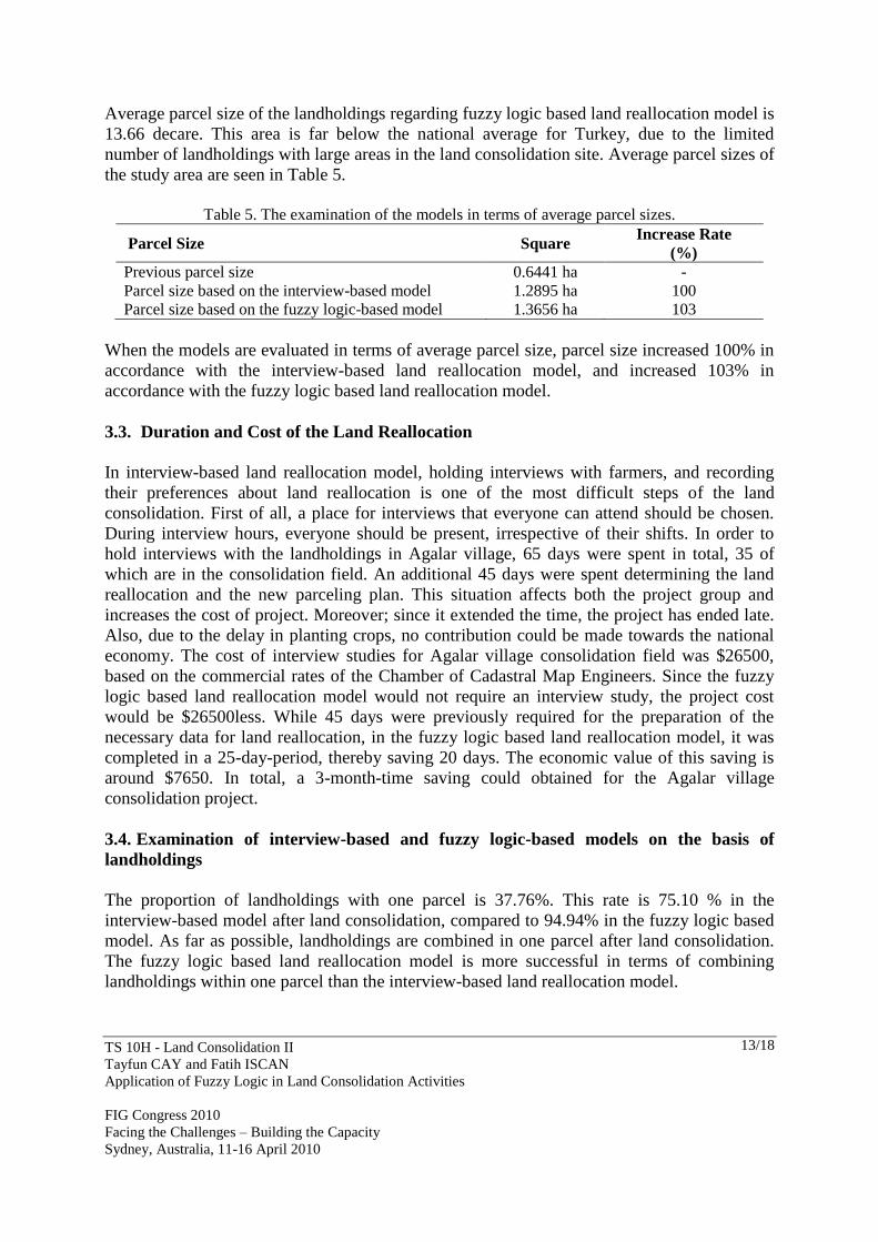
Table 5. The examination of the models in terms of average parcel sizes.
Parcel Size Square Increase Rate
(%)
Previous parcel size 0.6441 ha -
Parcel size based on the interview-based model 1.2895 ha 100
Parcel size based on the fuzzy logic-based model 1.3656 ha 103
When the models are evaluated in terms of average parcel size, parcel size increased 100% in
accordance with the interview-based land reallocation model, and increased 103% in
accordance with the fuzzy logic based land reallocation model.
3.3. Duration and Cost of the Land Reallocation
In interview-based land reallocation model, holding interviews with farmers, and recording
their preferences about land reallocation is one of the most difficult steps of the land
consolidation. First of all, a place for interviews that everyone can attend should be chosen.
During interview hours, everyone should be present, irrespective of their shifts. In order to
hold interviews with the landholdings in Agalar village, 65 days were spent in total, 35 of
which are in the consolidation field. An additional 45 days were spent determining the land
reallocation and the new parceling plan. This situation affects both the project group and
increases the cost of project. Moreover; since it extended the time, the project has ended late.
Also, due to the delay in planting crops, no contribution could be made towards the national
economy. The cost of interview studies for Agalar village consolidation field was $26500,
based on the commercial rates of the Chamber of Cadastral Map Engineers. Since the fuzzy
logic based land reallocation model would not require an interview study, the project cost
would be $26500less. While 45 days were previously required for the preparation of the
necessary data for land reallocation, in the fuzzy logic based land reallocation model, it was
completed in a 25-day-period, thereby saving 20 days. The economic value of this saving is
around $7650. In total, a 3-month-time saving could obtained for the Agalar village
consolidation project.
3.4. Examination of interview-based and fuzzy logic-based models on the basis of
landholdings
The proportion of landholdings with one parcel is 37.76%. This rate is 75.10 % in the
interview-based model after land consolidation, compared to 94.94% in the fuzzy logic based
model. As far as possible, landholdings are combined in one parcel after land consolidation.
The fuzzy logic based land reallocation model is more successful in terms of combining
landholdings within one parcel than the interview-based land reallocation model.

TS 10H - Land Consolidation II
Tayfun CAY and Fatih ISCAN
Application of Fuzzy Logic in Land Consolidation Activities
FIG Congress 2010
Facing the Challenges – Building the Capacity
Sydney, Australia, 11-16 April 2010
14/18
Five landholdings were chosen that serve as an example in the application site. Parcel
numbers derived from cadastre, interview and fuzzy logic based land reallocation results are
given in Table 6. Table 6. Evaluations on the basis of landholdings
Landholding
No Surname, name
Number of
cadastral
parcels
New parcel
numbers after
the interview-
based model
New parcel
numbers after
the fuzzy logic -
based model
24 Akgöl Mevlüt 4 2 1
70 Arı Ethem 3 2 1
74 Arık Mustafa 5 3 1
80 Arslan Güler 2 2 1
95 Aşık Mustafa 8 4 1
The conditions of the cadastral parcels belonging to the 24th landholding are shown in Figure
2, the new parcels formed after applying the interview-based model are shown in Figure 7,
and the parcels formed after applying the fuzzy logic based model are shown in Figure 8.
At the end of the fuzzy logic based land reallocation, 433 of 715 landholdings are placed into
the same blocks with the interview-based land reallocation. In means; 60.6% of the
landholdings match with the interview based land reallocation. This result shows that the
fuzzy logic based land reallocation model is successful.
In land consolidation projects, it is not always possible to comply with the requests made by
landholdings during interviews. In the interview-based land reallocation model, the requests
made by 586 (90.1%) of the 650 interviewees were fulfilled; the requests of 64 (9.9%) could
not be fulfilled. When the fuzzy logic based land reallocation is compared with the requests
made during interviews, 477 landholdings are fulfilled, while the requests of 173 could not be
fulfilled. This result shows that the fuzzy logic based land reallocation model fulfilled 73.4 %
of landholding requests. From this perspective, it can be said that the fuzzy logic based land
reallocation model is successful at fulfilling the requests of the farmers.

TS 10H - Land Consolidation II
Tayfun CAY and Fatih ISCAN
Application of Fuzzy Logic in Land Consolidation Activities
FIG Congress 2010
Facing the Challenges – Building the Capacity
Sydney, Australia, 11-16 April 2010
15/18
Figure 7. New Parcels of the 24th Landholding after the interview-based model
Figure 8. New parcels of the 24th landholding after the Fuzzy Logic Based Land Reallocation
TS 10H - Land Consolidation II
Tayfun CAY and Fatih ISCAN
Application of Fuzzy Logic in Land Consolidation Activities
FIG Congress 2010
Facing the Challenges – Building the Capacity
Sydney, Australia, 11-16 April 2010
16/18
4. CONCLUSION
Land reallocation works on the basis of the interview-based and fuzzy logic-based models
have been compared in terms of the number of parcels, average parcel size, duration of the
land reallocation process, project cost, and the conditions of the landholdings with respect to
those of the owners’ relatives. As a result of these comparisons, it has been concluded that the
fuzzy logic based model was more successful in terms of number of parcels, average parcel
size, average number of parcels per landholding, duration of land reallocation process, project
cost and farmer satisfaction, whereas the interview-based land reallocation model proved to
be more applicable in meeting the conditions set by the landholdings concerning their
relatives and other landholdings.
In the fuzzy logic based land reallocation model developed in the present study, more than
half of the landholdings are given from the blocks with new parcels based on the interview-
based reallocation model. When the interviews conducted with farmers to perform the
interview-based land reallocation are analyzed, the fuzzy logic based land reallocation method
gave quite successful results in fulfilling the requests of the landholdings. This is important,
since farmer satisfaction is among the objectives of land consolidation.
According to the results of the interviews conducted with the farmers, it appeared that they
are much happier with the outcome of the fuzzy logic based land reallocation model than that
of the interview-based land reallocation model. Considering the fact that farmer satisfaction is
important in land consolidation projects, the fuzzy logic based land reallocation model is
judged to have been successful.
As a result of this study, a fuzzy logic based method can be recommend for the land
reallocation procedure in land consolidation projects, since FL has suitable characteristics to
model human processes of thinking and behavior. Due to this characteristic, it can
incorporate and represent more variable parameters than classical forma of logic, and can be
used to incorporate linguistic expressions and opinions. One of the most important
characteristics of this method is that, since it is better able to model human behaviors, it can
provide solutions to situations even when it is not possible to derive a standard mathematical
model. The application of FL to an increasing range of issues suggests that the FL method,
which is currently used in areas such as engineering applications, will soon be used more
widely.
ACKNOWLEDGMENTS
The research is supported by Selcuk University Scientific Research Project. In addition, The
research is based on a part of Fatih ISCAN’s PhD thesis, supervising by Tayfun CAY.
TS 10H - Land Consolidation II
Tayfun CAY and Fatih ISCAN
Application of Fuzzy Logic in Land Consolidation Activities
FIG Congress 2010
Facing the Challenges – Building the Capacity
Sydney, Australia, 11-16 April 2010
17/18
REFERENCES
Avcı, M., 1999. A New Approach Oriented to New Reallotment Model Based on Block
Priority Method in Land Consolidation. Tr Journal of Agriculture and Forestry 23, 451–457.
Cay T, Iscan F. 2004. Algorithm developing for land consolidation software. XXth ISPRS
Congress, 12-13 July, Istanbul, Turkey.
Cay, T., Ayten, T., Iscan,.F., 2006. An investigation of reallocation model based on interview
in land consolidation. In: Proceedings of the XXIII International FIG Congress, October 8–13,
2006, Münich, Germany.
Girgin, I., Kik, R., 1989. Reallotment Research in The Turkish Land Consolidation Project
Emirhacılı Village, Proceedings of The Eleventh International Congress on Agricultural
Engineering, Ed.Dodd&Grace, Dublin.
Iscan, F., 2009. Application of Fuzzy Logic in Land Consolidation Activities. PhD. Thesis,
Selcuk University, Institute of the Natural and Applied Sciences, Konya, Turkey.(in Turkish)
Kandel, A., Ed.,1991. Fuzzy Expert Systems. Boca Raton, FL: CRC Press, 1991.
Kik, R. and Sprik, J.B., 1990. Application of GIS in Reallotment Research for Land
Development Projects, Proceedings of The First Europen Conference on Geographical
Information Systems, Amsterdam.
Klir, J. K. and Yuan, B. 1995. Fuzzy Sets and Fuzzy Logic: Theory and Applications. Upper
Saddle River, NJ: Prentice-Hall, 1995.
Lemmen, C.H.J. and Sonnenberg, J.K.B., 1986. A model for Allocation and Adjustment of
Lots in Land Consolidation, FIG XVIII. International Congress, 760.5, Toronto, Canada.
Maiers, J. and Sherif, Y. S., 1985. Applications of fuzzy set theory, IEEE Trans. Syst., Man,
Cybern., vol. SMC-15, pp. 175–189, 1985.
Mendel, J. M. 1995. Fuzzy logic systems for engineering: A tutorial, Proc. IEEE, vol. 83, pp.
345–377, Mar. (1995).
Ramot, D., Friedman, M., Langholz, G., and Kandel, A., 2003. Complex Fuzzy Logic, IEEE
Transactions On Fuzzy Systems, Vol. 11, No. 4, August (2003).
Sakawa, M., Fuzzy Sets and Interactive Multi-objective Optimisation, Plenum Press, New
York, 1993.
Sen, Z., 2004. Fuzzy logic and system models in water sciences, Turkish Water Foundation,
Istanbul.
Sklenicka, P., 2006. Applying evaluation criteria for the land consolidation effect to three
contrasting study areas in the Czech Republic. Land Use Policy 23, 502–510.
Sugeno, M. and Park, G. K., 1993. An approach to linguistic instruction based learning, Int.
J. Uncertainty, Fuzziness, Knowledge Syst., Vol. 1, No. 1, pp. 19–56,
Vitikainen A. 2004. An overview of land consolidation in Europe. Nordic journal of
surveying and real estate research, 1, 25-43.
Zou, X., Luo, M., Su, W., Li, D., Jiang, Y., Ju, Z. and Wang, J., 2008. Spatial decision
support system for the potential evaluation of land consolidation projects. WSEAS
Transactions on Computers, Issue 7, Volume 7, P. 88

TS 10H - Land Consolidation II
Tayfun CAY and Fatih ISCAN
Application of Fuzzy Logic in Land Consolidation Activities
FIG Congress 2010
Facing the Challenges – Building the Capacity
Sydney, Australia, 11-16 April 2010
18/18
CONTACTS
Assis.Prof.Dr.Tayfun CAY
University of Selcuk
Faculty of Engineering –Architecture
Department of Geomatic Engineering
42075 Konya
TURKEY
Tel. +90 332 223 19 44
Fax +90 332 241 06 35
Email:[email protected]
Dr.Fatih ISCAN
University of Selcuk
Faculty of Engineering –Architecture
Department of Geomatic Engineering
42075 Konya
TURKEY
Tel. +90 332 223 19 32
Fax +90 332 241 06 35
Email:[email protected]