Embed Size (px)
Citation preview

INTERNATIONAL COURT OF JUSTICE
APPLICATIONINSTITUTING PROCEEDINGS
filed in the Registry of the Courton 18 November 2010
CERTAIN ACTIVITIES CARRIED OUT BY NICARAGUAIN THE BORDER AREA
(COSTA RICA v. NICARAGUA)
COUR INTERNATIONALE DE JUSTICE
REQUÊTEINTRODUCTIVE D’INSTANCE
enregistrée au Greffe de la Courle 18 novembre 2010
CERTAINES ACTIVITÉS MENÉES PAR LE NICARAGUADANS LA RÉGION FRONTALIÈRE
(COSTA RICA c. NICARAGUA)

2
1 Charter of the United Nations, San Francisco, 26 June 1945.2 Charter of the Organization of American States, Bogotá, 13 April 1948, 119 United
Nations Treaty Series (UNTS) 3.3 Treaty of Territorial Limits between Costa Rica and Nicaragua, San José, 15 April 1858,
also referred to as the Cañas-Jeréz Treaty. An English translation of the Treaty is found in theCosta Rican Memorial presented to President Cleveland in 1887 : see Argument on the Questionof the Validity of the Treaty of Limits between Costa Rica and Nicaragua and other Supp-lementary Points Connected with it, submitted to the Arbitration of the President of the UnitedStates of America, filed on behalf of the Government of Costa Rica by Pedro Pérez Zeledón,its Envoy Extraordinary and Minister Plenipotentiary in the United States. (Translated intoEnglish by J. L. Rodríguez, Washington : Gibson Bros., Printers and Bookbinders, 1887.)Source : US National Archives, Record Group 76, Record of Boundary and Claims Commis-sion and Arbitration, Costa Rica-Nicaragua Boundary Arbitration, NC-155, Entry 24. Thistranslation and the original Spanish text are at Attachment 1.
4 The Award was given in English : see « Award of the Arbitrator, the President of the UnitedStates, upon the validity of the Treaty of Limits of 1858 between Nicaragua and Costa Rica »,reprinted in Papers relating to the Foreign Relations of the United States Transmitted toCongress, Part I, December 1888 (Washington D.C. : Government Printing Office, 1889) :Attachment 2.
5 The Alexander Awards are reprinted in H. La Fontaine, Pasicrisie internationale (1794-1900) : Histoire documentaire des arbitrages internationaux (1902, repr. 1997, The Hague,Martinus Nijhoff), pp. 528-539 : Attachments 3 and 4.
APPLICATION INSTITUTING PROCEEDINGS
To the Registrar, International Court of Justice, the undersigned being duly autho-rized by the Government of the Republic of Costa Rica.
INTRODUCTION
1. On behalf of the Government of the Republic of Costa Rica and pursuant toArticle 36, paragraphs 1 and 2 ; Article 40 of the Statute of the Court and Article 38of the Rules of Court, I have the honour to submit the present Application institut-ing proceedings against the Government of the Republic of Nicaragua. The caseconcerns the incursion into, occupation of and use by Nicaragua’s army of CostaRican territory as well as breaches of Nicaragua’s obligations towards Costa Ricaunder the following :
(a) the Charter of the United Nations1 and the Charter of the Organization ofAmerican States2 ;
(b) the Treaty of Territorial Limits between Costa Rica and Nicaragua of15 April 1858 (the Treaty of Limits), in particular Articles I, II, V and IX3 ;
(c) the arbitral award issued by the President of the United States of America,Grover Cleveland, on 22 March 1888 (the Cleveland Award)4 ;
(d) the first and second arbitral awards rendered by Edward Porter Alexander datedrespectively 30 September and 20 December 1897 (the first and second Alexan-der Awards)5 ;
2010General List
No. 150

3
1 Charte des Nations Unies, San Francisco, 26 juin 1945.2 Charte de l’Organisation des Etats américains, Bogotá, 13 avril 1948, Nations Unies,
Recueil des traités, vol. 119, p. 3.3 Traité de limites territoriales entre le Costa Rica et le Nicaragua, San José, 15 avril 1858.
Ce traité est connu sous le nom de « traité Cañas-Jeréz ». Une traduction anglaise de ce textefigure dans le mémoire soumis en 1887 au président Cleveland par le Costa Rica, intitulé Argument on the Questions of the Validity of the Treaty of Limits between Costa Rica andNicaragua and Other Supplementary Points Connected with it, submitted to the Arbitration ofthe President of the United States of America, filed on behalf of the Government of Costa Ricaby Pedro Pérez Zeledón, its Envoy Extraordinary and Minister Plenipotentiary in theUnited States (traduit en anglais par J. L. Rodríguez, Washington : Gibson Bros., Printers andBookbinders, 1887). Source : US National Archives, Record Group 76, Record of Boundaryand Claims Commission and Arbitration, Costa Rica-Nicaragua Boundary Arbitration, NC-155,Entry 24. Ce traité, accompagné du texte original espagnol, figure à l’annexe 1.
4 Cette sentence fut rendue en anglais : voir « Award of the Arbitrator, the President of theUnited States, upon the validity of the Treaty of Limits of 1858 between Nicaragua andCosta Rica », repris dans Papers relating to the Foreign Relations of the United States Trans-mitted to Congress, première partie, décembre 1888 (Washington, D.C., Government PrintingOffice, 1889) (annexe 2).
5 Les « sentences Alexander » sont reprises dans H. La Fontaine, Pasicrisie internationale(1794-1900) : Histoire documentaire des arbitrages internationaux (1902, réimpr. 1997, La Haye,Martinus Nijhoff), p. 528-539 (annexes 3 et 4).
REQUÊTE INTRODUCTIVE D’INSTANCE
[Traduction]
A Monsieur le Greffier de la Cour internationale de Justice, le soussigné ayant étédûment autorisé par le Gouvernement de la République du Costa Rica.
INTRODUCTION
1. Au nom du Gouvernement de la République du Costa Rica, j’ai l’honneur desoumettre à la Cour, conformément aux paragraphes 1 et 2 de l’article 36 et à l’ar-ticle 40 de son Statut ainsi qu’à l’article 38 de son Règlement, la présente requêteintroductive d’instance contre le Gouvernement de la République du Nicaragua. Elle concerne l’incursion en territoire costa-ricien de l’armée nicaraguayenne, l’occupation et l’utilisation d’une partie de celui-ci, ainsi que les violations par le Nicaragua d’obligations lui incombant envers le Costa Rica en vertu des instru-ments suivants :
a) la Charte des Nations Unies1 et la charte de l’Organisation des Etats américains2 ;
b) le traité de limites territoriales entre le Costa Rica et le Nicaragua, conclu le15 avril 1858 (ci-après le « traité de limites »), en particulier ses articles I, II, Vet IX3 ;
c) la sentence arbitrale rendue le 22 mars 1888 par le président des Etats-Unisd’Amérique, Grover Cleveland (ci-après la « sentence Cleveland »)4 ;
d) les première et deuxième sentences arbitrales rendues par Edward Porter Alexan-der en date respectivement du 30 septembre et du 20 décembre 1897 (ci-après les« première et deuxième sentences Alexander »)5 ;
2010Rôle général
no 150

4
6 Convention on Wetlands of International Importance Especially as Waterfowl Habitat,Ramsar, 2 February 1971, 996 UNTS 246. Both Costa Rica and Nicaragua are parties to theRamsar Convention.
7 Charter of the Organization of American States, Bogotá, 13 April 1948, 119 UNTS 3.
8 American Treaty on Pacific Settlement, Bogotá, 30 April 1948, 30 UNTS 84. Both CostaRica and Nicaragua are parties to the Pact of Bogotá.
(e) the 1971 Convention on Wetlands of International Importance especially asWaterfowl Habitat (the Ramsar Convention)6 ;
(f) the Judgment of the Court of 13 July 2009 in the Dispute regarding Naviga-tional and Related Rights (Costa Rica v. Nicaragua) ; and
(g) other applicable rules and principles of international law.
2. By sending contingents of its armed forces to Costa Rican territory and estab-lishing military camps therein, Nicaragua is not only acting in outright breach of theestablished boundary régime between the two States, but also of the core foundingprinciples of the United Nations, namely the principles of territorial integrity and theprohibition of the threat or use of force against any State in accordance with Arti-cle 2, paragraph 4 of the Charter ; also endorsed as between the parties in Articles 1,19 and 29 of the Charter of the Organization of American States7.
THE COURT’S JURISDICTION
3. The Court has jurisdiction over the present dispute by virtue of :
(a) Article XXXI of the American Treaty on Pacific Settlement, Bogotá,30 April 1948 (the Pact of Bogotá) pursuant to Article 36 (1) of the Statute ofthe Court8 ;
(b) the operation of the declarations of acceptance made respectively by the Repub-lic of Costa Rica dated 20 February 1973, and by the Republic of Nicaraguadated 24 September 1929 (as modified 23 October 2001), pursuant to Arti-cle 36 (2) of the Statute of the Court.
FACTS OF THE PRESENT DISPUTE
4. The facts underlying the present dispute are as follows. Nicaragua has, in twoseparate incidents, occupied the territory of Costa Rica in connection with the con-struction of a canal across Costa Rican territory from the San Juan River to Lagunalos Portillos (also known as Harbor Head Lagoon), and certain related works ofdredging on the San Juan River. The first incursion occurred on or about 18 October2010, at the same time as President Ortega of Nicaragua gave the order to commencedredging works. Nicaragua was reported felling trees and depositing sediment from the dredging works on Costa Rican territory. After a brief withdrawal, on or about 1 November 2010 a second contingent of Nicaraguan troops entered CostaRican territory and established a camp. This second incursion has resulted in thecontinuing occupation by armed Nicaraguan military forces of an initial area ofaround 3 square kilometres of Costa Rican territory, located at the north-east

5
6 Convention relative aux zones humides d’importance internationale, particulièrementcomme habitats des oiseaux d’eau, Ramsar, 2 février 1971, Nations Unies, Recueil destraités, vol. 996, p. 246. Le Costa Rica et le Nicaragua sont tous deux parties à la conven-tion de Ramsar.
7 Charte de l’Organisation des Etats américains, Bogotá, 13 avril 1948, Nations Unies,Recueil des traités, vol. 119, p. 3.
8 Traité américain de règlement pacifique, Bogotá, 30 avril 1948, Nations Unies, Recueildes traités, vol. 30, p. 85. Le Costa Rica et le Nicaragua sont tous deux parties au pacte deBogotá.
e) la convention de 1971 relative aux zones humides d’importance internationale,particulièrement comme habitats des oiseaux d’eau (ci-après la « convention deRamsar »)6 ;
f) l’arrêt rendu par la Cour le 13 juillet 2009 en l’affaire du Différend relatif à desdroits de navigation et des droits connexes (Costa Rica c. Nicaragua) ;
g) d’autres règles et principes applicables du droit international.
2. En dépêchant des contingents de ses forces armées en territoire costa-ricien eten y faisant établir des campements militaires, le Nicaragua agit en violation fla-grante non seulement du régime frontalier établi entre les deux Etats, mais aussi desgrands principes fondateurs des Nations Unies, à savoir le principe de l’intégrité ter-ritoriale et celui de l’interdiction du recours à la menace ou à l’emploi de la forcecontre tout Etat, tels qu’affirmés au paragraphe 4 de l’article 2 de la Charte, et aux-quels les Parties ont réaffirmé leur adhésion aux articles premier, 19 et 29 de lacharte de l’Organisation des Etats américains7.
COMPÉTENCE DE LA COUR
3. La Cour est compétente en la présente affaire en vertu :
a) de l’article XXXI du traité américain de règlement pacifique du 30 avril 1948(ci-après le « pacte de Bogotá »), conformément au paragraphe 1 de l’article 36du Statut de la Cour8 ;
b) de la déclaration d’acceptation formulée par la République du Costa Rica le20 février 1973 et de celle formulée par la République du Nicaragua le 24 sep-tembre 1929 (telle que modifiée le 23 octobre 2001), conformément au para-graphe 2 de l’article 36 du Statut de la Cour.
LES FAITS DE L’ESPÈCE
4. Les faits à l’origine de la présente instance sont les suivants. Le Nicaragua, àl’occasion de deux incidents distincts, a occupé le sol costa-ricien dans le cadre dela construction d’un canal à travers le territoire du Costa Rica, entre le fleuveSan Juan et la lagune de los Portillos (également connue sous le nom de « lagune deHarbor Head »), et de certaines activités connexes de dragage menées dans leSan Juan. La première incursion s’est produite le 18 octobre 2010, ou autour decette date, à l’époque où le président Ortega a ordonné le commencement des tra-vaux de dragage. Les forces nicaraguayennes ont, selon certaines informations,abattu des arbres et déversé des sédiments provenant des travaux de dragage effec-tués sur le sol costa-ricien. Après un bref retrait, un second contingent de troupesnicaraguayennes est entré en territoire costa-ricien le 1er novembre ou autour decette date et y a établi un campement. Depuis cette seconde incursion, des forces

Caribbean tip of Costa Rica, although evidence shows that Nicaraguan militaryforces have also ventured further inside Costa Rican territory, to the south of thatarea. Nicaragua has also seriously damaged that part of Costa Rican territory underits occupation.
5. The ongoing and planned dredging and the construction of the canal will seri-ously affect the flow of water to the Colorado River of Costa Rica, and will causefurther damage to Costa Rican territory, including the wetlands and national wildlifeprotected areas located in the region.
6. Edén Pastora, head of the dredging operations, has confirmed in televisioninterviews that the purpose of the planned canal is to “restore the Nicaraguan borderriver to its historic channel to the sea” and that the 1858 Treaty of Limits proves thatthe Isla Calero “is part of Nicaragua, not Costa Rica”9. In relation to the dredgingoperation, Pastora has stated that he intends to, “clean the river and rescue it”10.
7. Moreover, Nicaragua intends by the artificial canalization of the San JuanRiver in this way to modify the natural watercourse which forms the boundary as setout in the first and second Alexander Awards. According to President Ortega :
“It is clear. Here is Punta Castilla, where the first marker is located, where isit, how do we call this ? Ah yes, the first landmark, which is the one that servesas point of departure for the marking down of the boundary between Nicaraguaand Costa Rica, here is the lagoon Harbour Head, which logically belongs toNicaragua, here is the famous channel that goes to Harbour Head and thatunites [with] the San Juan River. And the San Juan River should, in its normalcourse, retake this route and reach this lagoon, in an area where many yearsago there was a great bay.”11
8. However, no such “great bay” has ever existed at or near this location. The“normal course” of the San Juan River was marked on the hand-drawn sketch-mapdescribing the boundary starting at Punta de Castilla and following the course of theSan Juan River (Alexander Minute No. X of 2 March 1898, Volume I, p. 33) ; (seesketch-map on p. 10). The delimitation recorded or depicted by Alexander is con-sistent with the contemporary maps submitted by Costa Rica and Nicaragua to theCourt in the case concerning Navigational and Related Rights, and of other officialmaps of both countries12. All of these maps show the San Juan River boundaryenclosing the entirety of the occupied territory with Costa Rica.
6
9 Report of interview with Edén Pastora on Nicaraguan television channel 100% Noti-cias, in Tim Rogers, “Nicaragua Denies Reports of Intrusion into Costa Rica” Tico Times,2 November 2010, available at : http://www.ticotimes.net/Current-Edition/News-Briefs/Nicaragua-Denies-Reports-of-Intrusion-into-Costa-Rica_Tuesday-November-02-2010 :Attachment 9.
10 Ibid.11 English translation by Costa Rica of a speech given by President Ortega on national
Nicaraguan television on 13 November 2010. English translation and Spanish original : Attach-ment 6.
12 See e.g., Nicaraguan Institute of Territorial Studies, Official Sheet Map of Nicaragua andNational Geographic Institute of Costa Rica, Official Map of Costa Rica : Attachment 11.

7
9 Compte rendu de l’interview accordée par Edén Pastora à la chaîne de télévision nica-raguayenne 100 % Noticias, dans Tim Rogers, « Nicaragua Denies Reports of Intrusion into Costa Rica » (« Le Nicaragua nie toute incursion au Costa Rica »), Tico Times,2 novembre 2010, à l’adresse http://www.ticotimes.net/Current-Edition/News-Briefs/Nicara-gua-Denies-Reports-of-Intrusion-into-Costa-Rica_Tuesday-November-02-2010 (annexe 9).
10 Ibid.11 Traduction établie par le Greffe à partir de la version anglaise, fournie par le Costa Rica,
d’une intervention du président Ortega à la télévision nationale nicaraguayenne le 13 no-vembre 2010 (annexe 6).
12 Voir par exemple la carte officielle du Nicaragua de l’Institut nicaraguayen d’études ter-ritoriales et la carte officielle du Costa Rica de l’Institut géographique national du Costa Rica(annexe 11).
militaires nicaraguayennes armées occupent de façon continue une partie de terri-toire costa-ricien d’une superficie initiale de quelque trois kilomètres carrés, à l’ex-trémité nord-est du Costa Rica, du côté de la mer des Caraïbes ; toutefois, selon certaines indications, les forces militaires nicaraguayennes se seraient égalementenfoncées en territoire costa-ricien au sud de cette zone. Le Nicaragua a en outrecausé des dommages importants dans la partie de territoire costa-ricien occupée.
5. Les travaux de dragage actuels et prévus, ainsi que la construction du canal,altéreront gravement le débit des eaux alimentant le Colorado, cours d’eau costa-ricien, et causeront d’autres dommages au territoire du Costa Rica, notamment aux zones humides et aux réserves nationales de flore et de faune sauvages de larégion.
6. Le responsable des opérations de dragage, Edén Pastora, a confirmé dans desinterviews télévisées que la construction du canal avait pour but de « rétablir lefleuve nicaraguayen qui délimite la frontière dans son chenal primitif en direction dela mer » et que le traité de limites de 1858 prouvait que l’île de Calero faisait « partiedu Nicaragua, et non du Costa Rica »9. Au sujet du dragage, M. Pastora a déclaréqu’il avait l’intention de « nettoyer le fleuve et de le sauver »10.
7. De surcroît, le Nicaragua compte, en canalisant ainsi de manière artificielle leSan Juan, modifier le cours naturel du fleuve qui, aux termes des première etdeuxième sentences Alexander, constitue la frontière. Le président Ortega a en effetdéclaré :
« C’est clair : voici Punta Castilla, où se trouve la première borne, commentdit-on ? le premier repère, qui sert de point de départ pour la démarcation de lafrontière entre le Nicaragua et le Costa Rica ; voici la lagune de Harbor Head,qui appartient logiquement au Nicaragua ; et voici le fameux chenal qui mène àHarbor Head et rejoint le fleuve San Juan. Le San Juan devrait, selon son coursnormal, repartir dans cette direction et atteindre cette lagune, dans une zone oùse trouvait une vaste baie il y a de nombreuses années. »11
8. Pourtant, il n’y a jamais eu à cet endroit, ni aux alentours, de « vaste baie ». Le« cours normal » du fleuve San Juan a été tracé à la main sur un croquis décrivant lafrontière qui part de Punta de Castilla pour suivre le cours du San Juan (minuteAlexander no X en date du 2 mars 1898, vol. I, p. 33) (voir croquis p. 10). La lignede délimitation telle que consignée ou représentée par Alexander est conforme auxcartes contemporaines soumises à la Cour par le Costa Rica et par le Nicaragua dansl’affaire du Différend relatif à des droits de navigation et des droits connexes ainsiqu’à d’autres cartes officielles des deux pays12. Toutes ces cartes placent l’intégra-lité du territoire occupé du côté costa-ricien de la frontière constituée par le fleuveSan Juan.

8
13 Cleveland Award, Attachment 2. See also the Dispute regarding Navigational andRelated Rights (Costa Rica v. Nicaragua), Judgment, I.C.J. Reports 2009, p. 229, para. 19.
14 Dispute regarding Navigational and Related Rights (Costa Rica v. Nicaragua), Judg-ment, I.C.J. Reports 2009, pp. 229-230, paras. 19-23 and pp. 268-269, paras. 153 and 155.
15 English translation of the Treaty of Limits (Cañas-Jerez), 15 April 1858, submitted byCosta Rica to Cleveland (Pérez Zeledón, Argument on the Question of the Validity of the Treatyof Limits between Costa Rica and Nicaragua (Washington, Gibson Bros., 1887)), Article II :Attachment 1.
16 Ibid., Article V : Attachement 1.17 It was listed as part of Nicaragua by the US consul on 6 October 1862 in the “Commer-
cial Relations of the United States with Foreign Countries” (United States Bureau of ForeignCommerce), Annual Report of 1862, p. 651.
THE COSTA RICA/NICARAGUA BOUNDARY
9. The 1858 Treaty of Limits between Costa Rica and Nicaragua, and the firstand second Alexander Awards, defined and settled with a permanent and definitecharacter the territorial boundary line between Costa Rica and Nicaragua (fromPunta Castilla to the point three miles below Castillo Viejo). The validity of the1858 Treaty of Limits was upheld by the Cleveland Award of 188813, which spelledout a number of Costa Rican rights, a task continued by the Court in 200914.
10. The 1858 Treaty of Limits delimited the boundary between Costa Rica andNicaragua from the Caribbean Sea to the Pacific Ocean. The part of the boundarybetween a point three English miles below Castillo Viejo and the Caribbean Sea wasclearly fixed as following the right bank of the San Juan River :
“The dividing line between the two Republics, starting from the NorthernSea, shall begin at the end of Punta de Castilla, at the mouth of the San Juande Nicaragua River, and shall run along the right bank of the said river up to apoint of three English miles distant from Castillo Viejo…”15
11. The 1858 Treaty of Limits also shows that the drafters had made a clear dis-tinction between the San Juan River and the Colorado. Article V, a transitional pro-vision, stated that :
“As long as Nicaragua does not recover the full possession of all her rightsin the port of San Juan del Norte, the use and possession of Punta de Castillashall be common and equal both for Nicaragua and Costa Rica ; and in themeantime, and as long as this community lasts, the boundary shall be the wholecourse of the Colorado River. It is furthermore stipulated that, as long as thesaid port of San Juan del Norte remains a free port, Costa Rica shall not chargeNicaragua any custom duties at Punta de Castilla.”16
This transitional provision was terminated shortly thereafter with the promulga-tion of the Regulations for the port and population of San Juan del Norte asapproved in 186117, when Nicaragua recovered possession over the port and a con-dominium was established by Costa Rica and Nicaragua over the Bay of San Juanpursuant to Article IV of the 1858 Treaty of Limits.
12. The Cleveland Award expressly confirmed this position :
“1. The boundary line between the Republics of Costa Rica and Nicaragua,on the Atlantic side, begins at the extremity of Punta de Castilla at the mouth

9
13 Sentence Cleveland (annexe 2). Voir aussi l’affaire du Différend relatif à des droits denavigation et des droits connexes (Costa Rica c. Nicaragua), arrêt, C.I. J. Recueil 2009,p. 229, par. 19.
14 Affaire du Différend relatif à des droits de navigation et des droits connexes (Costa Rica c. Nicaragua), arrêt, C.I.J. Recueil 2009, p. 229-230, par. 19-23, et 268-269, par. 153 et155.
15 Traduction du Greffe établie à partir de la traduction anglaise, fournie par le Costa Ricaau président Cleveland, du traité de limites (Cañas-Jerez), 15 avril 1858 (Pérez Zeledón, Argu-ment on the Question of the Validity of the Treaty of Limits between Costa Rica and Nicaragua(Washington, Gibson Bros., 1887)), article II (annexe 1).
16 Ibid., article V (annexe 1).17 Présenté comme territoire nicaraguayen par le consul des Etats-Unis le 6 octobre 1862,
dans le document intitulé « Commercial Relations of the United States with Foreign Countries »(United States Bureau of Foreign Commerce), Annual Report of 1862, p. 651.
LA FRONTIÈRE ENTRE LE COSTA RICA ET LE NICARAGUA
9. Le traité de limites conclu en 1858 entre le Costa Rica et le Nicaragua ainsique les première et deuxième sentences Alexander ont fixé de manière précise etdéfinitive la frontière terrestre entre le Costa Rica et le Nicaragua (depuisPunta Castilla jusqu’au point situé à trois milles en aval de Castillo Viejo). La validité du traité de limites de 1858 a été confirmée par la sentence Clevelandde 188813, qui a énoncé un certain nombre de droits appartenant au Costa Rica,tâche que la Cour a poursuivie en 200914.
10. Le traité de limites de 1858 a défini la frontière entre le Costa Rica et leNicaragua de la mer des Caraïbes à l’océan Pacifique. Le tronçon de la frontières’étendant entre un point situé à trois milles anglais en aval de Castillo Viejo et la mer des Caraïbes a été clairement fixé le long de la rive droite du fleuve San Juan :
« La limite entre les deux républiques, à partir de la mer du Nord, partira del’extrémité de Punta de Castilla, à l’embouchure du fleuve San Juan de Nicara-gua, puis suivra la rive droite de ce fleuve jusqu’à un point distant de troismilles anglais de Castillo Viejo… »15
11. Le texte montre par ailleurs que les auteurs du traité de limites de 1858 opé-raient une nette distinction entre le San Juan et le Colorado. L’article V, qui était unedisposition transitoire, se lisait en effet comme suit :
« Tant que le Nicaragua n’aura pas recouvré la pleine possession de ses droitssur le port de San Juan del Norte, l’usage et la possession de Punta de Castillaseront communs et également partagés entre le Nicaragua et le Costa Rica ; tantque durera cette communauté, le cours entier du Colorado en marquera lalimite. Il est en outre stipulé que, tant que le port de San Juan del Norte resteraun port franc, le Costa Rica n’imposera pas de droits de douane au Nicaraguaà Punta de Castilla. »16
Cette disposition transitoire a pris fin peu après, à la suite de la promulgation durèglement relatif au port et à la population de San Juan del Norte17, tel qu’approuvéen 1861, lorsque le Nicaragua a repris possession du port et a établi, avec leCosta Rica, un condominium sur la baie de San Juan, conformément à l’article IVdu traité de limites de 1858.
12. La sentence Cleveland en apporte une confirmation expresse :
« 1. La frontière entre la République du Costa Rica et la République duNicaragua du côté de l’Atlantique commence à l’extrémité de Punta de Castilla

10
Image provided by La Prensa (Nicaraguan news channel), available at :http://www.laprensa.com.ni/infografia/721
Hand drawn sketch-map describing the boundary starting at Punta de Castilla and following the course of the San Juan River.
Source : Alexander Minute No. X of 2 March 1898, Vol. I, p. 33.Croquis tracé à la main décrivant la frontière à partir de Punta de Castilla
et le long du San Juan.Source : Minute Alexander no X en date du 2 mars 1898, vol. I, p. 33.

11
Image provided by La Prensa (Nicaraguan news channel) available at :http://www.laprensa.com.ni/infografia/721.
Image fournie par La Prensa (chaîne d’information nicaraguayenne),disponible à l’adresse : http://www.laprensa.com.ni/infografia/721.

of the San Juan de Nicaragua River, as they both existed on the 15th day ofApril 1858.. . . . . . . . . . . . . . . . . . . . . . . . . . . . . . . . . . . . . . . . . .
7. The branch of the River San Juan known as the Colorado River must notbe considered as the boundary between the Republics of Costa Rica andNicaragua in any part of its course.”18
13. Following the Cleveland Award, the 1896 Delimitation Convention(Pacheco-Matus)19 was concluded. Costa Rica and Nicaragua thereby agreed toname a Commission for the purpose of properly tracing and marking the boundaryline between the two Republics. It was further agreed to request the President of theUnited States of America to appoint an Engineer who would undertake the functionof umpire to decide, with binding effect, any disagreement between the Commis-sioners of Costa Rica and Nicaragua. The President of the United States appointedMr. Edward Porter Alexander.
14. The Commission commenced its demarcation work in 1897. During the workof the Commission, Mr. Alexander rendered five Awards20. According to the firstAward of 30 September 1897 :
“I have accordingly made personal inspection of this ground, and declare theinitial boundary to run as follows, to wit :
Its direction shall be due northeast and southwest, across the bank of sand,from the Caribbean Sea into the waters of Harbor Head Lagoon. It shall pass atits nearest point, 300 feet on the northwest side from the small hut now stand-ing in that vicinity. On reaching the waters of Harbor Head Lagoon, the bound-ary line shall turn to the left, or southeastward, and shall follow the water’sedge around the harbor until it reaches the river proper by the first channel met.Up this channel, and up the river proper, the line shall continue to ascend asdirected in the treaty.”21
The hand-drawn sketch-map portrayed in the Alexander Minute (page 10 above)illustrates clearly this delimitation22.
15. The second Alexander Award settled the tracing and marking of the boundaryline starting at Punta Castilla, in the Caribbean Sea, until it reaches the point threeEnglish miles below Castillo Viejo, along the southern bank of the San Juan River.Relevantly, the Second Award provided as follows :
“‘The Costa Rican Commission proposed that we proceed to the measure-ment of the line that ran from the starting point and continued along the shoreof Harbor Head and thence along the shore around the harbor until it reachesthe San Juan river proper by the first channel met and thence along the bank ofthe river to a point three miles below Castillo Viejo and that a map should bemade of such line and that all of that should be set down in the daily record.The Nicaraguan Commission expressed the view that the measurement and
12
18 Cleveland Award : Attachment 2.19 Costa Rica-Nicaragua Delimitation Convention (Pacheco-Matus), San Salvador,
27 March 1896, 182 Consolitated Treaty Series (CTS) 359.20 The five Alexander Awards are reprinted in H. La Fontaine, Pasicrisie internationale (1794-
1900) : Histoire documentaire des arbitrages internationaux (1902, repr. 1997, The Hague,Martinus Nijhoff). Relevantly, the first and second Awards are at Attachments 3 and 4.
21 Ibid., p. 532.22 Alexander Minute No. X of 2 March 1898, Vol. I, p. 33.

à l’embouchure du fleuve San Juan de Nicaragua, en leur état respectif au15 avril 1858. . . . . . . . . . . . . . . . . . . . . . . . . . . . . . . . . . . . . . . . . . .
7. L’affluent du fleuve San Juan connu sous le nom de Colorado ne saurait,en aucune partie de son cours, être considéré comme la frontière entre la Répu-blique du Costa Rica et la République du Nicaragua. »18
13. En 1896, à la suite de l’arbitrage Cleveland, fut conclue la convention dedélimitation Pacheco-Matus19, aux termes de laquelle le Costa Rica et le Nicaraguaconvenaient de désigner chacun une commission en vue de tracer et démarquer demanière appropriée la ligne frontière entre les deux républiques. Ils convenaient enoutre de demander au président des Etats-Unis d’Amérique de désigner un ingé-nieur-arbitre chargé de rendre des décisions ayant effet obligatoire sur tout point dedivergence qui pourrait surgir entre les commissaires du Costa Rica et du Nicaragua.Le président américain nomma à cet effet M. Edward Porter Alexander.
14. La commission entama ses travaux de démarcation en 1897. Au cours de cestravaux, M. Alexander rendit cinq sentences20. Dans la première, en date du 30 sep-tembre 1897, il indiquait :
« J’ai en conséquence personnellement inspecté cette zone et je déclare quela ligne initiale de la frontière sera la suivante :
Son orientation sera nord-est sud-ouest, à travers le banc de sable, de la merdes Caraïbes aux eaux de la lagune de Harbor Head. Elle passera au plus prèsà 300 pieds au nord-ouest de la petite cabane qui se trouve actuellement dansles parages. En atteignant les eaux de la lagune de Harbor Head, la ligne fron-tière obliquera vers la gauche, en direction du sud-est, et suivra le rivage autourdu port jusqu’à atteindre le fleuve proprement dit par le premier chenal ren-contré. Remontant ce chenal et le fleuve proprement dit, la ligne se poursuivracomme prescrit dans le traité. »21
Le croquis à main levée reproduit dans les minutes Alexander (voir p. 10) illustreclairement cette délimitation22. 15. La deuxième sentence Alexander a tranché la question du tracé et de la démar-cation de la ligne frontière de Punta Castilla, dans la mer des Caraïbes, jusqu’aupoint situé à trois milles anglais en aval de Castillo Viejo, le long de la rive sud duSan Juan. Le passage pertinent de cette deuxième sentence se lit comme suit :
« « La commission du Costa Rica a proposé que nous réalisions les mesuresse rapportant à la ligne qui, à partir du point de départ, suit le rivage deHarbor Head, contourne, le long du rivage, le port jusqu’au moment où elleatteint le fleuve San Juan proprement dit, par le premier chenal rencontré, puisremonte le long de la rive du fleuve jusqu’à un point situé à trois milles en avalde Castillo Viejo, que nous en dressions la carte et consignions le tout dans leprocès-verbal quotidien. La commission du Nicaragua a soutenu que les tra-
13
18 Sentence Cleveland (annexe 2).19 Convention de délimitation Pacheco-Matus entre le Costa Rica et le Nicaragua, San Sal-
vador, 27 mars 1896 ; Consolidated Treaties Series (CTS), vol. 182, p. 359.20 Les versions anglaises de ces cinq sentences sont reproduites dans H. La Fontaine, Pasi-
crisie internationale (1794-1900) : Histoire documentaire des arbitrages internationaux (1902,réimpr. 1997, La Haye, Martinus Nijhoff). Les première et deuxième sentences, pertinentes enl’espèce, sont jointes en annexes 3 et 4.
21 Ibid., p. 532.22 Minute Alexander no X du 2 mars 1898, vol. I, p. 33.

14
23 Op. cit. supra note 20, pp. 532-533, as translated and reported in Recueil des sentencesarbitrales (RIAA), Vol. XXVIII, pp. 223-225 (United Nations, 2007). The original Spanish textreads at page 532 : “según el Tratado y el Laudo General E. P. Alexander, el límite divisoriolo forma la margen derecha del Harbour y del río . . .”. The United Nations translation incorrectly reports this as “according to the Award by General E. P. Alexander, the left bankof the harbor and of the river”.
24 See, for example, sketch-map No. 2 of the Memorial of Costa Rica dated 29 August2006 and sketch-map No. 1 of the Counter-Memorial of Nicaragua dated 27 May 2007 inthe Dispute regarding Navigational and Related Rights (Costa Rica v. Nicaragua).
25 Dispute regarding Navigational and Related Rights (Costa Rica v. Nicaragua), Memorialof Costa Rica, 29 August 2006, p. 7, para. 2.03.
26 Referred to as “Harbor Head Lagoon” in the first and second Alexander Awards.
mapping work on that portion of the line was pointless and worthless because,according to the Award by General E. P. Alexander, the [right] bank of the Harbor and of the river formed the boundary and that therefore the dividingline was subject to change and not permanent . . . To that end, the two Com-missions have decided to hear the decision that the arbitrator would renderwithin a week to their respective arguments submitted to him on that question.’
. . . . . . . . . . . . . . . . . . . . . . . . . . . . . . . . . . . . . . . . . .Clearly, therefore, the consequence of any disagreement on the question of
whether the measurement is more or less accurate must be that the view of theparty favouring greater accuracy should prevail.I therefore announce my award as follows : the Commissioners shall imme-diately proceed to measuring the line from the starting point to a point threemiles below El Castillo Viejo, as proposed by Costa Rica.”23
16. This depiction of the border line has consistently been respected anddepicted, in all official maps of both countries, as constituting the internationalboundary line between Costa Rica and Nicaragua for the last 113 years24.
17. As noted in Costa Rica’s Memorial in the case concerning Navigational andRelated Rights25, the San Juan River divides some 19.3 kilometres from the sea,continuing on its northerly arm as the San Juan, in the ordinary course emptyinginto the Caribbean Sea at the Bay of San Juan del Norte. The Colorado River is thesouthern and larger stream : it runs entirely within Costa Rica, reaching the sea atBarra del Colorado. The broader area concerned in the present dispute is referred toas Isla Calero ; a landmass comprising some 151 square kilometres in total, situatedbetween the San Juan and Colorado Rivers and the Caribbean Sea. Included in thisarea, there is a smaller area to the north called Isla Portillos, adjacent to PuntaCastilla and bordered by the San Juan River and the Laguna los Portillos26. Theentirety of Isla Calero (including Isla Portillos) is recognized to be wholly within theterritory of Costa Rica.
18. The northern part of Isla Portillos is currently occupied by Nicaraguanforces.
19. Furthermore, Nicaragua has commenced the construction of a canal which

15
23 Op. cit. supra note 20, p. 532-533, traduction du Greffe établie à partir de la traductionanglaise reproduite dans le Recueil des sentences arbitrales (RSA), Nations Unies, 2007,vol XXVIII, p. 223-225. Le texte original espagnol se lit comme suit, à la page 532 : « segúnel Tratado y el Laudo [del] General E. P. Alexander, el límite divisorio lo forma la margenderecha del Harbour y del río… », traduit à tort, dans la version anglaise fournie par lesNations Unies, par : « according to the Award by General E.P. Alexander, the left bank of theHarbor and of the river » (soit, en français : « selon la sentence rendue par le généralE. P. Alexander, la frontière était constituée par la rive gauche de Harbor et du fleuve »).
24 Voir, par exemple, le croquis no 2 du mémoire du Costa Rica en date du 29 août 2006et le croquis no 1 du contre-mémoire du Nicaragua en date du 27 mai 2007 en l’affaire du Différend relatif à des droits de navigation et des droits connexes (Costa Rica c. Nica-ragua).
25 Différend relatif à des droits de navigation et des droits connexes (Costa Rica c. Nicara-gua), mémoire du Costa Rica, 29 août 2006, p. 7 (par. 2.03).
26 Appelée lagune de Harbor Head dans les première et deuxième sentences Alexander.
vaux de mesurage et de levé de ce tronçon ne présentaient aucun intérêtpuisque, selon la sentence rendue par le général E. P. Alexander, la frontièreétait constituée par la rive [droite] de Harbor et du fleuve, et que la ligne deséparation n’était donc pas permanente, mais sujette à altération… A cet effet,les deux commissions ont décidé d’entendre la décision que rendra l’arbitredans un délai d’une semaine, sur la base des arguments soumis par chacuned’elles à cet égard. ». . . . . . . . . . . . . . . . . . . . . . . . . . . . . . . . . . . . . . . . . .
Il est donc clair que, en cas de désaccord quant au degré de précision desmesures à effectuer, c’est la position de la partie favorable à une plus grandeexactitude qui doit prévaloir.
Je rends en conséquence la sentence suivante : les commissaires entrepren-dront immédiatement de mesurer la ligne, depuis le point de départ jusqu’à unpoint situé à trois milles en aval d’El Castillo Viejo, ainsi que proposé par leCosta Rica. »23
16. Au cours des 113 dernières années, la ligne frontière ainsi décrite a systé-matiquement été reprise et représentée, sur toutes les cartes officielles des deuxpays, comme constituant la frontière internationale entre le Costa Rica et le Nica-ragua24.
17. Ainsi qu’observé par le Costa Rica dans son mémoire soumis en l’affaire duDifférend relatif à des droits de navigation et des droits connexes (Costa Ricac. Nicaragua)25, le San Juan se sépare à quelque 19,3 kilomètres de la mer en deuxbras, le plus septentrional formant la continuation du fleuve San Juan proprement ditet se jetant sous ce nom, en temps normal, dans la mer des Caraïbes au niveau de labaie de San Juan del Norte, et le plus méridional, en même temps que le plus large,des deux coulant entièrement en territoire costa-ricien sous le nom de Coloradoavant de se jeter dans la mer à Barra del Colorado. Plus largement, la zone concer-née en l’espèce est connue sous le nom d’île de Calero : il s’agit d’une masse ter-restre d’une surperficie totale d’environ 151 kilomètres carrés, située entre le SanJuan, le Colorado et la mer des Caraïbes. Cette zone en recouvre une plus petite, aunord, appelée île de Portillos, jouxtant Punta Castilla et bordée par le San Juan et lalagune de los Portillos26. L’intégralité de l’île de Calero (île de Portillos comprise)est reconnue comme entièrement située en territoire costa-ricien.
18. La partie nord de l’île de Portillos est actuellement occupée par les forcesnicaraguayennes.
19. En outre, le Nicaragua a entrepris la construction d’un canal qui scinderait en

16
27 English translation by Costa Rica of a speech given by President Ortega on nationalNicaraguan television on 13 November 2010 : Attachment 6.
28 Cleveland Award, p. 458 (emphasis added) : Attachment 2.
would divide the northern part of Isla Portillos in two, and would join the San JuanRiver to the Laguna Los Portillos. This would have the effect of artificially cuttingacross Costa Rican territory and of placing what is clearly Costa Rican territory onthe left bank of that canal.
20. Furthermore, Nicaragua has expressed its intention to dredge the San JuanRiver from the new canal to the point where the San Juan and Colorado Riversdiverge. Nicaragua claims that the Colorado River . . .
“was river that did not have the same volume of flow as it currently has, andwith the passing of time, obstructions that took place at this point kept deviat-ing the waters of the San Juan River to the Colorado River. Thus, the ColoradoRiver is fed in about 90% by Nicaraguan waters, what are these Nicaraguanwaters ? The waters that come from the north of our country, to drain the Man-agua lake, the great lake of Granada and then drain through the San JuanRiver.”27
21. Nicaragua takes the position that it is restoring the historic flow and channelsof the San Juan River. This is entirely inconsistent with the clear delimitation of theSan Juan River as the boundary in this sector between Nicaragua and Costa Rica setout in the 1858 Treaty of Limits, the Cleveland Award and the first and secondAlexander Awards. According to those instruments, the Colorado River has alwaysfallen exclusively within the territory of Costa Rica and formed no part of theborder.
22. Nicaragua is now trying to take by force what the treaties, awards, and thisCourt, denied it — in breach of the United Nations Charter and of well-establishedprinciples of international law.
23. In addition to the clear definition of the border, the Cleveland Award alsodeals with the question of dredging, stating in the relevant part that :
“6. The Republic of Costa Rica cannot prevent the Republic of Nicaraguafrom executing at her own expense and within her own territory such works ofimprovement, provided such works of improvement do not result in the occu-pation or flooding or damage of Costa Rica territory, or in the destruction orserious impairment of the navigation of the said River or any of its branches atany point where Costa Rica is entitled to navigate the same.”28
24. The Court referred to this passage in rejecting Nicaragua’s request for a declara-tion of its entitlement to dredge the San Juan River, stating,
“153. Nicaragua adds a further submission. It requests the Court ‘to make a formal declaration on the issues raised by Nicaragua in Section II of Chapter VII of her Counter-Memorial, [and] in Section I, Chapter VI of herRejoinder’.
The declaration requested is the following :. . . . . . . . . . . . . . . . . . . . . . . . . . . . . . . . . . . . . . . .‘(v) Nicaragua has the right to dredge the San Juan in order to return the

17
27 Traduction établie par le Greffe à partir de la version anglaise, fournie par le Costa Rica, d’une intervention du président Ortega à la télévision nationale nicaraguayenne le13 novembre 2010 (annexe 6).
28 Sentence Cleveland (les italiques sont de nous) (annexe 2).
deux cette partie nord de l’île de Portillos et relierait le fleuve San Juan à la lagunede los Portillos, de telle sorte que le canal traverserait, de manière artificielle, le solcosta-ricien, et que se trouverait alors situé sur sa rive gauche un territoire apparte-nant incontestablement au Costa Rica.
20. Au surplus, le Nicaragua a exprimé l’intention de mener des opérations dedragage dans le San Juan, depuis l’emplacement du nouveau canal jusqu’à l’endroitoù le San Juan et le Colorado se séparent. Le Nicaragua affirme, à propos du Colo-rado, qu’il
« n’avait pas le débit qu’il a actuellement mais, au fil du temps, l’accumulationde matériaux à cet endroit a entraîné la déviation des eaux du fleuve San Juandans le Colorado. Ainsi, le Colorado est alimenté à environ 90 % par des eauxnicaraguayennes, et de quelles eaux s’agit-il ? Celles qui viennent du nord denotre pays et qui traversent le lac de Managua, le grand lac de Granada et sejettent enfin dans le fleuve San Juan. »27
21. Le Nicaragua affirme vouloir ainsi rétablir le débit et les chenaux historiquesdu fleuve San Juan. Or cette prétention va totalement à l’encontre de la délimitationclairement établie par le traité de limites de 1858, la sentence Cleveland et les pre-mière et deuxième sentences Alexander, qui font du fleuve San Juan la frontièreentre le Nicaragua et le Costa Rica dans ce secteur. Selon ces instruments, le Colo-rado a toujours exclusivement relevé du territoire costa-ricien sans revêtir en rien lecaractère d’une frontière.
22. Le Nicaragua s’emploie aujourd’hui à prendre par la force ce que les traités,les sentences et la Cour lui ont refusé — et ce, en violation de la Charte desNations Unies et des principes bien établis du droit international.
23. Outre qu’elle définit clairement la frontière, la sentence Cleveland traite de laquestion du dragage, le passage pertinent se lisant comme suit :
« 6. La République du Costa Rica ne peut empêcher la République du Nica-ragua d’exécuter à ses propres frais et sur son propre territoire de tels travauxd’amélioration, à condition que le territoire du Costa Rica ne soit pas occupé,inondé ou endommagé en conséquence de ces travaux et que ceux-ci n’arrêtentpas ou ne perturbent pas gravement la navigation sur ledit fleuve ou sur l’unquelconque de ses affluents en aucun endroit où le Costa Rica a le droit denaviguer. »28
24. La Cour s’est référée à ce passage lorsqu’elle a rejeté la demande du Nica-ragua visant à obtenir une déclaration lui reconnaissant le droit de draguer le San Juan :
« 153. Le Nicaragua ajoute un chef de conclusions supplémentaire. Ildemande à la Cour de « faire une déclaration formelle sur les questions qu’il asoulevées à la section II du chapitre VII de son contre-mémoire et à la section Idu chapitre VI de sa duplique ».
La déclaration sollicitée est la suivante :. . . . . . . . . . . . . . . . . . . . . . . . . . . . . . . . . . . . . . . .« v) le Nicaragua a le droit de draguer le San Juan afin de rétablir le débit

18
29 Dispute regarding Navigational and Related Rights (Costa Rica v. Nicaragua), Judg-ment, I.C.J. Reports 2009, pp. 268-269, paras. 153 and 155.
flow of water to that obtaining in 1858 even if this affects the flow ofwater to other present day recipients of this flow such as the Col-orado River.’
. . . . . . . . . . . . . . . . . . . . . . . . . . . . . . . . . . . . . . . .155. . . . In any event it suffices for the Court to observe that the two ques-
tions thus raised were settled in the decision made in the Cleveland Award. Itwas determined in paragraphs 4 to 6 of the third clause of the Award that CostaRica is not bound to share in the expenses necessary to improve navigation ofthe San Juan River and that Nicaragua may execute such works of improve-ment as it deems suitable, provided that such works do not seriously impairnavigation on tributaries of the San Juan belonging to Costa Rica.
As Nicaragua has offered no explanation why the Award does not suffice tomake clear the Parties’ rights and obligations in respect of these matters, itsclaim in this regard must be rejected.”29
25. Nicaragua’s plan to build a canal in Costa Rica’s territory and to divert theSan Juan through that canal, is causing and will continue to cause flooding anddamage to Costa Rica’s territory, specifically the wetlands and other fragile ecosys-tems in the area.
26. Last but not least, Nicaragua’s continuing emplacement of military personnelin Costa Rican territory in spite of the OAS Resolution is an act of hostility contraryto the terms of Article IX of the 1858 Treaty of Limits, which states that :
“Under no circumstances, and even in case that the Republics of Costa Ricaand Nicaragua should unhappily find themselves in a state of war, neither ofthem shall be allowed to commit any act of hostility against the other, whetherin the port of San Juan del Norte, or in the San Juan River, or the Lake ofNicaragua.”
ATTEMPTS AT A DIPLOMATIC SETTLEMENTOF THE DISPUTE
27. On 21 October, 2010, after learning of the presence of Nicaraguan troops onCosta Rican territory, the Government of Costa Rica, through its Foreign Ministry,submitted a formal protest to the Government of Nicaragua. Costa Rica requestedthat Nicaragua immediately cease any action or activity that would affect CostaRican territory or sovereignty.
28. In response, on 26 October, Nicaragua rejected Costa Rica’s protest letter andin fact accused Costa Rica of conducting an incursion onto Nicaraguan territory.
29. On 1 November 2010, Costa Rica’s Foreign Minister responded to Nica-ragua’s allegations and reminded Nicaragua of its international obligations. Afterlearning on the same day that Nicaragua’s armed forces had invaded, for the secondtime, and established a base on Costa Rican territory, the Costa Rican Foreign Minister sent a second diplomatic note, protesting in the strongest terms those hostile acts by Nicaragua.

19
29 Différend relatif à des droits de navigation et des droits connexes (Costa Rica c. Nica-ragua), arrêt, C.I. J. Recueil 2009, p. 268-269, par. 153 et 155.
d’eau qui existait en 1858, même si cela modifie le débit d’autrescours d’eau récepteurs comme le Colorado. »
. . . . . . . . . . . . . . . . . . . . . . . . . . . . . . . . . . . . . . . .155. … En tout état de cause, il suffit à la Cour de relever que les deux
questions ainsi soulevées ont été réglées dans le dispositif de la sentenceCleveland. Cette sentence a en effet décidé, dans les points 4 à 6 de la troi-sième partie, que le Costa Rica n’est pas tenu de contribuer aux dépensesnécessaires pour améliorer la navigation sur le fleuve San Juan et que le Nica-ragua peut exécuter les travaux d’amélioration qu’il estime convenables, àcondition que lesdits travaux ne perturbent pas gravement la navigation sur lesaffluents du San Juan appartenant au Costa Rica.
Le Nicaragua n’ayant nullement expliqué en quoi la sentence précitée ne suf-firait pas à préciser les droits et obligations des Parties sur ces questions, sademande à cet égard doit être rejetée. »29
25. En conséquence du projet du Nicaragua de construire un canal en territoirecosta-ricien, à travers lequel seront déviées les eaux du San Juan, le territoire duCosta Rica, et en particulier les zones humides et autres écosystèmes fragiles de larégion, subit et continuera de subir dommages et inondations.
26. Dernier point, mais non le moindre, le déploiement continu de personnelmilitaire en territoire costa-ricien imposé par le Nicaragua en dépit de la résolutionde l’OEA est un acte d’hostilité contraire aux termes de l’article IX du traité delimites de 1858, aux termes duquel :
« En aucun cas, pas même si elles devaient malheureusement se trouver enétat de guerre, les Républiques du Costa Rica et du Nicaragua ne seront autori-sées à se livrer à de quelconques actes d’hostilité l’une envers l’autre, que cesoit dans le port de San Juan del Norte, sur le fleuve San Juan ou sur le lac deNicaragua. »
TENTATIVES EN VUE DE RÉGLER LE DIFFÉRENDPAR LA VOIE DIPLOMATIQUE
27. Le 21 octobre 2010, après avoir été informé de la présence de soldats nicara-guayens sur son territoire, le Gouvernement costa-ricien, agissant par l’intermédiairede son ministère des affaires étrangères, a adressé une protestation formelle au Gou-vernement nicaraguayen, lui demandant de cesser immédiatement toute action ouactivité susceptible de causer un préjudice au territoire du Costa Rica ou de porteratteinte à la souveraineté de celui-ci.
28. Le 26 octobre 2010, le Nicaragua a rejeté la lettre de protestation du Costa Rica, accusant même ce dernier de conduire une incursion en territoire nicaraguayen.
29. Le 1er novembre 2010, le ministre des affaires étrangères du Costa Rica arépondu aux allégations du Nicaragua et rappelé à celui-ci ses obligations internatio-nales. Informé le même jour que les forces armées nicaraguayennes avaient envahi,pour la deuxième fois, le territoire costa-ricien et y avaient établi un campement, leministre a adressé une deuxième note diplomatique au Nicaragua, dans laquelle ildénonçait dans les termes les plus vifs les actes d’hostilité perpétrés par ce dernier.

20
30 The Permanent Council of the OAS adopted the Secretary-General’s four recommen-dations in a resolution on 12 November 2010, available as a press release at :http://www.oas.org/en/media_center/press_release.asp?sCodigo=E-16#U : Attachment 7.
31 Ibid.
30. Nicaragua having made no further response, on 3 November 2010, in accor-dance with Articles 21 and 62 of the Charter of the Organization of American States(OAS), a Special Session of the Permanent Council of the OAS was convened fol-lowing an urgent request from Costa Rica.
Between 5 and 8 November 2010, the Secretary-General of the OAS, José MiguelInsulza, visited both Nicaragua and Costa Rica in order to seek a diplomatic solution. He also flew above the Costa Rican territory occupied by the Nicaraguanmilitary. Despite efforts to seek a diplomatic solution, whereby Nicaragua wouldwithdraw its armed forces from the occupied territory to permit the issue to be discussed bilaterally, Nicaragua rejected all calls for withdrawal and all means of negotiation. As a result, the Secretary-General made four recommendations to the Permanent Council of the OAS :
— To “hold the Eighth Meeting of the Binational Commission in order to address as a matter of urgency aspects of the bilateral agenda as soon as possible and no later than the date originally agreed, with the assistance of the OAS” ;
— To “immediately resume the talks on aspects concerning the demarcation ofthe boundary line done to date, in accordance with the treaties and decisionsin force” ;
— “In order to create a favourable climate for dialogue between the two nations,to avoid the presence of military or security forces in the area, where theirexistence might rouse tension” ; and
— To “instruct the appropriate authorities to review and strengthen co-operationmechanisms between the two nations in order to prevent, control, and confrontdrug trafficking, organized crime, and arms trafficking in the border area.”30
31. Notwithstanding the fact that the area in question is Costa Rican territory, andthe fact that the delimitation of the boundary line was settled in a permanent anddefinite character by the first and second Alexander Awards, Costa Rica accepted allfour recommendations made by the Secretary-General without reservation. HoweverNicaragua refused to agree to any of the recommendations.
32. On 12 November 2010, the Permanent Council of the OAS issued a resolu-tion, passed by a vote of 22 votes to two (Nicaragua, Venezuela) with three absten-tions, calling for the adoption of the Secretary-General’s recommendations and inparticular, calling for the withdrawal of Nicaraguan armed forces from the borderregion, by requesting the avoidance of the presence of military or security forces inthe area where their existence might rouse tension, in order to create a favourableclimate for dialogue between the two nations31.
33. Despite the very strong support for the recommendations, the NicaraguanAmbassador to the OAS stated Nicaragua’s intention not to comply with the resolution :
“We are going to challenge this resolution. We are going to question it, and

21
30 Le conseil permanent de l’OEA a adopté les quatre recommandations du secrétairegénéral dans une résolution en date du 12 novembre 2010 dont la traduction française peut être consultée à l’adresse suivante : http://www.oas.org/consejo/fr/resolutions/res978.asp(annexe 7).
31 Ibid.
30. Le 3 novembre 2010, en l’absence de réponse de la part du Nicaragua et à lademande urgente du Costa Rica, le conseil permanent de l’Organisation des Etatsaméricains (OEA) s’est réuni en séance extraordinaire en application des articles 21 et62 de la charte de l’OEA.
Du 5 au 8 novembre 2010, M. José Miguel Insulza, secrétaire général de l’OEA,s’est rendu au Nicaragua et au Costa Rica pour tenter de trouver une solution diplo-matique au différend. Il a survolé à cette occasion le territoire costa-ricien occupé par l’armée nicaraguayenne. Le Nicaragua, malgré les efforts déployés pour parvenir à une solution diplomatique consistant à obtenir qu’il retire ses forcesarmées du territoire occupé afin d’ouvrir la voie à des négociations bilatérales, a rejeté tous les appels au retrait de ses forces et toute forme de négo-ciation. Le secrétaire général de l’OEA a donc adressé quatre recommandations au conseil permanent, tendant à ce que les Gouvernements du Costa Rica et du Nicaragua :
« — t[iennent] la Huitième Réunion de la Commission binationale pour aborderd’urgence les aspects du programme bilatéral dans les plus brefs délais, auplus tard à la date originellement arrêtée, avec le support de l’OEA ;
«— repren[nent] immédiatement les conversations au sujet des aspects liés à ladélimitation des frontières effectuée à ce jour, conformément aux traités etjugements d’arbitration ;
«— en vue de favoriser un climat propice au dialogue entre les deux nations,évite[nt] la présence de forces armées ou de sécurité dans la zone où une telleprésence pourrait créer des tensions ;
«— charge[nt] les autorités pertinentes de réviser et de renforcer les mécanismesde coopération entre les deux nations en vue de prévenir, de contrôler et d’af-fronter le trafic des drogues, la criminalité organisée et le trafic des armesdans la zone frontalière. »30
31. Bien que la zone en question soit située sur son territoire et qu’il ait été pro-cédé à une délimitation précise et définitive de la ligne frontière par les première etdeuxième sentences Alexander, le Costa Rica a accepté sans réserve les quatrerecommandations formulées par le secrétaire général, à la différence du Nicaragua,qui les a toutes rejetées.
32. Le 12 novembre 2010, le conseil permanent de l’OEA a, par vingt-deux voix contre deux (Nicaragua, Venezuela) et trois abstentions, adopté une résolu-tion par laquelle il a décidé d’accueillir et de faire siennes les recommandations du secrétaire général. Cette résolution appelait, en particulier, au retrait des forcesarmées nicaraguayennes de la région frontalière et demandait, en vue de favoriser un climat propice au dialogue entre les deux nations, d’éviter la présence de forces armées ou de sécurité dans la zone où une telle présence pourrait créer des tensions31.
33. En dépit du soutien marqué apporté à ces recommandations, l’ambassadeurdu Nicaragua auprès de l’OEA a fait savoir que son pays entendait ne pas se confor-mer à la résolution :
« Nous allons contester cette résolution. Nous allons la remettre en cause en

22
32 Statement of Denis Ronaldo Moncada, Nicaraguan Ambassador to the Organization ofAmerican States, as reported in “Call for troop withdrawal in Nicaragua, Costa Rica dispute”,CNN International, 13 November 2010, available at : http://edition.cnn.com/2010/WORLD/americas/11/12/nicaragua.costa.rica.dispute/ : Attachment 8.
33 English translation by Costa Rica of a speech given by President Ortega on nationalNicaraguan television on 13 November 2010 : Attachment 6.
34 A separate request for provisional measures is being filed simultaneously.
we are going to document our position against this resolution, which wasflawed by the outset and flawed in its conclusion.”32
The next day, President Ortega made an even more vehement statement denounc-ing the OAS :
“In this meeting of the OAS the possibility of unconditional dialogue wasreally killed, killed, because they started to include conditioning elements andthat kills unconditional dialogue. And we, I repeat, as of principle, are not with-drawing from an area of Nicaraguan territory on the border areas with thebrother people of Costa Rica, with the brother people of Honduras, nor in mar-itime zones, we are not withdrawing our army forces or our police forces thatright against drug-trafficking. There is no withdrawing here.
And that proposal from the OAS last night of ‘approving’, in invertedcommas, what they are telling us is that we should leave free the territory ofdrug-trafficking, we do not accept this . . . we have lost all faith in the OAS. Itwould even be convenient to start working on our withdrawal from the OAS.What is the OAS for ? What are we doing in the OAS ?”33
34. Not having other diplomatic options as a result of Nicaragua’s refusal toaccept the recommendations adopted by the Council of the OAS, and being seri-ously affected by the violations and breaches perpetrated by Nicaragua, Costa Rica seeks appropriate relief from the Court, including by way of provisional measures34.
DAMAGE CAUSED BY THE OCCUPATION
35. During the course of the occupation, the following damage to Costa Rican ter-ritory has been perpetrated by Nicaragua, in violation of its international obligations :(a) the installation of military camps in Costa Rican territory ;(b) the handling and storage of fuels in Costa Rican territory, with potential
damage to the wildlife of Costa Rica’s wildlife protected areas ;
(c) the landing of Nicaraguan army helicopters without Costa Rican permission andin disregard of the fragile ecosystems in Costa Rica’s wildlife protected areas ;
(d) the penetration by Nicaraguan armed vessels of Costa Rica’s maritime territo-rial waters in the Caribbean Sea.
36. Furthermore, the following Nicaraguan acts are directly related to Nica-ragua’s incursion, and its canal building and dredging activities :

23
32 Déclaration de S. Exc. M. Denis Ronaldo Moncada, ambassadeur du Nicaragua auprès de l’OEA, telle que rapportée dans l’article « Call for troop withdrawal in Nicaragua,Costa Rica dispute » (« Appel au retrait des troupes dans le différend opposant le Nica-ragua au Costa Rica »), CNN International, 13 novembre 2010, disponible à l’adressesuivante : http://edition.cnn.com/2010/WORLD/americas/11/12/nicaragua.costa.rica.dispute/(annexe 8).
33 Traduction établie par le Greffe à partir de la traduction anglaise fournie par le CostaRica d’un discours prononcé par le président Ortega à la télévision nationale nicaraguayennele 13 novembre 2010 (annexe 6).
34 Outre la présente requête, le Costa Rica dépose une demande en indication de mesuresconservatoires.
faisant valoir, preuves à l’appui, notre position. Cette résolution était biaiséedans la manière dont elle a été engagée et l’est demeurée dans la manière dontelle s’est conclue. »32
Le lendemain, le président Ortega prononçait un discours encore plus véhémentdans lequel il désavouait l’OEA :
« Cette réunion de l’OEA a réellement détruit — anéanti — toute possibilitéde dialogue inconditionnel, parce qu’ils ont commencé à ajouter des conditionset que cela sonne le glas d’un dialogue ouvert. Et par principe, je le répète,nous n’allons pas nous retirer d’une zone du territoire nicaraguayen située dansdes régions proches de la frontière avec nos frères du Costa Rica, avec nosfrères du Honduras, pas plus que des zones maritimes — nous ne retirerons pasnos forces armées ou nos forces de police, qui luttent contre le trafic de drogue.Il n’en est pas question.
Quant à la proposition avancée hier soir par l’OEA — qui nous demande d’« approuver », entre guillemets —, elle revient à dire que nous devrions lais-ser les mains libres aux trafiquants de drogue, et nous ne l’accepteronspas. … Nous avons purement et simplement perdu confiance en l’OEA. Nousferions même bien de nous préparer à en sortir. A quoi sert l’OEA ? Que faisons-nous dans cette organisation ? »33
34. Face à l’impasse diplomatique créée par le refus du Nicaragua d’accepter lesrecommandations adoptées par le conseil permanent de l’OEA, et gravement touchépar les violations et autres manquements commis par le Nicaragua, le Costa Ricademande à la Cour d’indiquer des remèdes appropriés, notamment sous forme demesures conservatoires34.
PRÉJUDICES CAUSÉS PAR L’OCCUPATION
35. Du fait de l’occupation, le Nicaragua a, en violation de ses obligations inter-nationales, causé les dommages suivants au territoire costa-ricien :a) installation de campements militaires en territoire costa-ricien ;b) manutention et stockage de carburants en territoire costa-ricien, au risque de
causer des dommages à la faune et à la flore sauvages des zones naturelles pro-tégées du Costa Rica ;
c) atterrissage d’hélicoptères de l’armée nicaraguayenne sans la permission duCosta Rica, au mépris de la fragilité des écosystèmes des zones naturelles proté-gées du Costa Rica ;
d) entrée de navires armés nicaraguayens dans les eaux territoriales du Costa Ricasituées dans la mer des Caraïbes.36. Sont en outre directement liés à l’incursion du Nicaragua et à ses activités de
dragage et de creusement d’un canal les actes suivants :

(e) the prohibition imposed by the Nicaraguan authorities on Costa Rican nationalsnavigating the San Juan River in contravention of the 1858 Treaty of Limitsand the Court’s Judgment of 13 July 2009 ;
(f) the use of the San Juan River to launch the incursion into Costa Rican territoryand to commit acts of hostility against Costa Rica, in violation of Article IX ofthe 1858 Treaty of Limits.
37. In particular, the following damage has been caused to Costa Rican territoryby Nicaragua’s dredging and the activities related to the construction of the canal :
(g) the deposit of sediments from the San Juan River on Costa Rican territory ;(h) the felling and destruction of primary forest in Costa Rican territory, specifi-
cally in a national wildlife protected area of rainforests and wetlands ;
(i) the digging and removal of soil in Costa Rican territory, with the purpose ofbuilding an artificial channel to divert the San Juan River ;
(j) the infliction of damage to wetlands in Costa Rican territory, as a result of dig-ging and removal of soil in a national wildlife protected area.
38. The damage noted at subparagraphs (a) and (g)-(j) is in part evidenced by thephotographs taken by Costa Rica during recent reconnaissance flights over the occu-pied territory and annexed to the present Application35.
39. Reserving the right to further particularize the various breaches of CostaRica’s rights, Nicaragua has committed the following violations of international law :
(a) Nicaragua has invaded and is currently occupying territory of the Republic ofCosta Rica, in breach of the 1858 Treaty of Limits, the first and second Alexan-der Awards, the Charter of the Organization of American States, and the Char-ter of the United Nations ;
(b) Nicaragua is damaging and destroying primary rainforests, wetlands and fragileecosystems located on Costa Rican territory ;
(c) Nicaragua has started digging an artificial channel cutting across Costa Ricanterritory, in an attempt to divert the waters of the San Juan River from their nat-ural watercourse ;
(d) Nicaragua has prohibited navigation on the San Juan River by Costa Ricannationals, in direct contravention of the 1858 Treaty of Limits and the Judgmentof the Court of 13 July 200936 ;
(e) Nicaragua is dredging and further plans to dredge the San Juan River for thepurpose of affecting the flow of water of the Colorado River of Costa Rica, and to potentially damage Costa Rican territory, including the Colorado Riverand Costa Rican wetlands, lagoons, rivers, herbaceous swamps and wood-lands ;
(f) Nicaragua is dredging and further plans to dredge the San Juan River in such away that would modify the natural watercourse agreed to form the boundary asset out in the first and second Alexander Awards.
40. Costa Rica seeks the immediate cessation of these breaches of Nicaragua’sinternational obligations vis-à-vis Costa Rica and of general international
35 Attachment 10.36 This is in addition to the promulgation by Nicaragua of Decree 79, in direct contra-
vention of the Court’s Judgment of 13 July 2009.
24

e) interdiction faite par les autorités nicaraguayennes à des ressortissants costa-riciens de naviguer sur le San Juan, en violation du traité de limites de 1858 etde l’arrêt rendu par la Cour le 13 juillet 2009 ;
f) utilisation du San Juan pour lancer l’incursion en territoire costa-ricien et com-mettre des actes d’hostilité à l’encontre du Costa Rica, en violation de l’article IXdu traité de limites de 1858.
37. Ont en particulier été infligés au territoire costa-ricien les dommages suivantsdu fait des opérations de dragage menées par le Nicaragua et des activités de celui-ci liées à la construction du canal :
g) déversement en territoire costa-ricien de sédiments provenant du San Juan ;h) abattage et destruction de forêts primaires situées en territoire costa-ricien, en
particulier dans une réserve nationale naturelle protégée abritant des forêts plu-viales et des zones humides ;
i) travaux d’excavation conduits en territoire costa-ricien en vue de construire unchenal artificiel destiné à faire dévier le cours du San Juan ;
j) dégradation de zones humides situées en territoire costa-ricien du fait des travauxd’excavation conduits dans des zones naturelles protégées.
38. Les dommages mentionnés aux alinéas a) et g)-j) sont en partie visibles sur lesphotographies prises par le Costa Rica lors de vols de reconnaissance récemmenteffectués au-dessus du territoire occupé et jointes en annexe à la présente requête35.
39. Tout en se réservant le droit d’exposer plus en détail les diverses violationsde ses droits, le Costa Rica soutient que le Nicaragua a commis les violations dudroit international suivantes :
a) Le Nicaragua a envahi et occupe actuellement une partie du territoire costa-ricien, en violation du traité de limites de 1858, des première et deuxième sen-tences Alexander, de la charte de l’Organisation des Etats américains et de laCharte des Nations Unies ;
b) Le Nicaragua dégrade et détruit des forêts pluviales primaires, des zones humideset des écosystèmes fragiles situés en territoire costa-ricien ;
c) Le Nicaragua a commencé à creuser un chenal artificiel à travers le territoirecosta-ricien en vue de détourner les eaux du San Juan de leur cours naturel ;
d) Le Nicaragua a interdit la navigation du San Juan à des ressortissants costa-riciens, en violation directe du traité de limites de 1858 et de l’arrêt rendu par laCour le 13 juillet 200936 ;
e) Le Nicaragua drague le San Juan, et prévoit de continuer à le faire, dans le butde modifier le débit des eaux du Colorado, cours d’eau costa-ricien, au risque decauser des dommages en territoire costa-ricien, notamment au Colorado, à deszones humides, à des lagunes, à des cours d’eau, à des prairies marécageuses età des zones boisées ;
f) Le Nicaragua drague le San Juan, et prévoit de continuer à le faire, d’une façontelle que s’en trouvera modifié le cours naturel du fleuve dont il a été convenu, aux termes des première et deuxième sentences Alexander, qu’il constituait la frontière.
40. Le Costa Rica demande que le Nicaragua mette sans délai un terme à ces vio-lations des obligations internationales qui sont les siennes vis-à-vis du Costa Rica et
35 Annexe 10.36 Outre la promulgation par le Nicaragua du décret 79, en violation directe de l’arrêt de
la Cour du 13 juillet 2009.
25

26
law. Costa Rica also seeks reparation for damage caused to Costa Rica’s territory.
REMEDIES REQUESTED BY COSTA RICA
41. For these reasons, and reserving the right to supplement, amplify or amendthe present Application, Costa Rica requests the Court to adjudge and declare thatNicaragua is in breach of its international obligations as referred to in paragraph 1of this Application as regards the incursion into and occupation of Costa Rican ter-ritory, the serious damage inflicted to its protected rainforests and wetlands, and thedamage intended to the Colorado River, wetlands and protected ecosystems, as wellas the dredging and canalization activities being carried out by Nicaragua on the SanJuan River.
In particular the Court is requested to adjudge and declare that, by its conduct,Nicaragua has breached :
(a) the territory of the Republic of Costa Rica, as agreed and delimited by the 1858Treaty of Limits, the Cleveland Award and the first and second AlexanderAwards ;
(b) the fundamental principles of territorial integrity and the prohibition of use offorce under the Charter of the United Nations and the Charter of the Organiza-tion of American States ;
(c) the obligation imposed upon Nicaragua by Article IX of the 1858 Treaty ofLimits not to use the San Juan River to carry out hostile acts ;
(d) the obligation not to damage Costa Rican territory ;(e) the obligation not to artificially channel the San Juan River away from its nat-
ural watercourse without the consent of Costa Rica ;(f) the obligation not to prohibit the navigation on the San Juan River by Costa
Rican nationals ;(g) the obligation not to dredge the San Juan River if this causes damage to Costa
Rican territory (including the Colorado River), in accordance with the 1888Cleveland Award ;
(h) the obligations under the Ramsar Convention on Wetlands ;(i) the obligation not to aggravate and extend the dispute by adopting measures
against Costa Rica, including the expansion of the invaded and occupied CostaRican territory or by adopting any further measure or carrying out any furtheractions that would infringe Costa Rica’s territorial integrity under internationallaw.
42. The Court is also requested to determine the reparation which must be madeby Nicaragua, in particular in relation to any measures of the kind referred to inparagraph 41 above.
43. In accordance with the provisions of Article 31 (2) of the Statute of the Courtand Article 35 (1) of its Rules, the Government of the Republic of Costa Rica statesits intention to designate a judge ad hoc.
44. The Minister of Foreign Affairs of Costa Rica has appointed as Agent forthese proceedings Ambassador Edgar Ugalde, and as Co-Agents Ambassador JorgeUrbina and Mr. Sergio Ugalde.
It is requested that all communications of this case be notified to the Agent at the

27
du droit international général. Le Costa Rica demande également réparation au titredes dommages causés à son territoire.
REMÈDES DEMANDÉS PAR LE COSTA RICA
41. Pour ces motifs, tout en se réservant le droit de compléter, préciser ou modi-fier la présente requête, le Costa Rica prie la Cour de dire et juger que le Nicaraguaviole ses obligations internationales mentionnées au paragraphe 1 de la présenterequête, à raison de son incursion en territoire costa-ricien et de l’occupation d’unepartie de celui-ci, des graves dommages causés à ses forêts pluviales et zoneshumides protégées, des dommages qu’il entend causer au Colorado, à ses zoneshumides et à ses écosystèmes protégés, ainsi que des activités de dragage et de creu-sement d’un canal qu’il mène actuellement dans le San Juan.
En particulier, le Costa Rica prie la Cour de dire et juger que, par son comporte-ment, le Nicaragua a violé :
a) le territoire de la République du Costa Rica, tel qu’il a été convenu et délimitépar le traité de limites de 1858, la sentence Cleveland ainsi que les première etdeuxième sentences Alexander ;
b) les principes fondamentaux de l’intégrité territoriale et de l’interdiction de l’em-ploi de la force consacrés par la Charte des Nations Unies et la charte de l’Orga-nisation des Etats américains ;
c) l’obligation faite au Nicaragua par l’article IX du traité de limites de 1858 de nepas utiliser le San Juan pour perpétrer des actes d’hostilité ;
d) l’obligation de ne pas causer de dommages au territoire costa-ricien ;e) l’obligation de ne pas dévier artificiellement le San Juan de son cours naturel
sans le consentement du Costa Rica ;f) l’obligation de ne pas interdire la navigation de ressortissants costa-riciens sur le
San Juan ;g) l’obligation de ne pas mener d’opérations de dragage dans le San Juan si ces acti-
vités ont un effet dommageable pour le territoire costa-ricien (y compris le Colo-rado), conformément à la sentence Cleveland de 1888 ;
h) les obligations découlant de la convention de Ramsar sur les zones humides ;i) l’obligation de ne pas aggraver ou étendre le différend, que ce soit par des actes
visant le Costa Rica, et consistant notamment à étendre la portion de territoirecosta-ricien envahie et occupée, ou par l’adoption de toute autre mesure ou laconduite d’activités qui porteraient atteinte à l’intégrité territoriale du Costa Ricaen violation du droit international.
42. La Cour est également priée de déterminer les réparations dues par le Nica-ragua à raison, en particulier, de toute mesure du type de celles qui sont mention-nées au paragraphe 41 de la requête.
43. Conformément aux dispositions du paragraphe 2 de l’article 31 du Statut de la Cour et du paragraphe 1 de l’article 35 de son Règlement, le Gouvernement de la République du Costa Rica déclare avoir l’intention de désigner un juge ad hoc.
44. Le ministre des affaires étrangères du Costa Rica a désigné S. Exc. M. l’am-bassadeur Edgar Ugalde comme agent ainsi que S. Exc. M. l’ambassadeurJorge Urbina et M. Sergio Ugalde comme coagents aux fins de la présente instance.
Toutes les communications ayant trait à cette affaire devront être adressées à

28
following address :
Embassy of the Republic of Costa Rica,Laan Copes van Cattenburch 46,2585 GB The Hague,The Netherlands.
Respectfully,
18 November 2010.
(Signed) Sergio UGALDE,Special Adviser to the Ministryof Foreign Affairs and Worship,
Co-Agent of the Government of Costa Rica.

29
l’agent, à l’adresse suivante :
Ambassade de la République du Costa Rica,46, Laan Copes van Cattenburch,2585 GB, La Haye, Pays-Bas.
Respectueusement,
Le 18 novembre 2010.
Le conseiller spécial auprès du ministère des affaires étrangères et du culte,
coagent du Gouvernement costa-ricien,(Signé) Sergio UGALDE.

30
List of Attachments
Attachment 1. Treaty of Territorial Limits between Costa Rica and Nicaragua, SanJosé, 15 April 1858.
Attachment 2. Arbitral Award issued by the President of the United States of Amer-ica, Grover Cleveland, 22 March 1888.
Attachment 3. First Alexander Award, 30 September 1897.Attachment 4. Second Alexander Award, 20 December 1897.Attachment 5. Costa Rica-Nicaragua, Pact of Amity, Washington, 21 February 1949.
Attachment 6. Speech by President-Commander Daniel Ortega defending thesovereign right of the Nicaraguan people over the San Juan River.
Attachment 7. Resolution of the Organization of American States, 12 Novem-ber 2010.
Attachment 8. Statement of Denis Ronaldo Moncada, Nicaraguan Ambassador tothe Organization of American States, in “Call for troop withdrawal in Nicaragua,Costa Rica dispute”, CNN International, 13 November 2010.
Attachment 9. Report of interview with Edén Pastora on Nicaraguan televisionchannel 100% Noticias, in Tim Rogers, “Nicaragua Denies Reports of Intrusioninto Costa Rica”, Tico Times, 2 November 2010.
Attachment 10. Selected photographs of the occupied area.Attachment 11. Nicaraguan Institute of Territorial Studies, Official Sheet Map of
Nicaragua and Geographic National Institute of Costa Rica, Official Map of CostaRica.

31
Liste des annexes
[Traduction]
Annexe 1. Traité de limites territoriales entre le Costa Rica et le Nicaragua, SanJosé, 15 avril 1858.
Annexe 2. Sentence arbitrale rendue par M. Grover Cleveland, président des Etats-Unis d’Amérique, le 22 mars 1888.
Annexe 3. Première sentence Alexander, rendue le 30 septembre 1897.Annexe 4. Deuxième sentence Alexander, rendue le 20 décembre 1897.Annexe 5. Pacte d’amitié entre le Costa Rica et le Nicaragua, Washington, 21 fé-
vrier 1949.Annexe 6. Allocution du président-commandant Daniel Ortega pour la défense du
droit souverain du peuple nicaraguayen sur le fleuve San Juan.Annexe 7. Résolution adoptée par l’Organisation des Etats américains le 12 no-
vembre 2010.Annexe 8. Déclaration de M. Denis Ronaldo Moncada, ambassadeur du Nicaragua
auprès de l’Organisation des Etats américains, dans « Call for troop withdrawal inNicaragua, Costa Rica dispute » (« Appel au retrait des troupes dans le différendopposant le Nicaragua au Costa Rica »), CNN International, 13 novembre 2010.
Annexe 9. Compte rendu de l’interview accordée par M. Edén Pastora à la chaîne detélévision nicaraguayenne 100 % Noticias, dans Tim Rogers, « Nicaragua DeniesReports of Intrusion into Costa Rica » (« Le Nicaragua nie toute incursion auCosta Rica »), Tico Times, 2 novembre 2010.
Annexe 10. Photographies de la zone occupée.Annexe 11. Carte officielle du Nicaragua établie par l’Institut nicaraguayen d’études
territoriales et carte officielle du Costa Rica établie par l’Institut géographiquenational du Costa Rica.

32
* Source : Pérez Zeledón, Argument on the Question of the Validity of the Treaty of Limitsbetween Costa Rica and Nicaragua (Washington, Gibson Bros., 1887), Document No. 1,p. 185.
Attachment 1
TREATY OF TERRITORIAL LIMITS BETWEEN COSTA RICA AND NICARAGUA, SAN JOSÉ, 15 APRIL 1858*
[Translation submitted by Costa Rica]
We, Máximo Jerez, Minister Plenipotentiary of the Government of the Republicof Nicaragua, and José María Cañas, Minister Plenipotentiary of the Government ofthe Republic of Costa Rica, having been entrusted by our respective Governmentswith the mission of adjusting a treaty of limits between the two Republics, whichshould put an end to all the differences which have obstructed the perfect under-standing and harmony that must prevail among them for their safety and prosperity,and having exchanged our respective powers, which were examined by Hon. SeñorDon Pedro R. Negrete, Minister Plenipotentiary of the Government of the Republicof Salvador, exercising the functions of fraternal mediator in these negotiations, whofound them to be good and in due form, as we on our part also found good and indue form the powers exhibited by the said Minister, after having discussed with thenecessary deliberation all the points in question, with the assistance of the represen-tative of Salvador who was present, have agreed to and adjusted the followingTreaty of Limits between Nicaragua and Costa Rica.
Article I
The Republic of Nicaragua and the Republic of Costa Rica declare in the mostsolemn and express terms that if for one moment they were about to enter into astruggle for reason of limits and for others which each one of the high contractingparties considered to be legal and a matter of honour, now after having given eachother repeated proofs of good understanding, peaceful principles, and true fraternity,they are willing to bind themselves, as they formally do, to secure that the peacehappily re-established should be each day more and more affirmed between theGovernment and the people of both nations, not only for the good and advantage ofNicaragua and Costa Rica, but for the happiness and prosperity which, to a certainextent, our sisters, the other Central American Republics, will derive from it.
Article II
The dividing line between the two Republics, starting from the Northern Sea, shallbegin at the end of Punta de Castilla, at the mouth of the San Juan de NicaraguaRiver, and shall run along the right bank of the said river up to a point three Englishmiles distant from Castillo Viejo, said distance to be measured between the exteriorworks of said castle and the above-named point. From here, and taking the saidworks as centre, a curve shall be drawn along said works, keeping at the distance ofthree English miles from them, in its whole length, until reaching another point,which shall be at the distance of two miles from the bank of the river on the otherside of the castle. From here the line shall continue in the direction of the Sapoá

33
* Source : Pérez Zeledón, Argument on the Question of the Validity of the Treaty of Limitsbetween Costa Rica and Nicaragua (Washington, Gibson Bros., 1887), document n° 1, p. 185.
Annexe 1
TRAITÉ DE LIMITES TERRITORIALES ENTRE LE COSTA RICA ET LE NICARAGUA, SAN JOSÉ, 15 AVRIL 1858*
[Traduction établie par le Greffe à partir de la version anglaise]
Nous, Máximo Jerez, ministre plénipotentiaire du Gouvernement de la Répu-blique du Nicaragua, et José María Cañas, ministre plénipotentiaire du Gouverne-ment de la République du Costa Rica, ayant été chargés par nos gouvernements res-pectifs d’élaborer un traité de limites entre les deux républiques destiné à mettre unterme à tous les litiges qui ont nui à la bonne entente et à l’harmonie devant préva-loir entre elles pour leur sécurité et leur prospérité ; ayant échangé nos pouvoirs res-pectifs, lesquels ont été examinés par Son Excellence Don Pedro R. Negrete,ministre plénipotentiaire du Gouvernement de la République d’El Salvador, exerçantles fonctions de médiateur fraternel dans les présentes négociations, qui les a trou-vés en bonne et due forme, comme pour notre part nous avons trouvé en bonne etdue forme les pouvoirs présentés par ce ministre ; ayant dûment examiné tous lesaspects pertinents, en présence du représentant d’El Salvador et avec son concours,avons rédigé et signé le présent traité de limites entre le Nicaragua et le Costa Rica.
Article I
La République du Nicaragua et la République du Costa Rica déclarent en lestermes les plus solennels et les plus exprès que, si elles ont un temps été sur le pointde se combattre pour des questions de délimitation ou d’autres questions dont cha-cune considérait qu’elles relevaient du droit ou de l’honneur, les Hautes Partiescontractantes, s’étant mutuellement donné des gages réitérés de leur volonté d’en-tente, de paix et de vraie fraternité, souhaitent aujourd’hui s’engager formellement àfaire en sorte que la paix heureusement rétablie se renforce de jour en jour entreleurs gouvernements et leurs peuples, non seulement pour le bien et dans l’intérêt duNicaragua et du Costa Rica, mais aussi pour le bonheur et la prospérité que leurssœurs, les autres républiques d’Amérique centrale, pourront dans une certainemesure en retirer.
Article II
La limite entre les deux républiques, à partir de la mer du Nord, partira de l’ex-trémité de Punta de Castilla, à l’embouchure du fleuve San Juan de Nicaragua, puissuivra la rive droite de ce fleuve jusqu’à un point distant de trois milles anglais deCastillo Viejo, cette distance devant être mesurée à partir des fortifications exté-rieures du château. Elle suivra à partir de ce point une courbe de trois milles anglaisde rayon dont le centre sera constitué par lesdites fortifications, pour rejoindre unautre point situé à deux milles de la rive du fleuve en amont du château. De là, laligne se poursuivra en direction de la rivière Sapoá, qui se jette dans le lac de Nica-ragua, et longera la rive droite du fleuve San Juan en suivant toujours ses méandres

34
River, which empties into the Lake of Nicaragua, and it shall follow its course, keep-ing always at the distance of two miles from the right bank of the San Juan River allalong its windings, up to reaching its origin in the lake ; and from there along theright shore of the said lake until reaching the Sapoá River, where the line parallel tothe bank and shore will terminate. From the point in which the said line shall coin-cide with the Sapoá River — a point which, according to the above description, mustbe two miles distant from the lake — an astronomic straight line shall be drawn tothe central point of the Salinas Bay in the Southern Sea, where the line marking theboundary between the two contracting Republics shall end.
Article III
Such surveys as may be required to locate this boundary, whether in whole or inpart, shall be made by Commissioners appointed by the two Governments ; and thetwo Governments shall agree also as to the time when the said survey shall be made.Said Commissioners shall have the power to somewhat deviate from the curvearound the castle, from the line parallel to the banks of the river and the lake, orfrom the astronomic straight line between Sapoá and Salinas, if they find that naturallandmarks can be substituted with advantage.
Article IV
The Bay of San Juan del Norte, as well as the Salinas Bay, shall be common toboth Republics, and, therefore, both the advantages of their use and the obligation tocontribute to their defence shall also be common. Costa Rica shall be bound, as faras the portion of the banks of the San Juan River which correspond to it is con-cerned, to contribute to its custody in the same way as the two Republics shall con-tribute to the defence of the river in case of external aggression ; and this they shalldo with all the efficiency within their reach.
Article V
As long as Nicaragua does not recover the full possession of all her rights in theport of San Juan del Norte, the use and possession of Punta de Castilla shall becommon and equal both for Nicaragua and Costa Rica ; and in the meantime, and aslong as this community lasts, the boundary shall be the whole course of the Col-orado River. It is furthermore stipulated that, as long as the said port of San Juan delNorte remains a free port, Costa Rica shall not charge Nicaragua any custom dutiesat Punta de Castilla.
Article VI
The Republic of Nicaragua shall have exclusively the dominion and sovereign juris-diction over the waters of the San Juan River from its origin in the lake to its mouthin the Atlantic ; but the Republic of Costa Rica shall have the perpetual right of freenavigation on the said waters, between the said mouth and the point, three Englishmiles distant from Castillo Viejo, said navigation being for the purposes of commerceeither with Nicaragua or with the interior of Costa Rica, through the San Carlos River,the Sarapiquí, or any other way proceeding from the portion of the bank of the SanJuan River, which is hereby declared to belong to Costa Rica. The vessels of bothcountries shall have the power to land indiscriminately on either side of the river, atthe portion thereof where the navigation is common ; and no charges of any kind, orduties, shall be collected unless when levied by mutual consent of both Governments.
Article VII
It is agreed that the territorial division made by this treaty cannot be understoodas impairing in any way the obligations contracted whether in public treaties or in

35
à une distance de deux milles, jusqu’au débouché du lac dans ce fleuve ; de ce point,elle suivra la rive droite du lac jusqu’à la rivière Sapoá, où cette ligne parallèle à larive du lac se terminera. Du point où la ligne rejoint la rivière Sapoá — point qui,comme indiqué plus haut, sera situé à deux milles du lac —, une droite astrono-mique sera tracée jusqu’au centre de la baie de Salinas dans la mer du Sud, mar-quant le point terminal de la frontière entre les deux républiques parties au présenttraité.
Article III
Tout levé qui pourrait être nécessaire pour délimiter partiellement ou intégrale-ment cette frontière sera effectué par des commissaires nommés par les deux gou-vernements, lesquels conviendront aussi des délais dans lesquels ce levé devra êtreeffectué. Ces commissaires auront la faculté de dévier quelque peu de la courbeautour du château, de la ligne parallèle aux rives du fleuve et du lac ainsi que de ladroite astronomique entre la Sapoá et Salinas, s’ils conviennent entre eux que deslimites naturelles peuvent leur être avantageusement substituées.
Article IV
La baie de San Juan del Norte ainsi que la baie de Salinas seront communes auxdeux républiques, en conséquence de quoi seront également partagés les avantagesliés à leur usage et l’obligation d’assurer leur défense. Pour la partie qui lui revientdes rives du fleuve, le Costa Rica sera tenu de concourir à la garde de celui-ci, demême que les deux républiques concourront à sa défense en cas d’agression exté-rieure, faisant tout ce qui est en leur pouvoir pour s’acquitter efficacement de cetteobligation.
Article V
Tant que le Nicaragua n’aura pas recouvré la pleine possession de ses droits surle port de San Juan del Norte, l’usage et la possession de Punta de Castilla serontcommuns et également partagés entre le Nicaragua et le Costa Rica ; tant que dureracette communauté, le cours entier du Colorado en marquera la limite. Il est en outrestipulé que, tant que le port de San Juan del Norte restera un port franc, le CostaRica n’imposera pas de droits de douane au Nicaragua à Punta de Castilla.
Article VI
La République du Nicaragua aura le dominium et l’imperium exclusifs sur leseaux du fleuve San Juan depuis son origine dans le lac jusqu’à son embouchuredans l’océan Atlantique ; la République du Costa Rica aura toutefois un droit perpé-tuel de libre navigation sur lesdites eaux, entre l’embouchure du fleuve et un pointsitué à trois milles anglais en aval de Castillo Viejo, à des fins de commerce soitavec le Nicaragua soit avec l’intérieur du Costa Rica, par la rivière San Carlos, larivière Sarapiquí ou toute autre voie de navigation partant de la portion de la rive duSan Juan établie par le présent traité comme appartenant à cette république. Lesbateaux des deux pays pourront accoster indistinctement sur l’une ou l’autre rive dela portion du fleuve où la navigation est commune, sans qu’aucune taxe ne soitperçue, sauf accord entre les deux gouvernements.
Article VII
Il est convenu que la délimitation territoriale opérée par le présent traité ne sau-rait avoir aucune incidence sur les obligations contractées par des traités internatio-
36
contracts of canalization or public transit by the Government of Nicaragua previousto the conclusion of the present treaty ; on the contrary, it is understood that CostaRica assumes those obligations, as far as the portion which corresponds to its terri-tory is concerned, without injury to the eminent domain and sovereign right whichit has over the same.
Article VIII
If the contracts of canalization or transit entered into by the Government ofNicaragua previous to its being informed of the conclusion of this treaty shouldhappen to be invalidated for any reason whatever, Nicaragua binds herself not toenter into any other arrangement for the aforesaid purposes without first hearingthe opinion of the Government of Costa Rica as to the disadvantages which thetransaction might occasion the two countries ; provided that the said opinion is ren-dered within the period of 30 days after the receipt of the communication askingfor it, if Nicaragua should have said that the decision was urgent ; and, if the transaction does not injure the natural rights of Costa Rica, the vote asked for shallbe only advisory.
Article IX
Under no circumstances, and even in case that the Republics of Costa Rica andNicaragua should unhappily find themselves in a state of war, neither of them shallbe allowed to commit any act of hostility against the other, whether in the port ofSan Juan del Norte, or in the San Juan River, or the Lake of Nicaragua.
Article X
The stipulation of the foregoing Article being essentially important for the propercustody of both the port and the river against foreign aggression, which would affectthe general interests of the country, the strict performance thereof is left under thespecial guarantee which, in the name of the mediator Government, its MinisterPlenipotentiary herein present is ready to give, and does hereby give, in use of thefaculties vested in him for that purpose by his Government.
Article XI
In testimony of the good and cordial understanding which is established betweenthe Republics of Nicaragua and Costa Rica, they mutually give up all claims againsteach other, on whatever ground they may be founded, up to the date of the presenttreaty ; and in the same way the two contracting parties do hereby waive all claimsfor indemnification of damages which they might consider themselves entitled topresent against each other.
Article XII
This treaty shall be ratified, and the ratifications thereof shall be exchanged, atSantiago de Managua within forty days after it is signed.
In testimony whereof we have hereunto subscribed our names to the presentinstrument, executed in triplicate, together with the Hon. Minister of Salvador, andunder the countersign of the respective secretaries of Legation, at the city ofSan José, in Costa Rica, on the 15th day of April, in the year of our Lord 1858.
Máximo JEREZ.José M. CAÑAS.
Pedro Rómulo NEGRETE.
37
naux ou des contrats de canalisation ou de passage conclus par le Gouvernement duNicaragua antérieurement à la conclusion du présent traité ; il est au contraireconvenu que le Costa Rica assumera ces obligations à l’égard de la partie de terri-toire qui lui revient, sans préjudice de l’imperium ou des droits souverains qu’ilexerce sur celle-ci.
Article VIII
Si les contrats de canalisation ou de passage signés par le Gouvernement du Nica-ragua avant la conclusion du présent traité venaient, pour quelque raison que ce soit,à être annulés, le Nicaragua s’engage à ne pas conclure d’autres contrats aux mêmesfins avant d’avoir entendu l’avis du Gouvernement du Costa Rica quant aux incon-vénients que pourrait avoir une telle transaction pour les deux pays, à condition quecet avis soit émis dans les trente jours suivant la réception de la demande, si leNicaragua a précisé que la décision était urgente ; dans le cas où la transaction n’estpas de nature à nuire aux droits naturels du Costa Rica, l’avis requis n’aura qu’uncaractère consultatif.
Article IX
En aucun cas, pas même si elles devaient malheureusement se trouver en état deguerre, les Républiques du Costa Rica et du Nicaragua ne seront autorisées à selivrer à de quelconques actes d’hostilité l’une envers l’autre, que ce soit dans le portde San Juan del Norte, sur le fleuve San Juan ou sur le lac de Nicaragua.
Article X
Les dispositions de l’article précédent revêtant une importance fondamentale pourla défense du port et du fleuve contre une agression extérieure qui nuirait aux inté-rêts généraux du pays, leur exécution est placée sous la garantie spéciale qu’est prêtà offrir et qu’offre effectivement, au nom du gouvernement médiateur, le ministreplénipotentiaire ici présent, dans l’exercice des pouvoirs qui lui ont été conférés àcet effet par son gouvernement.
Article XI
En témoignage de la bonne et cordiale entente établie entre elles, les Républiquesdu Nicaragua et du Costa Rica renoncent mutuellement à toute créance qu’ellespourraient avoir l’une à l’égard de l’autre, à quelque titre que ce soit, à la date duprésent traité ; les deux parties renoncent également par le présent traité à toutedemande d’indemnisation qu’elles pourraient s’estimer fondées à présenter à l’autrepartie.
Article XII
Le présent traité devra être ratifié et les instruments de ratification devront êtreéchangés à Santiago de Managua, dans un délai de quarante jours suivant la signature.
En foi de quoi, en présence de M. le ministre d’El Salvador, nous avons signé leprésent instrument en trois exemplaires en la ville de San José du Costa Rica, lequinze avril de l’an de grâce mil huit cent cinquante-huit, sous contreseing dessecrétaires de légation.
Máximo JEREZ.José M. CAÑAS.
Pedro Rómulo NEGRETE.
38
Manuel RIVAS,Secretary of the Legation of Nicaragua.
Salvador GONZÁLEZ,Secretary of the Legation of Costa Rica.
Florentino SOUZA,Secretary of the Legation of Salvador.
ADDITIONAL ACT
The undersigned, Ministers of Nicaragua and Costa Rica, wishing to give publictestimony of their high esteem and of their feelings of gratitude towards the Repub-lic of Salvador, and the worthy representative of the same, Col. Don PedroR. Negrete, have agreed that the treaty of territorial limits be accompanied with thefollowing declaration, namely :
“Whereas, the Government of Salvador has given to the Governments ofCosta Rica and Nicaragua the most authentic testimony of its noble feelings, andof its high appreciation of the value and necessity of cultivating fraternal sym-pathy among these Republics, and has interested itself as efficiently as friendlyin the equitable settlement of the differences which unhappily have existedbetween the high contracting parties, a settlement which has been secured by thetwo Legations, owing in great part to the estimable and efficient action of theHon. Señor Negrete, Minister Plenipotentiary of the said Government, whoproved to be the right person to accomplish the generous mediation for which hewas appointed, and who has known perfectly well how to meet the intentions ofhis Government, and owing also to the important aid, to the learning and to theimpartial suggestions of the same Minister during the discussion of the subject,we, the Representatives of Costa Rica and Nicaragua, in the name of our respec-tive countries, do hereby fulfil the pleasant duty of declaring and recording hereall the gratitude which we feel for the patriotism, high mindedness, fraternity,and benevolence characterizing the Government of Salvador.”
In testimony whereof we have hereunto subscribed our names and signed this, intriplicate, in the presence of the Hon. Minister of Salvador, under the countersign ofthe respective Secretaries of Legation, in the city of San José, the capital ofCosta Rica, on the 15th day of April, in the year of our Lord 1858”.
Máximo JEREZ.José M. CAÑAS.
Manuel RIVAS,Secretary of the Legation of Nicaragua.
Salvador GONZÁLEZ,Secretary of the Legation of Costa Rica.

39
Le secrétaire de la légation du Nicaragua,Manuel RIVAS.
Le secrétaire de la légation du Costa Rica,Salvador GONZÁLEZ.
Le secrétaire de la légation d’El Salvador,Florentino SOUZA.
ACTE ADDITIONNEL
Les soussignés, ministres du Nicaragua et du Costa Rica, désireux de témoignerpubliquement leur haute estime et leur gratitude à la République d’El Salvador et àson digne représentant, le colonel Don Pedro R. Negrete, sont convenus que le traitéde limites territoriales sera accompagné de la déclaration suivante :
« Attendu que le Gouvernement d’El Salvador a apporté aux Gouvernementsdu Costa Rica et du Nicaragua le témoignage le plus authentique de ses noblessentiments et de l’importance que revêt à ses yeux la nécessité de cultiver uneentente fraternelle entre les deux républiques, qu’il s’est employé avec autantd’efficacité que d’amitié à la recherche d’une solution équitable aux différendsqui ont malheureusement opposé les Hautes Parties contractantes, solution àlaquelle les deux légations sont parvenues en grande partie grâce à l’estimableet efficace intervention de Son Excellence M. Negrete, ministre plénipotentiairedudit gouvernement, qui s’est montré la personne idéale pour accomplir lagénéreuse médiation qui lui a été confiée et qui a su parfaitement répondre auxintentions de son gouvernement, et grâce aussi à l’aide précieuse, au savoir etaux propositions impartiales faites par ce ministre lors des discussions, nous,représentants du Costa Rica et du Nicaragua, au nom de nos pays respectifs,avons le plaisir d’exprimer et de consigner ici toute notre gratitude pour lepatriotisme, la noblesse, la fraternité et la bienveillance qui caractérisent leGouvernement d’El Salvador. »
En foi de quoi nous avons signé le présent document, en trois exemplaires, enprésence de Son Excellence le ministre d’El Salvador, sous contreseing des secré-taires de légation, en la ville de San José, capitale du Costa Rica, le quinze avril del’an de grâce mil huit cent cinquante-huit.
Máximo JEREZ.José M. CAÑAS.
Le secrétaire de la légation du Nicaragua,Manuel RIVAS.
Le secrétaire de la légation du Costa Rica,Salvador GONZÁLEZ.

40
TREATY OF TERRITORIAL LIMITS BETWEEN COSTA RICA AND NICARAGUA,SAN JOSÉ, 15 APRIL 1858
TRAITÉ DE LIMITES TERRITORIALES ENTRE LE COSTA RICA ET LE NICARAGUA,SAN JOSÉ, 15 AVRIL 1858
[Original Spanish text]
[Texte original en espagnol]
41
* Source : Colección de las Leyes, Decretos y Ordenes expedidos por los SupremosPoderes Legislativo y Ejecutivo de Costa Rica en los años de 1858, tomo XV (San José :Imprenta de la Paz, 1871), p. 175-188.
TRATADO [DE 15 DE ABRIL DE 1858] DE LIMITES TERRITORIALESCON NICARAGUA*
Máximo Jerez, Ministro Plenipotenciario del Gobierno de la República de Nica-ragua, y José María Cañas, Ministro Plenipotenciario del Gobierno de la Repúblicade Costa Rica : encargados por nuestros comitentes de celebrar un Tratado de lími-tes entre ambas Repúblicas, que ponga término á las diferencias que han retardadola mejor y mas perfecta inteligencia y armonía que deben reinar entre ellas, para sucomun seguridad y engrandecimiento ; habiendo verificado el canje de nuestros res-pectivos poderes, bajo el examen que de ellos hizo el Honorable Sr. D. PedroRómulo Negrete, Ministro Plenipotenciario del Gobierno de la República del Sal-vador, en ejercicio de las nobles funciones de mediator fraternal en estas nego-ciaciones, quien los encontró en buena y debida forma ; de la misma manera que por nuestra parte fueron hallados bastantes los que exhibió el mismo Sr. Minis-tro : discutidos con el detenimiento necesario los puntos convenientes, con la asistencia y auxilio del Representante del Salvador ; hemos convenido y celebrado el siguiente :
Artículo I
La República de Nicaragua y la República de Costa Rica, declaran en los térmi-nos mas expresos y solemnes : que si por un momento llegaron á disponerse paracombatir entre si por diferencias de limites y por razones que cada una de las AltasPartes Contratantes consideró legales y de honor, hoy, después de repetidas pruebasde buena inteligencia, de principios pacíficos y de verdadera confraternidad, quiereny se comprometen formalmente á procurar, que la paz, felizmente restablecida, seconsolide cada dia mas y mas entre ambos Gobiernos y entre ambos pueblos nosolamente para el bien y provecho de Nicaragua y Costa Rica, sino para la venturay prosperidad que en cierta manera redunda en beneficio de nuestras hermanas lasdemas Repúblicas de Centro-América.
Artículo 2
La línea divisoria de las dos Repúblicas, partiendo del mar del Norte, comenzaráen la extremidad de Punta de Castilla, en la desembocadura del rio de San Juan deNicaragua, y continuará marcándose con la márgen derecha del expresado rio, hastaun punto distante del Castillo Viejo tres millas inglesas, medidas desde las fortifica-ciones exteriores de dicho Castillo, hasta el indicado punto. De allí partirá unacurva, cuyo centro serán dichas obras, y distará de él tres millas inglesas en toda suprogresión ; terminando en un punto que deberá distar dos millas de la ribera del ríoaguas arriba del Castillo. De allí se continuará en direccion al río Sapoá, que desa-gua en el Lago de Nicaragua, siguiendo un curso que diste siempre dos millas de lamargen derecha del rio de San Juan con sus circunvoluciones hasta su orígen en elLago, y de la márgen derecha del propio Lago, hasta el expresado río de Sapoá, endonde terminará esta línea paralela á dichas riberas. Del punto en que ella coincidacon el rio Sapoá, el que por lo dicho, debe distar dos millas del Lago, se tirará unarecta astronómica hasta el punto céntrico de la Bahia de Salinas, en el mar del Sur,donde quedará terminada la demarcación del territorio de las dos Repúblicas contra-tantes.

42
Artículo 3
Se practicarán las medidas correspondientes á esta línea divisoria, en el todo ó enparte, por comisionados de los dos Gobiernos, poniéndose estos de acuerdo paraseñalar el tiempo en que haya de verificarse la operación. Dichos comisionados ten-drán la facultad de desviarse un tanto de la curva al rededor del Castillo, de la para-lela á las márgenes del rio y el Lago, ó de la recta astronómica entre Sapoá y Sali-nas, caso que en ello puedan acordarse para buscar mojones naturales.
Artículo 4
La Bahía de San Juan del Norte, así como la de Salinas, serán comunes á ambasRepúblicas, y de consigniente lo serán sus ventajas, y la obligacion de concurrir á sudefensa. También está obligado Costa Rica por la parte que le corresponde en lasmárgenes del rio de San Juan, que en los mismos términos que por tratados lo estáNicaragua, á concurrir á la guarda de él, del propio modo que concurrirán las dosRepúblicas á su defensa en caso de agresión exterior ; y lo harán con toda la efica-cia que estuviese á su alcance.
Artículo 5
Mientras tanto que Nicaragua no recobre la plena posesión de todos sus derechosen el puerto de San Juan del Norte, la Punta de Castilla será de uso y posesion ente-ramente comun igual para Nicaragua y Costa Rica, marcándose para entre tantosdure esta comunidad, como límite de ella, todo el trayecto del rio Colorado. Yademas se estipula, que mientras el indicado puerto de San Juan del Norte haya deexistir con la calidad de franco, Costa Rica no podrá cobrar á Nicaragua derechos depuerto en Punta de Castilla.
Artículo 6
La República de Nicaragua tendrá exclusivamente el dominio y sumo imperiosobre las aguas del rio San Juan desde su salida del Lago, hasta su desembocaduraen el Atlántico ; pero la República de Costa Rica tendrá en dichas aguas, los dere-chos perpetuos de libre navegacion, desde la expresada desembocadura hasta tresmillas inglesas antes de llegar al Castillo Viejo, con objetos de comercio, ya sea conNicaragua ó al interior de Costa Rica, por los rios de San Carlos ó Sarapiquí, ó cual-quiera otra vía procedente de la parte que en la ribera del San Juan se establececorresponder á esta República. Las embarcaciones de uno ú otro pais podrán indis-tintamente atracar en las riberas del rio en la parte en que la navegacion es comun,sin cobrarse ninguna clase de impuestos, á no ser que se establezcan de acuerdoentre ambos Gobiernos.
Artículo 7
Queda convenido que la division territorial que se hace por este Tratado, en nadadebe entenderse contrariando las obligaciones consignadas, ya sea en tratados polí-ticos, ó en contratos de canalizacion ó de tránsito celebrados por parte de Nicaraguacon anterioridad al conocimiento ; y antes bien se entenderá que Costa Rica asumeaquellas obligaciones en la parte que corresponde á su territorio, sin que en maneraalguna se contrarie el dominio eminente derechos de soberania que tiene en elmismo.
Artículo 8
Si los contratos de canalizacion ó do tránsito celebrados antes de tener elGobierno de Nicaragua conocimiento de este convenio, llegasen á quedar insubsis-tentes por cualquiera causa, Nicaragua se compromete á no concluir otro sobre losexpresados objetos, sin oír ántes la opinion del Gobierno de Costa Rica, acerca de
43
los inconvenientes que el negocio pueda tener para los dos paises ; con tal que estaopinion se emita dentro de treinta dias despues de recibida la consulta ; caso que elde Nicaragua manifieste ser urgente la resolucion ; y no dañándose en el negocio delos derechos naturales de Costa Rica, este voto será consultivo.
Artículo 9
Por ningun motivo, ni en caso y estado de guerra, en que por desgracia llegasená encontrarse las Repúblicas de Nicaragua y Costa Rica, les será permitido ejercerningun acto de hospitalidad entre de ellas en el puerto de San Juan del Norte, ni enel rio de este nombre y lago de Nicaragua.
Artículo 10
Siendo lo estipulado en el artículo anterior esencialmente importante á la debidaguarda del puerto y del rio contra agresiones exteriores que afectarian los interesesgenerales del país, queda su estricto cumplimiento, bajo la especial garantia, que ánombre del Gobierno mediator está dispuesto á dar y en efecto da su Ministro Ple-nipotenciario presente, en virtud de las facultades que al intento declara estarle con-feridas por su Gobierno.
Artículo 11
En testimonio de la buena y cordial inteligencia que queda establecida entre lasRepúblicas de Nicaragua y Costa Rica, renuncian á todo crédito activo que entre sitengan por cualesquiera títulos hasta la asignatura del presente Tratado ; é igual-mente prescinden las Altas Partes contratantes, de toda reclamacion, por indemniza-ciones á que se considerasen con derecho.
Artículo 12
Este Tratado será ratificado, y sus ratificaciones cambiadas, dentro de cuarentadías de la signatura, en Santiago de Managua.
En fe de lo cual firmamos el presente por triplicado, en union del HonorableSeñor Ministro del Salvador, refrendándole los respectivos Secretarios en la ciudadde San José, capital de Costa Rica, á los quince días del mes de Abril del año delSeñor de mil ochocientos cincuenta y ocho.
(f) Máximo JEREZ.(f) José M. CAÑAS.(f) Pedro Rómulo NEGRETE.

44
* Source : Papers relating to the Foreign Relations of the United States Transmitted toCongress, with the annual message of the President, Part I, December 1888 (Washington,D.C. : Government Printing Office, 1889).
Attachment 2
CLEVELAND AWARD UPON THE VALIDITY OF THE TREATY OF LIMITS OF 1858 BETWEEN COSTA RICA AND NICARAGUA, WASHINGTON, 22 MARCH 1888*
ARBITRAL Award ISSUED BY THE PRESIDENT OF THE UNITED STATES OF AMERICA, GROVER CLEVELAND, 22 MARCH 1888
GROVER CLEVELAND,PRESIDENT OF THE UNITED STATES
TO WHOM IT SHALL CONCERN, GREETING:
The functions of arbitrator having been conferred upon the President of theUnited States by virtue of a treaty signed at the City of Guatemala on the 24th dayof December, one thousand eight hundred and eighty-six, between the Republics ofCosta Rica and Nicaragua, whereby it was agreed that the question pending betweenthe contracting Governments in regard to the validity of their Treaty of Limits of the15th day of April, one thousand eight hundred and fifty-eight, should be submittedto the arbitration of the President of the United States of America ; that if the arbi-trator’s award should determine that the treaty was valid, the same award shouldalso declare whether Costa Rica has the right of navigation of the River San Juanwith vessels of war or of the revenue service ; and that in the same manner the arbi-trator should decide, in case of the validity of the treaty, upon all the other points ofdoubtful interpretation which either of the parties might find in the treaty and shouldcommunicate to the other party within thirty days after the exchange of the ratifica-tions of the said treaty of the 24th day of December, one thousand eight hundredand eighty-six ;
And the Republic of Nicaragua having duly communicated to the Republic ofCosta Rica eleven points of doubtful interpretation found in the said Treaty ofLimits of the 15th day of April, one thousand eight hundred and fifty-eight ; and theRepublic of Costa Rica having failed to communicate to the Republic of Nicaraguaany points of doubtful interpretation found in the said last-mentioned treaty ;
And both parties having duly presented their allegations and documents to thearbitrator, and having thereafter duly presented their respective answers to the allega-tions of the other party as provided in the treaty of the 24th day of December, onethousand eight hundred and eighty-six ;
And the arbitrator, pursuant to the fifth clause of said last-named treaty, havingdelegated his powers to the Honorable George L. Rives, Assistant Secretary of State,who, after examining and considering the said allegations, documents and answers,has made his report in writing thereon to the arbitrator ;
Now, therefore, I, Grover Cleveland, President of the United States of America,do hereby make the following decision and award :

45
* Source : Papers relating to the Foreign Relations of the United States Transmitted toCongress, avec le message annuel du président, première partie, décembre 1888 (Washington,D.C., Government Printing Office, 1889).
Annexe 2
SENTENCE CLEVELAND RENDUE LE 22 MARS 1888 À WASHINGTON, AU SUJET DE LA VALIDITÉ DU TRAITÉ DE LIMITES CONCLU EN 1858
ENTRE LE COSTA RICA ET LE NICARAGUA*
[Traduction]
SENTENCE ARBITRALE RENDUE PAR M. GROVER CLEVELAND, PRÉSIDENT DES ÉTATS-UNIS D’AMÉRIQUE, LE 22 MARS 1888
GROVER CLEVELAND, PRÉSIDENT DES ÉTATS-UNIS D’AMÉRIQUE
À QUI DE DROIT :
Les fonctions d’arbitre ayant été conférées au président des Etats-Unis en vertud’un traité signé en la ville de Guatemala le 24 décembre 1886 par la Républiquedu Costa Rica et la République du Nicaragua, traité par lequel il a été convenuque la question qui se pose actuellement entre les Etats parties au sujet de la vali-dité du traité de limites qu’ils ont conclu le 15 avril 1858 serait soumise à l’arbi-trage du président des Etats-Unis d’Amérique ; que, si l’arbitre juge le traitévalide, il devra dire aussi dans la même sentence si le Costa Rica a le droit denaviguer sur le fleuve San Juan avec des bateaux de guerre ou des bateaux desdouanes ; et que, de la même manière, en cas de validité du traité, l’arbitre devrase prononcer sur tous les autres points d’interprétation douteuse que l’une oul’autre des parties auront pu relever dans le traité et qu’elles auront indiqués àl’autre partie dans les trente jours suivant l’échange des ratifications dudit traitédu 24 décembre 1886 ;
La République du Nicaragua ayant dûment indiqué à la République du Costa Ricaonze points d’interprétation douteuse relevés dans ledit traité de limites du15 avril 1858 et la République du Costa Rica n’ayant pas indiqué à la Républiquedu Nicaragua de point d’interprétation douteuse qu’elle aurait relevé dans ce traité ;
Les parties ayant l’une et l’autre présenté en bonne et due forme leurs thèses etleurs pièces à l’arbitre, puis leurs réponses respectives aux thèses de l’autre partie,comme le prévoit le traité du 24 décembre 1886 ;
Et l’arbitre ayant, conformément à l’article 5 de ce traité, délégué ses pouvoirs àl’honorable George L. Rives, secrétaire d’Etat adjoint, lequel, après examen et ana-lyse desdites thèses, pièces et réponses, a remis son rapport à ce sujet par écrit àl’arbitre ;
En conséquence, je soussigné Grover Cleveland, président des Etats-Unis d’Amé-rique, rend par le présent acte la décision et sentence suivante :

46
First. The above-mentioned Treaty of Limits, signed on the 15th day of April, onethousand eight hundred and fifty-eight, is valid.
Second. The Republic of Costa Rica, under said treaty and the stipulations con-tained in the sixth article thereof, has not the right of navigation of the River SanJuan with vessels of war, but she may navigate said river with such vessels of therevenue service as may be related to and connected with her enjoyment of the “pur-poses of commerce” accorded to her in said article, or as may be necessary to theprotection of said enjoyment.
Third. With respect to the points of doubtful interpretation communicated asaforesaid by the Republic of Nicaragua, I decide as follows :
1. The boundary line between the Republics of Costa Rica and Nicaragua, on theAtlantic side, begins at the extremity of Punta de Castilla, at the mouth of theSan Juan de Nicaragua River, as they both existed on the 15th day of April1858. The ownership of any accretion to said Punta de Castilla to be governedby the laws applicable to that subject.
2. The central point of the Salinas Bay is to be fixed by drawing a straight lineacross the mouth of the bay and determining mathematically the centre of theclosed geometrical figure formed by such straight line and the shore of the bayat low-water mark.
3. By the central point of Salinas Bay is to be understood the centre of the geo-metrical figure formed as above stated. The limit of the bay towards the oceanis a straight line drawn from the extremity of Punta Arranca Barba, nearly truesouth, to the westernmost portion of the land about Punta Sacate.
4. The Republic of Costa Rica is not bound to concur with the Republic ofNicaragua in the expenses necessary to prevent the Bay of San Juan del Nortefrom being obstructed ; to keep the navigation of the river or port free andunembarrassed, or to improve it for the common benefit.
5. The Republic of Costa Rica is not bound to contribute any proportion of theexpenses that may be incurred by the Republic of Nicaragua for any of the pur-poses above mentioned.
6. The Republic of Costa Rica cannot prevent the Republic of Nicaragua fromexecuting at her own expense and within her own territory such works ofimprovement, provided such works of improvement do not result in the occupa-tion or flooding or damage of Costa Rica territory, or in the destruction or seri-ous impairment of the navigation of the said river or any of its branches at anypoint where Costa Rica is entitled to navigate the same. The Republic ofCosta Rica has the right to demand indemnification for any places belonging toher on the right bank of the River San Juan which may be occupied without herconsent, and for any lands on the same bank which may be flooded, or damagedin any other way, in consequence of works of improvement.
7. The branch of the River San Juan known as the Colorado River must not beconsidered as the boundary between the Republics of Costa Rica and Nicaraguain any part of its course.
8. The right of the Republic of Costa Rica to the navigation of the River San Juanwith men-of-war or revenue-cutters is determined and defined in the secondArticle of this Award.
9. The Republic of Costa Rica can deny to the Republic of Nicaragua the right ofdeviating the waters of the River San Juan, in case such deviation will result inthe destruction or serious impairment of the navigation of the said river or anyof its branches at any point where Costa Rica is entitled to navigate the same.
10. The Republic of Nicaragua remains bound not to make any grants for canal pur-poses across her territory without first asking the opinion of the Republic of

47
Premièrement, le traité de limites susmentionné signé le 15 avril 1858 est valide.
Deuxièmement, la République du Costa Rica, en vertu dudit traité et des disposi-tions de son article VI, n’a pas le droit de naviguer sur le fleuve San Juan avec desbateaux de guerre, mais elle peut naviguer sur ledit fleuve avec des bateaux du ser-vice des douanes dans l’exercice du droit d’usage de ce fleuve « aux fins du com-merce » que lui reconnaît ledit article, ou dans les cas nécessaires à la protection dece droit d’usage.
Troisièmement, en ce qui concerne les points d’interprétation douteuse indiquéspar la République du Nicaragua comme il est dit plus haut, je décide ce qui suit :
1. La frontière entre la République du Costa Rica et la République du Nicaraguadu côté de l’Atlantique commence à l’extrémité de Punta de Castilla à l’em-bouchure du fleuve San Juan de Nicaragua, en leur état respectif au15 avril 1858. La propriété de tous atterrissements à Punta de Castilla sera régiepar le droit applicable en la matière.
2. Pour déterminer le point central de la baie de Salinas, on tracera une lignedroite à travers l’entrée de la baie et on déterminera mathématiquement lecentre de la figure géographique fermée formée par cette ligne droite et la laissede basse mer le long du rivage de la baie.
3. Le point central de la baie de Salinas s’entend du centre de la figure géomé-trique formée de la manière susindiquée. La limite de la baie du côté de l’océanest une ligne droite tracée de l’extrémité de Punta Arranca Barba, presque pleinsud, jusqu’à la partie la plus à l’ouest des terres aux environs de Punta Sacate.
4. La République du Costa Rica n’est pas obligée de s’entendre avec la Répu-blique du Nicaragua sur les dépenses nécessaires pour empêcher l’obstructionde la baie de San Juan del Norte, pour assurer une navigation libre et sansencombre sur le fleuve ou dans le port, ou pour améliorer celle-ci dans l’intérêtcommun.
5. La République du Costa Rica n’est tenue de contribuer à aucune part desdépenses que pourra engager la République du Nicaragua pour l’une quel-conque des fins susmentionnées.
6. La République du Costa Rica ne peut empêcher la République du Nicaraguad’exécuter à ses propres frais et sur son propre territoire de tels travaux d’amé-lioration, à condition que le territoire du Costa Rica ne soit pas occupé, inondéou endommagé en conséquence de ces travaux et que ceux-ci n’arrêtent pas oune perturbent pas gravement la navigation sur ledit fleuve ou sur l’un quelconquede ses affluents en aucun endroit où le Costa Rica a le droit de naviguer. LaRépublique du Costa Rica aura le droit d’être indemnisée si des parties de la rivedroite du fleuve San Juan qui lui appartiennent sont occupées sans son consente-ment ou si des terres situées sur cette même rive sont inondées ou endommagéesde quelque manière que ce soit en conséquence de travaux d’amélioration.
7. L’affluent du fleuve San Juan connu sous le nom de Colorado ne saurait, enaucune partie de son cours, être considéré comme la frontière entre la Répu-blique du Costa Rica et la République du Nicaragua.
8. Le droit de navigation de la République du Costa Rica sur le fleuve San Juanavec des bateaux de guerre ou des vedettes des douanes est établi et défini audeuxième article de la présente sentence.
9. La République du Costa Rica peut refuser à la République du Nicaragua le droitde dévier les eaux du fleuve San Juan lorsque cette déviation arrêterait ou per-turberait gravement la navigation sur ledit fleuve ou sur l’un quelconque de sesaffluents en tout endroit où le Costa Rica a le droit de naviguer.
10. La République du Nicaragua demeure tenue de n’octroyer aucune concession àdes fins de canalisation au travers de son territoire sans avoir demandé au préa-

48
Costa Rica, as provided in Article VIII of the Treaty of Limits of the 15th dayof April, one thousand eight hundred and fifty-eight. The natural rights of theRepublic of Costa Rica alluded to in the said stipulation are the rights which, inview of boundaries fixed by the said Treaty of Limits, she possesses in the soilthereby recognized as belonging exclusively to her ; the rights which she pos-sesses in the harbours of San Juan del Norte and Salinas Bay ; and the rightswhich she possesses in so much of the River San Juan as lies more than threeEnglish miles below Castillo Viejo, measuring from the exterior fortifications ofthe said castle as the same existed in the year 1858 ; and perhaps other rightsnot here particularly specified. These rights are to be deemed injured in anycase where the territory belonging to the Republic of Costa Rica is occupied orflooded ; where there is an encroachment upon either of the said harbours inju-rious to Costa Rica ; or where there is such an obstruction or deviation of theRiver San Juan as to destroy or seriously impair the navigation of the said riveror any of its branches at any point where Costa Rica is entitled to navigate thesame.
11. The Treaty of Limits of the 15th day of April, one thousand eight hundred andfifty-eight, does not give to the Republic of Costa Rica the right to be a partyto grants which Nicaragua may make for inter-oceanic canals ; though in caseswhere the construction of the canal will involve an injury to the natural rightsof Costa Rica, her opinion or advice, as mentioned in Article VIII of the treaty,should be more than “advisory” or “consultative”. It would seem in such casesthat her consent is necessary, and that she may thereupon demand compensa-tion for the concessions she is asked to make ; but she is not entitled, as a right,to share in the profits that the Republic of Nicaragua may reserve for herself as a compensation for such favours and privileges as she, in her turn, may concede.
In testimony whereof, I have hereunto set my hand and have caused the seal of theUnited States to be hereunto affixed.
Done in triplicate at the city of Washington, on the twenty-second day of March,in the year one thousand eight hundred and eighty-eight, and of the independence ofthe United States the one hundred and twelfth.
Grover CLEVELAND,President of the United States.
T. F. BAYARD,Secretary of State.

49
lable l’avis de la République du Costa Rica, comme le prévoit l’article VIII dutraité de limites du 15 avril 1858. Les droits naturels de la République duCosta Rica visés dans cette disposition sont les droits que, eu égard aux fron-tières arrêtées par ledit traité de limites, elle possède sur les terres reconnuesdans cet instrument comme étant sa propriété exclusive, les droits qu’elle pos-sède sur les ports de San Juan del Norte et la baie de Salinas, et les droitsqu’elle possède dans la partie du fleuve San Juan située à une distance de plustrois milles anglais en dessous de Castillo Viejo, mesurée à partir des fortifica-tions extérieures dudit château en l’état qui était le leur en l’an 1858, ainsi éven-tuellement que d’autres droits qui ne sont pas énoncés expressément ici. L’at-teinte à ces droits est présumée dès lors que le territoire appartenant à laRépublique du Costa Rica est occupé ou inondé, que l’un ou l’autre desditsports subit une intrusion qui porterait préjudice au Costa Rica, ou que le fleuveSan Juan est obstrué ou dévié d’une manière qui arrête ou perturbe gravementla navigation sur ledit fleuve ou sur l’un quelconque de ses affluents en unendroit où le Costa Rica a le droit de naviguer.
11. Le traité de limites du 15 avril 1858 ne donne pas à la République du CostaRica le droit d’être partie aux concessions que le Nicaragua peut octroyer pourdes canaux interocéaniques ; toutefois, dans les cas où la construction du canalporterait atteinte aux droits naturels du Costa Rica, l’avis de celui-ci, mentionnéà l’article VIII du traité, ne devrait pas avoir un caractère seulement « consulta-tif ». Il semblerait que, dans de tels cas, le consentement du Costa Rica soitnécessaire et que celui-ci puisse exiger une compensation pour les concessionsqu’il serait prié de faire à cet égard ; toutefois, le Costa Rica ne peut prétendrede plein droit à une part des bénéfices que la République du Nicaragua pourraitse réserver en contrepartie des faveurs et privilèges que, de son côté, elle pour-rait concéder.
En foi de quoi, j’ai signé la présente sentence et fait apposer sur celle-ci le sceaudes Etats-Unis.
Fait en trois exemplaires dans la ville de Washington le 22 mars de l’an 1888,cent douzième année de l’indépendance des Etats-Unis.
Le président des Etats-Unis d’Amérique,Grover CLEVELAND.
Le secrétaire d’Etat, T. F. BAYARD.

50
* Source : H. La Fontaine, Pasicrisie internationale (1794-1900) : Histoire documentairedes arbitrages internationaux (1902, repr. 1997, The Hague, Martinus Nijhoff), pp. 528-539.
Attachment 3
FIRST ALEXANDER AWARD, 30 SEPTEMBER 1897*
FIRST AWARD RENDERED, TO SAN JUAN DEL NORTE, BY THE UMPIRE, E. P. ALEXANDER, ON SEPTEMBER 30, 1897, IN THE BOUNDARY
QUESTION BETWEEN COSTA RICA AND NICARAGUA
San Juan del Norte, Nicaragua,September 30, 1897.
In pursuance of the duties assigned me by my commission as engineer-arbitratorto your two bodies, with the power to decide finally any points of difference, thatmay arise in tracing and marking out the boundary line between the two republics,I have given careful study and consideration to all arguments, counter arguments,maps, and documents submitted to me in the matter of the proper location of the ini-tial point of the said boundary line upon the Caribbean coast.
The conclusion at which I have arrived and the award I am about to make do notaccord with the views of either commission. So, in deference to the very excellentand earnest arguments so faithfully and loyally urged by each commission for itsrespective side, I will indicate briefly my line of thought and the considerationswhich have seemed to me to be paramount in determining the question ; and of theseconsiderations the principal and the controlling one is that we are to interpret andgive effect to the Treaty of April 15, 1858, in the way in which it was mutuallyunderstood at the time by its makers.
Each commission has presented an elaborate and well argued contention that thelanguage of that treaty is consistent with its claims for a location of the initial pointof the boundary line at a place which would give to its country great advantages.The points are over six miles apart, and are indicated on the map accompanying thisaward.
The Costa Rican claim is located on the left-hand shore or west headland of theharbor ; the Nicaraguan on east headland of the mouth of the Taura branch.
Without attempting to reply in detail to every argument advanced by either side insupport of his respective claim, all will be met and sufficiently answered by show-ing that those who made the treaty mutually understood and had in view anotherpoint, to wit, the eastern headland at the mouth of the harbor.
It is the meaning of the men who framed the treaty which we are to seek, ratherthan some possible meaning which can be forced upon isolated words of sentences.And this meaning of the men seems to me abundantly plain and obvious.
This treaty was not made hastily or carelessly. Each State had been wrought up byyears of fruitless negotiations to a state of readiness for war in defense of what itconsidered its rights, as is set forth in Article I. In fact, war had actually beendeclared by Nicaragua on November 25, 1857, when, through the mediation of the
51
* Source : H. La Fontaine, Pasicrisie internationale (1794-1900) : Histoire documentairedes arbitrages internationaux (1902, réimpr. 1997, La Haye, Martinus Nijhoff), p. 528-539.
Annexe 3
PREMIÈRE SENTENCE ALEXANDER, RENDUE LE 30 SEPTEMBRE 1897*
[Traduction établie par le Greffe à partir de la version anglaise]
PREMIÈRE SENTENCE RENDUE PAR L’ARBITRE E. P. ALEXANDERÀ SAN JUAN DEL NORTE LE 30 SEPTEMBRE 1897,
SUR LA QUESTION DE LA FRONTIÈRE ENTRE LE COSTA RICA ET LE NICARAGUA
San Juan del Norte, Nicaragua,le 30 septembre 1897.
Conformément à la mission qui m’a été confiée en tant qu’ingénieur-arbitre devos deux organes, ayant reçu pouvoir de prendre une décision définitive sur touspoints de divergence qui pourraient surgir lors du tracé et du marquage de la lignefrontière entre les deux républiques, j’ai examiné avec attention tous les arguments,contre-arguments, cartes et documents qui m’ont été soumis concernant l’emplace-ment approprié de ladite ligne frontière sur la côte caraïbe.
La conclusion à laquelle je suis parvenu et la sentence que je suis sur le point derendre ne concordent pas avec les avis des deux commissions. Par conséquent, parrespect pour les très excellents et très sérieux arguments exposés si fidèlement etloyalement par chaque commission pour sa partie respective, j’indiquerai briève-ment mon raisonnement et les considérations qui m’ont semblé primordiales pourtrancher la question ; et, parmi ces considérations, la principale et celle qui domineles autres est que nous devons interpréter le traité du 15 avril 1858 et lui donnereffet de la manière dont il était compris à l’époque par ses auteurs.
Chaque commission a présenté un point de vue détaillé et bien argumenté selonlequel la formulation du traité est conforme à sa revendication qui consiste à situerle point initial de la ligne de démarcation à un endroit qui procurerait de grandsavantages à son pays. Ces points sont situés à plus de six milles l’un de l’autre etsont indiqués sur la carte qui accompagne la présente sentence.
Le point revendiqué par le Costa Rica se situe sur la rive gauche ou le promon-toire ouest du port ; celui revendiqué par le Nicaragua, sur le promontoire est del’embouchure de l’affluent Taura.
Sans tenter de répondre en détail à chaque argument avancé par l’un et l’autrecôté à l’appui de sa revendication, il suffira, pour répondre à toutes les questions, demontrer que les auteurs du traité entendaient et avaient en vue un autre point, àsavoir le promontoire est à l’embouchure du port.
Il s’agit du sens donné par les personnes qui ont conçu le traité que nous devons exa-miner, et non d’un sens éventuel que l’on peut imposer de force à des termes ou desphrases isolés. Et le sens donné par ces personnes me semble tout à fait clair et évident.
Le traité n’a pas été rédigé à la hâte ou de manière peu consciencieuse. ChaqueEtat avait été amené par des années de vaines négociations dans un état de prépara-tion à la guerre pour défendre ce qu’il considérait comme ses droits, comme l’in-dique l’article premier. En réalité, la guerre avait été déclarée par le Nicaragua le

52
Republic of Salvador, a final effort to avert it was made, another convention washeld, and this treaty resulted. Now, we may arrive at the mutual understandingfinally reached by its framers by first seeking in the treaty as a whole for the gen-eral idea or scheme of compromise upon which they were able to agree. Next, wemust see that this general idea of the treaty as a whole harmonizes fully with anydescription of the line given in detail, and the proper names of all the localitiesused, or not used, in connection therewith, for the non use of some names may beas significant as the use of others. Now, from the general consideration of the treatyas a whole, the scheme of compromise stands out clear and simple.
Costa Rica was to have as a boundary line the right or southeast bank of the river,considered as an outlet for commerce, from a point 3 miles below Castillo to thesea.
Nicaragua was to have her prized sumo imperio of all the waters of this sameoutlet for commerce, also unbroken to the sea.
It is to be noted that this division implied also, of course, the ownership byNicaragua of all islands in the river and of the left or north-west bank and head-land.
This division brings the boundary line (supposed it to be traced downward alongthe right bank from the point near Castillo) across both the Colorado and the Taurabranches.
It can not follow either of them, for neither is an outlet for commerce, as neitherhas a harbor at its mouth.
It must follow the remaining branch, the one called the Lower San Juan, throughits harbor and into the sea.
The natural terminus of that line is the right-hand headland of the harbor mouth.
Next let us note the language of description used in the treaty telling whence theline is to start and how it is to run, leaving out for the moment the proper nameapplied to the initial point. It is to start “at the mouth of the River San Juan deNicaragua, and shall continue following the right bank of the said river to a pointthree English miles from Castillo Viejo”.
This language is evidently carefully considered and precise, and there is but onestarting point possible for such a line, and that is at the right headland of the bay.
Lastly, we come to the proper name applied to the starting point, “the extremityof Punta de Castillo”. This name Punta de Castillo does not appear upon a singleone of all the original maps of the Bay of San Juan which have been presented byeither side, and which seem to include all that were ever published before the treatyor since. This is a significant fact, and its meaning is obvious. Punta de Castillomust have been, and must have remained, a point of no importance, political orcommercial, otherwise it could not possibly have so utterly escaped note or mentionupon the maps. This agrees entirely with the characteristics of the mainland and theheadland on the right of the bay. It remains until today obscure and unoccupied,except by the hut of a fisherman. But the identification of the locality is still furtherput beyond all question by the incidental mention, in another article of the treatyitself, of the name Punta de Castillo.
In Article V Costa Rica agrees temporarily to permit Nicaragua to use CostaRica’s side of the harbor without payment of port dues, and the name Punta deCastillo is plainly applied to it. Thus we have, concurring, the general idea of com-promise in the treaty as a whole, the literal description of the line in detail, and theverification of the name applied to the initial point by its incidental mention in
53
25 novembre 1857 lorsque, par la médiation de la République d’El Salvador, un der-nier effort a été fait pour l’éviter, une autre convention a été tenue, et le présenttraité en est le fruit. Nous pouvons à présent trouver l’accord réciproque auquel lesauteurs sont parvenus en cherchant tout d’abord dans le traité pris globalementl’idée, le système ou le compromis général sur lequel ils ont pu tomber d’accord.Ensuite, nous devons vérifier si cette idée générale du traité est en totale harmonieavec toute description détaillée qui est donnée de la ligne de démarcation et avec les noms précis des localités utilisées, ou non utilisées, dans ce cadre, car la non-utilisation de certains noms peut être aussi importante que l’utilisation d’autres. Or, il ressort de l’examen général du traité dans son ensemble que le système decompromis apparaît clair et simple.
Le Costa Rica devait avoir comme ligne de démarcation la rive droite ou sud-estdu fleuve, considéré comme un point de sortie pour le commerce, à partir d’un pointsitué à trois milles au-dessous de Castillo jusqu’à la mer.
Le Nicaragua devait avoir le sumo imperio qu’il prisait sur toutes les eaux de cemême point de sortie pour le commerce, également de manière ininterrompue jus-qu’à la mer.
Il convient de noter que cette démarcation impliquait aussi, à l’évidence, la pro-priété, par le Nicaragua, de toutes les îles dans le fleuve ainsi que de la rive et dupromontoire gauche ou nord-ouest.
La démarcation fait passer la ligne frontière (à supposer qu’elle soit tracée vers lebas le long de la rive droite à partir du point à proximité de Castillo) à travers lesbras Colorado et Taura.
Elle ne peut suivre ni l’un ni l’autre, car aucun n’est un point de sortie pour lecommerce, puisqu’ils n’ont ni l’un ni l’autre un port à leur embouchure.
Elle doit suivre le bras restant, appelé le San Juan inférieur, à travers son port etdans la mer.
L’extrémité naturelle de cette ligne est le promontoire droit de l’embouchure duport.
Prêtons maintenant attention au libellé de la description utilisée dans le traité pourindiquer où la ligne doit commencer et comment elle doit se poursuivre, en laissantde côté pour l’instant le nom donné au point initial. La ligne doit commencer « àl’embouchure du fleuve San Juan de Nicaragua, puis [suivre] la rive droite duditfleuve jusqu’à un point distant de trois milles anglais de Castillo Viejo ».
Ce libellé est évidemment soigneusement choisi et précis, et il n’y a qu’un seulpoint de départ possible pour cette ligne, à savoir le promontoire droit de la baie.
Nous en arrivons enfin au nom donné au point de départ, « l’extrémité de Puntade Castillo ». Cette dénomination de Punta de Castillo ne figure sur aucune descartes originelles de la baie de San Juan qui ont été présentées par l’une ou l’autrepartie, et qui paraissent inclure toutes celles qui ont pu être publiées avant ou aprèsla conclusion du traité. C’est un fait important et sa signification est évidente. Puntade Castillo devrait être et est certainement resté un point dépourvu d’importance,politique ou commerciale, pour avoir si complètement échappé à toute mention surles cartes. Cela concorde parfaitement avec les caractéristiques de la côte conti-nentale et du promontoire droit de la baie. L’endroit reste à ce jour peu connu etinoccupé, à l’exception d’une cabane de pêcheur. Cependant, son identification estd’autant moins douteuse qu’est incidemment mentionné, dans un autre article dutraité, le nom Punta de Castillo.
A l’article V, le Costa Rica accepte temporairement de permettre au Nicaraguad’utiliser la partie costa-ricienne du port sans payer de droits portuaires et le nom dePunta de Castillo lui est clairement appliqué. Nous avons donc à la fois l’idée géné-rale de compromis qui ressort du traité dans son ensemble, la description littérale dela ligne dans le détail et la confirmation du nom donné au point initial par sa men-

54
another portion of the treaty, and by the concurrent testimony of every map makerof every nation, both before the treaty and since, in excluding this name from allother portions of the harbor. This might seem to be sufficient argument upon thesubject, but it will present the whole situation in a still clearer light to give a briefexplanation of the local geography and of one special peculiarity of this Bay of SanJuan.
The great feature in the local geography of this bay, since our earliest accounts ofit, has been the existence of an island in its outlet, called on some early maps theisland of San Juan. It was an island of such importance as to have been mentionedin 1820 by two distinguished authors, quoted in the Costa Rican reply toNicaragua’s argument (page 12), and it is an island today, and so appears in the mapaccompanying this award.
The peculiarity of this bay, to be noted, is that the river brings down very littlewater during the annual dry season. When that happens, particularly of late years,sand bars, dry at all ordinary tides, but submerged more or less and broken over bythe waves at all high ones, are formed, frequently reaching the adjacent headlands,so that a man might cross dry-shod.
Now, the whole claim of Costa Rica is based upon the assumption that on April15, 1858, the date of the treaty, a connection existed between the island and theeastern headland, and that this converted the island into mainland, and carried theinitial point of the boundary over to the western extremity of the island. To thisclaim there are at least two replies, either one seeming to me conclusive.
First, the exact state of the bar on that day can not be definitely proven, whichwould seem to be necessary before drawing important conclusions.
However, as the date was near the end of the dry season, it is most probable thatthere was such a connection between the island and the eastern Costa Rican shoreas has been described. But even if that be true, it would be unreasonable to supposethat such temporary connection could operate to change permanently the geograph-ical character and political ownership of the island. The same principle, if allowed,would give to Costa Rica every island in the river to which sand bars from her shorehad made out during that dry season. But throughout the treaty the river is treatedand regarded as an outlet of commerce. This implies that it is to be considered as inaverage condition of water, in which condition alone it is navigable.
But the overwhelming consideration in the matter is that by the use of the name ofPunta de Castillo for the starting point, instead of the name Punta Arenas, the makersof the treaty intended to designate the mainland on the east of the harbor. This hasalready been discussed, but no direct reply was made to the argument of Costa Ricaquoting three authors as applying the name Punta de Castillo to the western extrem-ity of the before-mentioned island, the point invariably called Point Arenas by all thenaval and other officers, surveyors, and engineers who ever mapped it.
These authors are L. Montufar, a Guatemalan, in 1887 ; J. D. Gamez, a Nica-raguan, in 1889, and E. G. Squier, an American, date not given exactly, but subse-quent to the treaty. Even of these, the last two merely used, once each, the namePunta de Castillo as an alternate for Punta Arenas. Against this array of authoritywe have, first, an innumerable number of other writers clearly far more entitled toconfidence ; second, the original makers of all the maps, as before pointed out, andthird, the framers of the treaty itself, by their use of Punta de Castillo in Article V.
It must be borne in mind that for some years before the making of this treatyPunta Arenas had been by far the most important and conspicuous point in the bay.On it were located the wharves, workshops, offices, etc., of Vanderbilt’s great tran-

55
tion incidente dans une autre partie du traité, et par le fait que, de tous les auteursde cartes de tous les pays, aucun, ni avant ni depuis la conclusion du traité, n’utilisece nom pour aucune autre partie du port. Cela pourrait sembler un argument suffisant sur ce point, mais, pour présenter l’ensemble de la situation encore plusclairement, une brève explication de la géographie locale et d’une caractéristiqueparticulière de cette baie de San Juan n’est pas inutile.
La principale caractéristique de la géographie de cette baie, depuis les descrip-tions les plus anciennes que nous en avons, est l’existence d’une île à son embou-chure, appelée sur certaines cartes anciennes l’île de San Juan. Cette île était assezimportante pour être mentionnée en 1820 par deux auteurs éminents, cités dans la réponse du Costa Rica à l’argumentation du Nicaragua (p. 12), et c’est encoreaujourd’hui une île, qui figure comme telle sur la carte jointe à la présente sentence.
La particularité de cette baie, qu’il convient de relever, est que le fleuve a un trèsfaible débit durant la saison sèche. Lorsque cela est le cas, notamment ces dernièresannées, des bancs de sable, découvrants lors des marées ordinaires mais plus oumoins submergés par les vagues aux grandes marées, se forment, fréquemmentreliés aux promontoires adjacents, si bien qu’il est possible de traverser à pied sec.
Toute l’argumentation du Costa Rica repose sur la présomption selon laquelle le15 avril 1858, date de la conclusion du traité, il existait une continuité entre l’île etle promontoire est, que cela transformait l’île en partie du continent et déplaçait lepoint initial de la frontière jusqu’à l’extrémité occidentale de l’île. A cette argumen-tation il y a au moins deux réponses, qui me paraissent toutes deux concluantes.
Premièrement, il est impossible de déterminer avec certitude l’état exact du bancce jour précis, ce qui est pourtant indispensable pour en tirer des conclusions impor-tantes.
Toutefois, comme cette date se situait près de la fin de la saison sèche, il est trèsprobable qu’il existait une telle continuité entre l’île et le rivage est du Costa Rica ;mais, même si cela est vrai, il serait déraisonnable de supposer qu’une telle conti-nuité temporaire puisse avoir pour effet de modifier de façon permanente le caractèregéographique et la propriété politique de l’île. Ce même principe, s’il était admis,attribuerait au Costa Rica toutes les îles du fleuve qui se seraient ainsi rattachées àson rivage durant cette saison sèche. Or, dans tout le traité, le fleuve est considérécomme un débouché en mer pour le commerce. Cela implique qu’il est considéré enmoyenne comme en eau, condition indispensable pour qu’il soit navigable.
Mais la considération majeure en l’espèce est que, en utilisant le nom de Punta deCastillo pour le point de départ, et non pas le nom de Punta Arenas, les auteurs dutraité entendaient désigner le continent à l’est du port. Cela a déjà été débattu, maisaucune réponse directe n’a été donnée à l’argumentation du Costa Rica, qui citetrois auteurs appliquant le nom de Punta de Castillo à l’extrémité occidentale de l’îlesusmentionnée, point invariablement appelé Punta Arenas par tous les officiers demarine et autres, géomètres et ingénieurs qui l’ont cartographié.
Ces auteurs sont L. Montufar, un Guatémaltèque, en 1887, J. D. Gamez, un Nica-raguayen, en 1889, et E. G. Squier, un Américain, à une date non précisée mais pos-térieure à la conclusion du traité. Et même, de ces trois auteurs, les deux derniersn’ont utilisé qu’une fois chacun le nom de Punta de Castillo au lieu de PuntaArenas. Face à ces sources, nous avons premièrement une quantité innombrabled’autres auteurs qui méritent clairement davantage qu’on leur fasse confiance,deuxièmement les auteurs originaux de toutes les cartes, comme il a déjà été indi-qué, et troisièmement les auteurs du traité lui-même, qui utilisent la dénominationPunta de Castillo à l’article V.
Il faut garder à l’esprit que, avant la conclusion du traité, Punta Arenas étaitdepuis quelques années de loin le point le plus important et le plus connu de la baie.On y trouvait des docks, des ateliers, des bureaux, etc., de la grande société de

56
sit company, conducting the through line from New York to San Francisco duringthe gold excitement of the early fifties. Here the ocean and river steamers met andexchanged passengers and cargo. This was the point sought to be controlled byWalker and the filibusters.
The village of San Juan cut no figure at all in comparison, and it would doubtlessbe easy to produce, by hundreds, references to this point as Punta Arenas by navaland diplomatic officers of all prominent nations, by prominent residents and offi-cials, and by engineers and surveyors constantly investigating the canal problem,and all having a personal knowledge of the locality.
In view of all these circumstances, the jealousy with which each party to thetreaty defined what it gave up and what it kept, the prominence and importance ofthe locality, the concurrence of all the original maps in the name, and its universalnotoriety, I find it impossible to conceive that Nicaragua had conceded this exten-sive and important territory to Costa Rica, and that the latter’s representative hadfailed to have the name Punta Arenas appear anywhere in the treaty. And for reasonsso similar that it is unnecessary to repeat them, it is also impossible to conceive thatCosta Rica should have accepted the Taura as her boundary and that Nicaragua’srepresentative should have entirely failed to have the name Taura appear anywherein the treaty.
Having then designated generally the mainland east of Harbor Head as the loca-tion of the initial point of the boundary line, it now becomes necessary to specifymore minutely, in order that the said line may be exactly located and permanentlymarked. The exact location of the initial point is given in President Cleveland’saward as the “extremity of Punta de Castillo, at the mouth of the San Juan deNicaragua River, as they both existed on the 15th of April 1858”.
A careful study of all available maps and comparisons between those made beforethe treaty and those of recent date made by boards of engineers and officers of thecanal company, and one of to-day made by yourselves to accompany this award,makes very clear one fact : The exact spot which was the extremity of the headlandof Punta de Castillo April 15, 1858, has long been swept over by the Caribbean Sea,and there is too little concurrence in the shore outline of the old maps to permit anycertainty of statement of distance or exact direction to it from the present headland.It was somewhere to the northeastward, and probably between 600 and 1,600 feetdistant, but it can not now be certainly located. Under these circumstances it bestfulfills the demands of the treaty and of President Cleveland’s award to adopt whatis practically the headland of to-day, or the northwestern extremity of what seems tobe the solid land, on the east side of Harbor Head Lagoon.
I have accordingly made personal inspection of this ground, and declare the ini-tial line of the boundary to run as follows, to wit :
Its direction shall be due northeast and southwest, across the bank of sand, fromthe Caribbean Sea into the waters of Harbor Head Lagoon. It shall pass, at its near-est point, 300 feet on the northwest side from the small hut now standing in thatvicinity. On reaching the waters of Harbor Head Lagoon the boundary line shall turnto the left, or southeastward, and shall follow the water’s edge around the harboruntil it reaches the river proper by the first channel met. Up this channel, and up theriver proper, the line shall continue to ascend as directed in the treaty.

57
transports Vanderbilt, qui contrôlait la ligne New York-San Francisco durant la foliede l’or du début des années 1850. Là navires océaniques et bateaux fluviaux se rencontraient et échangeaient passagers et marchandises. C’était le point que cherchaient à contrôler Walker et les pirates.
Le village de San Juan était peu de chose en comparaison, et il serait certainementfacile de produire des centaines de références à ce point désigné comme PuntaArenas, venant d’officiers de marine et de diplomates de toutes les grandes nations,de résidents et de fonctionnaires éminents, et d’ingénieurs et de géomètres quiconstamment examinaient le problème du canal et avaient tous une connaissancepersonnelle de l’endroit.
Etant donné tous ces éléments, l’attention scrupuleuse avec laquelle chaque partiea défini ce qu’elle laissait à l’autre et ce qu’elle conservait, l’importance de l’en-droit, l’unanimité de toutes les cartes initiales concernant le nom et sa notoriété uni-verselle, j’estime inconcevable que le Nicaragua ait concédé ce vaste et importantterritoire au Costa Rica et que le représentant de ce dernier n’ait réussi à faire men-tionner le nom de Punta Arenas dans aucune disposition du traité. Et, pour des rai-sons tellement similaires qu’il n’est pas nécessaire d’y revenir, il est égalementinconcevable que le Costa Rica ait accepté la Taura comme sa frontière et que lereprésentant du Nicaragua n’ait réussi à faire mentionner le nom de Taura dansaucune disposition du traité.
La côte continentale située à l’est de Harbor Head ayant ainsi été indiquée demanière générale comme l’emplacement du point de départ de la ligne frontière, ilfaut maintenant définir ce point avec plus de précision afin que ladite ligne puisseêtre exactement localisée et marquée de façon permanente. L’emplacement exact dupoint de départ est donné dans la sentence arbitrale rendue par le président Cleve-land : c’est l’extrémité de Punta de Castillo, à l’embouchure du fleuve San Juan deNicaragua, en leur état respectif au 15 avril 1858.
Une étude attentive de toutes les cartes disponibles et des comparaisons entrecelles qui ont été établies avant le traité, celles qui l’ont été plus récemment par lesgroupes d’ingénieurs et de fonctionnaires de la société du canal, et celle que nousavons nous-mêmes établie pour accompagner la présente sentence permet d’affirmerun fait très clair : l’emplacement exact où était l’extrémité du promontoire de Puntade Castillo le 15 avril 1858 est depuis longtemps recouvert par la mer des Caraïbes,et il n’y a pas assez de convergence dans les cartes anciennes sur le tracé du rivagepour déterminer avec une certitude suffisante sa distance ou son orientation par rap-port au promontoire actuel. Il se trouvait quelque part au nord-est et probablement àune distance de 600 à 1600 pieds, mais il est aujourd’hui impossible de le situerexactement. Dans ces conditions, la meilleure façon de satisfaire aux exigences dutraité et de la sentence arbitrale du président Cleveland est d’adopter ce qui consti-tue en pratique le promontoire aujourd’hui, à savoir l’extrémité nord-ouest de ce quiparaît être la terre ferme, sur la rive est de la lagune de Harbor Head.
J’ai en conséquence personnellement inspecté cette zone et je déclare que la ligneinitiale de la frontière sera la suivante :
Son orientation sera nord-est sud-ouest, à travers le banc de sable, de la mer desCaraïbes aux eaux de la lagune de Harbor Head. Elle passera au plus près à300 pieds au nord-ouest de la petite cabane qui se trouve actuellement dans lesparages. En atteignant les eaux de la lagune de Harbor Head, la ligne frontière obli-quera vers la gauche, en direction du sud-est, et suivra le rivage autour du port jus-qu’à atteindre le fleuve proprement dit par le premier chenal rencontré. Remontantce chenal et le fleuve proprement dit, la ligne se poursuivra comme prescrit dans letraité.

58
* Source : H. La Fontaine, Pasicrisie internationale (1794-1900) : Histoire documentairedes arbitrages internationaux (1902, repr. 1997, The Hague, Martinus Nijhoff), pp. 528-539.The following text, as submitted by Costa Rica, is taken from RIAA, Vol. XXVIII, pp. 223-225 (United Nations, 2007).
Attachment 4
SECOND ALEXANDER AWARD, 20 DECEMBER 1897*
Interpretation of treaty of delimitation — during demarcation process, accuracy ofthe measurement of the border-line is not as important as the finding of natural land-marks, provided there is agreement between the two Parties — in case of disagree-ment, the view of the party favouring greater accuracy must prevail.
International boundary — natural changes of the banks of a river serving as aninternational boundary — determination of future changes made easier thanks tomeasurement and demarcation.
* *
SECOND AWARD RENDERED ON DECEMBER 20, 1897,TO SAN JUAN DEL NORTE, IN THE BOUNDARY QUESTION
BETWEEN NICARAGUA AND COSTA RICA
In pursuance once again of the duties assigned me by my commission as engineer-arbitrator to your two bodies, I have been called upon to decide on the matter sub-mitted to me in the record dated the 7th of this month, as per the following para-graph of that record :
“The Costa Rican Commission proposed that we proceed to the measurementof the line that ran from the starting point and continued along the shore ofHarbor Head and thence along the shore around the harbor until it reaches theSan Juan River proper by the first channel met and thence along the bank ofthe river to a point three miles below Castillo Viejo and that a map should bemade of such line and that all of that should be set down in the daily record.The Nicaraguan Commission expressed the view that the measurement andmapping work on that portion of the line was pointless and worthless because,according to the Award by General E. P. Alexander, the left bank of the Harborand of the river formed the boundary and that therefore the dividing line wassubject to change and not permanent. Therefore, the map and any data obtainedshall never correspond to the actual dividing line. To that end, the two Com-missions have decided to hear the decision that the arbitrator would renderwithin a week to their respective arguments submitted to him on that question.”
The above-mentioned arguments of each party have been received and duly con-sidered. It should be noted, for a clearer understanding of the question at hand, thatthe San Juan River runs through a flat and sandy delta in the lower portion of itscourse and that it is obviously possible that its banks will not only gradually expandor contract but that there will be wholesale changes in its channels. Such changes
59
* Source : H. La Fontaine, Pasicrisie internationale (1794-1900) : Histoire documentairedes arbitrages internationaux (1902, réimpr. 1997, La Haye, Martinus Nijhoff), p. 528-539.Le texte suivant, tel que soumis par le Costa Rica, est extrait du Recueil des sentences arbi-trales, vol. XXVIII, p. 223-225 (Nations Unies, 2007).
Annexe 4
DEUXIÈME SENTENCE ALEXANDER, RENDUE LE 20 DÉCEMBRE 1897*
Interprétation d’un traité de délimitation — durant la procédure de démarcation,l’exactitude du métrage de la ligne frontière est moins importante que l’établissementde repères naturels, sous réserve de l’accord des deux parties — en cas de désaccord,la position de la partie en faveur de la plus grande exactitude doit prévaloir.
Frontière internationale — altérations naturelles des rives d’un fleuve servant defrontière internationale — détermination des modifications futures facilitée par lemétrage et la démarcation.
* *
[Traduction établie par le Greffe à partir de la version anglaise]
DEUXIÈME SENTENCE ARBITRALE RENDUE LE 20 DÉCEMBRE 1897 À SAN JUAN DEL NORTE, SUR LA QUESTION DE LA FRONTIÈRE
ENTRE LE NICARAGUA ET LE COSTA RICA
Conformément à la mission qui m’a une nouvelle fois été confiée en tant qu’ar-bitre-ingénieur entre vos deux commissions, il m’incombe de trancher la questionqui m’a été soumise en vertu du paragraphe ci-après du procès-verbal en date du7 courant :
« La commission du Costa Rica a proposé que nous réalisions les mesures serapportant à la ligne qui, à partir du point de départ, suit le rivage deHarbor Head, contourne, le long du rivage, le port jusqu’au moment où elleatteint le fleuve San Juan proprement dit, par le premier chenal rencontré, puisremonte le long de la rive du fleuve jusqu’à un point situé à trois milles en avalde Castillo Viejo, que nous en dressions la carte et consignions le tout dans leprocès-verbal quotidien. La commission du Nicaragua a soutenu que les tra-vaux de mesurage et de levé de ce tronçon ne présentaient aucun intérêtpuisque, selon la sentence rendue par le général E. P. Alexander, la frontièreétait constituée par la rive [droite] de Harbor et du fleuve, et que la ligne deséparation n’était donc pas permanente, mais sujette à altération… A cet effet,les deux commissions ont décidé d’entendre la décision que rendra l’arbitredans un délai d’une semaine, sur la base des arguments soumis par chacuned’elles à cet égard. »
Lesdits arguments ont été reçus et dûment examinés. Il convient de noter, pourmieux comprendre la question, que le fleuve San Juan traverse, dans sa partie infé-rieure, un delta plan et sablonneux, et qu’il est bien sûr possible non seulement queses rives s’élargissent ou se resserrent de manière progressive, mais aussi que seschenaux soient radicalement modifiés. De tels changements peuvent survenir de

60
may occur fairly rapidly and suddenly and may not always be the result of unusualfactors such as earthquakes or major storms. Examples abound of previous channelsnow abandoned and banks that are now changing as a result of gradual expansionsor contractions.
Today’s boundary line must necessarily be affected in future by all these gradualor sudden changes. But the impact in each case can only be determined by the cir-cumstances of the case itself, on a case-by-case basis in accordance with such prin-ciples of international law as may be applicable.
The proposed measurement and demarcation of the boundary line will not haveany effect on the application of those principles.
The fact that the line has been measured and demarcated will neither increase nordecrease any legal standing that it might have had it not been measured or demarcated.
The only effect obtained from measurement and demarcation is that the natureand extent of future changes may be easier to determine.
There is no denying the fact that there is a certain contingent advantage to beingalways able to locate the original line in future. But there may well be a difference ofopinion as to how much time and expense needs to be spent in order to obtain sucha contingent advantage. That is the difference now between the two Commissions.
Costa Rica wants to have that future capacity. Nicaragua feels that the contingentbenefit is not worth the current expenditure.
In order to decide which one of these views should hold sway, I have to abide bythe spirit and letter of the 1858 Treaty and to determine whether there is anything ineither point of view that is applicable to the question. I find both things in Article 3.
Article 2 describes the entire dividing line from the Caribbean Sea to the Pacificand Article 3 continues thus :
“measurements corresponding to this dividing line shall be taken in whole or inpart by the Government commissioners, who shall agree on the time requiredfor such measurements to be made. The commissioners shall be empowered todiverge slightly from the curve around El Castillo, from the line parallel to thebanks of the river and lake, or from the straight astronomical line betweenSapoá and Salinas, provided that they can agree upon this, in order to adoptnatural landmarks.”
The entire article is devoted to prescribing how the Commissioners should per-form their task. It allows them to dispense with a few details because it says that thewhole or part of the line may be measured and implies that accuracy is not asimportant as finding natural landmarks. But the condition expressly stipulated in thelatter case and clearly understood also in the former is that the two Commissionsmust agree.
Otherwise, the line in its entirety must be measured, following all the practicalsteps described in Article 2.
Clearly, therefore, the consequence of any disagreement on the question ofwhether the measurement is more or less accurate must be that the view of the partyfavouring greater accuracy should prevail.
I therefore announce my award as follows : the Commissioners shall immediatelyproceed to measuring the line from the starting point to a point three miles belowEl Castillo Viejo, as proposed by Costa Rica.

61
manière assez rapide et soudaine, et ne pas être toujours la conséquence de phéno-mènes exceptionnels, tels des tremblements de terre ou de violentes tempêtes. Nom-breux sont les exemples d’anciens chenaux aujourd’hui abandonnés et de rives quise modifient sous l’effet d’expansions ou de contractions progressives.
De tels changements, qu’ils soient progressifs ou soudains, auront nécessairementdes incidences sur la ligne frontière actuelle. Mais, concrètement, les conséquencesne pourront être déterminées qu’en fonction des circonstances particulières à chaquecas, conformément aux principes du droit international applicables.
Le mesurage et la démarcation proposés de la ligne frontière seront sans inci-dence sur l’application desdits principes.
Le fait que la ligne ait été mesurée ou démarquée ne renforcera ni n’affaiblira lavaleur juridique qui aurait pu être la sienne si ces opérations n’avaient pas eu lieu.
Ce mesurage et cette démarcation auront pour seul effet de permettre de détermi-ner plus aisément la nature et l’ampleur des modifications futures.
Il y aurait sans nul doute un avantage relatif à être en tout temps capable de situerla ligne originelle. Des divergences peuvent cependant se faire jour quant au tempset aux ressources à consacrer à la recherche de cet avantage relatif. Tel est, aujour-d’hui, le point de désaccord entre les deux commissions.
Le Costa Rica souhaite que cette possibilité existe à l’avenir alors que le Nicara-gua, pour sa part, estime que l’avantage attendu ne justifie pas la dépense.
Afin de déterminer laquelle de ces positions doit l’emporter, il me faut m’en tenirà l’esprit et à la lettre du traité de 1858 et déterminer si l’un ou l’autre contient deséléments applicables à la question. Je trouve les deux choses dans l’article 3.
L’article 2 décrit, dans son entier, le tracé de la ligne de démarcation, de la merdes Caraïbes au Pacifique. L’article 3 se lit comme suit :
« Les mesures correspondant à cette ligne de partage seront relevées, en toutou en partie, par les commissaires du gouvernement, qui s’entendront sur letemps voulu pour procéder à ces mesures. Les commissaires auront la facultéde s’écarter légèrement de la courbe autour d’El Castillo, de la ligne parallèleaux rives du fleuve et du lac, ou de la droite astronomique entre la Sapoá etSalinas, à condition qu’ils soient d’accord pour ce faire, afin d’adopter desrepères naturels. »
Cet article, dans son intégralité, prescrit la manière dont les commissaires doivents’acquitter de leur tâche. Il leur est permis de ne pas se préoccuper de certainsdétails, attendu qu’il est précisé que la ligne pourrait être délimitée en tout ou enpartie et qu’il est sous-entendu que l’exactitude est moins importante que l’établis-sement de repères naturels. Cependant, la condition expressément énoncée concer-nant ce second point — et clairement sous-entendue concernant le premier — estque les deux commissions doivent s’entendre.
A défaut, la ligne doit être mesurée dans son intégralité, en suivant chacune desétapes énoncées à l’article 2.
Il est donc clair que, en cas de désaccord quant au degré de précision des mesuresà effectuer, c’est la position de la partie favorable à une plus grande exactitude quidoit prévaloir.
Je rends en conséquence la sentence suivante : les commissaires entreprendrontimmédiatement de mesurer la ligne, depuis le point de départ jusqu’à un point situéà trois milles en aval d’El Castillo Viejo, ainsi que proposé par le Costa Rica.

62
SECOND AWARD RENDERED ON DECEMBER 20, 1897, TO SAN JUAN DEL NORTE, IN THE BOUNDARY QUESTION
BETWEEN NICARAGUA AND COSTA RICA
DEUXIÈME SENTENCE ARBITRALE RENDUE LE 20 DÉCEMBRE 1897 À SAN JUAN DEL NORTE, SUR LA QUESTION DE LA FRONTIÈRE
ENTRE LE NICARAGUA ET LE COSTA RICA
[Original Spanish text]
[Texte original en espagnol]
SEGUNDO LAUDO SOBRE LÍMITES ENTRE LAS REPÚBLICAS DE NICARAGUA YCOSTA RICA, FIRMADO EN SAN JUAN DEL NORTE, DICIEMBRE 20 DE 1897
En cumplimiento otra vez de mis deberes como Ingeniero Arbitro entre los dosHonorables Cuerpos de Ustedes, he sido llamado para decidir la cuestión sometidaá mí en el acta del 7 del presente mes, como se manifesta en el siguiente páraffo dellibro de sesiones, á saber :
« Propuso la Comisión Costaricense que se proceda á medir la línea quecontinúo desde el punto inicial y sigue por la margen de Harbour Head, y des-pués por la del caño mas próximo hasta encontrar el río propio de San Juan,siguiendo la de éste hasta el punto que diste tres millas abajo del CastilloViejo ; que se levante el plano de dicha línea y que se incorpore todo en lasactas día por día en las sesiones. La de Nicaragua manifesto que el trabajo dela medida y leventamiento del plano en esa parte de la línea no tiene valor niobjeto útil porque, según el Tratado y el Laudo del General E. P. Alexander, ellímite divisorio lo forma la margen derecho del Harbour y del río, y quesiendo así, es variable y no línea fija ; y por tanto el plano y los datos que seobtengan no corresponderán nunca á la verdadera línea divisorio. En tal estadodeterminan ambas Comisiones oír la decisión del señor Arbitro sobre estepunto, á cuyo fin le presentarán sus respectivos fundamentos dentro del tér-mino de ocho días. »
Han sido recibidos y debidamente considerados los referidos argumentos de cadaparte. Debe de hacerse notar para una clara inteligencia de la cuestión propuesta queen la parte baja de su curso el río San Juan corre al través de un delta llano y are-noso, y que son evidentemente posibles no solamente acrecimientos ó disminucionesgraduales en sus márgenes, sino cambios enteros de sus caños. Estos cambiospueden ser más o menos rápidos y repentinos por causas no siempre aparentes y aún sin la concurrencia de factores especiales tales como terremotos ó grandes tempestades. Son abundantes los ejemplos de caños anteriores ahora abando-nados, y de márgenes que estan cambiando hoy día por graduales acrecimientos ódisminuciones.
La línea divisoria de hoy debe ser necesariamente afectada en lo futoro más ómenos, por todos estos cambios graduales ó repentinos. Pero el efecto en cada caso
63
puede ser determinado solamente por las circunstancias del mismo caso, como élacontezca, según los principios de las leyes internacionales que puedan ser aplica-bles.
La medida y demarcación propuesta de la línea divisoria no producerá ningúnefecto sobre la aplicación de estos principios.
El hecho de que ella haya sido medida y demarcada no aumentará ni disminuirácualquiera estabilidad legal que ella pudiera tener como si no hubrera sido medidani demarcada.
El solo efecto que se obtiene de la medida y demarcación es que el cáracter yextensión de los cambios futuros pueden ser más fácil y definitivamente determina-dos.
No se puede negar que hay una cierta ventaja contigente en esta futura capacidadde encontrár siempre la línea primitiva. Pero bien puede existar una diferencia deopinión sobre cuanto tiempo y gastos actuales deben invertirse para obtener esa ven-taja contingente. Esta es la diferencia que existe ahora entre las dos Comisiones.
Costa Rica desea tener esa facilidad futura. Nicaragua considera que il beneficiocontingente no vale el gasto actual.
Para decidir cual de estas opiniones debe prevalecer, me debo atener á la letra yal espíritu del Tratado de 1858, si hay en cualquiera de ellos lo que es aplicable á lacuestión. Yo encuentro ambas cosas en el artículo 3o.
El artículo 2º describe toda la línea divisoria desde el mar Caribe hasta el Pací-fico, y el artículo 3º sigue así :
« Se practicarán las medidas correspondientes á esta línea divisoria en el todoó en parte por Comisionados de los Gobiernos, poniéndose éstos de acuerdopara señalar el tiempo en que haya de verificarse la operación. Dichos Comi-sionados tendrán la facultad de desviarse un tanto de la curva del rededor delCastillo, de la paralela á las márgenes del río y y el lago, ó de la recta astronó-mica entre Sapoá y Salinas, caso que en ello puedan acordarse para buscarmojones naturales. »
Todo este artículo está dedicado á prescribir la exactitud con que los Comisiona-dos deberán ejecutar la obra. El permite apartarse de algunos detalles, porque diceque la línea puede ser medida en todo ó en parte, y permite apartarse de la exacti-tud si por eso es posible encontrar mojones naturales. Pero la condición expresa-mente estipulada en el último caso y claramente comprendida tambien por el pri-mero, es que ambas Comisiones estén de acuerdo.
De otro modo la línea debe medirse en el todo, y con todo la exactitud práctica-mente realizable como está descrita en el artículo 2º.
Claramente, pues, la consecuencia de cualquiera desavenencia sobre la cuestiónde más ó menes exactitud en la medida, ha de ser que prevalezca la opinión de laparte que desea hacerla más perfecta.
Yo, por consiguiente anuncio como mi Laudo en ésta materia que las dos Comi-siones procederán enseguida á la medida de la línea desde el punto inicial hasta elpunto tres millas abajo del Castillo Viejo, como se propuso por Costa Rica**.
** Memoria [de Relaciones Exteriores], Nicaragua, 1899, p. 228.

64
* Source : UNTS, Vol. 1465, pp. 224-226.37 Came into force on 15 July 1949 by the exchange of the instruments of ratification,
which took place at Washington, in accordance with paragraph VII.
Attachment 5
COSTA RICA-NICARAGUA, PACT OF AMITY, WASHINGTON, 21 FEBRUARY 1949*
PACT OF AMITY BETWEEN THE GOVERNMENTS OF THE REPUBLICSOF COSTA RICA AND NICARAGUA37
The Governments of the Republics of Costa Rica and Nicaragua, having taken themeasures necessary to carry out, faithfully and in full, each and every one of the pro-visions contained in the Resolution of the Provisional Organ of Consultationapproved on 24 December 1948, the text of which is annexed to the present Pact OfAmity, and is fully accepted by the signatory Governments, reiterating their firmresolve to continue taking all measures necessary, without restriction, to observe fullyand faithfully each and all of the provisions and recommendations contained in thesaid Resolution ; desiring to put an end to the situation that has arisen between the twoStates, and at the same time solemnly to reaffirm their desire to maintain the closestfriendship and to strengthen the fraternal bonds which have historically charac-terized their relations ; and wishing to avail themselves of the offer made to them bythe Council of the Organization of American States, acting as a Provisional Organ ofConsultation, of its good offices in attaining this objective, have agreed to enter intothe present Pact of Amity in the presence of the Chairman and other Members of theCouncil. To this end, His Excellency the President of the Government of Costa Rica,Don José Fugueres, and His Excellency the President of Nicaragua,Dr. Víctor M. Román y Reyes, have designated the following Plenipotentiaries :
For the Republic of Costa Rica : His Excellency Ambassador Mario A. Esquivel,Representative of Costa Rica on the Council of the Organization of American States ;
For the Republic of Nicaragua : His Excellency Ambassador Dr. Guillermo SevillaSacasa, Representative of Nicaragua on the Council of the Organization of Ameri-can States ;
who having exhibited their respective full powers, found in good and due form,agree to sign the present Pact.
I
The Governments of Costa Rica and Nicaragua both affirm that the eventsbrought before the Council of the Organization of American States, acting as a Pro-visional Organ of Consultation, should not break the fraternal friendship of the twopeoples, manifested in their common history and based on the solidarity whichbinds together the nations of the Hemisphere.
II
The Governments of Costa Rica and Nicaragua agree to prevent the repetition inthe future of events of this nature, through the constant application by both Govern-ments of effective measures for the safeguarding of the principles of non-interven-

65
* Source : Nations Unies, Recueil des traités, vol. 1465, p. 224-226.37 Entré en vigueur le 15 juillet 1949 par l’échange des instruments de ratification, qui a eu
lieu à Washington, conformément au paragraphe VII.
Annexe 5
PACTE D’AMITIÉ ENTRE LE COSTA RICA ET LE NICARAGUA,WASHINGTON, 21 FÉVRIER 1949*
PACTE D’AMITIÉ ENTRE LES GOUVERNEMENTS DES RÉPUBLIQUESDU COSTA RICA ET DU NICARAGUA37
Les Gouvernements des Républiques du Costa Rica et du Nicaragua, après avoirpris les mesures indispensables pour donner un plein et entier effet à toutes les dispositions de la résolution de l’organe provisoire de consultation approuvée le24 décembre 1948, dont le texte figure en annexe au présent Pacte d’amitié et dontles gouvernements signataires dudit Pacte acceptent toutes les parties, réaffirmantleur volonté inébranlable de continuer à prendre toutes les mesures nécessaires, sanslimitation aucune, pour donner un plein et entier effet à toutes les dispositions etrecommandations figurant dans la résolution citée ; désireux de mettre fin à la situa-tion créée entre les deux Etats, ainsi que d’affirmer à nouveau solennellement leurvolonté de maintenir entre eux les liens les plus étroits d’amitié et de renforcer lesliens fraternels qui historiquement ont caractérisé leurs relations ; tenant compte enoutre du fait que le Conseil de l’Organisation des Etats américains, agissant en qua-lité d’organe provisoire de consultation, leur a offert ses bons offices pour parvenirà cette fin, ont résolu de conclure le présent Pacte d’amitié en présence du présidentet des autres membres du distingué Conseil. A cet effet, le président du Gouverne-ment du Costa Rica, José Figueres, et le président du Nicaragua, Víctor M. Romány Reyes, ont jugé bon de désigner les plénipotentiaires suivants :
Pour la République du Costa Rica : l’ambassadeur Mario A. Esquivel, représen-tant du Costa Rica au Conseil de l’Organisation des Etats américains ;
Pour la République du Nicaragua : l’ambassadeur Guillermo Sevilla Sacasa, repré-sentant du Nicaragua au Conseil de l’Organisation des Etats américains ;
lesquels, après avoir présenté leurs pleins pouvoirs respectifs, trouvés en bonne etdue forme, sont convenus de signer le Pacte suivant.
I
Les Gouvernements du Costa Rica et du Nicaragua s’accordent à affirmer que lesfaits qui ont été portés à la connaissance du Conseil de l’Organisation des Etatsaméricains, constitué en organe provisoire de consultation, ne doivent pas ébranlerl’amitié fraternelle des deux peoples, démontrée au cours de leur histoire communeet fondée sur la solidarité qui lie les nations de l’hémisphère.
II
Les Gouvernements du Costa Rica et du Nicaragua s’engagent à empêcher àl’avenir la répétition de faits de cette nature, au moyen de l’application constantepar les deux gouvernements de mesures propres à sauvegarder les principes de la
66
38 UNTS, Vol. 21, p. 77. 39 Ibid., Vol. 119, p. 3. 40 Ibid., Vol. 30, p. 55.41 League of Nations, Treaty Series, Vol. CXXXIV, p. 45.
tion and continental solidarity, as well as for the faithful observance of the treaties,conventions and other inter-American instruments intended to ensure peace andgood neighbourliness.
III
The Governments of Costa Rica and Nicaragua recognize the existing obligationof each of them, under the Inter-American Treaty of Reciprocal Assistance of Rio deJaneiro38 and under Article 20 of the Charter of the Organization of AmericanStates39, to submit disputes that may arise between them to the methods for thepeaceful settlement of international conflicts.
In order to carry out this high purpose, both Governments agree to apply theAmerican Treaty on Pacific Settlement, known as the Pact of Bogotá40 recognizingthat Treaty as having full validity as to disputes between them even before it is for-mally ratified and enters in consequence into effect between all the AmericanRepublics.
IV
The Governments of Costa Rica and Nicaragua likewise undertake to reach anagreement as to the best manner of putting into practice the provisions of the Con-vention concerning the Duties and Rights of States in the Event of Civil Strife41, incases contemplated by that Convention, so that it may be applied immediatelywhenever a situation of this kind arises, in the manner provided for in the saidagreement, especially with respect to measures for the control and supervision offrontiers, as well as with respect to any other measure intended to prevent the organi-zation or existence of any revolutionary movement against the Government of eitherof the two Parties in the territory of the other.
V
The Governments of Costa Rica and Nicaragua acknowledge and applaud theaction of the Council of the Organization of American States, constituted as a Pro-visional Organ of Consultation, which has culminated in the present Pact reaffirm-ing the fraternal relations between Costa Rica and Nicaragua.
VI
The Pan American Union shall transmit authentic certified copies of the originalof the present Pact to the Signatory Governments, to the other Governments of theStates members of the Organization, and to the Secretary-General of the UnitedNations.
VII
The present Pact shall be ratified and shall enter into force when the ratificationsare deposited with the Pan American Union, which shall communicate each depositto the other Signatory State. Such notification shall be considered as an exchange ofratifications.
IN WITNESS WHEREOF, the Plenipotentiaries above mentioned sign and seal thepresent Pact at the Pan American Union, in the presence of the Chairman and other

67
38 Nations Unies, Recueil des traités, vol. 21, p. 77.39 Ibid., vol. 119, p. 3.40 Ibid., vol. 30, p. 55.41 Société des Nations, Recueil des traités, vol. CXXXIV, p. 45.
non-intervention et de la solidarité continentale et la fidèle application des traités,accords et autres instruments interaméricains destinés à assurer la paix et des rela-tions de bon voisinage.
III
Les Gouvernements du Costa Rica et du Nicaragua reconnaissent l’obligation quiest faite à chacun d’eux, conformément au Traité interaméricain d’assistancemutuelle de Rio de Janeiro38 et à l’article 20 de la Charte de l’Organisation desEtats américains39, de soumettre les différends qui surgiraient entre eux aux procé-dures de règlement pacifique des différends internationaux.
Dans ce noble dessein, les deux gouvernements conviennent d’appliquer le Traitéaméricain de règlement pacifique connu sous le nom de Pacte de Bogotá40, auquelils souscrivent entièrement, pour résoudre leurs différends, avant même que leditTraité soit officiellement ratifié et qu’il entre de ce fait pleinement en vigueur entretoutes les républiques américaines.
IV
Les Gouvernements du Costa Rica et du Nicaragua conviennent également des’entendre sur la meilleure manière de mettre en pratique, dans les cas visés par laconvention concernant les droits et devoirs des Etats en cas de luttes civiles41, lesdispositions de ladite convention afin qu’elle puisse être appliquée dès que se pro-duit une situation de ce genre sous la forme prévue par l’accord, notamment pour cequi est des mesures de contrôle et de surveillance de la frontière, ainsi que de touteautre mesure visant à éviter l’organisation ou l’existence d’un mouvement révolu-tionnaire quel qu’il soit contre le gouvernement de l’une quelconque des deux Partiessur le territoire de l’autre.
V
Les Gouvernements du Costa Rica et du Nicaragua reconnaissent et s’accordent àapplaudir l’action du Conseil de l’Organisation des Etats américains, constitué enorgane provisoire de consultation, dont le couronnement est le présent Pacte réaffir-mant des relations fraternelles entre le Costa Rica et le Nicaragua.
VI
L’Union panaméricaine enverra des copies certifiées conformes de l’original duprésent Pacte aux gouvernements signataires, aux autres gouvernements des Etatsmembres de l’Organisation et au Secrétaire général des Nations Unies.
VII
Le présent Pacte est sujet à ratification et entrera en vigueur quand les ratifica-tions auront été déposées auprès de l’Union panaméricaine, laquelle communiquerachaque dépôt à l’autre Etat signataire. Cette notification sera considérée comme unéchange des instruments de ratification.
EN FOI DE QUOI, les plénipotentiaires précités ont signé le présent Pacte et y ontapposé leurs sceaux à l’Union panaméricaine, en présence du président et des

68
Members of the Council of the Organization of American States, in the City ofWashington, D.C., this 21st day of February, 1949.
For Costa Rica : Mario A. ESQUIVEL.
For Nicaragua : Guillermo SEVILLA SACASA.
ANNEX
RESOLUTION OF THE COUNCIL OF THE ORGANIZATION OF AMERICAN STATES ACTINGAS A PROVISIONAL ORGAN OF CONSULTATION APPROVED AT THE MEETING
OF 24 DECEMBER 1948
The Council of the Organization of American States, acting as a ProvisionalOrgan of Consultation, after studying the detailed report of the Committee that wasin Costa Rica and Nicaragua for the purpose of investigating the facts andantecedents of the situation created between those sister Republics,
Resolves :
I. To request the Government of Costa Rica and Nicaragua, in compliance withthe Inter-American Treaty of Reciprocal Assistance, to give full assurances to theProvisional Organ of Consultation that they will immediately abstain from any hos-tile act toward each other.
II. To make known, with due respect to the Government of Nicaragua, that, in thelight of data gathered by the Committee of Information especially appointed for the pur-pose, that Government could and should have taken adequate measures at the proper time for the purpose of preventing : (a) the development, in Nicaraguan terri-tory, of activities intended to overthrow the present régime in Costa Rica, and (b) thedeparture from Nicaraguan territory of revolutionary elements who crossed the fron-tier and today are prisoners or are still fighting against the Government of Costa Rica.
III. To make known, with due respect to the Government of Costa Rica, that itcan and should take adequate measures to rid its territory of groups of nationals orforeigners, organized on a military basis with the deliberate purpose of conspiringagainst the security of Nicaragua and other sister Republics, and of preparing tofight against their Governments.
IV. To request very respectfully that both Governments, by every availablemeans, faithfully observe the principles and rules of non-intervention and solidaritycontained in the various inter-American instruments signed by them.
V. To continue in consultation until positive assurances have been received fromthe Governments of Costa Rica and Nicaragua, that, as they are assuredly disposedto do, they will adhere strictly to the lofty principles and rules that constitute thejuridical basis of American international life.
VI. To recommend that all American Governments actively co-operate toward thebest observance of the principles which inspire this resolution.
VII. To inform all States Members of the Organization of the steps taken in thiscase.

69
membres du distingué Conseil de l’Organisation des Etats américains, en la ville deWashington, D.C., le 21 février 1949.
Pour le Costa Rica,Mario A. ESQUIVEL.
Pour le Nicaragua,Guillermo SEVILLA SACASA.
ANNEXE
RÉSOLUTION DU CONSEIL DE L’ORGANISATION DES ÉTATS AMÉRICAINS, AGISSANT EN QUALITÉ D’ORGANE PROVISOIRE DE CONSULTATION,
APPROUVÉE LORS DE LA SESSION DU 24 DÉCEMBRE 1948
Le Conseil de l’Organisation des Etats américains, agissant en qualité d’organeprovisoire de consultation, après avoir examiné attentivement le rapport détaillé dela Commission qui s’est rendue au Costa Rica et au Nicaragua afin d’enquêter surles faits et sur la genèse de la situation créée entre ces républiques sœurs,
Décide :
I. De demander aux Gouvernements du Costa Rica et du Nicaragua de donner,conformément au Traité interaméricain d’assistance mutuelle, à l’organe provisoirede consultation la ferme garantie qu’ils s’abstiendront immédiatement de tout actehostile, de quelque nature que ce soit, à l’égard l’un de l’autre.
II. De faire observer respectueusement au Gouvernement du Nicaragua qu’il appa-raît, à la lumière des données recueillies par la Commission d’information expressé-ment créée à cet effet, qu’il aurait pu et aurait dû prendre en temps voulu des mesuresadéquates pour empêcher : a) le développement, en territoire nicaraguayen, d’activitésdestinées à renverser le régime actuel de Costa Rica ; et b) la sortie du territoire nica-raguayen d’éléments révolutionnaires qui ont franchi la frontière et qui sont aujour-d’hui prisonniers ou en train de lutter contre le Gouvernement du Costa Rica.
III. De faire observer respectueusement au Gouvernement du Costa Rica qu’ilpeut et doit prendre des mesures adéquates pour qu’il n’existe pas sur son territoirede groupes de nationaux ou d’étrangers organisés militairement et ayant l’intentiondélibérée de conspirer contre la sécurité du Nicaragua et des autres républiquessœurs et de se préparer à lutter contre leurs gouvernements.
IV. D’inviter instamment les deux gouvernements à observer fidèlement, par tousles moyens à leur disposition, les principes et règles de non-intervention et de soli-darité figurant dans les divers instruments interaméricains signés par eux.
V. De continuer à siéger en tant qu’organe de consultation jusqu’à ce qu’il ait reçudes Gouvernements du Costa Rica et du Nicaragua de fermes assurances que, commeils sont certainement résolus à le faire, ils s’en tiendront strictement aux nobles prin-cipes et règles qui constituent la base juridique de la coexistence américaine.
VI. De recommander à tous les gouvernements d’Amérique de collaborer active-ment à la meilleure application des principes dont s’inspire la présente résolution.
VII. D’informer à toutes fins utiles les Etats membres de l’Organisation desmesures prises dans le cas présent.

70
Attachment 6
SPEECH BY PRESIDENT-COMMANDER DANIEL ORTEGADEFENDING THE SOVEREIGN RIGHT OF THE NICARAGUAN PEOPLE
OVER THE SAN JUAN RIVER
[English translation by Costa Rica]
13 November 2010, 19:25.
Rosario’s Words
Dear brothers, dear sisters, dear Nicaraguan families, we are in this House of thePresidency to broadcast the appearance of the President of the Republic in relationto the fight for our Sovereignty, for our Sovereign Rights over the San Juan River,the Natural Heritage of Nicaragua and the pride of all our people, National Pride.
Joining the President, His Eminence, the Cardinal for Reconciliation, Peace andUnity for the Common Good, Miguel Obando y Bravo ; the Head of the NicaraguanArmy and the Joint Chiefs of the Nicaraguan Army ; the Police Leadership and hisSenior Staff ; the Foreign Ministry, its Minister, fellow Samuel Santos, theVice-Minister, fellow Waldrack Jaentschke ; the Minister for the Environment,fellow Juanita Argeňal, the Director of the Nicaraguan Institute for Territorial Studies,fellow Alejandro Rodríguez ; the Chief of Legal Affairs of the Foreign Ministry,Doctor César Vega. Fellow Leaders of Environmental Organizations, Social Move-ments and Distinguished Members of Juventud Sandinista 19 de Julio.
To begin this appearance on behalf of our Sovereign Rights, we will listen to themessage of His Eminence, the Minister of the Nicaraguans, of Unity for theCommon Good, Miguel Obando y Bravo.
Message of His Eminence, Cardinal Miguel Obando y Bravo
Commander Daniel Ortega Saavedra, President of Nicaragua, MadamRosario Murillo, Co-ordinator of Social Communication and Citizens ; a respectfulgreeting to all the authorities ; all brothers in Christ our Lord.
The Motherland has right to our soil, to our talent, to our reason, [we] shall con-secrate [our] best and most noble faculties ; we were not born for ourselves, but forour country, Plato said.
Let’s congratulate the President, the First Lady and the National Assembly, theArmy, the Police, the people of Nicaragua, who have united to try to solve the prob-lem through civilized ways. Nicaraguans have shown that we are people who lovePeace, the behaviour of an individual is fully human when it is born out of Love,expresses Love and is aimed at Love.
This truth is also valid in the social sphere ; it is necessary that Christians be pro-foundly convinced witnesses and that they be able to show with their lives, thatLove is the only force that can lead to personal and social perfection and move His-tory towards the Good.
As the Ancient Romans said : “If you want peace, be prepared for war.” But us,who are Peace-loving people, will continue to exhaust all the means at our disposalto avoid, as much as possible, the spilling of blood.

71
Annexe 6
ALLOCUTION DU PRÉSIDENT-COMMANDANT DANIEL ORTEGAPOUR LA DÉFENSE DU DROIT SOUVERAIN DU PEUPLE NICARAGUAYEN
SUR LE FLEUVE SAN JUAN
[Traduction établie par le Greffe à partir de la version anglaise fournie par leCosta Rica]
Le 13 novembre 2010, 19 h 25.
Introduction de Rosario
Chers frères, chères sœurs, chères familles nicaraguayennes, nous sommes ici aupalais présidentiel pour diffuser l’allocution du président de la République sur lalutte que nous menons pour notre souveraineté, pour nos droits souverains sur lefleuve San Juan, patrimoine naturel du Nicaragua et fierté de notre peuple toutentier, notre orgueil national.
Sont présents aux côtés du président Son Eminence le cardinal MiguelObando y Bravo, chargé de la réconciliation, la paix et l’unité pour le bien commun ;le chef de l’armée nicaraguayenne et son état-major ; la direction nationale de la policeet son état-major ; le ministère des affaires étrangères en la personne de son ministre,le camarade Samuel Santos, et de son vice-ministre, le camarade Waldrack Jaentschke ;le ministre de l’environnement, la camarade Juanita Argeñal ; le directeur de l’Institutnicaraguayen d’études territoriales, le camarade Alejandro Rodríguez ; le directeur desaffaires juridiques du ministère des affaires étrangères, le docteur César Vega ; descamarades dirigeants d’organisations environnementales et de mouvements sociaux etdes membres éminents de Jeunesse sandiniste du 19 juillet.
Pour introduire cette allocution sur nos droits souverains, nous allons tout d’abordécouter le message de Son Eminence Miguel Obando y Bravo, pasteur des Nicara-guayens et de l’unité pour le bien commun.
Message de Son Eminence le cardinal Miguel Obando y Bravo
Commandant Daniel Ortega Saavedra, président du Nicaragua, Madame Rosa-rio Murillo, coordinatrice de la communication sociale et de la citoyenneté ; je saluerespectueusement toutes les autorités ; tous frères en Jésus-Christ, notre Seigneur.
Notre patrie a droit à ce que les facultés les meilleures et les plus nobles de notreâme, de notre talent et de notre raison lui soient consacrées : nous ne sommes pasnés pour nous-mêmes, mais pour notre pays, disait Platon.
Nous félicitons le président, la première dame, l’Assemblée nationale, l’armée, lapolice et le peuple du Nicaragua, qui se sont unis pour tenter de résoudre le problèmepar des moyens civilisés. Nous, les Nicaraguayens, avons démontré que nous sommesun peuple épris de paix, le comportement d’une personne étant pleinement humainlorsqu’il procède de l’amour, qu’il exprime l’amour et qu’il tend vers l’amour.
Cette vérité vaut également en matière sociale ; les chrétiens doivent être destémoins profondément convaincus, capables de montrer par l’exemple de leur proprevie que l’amour est l’unique force qui peut conduire à la perfection personnelle etsociale et faire évoluer l’Histoire vers le bien.
Les Romains de l’Antiquité disaient : « Si tu veux la paix, prépare la guerre. »Mais nous, peuple épris de paix, nous ne négligerons aucun moyen à notre disposi-tion pour éviter, autant que possible, l’effusion de sang.

72
We must pray, begging for light to the Divine Spirit, so that he illuminates ourminds and gives light to our neighbours as well, so that we can achieve a Peacebased in Love, Justice, Truth and Liberty.
All-powerful and eternal God, who created us with overwhelming love, shed yourHoly Spirit over our authorities, so that in making considered and wise decision,they safeguard the integrity of our Motherland and through the intersection of “laPurisima Concepcion”, Patron of Nicaragua, we may reach Harmony and Peace, forJesus Christ, our Lord, Amen.
Daniel’s [Ortega] Words
Good evening, Nicaraguan brothers, Nicaraguan families, we are in this weekendof the month of November, approaching the festivities of “las Purísimas”, Christmasand the New Year. In the middle of the daily work of all Nicaraguan families, of thestudious youth, the farmers and all the sectors of the Nicaraguan society, today wehave been summoned to discuss this topic that has come to alter the relationsbetween two brother nations, Costa Rica and Nicaragua . . . We are two brothernations!
It is important to note the way in which Nicaraguans in general have “closedrank” during the visit of the National Assembly to the area where the Nicaraguanpeople, the Nicaraguan State, exercise their Sovereignty ; the River of San Juan ofNicaragua, now the official name of the river, after the resolutions adopted by theNational Assembly of Nicaragua.
We have not seen here demonstrations against the Costa Rican people, or againstthe authorities that here represent the Costa Rican people. Even in the last few days,in the coast of the Caribbean Sea four Costa Rican fishermen were helped, whowere very well inside Nicaraguan territorial sea, quite up north. This logically wor-ried us, the authorities, because they could well be lost fishermen or they could havebeen the famous drug-trafficking operations.
Protection and attention were afforded to them, but also, logically, they wereasked the corresponding questions ; and today they were surrendered to the CostaRican authorities, to the Consulate, with whom we had been fulfilling the corre-sponding arrangements and who were responsible for giving us the correspondingdetails. But there have been demonstrations, by the Costa Rican brother people, notby all of the people but only by some groups, who are trying to make the situationmore serious than it really is.
Yesterday, the Nicaraguan embassy in Costa Rica was the object of an attack,Molotov cocktails were launched at it from a vehicle that has been identified ; amember of the Costa Rican police who was in that place is a witness ; immediatelyother police units were called. But these are manifestations of violence that have notoccurred, nor will occur in Nicaragua. Equally, the detention of some trucks comingfrom Panama and they tried to stop them, thinking they were army trucks ; trucksoriginating in Germany that were travelling to Nicaragua from Panama. This was anaction by the Costa Rican authorities, and when they found out that they were nottrucks for the army, but that they were of the normal commercial operations thatexist in our State, then, logically, they were let go. But these are signs that worry usand we must denounce the attack of which the Nicaraguan embassy in Costa Ricawas a victim. Thank God the “cocktail” did not penetrate the Mission, if it had pen-etrated to its interior it would have taken fire (!) with all the consequences that thisentails.
We see the importance of the message of His Eminence . . . We must face theseproblems with strength, respect, with a constructive spirit, but without fostering con-frontation, without fostering xenophobia, without fostering racism, which are ele-

73
Nous devons prier, demander ses lumières au Saint-Esprit, pour qu’il illuminenotre esprit et aussi celui de nos voisins et que nous puissions ainsi construire unepaix fondée sur l’amour, la justice, la vérité et la liberté.
Dieu tout-puissant et éternel, toi qui nous a créés avec un amour ineffable, queton Esprit saint guide nos autorités afin que, par leurs décisions sages et pondérées,elles préservent l’intégrité de notre patrie et que, avec l’intercession de l’ImmaculéeConception, patronne du Nicaragua, nous parvenions à l’harmonie et à la paix, parJésus-Christ, notre Seigneur, Amen.
Allocution de Daniel [Ortega]
Bonsoir, frères nicaraguayens, familles nicaraguayennes. En ce week-end du moisde novembre, à l’approche des festivités de l’Immaculée Conception, de Noël et dunouvel an, nous sommes rassemblés aujourd’hui, au milieu des tâches quotidiennesde toutes les familles nicaraguayennes, de la jeunesse studieuse, des paysans, et detous les secteurs de la société nicaraguayenne, pour parler de ce problème qui estvenu altérer les relations entre deux peuples frères, le Costa Rica et le Nicaragua…Car nous sommes des peuples frères !
Il est important de relever comment tous les Nicaraguayens en général ont « serréles rangs » pendant la visite de l’Assemblée nationale dans la zone où le peuplenicaraguayen, l’Etat nicaraguayen, exercent leur souveraineté, le fleuve San Juan duNicaragua — c’est désormais son nom officiel, depuis que l’Assemblée nationale duNicaragua en a ainsi décidé.
Nous n’avons pas vu chez nous de manifestations d’hostilité contre le peuplecosta-ricien ou les autorités qui le représentent dans notre pays. Nous avons mêmeporté secours il y a quelques jours, sur la côte de la mer des Caraïbes, à quatrepêcheurs costa-riciens qui avaient largement pénétré notre mer territoriale en direction du nord, ce qui a légitimement inquiété nos autorités, puisqu’il pouvaittout aussi bien s’agir de pêcheurs perdus que de ces fameux narcotrafiquants effec-tuant une de leurs opérations.
Nous leur avons apporté protection et attention mais, bien entendu, nous les avonsaussi interrogés ; et aujourd’hui, nous les avons remis aux autorités costa-riciennes,aux autorités consulaires, qui avaient entrepris les démarches nécessaires et quiétaient chargées de nous fournir des renseignements sur ces pêcheurs. Et pourtant, lepeuple frère costa-ricien s’est livré à des manifestations, pas le peuple tout entiermais quelques groupes seulement, qui cherchent à rendre la situation plus gravequ’elle ne l’est vraiment.
Hier, l’ambassade du Nicaragua au Costa Rica a été la cible d’un attentat : descocktails Molotov ont été lancés d’un véhicule qui a été identifié, et cela sous lesyeux d’un agent de la police costa-ricienne qui a immédiatement appelé en renfortd’autres unités de police. Voilà des manifestations de violence qui n’ont pas cours,qui n’auront pas cours au Nicaragua. De même, des camions en provenance duPanama ont été retenus par les autorités, qui les avaient pris pour des camions del’armée. C’étaient des camions venant d’Allemagne et se dirigeant vers le Nicaragua,via le Panama. Quand les autorités costa-riciennes se sont aperçues qu’il ne s’agis-sait pas de véhicules destinés à l’armée, mais de camions participant aux opérationscommerciales normales de notre pays, elles les ont naturellement laissés partir. Cesont toutefois des signaux qui nous préoccupent, et nous tenons à dénoncer l’atten-tat dont a été victime l’ambassade du Nicaragua au Costa Rica. Grâce à Dieu, lecocktail Molotov n’a pas pénétré dans les locaux, mais, si tel avait été le cas, celaaurait déclenché un incendie, avec toutes les conséquences que cela implique.
D’où l’importance du message de Son Eminence… Nous devons affronter cesproblèmes avec fermeté, avec respect, dans un esprit constructif, mais sans inciter àla confrontation, à la xénophobie et au racisme qu’on encourage dans la République
74
ments that have been incited there in our sister Republic of Costa Rica. There aregroups, forces interested in this situation being complicated further, instead of beingsolved through unconditional dialogue. I have here, in my hands, a map of thefamous disputed zone. This is a satellite shot, a radar image, it says 1960 ; here wehave this other image of 24 February 2010 . . . This is the focus of the conflict, lookclosely. This has been the object of abundant arguments, justifications, in the pre-sentation that we made here for the OAS delegation ; in the presentation made bythe head of the Army, General Avilés, to the National Assembly in San Carlos, SanJuan River ; in the presentation that the presidential consultant and Nicaraguan sci-entist Jaime Incer made before the OAS in last night’s session. It is clear, here isPunta Castilla, where the first marker is located, where is it how do we call this ? Ahyes, the first landmark, which is the one that serves as point of departure for themarking down of the boundary between Nicaragua and Costa Rica, here is thelagoon Harbour Head, which logically belongs to Nicaragua, here is the famouschannel that goes to Harbour Head and that unites [with] the San Juan River. Andthe San Juan River should, in its normal course, retake this route and reach thislagoon, in an area where many years ago there was a great bay.
In that bay, with the passage of time, many factors of different types were com-bined, and especially, the development of Costa Rica in this area. That is, CostaRica decided to sacrifice the forest, the Reserve. It decided to sacrifice it, for what ?To develop projects, stockbreeding programs, farming projects, namely to takemodernity there, but at the cost of what used to be a Reserve, where practically, allhere was a corridor, the Reserve from Costa Rica and then reaching the Reserve inNicaragua, in Indio-Maiz.
There the Reserve disappeared . . . Here, the Reserve remained and from there thefight to maintain it, because it is not once that this Reserve of Indio Maiz has beeninvaded by individuals manipulated by wood traffickers, so much they have manip-ulated both Nicaraguan and Costa Rican farmers that they have been taken to theReserve. And the army, the Police, with MARENA have had to go there to tell them :see please leave this site, this is a sacred site that we must respect ; it is life for ourcountry, it is life to the region and it is life for the Planet.
So we have the two shots of 1960 and 2010, this one is recent, here is the lagoon ;and as you can see, the San Juan River, is a river that in summer loses its volumeof flow, it cannot yet reach its historical mouth in conformity with the sameTreaties, Awards, Resolutions, etc., which established in the years 1858. We cannotyet recover, and that is what we are doing with the cleanup of the river, using thedredger “Sovereignty” ; the cleanup of the river, the cleanup of the channels, to beable to allow the river to regain its volume of flow. This happens necessarily, due tothe dredging of the area where Nicaragua feeds in about 90% of the Colorado River.
And I am going to now go on to another map . . . Look carefully this is the Col-orado River, which was a river that did not have the same volume of flow as it cur-rently has, and with the passing of time, obstructions that took place at this pointkept deviating the waters of the San Juan River to the Colorado River. Thus, theColorado River is fed in about 90% by Nicaraguan waters.
What are these Nicaraguan waters ? The waters that come from the north of ourcountry, to drain the Managua lake, the great lake of Granada and then drainthrough the San Juan River. In those times, as the Transit Route, the flow was suf-ficient to be able to also count on an immense bay, and that here, where the riverflowed, normal navigation could be had at all times.
But insofar as the waters were diverted towards the Colorado River, the volume offlow of the San Juan River was affected, the flow of the San Juan River lost inten-sity. Note that the San Juan River until [it becomes] the Colorado River flows with

75
sœur du Costa Rica. Certains groupes, certaines forces ont intérêt à ce que la situa-tion actuelle, au lieu d’être résolue par un dialogue inconditionnel, se compliqueencore plus. J’ai ici dans les mains une carte de la fameuse zone litigieuse. C’estune image satellite, une image radar datant de 1960 d’après sa légende ; et voicicette autre image, du 24 février 2010. C’est ce qui est au cœur du conflit, regardezbien. Cela a fait l’objet de très nombreux arguments et justifications dans la présen-tation que nous avons faite à la délégation de l’OEA, dans la présentation que lechef de l’armée, le général Avilés, a faite devant l’Assemblée nationale àSan Carlos, fleuve San Juan, et dans celle que le conseiller présidentiel, le scienti-fique nicaraguayen Jaime Incer, a faite devant l’OEA au cours de sa réunion d’hiersoir. C’est clair : voici Punta Castilla, où se trouve la première borne, comment dit-on ? le premier repère, qui sert de point de départ pour la démarcation de la frontièreentre le Nicaragua et le Costa Rica ; voici la lagune de Harbor Head, qui appartientlogiquement au Nicaragua ; et voici le fameux chenal qui mène à Harbor Head etrejoint le fleuve San Juan. Le San Juan devrait, selon son cours normal, repartirdans cette direction et atteindre cette lagune, dans une zone où se trouvait une vastebaie il y a de nombreuses années.
Dans cette baie, un grand nombre de facteurs différents se sont combinés au coursdu temps, et surtout le développement du Costa Rica dans cette zone. Le Costa Ricaa décidé de sacrifier la forêt, la réserve. Pour quoi faire ? Pour développer des pro-jets, des programmes d’élevage, des projets agricoles, en un mot pour moderniser larégion, mais au prix du sacrifice de la réserve, qui, en pratique, formait un couloirdu Costa Rica au Nicaragua, à Indio-Maíz.
La réserve a donc disparu là-bas, mais ici elle est restée, d’où la lutte pour sa préservation, parce que la réserve d’Indio-Maíz est régulièrement envahie par desindividus manipulés par les trafiquants de bois, des agriculteurs nicaraguayens etcosta-riciens qu’ils ont amenés dans la réserve. L’armée, la police, le ministère del’environnement ont dû se rendre là-bas pour leur dire : s’il vous plaît, partez d’ici,c’est un site sacré que nous devons respecter ; il en va de la vie de notre pays, denotre région et de notre planète.
Nous avons donc les deux photos de 1960 et de 2010. Celle-ci est récente, voicila lagune ; et, comme vous pouvez le constater, le San Juan est un fleuve qui, en été,perd son débit et ne peut pas encore atteindre son embouchure historique conformé-ment aux traités, sentences, décisions, etc., établis dans les années 1858 et suivantes.Nous ne l’avons pas encore récupérée, mais c’est ce que nous essayons de faire ennettoyant le fleuve avec la drague « Soberanía » (Souveraineté) ; nous nettoyons lefleuve et les chenaux pour que le fleuve retrouve son débit. Nous y parviendronsnécessairement, puisque nous draguons la zone dans laquelle le Nicaragua alimenteenviron 90 % du Colorado.
Et je vais maintenant passer à une autre carte. Regardez attentivement : voici leColorado, un cours d’eau qui n’avait pas le débit qu’il a actuellement mais, au fil dutemps, l’accumulation de matériaux à cet endroit a entraîné la déviation des eaux dufleuve San Juan dans le Colorado. Ainsi, le Colorado est alimenté à environ 90 %par des eaux nicaraguayennes.
De quelles eaux s’agit-il ? Celles qui viennent du nord de notre pays et qui tra-versent le lac de Managua, le grand lac de Granada et se jettent enfin dans le fleuveSan Juan. A l’époque, le San Juan était une voie de transit, son débit était suffisantpour former également une immense baie et pour assurer une navigation normale àtout moment.
Mais, à mesure que les eaux du San Juan ont été déviées vers le Colorado, le débitdu San Juan a diminué. Voyez comme le débit du San Juan est puissant jusqu’auconfluent avec le Colorado et comment, à ce point, il commence à perdre de sa puis-
76
great strength, but there, in this point . . . it begins to lose strength, to lose volume offlow, why ? Because the bulk of the waters of Nicaragua go to fed the Colorado River.
As I was saying, this means that we have a San Juan River that during the rainyseason is navigable, without being able to recover its historical line ; during thesummer season it is not navigable, and there are kilometres and kilometres that are nomore than sand ; places in which all that remains are small puddles. People who havevisited the river know this ; it is possible to walk in the river bed for kilometres andkilometres ! Because simply what its water is doing is feeding the Colorado River.
Now what are we doing ? We are simply working for the cleanup of the river,what for ? To restore our volume of flow, and as I was saying, this leads necessarilyto cleaning this area that goes towards the Colorado River. In such a way that incleaning this area that goes to the Colorado River, there will be a decrease of theflow of waters of the river to the Colorado River ; that is, there will be a decrease ofthe waters of the Lake of Nicaragua through the San Juan River into the ColoradoRiver. Which does not mean that the Colorado River will dry out, but it will allowthe San Juan River to regain its volume of flow and that, in a permanent manner andat all times, we may have a navigable route. This is all that we are defending. Whatthe Treaties order, what the Awards order, what the resolutions of the InternationalCourt of Justice order, this is what we are defending ! To recover the flow of theriver to the level it had in 1858, which is clearly established in all the Awards, in allthe resolutions that have been taken on this subject.
In the meantime, also in accordance with a resolution of the Court, we recognizethe right of our brother people of Costa Rica, to use the river in an area that isalready clearly established, which is the area of the Castle, three miles down . . .From there onwards Costa Rican motorboats and boats can enter and navigate with-out any problems, to the mouth, if it [only] existed ! If we had a river mouth, theywould benefit because they could easily exit with their boats through the rivermouth.
And to this traffic, which is commercial, which is touristic, are not applied thoserules that are applied when it comes to the navigation in a river in a country that hastransit rules, [and] corresponding established rules, of migration ; in this sense, theyare only elementary steps, already defined, that they have to comply with, but theycan navigate the river, and they do navigate it ! I invite our Costa Rican brothers tocontinue to navigate it, we are not closing transit of Costa Rica towards the river.
Further, as they are celebrating, starting today in San Carlos, San Juan River, theaquatic holiday of San Juan of Nicaragua, then we have left the doors open, so thatwith no problem Costa Rican brothers go to the celebrations and together with theirNicaraguan brothers enjoy the resources of nature.
Let’s see now . . . Which is Isla Calero ? Because here has started a campaign thatNicaragua has militarily taken Isla Calero. That is the campaign that the Costa Ricanauthorities have launched. Which one is Isla Calero ? It is this territory . . . Herecomes the Colorado River, look and here comes the San Juan River ; then, as thisterritory is found between the Colorado River and the San Juan River, they called itIsla Calero. In this territory that is Isla Calero, it’s close to 180 square kilometres, inthis territory, I can assure you Nicaraguan brothers, Costa Rican brothers, there isnot one single Nicaraguan soldier ! Not has any Nicaraguan soldier or policemanentered this territory, they have not entered at any time.
Then there is the area they called Isla Portillos, as well ; and then there is this areawhere we have the lagoon and the channel where we are working on, and here, weare already in Nicaraguan territory. In Costa Rican territory, we have neither occu-pied Isla Calero, that is not true ! Nor occupied what they call Isla Portillos . . . thereare no soldiers or police there.
Where Nicaragua is exercising its Sovereignty is in this area, in which we are

77
sance et de son débit. Pourquoi ? Parce que l’essentiel des eaux du Nicaragua vontalimenter le Colorado.
Comme je le disais, cela signifie que, pendant la saison des pluies, le San Juan estnavigable, sans toutefois revenir à son tracé historique. Pendant la saison estivale, iln’est pas navigable et, sur des kilomètres et des kilomètres, il n’en reste plus que dusable ou des petites flaques. Ceux qui sont allés voir le fleuve le savent : on peutmarcher dans le lit du San Juan sur des kilomètres, tout simplement parce que seseaux alimentent le Colorado.
Alors que sommes-nous en train de faire ? Nous nettoyons tout simplement le litdu fleuve. Dans quel but ? Retrouver notre débit. Comme je le disais, cela nousamène nécessairement à nettoyer la zone située en amont du Colorado, de manièreà ce qu’une quantité moins importante des eaux du San Juan soit déviée dans leColorado, ou plus exactement des eaux du lac Nicaragua qui se déversent, via leSan Juan, dans le Colorado. Cela ne veut pas dire que le Colorado va être mis à sec,mais le San Juan pourra retrouver son débit et nous aurons de nouveau une voienavigable en permanence et en toutes saisons. C’est tout ce que nous demandons.Ce que prescrivent les traités, ce que prescrivent les sentences, ce qu’ordonnent lesdécisions de la Cour internationale de Justice, c’est ce que nous demandons ! Nousvoulons seulement revenir au débit qu’avait le fleuve en 1858 et qui est clairementétabli dans toutes les sentences et dans toutes les décisions qui ont été adoptées à cesujet.
En attendant, et toujours conformément à une décision de la Cour, nous recon-naissons le droit de nos frères costa-riciens d’utiliser le fleuve dans une zone qui estdéjà clairement établie, celle qui est située trois milles en aval du château. A partirde là, les bateaux à moteur et autres embarcations du Costa Rica peuvent naviguersur le fleuve, sans aucun problème, jusqu’à l’embouchure, si [seulement] elle exis-tait ! Si nous avions une embouchure, ils en profiteraient car, avec leurs bateaux, ilspourraient facilement sortir par l’embouchure du fleuve.
Et ce trafic, qui est commercial et touristique, n’est pas soumis à la réglementa-tion normalement appliquée à la navigation fluviale dans un pays où existent desrègles concernant le transit [ainsi que] les migrations ; en ce sens, les Costa-Riciensdoivent seulement respecter certaines règles élémentaires préétablies, mais ils peu-vent naviguer sur le fleuve et ils le font ! J’invite nos frères costa-riciens à continuerde naviguer sur le fleuve, nous ne leur fermons pas l’accès au fleuve.
D’ailleurs, comme on commence à célébrer aujourd’hui à San Carlos, sur lefleuve San Juan, la fête aquatique de San Juan du Nicaragua, nous avons laissé lesportes ouvertes afin que nos frères du Costa Rica puissent sans difficulté s’y rendrepour profiter, avec leurs frères nicaraguayens, des richesses de la nature.
Voyons maintenant. Laquelle est l’île de Calero ? Parce que c’est cette île qu’onprétend avoir été occupée militairement par le Nicaragua. C’est la campagne que lesautorités costa-riciennes ont lancée. Laquelle est l’île de Calero ? C’est ce territoire.Voici le Colorado, regardez, et là le San Juan ; et ce territoire qui se trouve entre leColorado et le San Juan, c’est ce qu’ils ont appelé l’île de Calero. Sur ce territoirede l’île de Calero, qui fait presque cent quatre-vingts kilomètres carrés, je peux vousassurer, frères nicaraguayens, frères costa-riciens, qu’il n’y a pas un seul soldat nica-raguayen ! Aucun soldat, aucun policier nicaraguayen n’est même entré sur ce terri-toire, à aucun moment.
Voici maintenant la zone qu’ils appellent l’île de Portillos ; et voici la zone de lalagune et du chenal dans lequel nous travaillons, et ici nous sommes déjà en terri-toire nicaraguayen. Sur le territoire costa-ricien, nous n’avons jamais occupé l’île deCalero, ce n’est pas vrai ! Nous n’avons pas non plus occupé ce qu’ils appellent l’îlede Portillos… il n’y a là-bas ni soldat ni police.
La zone où le Nicaragua exerce sa souveraineté, c’est celle-ci où nous menons

78
developing the operation for the cleanup of the river to recover our volume of flow,by recovering our volume of flow both will benefit, since we both navigate thisriver. But we have the following situation . . .
Costa Rica has the advantage that it can navigate the San Juan River without any[of the] obligations of foreign visitors, they can navigate in all this 140 kilometrestretch ; in winter times they can navigate the 140 kilometres, because the river takeswater, it has water ; but during the summer they can no longer do so.
And what is it that they do ? They do their routes, touristic tours ; they go throughthe San Juan River and then descend through the Colorado River, because the Col-orado River does permanently have water, because Nicaragua is giving water to it !Ninty per cent of the water is given to it by Nicaragua.
I was speaking on the phone with my fellow Carlos Argüello, our agent to defendNicaragua before the International Court of Justice in The Hague ; in conversationwith him, we reached a conclusion, which is the following and that we are going towork on, I will later explain how.
Since Nicaragua has a problem, because it has not yet recovered the volume offlow of the river, nor its exit, what is the position of Nicaragua ? While we continuewith the cleanup, the dredging, cleaning the channel, so that we can fulfill every-thing that the awards order us to do and we can establish an exit through Harbour[Head] Island . . . This would open a space that would benefit Costa Rica andNicaragua, because they have a right to exit through there as well, for both com-merce and tourism.
While we work and finish these works, Costa Rica should allow, accept, thatNicaragua receive the same treatment to navigate through the Colorado River . . .these are waters that come from Nicaragua ! But also starting from a principle thatis established in international law, which is the principle of passage, the passage thatis in all parts of the world. There are rivers in Europe, which are of common pas-sage, all European States use them ; similarly, there are rivers in Africa ; and alsorivers in Latin America.
Let’s say that what we are looking for is simply to search for a point of balance,of justice ; just like they benefit from the San Juan River, we should also count onthe same conditions that they have to navigate through the San Juan River ; us too,for commercial reasons, touristic reasons, we do not suggest, like they were doing,to enter with armed people, no, that never ! But tourism, commercial [reasons], withthe same prerogatives, with the same facilities, with the same privileges that CostaRica has to navigate the San Juan River.
When Nicaragua will have finished the cleaning works with the dredges and willhave recovered the river’s flow and the passage from the river to the Harbour[Head] Lagoon, and we will have recovered this passage permanently, both insummer and in winter ; then, at that moment, I would not say that we shouldrenounce that right, rather I think that we should also maintain it, because they willbenefit from works that are a cost for Nicaragua, because that is what the Awardssay . . . Nicaragua has to do it ; an effort that represents a cost for Nicaragua.
I would like to salute, in this moment, the brothers that are out there inNicaraguan territory working on the cleanup of the river with the dredge ; to thebrothers who are working in the cleanup of the channel. Who are doing it in verydifficult, harsh conditions, for they are working in swamps and they are workingwith pickaxe and shovels ! That is to say, they are working to recover the fullSovereignty of our river and its navigation, shedding sweat, enduring mosquitobites, enduring the rain, enduring the humidity, we know how humid that inhos-pitable area is. Let’s remember that they are in areas where a person, no matter itsgreat strength, can easily get sick.

79
l’opération de nettoyage du fleuve afin qu’il retrouve son débit d’autrefois, ce dontnous bénéficierons les uns et les autres, puisque nous naviguons tous sur le fleuve.Mais voici la situation.
Les Costa-Riciens ont l’avantage de pouvoir naviguer sur le San Juan sans êtresoumis à aucune [des] obligations qui incombent aux visiteurs étrangers, ils peuventnaviguer sur tout ce tronçon de cent quarante kilomètres ; en hiver, ils peuvent lefaire car il y a de l’eau dans le fleuve ; mais, en été, ils ne le peuvent plus.
Et que font-ils ? Ils font leurs excursions touristiques, ils descendent le San Juanpuis le Colorado, parce qu’il y a en permanence de l’eau dans le Colorado, puisquele Nicaragua lui en donne ! Quatre-vingt-dix pour cent de son eau viennent du Nica-ragua.
Je parlais au téléphone avec le camarade Carlos Argüello, l’agent qui défendnotre pays devant la Cour internationale de Justice de La Haye, et nous sommes par-venus à la conclusion suivante sur laquelle nous allons travailler, je vous explique-rai comment plus tard.
Comme le Nicaragua a un problème, puisqu’il n’est pas encore parvenu à rétablirle débit du fleuve et son embouchure, quelle est sa position ? Pour le moment, nouscontinuons le nettoyage, le dragage et le curage du chenal, de manière à pouvoirfaire tout ce que les sentences nous ordonnent et à créer une sortie par l’île d’Har-bor [Head]. Cela ouvrirait un espace dont profiteraient le Costa Rica comme leNicaragua, car ils ont le droit de sortir par là aussi, à des fins commerciales et tou-ristiques.
Pendant que nous menons à bien ces travaux, le Costa Rica devrait accorder lemême traitement au Nicaragua, il devrait lui accorder un droit de navigation sur leColorado. Cela non seulement parce que ses eaux viennent du Nicaragua, mais éga-lement au nom d’un principe bien établi en droit international et appliqué dans lemonde entier : le principe de libre passage. Il existe en Europe des fleuves qui sontdes lieux de passage commun, que tous les Etats européens empruntent ; il en va demême en Afrique et en Amérique latine.
Disons que ce que nous cherchons, c’est simplement un point d’équilibre, c’est lajustice ; tout comme ils profitent du San Juan, nous devrions pouvoir bénéficier desmêmes conditions que celles dans lesquelles ils naviguent sur le San Juan ; nousaussi, nous voulons ces conditions à des fins commerciales et touristiques, nousn’avons jamais envisagé — comme eux — d’entrer avec des gens armés, jamais !Mais, pour nos activités touristiques et commerciales, nous voulons pouvoir bénéfi-cier des mêmes prérogatives, des mêmes facilités et des mêmes privilèges que ceuxdes Costa-Riciens lorsqu’ils naviguent sur le San Juan.
Lorsque le Nicaragua aura achevé le travail de nettoyage avec les dragues, que lefleuve aura retrouvé son débit, que le passage du fleuve à la lagune d’Harbor [Head]sera rétabli, et qu’il le sera de façon permanente, été comme hiver, alors, je ne dispas que le Nicaragua devrait renoncer à ce droit, je crois au contraire que nousdevrions le conserver car le Costa Rica profitera de travaux effectués aux frais duNicaragua, puisque les sentences en ont ainsi décidé. Le Nicaragua doit faire ceteffort, ce qui représente pour lui un coût.
Je tiens à saluer en cet instant les frères qui, en territoire nicaraguayen, travaillentau dragage du fleuve ; aux frères qui travaillent au nettoyage du chenal. Ils le fontdans des conditions très rudes et difficiles, car ils travaillent dans des marécages,avec des pioches et des pelles ! A la sueur de leurs fronts, sous les piqûres des mous-tiques, sous la pluie et dans une humidité pénible — nous savons à quel point cetterégion inhospitalière est humide —, ils travaillent pour nous rendre toute notre sou-veraineté sur notre fleuve et pour qu’il redevienne navigable. N’oublions pas que,dans cette zone, n’importe qui, quelle que soit sa résistance, peut facilement tombermalade.

80
At this moment we have a contingent of Nicaraguan patriots, whose weapons arepickaxes and shovels, those are their weapons! And the strength, the fists that sup-port those weapons, that the pickaxe and the shovel are in the conscience of thosebrothers, in the hearts and in the spirit of those brothers, who are working for thebenefit of Nicaragua, and for the benefit of Costa Rica! And this is what is mostincredible . . . that Costa Rica opposes works that will benefit them, since theyalready have a right to transit.
Until today we will formally propose, with a proposal that I will explain at theend, the navigation by Nicaragua on the Colorado River on the same conditions ofCosta Rican navigation on the San Juan River.
Last night we were all witness to a failure of the OAS. It is not the first one, thatis an institution which every day loses its minimal credibility, if it has any credibil-ity left. We were witness to the manner in which the session was manipulated ; therewas a manipulation, a conspiracy, that was already in plain view. Manipulation thateven tried to surprise with fast voting [procedures], where the percentages requiredby qualified majority [voting] were not taken into account, or where this was cir-cumvented. Because the Permanent Council of the OAS has a total of 35 members,of these 35 members 28 States were present in the debates, in the discussion and inthe voting, that is seven States were not present. And according with what the OASestablishes in its mechanisms, that were read there on several opportunities, becauseit appeared that nobody knew [them] clearly, not even the Directive Body.
It said : “The Permanent Council in exercise of its functions by Article 89, willadopt its decisions by the affirmative vote of two-thirds of its members, excludingthe parties, except for those decisions that can be approved by a simple majority asauthorized by its rules”. This last part was not complied with and a voting procedurewas imposed where neither Costa Rica nor Nicaragua were excluded. Why ?Because they were clear that if Costa Rica and Nicaragua did not vote, they wouldnot have reached the 21 votes needed, they would have had only 20 votes, and votenumber 21 was provided by Costa Rica.
But further in accordance with what is established in the rules and procedures, itis required that two-thirds of the members of the Permanent Council [vote] for theapproval of the resolution . . . Which means that 22 votes were necessary to approvethis resolution. Twenty-two votes to approve it and not 21, as they falsely said there.They lied, they manipulated !
Even worse, they also included Costa Rica and Nicaragua so as to be able tocount on vote 21, because they said that they were 21, when that was not so, theywere 22. But since they were proceeding from the basis of the lie, of the falsehoodthat they were 21, then they included Costa Rica, because they knew that with thatvote they would have obtained 21. That had been decided beforehand ! The plan hadbeen arranged, logically a political plan, to try to impose conditions, conditions thatcannot be imposed !
It was well-known how the initiative in all these discussions, logically settingaside the Costa Rican delegate — he is there to defend Costa Rica at all cost and didit in his way — the leadership of Colombia was emphasized . . . We all know whatColombia means ! Colombia has an expansionist policy that has tried to take pos-session of the Caribbean Sea ; it maintains occupied [territory] by armed force [in]San Andres, Providencia and the Keys of Roncador, Quitasueňos, Serranías. It main-tains by the force of arms, against a resolution of the Court in The Hague, itspatrolling in areas where those Colombian warships should not be.
81
En ce moment, nous avons un contingent de patriotes nicaraguayens armés depioches et de pelles, voilà leurs armes ! Et la force, les poings qui tiennent ces armesque sont les pioches et les pelles, c’est la conscience qu’ont nos frères, dans leurcœur et dans leur esprit, d’accomplir une œuvre au service du Nicaragua, et au ser-vice du Costa Rica ! Voilà ce qui est le plus incroyable : que le Costa Rica s’opposeà des travaux dont il va profiter, puisqu’il bénéficie déjà d’un droit de passage.
Aujourd’hui, nous allons officiellement demander, avec une proposition que jedétaillerai à la fin de mon discours, le droit pour les Nicaraguayens de naviguer surle Colorado dans les mêmes conditions que celles dont bénéficient les Costa-Ricienssur le San Juan.
La nuit dernière, nous avons tous été témoins de l’échec de l’OEA. Ce n’est pasle premier, cette institution perd chaque jour un peu plus de sa crédibilité déjàinfime, si tant est qu’il lui en reste. Nous avons vu comment la séance a été mani-pulée, une manipulation, une conspiration, s’est jouée au vu et au su de tous. Unemanipulation qui a consisté à tenter de surprendre les participants en ayant recoursà une procédure de vote accélérée et à ne pas tenir compte des pourcentages requispour le vote à la majorité qualifiée, ou à les contourner. Le Conseil permanent del’OEA se compose de trente-cinq membres au total, dont vingt-huit étaient présentslors des débats, de la discussion et du vote, c’est-à-dire que sept Etats étaientabsents. Et ce que prévoient les mécanismes de l’OEA, qui ont été lus à plusieursreprises, car il est apparu que personne ne les connaissait vraiment, pas même lebureau…
Voici ce qui est prévu : « Dans l’exercice de ses fonctions en vertu de l’article 89,le Conseil permanent adopte ses décisions par le vote affirmatif des deux tiers de sesmembres — à l’exclusion des parties en cause — sauf lorsqu’il s’agit de décisionsdont le règlement autorise l’adoption à la majorité simple ». Cette dernière partie n’apas été respectée et on a imposé une procédure de vote dont ni le Costa Rica ni leNicaragua n’ont été exclus. Pourquoi cela ? Parce qu’il était manifeste que, sans levote du Costa Rica et du Nicaragua, les vingt et une voix nécessaires n’auraient pasété réunies, il n’y aurait eu que vingt voix, et la vingt et unième a été celle duCosta Rica.
Mais, toujours d’après ce que prévoient le règlement et les procédures, les deuxtiers des membres du Conseil permanent doivent avoir voté en faveur d’une décisionpour qu’elle soit approuvée. Ce qui signifie qu’il fallait vingt-deux voix pourapprouver cette décision. Vingt-deux et non vingt et une, comme ils l’ont fausse-ment affirmé. Ils ont menti, ils ont manipulé !
Pire encore, ils ont aussi inclus le Costa Rica et le Nicaragua pour pouvoir avoirune vingt et unième voix, parce qu’ils ont dit qu’ils étaient vingt et un, mais ce n’estpas vrai, ils étaient vingt-deux. Mais puisqu’ils partaient d’un mensonge, de l’affir-mation mensongère qu’ils étaient vingt et un, ils ont inclus le Costa Rica, car ilssavaient qu’avec lui ils obtiendraient vingt et une voix. Cela avait été décidé àl’avance ! Le plan avait été arrangé, un plan politique évidemment, pour tenter d’im-poser des conditions, des conditions qui ne peuvent pas être imposées !
On a très bien vu comment, dans toutes ces discussions, l’initiative — à part, bienentendu, le délégué du Costa Rica, qui devait défendre son pays à tout prix et quil’a fait à sa manière —, la prépondérance de la Colombie a été manifeste. Or noussavons tous ce que représente la Colombie ! Avec sa politique expansionniste, elle atenté de prendre possession de la mer des Caraïbes ; elle occupe par la force desarmes [le territoire de] San Andrés, de Providencia et des cayes de Roncador, Qui-tasueño et Serranías. En violation d’une décision de la Cour de La Haye, elle conti-nue, avec la force des armes, à patrouiller dans des zones où ces navires de guerrecolombiens ne devraient pas être.

82
They have already lost the first battle in the Court, precisely, in the decision thatthe Court adopted in the year 2008 in favour of Nicaragua, and where it tellsColombia . . . no, the maritime boundaries are not where you claim them to be, theyare not there. And the decision of the Court is pending, in which the Court willdetermine where the maritime boundary is located and where, logically, all indicatesthat Nicaragua is going to win this decision, to the benefit of what belongs to it, itsterritorial sea. The stage has been set . . . A conspiracy led by Colombia, to whichCosta Rica added itself, to which Honduras added itself and they all ran to the Courtto say that they have to intervene as parties that can be affected by the judgment thatthe Court will adopt in a dispute that is exclusively between Nicaragua and Colom-bia. What has Costa Rica to do there ? What has Honduras to do there ? Ah, butCosta Rica and Honduras appeared there !
This was only a part of a plan that had been arranged and that they brought to thesurface, the saddest thing is that they brought it to the surface following reportsmade by drug-traffickers. Notice this ! That is, the Costa Rican authorities echoedthe claims [made] by drug-traffickers who, escaping Nicaraguan authorities, tookrefuge in San Jose and there they said that the Nicaraguan army had occupied CostaRican territory . . . The drug-traffickers are leading Costa Rican foreign policy !Since when ? This must worry us . . . And this desperation to have us withdraw ourarmy from the area ? An army that is only in confrontation with drug-trafficking . . .Who will benefit from this request, with the proposal that Costa Rica makes that thearmy should stop to operate in Nicaraguan territory to combat drug-trafficking ?Who benefits ? Drug-traffickers.
And we know that drug-traffickers have long tentacles, tentacles that enter theState’s Institutions, tentacles that move multibillion resources and tentacles thathave currently brought into crisis, an extreme crisis, brother Latin American Stateslike Mexico. Mexico has been taken over by drug-trafficking ! Mexico is in a warwhere drug-trafficking has even taken Mexican military institutions, entire detach-ments of soldiers of the Mexican Army, of the special forces of the Mexican Army,have come to be detachments of the drug-traffickers. War weapons are everywhere,deaths, homicides, damage everywhere in Mexico.
Mexico is a State occupied by drug-trafficking, and Mexico should be worriedthat drug-trafficking does not extend towards Nicaragua ; because it has alreadyextended over Guatemala, which is another country occupied by drug-trafficking.Drug-traffickers killing members of the Salvadorian parliament in Guatemalan terri-tory, members of the Central-American Parliament. Notice this ! Like drug-traffick-ing was moving behind these States, behind Mexico, behind Guatemala, Colombia,to try to influence, and for what ? To have influence in an operation against theefforts of Nicaragua, to stop the operation against drug-trafficking.
They did not speak about drug-trafficking last night. They, the Mexicans that arecompletely contaminated by drug-trafficking, did not speak ; the Colombians did notspeak about the problem of drug-trafficking ; the Guatemalans did not speak, what theydid was, simply, to make a common cause with a political position, where areas that arestrictly legal are also being invaded, bordering [sic], that should not be addressed,decided and conditioned by the OAS, the OAS has nothing to do in this sense !
Then one gets the impression that drug-trafficking has become so powerful, thatit takes the representative of Panama and he too throws himself . . . They don’t wantNicaragua to fight drug-trafficking ! That is the conclusion that I take from theirinterventions. It appears as if they were given the line . . . We must work hard thereto prevent Nicaragua to continue fighting drug-trafficking. What are the interests

83
La Colombie a déjà perdu une première bataille devant la Cour — en 2008,quand celle-ci s’est prononcée en faveur du Nicaragua, en disant à la Colombie : « Non, les frontières maritimes ne sont pas là où vous le prétendez, elles sontailleurs. » La Cour statuera bientôt sur l’emplacement de la frontière maritime ettout porte à croire que le Nicaragua obtiendra gain de cause — obtiendra ce qui lui appartient, sa mer territoriale. La mise en scène est claire : une conspiration dirigée par la Colombie, à laquelle le Costa Rica s’est associé, à laquelle le Honduras s’est associé. Ils se sont précipités devant la Cour en clamant qu’ilsdevaient intervenir en tant que parties, qu’ils pourraient être touchés par l’arrêt querendra la Cour dans un différend qui concerne exclusivement le Nicaragua et laColombie. Que vient faire là le Costa Rica ? Que vient faire là le Honduras ? Tou-jours est-il qu’ils étaient là !
Ce n’est là qu’une partie d’un plan qu’ils avaient conçu et qu’ils ont mis au jour,mais, le plus triste, c’est qu’ils l’ont fait sur la base d’informations émanant de trafi-quants de drogue. Eh oui, les autorités costa-riciennes se sont fait l’écho des alléga-tions de narcotrafiquants qui, fuyant les autorités nicaraguayennes, se sont réfugiésà San José, et là ont affirmé que l’armée nicaraguayenne avait occupé des terrescosta-riciennes. Les trafiquants de drogue tirent donc les ficelles de la politiqueétrangère du Costa Rica ! Depuis quand ? Il y a là de quoi nous inquiéter… Et cesouci désespéré de nous voir retirer notre armée de la région ? Une armée qui nes’en prend qu’aux trafiquants de drogue… A qui cela profitera-t-il que, comme ledemande le Costa Rica, l’armée cesse ses opérations de lutte contre le trafic de stu-péfiants en territoire nicaraguayen ? Qui seront les bénéficiaires de cette proposition ?Les narcotrafiquants.
Et nous savons que le pouvoir des barons de la drogue est tentaculaire... qu’il aglissé ses longs tentacules jusque dans les institutions de l’Etat, ces tentacules quibrassent des milliards et qui ont plongé dans la crise — une crise des plus graves —certains de nos Etats frères d’Amérique latine, le Mexique par exemple. Le Mexiqueest aujourd’hui livré aux narcotrafiquants ! Il est le théâtre d’une guerre où les trafi-quants de drogue ont infiltré jusqu’aux institutions militaires — des détachementsentiers de soldats de l’armée mexicaine, des forces spéciales de l’armée mexicaine,ont été recrutés par les trafiquants de drogue. Les armes de guerre sont partout auMexique… partout des assassinats, la mort, la désolation.
Les narcotrafiquants ont fait main basse sur le Mexique, et celui-ci devrait se pré-occuper de ne pas laisser leur emprise s’étendre jusqu’au Nicaragua ; car elle s’estdéjà étendue sur tout le Guatemala, autre pays tombé aux mains des cartels de ladrogue. Des trafiquants ont assassiné des députés salvadoriens en territoire guaté-maltèque, des membres du parlement centraméricain. Comprenez bien : tout se passecomme si ces Etats — le Mexique, le Guatemala, la Colombie — étaient les jouetsde narcotrafiquants cherchant à exercer une influence, et une influence pour quoifaire ? Pour contrarier les efforts que fait le Nicaragua et pour mettre fin à l’opéra-tion de lutte anti-drogue.
Ils n’ont pas parlé de trafic de drogue hier soir. Les Mexicains, dont le pays est laproie des narcotrafiquants, n’en ont pas parlé ; les Colombiens n’en ont pas parlénon plus ; les Guatémaltèques, pas davantage. Ils se sont simplement ralliés à uneposition politique, qui déborde sur des domaines strictement juridiques sur lesquelsl’OEA n’a pas son mot à dire — l’OEA n’a pas à s’en mêler !
Et voilà, semble-t-il, que le trafic de drogue est devenu si puissant que le repré-sentant du Panama est pris à son tour. Le Panama ne veut pas voir le Nicaraguacombattre le trafic de drogue ! C’est ce que je conclus de ses interventions. Commesi on lui avait dicté la ligne à suivre : tout faire pour empêcher le Nicaragua de pour-suivre la lutte anti-drogue. Quels sont les intérêts à l’œuvre derrière ces positions

84
behind these political positions ? From Colombia, from Panama, from Costa Rica,from Guatemala, from Mexico, which are States that are completely contaminatedby drug-trafficking. And some of them are completely destabilized, have alreadybecome impossible to govern, as is the case of Guatemala and of Mexico.
What happened there was simply a battle between States who defend drug-traf-ficking and Nicaragua, who is fighting drug-trafficking because in that area thatCosta Rica claims that we have invaded . . . First, it is Nicaraguan territory and weare fighting against drug-trafficking ! There have been no confrontations betweenCosta Ricans and Nicaraguans. There has not been a single bullet shot betweenNicaraguans and Costa Ricans.
Because some were speaking, giving the example of other Latin American Stateswhere there have been bullets . . . if there had been bullets, there would have beendeaths ! But here, there have not been bullets or dead people, simply because thepresence of the army in this Nicaraguan area is, has been, and will continue to be tofight drug-trafficking. It already appears that the influence of drug-trafficking, isreally advancing, it continues to advance.
But anyway, we want to emphasize the position of ALBA in that debate andduring the famous manipulated and distorted voting . . . We want to emphasize thebrother people of Venezuela ; I was precisely speaking now on the phone with Pres-ident Hugo Chávez, he called us. And he is really not surprised, because who wouldbe surprised. We already know what the OAS is, but he is outraged ; as are we,about what happened.
Because at the OAS a consensus should have been sought, that has been the prin-ciple. Voting merely leads to confrontations and to the fracture and eventual disap-pearance of the so-called OAS, which should have disappeared a while ago, is thetruth. We continue to be there out of habit, but it should have disappeared a whileago ! But they are breaking the principle of consensus, that was defended with muchstrength by the Venezuelan representative. I would say that the representative ofVenezuela, with the representative of Nicaragua, maintained a firm position until thelast second, fighting the battle for consensus and for dialogue without conditions ;that was the position !
We also recognize the position of Bolivia, who had a good intervention ; and theBolivian representative said : in this situation we prefer not to participate in thatvote. That is they did not simply abstain they erased themselves, namely, Boliviasaid : I am not here ; Guyana abstained, a dignified attitude ; Ecuador abstained, adignified position ; Dominica abstained and, as was to be expected, Venezuela andNicaragua, fighting for Latin America, fighting for our people.
And, especially, fighting against drug-trafficking . . . ! Because I consider that thishas turned into a battle between the interests of drug-traffickers, which are trans-national, and the interests of our people and of the institutions that are in the fight,because Nicaragua in this moment is the point of restraint. Drug-trafficking hasalready taken Guatemala, it advances over El Salvador, it advances over Hondurasand the point of restraint is Nicaragua. Costa Rica should be thankful that Nicaraguais the point of restraint, so that Costa Rica is not completely taken over by drug-trafficking in the same way as Guatemala, Mexico have been taken, which does notmean that drug-traffickers are not present in Costa Rica, as they are in Panama.
In this meeting of the OAS the possibility of unconditional dialogue was reallykilled, killed, because they started to include conditioning elements and that killsunconditional dialogue. And we, I repeat, as of principle, are not withdrawing froman area of Nicaraguan territory on the border areas with the brother people of Costa
85
politiques ? Ces positions de la Colombie, du Panama, du Costa Rica, du Guatemala,du Mexique — autant d’Etats complètement gangrenés par le narcotrafic, à ce pointdéstabilisés, pour certains (comme le Guatemala et le Mexique), qu’ils en sont deve-nus ingouvernables.
Ce qui s’est passé n’était rien d’autre qu’une bataille entre des Etats qui défendentle trafic de drogue et le Nicaragua qui le combat, parce que dans cette zone que leCosta Rica nous accuse d’avoir envahie… pour commencer, elle fait partie du terri-toire nicaraguayen, et nous y luttons contre le trafic de stupéfiants ! Il n’y a eu aucunaffrontement entre Costa-Riciens et Nicaraguayens, pas une seule balle tirée entrenos deux peuples.
D’aucuns ont mis en avant — donné l’exemple — d’autres Etats d’Amériquelatine où les armes ont parlé… Or, si les armes avaient parlé, il y aurait eu des morts !Mais, ici, il n’y a eu aucun tir de balle, aucun mort, pour la simple raison que, sil’armée est présente dans cette partie du Nicaragua, c’est, c’était, et ce continuerad’être, pour lutter contre le trafic de drogue. Un trafic dont manifestement l’in-fluence s’étend déjà, ne cesse de progresser.
Mais nous tenons à relever la position adoptée par l’ALBA pendant cette discus-sion, pendant le fameux scrutin — ce scrutin où les dés étaient pipés, la partie jouéed’avance… nous voulons parler du peuple frère, le peuple du Venezuela. Je viensjustement de m’entretenir au téléphone avec le président Hugo Chávez, il nous atéléphoné. Et il n’est pas vraiment surpris — car qui le serait ? Nous savions déjà cequ’est l’OEA —, mais il est profondément indigné, comme nous le sommes nous-mêmes, par ce qui s’est passé.
Car, au sein de l’OEA, on aurait dû rechercher le consensus, c’est là le principe.Le vote ne peut conduire qu’à des affrontements, à la division et, à terme, à la dis-parition de cette organisation qui, il est vrai, aurait dû disparaître depuis un certaintemps déjà. Nous continuons d’en faire partie, par habitude, mais elle aurait dû dis-paraître depuis déjà un bon moment ! Mais ils sont en train de faire voler en éclatsle principe du consensus, si résolument défendu par le représentant du Venezuela.Le représentant du Venezuela, de même que celui du Nicaragua, a maintenu uneposition ferme jusqu’à la dernière seconde, livrant bataille en faveur du consensus etd’un dialogue sans condition — telle était notre position !
Nous nous félicitons, également, de la position de la Bolivie, qui est intervenuefort à propos. Le représentant de la Bolivie a dit ceci : dans cette situation, nous pré-férons ne pas participer au vote. La Bolivie ne s’est donc pas simplement abstenue,elle s’est effacée, elle a dit « je ne suis pas là » ; le Guyana s’est abstenu — une atti-tude pleine de dignité ; l’Equateur s’est abstenu — une position pleine de dignité ; laDominique s’est abstenue, de même que, comme on pouvait s’y attendre, le Vene-zuela et le Nicaragua, luttant pour l’Amérique latine, luttant pour notre peuple.
Et luttant avant tout contre le trafic de drogue ! Parce que je considère que ce quise joue ici, c’est un combat entre les intérêts des narcotrafiquants, intérêts qui neconnaissent pas les frontières, et ceux de notre peuple et des institutions impliquéesdans la lutte anti-drogue. En ce moment, le Nicaragua est l’ultime garde-fou. Letrafic de drogue a déjà gagné le Guatemala, il s’étend à El Salvador, il progresse àtravers le Honduras, et c’est le Nicaragua qui est l’ultime garde-fou. Le Costa Ricadevrait être reconnaissant au Nicaragua de faire ainsi barrage, de lui permettre de nepas tomber sous la coupe des trafiquants de drogue, qui ont déjà fait main basse surle Guatemala et sur le Mexique — ce qui ne veut pas dire que les trafiquants soientabsents du Costa Rica : il y en a au Costa Rica, comme il y en a au Panama.
Cette réunion de l’OEA a réellement détruit — anéanti — toute possibilité de dia-logue inconditionnel, parce qu’ils ont commencé à ajouter des conditions et que celasonne le glas d’un dialogue ouvert. Et par principe, je le répète, nous n’allons pasnous retirer d’une zone du territoire nicaraguayen située dans des régions proches de

86
Rica, with the brother people of Honduras, nor in maritime zones, we are not with-drawing our army forces or our police forces that fight against drug-trafficking.There is no withdrawing here.
And that proposal from the OAS last night of “approving”, in inverted commas,what they are telling us is that we should leave free the territory to drug-trafficking,we do not accept this.
But now I want to conclude, because President Hugo Chávez, dear fellow Com-mander, he said he would pay attention to this intervention. He is a sports lover andhere we are sports lovers and there is great expectation today, dear brother Presi-dent Commander Hugo Chávez, because today there is a fight here between a greatMexican boxer, Margarito, and a great Philipino boxer, Pacquiao, and they willbroadcast it. But we still have time. I will not attempt to repeat so many argumentsthat have already been presented, but I think we must continue to work, that ourpeople, or youth should be aware and master this subject, because the way in whichNicaragua has lost many square kilometres is painful. We lost it in Mocorón to Hon-duras, we lost Guanacaste and Nicoya to Costa Rica ; they wanted to take the SanJuan River from us, which led the Court to a judgment in 2009 saying that the SanJuan River belongs to Nicaragua ! Colombians continue to want to take from us ourseas and our maritime platforms ; the Honduran, Costa Rican and Colombian inter-ests continue to conspire to attain their expansionist objectives. And, logically, wecannot discontinue this battle.
I want to say that yesterday afternoon, when the discussions were about to begin,there was no place in our country, even in the middle of a working day . . . Wherethere were televisions, the debate was being broadcast ; even commercial centres,the televisions for sale, on offer, were broadcasting the debates ; and the citizens ofall economic layers, of all social layers, of all political views, all, following thedebate . . . With a deep sense of dignity and pride for being Nicaraguan ! And we aredefending a just cause, because what we are defending is to prevent them from con-tinuing to destroy us, enough damage has been caused to Nicaragua in relation to itsterritory.
I see the image of Nicaragua, as though they want to repeat the story of theNicaraguan brother there in Costa Rica, who in the sight [of] and [with the] toler-ance of the cameraman, wardens, what they did was to enjoy the photos of how veryferocious dogs destroyed that Nicaraguan brother, as if they wanted to destroy themotherland ! But the motherland cannot be destroyed anymore . . . Enough, wecannot allow that the territory of Nicaragua be cut off !
I want to express that, summarizing what would be our conclusions, and what thecourse of action that we are developing is . . . first, I have here the letter that thefellow Denis Moncada Colindres sent to Joaquín Alexander Maza Martelli, Presi-dent of the Permanent Council of the OAS, where he says that Nicaragua withdrawsits request for the calling of the OAS Foreign Ministers’ meeting. You will remem-ber that this was part of the debate and it was the opportunity to urge consensus, ifthe ambassadors could not find consensus, the practice of the OAS had been to con-tinue until consensus was reached, and then to coax the Ministers to be the ones tofind consensus.
At that moment we were still betting that consensus could be achieved, but whenwe are subjected to manipulated, fixed, false voting, then, simply, we see no sensein calling a meeting of Foreign Ministers ; simply, we have lost all faith in the OAS.It would even be convenient to start working on our withdrawal from the OAS.What is the OAS for ? What are we doing in the OAS ?

87
la frontière avec nos frères du Costa Rica, avec nos frères du Honduras, pas plusque des zones maritimes — nous ne retirerons pas nos forces armées ou nos forcesde police, qui luttent contre le trafic de drogue. Il n’en est pas question.
Quant à la proposition avancée hier soir par l’OEA — qui nous demande d’« ap-prouver », entre guillemets —, elle revient à dire que nous devrions laisser les mainslibres aux trafiquants de drogue, et nous ne l’accepterons pas.
Mais j’aimerais maintenant conclure, parce que le président Hugo Chávez, notrecher camarade commandant, m’a dit qu’il suivrait cette intervention. Or, c’est ungrand amateur de sport, nous aussi nous sommes amateurs de sport, et on attendaujourd’hui avec impatience, cher président, cher frère, le match qui opposera deuxgrands boxeurs — le Mexicain Margarito et le Philippin Pacquiao —, qui va êtreretransmis. Mais nous avons encore un peu de temps. Je ne vais pas chercher à répé-ter une quantité d’arguments qui ont déjà été exposés, mais je pense qu’il nous fautpersévérer, il faut que notre peuple, notre jeunesse soient au courant de la situation,qu’ils en connaissent les tenants et les aboutissants, parce que la façon dont le Nica-ragua a perdu de nombreux kilomètres carrés nous a laissé un goût amer. AMocorón, nous avons dû laisser des terres au Honduras ; nous avons dû laisser Gua-nacaste et Nicoya au Costa Rica ; ils ont voulu nous prendre le fleuve San Juan,mais la Cour a jugé, en 2009, que le San Juan nous appartenait ! Les Colombienscontinuent de vouloir s’approprier nos mers et nos plates-formes maritimes ; les inté-rêts honduriens, costa-riciens et colombiens continuent de conspirer, animés de cesvisées expansionnistes. Et, bien évidemment, nous ne pouvons pas renoncer à nousbattre.
Je voudrais encore dire qu’hier après-midi, alors que les discussions allaient com-mencer, il n’y avait pas un seul endroit dans notre pays, au beau milieu — pour-tant — d’une journée de travail… partout où il y avait des postes de télévision, ledébat était diffusé ; même dans les centres commerciaux, sur les écrans des télévi-seurs à vendre, le débat était retransmis ; et les citoyens de toutes couches sociales,de tous horizons économiques, de tous bords politiques, tous suivaient ce débat, ilsle suivaient avec un profond sentiment de dignité et la fierté d’être nicaraguayens !La cause que nous défendons est juste : nous voulons les empêcher de continuer ànous détruire, le territoire du Nicaragua a été suffisamment entamé.
J’ai une image du Nicaragua… c’est comme s’ils voulaient répéter l’histoire de cefrère nicaraguayen au Costa Rica qui, sous les yeux impassibles des personnes pré-sentes — cameramans, surveillants… Ce qu’ils ont fait, c’est qu’ils se sont repus deces images de chiens féroces mettant en pièces notre frère nicaraguayen, commes’ils voulaient mettre en pièces notre patrie ! Mais nous ne pouvons plus laissermettre en pièces notre patrie… C’est assez, nous ne pouvons pas laisser amputerdavantage le territoire du Nicaragua !
Enfin, je voudrais vous dire — pour résumer nos conclusions et la démarche quisera la nôtre : premièrement, j’ai entre les mains la lettre que le camarade DenisMoncada Colindres a adressée à Joaquín Alexander Maza Martelli, président duConseil permanent de l’OEA, pour lui dire que le Nicaragua retire sa demandevisant à obtenir la convocation d’une réunion des ministres des affaires étrangèresde l’OEA. Vous vous souviendrez que c’était là un élément du débat, c’était la pos-sibilité d’obtenir le consensus ; s’il n’y avait pas de consensus entre les ambassa-deurs, la pratique de l’OEA a toujours été de persévérer jusqu’à aboutir au consen-sus, de convaincre les ministres de reprendre le flambeau.
Nous croyions encore alors qu’un consensus était possible ; mais, lorsqu’un scru-tin est manipulé, faussé, truqué, nous ne voyons plus l’intérêt de convoquer uneréunion des ministres ; nous avons purement et simplement perdu confiance enl’OEA. Nous ferions même bien de nous préparer à en sortir. A quoi sert l’OEA ?Que faisons-nous dans cette organisation ?
88
Cuba was expelled from the OAS in a barbarous act, and then, in an historicalevent, the right of Cuba was vindicated. Those unjust sanctions imposed againstCuba were lifted. What was the role of the OAS during the coup in Honduras ?Could by any chance the OAS stop the coup ? No. What the OAS did was to pro-mote dialogue with the coup [government]. And, at this point, there are a greatnumber of States which have been opening relations with Honduras and havenormal relations with this country. So I ask myself, what is the point of being in theOAS ? We must seriously consider our withdrawal from the OAS, work so that the new front of Latin American and Caribbean nations is formed, the project of the Community of Latin American and Caribbean Nations, which is the project weapproved last year in Mexico, Cancun, and there will be a meeting next year inCaracas, Venezuela, in the month of July, to lay the bases for this. The meeting inMexico was a historic meeting, because there all the Caribbean nations, withoutexception, Cuba was there, agreed to integrate this force of Governments, of LatinAmerican and Caribbean States.
Venezuela will be the seat of the next meeting, where the foundations will belaid and there, for the first time in our history, we the Latin Americans will have aninstrument that we have not been able to have ; then the Supreme Dream of Bolí-var will come true, [the dream] of which Sandino spoke about in that famous man-ifesto from the mountains of Nicaragua, when he was confronting the Yankee inter-vention.
So we are not interested in the meeting of Foreign Ministers ; if Costa Rica callsfor it, it is their business if they want to call for it ; we no longer have any interestin the meeting of Foreign Ministers, nor any interest in participating . . . Whatwould be the point of taking part in that meeting of Foreign Ministers ? None. Ifthey call for it, then [so] be it, we will not be there, we will not take part in themeeting of Foreign Ministers.
Nicaragua will proceed, I have been speaking with fellow Carlos Argüello, wewill proceed [with] doing the work and the refinement, preparing everything to formthe team. I have already told Carlos to advance some ideas and to meet in the nextfew days here in Managua to work on the strategy in front of the International Courtof Justice in The Hague, which is the place where these subjects should be dis-cussed.
That is, we as the harmed party [of the case], because we are being harmed byCosta Rica, will have recourse to the Court and denounce Costa Rica for wanting tooccupy Nicaraguan territory, because this is what Costa Rica wants ! To take pos-session of Nicaraguan territory. And also to proceed with the demarcation, densifi-cation of the terrestrial boundary and the delimitation of the maritime boundaries.To find an integral solution, because if we solve this today and do not solve thewhole [dispute], at any point we could have another conflict ; and we do not want tobe in conflict with brother people, with sister Nations, since, at the end of the day,[it is the] people [that] are involved and manipulated in these conflicts.
We will propose there, and have already proposed to Costa Rica, we publicly pro-pose . . . If they do not agree, we can take the case to the Court, that Nicaragua mayimmediately use the Colorado River to navigate on the same conditions as CostaRica navigates on the San Juan River. These are the fundamental points that we willwork on, from the starting point that this subject died in the OAS, where we nolonger have anything to do ; the OAS, at least with respect to this topic . . . “Requi-escat in pace”, as His Eminence would say.
And make a call to the Costa Rican people not to be carried away by the con-frontation. See the difference, here in Nicaragua, here we are confronting this withmaturity, seriousness and responsibility. They say that they have a very high level of

89
Cuba a été expulsée de l’OEA par un acte de barbarie puis, par un événement his-torique, elle a été rétablie dans ses droits. Les sanctions injustes imposées à Cubaont fini par être levées. Quel rôle l’OEA a-t-elle joué lors du coup d’Etat au Hon-duras ? Est-ce que par hasard elle a pu s’y opposer ? Non. Ce qu’a fait l’OEA, c’estpromouvoir le dialogue avec ceux qui ont fomenté le coup d’Etat. Et, aujourd’hui,un grand nombre de pays ont repris des relations avec le Honduras, ils entretiennentdes relations normales avec ce pays. J’en viens donc à me demander : à quoi bonfaire partie de l’OEA ? Nous devons sérieusement envisager de nous en retirer, pourtravailler à constituer le nouveau front des pays latino-américains et caraïbes. Ceprojet de communauté des nations latino-américaines et caraïbes, nous l’avonsapprouvé l’année dernière au Mexique, à Cancún, et au mois de juillet de l’annéeprochaine une autre réunion se tiendra à Caracas, au Venezuela, pour en jeter lesbases. La réunion du Mexique était un événement historique, car toutes les nationscaraïbes, sans exception — même Cuba y était — sont convenues de participer àcette union des gouvernements des Etats latino-américains et caraïbes.
C’est le Venezuela qui accueillera la prochaine réunion, destinée à jeter les basesdu projet. Là, pour la première fois de notre histoire, nous, Latino-Américains, dis-poserons de l’instrument que nous n’avons pas pu avoir par le passé ; alors devien-dra réalité le rêve suprême de Bolívar, évoqué par Sandino dans le célèbre manifestequ’il a lancé depuis les montagnes du Nicaragua, alors qu’il faisait face à l’inter-vention yankee.
C’est pourquoi la réunion des ministres des affaires étrangères ne nous intéressepas ; si le Costa Rica veut la convoquer, qu’il la convoque, c’est son affaire ; nous ne trouvons plus aucun intérêt à cette réunion, ni à la participation… A quoi nousservirait-il de participer à une réunion des ministres des affaires étrangères ? A rien.S’ils la convoquent, très bien, mais nous n’y serons pas, nous ne participerons pas àla réunion des ministres des affaires étrangères.
Le Nicaragua va continuer, j’en ai discuté avec le camarade Carlos Argüello, nousallons continuer à faire le travail, à l’affiner, à préparer tout ce qu’il faut pourformer l’équipe. J’ai déjà dit à Carlos d’avancer quelques idées et de tenir desréunions dans les jours qui viennent, ici à Managua, pour élaborer notre stratégiedevant la Cour internationale de Justice à La Haye, qui est le lieu où ces questionsdoivent être débattues.
Je dis que, en tant que partie lésée — parce que nous sommes actuellement léséspar le Costa Rica —, nous irons devant la Cour pour dénoncer la volonté de ce paysd’occuper des terres nicaraguayennes. Parce que c’est là ce que veut le Costa Rica :s’approprier une partie du territoire nicaraguayen ! Nous irons aussi devant la Courpour obtenir la démarcation, la densification des frontières terrestres et la délimita-tion des frontières maritimes. Pour trouver une solution globale, parce que, si nousréglons aujourd’hui un aspect du différend sans régler l’ensemble, nous pourrons àtout moment nous retrouver devant un autre conflit. Et nous ne voulons pas deconflit avec des peuples frères, des nations sœurs, puisqu’au bout du compte ce sontles populations qui sont entraînées et manipulées dans le cadre de tels conflits.
Nous proposerons là-bas ce que nous avons déjà proposé au Costa Rica, nous leproposerons publiquement. S’il n’accepte pas, nous demanderons à la Cour que leNicaragua puisse immédiatement jouir sur le fleuve Colorado des droits de naviga-tion dont jouit le Costa Rica sur le fleuve San Juan. Ce sont là les points fonda-mentaux sur lesquels nos efforts vont porter, puisque ce débat est mort à l’OEA, oùnous n’avons plus rien à faire ; quant à l’OEA, du moins sur ce sujet, … requiescatin pace, comme dirait Son Eminence.
Et nous appelons le peuple costa-ricien à ne pas se laisser emporter par l’esprit deconfrontation. Voyez la différence : ici, au Nicaragua, nous faisons face à la situationavec maturité, sérieux et responsabilité. Ce peuple se targue d’avoir un très haut

90
culture, they pride themselves on being the most cultured of Latin America and theCaribbean, well the Nicaraguan people are showing more culture and responsibilityin addressing these matters ; workers, women, youth, different economic and socialsectors of the country, the different political forces.
I want to leave this matter very clear here, that this is a matter that unites us andthat with this matter that unites us I am not ignoring or trying to evade, nor am Iinterested in covering the matters that do not unite us Nicaraguans, topics of a polit-ical and institutional order . . . There we have differences, there they are ! And thosedifferences, in the end, will be resolved, will be decided by the Nicaraguan peoplein a peaceful manner, next year in the month of November, depositing their vote . . .That is the solution !
Nicaraguan brothers, let’s continue to work in all fields, in the economic field, inthe social field ; in the political field, each contributing their ideas, their proposals.There are people who will organize marches in the next few days, wonderful, organizeyour march ! Go protest against the Government, protest, there is no problem ! Protestall you want . . . But in this matter : united, all united ! Which is the most importantthing, and there we are being consistent with our being Nicaraguans.
Many thanks, dear brothers, dear sisters, dear Nicaraguan families, good nightand may God give us the patience and wisdom to resolve this situation. Thank you.
___________
91
niveau d’éducation, il s’enorgueillit d’être le plus cultivé d’Amérique latine et desCaraïbes ; eh bien, en l’occurrence, le peuple nicaraguayen fait preuve de davantaged’éducation et de sens des responsabilités — et c’est vrai de toute la population,qu’il s’agisse des travailleurs, des femmes, des jeunes, des différents secteurs éco-nomiques et sociaux du pays ou de ses différentes forces politiques.
Je veux qu’aujourd’hui il soit parfaitement clair que, sur cette question, noussommes tous unis et que, en l’évoquant, je n’oublie pas, je ne cherche pas à éluderet encore moins à cacher les questions qui nous divisent, nous les Nicaraguayens,questions qui sont d’ordre politique ou institutionnel. Oui, nous avons nos diver-gences, je ne le nie pas ! Et ces divergences finiront par être aplanies, elles serontréglées par la décision que le peuple nicaraguayen prendra pacifiquement lorsqu’ilira voter au mois de novembre de l’année prochaine. C’est là la solution !
Frères nicaraguayens, poursuivons nos efforts dans tous les domaines, de l’éco-nomie au social en passant par la politique, chacun de nous apportant ses idées etses propositions. Certains organiseront peut-être des manifestations dans les joursqui viennent, c’est parfait, organisez vos manifestations ! Allez protester contre legouvernement, allez-y, il n’y a aucun problème ! Protestez autant que vous vou-drez… Mais, sur cette question particulière : unis, nous sommes tous unis ! C’est cequ’il y a de plus important et nous nous montrons ainsi fidèles à notre identité nica-raguayenne.
Un grand merci à vous, chers frères et sœurs, chères familles nicaraguayennes ; jevous souhaite une bonne nuit et que Dieu nous donne la patience et la sagessenécessaires pour régler cette situation. Je vous remercie.

92
SPEECH BY PRESIDENT-COMMANDER DANIEL ORTEGADEFENDING THE SOVEREIGN RIGHT OF THE NICARAGUAN PEOPLE
OVER THE SAN JUAN RIVER
ALLOCUTION DU PRÉSIDENT-COMMANDANT DANIEL ORTEGAPOUR LA DÉFENSE DU DROIT SOUVERAIN DU PEUPLE NICARAGUAYEN
SUR LE FLEUVE SAN JUAN
[Original Spanish text]
[Texte original en espagnol]

93
COMPARECENCIA DEL PRESIDENTE-COMANDANTE DANIELDEFENDIENDO EL DERECHO SOBERANO DEL PUEBLO DE NICARAGUA
SOBRE EL RÍO SAN JUAN DE NICARAGUA
13 de noviembre de 2010 [19:25:36]
Palabras de Rosario
Queridos hermanos, queridas hermanas, queridas familias nicaragüenses, estamosdesde esta Casa de la Presidencia para transmitir la Comparencia del Presidente dela República en relación a la lucha por nuestra Soberanía, por nuestros DerechosSoberanos sobre el Río San Juan, Patrimonio Natural de Nicaragua y orgullo detodo nuestro pueblo, Orgullo Nacional.
Acompañan al Presidente, Su Eminencia, el Cardenal de la Reconciliación, la Pazy la Unidad por el Bien Común, Miguel Obando y Bravo ; el Jefe del Ejército deNicaragua y el Estado Mayor del Ejército de Nicaragua ; la Jefatura Nacional de laPolicía y su Estado Mayor ; la Cancillería, su Canciller, compañero Samuel Santos,el Vice Canciller, compañero Valdrack Jaentschke ; la Ministra del Ambiente, com-pañera Juanita Argeñal ; el Director del Instituto Nicaragüense de Estudios Territo-riales, compañero Alejandro Rodríguez ; el Jefe de Asuntos Jurídicos de la Cancille-ría, Doctor César Vega. Compañeros Dirigentes de Organizaciones Ambientalistas,Movimientos Sociales y Miembros Destacados de Juventud Sandinista 19 de Julio.
Para iniciar esta Comparecencia por nuestros Derechos Soberanos, vamos a escu-char el mensaje de Su Eminencia, el Pastor de los nicaragüenses, de la Unidad porel Bien Común, Miguel Obando y Bravo.
Mensaje de Su Eminencia, Cardenal Miguel Obando y Bravo
Comandante Daniel Ortega Saavedra, Presidente de Nicaragua, señora RosarioMurillo, Coordinadora de Comunicación Social y Ciudadanía ; un saludo respetuosoa todas las autoridades ; hermanos todos en Cristo Nuestro Señor.
La Patria tiene derecho a que nuestra alma, nuestro talento, nuestra razón, le con-sagren sus mejores y más nobles facultades ; no hemos nacido para nosotros, sinopara nuestro país, decía Platón.
Felicitamos al señor Presidente, a la Primera Dama y a la Asamblea Nacional, alEjército, a la Policía, al pueblo de Nicaragua, que se han unido para tratar de resol-ver el problema por cauces civilizados. Los nicaragüenses hemos demostrado quesomos personas amantes de la Paz, el comportamiento de la persona es plenamentehumano cuando nace del Amor, manifiesta el Amor y está ordenado al Amor.
Esta verdad vale también en el ámbito social ; es necesario que los cristianos seantestigos profundamente convencidos y que sepan mostrar con sus vidas, que el Amores la única fuerza que puede conducir a la perfección personal y social y mover laHistoria hacia el Bien.
Los antiguos romanos decían : « si quieres la Paz, prepárate para la guerra. » Peronosotros, que somos un pueblo amante de la Paz, seguiremos agotando todos losmedios que están a nuestro alcance para evitar, en cuanto sea posible, el derrama-miento de sangre.
Debemos orar, pidiendo luces al Divino Espíritu, para que ilumine nuestrasmentes y le dé a nuestro vecinos también luz, para que podamos obtener una Pazque esté basada en el Amor, la Justicia, la Verdad y la Libertad :
Dios Todopoderoso y Eterno, que con amor inefable nos has creado, derrama TuSanto Espíritu sobre nuestras autoridades, a fin de que tomando decisiones sabias yponderadas, resguarden la integridad de nuestra Patria y por intersección de La Purí-sima Concepción, Patrona de Nicaragua, alcancemos la Concordia y la Paz, porJesucristo, Nuestro Señor, amén.

94
Palabras de Daniel
Buenas noches, hermanos nicaragüenses, familias nicaragüenses, estamos en estefin de semana del mes de noviembre, acercándonos a las festividades de Las Purísi-mas, de las Navidades y del Año Nuevo. En medio del trabajo diario de todas lasfamilias nicaragüenses, de la juventud estudiosa, de los campesinos, de los diferen-tes sectores de la sociedad nicaragüense, hoy nos hemos convocado para abordareste tema que ha venido a alterar las relaciones entre dos pueblos hermanos, CostaRica y Nicaragua… ¡somos dos pueblos hermanos !
Es importante destacar la forma en que todos los nicaragüenses en general, hemoscerrado filas ; la visita de la Asamblea Nacional a la zona donde ejerce su Soberaníael pueblo nicaragüense, el Estado nicaragüense ; el Río San Juan de Nicaragua,nombre oficial ahora del Río, luego de las Resoluciones tomadas por la AsambleaNacional de Nicaragua.
No hemos visto aquí manifestaciones en contra del pueblo costarricense, ni encontra de las autoridades que representan aquí al pueblo de Costa Rica ; incluso, enestos días fueron auxiliados en las costas del Mar Caribe, cuatro pescadores costa-rricenses que estaban ya bastante adentro del mar territorial de Nicaragua, bastanteel Norte. Eso nos preocupó, lógicamente, a las autoridades, porque bien podían serpescadores perdidos o bien podrían ser las famosas operaciones de narcotráfico.
Se les dio la protección, se les dio la atención, pero también, lógicamente, se leshicieron las preguntas correspondientes ; y el día de hoy fueron entregados a lasautoridades costarricenses, al Consulado, que fueron los que estuvieron haciendo lasgestiones correspondientes y se encargaron de dar los datos de los pescadores. Perose han dado manifestaciones, en el hermano pueblo costarricense, no del pueblo,sino de algunos sectores, que tratan de poner la situación mas grave de lo que real-mente es.
Anoche, la Embajada de Nicaragua en Costa Rica fue objeto de un atentado, lelanzaron cócteles molotov desde un vehículo que fue identificado ; está de testigo elvigilante de la Policía costarricense que estaba en el sitio ; inmediatamente llamarona otras unidades de la Policía. Pero son manifestaciones de violencia que no se hanpresentado, ni se van a presentar en Nicaragua. Igualmente, la detención de unoscamiones que venían de Panamá y trataron de detenerlos, pensando que eran camio-nes del Ejército ; unos camiones procedentes de Alemania, venían por Panamá haciaNicaragua. Esto fue una acción ya de las autoridades costarricenses, y cuando seencontraron que no eran camiones que viniesen para el Ejército, sino que son de lasoperaciones comerciales normales que existen en nuestro país, entonces, lógica-mente, los liberaron. Pero son señales que nos preocupan y tenemos que denunciarel atentado de que ha sido víctima la Misión de la Embajada de Nicaragua en CostaRica. Gracias a Dios que el coctel no penetró al interior, si hubiese penetrado alinterior de la Misión ¡se incendia ! con todas las consecuencias que esto trae.
De ahí la trascendencia del mensaje de Su Eminencia… tenemos que enfrentarestos problemas con firmeza, con respeto, con un espíritu constructivo, pero sinalentar a la confrontación, sin alentar a la xenofobia, sin alertar al racismo, que sonelementos que se están moviendo en la hermana República de Costa Rica. Haygrupos, fuerzas interesadas en que esta situación, en lugar de resolverse a través deldiálogo incondicional, más bien, se complique aún más. Tengo aquí, en mis manos,un mapa de la zona famosa del diferendo. Esta es una toma satelital, imagen deradar, dice, 1960 ; aquí tenemos esta otra imagen del 24 de febrero del 2010… estees el foco del conflicto, fíjense bien. De esto, han abundado en argumentaciones, enfundamentaciones, en la presentación que le hicimos aquí a la Delegación de laOEA ; en la presentación que le hizo el Jefe del Ejército, el General Avilés, a laAsamblea Nacional en San Carlos, Río San Juan ; en la exposición que hizo elAsesor Presidencial y científico nicaragüense, Jaime Incer, en la Sesión de anoche,

95
en la reunión que se realizaba allá en la OEA. Ahí está claro, aquí está Punta Casti-lla donde está el primer mojón, o como le llamamos, el primer hito, que es el quesirve de punto de partida para luego ir trazando lo que es la frontera entre Nicara-gua y Costa Rica ; aquí esta la laguna de Harbor Head, aquí se encuentra la lagunaque pertenece lógicamente a Nicaragua. Aquí está el famoso caño que va a HarborHead, o sea, aquí va el Río San Juan y el Río San Juan debería, en un cauce normal,retomar esta ruta y llegar a esta laguna, en una zona donde hace muchos años exis-tió una gran bahía.
Esa bahía, con el paso del tiempo, ahí se conjugaron factores de todo tipo y, sobretodo, el desarrollo de Costa Rica en esta zona. O sea, Costa Rica decidió sacrificarel bosque, la Reserva. Decidió sacrificarla ¿para qué? Para desarrollar proyectos,programas ganaderos, proyectos agrícolas, es decir, llevar ahí lo que es la moderni-dad, pero a costa de lo que era una Reserva, donde prácticamente, aquí era todo uncorredor, la Reserva desde Costa Rica y luego a caer a la Reserva en Nicaragua, enIndio-Maíz.
Ahí desapareció la Reserva… aquí, quedó la Reserva y ahí está la lucha por man-tenerla, porque no es una vez que esta Reserva Indio-Maíz ha sido invadida porgente manipulada por narcotraficantes de madera ; tanto han manipulado a campesi-nos nicaragüenses como a campesinos costarricenses y los han metido en laReserva. Y ahí ha tenido que llegar el Ejército, la Policía, con MARENA, paradecirles : vean, por favor, salgan de este sitio, que este es un sitio sagrado que tene-mos que respetar ; es vida para nuestro país y es vida para la Región y es vida parael Planeta.
Tenemos las dos tomas de 1960 y del 2010, esta es reciente, aquí está la laguna ;y como se ve, el Río San Juan, es un río que en época de verano pierde caudal, nologra todavía llegar a su desembocadura histórica de acuerdo a los mismos Tratados,Laudos, Resoluciones, etc., que establecen en los años 1858. No logramos todavíarecuperar, y es lo que estamos haciendo con la limpieza del río, utilizando la dragaSoberanía ; la limpieza del río, limpieza de los caños, para poder lograr que el ríorecupere su caudal. Eso pasa necesariamente, por dragar también la zona dondeNicaragua alimenta en un 90 % al Río Colorado.
Y voy a pasar a otro mapa… fíjense bien, este es el Río Colorado, que era un ríoque, en su caudal, no tenía el volumen que tiene actualmente ; y con el paso deltiempo, obstrucciones que se dieron en este punto, entonces, se fue desviando elagua del Río San Juan hacia el Río Colorado. De tal manera que el Río Colorado,es alimentado en un 90 % por aguas nicaragüenses.
¿Cuales son estas aguas nicaragüenses ? Las que vienen desde el norte del país adesaguar al Lago de Managua, a desaguar al Gran Lago de Granada y luego, eso vaa desaguar por el Río San Juan. En aquellos tiempos, cuando la Ruta del Tránsito,el caudal era suficiente como para que se pudiese contar también con una inmensabahía, y que ahí, al desembocar el río, se pudiese dar una navegación normal detodo tiempo.
Pero en la medida que las aguas se fueron desviando hacia el Río Colorado, sefue afectando el caudal del Río San Juan ; se fue arralando el caudal del Río SanJuan. Fíjense, el Río San Juan hasta el Río Colorado, viene con una gran fuerza,pero ahí, ya en ese punto, empieza a perder fuerza, empieza a perder caudal, ¿por qué ? porque el grueso de las aguas de Nicaragua van a alimentar al Río Colorado.
Como les decía, esto significa que nosotros tenemos un Río San Juan que, entiempo de lluvias es navegable, sin lograr recuperar su trazo histórico ; en tiempo deverano, no es navegable y, hay kilómetros de kilómetros que quedan en pura arena ;lugares donde lo que quedan son pequeños charcos. Esto lo saben los que han visi-tado el río ¡que se puede caminar incluso por el lecho del río, por kilómetros !porque sencillamente, el agua lo que está haciendo es alimentando al Río Colorado.

96
Ahora, nosotros ¿qué es lo que estamos haciendo ? Estamos simplemente traba-jando en la limpieza del río, ¿para qué ? Para recuperar nuestro caudal, y como lesdecía, eso lleva necesariamente a limpiar esta zona que va al Río Colorado. De ta1manera que al limpiar esta zona que va al Río Colorado, va a haber una merma delflujo de agua del río hacia el Río Colorado ; o sea, va a haber una merma de aguadel Lago de Nicaragua a través del Río San Juan, hacia el Río Colorado. Lo queno significa que se vaya a secar el Río Colorado, pero, va a permitir que el RíoSan Juan recupere su caudal, y que de manera permanente, en todo tiempo, tenga-mos una ruta navegable. Eso es todo lo que estamos nosotros defendiendo. Lo quemandan los Tratados, lo que mandan los Laudos, lo que mandan las Resolucionesde la Corte Internacional de Justicia, ¡eso es lo que estamos defendiendo ! Recu-perar el caudal del Río a nivel del año 1858, que queda claramente establecido entodos los Laudos, en todas las Resoluciones que se han tomado sobre esta mate-ria.
Mientras tanto, también, acatando una Resolución de la Corte, reconocemos elderecho que tiene el hermano pueblo de Costa Rica, a utilizar el río en una zona queya está claramente definida, que es de la zona del Castillo, 3 millas al sur… de ahíen adelante, pueden entrar las lanchas de Costa Rica, los barcos de Costa Rica y,transitar sin ningún problema, hasta la desembocadura ¡si existiera ! Si tuviéramosuna desembocadura nosotros, ellos se beneficiarían porque podrían salir tranquila-mente con sus barcos hasta la desembocadura.
Y por este tráfico, que es comercial, que es turístico, no se le aplican las normasque se aplican cuando se trata de ir a transita un río a un país que tiene normas detránsito, normas establecidas correspondientes, de migración ; en este sentido, sonnada más pasos elementales, ya definidos, que ellos tienen que llenar, pero puedentransitar el río ¡y lo transitan ! Y yo invito a los hermanos costarricenses a que sigantransitándolo, nosotros no estamos cerrando el tránsito de Costa Rica hacia el río.
Incluso, como se está celebrando, a partir del día de hoy allá en San Carlos, RíoSan Juan, la fiesta acuática en San Juan de Nicaragua, entonces, hemos dejado laspuertas abiertas, para que lleguen, sin ningún problema, los hermanos costarricen-ses, que ahí se juntan con los hermanos nicaragüenses y disfrutan de los recursos dela Naturaleza.
Vamos a ver ahora… ¿cual es Isla Calero ? Porque aquí se ha levantado unacampaña de que Nicaragua ha ocupado militarmente Isla Calero. Esa es la cam-paña lanzada por las autoridades costarricenses. ¿Cuál es Isla Calero ? Es esteterritorio… aquí viene el Río Colorado, fíjense, y aquí viene el Río San Juan ;entonces, como este territorio se encuentra entre el Río Colorado y el Río SanJuan, ellos le llamaron Isla Calero. En este territorio que es Isla Calero, son cercade 180 kilómetros cuadrados, en ese territorio, les puedo asegurar, hermanos nica-ragüenses y hermanos costarricenses no hay un solo soldado nicaragüense ! Ni haentrado un solo soldado ni policía nicaragüense a ese territorio, no ha entrado enun ningún momento.
Luego, está la zona que llaman Isla Portillo, igual ; y luego está esta zona dondetenemos la Laguna y el caño que se está trabajando, y aquí, ya estamos en territorionicaragüense. En territorio costarricense, ni hemos ocupado Isla Calero, ¡eso no escierto ! Ni les hemos ocupado lo que ellos llaman Isla Portillo… ahí no hay ni sol-dados, ni policías en esos sitios.
Donde Nicaragua está ejerciendo su Soberanía, es en esta zona, en la que estamosdesarrollando la operación de limpieza del Río para recuperar nuestro caudal ; recu-perando el caudal nos vamos a beneficiar ambos, porque ambos recorremos esteRío. Pero tenemos la siguiente situación…
Costa Rica tiene la ventaja que puede recorrer el Río San Juan, sin ningún tipo deobligaciones para un visitante extranjero, lo pueden recorrer en todo ese tramo de

97
140 kilómetros ; en época de invierno pueden recorrer los 140 kilómetros, porque elRío agarra agua, tiene agua ; pero en época de verano ya no pueden.
Y qué es lo que hacen ellos ? hacer sus recorridos, su tours turísticos, van por elRío San Juan, y luego bajan por el Río Colorado, porque el Río Colorado sí tieneagua permanentemente, ¡porque se la está dando Nicaragua… ! el 90 % del agua sela está entregando Nicaragua.
Yo estaba conversando telefónicamente con el compañero Carlos Argüello, nues-tro Representante para defender a Nicaragua en la Corte Internacional de Justicia deLa Haya ; intercambiando con él, llegamos a una conclusión, que es la siguiente yque nosotros la vamos a trabajar, ya les explico luego cómo.
Como Nicaragua tiene un problema, porque no recuperamos todavía el caudal delRío, ni su salida, ¿cual es la posición de Nicaragua ? Mientras seguimos desarro-llando la limpieza, el dragado, limpiando el caño, para que se pueda cumplir contodo lo que mandan los Laudos, y se pueda ya establecer una salida a través de laIsla Harbor… Eso nos amplía un espacio que va a beneficiar a Costa Rica y Nica-ragua, porque ellos tienen derecho a salir por ahí también, en cuanto a comercio yturismo.
En tanto nosotros trabajamos y culminamos esas obras, que Costa Rica admita,acepte, que Nicaragua reciba el mismo tratamiento para transitar por el Río Colo-rado… son aguas que vienen de Nicaragua ! Pero además, partiendo de un principioque está establecido en el Derecho Internacional y, es el principio del paso, que esoestá en todas partes del mundo. Hay ríos en Europa, que son de paso común, lo uti-lizan todos los países europeos ; hay ríos en África, igual ; ríos en América Latina,igual.
Digamos, que lo que nosotros estamos planteando, es simplemente buscar unpunto de equilibrio, de justicia ; así como ellos se benefician del Río San Juan, quetambién nosotros podamos optar con las mismas condiciones que ellos tienen paranavegar por el Río San Juan ; igual nosotros, por razones comerciales, razones turís-ticas, no se nos ocurre plantear, como ellos estaban planteando, meter gente armada,¡ no, eso jamás ! sino turísticas, comerciales, pero con las mismas prerrogativas, conlas mismas facilidades, con los mismos privilegios que tiene Costa Rica para nave-gar por el Río San Juan.
Cuando Nicaragua ya haya culminado la labor de limpieza con las dragas, y recu-perado el flujo y el paso del Río hacia la Laguna Harbor, y que tengamos ya demanera permanente ese paso, un Río navegable en tiempos de verano y de invierno ;entonces, en ese momento, yo no diría que deberíamos de renunciar a ese derecho,sino que creo que habría que mantenerlo también, porque ellos se van a beneficiarde obras que le cuestan a Nicaragua, porque así lo dicen los Laudos… tiene quehacerlo Nicaragua ; esfuerzo que le cuesta a Nicaragua.
Y quiero saludar en estos momentos, a los hermanos que se encuentran, en terri-torio nicaragüense, trabajando en la limpieza del Río con la draga ; a los hermanosque están trabajando en la limpieza del caño. Que lo están haciendo en condicionesrealmente difíciles, duras, porque están trabajando sobre pantanos ¡y ahí están trabajando a pico y pala ! Es decir, están trabajando para recuperar la Soberaníaplena de nuestro Río y su navegación, derramando sudor, aguantando piquetes dezancudos, aguantando la lluvia, la humedad, ya sabemos ahí los niveles de humedadque hay en esa zona inhóspita. Recordemos que son zonas donde fácilmente sepuede enfermar una persona por mucha fortaleza que tenga.
En estos momentos, tenemos ya un contingente de patriotas nicaragüenses, cuyasarmas son las palas y los picos ¡esas son sus armas ! Y la fortaleza, los puños quesostienen esas armas, que son los picos y las palas, están en la conciencia de esoshermanos, en el corazón, en el espíritu de esos hermanos, de estar haciendo una obrapara beneficio de Nicaragua ¡y para beneficio de Costa Rica ! Eso es lo más incre-

98
íble… que Costa Rica se oponga a una obra que los va a beneficiar, porque ellos yatienen derecho a transitar.
Nosotros, hasta hoy vamos a plantear formalmente, en todo un planteamiento que al final voy a explicar, el tema de la navegación de Nicaragua por el Río Colorado, en iguales condiciones a las que Costa Rica navega por el Río San Juan.
Anoche, fuimos todos testigos de un fracaso de la OEA. No es el primero, esa esuna Institución que cada día pierde la mínima credibilidad, si es que queda algunacredibilidad en ella. Fuimos testigos de la forma en que se manipuló la Sesión, hubouna manipulación, una conspiración, eso ya estaba a la vista. Manipulación quellegó incluso, a tratar de sorprender con votaciones rápidas, donde no se tomó encuenta los porcientos que establece esa votación calificada, o se burló esto. Porqueel Consejo Permanente de la OEA tiene un total de 35 miembros, de estos 35 miem-bros estuvieron presentes en los debates, en la discusión, y en la votación misma, 28países, o sea, no estuvieron presentes 7 países. Y de acuerdo con lo que establece laOEA en sus mecanismos, que fueron ahí leídos en varias ocasiones, porque comoque nadie estaba claro, ni la misma Mesa Directiva.
Decía : « El Consejo Permanente en el ejercicio de estas funciones, Articulo 89,adoptará sus decisiones por el voto afirmativo de los dos tercios de sus miembros,excluidas las partes ; salvo aquellas decisiones, cuya aprobación por simple mayoríaautoriza el reglamento. » No se cumplió con esto último, y se impuso una votacióndonde no fueron excluidas ni Costa Rica ni Nicaragua. ¿Por qué ? porque ellos estánclaros que si Costa Rica y Nicaragua no votaban, no alcanzaban los 21 votos, sequedaban en 20 votos, el voto 21 lo da Costa Rica.
Pero además, de acuerdo a lo que establecen las normas y procedimientos, senecesita de los dos tercios de los Miembros del Consejo Permanente para la apro-bación de una Resolución… eso significaba que se necesitaban 22 votos para apro-bar esta Resolución, 22 votos para la aprobación y no 21, como mentirosamente loestablecieron ahí… ¡mintieron, manipularon !
Peor aún, también incluyeron a Costa Rica y Nicaragua para poder contar con elvoto 21, porque ellos dijeron que eran 21, cuando no era así, eran 22. Pero comoellos partían de la mentira, de la falsedad que eran 21, entonces incluyeron a CostaRica, porque sabían que con ese voto llegaban a los 21… ¡eso ya estaba trabajado !El plan estaba trabajado, un plan, lógicamente político, para tratar de imponer con-diciones. ¡Condiciones que no pueden ser impuestas !
Fue notorio cómo, la iniciativa en todos estos debates, aparte lógicamente delRepresentante de Costa Rica, él esta ahí para defender a Costa Rica a como sea y lohizo a su manera ; se destacó el liderazgo de Colombia… ¡ya sabemos qué significaColombia ! Colombia es una política expansionista que ha querido apoderarse delMar Caribe ; mantiene ocupadas por la fuerza de las armas, a San Andrés, Providen-cia, los Cayos Roncador, Quitasueños, Serranías. Mantiene por las fuerzas de lasarmas, en contra de la Resolución de la Corte de La Haya, su patrullaje en zonasdonde no deberían de estar esos barcos de guerra colombianos.
Ya perdieron una primera batalla en la Corte, precisamente, en el Fallo que dictó laCorte en el año 2008, a favor de Nicaragua, y donde le dice a Colombia… no, las fron-teras marítimas no son donde vos estás diciendo que son, no son ahí. Y esta pendienteel Fallo de la Corte, donde la Corte va a decir dónde están esas fronteras marítimas ydonde, lógicamente, todo indica que Nicaragua va a ganar esta Sentencia, en beneficiode lo que le pertenece, su Mar territorial. El escenario ha sido claro… una conspiraciónencabezada por Colombia, a la cual se suma Costa Rica, se suma Honduras, y correna la Corte, a decir que ellos tienen que entrar también ahora como partes que puedenser afectadas en la sentencia que la Corte va a dictar, en un diferendo que está entreNicaragua y Colombia exclusivamente. ¿Qué tiene que hacer ahí Costa Rica ? ¿Quétiene que hacer Honduras ? ¡Ah, pero aparecen ahí, Honduras y Costa Rica !

99
Esto no era más que parte de un plan que venía caminando y que lo hacen explo-tar, lo más triste es que lo hacen explotar, a partir de las denuncias de unos narco-traficantes, ¡fíjense ! O sea, las autoridades costarricenses, se hicieron eco de lasdenuncias de narcotraficantes que, huyendo de las autoridades nicaragüenses, sefueron a refugiar a San José, y allá dijeron que el Ejército de Nicaragua había ocu-pado territorio costarricense… ¡Los narcotraficantes dirigiendo la política exteriorcostarricense ! ¿Desde cuando ? Esto nos tiene que preocupar… ¿Y esa desespera-ción porque retiremos el Ejército de la zona ? Un Ejército que no está en ningunaconfrontación más que con el narcotráfico… ¿Quiénes serían los beneficiados conesa propuesta, con esa exigencia que hace Costa Rica, de que el Ejército deje deoperar en territorio nicaragüense combatiendo el narcotráfico ? ¿Quiénes son losbeneficiados ? Los narcotraficantes.
Y sabemos que los narcotraficantes tienen grandes tentáculos, tentáculos que entranen las Instituciones de Estado, tentáculos que mueven recursos multi-billonarios y quetienen en crisis actualmente, una crisis extrema, a hermanos países latinoamericanoscomo México. ¡México tomado por el narcotráfico ! México esta en una guerra dondeel narcotráfico se ha tomado hasta instituciones militares mexicanas, destacamentosenteros de soldados del Ejército mexicano, de Fuerzas especiales del Ejército mexi-cano, se han pasado a ser destacamento de los narcotraficantes. Armamento de guerrapor todos lados, muertes, asesinatos, daños por todos lados en México.
México hoy es un país ocupado por el narcotráfico, y México debería de preocu-parse porque el narcotráfico no se extienda hacia Nicaragua ; porque ya se extendiósobre Guatemala, que es otro país ocupado por el narcotráfico. Narcotraficantes ase-sinando Diputados salvadoreños, en territorio guatemalteco, Diputados al Parla-mento Centroamericano. ¡Fíjense bien ! como que el narcotráfico se estuvieramoviendo detrás de estos Estados, detrás de México, de Guatemala, Colombia, parabuscar cómo influir ¿para qué ? Para influir en una operación contra los esfuerzos enNicaragua, que se detenga la operación contra el narcotráfico.
No hablaron del tema del narcotráfico anoche. Ellos, los mexicanos que estántotalmente contaminados por el narcotráfico, no hablaron ; no hablaron los colom-bianos del problema del narcotráfico ; no hablaron los guatemaltecos, sino lo quehicieron fue, sencillamente, hacer causa común con una posición política, donde seestán invadiendo también espacios que son de orden estrictamente jurídico, limí-trofe, que no tienen por qué ser abordados, decididos o condicionados por la OEA,¡no tiene que hacer nada en este sentido la OEA !
Entonces, da la impresión que el narcotráfico se ha vuelto tan poderoso queagarra al Representante de Panamá, y éste se lanza también… ¡no quieren que Nicaragua esté combatiendo el narcotráfico ! Esa es la conclusión que yo saco deesas intervenciones. Como que les dieron la línea… hay que trabajar ahí fuerte paraque Nicaragua no siga combatiendo el narcotráfico. ¿Qué intereses están detrás deesas posiciones políticas ? Desde Colombia, desde Panamá, desde Costa Rica, desdeGuatemala, desde México, que son países que están totalmente contaminados por elnarcotráfico. Y algunos de ellos, totalmente desestabilizados, se han vuelto ya ingo-bernables, como el caso de Guatemala y el caso de México.
Ahí, simplemente, lo que se planteó fue una batalla entre países defensores delnarcotráfico y Nicaragua, que está combatiendo el narcotráfico, porque en este sitio,donde Costa Rica alega que hemos invadido… primero, es territorio nicaragüense ¡y estamos luchando contra el narcotráfico ! Ahí no ha habido ningún enfrentamientoentre costarricenses y nicaragüenses ; no ha habido una sola bala entre nicaragüen-ses y costarricenses.
Porque algunos hablaban, ponían ejemplo de otros países latinoamericanos dondeha habido balas… ¡si ha habido balas hubiera muertos ! Pero aquí no ha habidobalas ni muertos, porque sencillamente, la presencia del Ejército en esa zona nicara-

100
güense, está, ha estado y estará, para combatir el narcotráfico. Parece que ya lainfluencia del narcotráfico, realmente va avanzando, sigue avanzando.
Pero bueno, nosotros queremos destacar la posición del ALBA en ese debate y ala hora de la famosa votación manipulada, distorsionada… destacar al hermanopueblo venezolano ; estaba hablando, precisamente, en estos momentos por teléfonocon el Presidente Hugo Chávez, nos llamo. Y él se encuentra realmente, no sor-prendido, porque ¿quién se va a sorprender ? Ya sabemos lo que es la OEA, pero si,indignado ; nosotros estamos. también indignados por lo que aconteció.
Porque en la OEA se tenía que haber buscado el consenso, ese ha sido el princi-pio. La votación lo que lleva es a confrontaciones y a que se fracture y terminedesapareciendo la tal OEA, que ya tenía que haber desaparecido hace rato, es laverdad. Nosotros nos mantenemos ahí como por inercia en la OEA, ¡ya tenia quehaber desaparecido hace rato ! Pero están rompiendo con el principio del consenso,que lo defendió con mucha firmeza el Representante de Venezuela. Yo diría que elRepresentante de Venezuela, con el Representante de Nicaragua, mantuvieron unaposición firme hasta el último segundo, dando la batalla por el consenso y el diálogosin condiciones, ¡esa era la posición !
Reconocemos la posición de Bolivia, que tuvo una buena intervención ; y dijo elrepresentante boliviano : nosotros, ante esta situación, preferimos no participar deesa votación. Es decir, no se abstuvieron, sino que simplemente se borraron, o sea,Bolivia dijo : no estoy ; Guyana se abstuvo, una actitud digna ; Ecuador se abstuvo,una posición digna ; Dominica se abstuvo y, como era de esperarse, Venezuela yNicaragua, dando la batalla por América Latina, dando la batalla por nuestros pue-blos.
¡Y dando la batalla, sobre todo, contra el narcotráfico… ! porque yo considero,que esto ya se ha convertido en una batalla entre los intereses del narcotráfico, queson transnacionales y los intereses de nuestros pueblos y de las instituciones queestamos luchando, porque Nicaragua, en estos momentos, es el punto de conten-ción. Ya el narcotráfico se tomó Guatemala, avanza sobre El Salvador, avanzasobre Honduras y el punto de contención es Nicaragua. Y debería de agradecerCosta Rica, que Nicaragua es el punto de contención, para que Costa Rica no seatotalmente tomada por el narcotráfico en la forma en que ha sido tomada Guate-mala, México, lo que no significa que el narcotráfico no esté en Costa Rica comolo está en Panamá.
Esta reunión de la OEA, realmente mató la posibilidad de un dialogo incondicio-nal, ¡la mato ! porque se metieron a establecer elementos de condicionamiento, y eso mata un diálogo incondicional. Y nosotros, repito, por principios, no nos esta-mos retirando de ningún sitio del territorio nicaragüense en zonas fronterizas con elhermano pueblo de Costa Rica y con el hermano pueblo de Honduras, o en zonasmarítimas… nosotros no estamos retirando a nuestras fuerzas, ni al Ejército, ni a laPolicía en el combate contra el narcotráfico. Ahí no hay retirada que valga.
Y esa propuesta de la OEA anoche… « aprobada » entre comillas, lo que nos estádiciendo es que le dejemos el terreno libre al narcotráfico. Fíjense bien… ¡que ledejemos libre el terreno al narcotráfico ! Nosotros no aceptamos esto.
Pero bueno, quiero concluir, porque el Presidente Hugo Chávez, querido com-pañero Comandante, me dijo que iba a estar pendiente de esta intervención. Éles amante del deporte, y aquí somos amantes del deporte y hay una gran expec-tativa hoy, querido hermano Presidente Comandante Hugo Chávez, porque hayuna pelea entre un gran peleador mexicano, Margarito, y un gran peleador fili-pino, Pacquiao, la van a transmitir, pero tenemos tiempo todavía. No voy aabundar en repetir tantos argumentos que han sido presentados, pero creo quehay que seguir trabajando, que nuestro pueblo, que nuestros jóvenes estén altanto, que dominen este tema, porque es dolorosa la forma en que Nicaragua ha

101
perdido miles de kilómetros cuadrados. Los perdimos en Mocorón con Hondu-ras, los perdimos con Costa Rica en el Guanacaste y Nicoya ; nos quisieron arre-batar todavía el Río San Juan, lo que llevó a la Corte fallar en el 2009, ¡que esde Nicaragua el Río San Juan ! Siguen los colombianos queriendo arrebatarnosnuestros mares, nuestras plataformas marítimas ; siguen conspirando los intere-ses hondureños y costarricenses con los colombianos, para buscar cómo alcanzaresos objetivos expansionistas. Y nosotros, lógicamente, no podemos dejar decontinuar en esta batalla.
Quiero comentar que el día de ayer por la tarde, cuando empezaban los debates,no había sitio en nuestro país, aún en medio de la jornada de trabajo… donde hubie-sen televisores, se estaban transmitiendo los debates ; incluso en los centros comer-ciales, los televisores que están en venta, en oferta, trasmitiendo los debates ; y losciudadanos de todos los estratos económicos, sociales, de toda la diversidad de pen-samiento político, todos, siguiendo los debates… ¡con un profundo sentido de dig-nidad y de orgullo de ser nicaragüense ! Y que estamos defendiendo una causa justa,porque lo que estamos defendiendo es que no nos sigan destrozando, bastante dañose le ha hecho a Nicaragua en cuanto a su territorio.
Yo veo la imagen de Nicaragua, como que quieren repetir la historia del hermanonicaragüense allá en Costa Rica, a vista y paciencia de periodistas costarricenses,camarógrafos, celadores, lo que hicieron fue disfrutar las tomas de cómo unosperros muy fieros, destrozaban a ese hermano nicaragüense, ¡cómo que así quisierandestrozar a la Patria ! pero la Patria ya no puede ser destrozada y… ¡ya basta, basta! No podemos permitir que se le siga cercenando territorio a Nicaragua.
Quiero expresar que, haciendo un resumen de lo que serían nuestras conclusiones,en la línea de trabajo que estamos desarrollando… uno, aquí tengo la carta queenvió el compañero Denis Moncada Colindres al señor Joaquín Alexander MazaMartelli, Presidente del Consejo Permanente de la OEA, donde le dice que Nicara-gua retira la solicitud de convocatoria de la Reunión de Consulta de Ministros de laOEA. Ustedes recordarán que eso fùe parte del debate, y era la oportunidad deempujar el consenso, si no podían encontrar el consenso los Embajadores, en lapráctica de la OEA ha sido seguir, hasta encontrar el consenso, entonces se convo-can a los Cancilleres y que sean ellos los que encuentren el consenso.
Nosotros, en ese momento, todavía estábamos apostando a que el consenso sepodía lograr, pero cuando ya se nos somete a una votación manipulada, amañada,mentirosa, entonces, sencillamente, no vemos sentido alguno para convocar a laReunión de los Cancilleres ; sencillamente, hemos perdido toda credibilidad en laOEA. Incluso, hasta sería conveniente ir considerando, ir trabajando un retiro de laOEA… ¿qué hacemos en la OEA ?
A Cuba la expulsaron de la OEA en un acto de barbarie, y luego, en un hecho his-tórico, reivindicaron el derecho de Cuba. Esas injustas sanciones impuestas contraCuba fueron levantadas. ¿De qué sirvió el papel de la OEA cuando el golpe en Hon-duras ? ¿Acaso pudo la OEA frenar el golpe ? No. Lo que hizo la OEA fue ir a pro-mover diálogo con el golpista. Y, a estas alturas, hay una cantidad de países que hanido abriendo relaciones con Honduras y tienen relaciones normales con este país.Entonces, yo me pregunto ¿qué sentido tiene estar en la OEA ? Tenemos que consi-derar seriamente nuestro retiro de la OEA, y trabajar para que se conforme esenuevo frente de Naciones Latinoamericanas y Caribeñas, el Proyecto de Mancomu-nidad de Naciones Latinoamericanas y Caribeñas, que es lo que aprobamos enfebrero de este año en México, Cancún, y habrá una reunión el próximo año enCaracas, Venezuela, en el mes de julio para sentar las bases. La reunión en Méxicofue histórica, porque ahí, todas las naciones latinoamericanas y caribeñas, sin exclu-sión, ahí estaba Cuba, acordamos integrar esta fuerza de Gobiernos, de Estados Lati-noamericanos y Caribeños.

102
Venezuela va a ser la sede de la próxima reunión, donde se van a sentar las basesy ahí tendremos los latinoamericanos, por primera vez en nuestra historia, el instru-mento que no hemos podido tener ; entonces se va a hacer realidad el SupremoSueño de Bolívar, del cual hablara Sandino en aquel famoso Manifiesto desde lasmontañas de Nicaragua, cuando se enfrentaba a la intervención yanqui.
Entonces, no nos interesa la Reunión de Cancilleres ; si la convoca Costa Rica,cosa de ellos si la quieren convocar ; nosotros ya no tenemos ningún interés en Reu-nión de Cancilleres, ni interés en participar… ¿qué sentido tendría participar en esareunión de Cancilleres ? Ninguno. Si la convocan, que lo hagan, nosotros no vamosa estar ahí, no vamos a participar en esa Reunión de Cancilleres.
Nicaragua, va a proceder, de eso estuve hablando con el compañero, el DoctorCarlos Argüello, vamos a proceder, ya ir haciendo el trabajo, el afinamiento, irnospreparando todos nosotros para formar el equipo. Ya le dije a Carlos que é1 vayaavanzando con algunas ideas, y en los próximos días nos reunimos aquí en Mana-gua, para trabajar la estrategia de cara a la Corte Internacional de Justicia de LaHaya, que es el lugar donde se deben debatir estos temas.
Es decir, nosotros, como parte ofendida, porque estamos siendo parte ofendidapor Costa Rica, vamos a recurrir a la Corte y denunciar a Costa Rica, por quererocupar territorio nicaragüense, ¡porque eso es lo que quiere Costa Rica ! adueñarsede territorio nicaragüense. Y que también se proceda al amojonamiento, densifica-ción de las fronteras terrestres y a la delimitación de las fronteras marítimas. Buscaruna solución integral, porque si hoy resolvemos esto y no resolvemos el todo, encualquier momento nos resulta otro conflicto ; y no queremos estar en conflicto conpueblos hermanos, con naciones hermanas, que al final de cuenta, los pueblos se veninvolucrados, manipulados en estos conflictos.
Vamos a plantear ahí, y se lo planteamos ya a Costa Rica, públicamente se loplanteamos… si a Costa Rica no le parece, vamos a llevarlo a la Corte, que Nicara-gua pueda utilizar, a lo inmediato, el Río Colorado para transitarlo, en las mismascondiciones en que Costa Rica transita el Río San Juan. Estos son los puntos funda-mentales que nosotros vamos a trabajar, partiendo de que ya este tema se murió enla OEA, donde ya no tenemos nada que hacer ; la OEA, por lo menos en este tema …“requiescat in pace”, como diría Su Eminencia.
Y, hacer un llamado al pueblo costarricense a que no se dejen llevar por la con-frontación. Vean la diferencia aquí en Nicaragua, aquí se está viendo todo esto conmadurez, con seriedad, con responsabilidad. Dicen que ellos tienen un altísimo gradode cultura, se precian de ser los más cultos de América Latina y El Caribe, pues elpueblo nicaragüense está demostrando más cultura, más responsabilidad en darleseguimiento a todos estos temas ; los trabajadores, las mujeres, la juventud, los dife-rentes sectores económicos y sociales de este país, las diferentes fuerzas políticas.
Yo quiero dejar bien claro aquí, que este es un tema que nos une, y que con estetema que nos une, yo no estoy ignorando ni trato de evadir, ni me interesa tapar lostemas que no nos unen a los nicaragüenses, donde están temas de orden político,institucional… ahí tenemos diferencias, ¡ahí están ! Y esas diferencias, a final decuentas, las va a dirimir, las va a decidir el pueblo nicaragüense, de manera pací-fica, el próximo año en el mes de noviembre, depositando su voto… ¡ahí está lasolución !
Hermanos nicaragüenses, a seguir trabajando en todos los campos, en el campoeconómico, en el campo social ; en el campo político, cada quien con sus ideas, consus planteamientos. Hay quienes van a hacer marchas en estos días, ¡magnífico, quehagan sus marchas ! que vayan a protestar contra el Gobierno, ¡que protesten, no hayningún problema ! Protesten todo lo que quieran… pero, en este tema : ¡unidos,todos unidos ! que es lo más importante, y ahí estamos siendo consecuentes connuestro ser nicaragüense.

103
Muchas gracias, queridos hermanos, queridas hermanas, queridas familias nicara-güenses, buenas noches, y que Dios nos de paciencia y sabiduría para salir adelanteen esta situación. Gracias.

104
* Source : http://www.oas.org/en/media_center/press_release.asp?sCodigo=E-16.
Attachment 7
RESOLUTION OF THE ORGANIZATION OF AMERICAN STATES, 12 NOVEMBER 2010*
CP/RES. 978 (1777/10) : SITUATION IN THE BORDER AREA BETWEENCOSTA RICA AND NICARAGUA
The Permanent Council of the Organization of American States,
Recalling the steadfast commitment of Costa Rica and Nicaragua to peace in theregion ;
Recognizing the need to generate confidence-building measures conducive tobilateral negotiations to overcome differences ; and
Having seen and analysed the Report by the Secretary-General on the course andoutcome of his visit to Costa Rica and Nicaragua regarding the situation in theborder area between both countries (CP/doc.4521/10) ; and
Having heard the statements by the representatives of Costa Rica and Nicaraguaand recognizing their willingness to engage in dialogue,
Resolves :
1. To welcome and endorse the recommendations by the Secretary-Generalentitled “Report by the Secretary-General of the OAS on his visit to Costa Ricaand Nicaragua” (CP/doc.4521/10) presented on November 9, 2010, with theobjective that the Governments of Costa Rica and Nicaragua adopt the recom-mendations proposed in that report, namely :— Hold the Eighth Meeting of the Binational Commission in order to address
as a matter of urgency aspects of the bilateral agenda as soon as possibleand no later than the date originally agreed, with the assistance of the OAS.
— Immediately resume the talks on aspects concerning the demarcation of theboundary line done to date, in accordance with the treaties and decisions inforce.
— In order to create a favourable climate for dialogue between the twonations, avoid the presence of military or security forces in the area, wheretheir existence might rouse tension.
— Instruct the appropriate authorities to review and strengthen co-operationmechanisms between the two nations in order to prevent, control, and con-front drug trafficking, organized crime, and arms trafficking in the borderarea.
2. To invite the parties to initiate simultaneously and without delay the pro-cesses referred to in the foregoing paragraph.
3. To request the Secretary-General to continue exercising his good officesto facilitate the dialogue between the parties and to keep the Permanent Councilinformed in this regard.
105
* Source : http://www.oas.org/consejo/fr/resolutions/res978.asp.
Annexe 7
RÉSOLUTION ADOPTÉE PAR L’ORGANISATION DES ÉTATS AMÉRICAINSLE 12 NOVEMBRE 2010*
CP/RES. 978 (1777/10) : SITUATION DANS LA ZONE LIMITROPHEDU COSTA RICA ET DU NICARAGUA
Le Conseil permanent de l’Organisation des Etats américains,
Rappelant le ferme engagement du Costa Rica et du Nicaragua en faveur de lapaix dans la région,
Reconnaissant la nécessité de créer des mesures d’encouragement de la confiancequi favorisent les négociations bilatérales pour surmonter les divergences,
Ayant entendu et analysé le rapport du Secrétaire général sur le déroulement et lesrésultats de sa visite au Costa Rica et au Nicaragua en ce qui concerne la situationdans la zone limitrophe des deux pays (CP/doc.4521/10),
Ayant entendu les déclarations des représentants du Costa Rica et du Nicaragua etreconnaissant leur disposition au dialogue,
Décide :
1. D’accueillir et de faire siennes les recommandations du Secrétaire généralcontenues dans le document intitulé « Rapport du Secrétaire général de l’OEAsur sa visite au Costa Rica et au Nicaragua » (CP/doc.4521/10), présenté le9 novembre 2010, afin que les gouvernements du Costa Rica et du Nicaraguaadoptent les décisions qui y sont proposées, à savoir :— Tenir la Huitième Réunion de la Commission binationale pour aborder d’ur-
gence les aspects du programme bilatéral dans les plus brefs délais, au plustard à la date originellement arrêtée, avec le support de l’OEA.
— Reprendre immédiatement les conversations au sujet des aspects liés à ladélimitation des frontières effectuée à ce jour, conformément aux traités etjugements d’arbitration.
— En vue de favoriser un climat propice au dialogue entre les deux nations,éviter la présence de forces armées ou de sécurité dans la zone où une telleprésence pourrait créer des tensions.
— Charger les autorités pertinentes de réviser et de renforcer les mécanismesde coopération entre les deux nations en vue de prévenir, de contrôler etd’affronter le trafic des drogues, la criminalité organisée et le trafic desarmes dans la zone frontalière.
2. D’inviter les parties à lancer les processus visés au paragraphe précédent,de manière simultanée et sans plus attendre.
3. De demander au Secrétaire général de continuer d’employer ses bonsoffices afin de faciliter le dialogue entre les parties et de tenir le Conseil per-manent informé sur cette question.

106
* Source : http://edition.cnn.com/2010/WORLD/americas/11/12/nicaragua.costa.rica.dispute/.
Attachment 8
STATEMENT OF DENIS RONALDO MONCADA, NICARAGUAN AMBASSADOR TO THE ORGANIZATION OF AMERICAN STATESIN “CALL FOR TROOP WITHDRAWAL IN NICARAGUA, COSTA RICA DISPUTE”,
CNN INTERNATIONAL, 13 NOVEMBER 2010*
Washington (CNN) – The permanent council of the Organization of AmericanStates has approved a resolution asking troops to withdraw from the disputed borderarea between Costa Rica and Nicaragua.
In a resolution issued early Saturday, the council said both nations should “avoiddeployments of the armed forces or security forces in the area where their presencecould generate tensions”.
Tensions between Nicaragua and Costa Rica have flared over Calero Island, aparcel of land on the Atlantic coast. Managua claims the area is Nicaraguan anddenies its troops are in Costa Rican territory. Costa Rica claims it has been invaded.
The resolution supported a report by OAS Secretary-General José Miguel Insulzathat said both sides should resume binational talks and not escalate the military andpolice presence near the disputed area.
The council’s Washington meeting was contentious, however, beginning Fridayafternoon and lasting until early Saturday as diplomats tried to reach consensus.Ultimately, the resolution passed with 22 votes, the organization said in a statement.Three countries abstained and two voted against it.
Denis Ronaldo Moncada, Nicaragua’s ambassador to the Organization of Ameri-can States, said early Saturday that officials from his country would challenge theresolution.
“In the end, an agreement was reached that is really without any value”, he said.“We are going to challenge this resolution. We are going to question it, and we
are going to document our position against this resolution, which was flawed fromthe outset and flawed in its conclusion”, he said.
Costa Rican officials claimed the vote was a “triumph of peace and law.”
“Now, more than ever, the Nicaraguan authorities must know to listen to theclamour of all of the hemisphere in favour of peace and peaceful relations betweenneighbouring nations, and withdraw their armed forces from Costa Rican territory”,Costa Rica’s foreign ministry said in a statement.
Costa Rica claims that in addition to the Nicaraguan troops, a dredging project inthe river is dumping sediment on its side of the border, and that a Costa Rican flagin the area was replaced with a Nicaraguan flag.
Nicaragua has accused Costa Rica of breaking diplomatic relations between thecountries.

107
* Source : http://edition.cnn.com/2010/WORLD/americas/11/12/nicaragua.costa.rica.dispute/.
Annexe 8
DÉCLARATION DE M. DENIS RONALDO MONCADA, AMBASSADEUR DU NICARAGUA AUPRÈS DE L’ORGANISATION DES ÉTATS AMÉRICAINS,
DANS « CALL FOR TROOP WITHDRAWAL IN NICARAGUA, COSTA RICA DISPUTE» (« APPEL AU RETRAIT DES TROUPES DANS LE DIFFÉREND OPPOSANT LE NICARAGUA
AU COSTA RICA»), CNN INTERNATIONAL, 13 NOVEMBRE 2010*
[Traduction]
Washington (CNN) – Le conseil permanent de l’Organisation des Etats améri-cains (OEA) a approuvé une résolution appelant au retrait des soldats déployés dansla zone frontalière faisant l’objet d’un différend entre le Costa Rica et le Nicaragua.
Dans une résolution adoptée samedi en tout début de journée, le conseil a déclaréque les deux nations devraient « éviter la présence de forces armées ou de sécuritédans la zone où une telle présence pourrait créer des tensions ».
Les tensions entre le Nicaragua et le Costa Rica se sont exacerbées à proposd’une parcelle de terre située sur la côte atlantique, l’île de Calero. Managua sou-tient que cette zone est nicaraguayenne et nie que ses soldats soient en territoirecosta-ricien. Le Costa Rica affirme pour sa part avoir été envahi.
Dans sa résolution, le conseil permanent a fait siennes les conclusions d’un rap-port du secrétaire général de l’OEA, M. José Miguel Insulza, appelant les deux paysà reprendre les pourparlers et à éviter toute surenchère en termes de présence mili-taire et policière à proximité de la zone contestée.
Toutefois, la réunion du conseil à Washington fut houleuse, se prolongeant jus-qu’en début de journée samedi alors qu’elle avait débuté vendredi après-midi, lesdiplomates tentant de parvenir à un consensus. Finalement, l’organisation a annoncéque la résolution avait été adoptée par 22 voix contre deux et trois abstentions.
L’ambassadeur du Nicaragua auprès de l’Organisation des Etats américains,M. Denis Ronaldo Moncada, a déclaré samedi matin que son pays allait contestercette résolution.
« Finalement, l’accord qui a été conclu n’a aucune valeur », a-t-il affirmé.« Nous allons contester cette résolution. Nous allons la remettre en cause en fai-
sant valoir, preuves à l’appui, notre position. Cette résolution était biaisée dans lamanière dont elle a été engagée et l’est demeurée dans la manière dont elle s’estconclue. »
Les représentants du Costa Rica, pour leur part, ont qualifié le vote de « triomphede la paix et du droit ».
Le ministre costa-ricien des affaires étrangères a déclaré : « Aujourd’hui plus quejamais, les autorités nicaraguayennes doivent entendre les appels à la paix et auxrelations pacifiques entre pays voisins émanant de tout l’hémisphère et retirer leursforces armées du territoire costa-ricien. »
Selon le Costa Rica, outre la présence des soldats nicaraguayens, les opérationsde dragage menées par le Nicaragua dans le fleuve entraînent le déversement desédiments du côté costa-ricien de la frontière ; et un drapeau costa-ricien aurait étéremplacé par un drapeau nicaraguayen dans cette zone.
Le Nicaragua a accusé le Costa Rica d’avoir rompu les relations diplomatiquesentre les deux pays.

108
Wednesday, Costa Rican President Laura Chinchilla said her country would takeits border dispute with Nicaragua to the United Nations and the International Courtof Justice if a resolution is not found.
Chinchilla has said her country accepted the recommendations made by Insulza,but that before there are binational talks, the Nicaraguan troops must move backinto undisputed Nicaraguan territory.
If the Nicaraguan troops pull back from the disputed area, Chinchilla said shegives assurances that Costa Rican police will not move in.
In response, Nicaraguan Vice-President Jaime Morales Carazo acknowledged thatCosta Rica may have no standing army, but said that means little, given that mem-bers of the Costa Rican police are better armed than Nicaragua’s soldiers.
In an earlier interview with CNN en Espanol, he called on Costa Rica andNicaragua “to resolve this as brothers” and “for a ceasefire in the verbal war”, butadded that Nicaragua is not the aggressor.
“We cannot invade our own floor of our own house”, he said. “Neither can weaccept from anyone conditions or ultimatums.”
___________

109
Mercredi, la présidente du Costa Rica, Mme Laura Chinchilla, a déclaré que, siaucune solution n’était trouvée, son pays soumettrait ce différend frontalier avec leNicaragua à l’Organisation des Nations Unies et à la Cour internationale de Justice.
Elle a déclaré que son pays acceptait les recommandations de M. Insulza, mais quele repli des soldats nicaraguayens dans un territoire nicaraguayen incontesté consti-tuait une condition préalable à la conduite de pourparlers entre les deux pays.
Elle a donné l’assurance que, en cas de retrait des troupes nicaraguayennes de lazone contestée, la police costa-ricienne n’entrerait pas dans cette zone.
Le vice-président du Nicaragua, M. Jaime Morales Carazo, lui a répondu que,même si le Costa Rica n’était pas un pays militarisé, cela importait peu dans la me-sure où la police costa-ricienne était mieux armée que les soldats nicaraguayens.
Dans un entretien qu’il avait donné précédemment à CNN en Español, il avaitappelé le Costa Rica et le Nicaragua « à résoudre [leur différend] en frères » et « àconclure un cessez-le-feu dans la guerre des mots », tout en précisant cependant quele Nicaragua n’était pas l’agresseur.
« Nous ne pouvons pas faire intrusion dans notre propre maison, avait-il affirmé.Nous ne pouvons pas non plus admettre que quiconque nous dicte des conditions ounous impose un ultimatum. »
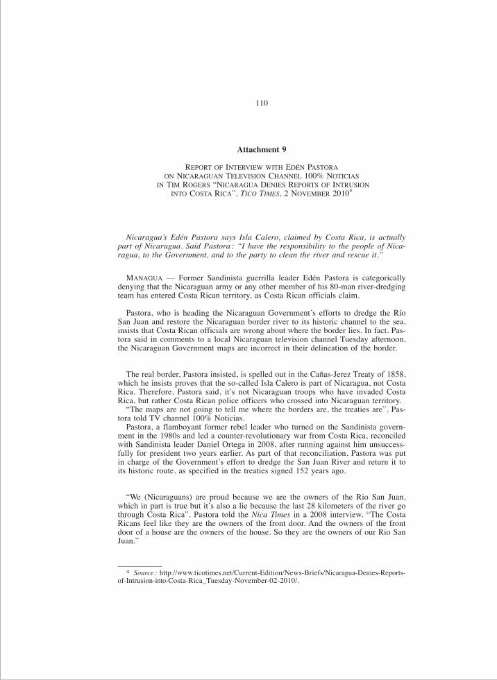
110
* Source : http://www.ticotimes.net/Current-Edition/News-Briefs/Nicaragua-Denies-Reports-of-Intrusion-into-Costa-Rica_Tuesday-November-02-2010/.
Attachment 9
REPORT OF INTERVIEW WITH EDÉN PASTORAON NICARAGUAN TELEVISION CHANNEL 100% NOTICIAS
IN TIM ROGERS “NICARAGUA DENIES REPORTS OF INTRUSIONINTO COSTA RICA”, TICO TIMES, 2 NOVEMBER 2010*
Nicaragua’s Edén Pastora says Isla Calero, claimed by Costa Rica, is actuallypart of Nicaragua. Said Pastora : “I have the responsibility to the people of Nica-ragua, to the Government, and to the party to clean the river and rescue it.”
MANAGUA — Former Sandinista guerrilla leader Edén Pastora is categoricallydenying that the Nicaraguan army or any other member of his 80-man river-dredgingteam has entered Costa Rican territory, as Costa Rican officials claim.
Pastora, who is heading the Nicaraguan Government’s efforts to dredge the RíoSan Juan and restore the Nicaraguan border river to its historic channel to the sea,insists that Costa Rican officials are wrong about where the border lies. In fact, Pas-tora said in comments to a local Nicaraguan television channel Tuesday afternoon,the Nicaraguan Government maps are incorrect in their delineation of the border.
The real border, Pastora insisted, is spelled out in the Cañas-Jerez Treaty of 1858,which he insists proves that the so-called Isla Calero is part of Nicaragua, not CostaRica. Therefore, Pastora said, it’s not Nicaraguan troops who have invaded CostaRica, but rather Costa Rican police officers who crossed into Nicaraguan territory.
“The maps are not going to tell me where the borders are, the treaties are”, Pas-tora told TV channel 100% Noticias.
Pastora, a flamboyant former rebel leader who turned on the Sandinista govern-ment in the 1980s and led a counter-revolutionary war from Costa Rica, reconciledwith Sandinista leader Daniel Ortega in 2008, after running against him unsuccess-fully for president two years earlier. As part of that reconciliation, Pastora was putin charge of the Government’s effort to dredge the San Juan River and return it toits historic route, as specified in the treaties signed 152 years ago.
“We (Nicaraguans) are proud because we are the owners of the Rio San Juan,which in part is true but it’s also a lie because the last 28 kilometers of the river gothrough Costa Rica”, Pastora told the Nica Times in a 2008 interview. “The CostaRicans feel like they are the owners of the front door. And the owners of the frontdoor of a house are the owners of the house. So they are the owners of our Rio SanJuan.”

111
* Source : http://www.ticotimes.net/Current-Edition/News-Briefs/Nicaragua-Denies-Reports-of-Intrusion-into-Costa-Rica_Tuesday-November-02-2010/.
Annexe 9
COMPTE RENDU DE L’INTERVIEW ACCORDÉE PAR M. EDÉN PASTORAÀ LA CHAÎNE DE TÉLÉVISION NICARAGUAYENNE 100 % NOTICIAS,
DANS TIM ROGERS, « NICARAGUA DENIES REPORTS OF INTRUSION INTO COSTA RICA» (« LE NICARAGUA NIE TOUTE INCURSION AU COSTA RICA»),
TICO TIMES, 2 NOVEMBRE 2010*
[Traduction]
Le Nicaraguayen Edén Pastora affirme que l’île de Calero, une île revendiquéepar le Costa Rica, appartient en fait au Nicaragua. Il a déclaré qu’il était « de [s]ondevoir, vis-à-vis du peuple du Nicaragua, du gouvernement et du parti, de nettoyerle fleuve et de le sauver ».
MANAGUA — L’ex-chef de la guérilla sandiniste Edén Pastora nie catégorique-ment que l’armée nicaraguayenne ou l’un des quatre-vingts membres de son équipede dragage soient entrés en territoire costa-ricien, comme l’affirment certains res-ponsables du Costa Rica.
M. Pastora, qui est à la tête des opérations menées par le Gouvernement nicara-guayen pour draguer le San Juan et rétablir le fleuve nicaraguayen qui délimite lafrontière dans son chenal primitif en direction de la mer, n’en démord pas : les auto-rités costa-riciennes se trompent sur l’emplacement de la frontière. En fait, a déclaréM. Pastora lors d’un entretien accordé mardi après-midi à une chaîne de télévisionlocale nicaraguayenne, les cartes du Gouvernement du Nicaragua sont incorrectes ence qui concerne la délimitation de la frontière.
Selon lui, la vraie frontière est celle établie par le traité Cañas-Jerez de 1858 qui,insiste-t-il, prouve que l’île dénommée île de Calero fait partie du Nicaragua, et nondu Costa Rica. Par conséquent, ce n’est pas l’armée nicaraguayenne qui a envahi leCosta Rica, mais la police costa-ricienne qui est entrée au Nicaragua.
« Ce ne sont pas les cartes qui vont me dire où sont les frontières, ce sont les trai-tés », a déclaré M. Pastora à la chaîne de télévision 100 % Noticias.
Cet ancien chef rebelle, qui a beaucoup fait parler de lui, s’était retourné contre le gouvernement sandiniste dans les années quatre-vingt pour mener uneguerre contre-révolutionnaire depuis le Costa Rica, avant de se réconcilier avec ledirigeant sandiniste Daniel Ortega en 2008, après avoir perdu contre lui les électionsprésidentielles deux ans auparavant. Dans le cadre de cette réconciliation, M. Pas-tora s’est vu confier la direction des opérations de dragage menées par le gouverne-ment en vue de rétablir le cours historique du San Juan, tel qu’indiqué dans le traitésigné 152 ans plus tôt.
« Nous (les Nicaraguayens) sommes fiers que le San Juan nous appartienne, cequi n’est toutefois vrai qu’en partie puisque les 28 derniers kilomètres du fleuvecoulent au Costa Rica, indiquait Pastora au Nica Times dans un entretien de 2008.Les Costa-Riciens pensent que, parce qu’ils possèdent la porte d’entrée, ils possè-dent la maison tout entière ; ils traitent notre San Juan comme leur propriété. »

112
Pastora added, “So I have the responsibility to the people of Nicaragua, to theGovernment, and to the party to clean the river and rescue it.”
Still, Pastora insists that in “rescuing the river” he has not set foot inside CostaRican territory, nor has he dumped any dredged sentiment on Costa Rican soil, asthe Tico officials and media contest.
“We haven’t put one drop of sand in Costa Rica”, Pastora said yesterday.
He insisted that the Nicaraguan military troops stationed along the border arethere as part of the war on drugs, and have nothing to do with the dredging project.
Indeed, months before the dredging controversy started, Nicaraguan Navy Admi-ral Róger González told the Nica Times that the border area around Costa Rica’sBarra de Colorado has become a new staging area for narcotraffickers to divide andload drugs into smaller crafts.
Pastora said in response to Costa Rica’s appeal to the Organization of AmericanStates (OAS) that the dredging project has shifted directions and is now going upriver towards Lake Nicaragua, rather than down river in the contested border area.However, he insisted, the project will continue as soon as the issue is sorted out.
“This will continue undeterred”, he told 100% Noticias.The Tico Times attempted to interview Pastora Tuesday afternoon, but the usually
approachable and chatty former revolutionary said he first had to get authorizationfrom the Nicaraguan Foreign Ministry before giving comments to the foreign press.
___________

113
Et M. Pastora d’ajouter : « Dans ces conditions, il est de mon devoir, vis-à-vis dupeuple du Nicaragua, du gouvernement et du parti, de nettoyer le fleuve et de lesauver. »
M. Pastora tient cependant à rappeler que, dans le cadre de sa mission de « sau-vetage », il n’a pas posé un pied en territoire costa-ricien, pas plus qu’il n’a déverséde sédiments sur le sol de cet Etat, contrairement à ce qu’affirme le Tico Times.
« Nous n’avons pas déposé le moindre grain de sable au Costa Rica », a ditM. Pastora hier.
Il a souligné que les forces militaires du Nicaragua stationnées le long de la fron-tière participaient à la guerre contre le trafic de stupéfiants, et qu’elles n’avaient rienà voir avec le projet de dragage.
De fait, plusieurs mois avant que n’éclate la controverse autour du projet de dra-gage, l’amiral nicaraguayen Róger González avait indiqué au Nica Times que lesnarcotrafiquants utilisaient la région frontalière autour de Barra de Colorado, auCosta Rica, comme une nouvelle zone opérationnelle servant à subdiviser les char-gements de drogue et à les transporter à bord d’embarcations plus petites.
M. Pastora a déclaré que le projet de dragage avait été réorienté dans l’autre senset que, en réponse à l’appel lancé par le Costa Rica à l’Organisation des Etats amé-ricains (OEA), les dragues remontaient à présent le cours d’eau en direction du lac Nicaragua au lieu de descendre jusqu’à la zone frontalière contestée. Toutefois,a-t-il insisté, le projet se poursuivra dès que la question aura été réglée.
« Rien ne nous arrêtera », a-t-il déclaré à 100 % Noticias. Le Tico Times a tenté de s’entretenir avec M. Pastora mardi après-midi, mais l’an-
cien révolutionnaire, si affable et loquace d’habitude, a répondu qu’il devait d’abordobtenir l’autorisation du ministère des affaires étrangères du Nicaragua avant defaire des déclarations à la presse étrangère.

114
Attachment 10
SELECTED PHOTOGRAPHS OF THE OCCUPIED AREA
Annexe 10
PHOTOGRAPHIES DE LA ZONE OCCUPÉE

Image of the dredge (draga) “Soberanía” (Sovereignty) and the area where thedredge is depositing sediment on Costa Rican territory (área depósito de sedimento).
Photographie de la drague (draga) « Soberanía » (Souveraineté) et du lieu où elle dépose des sédiments en territoire costa-ricien (área depósito de sedimento).
115
Close-up view showing the pipe (tubería) from dredge and deposits of sediment on Costa Rican territory.
Vue rapprochée montrant l’élingue (tubería) de la drague et les dépôts de sédiments en territoire costa-ricien.

116
The broader area encompassing a view of the area of sediment deposit ; the preliminary works on the canal trench (trocha) and the logging
of 2 hectares of Costa Rican territory (tala 2 hectáreas).Vue plus large de la zone, montrant l’aire de dépôt de sédiments,
les travaux préliminaires sur la tranchée du canal (trocha)et le déboisement de 2 hectares de territoire costa-ricien (tala 2 hectáreas).

117
The area of deforestation (area talada) leading to Laguna los Portillos on the north-east tip of Isla Portillos.
Zone de déboisement (área talada) menant à la lagune de los Portillos, à l’extrémité nord-est de l’île de Portillos.
The dredge “Soberanía” with Nicaraguan military forces on board.La drague « Soberanía » avec des militaires nicaraguayens à son bord.
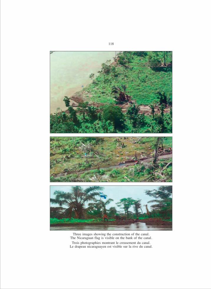
118
Three images showing the construction of the canal. The Nicaraguan flag is visible on the bank of the canal.Trois photographies montrant le creusement du canal.
Le drapeau nicaraguayen est visible sur la rive du canal.

119
San Juan River on the left, Laguna los Portillos to the right ; affected areas on left and right hand side.
Le San Juan sur la gauche, la lagune de los Portillos sur la droite ; les zones touchées se trouvent sur la gauche et sur la droite.
Construction of the canal.Creusement du canal.

120
Panoramic view of the deforestation.Vue panoramique de la déforestation.

121
Attachment 11
NICARAGUAN INSTITUTE OF TERRITORIAL STUDIES, OFFICIAL SHEET MAPOF NICARAGUA AND GEOGRAPHIC NATIONAL INSTITUTE OF COSTA RICA,
OFFICIAL MAP OF COSTA RICA
Annexe 11
CARTE OFFICIELLE DU NICARAGUA ÉTABLIE PAR L’INSTITUT NICARAGUAYEND’ÉTUDES TERRITORIALES ET CARTE OFFICIELLE DU COSTA RICA ÉTABLIE
PAR L’INSTITUT GÉOGRAPHIQUE NATIONAL DU COSTA RICA

122
Nicaraguan Institute of Territorial Studies, Official Sheet Map of Nicaragua(Scale : 1:50,000).
Carte officielle du Nicaragua établie par l’Institut nicaraguayen d’études territoriales (échelle 1/50 000).

123
Geographic National Institute of Costa Rica, Official Map of Costa Rica(Scale : 1:50,000).
Carte officielle du Costa Rica établie par l’Institut géographique national du Costa Rica (échelle 1/50 000).

124
Comparison of official maps showing boundary line.Comparaison des deux cartes officielles marquant le tracé de la ligne frontière.
CO
STA
RIC
AN
ICA
RA
GU
A
Com
pari
son
of o
ffici
al m
aps
show
ing
boun
dary
line


IMPRIMÉ EN FRANCE – PRINTED IN FRANCE