Embed Size (px)
Citation preview


APPLICATION FOR PERMIT TO CONSTRUCT AGRIUM RASMUSSEN VALLEY MINE
IN CARIBOU COUNTY IDAHO
Submitted to:
Idaho Department of Environmental Quality Air Quality Program
1410 North Hilton Boise, Idaho 83706
Prepared by: RTP Environmental Associates
304A West Millbrook Road Raleigh, North Carolina 27609
June 2016

i
Table of Contents
1.0 INTRODUCTION ................................................................................................. 1-1
2.0 PROJECT DESCRIPTION AND SUMMARY OF EMISSIONS ............................ 2-1
2.1 Project Description ........................................................................................... 2-1 2.2 Emission Calculation Methodology ................................................................... 2-3 2.3 Summary of Air Emissions ............................................................................... 2-9
3.0 ANALYSIS OF AIR QUALITY REGULATORY REQUIREMEnTS ....................... 3-1
3.1 Permit to Construct (IDAPA 58.01.01.201) ....................................................... 3-1 3.2 Tier I Operating Permit (IDAPA 58.01.01.300) ................................................. 3-1 3.3 Visible Emissions (IDAPA 58.01.01.625) ......................................................... 3-1 3.4 Rules for Control of Fugitive Dust (IDAPA 58.01.01.650-651).......................... 3-2 3.5 Rules for Sulfur Content of Fuels (IDAPA 58.01.01.725) ................................. 3-2 3.6 Rules for the Control of Nonmetallic Mineral Processing Plants (IDAPA 58.01.01.790, 793, 794) ............................................................................................ 3-2 3.7 NSPS Applicability (40 CFR 60 Subpart NN) ................................................... 3-3 3.8 NSPS Applicability (40 CFR 60 Subpart OOO) ................................................ 3-3 3.9 NSPS Applicability (40 CFR 60 Subpart IIII)..................................................... 3-3 3.10 NESHAP Applicability (40 CFR 61) .................................................................. 3-3 3.11 NESHAP Applicability (40 CFR 63 Subpart ZZZZ) ........................................... 3-3
4.0 AIR QUALITY DISPERSION MODELING ........................................................... 4-1
4.1 Site Description ................................................................................................ 4-2 4.2 Model Selection and Control Options ............................................................... 4-2 4.3 Source Data ..................................................................................................... 4-4 4.4 Monitored Background Data ............................................................................. 4-6 4.5 Ambient Air Boundary and Receptor Grid ........................................................ 4-6 4.6 Meteorological Data ....................................................................................... 4-10 4.7 Modeling Methodology ................................................................................... 4-14 4.8 Model Results ................................................................................................. 4-20 4.9 Summary and Conclusions ............................................................................ 4-24
ii
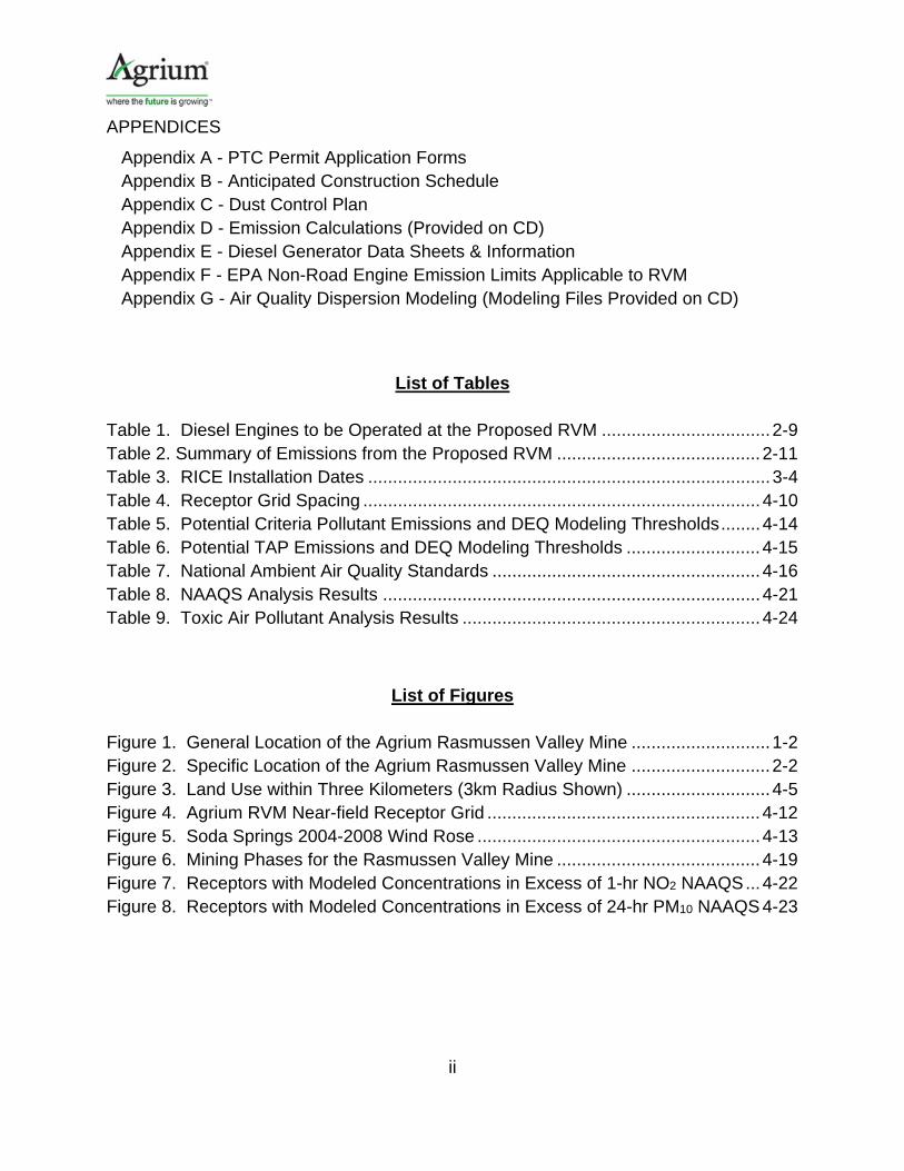
APPENDICES
Appendix A - PTC Permit Application Forms Appendix B - Anticipated Construction Schedule Appendix C - Dust Control Plan Appendix D - Emission Calculations (Provided on CD) Appendix E - Diesel Generator Data Sheets & Information Appendix F - EPA Non-Road Engine Emission Limits Applicable to RVM
Appendix G - Air Quality Dispersion Modeling (Modeling Files Provided on CD)
List of Tables Table 1. Diesel Engines to be Operated at the Proposed RVM .................................. 2-9 Table 2. Summary of Emissions from the Proposed RVM ......................................... 2-11 Table 3. RICE Installation Dates ................................................................................. 3-4 Table 4. Receptor Grid Spacing ................................................................................ 4-10 Table 5. Potential Criteria Pollutant Emissions and DEQ Modeling Thresholds ........ 4-14 Table 6. Potential TAP Emissions and DEQ Modeling Thresholds ........................... 4-15 Table 7. National Ambient Air Quality Standards ...................................................... 4-16 Table 8. NAAQS Analysis Results ............................................................................ 4-21 Table 9. Toxic Air Pollutant Analysis Results ............................................................ 4-24
List of Figures Figure 1. General Location of the Agrium Rasmussen Valley Mine ............................ 1-2 Figure 2. Specific Location of the Agrium Rasmussen Valley Mine ............................ 2-2 Figure 3. Land Use within Three Kilometers (3km Radius Shown) ............................. 4-5 Figure 4. Agrium RVM Near-field Receptor Grid ....................................................... 4-12 Figure 5. Soda Springs 2004-2008 Wind Rose ......................................................... 4-13 Figure 6. Mining Phases for the Rasmussen Valley Mine ......................................... 4-19 Figure 7. Receptors with Modeled Concentrations in Excess of 1-hr NO2 NAAQS ... 4-22 Figure 8. Receptors with Modeled Concentrations in Excess of 24-hr PM10 NAAQS 4-23
1-1
1.0 INTRODUCTION
Nu-West Mining, Inc., a wholly owned subsidiary of Nu-West Industries, Inc., doing
business as Agrium Conda Phosphate Operations (Agrium CPO), is seeking
authorization in the form of a Permit to Construct (PTC) to develop a new open pit
phosphate mining operation that will include external overburden and ore piles, haul
roads, mining pits, and other ancillary facilities. Phosphate ore excavated from the mine
will be processed off site at Agrium's Conda Phosphate Operations Fertilizer
Manufacturing Plant northeast of Soda Springs. The proposed mining operation is
located on the southern end of Rasmussen Ridge in Caribou County approximately 18
miles northeast of Soda Springs, Idaho. Figure 1 shows the general location of the
Agrium CPO Rasmussen Valley Mine (RVM).
The mining operation would develop phosphate ore reserves contained within Federal
Phosphate Lease IDI–05975 and associated Lease Modifications, Temporary Use
Permits and Special Use Permits (Lease) in portions of Sections 4, 5, 6, 8, and 9, T7S,
R44E; and Section 34, 35, and 36, T6S, R43E; and Section 1, T7S, R43E. The lease
encompasses approximately 680 acres.
The federal mineral lease for the project is administered by the United States Bureau of
Land Management (BLM). Surface ownership in the project area includes state-owned
land (managed by the Idaho Department of Fish and Game [IDFG] and Idaho
Department of Lands [IDL] ), federally owned land (Bureau of Land Management (BLM)
and United States Forest Service [USFS]), and private land. In accordance with the
requirements of the National Environmental Policy Act and the Federal Land Policy and
Management Act, the BLM and USFS are preparing an Environmental Impact
Statement (EIS) for the proposed mine. Idaho Department of Environmental Quality
(IDEQ) and United States Army Corps of Engineers are Cooperating Agencies for the
EIS. IDL and IDFG are also participating in the review and development of the EIS.

1-2
Figure 1. General Location of the Agrium CPO Rasmussen Valley Mine

1-3
BLM, USFS, USACE and IDEQ are collectively referred to as the Agencies for the
purposes of this document.
This PTC application contains all of the required information pursuant to IDAPA
58.01.01.200 through 228, including completed application forms, application fee and
Responsible Official certification. The remainder of this PTC application is organized as
follows:
Section 2.0 – Project Description and Summary of Emissions Section 3.0 – Analysis of Air Quality Regulatory Requirements Section 4.0 – Air Quality Dispersion Modeling Appendix A – PTC Permit Application Forms Appendix B – Anticipated Construction Schedule Appendix C – Dust Control Plan Appendix D – Emission Calculations (Provided on CD) Appendix E – Diesel Generator Data Sheets & Information Appendix F – EPA Non-Road Engine Emission Limits Applicable to RVM Appendix G –Air Quality Dispersion Modeling (Provided on CD)

2-1
2.0 PROJECT DESCRIPTION AND SUMMARY OF EMISSIONS
Agrium CPO proposes the RVM to construct, operate, and reclaim an open-pit
phosphate mine in the Rasmussen Valley in Caribou County, Idaho. The RVM will
incorporate an existing pit operated by Monsanto. The project proposes excavation of
3.0 million tons of phosphate ore per year, and 10.2 million tons of overburden. No
phosphate ore crushing or smelting is included in the project, nor is any crushing or
smelting under consideration. Mining of ore will be consistent with methods currently
utilized at Agrium CPO’s other open-pit phosphate mining operations in the region
including extensive reclamation activities. Figure 2 presents the specific location of the
RVM project.
2.1 Project Description
The RVM mining plan consists of:1
1. Development of a large open pit in a sequenced manner, consisting of nine
phases, beginning at the northwest and generally progressing southeast. The life of proposed mining activities would be approximately 4.8 years, and the total project duration (including reclamation) would be 7.1 years.
2. Placement of overburden from the initial phases into Monsanto’s partially backfilled and reclaimed South Rasmussen Mine (SRM) main pit (located directly north of the proposed mining activities), thus increasing the reclaimed area at the South Rasmussen Mine pit.
3. Development and reclamation of up to four growth media stockpile areas. 4. Backfilling the majority of the mined-out pit. 5. Construction and reclamation of a staging area. 6. Utilize electrical generators to power mine facilities. 7. Realignment of portions of Blackfoot River Road, Lanes Creek Road and
Diamond Creek Road. 8. Construction and reclamation of sediment control structures. 9. Construction of two temporary overburden storage piles within the mine footprint.
1 Rasmussen Alternative Collaborative mining plan from the Draft Environmental Impact Statement Rasmussen
Valley Mine, September 2015.

2-2
Figure 2. Specific Location of the Agrium CPO Rasmussen Valley Mine
2-3
10. Extension of the pit floor to the Lease boundary at the north end to maximize ore recovery.
11. Establishment of growth media and alluvium storage and borrow areas to be used to construct a backfill cap.
12. Reclamation with a diverse variety of plant species.
Agrium CPO’s RVM ultimately will result in several benefits accruing to the existing
property. A primary objective of the project is to minimize the risk of potential impacts to
the environment from selenium and other COPCs, from both historical and newly-mined
areas through the implementation of comprehensive reclamation. In part, this will be
accomplished by backfilling 94 percent of the pit leaving no open pit and only small
areas of pit wall exposed, limiting infiltration of water through the backfill by the
installation of a robust cover, restoring regional drainage patterns, and increasing
reclamation at the SRM.
Agrium CPO has implemented plans above and beyond the Proposed Action to ensure
minimal environmental impacts which include the following:
Elimination of permanent external overburden piles downslope of the mine and
near already impacted surface water;
Elimination of all temporary external Meade Peak overburden piles downslope of
the mine and near already impacted surface water;
No wetland impacts across the entire project;
Use of previously disturbed ground and existing infrastructure to the maximum
extent practicable;
Reduced water crossings;
Increased ridge-wide reclamation;
Elimination of a proposed power line segment; and
Increased public safety.
2.2 Emission Calculation Methodology

2-4
Major operations at the RVM include: (a) open-pit mining including drilling, blasting,
loading; hauling ore and overburden material, stock piling of ore, growth media and
overburden material; and (b) diesel burning engines generating electricity for the
operation of the production trailer, stadium lights, water pumps, and portable lights to
facilitate 24 hour per day operation. As previously mentioned, no phosphate ore
crushing or smelting is included in the project.
Open Pit Mining
Mining of ore will be consistent with methods currently utilized at Agrium CPO’s other
open-pit phosphate mining operations in the region and will include large-scale
equipment including rotary blast hole drills, off-highway haul trucks, off-highway water
trucks, dozers and graders, fueling trucks and support vehicles. Peak mining rates are
expected to reach up to 2 million tons per year.
Drilling, Blasting &Screening
Drilling, blasting, and screening are performed within the open-pit mine. These
operations result in the fugitive emissions of PM (particulate matter), PM10, and PM2.5
with blasting also emitting carbon monoxide (CO), nitrogen oxides (NOx), and sulfur
dioxide (SO2).
Drilling will be performed by a rotary blast-hole drill. Drilling emissions are estimated
based on drilling eight holes per day, 365-days per year. Uncontrolled PM, PM10, and
PM2.5 emissions from drilling are calculated using the emission factor of 1.3 pounds/hole
for total suspended particulates (TSP) from drilling of overburden at western surface
coal mines.2 To be conservative, PM, PM10, and PM2.5 emissions were all considered
equal to the TSP emission factor. A controlled factor for the use of wet suppression of
84 percent was used.3
2 AP-42 Table 11.9-4 (7/98).
3 Control efficiency based on the WRAP Fugitive Dust Handbook, September 2006. Table 3-7. Control Efficiencies
for Control Measures for Construction/Demolition.

2-5
Blasting emissions are based on one blast per day, 365-days per year. Ammonium
nitrate and fuel oil (ANFO) blasting agents will be used based on 2,128 pounds of
ANFO per blast (388 tons per year of ANFO). Uncontrolled emissions of PM10 and
PM2.5 for blasting are calculated by using the predictive emission equation from AP-42
Table 11.9-1 (10/98) for blasting at western surface coal mines for TSP and multiplies
the result by the scaling factor for PM10 and PM2.5 to get emissions in pounds per blast.
The scaling factors of 0.52 for PM10 and 0.03 for PM2.5 are provided in AP-42 Table
11.9-1 (10/98). The TSP predictive emission equation for blasting is provided below.
EF = (k) x (0.000014) x (A)1.5
Where:
EF = emission factor (lb. /blast) k = scaling factor (TSP assumed to be equivalent to PM, 0.52 for PM10, 0.03 for PM2.5) A = horizontal area of the blast (assumed spacing of 20 feet by 20 feet times 4 holes)
Uncontrolled gaseous (CO, NOx, and SO2) emissions from blasting are calculated using
the emission factors from AP-42 Table 13.3-1 (02/80) for the detonation of ANFO.
Screening will be performed during the summer months on approximately 30,000 tons
of material (i.e. chert and limestone). Controlled PM, PM10, and PM2.5 emissions from
screening are calculated using the AP-42 Table 11.19.2-2 pound per ton emission
factors.
Hauling Ore and Overburden Material
The hourly and annual process rates for the amount of vehicle miles traveled (VMT) by
the haul trucks in order to haul ore, overburden material and growth media to their
respective storage areas are calculated by multiplying the distance traveled by the
amount of truckloads needed to haul the material, which are anticipated to be consistent

2-6
throughout the life of the mine. Controlled PM10 and PM2.5 emissions resulting from the
use of haul trucks on unpaved haul roads at RVM are calculated from the emission
factor in AP-42, Section 13.2.2 (11/06) a control efficiency factor multiplier.
EF = [k x (s/12)a x (W/3)b] x [(365-P)/365] x [control efficiency factor]
Where:
EF = size-specific emission factor (lb/VMT) k = empirical constant (1.5 for PM10 and 0.15 for PM2.5) a = empirical constant (0.9 for PM10 and PM2.5) b = empirical constant (0.45 for PM10 and PM2.5) s = surface material silt content of 8.4 % from AP-42 Table 13.2.2-1(western surface coal mining haul road to/from pit) W = mean weight of vehicles in tons (125 tons)4 P = number of days in a year with at least 0.254 mm (0.01 in) of precipitation = 90 from Figure 13.2.2-1
Control efficiency factor = 90% dust control for applying water5
Vehicle miles traveled for truck hauling from the pit to the overburden piles is 2.5 miles
round trip with 90 trips per day. Vehicle miles traveled for truck hauling from the pit to
the ore stockpile or lease boundary is 5 miles round trip with 30 trips per day.
Wind Erosion of Stockpiles
Uncontrolled PM10 and PM 2.5 emissions generated from the storage of ore, overburden
material and growth media are calculated from the emission factor provided in AP-42
Table 11.9-4. From this table a wind erosion emission rate for exposed areas of 0.38
tons per acre-year was used. Because Table 11.9-4 does not include particle size
4 The average vehicle weight is based on a Cat 777 haul truck that has an empty weight of 70 tons and a loaded weight of 180 tons. 5 Haul roads and other areas requiring suppression of dust from mining operations will be sprayed with dust-suppression water from water wells. Applying water to unpaved roads can result in control efficiency of 75 to 95%. (WRAP Air Handbook, September 2006 Figure 6-1. Watering Control Effectiveness for Unpaved Travel Surfaces).

2-7
multipliers, scaling factors for particle size multiplies found in AP-42 Section 13.2.5 page
3 were use as follows:
PM = 1.0
PM10 = 0.5, and
PM2.5 = 0.075.
Although fugitive particulate emissions from the storage of ore, overburden material and
growth media may be controlled by the addition of water on an as needed basis in order
to inhibit the escape of particulate emissions, potential emissions are calculated
assuming no controls.
Loading and Unloading Ore and Overburden
Uncontrolled PM10 and PM2.5 emissions generated from the loading and unloading of
ore, overburden material and growth media into haul trucks and stockpiles are
calculated from the emission factor provided in AP-42 Section 13.2.4. The PM10 and
PM2.5 emission factor (pound/ton) is generated from using the particle size multiplier
(dimensionless), mean wind speed and the material moisture content. The emission
factor is then multiplied by the material throughput to yield the PM10 and PM2.5
emissions. This equation is:
∙ 0.0032 ∙ 5
.
2
.
Where:
EF = emission factor (lb/ton) k = aerodynamic particle size multiplier (dimensionless), (0.35 for PM10, 0.053 for PM2.5) U = mean wind speed. (The mean wind speed at the RVM site is 7.9 mph, the average value calculated from hourly data collected at the Soda Springs airport meteorological station from 1/2011 through 12/2011) M = material moisture content (overburden and growth media assigned 6.9 percent moisture content and phosphate ore assigned 12 percent moisture content)

2-8
Open Pit Mining TAP and HAP Metal Emissions
Toxic air pollutant (TAP) and hazardous air pollutant (HAP) metal emissions were
estimated based on estimated concentrations of the metals in similar materials. Metals
concentrations for the overburden and ore were based on measured values from a
geochemical baseline study conducted for RVM,6 which included the following metals:
aluminum, antimony, arsenic, beryllium, cadmium, chromium, copper, iron, lead,
magnesium, molybdenum, nickel, selenium, silver, uranium, and zinc. Samples of
lithologic units were collected from exploratory boreholes at specified intervals along the
strike of the deposit and submitted for laboratory analysis. Geometric mean values for
metals were calculated for each lithologic unit, (e.g. alluvium, chert, limestone, upper
ore, lower ore, ore associated waste, etc.). These geometric mean concentration values
were weighted with respect to each lithologic unit using material balance data from
RVM. The resultant weighted geometric mean values were utilized in the modeling, and
reflect the metals concentrations in phosphate ore and overburden material that will
undergo excavation, stockpiling and transport during operations at RVM. Metal
analyses were not conducted for cobalt, mercury, tungsten, and zirconium. The
expected concentrations for cobalt, mercury, and zirconium were taken from
Lithogeochemistry of the Meade Peak Phosphatic Shale Member of the Phosphoria
Formation.7 The expected concentration of tungsten was taken from Chemical
Analyses for Selected Minor Elements in Pierre Shale.8 Tungsten samples analyzed in
a similar lithologic unit (Pierre Shale) indicated less than 1 parts per million by weight
(ppmw) tungsten; 1 ppmw was used in the modeling analysis.
6 Whetstone Associates, Inc., 2012, Final Baseline Geochemical Characterization Study Plan, Rasmussen Valley
Mine Project, U.S. Department of Interior, Bureau of Land Management, Idaho Falls District, Pocatello Field Office
(preliminary geochemical data summary). 7 Herring, J.R., and R.I. Grauch. 2004. Lithogeochemistry of the Meade Peak Phosphatic Shale Member of the
Phosphoria Formation, Southeast Idaho. pp. 321-366 in Life Cycle of the Phosphoria Formation: From Deposition to
Post-Mining Environment, ed. J. R. Hein, Vol. 8 of Handbook of Exploration and Environmental Geochemistry, ed. M.
Hall Elsevier B.V., Amsterdam. 8 Rader, L.F., and Grimaldi, F.S., 1961, Chemical Analyses for Selected Minor Elements in Pierre Shale, Geological
Survey Professional Paper 391-A, U.S. Govt. Printing Office, Washington, 1961, 51 pp.

2-9
Diesel Burning Engines
The RVM will operate twelve diesel engines as shown in Table 1.
Table 1. Diesel Engines to be Operated at the Proposed RVM
Description Model Number Diesel Engine Hp Status Dust Suppression Well DCA85USJ 113 Existing – Tier 3 Dust Suppression Well DCA45SSIU4F 65.7 New – Tier 4 Ready Line DCA70SSJU4i 107 New – Tier 4 interim Light Plants (9) WLTC 13.6 New – Tier 4
The daily and annual emission rates for the diesel-burning generators are based on the
nominal horse power (Hp) ratings of the generators and the hours of operation. All
generator emissions were calculated for continuous operation at 8,760 hours/year.
Manufacturer’s data sheets for the generators are provided in Appendix E.
Controlled emission rates for CO, non-methane hydrocarbons (assumed to be VOC),
NOx, and PM are calculated using EPA Tier III and IV emission factors for non-road
engines as provided in Appendix F. Emissions of SO2 are based on diesel fuel sulfur
content of 15 parts per million by weight (ppmw). Emissions of greenhouse gases are
based on emission factors from Table 1 for Stationary Combustion Emission Factors
from the EPA Emission Factors for Greenhouse Gas Inventories and Table 9 for Global
Warming Potentials (GWPs) for conversion of gasses to CO2 equivalent from the EPA
Emission Factors for Greenhouse Gas Inventories. Emissions of HAP and TAP
emissions resulting from the burning of diesel fuel are calculated using emission factors
from AP-42 Table 3.3-2 (10/96) for uncontrolled diesel engines less than or equal to 600
horsepower.
2.3 Summary of Air Emissions
The RVM operation will subject the overburden and ore to drilling and blasting to enable
mine excavation. Excavation is conducted using a fleet of diesel/hydraulic excavators

2-10
and diesel haul trucks. Other diesel engine equipment used at the site include electric
generators to provide power for the production trailer, stadium lights, water pumps, and
light generators to facilitate 24 hour per day operation. Air emissions will occur from the
diesel engine equipment, fugitive emissions from mining activities (drilling, blasting, and
screening), and fugitive emissions from materials hauling, handling and storage. Table
2 presents a summary of air emissions from the RVM project. Both point source
emissions and fugitive emissions are presented. Emissions of HAPs and TAPs are less
than one ton per year. Appendix D presents the details of the emission calculations.

2-11
Table 2. Summary of Emissions from the Proposed RVM
riteria Pollutant Potential to Emit Emissions Summary, Rasmussen Valley Mine Proposed Action
lb/hr tons/yr lb/hr tons/yr lb/hr tons/yr lb/hr tons/yr lb/hr tons/yr lb/hr tons/yr lb/hr tons/yr lb/hr tons/yrStationary Fuel Combustion SourcesDiesel Light Plant 1 0.016 0.071 0.016 0.071 0.000 0.001 0.3 1.3 0.27 1.2 0.06 0.27 28 124 6.70E‐04 2.93E‐03
Diesel Light Plant 2 0.016 0.071 0.016 0.071 0.000 0.001 0.3 1.3 0.27 1.2 0.06 0.27 28 124 6.70E‐04 2.93E‐03
Diesel Light Plant 3 0.016 0.071 0.016 0.071 0.000 0.001 0.3 1.3 0.27 1.2 0.06 0.27 28 124 6.70E‐04 2.93E‐03
Diesel Light Plant 4 0.016 0.071 0.016 0.071 0.000 0.001 0.3 1.3 0.27 1.2 0.06 0.27 28 124 6.70E‐04 2.93E‐03
Diesel Light Plant 5 0.016 0.071 0.016 0.071 0.000 0.001 0.3 1.3 0.27 1.2 0.06 0.27 28 124 6.70E‐04 2.93E‐03
Diesel Light Plant 6 0.016 0.071 0.016 0.071 0.000 0.001 0.3 1.3 0.27 1.2 0.06 0.27 28 124 6.70E‐04 2.93E‐03
Diesel Light Plant 7 0.016 0.071 0.016 0.071 0.000 0.001 0.3 1.3 0.27 1.2 0.06 0.27 28 124 6.70E‐04 2.93E‐03
Diesel Light Plant 8 0.016 0.071 0.016 0.071 0.000 0.001 0.3 1.3 0.27 1.2 0.06 0.27 28 124 6.70E‐04 2.93E‐03
Diesel Light Plant 9 0.016 0.071 0.016 0.071 0.000 0.001 0.3 1.3 0.27 1.2 0.06 0.27 28 124 6.70E‐04 2.93E‐03
Existing Dust Suppression Well 0.056 0.244 0.056 0.244 0.001 0.005 0.7 3.2 0.9 4.1 0.28 1.24 129 567 3.06E‐03 1.34E‐02
New Dust Suppression Well 0.003 0.014 0.003 0.014 0.001 0.003 0.5 2.2 0.5 2.4 0.17 0.72 75 330 1.78E‐03 7.80E‐03
Ready Line 0.004 0.015 0.004 0.015 0.001 0.005 0.1 0.3 0.9 3.8 0.03 0.15 123 537 2.90E‐03 1.27E‐02
Point Source Subtotals 0.21 0.9 0.21 0.9 0.01 0.0 4.05 17.8 4.75 20.8 1.04 4.6 582 2,548 0.01 0.06Mining FugitivesDrilling 0.069 0.304 0.069 0.304 ‐‐ ‐‐ ‐‐ ‐‐ ‐‐ ‐‐ ‐‐ ‐‐ ‐‐ ‐‐ 1.72E‐03 7.52E‐03
Blasting & Explosives 0.019 0.085 0.001 0.005 0.089 0.39 0.75 3.3 3.0 13.0 ‐‐ ‐‐ ‐‐ ‐‐ 4.81E‐04 2.11E‐03
Screening 0.010 0.011 0.001 0.001 ‐‐ ‐‐ ‐‐ ‐‐ ‐‐ ‐‐ ‐‐ ‐‐ ‐‐ ‐‐ 4.75E‐05 2.08E‐04
Haul Road ‐ Pit to Overburden Pile 4.1 18.0 0.4 1.8 7.19E‐02 3.15E‐01
Haul Road ‐ Pit to Ore Stockpile/Lease Boundry 4.1 18.0 0.4 1.8 7.19E‐02 3.15E‐01
Ore Loading at Pit 0.0202 0.089 0.0031 0.0134 3.79E‐04 1.66E‐03
Ore Unloading at Pile 0.0202 0.089 0.0031 0.0134 3.79E‐04 1.66E‐03
Ore Loading at Pile 0.0202 0.089 0.0031 0.0134 3.79E‐04 1.66E‐03
Overburden Loading at Pit 0.0746 0.327 0.0113 0.0494 1.30E‐03 5.70E‐03
Overburden Unloading at Pile 0.0746 0.327 0.0113 0.0494 1.30E‐03 5.70E‐03
Overburden Loading at Pile 0.0609 0.267 0.0092 0.0404 1.06E‐03 4.66E‐03
Overburdent Unloading Pit Refill 0.0609 0.267 0.0092 0.0404 1.06E‐03 4.66E‐03
Wind Erosion ‐ GM and OB Piles 0.0021 0.009 0.0003 0.0014 3.72E‐05 1.63E‐04
Wind Erosion ‐ Ore Stock Piles 0.0002 0.0008 0.0000 0.0001 3.46E‐06 1.51E‐05
Fugitive Source Subtotals 8.7 37.9 0.9 4.1 0.1 0.4 0.8 3.3 3.0 13.0 0.0 0.0 0.0 0.0 0.15 0.67Project Totals 9 39 1 5 0 0 5 21 8 34 1 5 582 2,548 0.17 0.73
CO HAPs & TAPs
Notes:
Emissions are based on 8760 hours/year, except for screening which is based on operating three months per year (2190 hours/year).
VOC CO2eEmission SourcePM10 PM2.5 SO2 NOX

3-1
3.0 ANALYSIS OF AIR QUALITY REGULATORY REQUIREMENTS
The RVM project is located in Caribou County, which is designated as attainment or
unclassified for PM2.5, PM10, SO2, NO2, CO and Ozone (VOC and NOx). The RVM
project is a minor source of air pollution under the regulations governing Prevention of
Significant Deterioration (40 CFR 52.21) and Title V (40 CFR 70.2). This is because the
uncontrolled potential-to-emit (PTE) of regulated pollutants from all stationary emissions
units, based on rated capacity and 8,760 hours per year operation, are below major
source thresholds.
3.1 Permit to Construct (IDAPA 58.01.01.201)
No owner or operator may commence construction or modification of any stationary
source, facility, major facility, or major modification without first obtaining a permit to
construct from the Department which satisfies the requirements of IDAPA 58.01.01.200
– 228. The proposed RVM project constitutes construction as that term is defined for
purposes of PTC applicability. Therefore, a PTC is required in accordance with IDAPA
58.01.01.201.
3.2 Tier I Operating Permit (IDAPA 58.01.01.300)
The post project emissions from the proposed facility do not have a PTE greater than
100 tons per year for PM2.5, PM10, SO2, NO2, CO and VOC, 10 tons per year for anyone
HAP, or 25 tons per year for all HAP combined. Therefore the facility is not a Tier I
source in accordance with IDAPA 58.01.01.006, and the requirements of IDAPA
58.01.01.301 do not apply.
3.3 Visible Emissions (IDAPA 58.01.01.625)

3-2
The sources of PM emissions at the facility are subject to the visible emissions standard
of 20% opacity. Agrium CPO will comply with this rule by implementing good operating
practices and inspecting emissions units regularly.
3.4 Rules for Control of Fugitive Dust (IDAPA 58.01.01.650-651)
This rule requires that all reasonable precautions must be taken to prevent particulate
matter from becoming airborne. The sources of fugitive dust at the facility are subject to
the requirements of this rule, and Agrium CPO will comply with this rule through the use
and execution of a fugitive dust control plan.
3.5 Rules for Sulfur Content of Fuels (IDAPA 58.01.01.725)
This rule prohibits selling, distributing and using any distillate fuel oil containing more
than the following percentages of sulfur:
a. ASTM Grade 1. ASTM Grade 1 fuel oil - zero point three percent (0.3%) by weight.
b. ASTM Grade 2. ASTM Grade 2 fuel oil - zero point five percent (0.5%) by weight.
This rule applies to the diesel generators at the facility, and Agrium CPO will comply by
using ultra-low sulfur diesel (< 0.0015% sulfur by weight).
3.6 Rules for the Control of Nonmetallic Mineral Processing Plants (IDAPA 58.01.01.790, 793, 794)
Rules 790 and 794 apply to any combination of equipment that is used to crush or grind
any nonmetallic mineral or rock wherever it may be located. The emission prohibitions
of these rules do not apply to the proposed facility because the facility will have no
crushing or grinding operations. However, Rule 793 applies to owners and operators of
nonmetallic mineral processing plants that are not subject to Rule 790. As such, Agrium
will not discharge from the screening operation atmospheric emissions which exhibit
greater than twenty percent (20%) opacity.

3-3
3.7 NSPS Applicability (40 CFR 60 Subpart NN)
Although RVM meets the definition of a Phosphate Rock Plant under NSPS Subpart
NN, because of the mining and screening processes, the facility does not utilize any of
the affected facilities covered by this Subpart and to which standards apply (rock dryer,
rock calciner, rock grinder, and ground rock handling and storage). As such this NSPS
is not applicable to the RVM facility.
3.8 NSPS Applicability (40 CFR 60 Subpart OOO)
The provisions of this subpart are applicable to the following affected facilities in fixed or
portable nonmetallic mineral processing plants: each crusher, grinding mill, screening
operation, bucket elevator, belt conveyor, bagging operation, storage bin, enclosed
truck or railcar loading station. The provisions of this subpart do not apply to plants
without crushers or grinding mills [§60.670(a)(2)]. As such this NSPS is not applicable
to the RVM because the facility will not have crushers or grinding mills.
3.9 NSPS Applicability (40 CFR 60 Subpart IIII)
The provisions of this subpart are applicable to manufacturers, owners, and operators of
stationary compression ignition (CI) internal combustion engines (ICE). This NSPS is
applicable to all of the stationary diesel engines at the RVM facility, and the facility will
comply with the emission standards, monitoring, recordkeeping, and reporting
requirements of Subpart IIII.
3.10 NESHAP Applicability (40 CFR 61)
None of the subparts under the National Emission Standards of Hazardous Air
Pollutants (NESHAP) 40 CFR Part 61 are applicable to the RVM facility.
3.11 NESHAP Applicability (40 CFR 63 Subpart ZZZZ)

3-4
This subpart applies to stationary reciprocating internal combustion engines (RICE)
located at major and area sources of HAPs. The RVM facility will be an area source of
HAPs. RICEs constructed on or after June 12, 2006 are considered new stationary
RICE and will meet the requirements of 40 CFR 60 Subpart IIII as required by this
subpart. RICEs constructed before June 12, 2006 are considered existing stationary
RICE and will meet the requirements of this subpart. All of the RVM RICE are
considered new stationary RICE. The installation year for the RVM RICE are shown in
Table 3.
Table 3. RICE Installation Dates
Generator Units Installation
Year Existing Well Pump (113 Hp) 2012
Nine Light Plants (24.7 Hp each) 2017
New Well Pump (65.7 Hp) 2017
Ready Line Generator (107 Hp) 2017

4-1
4.0 AIR QUALITY DISPERSION MODELING
An air quality modeling analysis was conducted to evaluate compliance with the
National Ambient Air Quality Standards (NAAQS) and the Toxic Air Pollutant (TAP)
increments of Idaho Air Rules found in the Idaho Administrative Procedures Act
(IDAPA) Sections 585 and 586. The Idaho Department of Environmental Quality
(IDEQ) has determined that this demonstration generally requires the applicant to
perform air quality impact analyses using dispersion models.
The analysis evaluated emissions of the criteria pollutants with total facility potential
emissions that exceed the Level I or Level II thresholds as listed in Table 2 of the Idaho
Guideline for Performing Air Quality Impact Analysis.9 For TAPs, only those pollutants
with total facility emissions in excess of the Screening Emissions Levels (EL) in IDAPA
Sections 585 and 586 were evaluated. TAPs from the diesel engines were not included
as these sources are subject to a National Emissions Standard for Hazardous Air
Pollution (NESHAP) and exempt from TAP review pursuant to IDAPA §210(20). Only
the TAPs associated with the fugitive dust from the mine haul roads, storage piles, and
truck loading/unloading were included.
The modeling analysis conformed with the modeling procedures outlined in the U.S.
Environmental Protection Agency’s (EPA) Guideline on Air Quality Models(Guideline), 10
the Idaho Guideline for Performing Air Quality Impact Analysis, and associated EPA
9 State of Idaho Guideline for Performing Air Quality Impact Analyses, Department of Environmental Quality,
September 2013. 10 Guidelines on Air Quality Models, (Revised). Appendix W of 40 CFR Part 51, U.S. Environmental Protection
Agency, Office of Air Quality Planning and Standards, Research Triangle Park, North Carolina. November 9, 2005.

4-2
modeling policy and guidance. The analysis also conforms with the modeling protocol
submitted to and approved by the IDEQ.11
4.1 Site Description The Agrium CPO RVM mining operation will be located on the southern end of
Rasmussen Ridge and in adjacent portions of Rasmussen Valley in Caribou County
approximately 18 miles northeast of Soda Springs, Idaho. The approximate Universal
Transverse Mercator (UTM) coordinates of the facility are 472,500 meters east and
4,743,000 meters north (UTM Zone 12, NAD 83). Figure 2 shows the specific location
of the lease boundary on a 7.5-minute U.S. Geological Survey (USGS) topographic
map. The majority of the mine is at elevations between 1980-2130m (6500-7000ft)
above mean sea level.
4.2 Model Selection and Control Options Model Selection
The latest version of the AMS/EPA Regulatory Model (AERMOD, Version 15181) was
used to conduct the dispersion modeling analysis. AERMOD is a Gaussian plume
dispersion model that is based on planetary boundary layer principals for characterizing
atmospheric stability. The model evaluates the non-Gaussian vertical behavior of
plumes during convective conditions with the probability density function and the
superposition of several Gaussian plumes. AERMOD is a modeling system with three
components: AERMAP is the terrain preprocessor program, AERMET is the
meteorological data preprocessor and AERMOD includes the dispersion modeling
algorithms.
11 Air Dispersion Modeling Protocol for the Agrium CPO Rasmussen Valley Mine in Caribou County Idaho, RTP
Environmental Associates, December 2015, and the subsequent IDEQ Approval letter, January 12, 2016.

4-3
AERMOD is the most appropriate model for calculating ambient concentrations near the
mine based on the model's ability to incorporate multiple sources and source types.
The model can also account for convective updrafts and downdrafts and meteorological
data throughout the plume depth. The model also provides parameters required for use
with up to date planetary boundary layer parameterization. The model also has the
ability to incorporate building wake effects and to calculate concentrations within the
cavity recirculation zone. All model options will be selected as recommended in the
EPA Guideline on Air Quality Models.
Oris Solution's BEEST Graphical User Interface (GUI) was used to run AERMOD. The
GUI uses an altered version of the AERMOD code to allow for flexibility in the file
naming convention. The dispersion algorithms of AERMOD are not altered. Therefore,
there is no need for a model equivalency evaluation pursuant to Section 3.2 of 40 CFR
51, Appendix W.
Model Control Options and Land Use
AERMOD was run in the regulatory default mode for all pollutants using the default rural
dispersion coefficients in the model. Use of rural dispersion coefficients is supported by
the Land Use Procedure consistent with subsection 7.2.3(c) of the Guideline and
Section 5.1 of the AERMOD Implementation Guide.
The USGS 2006 National Land Cover Data (NLCD) within 3km of the site were
converted to Auer 1978 land use types and evaluated. 12 It was determined that the
land use in the vicinity of the facility is predominantly rural (Figure 3). There is no area
(red and dark red in the figure) classified as urban by Auer. The potential for urban heat
12 Auer, Jr., A.H. "Correlation of Land Use and Cover with Meteorological Anomalies." Journal of Applied
Meteorology, 17:636 643, 1978.

4-4
island affects, which are regional in character, was considered and determined not to be
of concern.
4.3 Source Data
Source Characterization Point Sources
Only the electrical generators and light plants will vent to stacks with a well defined
opening. These sources were modeled as point sources in AERMOD.
Fugitive Emissions
The majority of operations at the site will be fugitive in nature and will not vent to a well
defined opening. The fugitive emissions were modeled as volume sources. The initial
dispersion coefficients (sigma y and sigma z) were calculated based upon the
dimensions of the area of release and the equations contained in Table 3-1 of the
AERMOD User’s Guide.
The haul roads were modeled as adjacent volume sources pursuant to procedures
adopted by the EPA Haul Road Workgroup: 13
Top of plume height: 1.7 × the vehicle height Volume source release height: 0.5 x top of plume height Width of plume: road width + 6m (for two lane road) Sigma Z: top of plume ÷ 2.15 Sigma Y: width of plume ÷ 2.15
All model input data are presented in Appendix G.
13 Haul Road Workgroup Final Report, EPA Region 5, March 2, 2012.

4-5
Figure 3. Land Use within Three Kilometers (3km Radius Shown)

4-6
Good Engineering Practice Stack Height Analysis A Good Engineering Practice (GEP) stack height evaluation was not conducted
because there are no building or other structures proposed to be constructed that would
create aerodynamic downwash.
4.4 Monitored Background Data
Ambient, background pollutant concentrations are needed to establish a representative
background concentration to complete the NAAQS portion of the Source Impact
Analysis of 40 CFR 52.21(k). The background concentrations are added to the
modeled concentrations to assess NAAQS compliance. The DEQ provided appropriate
background PM10, PM2.5, and NO2 values for this analysis.
4.5 Ambient Air Boundary and Receptor Grid Modeled receptors were placed in all areas considered as "ambient air" pursuant to 40
CFR 50.1(e) as implemented at Section 006 of the Idaho Air Rules. Ambient air is
defined as that portion of the atmosphere, external to buildings, to which the general
public has access. The EPA has further stated that “the exemption from ambient air is
available only for the atmosphere over land owned or controlled by the source and to
which public access is precluded by a fence or other physical barriers”.
Based upon these definitions, DEQ developed case-by-case guidance in its modeling
protocol that sets forth criteria for justification of an ambient air boundary. Agrium CPO
applied the criteria to assess “Facility Control” and determined that an ambient air
boundary can be established satisfactorily at the mine lease boundary. A similar
approach was used to establish the ambient air boundary for the Agrium CPO North
Rasmussen Ridge modeling demonstration, as well as for Monsanto’s P4 South
Rasmussen Mine PTC of 2011.

4-7
Facility Control Criteria
DEQ’s modeling guidance asks a series of questions to justify a proposed ambient air
boundary. First, ‘is general public access precluded by a physical barrier (e.g., a fence
with a gate)?’ No, the general public will not be precluded by a manmade physical
barrier. Located approximately 18 miles northeast of Soda Springs in Caribou County,
the RVM is situated in the southeast end of Rasmussen Ridge and in adjacent portions
of Rasmussen Valley. The local topography of the RVM is characterized by a series of
north to northwest trending mountain ranges separated by broad intermountain valleys.
The proposed ambient air boundary for this minor source follows the ridgeline to the
north and the open valley to the south. The proposed boundary encompasses the
farthest extent of the mine lease boundary. Constructing and maintaining a fence in this
rugged and remote area is impractical and unreasonable.
In addition, the terms and conditions of Agrium CPO’s federal leases do not grant the
company the right to construct a fence. Agrium CPO has the exclusive right to the
minerals, but not to the surface lands. The mining lease for RVM gives Agrium CPO the
right to explore and develop phosphate minerals. Surface use by Agrium CPO is limited
to uses ‘necessary and convenient’ to the development of the mineral interests. Agrium
CPO must make all reasonable efforts to avoid interference with other authorized uses
(43 CFR §3501.16). Therefore, installing a fence may exceed Agrium CPO’s limited
surface rights under its federal mining lease. While DEQ’s guidance suggests a
preference for fencing the ambient air boundary, additional questions confirm that other
methods to preclude access are acceptable. Agrium CPO provides the following
information to justify other means of establishing an ambient air boundary.
Under DEQ’s guidance, when fencing is not reasonable, a source like RVM is presented
with additional questions (“1b Questions”). First, ‘is general public access discouraged
by the type of area…size of facility…or a remote location away from the proximity of
human habitation or activities?’ Yes, general public access is strongly discouraged by
the type of area, size of facility, and remoteness. The RVM site is a relatively large site
4-8
in a remote location away from human habitation and activities. There are very few
sensitive receptors in the area. The closest populated area is the small, unincorporated
Town of Wayan, which is located approximately 7.6 miles north. The closest seasonal
residence is 0.5 mile to the south, while a group of nine residences is located between
1.17 and 1.3 miles northeast of the site. The general public is not part of normal
business operations in the area, nor are they invited as part of the normal business
conducted at the site. Active mining operations will occupy most of the lease area. In
light of the type of area, type of operational activity, and size of the facility, Agrium CPO
has the responsibility to restrict public access to ensure public safety under the Mine
Safety and Health Administration Act (MSHA). Therefore, discouraging public access at
the lease boundary is essential to protect the public and to conduct operational
activities. The US Forest Service also requires that Agrium CPO effectively control
public access near any areas of activity for public safety reasons.
Next DEQ’s 1b Questions ask: ‘is the facility controlled by reasonable posting of the
property with ‘no trespassing’ signs or reasonable patrol of the property by a security
person who routinely asks trespassers to leave?’ Yes, the facility is controlled by these
activities. First, the entire length of the lease line will be posted with clearly visible signs
to deter access, and the boundary will be monitored by Agrium CPO personnel to
discourage the public from accessing the site. Signs will also be posted at known
access points. Gates will be installed at mine entry roads. With Angus Creek located
along the western boundary of the site, signs will also be posted on the western
boundary of the site along the creek. Blackfoot River is located immediately south of the
southern boundary and therefore signage will also be posted at the site along the
southern boundary.
The RVM facility will have staff (Agrium and contract personnel) in areas of operation
and should generally have a line of sight to observe the surrounding boundary area. All
staff will have the right and the duty to discourage unauthorized access to the site, and
to request any member of the public to leave the area immediately. If RVM personnel

4-9
identify that someone has entered the RVM boundary, the mine supervisor is contacted
by phone/radio and all mining operations will be stopped. Any unauthorized personnel
will be promptly escorted off the premises. In addition, the general public will not be
allowed to access the property through any right-of-way easement or common service
road. Instead, Agrium CPO intends to re-route the existing public road, Lanes Creek
Road, which transects the southern portion of the Agrium CPO lease. This road will be
re-routed to run through the southeastern end of the property covered by the lease,
effectively removing it from the area of mining activities. There are no other easements
or common roads running through the subject site.
Under DEQ’s guidance, if Agrium CPO answers “yes” to both of the 1b Questions
presented above, then the facility is assumed to be controlled, with public access
effectively precluded. Under DEQ’s guidance, the ambient air boundary can
satisfactorily be determined to be at the mine lease boundary.
Specific Facility Control Actions
In summary and to support the 1b Questions used to justify the proposed ambient air
boundary, Agrium CPO will:
1. Install gates at access points and fencing where it may be practical.
2. Where fences or gates are not practical, and only natural barriers exist:
a. Identify the area within the ambient air boundary as part of a safety exclusion zone, and ensure a consistent approach to identifying and removing members of the public.
b. Post visible signs to discourage access along the mine lease boundary so that a sign is reasonably visible upon approach to the boundary.
c. Maintain a written public access control plan to locate, identify and intercept persons crossing the ambient air boundary and entering the safety exclusion zone. Include as part of this plan routine inspections of the signs (at least semi-annually) with written documentation of the inspections.

4-10
Receptor Locations
The receptor grid consists of three cartesian grids and receptors spaced at 25m
intervals along the lease line and along Lanes Creek Road. The first cartesian grid
extended to approximately 150m from the boundary in all directions. Receptors in this
region were spaced at 25m intervals. The second grid extended to 2.5km. Receptor
spacing in this region was 100m. The third grid will extend to 5km with a spacing of
250m. The receptor grid was designed such that maximum facility impacts fall within
the 25 or 100m spacing of receptors. The grid spacing is presented in Table 4.
Table 4. Receptor Grid Spacing
Receptor Spacing (m) Distance from Facility
Lease Line (m) 25 150
100 2,500 250 5,000
There is mountainous terrain near the facility. Receptor elevations and hill height scale
factors were calculated with AERMAP (11103). The elevation data was derived from
the USGS 1 arc second National Elevation Data (NED) obtained from the USGS.
Locations were based upon a NAD83, UTM Zone 12 projection. The near-field receptor
grid is presented in Figure 4. The model boundary is shown as the blue line. The lease
boundary is shown as the red line.
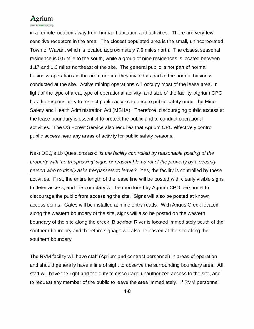
4.6 Meteorological Data Meteorological data from Soda Springs was used in the analysis. These data are
reasonably representative of the Agrium CPO Rasmussen Valley Mine site conditions.
This dataset was used in the modeling recently conducted for both the Agrium CPO
North Rasmussen Ridge and Lanes Creek mine sites. The Soda Springs
meteorological monitoring site is located approximately 27km south west of the Agrium
CPO RVM site. A 5-year dataset (2004-2008) was provided by the DEQ for use. The
data consists of the Monsanto P4 Soda Springs surface data supplemented with data

4-11
from the Pocatello airport. Upper air data were from Boise. RTP Environmental
processed the data with the current version of AERMET (version 15181). A wind rose
of the 5-year meteorological dataset is provided in Figure 5.
The AERMET meteorological processor requires estimates of the following surface
characteristics: surface roughness length, albedo, and Bowen ratio. The surface
roughness length is related to the height of obstacles to the wind flow. It is the height
above the surface where the average wind speed is zero. The smoother the surface is,
the lower the roughness length. The surface roughness length influences the surface
shear stress and is an important factor in calculating mechanical turbulence and
stability. The albedo is the fraction of the total incident solar radiation reflected by the
surface back to space without absorption. The Bowen ratio is an indicator of surface
moisture and is the ratio of the sensible heat flux to the latent heat flux.
The albedo and Bowen ratio are used for determining the planetary boundary layer
parameters for convective conditions due to the surface sensible heat flux. Estimates of
the surface characteristics were made using EPA’s AERSURFACE program (Version
13016). A 1km search radius was employed at the location of the meteorological tower.
Twelve sectors of 30 degrees each and seasonal resolution were used in the
AERSURFACE analysis.

4-12
Figure 4. Agrium CPO RVM Near-field Receptor Grid
4-13
Figure 5. Soda Springs 2004-2008 Wind Rose

4-14
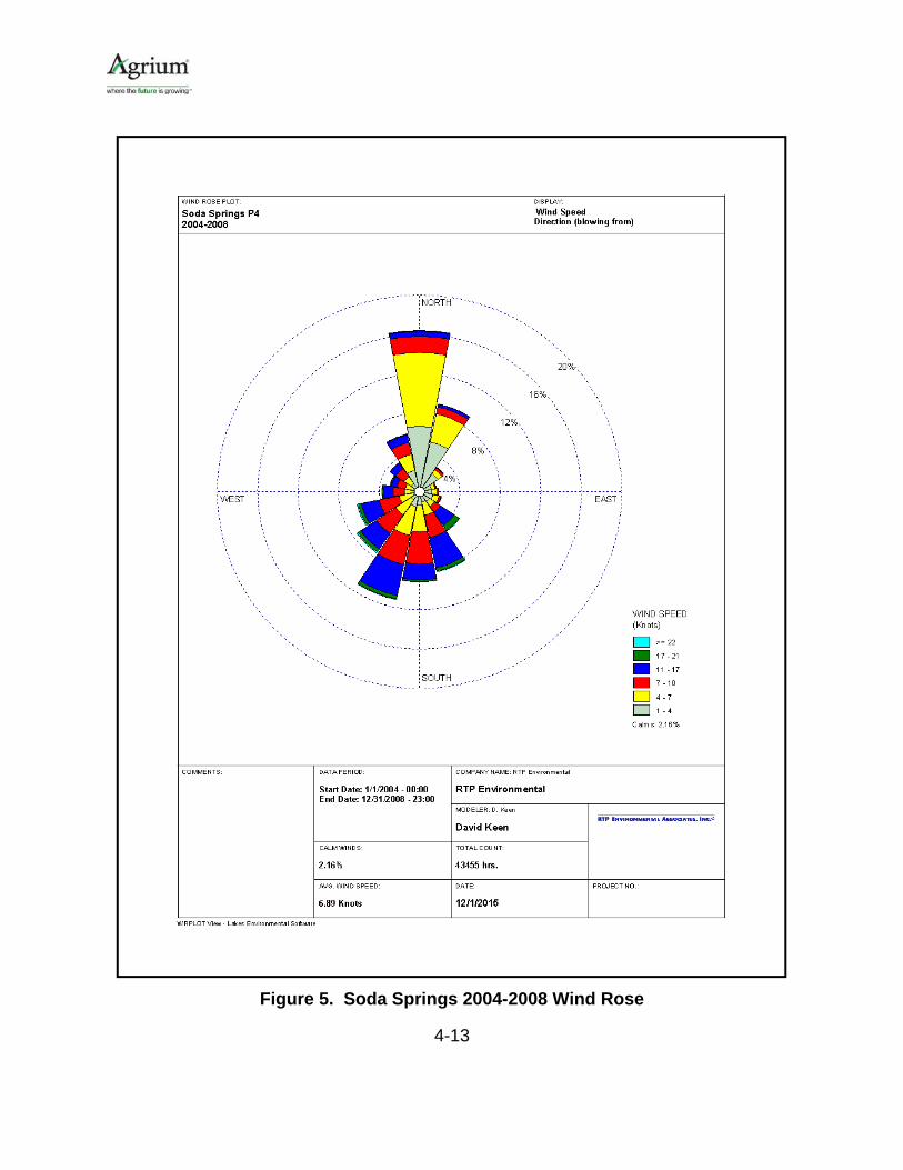
4.7 Modeling Methodology
Pollutants Subject to Review
Only the regulated NSR pollutants with total facilty emissions in excess of the DEQ's
Level I and Level II modeling thresholds and the toxic air pollutants (TAPs) in excess of
the Idaho Screening Emission Levels (ELs) were evaluated in the modeling analysis.
The potential emissions of each criteria pollutant relative to the modeling thresholds are
presented in Table 5. As can be seen, only PM10, PM2.5, and NOx emissions required
review. The potential emissions of each TAP relative to the ELs is presented in Table 6.
Several TAPs (arsenic, cadmium, and nickel) also required evaluation.
Table 5. Potential Criteria Pollutant Emissions and DEQ Modeling Thresholds
Pollutant Level I
Threshold
Level II Threshold
(case-by-case)
Agrium Total Facility
Emissions Modeling Required?
CO 15 lb/hr 175 lb/hr 7.7 lb/hr No
NOx
1.2 ton/yr and
0.20 lb/hr
14 ton/yr and
2.4 lb/hr
21.1 ton/yr and
4.8 lb/hr Yes
SO2
1.2 ton/yr and
0.21 lb/hr
14 ton/yr and
2.5 lb/hr
0.4 lb/hr and
0.1 ton/yr No
PM10 0.22 lb/hr 2.6 lb/hr 8.9 lb/hr Yes
PM2.5
0.35 ton/yr and
0.054 lb/hr
4.1 ton/yr and
0.63 lb/hr
5.0 ton/yr and
1.2 lb/hr Yes
Pb 14 lb/month 0.0 lb/month No
NAAQS Analysis
The Agrium CPO Rasmussen Valley Mine is not a major new source, and is generally
located in a rural area away from potential synergistic influences of other industry.
However, Agrium CPO also operates the Lanes Creek mine which is located
approximately one half of a mile to the east of the proposed RVM.
4-15
Table 6. Potential TAP Emissions and DEQ Modeling Thresholds
Pollutant
Level I Threshold
(lb/hr)
Agrium Total Facility
Emissions (lb/hr) Modeling Required?
Aluminum 1.33E-01 6.58E-02 No
Antimony 3.30E-02 5.29E-06 No
Arsenic 1.50E-06 4.47E-05 Yes
Beryllium 2.80E-05 4.83E-06 No
Cadmium 3.70E-06 8.38E-05 Yes
Chromium 3.30E-02 8.06E-04 No
Cobalt 3.30E-03 1.73E-04 No
Copper 6.70E-02 1.91E-04 No
Iron 6.70E-02 7.87E-02 Yes
Manganese 3.33E-01 1.88E-03 No
Mercury 2.50E+01 9.11E-05 No
Molybdenum 3.30E-01 2.68E-05 No
Nickel 2.70E-05 4.29E-04 Yes
Selenium 1.30E-02 4.58E-05 No
Silver 7.00E-03 3.79E-06 No
Tungsten 7.00E-03 8.67E-06 No
Uranium 1.30E-02 7.22E-05 No
Zirconium 3.33E-01 1.45E-03 No
Zinc 6.67E-01 2.35E-03 No
Please note that the TAPs emitted from the diesel engines that power the emergency generators and light towers are exempt from modeling review pursuant to Section 210.20 because they are subject to either NSPS or MACT standard. Therefore only TAP emissions from the mining operation were considered.
The DEQ requested that the emissions from the Lanes Creek operation be modeled in
conjunction with the RVM in assessing compliance with the NAAQS.
Monsanto’s P-4 SRM mining activity to the northeast of the proposed Agrium CPO
Rasmussen Valley Mine. The mining operation at the SRM is complete and the mine is

4-16
currently being closed down. Agrium CPO plans to fill portions of the open SRM pit with
overburden from the new mine. Emissions associated with these activities will be
accounted for and included in the Agrium CPO model; however, by the time the RVM is
operational, there will be no other emissions from the SRM. Therefore, no other
emissions from the SRM were modeled.
Therefore, in assessing NAAQS compliance, modeled impacts from the Agrium CPO
RVM and Lanes Creek were added to regional background concentrations. The
resultant total concentrations were compared to the NAAQS to determine compliance.
It should be noted that increment evaluations are not required by the IDEQ for minor
sources.
Demonstration of compliance with the 24-hour PM10 NAAQS was based on the highest
sixth high value as derived from the five year, concatenated meteorological dataset.
Compliance with the 1-hr NO2 standard was based upon the five year average of the
98th percentile (8th highest value) of the annual distribution of daily maximum 1-hour
concentrations. Compliance with the annual NO2 standard was based upon the
maximum modeled impact from each of the five individual years of meteorology.
Compliance with the 24-hr PM2.5 standard was based upon the eighth highest
concentration at each receptor as averaged over five years. Compliance with the
annual PM2.5 standard will be based upon the highest concentration at each receptor as
averaged over five years. The NAAQS are shown in Table 7.
Table 7. National Ambient Air Quality Standards
Pollutant Averaging Time
National Ambient Air Quality Standards (µg/m3)
Primary Secondary PM10 24-hour 150 150 PM2.5 24-hour 35 35
Annual 12 15 NO2 1-hour 188 --
Annual 100 100

4-17
NO2 and Secondary PM2.5 Considerations
Following USEPA guidance, the NO2 modeling analyses used the Tier 2 (Ambient Ratio
Method, or ARM) with the EPA recommended NOx to NO2 conversion factor of 0.75 for
the annual average and 0.80 for the hourly average.
In May of 2014, the EPA issued its final guidance for assessing primary and secondarily
formed fine particulate matter (PM2.5) in a National Ambient Air Quality Standard
(NAAQS) and increment compliance demonstration under Prevention of Significant
Deterioration (PSD).14 The EPA outlines four cases for assessing the primary and
secondary PM2.5 impacts. The appropriate case to use depends on the magnitude of
direct PM2.5 and precursor NO2 and SO2 emissions. Case 1 is applicable to the Agrium
CPO mine as direct PM2.5 emissions are less than 10 tons per year and NOx emissions
are less than 40 tons per year (precursor SO2 emissions are also less than 40 tons per
year). In this case, a PM2.5 compliance demonstration is not required (under federal
guidance) for either the direct PM2.5 emissions or for the precursor emissions.
Therefore, the potential for secondary PM2.5 impacts was not evaluated. Per IDEQ
guidance, however, RTP modeled the direct PM2.5 emissions using approved dispersion
techniques to assess compliance with the NAAQS.
Toxic Air Pollutant Analysis
Compliance with the applicable TAP increments of Idaho Air Rules Section 585 for non-
carcinogens (AACs) and 586 for carcinogens (AACCs) was also assessed. The
modeling procedures described above were used to calculate the maximum 24-hour
and maximum annual average values for assessing compliance with the TAP
increments.
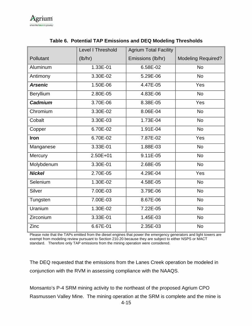
Model Scenarios and Source Groupings
The mining operation at Rasmussen Valley will occur in nine phases as shown in Figure
6. The majority of mine emissions at any point in time will occur from only one phase of
14 Guidance for PM2.5 Permit Modeling, EPA-454/B-14-001, May 2014.

4-18
the mine. To most accurately represent the potential impacts from the mine over time,
RTP modeled an initial phase (Phase 2), a middle phase (Phase 5) and one of the last
phases (Phase 8). Even though Phases 1 and 9 are closer to the modeling boundary,
these phases will not be in operation very long and will have the smallest open pits and
thus lower emissions. Phases 2 and 8 are therefore the worst-case from an air quality
perspective. The modeled sources and emissions were assumed the same for each
phase. All three phases were included in a single model run with different source
groupings for each phase. The Lanes Creek mining operations were included with each
of the RVM mine phases. The phase resulting in the highest concentrations was used
to represent the impacts from the mining operation.
In addition to the three source groupings for each of the modeled RVM mine phases, a
separate source grouping was included in the NAAQS runs for each of the RVM mine
phases that did not include the Lanes Creek mine. These source groupings were used
to evaluate NAAQS compliance in the absence of influence from Lanes Creek mine.
The following source groups were therefore included with each model run:
1. “Phase2” – RVM Phase 2 mine, including Lanes Creek mine 2. “Phase5” – RVM Phase 5 mine, including Lanes Creek mine 3. “Phase8” – RVM Phase 8 mine, including Lanes Creek mine 4. “P2_NO_LC” – RVM Phase 2 mine, excluding Lanes Creek mine 5. “P5_NO_LC” – RVM Phase 5 mine, excluding Lanes Creek mine 6. “P8_NO_LC” – RVM Phase 8 mine, excluding Lanes Creek mine
4-19
Figure 6. Mining Phases for the Rasmussen Valley Mine

4-20
4.8 Model Results
Appendix G provides the model summary input and output data, respectively.
Electronic versions AERMOD input and output files, including the BEEST graphical user
interface files, are included on the enclosed CD.
NAAQS Analysis Results
The results of the NAAQS analyses are presented in Table 8. Only the mine phase that
resulted in the worst-case impact is presented. The impacts for each of the other
phases can be found in Appendix G. The maximum combined impacts from all RVM
sources and the Lanes Creek mine are presented. A background concentration was
added to the modeled impacts in assessing compliance with the NAAQS.
As shown, the model indicates potential NAAQS exceedances for the 1-hr NO2 and 24-
hr PM10 standards. However, these modeled exceedances are due to emissions from
the Lanes Creek mine and the exceedances only occur within the confines of the Lanes
Creek mine (Figures 7 and 8). Since the Lanes Creek mine cannot impact the area
within its own boundary, the exceedances do not occur in ambient air. In addition, when
emissions from the Lanes Creek facility are not included in the modeled concentrations,
and only emissions from RVM are considered, compliance is demonstrated.
Toxic Air Pollutant Analysis Results
The results of the toxic air pollutant (TAP) analyses are presented in Table 9. The
maximum combined impacts from all Agrium CPO sources are presented. As shown,
the impacts are below the TAP increments of Idaho Air Rules Section 585 for non-
carcinogens (AACs) and 586 for carcinogens (AACCs).

4-21
Table 8. NAAQS Analysis Results
Pollutant Averaging
Period
Modeled Concentration
(µg/m3)
Background Concentration
(µg/m3)a
Total Concentration
(µg/m3) Standard% of
Standard
PM10 24-hr 162.0 34.0 196.0 150.0 131b
105.8 34.0 139.8 150.0 93c
PM2.5 24-hr 16.3 6.5 22.8 35.0 65
Annual 8.0 1.8 9.8 12.0 82
NO2d
1-hr 398.6 17.2 415.8 188.0 221b
63.5 17.2 80.7 188.0 43c
Annual 34.6 1.5 36.1 100.00 36
Notes: a All background concentrations provided by DEQ. b Agrium Lanes Creek mine included. Modeled exceedances are due to emissions from Lanes Creek mine. All exceedances occur within Lanes Creek ambient boundary which is not considered as ambient air for RVM. c Emissions from Lanes Creek mine not included. d ARM of 0.75 applied to annual NOx modeled impact and ARM of 0.80 applied to 1-hr NOx impact.

4-22
Figure 7. Receptors with Modeled Concentrations in Excess of 1-hr NO2 NAAQS

4-23
Figure 8. Receptors with Modeled Concentrations in Excess of 24-hr PM10 NAAQS

4-24
Table 9. Toxic Air Pollutant Analysis Results
Toxic Air Pollutant
Averaging Period
Maximum Modeled
Concentration (µg/m3)
Acceptable Ambient
Concentration (µg/m3) % Standard
Arsenic Annual 1.40E-04 2.3.E-04 61%
Cadmium Annual 3.10E-04 5.6.E-04 55%
Iron Annual 1.24E-00 5.0.E+01 2%
Nickel Annual 1.34E-03 4.2.E-03 32%
Note: Phase 2 was found to result in the highest modeled concentration.
4.9 Summary and Conclusions
Emissions of regulated pollutants were evaluated in a dispersion modeling analysis.
The modeling demonstrates that the ground level concentrations of each pollutant are
below the levels designed to protect human health and welfare. The modeling input
and output files and results are provided on the attached CD as Appendix G. The
summary results list the model file names associated with each phase of the
analysis.15
15 As a general rule, the AERMOD input files have a “dta” extension. The AERMOD output files have a “lst” extension.

APPENDICES
Appendix A - PTC Permit Application Forms Appendix B - Anticipated Construction Schedule Appendix C - Dust Control Plan Appendix D - Emission Calculations (Provided on CD) Appendix E - Diesel Generator Data Sheets & Information Appendix F - EPA Non-Road Engine Emission Limits Applicable to RVM Appendix G - Air Quality Dispersion Modeling (Modeling Files Provided on CD)

Appendix A
PTC Permit Application Forms

Page 1
DEQ AIR QUALITY PROGRAM 1410 N. Hilton, Boise, ID 83706 For assistance, call the Air Permit Hotline – 1-877-5PERMIT
Cover Sheet for Air Permit Application – Permit to Construct Form CSPTC
Please see instructions on page 2 before filling out the form.
COMPANY NAME, FACILITY NAME, AND FACILITY ID NUMBER
1. Company Name Nu West Industries, Inc. dba Agrium
2. Facility Name Rasmussen Valley Mine 3. Facility ID No. TBD
4. Brief Project Description - One sentence or less
Phosphate Mining
PERMIT APPLICATION TYPE 5. New Source New Source at Existing Facility PTC for a Tier I Source Processed Pursuant to IDAPA 58.01.01.209.05.c
Unpermitted Existing Source Facility Emissions Cap Modify Existing Source: Permit No.: Date Issued:
Required by Enforcement Action: Case No.:
6. Minor PTC Major PTC
FORMS INCLUDED
Included N/A Forms DEQ
Verify
Form CSPTC – Cover Sheet
Form GI – Facility Information
Form EU0 – Emissions Units General
Form EU1– Industrial Engine Information Please specify number of EU1s attached: 12
Form EU2– Nonmetallic Mineral Processing Plants Please specify number of EU2s attached:
Form EU3– Spray Paint Booth Information Please specify number of EU3s attached:
Form EU4– Cooling Tower Information Please specify number of EU3s attached:
Form EU5 – Boiler Information Please specify number of EU4s attached:
Form CBP– Concrete Batch Plant Please specify number of CBPs attached:
Form HMAP – Hot Mix Asphalt Plant Please specify number of HMAPs attached:
PERF – Portable Equipment Relocation Form
Form AO – Afterburner/Oxidizer
Form CA – Carbon Adsorber
Form CYS – Cyclone Separator
Form ESP – Electrostatic Precipitator
Form BCE– Baghouses Control Equipment
Form SCE– Scrubbers Control Equipment
Form VSCE – Venturi Scrubber Control Equipment
Form CAM – Compliance Assurance Monitoring
Forms EI-– Emissions Inventory (see Table 1 of application and Appendix D Tabs “PTE Tables” and “PTE Metal TAPs”)
PP – Plot Plan
Forms MI1 – MI4 – Modeling Information in modeling file CD (Appendix G of application)
Form FRA – Federal Regulation Applicability


Page 1
DEQ AIR QUALITY PROGRAM 1410 N. Hilton, Boise, ID 83706 For assistance, call the Air Permit Hotline – 1-877-5PERMIT
Emissions Units - Industrial Engine Information Form EU1 Revision 8
1/15/10
Please see instructions on page 2 before filling out the form.
IDENTIFICATION
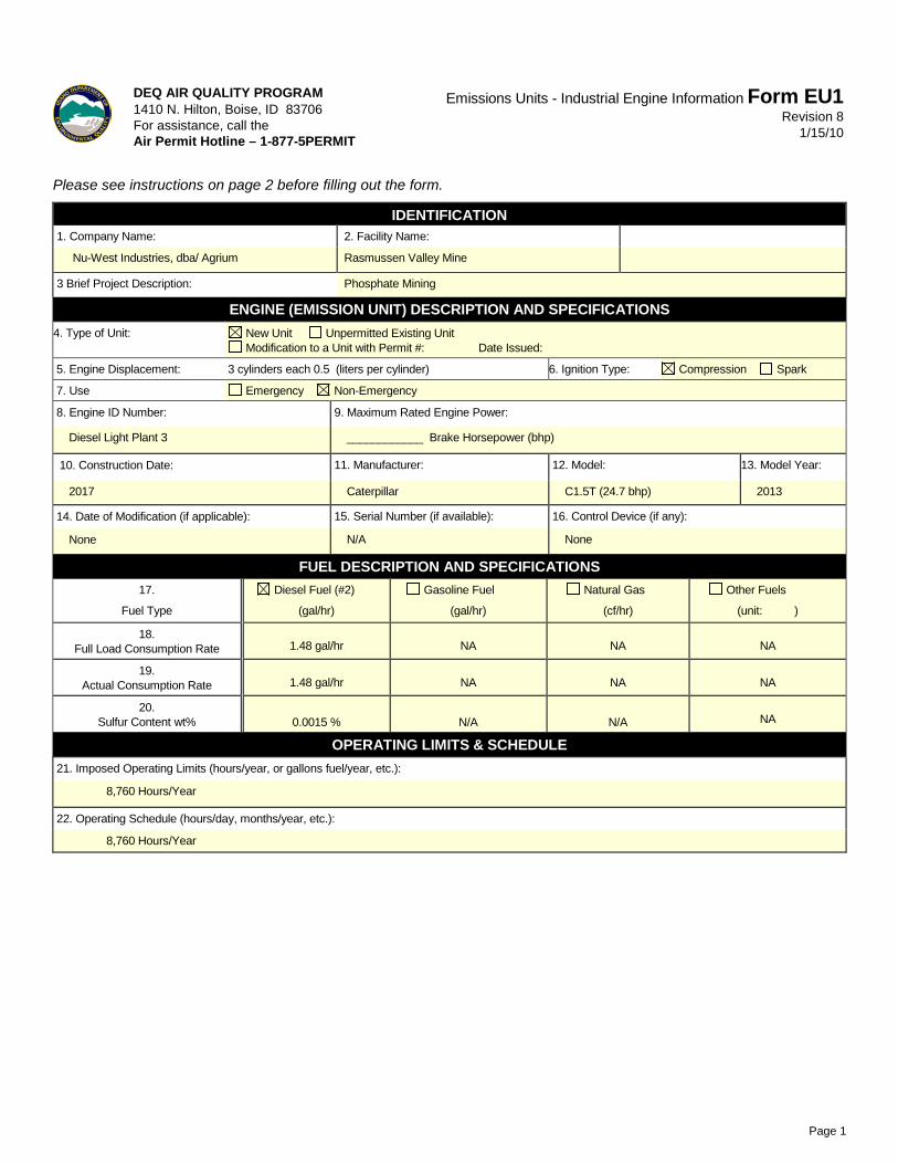
1. Company Name: 2. Facility Name:
Nu-West Industries, dba/ Agrium Rasmussen Valley Mine
3 Brief Project Description: Phosphate Mining
ENGINE (EMISSION UNIT) DESCRIPTION AND SPECIFICATIONS
4. Type of Unit: New Unit Unpermitted Existing Unit Modification to a Unit with Permit #: Date Issued:
5. Engine Displacement: 4 cylinders each 1.13 (liters per cylinder) 6. Ignition Type: Compression Spark
7. Use Emergency Non-Emergency
8. Engine ID Number:
9. Maximum Rated Engine Power:
Ready Line Generator ____________ Brake Horsepower (bhp)
10. Construction Date:
11. Manufacturer: 12. Model: 13. Model Year:
2017 John Deer
4045HFG92 (107 bhp) 2012
14. Date of Modification (if applicable): 15. Serial Number (if available): 16. Control Device (if any):
None N/A None
FUEL DESCRIPTION AND SPECIFICATIONS
17.
Fuel Type
Diesel Fuel (#2)
(gal/hr)
Gasoline Fuel
(gal/hr)
Natural Gas
(cf/hr)
Other Fuels
(unit: )
18. Full Load Consumption Rate
4.3 gal/hr
NA
NA
NA
19. Actual Consumption Rate
4.3 gal/hr
NA
NA
NA
20. Sulfur Content wt%
0.0015 % N/A N/A
NA
OPERATING LIMITS & SCHEDULE
21. Imposed Operating Limits (hours/year, or gallons fuel/year, etc.):
8,760 Hours/Year
22. Operating Schedule (hours/day, months/year, etc.):
8,760 Hours/Year

Page 1
DEQ AIR QUALITY PROGRAM 1410 N. Hilton, Boise, ID 83706 For assistance, call the Air Permit Hotline – 1-877-5PERMIT
Emissions Units - Industrial Engine Information Form EU1 Revision 8
1/15/10
Please see instructions on page 2 before filling out the form.
IDENTIFICATION
1. Company Name: 2. Facility Name:
Nu-West Industries, dba/ Agrium Rasmussen Valley Mine
3 Brief Project Description: Phosphate Mining
ENGINE (EMISSION UNIT) DESCRIPTION AND SPECIFICATIONS
4. Type of Unit: New Unit Unpermitted Existing Unit Modification to a Unit with Permit #:P-2013.0046 Date Issued: 2015
5. Engine Displacement: 4 cylinders each 1.13 (liters per cylinder) 6. Ignition Type: Compression Spark
7. Use Emergency Non-Emergency
8. Engine ID Number:
9. Maximum Rated Engine Power:
Well Pump 1 ____________ Brake Horsepower (bhp)
10. Construction Date:
11. Manufacturer: 12. Model: 13. Model Year:
Existing- installed 2015 John Deer
4045HF285 (113 bhp) 2012
14. Date of Modification (if applicable): 15. Serial Number (if available): 16. Control Device (if any):
None N/A None
FUEL DESCRIPTION AND SPECIFICATIONS
17.
Fuel Type
Diesel Fuel (#2)
(gal/hr)
Gasoline Fuel
(gal/hr)
Natural Gas
(cf/hr)
Other Fuels
(unit: )
18. Full Load Consumption Rate
5.3 gal/hr
NA
NA
NA
19. Actual Consumption Rate
5.3 gal/hr
NA
NA
NA
20. Sulfur Content wt%
0.0015 % N/A N/A
NA
OPERATING LIMITS & SCHEDULE
21. Imposed Operating Limits (hours/year, or gallons fuel/year, etc.):
8,760 Hours/Year
22. Operating Schedule (hours/day, months/year, etc.):
8,760 Hours/Year

Page 1
DEQ AIR QUALITY PROGRAM 1410 N. Hilton, Boise, ID 83706 For assistance, call the Air Permit Hotline – 1-877-5PERMIT
Emissions Units - Industrial Engine Information Form EU1 Revision 8
1/15/10
Please see instructions on page 2 before filling out the form.
IDENTIFICATION
1. Company Name: 2. Facility Name:
Nu-West Industries, dba/ Agrium Rasmussen Valley Mine
3 Brief Project Description: Phosphate Mining
ENGINE (EMISSION UNIT) DESCRIPTION AND SPECIFICATIONS
4. Type of Unit: New Unit Unpermitted Existing Unit Modification to a Unit with Permit #: Date Issued:
5. Engine Displacement: 4 cylinders each 0.54 (liters per cylinder) 6. Ignition Type: Compression Spark
7. Use Emergency Non-Emergency
8. Engine ID Number:
9. Maximum Rated Engine Power:
Well Pump 2 ____________ Brake Horsepower (bhp)
10. Construction Date:
11. Manufacturer: 12. Model: 13. Model Year:
2017 Isuzu
4LE2X (65.7 bhp) 2013
14. Date of Modification (if applicable): 15. Serial Number (if available): 16. Control Device (if any):
None N/A None
FUEL DESCRIPTION AND SPECIFICATIONS
17.
Fuel Type
Diesel Fuel (#2)
(gal/hr)
Gasoline Fuel
(gal/hr)
Natural Gas
(cf/hr)
Other Fuels
(unit: )
18. Full Load Consumption Rate
2.93 gal/hr
NA
NA
NA
19. Actual Consumption Rate
2.93 gal/hr
NA
NA
NA
20. Sulfur Content wt%
0.0015 % N/A N/A
NA
OPERATING LIMITS & SCHEDULE
21. Imposed Operating Limits (hours/year, or gallons fuel/year, etc.):
8,760 Hours/Year
22. Operating Schedule (hours/day, months/year, etc.):
8,760 Hours/Year

Page 1
DEQ AIR QUALITY PROGRAM 1410 N. Hilton, Boise, ID 83706 For assistance, call the Air Permit Hotline – 1-877-5PERMIT
Emissions Units - Industrial Engine Information Form EU1 Revision 8
1/15/10
Please see instructions on page 2 before filling out the form.
IDENTIFICATION
1. Company Name: 2. Facility Name:
Nu-West Industries, dba/ Agrium Rasmussen Valley Mine
3 Brief Project Description: Phosphate Mining
ENGINE (EMISSION UNIT) DESCRIPTION AND SPECIFICATIONS
4. Type of Unit: New Unit Unpermitted Existing Unit Modification to a Unit with Permit #: Date Issued:
5. Engine Displacement: 3 cylinders each 0.5 (liters per cylinder) 6. Ignition Type: Compression Spark
7. Use Emergency Non-Emergency
8. Engine ID Number:
9. Maximum Rated Engine Power:
Diesel Light Plant 1 ____________ Brake Horsepower (bhp)
10. Construction Date:
11. Manufacturer: 12. Model: 13. Model Year:
2017 Caterpillar
C1.5T (24.7 bhp) 2013
14. Date of Modification (if applicable): 15. Serial Number (if available): 16. Control Device (if any):
None N/A None
FUEL DESCRIPTION AND SPECIFICATIONS
17.
Fuel Type
Diesel Fuel (#2)
(gal/hr)
Gasoline Fuel
(gal/hr)
Natural Gas
(cf/hr)
Other Fuels
(unit: )
18. Full Load Consumption Rate
1.48 gal/hr
NA
NA
NA
19. Actual Consumption Rate
1.48 gal/hr
NA
NA
NA
20. Sulfur Content wt%
0.0015 % N/A N/A
NA
OPERATING LIMITS & SCHEDULE
21. Imposed Operating Limits (hours/year, or gallons fuel/year, etc.):
8,760 Hours/Year
22. Operating Schedule (hours/day, months/year, etc.):
8,760 Hours/Year

Page 1
DEQ AIR QUALITY PROGRAM 1410 N. Hilton, Boise, ID 83706 For assistance, call the Air Permit Hotline – 1-877-5PERMIT
Emissions Units - Industrial Engine Information Form EU1 Revision 8
1/15/10
Please see instructions on page 2 before filling out the form.
IDENTIFICATION
1. Company Name: 2. Facility Name:
Nu-West Industries, dba/ Agrium Rasmussen Valley Mine
3 Brief Project Description: Phosphate Mining
ENGINE (EMISSION UNIT) DESCRIPTION AND SPECIFICATIONS
4. Type of Unit: New Unit Unpermitted Existing Unit Modification to a Unit with Permit #: Date Issued:
5. Engine Displacement: 3 cylinders each 0.5 (liters per cylinder) 6. Ignition Type: Compression Spark
7. Use Emergency Non-Emergency
8. Engine ID Number:
9. Maximum Rated Engine Power:
Diesel Light Plant 2 ____________ Brake Horsepower (bhp)
10. Construction Date:
11. Manufacturer: 12. Model: 13. Model Year:
2017 Caterpillar
C1.5T (24.7 bhp) 2013
14. Date of Modification (if applicable): 15. Serial Number (if available): 16. Control Device (if any):
None N/A None
FUEL DESCRIPTION AND SPECIFICATIONS
17.
Fuel Type
Diesel Fuel (#2)
(gal/hr)
Gasoline Fuel
(gal/hr)
Natural Gas
(cf/hr)
Other Fuels
(unit: )
18. Full Load Consumption Rate
1.48 gal/hr
NA
NA
NA
19. Actual Consumption Rate
1.48 gal/hr
NA
NA
NA
20. Sulfur Content wt%
0.0015 % N/A N/A
NA
OPERATING LIMITS & SCHEDULE
21. Imposed Operating Limits (hours/year, or gallons fuel/year, etc.):
8,760 Hours/Year
22. Operating Schedule (hours/day, months/year, etc.):
8,760 Hours/Year
Page 1
DEQ AIR QUALITY PROGRAM 1410 N. Hilton, Boise, ID 83706 For assistance, call the Air Permit Hotline – 1-877-5PERMIT
Emissions Units - Industrial Engine Information Form EU1 Revision 8
1/15/10
Please see instructions on page 2 before filling out the form.
IDENTIFICATION
1. Company Name: 2. Facility Name:
Nu-West Industries, dba/ Agrium Rasmussen Valley Mine
3 Brief Project Description: Phosphate Mining
ENGINE (EMISSION UNIT) DESCRIPTION AND SPECIFICATIONS
4. Type of Unit: New Unit Unpermitted Existing Unit Modification to a Unit with Permit #: Date Issued:
5. Engine Displacement: 3 cylinders each 0.5 (liters per cylinder) 6. Ignition Type: Compression Spark
7. Use Emergency Non-Emergency
8. Engine ID Number:
9. Maximum Rated Engine Power:
Diesel Light Plant 3 ____________ Brake Horsepower (bhp)
10. Construction Date:
11. Manufacturer: 12. Model: 13. Model Year:
2017 Caterpillar
C1.5T (24.7 bhp) 2013
14. Date of Modification (if applicable): 15. Serial Number (if available): 16. Control Device (if any):
None N/A None
FUEL DESCRIPTION AND SPECIFICATIONS
17.
Fuel Type
Diesel Fuel (#2)
(gal/hr)
Gasoline Fuel
(gal/hr)
Natural Gas
(cf/hr)
Other Fuels
(unit: )
18. Full Load Consumption Rate
1.48 gal/hr
NA
NA
NA
19. Actual Consumption Rate
1.48 gal/hr
NA
NA
NA
20. Sulfur Content wt%
0.0015 % N/A N/A
NA
OPERATING LIMITS & SCHEDULE
21. Imposed Operating Limits (hours/year, or gallons fuel/year, etc.):
8,760 Hours/Year
22. Operating Schedule (hours/day, months/year, etc.):
8,760 Hours/Year

Page 1
DEQ AIR QUALITY PROGRAM 1410 N. Hilton, Boise, ID 83706 For assistance, call the Air Permit Hotline – 1-877-5PERMIT
Emissions Units - Industrial Engine Information Form EU1 Revision 8
1/15/10
Please see instructions on page 2 before filling out the form.
IDENTIFICATION
1. Company Name: 2. Facility Name:
Nu-West Industries, dba/ Agrium Rasmussen Valley Mine
3 Brief Project Description: Phosphate Mining
ENGINE (EMISSION UNIT) DESCRIPTION AND SPECIFICATIONS
4. Type of Unit: New Unit Unpermitted Existing Unit Modification to a Unit with Permit #: Date Issued:
5. Engine Displacement: 3 cylinders each 0.5 (liters per cylinder) 6. Ignition Type: Compression Spark
7. Use Emergency Non-Emergency
8. Engine ID Number:
9. Maximum Rated Engine Power:
Diesel Light Plant 4 ____________ Brake Horsepower (bhp)
10. Construction Date:
11. Manufacturer: 12. Model: 13. Model Year:
2017 Caterpillar
C1.5T (24.7 bhp) 2013
14. Date of Modification (if applicable): 15. Serial Number (if available): 16. Control Device (if any):
None N/A None
FUEL DESCRIPTION AND SPECIFICATIONS
17.
Fuel Type
Diesel Fuel (#2)
(gal/hr)
Gasoline Fuel
(gal/hr)
Natural Gas
(cf/hr)
Other Fuels
(unit: )
18. Full Load Consumption Rate
1.48 gal/hr
NA
NA
NA
19. Actual Consumption Rate
1.48 gal/hr
NA
NA
NA
20. Sulfur Content wt%
0.0015 % N/A N/A
NA
OPERATING LIMITS & SCHEDULE
21. Imposed Operating Limits (hours/year, or gallons fuel/year, etc.):
8,760 Hours/Year
22. Operating Schedule (hours/day, months/year, etc.):
8,760 Hours/Year

Page 1
DEQ AIR QUALITY PROGRAM 1410 N. Hilton, Boise, ID 83706 For assistance, call the Air Permit Hotline – 1-877-5PERMIT
Emissions Units - Industrial Engine Information Form EU1 Revision 8
1/15/10
Please see instructions on page 2 before filling out the form.
IDENTIFICATION
1. Company Name: 2. Facility Name:
Nu-West Industries, dba/ Agrium Rasmussen Valley Mine
3 Brief Project Description: Phosphate Mining
ENGINE (EMISSION UNIT) DESCRIPTION AND SPECIFICATIONS
4. Type of Unit: New Unit Unpermitted Existing Unit Modification to a Unit with Permit #: Date Issued:
5. Engine Displacement: 3 cylinders each 0.5 (liters per cylinder) 6. Ignition Type: Compression Spark
7. Use Emergency Non-Emergency
8. Engine ID Number:
9. Maximum Rated Engine Power:
Diesel Light Plant 5 ____________ Brake Horsepower (bhp)
10. Construction Date:
11. Manufacturer: 12. Model: 13. Model Year:
2017 Caterpillar
C1.5T (24.7 bhp) 2013
14. Date of Modification (if applicable): 15. Serial Number (if available): 16. Control Device (if any):
None N/A None
FUEL DESCRIPTION AND SPECIFICATIONS
17.
Fuel Type
Diesel Fuel (#2)
(gal/hr)
Gasoline Fuel
(gal/hr)
Natural Gas
(cf/hr)
Other Fuels
(unit: )
18. Full Load Consumption Rate
1.48 gal/hr
NA
NA
NA
19. Actual Consumption Rate
1.48 gal/hr
NA
NA
NA
20. Sulfur Content wt%
0.0015 % N/A N/A
NA
OPERATING LIMITS & SCHEDULE
21. Imposed Operating Limits (hours/year, or gallons fuel/year, etc.):
8,760 Hours/Year
22. Operating Schedule (hours/day, months/year, etc.):
8,760 Hours/Year

Page 1
DEQ AIR QUALITY PROGRAM 1410 N. Hilton, Boise, ID 83706 For assistance, call the Air Permit Hotline – 1-877-5PERMIT
Emissions Units - Industrial Engine Information Form EU1 Revision 8
1/15/10
Please see instructions on page 2 before filling out the form.
IDENTIFICATION
1. Company Name: 2. Facility Name:
Nu-West Industries, dba/ Agrium Rasmussen Valley Mine
3 Brief Project Description: Phosphate Mining
ENGINE (EMISSION UNIT) DESCRIPTION AND SPECIFICATIONS
4. Type of Unit: New Unit Unpermitted Existing Unit Modification to a Unit with Permit #: Date Issued:
5. Engine Displacement: 3 cylinders each 0.5 (liters per cylinder) 6. Ignition Type: Compression Spark
7. Use Emergency Non-Emergency
8. Engine ID Number:
9. Maximum Rated Engine Power:
Diesel Light Plant 6 ____________ Brake Horsepower (bhp)
10. Construction Date:
11. Manufacturer: 12. Model: 13. Model Year:
2017 Caterpillar
C1.5T (24.7 bhp) 2013
14. Date of Modification (if applicable): 15. Serial Number (if available): 16. Control Device (if any):
None N/A None
FUEL DESCRIPTION AND SPECIFICATIONS
17.
Fuel Type
Diesel Fuel (#2)
(gal/hr)
Gasoline Fuel
(gal/hr)
Natural Gas
(cf/hr)
Other Fuels
(unit: )
18. Full Load Consumption Rate
1.48 gal/hr
NA
NA
NA
19. Actual Consumption Rate
1.48 gal/hr
NA
NA
NA
20. Sulfur Content wt%
0.0015 % N/A N/A
NA
OPERATING LIMITS & SCHEDULE
21. Imposed Operating Limits (hours/year, or gallons fuel/year, etc.):
8,760 Hours/Year
22. Operating Schedule (hours/day, months/year, etc.):
8,760 Hours/Year

Page 1
DEQ AIR QUALITY PROGRAM 1410 N. Hilton, Boise, ID 83706 For assistance, call the Air Permit Hotline – 1-877-5PERMIT
Emissions Units - Industrial Engine Information Form EU1 Revision 8
1/15/10
Please see instructions on page 2 before filling out the form.
IDENTIFICATION
1. Company Name: 2. Facility Name:
Nu-West Industries, dba/ Agrium Rasmussen Valley Mine
3 Brief Project Description: Phosphate Mining
ENGINE (EMISSION UNIT) DESCRIPTION AND SPECIFICATIONS
4. Type of Unit: New Unit Unpermitted Existing Unit Modification to a Unit with Permit #: Date Issued:
5. Engine Displacement: 3 cylinders each 0.5 (liters per cylinder) 6. Ignition Type: Compression Spark
7. Use Emergency Non-Emergency
8. Engine ID Number:
9. Maximum Rated Engine Power:
Diesel Light Plant 7 ____________ Brake Horsepower (bhp)
10. Construction Date:
11. Manufacturer: 12. Model: 13. Model Year:
2017 Caterpillar
C1.5T (24.7 bhp) 2013
14. Date of Modification (if applicable): 15. Serial Number (if available): 16. Control Device (if any):
None N/A None
FUEL DESCRIPTION AND SPECIFICATIONS
17.
Fuel Type
Diesel Fuel (#2)
(gal/hr)
Gasoline Fuel
(gal/hr)
Natural Gas
(cf/hr)
Other Fuels
(unit: )
18. Full Load Consumption Rate
1.48 gal/hr
NA
NA
NA
19. Actual Consumption Rate
1.48 gal/hr
NA
NA
NA
20. Sulfur Content wt%
0.0015 % N/A N/A
NA
OPERATING LIMITS & SCHEDULE
21. Imposed Operating Limits (hours/year, or gallons fuel/year, etc.):
8,760 Hours/Year
22. Operating Schedule (hours/day, months/year, etc.):
8,760 Hours/Year

Page 1
DEQ AIR QUALITY PROGRAM 1410 N. Hilton, Boise, ID 83706 For assistance, call the Air Permit Hotline – 1-877-5PERMIT
Emissions Units - Industrial Engine Information Form EU1 Revision 8
1/15/10
Please see instructions on page 2 before filling out the form.
IDENTIFICATION
1. Company Name: 2. Facility Name:
Nu-West Industries, dba/ Agrium Rasmussen Valley Mine
3 Brief Project Description: Phosphate Mining
ENGINE (EMISSION UNIT) DESCRIPTION AND SPECIFICATIONS
4. Type of Unit: New Unit Unpermitted Existing Unit Modification to a Unit with Permit #: Date Issued:
5. Engine Displacement: 3 cylinders each 0.5 (liters per cylinder) 6. Ignition Type: Compression Spark
7. Use Emergency Non-Emergency
8. Engine ID Number:
9. Maximum Rated Engine Power:
Diesel Light Plant 8 ____________ Brake Horsepower (bhp)
10. Construction Date:
11. Manufacturer: 12. Model: 13. Model Year:
2017 Caterpillar
C1.5T (24.7 bhp) 2013
14. Date of Modification (if applicable): 15. Serial Number (if available): 16. Control Device (if any):
None N/A None
FUEL DESCRIPTION AND SPECIFICATIONS
17.
Fuel Type
Diesel Fuel (#2)
(gal/hr)
Gasoline Fuel
(gal/hr)
Natural Gas
(cf/hr)
Other Fuels
(unit: )
18. Full Load Consumption Rate
1.48 gal/hr
NA
NA
NA
19. Actual Consumption Rate
1.48 gal/hr
NA
NA
NA
20. Sulfur Content wt%
0.0015 % N/A N/A
NA
OPERATING LIMITS & SCHEDULE
21. Imposed Operating Limits (hours/year, or gallons fuel/year, etc.):
8,760 Hours/Year
22. Operating Schedule (hours/day, months/year, etc.):
8,760 Hours/Year

Page 1
DEQ AIR QUALITY PROGRAM 1410 N. Hilton, Boise, ID 83706 For assistance, call the Air Permit Hotline – 1-877-5PERMIT
Emissions Units - Industrial Engine Information Form EU1 Revision 8
1/15/10
Please see instructions on page 2 before filling out the form.
IDENTIFICATION
1. Company Name: 2. Facility Name:
Nu-West Industries, dba/ Agrium Rasmussen Valley Mine
3 Brief Project Description: Phosphate Mining
ENGINE (EMISSION UNIT) DESCRIPTION AND SPECIFICATIONS
4. Type of Unit: New Unit Unpermitted Existing Unit Modification to a Unit with Permit #: Date Issued:
5. Engine Displacement: 3 cylinders each 0.5 (liters per cylinder) 6. Ignition Type: Compression Spark
7. Use Emergency Non-Emergency
8. Engine ID Number:
9. Maximum Rated Engine Power:
Diesel Light Plant 9 ____________ Brake Horsepower (bhp)
10. Construction Date:
11. Manufacturer: 12. Model: 13. Model Year:
2017 Caterpillar
C1.5T (24.7 bhp) 2013
14. Date of Modification (if applicable): 15. Serial Number (if available): 16. Control Device (if any):
None N/A None
FUEL DESCRIPTION AND SPECIFICATIONS
17.
Fuel Type
Diesel Fuel (#2)
(gal/hr)
Gasoline Fuel
(gal/hr)
Natural Gas
(cf/hr)
Other Fuels
(unit: )
18. Full Load Consumption Rate
1.48 gal/hr
NA
NA
NA
19. Actual Consumption Rate
1.48 gal/hr
NA
NA
NA
20. Sulfur Content wt%
0.0015 % N/A N/A
NA
OPERATING LIMITS & SCHEDULE
21. Imposed Operating Limits (hours/year, or gallons fuel/year, etc.):
8,760 Hours/Year
22. Operating Schedule (hours/day, months/year, etc.):
8,760 Hours/Year

NSPS/NESHAP Regulation Review and Applicability Form FRA
Page 1
DEQ AIR QUALITY PROGRAM 1410 N. Hilton, Boise, ID 83706 For assistance, call the Air Permit Hotline – 1-877-5PERMIT
AIR PERMIT APPLICATION Revision 6
10/7/09 For each box in the table below, CTRL+click on the blue underlined text for instructions and information.
IDENTIFICATION
1. Company Name: 2. Facility Name:
Nu-West Industries dba Agrium Rasmussen Valley Mine.
3. Brief Project Description: Phosphate Mining
APPLICABILITY DETERMINATION
4. List applicable subparts of the New Source Performance Standards (NSPS) (40 CFR part 60).
Examples of NSPS affected emissions units include internal combustion engines, boilers, turbines, etc. The applicant must thoroughly review the list of affected emissions units.
List of applicable subpart(s): 40 CFR Part 60 Subpart IIII
Not Applicable
5. List applicable subpart(s) of the National Emission Standards for Hazardous Air Pollutants (NESHAP) found in 40 CFR part 61 and 40 CFR part 63.
Examples of affected emission units include solvent cleaning operations, industrial cooling towers, paint stripping and miscellaneous surface coating. EPA has a web page dedicated to NESHAP that should be useful to applicants.
List of applicable subpart(s): 40 CFR Part 63 Subpart ZZZZ – Must comply with the requirements of 40 CFR Part 60 Subpart IIII
Not Applicable
6. For each subpart identified above, conduct a complete a regulatory analysis using the instructions and referencing the example provided on the following pages.
Note - Regulatory reviews must be submitted with sufficient detail so that DEQ can verify applicability and document in legal terms why the regulation applies. Regulatory reviews that are submitted with insufficient detail will be determined incomplete.
A detailed regulatory review is provided (Follow instructions and example).
DEQ has already been provided a detailed regulatory review. Give a reference to the document including the date.
IF YOU ARE UNSURE HOW TO ANSWER ANY OF THESE QUESTIONS, CALL THE AIR PERMIT HOTLINE AT 1-877-5PERMIT
It is emphasized that it is the applicant’s responsibility to satisfy all technical and regulatory requirements, and that DEQ will help the applicant understand what those requirements are prior to the application being submitted but that DEQ will not perform the required technical or regulatory analysis on the applicant’s behalf.

Regulatory Analysis
Summary
The diesel engines at the Rasmussen Valley Mine (RVM) must comply with 40 CFR Part 63 Subpart ZZZZ. Subpart ZZZZ requires meeting 40 CFR Part 60, Subpart IIII requirements. RVM will have 9 diesel light plants rated at 24.7 hp each, diesel well water pump 1 rated at 113 hp, diesel well water pump 2 rated at 65.7 hp, and diesel ready line generator rated at 107 hp. Installation date for well water pump 1 was 2015, and installation date for all other engines will be 2017. These diesel fuel burning engines are considered non-road engines. Agrium must purchase engines that are certified by the manufacturer to comply with Subpart IIII requirements. The facility must operate and maintain the engines according to the manufacturer's written instructions or procedures developed by the owner or operator that are approved by the engine manufacturer, over the entire life of the engine. The facility must use ultra-low sulfur content diesel fuel (15 ppm maximum sulfur content or 0.0015% by weight). If the engines are equipped with a diesel particulate filter to comply with the emission standards, the diesel particulate filter must be installed with a backpressure monitor that notifies the owner or operator when the high backpressure limit of the engine is approached.
Applicable Emission Standards for the Diesel Engines at RVM
Tier 3 & 4 Emission Standards—Engines, g/kWh (g/bhp-hr)
Engine Power Engine (hp) CO NMHC NMHC+ NOx
NOx PM
TIER 3 75 ≤ kW < 130 (100 ≤ hp < 175)
Well Water Pump 1 (113) 5.0 (3.7) - 4.0 (3.0) - 0.3 (0.22)
TIER 4 8 ≤ kW < 19 (11 ≤ hp < 25)
Light plants (24.7)
6.6 (4.9) - 7.5 (5.6) - 0.4 (0.3)
37 ≤ kW < 56 (50 ≤ hp < 75)
Well Water Pump 2 (65.7)
5.0 (3.7) - 4.7 (3.5) - 0.03 (0.022)
56 ≤ kW < 130 (75 ≤ hp < 175)
Ready Line Generator (107)
5.0 (3.7) 0.19 (0.14)
- 0.40 (0.30)
0.02 (0.015)

Regulatory Background § 60.4200 Am I subject to this subpart? Installation date for all engines is 2015 or later. Therefore, according to § 60.4200, engines at RVM are subject to 40 CFR Part 60, Subpart IIII. For the purposes of this subpart, the date that construction commences is the date the engine is ordered by the owner or operator. According to § 60.4200 (a)(4) The provisions of § 60.4208 of this subpart are applicable to all owners and operators of stationary CI ICE that commence construction after July 11, 2005. § 60.4204 Emission Standards for Owners and Operators According to 40 CFR §60.4204(b) Owners and operators of 2007 model year and later non-emergency stationary CI ICE with a displacement of less than 30 liters per cylinder must comply with the emission standards for new CI engines in § 60.4201which is certification by manufacturer of the engines that the engines comply with requirements of this subpart.
§ 60.4206 How long must I meet the emission standards if I am an owner or operator of a stationary CI internal combustion engine? Owners and operators of stationary CI ICE must operate and maintain stationary CI ICE that achieve the emission standards as required in §§ 60.4204 according to the manufacturer's written instructions or procedures developed by the owner or operator that are approved by the engine manufacturer, over the entire life of the engine.
§ 60.4207 What fuel requirements must I meet if I am an owner or operator of a stationary CI internal combustion engine subject to this subpart? In accordance with § 60.4207 (b), beginning October 1, 2010, owners and operators of stationary CI ICE subject to this subpart with a displacement of less than 30 liters per cylinder that use diesel fuel must purchase diesel fuel that meets the requirements of 40 CFR 80.510(b) for nonroad diesel fuel. § 60.4209 What are the monitoring requirements if I am an owner or operator of a stationary CI internal combustion engine?
If you are an owner or operator, you must meet the monitoring requirements of this section. In addition, you must also meet the monitoring requirements specified in § 60.4211.
§ 60.4209(b) If you are an owner or operator of a stationary CI internal combustion engine equipped with a diesel particulate filter to comply with the emission standards in § 60.4204, the diesel particulate filter must be installed with a backpressure monitor that notifies the owner or operator when the high backpressure limit of the engine is approached.

§ 60.4211 What are my compliance requirements if I am an owner or operator of a stationary CI internal combustion engine? § 60.4211(a) – RVM must do all of the following, except as permitted under paragraph (g) of this section:
(1) Operate and maintain the stationary CI internal combustion engine and control device according to the manufacturer's emission-related written instructions;
(2) Change only those emission-related settings that are permitted by the manufacturer; and
(3) Meet the requirements of 40 CFR parts 89, 94 and/or 1068, as they apply to you.
§ 60.4211 (c) – RVM must comply with the emission standards specified in § 60.4204(b) and must comply by purchasing an engine certified to the emission standards in § 60.4204(b), for the same model year and maximum engine power. The engine must be installed and configured according to the manufacturer's emission-related specifications, except as permitted in paragraph (g) of this section.
§ 60.4211(g) – If RVM does not install, configure, operate, and maintain each engine and control device according to the manufacturer's emission-related written instructions, or change emission-related settings in a way that is not permitted by the manufacturer, it must demonstrate compliance as follows:
(1) for the stationary CI internal combustion engine with maximum engine power less than 100 HP, RVM must keep a maintenance plan and records of conducted maintenance to demonstrate compliance and must, to the extent practicable, maintain and operate the engine in a manner consistent with good air pollution control practice for minimizing emissions. In addition, if you do not install and configure the engine and control device according to the manufacturer's emission-related written instructions, or you change the emission-related settings in a way that is not permitted by the manufacturer, you must conduct an initial performance test to demonstrate compliance with the applicable emission standards within 1 year of such action.
(2) for the stationary CI internal combustion engine with maximum engine power greater than 100 HP, RVM must keep a maintenance plan and records of conducted maintenance and must, to the extent practicable, maintain and operate the engine in a manner consistent with good air pollution control practice for minimizing emissions. In addition, you must conduct an initial performance test to demonstrate compliance with the applicable emission standards within 1 year of startup, or within 1 year after an engine and control device is no longer installed, configured, operated, and maintained in accordance with the manufacturer's emission-related written instructions, or within 1 year after you change emission-related settings in a way that is not permitted by the manufacturer.

Appendix B
Anticipated Construction Schedule
Year Activity Description
2017 Infrastructure Development
2018-2022 Mining
2019-2025 Reclamation

APPENDIX C
Dust Control Plan
This Dust Control Plan identifies the fugitive dust sources at the Rasmussen Valley Mine site and describes all of the dust control measures to be implemented before, during, and after any dust generating activity for the duration of the project.
Dust Control Plan Section 1 – General Information – Page 1
1-A Project Name and Location
Project Name: Rasmussen Valley Mine
Project Address: 18 miles Northeast of Soda Springs
Physical Address: 3010 Conda Road
City/State/Zip: Soda Springs, Idaho 83276 County: Caribou
Section(s): 4, 5, 6, 8, and 9 Township: 7 S Range: 44 E
Section(s): 34, 35, 36 / 1 Township 6 S / S7 Range: 44 E / 43E
Expected Construction Start Date: 2017 End Date: 2025
1-B Contacts
Names, addresses, and phone numbers of persons and operators responsible for the implementation of the Dust Control Plan and responsible for the dust generating operation.
Mine Manager: Alan Haslam
Address: P.O. Box 758 / 3010 Conda Road
City / State / Zip: Soda Springs, Idaho 83276
Phone: (208) 351-9813 Fax: N/A

Section 1 – General Information – Page 2
Project Name: Rasmussen Valley Mine
1-C Contractors
Provide the names, addresses, and phone numbers of the contractors involved in dust generating activities or performing dust control as part of this project.
1. Kiewit Mining Group, P.O. Box 919/3826 Blackfoot River Road, Soda Springs, ID 83276 (208) 547-1097
1-D The following will have the primary responsibility for implementing this Dust Control Plan?
Primary Project Contact: Scott Donahoo
Title: Mine Superintendent
Company Name: Agrium Conda Phosphate Operations (CPO)
Address: P.O. Box 758 / 3010 Conda Road
City / State / Zip: Soda Springs, Idaho 83276
On-Site Phone: 208-574-2080 x 1301 Fax: N/A
Mobile Phone: N/A Pager: N/A
1-E Provide a brief description of the project’s operations.
Agrium is proposing to construct and operate an open-pit phosphate mine in the Rasmussen Valley in Caribou County, Idaho. The RVM will develop a large open pit over 9 sequential phases. Storm water and sediment control structures, a facilities area, ore stockpile areas, growth media storage areas, and access and haul roads within the lease will be constructed to support mining operations. The existing and proposed mine pits and supporting areas will be restored dramatically improving the aesthetics of the property. There will be a total of 400 acres of new surface disturbance.

Dust Control Plan Section 2 – Plot Plan – Page 1
Project Name: Rasmussen Valley Mine
2-A Plot Plan
A plot plan or facility layout map identifies the location of the project. Refer to Figure 1-1 for a facility layout map. Attached maps may include tract maps, site maps, and topographic maps. Use the checklist below to make sure all areas have been identified on the facility layout map.
Identify the relative locations of actual and potential sources of fugitive dust emissions. Bulk material handling and storage areas.
Paved and unpaved access roads, haul roads, traffic areas, and equipment storage yards.
Drilling and Blasting operations
Exit points where carryout and trackout onto paved public roads may occur.
Water supply locations if water application will be used for controlling visible dust emissions.
Freeways, roads, or traffic areas that may be affected by the dust generating activities.
Water for dust suppressant will come from water wells located at the Rasmussen Valley Mine
2-B Facility Map
Figure 1 provides a facility layout map.

Figure 1. Rasmussen Valley Mine Layout

Dust Control Plan Section 3 – Fugitive Dust Sources – Page 1
Project Name: Rasmussen Valley Mine
3-A Disturbed Surface Area
Report the total area of land surface to be disturbed, the daily throughput volume of earthmoving in cubic yards, and the total area in acres of the entire project site.
Total area of existing surface disturbances: 28 Acres
Total area of new surface to be disturbed: 400 Acres
Total throughput volume of earthmoving: 10,530 Cubic Yards
Total area of entire project site: 428 Acres
3-B Dust Generating Activity Dates
The expected start and completion dates of dust generating activities and soil disturbance activities to be performed on site.
Expected start date:
2017
Completion Date:
2025
Phase Project Start – A: 2017 (Mining) Completion – A: 2023 (Mining)
Phase Project Start – B: 2023 (Reclamation) Completion – B: 2025 (Reclamation)
3-C Other Locations
Other locations included with this plan that are involved with this project. An example may include listing any site where materials will be imported from or exported to.
No other locations are included with this project. (Skip to 3-D)
Location 1: Monsanto P4 Pit
No Dust Control Plan Required Included with this plan Included with another plan
Location 2:
No Dust Control Plan Required Included with this plan Included with another plan
Location 3:
No Dust Control Plan Required Included with this plan Included with another plan

Section 3 – Fugitive Dust Sources – Page 2
Project Name: Rasmussen Valley Mine
3-D Sources of Fugitive Dust
Procedures to limit visible dust emissions from activities that cause fugitive dust emissions. Check at least one box under each category.
Pre-Activity. The site will be pre-watered and work will be phased to reduce the amount of disturbed surface area at
any one time (Refer to Section 4-A).
Active Operations. Water will be applied to dry areas during leveling, grading, trenching, drilling, and earthmoving activities
(Refer to Section 4-A). Dust suppressants may be applied to the disturbed surface areas (Refer to Sections 4-A or 4-B, and 4-C).
Inactive Operations, including after work hours, weekends, and holidays. N/A Water or dust suppressants will be applied on disturbed surface areas to form a visible crust, and vehicle
access will be restricted to maintain the visible crust. (mine operates 8,760 hours per year)
Temporary stabilization of areas that remains unused for seven or more days. Vehicular access will be restricted and water or dust suppressants will be applied and maintained at all un-
vegetated areas (Refer to Section 4-A or 4-B, and 4-C). Vegetation will be established on all previously disturbed growth media areas (Refer to Section 4-C).
Gravel will be applied and maintained at all previously disturbed areas (Refer to Section 4-C).
Previously disturbed areas will be stabilized by vegetation, compaction … (Refer to Section 4-C).
Unpaved Access and Haul Roads, Traffic and Equipment Storage Areas. Apply water or dust suppressants to unpaved haul and access roads (Complete Section 4-A or 4-B)
Post speed limit signs of not more than 35 miles per hour at each entrance. (Refer to Section 4-C)
Water or dust suppressants will be applied to vehicle traffic and equipment storage areas (Refer to Section 4-A or 4-B).
Wind Events. Water application equipment will apply water to control fugitive dust during wind events, unless unsafe to
do so.

Section 3 – Fugitive Dust Sources – Page 3
3-E Bulk Materials
Handling of Bulk Materials. Water or dust suppressants will be applied when handling bulk materials.
Wind barriers with less than 50 percent porosity will be installed and maintained, and water or dust suppressants will be applied.
Storage of Bulk Materials. Water, or dust suppressants, or re-seeding of stockpiles will be applied.
Wind barriers with less than 50 percent porosity will be installed and maintained around the storage piles, and water or dust suppressants will be applied.
On-Site Transporting of Bulk Materials. Vehicle speed will be limited on the work site to 35 mph.
N/A All haul trucks will be loaded such that the freeboard is not less than six inches when transported across any paved public access road.
Off-Site Transporting of Bulk Materials. The following practices will be performed: (Refer to Section 5-B)
3-F Comments
Agrium shall conduct monthly facility-wide inspections of potential sources of fugitive dust emissions, during daylight hours and under normal operating conditions to ensure that the methods used to reasonably control fugitive dust emissions are effective.
Agrium shall maintain records of all fugitive dust complaints received for a minimum period of two years. Agrium shall take appropriate corrective action as expeditiously as practicable after receipt of a valid complaint. The records shall include, at a minimum, the date that each complaint was received and a description of the complaint, Agrium’s assessment of the validity of the complaint, any corrective action taken, and the date the corrective was taken. A record of fugitive dust complaints shall be maintained by the mine project manager.

Dust Control Plan Section 4 – Dust Control Methods – Page 1
Project Name:
Rasmussen Valley Mine
4-A Water Application
Water application will be used for limiting visible dust emissions and stabilizing surface areas. Check and answer everything that applies to this project.
Water Application Equipment:
Sprinklers: Describe the activities that will utilize sprinklers:
Minimum treated area: Square Feet Acres Maximum treated area: Square Feet Acres Minimum water flow rate: Gallons/minute Duration:
Water Truck, Water Trailer, Water Wagon, Other:
Describe the activities that will utilize this equipment:
Haul roads, ore, overburden, and growth media stockpiles, and facility areas.
Number of application equipment available: 1 Water Truck
Application equipment capacity: 5,000 gal
Application frequency: Up to 4 Times Per Day
Hours of operation: 12 to 24 hours/day
Water Supply:
Storage tanks 10,000 & 20,000 gal tanks
Wells Two Rasmussen Valley Sites
Canal, River, Pond, Lake, etc. Describe:
Approval granted by the owner or public agency to use their water source for this project.
Owner or Agency: Agrium CPO
Contact: Scott Donahoo (Mine Superintendent) Pho 208-574-2080 x 1301
Other:
X

Section 4 – Dust Control Methods – Page 2
Project Name: Rasmussen Valley Mine
4-B Dust Suppressant Products
Complete this section if a dust suppressant product will be used. These materials include, but are not limited to: hygroscopic suppressants (road salts), adhesives, petroleum emulsions, polymer emulsions, and bituminous materials (road oils).
Magnesium chloride will be used for dust suppression on County roads.
Application Area: Haul Roads
Product Name: Magnesium Chloride
Contractor’s Name: Dustbu Phone No: 207-789-3878
Application Rate: Gallons of undiluted material per mile or acre treated.
Application Frequency: 1 - 2 Applications per week, month, year
Application Equipment: 10 wheel truck with spray bar
Number of Application Equipment Available: 1
Application Equipment Capacity: 4400 gallons
Attach each of the following information that fully describes this product. Use the checklist below to make sure all information is submitted with this plan.
Product Specifications (MSDS, Product Safety Data Sheet, etc.)
Manufacturer’s Usage Instructions (method, frequency, and intensity of application)
Environmental impacts and approvals or certifications related to the appropriate and safe use for ground application.

Section 4 – Dust Control Methods – Page 3
Project Name: Rasmussen Valley Mine
4-C Other Dust Control Methods
Check below the other types of dust control methods that will be employed at the site.
Physical barriers for restricting unauthorized vehicle access:
Fences Gates Signs Berms Concrete Barriers
Other:
Wind barriers Describe:
Posted speed limit signs
Posted at 35 miles per hour, Posted at miles per hour (less than 15 MPH)
Re-establish vegetation for temporarily stabilizing previously disturbed surfaces.
Explain: Growth media stockpiles will be vegetated
Apply and maintain gravel:
On haul roads On access roads At equipment storage yards
At vehicle traffic areas For temporarily stabilizing previously disturbed areas.
Explain: Facility areas and on-site access and haul roads will be constructed using a gravel base
Apply pavement:
Explain:
Other:
4-D Contingencies
Contingencies to be implemented if application equipment becomes inoperable, more equipment is needed to effectively control fugitive dust emissions during active and inactive periods, accessibility limitations occur at the water sources, or staff is not available to operate the application equipment. Describe the contingencies that will be in place and when they will be implemented. Provide any additional information below.
In the event that the water truck becomes inoperable, the water truck will either be repaired or another measure of controlling fugitive dust would be utilized as expeditiously as practicable. Mine personnel will be responsible for assisting the mine manager in controlling fugitive dust emissions. Applicable mine personnel will have access to either an electronic or paper copy of the dust control plan.
4-E Record keeping
Records and any other supporting documents for demonstrating compliance must be maintained, but only for those days when a control measure is implemented. IDEQ has developed record keeping forms that may be used for complying with this requirement. Check below:
Records will be maintained using documents and forms developed by IDEQ, or similar.
Fugitive Dust Control Method Log, Weather Log, Self Inspection
Checklist

Example - Self-Inspection Checklist: Fugitive Dust Control Method Log
Date Time Control Method Comments 5-09-14 7 AM Water Truck All haul roads on facility grounds 5-09-14 7 AM Water Truck Entrance of facility/North stock pile area only 5-09-14 7 AM Water Truck All haul roads on facility grounds 5-09-14 7 AM See weather log All haul roads on facility grounds 5-09-14 7 AM See weather log All haul roads on facility grounds
Example - Self-Inspection Checklist: Weather Log
Date Temperature Wind Speed/Direction Amt. of Rainfall Comments 10-10-14 55 F (high) 5 mph 0.10 inch Wet, cloudy, cold 10-11-14 50 F (high) 8 mph 0.0 inch Wet, cloudy, cold 10-12-14 56 F (high) 8 mph 0.05 inch Wet, cloudy, cold 10-16-14 52 F (high) 7 mph 0.0 inch Wet, cloudy, cold


Self-Inspection Checklist: Fugitive Dust Control Method Log
Fugitive Dust Source: Haul Roads
Date Time Control Method Comments

Self-Inspection Checklist: Fugitive Dust Control Method Log
Fugitive Dust Source: Ore Stockpile
Date Time Control Method Comments

Self-Inspection Checklist: Fugitive Dust Control Method Log
Fugitive Dust Source: North & South Overburden Stockpiles
Date Time Control Method Comments

Self-Inspection Checklist: Fugitive Dust Control Method Log
Fugitive Dust Source: Drilling
Date Time Control Method Comments

Self-Inspection Checklist: Fugitive Dust Control Method Log
Fugitive Dust Source: Facility Areas
Date Time Control Method Comments

Self-Inspection Checklist: Weather Log
Date Temperature Wind Speed / Direction Amt. of Rainfall Comments

Appendix D
Emission Calculations
(Provided on CD)
Reference Document: Brown and Caldwell, April 7, 2014, Data Request for
Desktop Air Resources Analysis by ARCADIS for Environmental Impact
Statement

Technical Memorandum
Limitations: This document was prepared solely for Nu-West Industries, Inc., dba Agrium in accordance with professional standards at the time the services were performed and in accordance with the contract between Nu-West Industries, Inc., dba Agrium and Brown and Caldwell dated February 7, 2011. This document is governed by the specific scope of work authorized by Nu-West Industries,, Inc. dba Agrium; it is not intended to be relied upon by any other party except for regulatory authorities contemplated by the scope of work. We have relied on information or instructions provided by Nu-West Industries, Inc., dba Agrium and other parties and, unless otherwise expressly indicated, have made no independent investigation as to the validity, completeness, or accuracy of such information.
950 West Bannock Street, Suite 250 Boise, ID 83702 Phone: 208-389-7700 Fax: 208-389-7750
Prepared for: Nu-West Industries, Inc., doing business as Agrium Conda Phosphate Operations
Project Title: Rasmussen Valley Mine Project
Project No. 145424.003.302
Technical Memorandum
Subject: Data Request for Desktop Air Resources Analysis by ARCADIS for Environmental Impact Statement
Date: April 7, 2014
To: Chris Guedes, Mine Permitting Lead
From: Todd Glindeman, Project Manager, Brown and Caldwell
Prepared by: Kenn Hardin, Scientist III
Reviewed by: Mike Puett, Project Engineer

Data Request for Desktop Air Resources Analysis
1
20140407_BC_RVMP-AgriumAirDataRequest.docx
Data Request for Desktop Air Resources Analysis ARCADIS, the third-party consultant for the Bureau of Land Management (BLM), has requested information from Nu-West Industries, Inc., doing business as Agrium Conda Phosphate Operations (Agrium), to conduct a desktop analysis of the air resource at the Rasmussen Valley Mine Project (RVMP) and to develop and analyze alternatives for the RVMP Environmental Impact Statement. ARCADIS sent a data request to Agrium on January 8, 2013, requesting that Agrium provide additional information required to complete the analysis of the air resource at the RVMP and proposed operations (Attachment A).The data provided in this technical memorandum was gathered directly from the RVMP Mine and Reclamation Plan, Revision 1 (Mine Plan) (Agrium, 2011) unless otherwise noted in the text. Each section provides a specific request and Agrium’s response.
Section 1: Operations
1.1 Days of Operations (hours/day and days/year) The RVMP would operate 24 hours a day for 365 days a year.
1.2 Drilling Overburden (hours/day) Under ideal conditions, drilling would occur 24 hours a day for 365 days a year. However, there would likely be times when drilling is caught up with mining activities and may be idle for several days (Agrium, 2013).
1.3 Blasting (square feet per blast, blasts/week, type of explosive, amount of explosive used/blast)
The blasting plan is for one shot per day (seven blasts per week). Common blast hole spacing is 20 feet by 20 feet or 400 square feet per blast. This pattern equals about 14.81 cubic yards per foot (Agrium, 2013).
Ammonium Nitrate (AN) Prill would be used in dry holes; emulsion would be used in wet holes. AN Prill has a specific gravity of 0.8 and weighs 26.6 pounds per foot; therefore, in a 40-foot hole, there would be about 20 feet or 532 pounds of AN Prill. Emulsion has a specific gravity of 1.14 and weighs 26.5 pounds per foot; therefore, in a 40-foot hole, there would be about 20 feet or 530 pounds of emulsion.
1.4 Loading Ore to Haul Trucks (tons/year) The Mine Plan proposes loading 2,000,000 wet tons per year directly from pit to tipple or to temporary stockpile then to tipple. The worst-case scenario would be loading ore twice, from pit to temporary stockpile then to tipple, and would total 4,000,000 wet tons per year.
1.5 Loading Overburden to Haul Trucks (tons/year) The worst-case scenario for loading overburden from the pit would be 10,197,000 tons per year. This would occur in the latter part of Phase 4 and all of Phase 6 based on Table 5.3 of the Mine Plan (Agrium, 2011).

Data Request for Desktop Air Resources Analysis
2
20140407_BC_RVMP-AgriumAirDataRequest.docx
1.6 Overburden Replacement Activities, Amount of Overburden Replaced (tons/year) from Stockpile to Pit
The worst-case scenario for overburden replacement activities from stockpile to the pit would be 8,325,843 tons per year. This would occur in the latter part of Phase 5 and all of Phase 6 based on the Mine Plan. Total backfill hauled from stockpiles to pit per phase would be as follows: • Phase 4: 476,028 tons • Phase 5: 1,577,894 tons • Phase 6: 7,323,416 tons
1.7 Number and Size of Ore Stockpiles According to the Mine Plan, the proposed ore stockpile would total 8.5 acres.
1.8 Number and Size of Overburden Stockpiles According to the Mine Plan, the overburden stockpiles would total 98.1 acres. There would be three over-burden piles: north, south main, and south-south.
1.9 Frequency of Disturbances to Ore and Overburden Stockpiles (number of times/day)
According to the Mine Plan, a total of 9,582,000 loose cubic yards (LCY) of material would be added to the overburden stockpiles over the life of the mine. In order to move this material over the life of the mine, approximately 90 trucks (assuming 78 LCY per truck) per day would be loaded during the worse-case scenario. This is based on an average of all material being stockpiled over the life of the mine.
The worst-case scenario for ore stockpile and transport to the tipple (Section 1.10) would total 4,000,000 wet tons per year of ore. Assuming a 100-ton truck transporting the material, approximately 30 trucks would be loaded per day over the life of the mine.
Assuming the ore and overburden stockpiles would be disturbed two times per truck load and 120 trucks per day (90 for overburden storage and 30 for ore storage/transport), the stockpiles would be disturbed on average 240 times per day.
1.10 Truck Unloading Ore at Tipple Ore Stockpile (tons/year) The Mine Plan proposes loading 2,000,000 wet tons per year directly from pit to tipple or to the temporary ore stockpile then to tipple. The worst-case scenario would be loading ore twice, from pit to stockpiles then to tipple, and would total 4,000,000 wet tons per year.
1.11 Rail Car Loading Transfer from Stockpile to Train (tons/year) There would be no transfer from stockpile to train.
1.12 Road Building Activities (linear distance and amount of roadbase) The Mine Plan states that approximately 4.7 miles of haul road would be constructed and 1,084,000 LCY of non-seleniferous waste would be used for construction.
The county road realignment would be approximately 1.67 miles (8,831 feet) of new road construction and would require approximately 141,296 cubic feet of roadbase.


Appendix E
Diesel Engine Information

California Environmemtal Prote-tlion Agency IHI SHIBAURA MACHINERY EXECUTIVE ORDER U-R-026-0442
CBaAir -~sourCes Board CORPORATION New Off-Road Compression-Ignition Engines
Pursuant to the authority vested in the Air Resources· Board by Sections 43013,43018,.43101,43102,43104 and 43105 of the Health and Safety Code; and
. Pursuant to the authority vested in the undersigned by Sections 39515 and 39516 of the Health and Safety Code and Executive Order G-14-012;
IT IS ORDERED AND RESOLVED: That the following compression-ignition engine and emission control system produced by the manufacturer are certified as described below for use in off-road equipment. Production engines shall be in all material respects the same as those for which certification is granted.
MODEL ENGINE FAMILY DISPLACEMENT FUEL TYPE USEFUL LIFE YEAR (liters) (hours)
2016 GH3XL 1.49FTV 1.496 Diesel 3000 !0.';/c' •c; '···•· .,, , ••. •• •·····, ·· .... , ·····; "' ~' ' ' '; ...... .... "· ·" ·;·. ... .. ,. ...... ,. i .• :.•.•·· ,' '··"·'" .. ·., .::.
SPECIAL FEATURES & EMISSION CONTROL SYSTEMS TYPICAL EQUIPMENT APPLICATION
Indirect Diesel Injection, Turbocharger Welder
The engine models and codes are attached.
The following are the exhaust certification standards (STD) and certification levels (CERT) for non-methane hydrocarbon (NMHC), oxides of nitrogen (NOx), or non-methane hydrocarbon plus oxides of nitrogen (NMHC+NOx), carbon monoxide (CO), and particulate matter (PM) in grams per kilowatt-hour (g/kw-hr), and the opacity-of-smoke certification standards and certification levels in percent(%) during acceleration (Accel), lugging (Lug), and the peak value from either mode (Peak) for this engine family (Title 13, California Code of Regulations, ( 13 CCR) Section 2423):
RATED EMISSION EXHAUST (g/kw-hr) OPACITY(%) POWER STANDARD
NOx NMHC+NOx co PM ACCEL LUG PEAK CLASS CATEGORY NMHC
8<KW<19 Tier4 Final STD N/A N/A 7.5 6.6 0.40 20 15 50
CERT -- -- 5.7 1.3 0.15 4 2 8
BE IT FURTHER RESOLVED: That for the listed engine models, the manufacturer has submitted the information and materials to demonstrate certification compliance with 13 CCR Section 2424 (emission control labels), and 13 CCR Sections 2425 and 2426 (emission control system warranty).
Engines certified under this Executive Order must conform to all applicable California emission regulations.
This Executive Order is only granted to the engine family and model-year listed above. Engines in this family that are produced for any other model-year are not covered by this Executive Order.
Executed at El Monte, California on this __ ...;8~· __ day of January 2016.
Annette Hebert, Chief Emissions Compliance, Automotive Regulations and Science Division

Engine Family 1.Engine Code 2.Engine Model
EnginfLM_odel Summary Tem-12La.m
3.BHP@RPM (SAE Gross)
4.Fuel Rate: 5.Fuel Rate: mm/stroke@ peak HP (lbs/hr)@ peak HP 6.Torque@ RPM
(for diesel only) (for diesels onlyl (SEA Gross)
L-t - ?<.- o ZG- 0 4 Lf 2
l2./2-~ I .:Zo IS
7. Fuel Rate: mm/stroke@peak 8.Fuel Rate: 9.Emission Control
torque (lbs/hr)@peak torqueoevice Per SAE J1930
GH3XL1.49FTV EL25/1800 403F-15T 24.7@1800 34.7 10.3 97.6@1800 34.7 10.3 IFI, TC _, ,,,.,_F''""->'•' •·-·~--~-- ......._,.. ... ,._,.,.,,...,. ... ____ ,.. ~,-... "f<,._,.,.,,,......._, ___ ~ ... ~·".,."' ~-,..,....__- ,,,..,__,..,...~-----.- ...... ,,...- ..... ---·'-Oo¥0' ....... ,...,,,,_.,_..,..~ o '"~ " - ,. ____ ,.,,,..., O•·• ,_, ...,,,. •• __.,,.,,._........,.._...~---...-..--,..... .. ,..~,-.._.. •'""'"" \o-~-.,,..., ..... _ ,_,, .... ,., •. ,.,,.,.,__, ... ~ .,.,.._,..,.":::_,._,,,,,•.,0, .-..._,,'O,..,)W(."<' ' :~-N .. h>~,--.. , ,o··---=--"""·•·----· ·-,..~~---<>,..,,..,,, ..... ,.-,. .... ... ,.. ... .,..,...,.,...~-· ·- ___ ,.. _ _.._.._....._ .. ,O'M_,__,._,,..,.,.~--~ ...... ,.. , ... ,_,. __ .. -. ,, ______ ,. ____ .... ............ ~ .... ..,... .... __ ., _, _ ... ,..,_M
g_~~-~!:~_9F_I~----···-~~~0 -~Q_Q __ -· ·····--· ·-··~-!:.~---------····?-~.:.I~-~~-q_Q ________ ., ____ ~~.:I. ______ ~-- -~------!g:.~----····--------- -·-~X:§.~.!~Q_Q ______________ ~~:X.. ... .. .. 1 0.3 TC

To: "Newman, John" < [email protected]> Cc: Jeff Nantkes < [email protected]>, Raymond Solano <[email protected]>, Dave Jones <[email protected]>
Dave -
We no longer offer the downward exit exhaust but the C1.5 has twodifferent options and the C1.5T only has one option, here is breakdownfor you.
The CAT C1.5 two different exhaust exit options:
Horizontal exit which is 46" off the ground. This is standard for theMaxi IIVertical exit which is 67" off the ground. This is standard for theMine and Rig Spec machines
The CAT C1.5T has one exhaust option and it is a vertical outlet out thetop of the machine. This is due to the orientation of the turbo. The heightof this outlet is 74" off the ground.
As for exhaust gas temperatures, CAT publishes the exhaust gastemperature measured at the outlet of the exhaust manifold (at the turbooutlet for the C1.5T) while running at full load. They are:
C1.5 - 824°FC1.5T - 869°F
I attached some pictures of the exhaust systems so you can get a betteridea as to what they look like since the C1.5T has a much differentexhaust system. One thing to note from the pictures, the C1.5 verticalsystem has a rain cap and that rain cap is in the process of beingreplaced by a curved stack. Similar to what the C1.5T stack looks like(minus the ring). I know the change has been made but I do not know ifall the old rain caps have been used up yet. If there is anything else I canhelp with, give me a shout!
Thank you,
Andy Grasz | New Product Development
Allmand Bros., Inc.
308.995.4495 | 800.562.1373
On Wed, Mar 2, 2016 at 5:43 AM, Newman, John <[email protected]> wrote:
Hi Jeff, Andy-

From: Newman, JohnTo: JoAnne C. Mooney- CanadaCc: Thomas Emmel; Tad Sparks; Tom Betty- Pocatello ID.; Skinner, Justin; [email protected]; David KeenSubject: Fwd: Rob Sweeney infoDate: Wednesday, March 16, 2016 2:18:08 PM
Here is more information.
---------- Forwarded message ----------From: Grasz, Andrew <[email protected]>Date: Wednesday, March 16, 2016Subject: Rob Sweeney infoTo: "Newman, John" <[email protected]>Cc: Dave Jones <[email protected]>
Dave -
C1.5 HP: 18.8C1.5T HP: 24.7C1.5 Certificate Sheet #: FH3XL1.49F2CC1.5T Certificate Sheet #: FH3XL 1.49FTVC1.5 & C1.5T Stack Diameter: 1.500"C1.5 Exhaust CFM: 99.6C1.5T Exhaust CFM: 127.1C1.5 & C1.5T Total Displacement: 1.496LC1.5 & C1.5T Number of Cylinders: 3
Thank you,
Andy Grasz | Project Engineer
Allmand Bros., Inc.
308.995.4495 | 800.562.1373
On Wed, Mar 16, 2016 at 12:19 PM, Newman, John <[email protected]> wrote:
Andy-
Can you help with this info.?
---------- Forwarded message ----------From: JoAnne Mooney <[email protected]>Date: Wednesday, March 16, 2016Subject: Rob Sweeney infoTo: [email protected], [email protected], [email protected], John Newman <[email protected]>Cc: Thomas Emmel <[email protected]>, David Keen <[email protected]>, Justin Skinner <[email protected]>
Hello Robert, and All
Thanks to everyone for your time and effort to provide the equipment spec information that we so desperately require at thistime. As you may know, this information needs to be plugged into an air quality model in order to acquire the environmentalpermits for our new mine project in Idaho. These permits are tightly bound to specific equipment. Once the permits are secured,then the equipment must be acquired.
We find ourselves in a crunch trying to get the last of the needed equipment spec information in order to complete the airmodelling. Below is a table summarizing the last equipment spec information that remains outstanding. Robert, can we prevailupon you to help our air modellers with filling the gaps in the table below? Our air modellers are copied on this email (Tom Emmeland David Keen) if you have any direct questions or need for clarification. Anything that you can do to help close these gapswould be greatly appreciated.
Thanks again for all of your assistance! For Agrium's RV Mine Project,
JoAnne
JoAnne Mooney, Environmental ManagerAlbatross Environmental & Process Consulting Inc.(705) 794-3818
Begin forwarded message:
From: Thomas Emmel <[email protected]>Subject: RE: missing info??Date: March 16, 2016 at 11:55:59 AM EDT
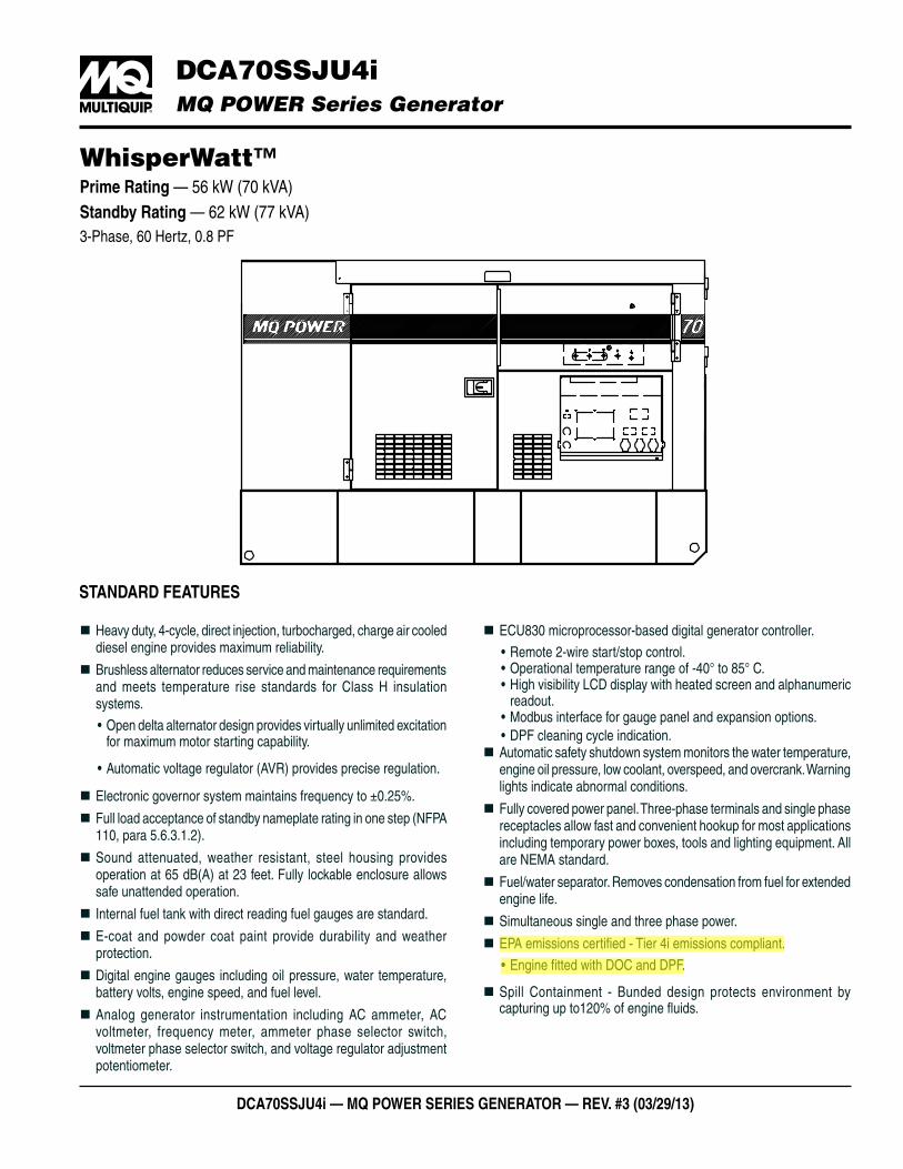
DCA70SSJU4i — MQ POWER SERiES gEnERAtOR — REv. #3 (03/29/13)
�� DCA70SSJU4i MQ POWER Series Generator
WhisperWatt™Prime Rating — 56 kW (70 kVA) Standby Rating — 62 kW (77 kVA)3-Phase, 60 Hertz, 0.8 PF
� Heavy duty, 4-cycle, direct injection, turbocharged, charge air cooled diesel engine provides maximum reliability.
� Brushless alternator reduces service and maintenance requirements and meets temperature rise standards for Class H insulation systems.
• Open delta alternator design provides virtually unlimited excitation for maximum motor starting capability.
• Automatic voltage regulator (AVR) provides precise regulation.
� Electronic governor system maintains frequency to ±0.25%.
� Full load acceptance of standby nameplate rating in one step (NFPA 110, para 5.6.3.1.2).
� Sound attenuated, weather resistant, steel housing provides operation at 65 dB(A) at 23 feet. Fully lockable enclosure allows safe unattended operation.
� Internal fuel tank with direct reading fuel gauges are standard.
� E-coat and powder coat paint provide durability and weather protection.
� Digital engine gauges including oil pressure, water temperature, battery volts, engine speed, and fuel level.
� Analog generator instrumentation including AC ammeter, AC voltmeter, frequency meter, ammeter phase selector switch, voltmeter phase selector switch, and voltage regulator adjustment potentiometer.
� ECU830 microprocessor-based digital generator controller.
• Remote 2-wire start/stop control.• Operational temperature range of -40° to 85° C.• High visibility LCD display with heated screen and alphanumeric
readout.• Modbus interface for gauge panel and expansion options.• DPF cleaning cycle indication.
� Automatic safety shutdown system monitors the water temperature, engine oil pressure, low coolant, overspeed, and overcrank. Warning lights indicate abnormal conditions.
� Fully covered power panel. Three-phase terminals and single phase receptacles allow fast and convenient hookup for most applications including temporary power boxes, tools and lighting equipment. All are NEMA standard.
� Fuel/water separator. Removes condensation from fuel for extended engine life.
� Simultaneous single and three phase power.
� EPA emissions certified - Tier 4i emissions compliant.
• Engine fitted with DOC and DPF.
� Spill Containment - Bunded design protects environment by capturing up to120% of engine fluids.
StAnDARD FEAtURES

DCA70SSJU4i — MQ POWER SERiES gEnERAtOR — REv. #3 (03/29/13)
�� DCA70SSJU4i MQ POWER Series Generator
SPECiFiCAtiOnS
Generator Specifications
Design Revolving field, self-ventilated Drip-proof, single bearing
Armature Connection Star with Neutral Zig ZagPhase 3 Single
Standby Output 62 KW (77 KVA) 44 KWPrime Output 56 KW (70 KVA) 40 KW
3Ø Voltage (L-L/L-N) Voltage Selector Switch at 3Ø 240/139
208Y/120, 220Y/127, 240Y/139 N/A
3Ø Voltage (L-L/L-N) Voltage Selector Switch at 3Ø 480/277
416Y/240, 440Y/254, 480Y/277 N/A
1Ø Voltage (L-L/L-N) (Voltage Selector Switch at 1Ø 240/120) N/A 240/120
Power Factor 0.8 1.0Voltage Regulation (No load to full load) ±0.5%
Generator RPM 1800Frequency 60 Hz
No. of Poles 4
Excitation Brushless with AVR
Frequency 60 HzFrequency Regulation: No Load to Full Load
Isochronous under varying loads from no load to 100% rated load
Frequency Regulation: Steady State ±0.25% of mean value for constant loads from no load to full load.
Insulation Class H
Sound Level dB(A) Full load at 23 feet 65
Engine SpecificationsMake / Model John Deere / 4045HFG92
Emissions EPA Interim Tier 4 CertifiedStarting System Electric
Design 4-cycle, water cooled, direct injection, turbocharged, charge air cooled and EGR
Displacement 275.0 in3 (4500 cc)No. cylinders 4
Bore x Stroke (mm) 106 x 127 Gross Engine Power Output 107 hp (80 kW)
BMEP 168 psi (1161 kPa)Piston Speed 1500 ft./min. (7.62 m/s)
Compression Ratio 16.1:1Engine Speed 1800 rpm
Overspeed Limit 2070 rpmOil Capacity 3.88 gallons (14.7 liters)
Battery 12V 75Ah x 1
Fuel SystemRecommended Fuel ASTM-D975-No.1 & No.2-D*
Maximum Fuel Flow (per hour) 15.9 gallons (60 liters)Maximum Inlet Restriction (Hg) 8.9 in. (225 mm)
Fuel Tank Capacity 103 gallons (390 liters)Fuel Consumption gph lph
At full load 4.3 16.2At 3/4 load 3.4 12.7At 1/2 load 2.7 10.1At 1/4 load 2.0 7.4
* - Use ultra-low sulfur diesel fuel.
Cooling SystemFan Load 4.2 hp (3.1 kW)
Coolant Capacity (with radiator) 5.92 gallons (22.4 liters)Coolant Flow Rate (per minute) 58 gallons (218 liters)
Heat Rejection to Coolant (per minute) 3068 Btu (3.2 MJ) Maximum Coolant Friction Head 14.9 psi (103 kPa)Maximum Coolant Static Head 78.7 feet (24.0 meters)Ambient Temperature Rating 104°F (40°C)
AirCombustion Air 181 cfm (5.1 m3/min)
Maximum Air Cleaner Restriction 25 in. H2O (6.25 kPa)Alternator Cooling Air 526 cfm (14.9 m3/min)Radiator Cooling Air 3393 cfm (96.1 m3/min)
Minimum Air Opening to Room 6.03 ft2 (0.56 m2)Minimum Discharge Opening 3.33 ft2 (0.31 m2)
Exhaust SystemGas Flow (full load) 399 cfm (11.3 m3/min) Gas Temperature 835°F (446°C)
Maximum Back Pressure 52 in. H2O (13 kPa)
Amperage Rated voltage Maximum Amps
1Ø 120 Volt 155.4 Amps (4 wire) 168A x 2 (Zigzag)
1Ø 240 Volt 77.8 Amps (4 wire) 168A (Zigzag)
3Ø 240 Volt 168 Amps3Ø 480 Volt 84 Amps
Main Line Circuit Breaker Rating 175 AmpsOver Current Relay Trip Set Point
480V Mode Only 84 Amps
NOTICE
Generator is not intended for use in enclosed areas or where free flow of air is restricted.
Backfeed to a utility system can cause electrocution, shock and/or property damage. DO nOt connect to any building’s electrical system except through an approved device.
Specifications are subject to change without notice.
WARRAnty*John Deere Engine12 months from date of purchase with unlimited hours or 24 months from date of purchase with 2000 hours (whichever comes first).
generator 24 months from date of purchase or 2000 hours (whichever occurs first).
trailer12 months excluding normal wear items.*Refer to the express written, one-year limited warranty sheet for additional information.

DCA70SSJU4i — MQ POWER SERiES gEnERAtOR — REv. #3 (03/29/13)
�� DCA70SSJU4i MQ POWER Series Generator
gEnERAtOR OUtPUt PAnEl
Our soundproof housingallows substantiallylower operating noiselevels than competitivedesigns. WhisperWattsare at home onconstruction sites, inresidentialneighborhoods, and athospitals — just aboutanywhere.
70
60
90
80
50
Subway / truck traffic
Average city traffic
Inside car at 60 mph
Air conditioner at 20 feet
Normal conversation
WhisperWatt at 23 feet
65.0DECIBELS
MQ POWER DECIBEL LEVELS �
CS-6369 TWIST-LOCKRECEPTACLES (3)
240V/120V, 50 AMPS
GFCI RECEPTACLES (2)120V, 20 AMP
CIRCUIT BREAKERSFOR GFCI RECEPTACLES
CIRCUIT BREAKERSFOR CS-6369 TWISTLOCK RECEPTACLES
OPtiOnAl gEnERAtOR FEAtURES
� Battery Charger — provides fully automatic and self-adjusting charging to the generator's battery system.
� Jacket Water Heater — for easy starting in cold weather climates.
� Special Batteries — long life batteries provide extra engine cranking power.
� Spring isolators — provides extra vibration protection for standby applications.
� trailer Mounted Package — meets National Highway Traffic Safety Administration (NHTSA) regulations. Trailer is equipped with electronic or surge brakes with double or triple axle configuration.
OPtiOnAl COntROl FEAtURES
�Audible Alarm — aler ts operator of abnormal conditions.
�Emergency Stop Switch — when manually activated, shuts down generator in the event of an emergency.
OPtiOnAl OUtPUt COnnECtiOnS
� Cam-lok Connectors — provides quick disconnect alternative to bolt-on connectors.
� Pin and Sleeve Connectors — provides industry standard connectors for all voltage requirements.
� Output Cable — Available in any custom length and size configuration.

MUltiQUiPPOST OFFICE BOx 6254CARSON, CA 90749310-537-3700 • 800-883-2551FAx: 310-604-3831E-MAIL: [email protected]: www.multiquip.com
Manufactured by Denyo Co.
Your Multiquip dealer is:
© COPYRIGHT 2013 MULTIQUIP INC.DCA70SSJU4i Rev. #3 (03/29/13)
�� DCA70SSJU4i MQ POWER Series Generator
DiMEnSiOnS
39.25 in
(997 mm)33.98 in(863 mm)
39.25 in(997 mm)32.80 in
(833 mm)
32.2
8 in
(820
mm
)3.0 in O.D.(76.3 mm)
11.06 in(281 mm)
6.93 in(176 mm)
1.73
in(4
4 m
m)
25.39 in(645 mm)
105.12 in(2670 mm)
20.08 in(510 mm)
22.44 in(570 mm)
19.69 in(500 mm)
19.69 in(500 mm)
58.27 in(1480 mm)
23.23 in(590 mm)
68.3 in(1735 mm)
37.40 in(950 mm)
WeightDry Weight 3,594 lbs. (1,630 kg) Wet Weight 4,410 lbs. (2,000 kg) Max. Lifting
Point Capacity 6,960 lb. (3,157 kg)
Generator can be placed on MQ Power Trailer TRLR70US.

dca85usj — MQ POWER WhisPERWatt™ sERiEs gEnERatOR — REv. #10 (12/16/10)
DCA85USJ MQ POWER WhisperWatt™ Series Generator
Prime Rating — 68 kW (85 kVA) standby Rating — 75 kW (94 kVA)60 Hertz
85 WHISPERWATT
standaRd FEatuREs
� Heavy duty, 4-cycle, direct injection, turbocharged diesel engine provides maximum reliability.
� Brushless alternator reduces service and maintenance requirements and meets temperature rise standards for Class F insulation systems.
� Open delta excitation design provides virtually unlimited excitation for maximum motor starting capability.
� Automatic voltage regulator (AVR) provides precise regulation. � Electronic Governor Control (Crystal Sync) — maintains frequency to within ±0.25% from no load to full load.
� Full load acceptance of standby nameplate rating in one step (NFPA 110, para 5-13.2.6).
� Sound attenuated, weather resistant, steel housing provides operation at 63 dB(A) at 23 feet. Fully lockable enclosure allows safe unattended operation.
� Internal fuel tank with direct reading of fuel gauge. � Seven stage powder coat paint system provides durability and weather protection.
� Fuel/water separator removes condensation from fuel for extended engine life. Panel mounted alarm light included.
� Complete engine analog instrumentation includes DC ammeter, oil pressure gauge, water temp. gauge, fuel level gauge, tachometer/hour meter, preheat indicator, and emergency shutdown monitors.
� Complete generator analog instrumentation includes voltage regulator control, ammeter phase selector switch, voltmeter phase selector switch, AC voltmeter, AC ammeter, frequency meter, panel light, and circuit breaker.
� Automatic safety shutdown system monitors the engine oil pressure and coolant temperature. Warning lights indicate abnormal conditions.
� Automatic start/stop control — automatically starts the generator set during a commercial power failure when used in conjunction with a transfer switch.
� Complete power panel. Fully covered; three-phase terminals and single phase receptacles allow fast and convenient hookup for most applications including temporary power boxes, tools and lighting equipment. The GFCI receptacles are NEMA 5-20, and the auxilillary outputs use CS6369 twist-lock receptacles.
� Simultaneous single and three phase power. � Voltage selector switch offers the operator a wide range of voltages that are manually selectable. Fine tuning of the output voltage can be accomplished by adjusting the voltage regulator control knob to obtain the desired voltage.
� EPA emissions certified - Tier 3 emissions compliant.

dca85usj — MQ POWER WhisPERWatt™ sERiEs gEnERatOR — REv. #10 (12/16/10)
DCA85USJ MQ POWER WhisperWatt™ Series Generator
sPEciFicatiOns Cooling SystemFan Load 1.6 hp (1.2 kW)
Coolant Capacity (with radiator) 3.70 gallons (14.0 liters)Coolant Flow Rate (per minute) 38 gallons (144 liters)
Heat Rejection to Coolant (per minute) 3300 Btu (3.5 MJ) Heat Rejection to Room (per minute) 582 Btu (0.614 MJ)
Maximum Coolant Friction Head 4.0 psi (27.6 kPa)Maximum Coolant Static Head 32 feet (9.8 meters)Ambient Temperature Rating 104°F (40°C)
AirCombustion Air 226 cfm (6.4 m3/min)
Maximum Air Cleaner Restriction 25 in. H2O (6.25 kPa)Alternator Cooling Air 911 cfm (45 m3/min)Radiator Cooling Air 1589 cfm (30 m3/min)
Minimum Air Opening to Room 7.85 sq. ft. (0.73 sq. m)Minimum DischargeOpening 3.87 sq. ft. (0.36 sq. m)
Exhaust SystemGas Flow (full load) 674 cfm (19.1 m3/min) Gas Temperature 1094°F (590°C)
Maximum Back Pressure 30.0 in. H2O (7.5 kPa)
Amperage Rated voltage Maximum amps
1Ø 120 Volt 188.9Amps (4 wire) 250A x 2 (Zigzag)
1Ø 240 Volt 94.4Amps (4 wire) 250A (Zigzag)
3Ø 240 Volt 204 Amps3Ø 480 Volt 102 Amps
Main Line Circuit Breaker Rating 250 AmpsOver Current Relay Trip Set Point
480V Mode Only 102 Amps
Fuel SystemRecommended Fuel ASTM-D975-No.1 & No.2-D
Maximum Fuel Flow (per hour) 15.9 gallons (60 liters)Maximum Inlet Restriction (Hg) 5.9 in. (150 mm)
Fuel Tank Capacity 126 gallons (150 liters)Fuel consumption gph lph
At full load 5.3 20.1At 3/4 load 4.3 16.2At 1/2 load 3.1 11.9
At 1/4 load 2.0 7.6
Engine SpecificationsMake / Model John Deere / 4045HF285
Emissions EPA Tier 3 CertifiedStarting System Electric
Design 4-cycle, water cooled, direct injection turbocharged
Displacement 274.6 in3 (4500 cc)No. cylinders 4
Bore x Stroke (mm) 106 x 127 Gross Engine Power Output 113.0 bhp (84.3 kWm)
BMEP 162 psi (1119 kPa)Piston Speed 1500 ft./min. (7.62 m/s)
Compression Ratio 17:1Engine Speed 1800 rpm
Overspeed Limit 2100 rpmOil Capacity 3.49 gallons (13.2 liters)
Battery 12V 72Ah x 1
Generator Specifications
Design Revolving field, self-ventilated Drip-proof, single bearing
Armature Connection Star with Neutral Zig Zag
Phase 3 Single
Standby Output 75 KW (94 KVA) 66 KW
Prime Output 68 KW (85 KVA) 60 KW
3Ø Voltage (L-L/L-N) Voltage Selector Switch at 3Ø 240/139
208Y/120, 220Y/127, 240Y/139 N/A
3Ø Voltage (L-L/L-N) Voltage Selector Switch at 3Ø 480/277
416Y/240, 440Y/254, 480Y/277 N/A
1Ø Voltage (L-L/L-N) (Voltage Selector Switch at 1Ø 240/120) N/A 240/120
Power Factor 0.8 1.0
Voltage Regulation (No load to full load) ±0.5%
Generator RPM 1800
Frequency 60 Hz
No. of Poles 4
Excitation Brushless with AVR
Frequency 60 Hz
Frequency Regulation: No Load to Full Load
3~5% under varying loads from no load to 100% rated load
Frequency Regulation: Steady State ±0.5% of mean value for constant loads from no load to full load.
Insulation Class F
Sound Level dB(A) Full load at 23 feet 63
NOTICE
Generator is not intended for use in enclosed areas or where free flow of air is restricted.
Backfeed to a utility system can cause electrocution, shock and/or property damage. dO nOt connect to any building’s electrical system except through an approved device.
Specifications are subject to change without notice.
WaRRanty*john deere12 months from date of purchase with unlimited hours or 24 months from date of purchase with 2000 hours (whichever comes first).
generator 24 months from date of purchase or 2000 hours (whichever occurs first).
trailer12 months excluding normal wear items.*Refer to the express written, one-year limited warranty sheet for additional information

dca85usj — MQ POWER WhisPERWatt™ sERiEs gEnERatOR — REv. #10 (12/16/10)
DCA85USJ MQ POWER WhisperWatt™ Series Generator
ultRa-silEnt FEatuREs � low noise Muffler — Large capacity low noise muffler minimizes exhaust sound.
� soundproof casing — The new design divides the cabinet into three sections, separating the engine, muffler and radiator for more efficient cooling and reduces noise from the engine and fans.
� new cooling system — An advanced design uses two separate air intake systems to cool the generator. The engine fan draws air in to cool the engine and generator housing while a second electric fan directly cools the radiator. With less air being drawn into the generator through each fan, considerably less noise is produced through the top of the generator.
� Environmental design — Constructed using an integrated environmental skid and fuel tank. This design fully contains fuel leakage and any liquid that might leak from the engine such as lube oil or radiator coolant. All potentially hazardous liquids are contained without contaminating the surrounding area.
Outside Air
Electric Fan Radiator
DieselEngine
ControlBox
Outside Air
AC Generator
Flow of Cooling Air
gEnERatOR OutPut PanEl
OPtiOnal cOntROl FEatuREs �Emergency stop switch — when manually activated shuts down generator in the event of an emergency. �audible alarm — alerts operator of abnormal conditions.
OPtiOnal gEnERatOR FEatuREs � Electronic governor control (crystal sync) — maintains frequency to within ±0.25% from no load to full load.
� Battery charger — provides fully automatic and self-adjusting charging to the generator's battery system.
� jacket Water heater — for easy starting in cold weather climates.
� special Batteries — long life batteries provide extra engine cranking power.
� spring isolaters — provides extra vibration protection for standby applications.
� low coolant level shutdown — provides protection from critically low coolant levels. Includes control panel warning light.
� trailer Mounted Package — meets National Highway Traffic Safety Administration (NHTSA) regulations. Trailer is equipped with electronic or surge brakes with tandem axle configuration.
OPtiOnal OutPut cOnnEctiOns � cam-lock connectors — provides quick disconnect alternative to bolt-on connectors.
� Pin and sleeve connectors — provides industry standard connectors for all voltage requirements.
� Output cable — available in any custom length and size configuration.

MultiQuiPPOST OFFICE BOx 6254CARSON, CA 90749310-537-3700 • 800-883-2551FAx: 310-604-3831E-MAIL: [email protected]: www.multiquip.com
Manufactured by Denyo Co.
Your Multiquip dealer is:
© COPYRIGHT 2010 MULTIQUIP INC.DCA85USJ2 Rev. #10 (12/16/10)
DCA85USJ MQ POWER WhisperWatt™ Series Generator
diMEnsiOns
WeightDry Weight 5,094 lbs. (2,310 kg) Wet Weight 6,048 lbs. (2,743 kg) Max. Lifting
Point Capacity 14,050 lbs. (6,370 kg)
Generator can be placed on a MQ Power Model TRLR85US Tandem Axle Trailer

dca45ssiU4F — MQ POWER sERiEs gEnERatOR — REv. #2 (10/14/13)
DCA45SSIU4F MQ POWER Series Generator
WhisperWatt™Prime Rating — 36 kW (45 kVA) Standby Rating — 40 kW (50 kVA)Three-Phase, 60 Hertz, 0.8 PF
StandaRd FeatuReS � Heavy duty, 4-cycle, direct injection, turbocharged, charge air cooled diesel engine provides maximum reliability.
� Brushless alternator reduces service and maintenance requirements and meets temperature rise standards for Class H insulation systems.•Open delta excitation design provides virtually unlimited
excitation for maximum motor starting capability.•Automatic voltage regulator (AVR) provides precise
regulation. � Electronic Governor Control — isochronous control, maintains frequency to within ±0.25% from no load to full load.
� Full load acceptance of standby nameplate rating in one step (NFPA 110, para 5-13.2.6).
� Sound attenuated, weather resistant, steel housing provides operation at 66 dB(A) at 23 feet. Fully lockable enclosure allows safe unattended operation.
� Internal fuel tank with direct reading of fuel gauge. � E-coat and powder coat paint provides durability and weather protection.
� Fuel/water separator removes condensation from fuel for extended engine life. Panel mounted alarm light included.
� Complete engine analog instrumentation includes DC ammeter, oil pressure gauge, water temp. gauge, fuel level gauge, tachometer/hour meter, preheat indicator, and emergency shutdown monitors.
� ECU750 — automatic CANBUS engine control with LED status indicator lights.
� Automatic start/stop control — automatically starts the generator set during a commercial power failure when used in conjunction with a transfer switch.
� Complete generator analog instrumentation includes voltage regulator control, ammeter phase selector switch, voltmeter phase selector switch, AC voltmeter, AC ammeter, frequency meter, panel light, and circuit breaker.
� Automatic safety shutdown system monitors the water temperature, engine oil pressure, overspeed and overcrank. Warning lights indicate abnormal conditions.
� Complete power panel. Fully covered; three-phase terminals and single phase receptacles allow fast and convenient hookup for most applications including temporary power boxes, tools and lighting equipment. The GFCI receptacles are NEMA 5-20, and the auxiliary outputs use CS6369 twist-lock receptacles.
� Voltage selector switch offers the operator a wide range of voltages that are manually selectable. Fine tuning of the output voltage can be accomplished by adjusting the voltage regulator control knob to obtain the desired voltage.
� EPA emissions certified — Tier 4 final emissions compliant. � Spill containment — Bunded design protects environment by capturing up to 119% of engine fluids.

DCA45SSIU4F— MQ POWER SERIES gEnERAtOR — REv. #2 (10/14/13)
DCA45SSIU4F MQ POWER Series Generator
SPeciFicationS
Generator Specifications
Design Revolving field, self-ventilated Drip-proof, single bearing
Armature Connection Star with Neutral Zig ZagPhase 3 Single
Standby Output 40 KW (50 KVA) 28.8 KWPrime Output 36 KW (45 KVA) 26 KW
3Ø Voltage (L-L/L-N) Voltage Selector Switch at 3Ø 240/139
208Y/120, 220Y/127, 240Y/139 N/A
3Ø Voltage (L-L/L-N) Voltage Selector Switch at 3Ø 480/277
416Y/240, 440Y/254, 480Y/277 N/A
1Ø Voltage (L-L/L-N) (Voltage Selector Switch at 1Ø 240/120) N/A 240/120
Power Factor 0.8 1.0Voltage Regulation (No load to full load) ±0.5%
Generator RPM 1800Frequency 60 Hz
No. of Poles 4
Excitation Brushless with AVR
Frequency Regulation: No Load to Full Load
Isochronous under varying loads from no load to 100% rated load
Frequency Regulation: Steady State ±0.25% of mean value for constant loads from no load to full load.
Insulation Class H
Sound Level dB(A) Full load at 23 feet 66
Engine SpecificationsMake / Model Isuzu / 4LE2X
Emissions EPA Tier 4 Final CertifiedStarting System Electric
Design4-cycle, water cooled,
direct injection, turbocharged, charge air cooled and EGR
Displacement 133.0 in3 (2179 cc)No. cylinders 4
Bore x Stroke (mm) 85 x 96 Gross Engine Power Output 65.7 hp (49 kW)
BMEP 217 psi (1499 kPa)Piston Speed 1133.9 ft./min. (5.76 m/s)
Compression Ratio 17.6:1Engine Speed 1800 rpm
Overspeed Limit 2070 rpmOil Capacity 3.2 gallons (12.2 liters)
Battery 12V 72Ah x 1
Fuel SystemRecommended Fuel ASTM-D975-No.1 & No.2-D
Maximum Fuel Flow (per hour) 3.4 gallons (13 liters)Maximum Inlet Restriction (Hg) 11 in. (280 mm)
Fuel Tank Capacity 79.2 gallons (300 liters)Fuel consumption gph lph
At full load 2.93 11.1At 3/4 load 2.20 8.31At 1/2 load 1.60 6.04At 1/4 load 1.04 3.92
Cooling SystemFan Load 2.01 hp (1.5 kW)
Coolant Capacity (with radiator) 4.44 gallons (16.8 liters)Coolant Flow Rate (per minute) 16.9 gallons (64.2 liters)
Heat Rejection to Coolant (per minute) 1934 Btu (2.04 MJ) Maximum Coolant Friction Head 14.5 psi (100 kPa)Maximum Coolant Static Head 3.35 feet (1.04 meters)Ambient Temperature Rating 104°F (40°C)
AirCombustion Air 174 cfm (4.94 m3/min)
Maximum Air Cleaner Restriction 25 in. H2O (6.23 kPa)Alternator Cooling Air 526 cfm (14.9 m3/min)Radiator Cooling Air 1900 cfm (53.8 m3/min)
Minimum Air Opening to Room 3.5 ft2 (0.33 m2)Minimum Discharge Opening 2.27 ft2 (0.21 m2)
Exhaust SystemGas Flow (full load) 237 cfm (6.7 m3/min) Gas Temperature 1078°F (581°C)
Maximum Back Pressure 38.1 in. H2O (9.5 kPa)
Amperage Rated Voltage Maximum amps
1Ø 120 Volt 100 Amps (4 wire),108A x 2 (Zigzag)1Ø 240 Volt 50 Amps (4 wire),108A (Zigzag3Ø 240 Volt 108 Amps3Ø 480 Volt 54 Amps
Main Line Circuit Breaker Rating 125 AmpsOver Current Relay Trip Set Point
480V Mode Only 54 Amps
NOTICE
Generator is not intended for use in enclosed areas or where free flow of air is restricted.
Backfeed to a utility system can cause electrocution, shock and/or property damage. do not connect to any building’s electrical system except through an approved device.
Specifications are subject to change without notice.
WaRRanty*isuzu engine12 months from date of purchase with unlimited hours or 24 months from date of purchase with 2000 hours (whichever comes first).
Generator 24 months from date of purchase or 2000 hours (whichever occurs first).
trailer12 months excluding normal wear items.*Refer to the express written, one-year limited warranty sheet for additional information.

dca45ssiU4F — MQ POWER sERiEs gEnERatOR — REv. #2 (10/14/13)
DCA45SSIU4F MQ POWER Series Generator
GeneRatoR outPut Panel
oPtional GeneRatoR FeatuReS
� Battery charger — provides fully automatic and self-adjusting charging to the generator's battery system.
� Jacket Water Heater — for easy starting in cold weather climates.
� Special Batteries — long life batteries provide extra engine cranking power.
� low coolant level Shutdown — provides protection from critically low coolant levels. Includes control panel warning light.
� Spring isolators — provides extra vibration protection for standby applications.
� trailer Mounted Package — meets National Highway Traffic Safety Administration (NHTSA) regulations. Trailer is equipped with electronic or surge brakes with double or triple axle configuration.
oPtional contRol FeatuReS
�emergency Stop Switch — when manually activated shuts down generator in the event of an emergency. �audible alarm — alerts operator of abnormal conditions
oPtional outPut connectionS
� cam-lok connectors — provides quick disconnect alternative to bolt-on connectors.
� Pin and Sleeve connectors — provides industry standard connectors for all voltage requirements.
� output cable — available in any custom length and size configuration.

Multiquippost office box 6254cARsoN, cA 90749310-537-3700 • 800-883-2551FAX: 310-604-3831e-MAiL: [email protected]: www.multiquip.com
Manufactured by Denyo Co.
Your Multiquip dealer is:
© copYRiGHt 2013 MULtiQUip iNc.DcA45ssiU4f Rev. #2 (10/14/13)
DCA45SSIU4F MQ POWER Series Generator
diMenSionS
665 mm / 2
6.18 in
820
mm
/ 32
.28
in
665 mm / 26.18 in 720 mm / 28.34 in
720 mm / 28.34 in
344 mm/13.5 in
232 mm/9.13 in
300 mm/11.81 in
880 mm/34.65 in950 mm/37.40 in
500 mm/19.69 in
500 mm/19.69 in
2130 mm / 83.86 in
1550
mm
/ 61
.02
in
1150
mm
/ 45
.28
in40
0 m
m/
15.7
5 in
740
mm
/ 29
.13
in
500 mm/19.69 in
330 mm/12.98 in
38 mm/1.5 in
61 mm/2.4 in
WeightDry Weight 2,337 lbs. (1,060 kg) Wet Weight 2,976 lbs. (1,350 kg) Max. Lifting
Point Capacity 5,150 lbs. (2,335 kg)
Generator can be placed on MQ Power Model TRLR45 Trailer.

Appendix F
EPA Non-Road Engine Emission Limits Applicable to RVM
Tier 3 & 4 Emission Standards—Engines, g/kWh (g/bhp-hr)
Engine Power Engine (hp) CO NMHC NMHC+ NOx
NOx PM
TIER 3 75 ≤ kW < 130 (100 ≤ hp < 175) After 2006 before 2012
Well Water Pump 1 (113) 5.0 (3.7) - 4.0 (3.0) - 0.3 (0.22)
TIER 4 8 ≤ kW < 19 (11 ≤ hp < 25) After 2007
Light plants (24.7)
6.6 (4.9) - 7.5 (5.6) - 0.4 (0.3)
37 ≤ kW < 56 (50 ≤ hp < 75) After 2012
Well Water Pump 2 (65.7)
5.0 (3.7) - 4.7 (3.5) - 0.03 (0.022)
56 ≤ kW < 130 (75 ≤ hp < 175) After 2012-2014
Ready Line Generator (107)
5.0 (3.7) 0.19 (0.14)
- 0.40 (0.30)
0.02 (0.015)

Appendix G
Air Dispersion Modeling Inputs, Summary Results and Supporting Information
(Modeling Files Provided on CD)

Appendix G (Modeling Inputs)

Agrium ‐ Rasmussen Valley Mine (RVM) Point Source Model Input (NAD83, Z12)‐ 4/18/16
Source ID Source Description Easting (m) Northing (m)
Base Elevation
(m)Stack
Height (ft) Temp. (°F)Exit Velocity
(ft/sec)
Stack Diameter
(ft)PM10 (lb/hr) PM25 (lb/hr)
NO2 (lb/hr)
LP_1_P2 Diesel light plant Phase 2 470933.24 4743772.20 2065.16 6.17 869.0 172.705 0.13 0.016 0.016 0.304LP_2_P2 Diesel light plant Phase 2 471093.61 4743822.38 2090.06 6.17 869.0 172.705 0.13 0.016 0.016 0.304LP_3_P2 Diesel light plant Phase 2 471235.84 4743789.94 2098.12 6.17 869.0 172.705 0.13 0.016 0.016 0.304LP_4_P2 Diesel light plant Phase 2 471331.90 4743738.79 2107.80 6.17 869.0 172.705 0.13 0.016 0.016 0.304LP_5_P2 Diesel light plant Phase 2 471264.53 4743605.30 2079.17 6.17 869.0 172.705 0.13 0.016 0.016 0.304LP_6_P2 Diesel light plant Phase 2 471170.96 4743620.27 2072.44 6.17 869.0 172.705 0.13 0.016 0.016 0.304LP_7_P2 Diesel light plant Phase 2 471126.05 4743646.47 2055.33 6.17 869.0 172.705 0.13 0.016 0.016 0.304LP_8_P2 Diesel light plant Phase 2 471021.25 4743682.65 2042.22 6.17 869.0 172.705 0.13 0.016 0.016 0.304LP_9_P2 Diesel light plant Phase 2 471203.08 4743469.08 2026.51 6.17 869.0 172.705 0.13 0.016 0.016 0.304GEN_1_P2 Mine Pit Equipment Generator Phase 2 471121.40 4743731.70 2053.52 7.61 835.0 135.541 0.25 0.004 0.004 0.070LP_1_P5 Diesel light plant Phase 5 472213.31 4743311.79 2090.47 6.17 869.0 172.705 0.13 0.016 0.016 0.304LP_2_P5 Diesel light plant Phase 5 472349.31 4743261.25 2092.29 6.17 869.0 172.705 0.13 0.016 0.016 0.304LP_3_P5 Diesel light plant Phase 5 472588.85 4743038.97 2079.74 6.17 869.0 172.705 0.13 0.016 0.016 0.304LP_4_P5 Diesel light plant Phase 5 472614.75 4742885.75 2069.57 6.17 869.0 172.705 0.13 0.016 0.016 0.304LP_5_P5 Diesel light plant Phase 5 472517.64 4742937.55 2046.33 6.17 869.0 172.705 0.13 0.016 0.016 0.304LP_6_P5 Diesel light plant Phase 5 472478.79 4742985.02 2064.15 6.17 869.0 172.705 0.13 0.016 0.016 0.304LP_7_P5 Diesel light plant Phase 5 472350.08 4743045.25 2058.00 6.17 869.0 172.705 0.13 0.016 0.016 0.304LP_8_P5 Diesel light plant Phase 5 472252.20 4743144.72 2047.67 6.17 869.0 172.705 0.13 0.016 0.016 0.304LP_9_P5 Diesel light plant Phase 5 471705.30 4743293.54 2043.47 6.17 869.0 172.705 0.13 0.016 0.016 0.304GEN_1_P5 Mine Pit Equipment Generator Phase 5 472381.68 4743138.24 2083.71 7.61 835.0 135.541 0.25 0.004 0.004 0.070LP_1_P8 Diesel light plant Phase 8 473434.17 4742199.07 2072.74 6.17 869.0 172.705 0.13 0.016 0.016 0.304LP_2_P8 Diesel light plant Phase 8 473520.11 4742203.68 2072.53 6.17 869.0 172.705 0.13 0.016 0.016 0.304LP_3_P8 Diesel light plant Phase 8 473628.01 4742108.68 2064.57 6.17 869.0 172.705 0.13 0.016 0.016 0.304LP_4_P8 Diesel light plant Phase 8 473719.48 4741904.62 2041.33 6.17 869.0 172.705 0.13 0.016 0.016 0.304LP_5_P8 Diesel light plant Phase 8 473606.90 4741925.73 2040.01 6.17 869.0 172.705 0.13 0.016 0.016 0.304LP_6_P8 Diesel light plant Phase 8 473504.73 4741982.15 2038.90 6.17 869.0 172.705 0.13 0.016 0.016 0.304LP_7_P8 Diesel light plant Phase 8 473458.44 4742013.96 2038.99 6.17 869.0 172.705 0.13 0.016 0.016 0.304LP_8_P8 Diesel light plant Phase 8 473388.47 4742077.31 2042.21 6.17 869.0 172.705 0.13 0.016 0.016 0.304LP_9_P8 Diesel light plant Phase 8 473078.08 4742202.22 2011.98 6.17 869.0 172.705 0.13 0.016 0.016 0.304GEN_1_P8 Mine Pit Equipment Generator Phase 8 473524.14 4742086.33 2063.64 7.61 835.0 135.541 0.25 0.004 0.004 0.070WEL_PMP1 Existing Dust Suppression Well 473986.71 4741917.37 1999.17 9.05 1094.0 101.760 0.38 0.056 0.056 0.742WEL_PMP2 New Dust Suppression Well 471760.95 4743695.46 2152.99 5.15 1078.0 125.796 0.20 0.003 0.003 0.507Note: Toxic Air Pollutants from diesel engines are exempt from evaluation per IDAPA §210(20). Total Point Source Emissions per Phase: 0.208 0.208 4.054

Agrium - Rasmussen Valley Volume Source Input
Source ID Source Description Easting (m) Northing (m)
Base Elevation
(m)Release
Height (ft)Horizontal
Dimension (ft)
Vertical Dimension
(ft)PM10 (lb/hr)
PM25 (lb/hr) NO2 (lb/hr) Al (lb/hr) As (lb/hr) Cd (lb/hr) Fe (lb/hr) Ni (lb/hr)
P2R_0001 Phase 2 Haul Road 471170.43 4743725.62 2071.99 11.56 55.81 10.75 1.27E‐01 1.27E‐02 0.00E+00 9.58E‐04 6.24E‐07 1.08E‐06 1.15E‐03 5.97E‐06P2R_0002 Phase 2 Haul Road 471201.14 4743712.16 2083.61 11.56 55.81 10.75 1.27E‐01 1.27E‐02 0.00E+00 9.58E‐04 6.24E‐07 1.08E‐06 1.15E‐03 5.97E‐06P2R_0003 Phase 2 Haul Road 471231.85 4743698.71 2096.77 11.56 55.81 10.75 1.27E‐01 1.27E‐02 0.00E+00 9.58E‐04 6.24E‐07 1.08E‐06 1.15E‐03 5.97E‐06P2R_0004 Phase 2 Haul Road 471262.56 4743685.25 2103.82 11.56 55.81 10.75 1.27E‐01 1.27E‐02 0.00E+00 9.58E‐04 6.24E‐07 1.08E‐06 1.15E‐03 5.97E‐06P2R_0005 Phase 2 Haul Road 471293.27 4743671.79 2102.04 11.56 55.81 10.75 1.27E‐01 1.27E‐02 0.00E+00 9.58E‐04 6.24E‐07 1.08E‐06 1.15E‐03 5.97E‐06P2R_0006 Phase 2 Haul Road 471323.97 4743658.34 2099.30 11.56 55.81 10.75 1.27E‐01 1.27E‐02 0.00E+00 9.58E‐04 6.24E‐07 1.08E‐06 1.15E‐03 5.97E‐06P2R_0007 Phase 2 Haul Road 471354.68 4743644.88 2091.90 11.56 55.81 10.75 1.27E‐01 1.27E‐02 0.00E+00 9.58E‐04 6.24E‐07 1.08E‐06 1.15E‐03 5.97E‐06P2R_0008 Phase 2 Haul Road 471385.40 4743631.42 2081.69 11.56 55.81 10.75 1.27E‐01 1.27E‐02 0.00E+00 9.58E‐04 6.24E‐07 1.08E‐06 1.15E‐03 5.97E‐06P2R_0009 Phase 2 Haul Road 471416.10 4743617.97 2081.56 11.56 55.81 10.75 1.27E‐01 1.27E‐02 0.00E+00 9.58E‐04 6.24E‐07 1.08E‐06 1.15E‐03 5.97E‐06P2R_0010 Phase 2 Haul Road 471446.81 4743604.51 2084.25 11.56 55.81 10.75 1.27E‐01 1.27E‐02 0.00E+00 9.58E‐04 6.24E‐07 1.08E‐06 1.15E‐03 5.97E‐06P2R_0011 Phase 2 Haul Road 471477.52 4743591.06 2086.65 11.56 55.81 10.75 1.27E‐01 1.27E‐02 0.00E+00 9.58E‐04 6.24E‐07 1.08E‐06 1.15E‐03 5.97E‐06P2R_0012 Phase 2 Haul Road 471508.23 4743577.60 2079.89 11.56 55.81 10.75 1.27E‐01 1.27E‐02 0.00E+00 9.58E‐04 6.24E‐07 1.08E‐06 1.15E‐03 5.97E‐06P2R_0013 Phase 2 Haul Road 471538.94 4743564.14 2066.17 11.56 55.81 10.75 1.27E‐01 1.27E‐02 0.00E+00 9.58E‐04 6.24E‐07 1.08E‐06 1.15E‐03 5.97E‐06P2R_0014 Phase 2 Haul Road 471564.95 4743543.64 2056.44 11.56 55.81 10.75 1.27E‐01 1.27E‐02 0.00E+00 9.58E‐04 6.24E‐07 1.08E‐06 1.15E‐03 5.97E‐06P2R_0015 Phase 2 Haul Road 471571.99 4743511.81 2050.85 11.56 55.81 10.75 1.27E‐01 1.27E‐02 0.00E+00 9.58E‐04 6.24E‐07 1.08E‐06 1.15E‐03 5.97E‐06P2R_0016 Phase 2 Haul Road 471562.47 4743480.38 2045.30 11.56 55.81 10.75 1.27E‐01 1.27E‐02 0.00E+00 9.58E‐04 6.24E‐07 1.08E‐06 1.15E‐03 5.97E‐06P2R_0017 Phase 2 Haul Road 471549.68 4743449.39 2040.78 11.56 55.81 10.75 1.27E‐01 1.27E‐02 0.00E+00 9.58E‐04 6.24E‐07 1.08E‐06 1.15E‐03 5.97E‐06P2R_0018 Phase 2 Haul Road 471528.89 4743423.09 2037.04 11.56 55.81 10.75 1.27E‐01 1.27E‐02 0.00E+00 9.58E‐04 6.24E‐07 1.08E‐06 1.15E‐03 5.97E‐06P2R_0019 Phase 2 Haul Road 471501.57 4743408.18 2032.38 11.56 55.81 10.75 1.27E‐01 1.27E‐02 0.00E+00 9.58E‐04 6.24E‐07 1.08E‐06 1.15E‐03 5.97E‐06P2R_0020 Phase 2 Haul Road 471468.36 4743403.57 2028.34 11.56 55.81 10.75 1.27E‐01 1.27E‐02 0.00E+00 9.58E‐04 6.24E‐07 1.08E‐06 1.15E‐03 5.97E‐06P2R_0021 Phase 2 Haul Road 471436.75 4743412.19 2028.44 11.56 55.81 10.75 1.27E‐01 1.27E‐02 0.00E+00 9.58E‐04 6.24E‐07 1.08E‐06 1.15E‐03 5.97E‐06P2R_0022 Phase 2 Haul Road 471405.61 4743424.60 2032.08 11.56 55.81 10.75 1.27E‐01 1.27E‐02 0.00E+00 9.58E‐04 6.24E‐07 1.08E‐06 1.15E‐03 5.97E‐06P2R_0023 Phase 2 Haul Road 471374.46 4743437.02 2034.83 11.56 55.81 10.75 1.27E‐01 1.27E‐02 0.00E+00 9.58E‐04 6.24E‐07 1.08E‐06 1.15E‐03 5.97E‐06P2R_0024 Phase 2 Haul Road 471343.32 4743449.43 2039.33 11.56 55.81 10.75 1.27E‐01 1.27E‐02 0.00E+00 9.58E‐04 6.24E‐07 1.08E‐06 1.15E‐03 5.97E‐06P2R_0025 Phase 2 Haul Road 471312.18 4743461.85 2041.74 11.56 55.81 10.75 1.27E‐01 1.27E‐02 0.00E+00 9.58E‐04 6.24E‐07 1.08E‐06 1.15E‐03 5.97E‐06P2R_0026 Phase 2 Haul Road 471279.67 4743467.07 2035.33 11.56 55.81 10.75 1.27E‐01 1.27E‐02 0.00E+00 9.58E‐04 6.24E‐07 1.08E‐06 1.15E‐03 5.97E‐06P2R_0027 Phase 2 Haul Road 471248.25 4743457.07 2029.25 11.56 55.81 10.75 1.27E‐01 1.27E‐02 0.00E+00 9.58E‐04 6.24E‐07 1.08E‐06 1.15E‐03 5.97E‐06P2R_0028 Phase 2 Haul Road 471228.96 4743430.66 2023.77 11.56 55.81 10.75 1.27E‐01 1.27E‐02 0.00E+00 9.58E‐04 6.24E‐07 1.08E‐06 1.15E‐03 5.97E‐06P2R_0029 Phase 2 Haul Road 471211.77 4743401.87 2017.26 11.56 55.81 10.75 1.27E‐01 1.27E‐02 0.00E+00 9.58E‐04 6.24E‐07 1.08E‐06 1.15E‐03 5.97E‐06P2R_0030 Phase 2 Haul Road 471193.67 4743374.09 2011.02 11.56 55.81 10.75 1.27E‐01 1.27E‐02 0.00E+00 9.58E‐04 6.24E‐07 1.08E‐06 1.15E‐03 5.97E‐06P2R_0031 Phase 2 Haul Road 471163.29 4743371.01 2013.74 11.56 55.81 10.75 1.27E‐01 1.27E‐02 0.00E+00 9.58E‐04 6.24E‐07 1.08E‐06 1.15E‐03 5.97E‐06P2R_0032 Phase 2 Haul Road 471159.47 4743401.88 2015.88 11.56 55.81 10.75 1.27E‐01 1.27E‐02 0.00E+00 9.58E‐04 6.24E‐07 1.08E‐06 1.15E‐03 5.97E‐06P2R_0033 Phase 2 Haul Road 471159.80 4743435.41 2017.89 11.56 55.81 10.75 1.27E‐01 1.27E‐02 0.00E+00 9.58E‐04 6.24E‐07 1.08E‐06 1.15E‐03 5.97E‐06P2R_0034 Phase 2 Haul Road 471160.13 4743468.93 2022.78 11.56 55.81 10.75 1.27E‐01 1.27E‐02 0.00E+00 9.58E‐04 6.24E‐07 1.08E‐06 1.15E‐03 5.97E‐06P2R_0035 Phase 2 Haul Road 471152.92 4743500.95 2027.67 11.56 55.81 10.75 1.27E‐01 1.27E‐02 0.00E+00 9.58E‐04 6.24E‐07 1.08E‐06 1.15E‐03 5.97E‐06P2R_0036 Phase 2 Haul Road 471128.31 4743521.77 2028.20 11.56 55.81 10.75 1.27E‐01 1.27E‐02 0.00E+00 9.58E‐04 6.24E‐07 1.08E‐06 1.15E‐03 5.97E‐06P2R_0037 Phase 2 Haul Road 471094.93 4743524.84 2024.33 11.56 55.81 10.75 1.27E‐01 1.27E‐02 0.00E+00 9.58E‐04 6.24E‐07 1.08E‐06 1.15E‐03 5.97E‐06P2R_0038 Phase 2 Haul Road 471061.54 4743527.92 2020.64 11.56 55.81 10.75 1.27E‐01 1.27E‐02 0.00E+00 9.58E‐04 6.24E‐07 1.08E‐06 1.15E‐03 5.97E‐06P2R_0039 Phase 2 Haul Road 471028.15 4743530.99 2016.38 11.56 55.81 10.75 1.27E‐01 1.27E‐02 0.00E+00 9.58E‐04 6.24E‐07 1.08E‐06 1.15E‐03 5.97E‐06P2R_0040 Phase 2 Haul Road 470994.77 4743534.06 2009.69 11.56 55.81 10.75 1.27E‐01 1.27E‐02 0.00E+00 9.58E‐04 6.24E‐07 1.08E‐06 1.15E‐03 5.97E‐06P2R_0041 Phase 2 Haul Road 470961.87 4743538.12 2006.84 11.56 55.81 10.75 1.27E‐01 1.27E‐02 0.00E+00 9.58E‐04 6.24E‐07 1.08E‐06 1.15E‐03 5.97E‐06P2R_0042 Phase 2 Haul Road 470939.45 4743563.04 2012.91 11.56 55.81 10.75 1.27E‐01 1.27E‐02 0.00E+00 9.58E‐04 6.24E‐07 1.08E‐06 1.15E‐03 5.97E‐06P2R_0043 Phase 2 Haul Road 470917.02 4743587.96 2015.21 11.56 55.81 10.75 1.27E‐01 1.27E‐02 0.00E+00 9.58E‐04 6.24E‐07 1.08E‐06 1.15E‐03 5.97E‐06P2R_0044 Phase 2 Haul Road 470894.59 4743612.89 2013.99 11.56 55.81 10.75 1.27E‐01 1.27E‐02 0.00E+00 9.58E‐04 6.24E‐07 1.08E‐06 1.15E‐03 5.97E‐06P2R_0045 Phase 2 Haul Road 470872.16 4743637.81 2015.03 11.56 55.81 10.75 1.27E‐01 1.27E‐02 0.00E+00 9.58E‐04 6.24E‐07 1.08E‐06 1.15E‐03 5.97E‐06P2R_0046 Phase 2 Haul Road 470843.24 4743645.87 2018.96 11.56 55.81 10.75 1.27E‐01 1.27E‐02 0.00E+00 9.58E‐04 6.24E‐07 1.08E‐06 1.15E‐03 5.97E‐06P2R_0047 Phase 2 Haul Road 470809.88 4743642.45 2028.16 11.56 55.81 10.75 1.27E‐01 1.27E‐02 0.00E+00 9.58E‐04 6.24E‐07 1.08E‐06 1.15E‐03 5.97E‐06P2R_0048 Phase 2 Haul Road 470776.53 4743639.02 2033.49 11.56 55.81 10.75 1.27E‐01 1.27E‐02 0.00E+00 9.58E‐04 6.24E‐07 1.08E‐06 1.15E‐03 5.97E‐06P2R_0049 Phase 2 Haul Road 470743.18 4743635.60 2032.19 11.56 55.81 10.75 1.27E‐01 1.27E‐02 0.00E+00 9.58E‐04 6.24E‐07 1.08E‐06 1.15E‐03 5.97E‐06P2R_0050 Phase 2 Haul Road 470714.85 4743644.17 2033.26 11.56 55.81 10.75 1.27E‐01 1.27E‐02 0.00E+00 9.58E‐04 6.24E‐07 1.08E‐06 1.15E‐03 5.97E‐06P2R_0051 Phase 2 Haul Road 470693.90 4743670.35 2035.86 11.56 55.81 10.75 1.27E‐01 1.27E‐02 0.00E+00 9.58E‐04 6.24E‐07 1.08E‐06 1.15E‐03 5.97E‐06P2R_0052 Phase 2 Haul Road 470672.95 4743696.52 2034.49 11.56 55.81 10.75 1.27E‐01 1.27E‐02 0.00E+00 9.58E‐04 6.24E‐07 1.08E‐06 1.15E‐03 5.97E‐06P2R_0053 Phase 2 Haul Road 470651.99 4743722.69 2037.48 11.56 55.81 10.75 1.27E‐01 1.27E‐02 0.00E+00 9.58E‐04 6.24E‐07 1.08E‐06 1.15E‐03 5.97E‐06P2R_0054 Phase 2 Haul Road 470631.04 4743748.87 2041.28 11.56 55.81 10.75 1.27E‐01 1.27E‐02 0.00E+00 9.58E‐04 6.24E‐07 1.08E‐06 1.15E‐03 5.97E‐06

Agrium - Rasmussen Valley Volume Source Input
Source ID Source Description Easting (m) Northing (m)
Base Elevation
(m)Release
Height (ft)Horizontal
Dimension (ft)
Vertical Dimension
(ft)PM10 (lb/hr)
PM25 (lb/hr) NO2 (lb/hr) Al (lb/hr) As (lb/hr) Cd (lb/hr) Fe (lb/hr) Ni (lb/hr)
P2R_0055 Phase 2 Haul Road 470610.08 4743775.04 2040.03 11.56 55.81 10.75 1.27E‐01 1.27E‐02 0.00E+00 9.58E‐04 6.24E‐07 1.08E‐06 1.15E‐03 5.97E‐06P2R_0056 Phase 2 Haul Road 470595.84 4743805.04 2035.84 11.56 55.81 10.75 1.27E‐01 1.27E‐02 0.00E+00 9.58E‐04 6.24E‐07 1.08E‐06 1.15E‐03 5.97E‐06P2R_0057 Phase 2 Haul Road 470603.93 4743837.29 2041.26 11.56 55.81 10.75 1.27E‐01 1.27E‐02 0.00E+00 9.58E‐04 6.24E‐07 1.08E‐06 1.15E‐03 5.97E‐06P2R_0058 Phase 2 Haul Road 470614.52 4743867.51 2048.52 11.56 55.81 10.75 1.27E‐01 1.27E‐02 0.00E+00 9.58E‐04 6.24E‐07 1.08E‐06 1.15E‐03 5.97E‐06P2R_0059 Phase 2 Haul Road 470600.30 4743894.28 2056.82 11.56 55.81 10.75 1.27E‐01 1.27E‐02 0.00E+00 9.58E‐04 6.24E‐07 1.08E‐06 1.15E‐03 5.97E‐06P2R_0060 Phase 2 Haul Road 470569.53 4743896.67 2058.50 11.56 55.81 10.75 1.27E‐01 1.27E‐02 0.00E+00 9.58E‐04 6.24E‐07 1.08E‐06 1.15E‐03 5.97E‐06P2R_0061 Phase 2 Haul Road 470537.26 4743887.82 2060.95 11.56 55.81 10.75 1.27E‐01 1.27E‐02 0.00E+00 9.58E‐04 6.24E‐07 1.08E‐06 1.15E‐03 5.97E‐06P2R_0062 Phase 2 Haul Road 470505.93 4743884.88 2066.88 11.56 55.81 10.75 1.27E‐01 1.27E‐02 0.00E+00 9.58E‐04 6.24E‐07 1.08E‐06 1.15E‐03 5.97E‐06P2R_0063 Phase 2 Haul Road 470477.91 4743902.10 2072.51 11.56 55.81 10.75 1.27E‐01 1.27E‐02 0.00E+00 9.58E‐04 6.24E‐07 1.08E‐06 1.15E‐03 5.97E‐06P2R_0064 Phase 2 Haul Road 470455.44 4743926.99 2074.17 11.56 55.81 10.75 1.27E‐01 1.27E‐02 0.00E+00 9.58E‐04 6.24E‐07 1.08E‐06 1.15E‐03 5.97E‐06P2R_0065 Phase 2 Haul Road 470432.97 4743951.87 2073.64 11.56 55.81 10.75 1.27E‐01 1.27E‐02 0.00E+00 9.58E‐04 6.24E‐07 1.08E‐06 1.15E‐03 5.97E‐06P5R_0001 Phase 5 Haul Road 472413.90 4743128.12 2088.41 11.56 55.81 10.75 8.76E‐02 8.76E‐03 0.00E+00 6.63E‐04 4.32E‐07 7.45E‐07 7.94E‐04 4.13E‐06P5R_0002 Phase 5 Haul Road 472436.82 4743103.65 2088.42 11.56 55.81 10.75 8.76E‐02 8.76E‐03 0.00E+00 6.63E‐04 4.32E‐07 7.45E‐07 7.94E‐04 4.13E‐06P5R_0003 Phase 5 Haul Road 472459.73 4743079.17 2087.51 11.56 55.81 10.75 8.76E‐02 8.76E‐03 0.00E+00 6.63E‐04 4.32E‐07 7.45E‐07 7.94E‐04 4.13E‐06P5R_0004 Phase 5 Haul Road 472482.65 4743054.70 2081.88 11.56 55.81 10.75 8.76E‐02 8.76E‐03 0.00E+00 6.63E‐04 4.32E‐07 7.45E‐07 7.94E‐04 4.13E‐06P5R_0005 Phase 5 Haul Road 472505.57 4743030.23 2071.38 11.56 55.81 10.75 8.76E‐02 8.76E‐03 0.00E+00 6.63E‐04 4.32E‐07 7.45E‐07 7.94E‐04 4.13E‐06P5R_0006 Phase 5 Haul Road 472528.49 4743005.75 2061.48 11.56 55.81 10.75 8.76E‐02 8.76E‐03 0.00E+00 6.63E‐04 4.32E‐07 7.45E‐07 7.94E‐04 4.13E‐06P5R_0007 Phase 5 Haul Road 472551.40 4742981.28 2061.31 11.56 55.81 10.75 8.76E‐02 8.76E‐03 0.00E+00 6.63E‐04 4.32E‐07 7.45E‐07 7.94E‐04 4.13E‐06P5R_0008 Phase 5 Haul Road 472574.32 4742956.81 2067.83 11.56 55.81 10.75 8.76E‐02 8.76E‐03 0.00E+00 6.63E‐04 4.32E‐07 7.45E‐07 7.94E‐04 4.13E‐06P5R_0009 Phase 5 Haul Road 472597.24 4742932.34 2072.83 11.56 55.81 10.75 8.76E‐02 8.76E‐03 0.00E+00 6.63E‐04 4.32E‐07 7.45E‐07 7.94E‐04 4.13E‐06P5R_0010 Phase 5 Haul Road 472598.88 4742901.74 2069.60 11.56 55.81 10.75 8.76E‐02 8.76E‐03 0.00E+00 6.63E‐04 4.32E‐07 7.45E‐07 7.94E‐04 4.13E‐06P5R_0011 Phase 5 Haul Road 472571.66 4742887.01 2057.92 11.56 55.81 10.75 8.76E‐02 8.76E‐03 0.00E+00 6.63E‐04 4.32E‐07 7.45E‐07 7.94E‐04 4.13E‐06P5R_0012 Phase 5 Haul Road 472538.56 4742881.68 2046.41 11.56 55.81 10.75 8.76E‐02 8.76E‐03 0.00E+00 6.63E‐04 4.32E‐07 7.45E‐07 7.94E‐04 4.13E‐06P5R_0013 Phase 5 Haul Road 472505.46 4742876.34 2033.94 11.56 55.81 10.75 8.76E‐02 8.76E‐03 0.00E+00 6.63E‐04 4.32E‐07 7.45E‐07 7.94E‐04 4.13E‐06P5R_0014 Phase 5 Haul Road 472472.36 4742871.01 2023.15 11.56 55.81 10.75 8.76E‐02 8.76E‐03 0.00E+00 6.63E‐04 4.32E‐07 7.45E‐07 7.94E‐04 4.13E‐06P5R_0015 Phase 5 Haul Road 472439.26 4742865.68 2018.67 11.56 55.81 10.75 8.76E‐02 8.76E‐03 0.00E+00 6.63E‐04 4.32E‐07 7.45E‐07 7.94E‐04 4.13E‐06P5R_0016 Phase 5 Haul Road 472406.05 4742865.95 2017.09 11.56 55.81 10.75 8.76E‐02 8.76E‐03 0.00E+00 6.63E‐04 4.32E‐07 7.45E‐07 7.94E‐04 4.13E‐06P5R_0017 Phase 5 Haul Road 472374.33 4742874.46 2017.10 11.56 55.81 10.75 8.76E‐02 8.76E‐03 0.00E+00 6.63E‐04 4.32E‐07 7.45E‐07 7.94E‐04 4.13E‐06P5R_0018 Phase 5 Haul Road 472345.77 4742892.03 2018.81 11.56 55.81 10.75 8.76E‐02 8.76E‐03 0.00E+00 6.63E‐04 4.32E‐07 7.45E‐07 7.94E‐04 4.13E‐06P5R_0019 Phase 5 Haul Road 472321.10 4742914.49 2020.67 11.56 55.81 10.75 8.76E‐02 8.76E‐03 0.00E+00 6.63E‐04 4.32E‐07 7.45E‐07 7.94E‐04 4.13E‐06P5R_0020 Phase 5 Haul Road 472297.52 4742938.32 2023.97 11.56 55.81 10.75 8.76E‐02 8.76E‐03 0.00E+00 6.63E‐04 4.32E‐07 7.45E‐07 7.94E‐04 4.13E‐06P5R_0021 Phase 5 Haul Road 472273.94 4742962.15 2026.89 11.56 55.81 10.75 8.76E‐02 8.76E‐03 0.00E+00 6.63E‐04 4.32E‐07 7.45E‐07 7.94E‐04 4.13E‐06P5R_0022 Phase 5 Haul Road 472250.36 4742985.99 2030.51 11.56 55.81 10.75 8.76E‐02 8.76E‐03 0.00E+00 6.63E‐04 4.32E‐07 7.45E‐07 7.94E‐04 4.13E‐06P5R_0023 Phase 5 Haul Road 472228.45 4743011.35 2034.95 11.56 55.81 10.75 8.76E‐02 8.76E‐03 0.00E+00 6.63E‐04 4.32E‐07 7.45E‐07 7.94E‐04 4.13E‐06P5R_0024 Phase 5 Haul Road 472206.77 4743036.93 2039.46 11.56 55.81 10.75 8.76E‐02 8.76E‐03 0.00E+00 6.63E‐04 4.32E‐07 7.45E‐07 7.94E‐04 4.13E‐06P5R_0025 Phase 5 Haul Road 472185.09 4743062.50 2043.66 11.56 55.81 10.75 8.76E‐02 8.76E‐03 0.00E+00 6.63E‐04 4.32E‐07 7.45E‐07 7.94E‐04 4.13E‐06P5R_0026 Phase 5 Haul Road 472163.41 4743088.08 2048.32 11.56 55.81 10.75 8.76E‐02 8.76E‐03 0.00E+00 6.63E‐04 4.32E‐07 7.45E‐07 7.94E‐04 4.13E‐06P5R_0027 Phase 5 Haul Road 472141.73 4743113.66 2052.81 11.56 55.81 10.75 8.76E‐02 8.76E‐03 0.00E+00 6.63E‐04 4.32E‐07 7.45E‐07 7.94E‐04 4.13E‐06P5R_0028 Phase 5 Haul Road 472120.05 4743139.23 2056.86 11.56 55.81 10.75 8.76E‐02 8.76E‐03 0.00E+00 6.63E‐04 4.32E‐07 7.45E‐07 7.94E‐04 4.13E‐06P5R_0029 Phase 5 Haul Road 472098.37 4743164.81 2058.81 11.56 55.81 10.75 8.76E‐02 8.76E‐03 0.00E+00 6.63E‐04 4.32E‐07 7.45E‐07 7.94E‐04 4.13E‐06P5R_0030 Phase 5 Haul Road 472076.69 4743190.38 2061.95 11.56 55.81 10.75 8.76E‐02 8.76E‐03 0.00E+00 6.63E‐04 4.32E‐07 7.45E‐07 7.94E‐04 4.13E‐06P5R_0031 Phase 5 Haul Road 472051.78 4743211.43 2063.62 11.56 55.81 10.75 8.76E‐02 8.76E‐03 0.00E+00 6.63E‐04 4.32E‐07 7.45E‐07 7.94E‐04 4.13E‐06P5R_0032 Phase 5 Haul Road 472020.53 4743223.56 2059.23 11.56 55.81 10.75 8.76E‐02 8.76E‐03 0.00E+00 6.63E‐04 4.32E‐07 7.45E‐07 7.94E‐04 4.13E‐06P5R_0033 Phase 5 Haul Road 471989.27 4743235.70 2058.07 11.56 55.81 10.75 8.76E‐02 8.76E‐03 0.00E+00 6.63E‐04 4.32E‐07 7.45E‐07 7.94E‐04 4.13E‐06P5R_0034 Phase 5 Haul Road 471958.02 4743247.83 2065.07 11.56 55.81 10.75 8.76E‐02 8.76E‐03 0.00E+00 6.63E‐04 4.32E‐07 7.45E‐07 7.94E‐04 4.13E‐06P5R_0035 Phase 5 Haul Road 471926.76 4743259.97 2071.03 11.56 55.81 10.75 8.76E‐02 8.76E‐03 0.00E+00 6.63E‐04 4.32E‐07 7.45E‐07 7.94E‐04 4.13E‐06P5R_0036 Phase 5 Haul Road 471895.51 4743272.10 2072.57 11.56 55.81 10.75 8.76E‐02 8.76E‐03 0.00E+00 6.63E‐04 4.32E‐07 7.45E‐07 7.94E‐04 4.13E‐06P5R_0037 Phase 5 Haul Road 471864.25 4743284.24 2071.09 11.56 55.81 10.75 8.76E‐02 8.76E‐03 0.00E+00 6.63E‐04 4.32E‐07 7.45E‐07 7.94E‐04 4.13E‐06P5R_0038 Phase 5 Haul Road 471833.00 4743296.37 2066.76 11.56 55.81 10.75 8.76E‐02 8.76E‐03 0.00E+00 6.63E‐04 4.32E‐07 7.45E‐07 7.94E‐04 4.13E‐06P5R_0039 Phase 5 Haul Road 471801.74 4743308.51 2061.41 11.56 55.81 10.75 8.76E‐02 8.76E‐03 0.00E+00 6.63E‐04 4.32E‐07 7.45E‐07 7.94E‐04 4.13E‐06P5R_0040 Phase 5 Haul Road 471774.72 4743303.25 2056.70 11.56 55.81 10.75 8.76E‐02 8.76E‐03 0.00E+00 6.63E‐04 4.32E‐07 7.45E‐07 7.94E‐04 4.13E‐06P5R_0041 Phase 5 Haul Road 471752.54 4743278.11 2051.37 11.56 55.81 10.75 8.76E‐02 8.76E‐03 0.00E+00 6.63E‐04 4.32E‐07 7.45E‐07 7.94E‐04 4.13E‐06P5R_0042 Phase 5 Haul Road 471730.36 4743252.97 2045.79 11.56 55.81 10.75 8.76E‐02 8.76E‐03 0.00E+00 6.63E‐04 4.32E‐07 7.45E‐07 7.94E‐04 4.13E‐06P5R_0043 Phase 5 Haul Road 471708.18 4743227.82 2042.19 11.56 55.81 10.75 8.76E‐02 8.76E‐03 0.00E+00 6.63E‐04 4.32E‐07 7.45E‐07 7.94E‐04 4.13E‐06

Agrium - Rasmussen Valley Volume Source Input
Source ID Source Description Easting (m) Northing (m)
Base Elevation
(m)Release
Height (ft)Horizontal
Dimension (ft)
Vertical Dimension
(ft)PM10 (lb/hr)
PM25 (lb/hr) NO2 (lb/hr) Al (lb/hr) As (lb/hr) Cd (lb/hr) Fe (lb/hr) Ni (lb/hr)
P5R_0044 Phase 5 Haul Road 471676.24 4743223.87 2034.72 11.56 55.81 10.75 8.76E‐02 8.76E‐03 0.00E+00 6.63E‐04 4.32E‐07 7.45E‐07 7.94E‐04 4.13E‐06P5R_0045 Phase 5 Haul Road 471655.23 4743242.30 2032.17 11.56 55.81 10.75 8.76E‐02 8.76E‐03 0.00E+00 6.63E‐04 4.32E‐07 7.45E‐07 7.94E‐04 4.13E‐06P5R_0046 Phase 5 Haul Road 471654.11 4743274.83 2034.92 11.56 55.81 10.75 8.76E‐02 8.76E‐03 0.00E+00 6.63E‐04 4.32E‐07 7.45E‐07 7.94E‐04 4.13E‐06P5R_0047 Phase 5 Haul Road 471658.48 4743308.07 2039.46 11.56 55.81 10.75 8.76E‐02 8.76E‐03 0.00E+00 6.63E‐04 4.32E‐07 7.45E‐07 7.94E‐04 4.13E‐06P5R_0048 Phase 5 Haul Road 471651.83 4743337.60 2043.47 11.56 55.81 10.75 8.76E‐02 8.76E‐03 0.00E+00 6.63E‐04 4.32E‐07 7.45E‐07 7.94E‐04 4.13E‐06P5R_0049 Phase 5 Haul Road 471627.15 4743359.53 2042.87 11.56 55.81 10.75 8.76E‐02 8.76E‐03 0.00E+00 6.63E‐04 4.32E‐07 7.45E‐07 7.94E‐04 4.13E‐06P5R_0050 Phase 5 Haul Road 471594.74 4743368.14 2037.46 11.56 55.81 10.75 8.76E‐02 8.76E‐03 0.00E+00 6.63E‐04 4.32E‐07 7.45E‐07 7.94E‐04 4.13E‐06P5R_0051 Phase 5 Haul Road 471562.34 4743376.75 2031.19 11.56 55.81 10.75 8.76E‐02 8.76E‐03 0.00E+00 6.63E‐04 4.32E‐07 7.45E‐07 7.94E‐04 4.13E‐06P5R_0052 Phase 5 Haul Road 471529.94 4743385.36 2030.68 11.56 55.81 10.75 8.76E‐02 8.76E‐03 0.00E+00 6.63E‐04 4.32E‐07 7.45E‐07 7.94E‐04 4.13E‐06P5R_0053 Phase 5 Haul Road 471497.53 4743393.97 2029.84 11.56 55.81 10.75 8.76E‐02 8.76E‐03 0.00E+00 6.63E‐04 4.32E‐07 7.45E‐07 7.94E‐04 4.13E‐06P5R_0054 Phase 5 Haul Road 471465.13 4743402.58 2027.95 11.56 55.81 10.75 8.76E‐02 8.76E‐03 0.00E+00 6.63E‐04 4.32E‐07 7.45E‐07 7.94E‐04 4.13E‐06P5R_0055 Phase 5 Haul Road 471434.06 4743415.03 2029.21 11.56 55.81 10.75 8.76E‐02 8.76E‐03 0.00E+00 6.63E‐04 4.32E‐07 7.45E‐07 7.94E‐04 4.13E‐06P5R_0056 Phase 5 Haul Road 471403.28 4743428.32 2032.70 11.56 55.81 10.75 8.76E‐02 8.76E‐03 0.00E+00 6.63E‐04 4.32E‐07 7.45E‐07 7.94E‐04 4.13E‐06P5R_0057 Phase 5 Haul Road 471372.50 4743441.62 2035.52 11.56 55.81 10.75 8.76E‐02 8.76E‐03 0.00E+00 6.63E‐04 4.32E‐07 7.45E‐07 7.94E‐04 4.13E‐06P5R_0058 Phase 5 Haul Road 471341.71 4743454.91 2040.58 11.56 55.81 10.75 8.76E‐02 8.76E‐03 0.00E+00 6.63E‐04 4.32E‐07 7.45E‐07 7.94E‐04 4.13E‐06P5R_0059 Phase 5 Haul Road 471310.93 4743468.20 2042.71 11.56 55.81 10.75 8.76E‐02 8.76E‐03 0.00E+00 6.63E‐04 4.32E‐07 7.45E‐07 7.94E‐04 4.13E‐06P5R_0060 Phase 5 Haul Road 471280.15 4743481.49 2037.75 11.56 55.81 10.75 8.76E‐02 8.76E‐03 0.00E+00 6.63E‐04 4.32E‐07 7.45E‐07 7.94E‐04 4.13E‐06P5R_0061 Phase 5 Haul Road 471249.37 4743494.78 2038.32 11.56 55.81 10.75 8.76E‐02 8.76E‐03 0.00E+00 6.63E‐04 4.32E‐07 7.45E‐07 7.94E‐04 4.13E‐06P5R_0062 Phase 5 Haul Road 471217.58 4743504.82 2039.78 11.56 55.81 10.75 8.76E‐02 8.76E‐03 0.00E+00 6.63E‐04 4.32E‐07 7.45E‐07 7.94E‐04 4.13E‐06P5R_0063 Phase 5 Haul Road 471184.67 4743511.20 2035.38 11.56 55.81 10.75 8.76E‐02 8.76E‐03 0.00E+00 6.63E‐04 4.32E‐07 7.45E‐07 7.94E‐04 4.13E‐06P5R_0064 Phase 5 Haul Road 471151.76 4743517.58 2030.97 11.56 55.81 10.75 8.76E‐02 8.76E‐03 0.00E+00 6.63E‐04 4.32E‐07 7.45E‐07 7.94E‐04 4.13E‐06P5R_0065 Phase 5 Haul Road 471118.84 4743523.97 2027.39 11.56 55.81 10.75 8.76E‐02 8.76E‐03 0.00E+00 6.63E‐04 4.32E‐07 7.45E‐07 7.94E‐04 4.13E‐06P5R_0066 Phase 5 Haul Road 471085.58 4743527.86 2023.75 11.56 55.81 10.75 8.76E‐02 8.76E‐03 0.00E+00 6.63E‐04 4.32E‐07 7.45E‐07 7.94E‐04 4.13E‐06P5R_0067 Phase 5 Haul Road 471052.17 4743530.73 2020.02 11.56 55.81 10.75 8.76E‐02 8.76E‐03 0.00E+00 6.63E‐04 4.32E‐07 7.45E‐07 7.94E‐04 4.13E‐06P5R_0068 Phase 5 Haul Road 471018.77 4743533.59 2014.90 11.56 55.81 10.75 8.76E‐02 8.76E‐03 0.00E+00 6.63E‐04 4.32E‐07 7.45E‐07 7.94E‐04 4.13E‐06P5R_0069 Phase 5 Haul Road 470985.36 4743536.45 2008.46 11.56 55.81 10.75 8.76E‐02 8.76E‐03 0.00E+00 6.63E‐04 4.32E‐07 7.45E‐07 7.94E‐04 4.13E‐06P5R_0070 Phase 5 Haul Road 470955.01 4743545.45 2008.38 11.56 55.81 10.75 8.76E‐02 8.76E‐03 0.00E+00 6.63E‐04 4.32E‐07 7.45E‐07 7.94E‐04 4.13E‐06P5R_0071 Phase 5 Haul Road 470932.58 4743570.37 2014.31 11.56 55.81 10.75 8.76E‐02 8.76E‐03 0.00E+00 6.63E‐04 4.32E‐07 7.45E‐07 7.94E‐04 4.13E‐06P5R_0072 Phase 5 Haul Road 470910.16 4743595.30 2014.97 11.56 55.81 10.75 8.76E‐02 8.76E‐03 0.00E+00 6.63E‐04 4.32E‐07 7.45E‐07 7.94E‐04 4.13E‐06P5R_0073 Phase 5 Haul Road 470887.74 4743620.23 2013.71 11.56 55.81 10.75 8.76E‐02 8.76E‐03 0.00E+00 6.63E‐04 4.32E‐07 7.45E‐07 7.94E‐04 4.13E‐06P5R_0074 Phase 5 Haul Road 470865.31 4743645.15 2015.98 11.56 55.81 10.75 8.76E‐02 8.76E‐03 0.00E+00 6.63E‐04 4.32E‐07 7.45E‐07 7.94E‐04 4.13E‐06P5R_0075 Phase 5 Haul Road 470833.10 4743644.71 2021.12 11.56 55.81 10.75 8.76E‐02 8.76E‐03 0.00E+00 6.63E‐04 4.32E‐07 7.45E‐07 7.94E‐04 4.13E‐06P5R_0076 Phase 5 Haul Road 470799.74 4743641.31 2030.45 11.56 55.81 10.75 8.76E‐02 8.76E‐03 0.00E+00 6.63E‐04 4.32E‐07 7.45E‐07 7.94E‐04 4.13E‐06P5R_0077 Phase 5 Haul Road 470766.39 4743637.92 2033.94 11.56 55.81 10.75 8.76E‐02 8.76E‐03 0.00E+00 6.63E‐04 4.32E‐07 7.45E‐07 7.94E‐04 4.13E‐06P5R_0078 Phase 5 Haul Road 470733.03 4743634.52 2031.58 11.56 55.81 10.75 8.76E‐02 8.76E‐03 0.00E+00 6.63E‐04 4.32E‐07 7.45E‐07 7.94E‐04 4.13E‐06P5R_0079 Phase 5 Haul Road 470708.93 4743653.36 2035.01 11.56 55.81 10.75 8.76E‐02 8.76E‐03 0.00E+00 6.63E‐04 4.32E‐07 7.45E‐07 7.94E‐04 4.13E‐06P5R_0080 Phase 5 Haul Road 470687.83 4743679.42 2035.62 11.56 55.81 10.75 8.76E‐02 8.76E‐03 0.00E+00 6.63E‐04 4.32E‐07 7.45E‐07 7.94E‐04 4.13E‐06P5R_0081 Phase 5 Haul Road 470666.73 4743705.47 2035.03 11.56 55.81 10.75 8.76E‐02 8.76E‐03 0.00E+00 6.63E‐04 4.32E‐07 7.45E‐07 7.94E‐04 4.13E‐06P5R_0082 Phase 5 Haul Road 470645.63 4743731.53 2039.27 11.56 55.81 10.75 8.76E‐02 8.76E‐03 0.00E+00 6.63E‐04 4.32E‐07 7.45E‐07 7.94E‐04 4.13E‐06P5R_0083 Phase 5 Haul Road 470624.53 4743757.58 2041.37 11.56 55.81 10.75 8.76E‐02 8.76E‐03 0.00E+00 6.63E‐04 4.32E‐07 7.45E‐07 7.94E‐04 4.13E‐06P5R_0084 Phase 5 Haul Road 470605.02 4743784.64 2039.21 11.56 55.81 10.75 8.76E‐02 8.76E‐03 0.00E+00 6.63E‐04 4.32E‐07 7.45E‐07 7.94E‐04 4.13E‐06P5R_0085 Phase 5 Haul Road 470597.96 4743815.77 2037.49 11.56 55.81 10.75 8.76E‐02 8.76E‐03 0.00E+00 6.63E‐04 4.32E‐07 7.45E‐07 7.94E‐04 4.13E‐06P5R_0086 Phase 5 Haul Road 470609.97 4743846.60 2042.41 11.56 55.81 10.75 8.76E‐02 8.76E‐03 0.00E+00 6.63E‐04 4.32E‐07 7.45E‐07 7.94E‐04 4.13E‐06P5R_0087 Phase 5 Haul Road 470614.41 4743878.76 2051.31 11.56 55.81 10.75 8.76E‐02 8.76E‐03 0.00E+00 6.63E‐04 4.32E‐07 7.45E‐07 7.94E‐04 4.13E‐06P5R_0088 Phase 5 Haul Road 470591.15 4743900.16 2058.88 11.56 55.81 10.75 8.76E‐02 8.76E‐03 0.00E+00 6.63E‐04 4.32E‐07 7.45E‐07 7.94E‐04 4.13E‐06P5R_0089 Phase 5 Haul Road 470558.20 4743894.00 2058.65 11.56 55.81 10.75 8.76E‐02 8.76E‐03 0.00E+00 6.63E‐04 4.32E‐07 7.45E‐07 7.94E‐04 4.13E‐06P5R_0090 Phase 5 Haul Road 470526.15 4743884.31 2063.05 11.56 55.81 10.75 8.76E‐02 8.76E‐03 0.00E+00 6.63E‐04 4.32E‐07 7.45E‐07 7.94E‐04 4.13E‐06P5R_0091 Phase 5 Haul Road 470494.85 4743890.27 2069.54 11.56 55.81 10.75 8.76E‐02 8.76E‐03 0.00E+00 6.63E‐04 4.32E‐07 7.45E‐07 7.94E‐04 4.13E‐06P5R_0092 Phase 5 Haul Road 470469.45 4743910.96 2074.64 11.56 55.81 10.75 8.76E‐02 8.76E‐03 0.00E+00 6.63E‐04 4.32E‐07 7.45E‐07 7.94E‐04 4.13E‐06P5R_0093 Phase 5 Haul Road 470446.99 4743935.85 2073.69 11.56 55.81 10.75 8.76E‐02 8.76E‐03 0.00E+00 6.63E‐04 4.32E‐07 7.45E‐07 7.94E‐04 4.13E‐06P5R_0094 Phase 5 Haul Road 470430.72 4743953.88 2073.60 11.56 55.81 10.75 8.76E‐02 8.76E‐03 0.00E+00 6.63E‐04 4.32E‐07 7.45E‐07 7.94E‐04 4.13E‐06P8R_0001 Phase 8 Haul Road 473571.27 4742074.37 2063.77 11.56 55.81 10.75 6.01E‐02 6.01E‐03 0.00E+00 4.55E‐04 2.96E‐07 5.11E‐07 5.45E‐04 2.83E‐06P8R_0002 Phase 8 Haul Road 473595.57 4742051.27 2060.51 11.56 55.81 10.75 6.01E‐02 6.01E‐03 0.00E+00 4.55E‐04 2.96E‐07 5.11E‐07 5.45E‐04 2.83E‐06P8R_0003 Phase 8 Haul Road 473619.87 4742028.16 2058.25 11.56 55.81 10.75 6.01E‐02 6.01E‐03 0.00E+00 4.55E‐04 2.96E‐07 5.11E‐07 5.45E‐04 2.83E‐06

Agrium - Rasmussen Valley Volume Source Input
Source ID Source Description Easting (m) Northing (m)
Base Elevation
(m)Release
Height (ft)Horizontal
Dimension (ft)
Vertical Dimension
(ft)PM10 (lb/hr)
PM25 (lb/hr) NO2 (lb/hr) Al (lb/hr) As (lb/hr) Cd (lb/hr) Fe (lb/hr) Ni (lb/hr)
P8R_0004 Phase 8 Haul Road 473644.16 4742005.06 2056.38 11.56 55.81 10.75 6.01E‐02 6.01E‐03 0.00E+00 4.55E‐04 2.96E‐07 5.11E‐07 5.45E‐04 2.83E‐06P8R_0005 Phase 8 Haul Road 473660.55 4741977.84 2053.84 11.56 55.81 10.75 6.01E‐02 6.01E‐03 0.00E+00 4.55E‐04 2.96E‐07 5.11E‐07 5.45E‐04 2.83E‐06P8R_0006 Phase 8 Haul Road 473657.28 4741945.33 2049.26 11.56 55.81 10.75 6.01E‐02 6.01E‐03 0.00E+00 4.55E‐04 2.96E‐07 5.11E‐07 5.45E‐04 2.83E‐06P8R_0007 Phase 8 Haul Road 473636.69 4741920.18 2042.27 11.56 55.81 10.75 6.01E‐02 6.01E‐03 0.00E+00 4.55E‐04 2.96E‐07 5.11E‐07 5.45E‐04 2.83E‐06P8R_0008 Phase 8 Haul Road 473611.55 4741898.00 2033.84 11.56 55.81 10.75 6.01E‐02 6.01E‐03 0.00E+00 4.55E‐04 2.96E‐07 5.11E‐07 5.45E‐04 2.83E‐06P8R_0009 Phase 8 Haul Road 473586.41 4741875.82 2025.52 11.56 55.81 10.75 6.01E‐02 6.01E‐03 0.00E+00 4.55E‐04 2.96E‐07 5.11E‐07 5.45E‐04 2.83E‐06P8R_0010 Phase 8 Haul Road 473554.84 4741867.68 2019.81 11.56 55.81 10.75 6.01E‐02 6.01E‐03 0.00E+00 4.55E‐04 2.96E‐07 5.11E‐07 5.45E‐04 2.83E‐06P8R_0011 Phase 8 Haul Road 473522.92 4741876.31 2015.84 11.56 55.81 10.75 6.01E‐02 6.01E‐03 0.00E+00 4.55E‐04 2.96E‐07 5.11E‐07 5.45E‐04 2.83E‐06P8R_0012 Phase 8 Haul Road 473495.66 4741894.85 2016.27 11.56 55.81 10.75 6.01E‐02 6.01E‐03 0.00E+00 4.55E‐04 2.96E‐07 5.11E‐07 5.45E‐04 2.83E‐06P8R_0013 Phase 8 Haul Road 473470.53 4741917.04 2018.87 11.56 55.81 10.75 6.01E‐02 6.01E‐03 0.00E+00 4.55E‐04 2.96E‐07 5.11E‐07 5.45E‐04 2.83E‐06P8R_0014 Phase 8 Haul Road 473445.39 4741939.23 2020.38 11.56 55.81 10.75 6.01E‐02 6.01E‐03 0.00E+00 4.55E‐04 2.96E‐07 5.11E‐07 5.45E‐04 2.83E‐06P8R_0015 Phase 8 Haul Road 473420.26 4741961.42 2021.26 11.56 55.81 10.75 6.01E‐02 6.01E‐03 0.00E+00 4.55E‐04 2.96E‐07 5.11E‐07 5.45E‐04 2.83E‐06P8R_0016 Phase 8 Haul Road 473395.13 4741983.61 2020.71 11.56 55.81 10.75 6.01E‐02 6.01E‐03 0.00E+00 4.55E‐04 2.96E‐07 5.11E‐07 5.45E‐04 2.83E‐06P8R_0017 Phase 8 Haul Road 473369.99 4742005.80 2021.03 11.56 55.81 10.75 6.01E‐02 6.01E‐03 0.00E+00 4.55E‐04 2.96E‐07 5.11E‐07 5.45E‐04 2.83E‐06P8R_0018 Phase 8 Haul Road 473344.86 4742027.99 2023.14 11.56 55.81 10.75 6.01E‐02 6.01E‐03 0.00E+00 4.55E‐04 2.96E‐07 5.11E‐07 5.45E‐04 2.83E‐06P8R_0019 Phase 8 Haul Road 473319.73 4742050.18 2023.68 11.56 55.81 10.75 6.01E‐02 6.01E‐03 0.00E+00 4.55E‐04 2.96E‐07 5.11E‐07 5.45E‐04 2.83E‐06P8R_0020 Phase 8 Haul Road 473294.59 4742072.37 2022.76 11.56 55.81 10.75 6.01E‐02 6.01E‐03 0.00E+00 4.55E‐04 2.96E‐07 5.11E‐07 5.45E‐04 2.83E‐06P8R_0021 Phase 8 Haul Road 473269.46 4742094.56 2023.87 11.56 55.81 10.75 6.01E‐02 6.01E‐03 0.00E+00 4.55E‐04 2.96E‐07 5.11E‐07 5.45E‐04 2.83E‐06P8R_0022 Phase 8 Haul Road 473244.32 4742116.75 2023.56 11.56 55.81 10.75 6.01E‐02 6.01E‐03 0.00E+00 4.55E‐04 2.96E‐07 5.11E‐07 5.45E‐04 2.83E‐06P8R_0023 Phase 8 Haul Road 473219.19 4742138.94 2022.46 11.56 55.81 10.75 6.01E‐02 6.01E‐03 0.00E+00 4.55E‐04 2.96E‐07 5.11E‐07 5.45E‐04 2.83E‐06P8R_0024 Phase 8 Haul Road 473191.70 4742157.22 2020.56 11.56 55.81 10.75 6.01E‐02 6.01E‐03 0.00E+00 4.55E‐04 2.96E‐07 5.11E‐07 5.45E‐04 2.83E‐06P8R_0025 Phase 8 Haul Road 473160.32 4742169.02 2016.05 11.56 55.81 10.75 6.01E‐02 6.01E‐03 0.00E+00 4.55E‐04 2.96E‐07 5.11E‐07 5.45E‐04 2.83E‐06P8R_0026 Phase 8 Haul Road 473133.47 4742152.68 2009.46 11.56 55.81 10.75 6.01E‐02 6.01E‐03 0.00E+00 4.55E‐04 2.96E‐07 5.11E‐07 5.45E‐04 2.83E‐06P8R_0027 Phase 8 Haul Road 473107.40 4742131.61 2004.92 11.56 55.81 10.75 6.01E‐02 6.01E‐03 0.00E+00 4.55E‐04 2.96E‐07 5.11E‐07 5.45E‐04 2.83E‐06P8R_0028 Phase 8 Haul Road 473078.34 4742114.92 2002.36 11.56 55.81 10.75 6.01E‐02 6.01E‐03 0.00E+00 4.55E‐04 2.96E‐07 5.11E‐07 5.45E‐04 2.83E‐06P8R_0029 Phase 8 Haul Road 473049.15 4742098.42 2000.80 11.56 55.81 10.75 6.01E‐02 6.01E‐03 0.00E+00 4.55E‐04 2.96E‐07 5.11E‐07 5.45E‐04 2.83E‐06P8R_0030 Phase 8 Haul Road 473019.96 4742081.92 1998.61 11.56 55.81 10.75 6.01E‐02 6.01E‐03 0.00E+00 4.55E‐04 2.96E‐07 5.11E‐07 5.45E‐04 2.83E‐06P8R_0031 Phase 8 Haul Road 472991.37 4742095.93 1997.76 11.56 55.81 10.75 6.01E‐02 6.01E‐03 0.00E+00 4.55E‐04 2.96E‐07 5.11E‐07 5.45E‐04 2.83E‐06P8R_0032 Phase 8 Haul Road 472966.69 4742115.86 1997.88 11.56 55.81 10.75 6.01E‐02 6.01E‐03 0.00E+00 4.55E‐04 2.96E‐07 5.11E‐07 5.45E‐04 2.83E‐06P8R_0033 Phase 8 Haul Road 472964.53 4742149.31 2001.15 11.56 55.81 10.75 6.01E‐02 6.01E‐03 0.00E+00 4.55E‐04 2.96E‐07 5.11E‐07 5.45E‐04 2.83E‐06P8R_0034 Phase 8 Haul Road 472976.48 4742178.49 2003.94 11.56 55.81 10.75 6.01E‐02 6.01E‐03 0.00E+00 4.55E‐04 2.96E‐07 5.11E‐07 5.45E‐04 2.83E‐06P8R_0035 Phase 8 Haul Road 472996.88 4742205.09 2007.57 11.56 55.81 10.75 6.01E‐02 6.01E‐03 0.00E+00 4.55E‐04 2.96E‐07 5.11E‐07 5.45E‐04 2.83E‐06P8R_0036 Phase 8 Haul Road 473017.28 4742231.70 2012.52 11.56 55.81 10.75 6.01E‐02 6.01E‐03 0.00E+00 4.55E‐04 2.96E‐07 5.11E‐07 5.45E‐04 2.83E‐06P8R_0037 Phase 8 Haul Road 473021.82 4742263.12 2017.08 11.56 55.81 10.75 6.01E‐02 6.01E‐03 0.00E+00 4.55E‐04 2.96E‐07 5.11E‐07 5.45E‐04 2.83E‐06P8R_0038 Phase 8 Haul Road 473019.64 4742296.58 2022.56 11.56 55.81 10.75 6.01E‐02 6.01E‐03 0.00E+00 4.55E‐04 2.96E‐07 5.11E‐07 5.45E‐04 2.83E‐06P8R_0039 Phase 8 Haul Road 472998.36 4742321.76 2023.61 11.56 55.81 10.75 6.01E‐02 6.01E‐03 0.00E+00 4.55E‐04 2.96E‐07 5.11E‐07 5.45E‐04 2.83E‐06P8R_0040 Phase 8 Haul Road 472974.57 4742345.27 2022.54 11.56 55.81 10.75 6.01E‐02 6.01E‐03 0.00E+00 4.55E‐04 2.96E‐07 5.11E‐07 5.45E‐04 2.83E‐06P8R_0041 Phase 8 Haul Road 472947.83 4742365.49 2019.09 11.56 55.81 10.75 6.01E‐02 6.01E‐03 0.00E+00 4.55E‐04 2.96E‐07 5.11E‐07 5.45E‐04 2.83E‐06P8R_0042 Phase 8 Haul Road 472921.10 4742385.72 2012.25 11.56 55.81 10.75 6.01E‐02 6.01E‐03 0.00E+00 4.55E‐04 2.96E‐07 5.11E‐07 5.45E‐04 2.83E‐06P8R_0043 Phase 8 Haul Road 472894.36 4742405.95 2005.06 11.56 55.81 10.75 6.01E‐02 6.01E‐03 0.00E+00 4.55E‐04 2.96E‐07 5.11E‐07 5.45E‐04 2.83E‐06P8R_0044 Phase 8 Haul Road 472867.62 4742426.18 2002.95 11.56 55.81 10.75 6.01E‐02 6.01E‐03 0.00E+00 4.55E‐04 2.96E‐07 5.11E‐07 5.45E‐04 2.83E‐06P8R_0045 Phase 8 Haul Road 472840.88 4742446.41 1999.60 11.56 55.81 10.75 6.01E‐02 6.01E‐03 0.00E+00 4.55E‐04 2.96E‐07 5.11E‐07 5.45E‐04 2.83E‐06P8R_0046 Phase 8 Haul Road 472822.23 4742474.00 1998.27 11.56 55.81 10.75 6.01E‐02 6.01E‐03 0.00E+00 4.55E‐04 2.96E‐07 5.11E‐07 5.45E‐04 2.83E‐06P8R_0047 Phase 8 Haul Road 472804.59 4742502.51 1997.95 11.56 55.81 10.75 6.01E‐02 6.01E‐03 0.00E+00 4.55E‐04 2.96E‐07 5.11E‐07 5.45E‐04 2.83E‐06P8R_0048 Phase 8 Haul Road 472786.95 4742531.02 1996.42 11.56 55.81 10.75 6.01E‐02 6.01E‐03 0.00E+00 4.55E‐04 2.96E‐07 5.11E‐07 5.45E‐04 2.83E‐06P8R_0049 Phase 8 Haul Road 472769.25 4742559.47 1994.46 11.56 55.81 10.75 6.01E‐02 6.01E‐03 0.00E+00 4.55E‐04 2.96E‐07 5.11E‐07 5.45E‐04 2.83E‐06P8R_0050 Phase 8 Haul Road 472737.90 4742571.33 1992.19 11.56 55.81 10.75 6.01E‐02 6.01E‐03 0.00E+00 4.55E‐04 2.96E‐07 5.11E‐07 5.45E‐04 2.83E‐06P8R_0051 Phase 8 Haul Road 472706.54 4742583.20 1993.76 11.56 55.81 10.75 6.01E‐02 6.01E‐03 0.00E+00 4.55E‐04 2.96E‐07 5.11E‐07 5.45E‐04 2.83E‐06P8R_0052 Phase 8 Haul Road 472675.18 4742595.06 1993.86 11.56 55.81 10.75 6.01E‐02 6.01E‐03 0.00E+00 4.55E‐04 2.96E‐07 5.11E‐07 5.45E‐04 2.83E‐06P8R_0053 Phase 8 Haul Road 472643.82 4742606.93 1991.98 11.56 55.81 10.75 6.01E‐02 6.01E‐03 0.00E+00 4.55E‐04 2.96E‐07 5.11E‐07 5.45E‐04 2.83E‐06P8R_0054 Phase 8 Haul Road 472612.97 4742619.58 1994.68 11.56 55.81 10.75 6.01E‐02 6.01E‐03 0.00E+00 4.55E‐04 2.96E‐07 5.11E‐07 5.45E‐04 2.83E‐06P8R_0055 Phase 8 Haul Road 472589.40 4742643.42 1998.83 11.56 55.81 10.75 6.01E‐02 6.01E‐03 0.00E+00 4.55E‐04 2.96E‐07 5.11E‐07 5.45E‐04 2.83E‐06P8R_0056 Phase 8 Haul Road 472565.82 4742667.26 2003.46 11.56 55.81 10.75 6.01E‐02 6.01E‐03 0.00E+00 4.55E‐04 2.96E‐07 5.11E‐07 5.45E‐04 2.83E‐06P8R_0057 Phase 8 Haul Road 472542.25 4742691.10 2006.89 11.56 55.81 10.75 6.01E‐02 6.01E‐03 0.00E+00 4.55E‐04 2.96E‐07 5.11E‐07 5.45E‐04 2.83E‐06

Agrium - Rasmussen Valley Volume Source Input
Source ID Source Description Easting (m) Northing (m)
Base Elevation
(m)Release
Height (ft)Horizontal
Dimension (ft)
Vertical Dimension
(ft)PM10 (lb/hr)
PM25 (lb/hr) NO2 (lb/hr) Al (lb/hr) As (lb/hr) Cd (lb/hr) Fe (lb/hr) Ni (lb/hr)
P8R_0058 Phase 8 Haul Road 472518.67 4742714.94 2006.84 11.56 55.81 10.75 6.01E‐02 6.01E‐03 0.00E+00 4.55E‐04 2.96E‐07 5.11E‐07 5.45E‐04 2.83E‐06P8R_0059 Phase 8 Haul Road 472495.10 4742738.78 2006.69 11.56 55.81 10.75 6.01E‐02 6.01E‐03 0.00E+00 4.55E‐04 2.96E‐07 5.11E‐07 5.45E‐04 2.83E‐06P8R_0060 Phase 8 Haul Road 472471.53 4742762.62 2008.30 11.56 55.81 10.75 6.01E‐02 6.01E‐03 0.00E+00 4.55E‐04 2.96E‐07 5.11E‐07 5.45E‐04 2.83E‐06P8R_0061 Phase 8 Haul Road 472447.95 4742786.46 2009.25 11.56 55.81 10.75 6.01E‐02 6.01E‐03 0.00E+00 4.55E‐04 2.96E‐07 5.11E‐07 5.45E‐04 2.83E‐06P8R_0062 Phase 8 Haul Road 472424.38 4742810.30 2010.23 11.56 55.81 10.75 6.01E‐02 6.01E‐03 0.00E+00 4.55E‐04 2.96E‐07 5.11E‐07 5.45E‐04 2.83E‐06P8R_0063 Phase 8 Haul Road 472400.80 4742834.14 2012.35 11.56 55.81 10.75 6.01E‐02 6.01E‐03 0.00E+00 4.55E‐04 2.96E‐07 5.11E‐07 5.45E‐04 2.83E‐06P8R_0064 Phase 8 Haul Road 472377.23 4742857.98 2014.64 11.56 55.81 10.75 6.01E‐02 6.01E‐03 0.00E+00 4.55E‐04 2.96E‐07 5.11E‐07 5.45E‐04 2.83E‐06P8R_0065 Phase 8 Haul Road 472353.65 4742881.82 2017.43 11.56 55.81 10.75 6.01E‐02 6.01E‐03 0.00E+00 4.55E‐04 2.96E‐07 5.11E‐07 5.45E‐04 2.83E‐06P8R_0066 Phase 8 Haul Road 472330.08 4742905.66 2019.58 11.56 55.81 10.75 6.01E‐02 6.01E‐03 0.00E+00 4.55E‐04 2.96E‐07 5.11E‐07 5.45E‐04 2.83E‐06P8R_0067 Phase 8 Haul Road 472306.50 4742929.50 2023.00 11.56 55.81 10.75 6.01E‐02 6.01E‐03 0.00E+00 4.55E‐04 2.96E‐07 5.11E‐07 5.45E‐04 2.83E‐06P8R_0068 Phase 8 Haul Road 472282.93 4742953.34 2025.60 11.56 55.81 10.75 6.01E‐02 6.01E‐03 0.00E+00 4.55E‐04 2.96E‐07 5.11E‐07 5.45E‐04 2.83E‐06P8R_0069 Phase 8 Haul Road 472259.35 4742977.18 2029.06 11.56 55.81 10.75 6.01E‐02 6.01E‐03 0.00E+00 4.55E‐04 2.96E‐07 5.11E‐07 5.45E‐04 2.83E‐06P8R_0070 Phase 8 Haul Road 472236.30 4743001.50 2032.90 11.56 55.81 10.75 6.01E‐02 6.01E‐03 0.00E+00 4.55E‐04 2.96E‐07 5.11E‐07 5.45E‐04 2.83E‐06P8R_0071 Phase 8 Haul Road 472214.69 4743027.13 2038.13 11.56 55.81 10.75 6.01E‐02 6.01E‐03 0.00E+00 4.55E‐04 2.96E‐07 5.11E‐07 5.45E‐04 2.83E‐06P8R_0072 Phase 8 Haul Road 472193.08 4743052.77 2042.07 11.56 55.81 10.75 6.01E‐02 6.01E‐03 0.00E+00 4.55E‐04 2.96E‐07 5.11E‐07 5.45E‐04 2.83E‐06P8R_0073 Phase 8 Haul Road 472171.46 4743078.40 2046.73 11.56 55.81 10.75 6.01E‐02 6.01E‐03 0.00E+00 4.55E‐04 2.96E‐07 5.11E‐07 5.45E‐04 2.83E‐06P8R_0074 Phase 8 Haul Road 472149.85 4743104.03 2051.09 11.56 55.81 10.75 6.01E‐02 6.01E‐03 0.00E+00 4.55E‐04 2.96E‐07 5.11E‐07 5.45E‐04 2.83E‐06P8R_0075 Phase 8 Haul Road 472128.24 4743129.66 2055.68 11.56 55.81 10.75 6.01E‐02 6.01E‐03 0.00E+00 4.55E‐04 2.96E‐07 5.11E‐07 5.45E‐04 2.83E‐06P8R_0076 Phase 8 Haul Road 472106.63 4743155.30 2058.30 11.56 55.81 10.75 6.01E‐02 6.01E‐03 0.00E+00 4.55E‐04 2.96E‐07 5.11E‐07 5.45E‐04 2.83E‐06P8R_0077 Phase 8 Haul Road 472085.01 4743180.93 2060.78 11.56 55.81 10.75 6.01E‐02 6.01E‐03 0.00E+00 4.55E‐04 2.96E‐07 5.11E‐07 5.45E‐04 2.83E‐06P8R_0078 Phase 8 Haul Road 472063.40 4743206.56 2064.38 11.56 55.81 10.75 6.01E‐02 6.01E‐03 0.00E+00 4.55E‐04 2.96E‐07 5.11E‐07 5.45E‐04 2.83E‐06P8R_0079 Phase 8 Haul Road 472032.73 4743219.52 2061.54 11.56 55.81 10.75 6.01E‐02 6.01E‐03 0.00E+00 4.55E‐04 2.96E‐07 5.11E‐07 5.45E‐04 2.83E‐06P8R_0080 Phase 8 Haul Road 472001.48 4743231.65 2057.74 11.56 55.81 10.75 6.01E‐02 6.01E‐03 0.00E+00 4.55E‐04 2.96E‐07 5.11E‐07 5.45E‐04 2.83E‐06P8R_0081 Phase 8 Haul Road 471970.22 4743243.78 2062.21 11.56 55.81 10.75 6.01E‐02 6.01E‐03 0.00E+00 4.55E‐04 2.96E‐07 5.11E‐07 5.45E‐04 2.83E‐06P8R_0082 Phase 8 Haul Road 471938.96 4743255.90 2069.25 11.56 55.81 10.75 6.01E‐02 6.01E‐03 0.00E+00 4.55E‐04 2.96E‐07 5.11E‐07 5.45E‐04 2.83E‐06P8R_0083 Phase 8 Haul Road 471907.70 4743268.03 2072.51 11.56 55.81 10.75 6.01E‐02 6.01E‐03 0.00E+00 4.55E‐04 2.96E‐07 5.11E‐07 5.45E‐04 2.83E‐06P8R_0084 Phase 8 Haul Road 471876.45 4743280.16 2071.95 11.56 55.81 10.75 6.01E‐02 6.01E‐03 0.00E+00 4.55E‐04 2.96E‐07 5.11E‐07 5.45E‐04 2.83E‐06P8R_0085 Phase 8 Haul Road 471845.19 4743292.29 2068.94 11.56 55.81 10.75 6.01E‐02 6.01E‐03 0.00E+00 4.55E‐04 2.96E‐07 5.11E‐07 5.45E‐04 2.83E‐06P8R_0086 Phase 8 Haul Road 471813.93 4743304.42 2063.29 11.56 55.81 10.75 6.01E‐02 6.01E‐03 0.00E+00 4.55E‐04 2.96E‐07 5.11E‐07 5.45E‐04 2.83E‐06P8R_0087 Phase 8 Haul Road 471782.67 4743316.55 2058.84 11.56 55.81 10.75 6.01E‐02 6.01E‐03 0.00E+00 4.55E‐04 2.96E‐07 5.11E‐07 5.45E‐04 2.83E‐06P8R_0088 Phase 8 Haul Road 471750.38 4743325.54 2054.78 11.56 55.81 10.75 6.01E‐02 6.01E‐03 0.00E+00 4.55E‐04 2.96E‐07 5.11E‐07 5.45E‐04 2.83E‐06P8R_0089 Phase 8 Haul Road 471718.05 4743334.44 2050.42 11.56 55.81 10.75 6.01E‐02 6.01E‐03 0.00E+00 4.55E‐04 2.96E‐07 5.11E‐07 5.45E‐04 2.83E‐06P8R_0090 Phase 8 Haul Road 471685.73 4743343.33 2048.06 11.56 55.81 10.75 6.01E‐02 6.01E‐03 0.00E+00 4.55E‐04 2.96E‐07 5.11E‐07 5.45E‐04 2.83E‐06P8R_0091 Phase 8 Haul Road 471653.40 4743352.22 2046.47 11.56 55.81 10.75 6.01E‐02 6.01E‐03 0.00E+00 4.55E‐04 2.96E‐07 5.11E‐07 5.45E‐04 2.83E‐06P8R_0092 Phase 8 Haul Road 471621.07 4743361.11 2041.92 11.56 55.81 10.75 6.01E‐02 6.01E‐03 0.00E+00 4.55E‐04 2.96E‐07 5.11E‐07 5.45E‐04 2.83E‐06P8R_0093 Phase 8 Haul Road 471588.74 4743370.00 2036.47 11.56 55.81 10.75 6.01E‐02 6.01E‐03 0.00E+00 4.55E‐04 2.96E‐07 5.11E‐07 5.45E‐04 2.83E‐06P8R_0094 Phase 8 Haul Road 471556.42 4743378.89 2030.85 11.56 55.81 10.75 6.01E‐02 6.01E‐03 0.00E+00 4.55E‐04 2.96E‐07 5.11E‐07 5.45E‐04 2.83E‐06P8R_0095 Phase 8 Haul Road 471524.09 4743387.78 2030.83 11.56 55.81 10.75 6.01E‐02 6.01E‐03 0.00E+00 4.55E‐04 2.96E‐07 5.11E‐07 5.45E‐04 2.83E‐06P8R_0096 Phase 8 Haul Road 471491.76 4743396.67 2029.69 11.56 55.81 10.75 6.01E‐02 6.01E‐03 0.00E+00 4.55E‐04 2.96E‐07 5.11E‐07 5.45E‐04 2.83E‐06P8R_0097 Phase 8 Haul Road 471459.43 4743405.56 2027.98 11.56 55.81 10.75 6.01E‐02 6.01E‐03 0.00E+00 4.55E‐04 2.96E‐07 5.11E‐07 5.45E‐04 2.83E‐06P8R_0098 Phase 8 Haul Road 471428.05 4743417.13 2029.67 11.56 55.81 10.75 6.01E‐02 6.01E‐03 0.00E+00 4.55E‐04 2.96E‐07 5.11E‐07 5.45E‐04 2.83E‐06P8R_0099 Phase 8 Haul Road 471397.26 4743430.41 2033.21 11.56 55.81 10.75 6.01E‐02 6.01E‐03 0.00E+00 4.55E‐04 2.96E‐07 5.11E‐07 5.45E‐04 2.83E‐06P8R_0100 Phase 8 Haul Road 471366.48 4743443.69 2036.04 11.56 55.81 10.75 6.01E‐02 6.01E‐03 0.00E+00 4.55E‐04 2.96E‐07 5.11E‐07 5.45E‐04 2.83E‐06P8R_0101 Phase 8 Haul Road 471335.69 4743456.97 2041.78 11.56 55.81 10.75 6.01E‐02 6.01E‐03 0.00E+00 4.55E‐04 2.96E‐07 5.11E‐07 5.45E‐04 2.83E‐06P8R_0102 Phase 8 Haul Road 471304.90 4743470.25 2041.49 11.56 55.81 10.75 6.01E‐02 6.01E‐03 0.00E+00 4.55E‐04 2.96E‐07 5.11E‐07 5.45E‐04 2.83E‐06P8R_0103 Phase 8 Haul Road 471274.12 4743483.53 2037.16 11.56 55.81 10.75 6.01E‐02 6.01E‐03 0.00E+00 4.55E‐04 2.96E‐07 5.11E‐07 5.45E‐04 2.83E‐06P8R_0104 Phase 8 Haul Road 471243.33 4743496.81 2039.16 11.56 55.81 10.75 6.01E‐02 6.01E‐03 0.00E+00 4.55E‐04 2.96E‐07 5.11E‐07 5.45E‐04 2.83E‐06P8R_0105 Phase 8 Haul Road 471211.13 4743505.55 2038.77 11.56 55.81 10.75 6.01E‐02 6.01E‐03 0.00E+00 4.55E‐04 2.96E‐07 5.11E‐07 5.45E‐04 2.83E‐06P8R_0106 Phase 8 Haul Road 471178.25 4743512.12 2034.29 11.56 55.81 10.75 6.01E‐02 6.01E‐03 0.00E+00 4.55E‐04 2.96E‐07 5.11E‐07 5.45E‐04 2.83E‐06P8R_0107 Phase 8 Haul Road 471145.37 4743518.70 2030.24 11.56 55.81 10.75 6.01E‐02 6.01E‐03 0.00E+00 4.55E‐04 2.96E‐07 5.11E‐07 5.45E‐04 2.83E‐06P8R_0108 Phase 8 Haul Road 471112.50 4743525.27 2026.87 11.56 55.81 10.75 6.01E‐02 6.01E‐03 0.00E+00 4.55E‐04 2.96E‐07 5.11E‐07 5.45E‐04 2.83E‐06P8R_0109 Phase 8 Haul Road 471079.17 4743528.66 2023.10 11.56 55.81 10.75 6.01E‐02 6.01E‐03 0.00E+00 4.55E‐04 2.96E‐07 5.11E‐07 5.45E‐04 2.83E‐06P8R_0110 Phase 8 Haul Road 471045.76 4743531.52 2019.31 11.56 55.81 10.75 6.01E‐02 6.01E‐03 0.00E+00 4.55E‐04 2.96E‐07 5.11E‐07 5.45E‐04 2.83E‐06P8R_0111 Phase 8 Haul Road 471012.35 4743534.39 2013.62 11.56 55.81 10.75 6.01E‐02 6.01E‐03 0.00E+00 4.55E‐04 2.96E‐07 5.11E‐07 5.45E‐04 2.83E‐06
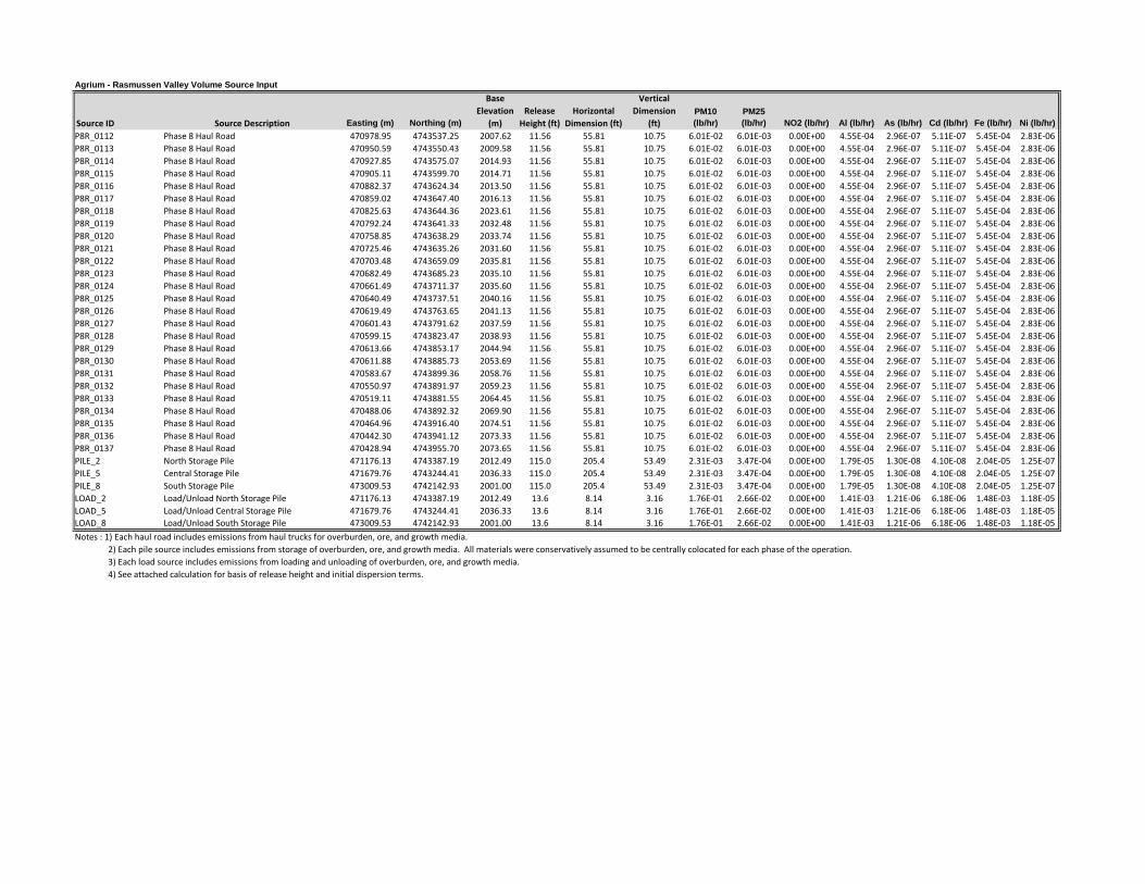
Agrium - Rasmussen Valley Volume Source Input
Source ID Source Description Easting (m) Northing (m)
Base Elevation
(m)Release
Height (ft)Horizontal
Dimension (ft)
Vertical Dimension
(ft)PM10 (lb/hr)
PM25 (lb/hr) NO2 (lb/hr) Al (lb/hr) As (lb/hr) Cd (lb/hr) Fe (lb/hr) Ni (lb/hr)
P8R_0112 Phase 8 Haul Road 470978.95 4743537.25 2007.62 11.56 55.81 10.75 6.01E‐02 6.01E‐03 0.00E+00 4.55E‐04 2.96E‐07 5.11E‐07 5.45E‐04 2.83E‐06P8R_0113 Phase 8 Haul Road 470950.59 4743550.43 2009.58 11.56 55.81 10.75 6.01E‐02 6.01E‐03 0.00E+00 4.55E‐04 2.96E‐07 5.11E‐07 5.45E‐04 2.83E‐06P8R_0114 Phase 8 Haul Road 470927.85 4743575.07 2014.93 11.56 55.81 10.75 6.01E‐02 6.01E‐03 0.00E+00 4.55E‐04 2.96E‐07 5.11E‐07 5.45E‐04 2.83E‐06P8R_0115 Phase 8 Haul Road 470905.11 4743599.70 2014.71 11.56 55.81 10.75 6.01E‐02 6.01E‐03 0.00E+00 4.55E‐04 2.96E‐07 5.11E‐07 5.45E‐04 2.83E‐06P8R_0116 Phase 8 Haul Road 470882.37 4743624.34 2013.50 11.56 55.81 10.75 6.01E‐02 6.01E‐03 0.00E+00 4.55E‐04 2.96E‐07 5.11E‐07 5.45E‐04 2.83E‐06P8R_0117 Phase 8 Haul Road 470859.02 4743647.40 2016.13 11.56 55.81 10.75 6.01E‐02 6.01E‐03 0.00E+00 4.55E‐04 2.96E‐07 5.11E‐07 5.45E‐04 2.83E‐06P8R_0118 Phase 8 Haul Road 470825.63 4743644.36 2023.61 11.56 55.81 10.75 6.01E‐02 6.01E‐03 0.00E+00 4.55E‐04 2.96E‐07 5.11E‐07 5.45E‐04 2.83E‐06P8R_0119 Phase 8 Haul Road 470792.24 4743641.33 2032.48 11.56 55.81 10.75 6.01E‐02 6.01E‐03 0.00E+00 4.55E‐04 2.96E‐07 5.11E‐07 5.45E‐04 2.83E‐06P8R_0120 Phase 8 Haul Road 470758.85 4743638.29 2033.74 11.56 55.81 10.75 6.01E‐02 6.01E‐03 0.00E+00 4.55E‐04 2.96E‐07 5.11E‐07 5.45E‐04 2.83E‐06P8R_0121 Phase 8 Haul Road 470725.46 4743635.26 2031.60 11.56 55.81 10.75 6.01E‐02 6.01E‐03 0.00E+00 4.55E‐04 2.96E‐07 5.11E‐07 5.45E‐04 2.83E‐06P8R_0122 Phase 8 Haul Road 470703.48 4743659.09 2035.81 11.56 55.81 10.75 6.01E‐02 6.01E‐03 0.00E+00 4.55E‐04 2.96E‐07 5.11E‐07 5.45E‐04 2.83E‐06P8R_0123 Phase 8 Haul Road 470682.49 4743685.23 2035.10 11.56 55.81 10.75 6.01E‐02 6.01E‐03 0.00E+00 4.55E‐04 2.96E‐07 5.11E‐07 5.45E‐04 2.83E‐06P8R_0124 Phase 8 Haul Road 470661.49 4743711.37 2035.60 11.56 55.81 10.75 6.01E‐02 6.01E‐03 0.00E+00 4.55E‐04 2.96E‐07 5.11E‐07 5.45E‐04 2.83E‐06P8R_0125 Phase 8 Haul Road 470640.49 4743737.51 2040.16 11.56 55.81 10.75 6.01E‐02 6.01E‐03 0.00E+00 4.55E‐04 2.96E‐07 5.11E‐07 5.45E‐04 2.83E‐06P8R_0126 Phase 8 Haul Road 470619.49 4743763.65 2041.13 11.56 55.81 10.75 6.01E‐02 6.01E‐03 0.00E+00 4.55E‐04 2.96E‐07 5.11E‐07 5.45E‐04 2.83E‐06P8R_0127 Phase 8 Haul Road 470601.43 4743791.62 2037.59 11.56 55.81 10.75 6.01E‐02 6.01E‐03 0.00E+00 4.55E‐04 2.96E‐07 5.11E‐07 5.45E‐04 2.83E‐06P8R_0128 Phase 8 Haul Road 470599.15 4743823.47 2038.93 11.56 55.81 10.75 6.01E‐02 6.01E‐03 0.00E+00 4.55E‐04 2.96E‐07 5.11E‐07 5.45E‐04 2.83E‐06P8R_0129 Phase 8 Haul Road 470613.66 4743853.17 2044.94 11.56 55.81 10.75 6.01E‐02 6.01E‐03 0.00E+00 4.55E‐04 2.96E‐07 5.11E‐07 5.45E‐04 2.83E‐06P8R_0130 Phase 8 Haul Road 470611.88 4743885.73 2053.69 11.56 55.81 10.75 6.01E‐02 6.01E‐03 0.00E+00 4.55E‐04 2.96E‐07 5.11E‐07 5.45E‐04 2.83E‐06P8R_0131 Phase 8 Haul Road 470583.67 4743899.36 2058.76 11.56 55.81 10.75 6.01E‐02 6.01E‐03 0.00E+00 4.55E‐04 2.96E‐07 5.11E‐07 5.45E‐04 2.83E‐06P8R_0132 Phase 8 Haul Road 470550.97 4743891.97 2059.23 11.56 55.81 10.75 6.01E‐02 6.01E‐03 0.00E+00 4.55E‐04 2.96E‐07 5.11E‐07 5.45E‐04 2.83E‐06P8R_0133 Phase 8 Haul Road 470519.11 4743881.55 2064.45 11.56 55.81 10.75 6.01E‐02 6.01E‐03 0.00E+00 4.55E‐04 2.96E‐07 5.11E‐07 5.45E‐04 2.83E‐06P8R_0134 Phase 8 Haul Road 470488.06 4743892.32 2069.90 11.56 55.81 10.75 6.01E‐02 6.01E‐03 0.00E+00 4.55E‐04 2.96E‐07 5.11E‐07 5.45E‐04 2.83E‐06P8R_0135 Phase 8 Haul Road 470464.96 4743916.40 2074.51 11.56 55.81 10.75 6.01E‐02 6.01E‐03 0.00E+00 4.55E‐04 2.96E‐07 5.11E‐07 5.45E‐04 2.83E‐06P8R_0136 Phase 8 Haul Road 470442.30 4743941.12 2073.33 11.56 55.81 10.75 6.01E‐02 6.01E‐03 0.00E+00 4.55E‐04 2.96E‐07 5.11E‐07 5.45E‐04 2.83E‐06P8R_0137 Phase 8 Haul Road 470428.94 4743955.70 2073.65 11.56 55.81 10.75 6.01E‐02 6.01E‐03 0.00E+00 4.55E‐04 2.96E‐07 5.11E‐07 5.45E‐04 2.83E‐06PILE_2 North Storage Pile 471176.13 4743387.19 2012.49 115.0 205.4 53.49 2.31E‐03 3.47E‐04 0.00E+00 1.79E‐05 1.30E‐08 4.10E‐08 2.04E‐05 1.25E‐07PILE_5 Central Storage Pile 471679.76 4743244.41 2036.33 115.0 205.4 53.49 2.31E‐03 3.47E‐04 0.00E+00 1.79E‐05 1.30E‐08 4.10E‐08 2.04E‐05 1.25E‐07PILE_8 South Storage Pile 473009.53 4742142.93 2001.00 115.0 205.4 53.49 2.31E‐03 3.47E‐04 0.00E+00 1.79E‐05 1.30E‐08 4.10E‐08 2.04E‐05 1.25E‐07LOAD_2 Load/Unload North Storage Pile 471176.13 4743387.19 2012.49 13.6 8.14 3.16 1.76E‐01 2.66E‐02 0.00E+00 1.41E‐03 1.21E‐06 6.18E‐06 1.48E‐03 1.18E‐05LOAD_5 Load/Unload Central Storage Pile 471679.76 4743244.41 2036.33 13.6 8.14 3.16 1.76E‐01 2.66E‐02 0.00E+00 1.41E‐03 1.21E‐06 6.18E‐06 1.48E‐03 1.18E‐05LOAD_8 Load/Unload South Storage Pile 473009.53 4742142.93 2001.00 13.6 8.14 3.16 1.76E‐01 2.66E‐02 0.00E+00 1.41E‐03 1.21E‐06 6.18E‐06 1.48E‐03 1.18E‐05Notes : 1) Each haul road includes emissions from haul trucks for overburden, ore, and growth media. 2) Each pile source includes emissions from storage of overburden, ore, and growth media. All materials were conservatively assumed to be centrally colocated for each phase of the operation. 3) Each load source includes emissions from loading and unloading of overburden, ore, and growth media. 4) See attached calculation for basis of release height and initial dispersion terms.
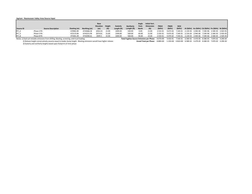
Agrium - Rasmussen Valley Area Source Input
Source ID Source Description Easting (m) Northing (m)
Base Elevation
(m)Height (ft)
Easterly Length (ft)
Northerly Length (ft)
Angle from North
Initial Vert. Dimension
(ft)PM10 (lb/hr)
PM25 (lb/hr)
NO2 (lb/hr) Al (lb/hr) As (lb/hr) Cd (lb/hr) Fe (lb/hr) Ni (lb/hr)
PIT_2 Phase 2 Pit 470965.98 4743666.36 2032.23 15.00 1000.00 500.00 0.00 15.00 2.55E‐01 9.47E‐02 7.54E‐01 2.13E‐03 2.94E‐06 7.59E‐06 2.58E‐03 2.92E‐05PIT_5 Phase 5 Pit 472175.84 4743215.99 2074.61 15.00 1500.00 500.00 40.00 15.00 2.55E‐01 9.47E‐02 7.54E‐01 2.13E‐03 2.94E‐06 7.59E‐06 2.58E‐03 2.92E‐05PIT_8 Phase 8 Pit 473401.49 4742096.61 2049.5 15.00 1000.00 500.00 40.00 15.00 2.55E‐01 9.47E‐02 7.54E‐01 2.13E‐03 2.94E‐06 7.59E‐06 2.58E‐03 2.92E‐05Notes: 1) Each pit includes emissions from drilling, blasting, screening, and truck loading. Total Fugitive Source Emissions per Phase: 8.67E+00 9.45E‐01 7.54E‐01 6.58E‐02 4.47E‐05 8.38E‐05 7.87E‐02 4.29E‐04 2) Release height conservatively assume equal to loader dump height. Blasting emissions would have higher release. Grand Total per Phase: 8.88E+00 1.15E+00 4.81E+00 6.58E‐02 4.47E‐05 8.38E‐05 7.87E‐02 4.29E‐04 3) Easterly and northerly lenghts based upon footprint of mine phase

Agrium ‐ Lane Creek Point Source Model Input (NAD83, Z12)‐ 10/29/13
Source ID Source Description Easting (m) Northing (m)
Base Elevation
(m)Stack
Height (ft) Temp. (°F)Exit Velocity
(ft/sec)
Stack Diameter
(ft)PM10 (lb/hr) PM25 (lb/hr)
NO2 (lb/hr)
LC_GEN_1 Diesel Generator 473972.24 4743666.04 1975.34 6.00 797.0 152.73 0.34 0.105 0.105 1.222LC_GEN_2 Diesel Generator 473977.92 4743648.99 1975.16 6.00 797.0 152.73 0.34 0.105 0.105 1.222LC_LP_ORE Diesel Light Plant (ore stockpile) 473999.00 4742427.00 2011.40 4.00 800.0 114.28 0.09 0.019 0.019 0.173LC_LP_FAC Diesel Light Plant (facilities area) 473991.18 4743712.13 1972.23 4.00 800.0 114.28 0.09 0.019 0.019 0.173LC_LPNSA Diesel Light Plant (north OSA area) 473677.00 4744105.00 1984.01 4.00 800.0 114.28 0.09 0.019 0.019 0.173LC_LPSSA Diesel Light Plant (south OSA area) 473967.28 4743004.79 2002.32 4.00 800.0 114.28 0.09 0.019 0.019 0.173LC_LPIT1 Diesel Light Plant (pit area ‐1) 473549.00 4743567.00 2090.49 4.00 800.0 114.28 0.09 0.019 0.019 0.173LC_LPIT2 Diesel Light Plant (pit area ‐2) 473710.00 4743238.00 2026.68 4.00 800.0 114.28 0.09 0.019 0.019 0.173LC_LPIT3 Diesel Light Plant (pit area ‐3) 474175.00 4743282.00 1979.01 4.00 800.0 114.28 0.09 0.019 0.019 0.173LC_LPIT4 Diesel Light Plant (pit area ‐4) 474036.16 4743521.33 1979.96 4.00 800.0 114.28 0.09 0.019 0.019 0.173LC_LPIT5 Diesel Light Plant (pit area ‐5) 473695.00 4743960.00 1989.21 4.00 800.0 114.28 0.09 0.019 0.019 0.173

Agrium - Lane Creek Volume Source Input
Source ID Source Description Easting (m) Northing (m)
Base Elevation
(m)Release
Height (ft)Horizontal
Dimension (ft)
Vertical Dimension
(ft)PM10 (lb/hr)
PM25 (lb/hr)
LC_RD1_1 Pit to N. OSA Road ‐ Segment 1 473835.64 4743608.09 2014.65 13.6 46.51 12.65 1.85E‐01 1.85E‐02LC_RD1_2 Pit to N. OSA Road ‐ Segment 2 473868.57 4743556.79 2008.39 13.6 46.51 12.65 1.85E‐01 1.85E‐02LC_RD1_3 Pit to N. OSA Road ‐ Segment 3 473901.50 4743505.49 2004.71 13.6 46.51 12.65 1.85E‐01 1.85E‐02LC_RD1_4 Pit to N. OSA Road ‐ Segment 4 473934.43 4743454.19 2003.73 13.6 46.51 12.65 1.85E‐01 1.85E‐02LC_RD1_5 Pit to N. OSA Road ‐ Segment 5 473976.46 4743411.12 2000.53 13.6 46.51 12.65 1.85E‐01 1.85E‐02LC_RD1_6 Pit to N. OSA Road ‐ Segment 6 474027.44 4743426.10 1989.55 13.6 46.51 12.65 1.85E‐01 1.85E‐02LC_RD1_7 Pit to N. OSA Road ‐ Segment 7 474024.17 4743483.24 1984.06 13.6 46.51 12.65 1.85E‐01 1.85E‐02LC_RD1_8 Pit to N. OSA Road ‐ Segment 8 473992.12 4743535.10 1984.14 13.6 46.51 12.65 1.85E‐01 1.85E‐02LC_RD1_9 Pit to N. OSA Road ‐ Segment 9 473959.55 4743586.60 1982.48 13.6 46.51 12.65 1.85E‐01 1.85E‐02LC_RD110 Pit to N. OSA Road ‐ Segment 10 473923.05 4743635.43 1983.94 13.6 46.51 12.65 1.85E‐01 1.85E‐02LC_RD111 Pit to N. OSA Road ‐ Segment 11 473886.56 4743684.26 1985.09 13.6 46.51 12.65 1.85E‐01 1.85E‐02LC_RD112 Pit to N. OSA Road ‐ Segment 12 473850.06 4743733.08 1991.74 13.6 46.51 12.65 1.85E‐01 1.85E‐02LC_RD113 Pit to N. OSA Road ‐ Segment 13 473813.56 4743781.91 1996.28 13.6 46.51 12.65 1.85E‐01 1.85E‐02LC_RD114 Pit to N. OSA Road ‐ Segment 14 473777.07 4743830.74 1992.98 13.6 46.51 12.65 1.85E‐01 1.85E‐02LC_RD115 Pit to N. OSA Road ‐ Segment 15 473757.98 4743856.27 1989.86 13.6 46.51 12.65 1.85E‐01 1.85E‐02LC_RD2_1 Pit to S. OSA Road ‐ Segment 1 473816.27 4743597.04 2023.13 13.6 46.51 12.65 1.94E‐01 1.94E‐02LC_RD2_2 Pit to S. OSA Road ‐ Segment 2 473849.42 4743545.88 2015.44 13.6 46.51 12.65 1.94E‐01 1.94E‐02LC_RD2_3 Pit to S. OSA Road ‐ Segment 3 473882.57 4743494.72 2012.02 13.6 46.51 12.65 1.94E‐01 1.94E‐02LC_RD2_4 Pit to S. OSA Road ‐ Segment 4 473915.72 4743443.56 2011.82 13.6 46.51 12.65 1.94E‐01 1.94E‐02LC_RD2_5 Pit to S. OSA Road ‐ Segment 5 473956.92 4743399.35 2008.18 13.6 46.51 12.65 1.94E‐01 1.94E‐02LC_RD2_6 Pit to S. OSA Road ‐ Segment 6 474002.66 4743359.05 2003.11 13.6 46.51 12.65 1.94E‐01 1.94E‐02LC_RD2_7 Pit to S. OSA Road ‐ Segment 7 474047.04 4743317.65 1996.22 13.6 46.51 12.65 1.94E‐01 1.94E‐02LC_RD2_8 Pit to S. OSA Road ‐ Segment 8 474076.88 4743264.49 1991.66 13.6 46.51 12.65 1.94E‐01 1.94E‐02LC_RD2_9 Pit to S. OSA Road ‐ Segment 9 474091.61 4743206.81 1994.78 13.6 46.51 12.65 1.94E‐01 1.94E‐02LC_RD210 Pit to S. OSA Road ‐ Segment 10 474076.15 4743149.63 1993.02 13.6 46.51 12.65 1.94E‐01 1.94E‐02LC_RD211 Pit to S. OSA Road ‐ Segment 11 474055.61 4743105.25 1996.05 13.6 46.51 12.65 1.94E‐01 1.94E‐02LC_RD3_1 Pit to Ore Stockpile ‐ Segment 1 473824.60 4743602.63 2019.36 13.6 46.51 12.65 5.59E‐02 5.59E‐03LC_RD3_2 Pit to Ore Stockpile ‐ Segment 2 473857.59 4743551.36 2012.46 13.6 46.51 12.65 5.59E‐02 5.59E‐03LC_RD3_3 Pit to Ore Stockpile ‐ Segment 3 473890.58 4743500.10 2008.55 13.6 46.51 12.65 5.59E‐02 5.59E‐03LC_RD3_4 Pit to Ore Stockpile ‐ Segment 4 473923.57 4743448.84 2007.96 13.6 46.51 12.65 5.59E‐02 5.59E‐03LC_RD3_5 Pit to Ore Stockpile ‐ Segment 5 473963.68 4743403.88 2005.32 13.6 46.51 12.65 5.59E‐02 5.59E‐03LC_RD3_6 Pit to Ore Stockpile ‐ Segment 6 474010.51 4743364.85 1999.86 13.6 46.51 12.65 5.59E‐02 5.59E‐03LC_RD3_7 Pit to Ore Stockpile ‐ Segment 7 474055.15 4743323.93 1994.21 13.6 46.51 12.65 5.59E‐02 5.59E‐03LC_RD3_8 Pit to Ore Stockpile ‐ Segment 8 474086.79 4743271.83 1989.78 13.6 46.51 12.65 5.59E‐02 5.59E‐03LC_RD3_9 Pit to Ore Stockpile ‐ Segment 9 474100.11 4743214.59 1993.14 13.6 46.51 12.65 5.59E‐02 5.59E‐03LC_RD310 Pit to Ore Stockpile ‐ Segment 10 474100.11 4743153.63 1990.49 13.6 46.51 12.65 5.59E‐02 5.59E‐03

Agrium - Lane Creek Volume Source Input
Source ID Source Description Easting (m) Northing (m)
Base Elevation
(m)Release
Height (ft)Horizontal
Dimension (ft)
Vertical Dimension
(ft)PM10 (lb/hr)
PM25 (lb/hr)
LC_RD311 Pit to Ore Stockpile ‐ Segment 11 474099.26 4743092.68 1991.00 13.6 46.51 12.65 5.59E‐02 5.59E‐03LC_RD312 Pit to Ore Stockpile ‐ Segment 12 474098.35 4743031.73 1990.70 13.6 46.51 12.65 5.59E‐02 5.59E‐03LC_RD313 Pit to Ore Stockpile ‐ Segment 13 474097.44 4742970.77 1989.62 13.6 46.51 12.65 5.59E‐02 5.59E‐03LC_RD314 Pit to Ore Stockpile ‐ Segment 14 474086.53 4742910.92 1989.88 13.6 46.51 12.65 5.59E‐02 5.59E‐03LC_RD315 Pit to Ore Stockpile ‐ Segment 15 474074.40 4742851.17 1991.21 13.6 46.51 12.65 5.59E‐02 5.59E‐03LC_RD316 Pit to Ore Stockpile ‐ Segment 16 474062.69 4742791.35 1993.75 13.6 46.51 12.65 5.59E‐02 5.59E‐03LC_RD317 Pit to Ore Stockpile ‐ Segment 17 474050.98 4742731.53 1995.17 13.6 46.51 12.65 5.59E‐02 5.59E‐03LC_RD318 Pit to Ore Stockpile ‐ Segment 18 474039.26 4742671.70 1996.90 13.6 46.51 12.65 5.59E‐02 5.59E‐03LC_RD4_1 N. OSA to Growth Pile ‐ Segment 1 473779.54 4743840.80 1990.67 13.6 46.51 12.65 1.21E‐02 1.21E‐03LC_RD4_2 N. OSA to Growth Pile ‐ Segment 2 473821.19 4743796.29 1991.73 13.6 46.51 12.65 1.21E‐02 1.21E‐03LC_RD4_3 N. OSA to Growth Pile ‐ Segment 3 473856.40 4743746.56 1987.86 13.6 46.51 12.65 1.21E‐02 1.21E‐03LC_RD4_4 N. OSA to Growth Pile ‐ Segment 4 473891.26 4743696.55 1983.13 13.6 46.51 12.65 1.21E‐02 1.21E‐03LC_RD4_5 N. OSA to Growth Pile ‐ Segment 5 473926.12 4743646.54 1982.43 13.6 46.51 12.65 1.21E‐02 1.21E‐03LC_RD4_6 N. OSA to Growth Pile ‐ Segment 6 473960.98 4743596.53 1981.19 13.6 46.51 12.65 1.21E‐02 1.21E‐03LC_RD4_7 N. OSA to Growth Pile ‐ Segment 7 473994.97 4743545.94 1982.78 13.6 46.51 12.65 1.21E‐02 1.21E‐03LC_RD4_8 N. OSA to Growth Pile ‐ Segment 8 474026.92 4743494.21 1982.95 13.6 46.51 12.65 1.21E‐02 1.21E‐03LC_RD4_9 N. OSA to Growth Pile ‐ Segment 9 474047.53 4743436.84 1986.23 13.6 46.51 12.65 1.21E‐02 1.21E‐03LC_RD410 N. OSA to Growth Pile ‐ Segment 10 474068.14 4743379.47 1985.64 13.6 46.51 12.65 1.21E‐02 1.21E‐03LC_RD411 N. OSA to Growth Pile ‐ Segment 11 474088.75 4743322.10 1987.73 13.6 46.51 12.65 1.21E‐02 1.21E‐03LC_RD412 N. OSA to Growth Pile ‐ Segment 12 474109.37 4743264.73 1986.58 13.6 46.51 12.65 1.21E‐02 1.21E‐03LC_RD413 N. OSA to Growth Pile ‐ Segment 13 474111.56 4743204.23 1991.37 13.6 46.51 12.65 1.21E‐02 1.21E‐03LC_RD414 N. OSA to Growth Pile ‐ Segment 14 474148.09 4743163.43 1985.65 13.6 46.51 12.65 1.21E‐02 1.21E‐03LC_RD415 N. OSA to Growth Pile ‐ Segment 15 474209.02 4743161.48 1982.44 13.6 46.51 12.65 1.21E‐02 1.21E‐03LC_RD416 N. OSA to Growth Pile ‐ Segment 16 474261.47 4743159.81 1979.46 13.6 46.51 12.65 1.21E‐02 1.21E‐03LC_RD417 N. OSA to Growth Pile ‐ Segment 17 473831.14 4743604.73 2016.80 13.6 46.51 12.65 1.21E‐02 1.21E‐03LC_RD5_1 Pit to Growth Pile ‐ Segment 1 473863.64 4743553.16 2010.30 13.6 46.51 12.65 2.03E‐02 2.03E‐03LC_RD5_2 Pit to Growth Pile ‐ Segment 2 473896.14 4743501.58 2006.75 13.6 46.51 12.65 2.03E‐02 2.03E‐03LC_RD5_3 Pit to Growth Pile ‐ Segment 3 473929.21 4743450.39 2005.61 13.6 46.51 12.65 2.03E‐02 2.03E‐03LC_RD5_4 Pit to Growth Pile ‐ Segment 4 473970.85 4743406.45 2002.87 13.6 46.51 12.65 2.03E‐02 2.03E‐03LC_RD5_5 Pit to Growth Pile ‐ Segment 5 474019.31 4743369.51 1996.79 13.6 46.51 12.65 2.03E‐02 2.03E‐03LC_RD5_6 Pit to Growth Pile ‐ Segment 6 474064.99 4743330.43 1991.39 13.6 46.51 12.65 2.03E‐02 2.03E‐03LC_RD5_7 Pit to Growth Pile ‐ Segment 7 474093.19 4743276.38 1988.62 13.6 46.51 12.65 2.03E‐02 2.03E‐03LC_RD5_8 Pit to Growth Pile ‐ Segment 8 474106.20 4743218.61 1991.84 13.6 46.51 12.65 2.03E‐02 2.03E‐03LC_RD5_9 Pit to Growth Pile ‐ Segment 9 474123.55 4743164.84 1987.98 13.6 46.51 12.65 2.03E‐02 2.03E‐03LC_RD510 Pit to Growth Pile ‐ Segment 10 474181.34 4743156.66 1983.75 13.6 46.51 12.65 2.03E‐02 2.03E‐03LC_RD511 Pit to Growth Pile ‐ Segment 11 474242.30 4743156.03 1981.02 13.6 46.51 12.65 2.03E‐02 2.03E‐03

Agrium - Lane Creek Volume Source Input
Source ID Source Description Easting (m) Northing (m)
Base Elevation
(m)Release
Height (ft)Horizontal
Dimension (ft)
Vertical Dimension
(ft)PM10 (lb/hr)
PM25 (lb/hr)
LC_RD512 Pit to Growth Pile ‐ Segment 12 474069.45 4743131.36 1994.08 13.6 46.51 12.65 2.03E‐02 2.03E‐03LC_RD6_1 S OSA to Growth Pile ‐ Segment 1 474117.78 4743153.97 1988.54 13.6 46.51 12.65 1.02E‐02 1.02E‐03LC_RD6_2 S OSA to Growth Pile ‐ Segment 2 474178.69 4743151.37 1984.00 13.6 46.51 12.65 1.02E‐02 1.02E‐03LC_RD6_3 S OSA to Growth Pile ‐ Segment 3 474239.59 4743148.76 1981.57 13.6 46.51 12.65 1.02E‐02 1.02E‐03LC_RD6_4 S OSA to Growth Pile ‐ Segment 4 474275.95 4743147.20 1978.65 13.6 46.51 12.65 1.02E‐02 1.02E‐03LC_RD6_5 S OSA to Growth Pile ‐ Segment 5 474028.18 4742674.99 1997.65 13.6 46.51 12.65 1.02E‐02 1.02E‐03LC_RD7_1 Ore Stockpile to Growth Pile ‐ Seg 1 474082.89 4742701.87 1992.29 13.6 46.51 12.65 1.32E‐02 1.32E‐03LC_RD7_2 Ore Stockpile to Growth Pile ‐ Seg 2 474115.25 4742751.50 1988.89 13.6 46.51 12.65 1.32E‐02 1.32E‐03LC_RD7_3 Ore Stockpile to Growth Pile ‐ Seg 3 474122.10 4742810.71 1988.29 13.6 46.51 12.65 1.32E‐02 1.32E‐03LC_RD7_4 Ore Stockpile to Growth Pile ‐ Seg 4 474121.56 4742871.66 1988.62 13.6 46.51 12.65 1.32E‐02 1.32E‐03LC_RD7_5 Ore Stockpile to Growth Pile ‐ Seg 5 474121.02 4742932.62 1987.84 13.6 46.51 12.65 1.32E‐02 1.32E‐03LC_RD7_6 Ore Stockpile to Growth Pile ‐ Seg 6 474121.26 4742993.58 1988.56 13.6 46.51 12.65 1.32E‐02 1.32E‐03LC_RD7_7 Ore Stockpile to Growth Pile ‐ Seg 7 474121.75 4743054.54 1988.53 13.6 46.51 12.65 1.32E‐02 1.32E‐03LC_RD7_8 Ore Stockpile to Growth Pile ‐ Seg 8 474122.70 4743115.49 1988.61 13.6 46.51 12.65 1.32E‐02 1.32E‐03LC_RD7_9 Ore Stockpile to Growth Pile ‐ Seg 9 474161.17 4743144.76 1985.26 13.6 46.51 12.65 1.32E‐02 1.32E‐03LC_RD710 Ore Stockpile to Growth Pile ‐ Seg 10 474222.07 4743141.98 1982.79 13.6 46.51 12.65 1.32E‐02 1.32E‐03LC_RD711 Ore Stockpile to Growth Pile ‐ Seg 11 474274.34 4743139.60 1979.01 13.6 46.51 12.65 1.32E‐02 1.32E‐03LC_NOSAP North OSA Pile 473717.69 4744039.28 1986.16 135 279.07 62.79 7.70E‐01 1.16E‐01LC_SOSAP South OSA Pile 473994.51 4742866.66 1995.37 115 279.07 53.49 7.70E‐01 1.16E‐01LC_ORE_P Ore Pile 474027.15 4742456.12 2003.51 45 148.00 20.93 1.51E+00 2.27E‐01LC_GRWTH Growth Media Pile 474411.96 4743225.56 1973.52 25 139.53 11.63 2.82E‐01 4.25E‐02LC_NOSAT North OSA Truck Load/Unload 473718.21 4743994.03 1987.49 14 8.14 3.16 3.30E‐01 5.00E‐02LC_SOSAT South OSA Truck Load/Unload 473994.45 4742922.39 1994.75 14 8.14 3.16 3.64E‐01 5.51E‐02LC_ORE_T Ore Truck Load/Unload 474031.84 4742528.33 2001.18 14 8.14 3.16 1.75E‐01 2.66E‐02LC_GRTHT Growth Media Truck Load/Unload 474357.13 4743165.04 1976.00 14 8.14 3.16 5.90E‐02 8.93E‐03LC_PIT_T Pit Truck Loading 473831.52 4743502.99 2026.60 14 8.14 3.16 9.35E‐02 1.42E‐02

Agrium - Lane Creek Area Source Input
Source ID Source Description Easting (m) Northing (m)
Base Elevation
(m) Height (ft)Easterly
Length (ft)Northerly Length (ft)
Angle from North
Initial Vert. Dimension
(ft) PM10 (lb/hr)PM25 (lb/hr)
NO2 (lb/hr)
LC_DRILL Pit Drilling 473829.99 4743348.88 2041.91 32.81 173.21 173.21 ‐25.00 3.28 0.774 0.432 0.000LC_BLAST Pit Blasting 473744.18 4743543.86 2045.99 65.62 173.21 173.21 ‐25.00 32.81 6.305 0.364 3.493Area source parameters assumed same as from preliminary Hildebrand modeling.

Appendix G (Volume Source Calculations)

Step 1: Width of Plume
Road Width (ft) of 100 + 20 ft (6 m) = 120 ft
Step 2: Height of Plume
Vehicle height (ft) of 13.6 X 1.7 = 23.12 ft
Step 3: Initial Sigma Y (Horizontal Dimension)
Width of plume (ft) of 120 / 2.15 = 55.81 ft
Step 4: Initial Sigma Z (Vertical Dimension)
Height of plume (ft) of 23.12 / 2.15 = 10.75 ft
Step 5: Height of Release
Height of plume (ft) of 23.12 / 2 = 11.6 ft
Agrium Truck Roadway Volume Source Parameter Calculation

Agrium Volume Source Initial Dispersion Characteristic Calculations
Source Description Height (ft)Length
(ft) Width (ft)
Release Height
(ft) Release Height Reference
Horizontal Dimension -Sigma Y (ft) Sigma Y Calculation Reference
Vertical Dimension -Sigma Z (ft) Sigma Z Calculation Reference
Storage Piles 230 1200 650 115 1/2 Pile Height 205.4 Square root of area divided by 4.3 53.5 Vertical dimension divided by 4.3
Truck Loading/Unloading 14 35 35 13.6 Top of truck 8.14 Square root of area divided by 4.3 3.16 Vertical dimension divided by 4.3

Appendix G (Modeling Results)

4/19/16 Agrium Rasmussen Valley NAAQS Model Results (3MM Tons/yr Production)Model File Pollutant Average Group Rank Conc/Dep East (X) North (Y) Elev Hill Flag Time Met File Sources Groups ReceptorsAERMOD 15181 Agrium NAAQS_5yrs_NO2.SUM NO2 8TH‐HIGHEST MAX DAILY 1‐HR LANESCK 1ST 498.18949 473975 4743625 1977.52 2282.88 0 5 YEARS soda_boi‐04‐08.sfc 47 7 21877AERMOD 15181 Agrium NAAQS_5yrs_NO2.SUM NO2 8TH‐HIGHEST MAX DAILY 1‐HR P2_NO_LC 1ST 79.37355 471176.9 4743210 1999.28 2357.14 0 5 YEARS soda_boi‐04‐08.sfc 47 7 21877AERMOD 15181 Agrium NAAQS_5yrs_NO2.SUM NO2 8TH‐HIGHEST MAX DAILY 1‐HR P5_NO_LC 1ST 53.72111 472360.4 4742384 1964.22 2376.14 0 5 YEARS soda_boi‐04‐08.sfc 47 7 21877AERMOD 15181 Agrium NAAQS_5yrs_NO2.SUM NO2 8TH‐HIGHEST MAX DAILY 1‐HR P8_NO_LC 1ST 77.91944 473573.5 4741531 1990.71 2123.78 0 5 YEARS soda_boi‐04‐08.sfc 47 7 21877AERMOD 15181 Agrium NAAQS_5yrs_NO2.SUM NO2 8TH‐HIGHEST MAX DAILY 1‐HR PHASE2 1ST 498.19343 473975 4743625 1977.52 2282.88 0 5 YEARS soda_boi‐04‐08.sfc 47 7 21877AERMOD 15181 Agrium NAAQS_5yrs_NO2.SUM NO2 8TH‐HIGHEST MAX DAILY 1‐HR PHASE5 1ST 498.19582 473975 4743625 1977.52 2282.88 0 5 YEARS soda_boi‐04‐08.sfc 47 7 21877AERMOD 15181 Agrium NAAQS_5yrs_NO2.SUM NO2 8TH‐HIGHEST MAX DAILY 1‐HR PHASE8 1ST 498.19629 473975 4743625 1977.52 2282.88 0 5 YEARS soda_boi‐04‐08.sfc 47 7 21877AERMOD 15181 Agrium NAAQS_2005_NOX.SUM NOX ANNUAL LANESCK 1ST 45.55018 473975 4743675 1977.23 2282.88 0 1 YEARS Soda_BOI‐05.SFC 47 7 21877AERMOD 15181 Agrium NAAQS_2006_NOX.SUM NOX ANNUAL LANESCK 1ST 44.6261 473975 4743675 1977.23 2282.88 0 1 YEARS Soda_BOI‐06.SFC 47 7 21877AERMOD 15181 Agrium NAAQS_2007_NOX.SUM NOX ANNUAL LANESCK 1ST 43.07099 473975 4743675 1977.23 2282.88 0 1 YEARS Soda_BOI‐07.SFC 47 7 21877AERMOD 15181 Agrium NAAQS_2004_NOX.SUM NOX ANNUAL LANESCK 1ST 41.16609 473975 4743675 1977.23 2282.88 0 1 YEARS Soda_BOI‐04.SFC 47 7 21877AERMOD 15181 Agrium NAAQS_2008_NOX.SUM NOX ANNUAL LANESCK 1ST 38.34559 473975 4743675 1977.23 2282.88 0 1 YEARS Soda_BOI‐08.SFC 47 7 21877AERMOD 15181 Agrium NAAQS_2005_NOX.SUM NOX ANNUAL P2_NO_LC 1ST 8.74362 471132.6 4743232 2002.32 2357.14 0 1 YEARS Soda_BOI‐05.SFC 47 7 21877AERMOD 15181 Agrium NAAQS_2004_NOX.SUM NOX ANNUAL P2_NO_LC 1ST 8.19904 471132.6 4743232 2002.32 2357.14 0 1 YEARS Soda_BOI‐04.SFC 47 7 21877AERMOD 15181 Agrium NAAQS_2007_NOX.SUM NOX ANNUAL P2_NO_LC 1ST 8.0142 471132.6 4743232 2002.32 2357.14 0 1 YEARS Soda_BOI‐07.SFC 47 7 21877AERMOD 15181 Agrium NAAQS_2008_NOX.SUM NOX ANNUAL P2_NO_LC 1ST 7.71415 471132.6 4743232 2002.32 2357.14 0 1 YEARS Soda_BOI‐08.SFC 47 7 21877AERMOD 15181 Agrium NAAQS_2006_NOX.SUM NOX ANNUAL P2_NO_LC 1ST 7.33262 471110.5 4743244 2000.29 2357.14 0 1 YEARS Soda_BOI‐06.SFC 47 7 21877AERMOD 15181 Agrium NAAQS_2005_NOX.SUM NOX ANNUAL P5_NO_LC 1ST 6.29323 472215.7 4742673 1988.63 2282.88 0 1 YEARS Soda_BOI‐05.SFC 47 7 21877AERMOD 15181 Agrium NAAQS_2004_NOX.SUM NOX ANNUAL P5_NO_LC 1ST 5.8132 472215.7 4742673 1988.63 2282.88 0 1 YEARS Soda_BOI‐04.SFC 47 7 21877AERMOD 15181 Agrium NAAQS_2007_NOX.SUM NOX ANNUAL P5_NO_LC 1ST 5.65339 472215.7 4742673 1988.63 2282.88 0 1 YEARS Soda_BOI‐07.SFC 47 7 21877AERMOD 15181 Agrium NAAQS_2008_NOX.SUM NOX ANNUAL P5_NO_LC 1ST 5.37749 472215.7 4742673 1988.63 2282.88 0 1 YEARS Soda_BOI‐08.SFC 47 7 21877AERMOD 15181 Agrium NAAQS_2006_NOX.SUM NOX ANNUAL P5_NO_LC 1ST 5.34842 472215.7 4742673 1988.63 2282.88 0 1 YEARS Soda_BOI‐06.SFC 47 7 21877AERMOD 15181 Agrium NAAQS_2005_NOX.SUM NOX ANNUAL P8_NO_LC 1ST 7.74638 473473.9 4741531 1990.62 2124.94 0 1 YEARS Soda_BOI‐05.SFC 47 7 21877AERMOD 15181 Agrium NAAQS_2004_NOX.SUM NOX ANNUAL P8_NO_LC 1ST 7.1229 473498.8 4741531 1990.63 2123.78 0 1 YEARS Soda_BOI‐04.SFC 47 7 21877AERMOD 15181 Agrium NAAQS_2007_NOX.SUM NOX ANNUAL P8_NO_LC 1ST 7.00788 473498.8 4741531 1990.63 2123.78 0 1 YEARS Soda_BOI‐07.SFC 47 7 21877AERMOD 15181 Agrium NAAQS_2008_NOX.SUM NOX ANNUAL P8_NO_LC 1ST 6.82324 473498.8 4741531 1990.63 2123.78 0 1 YEARS Soda_BOI‐08.SFC 47 7 21877AERMOD 15181 Agrium NAAQS_2006_NOX.SUM NOX ANNUAL P8_NO_LC 1ST 6.38542 473473.9 4741531 1990.62 2124.94 0 1 YEARS Soda_BOI‐06.SFC 47 7 21877AERMOD 15181 Agrium NAAQS_2005_NOX.SUM NOX ANNUAL PHASE2 1ST 45.7965 473975 4743675 1977.23 2282.88 0 1 YEARS Soda_BOI‐05.SFC 47 7 21877AERMOD 15181 Agrium NAAQS_2006_NOX.SUM NOX ANNUAL PHASE2 1ST 44.86163 473975 4743675 1977.23 2282.88 0 1 YEARS Soda_BOI‐06.SFC 47 7 21877AERMOD 15181 Agrium NAAQS_2007_NOX.SUM NOX ANNUAL PHASE2 1ST 43.3164 473975 4743675 1977.23 2282.88 0 1 YEARS Soda_BOI‐07.SFC 47 7 21877AERMOD 15181 Agrium NAAQS_2004_NOX.SUM NOX ANNUAL PHASE2 1ST 41.41172 473975 4743675 1977.23 2282.88 0 1 YEARS Soda_BOI‐04.SFC 47 7 21877AERMOD 15181 Agrium NAAQS_2008_NOX.SUM NOX ANNUAL PHASE2 1ST 38.60389 473975 4743675 1977.23 2282.88 0 1 YEARS Soda_BOI‐08.SFC 47 7 21877AERMOD 15181 Agrium NAAQS_2005_NOX.SUM NOX ANNUAL PHASE5 1ST 45.99165 473975 4743675 1977.23 2282.88 0 1 YEARS Soda_BOI‐05.SFC 47 7 21877AERMOD 15181 Agrium NAAQS_2006_NOX.SUM NOX ANNUAL PHASE5 1ST 45.04587 473975 4743675 1977.23 2282.88 0 1 YEARS Soda_BOI‐06.SFC 47 7 21877AERMOD 15181 Agrium NAAQS_2007_NOX.SUM NOX ANNUAL PHASE5 1ST 43.51083 473975 4743675 1977.23 2282.88 0 1 YEARS Soda_BOI‐07.SFC 47 7 21877AERMOD 15181 Agrium NAAQS_2004_NOX.SUM NOX ANNUAL PHASE5 1ST 41.59729 473975 4743675 1977.23 2282.88 0 1 YEARS Soda_BOI‐04.SFC 47 7 21877AERMOD 15181 Agrium NAAQS_2008_NOX.SUM NOX ANNUAL PHASE5 1ST 38.79835 473975 4743675 1977.23 2282.88 0 1 YEARS Soda_BOI‐08.SFC 47 7 21877AERMOD 15181 Agrium NAAQS_2005_NOX.SUM NOX ANNUAL PHASE8 1ST 46.11703 473975 4743675 1977.23 2282.88 0 1 YEARS Soda_BOI‐05.SFC 47 7 21877AERMOD 15181 Agrium NAAQS_2006_NOX.SUM NOX ANNUAL PHASE8 1ST 45.14261 473975 4743675 1977.23 2282.88 0 1 YEARS Soda_BOI‐06.SFC 47 7 21877AERMOD 15181 Agrium NAAQS_2007_NOX.SUM NOX ANNUAL PHASE8 1ST 43.61678 473975 4743675 1977.23 2282.88 0 1 YEARS Soda_BOI‐07.SFC 47 7 21877AERMOD 15181 Agrium NAAQS_2004_NOX.SUM NOX ANNUAL PHASE8 1ST 41.71283 473975 4743675 1977.23 2282.88 0 1 YEARS Soda_BOI‐04.SFC 47 7 21877AERMOD 15181 Agrium NAAQS_2008_NOX.SUM NOX ANNUAL PHASE8 1ST 38.90414 473975 4743675 1977.23 2282.88 0 1 YEARS Soda_BOI‐08.SFC 47 7 21877AERMOD 15181 Agrium NAAQS_5yrs_PM10.SUM PM10 24‐HR LANESCK 6TH 157.79558 474075 4743075 1995.83 2282.46 0 5030524 soda_boi‐04‐08.sfc 448 7 21877AERMOD 15181 Agrium NAAQS_5yrs_PM10.SUM PM10 24‐HR P2_NO_LC 6TH 105.76548 471154.8 4743221 2001.9 2357.14 0 5012324 soda_boi‐04‐08.sfc 448 7 21877AERMOD 15181 Agrium NAAQS_5yrs_PM10.SUM PM10 24‐HR P5_NO_LC 6TH 48.92344 471641 4742970 2007.98 2357.14 0 5022724 soda_boi‐04‐08.sfc 448 7 21877AERMOD 15181 Agrium NAAQS_5yrs_PM10.SUM PM10 24‐HR P8_NO_LC 6TH 34.11302 472930.6 4741740 1982.24 2282.88 0 5121524 soda_boi‐04‐08.sfc 448 7 21877AERMOD 15181 Agrium NAAQS_5yrs_PM10.SUM PM10 24‐HR PHASE2 6TH 159.56101 474075 4743075 1995.83 2282.46 0 5030524 soda_boi‐04‐08.sfc 448 7 21877AERMOD 15181 Agrium NAAQS_5yrs_PM10.SUM PM10 24‐HR PHASE5 6TH 160.57205 474075 4743075 1995.83 2282.46 0 5030524 soda_boi‐04‐08.sfc 448 7 21877AERMOD 15181 Agrium NAAQS_5yrs_PM10.SUM PM10 24‐HR PHASE8 6TH 162.00328 474075 4743075 1995.83 2282.46 0 5030524 soda_boi‐04‐08.sfc 448 7 21877AERMOD 15181 Agrium NAAQS_5yrs_PM25.SUM PM25 8TH‐HIGHEST 24‐HR LANESCK 1ST 16.09082 473950 4743550 1988.8 2282.88 0 5 YEARS soda_boi‐04‐08.sfc 448 7 21877AERMOD 15181 Agrium NAAQS_5yrs_PM25.SUM PM25 8TH‐HIGHEST 24‐HR P2_NO_LC 1ST 10.29188 471154.8 4743221 2001.9 2357.14 0 5 YEARS soda_boi‐04‐08.sfc 448 7 21877AERMOD 15181 Agrium NAAQS_5yrs_PM25.SUM PM25 8TH‐HIGHEST 24‐HR P5_NO_LC 1ST 4.19163 471641 4742970 2007.98 2357.14 0 5 YEARS soda_boi‐04‐08.sfc 448 7 21877AERMOD 15181 Agrium NAAQS_5yrs_PM25.SUM PM25 8TH‐HIGHEST 24‐HR P8_NO_LC 1ST 3.8418 473498.8 4741531 1990.63 2123.78 0 5 YEARS soda_boi‐04‐08.sfc 448 7 21877AERMOD 15181 Agrium NAAQS_5yrs_PM25.SUM PM25 8TH‐HIGHEST 24‐HR PHASE2 1ST 16.23244 473950 4743550 1988.8 2282.88 0 5 YEARS soda_boi‐04‐08.sfc 448 7 21877AERMOD 15181 Agrium NAAQS_5yrs_PM25.SUM PM25 8TH‐HIGHEST 24‐HR PHASE5 1ST 16.2838 473950 4743550 1988.8 2282.88 0 5 YEARS soda_boi‐04‐08.sfc 448 7 21877AERMOD 15181 Agrium NAAQS_5yrs_PM25.SUM PM25 8TH‐HIGHEST 24‐HR PHASE8 1ST 16.33281 473950 4743550 1988.8 2282.88 0 5 YEARS soda_boi‐04‐08.sfc 448 7 21877AERMOD 15181 Agrium NAAQS_5yrs_PM25.SUM PM25 ANNUAL LANESCK 1ST 7.88534 473950 4743550 1988.8 2282.88 0 5 YEARS soda_boi‐04‐08.sfc 448 7 21877AERMOD 15181 Agrium NAAQS_5yrs_PM25.SUM PM25 ANNUAL P2_NO_LC 1ST 3.0066 471154.8 4743221 2001.9 2357.14 0 5 YEARS soda_boi‐04‐08.sfc 448 7 21877AERMOD 15181 Agrium NAAQS_5yrs_PM25.SUM PM25 ANNUAL P5_NO_LC 1ST 1.30372 472215.7 4742673 1988.63 2282.88 0 5 YEARS soda_boi‐04‐08.sfc 448 7 21877AERMOD 15181 Agrium NAAQS_5yrs_PM25.SUM PM25 ANNUAL P8_NO_LC 1ST 1.06505 473498.8 4741531 1990.63 2123.78 0 5 YEARS soda_boi‐04‐08.sfc 448 7 21877AERMOD 15181 Agrium NAAQS_5yrs_PM25.SUM PM25 ANNUAL PHASE2 1ST 7.95821 473950 4743550 1988.8 2282.88 0 5 YEARS soda_boi‐04‐08.sfc 448 7 21877AERMOD 15181 Agrium NAAQS_5yrs_PM25.SUM PM25 ANNUAL PHASE5 1ST 7.99975 473950 4743550 1988.8 2282.88 0 5 YEARS soda_boi‐04‐08.sfc 448 7 21877AERMOD 15181 Agrium NAAQS_5yrs_PM25.SUM PM25 ANNUAL PHASE8 1ST 8.041 473950 4743550 1988.8 2282.88 0 5 YEARS soda_boi‐04‐08.sfc 448 7 21877

4/19/16 Agrium Rasmussen Valley NAAQS Model Results (3MM Tons/yr Production)
Pollutant Average Group Rank
Modeled Conc.
(ug/m3)Background (ug/m3)
Total (ug/m3)
Standard (ug/m3)
% Standard Comment
NO2 8TH‐HIGHEST MAX DAILY 1‐HR PHASE2 1ST 398.55 17.2 415.75 188 221% See Note 4NO2 8TH‐HIGHEST MAX DAILY 1‐HR P2_NO_LC 1ST 63.50 17.2 80.70 188 43% See Note 5NO2 8TH‐HIGHEST MAX DAILY 1‐HR PHASE5 1ST 398.56 17.2 415.76 188 221% See Note 4NO2 8TH‐HIGHEST MAX DAILY 1‐HR P5_NO_LC 1ST 42.98 17.2 60.18 188 32% See Note 5NO2 8TH‐HIGHEST MAX DAILY 1‐HR PHASE8 1ST 398.56 17.2 415.76 188 221% See Note 4NO2 8TH‐HIGHEST MAX DAILY 1‐HR P8_NO_LC 1ST 62.34 17.2 79.53 188 42% See Note 5
NOx ANNUAL PHASE2 1ST 34.35 1.5 35.86 100 36%NOx ANNUAL PHASE5 1ST 34.49 1.5 36.01 100 36%NOx ANNUAL PHASE8 1ST 34.59 1.5 36.10 100 36%
PM10 24‐HR PHASE2 6TH 159.56 34.0 193.56 150 129% See Note 4PM10 24‐HR P2_NO_LC 6TH 105.77 34.0 139.77 150 93% See Note 5PM10 24‐HR PHASE5 6TH 160.57 34.0 194.57 150 130% See Note 4PM10 24‐HR P5_NO_LC 6TH 48.92 34.0 82.92 150 55% See Note 5PM10 24‐HR PHASE8 6TH 162.00 34.0 196.00 150 131% See Note 4PM10 24‐HR P8_NO_LC 6TH 34.11 34.0 68.11 150 45% See Note 5
PM25 ANNUAL PHASE2 1ST 7.96 1.80 9.76 12 81%PM25 ANNUAL PHASE5 1ST 8.00 1.80 9.80 12 82%PM25 ANNUAL PHASE8 1ST 8.04 1.80 9.84 12 82%
PM25 8TH‐HIGHEST 24‐HR PHASE2 1ST 16.23 6.5 22.73 35 65%PM25 8TH‐HIGHEST 24‐HR PHASE5 1ST 16.28 6.5 22.78 35 65%PM25 8TH‐HIGHEST 24‐HR PHASE8 1ST 16.33 6.5 22.83 35 65%1. ARM of 0.75 applied to annual NOx modeled impact and ARM of 0.80 applied to 1‐hr NOx impact.2. All background concentrations were provided by the DEQ.3. Agrium's Lanes Creek mine included.4. Exceedences due to emissions from Lanes Creek. All exceedences occur within Lanes Creek ambient boundary which would not be considered ambient air for Lanes operations.5. Lanes Creek emissions not included. There are no modeled exceedences when Lanes Creek sources are excluded.

4/19/16 Agrium Rasmussen Valley TAP Model Results (3MM Tons/yr Production)Model File Pollutant Average Group Rank Conc/Dep East (X) North (Y) Elev Hill Flag Time Met File Sources Groups ReceptorsAERMOD 15181 Agrium TAP_2005_AS.SUM AS ANNUAL PHASE2 1ST 0.00014 471154.8 4743221 2001.9 2357.14 0 1 YEARS Soda_BOI‐05.SFC 305 3 21877AERMOD 15181 Agrium TAP_2004_AS.SUM AS ANNUAL PHASE2 1ST 0.00013 471154.8 4743221 2001.9 2357.14 0 1 YEARS Soda_BOI‐04.SFC 305 3 21877AERMOD 15181 Agrium TAP_2007_AS.SUM AS ANNUAL PHASE2 1ST 0.00013 471154.8 4743221 2001.9 2357.14 0 1 YEARS Soda_BOI‐07.SFC 305 3 21877AERMOD 15181 Agrium TAP_2006_AS.SUM AS ANNUAL PHASE2 1ST 0.00012 471154.8 4743221 2001.9 2357.14 0 1 YEARS Soda_BOI‐06.SFC 305 3 21877AERMOD 15181 Agrium TAP_2008_AS.SUM AS ANNUAL PHASE2 1ST 0.00012 471154.8 4743221 2001.9 2357.14 0 1 YEARS Soda_BOI‐08.SFC 305 3 21877AERMOD 15181 Agrium TAP_2004_AS.SUM AS ANNUAL PHASE5 1ST 0.00006 471641 4742970 2007.98 2357.14 0 1 YEARS Soda_BOI‐04.SFC 305 3 21877AERMOD 15181 Agrium TAP_2005_AS.SUM AS ANNUAL PHASE5 1ST 0.00006 471641 4742970 2007.98 2357.14 0 1 YEARS Soda_BOI‐05.SFC 305 3 21877AERMOD 15181 Agrium TAP_2007_AS.SUM AS ANNUAL PHASE5 1ST 0.00006 471641 4742970 2007.98 2357.14 0 1 YEARS Soda_BOI‐07.SFC 305 3 21877AERMOD 15181 Agrium TAP_2008_AS.SUM AS ANNUAL PHASE5 1ST 0.00006 471641 4742970 2007.98 2357.14 0 1 YEARS Soda_BOI‐08.SFC 305 3 21877AERMOD 15181 Agrium TAP_2006_AS.SUM AS ANNUAL PHASE5 1ST 0.00005 471641 4742970 2007.98 2357.14 0 1 YEARS Soda_BOI‐06.SFC 305 3 21877AERMOD 15181 Agrium TAP_2004_AS.SUM AS ANNUAL PHASE8 1ST 0.00004 470404.9 4743907 2056.09 2357.14 0 1 YEARS Soda_BOI‐04.SFC 305 3 21877AERMOD 15181 Agrium TAP_2005_AS.SUM AS ANNUAL PHASE8 1ST 0.00004 472953 4741731 1982.05 2282.46 0 1 YEARS Soda_BOI‐05.SFC 305 3 21877AERMOD 15181 Agrium TAP_2007_AS.SUM AS ANNUAL PHASE8 1ST 0.00004 470404.9 4743907 2056.09 2357.14 0 1 YEARS Soda_BOI‐07.SFC 305 3 21877AERMOD 15181 Agrium TAP_2008_AS.SUM AS ANNUAL PHASE8 1ST 0.00004 470404.9 4743907 2056.09 2357.14 0 1 YEARS Soda_BOI‐08.SFC 305 3 21877AERMOD 15181 Agrium TAP_2006_AS.SUM AS ANNUAL PHASE8 1ST 0.00003 470404.9 4743907 2056.09 2357.14 0 1 YEARS Soda_BOI‐06.SFC 305 3 21877AERMOD 15181 Agrium TAP_2005_CD.SUM CD ANNUAL PHASE2 1ST 0.00031 471154.8 4743221 2001.9 2357.14 0 1 YEARS Soda_BOI‐05.SFC 305 3 21877AERMOD 15181 Agrium TAP_2004_CD.SUM CD ANNUAL PHASE2 1ST 0.00029 471154.8 4743221 2001.9 2357.14 0 1 YEARS Soda_BOI‐04.SFC 305 3 21877AERMOD 15181 Agrium TAP_2007_CD.SUM CD ANNUAL PHASE2 1ST 0.00028 471154.8 4743221 2001.9 2357.14 0 1 YEARS Soda_BOI‐07.SFC 305 3 21877AERMOD 15181 Agrium TAP_2008_CD.SUM CD ANNUAL PHASE2 1ST 0.00027 471154.8 4743221 2001.9 2357.14 0 1 YEARS Soda_BOI‐08.SFC 305 3 21877AERMOD 15181 Agrium TAP_2006_CD.SUM CD ANNUAL PHASE2 1ST 0.00026 471154.8 4743221 2001.9 2357.14 0 1 YEARS Soda_BOI‐06.SFC 305 3 21877AERMOD 15181 Agrium TAP_2005_CD.SUM CD ANNUAL PHASE5 1ST 0.00014 471641 4742970 2007.98 2357.14 0 1 YEARS Soda_BOI‐05.SFC 305 3 21877AERMOD 15181 Agrium TAP_2004_CD.SUM CD ANNUAL PHASE5 1ST 0.00013 471641 4742970 2007.98 2357.14 0 1 YEARS Soda_BOI‐04.SFC 305 3 21877AERMOD 15181 Agrium TAP_2007_CD.SUM CD ANNUAL PHASE5 1ST 0.00013 471641 4742970 2007.98 2357.14 0 1 YEARS Soda_BOI‐07.SFC 305 3 21877AERMOD 15181 Agrium TAP_2006_CD.SUM CD ANNUAL PHASE5 1ST 0.00012 471641 4742970 2007.98 2357.14 0 1 YEARS Soda_BOI‐06.SFC 305 3 21877AERMOD 15181 Agrium TAP_2008_CD.SUM CD ANNUAL PHASE5 1ST 0.00012 471641 4742970 2007.98 2357.14 0 1 YEARS Soda_BOI‐08.SFC 305 3 21877AERMOD 15181 Agrium TAP_2005_CD.SUM CD ANNUAL PHASE8 1ST 0.00009 472953 4741731 1982.05 2282.46 0 1 YEARS Soda_BOI‐05.SFC 305 3 21877AERMOD 15181 Agrium TAP_2004_CD.SUM CD ANNUAL PHASE8 1ST 0.00008 472953 4741731 1982.05 2282.46 0 1 YEARS Soda_BOI‐04.SFC 305 3 21877AERMOD 15181 Agrium TAP_2007_CD.SUM CD ANNUAL PHASE8 1ST 0.00008 472953 4741731 1982.05 2282.46 0 1 YEARS Soda_BOI‐07.SFC 305 3 21877AERMOD 15181 Agrium TAP_2008_CD.SUM CD ANNUAL PHASE8 1ST 0.00008 472975.5 4741721 1982.21 2282.46 0 1 YEARS Soda_BOI‐08.SFC 305 3 21877AERMOD 15181 Agrium TAP_2006_CD.SUM CD ANNUAL PHASE8 1ST 0.00007 472953 4741731 1982.05 2282.46 0 1 YEARS Soda_BOI‐06.SFC 305 3 21877AERMOD 15181 Agrium TAP_2004_FE.SUM FE 24‐HR PHASE2 1ST 1.23736 471154.8 4743221 2001.9 2357.14 0 4011724 Soda_BOI‐04.SFC 305 3 21877AERMOD 15181 Agrium TAP_2005_FE.SUM FE 24‐HR PHASE2 1ST 1.00254 471154.8 4743221 2001.9 2357.14 0 5121424 Soda_BOI‐05.SFC 305 3 21877AERMOD 15181 Agrium TAP_2006_FE.SUM FE 24‐HR PHASE2 1ST 0.94592 471132.6 4743232 2002.32 2357.14 0 6120324 Soda_BOI‐06.SFC 305 3 21877AERMOD 15181 Agrium TAP_2007_FE.SUM FE 24‐HR PHASE2 1ST 0.9075 471154.8 4743221 2001.9 2357.14 0 7012424 Soda_BOI‐07.SFC 305 3 21877AERMOD 15181 Agrium TAP_2008_FE.SUM FE 24‐HR PHASE2 1ST 0.84856 471154.8 4743221 2001.9 2357.14 0 8012324 Soda_BOI‐08.SFC 305 3 21877AERMOD 15181 Agrium TAP_2004_FE.SUM FE 24‐HR PHASE5 1ST 0.55156 471641 4742970 2007.98 2357.14 0 4011724 Soda_BOI‐04.SFC 305 3 21877AERMOD 15181 Agrium TAP_2006_FE.SUM FE 24‐HR PHASE5 1ST 0.48719 471618.9 4742981 2008.44 2357.14 0 6120324 Soda_BOI‐06.SFC 305 3 21877AERMOD 15181 Agrium TAP_2005_FE.SUM FE 24‐HR PHASE5 1ST 0.4516 471641 4742970 2007.98 2357.14 0 5012324 Soda_BOI‐05.SFC 305 3 21877AERMOD 15181 Agrium TAP_2007_FE.SUM FE 24‐HR PHASE5 1ST 0.3894 471625 4742975 2007.66 2357.14 0 7012424 Soda_BOI‐07.SFC 305 3 21877AERMOD 15181 Agrium TAP_2008_FE.SUM FE 24‐HR PHASE5 1ST 0.37642 471641 4742970 2007.98 2357.14 0 8012324 Soda_BOI‐08.SFC 305 3 21877AERMOD 15181 Agrium TAP_2004_FE.SUM FE 24‐HR PHASE8 1ST 0.39967 472953 4741731 1982.05 2282.46 0 4011724 Soda_BOI‐04.SFC 305 3 21877AERMOD 15181 Agrium TAP_2006_FE.SUM FE 24‐HR PHASE8 1ST 0.33654 472908.2 4741750 1982.68 2282.88 0 6120324 Soda_BOI‐06.SFC 305 3 21877AERMOD 15181 Agrium TAP_2005_FE.SUM FE 24‐HR PHASE8 1ST 0.32394 472930.6 4741740 1982.24 2282.88 0 5022724 Soda_BOI‐05.SFC 305 3 21877AERMOD 15181 Agrium TAP_2007_FE.SUM FE 24‐HR PHASE8 1ST 0.28482 472930.6 4741740 1982.24 2282.88 0 7012424 Soda_BOI‐07.SFC 305 3 21877AERMOD 15181 Agrium TAP_2008_FE.SUM FE 24‐HR PHASE8 1ST 0.26074 472975.5 4741721 1982.21 2282.46 0 8021824 Soda_BOI‐08.SFC 305 3 21877AERMOD 15181 Agrium TAP_2005_NI.SUM NI ANNUAL PHASE2 1ST 0.00134 471154.8 4743221 2001.9 2357.14 0 1 YEARS Soda_BOI‐05.SFC 305 3 21877AERMOD 15181 Agrium TAP_2004_NI.SUM NI ANNUAL PHASE2 1ST 0.00125 471154.8 4743221 2001.9 2357.14 0 1 YEARS Soda_BOI‐04.SFC 305 3 21877AERMOD 15181 Agrium TAP_2007_NI.SUM NI ANNUAL PHASE2 1ST 0.00122 471154.8 4743221 2001.9 2357.14 0 1 YEARS Soda_BOI‐07.SFC 305 3 21877AERMOD 15181 Agrium TAP_2008_NI.SUM NI ANNUAL PHASE2 1ST 0.00118 471154.8 4743221 2001.9 2357.14 0 1 YEARS Soda_BOI‐08.SFC 305 3 21877AERMOD 15181 Agrium TAP_2006_NI.SUM NI ANNUAL PHASE2 1ST 0.00112 471154.8 4743221 2001.9 2357.14 0 1 YEARS Soda_BOI‐06.SFC 305 3 21877AERMOD 15181 Agrium TAP_2005_NI.SUM NI ANNUAL PHASE5 1ST 0.0006 471641 4742970 2007.98 2357.14 0 1 YEARS Soda_BOI‐05.SFC 305 3 21877AERMOD 15181 Agrium TAP_2004_NI.SUM NI ANNUAL PHASE5 1ST 0.00057 471641 4742970 2007.98 2357.14 0 1 YEARS Soda_BOI‐04.SFC 305 3 21877AERMOD 15181 Agrium TAP_2007_NI.SUM NI ANNUAL PHASE5 1ST 0.00056 471641 4742970 2007.98 2357.14 0 1 YEARS Soda_BOI‐07.SFC 305 3 21877AERMOD 15181 Agrium TAP_2008_NI.SUM NI ANNUAL PHASE5 1ST 0.00053 471641 4742970 2007.98 2357.14 0 1 YEARS Soda_BOI‐08.SFC 305 3 21877AERMOD 15181 Agrium TAP_2006_NI.SUM NI ANNUAL PHASE5 1ST 0.00051 471641 4742970 2007.98 2357.14 0 1 YEARS Soda_BOI‐06.SFC 305 3 21877AERMOD 15181 Agrium TAP_2005_NI.SUM NI ANNUAL PHASE8 1ST 0.00038 472953 4741731 1982.05 2282.46 0 1 YEARS Soda_BOI‐05.SFC 305 3 21877AERMOD 15181 Agrium TAP_2004_NI.SUM NI ANNUAL PHASE8 1ST 0.00036 470404.9 4743907 2056.09 2357.14 0 1 YEARS Soda_BOI‐04.SFC 305 3 21877AERMOD 15181 Agrium TAP_2007_NI.SUM NI ANNUAL PHASE8 1ST 0.00036 470404.9 4743907 2056.09 2357.14 0 1 YEARS Soda_BOI‐07.SFC 305 3 21877AERMOD 15181 Agrium TAP_2008_NI.SUM NI ANNUAL PHASE8 1ST 0.00035 470404.9 4743907 2056.09 2357.14 0 1 YEARS Soda_BOI‐08.SFC 305 3 21877AERMOD 15181 Agrium TAP_2006_NI.SUM NI ANNUAL PHASE8 1ST 0.00033 470404.9 4743907 2056.09 2357.14 0 1 YEARS Soda_BOI‐06.SFC 305 3 21877

4/19/16 Agrium Rasmussen Valley TAP Model Results (3MM Tons/yr Production)
Pollutant Average Group Rank
Modeled Conc.
(ug/m3)AACC/AAC (ug/m3)
% Standard
AS ANNUAL PHASE2 1ST 1.40E‐04 2.3.E‐04 61%AS ANNUAL PHASE5 1ST 6.00E‐05 2.3.E‐04 26%AS ANNUAL PHASE8 1ST 4.00E‐05 2.3.E‐04 17%FE 24‐HR PHASE2 1ST 1.24E+00 5.0.E+01 2%FE 24‐HR PHASE5 1ST 5.52E‐01 5.0.E+01 1%FE 24‐HR PHASE8 1ST 4.00E‐01 5.0.E+01 1%CD ANNUAL PHASE2 1ST 3.10E‐04 5.6.E‐04 55%CD ANNUAL PHASE5 1ST 1.40E‐04 5.6.E‐04 25%CD ANNUAL PHASE8 1ST 9.00E‐05 5.6.E‐04 16%NI ANNUAL PHASE2 1ST 1.34E‐03 4.2.E‐03 32%NI ANNUAL PHASE5 1ST 6.00E‐04 4.2.E‐03 14%NI ANNUAL PHASE8 1ST 3.80E‐04 4.2.E‐03 9%

Appendix G (Model Protocol Approval)

STATE OF IDAHO
DEPARTMENT OF
ENVIRONMENTAL QUALITY
1410 NORTH HILTON, BOISE, ID 83706 · (208) 373-0502 C. L. “BUTCH” OTTER, GOVERNOR
JOHN TIPPETS, DIRECTOR
January 12, 2016 David Keane RTP Environmental Associates on behalf of Agrium, Rassmussen Valley Mine, Caribou County, Idaho Re: Modeling Protocol for the Rasmussen Valley Mine in Caribou County, Idaho Dear David: DEQ received your dispersion modeling protocol via email on December 18, 2015 on behalf of Agrium, Rasmussen Valley Mine project in Caribou County, Idaho. The modeling protocol was submitted by David Keane of RTP Environmental Associates, Inc (RTP). The modeling protocol proposes methods and data for use in the ambient impact analyses of a Permit to Construct (PTC) application for a new facility. The analyses are needed to demonstrate compliance with ambient air quality standards for the proposed facility. DEQ has the following comments:
• Comment 1: Documentation and justification of release parameters must be provided in the
application. Refer to Section 3.4.3 of the State of Idaho Guideline for Performing Air Quality Impact Analyses, September 2013(http://www.deq.idaho.gov/media/1029/modeling-guideline.pdf). Simply stating that values are “manufacturer data” does not constitute adequate documentation and/or justification. DEQ requests that the application describe how the values were obtained (measurement, similar source, combustion evaluation, fan curves, etc.). If values were obtained from an equipment/engineering firm, then those forms, specification sheets, etc. provided by the firm should be included in the application as documentation for the values used in the modeling analyses. The application should be treated as a stand-alone document. If values have been taken from previous permit applications or permits, then the data and derivation from those permit applications or permits must be included in the document. If data was taken from a stack test, then the stack test report and data should also be included in the document.

• Comment 2: RTP states that operation of the emergency generator will be limited to 100 hours a year, and therefore will not be modeled for the NO2 1-hour NAAQS analysis, per DEQ modeling guidelines. DEQ reminds RTP that the emissions for the emergency generator still need to be accounted for in the modeling analyses for other pollutants and for annual NO2 analysis. Unless a permit provision limiting the source to total operations of less than 100 hours/year is requested by the applicant, annual modeling of emergency generators should assume 500 hours/year (a value EPA determined represents PTE, considering both testing, maintenance, and potential use during emergencies). Short term rates based on maximum hourly emissions should be adequate to demonstrate compliance with short term NAAQS, such as that for PM2.5.
• Comment 3: Descriptions of the facility process are generally adequate. The ambient air boundary, as stated in the State of Idaho Guideline for Performing Air Quality Impact Analyses, should be defined by an area where the public access is legally and practically precluded. This includes separation from areas of habitation or activities by people not employed by the facility. The protocol states that the ambient boundary will not be controlled by a physical barrier but general access will be discouraged by posting, and facility employees will maintain awareness of possible trespasses. The applicant should strive to provide a very detailed description of the facility and boundary in the modeling report provided in the final submittal as described in section 1c of Section 6.5 in the Modeling Guideline 1 If a physical barrier is not used to preclude public access from areas excluded from ambient air, then the application must thoroughly describe the methods used to practically preclude access.
• Comment 4: RTP has proposed to use the meteorological data provided by DEQ. This data
was collected at the nearby Soda Springs Idaho airport for the period 2008-2012, and is deemed to be appropriately representative of the facility locale.
• Comment 5: RTP has chosen to model the mine haul roads as adjacent volume sources in accordance with the procedures adopted by the EPA Haul Road Workgroup, as described in “Haul Road Workgroup Final Report”, EPA Region 5, March 2012. DEQ accepts that document as adequate guidance. DEQ will review RTP’s adaptation of those procedures when the modeling analyses report is submitted with the permit application.
• Comment 6: DEQ is providing updated ambient background concentrations to be used in the modeling analyses. These data will be taken from the NWAIRQUEST tool using the coordinates of the facility.
• Comment 7: RTP did not provide detailed emission data with the modeling protocol. It should be noted that review and acceptance of the emission calculation and their usage with respect to modeling thresholds is the responsibility of the assigned permit writer, and DEQ review of such emissions estimates will be performed during DEQ’s review of the submitted application. Usage of emissions with respect to modeling thresholds is normally limited to Level I thresholds. Level II modeling applicability thresholds are accepted on a case by case

situation, and discussions with DEQ and approval by DEQ are necessary before any pollutants can be excluded from site-specific analyses on the basis of emissions quantities below Level II thresholds. Therefore modeling applicability and estimated modeling emissions are considered preliminary as submitted in the protocol.
• Comment 8: RTP requests that no other sources be modeled in the application, and that the impact from all other nearby sources should be assumed to be included with the ambient background concentrations derived from NWAIRQUEST. DEQ will not agree to this request without further assessment of the existing sources in the immediate area of the proposed mine site. The background values from NWAIRQUEST are relatively small in magnitude, and would not account for another nearby source with significant emissions, (such as the Lanes Creek mine). The submitted application must provide justification for exclusion of any nearby facilities. If RTP requests that this issue be confidently resolved prior to submission of the application, then a protocol addendum could be submitted for DEQ’s consideration prior to performing the analyses.
• Comment 9: RTP discusses various options available about assessing NO2 impacts with respect to chemical transformation from NOx to NO2. If non-default Tier 3 options such as OLM or PVMRM are used, the applicant must first contact DEQ for prior approval. The Tier 1 and Tier 2 options as discussed are adequate, as are the suggested equilibrium ratio of 0.9. The in-stack ratio (ISR) database items used for selection of the ISR for the diesel fired generators must be provided with the modeling report.
• Comment 10: RTP provides adequate description of a modeling receptor grid. DEQ agrees with placement of receptors on Lanes Creek Road. DEQ reminds the applicant that the density spacing of receptors in the immediate areas of maximum “design” concentrations should be such that DEQ is confident that maximum impacts have been identified at a level where compliance with the applicable standards is highly confident.
• Comment 11: DEQ has recently developed a modeling report template form for consultants/applicants to use when submitting modeling analyses. An electronic copy of this template should have been attached to the email delivering this protocol approval notice. DEQ now requires that this template be used for the submitted modeling analyses.
DEQ modeling staff considers the submitted dispersion modeling protocol, with consideration and resolution of the additional items noted above, to be approved. It should be noted, however, that the approval of this modeling protocol is not meant to imply approval of a completed dispersion modeling analysis. Please refer to the State of Idaho Air Quality Modeling Guideline, which is available on the Internet at http://www.deq.state.id.us/air/permits_forms/permitting/modeling_guideline.pdf, for further guidance. DEQ modeling staff requests submission of electronic copies of all modeling input and output files (including BPIP and AERMAP input and output files) with an analysis report. Also, please include with

the application materials a copy of the protocol and this protocol approval in the appendix of the application. If you have any questions, please call at 208 373 0220
Sincerely, Thomas Swain Analyst 3 , Air Modeling Idaho Department of Environmental Quality 208 373-0220 [email protected] (1)State of Idaho Guideline for Performing Air Quality Impact Analyses, September 2013