Embed Size (px)
Citation preview

Standard application form 2016
For Office Use
Ref. No._________________
Application date: __________
Date of receipt. ___________
Date Validated: ___________
APPLICATION FOR A LEASE/LICENCE/CONSENT UNDER THE FORESHORE ACT 1933 (AS AMENDED)
• Applications for Offshore renewable energy (ORE) projects should use an ORE specific
form. • Please complete the form electronically. Type details in the boxes provided, space will
expand as you type. • The enclosures checklist should also be completed • Tá an leagan Gaeilge den fhoirm seo ar fáil ar iarratas.
BEFORE FILLING OUT THIS FORM PLEASE READ THE DECLARATION AND CONSENT AT THE END OF THIS FORM: IT IS IMPORTANT TO NOTE THAT A CHANGE IN APPLICANT NAME WILL REQUIRE A NEW APPLICATION.
DATA PROTECTION The Office of the Data Protection Commissioner states that the sending of marketing material to individuals without consent may result in action by the Data Protection Commissioner against the sender including prosecution. It is the responsibility of persons or entities wishing to use any personal data on an application form for direct marking purposes to be satisfied that that they may do so legitimately under the requirements of the Data Protection Acts 1998 and 2003 and with regard to General Data Protection Regulation (2016/679) requirements.
Applicant Name and Address:
Full Name of Applicant (not Agent): Company/Organisation: Irish Water Address: Colvill House, 24 – 26 Talbot Street, Dublin 1 Eircode: D01 NP86
Applicant Contact Details:
Phone No: E-mail address: @water.ie

2
Agent (if any) Address/Contact Details: Person/Agent acting on behalf of the Applicant: Kevin O’Sullivan Company: Arup Address: One Albert Quay, Cork, Ireland Eircode: T12 X8N6 Phone No: 087-7504132 E-mail address: [email protected]
Applicant’s Legal Advisor:
Name: Irish Water Legal Services Address: Colvill House, 24-26 Talbot Street, Dublin 1.
Eircode: DO1 NP86 Phone No: 01 823 0300 E-mail address: [email protected]

3
Part 1: Proposal Details (Attach additional documents as required)
1.1
Description of proposed works/activity. The proposed development would consist of the construction of a wastewater collection and treatment system for the combined villages of Whitegate and Aghada, Co. Cork. Currently, there is no wastewater treatment facility serving the villages and as a result untreated wastewater is being discharged directly into Cork Harbour. This process is not compliant with obligations of the Urban Wastewater Treatment Directive (UWWTD) 91/271/EEC. To rectify this problem and to facilitate future development in the villages, currently constrained by the lack of adequate wastewater treatment, the proposed development is being advanced by Irish Water. The following elements of the scheme will be located within the foreshore:
• Marine Outfall
The laying of a proposed 295m (approx.) long marine outfall (from the High Water Mark (HWM)) to convey treated effluent from the proposed Whitegate & Aghada Wastewater Treatment Plant (WwTP) to be discharged in White Bay. The construction works for the proposed development would also require temporary working areas to accommodate the required infrastructure within the foreshore.
• Part of proposed Rostellan Wastewater Pump Station and Rising
Main Because of the location of the HWM on the local 25” Ordnance Survey map, the following two elements of the proposed pump station in Rostellan would be located in the foreshore:
1. Part of the proposed underground stormwater storage tank; 2. Part of the proposed rising main.
• Part of proposed Whitegate Wastewater Pump Station and Rising
Main: Because of the location of the HWM on the local 25” Ordnance Survey map, the following two elements of the proposed pump station in Whitegate would be located in the foreshore:
1. Part of the proposed underground pump station and stormwater storage tank, control kiosk, valve chamber, manholes, pipework.
2. Part of the proposed rising main from the proposed Whitegate pump station to the proposed WwTP.
3. The overflow pipeline from the proposed pumping station.
It is proposed that these elements of the scheme would be undertaken within the foreshore and would require appropriate consents under the Foreshore Acts, as amended. Please see the enclosed AA Screening, NIS and EIA Screening documentation for a more detailed description of the proposed development.

4
The overall scheme would comprise the following elements:
• Wastewater Treatment Plant (WwTP): A wastewater treatment plant providing preliminary and primary treatment for an initial population equivalent of approx. 2,479 PE (10-year design horizon), with provision for upgrading to a population equivalent of 3,700 PE (30-year design horizon). The plant would be located south-west of Whitegate village in Ballytigeen townland.
• Gravity Sewer-Outfall: A terrestrial gravity sewer to convey treated effluent flows from the WwTP to the outfall launch point in White Bay.
• Marine Outfall: A proposed 295m long marine outfall to discharge treated
effluent to White Bay.
• Rostellan Wastewater Pumping Station and Rising Main - diversion of the existing gravity sewer to convey wastewater from the existing network to the proposed Rostellan PS; - proposed pump station, incorporating an underground pump sump, underground stormwater storage tank, valve and flowmeter chambers, manholes, pipework, access road and gate, control kiosks and vent stack; - proposed rising main to convey wastewater from Rostellan PS to the proposed Lower Aghada pump station.
• Lower Aghada Wastewater Pumping Station and Rising Main - diversion of the existing gravity sewer to convey wastewater from the existing network to the proposed Lower Aghada PS; - proposed pump station, incorporating an underground pump sump, underground stormwater storage tank, valve and flowmeter chambers, manholes, pipework, access road, gate, control kiosks, a surge vessel and vent stack; - rising main to convey wastewater to the Upper Aghada-Whitegate sewerage network; - existing package treatment plant to be decommissioned.
• Whitegate Wastewater Pumping Station and Rising Main - diversion of the existing gravity sewer to convey wastewater from the existing network to the proposed Whitegate PS; - proposed pump station, incorporating an underground pump sump, underground stormwater storage tank, valve and flowmeter chambers, manholes, pipework, control kiosks and vent stack; - overflow pipeline connecting to an existing culvert approximately 25m to east of the proposed pumping station; - rising main to convey wastewater to the proposed new Wastewater Treatment Plant; - existing pump station adjacent to the site to be decommissioned.
• Ardnabourkey Gravity Sewer -proposed 530m long 225m diameter gravity at Ardnabourkey TD and decommissioning on an existing septic tank.
• Upgrade Works to Existing Sewerage System
-proposed upgrades to existing sewers with proposed 300mm diameter sewers at Aghada TD and Curragh TD.

5
Relevant drawings showing the location and layout of the proposed development, as well as details of the works to be undertaken within the foreshore and inter-tidal areas are provided in Appendix A. The proposed development would be procured by means of a design & build type contract, whereby the contractor would responsible for the detailed design and construction of the proposed Scheme.
1.2 Describe the nature and scale of any structure to be erected on the foreshore. Is the structure proposed to be temporary or permanent?
Proposed Marine Outfall A permanent marine outfall is proposed to discharge the treated effluent from the proposed WwTP in Ballytigeen TD to White Bay. The proposed outfall will extend approximately 295m beyond the high water mark and approx. 190m beyond the low water mark discharging in a water depth range of between 4.3m and 8m during a typical spring tide. The outfall has been designed as a 315mm OD HDPE pipe terminating at an 80mm diameter diffuser port. The outfall pipe has been designed in accordance with Irish Water’s technical standard ‘Wastewater Gravity Sewers’ (IW-TEC-800-01). The design basis for the outfall is Formula A for the 30-year design horizon from Whitegate pumping station. No other developments have been included. The calculated design flow for the outfall is 66l/s. Flow through the outfall will be via gravity and sufficient capacity will be provided to allow for high velocity pumped flush, therefore avoiding any blockages in the outfall during continuous periods of low rainfall. An investigation of the impact of discharges from the proposed treated effluent outfall at the WwTP on coastal water quality has been undertaken. Both near-field and far-field dispersion modelling has been undertaken. The final dispersion modelling report is provided in Appendix B of this licence application. A 40m wide pipe corridor (i.e. 20m either side of the outfall) is included in the consent application, to allow flexibility for construction activities required within this corridor. There are several methods by which the marine sea outfall could be constructed and the Contractor’s methodology would ultimately depend on their available plant and equipment as well as their previous experience with laying marine outfalls. The Contractor will be responsible for determining which method would be most appropriate. The likely methods to construct the marine outfall are presented below, based on current practice and site constraints/characteristics:
• Horizontal directional drilling method; • Float and flood method; • Bottom-pull method.
Construction of the outfall would include works from both the land and sea. It is expected that several vessels might be required during the construction of the outfall and that diving support might be required. Since the construction of the marine section of the outfall would require relatively quiet sea conditions, normally experienced during the months of April to September, it would be

6
necessary to close the beach at White Bay for one summer season to facilitate the construction of the sea outfall. Once the outfall has been laid, the diffuser would be assembled at the seaward end of the outfall. The diffuser would be prefabricated on land and placed on the seabed by barge as one complete unit. The exact procedure and depths of backfill required will depend on the equipment available from the contractor along with programme and cost considerations, however it is anticipated that this would be undertaken from a barge. Proposed Rostellan Wastewater Pump Station & Rising Main Proposed Pump Station
A proposed permanent stormwater storage tank would be constructed in the foreshore. This stormwater tank would form part of a proposed wastewater pump station at Rostellan. The full pump station would comprise an underground pump sump, underground stormwater storage tank, valve and flowmeter chambers, manholes, pipework, access road, gate, control kiosks and a vent stack. The stormwater holding tank to be built in the foreshore would be constructed of reinforced concrete and would have a total volume of 295m3 of which approximately 117m3 (or 60%) would be constructed in the foreshore. A stormwater overflow pipe will be connected from the stormwater tank to the existing outfall at Rostellan. To facilitate excavation and construction of the pump station, a sheet pile wall system or a contiguous pile system would be constructed, prior to the construction of the pump station. Part of this sheet pile wall or contiguous pile system would be located in the foreshore and may remain permanently in place.
Proposed Rising Main
A short section (12.5m approximately) of the proposed 110mm external diameter rising main to convey wastewater from Rostellan PS to the proposed Lower Aghada pump station would be constructed in the foreshore. This would be a permanent installation. Proposed Whitegate Wastewater Pumping Station and Rising Main Proposed Pump Station
A proposed permanent pump station would be constructed partly in the foreshore. The pump station would comprise an underground pump sump, underground stormwater storage tank, valve and flowmeter chambers, manholes, pipework, access road, gate, control kiosks and a vent stack. The pump station to be built in the foreshore would be constructed of reinforced concrete and would have a total volume of 1051.9m3 of which approximately 525.9m3 (or 50%) would be constructed in the foreshore. A stormwater overflow pipe will be connected from the stormwater tank to the existing outfall culvert at Whitegate. To facilitate excavation and construction of the pump station, a sheet pile wall system or a contiguous pile system would be constructed, prior to the construction of the pump station. Part of this sheet pile wall or contiguous pile system would be located in the foreshore and may remain permanently in place. Proposed Rising Main
A 307m long section of the proposed 315mm external diameter rising main to convey wastewater from Whitegate PS to the WwTP would be constructed in the foreshore. This would be a permanent installation.

7
1.3 Indicative timing of the works/activity: (i) Start date (ii) Duration (iii) Any other information relevant to timing. It is anticipated that the contract for this scheme will be awarded in October 2020 with an estimated 16-month construction period thereafter.
1.4
Primary usage for proposed development (please tick)
The proposed works relevant to works at the Foreshore will accommodate the construction of a marine outfall, 2 no. wastewater pump stations and rising mains.
Use Industrial Commercial Within Fishery Harbour Centre Sea Fisheries Local Authority Community/Co Op scheme Other(specify) X
1.5
Do the proposed works provide for public use, commercial use, restricted use or strictly private use? Provide Details The works provide infrastructure for the collection, treatment and discharge of wastewater from the villages of Whitegate and Aghada. Use will therefore be restricted to IW and its agents.
1.6
Might the proposed works restrict public use/enjoyment of the foreshore? Provide details. It is likely that there will be restrictions on access to certain parts of the foreshore
during the construction of the proposed outfall, but these will be temporary. Since the construction of the marine section of the outfall would require relatively quiet sea conditions, normally experienced during the months of April to September, it would be necessary to close the beach at White Bay for one summer season to facilitate the construction of the sea outfall. Once operational, the works will not restrict public access/enjoyment of the foreshore. The foreshore areas near the proposed Rostellan and Whitegate pumping stations comprise public road and open space areas. Use of these areas during the construction stage will be managed by a traffic management plan, which will allow for continued use of the road system, in collaboration with Cork County Council. Irish water recognises the importance of ensuring that the development and operation of its assets is undertaken with minimum impact on the general public.
8
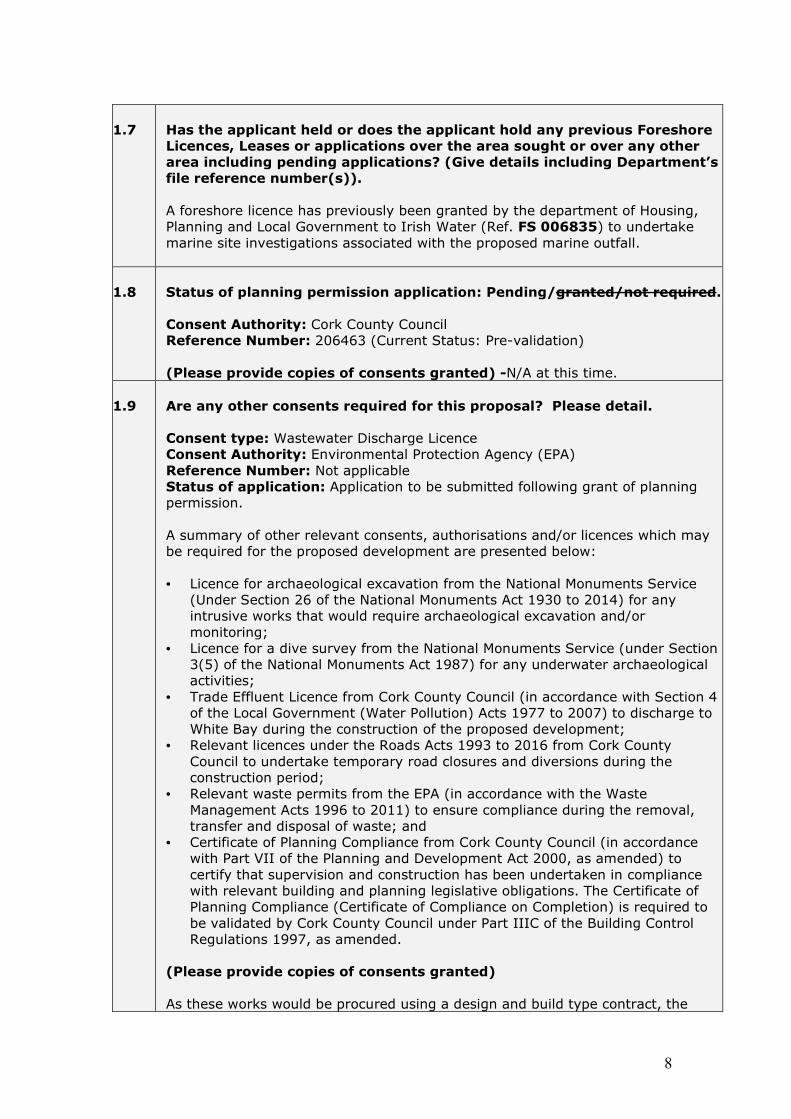
1.7
Has the applicant held or does the applicant hold any previous Foreshore Licences, Leases or applications over the area sought or over any other area including pending applications? (Give details including Department’s file reference number(s)). A foreshore licence has previously been granted by the department of Housing, Planning and Local Government to Irish Water (Ref. FS 006835) to undertake marine site investigations associated with the proposed marine outfall.
1.8
Status of planning permission application: Pending/granted/not required. Consent Authority: Cork County Council Reference Number: 206463 (Current Status: Pre-validation) (Please provide copies of consents granted) -N/A at this time.
1.9
Are any other consents required for this proposal? Please detail. Consent type: Wastewater Discharge Licence Consent Authority: Environmental Protection Agency (EPA) Reference Number: Not applicable Status of application: Application to be submitted following grant of planning permission. A summary of other relevant consents, authorisations and/or licences which may be required for the proposed development are presented below: • Licence for archaeological excavation from the National Monuments Service
(Under Section 26 of the National Monuments Act 1930 to 2014) for any intrusive works that would require archaeological excavation and/or monitoring;
• Licence for a dive survey from the National Monuments Service (under Section 3(5) of the National Monuments Act 1987) for any underwater archaeological activities;
• Trade Effluent Licence from Cork County Council (in accordance with Section 4 of the Local Government (Water Pollution) Acts 1977 to 2007) to discharge to White Bay during the construction of the proposed development;
• Relevant licences under the Roads Acts 1993 to 2016 from Cork County Council to undertake temporary road closures and diversions during the construction period;
• Relevant waste permits from the EPA (in accordance with the Waste Management Acts 1996 to 2011) to ensure compliance during the removal, transfer and disposal of waste; and
• Certificate of Planning Compliance from Cork County Council (in accordance with Part VII of the Planning and Development Act 2000, as amended) to certify that supervision and construction has been undertaken in compliance with relevant building and planning legislative obligations. The Certificate of Planning Compliance (Certificate of Compliance on Completion) is required to be validated by Cork County Council under Part IIIC of the Building Control Regulations 1997, as amended.
(Please provide copies of consents granted) As these works would be procured using a design and build type contract, the

9
Contractor will be responsible for obtaining much of the required consents for the proposed development.
1.10
Employment Implications (if any)
Construction of the proposed development will generate employment opportunities as there will be a range of personnel employed directly to support the construction activities of the scheme. It is anticipated that there will be up to approximately 20 construction employees working on site during peak construction activity. When completed and fully operational, the proposed development is likely to directly employ approximately 1 person. There will also be some indirect employment opportunities.
1.11
Capital cost of proposed works (€ - Euro) The estimated capital cost of the overall Whitegate-Aghada Sewerage Scheme is in the region of €6 million.
1.12
Do the proposed works involve the draw down of European Union or State funding? If “Yes” give details, including any time restrictions, etc. applying No
Part 2: Proposed Site. (Attach additional documents as required)
2.1
County: Cork
2.2
Location name and nearest townland name:
• Proposed Marine Outfall - White Bay, Glanagow TD. • Proposed Rostellan Wastewater Pump Station and Rising Main -
Thomas Kent Memorial Park at Knockanemorney TD. • Proposed Whitegate Wastewater Pump Station and Rising Main - the
Square, Whitegate village at Ballincarroonig TD, Mosestown TD and Corkbeg TD.

10
2.3
Geographic co-ordinates of the area under application in degrees minutes and seconds WGS84 for offshore developments and where the area can also be identified on the Ordnance Survey map and /or is connected to the seashore/mainland, specify Ordnance Survey map no and Irish Transverse Mercator (ITM) co-ordinates Foreshore Licence Area Ordnance Survey Map No: 6512-C, 6512-D, 6550-A & 6550-B
Area WGS84 ITM
Latitude Longitude Easting Northing A +51° 50' 42.248" -8° 11' 24.601" 586897.03 565889.37 B +51° 50' 41.383" -8° 11' 25.797" 586874.07 565862.71 C +51° 49' 32.914" -8° 13' 55.793" 583996.45 563755.266 D +51° 48' 28.130" -8° 15' 8.736" 582592.85 561758.02
See Appendix A for further information.
2.4
Please indicate the size of the Foreshore area (Ha) or (M2) or (KM2)
Total Foreshore Area Required: 2.036 ha • Rostellan Wastewater Pumping Station: 0.026 ha • Whitegate Wastewater Pumping Station and Rising Main: 0.71ha • Proposed Outfall: 1.30ha
2.5
If offshore please indicate distance from shore (km):
The proposed treated effluent outfall is to extend 295m approximately from the high-water mark offshore into White Bay.
2.6
Is any of the foreshore in the proposed site in private ownership? If yes please provide documentary evidence of same (e.g. folio) No.
2.7
Any other site details considered relevant: See Natura Impact Statement which accompanies this application (Appendix C) and the relevant drawings (Appendix A) for further site details.

11
Part 3. Maps and Drawings, Please refer to Guidance on map and drawing requirements.
3.1
Site location map attached? Please include reference no(s).
• Drawing No. IW-10015229-03-04-000 – Foreshore licence Areas
This map is included in Appendix A. 3.2
Foreshore Lease/Licence map attached? Please include reference no(s).
• Drawing No. IW-10015229-03-04-001, IW-10015229-03-04-002 and IW-10015229-03-04-003– Foreshore Licence Maps
These maps are included in Appendix A.
3.3
Drawings of structures to be used and or layout (if required) attached? Please detail and include reference no(s).
• IW-10015229-03-01-001 – Location Map • IW-10015229-03-01-002 – Overall Site Layout Plan sheet 1 of 2 • IW-10015229-03-01-003 – Overall Site Layout Plan sheet 2 of 2 • IW-10015229-03-01-004 – Proposed Rostellan Pumping Station Site Layout
and Sections • IW-10015229-03-01-005 – Proposed Lower Aghada Pumping Station Site
Layout and Sections • IW-10015229-03-01-006 – Proposed Whitegate Pump Station Site Layout
Plan • IW-10015229-03-01-007 – Proposed Whitegate Pump Station Sections • IW-10015229-03-01-008 – Proposed Whitegate Pump Station Kiosk Layout
Plan and Sections • IW-10015229-03-01-009 – Proposed Rising Main Whitegate Pump Station to
WWTP Layout Plans and Sections Sheet 1 of 6 • IW-10015229-03-01-010 – Proposed Rising Main Whitegate Pump Station to
WWTP Layout Plans and Sections Sheet 2 of 6 • IW-10015229-03-01-011 – Proposed Rising Main Whitegate Pump Station to
WWTP Layout Plans and Sections Sheet 3 of 6 • IW-10015229-03-01-012 – Proposed Rising Main Whitegate Pump Station to
WWTP Layout Plans and Sections Sheet 4 of 6 • IW-10015229-03-01-013 – Proposed Rising Main Whitegate Pump Station to
WWTP Layout Plans and Sections Sheet 5 of 6 • IW-10015229-03-01-014 – Proposed Rising Main Whitegate Pump Station to
WWTP Layout Plans and Sections Sheet 6 of 6 • IW-10015229-03-01-015 – Proposed WWTP Site layout plan • IW-10015229-03-01-016 – Proposed Gravity sewers WWTP to Outfall Plans
and Sections Sheet 1 of 3 • IW-10015229-03-01-017 – Proposed Gravity sewers WWTP to Outfall Plans
and Sections Sheet 2 of 3 • IW-10015229-03-01-018 – Proposed Gravity sewers WWTP to Outfall Plans
and Sections Sheet 3 of 3 • IW-10015229-03-01-019 – Treated Effluent Outfall Plan
These drawings are included in Appendix A.

12
3.4
Admiralty Chart attached?
• Drawing No. IW-10015229-03-04-004 and IW-10015229-03-04-005- Admiralty charts
These drawings are included in Appendix A.
3.5
Other maps/drawings attached? – please detail and include reference numbers
• IW-10015229-03-04-006- Aquaculture Site Location Plan • IW-10015229-03-04-007- Rostellan Shellfish Areas Plan
This drawing is included in Appendix A.

13
Part 4: Pre- application consultations 4.1
Describe briefly any consultations undertaken with the following bodies:
• National Parks & Wildlife Service (NPWS) of the Department of Arts, Heritage, Regional, Rural and Gaeltacht Affairs
• National Monuments Service (NMS) of the Department of Arts, Heritage, Regional, Rural and Gaeltacht Affairs
• Inland Fisheries Ireland • Sea Fisheries Protection Authority • Marine Institute • Marine Survey Office
Please also provide copies of correspondence. Copies of the reports entitled ‘Monitoring Report- Site Investigation Works’ and
‘Testing Report- Site Investigation Works’ were issued to the following bodies as per
condition requirements set out in the site investigation licence:
• 2 no. copies plus CD to the National Monuments Service;
• 1 no. copy plus CD to the National Museum. Both reports are provided in Appendix G. A copy of the grant of marine site investigation works licence is included in Appendix D.
4.2
Describe briefly any consultations undertaken with other relevant authorities (e.g. Local Authority, Port/Harbour authority etc) or State Agencies.
Pre-Planning Consultation with Cork County Council (26/11/2019) A pre-planning consultation took place to inform Cork County Council of the proposed Whitegate-Aghada Sewerage Scheme and to obtain feedback.
4.3
Describe any consultations undertaken to date with other foreshore users.
A public information evening was held in Aghada Community Hall on 8th May 2018 to advise local residents and interested third parties of the proposals for the Whitegate-Aghada Sewerage Scheme and to obtain feedback from the attendees.

14
4.4
Describe any likely interactions with activities of the public or other foreshore users during the construction and operational phases of the works/activities (e.g. fishing, aquaculture, sailing, and surfingswimming, walking). Describe any measures proposed to minimise inconvenience to other users. It is likely that there will be restrictions on access to certain parts of the foreshore during the construction of the proposed outfall, but these will be temporary. In particular, during construction of the outfall, if open trench techniques are used, there would be vessels in the working area, required to excavate the trench, lay the pipeline and provide the required scour protection. A description of the construction methodology for the scheme is provided in Section 4.3.1 of the Natura Impact Statement (see Appendix C). It includes information on the proposed rising mains and gravity sewer connections, proposed pumping stations, proposed WwTP and marine outfall. The marine outfall construction methodology includes information on the following likely methods of construction: horizontal directional drilling, float and flood, bottom-pull method. A Construction Environmental Management Plan (CEMP) is also provided in Appendix E. Once operational, the works will not restrict public access to the foreshore and it is unlikely that there will be any significant interactions with the public or other foreshore users during the operation stage of the project. The marine outfall will be below seabed level, with scour protection finishing at bed level. Scour protection will be monitored by Irish Water as part of the overall marine outfall maintenance at intervals. The inspection crew would check the pipeline for scour protection damage, slide, anchor or other damage. Scour protection would be reinstated and/or repaired as required, if damage was observed. An appropriate aid (marker buoy) for navigation will be provided to mark the location of the end of the outfall. The foreshore areas near the proposed Rostellan and Whitegate pumping stations comprise public road and open space areas. Use of these areas during the construction stage will be managed by a traffic management plan, which will allow for continued use of the road system, in collaboration with Cork County Council.
4.5
Have adjacent land owners, whose properties may be affected by these works been consulted? Please provide details/permissions as appropriate.
All landowners who may be affected have been consulted. A CPO application has been made to An Bord Pleanála and the CPO has been confirmed. The CPO includes all permanent acquisition of lands, permanent wayleaves, permanent rights of way, temporary rights and temporary construction rights required for the overall development. The CPO Inspectors report is included in Appendix F.

15
Part 5: Environmental Considerations (your consultations with National Parks and Wildlife Service and National Monuments Service may inform your answers. Attach additional reports as required and mark under the R column) www.epa.ie/downloads/advice/ea/guidelines/ www.environ.ie/en/DevelopmentHousing/PlanningDevelopment/EnvironmentalAssessment/
http://www.npws.ie/protectedsites/appropriateassessment/ http://webgis.npws.ie/npwsviewer/ Environmental legislative requirements
Yes No R
5.1
Is an Environmental Impact Statement required for this proposal?
X
5.2
Is a Natura Impact Statement required for this proposal? An AA Screening and Natura Impact Statement is included in Appendix C.
X
X
5.3
Is the area within or adjacent to a NHA, pNHA, SAC, SPA, or National Park? Specify site names and code(s). The proposed development does not lie within or adjoin any European sites. The only Natura 2000 site for which potential significant impacts have been identified is the Cork Harbour SPA. A range of mitigation measures have been incorporated into the project design, and other mitigation measures have been developed and proposed, with the purpose of avoiding or minimising impacts on the qualifying interests and conservation objectives of the Cork Harbour Special Protection Area (Site Code 4030). The likely success of these measures was also considered and no difficulties in their effective implementation were identified. The full assessment on any potential impacts on European and National sites are assessed in the NIS included in Appendix C.
X
X

16
5.4
Describe any other projects or plans for the area, anticipated or developed, that in combination with this proposal, may have a significant effect on a Natura 2000 site: Please list with planning reference numbers (where available). A Natura Impact Statement (NIS) (see Appendix C) has been prepared for the proposed development. It is the considered view of the authors (Dixon Brosnan Environmental Consultants) that, following the implementation of the mitigation measures, that the proposed UTAS development will not, by itself or in combination with other plans or projects, have any adverse effects on the integrity of any European sites (including Cork Harbour SPA) in view of their conservation objectives and there is no reasonable doubt as to that conclusion.
X
X
Environmental Considerations Yes No R
5.5
Will the proposal have any potential environmental impacts? If yes, please describe The NIS (Appendix C) accompanying this application appraises the potential environmental impacts and the potential impacts on Natura 2000 sites.
X
X
5.6
Are you proposing any measures to mitigate the potential environmental impacts? If yes, please describe A Construction Environmental Management Plan (CEMP) (Appendix E) which accompanies this application sets out the mitigation measures proposed to minimise the potential environmental impacts. Once appointed, the Contractor must provide a Detailed CEMP for approval prior to the commencement of any works.
x
x

17
5.7
Are there public health/safety implications arising from the proposed works? (e.g. effluent disposal, removal of derelict or dangerous structures etc.) If yes, please describe The consideration, design and construction strategy for the overall scheme has had regard to public health/safety considerations throughout. The proposed development provides for primary wastewater treatment for the villages of Whitegate and Aghada, eliminating in so far as possible the existing practice of discharging untreated wastewater to Cork Harbour. The Scheme would assist with the improvement of the water quality in Cork Harbour. The treated effluent from the wastewater treatment will be discharged to White Bay through a proposed c. 295m (from the HWM) marine outfall, which will be designed to ensure appropriate dispersion and minimal impact on the receiving waters. Dispersion modelling (near-field and far-field) have been undertaken and reports are provided in Appendix B.
X
X
The wastewater treatment plant will be designed to meet the following emission limit values (ELVs). Minimum WwTP Design Standards
Parameters % Reduction
(influent to effluent)
CBOD 20%
COD N/A
SS 50%
The proposed development will be subject to a Wastewater Discharge Authorisation from the EPA, an application for which is being prepared at the current time and will be submitted in parallel with the Foreshore Licence Application. The EPA will ultimately specify the Design Standards/Emission Limit Values to be achieved in its Waste Water Discharge Authorisation, however the treatment processes have been designed on the basis that any discharge from the WwTP (i.e. effluent) will be treated to achieve the required standards. Once operational, the WwTP will achieve these Design Standards/Emission Limit Values to guarantee compliance with the requirements of the UWWT Directive and therefore meet all regulatory requirements and significantly improve the quality of effluent being discharged to Cork Harbour.

18
5.8
Will the works involve the storage and/or disposal of waste? If “Yes” please give details of the type of waste and the proposed method of storage and/or disposal (including location)
• Construction Stage:
During the construction of the proposed development, waste will be generated from site clearance and excavation. General construction waste is likely to be generated throughout the construction of the proposed development.
• Operation Stage:
During operation, sludge will be generated from operation of the WwTP. Grit and other materials will also be generated from the preliminary screening of wastewater. Maintenance waste is likely to be generated from repair and maintenance works associated with the proposed development. Office waste will be generated from the Administration building.
A Construction Environmental Management Plan (CEMP) has been compiled as part of the planning application package for submission to Cork County Council. It provides a framework that outlines how Irish Water and any Contractor(s) appointed will manage and where practicable, minimise negative environmental effects during construction of the proposed development. Section 3.2 of the document is entitled ‘Waste Management’ and discusses waste management procedures to be implemented at construction stage. The Contractor will be required to provide a detailed CEMP following appointment which will include details on the storage and/ or disposal of waste from site. The document will be required to have regard to the guidance and industry best practice. The CEMP will be implemented throughout construction and the contractor will be required to review and update the CEMP as construction progresses. It will must include mitigation measures where necessary to reduce the impact of the waste generated by the proposed development during the construction and operational phases of the Scheme.
x
x
5.9
Any other Environmental Considerations? If yes, please specify. A Natura Impact Statement (NIS) Report has been prepared and is presented in Appendix C. It details environmental aspects and considerations associated with the proposed development. The contractor will be required to integrate these measures into a detailed CEMP following appointment (prior to the
X
X

19
commencement of any construction activities). Effective implementation of the CEMP will ensure that disruption and nuisance are kept to a minimum throughout the construction of the proposed development.
Built Heritage Considerations
Yes No R
5.10
Does the area contain an archaeological site or feature? If yes, please specify. No. An Archaeological Impact Assessment report is provided in Appendix G.
X
X
5.11
Does the area contain or adjoin a listed archaeological site or monument? If yes, please specify. An Archaeological Impact Assessment has been undertaken and is included in Appendix G. It notes that the site of the WwTP and the routes of the proposed upgrades at Whitegate-Aghada contain no Recorded Monuments listed within the Record of Monuments and Places (RMP). However, the townlands which the project is located, contain a relatively high concentration of Recorded Monuments that will not be physically affected by the scheme, but serve as indications of the overall landscape archaeological potential. There are a number of period buildings located along routes of the proposed upgrade works and these structures are listed in the NIAH and some are also protected structures. These are to be avoided and protected from heavy machinery. There are no architectural conservation areas (ACAs) located within the receiving environment of the proposed development.
X
X

20
5.12
Will the proposal have any potential impacts on the archaeological integrity of the site? If yes please describe The Archaeological Impact Assessment report (Appendix G) concludes that the proposed works have the potential to directly impact archaeological deposits where they exist. Test trenching was carried out at green field areas on the Scheme following recommendations of the Archaeological Impact Assessment Report. Trench testing at the location of the proposed WwTP indicates that no finds or features of archaeological significance will be impacted by the works. It was not possible to test the entire route of the Outfall Pipe due to the densely planted area and disturbed land from recent construction activities however, the area that was tested did not reveal any finds of archaeological significance. Mitigation measures are presented in Section 6 of the report. The Archaeological Monitoring Report (Appendix G) notes a total of 16 slit trenches (ST 613-ST 628) and 26 test pits (TCPT 613-638) were excavated between Aghada and Rostellan and notes that no finds or features of archaeological significance were exposed. The Underwater Archaeological Impact Assessment Report is also included in Appendix G.
X
X
5.13
Are you proposing any measures to mitigate potential archaeological impacts? If yes, please describe? Full details of the proposed mitigation and monitoring measures are set out in Section 6 of the Site Investigation Monitoring Report (Appendix G). Section 4 of the Archaeological Impact Assessment Report (Appendix G) also includes recommendations. Proposed mitigation measures are also included in Section 6 of the Underwater Archaeological Impact Assessment Report (Appendix G).
X
X

21
Part 6: Navigational Safety Considerations. (Your consultations with relevant stakeholders may inform your answers. Attach additional documents as required and mark under the R column)
Navigational Safety Considerations.
Yes
No
R
6.1
Are there public navigational safety implications arising from the proposed works? The marine sea outfall will be approximately 295m in length. It has been designed as a 315mm OD HDPE pipe terminating at 1 no. 80mm diameter diffuser port. The marine sea outfall can be constructed by a number of methods and the Contractor is responsible for determining the appropriate method. The likely methods that can be undertaken to construct the outfall are outlined below, based on current practice and site constraints/ characteristics. These are as follows: • Horizontal directional drilling method; • Float and flood method; and • Bottom-pull method. Restrictions on access to the works area are likely to be required during the construction phase, particularly if either the float and flood or bottom-pull methods are used. If either of these methods are used, it will be required to use scour protection along the length of the outfall, to protect against the potential medium/ long term effects of scour. Suitable protection of the pipeline is required. A concrete mattress layer of approximately 300mm thickness is proposed for this purpose. The concrete mattress will finish at existing bed level. Once the marine sea outfall has been laid, by whichever method (HDD, float and flood or bottom-pull), the diffuser arrangement will be assembled on the seaward end of the outfall. This will comprise 1 no. 80mm diameter diffuser port. The diffuser arrangement would be prefabricated on land and placed on the seabed by barge as one complete unit. The exact procedure and depths of backfill required will depend on the equipment available from the contractor along with the programme cost considerations. However, it is anticipated that this would be undertaken from a barge and it is likely that open excavation of the seabed would be required along the length of the diffusers.
X

22
6.2
What marine activity is there in the area?
Cork Harbour is one of the finest natural harbours in the World and hosts a number of marine activities. Marine activity in the area close to the proposed Scheme include the following: • Fishing activities; • White Bay is used during the summer months as a
bathing area by residents and tourists; • The Ringaskiddy Ferry terminal provides a Ferry service
to Roscoff, France and the route runs in close proximity (approx. 1km) to the proposed outfall as the Ferry leaves Cork Harbour.
X
6.3
How will the marine activity be affected by the proposed works? The construction of the proposed development may require a temporary exclusion zone around working areas, to accommodate the safe construction of the works. The operation of the proposed development is unlikely to significantly affect marine activity in the area.
X
6.4
What mitigating measures will be put in place? The proposed development is being procured as a Design and Build type contract. The Contractor appointed will be required to demonstrate competency in the type of work required and will also, under the contract, be required to comply with all consent conditions, NIS and the CEMP (see Appendix C and E herein). The Contractor appointed will be required to liaise with all relevant authorities and bodies to ensure that minimal disruption to marine activity occurs during the construction phase. A marker buoy will be provided to mark the location of the diffuser at the end of the outfall.
X
X

23
6.5
How will the proposed works affect Marine Navigation in the future? The marine sea outfall will be below seabed level, with scour protection finishing at bed level. The scour protection will be monitored to check its performance and avoid any risk of future exposure to the pipe. Scour protection will be monitored by Irish Water as part of the overall marine outfall maintenance at intervals. The inspection crew would check the pipeline for scour protection damage, slide, anchor, or other damage. Scour protection would be reinstated and/ or repaired as required, if any damage is observed. As outlined above, a marker buoy will be provided to mark the location of the end of the outfall.
X

24
Part 7: Fishing/Aquaculture considerations (your consultations with IFI, SFPA, DAFM may inform your answers. Attach additional documents as required and mark under the R column)
Fishing/Aquaculture considerations
Yes
No
R
7.1
Is the proposal located in proximity to any of the following: • aquaculture operation • designated Shellfish Growing Waters • fish spawning ground • other sensitive fisheries location
Please Illustrate on appropriate chart including distance in Km. Aquaculture Operation The Marine Institute online mapping tool (Ireland’s Marine
Atlas) http://atlas.marine.ie/#?c=51.8426:-8.2530:13 identifies
an aquaculture site in Cork Harbour (ID: T05/002OFO). The
site relates to a shellfish fishery order.
The location is indicated on drawing IW-10015229-03-04-006 presented in Appendix A. Designated Shellfish Waters The nearest designated shellfish waters are: Rostellan North Shellfish Area, Rostellan South Shellfish Area, Rostellan South Shellfish Area and Rostellan West Shellfish Area These locations are indicated on drawing IW-10015229-03-04-07 presented in Appendix A. Fish Spawning Ground The Marine Institute online mapping tool (Ireland’s Marine
Atlas) http://atlas.marine.ie/#?c=51.8426:-8.2530:13 identifies Cork Harbour as fish spawning and nursary ground for the following species:
• Atlantic Mackerel nursery grounds; • Horse Mackerel nursery grounds; • Atlantic Cod nursery grounds; • Atlantic Herring spawning and nursery grounds; • Whiting spawning and nursery grounds.
Other Sensitive Fisheries Locations To be confirmed upon receipt of the NIS.
X

25
7.2
Are there other potential impacts of the proposal on fishing/aquaculture in the area? If yes, please describe. Impacts on any recreational fishing in the area are likely only during the construction stage.
X
7.3
Are there any measures proposed to mitigate potential impacts on fisheries or aquaculture? If yes, please describe. The proposed development will be procured as a design and build type contract. The Contractor appointed will be required to demonstrate competency in the type of work required and will also, under the contract, be required to comply with all consent conditions, NIS and the CEMP (see Appendix C and E herein). The Contractor appointed will be required to liaise with all relevant authorities and bodies to ensure that minimal disruption to fishing activity occurs during the construction phase. No significant effects on fishing activity are envisaged during the operational phase.
X
X
Part 8 – Additional information 8.1
Please detail any additional relevant information.
N/A

26
Declaration and Consent: The details provided here are correct to the best of my knowledge. I understand that no works will be commenced, by me or my agents on the proposed site, without the prior written consent of the Minister. By submitting this application form, I agree that the details provided (with personal contact details redacted) are to be published on the Department of Housing website and also that the full information provided including contact details are to be processed and retained by the Department of Housing, Planning and Local Government and shared with all appropriate Prescribed Bodies (as part of the Prescribed Bodies Consultation process) in furtherance of consideration for a foreshore Consent under the Foreshore Act 1933 (and Foreshore Amendment Act 2011). I give consent to the Minister and his servants to copy this application and to make (a redacted) copy available for inspection and copying by the public. This consent relates to this application, to any further information, or submission provided by me or on my behalf and to the publication of the licence document. Signature of Applicant (or his or her Agent):
Name of above Signatory (block letters): KEVIN O’SULLIVAN ________________________________ Position Held: Senior Engineer (OVE ARUP & PARTNERS IRELAND LTD.) _________________________________ Date: ___23/11/2020 _______________ Return completed applications to: Marine Environment and Foreshore Section Department of Housing, Planning and Local Government Newtown Road Wexford Y35 AP90 Enquiries to: [email protected] (Other contact details to be included in Guidance materials)
27
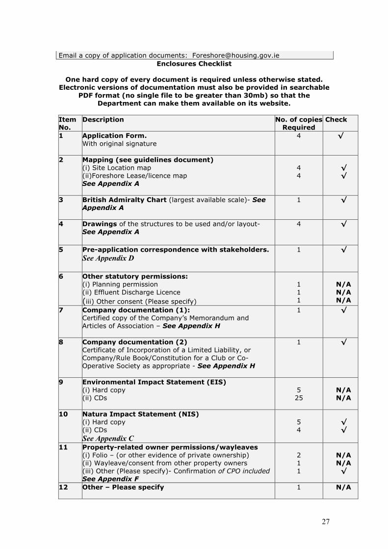
Email a copy of application documents: [email protected] Enclosures Checklist
One hard copy of every document is required unless otherwise stated.
Electronic versions of documentation must also be provided in searchable PDF format (no single file to be greater than 30mb) so that the
Department can make them available on its website.
Item No.
Description No. of copies Required
Check
1 Application Form. With original signature
4 √
2 Mapping (see guidelines document) (i) Site Location map (ii)Foreshore Lease/licence map See Appendix A
4 4
√ √
3 British Admiralty Chart (largest available scale)- See
Appendix A
1 √
4 Drawings of the structures to be used and/or layout- See Appendix A
4 √
5 Pre-application correspondence with stakeholders. See Appendix D
1 √
6 Other statutory permissions: (i) Planning permission (ii) Effluent Discharge Licence
(iii) Other consent (Please specify)
1 1 1
N/A N/A N/A
7 Company documentation (1): Certified copy of the Company’s Memorandum and Articles of Association – See Appendix H
1 √
8 Company documentation (2) Certificate of Incorporation of a Limited Liability, or Company/Rule Book/Constitution for a Club or Co-Operative Society as appropriate - See Appendix H
1 √
9 Environmental Impact Statement (EIS) (i) Hard copy (ii) CDs
5 25
N/A N/A
10 Natura Impact Statement (NIS) (i) Hard copy (ii) CDs
See Appendix C
5 4
√ √
11 Property-related owner permissions/wayleaves (i) Folio – (or other evidence of private ownership) (ii) Wayleave/consent from other property owners (iii) Other (Please specify)- Confirmation of CPO included
See Appendix F
2 1 1
N/A N/A
√
12 Other – Please specify
1 N/A

28
APPENDIX A
DRAWINGS AND MAPPING

29
APPENDIX B
DISPERSION MODELLING

30
APPENDIX C
NATURA IMPACT STATEMENT (NIS)

31
APPENDIX D
CORRESPONDENCE

32
APPENDIX E
CONSTRUCTION ENVIRONMENTAL MANAGEMENT PLAN (CEMP)

33
APPENDIX F
COMPULSORY PURCHASE ORDER (CPO)

34
APPENDIX G
ARCHAEOLOGY

35
APPENDIX H
COMPANY DOCUMENTATION (1) AND (2)