Embed Size (px)
Citation preview

Report ECMWF 2015 -- ITALY
Application and Verification of ECMWF Products 2015
Centro Operativo per la Meteorologia (COMET)
submitted by Antonio Vocino
1. Summary of major highlights
IFS deterministic model output from both 12 and 00 UTC runs is used at COMET as plotted
fields in the forecasting department mainly for the medium range, as input to statistical (PPM
type) and physical adaptation schemes, but also as initial and/or boundary conditions for
COMET Local Area Models (7km COSMO-ME and very high resolution 2.8km COSMO-
IT). Verification of ECMWF products is carried out at COMET for operational model T1279.
Surface parameters and forecast ranges mainly used by weather forecasters are considered.
2. Use and application of products
2.1. Post-processing of ECMWF model output.
2.1.1. Statistical adaptation.
Statistical adaptation is involved in a Perfect Prog application currently being used
named ARGO. The model is used to infer surface weather parameters such as
precipitation, 2T, humidity, cloudiness, wind etc. over about one hundred
geographical sites corresponding to the locations were the Italian network of
weather stations is deployed and observations are available.
2.1.2. Physical adaptation.
Physical adaptation is being used within the meteograms generation application.
Routines selecting for each geographical site the most likely point among nearest
grid points, make use of land/sea mask and elevation comparisons. Correction at
all is being performed once the grid point has been chosen on the base of
geophysical properties of the site.
2.1.3. Derived fields.
Thousands of meteograms are routinely produced over geographical sites within
the 80°N-60°S area. At present meteograms are being produced in PNG graphical
format and in text mode every 6 hours for the medium range (up to T+72H
stepping in time) and every 12 hours for the long range (T+72H to T+168H
stepping in time). Meteograms are produced targeting to a general purpose use
and for this reason the weather parameters included are numerous; among them:
2m temperature, 2m humidity, mean sea level pressure, total-high-medium-low
cloud cover, convective precipitation, grid scale precipitation and 10 m wind.
Based on the ECMWF models output, several derived parameters are routinely
calculated as well. Using the deterministic operational model forecasts, the
derived fields produced are for example:
- freezing level;
- wet bulb potential temperature;

Report ECMWF 2015 -- ITALY
- KO and other stability indexes;
- liquid water content;
- accumulated precipitation over fixed time interval;
- heat index (Steadman);
- wind-chill;
- tropopause height and maximum wind;
- 2m relative humidity.
Derived fields are also calculated using the ECMWF Wave Model output. The
most important derived parameter is the sea state code, which is based on the
primary wind wave height (Beaufort Scale). Metgrams (sometime you call them
meteograms, others metgrams) over sea geographical sites are being produced too.
For each site primary sea swell height, wind wave height, 10 m wind and wave
direction behaviours are described from T+12H up to T+96H. Most of the sites
are chosen according to buoys and tide gauges deployment. Some of them do not
correspond to any physical instrument deployed and for this reason they are
named as “virtual buoys”.
The production of some graphical outputs from the EPS forecast system, is carried
out directly from ECMWF Servers using “ad hoc” built applications and Metview
batch procedures. In particular, the following maps are created on a daily basis:
- Epsgrams and Plumes for 40 main Italian cities
- Probability maps on Europe from t+ 48 to t+168 (precipitation, wind, 850 hPa
Temp)
- Tubes on Europe t+96 and t+168
2.2. Use of ECMWF products
The ECMWF T1279L137 operational model is being used at COMET. Surface and
upper air fields of the 00Z and 12Z runs are routinely downloaded on 0.25° horizontally
spaced mesh for surface fields and on a 1.0° horizontally spaced mesh for upper air
fields. The time step between two adjacent meteorological fields issued, is 6 hours from
T+0h to T+168h and 12 hours between T+168h and T+240h forecast times.
The ECMWF products are classified in two main typologies: primary and secondary.
In the first one, parameter fields identified as synoptic tracers are considered, like
Potential Vorticity at 300 Hpa and equivalent temperature at 850 hPa as well; they allow
to localize and define the path of synoptic configurations, especially in cases where
they are not well defined at 500 hPa maps.
In the second category belong all the maps concerning parameters which better
summarize the related meteorological conditions (high, medium and low cloudiness,
temperature, wind etc.). The fields are generally plotted in an overlapping mode,
including satellite images; many combinations are used using proper tools. In this way
the forecaster is able to detect the subjects of interest, like Conceptual Models.
Besides these maps, products from EPS and EFI are used for severe weather events
detection and issuing of warnings.
Every month, according to the availability of the ECMWF model products, maps from
System 3 Seasonal FC (ensemble mean, probability and climagrams) are subjectively
analyzed to obtain an outlook for the next quarterly period. Along with a concise

Report ECMWF 2015 -- ITALY
commentary, these maps are shown on the internal intranet website (available on
request also for external users).
Finally monthly forecasts system is also used in the Operational Forecasting room even
if not routinely.
3. Verification of products
3.1. Objective verification
3.1.1. Direct ECMWF model output
(i) in the free atmosphere
Some basic (ME, MAE and RMSE) verification statistical indices for the free atmosphere
parameters (e.g wind, temperature, RH and geopotential at standard pressure level) are
produced and compared to COSMO-ME model output verification results.
(ii) of local weather parameters verified for locations
Objective scores are computed for ECMWF 12 and 00 UTC run (d+1 to d+7) after
collecting data retrieved from all available Italian Synop stations, using several
stratifications. Graphics have been elaborated for a number of parameters: 2m
Temperature, 2m Dew Point, 10m Wind Speed, MSLP, Total Cloud Cover (ME, MAE).
Cumulated precipitation quarterly event scores (POD/FAR, FBI, KSS, ETS, ORSS, POD,
FAR) with respect to fixed thresholds and for d+1 to d+7 ranges, are computed.
For this report, data covering the 1-year period from JJA 2014 to MAM 2015 have been
used for the verification of these parameters and only some selected results are presented
in the next pages (see Appendix A), for ECMWF 00 UTC run only.
In order to compute the scores, no interpolation from grid point to observation location is
performed. The “nearest point” method is used, optimised by the “smaller” difference in
altitude combined with the horizontal distance between a station and the corresponding
grid point. The reference software used for verification purposes is called VERSUS
(VERification System Unified Survey), i.e. the official software used within COSMO
model consortium as Common Verification Suite (CVS). The VERSUS system has been
developed at CNMCA centre (now named COMET) and it is based on DB architecture
with a GUI. Through this tool, Conditional Verifications are also possible (cross
conditions on different parameters).
A short note on the results is given below.
10m Wind Speed: clear diurnal cycle for all the seasons for ME and MAE, especially
during winter and summer. A general small underestimation is shown in ME, less than 1
m/s in absolute value. MAE, around 1.5-2.0 m/s in summer and fall and 2.0-2.5 m/s in
winter and spring, with a tendency to slightly increase with forecast step.
2m Temperature: clear diurnal cycle in both ME and MAE. A general underestimation is
shown in ME, especially during the night. MAE increases with the forecast time and its
values are mainly comprised between 1.5 and 2.5 K (reaching up to 3.5 K in winter).
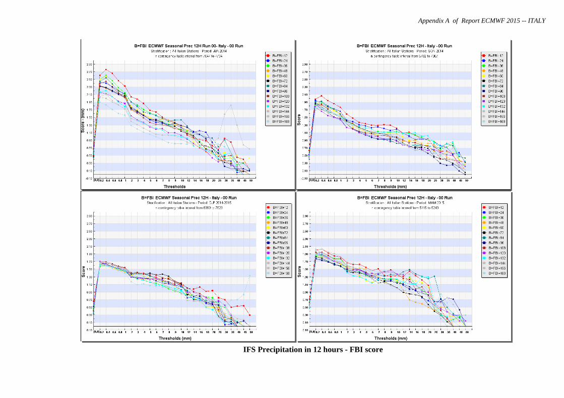
12-h Cumulated Precipitation: regarding the bias (FBI) ECMWF model shows an
overestimation for all the seasons for lower thresholds, while tends to underestimate the
really higher ones. The discriminant threshold (i.e. FBI = 1) is around 15 mm/12h. About
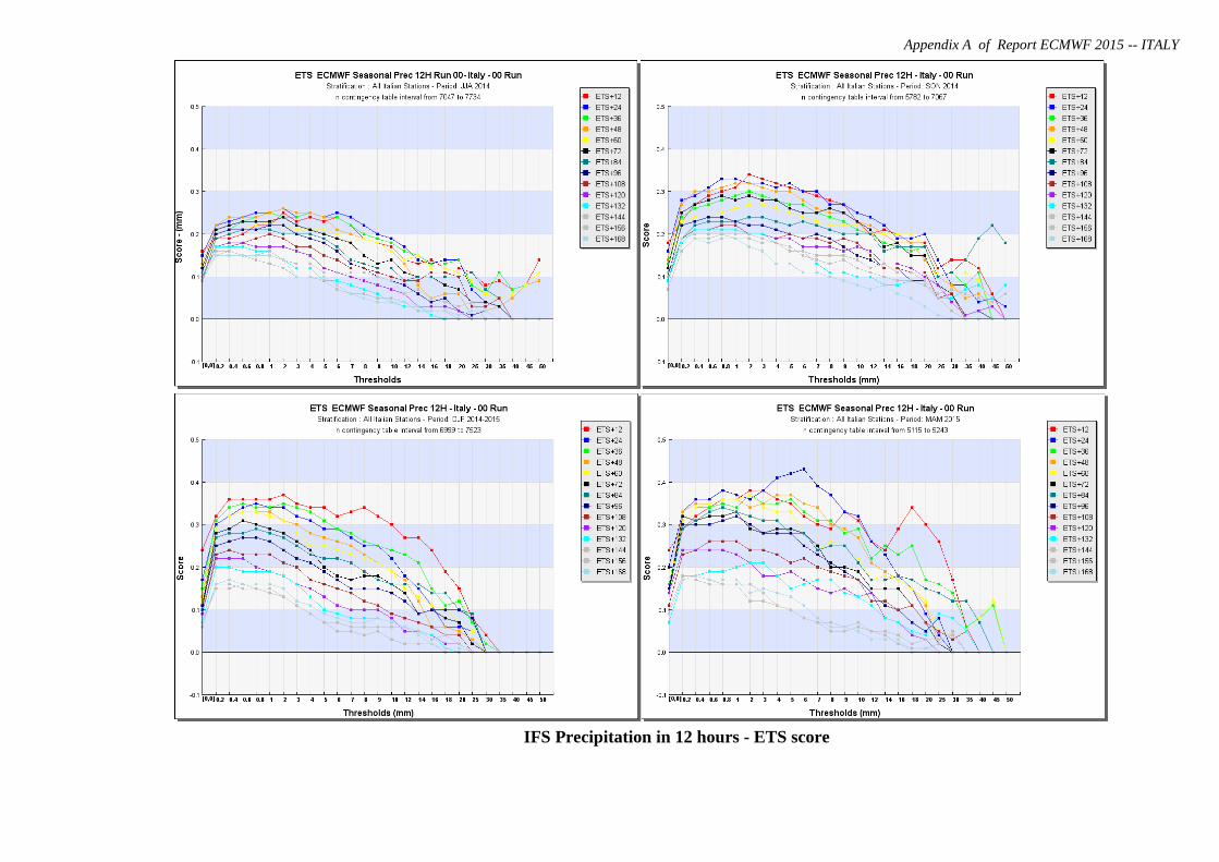
the accuracy (ETS), all seasons exhibit the best results mainly for low thresholds and for
the first 3-5 days of integration. For all thresholds there is a gradual decrease in accuracy
with integration time.

Report ECMWF 2015 -- ITALY
3.1.2 ECMWF model output compared with COMET COSMO-ME limited area model
ECMWF 00-UTC scores (ETS, FBI) for 12 hours cumulated precipitation have been
calculated and graphically compared to those evaluated for Italian 00-UTC run non-
hydrostatic LAM named COSMO-ME (7 km resolution) for d+1 and d+2 on Italian area.
These scores are shown in the next pages (see Appendix A).
About FBI scores, COSMO-ME model shows a better distribution and representation
than ECMWF for almost all the thresholds and for all the seasons. In general higher
thresholds are underestimated with both IFS and COSMO-ME models, whereas the
overestimation is less evident in COSMO-ME than in ECMWF model.
Accuracy, represented here through ETS score, tends to be slightly higher for COSMO-
ME especially for lower thresholds for all seasons.
3.1.3 Post processed products: none
3.1.4 End products delivered to users
Quarterly reports on model verification results are made available to Intranet and Internet
users as well as Forecasts and Research division.
3.2 Subjective verification
3.2.1. Subjective scores: none
3.2.2. Case studies
A synoptic study regarding the flood over Marche (Senigallia, Ancona) on 3rd May 2014
has been carried out and the main results are shown in the next pages (see Appendix B).
4 References
http://www.meteoam.it/page/verifiche-modelli
for quarterly reports on model verification (in Italian only).

Appendix A of Report ECMWF 2015 -- ITALY
IFS 10m Wind Speed (Mean Absolute Error, Mean Error and Root MSE)

Appendix A of Report ECMWF 2015 -- ITALY
IFS T2m (Mean Absolute Error, Mean Error, Root MSE)
Appendix A of Report ECMWF 2015 -- ITALY
IFS Precipitation in 12 hours - FBI score
Appendix A of Report ECMWF 2015 -- ITALY
IFS Precipitation in 12 hours - ETS score

Appendix A of Report ECMWF 2015 -- ITALY
COSMO-ME Precipitation in 12 hours - FBI score

Appendix A of Report ECMWF 2015 -- ITALY
COSMO-ME Precipitation in 12 hours - ETS score

Appendix B of Report ECMWF 2015 -- ITALY
Case study : rain flood over Marche in Senigallia
At early morning 3rd
May 2014 in Senigallia,(AN) heavy and persistent rainfall occurred causing channel
overflood and many more incident.
Synoptic overview
On 2nd
May the European scenario was characterized by Azores High extending poleward up to 60°N and
by a widespread trough over central Europe evolving into a cut-off (“coldcore” of -24°C at 500hPa)over
central Mediterranean Sea and Italy. The frontal system associated to the aforementioned trough was
active over Sardinia and north-western regions.
The cold front affected western side of the peninsula with thunderstorms while the Adriatic regions, lied in
warm sector, were involved in Warm Conveyor Belt (WCB) prefrontal flux that brought heavy convective
rainfall.
500 hPa Geopotential and Temperature
(ECMWF,02/05/2014 12.00 UTC) Surface Analysiswith fronts(02/05/201412.00
UTC)
Composite Image (IR10.8μm+radar rain rate+lightning) 02/05/2015 13:30UTC. It is worth of notice thunderstorm activity over northern and central Tyrrhenian due to the cold front and WCB convective rainfall over Marcheand northern Adriatic Sea still with lightnings.
Surface analysis 03/05/2014, 00 UTC
Appendix B of Report ECMWF 2015 -- ITALY
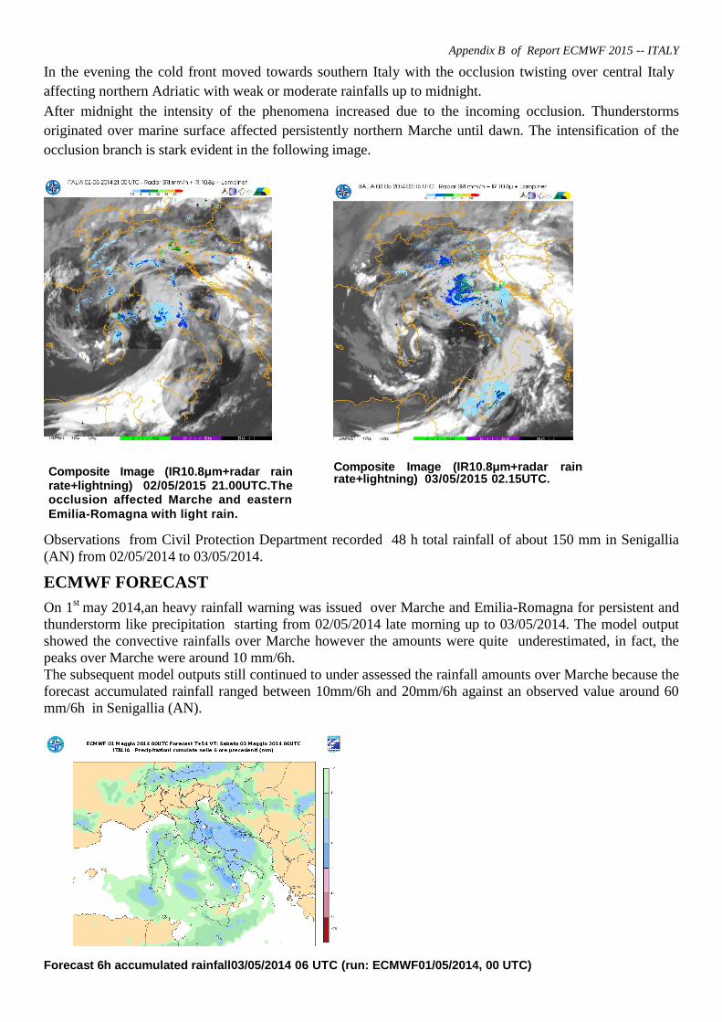
In the evening the cold front moved towards southern Italy with the occlusion twisting over central Italy
affecting northern Adriatic with weak or moderate rainfalls up to midnight.
After midnight the intensity of the phenomena increased due to the incoming occlusion. Thunderstorms
originated over marine surface affected persistently northern Marche until dawn. The intensification of the
occlusion branch is stark evident in the following image.
Observations from Civil Protection Department recorded 48 h total rainfall of about 150 mm in Senigallia
(AN) from 02/05/2014 to 03/05/2014.
ECMWF FORECAST
On 1st
may 2014,an heavy rainfall warning was issued over Marche and Emilia-Romagna for persistent and
thunderstorm like precipitation starting from 02/05/2014 late morning up to 03/05/2014. The model output
showed the convective rainfalls over Marche however the amounts were quite underestimated, in fact, the
peaks over Marche were around 10 mm/6h.
The subsequent model outputs still continued to under assessed the rainfall amounts over Marche because the
forecast accumulated rainfall ranged between 10mm/6h and 20mm/6h against an observed value around 60
mm/6h in Senigallia (AN).
Forecast 6h accumulated rainfall03/05/2014 06 UTC (run: ECMWF01/05/2014, 00 UTC)
Composite Image (IR10.8μm+radar rain rate+lightning) 02/05/2015 21.00UTC.The occlusion affected Marche and eastern
Emilia-Romagna with light rain.
Composite Image (IR10.8μm+radar rain rate+lightning) 03/05/2015 02.15UTC.


