Embed Size (px)
Citation preview

Monument Management Plan Volume III: Appendices – Supporting Documents and References
APPENDIX G: IMO Particularly Sensitive Sea Area Designation and Associated Protective Measures


For reasons of economy, this document is printed in a limited number. Delegates are kindly asked to bring their copies to meetings and not to request additional copies.
I:\MEPC\57\21.doc
INTERNATIONAL MARITIME ORGANIZATION
IMO
E
MARINE ENVIRONMENT PROTECTION COMMITTEE 57th session Agenda item 21
MEPC 57/21 7 April 2008 Original: ENGLISH
REPORT OF THE MARINE ENVIRONMENT PROTECTION COMMITTEE ON ITS FIFTY-SEVENTH SESSION
Section Paragraph Nos. Page No. 1 INTRODUCTION 1.1 – 1.9 4
2 HARMFUL AQUATIC ORGANISMS IN BALLAST WATER 2.1 – 2.50 7
3 RECYCLING OF SHIPS 3.1 – 3.67 16
4 PREVENTION OF AIR POLLUTION FROM SHIPS 4.1 – 4.121 28
5 INTERPRETATIONS OF AND AMENDMENTS
TO MARPOL AND RELATED INSTRUMENTS 5.1 – 5.17 58 6 IMPLEMENTATION OF THE OPRC
CONVENTION AND THE OPRC-HNS PROTOCOL AND RELEVANT CONFERENCE RESOLUTIONS 6.1 – 6.11 62
7 IDENTIFICATION AND PROTECTION OF
SPECIAL AREAS AND PARTICULARLY SENSITIVE SEA AREAS 7.1 – 7.19 66
8 INADEQUACY OF RECEPTION FACILITIES 8.1 – 8.10 68
9 REPORTS OF SUB-COMMITTEES 9.1 – 9.12 70
10 WORK OF OTHER BODIES 10.1 – 10.32 71
11 STATUS OF CONVENTIONS 11.1 – 11.2 78
December 2008 G-1 Appendix G: Particularly Sensitive Sea Area

MEPC 57/21 - 2 -
I:\MEPC\57\21.doc
Section Paragraph Nos. Page No.
12 HARMFUL ANTI-FOULING SYSTEMS FOR SHIPS 12.1 – 12.13 79
13 PROMOTION OF IMPLEMENTATION AND
ENFORCEMENT OF MARPOL AND RELATED INSTRUMENTS 13.1 – 13.6 81
14 FOLLOW-UP TO UNCED AND WSSD 14.1 – 14.4 82
15 TECHNICAL CO-OPERATION PROGRAMME 15.1 – 15.21 82
16 ROLE OF THE HUMAN ELEMENT 16.1 – 16.6 86
17 FORMAL SAFETY ASSESSMENT 17.1 – 17.13 87
18 WORK PROGRAMME OF THE COMMITTEE AND SUBSIDIARY BODIES 18.1 – 18.20 89
19 APPLICATION OF THE COMMITTEES’
GUIDELINES 19.1 – 19.11 92
20 ANY OTHER BUSINESS 20.1 – 20.19 94
LIST OF ANNEXES
ANNEX 1 RESOLUTION MEPC.169(57) – PROCEDURE FOR APPROVAL OF BALLAST WATER MANAGEMENT SYSTEMS THAT MAKE USE OF ACTIVE SUBSTANCES (G9)
ANNEX 2 PROVISIONAL TERMS OF REFERENCE FOR THE BALLAST WATER
REVIEW GROUP AT MEPC 58 ANNEX 3 STATEMENT BY THE DELEGATION OF THE UNITED STATES
CONCERNING SHIP RECYCLING IN NON-PARTY FACILITIES ANNEX 4 RESOLUTION MEPC.170(57) – GUIDELINES FOR EXHAUST GAS
CLEANING SYSTEMS ANNEX 5 DRAFT AMENDMENTS TO MARPOL ANNEX VI ANNEX 6 DRAFT AMENDMENTS TO THE NOX TECHNICAL CODE ANNEX 7 TERMS OF REFERENCE FOR THE INTERSESSIONAL MEETING OF
THE WORKING GROUP ON GREENHOUSE GAS EMISSIONS FROM SHIPS
December 2008 G-2 Appendix G: Particularly Sensitive Sea Area

- 3 - MEPC 57/21
I:\MEPC\57\21.doc
ANNEX 8 UNIFIED INTERPRETATION TO REGULATIONS 1.28 AND 1.30 OF
MARPOL ANNEX I AND REGULATION 1.1 OF MARPOL ANNEX IV ANNEX 9 UNIFIED INTERPRETATION TO REGULATION 22 OF MARPOL
ANNEX I ANNEX 10 REVISED WORK PROGRAMME OF THE OPRC-HNS TECHNICAL
GROUP AND PROVISIONAL AGENDA FOR TG 8 ANNEX 11 STATEMENT BY THE DELEGATION OF SINGAPORE CONCERNING
THE TORRES STRAIT EXTENSION TO THE GREAT BARRIER REEF PSSA
ANNEX 12 RESOLUTION MEPC.171(57) – DESIGNATION OF THE
PAPAH�NAUMOKU�KEA MARINE NATIONAL MONUMENT AS A PARTICULARLY SENSITIVE SEA AREA
ANNEX 13 RESOLUTION MEPC.172(57) – ESTABLISHMENT OF THE DATE ON
WHICH REGULATION 5(1)(a) OF MARPOL ANNEX V IN RESPECT OF THE MEDITERRANEAN SEA AREA SPECIAL AREA SHALL TAKE EFFECT
ANNEX 14 REVISED WORK PROGRAMME OF THE BLG SUB-COMMITTEE AND
PROVISIONAL AGENDA FOR BLG 13 ANNEX 15 REVISED WORK PROGRAMME OF THE FSI SUB-COMMITTEE AND
PROVISIONAL AGENDA FOR FSI 16 ANNEX 16 WORK PROGRAMME ITEMS OF THE DSC, NAV AND
DE SUB-COMMITTEES WHICH RELATE TO ENVIRONMENTAL ISSUES
ANNEX 17 ITEMS TO BE INCLUDED IN THE AGENDAS FOR MEPC 58, MEPC 59
AND MEPC 60 ANNEX 18 AMENDMENTS TO THE GUIDELINES ON THE ORGANIZATION
AND METHOD OF WORK OF THE MARITIME SAFETY COMMITTEE AND THE MARINE ENVIRONMENT PROTECTION COMMITTEE AND THEIR SUBSIDIARY BODIES (MSC-MEPC.1/CIRC.1)
December 2008 G-3 Appendix G: Particularly Sensitive Sea Area

MEPC 57/21
I:\MEPC\57\21.doc
ANNEX 12
RESOLUTION MEPC.171(57)
Adopted on 4 April 2008
DESIGNATION OF THE PAPAH�NAUMOKU�KEA MARINE NATIONAL MONUMENT
AS A PARTICULARLY SENSITIVE SEA AREA THE MARINE ENVIRONMENT PROTECTION COMMITTEE, BEING AWARE of the ecological, socio-economic and scientific attributes of the Papah�naumoku�kea Marine National Monument, as well as its vulnerability to damage by international shipping activities and the steps taken by the United States to address that vulnerability, NOTING the Revised Guidelines for the Identification and Designation of Particularly Sensitive Sea Areas adopted by resolution A.982(24) (PSSA Guidelines) and the Revised Guidance Document for Submission of PSSA Proposals to IMO set forth in MEPC/Circ.510, HAVING CONSIDERED the proposal made by the Government of the United States that the Papah�naumoku�kea Marine National Monument be designated as a Particularly Sensitive Sea Area, HAVING AGREED that the criteria for the identification and designation of a Particularly Sensitive Area provided in resolution A.982(24) are fulfilled for the Papah�naumoku�kea Marine National Monument, HAVING NOTED that the Maritime Safety Committee, at its eighty-third session, in considering the necessary associated protective measures, adopted new and amended, routeing measures, as well as a new ship reporting system applicable to the proposed Particularly Sensitive Sea Area, 1. DESIGNATES the Papah�naumoku�kea Marine National Monument described in annex 1 as a Particularly Sensitive Sea Area; 2. INVITES Member Governments to recognize the ecological, socio-economic, and scientific attributes of the area, set forth in annex 2, as well as its vulnerability to damage by international shipping activities, as described in annex 3; and 3. FURTHER INVITES Member Governments to note the associated protective measures established to address the area’s vulnerability, the details of which are contained in annex 4, and request ships flying their flag that they act in accordance with such measures.
December 2008 G-4 Appendix G: Particularly Sensitive Sea Area

MEPC 57/21 ANNEX 12 Page 2
I:\MEPC\57\21.doc
ANNEX 1
DESCRIPTION OF THE PAPAH�NAUMOKU�KEA MARINE NATIONAL MONUMENT PSSA�
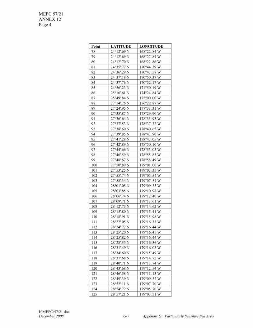
(Reference chart: United States 19016, 2007 edition; 19019, 2007 edition; 19022, 2007 edition. These charts are based on World Geodetic Survey 1984 and astronomic datum.) Description of the Particularly Sensitive Sea Area for the Papah�naumoku�kea Marine National Monument To avoid the risk of damage from ship groundings and pollution damage by international shipping activities and the destruction and degradation of this unique, fragile, and pristine coral reef ecosystem, as well as of significant cultural and archaeological resources, mariners should exercise extreme care when navigating in the area bounded by a line connecting the following geographical positions which is designated as a Particularly Sensitive Sea Area:
Point LATITUDE LONGITUDE 1 28°26'.24 N 175°10'.65 W 2 28°16'.07 N 175°00'.00 W 3 26°50'.89 N 173°30'.79 W 4 26°36'.00 N 171°37'.70 W 5 26°35'.49 N 171°33'.84 W 6 26°35'.09 N 171°30'.84 W 7 26°34'.07 N 171°27'.50 W 8 26°33'.35 N 171°25'.16 W 9 26°14'.25 N 170°23'.04 W 10 25°50'.55 N 167°57'.88 W 11 25°48'.99 N 167°48'.35 W 12 25°47'.09 N 167°36'.72 W 13 25°39'.84 N 167°26'.48 W 14 25°35'.10 N 167°19'.79 W 15 25°10'.43 N 166°45'.00 W 16 24°40'.91 N 166°03'.36 W 17 24°35'.64 N 165°34'.99 W 18 24°23'.98 N 164°32'.24 W 19 23°52'.82 N 161°44'.54 W 20 23°52'.10 N 161°41'.20 W 21 23°51'.18 N 161°37'.92 W 22 23°50'.08 N 161°34'.71 W 23 23°48'.79 N 161°31'.58 W 24 23°47'.33 N 161°28'.55 W 25 23°45'.69 N 161°25'.62 W 26 23°43'.88 N 161°22'.81 W 27 23°41'.92 N 161°20'.13 W 28 23°39'.80 N 161°17'.60 W 29 23°37'.54 N 161°15'.21 W
� The text in this annex is taken from the United States submission contained in document MEPC 56/8.
December 2008 G-5 Appendix G: Particularly Sensitive Sea Area

MEPC 57/21 ANNEX 12
Page 3
I:\MEPC\57\21.doc
Point LATITUDE LONGITUDE 30 23°35'.14 N 161°12'.99 W 31 23°32'.62 N 161°10'.93 W 32 23°29'.99 N 161°09'.05 W 33 23°27'.25 N 161°07'.35 W 34 23°24'.42 N 161°05'.85 W 35 23°21'.51 N 161°04'.54 W 36 23°18'.52 N 161°03'.43 W 37 23°15'.48 N 161°02'.53 W 38 23°12'.39 N 161°01'.84 W 39 23°09'.27 N 161°01'.35 W 40 23°06'.13 N 161°01'.09 W 41 23°02'.97 N 161°01'.03 W 42 22°59'.82 N 161°01'.19 W 43 22°56'.69 N 161°01'.57 W 44 22°53'.58 N 161°02'.15 W 45 22°50'.51 N 161°02'.95 W 46 22°47'.50 N 161°03'.95 W 47 22°44'.55 N 161°05'.15 W 48 22°41'.67 N 161°06'.54 W 49 22°38'.88 N 161°08'.13 W 50 22°36'.19 N 161°09'.90 W 51 22°33'.61 N 161°11'.85 W 52 22°31'.14 N 161°13'.97 W 53 22°28'.81 N 161°16'.25 W 54 22°26'.61 N 161°18'.69 W 55 22°24'.56 N 161°21'.26 W 56 22°22'.66 N 161°23'.97 W 57 22°20'.92 N 161°26'.80 W 58 22°19'.35 N 161°29'.74 W 59 22°17'.95 N 161°32'.78 W 60 22°16'.73 N 161°35'.90 W 61 22°15'.70 N 161°39'.10 W 62 22°14'.85 N 161°42'.37 W 63 22°14'.20 N 161°45'.68 W 64 22°13'.73 N 161°49'.03 W 65 22°13'.47 N 161°52'.41 W 66 22°13'.40 N 161°55'.80 W 67 22°13'.53 N 161°59'.18 W 68 22°13'.85 N 162°02'.55 W 69 22°14'.31 N 162°05'.45 W 70 22°14'.37 N 162°05'.89 W 71 22°45'.18 N 164°51'.62 W 72 22°50'.26 N 165°34'.99 W 73 22°55'.50 N 166°19'.63 W 74 22°55'.93 N 166°23'.32 W 75 22°57'.41 N 166°36'.00 W 76 23°03'.75 N 166°45'.00 W 77 23°05'.48 N 166°47'.45 W
December 2008 G-6 Appendix G: Particularly Sensitive Sea Area
MEPC 57/21 ANNEX 12 Page 4
I:\MEPC\57\21.doc
Point LATITUDE LONGITUDE 78 24°12'.69 N 168°22'.84 W 79 24°12'.69 N 168°22'.84 W 80 24°12'.70 N 168°22'.86 W 81 24°35'.77 N 170°44'.39 W 82 24°36'.29 N 170°47'.58 W 83 24°37'.18 N 170°50'.37 W 84 24°37'.76 N 170°52'.17 W 85 24°56'.23 N 171°50'.19 W 86 25°16'.61 N 174°24'.84 W 87 25°49'.84 N 175°00'.00 W 88 27°14'.76 N 176°29'.87 W 89 27°24'.95 N 177°33'.31 W 90 27°35'.87 N 178°29'.90 W 91 27°36'.64 N 178°33'.93 W 92 27°37'.53 N 178°37'.32 W 93 27°38'.60 N 178°40'.65 W 94 27°39'.85 N 178°43'.90 W 95 27°41'.28 N 178°47'.05 W 96 27°42'.89 N 178°50'.10 W 97 27°44'.66 N 178°53'.03 W 98 27°46'.59 N 178°55'.83 W 99 27°48'.67 N 178°58'.49 W 100 27°50'.89 N 179°01'.00 W 101 27°53'.25 N 179°03'.35 W 102 27°55'.74 N 179°05'.54 W 103 27°58'.34 N 179°07'.54 W 104 28°01'.05 N 179°09'.35 W 105 28°03'.85 N 179°10'.98 W 106 28°06'.74 N 179°12'.40 W 107 28°09'.71 N 179°13'.61 W 108 28°12'.73 N 179°14'.62 W 109 28°15'.80 N 179°15'.41 W 110 28°18'.91 N 179°15'.98 W 111 28°22'.05 N 179°16'.33 W 112 28°24'.72 N 179°16'.44 W 113 28°25'.20 N 179°16'.45 W 114 28°25'.82 N 179°16'.44 W 115 28°28'.35 N 179°16'.36 W 116 28°31'.49 N 179°16'.03 W 117 28°34'.60 N 179°15'.49 W 118 28°37'.68 N 179°14'.72 W 119 28°40'.71 N 179°13'.74 W 120 28°43'.68 N 179°12'.54 W 121 28°46'.58 N 179°11'.13 W 122 28°49'.39 N 179°09'.52 W 123 28°52'.11 N 179°07'.70 W 124 28°54'.72 N 179°05'.70 W 125 28°57'.21 N 179°03'.51 W
December 2008 G-7 Appendix G: Particularly Sensitive Sea Area

MEPC 57/21 ANNEX 12
Page 5
I:\MEPC\57\21.doc
Point LATITUDE LONGITUDE 126 28°59'.58 N 179°01'.15 W 127 29°01'.81 N 178°58'.62 W 128 29°03'.90 N 178°55'.93 W 129 29°05'.83 N 178°53'.10 W 130 29°07'.60 N 178°50'.13 W 131 29°09'.21 N 178°47'.04 W 132 29°10'.64 N 178°43'.84 W 133 29°11'.89 N 178°40'.54 W 134 29°12'.95 N 178°37'.16 W 135 29°13'.82 N 178°33'.71 W 136 29°14'.50 N 178°30'.21 W 137 29°14'.99 N 178°26'.66 W 138 29°15'.28 N 178°23'.08 W 139 29°15'.36 N 178°19'.49 W 140 29°15'.25 N 178°15'.90 W 141 29°14'.94 N 178°12'.32 W 142 29°14'.43 N 178°08'.78 W 143 29°03'.47 N 177°12'.07 W 144 29°02'.55 N 177°07'.29 W 145 28°38'.96 N 175°35'.47 W 146 28°38'.67 N 175°34'.35 W 147 28°34'.91 N 175°19'.74 W 148 28°26'.24 N 175°10'.65 W
December 2008 G-8 Appendix G: Particularly Sensitive Sea Area

MEPC 57/21 ANNEX 12 Page 6
I:\MEPC\57\21.doc
CHARTLET
December 2008 G-9 Appendix G: Particularly Sensitive Sea Area

MEPC 57/21 ANNEX 12
Page 7
I:\MEPC\57\21.doc
ANNEX 2
ECOLOGICAL, SOCIO-ECONOMIC, AND SCIENTIFIC ATTRIBUTES OF THE PAPAH�NAUMOKU�KEA MARINE NATIONAL MONUMENT PSSA�
1 Ecological Criteria 1.1 Uniqueness or rarity 1.1.1 The Papah�naumoku�kea Marine National Monument (North-western Hawaiian Islands or NWHI) supports a unique, dynamic coral reef ecosystem, which, thanks to its relative isolation, is among the healthiest in the world (Citizen’s Guide 2006). It is one of the last remaining large-scale wilderness coral reef ecosystems on the planet and the largest coral reef ecosystem in the marginal tropical seas (Cousteau 2003). Approximately one-quarter of the species found in the NWHI are endemic to the Hawaiian Island chain, which is one of the highest rates of marine endemism in the world (Friedlander et al. 2005; Citizen’s Guide 2006). The proportion of scientifically non-described coral reef species (e.g., sponges, corals, algae, and other invertebrates) in this area is one of the highest in the world (Cousteau 2003). The NWHI also contain important breeding and nesting grounds for a number of species, many of which are at risk, including the critically endangered Hawaiian monk seal, the threatened green sea turtle, and 19 species of seabirds (Henderson 2001; NOAA 2004b; Citizen’s Guide 2006). 1.1.2 The uniqueness of this area was expressed in 2003 by ocean explorer Jean-Michel Cousteau in his Voyage to Kure expedition log: “These islands are a celebration of the uniqueness brought on by isolation. Along this ribbon of life, we found teeming populations of spinner dolphins and large apex predators such as reef sharks, jacks, and groupers. We encountered many of the Hawaiian endemic species of reef fish, including the rare masked angelfish and Hawaiian grouper; all perfect reminders of an intact coral reef ecosystem” (Cousteau 2003). 1.2 Critical Habitat 1.2.1 Parts of the proposed area provide critical habitat for a variety of endangered or threatened species that are protected under various United States domestic laws. These species include the critically endangered Hawaiian monk seal; the endangered sperm whale; the endangered hawksbill, leatherback, and green sea turtles; the endangered short-tailed albatross; six endangered plant species; and four endangered land birds: the Nihoa finch, Nihoa millerbird, Laysan finch, and Laysan Duck, the world’s rarest duck. Of these species, seven are listed in Appendix I of the Convention on Trade in Endangered Species of Wild Flora and Fauna (CITES) and nine are listed on the World Conservation Union (IUCN) Red List of Threatened Species (including three with “critically endangered” status). 1.3 Dependency 1.3.1 The ecological processes of the NWHI ecosystem are dependent on the health of its vast, diverse coral reef tracts. Often called the “rainforests” of the sea, coral reefs are vital to
� The text in this annex is taken from the United States submission contained in document MEPC 56/8.
December 2008 G-10 Appendix G: Particularly Sensitive Sea Area
MEPC 57/21 ANNEX 12 Page 8
I:\MEPC\57\21.doc
maintaining the biological diversity of the oceans (Citizen’s Guide 2006). The pristine coral reefs of the NWHI are the foundation of a symbiotic community composed of countless millions of plants and animals dependent upon one another for survival (Citizen’s Guide 2006). These reefs perform important ecosystem services including filtering water, protecting islands from sediment deposition and storms, and providing nourishment for marine organisms. 1.3.2 Thousands of species depend on the coral reefs of the NWHI. Hawaiian monk seals, a majority of which make their home in the NWHI, are the only surviving marine mammal that is dependent on coral reef ecosystems (Citizen’s Guide 2006; Cousteau 2003). The high incidence of apex predators such as sharks, jacks, and groupers also depends on the high productivity of this ecosystem. In turn, the prevalence of apex predators has a significant effect on the structuring of the fish assemblage of the area, impacting the diversity and relative abundance of species lower on the food chain. Thus, adverse impacts on these apex predators could cause populations of smaller fish to quickly become unbalanced, changing the trophic structure and order of dominance within the ecosystem (Maragos and Gulko 2002; Friedlander and DeMartini 2002; Suthers 2004). 1.3.3 Approximately 14 million seabirds, with 5.5 million nesting annually in the NWHI, rely on the coral reef ecosystem for food and other habitat needs (Naughton and Flint 2004). In turn, the ecosystem is dependent on these birds’ role in the high relative productivity and diversity of the NWHI. Nutrient-rich defecation (guano) deposited by the birds on the islands and nearshore waters – which subsequently is dissolved and provides significant levels of nitrogen to the ecosystem – is thought to stimulate the prolific growths of algae found around the islands. When high levels of algal growth are combined with significant wave action, such as at La Perouse Pinnacle at French Frigate Shoals, this creates favourable conditions for the growth of other species (Maragos and Gulko 2002). 1.3.4 The ecological processes of the NWHI depend on more than just its coral reefs. Beyond the banks and steep slopes, between 1,640 and 14,000 feet, the ocean floor levels out at sea bottom which contains distinct, rich habitat (Press and Siever 1986; Benoit-Bird et al. 2001). This habitat is linked to the coral reef ecosystem by a dense assemblage of small fish, shrimp, and squid that migrate from the ocean depths to near the surface in regular patterns and serve as an important food resource for many animals, including spinner dolphins, bottom fish, tunas, and billfish (Benoit-Bird et al. 2001). The importance of offshore and deepwater habitat is also evidenced by the movements and diets of Hawaiian monk seals. Although part of the seals’ diet comes from shallow-water coral reef fish, the seals are known to travel over one hundred miles between islands and dive to depths of greater than 900 feet when foraging for deepwater prey, mainly bottom fish, which make up the primary part of their diet (Henderson 2001; TenBruggencate 2006). Each of these habitats is essential to the other, and the loss of one affects the operation of all the others throughout the system. Accordingly, an impact on one part of the system can threaten the entire ecosystem as well as the diversity of species that depend on the area. 1.4 Diversity 1.4.1 The NWHI supports more than 7,000 species of fishes, mammals, plants, coral, and other invertebrates (Bush 2006). Discoveries of species in the NWHI are continuing to be made, as demonstrated by a 2006 research expedition in French Frigate Shoals which yielded over 100 species not previously known to exist in the area and many of which may be previously unknown to science (Associated Press 2006). The rich diversity of the NWHI is in part due to
December 2008 G-11 Appendix G: Particularly Sensitive Sea Area

MEPC 57/21 ANNEX 12
Page 9
I:\MEPC\57\21.doc
the relative isolation of the area and minimal impact from humans, which is underscored by the starkly contrasting lower levels of diversity found in the marine areas of the main Hawaiian Islands (DeMartini and Friedlander 2004; Friedlander et al. 2005a; NOAA 2004g). Coral reefs are among the most highly diverse of all ecosystems on the planet; the coral reef ecosystem of the NWHI exemplifies this point. 1.4.2 Further contributing to diversity, the ecosystem of the NWHI contains a wide variety of habitats, extending from the shoreline to depths of approximately 14,000 feet. For example, within the pristine coral reefs of the NWHI, the percentage of coral cover varies widely, creating a series of interconnected but distinct types of coral reef habitats, or zones (e.g., shelf, fore reef, reef crest, back reef, and lagoon). Wave exposure is the primary factor causing zonation in the NWHI, but gradients in sediment, salinity, and temperature are also important (Friedlander et al. 2005a). As a result of this zonation, the coral reefs of the NWHI contain a variety of environmental niches and resources that support a diverse array of species. 1.5 Productivity 1.5.1 Coral reef ecosystems have the highest gross primary productivity of all ocean areas, and the proposed area contains several thousand square miles of coral reefs, indicating a highly productive ecosystem. Also indicative of the area’s productivity is the high incidence of apex predators such as sharks, jacks, and groupers, which make up more than half of the total fish biomass in the NWHI. A very high replacement rate of small and mid-size fish is necessary to support an apex predator-dominated ecosystem. 1.5.2 The productivity of the proposed area can readily be seen by comparing it to the productivity in the main Hawaiian Islands. A comparison of both biomass and trophic structure between reef fish communities in the NWHI and the main Hawaiian Islands showed that across similar habitats, biomass was 260 per cent higher in the NWHI (Friedlander and DeMartini 2002). Productivity is especially high in the area’s inshore waters, shallow lagoons, and coral reefs. For example, the lagoon in French Frigate Shoals produces nearly ten times the amount of phytoplankton as produced in the same volume of water in the open seas. The area also has extensive submerged banks, which have high levels of primary productivity due to the existence of expansive algal meadows. Furthermore, while apex predators represent only three per cent of the fish biomass in the main Hawaiian Islands, they make up 54 per cent of the biomass in the NWHI (Suthers 2004). 1.6 Spawning or Breeding Grounds 1.6.1 The NWHI provide critical breeding and nesting grounds for a wide variety of species. The area contains the breeding grounds for almost the entire remaining population of the Hawaiian monk seal, and serves as the seals’ primary haul-out, pupping, and weaning habitat. The area also provides the breeding grounds and primary nesting sites for approximately 90 per cent of the threatened Hawaiian Islands green sea turtle population. Millions of Central Pacific seabirds also congregate on these islands to breed, including all but three of Hawaii’s 22 species of seabirds, such as the grey-backed tern, short-tailed albatross, and the red-tailed tropicbird. More than 99 per cent of the world’s Laysan albatrosses and 98 per cent of the world’s black-footed albatrosses return to the NWHI each year to reproduce. For some bird species, the NWHI provide their only breeding site.
December 2008 G-12 Appendix G: Particularly Sensitive Sea Area

MEPC 57/21 ANNEX 12 Page 10
I:\MEPC\57\21.doc
1.7 Naturalness 1.7.1 Because of their geographical isolation and long history of protection, the reefs of the NWHI are among the healthiest and most undisturbed coral reefs on the planet. Their naturalness is perhaps best evidenced by the relatively high diversity and productivity in the NWHI as compared with the reefs of the main Hawaiian Islands, which have experienced much greater impacts from humans, and by the fact that the NWHI is one of the worlds last remaining large-scale apex predator-dominated reef ecosystems. 1.8 Integrity 1.8.1 The area of the NWHI is a prime example of a self-sustaining ecological entity. The volcanic islands, coral atolls, shallow reefs, banks, slopes, shoals, seamounts, deep reefs, and open water form the basis for this interlocking and complex ecosystem. Its integrated nature is evidenced by the vast number of interdependent processes that connect the varied NWHI habitats, as discussed in particular in section 3.4 (Dependency) of this proposal. Examples of this include: (1) the critical link between the shallow coral reef and the deep ocean floor habitats manifested by species that migrate regularly from great depths and are consumed by many shallower water animals; (2) the foraging, feeding, breeding, and pupping areas of the Hawaiian monk seal range from the offshore, deepwater habitats to the land areas; and (3) the deposits of bird guano stimulate algal growth which, when combined with wave action, contributes to the growth of other species and the high productivity of the ecosystem. 1.8.2 While the NWHI are a part of the greater chain of Hawaiian Islands, there is clear evidence that the NWHI function as a distinct, biological unit. The NWHI ecosystem is highly productive, diverse, and apex predator-dominated while the ecosystem around the main Hawaiian Islands has substantially lower productivity, less species diversity, and is not apex predator-dominated. These differences demonstrate that the NWHI function as an integral unit. 1.9 Fragility 1.9.1 The area contains several thousand square miles of coral reefs made up of at least 57 species of hard coral and 12 species of soft coral. Coral communities are fragile ecosystems. They require a delicate balance across a range of environmental conditions in order to be healthy and grow. The health of a coral ecosystem may be threatened by changes to even one of those environmental conditions. Corals derive a substantial portion of their nutrition from symbiotic algae (called zooxanthellae) within their tissues. Because algae require light for photosynthesis, clear and clean water conditions are necessary for growth and well-being. The introduction of pollutants can be toxic to the coral. 1.9.2 The physical structure of the reef is provided by calcium carbonate, which forms the rock framework or reef “skeleton”. This calcium carbonate is deposited at a rate of about one-centimetre per year by the living coral animal (polyp). These polyps exist in a thin layer at the surface of the reef rock. The coral reef system of the NWHI has taken thousands of years to build and, if damaged, regeneration of the reef may never occur. If optimal conditions for regeneration exist, it would still take hundreds, and perhaps thousands of years, for a damaged area of the reef to return to its previous condition.
December 2008 G-13 Appendix G: Particularly Sensitive Sea Area
MEPC 57/21 ANNEX 12
Page 11
I:\MEPC\57\21.doc
1.9.3 In the NWHI, transiting ships are a primary anthropogenic threat to this fragile ecosystem because of ship groundings and pollution from operational and accidental discharges. Secondary and cumulative damage may occur when dislocated coral fragments caused by groundings are tossed against healthy coral by wave action, currents, and storms. 1.9.4 The isolation of the NWHI affords both protection from and vulnerability to invasive species, which can be transferred by ships. The islands’ ecosystems have evolved without the influence of outside forces, demonstrated by the high level of native and endemic species. To date, 11 non-native species have been identified in the waters of the NWHI. Non-native species can displace native species and seriously disrupt and imbalance the natural ecosystem. 1.10 Bio-geographic importance 1.10.1 The NWHI represent one of the last remaining examples of an intact apex predator-dominated coral reef ecosystem with large top predator fish such as sharks in abundance. Because it is isolated, many aspects of the area represent what a completely pristine and undisturbed bio-geographic system would look like at this latitude if one still existed. 1.10.2 The area is geologically unique. The islands were created from a single plume of magma rising from a hot spot in the earth’s mantle. Built up over millions of years of eruption, high volcanic islands were formed, then carried north-westerly by the movement of the Pacific Plate beneath. Twenty-eight million years ago the last emergent feature of the chain, Kure, was located where the present Big Island of Hawaii is now located. 2 Social, cultural and economic criteria 2.1 Human Dependency 2.1.1 The NWHI are of particular importance because of their significance in Native Hawaiian history and culture. The NWHI have long been considered a sacred place in Native Hawaiian traditions, and two of the islands in particular contain important archaeological sites (Kikiloi 2006). Early Polynesian voyagers, in their trans-Pacific voyages aboard large double-hulled sailing canoes, were the first humans to arrive in the NWHI, as early as 1000 A.D. Early Hawaiians lived on Nihoa for an estimated 700 years, but this occupation mysteriously ceased before Captain Cook’s first landing in Hawaii in 1778 (Citizen’s Guide 2006). Their early presence is evidenced by numerous sites on Nihoa and Mokumanamana (Necker), which are listed on both United States and State of Hawaii Registers of Historic Places for their cultural and historical significance. Together, the two islands have 140 recorded cultural sites, including ceremonial, residential, and agricultural sites, some which resemble historically important Polynesian sites in Tahiti and the Marqueses (Emory 1928; Cleghorn 1988; Liller 2000; Kawaharada 2001; Kikiloi 2006). These sites are being studied to increase the understanding of the connection between Native Hawaiian culture and the early Polynesians. 2.1.2 Oral traditions also confirm the relationship of the islands to ancestral Native Hawaiians, and recent ethnological studies have highlighted the continuity of traditional practices in the NWHI. Native Hawaiian cultural practitioners continue to voyage to the NWHI to honour their ancestors and perpetuate these practices. In 1997, Hui Mälama i Nä Küpuna o Hawaii’s Nei, a group dedicated to the repatriation of ancestral remains, returned sets of iwi (bones) to Nihoa and Mokumanamana (Necker). In 2003, the voyaging canoe H�k�le`a travelled to Nihoa so that a group could conduct traditional ceremonies. In 2004, the H�k�le`a sailed to Kure Atoll, and
December 2008 G-14 Appendix G: Particularly Sensitive Sea Area

MEPC 57/21 ANNEX 12 Page 12
I:\MEPC\57\21.doc
in 2005 it took a group to Mokumanamana (Necker) for ceremonies on the summer solstice (Citizen’s Guide 2006). Finally, underscoring the importance of the NWHI marine ecosystem in Native Hawaiian culture, oral traditions identify the coral polyp as the first living creature to emerge on Earth and the foundation and the building block of all other life in the sea (Friedlander et al. 2005b). It follows that ensuring a healthy, intact ecosystem in the NWHI plays an important role in perpetuating Native Hawaiian cultural traditions. 2.2 Cultural heritage 2.2.1 The NWHI are rich in underwater cultural heritage. The numerous wrecks found in the area are time capsules which capture specific elements of our seagoing past. Documents indicate that over 120 vessels and aircraft have been lost in the waters of the proposed area. These remains are representative of distinct phases of Pacific history and include Japanese junks, Hawaiian sampans, 19th century whalers, United States Navy side wheel steamers, French sailing ships, and fighter aircraft lost during the World War II Battle of Midway. Only a handful of these sites have been located and assessed so far, but these surveys reveal resources unique to the North-western Hawaiian Islands. The wrecks of the whaling ships Pearl and Hermes, both of which ran aground in 1822, are the only archaeological remains of the South Seas whaling industry, and the oldest shipwrecks found thus far in Hawaii. The scattered remains of the USS Saginaw, lost in 1870, capture the United States Civil War-era technology of the “old steam navy.” The wreck site of the Dunnottar Castle, an iron hulled sailing ship lost in 1886, offers a rare glimpse of the days of the Tall Ships. These and many other sites are rare, representative of broad themes of maritime history, and a testimony to the uniqueness of Pacific seafaring history. Unwarranted damage or removal of submerged archaeological sites is prohibited by state and federal preservation laws, and United States Monument management agencies seek to protect these heritage resources as windows into the past. 3 Scientific and educational criteria 3.1 Research 3.1.1 This area is of high scientific interest and offers unparalleled opportunity for research. Given the fact that the NWHI are remote and rich with marine and terrestrial life, they provide one of the few areas in the world where researchers can conduct large-scale comparisons between human-impacted marine ecosystems and un-impacted marine ecosystems (Citizen’s Guide; Friedlander and DeMartini 2002). Such comparisons may serve as a living model to guide restoration efforts elsewhere. 3.1.2 As further evidence of the importance of this area for research, in October 2006 an international team of biologists made discoveries in French Frigate Shoals of several new species of coral, sea stars, snails, and clams. The researchers also discovered over one hundred species never before seen in French Frigate Shoals and many of which may have been previously unknown to science (Associated Press 2006). These scientific discoveries suggest that much research remains to be done to fully understand and appreciate this complex ecosystem. 3.1.3 Research and monitoring conducted by United States federal and state agencies, academic institutions, and other organizations over the last 30 years have contributed substantially to the understanding of natural and anthropogenic factors influencing the NWHI and the interconnectedness of the physical and biological processes along the entire Hawaiian Island chain. Ongoing research and monitoring of the marine ecosystems in the NWHI will continue to
December 2008 G-15 Appendix G: Particularly Sensitive Sea Area

MEPC 57/21 ANNEX 12
Page 13
I:\MEPC\57\21.doc
provide significant insights that will benefit management not only for the NWHI but in the entire Hawaiian Island chain and marine ecosystems around the world. 3.2 Baseline for monitoring studies 3.2.1 The NWHI are one of the few marine regions on earth where monitoring and research activities can be conducted in the virtual absence of local human habitation and activities. It thus provides ideal baseline conditions with regard to biota and environmental characteristics because it has not had substantial perturbations and is thus in a natural or near-natural condition. Remote, uninhabited, and relatively pristine in comparison to the main Hawaiian Islands and other marine ecosystems around the world, the NWHI serve as one of the few modern sentinels for monitoring and deciphering short-term and long-term responses to local, regional, and global environmental and anthropogenic stressors. 3.3 Education 3.3.1 The NWHI provide a model and rare benchmark of a healthy, intact integrated ecosystem preserved in its natural or near-natural state that may inspire Hawaiian residents as well as others to take part in ocean restoration efforts in their communities. This guiding premise led to “Navigating Change”, a multi-year, interagency project which focuses on raising awareness and motivating people to change their attitudes and behaviours to better care for Hawaii’s land and ocean resources. A five-part video and educational curriculum featuring the traditional Polynesian voyaging canoe H�k�le`a during its 2004 expedition to the NWHI was completed in partnership with several agencies and organizations. Teacher workshops on the “Navigating Change” program have been held since 2003 across Hawaii and an outreach co-ordinator leads an associated curriculum in schools state-wide. As people learn more about the NWHI, many will want to go there and experience it. Therefore, the educational message that is being sent to preserve the fragile balance of the NWHI is that people must admire it from afar. Educational activities, therefore, will focus on bringing the place to the people, not the people to the place.
December 2008 G-16 Appendix G: Particularly Sensitive Sea Area
MEPC 57/21 ANNEX 12 Page 14
I:\MEPC\57\21.doc
ANNEX 3
VULNERABILITY TO DAMAGE BY INTERNATIONAL SHIPPING ACTIVITIES�
1 Vessel Traffic Characteristics 1.1 Operational factors 1.1.1 There are limited maritime activities conducted in the waters of the NWHI, undoubtedly due to the islands’ remote location and harsh environmental conditions for human activities. Pursuant to the Presidential Proclamation of June 15, 2006, most domestic activities within NWHI waters are prohibited or strictly regulated. Public access to the land portions of the NWHI has for many years been allowed by permit only, except for Midway Atoll, and permits are issued only for research and Native Hawaiian cultural activities. The maritime activities in this area are primarily research and management, fishing, cultural practices, and recreation. Research activities include assessment, long-term monitoring of resources, impacts and threats from human activities, and protection and conservation of NWHI resources. An estimated four million dollars are spent annually on research and management of the area. There are eight remaining commercial fishing permits in the NWHI, although the Presidential Proclamation and codifying regulations require closure of the fishery five years from the date of the Proclamation. Native Hawaiian cultural practitioners voyage to the NWHI to honour their ancestors and perpetuate traditional practices. Current tourism and recreational activities are limited to Midway Atoll and, under the Proclamation, a permit is now required. The extent to which ocean tourism and recreation occurs in the NWHI is unknown, but it appears to be extremely low. These activities may include wildlife watching, diving and snorkelling, charter fishing, and tour boats. Additionally, a management plan for tourism to the historic World War II location and military heritage sites on Midway Atoll is currently being developed and up to three cruise ships may visit the island each year. 1.2 Vessel Types 1.2.1 Container ships, bulk carriers, tankers, freighters, and fishing vessels regularly transit the waters surrounding the NWHI. With the exception of a few small boats at Midway Atoll and Tern Island (French Frigate Shoals), no vessels home port in the NWHI. Research and management vessels, eight fishing vessels, vessels used by Native Hawaiians, some recreational vessels, and a few cruise ships, conduct strictly regulated activities in NWHI waters (Franklin 2006; Mohri 2006). 1.3 Traffic Characteristics 1.3.1 Although due to its remoteness, the exact route of vessels through this area is unknown, it appears that most traffic passes to the north of the island chain, following the great circle routes to and from ports on the west coast of North America and East Asia. Other trans-Pacific ships travelling from ports in Hawaii transit at least 100 miles south of the NWHI. Occasionally, vessels transiting from the south pass within the boundaries of the proposed PSSA (Franklin 2006; Tosatto 2005; Horizon Lines 2006; Devany 2006).
� The text in this annex is taken from the United States submission contained in document MEPC 56/8.
December 2008 G-17 Appendix G: Particularly Sensitive Sea Area

MEPC 57/21 ANNEX 12
Page 15
I:\MEPC\57\21.doc
1.3.2 A preliminary analysis of vessel traffic patterns within the NWHI was conducted based on data collected by the World Meteorological Organization’s Voluntary Observing Ships scheme. This scheme collects geo-referenced data from select non-research vessels that make frequent and regular crossings of all major ocean basins. While the scheme does not capture the total traffic in the area, during a 21-month study period in 2004 and 2005, approximately 132 vessels reported from within the area of the proposed PSSA: 104 of these vessels were freighters, 8 were tankers, 4 were research vessels, 2 were passenger vessels, 2 were vessels used for educational purposes, 1 was a recreational vessel, 1 was a towing vessel with a 666-foot vessel in tow, and 10 were unidentified vessels. The 132 vessels were flagged in 23 different countries (Franklin 2006). 1.4 Substances Carried 1.4.1 While precise data is not available for the types of harmful substances carried on board the vessels that transit the waters of the NWHI, it is possible to identify examples of such substances from incidents that have occurred in the area. Three vessels, the Paradise Queen II (1998), the Swordman I (2000), and the Casitas (2005), all grounded in the NWHI and had significant quantities of bunker fuel or were carrying other types of fuel onboard (Cascadia Times 2006; Shallenberger 2004). These substances are harmful to the marine ecosystem and to the terrestrial environment when washed ashore. In another incident, a container of the pesticide, carbofuran, washed ashore at Laysan Island (Friedlander et al. 2005). 1.4.2 Three other ship accidents occurred involving cargoes that may not be classified as “hazardous substances,” but that would be harmful if released into this area of the sea. The first incident involved the Anangel Liberty in 1980 where 2,200 tons of kaolin clay was dumped overboard to lighten the ship enough to pull it off one of the reefs on French Frigate Shoals. Fortunately, the currents on that day carried most of the clay out to sea rather than onto the reef. Had it not, the clay could have smothered coral thus adversely affecting the ecosystem. The other two incidents involved the grounding on Laysan of fishing vessels that had evidence of rats on board. Again, fortunately, the rats did not take up residence on the nearby island; however, if they had, it would have been extremely harmful to the ecology of the area because such introduced species can become “ecosystem busters” and cripple the ecosystem within that area (Shallenberger 2004). 2 Natural Factors 2.1 Hydrographical 2.1.1 The hydrography of the NWHI underscores the need for mariners to navigate with extreme caution. The chain of small islands, atolls, banks, seamounts, pinnacles, shoals, and other emergent features are remnants of volcanic islands which are eroding and subsiding beneath the ocean surface. While only the peaks of the original islands remain above the water’s surface, coral growth on submerged slopes has matched the rate of subsidence (Evans et al. 2004). Due to these features, navigation in this area is dangerous and must be done with extreme caution. Water depths in this area range from the water’s surface to slightly submerged banks, reefs, and other emergent features to the ocean floor at more than 14,000 feet. 2.1.2 The area of the proposed PSSA is currently covered by mostly small scale charts, with the most recent surveys taking place since 2000 near known islands, reefs and atolls. Although modern hydrographic surveys by the University of Hawaii and satellite imagery of the area have
December 2008 G-18 Appendix G: Particularly Sensitive Sea Area

MEPC 57/21 ANNEX 12 Page 16
I:\MEPC\57\21.doc
allowed NOAA’s Office of Coast Survey to correct the position of several of these features, many of the submerged banks and isolated features have yet to be updated or discovered. 2.1.3 In 2003, a mapping expedition was undertaken by NOAA and the University of Hawaii Undersea Research Laboratory. The primary objective of this project was to provide for more complete and accurate charts and survey data to support the management of the NWHI Coral Reef Ecosystem Reserve and protection of its resources. This expedition included hydrographic experts to ensure that appropriate International Hydrographic Organization quality standards were met. The hydrographic data will be applied to all affected charts by the end of 2007. Notwithstanding, large areas of the NWHI remain to be surveyed and nautical charts updated. 2.2 Meteorological 2.2.1 The northeast trade winds prevail throughout the year, but westerly blows can be expected during the winter. The average velocity of the winds is 12 knots, with monthly averages of 16 knots in December and 9.5 knots in August. Gales have been experienced in July and September. Occasional heavy showers of short duration also occur, cutting visibility to about 2 miles (Coast Pilot 7, 38th ed., 2006). 2.2.2 Tropical storms and hurricanes are a potential, but infrequent, threat to the shallow coral reef community structure of the NWHI. They can generate extreme wave energy events that can damage the coral and are the primary natural force in altering and shaping coral reef community structures (Dollar 1982; Dollar and Grigg 2004). Since 1979, two hurricanes (category 2) have passed near the NWHI. The most recent significant tropical storm was Hurricane Nele which passed near Gardner Pinnacles in 1985 (Friedlander et al. 2005). 2.2.3 Pacific Decadal Oscillation (PDO) events and the El Nino/La Nina phenomenon (ENSO) are two other meteorological factors that occur in the area of the NWHI. PDO events have been described as long-lived El Nino-like patterns of Pacific climate variability. They appear to persist for 20 to 30 years, compared to the 6 to 18 months for an El Niño event. The effects of the PDO are strongest in the North Pacific, while secondary signatures exist in the tropics. PDO sea level pressure anomalies vary with low pressures over the North Pacific and high pressure over the subtropical Pacific. These pressure patterns cause enhanced counter-clockwise wind stress over the North Pacific. With regard to the ENSO, while scientists do not fully understand how one is triggered, the initial detection occurs by a rise in atmospheric pressure in the western Pacific and a drop in pressure in the eastern Pacific (Garrison 1999). This causes trade winds to shift direction, which subsequently causes warm water in the western Pacific to flow across the Pacific basin. This mass of warm water has a number of effects on climate and ocean conditions. For example, it can cause trade wind speeds to drop, which can cause an increase in sea surface temperature (Hoeke et al. 2004). Light winds are likely the cause of recent coral bleaching in the NWHI. Increased water temperatures stress the coral, which causes it to expel the symbiotic zooxanthellae. If water temperature does not decrease and zooxanthellae do not return to the coral tissue, the coral will die. 2.3 Oceanographic 2.3.1 The NWHI are influenced by a wide range of oceanographic conditions that vary on spatial and temporal scales. Ocean currents, waves, temperatures, nutrients, and other oceanographic parameters and conditions influence ecosystem composition, structure, and function in the NWHI. Ocean currents play an important role in the dispersal and recruitment of
December 2008 G-19 Appendix G: Particularly Sensitive Sea Area

MEPC 57/21 ANNEX 12
Page 17
I:\MEPC\57\21.doc
marine life in the NWHI. Surface currents are highly variable in both speed and direction (Firing et al. 2004), with long-term average surface flow from east to west in response to the prevailing northeast trade wind conditions. The highly variable nature of the surface currents is due in large part to eddies created by local island effects on large-scale circulation. Marine debris accumulation in shallow water areas of the NWHI also is influenced by large and small-scale ocean circulation patterns. These eddies might also result in pollution from vessels accumulating in the coral thus damaging resources. 2.3.2 Ocean waves also play an important role in the NWHI. The distribution of corals and other shallow water organisms is influenced by the exposure to waves. The size and strength of ocean wave events have annual, inter-annual, and decadal time scales. Annual extra-tropical storms (storms that originate outside the tropical latitudes) create high energy large wave events from five to over ten meters which approach largely from the northwest during the winter. During this time, the average wave power increases substantially and extreme wave events of over ten meters pound the shallow water coral communities, thus posing a hazard to the coral reef communities and to navigation. Decadal variability in wave power is possibly related to PDO events (Manutau et al. 1997). The number of extreme wave events has been recorded during the periods from 1985 to 1989 and from 1998 to 2002, and anomalously low numbers of extreme wave events occurred during the early 1980s and during the period from 1990 to 1996 (Friedlander et al. 2005). 2.4 Other helpful information 2.4.1 There is substantial evidence that international shipping activities are causing or may cause damage to the recognized attributes of the proposed PSSA. The hazards to navigation in the NWHI are demonstrated by the large number of shipwrecks throughout the NWHI chain. Over 60 shipwrecks have occurred in the area and some of these wrecks serve as the origin of a number of the islands’ names.� While some of these wrecks are truly historic and therefore serve as time capsules of seafaring history, there have been a number of significant maritime casualties in more recent years. In 1998, the 80-foot Paradise Queen II ran aground on Kure Atoll. It spilled approximately 4,000 gallons of diesel fuel and other petroleum hydrocarbons. The remaining 7,000 gallons on board the vessel were recovered during salvage operations. The 85-foot Swordman I ran aground on Pearl and Hermes Atoll in 2000. It was carrying over 10,000 gallons of diesel fuel and hydraulic oil and approximately $1.5 million was spent for response and removal of the vessel. In 2005, the 145-foot Casitas also ran aground on Pearl and Hermes Atoll, carrying over 33,000 gallons of diesel fuel on board. The vast majority of diesel fuel was salvaged and the vessel was removed from the Atoll and scuttled in an estimated $5 million clean up and removal operation (Cascadia Times 2006; Shallenberger 2004; Biennial Coastal Zone Conference 2003). 2.4.2 The grounding of the Anangel Liberty on French Frigate Shoals in 1980 plowed a channel 2-3 metres deep, 100 metres long, and 30 meters wide in the coral reef. Coral communities were damaged within 50 meters on both sides of the channel ploughed by the freighter as a result of cargo (kaolin clay) that was dumped. In 1977, the burning and sinking of the Hawaiian Patriot to the south of French Frigate Shoals resulted in more than five million gallons of fuel oil entering the ocean (United States Fish & Wildlife Serv. 2005; United States Coral Reef Task Force 1999). Also in 1977, Irene’s Challenge spilled � This figure does not include aircraft or vessels that were sunk in the Battle of Midway.
December 2008 G-20 Appendix G: Particularly Sensitive Sea Area

MEPC 57/21 ANNEX 12 Page 18
I:\MEPC\57\21.doc
approximately 10.4 million gallons of crude oil approximately 50 miles to the north of Lisianski Island. MEPC 56/INF.2, annex 1, provides a table summarizing select incidents that have occurred between 1970 and 2006 (United States Coral Reef Task Force 1999; NOAA 2006). 2.4.3 In addition to the damage that may be caused to the NWHI by spills or releases of ships’ cargos or bunker fuel, damage may be caused by the grounding of ships on fragile coral and other sensitive habitats in the area. In the case of vessel grounding, destruction in the area of contact may be widespread and result in the scouring and destruction of coral by dislodgement and pulverization, as well as the crushing, fracturing, and removal of reef structure. Impacts may also include the scarring and abrading of nearby resources as wave action, currents, and wind move rubble produced at the initial site of the grounding. Additionally, there may be increased sedimentation with the fracturing and erosion of the reef structure, which can smother coral and other sensitive habitats (Coral Reef Restoration Handbook 2006). Damage may also be caused by subsequent vessel removal efforts which can further crush and bury sensitive resources. A vessel that has grounded and then is abandoned can continue to damage resources as debris becomes dislodged from the vessel and from its movement at the grounding location by wind and wave action. 2.4.4 Fortunately, although damage to coral and other resources has occurred from the ships that have grounded or sunk in the NWHI, recovery and removal efforts as well as favourable weather patterns and the currents occurring at the time of these maritime casualties have so far spared the fragile NWHI ecosystem from being seriously adversely impacted (Shallenberger 2004). Without taking the necessary action to increase maritime safety, protect the fragile marine environment, and facilitate the ability to respond to developing maritime emergences, it is reasonably foreseeable that ships will continue to run aground in the NWHI and cause physical damage to the fragile coral reef ecosystem, as well as pose a threat of severe damage to this pristine area from the release of cargo and bunker fuel. Given the remoteness of the NWHI, the low level of development on the islands, and the minimum amount of domestic maritime activity that takes place within the surrounding waters, vessels that transit the area are one of the most persistent and significant anthropogenic threats to the recognized attributes of the area. 2.4.5 Another element that increases the vulnerability of the NWHI to international shipping activities is that, although the islands span 1,200 miles, most emergency response equipment is stationed in the main Hawaiian Islands, including Kauai, which is to the east of the NWHI. Search, rescue, and response operations have been staged from Midway Atoll, which is at the far north-western end of the island chain; however, without assistance from resources based in the main Hawaiian Islands, search, rescue, and response from Midway can generally reach only 10 miles offshore due to the limited equipment located permanently on the island. The sparse land area and fragile environment of the other islands makes it virtually impossible for them to act as staging areas for emergency response efforts. This fact, coupled with the hazardous nature of navigation throughout this area, results in the NWHI being highly vulnerable to damage by international shipping. 2.4.6 Another potential source of damage to this pristine area by international shipping activities is from the introduction of alien species. While only approximately 11 alien species have been detected in the waters of the NWHI, once established these species are extremely difficult – if not impossible – to control and eradicate from the reefs. Therefore, it is critical to keep ships that may be carrying ballast water or species on their hulls from foundering or
December 2008 G-21 Appendix G: Particularly Sensitive Sea Area

MEPC 57/21 ANNEX 12
Page 19
I:\MEPC\57\21.doc
grounding on the reefs and providing the opportunity for the introduction of alien species (Citizen’s Guide 2006). 2.4.7 In addition to the threat posed by transiting ships, another stress to the environment of the NWHI is marine debris, a severe and chronic threat to the area. Ocean currents carry a wide array of marine debris to the NWHI, including derelict fishing nets and other gear, household plastics, hazardous materials, and shore-based debris, and deposit it on the reef and beaches of the island chain. The debris frequently entangles and kills coral and leads to the death of animals such as seabirds and the Hawaiian monk seal through the ingestion of material or entanglement in nets. Derelict fishing gear also poses a navigation hazard because, for example, it can get wrapped around the propeller of a vessel. In the past 10 years, United States agencies have removed over 560 tons of debris from NWHI reefs at a cost of approximately US$13.5 million (Citizen’s Guide 2006; Brainard 2006). 2.4.8 The IMO measure of six existing ATBAs is already in effect. While there has been no incident in the areas of the existing ATBAs subsequent to their adoption that involves the vessels to which the ATBAs apply (e.g., vessels of 1,000 gross tons and above), there have been incidents in the NWHI outside of the existing ATBAs and incidents within the ATBAs by vessels to which the ATBAs do not now apply. For instance, the Paradise Queen II grounded on Kure Atoll, an area which is not now included within the ATBAs. Within the ATBA surrounding Pearl and Hermes Atoll, the Swordman I and Casitas ran aground; however, these vessels were smaller than the 1,000 gross ton applicability threshhold of the existing ATBAs.
December 2008 G-22 Appendix G: Particularly Sensitive Sea Area

MEPC 57/21 ANNEX 12 Page 20
I:\MEPC\57\21.doc
ANNEX 4
ASSOCIATED PROTECTIVE MEASURES FOR THE PAPAH�NAUMOKU�KEA MARINE NATIONAL MONUMENT PSSA�
Expansion and amendment of the areas to be avoided “In the region of the Papah�naumoku�kea Marine National Monument Particularly Sensitive Sea Areas (PSSA)” (Reference chart: United States 19016 (2007 edition; 19019, 2007 edition; 19022, 2007 edition.) Note: These charts are based on World Geodetic System 1984 Datum (WGS-84) and astronomic datum�.) Description of the Areas to be Avoided Given the magnitude of obstacles that make navigation in these areas hazardous, and in order to increase maritime safety, protection of the environment, preservation of cultural resources and areas of cultural importance significant to Native Hawaiians, and facilitate the ability to respond to developing maritime emergencies in the Papah�naumoku�kea Marine National Monument, all ships solely in transit should avoid the following areas: 1 Those areas contained within a circle of radius of 50 nautical miles centred upon the following geographical positions:
(1) 28° 25�.18 N 178° 19�.75 W (Kure Atoll) (2) 28° 14�.20 N 177° 22�.10 W (Midway Atoll) (3) 27° 50�.62 N 175° 50�.53 W (Pearl and Hermes Atoll) (4) 26° 03�.82 N 173° 58�.00 W (Lisianski Island) (5) 25° 46�.18 N 171° 43�.95 W (Laysan Island) (6) 25° 25�.45 N 170° 35�.32 W (Maro Reef) (7) 25° 19�.50 N 170° 00�.88 W (Between Maro Reef and Raita Bank) (8) 25° 00�.00 N 167° 59�.92 W (Gardner Pinnacles) (9) 23° 45�.52 N 166° 14�.62 W (French Frigate Shoals) (10) 23° 34�.60 N 164° 42�.02 W (Necker Island) (11) 23° 03�.38 N 161° 55�.32 W (Nihoa Island)
2 The areas contained between the following geographical positions:
Begin Co-ordinates End Co-ordinates Latitude Longitude Latitude Longitude
Area 1 Lisianski Island (N) ---> Laysan Island 26� 53�.22 N 173� 49�.64 W 26� 35�.58 N 171� 35�.60 W Lisianski Island (S) ---> Laysan Island 25� 14�.42 N 174� 06�.36 W 24� 57�.63 N 171� 57�.07 W Area 2 Gardner Pinnacles (N) ---> French Frigate Shoals 25� 38�.90 N 167� 25�.31 W 24� 24�.80 N 165� 40�.89 W Gardner Pinnacles (S) ---> French Frigate Shoals 24� 14�.27 N 168� 22�.13 W 23� 05�.84 N 166� 47�.81 W
� The text in this annex is directly taken from document MSC 83/28, annexes 25 and 26.
� The charts are available in paper, raster, or ENC form and may be found at http://chartmaker.ncd.noaa.gov/NSD/coastpilot.htm. Mariners are also urged to consult the latest edition, of the United States Coast Pilot No.7, available at http://chartmaker.ncd.noaa.gov/nsd/coastpilot7.htm and in particular, Chapter 14, which pertains to Hawaii, available at http://chartmaker.ncd.noaa.gov/nsd/Cp7/CP7-39ed-Ch14_7.pdf.
December 2008 G-23 Appendix G: Particularly Sensitive Sea Area

MEPC 57/21 ANNEX 12
Page 21
I:\MEPC\57\21.doc
A ship reporting system (CORAL SHIPREP) is established in “The Papah�naumoku�kea Marine National Monument” Particularly Sensitive Sea Area (PSSA) 1 Categories of ships 1.1 Ships required to participate in the system
1.1.1 As a condition of entry to a United States port or place, all ships 300 gross tonnage or greater, and all ships in the event of a developing emergency, and that are in transit through the reporting area are required to participate in CORAL SHIPREP, except for sovereign immune vessels which are exempt under SOLAS regulation V/1.
1.2 Ships recommended to participate in the system 1.2.1 All ships 300 gross tonnage or greater, fishing vessels, and all ships in the event of a developing emergency, and that are in transit through the reporting area are recommended to participate in CORAL SHIPREP.
2 Geographical coverage of the system and the number and edition of the reference
chart used for the delineation of the system 2.1 The geographical coverage of CORAL SHIPREP is depicted by the geographical positions in the appendix.
2.2 The reference charts that include the ship reporting area are United States 19016, 2007 edition, 19019, 2007 edition, and 19022, 2007 edition. These charts are based on World Geodetic System 1984 Datum (WGS-84) and astronomic datum.
3 Format, content of reports, times and geographical positions for submitting reports,
authorities to whom reports should3 be sent, available services 3.1 Format
3.1.1 The ship report should be drafted in accordance with the format shown in paragraph 2 of the appendix to resolution A.851(20). 3.2 Content
3.2.1 The report for a ship entering the system should contain the following information:
System identifier: CORAL SHIPREP
A Name of the ship, call sign, or IMO identification number B Date and Time (UTC) C or D Position E or F Course and speed of ship I Destination L Intended route through the reporting area O Vessel draft
3 For those ships that are required to report the use of the word “should” in this annex is to be read as “shall”.
December 2008 G-24 Appendix G: Particularly Sensitive Sea Area

MEPC 57/21 ANNEX 12 Page 22
I:\MEPC\57\21.doc
P General categories of hazardous cargo on board Q or R Defects or deficiencies, if relevant T Contact information of ship’s agent or owner U Ship size and type (e.g., length, tonnage, and type) W Total number of persons on board
3.2.2 The report for a ship leaving the system should contain the following information: System identifier: CORAL SHIPREP
A Name of the ship, call sign, or IMO identification number B Date and Time (UTC) C or D Position
3.2.3 A ship may elect, for reasons of commercial confidentiality, to communicate that section of the report which provides information on general categories of hazardous cargo by non-verbal means prior to entering the reporting area. 3.3 Geographical positions for submitting reports
3.3.1 Each ship should submit a full report in accordance with paragraph 3.2.1 as soon as it crosses the boundary to enter the ship reporting system. 3.3.2 Each ship should submit a report in accordance with paragraph 3.2.2 as soon as it crosses the boundary to leave the ship reporting system.
3.3.3 Further reports should be made whenever there is a change in navigation status or circumstances, particularly in relation to item Q of the reporting format. 3.4 Authority to whom reports should be sent 3.4.1 The shore-based Authority is the United States Coast Guard’s Communication Area Master Station Pacific (CAMSPAC). For ships 300 gross tonnage and greater, an e-mail address to be used for reporting through INMARSAT-C will be provided in advance of implementation of this system through Notices to Mariners. In the event of a developing emergency, ships are urged to call the United States Coast Guard 14th District. Vessels unable to report in through INMARSAT-C should report to [email protected]. 4 Information to be provided to ship and procedures to be followed 4.1 The CORAL SHIPREP shore-based Authority will provide critical alerts and information to shipping about specific and urgent situations and other information that may affect safety of navigation within the IMO-adopted Areas To Be Avoided and “The Papah�naumoku�kea Marine National Monument” Particularly Sensitive Sea Area, as well as remind ships about the existence of the IMO-adopted Areas To Be Avoided and necessity of navigating with extreme caution through the Particularly Sensitive Sea Area.4
4 Pending the final decision of MEPC 57 on the designation of this PSSA.
December 2008 G-25 Appendix G: Particularly Sensitive Sea Area
MEPC 57/21 ANNEX 12
Page 23
I:\MEPC\57\21.doc
4.2 Navigational warnings and emergency broadcasts will be issued as NAVTEX messages or specifically directed at GMDSS equipped vessels using INMARSAT-C. 5 Radio Communication required for the system and frequencies on which reports
should be transmitted 5.1 This system will be based on INMARSAT-C and an e-mail and ships equipped with such capabilities should report through INMARSAT-C. 5.2 In the event of a developing emergency, a ship is urged to call the United States Coast Guard 14th District at 001-808-541-2500 to request a response and assistance.
5.3 For vessels unable to communicate through INMARSAT-C, reports should be made prior to, during, or after transiting through the reporting area to [email protected]. 5.4 Commercially sensitive information will be kept confidential and should be transmitted prior to entry into the reporting system. Such information may be sent to [email protected]. 5.5 The language used for reports to the system should be English, employing the IMO Standard Marine Communications Phrases, where necessary. 5.6 Communications associated with CORAL SHIPREP are, in accordance with SOLAS regulation V/11, free of charge to affected vessels. 6 Relevant rules and regulations in force in the area of the system 6.1 International actions 6.1.1 The United States has taken appropriate action to implement the international conventions to which it is party. 6.1.2 In recognition of the fragile environment in this area and potential hazards to navigation, the IMO has adopted several Areas To Be Avoided to protect the Northwestern Hawaiian Islands and has designated the area as a Particularly Sensitive Sea Areas where mariners should navigate with extreme caution. 6.1.3 The United States applies its laws in accordance with international law, which includes navigational rights under customary international law as reflected in the United Nations Convention on the Law of the Sea. No restrictions shall apply to or be enforced against foreign flagged vessels unless in accordance with such law. 6.2 Domestic Actions 6.2.1 The United States has taken considerable action to ensure maritime safety and to protect the fragile environment and cultural resources and areas of cultural importance significant to Native Hawaiians in the NWHI. This area has been the subject of a variety of protective measures, including designation of this area as the North-western Hawaiian Islands Marine National Monument (subsequently renamed the Papah�naumoku�kea Marine National Monument) in recognition of its fragility and to protect the many species of coral, fish, birds, marine mammals, and other flora and fauna, as well as to protect historical and archaeological
December 2008 G-26 Appendix G: Particularly Sensitive Sea Area

MEPC 57/21 ANNEX 12 Page 24
I:\MEPC\57\21.doc
heritage resources, including cultural resources and areas of significant importance to Native Hawaiians. 6.2.2 Regulations in this area, inter alia, prohibit taking, possessing, injuring, or disturbing any resource; altering the seabed; anchoring or deserting a vessel; and possessing fishing gear unless stowed. All of these activities may be allowed by permit; however, permits cannot be issued for such things as releasing an introduced species. Activities such as discharging or depositing any material into the Monument, or discharging or depositing any material outside the Monument that subsequently injures Monument resources, except discharges incidental to vessel use, such as approved marine sanitation device effluent, cooling water, and engine exhaust are also prohibited. The United States strictly regulates entry into the Monument and, for those vessels subject to United States jurisdiction, requires the mandatory use of vessel monitoring systems on those vessels that may be allowed into the Monument for specific purposes. 7 Shore-based facilities to support operation of the system 7.1 The shore-based Authority is the United States Coast Guard’s Communications Area Master Station Pacific (CAMSPAC). CAMSPAC provides maritime distress communication services and safety and weather broadcasts to commercial and recreational mariners, and also provides secure voice communications and record message delivery services for all United States Coast Guard cutters, aircraft, and shore units. Additionally, CAMSPAC is one of the United States Coast Guard’s Pacific Area’s (PACAREA) Continuity of Operations sites. CAMSPAC delivers contingency and interagency communication services for Incident Commanders by deploying a state-of-the-art transportable communications centre. CAMSPAC is the Operational Commander of the United States Coast Guard’s Pacific Area Communications System, consisting of communication stations in Honolulu Hawaii, Kodiak Alaska, and remote facilities in Guam. There are approximately 150 people assigned to CAMSPAC. 7.2 CORAL SHIPREP will use INMARSAT-C communications equipment. A computer server handles and sorts incoming reports and sends the return message. Incoming reports are text messages that arrive via either internet e-mail or telex. When the ship reporting system server receives a report, the server sends the ship a specific return message. Area co-ordinators will monitor and update the information to the server for inclusion in the outgoing message. 8 Alternative communication if the shore-based facilities fail 8.1 NAVTEX Broadcast Notice to Mariners may be used to notify mariners of the temporary failure of the system and can provide mariners with basic information necessary to navigate safely through this area. 8.2 For those ships reporting through INMARSAT-C, the standard protocol now used for such systems will be used to re-route incoming and outgoing communications through an alternative address and it is expected that this will minimize the system’s downtime, though a short delay may occur. 9 Measures to be taken if a ship does not report 9.1.1 All means will be used to encourage and promote the full participation of the ships recommended to submit reports.
December 2008 G-27 Appendix G: Particularly Sensitive Sea Area

MEPC 57/21 ANNEX 12
Page 25
I:\MEPC\57\21.doc
9.1.2 If reports are not submitted by those ships required to report and the ship can be positively identified, appropriate action will be taken – including interaction with the flag State – in accordance with customary international law as reflected in the 1982 United Nations Convention on the Law of the Sea.
December 2008 G-28 Appendix G: Particularly Sensitive Sea Area

MEPC 57/21 ANNEX 12 Page 26
I:\MEPC\57\21.doc
APPENDIX
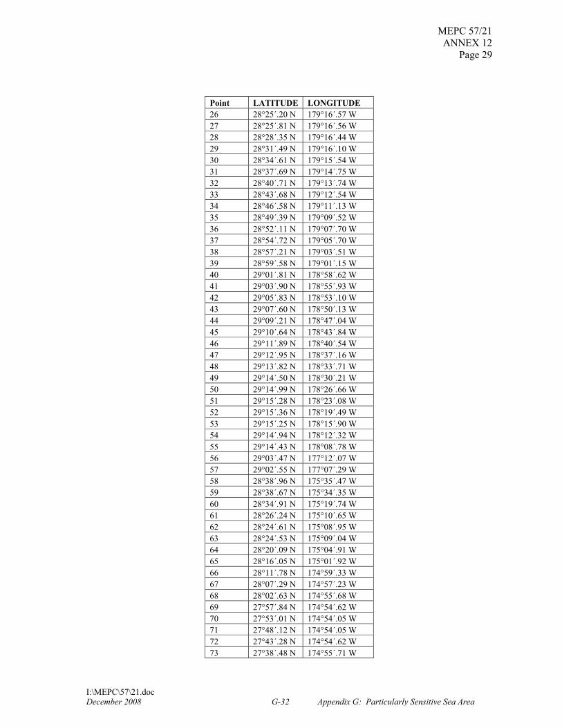
GEOGRAPHICAL CO-ORDINATES SHIP REPORTING SYSTEM (Reference chart: United States 19016 (2007 edition; 19019, 2007 edition; 19022, 2007 edition.) These charts are based on World Geodetic System 1984 Datum (WGS-84) and astronomic datum.) 1 Outer Boundary
Point LATITUDE LONGITUDE 1 29°25´.47 N 178°16´.97 W 2 28°43´.73 N 175°13´.84 W 3 27°00´.77 N 173°25´.78 W 4 26°44´.91 N 171°28´.07 W 5 26°24´.23 N 170°20´.59 W 6 25°56´.43 N 167°32´.10 W 7 24°50´.20 N 165°58´.69 W 8 24°05´.52 N 161°56´.86 W 9 24°05´.29 N 161°56´.62 W 10 24°04´.37 N 161°51´.53 W 11 24°03´.44 N 161°46´.45 W 12 24°02´.41 N 161°41´.39 W 13 24°01´.31 N 161°36´.35 W 14 23°59´.68 N 161°31´.55 W 15 23°57´.85 N 161°26´.85 W 16 23°55´.54 N 161°22´.31 W 17 23°52´.96 N 161°17´.92 W 18 23°50´.12 N 161°13´.72 W 19 23°46´.94 N 161°10´.08 W 20 23°43´.49 N 161°06´.47 W 21 23°39´.71 N 161°03´.09 W 22 23°35´.72 N 161°00´.14 W 23 23°31´.59 N 160°57´.46 W 24 23°27´.32 N 160°55´.23 W 25 23°22´.74 N 160°53´.71 W 26 23°18´.29 N 160°52´.17 W 27 23°13´.57 N 160°51´.04 W 28 23°08´.68 N 160°50´.46 W 29 23°03´.70 N 160°50´.17 W 30 22°58´.67 N 160°50´.35 W 31 22°53´.84 N 160°51´.04 W 32 22°49´.11 N 160°52´.20 W 33 22°44´.46 N 160°53´.56 W 34 22°40´.03 N 160°55´.52 W
December 2008 G-29 Appendix G: Particularly Sensitive Sea Area

MEPC 57/21 ANNEX 12
Page 27
I:\MEPC\57\21.doc
Point LATITUDE LONGITUDE 35 22°35´.73 N 160°57´.68 W 36 22°31´.54 N 161°00´.25 W 37 22°27´.57 N 161°03´.23 W 38 22°23´.76 N 161°06´.64 W 39 22°20´.24 N 161°10´.23 W 40 22°17´.02 N 161°14´.13 W 41 22°14´.04 N 161°18´.34 W 42 22°11´.35 N 161°22´.80 W 43 22°09´.19 N 161°27´.45 W 44 22°07´.29 N 161°32´.11 W 45 22°05´.87 N 161°36´.94 W 46 22°04´.62 N 161°41´.89 W 47 22°03´.94 N 161°47´.09 W 48 22°03´.41 N 161°52´.36 W 49 22°03´.41 N 161°57´.51 W 50 22°03´.82 N 162°02´.83 W 51 22°04´.49 N 162°08´.04 W 52 22°05´.43 N 162°13´.12 W 53 22°05´.97 N 162°16´.41 W 54 22°06´.29 N 162°16´.85 W 55 22°34´.57 N 164°47´.27 W 56 22°47´.60 N 166°38´.23 W 57 24°03´.82 N 168°27´.91 W 58 24°25´.76 N 170°45´.39 W 59 24°46´.54 N 171°53´.03 W 60 25°07´.60 N 174°28´.71 W 61 27°05´.82 N 176°35´.51 W 62 27°27´.32 N 178°38´.66 W 63 27°28´.93 N 178°43´.56 W 64 27°30´.64 N 178°48´.40 W 65 27°32´.74 N 178°52´.96 W 66 27°35´.06 N 178°57´.30 W 67 27°37´.89 N 179°01´.49 W 68 27°40´.90 N 179°05´.60 W 69 27°44´.17 N 179°09´.41 W 70 27°47´.74 N 179°12´.85 W 71 27°51´.45 N 179°16´.00 W 72 27°55´.32 N 179°18´.82 W 73 27°59´.33 N 179°21´.13 W 74 28°03´.49 N 179°23´.15 W 75 28°07´.82 N 179°24´.76 W 76 28°12´.31 N 179°26´.18 W 77 28°16´.95 N 179°27´.05 W 78 28°21´.61 N 179°27´.63 W 79 28°26´.18 N 179°27´.77 W 80 28°30´.87 N 179°27´.48 W 81 28°35´.61 N 179°26´.95 W 82 28°40´.09 N 179°25´.75 W
December 2008 G-30 Appendix G: Particularly Sensitive Sea Area

MEPC 57/21 ANNEX 12 Page 28
I:\MEPC\57\21.doc
Point LATITUDE LONGITUDE 83 28°44´.46 N 179°24´.31 W 84 28°48´.70 N 179°22´.50 W 85 28°52´.81 N 179°20´.43 W 86 28°56´.71 N 179°17´.77 W 87 29°00´.58 N 179°14´.92 W 88 29°04´.18 N 179°11´.69 W 89 29°07´.62 N 179°08´.20 W 90 29°10´.86 N 179°04´.37 W 91 29°13´.76 N 179°00´.21 W 92 29°16´.24 N 178°55´.78 W 93 29°18´.51 N 178°51´.26 W 94 29°20´.45 N 178°46´.50 W 95 29°22´.26 N 178°41´.67 W 96 29°23´.52 N 178°36´.64 W 97 29°24´.53 N 178°31´.54 W 98 29°25´.16 N 178°26´.31 W 99 29°25´.42 N 178°20´.92 W 100 29°25´.29 N 178°16´.70 W
2 Inner Boundary Around Kure Atoll, Midway Atoll, and Pearl and Hermes Atoll
Point LATITUDE LONGITUDE 1 27°14´.76 N 176°29´.87 W 2 27°24´.95 N 177°33´.31 W 3 27°35´.87 N 178°29´.90 W 4 27°36´.64 N 178°33´.93 W 5 27°37´.53 N 178°37´.32 W 6 27°38´.60 N 178°40´.65 W 7 27°39´.85 N 178°43´.90 W 8 27°41´.28 N 178°47´.05 W 9 27°42´.89 N 178°50´.10 W 10 27°44´.66 N 178°53´.03 W 11 27°46´.59 N 178°55´.83 W 12 27°48´.67 N 178°58´.49 W 13 27°50´.89 N 179°01´.00 W 14 27°53´.22 N 179°03´.39 W 15 27°55´.69 N 179°05´.61 W 16 27°58´.29 N 179°07´.61 W 17 28°01´.01 N 179°09´.47 W 18 28°03´.81 N 179°11´.10 W 19 28°06´.71 N 179°12´.53 W 20 28°09´.67 N 179°13´.75 W 21 28°12´.70 N 179°14´.75 W 22 28°15´.78 N 179°15´.54 W 23 28°18´.91 N 179°16´.11 W 24 28°22´.04 N 179°16´.45 W 25 28°24´.72 N 179°16´.56 W
December 2008 G-31 Appendix G: Particularly Sensitive Sea Area
MEPC 57/21 ANNEX 12
Page 29
I:\MEPC\57\21.doc
Point LATITUDE LONGITUDE 26 28°25´.20 N 179°16´.57 W 27 28°25´.81 N 179°16´.56 W 28 28°28´.35 N 179°16´.44 W 29 28°31´.49 N 179°16´.10 W 30 28°34´.61 N 179°15´.54 W 31 28°37´.69 N 179°14´.75 W 32 28°40´.71 N 179°13´.74 W 33 28°43´.68 N 179°12´.54 W 34 28°46´.58 N 179°11´.13 W 35 28°49´.39 N 179°09´.52 W 36 28°52´.11 N 179°07´.70 W 37 28°54´.72 N 179°05´.70 W 38 28°57´.21 N 179°03´.51 W 39 28°59´.58 N 179°01´.15 W 40 29°01´.81 N 178°58´.62 W 41 29°03´.90 N 178°55´.93 W 42 29°05´.83 N 178°53´.10 W 43 29°07´.60 N 178°50´.13 W 44 29°09´.21 N 178°47´.04 W 45 29°10´.64 N 178°43´.84 W 46 29°11´.89 N 178°40´.54 W 47 29°12´.95 N 178°37´.16 W 48 29°13´.82 N 178°33´.71 W 49 29°14´.50 N 178°30´.21 W 50 29°14´.99 N 178°26´.66 W 51 29°15´.28 N 178°23´.08 W 52 29°15´.36 N 178°19´.49 W 53 29°15´.25 N 178°15´.90 W 54 29°14´.94 N 178°12´.32 W 55 29°14´.43 N 178°08´.78 W 56 29°03´.47 N 177°12´.07 W 57 29°02´.55 N 177°07´.29 W 58 28°38´.96 N 175°35´.47 W 59 28°38´.67 N 175°34´.35 W 60 28°34´.91 N 175°19´.74 W 61 28°26´.24 N 175°10´.65 W 62 28°24´.61 N 175°08´.95 W 63 28°24´.53 N 175°09´.04 W 64 28°20´.09 N 175°04´.91 W 65 28°16´.05 N 175°01´.92 W 66 28°11´.78 N 174°59´.33 W 67 28°07´.29 N 174°57´.23 W 68 28°02´.63 N 174°55´.68 W 69 27°57´.84 N 174°54´.62 W 70 27°53´.01 N 174°54´.05 W 71 27°48´.12 N 174°54´.05 W 72 27°43´.28 N 174°54´.62 W 73 27°38´.48 N 174°55´.71 W
December 2008 G-32 Appendix G: Particularly Sensitive Sea Area
MEPC 57/21 ANNEX 12 Page 30
I:\MEPC\57\21.doc
Point LATITUDE LONGITUDE 74 27°33´.81 N 174°57´.32 W 75 27°29´.30 N 174°59´.43 W 76 27°25´.00 N 175°02´.03 W 77 27°20´.93 N 175°05´.07 W 78 27°17´.18 N 175°08´.59 W 79 27°13´.73 N 175°12´.47 W 80 27°10´.59 N 175°16´.67 W 81 27°07´.88 N 175°21´.25 W 82 27°05´.57 N 175°26´.09 W 83 27°03´.66 N 175°31´.15 W 84 27°02´.22 N 175°36´.40 W 85 27°01´.29 N 175°41´.78 W 86 27°00´.73 N 175°47´.22 W 87 27°00´.68 N 175°52´.74 W 88 27°01´.09 N 175°58´.16 W 89 27°01´.99 N 176°03´.53 W 90 27°03´.34 N 176°08´.81 W 91 27°05´.12 N 176°13´.91 W 92 27°07´.37 N 176°18´.79 W 93 27°09´.98 N 176°23´.40 W 94 27°13´.02 N 176°27´.74 W 95 27°13´.77 N 176°28´.70 W
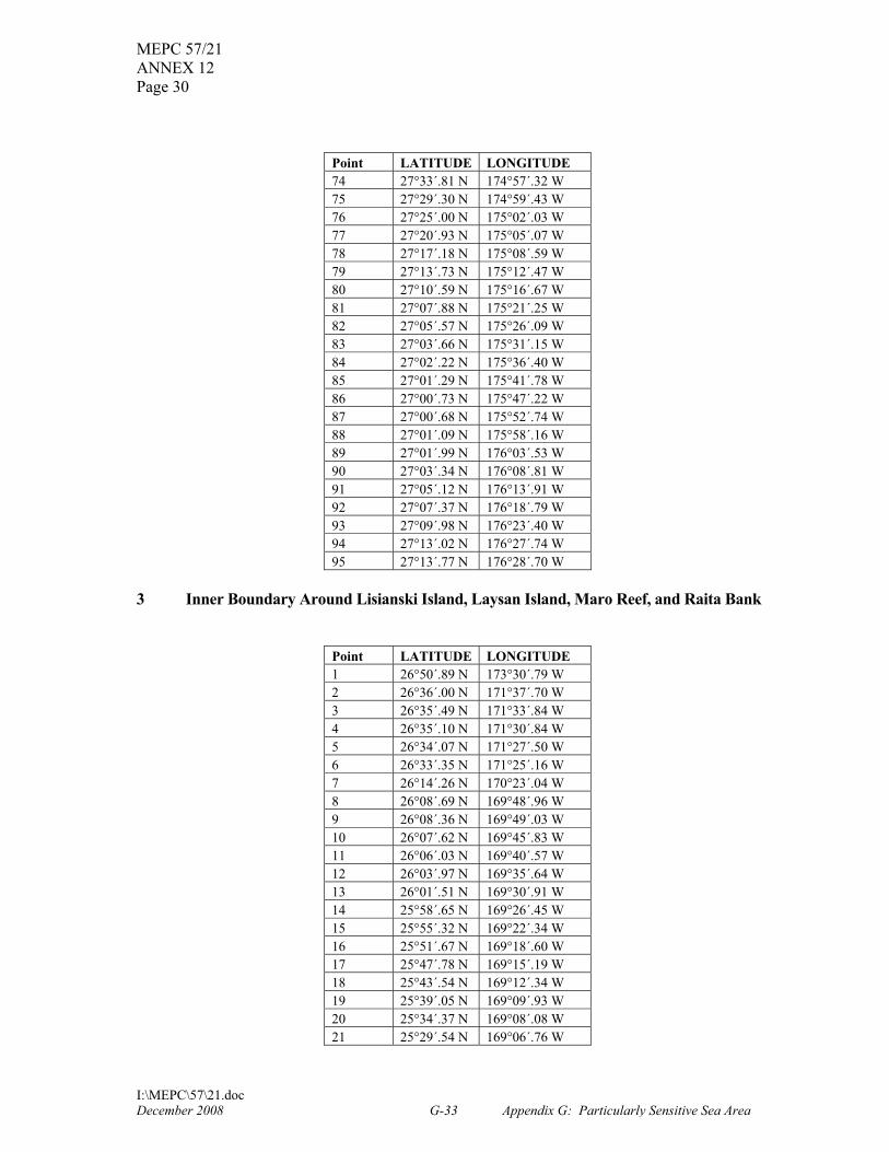
3 Inner Boundary Around Lisianski Island, Laysan Island, Maro Reef, and Raita Bank
Point LATITUDE LONGITUDE 1 26°50´.89 N 173°30´.79 W 2 26°36´.00 N 171°37´.70 W 3 26°35´.49 N 171°33´.84 W 4 26°35´.10 N 171°30´.84 W 5 26°34´.07 N 171°27´.50 W 6 26°33´.35 N 171°25´.16 W 7 26°14´.26 N 170°23´.04 W 8 26°08´.69 N 169°48´.96 W 9 26°08´.36 N 169°49´.03 W 10 26°07´.62 N 169°45´.83 W 11 26°06´.03 N 169°40´.57 W 12 26°03´.97 N 169°35´.64 W 13 26°01´.51 N 169°30´.91 W 14 25°58´.65 N 169°26´.45 W 15 25°55´.32 N 169°22´.34 W 16 25°51´.67 N 169°18´.60 W 17 25°47´.78 N 169°15´.19 W 18 25°43´.54 N 169°12´.34 W 19 25°39´.05 N 169°09´.93 W 20 25°34´.37 N 169°08´.08 W 21 25°29´.54 N 169°06´.76 W
December 2008 G-33 Appendix G: Particularly Sensitive Sea Area

MEPC 57/21 ANNEX 12
Page 31
I:\MEPC\57\21.doc
Point LATITUDE LONGITUDE 22 25°24´.61 N 169°05´.93 W 23 25°19´.63 N 169°05´.64 W 24 25°14´.65 N 169°05´.93 W 25 25°09´.69 N 169°06´.66 W 26 25°04´.85 N 169°08´.02 W 27 25°00´.17 N 169°09´.96 W 28 24°55´.66 N 169°12´.35 W 29 24°51´.35 N 169°15´.14 W 30 24°47´.37 N 169°18´.48 W 31 24°43´.69 N 169°22´.22 W 32 24°40´.34 N 169°26´.31 W 33 24°37´.42 N 169°30´.78 W 34 24°35´.00 N 169°35´.64 W 35 24°33´.02 N 169°40´.66 W 36 24°31´.34 N 169°45´.88 W 37 24°30´.31 N 169°51´.08 W 38 24°29´.68 N 169°56´.53 W 39 24°29´.56 N 170°01´.81 W 40 24°29´.61 N 170°04´.57 W 41 24°35´.77 N 170°44´.39 W 42 24°36´.29 N 170°47´.58 W 43 24°37´.18 N 170°50´.37 W 44 24°37´.76 N 170°52´.17 W 45 24°56´.23 N 171°50´.19 W 46 25°16´.61 N 174°24´.84 W 47 25°29´.56 N 174°38´.45 W 48 25°33´.28 N 174°42´.03 W 49 25°37´.33 N 174°45´.20 W 50 25°41´.68 N 174°47´.84 W 51 25°46´.23 N 174°50´.05 W 52 25°50´.93 N 174°51´.77 W 53 25°55´.80 N 174°52´.91 W 54 26°00´.71 N 174°53´.47 W 55 26°05´.67 N 174°53´.61 W 56 26°10´.59 N 174°53´.07 W 57 26°15´.46 N 174°52´.08 W 58 26°20´.20 N 174°50´.57 W 59 26°24´.75 N 174°48´.44 W 60 26°29´.15 N 174°45´.94 W 61 26°33´.26 N 174°42´.96 W 62 26°37´.11 N 174°39´.49 W 63 26°40´.60 N 174°35´.63 W 64 26°43´.75 N 174°31´.43 W 65 26°46´.49 N 174°26´.87 W 66 26°48´.90 N 174°22´.09 W 67 26°50´.79 N 174°17´.03 W 68 26°52´.20 N 174°11´.79 W 69 26°53´.21 N 174°06´.43 W
December 2008 G-34 Appendix G: Particularly Sensitive Sea Area

MEPC 57/21 ANNEX 12 Page 32
I:\MEPC\57\21.doc
Point LATITUDE LONGITUDE 70 26°53´.74 N 174°00´.98 W 71 26°53´.74 N 173°55´.48 W 72 26°53´.29 N 173°50´.02 W 73 26°52´.56 N 173°44´.58 W 74 26°51´.85 N 173°39´.14 W 75 26°51´.13 N 173°33´.69 W 76 26°50´.75 N 173°30´.87 W
4 Inner Boundary Around Gardner Pinnacles, French Frigate Shoals, and Necker Island
Point LATITUDE LONGITUDE 1 25°49´.64 N 167°52´.66 W 2 25°49´.70 N 167°52´.65 W 3 25°48´.99 N 167°48´.35 W 4 25°47´.09 N 167°36´.72 W 5 25°39´.84 N 167°26´.48 W 6 25°35´.10 N 167°19´.79 W 7 25°10´.43 N 166°45´.00 W 8 24°40´.91 N 166°03´.36 W 9 24°35´.64 N 165°34´.99 W 10 24°23´.78 N 164°31´.12 W 11 24°23´.59 N 164°31´.14 W 12 24°23´.31 N 164°29´.74 W 13 24°21´.85 N 164°24´.52 W 14 24°20´.10 N 164°19´.39 W 15 24°17´.75 N 164°14´.56 W 16 24°14´.99 N 164°09´.97 W 17 24°11´.86 N 164°05´.69 W 18 24°08´.30 N 164°01´.80 W 19 24°04´.48 N 163°58´.23 W 20 24°00´.27 N 163°55´.22 W 21 23°55´.85 N 163°52´.59 W 22 23°51´.17 N 163°50´.56 W 23 23°46´.33 N 163°48´.98 W 24 23°41´.37 N 163°47´.99 W 25 23°36´.34 N 163°47´.56 W 26 23°31´.27 N 163°47´.60 W 27 23°26´.27 N 163°48´.28 W 28 23°21´.34 N 163°49´.50 W 29 23°16´.53 N 163°51´.14 W 30 23°11´.96 N 163°53´.47 W 31 23°07´.54 N 163°56´.15 W 32 23°03´.46 N 163°59´.38 W 33 22°59´.65 N 164°03´.01 W 34 22°56´.27 N 164°07´.10 W 35 22°53´.22 N 164°11´.49 W 36 22°50´.60 N 164°16´.18 W
December 2008 G-35 Appendix G: Particularly Sensitive Sea Area

MEPC 57/21 ANNEX 12
Page 33
I:\MEPC\57\21.doc
Point LATITUDE LONGITUDE 37 22°48´.48 N 164°21´.16 W 38 22°46´.73 N 164°26´.28 W 39 22°45´.49 N 164°31´.60 W 40 22°44´.83 N 164°37´.03 W 41 22°44´.65 N 164°42´.51 W 42 22°44´.92 N 164°47´.99 W 43 22°45´.11 N 164°49´.52 W 44 22°45´.39 N 164°51´.48 W 45 22°45´.17 N 164°51´.53 W 46 22°50´.26 N 165°34´.99 W 47 22°55´.50 N 166°19´.63 W 48 22°55´.93 N 166°23´.32 W 49 22°57´.41 N 166°36´.00 W 50 23°03´.75 N 166°45´.00 W 51 23°05´.48 N 166°47´.45 W 52 24°12´.70 N 168°22´.86 W 53 24°12´.88 N 168°22´.78 W 54 24°16´.05 N 168°27´.28 W 55 24°19´.15 N 168°31´.66 W 56 24°22´.27 N 168°35´.95 W 57 24°25´.71 N 168°39´.94 W 58 24°29´.51 N 168°43´.55 W 59 24°33´.67 N 168°46´.63 W 60 24°38´.06 N 168°49´.29 W 61 24°42´.68 N 168°51´.46 W 62 24°47´.45 N 168°53´.12 W 63 24°52´.34 N 168°54´.28 W 64 24°57´.32 N 168°54´.82 W 65 25°02´.32 N 168°54´.95 W 66 25°07´.30 N 168°54´.43 W 67 25°12´.19 N 168°53´.32 W 68 25°16´.99 N 168°51´.76 W 69 25°21´.57 N 168°49´.60 W 70 25°25´.94 N 168°46´.93 W 71 25°30´.09 N 168°43´.86 W 72 25°33´.89 N 168°40´.42 W 73 25°37´.37 N 168°36´.52 W 74 25°40´.49 N 168°32´.24 W 75 25°43´.24 N 168°27´.68 W 76 25°45´.57 N 168°22´.82 W 77 25°47´.43 N 168°17´.76 W 78 25°48´.79 N 168°12´.47 W 79 25°49´.72 N 168°07´.09 W 80 25°50´.11 N 168°01´.62 W 81 25°50´.18 N 168°00´.09 W
December 2008 G-36 Appendix G: Particularly Sensitive Sea Area

MEPC 57/21 ANNEX 12 Page 34
I:\MEPC\57\21.doc
5 Inner Boundary Around Nihoa Island
Point LATITUDE LONGITUDE 1 23°52´.82 N 161°44´.54 W 2 23°52´.10 N 161°41´.20 W 3 23°51´.18 N 161°37´.92 W 4 23°50´.08 N 161°34´.71 W 5 23°48´.79 N 161°31´.58 W 6 23°47´.33 N 161°28´.55 W 7 23°45´.69 N 161°25´.62 W 8 23°43´.88 N 161°22´.81 W 9 23°41´.92 N 161°20´.13 W 10 23°39´.80 N 161°17´.60 W 11 23°37´.54 N 161°15´.21 W 12 23°35´.14 N 161°12´.99 W 13 23°32´.62 N 161°10´.93 W 14 23°29´.99 N 161°09´.05 W 15 23°27´.25 N 161°07´.35 W 16 23°24´.42 N 161°05´.85 W 17 23°21´.51 N 161°04´.54 W 18 23°18´.52 N 161°03´.43 W 19 23°15´.48 N 161°02´.53 W 20 23°12´.39 N 161°01´.84 W 21 23°09´.27 N 161°01´.35 W 22 23°06´.13 N 161°01´.09 W 23 23°02´.97 N 161°01´.03 W 24 22°59´.82 N 161°01´.19 W 25 22°56´.69 N 161°01´.57 W 26 22°53´.58 N 161°02´.15 W 27 22°50´.51 N 161°02´.95 W 28 22°47´.50 N 161°03´.95 W 29 22°44´.55 N 161°05´.15 W 30 22°41´.67 N 161°06´.54 W 31 22°38´.88 N 161°08´.13 W 32 22°36´.19 N 161°09´.90 W 33 22°33´.61 N 161°11´.85 W 34 22°31´.14 N 161°13´.97 W 35 22°28´.81 N 161°16´.25 W 36 22°26´.61 N 161°18´.69 W 37 22°24´.56 N 161°21´.26 W 38 22°22´.66 N 161°23´.97 W 39 22°20´.92 N 161°26´.80 W 40 22°19´.35 N 161°29´.74 W 41 22°17´.95 N 161°32´.78 W 42 22°16´.73 N 161°35´.90 W 43 22°15´.70 N 161°39´.10 W 44 22°14´.85 N 161°42´.37 W 45 22°14´.20 N 161°45´.68 W 46 22°13´.73 N 161°49´.03 W
December 2008 G-37 Appendix G: Particularly Sensitive Sea Area
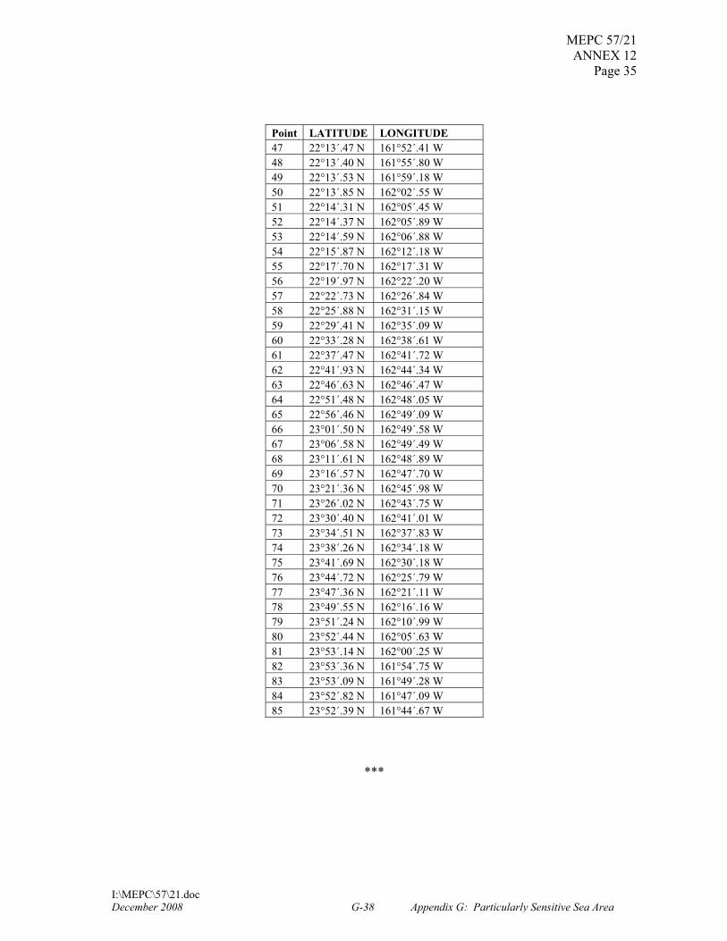
MEPC 57/21 ANNEX 12
Page 35
I:\MEPC\57\21.doc
Point LATITUDE LONGITUDE 47 22°13´.47 N 161°52´.41 W 48 22°13´.40 N 161°55´.80 W 49 22°13´.53 N 161°59´.18 W 50 22°13´.85 N 162°02´.55 W 51 22°14´.31 N 162°05´.45 W 52 22°14´.37 N 162°05´.89 W 53 22°14´.59 N 162°06´.88 W 54 22°15´.87 N 162°12´.18 W 55 22°17´.70 N 162°17´.31 W 56 22°19´.97 N 162°22´.20 W 57 22°22´.73 N 162°26´.84 W 58 22°25´.88 N 162°31´.15 W 59 22°29´.41 N 162°35´.09 W 60 22°33´.28 N 162°38´.61 W 61 22°37´.47 N 162°41´.72 W 62 22°41´.93 N 162°44´.34 W 63 22°46´.63 N 162°46´.47 W 64 22°51´.48 N 162°48´.05 W 65 22°56´.46 N 162°49´.09 W 66 23°01´.50 N 162°49´.58 W 67 23°06´.58 N 162°49´.49 W 68 23°11´.61 N 162°48´.89 W 69 23°16´.57 N 162°47´.70 W 70 23°21´.36 N 162°45´.98 W 71 23°26´.02 N 162°43´.75 W 72 23°30´.40 N 162°41´.01 W 73 23°34´.51 N 162°37´.83 W 74 23°38´.26 N 162°34´.18 W 75 23°41´.69 N 162°30´.18 W 76 23°44´.72 N 162°25´.79 W 77 23°47´.36 N 162°21´.11 W 78 23°49´.55 N 162°16´.16 W 79 23°51´.24 N 162°10´.99 W 80 23°52´.44 N 162°05´.63 W 81 23°53´.14 N 162°00´.25 W 82 23°53´.36 N 161°54´.75 W 83 23°53´.09 N 161°49´.28 W 84 23°52´.82 N 161°47´.09 W 85 23°52´.39 N 161°44´.67 W
***
December 2008 G-38 Appendix G: Particularly Sensitive Sea Area

73592 Federal Register / Vol. 73, No. 233 / Wednesday, December 3, 2008 / Rules and Regulations
isopropylamine salt of glyphosate, the ethanolamine salt of glyphosate, the dimethylamine salt of glyphosate, the ammonium salt of glyphosate, and the potassium salt of glyphosate on the food commodities cattle, meat byproducts at 5.0 ppm; egg at 0.05 ppm; goat, meat byproducts at 5.0 ppm; grain, aspirated fractions at 310 ppm; hog, meat byproducts at 5.0 ppm; horse, meat byproducts at 5.0 ppm; poultry, meat, at 4.0 ppm; poultry, meat byproducts at 1.0 ppm; sheep, meat byproducts at 5.0 ppm; soybean, seed at 20.0 ppm; soybean, forage at 100.0 ppm; soybean, hay at 200.0 ppm, and soybean, hulls at 120 ppm as discussed in Unit II of this document.
VI. Statutory and Executive Order Reviews
This final rule establishes tolerances under section 408(d) of FFDCA in response to a petition submitted to the Agency. The Office of Management and Budget (OMB) has exempted these types of actions from review under Executive Order 12866, entitled Regulatory Planning and Review (58 FR 51735, October 4, 1993). Because this final rule has been exempted from review under Executive Order 12866, this final rule is not subject to Executive Order 13211, entitled Actions Concerning Regulations That Significantly Affect Energy Supply, Distribution, or Use (66 FR 28355, May 22, 2001) or Executive Order 13045, entitled Protection of Children from Environmental Health Risks and Safety Risks (62 FR 19885, April 23, 1997). This final rule does not contain any information collections subject to OMB approval under the Paperwork Reduction Act (PRA), 44 U.S.C. 3501 et seq., nor does it require any special considerations under Executive Order 12898, entitled Federal Actions to Address Environmental Justice in Minority Populations and Low-Income Populations (59 FR 7629, February 16, 1994).
Since tolerances and exemptions that are established on the basis of a petition under section 408(d) of FFDCA, such as the tolerance in this final rule, do not require the issuance of a proposed rule, the requirements of the Regulatory Flexibility Act (RFA) (5 U.S.C. 601 et seq.) do not apply.
This final rule directly regulates growers, food processors, food handlers, and food retailers, not States or tribes, nor does this action alter the relationships or distribution of power and responsibilities established by Congress in the preemption provisions of section 408(n)(4) of FFDCA. As such, the Agency has determined that this action will not have a substantial direct
effect on States or tribal governments, on the relationship between the national government and the States or tribal governments, or on the distribution of power and responsibilities among the various levels of government or between the Federal Government and Indian tribes. Thus, the Agency has determined that Executive Order 13132, entitled Federalism (64 FR 43255, August 10, 1999) and Executive Order 13175, entitled Consultation and Coordination with Indian Tribal Governments (65 FR 67249, November 9, 2000) do not apply to this final rule. In addition, this final rule does not impose any enforceable duty or contain any unfunded mandate as described under Title II of the Unfunded Mandates Reform Act of 1995 (UMRA) (Public Law 104–4).
This action does not involve any technical standards that would require Agency consideration of voluntary consensus standards pursuant to section 12(d) of the National Technology Transfer and Advancement Act of 1995 (NTTAA), Public Law 104–113, section 12(d) (15 U.S.C. 272 note).
VII. Congressional Review Act
The Congressional Review Act, 5 U.S.C. 801 et seq., generally provides that before a rule may take effect, the agency promulgating the rule must submit a rule report to each House of the Congress and to the Comptroller General of the United States. EPA will submit a report containing this rule and other required information to the U.S. Senate, the U.S. House of Representatives, and the Comptroller General of the United States prior to publication of this final rule in the Federal Register. This final rule is not a ‘‘major rule as defined by 5 U.S.C. 804(2).
List of Subjects in 40 CFR Part 180
Environmental protection, Administrative practice and procedure, Agricultural commodities, Pesticides and pests, Reporting and recordkeeping requirements.
Dated: November 19, 2008. Donald R. Stubbs, Director, Registration Division, Office of Pesticide Programs.
■ Therefore, 40 CFR chapter I is amended as follows:
PART 180—[AMENDED]
■ 1. The authority citation for part 180 continues to read as follows:
Authority: 21 U.S.C. 321(q), 346a and 371.
■ 2. Section 180.364 is amended as follows:
■ a. By removing the entries cattle, meat byproducts; egg; goat, meat byproducts; grain, aspirated fractions; hog, meat byproducts; horse, meat byproducts; poultry, meat; poultry, meat byproducts; sheep, meat byproducts; soybean, forage; soybean, hay; soybean, hulls; and soybean, seed from the table in paragraph (a). ■ b. By redesignating paragraph (a) introductory text and the remainder of the table as paragraph (a)(1) and by adding paragraph (a)(2) to read as follows:
§ 180.364 Glyphosate, Tolerance for residue.
(a) * * * (1) * * * (2) Tolerances are established for
combined residues of glyphosate, N- (phosphonomethyl)glycine and its metabolite N-acetyl-glyphosate (expressed as glyphosate) resulting from the application of glyphosate, the isopropylamine salt of glyphosate, the ethanolamine salt of glyphosate, the dimethylamine salt of glyphosate, the ammonium salt of glyphosate, and the potassium salt of glyphosate on the food commodities:
Commodity Parts per Million
Cattle, meat byproducts ... 5.0 Egg ................................... 0.05 Goat, meat byproducts ..... 5.0 Grain aspirated fractions .. 310.0 Hog, meat byproducts ...... 5.0 Horse, meat byproducts ... 5.0 Poultry, meat .................... 4.0 Poultry, meat byproducts .. 1.0 Sheep, meat byproducts .. 5.0 Soybean, forage ............... 100.0 Soybean, hay .................... 200.0 Soybean, hulls .................. 120.0 Soybean, seed .................. 20.0
* * * * * [FR Doc. E8–28571 Filed 12–2–08; 8:45 am] BILLING CODE 6560–50–S
DEPARTMENT OF COMMERCE
National Oceanic and Atmospheric Administration
DEPARTMENT OF THE INTERIOR
Fish and Wildlife Service
50 CFR Part 404
[Docket No. 080227317–81455–02]
RIN 0648–AW44
Papahanaumokuakea Marine National Monument Proclamation Provisions
AGENCIES: National Oceanic and Atmospheric Administration (NOAA),
VerDate Aug<31>2005 15:34 Dec 02, 2008 Jkt 217001 PO 00000 Frm 00048 Fmt 4700 Sfmt 4700 E:\FR\FM\03DER1.SGM 03DER1yshi
vers
on
PR
OD
1PC
62 w
ith R
ULE
S
December 2008 G-39 Appendix G: Particularly Sensitive Sea Area
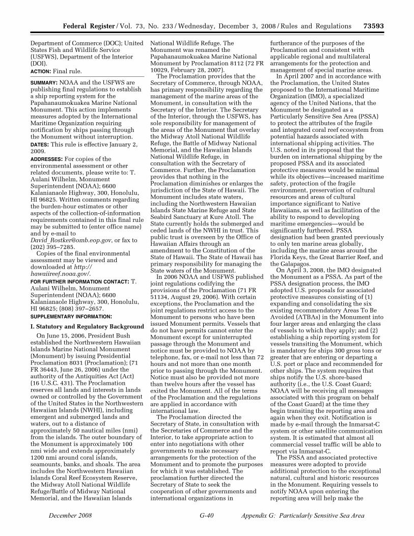
73593 Federal Register / Vol. 73, No. 233 / Wednesday, December 3, 2008 / Rules and Regulations
Department of Commerce (DOC); United States Fish and Wildlife Service (USFWS), Department of the Interior (DOI). ACTION: Final rule.
SUMMARY: NOAA and the USFWS are publishing final regulations to establish a ship reporting system for the Papahanaumokuakea Marine National Monument. This action implements measures adopted by the International Maritime Organization requiring notification by ships passing through the Monument without interruption. DATES: This rule is effective January 2, 2009. ADDRESSES: For copies of the environmental assessment or other related documents, please write to: T. Aulani Wilhelm, Monument Superintendent (NOAA); 6600 Kalanianaole Highway, 300, Honolulu, HI 96825. Written comments regarding the burden-hour estimates or other aspects of the collection-of-information requirements contained in this final rule may be submitted to (enter office name) and by e-mail to [email protected], or fax to (202) 395–7285.
Copies of the final environmental assessment may be viewed and downloaded at http:// hawaiireef.noaa.gov/. FOR FURTHER INFORMATION CONTACT: T. Aulani Wilhelm, Monument Superintendent (NOAA); 6600 Kalanianaole Highway, 300, Honolulu, HI 96825; (808) 397–2657. SUPPLEMENTARY INFORMATION:
I. Statutory and Regulatory Background
On June 15, 2006, President Bush established the Northwestern Hawaiian Islands Marine National Monument (Monument) by issuing Presidential Proclamation 8031 (Proclamation); (71 FR 36443, June 26, 2006) under the authority of the Antiquities Act (Act) (16 U.S.C. 431). The Proclamation reserves all lands and interests in lands owned or controlled by the Government of the United States in the Northwestern Hawaiian Islands (NWHI), including emergent and submerged lands and waters, out to a distance of approximately 50 nautical miles (nmi) from the islands. The outer boundary of the Monument is approximately 100 nmi wide and extends approximately 1200 nmi around coral islands, seamounts, banks, and shoals. The area includes the Northwestern Hawaiian Islands Coral Reef Ecosystem Reserve, the Midway Atoll National Wildlife Refuge/Battle of Midway National Memorial, and the Hawaiian Islands
National Wildlife Refuge. The Monument was renamed the Papahanaumokuakea Marine National Monument by Proclamation 8112 (72 FR 10029, February 28, 2007).
The Proclamation provides that the Secretary of Commerce, through NOAA, has primary responsibility regarding the management of the marine areas of the Monument, in consultation with the Secretary of the Interior. The Secretary of the Interior, through the USFWS, has sole responsibility for management of the areas of the Monument that overlay the Midway Atoll National Wildlife Refuge, the Battle of Midway National Memorial, and the Hawaiian Islands National Wildlife Refuge, in consultation with the Secretary of Commerce. Further, the Proclamation provides that nothing in the Proclamation diminishes or enlarges the jurisdiction of the State of Hawaii. The Monument includes state waters, including the Northwestern Hawaiian Islands State Marine Refuge and State Seabird Sanctuary at Kure Atoll. The State currently holds the submerged and ceded lands of the NWHI in trust. This public trust is overseen by the Office of Hawaiian Affairs through an amendment to the Constitution of the State of Hawaii. The State of Hawaii has primary responsibility for managing the State waters of the Monument.
In 2006 NOAA and USFWS published joint regulations codifying the provisions of the Proclamation (71 FR 51134, August 29, 2006). With certain exceptions, the Proclamation and the joint regulations restrict access to the Monument to persons who have been issued Monument permits. Vessels that do not have permits cannot enter the Monument except for uninterrupted passage through the Monument and notice must be provided to NOAA by telephone, fax, or e-mail not less than 72 hours and not more than one month prior to passing through the Monument. Notice must also be provided not more than twelve hours after the vessel has exited the Monument. All of the terms of the Proclamation and the regulations are applied in accordance with international law.
The Proclamation directed the Secretary of State, in consultation with the Secretaries of Commerce and the Interior, to take appropriate action to enter into negotiations with other governments to make necessary arrangements for the protection of the Monument and to promote the purposes for which it was established. The proclamation further directed the Secretary of State to seek the cooperation of other governments and international organizations in
furtherance of the purposes of the Proclamation and consistent with applicable regional and multilateral arrangements for the protection and management of special marine areas.
In April 2007 and in accordance with the Proclamation, the United States proposed to the International Maritime Organization (IMO), a specialized agency of the United Nations, that the Monument be designated as a Particularly Sensitive Sea Area (PSSA) to protect the attributes of the fragile and integrated coral reef ecosystem from potential hazards associated with international shipping activities. The U.S. noted in its proposal that the burden on international shipping by the proposed PSSA and its associated protective measures would be minimal while its objectives—increased maritime safety, protection of the fragile environment, preservation of cultural resources and areas of cultural importance significant to Native Hawaiians, as well as facilitation of the ability to respond to developing maritime emergencies—would be significantly furthered. PSSA designation had been granted previously to only ten marine areas globally, including the marine areas around the Florida Keys, the Great Barrier Reef, and the Galapagos.
On April 3, 2008, the IMO designated the Monument as a PSSA. As part of the PSSA designation process, the IMO adopted U.S. proposals for associated protective measures consisting of (1) expanding and consolidating the six existing recommendatory Areas To Be Avoided (ATBAs) in the Monument into four larger areas and enlarging the class of vessels to which they apply; and (2) establishing a ship reporting system for vessels transiting the Monument, which is mandatory for ships 300 gross tons or greater that are entering or departing a U.S. port or place and recommended for other ships. The system requires that ships notify the U.S. shore-based authority (i.e., the U.S. Coast Guard; NOAA will be receiving all messages associated with this program on behalf of the Coast Guard) at the time they begin transiting the reporting area and again when they exit. Notification is made by e-mail through the Inmarsat-C system or other satellite communication system. It is estimated that almost all commercial vessel traffic will be able to report via Inmarsat-C.
The PSSA and associated protective measures were adopted to provide additional protection to the exceptional natural, cultural and historic resources in the Monument. Requiring vessels to notify NOAA upon entering the reporting area will help make the
VerDate Aug<31>2005 15:34 Dec 02, 2008 Jkt 217001 PO 00000 Frm 00049 Fmt 4700 Sfmt 4700 E:\FR\FM\03DER1.SGM 03DER1yshi
vers
on
PR
OD
1PC
62 w
ith R
ULE
S
December 2008 G-40 Appendix G: Particularly Sensitive Sea Area

73594 Federal Register / Vol. 73, No. 233 / Wednesday, December 3, 2008 / Rules and Regulations
operators of these vessels aware that they are traveling through a fragile area with potential navigational hazards such as the extensive coral reefs found in many shallow areas of the Monument. The PSSA is now in effect, and the IMO has provided for an effective date for the associated protective measures of May 1, 2008.
NOAA and USFWS are establishing the infrastructure that will be required to maintain an international ship reporting system and to ensure that information regarding PSSA designation will be incorporated into nautical charts and other information sources. This rule implements the mandatory ship reporting system as adopted by IMO, establishes the reporting area using the IMO boundary coordinates, and publishes the coordinates of the four ATBAs.
II. Vessel Reporting Requirements These regulations apply to vessels
that do not have permits to enter the Monument and that pass through the Monument without interruption. These regulations do not change the exemptions at 50 CFR 404.8 (activities necessary to respond to emergencies or necessary for law enforcement purposes) and 404.9 (activities and exercises of the Armed Forces, including those of the United States Coast Guard) and, therefore, do not apply to vessels covered by those exemptions. As explained further, below, these regulations also do not apply to sovereign immune vessels.
The regulations accomplish the following actions:
(1) Modify the current notification requirements (at 50 CFR 404.4) for passing through the Monument without interruption and add several new associated terms and definitions (at Sec. 404.3);
(2) Establish a reporting area around the Monument, extending outward ten nautical miles from the Monument boundary but excluding the ATBAs within the Monument;
(3) Describe the categories of vessels that are subject to the reporting requirement;
(4) Specify the type of information regarding the vessel, its location, etc. that is required in the e-mail to NOAA
and that is to be sent in a reporting format that is consistent with the reporting system adopted by IMO;
(5) Allow for vessels that do not have e-mail capability to continue to comply with the current prior notification requirements;
(6) Recommend voluntary participation in the reporting system for all other vessels that are not required to notify NOAA; and
(7) Publish the revised boundaries of the four voluntary ATBAs.
Each of these elements is described below.
A. Modification of Existing Notification Requirements
Monument regulations at 50 CFR 404.4 prohibit entry into the Monument except in certain situations. One of the exceptions is for vessels passing through the Monument without interruption. Those vessels, however, are currently required to provide notice prior to entering and after leaving the Monument. Notification of entry must be provided at least 72 hours, but no longer than 1 month, prior to the entry date. Notification of departure from the Monument must be provided within 12 hours of leaving. Notification may be made by e-mail, telephone, or fax and must include the following information: Position when making the report; vessel name and IMO identification number; name, address, and telephone number of owner and operator; United States Coast Guard documentation, state license, or registration number; home port; intended and actual route through the Monument; general categories of any hazardous cargo on board; and length of vessel and propulsion type (e.g., motor or sail).
These changes to the regulations replace the current notification requirements for vessels that have e- mail capability. Vessels without e-mail capability will continue to provide notification in advance and upon exiting the Monument as described previously but the type of information to be provided is modified by these regulations as indicated below.
The following terms are being added to the definitions at 50 CFR 404.3 to facilitate implementation of the proposed ship reporting requirements:
‘‘Areas to be avoided’’; ‘‘Categories of hazardous cargoes’’; ‘‘IMO’’; and ‘‘Reporting area.’’ The definitions to these terms are contained in the text of the regulations.
B. Reporting Area
The regulations create a reporting area extending ten miles out and entirely around the Monument boundary. The coordinates of the area are set forth in Appendix D of the regulations and are the same as the coordinates that were adopted by IMO when it accepted the PSSA in principle and adopted the associated protective measures for the PSSA in 2007. Certain categories of vessels (described below) that intend to pass through the Monument without interruption are required to e-mail certain information at the time they cross the reporting area boundary and again when they exit the reporting area after having passed through the Monument.
The reporting area does not include the ATBAs within the Monument. As such, vessels that pass through an ATBA while passing through the Monument must notify NOAA at the time they exit the reporting area and enter the ATBA, and again when they exit the ATBA and re-enter the reporting area.
There are three large areas of the Monument (within the reporting area) that are not within the IMO-designated ATBAs. These breaks between the four ATBAs allow for primarily north-south passage through the Monument. From west to east, these areas are in the following locations and are shown in Figure 1: Between the ATBAs extending around Pearl and Hermes Atoll and Lisianski Island; between the ATBAs around Maro Reef and Gardner Pinnacles; and between the ATBAs around Mokumanamana (Necker Island) and Nihoa Island. It is anticipated that vessels will navigate through the Monument via these areas. Vessels passing through the Monument in these areas are only required to send e-mail notification upon entering the reporting area and again upon leaving it. BILLING CODE 3510–22–P
VerDate Aug<31>2005 15:34 Dec 02, 2008 Jkt 217001 PO 00000 Frm 00050 Fmt 4700 Sfmt 4700 E:\FR\FM\03DER1.SGM 03DER1yshi
vers
on
PR
OD
1PC
62 w
ith R
ULE
S
December 2008 G-41 Appendix G: Particularly Sensitive Sea Area

73595 Federal Register / Vol. 73, No. 233 / Wednesday, December 3, 2008 / Rules and Regulations
BILLING CODE 3510–22–C
VerDate Aug<31>2005 15:34 Dec 02, 2008 Jkt 217001 PO 00000 Frm 00051 Fmt 4700 Sfmt 4700 E:\FR\FM\03DER1.SGM 03DER1 ER
03D
E08
.000
</G
PH
>
yshi
vers
on
PR
OD
1PC
62 w
ith R
ULE
S
December 2008 G-42 Appendix G: Particularly Sensitive Sea Area

73596 Federal Register / Vol. 73, No. 233 / Wednesday, December 3, 2008 / Rules and Regulations
C. Vessels That Are Required To Provide Notification
All vessels of the United States— regardless of size—are subject to the proposed reporting requirements. All foreign vessels greater than 300 gross tons and that are either going to or coming from a U.S. port or place are required to participate in the ship reporting system. Foreign vessels of any size that are heading to or coming from a U.S. port or place are also required to provide e-mail notification if they experience an emergency while crossing through the reporting area. Although e- mail capability is now routine on vessels greater than 300 gross tons and is also widely used by many smaller vessels, vessels of the United States less than 300 gross tons that do not have e- mail capability remain subject to the advanced notice reporting requirements currently in effect. These vessels will continue to be required to follow the current reporting process: Provide notice by telephone, fax, or e-mail not less than 72 hours but not more than one month prior to entering the Monument for uninterrupted passage and to provide notification of departing the Monument within 12 hours of leaving.
Vessels are not required to provide notification if they operate in the reporting area but remain outside of the Monument, such as fishing vessels fishing outside the Monument boundary. However, if the operator of a vessel within the reporting area decides to cross uninterrupted through the Monument all of the notification requirements will then apply. In no case may the vessel lawfully pass through the Monument until notification had been provided, consistent with these regulations.
The reporting requirements do not apply to vessels of the Armed Forces and the United States Coast Guard because the prohibitions in the Proclamation and the regulations do not apply to their activities and exercises (50 CFR 404.9(a)). In addition, the ship reporting system adopted by the IMO specifically exempts all sovereign immune vessels from the reporting requirement and, therefore, the regulations published today do not apply to these vessels. Vessel sovereign immunity is interpreted in light of relevant provisions of international instruments, such as the IMO-adopted ship reporting system, Article 36 of the United Nations Convention on the Law of the Sea, and Chapter 5, Regulation 1 of the International Convention for the Safety of Life at Sea. This is consistent with provisions of the Proclamation and
the regulations that state the Proclamation shall be applied in accordance with international law. No restrictions shall apply to or be enforced against a person who is not a citizen, national, or resident alien of the United States (including foreign flag vessels) unless in accordance with international law.
D. Specific Information and Reporting Format Required for Entry and Exit Notifications by Vessels With E-mail Capability
The information that each vessel must submit and the format in which it must be submitted are shown in Appendix E to the regulations. The information to be provided upon entering the reporting area and the reporting format are based on and consistent with the reporting requirements adopted by IMO and include: Vessel identification information (i.e., name, call sign, flag, IMO identification number); date and time of entry; position; true course; speed in knots and tenths; destination and estimated time of arrival; intended route through the reporting area; vessel draft; categories of hazardous cargoes on board; any vessel defects or deficiencies that restrict maneuverability or impair normal navigation; any pollution incident or goods lost overboard within the Monument, reporting area, or the U.S. EEZ; contact information for the vessel’s agent or owner; vessel size (length overall, gross tonnage) and type; and total number of persons on board. Information required when the vessel leaves the reporting area includes: Vessel identification information (i.e., name, call sign, flag, IMO identification number); date and time of exit; position; and any pollution incident or goods lost overboard within the Monument, reporting area, or the U.S. EEZ.
The system that is being established to receive the notifications is based on Inmarsat-C and NOAA will assume the cost associated with Inmarsat-C transmissions to the e-mail address provided under this program. This rule does not require a vessel to install or use Inmarsat-C, but NOAA will not assume costs associated with e-mail transmissions sent through other satellite communications systems. Vessel owners who receive an Inmarsat- C charge for any e-mail sent to NOAA pursuant to these regulations will be reimbursed upon invoicing NOAA with a copy of the charges.
E. Specific Information and Reporting Format Required for Entry and Exit Notifications by Vessels Without Onboard E-mail Capability
Vessels of the United States less than 300 gross tons that do not have onboard e-mail capability are required to submit the following information not less than 72 hours but not more than one month prior to entering the Monument for uninterrupted passage: Vessel identification information (e.g., name, call sign, flag, IMO identification number); date and time of entry; position (as applicable); destination and estimated time of arrival; intended route through the Monument and the reporting area; vessel draft; categories of hazardous cargoes on board (as applicable); any vessel defects or deficiencies that restrict maneuverability or impair normal navigation; contact information for the vessel’s agent or owner; vessel size (length overall, gross tonnage) and type; and total number of persons on board. Upon exiting the Monument these vessels must provide the following information within 12 hours of leaving: Vessel identification information (e.g., name, call sign, flag, IMO identification number); date and time of exit; position; and any pollution incident or goods lost overboard within the Monument, reporting area, or the U.S. EEZ. This information may be submitted by nonvessel-based e-mail (e.g., from home or office), fax, or telephone. Once a vessel is equipped with an onboard e- mail system, however, it must comply with the requirements for vessels with that capability, including the reporting format shown in Appendix E to the regulations.
F. Voluntary Participation in the Ship Reporting System by All Other Vessels
Vessels that are not required to participate in the ship reporting system are nevertheless strongly urged to participate on a voluntary basis. Participation will help make the operators of these vessels aware that they are traveling through a fragile area with potential navigational hazards such as the extensive coral reefs found in many shallow areas of the Monument. Voluntary participation will increase maritime safety, protection of the fragile environment, preservation of cultural resources and areas of cultural importance significant to Native Hawaiians. Participation will also facilitate the ability to respond to developing maritime emergencies.
VerDate Aug<31>2005 15:34 Dec 02, 2008 Jkt 217001 PO 00000 Frm 00052 Fmt 4700 Sfmt 4700 E:\FR\FM\03DER1.SGM 03DER1yshi
vers
on
PR
OD
1PC
62 w
ith R
ULE
S
December 2008 G-43 Appendix G: Particularly Sensitive Sea Area
73597 Federal Register / Vol. 73, No. 233 / Wednesday, December 3, 2008 / Rules and Regulations
G. Modification of the Areas To Be Avoided (ATBAs)
An ATBA is an area within which either navigation is particularly hazardous or it is exceptionally important to avoid casualties. As such, ATBAs should be avoided by all ships, or certain classes of ships. While ATBAs can be mandatory (i.e., vessels are required by applicable law to avoid and operate outside of the area) most are voluntary and vessels may travel through them. The IMO adopted six voluntary ATBAs in the Northwestern Hawaiian Islands in 1980. Part of the action taken in 2008 by the IMO was to enlarge the six original ATBAs so that they now connect in certain places resulting in four larger ATBAs. This rule publishes the coordinates of these four ATBAs. The coordinates are attached to the regulations as Appendix C. The ATBAs are not part of the reporting area and vessels that enter any ATBA while passing through the Monument without interruption must provide an exit notification upon entering the ATBA, an entry notification again upon reentering the reporting area, and a second exit notification when the vessel departed the reporting area and the Monument on the other side. Thus, transiting through the Monument via an ATBA requires four reports as compared with the two reports required for transiting the Monument between the ATBAs.
III. Response to Comments
Comments on the proposed rule and the draft environmental assessment were received from the following: The Department of the Navy; the United States Coast Guard; the Missile Defense Agency; and the Marine Mammal Commission. The comments did not result in any changes to the proposed regulations but additional discussion has been added to the preamble of this final rule to clarify that the reporting requirements do not apply to activities and exercises of the Armed Forces (including those carried out by the United States Coast Guard) or to sovereign immune vessels of foreign nations. The comments are summarized below together with responses from NOAA and FWS.
Comment 1: It should be clear that the Armed Forces exception in 50 CFR 404.9 applies to the new ship reporting regulations.
Response: The reporting regulations do not affect the Armed Forces exception to the prohibitions set forth in the Proclamation and in the regulations at 50 CFR 404.9. The reporting regulations do not apply to activities and exercises of the Armed Forces,
(including those carried out by the United States Coast Guard) that are consistent with applicable laws. The Armed Forces exemptions in the Proclamation and at 50 CFR 404.9 are not affected by these regulations.
Comment 2: Clarify that the regulations do not affect international legal principles governing freedom of navigation for sovereign immune vessels in international waters, such as foreign warships, and law-enforcement craft.
Response: Language has been added to section 404.4(c) to clarify that the regulations do not apply to sovereign immune vessels in international waters. The ship reporting system adopted by the IMO specifically exempts all sovereign immune vessels from the reporting requirement and, therefore, the regulations published today do not apply to these vessels. This is consistent with provisions of the Proclamation and the regulations that state the Proclamation shall be applied in accordance with international law. No restrictions shall apply to or be enforced against a person who is not a citizen, national, or resident alien of the United States (including foreign flag vessels) unless in accordance with international law.
Comment 3: The ATBAs are recommendatory and ships should not be required to report their entry into or exit from Monument ATBAs.
Response: The regulations do not require vessels to report when they enter or exit ATBAs. They do, however, require vessels to notify the U.S. shore- based authority (NOAA, on behalf of the U.S. Coast Guard) whenever they enter or exit the Reporting Area. As adopted by the IMO and implemented by these regulations, the ATBAs are outside of the Reporting Area. A vessel entering an ATBA is required to notify NOAA because it is exiting the Reporting Area and it must send another e-mail when it reenters the Reporting Area from an ATBA or anywhere else that is outside of the Reporting Area.
Comment 4: Modify the reporting requirements to: (a) Ensure that all vessels in the reporting area or Monument immediately report any emergencies; (b) clarify that emergencies include any accidents, pollution incidents, or losses of cargo that could pose a risk to natural and cultural resources; and (c) identify the types of information to be reported in cases of emergencies.
Response: At this time, NOAA and FWS are maintaining the regulations as proposed to implement the measures recommended by the IMO, but will consider a separate rule making to address whether and how to require the
reporting of emergencies in the Monument. The scope of such a rule could apply to a broader category of vessels than those simply passing through the Monument without interruption and could include vessels entering the Monument pursuant to permits. Such a rule would also be applied in accordance with international law.
Comment 5: Include in the ship reporting system a return message describing why special precautions are needed in the area, the Areas To Be Avoided, other relevant protection measures and appropriate information (e.g., permit requirements for any activity other than uninterrupted passage through the Monument).
Response: A return message will be sent back to vessels that provide e-mail notification and will include relevant information such as precautions while in the Monument and other matters.
IV. Classification
A. National Environmental Policy Act An environmental assessment has
been prepared to evaluate the proposed revisions to the reporting requirements and resulted in a Finding of No Significant Impact (FONSI). Copies are available at the address and Web site listed in the ADDRESSES section of this rule.
B. Executive Order 12866: Regulatory Impact
This rule has been determined to be not significant within the meaning of Executive Order 12866.
C. Executive Order 13132: Federalism Assessment
NOAA has concluded this regulatory action does not have federalism implications sufficient to warrant preparation of a federalism assessment under Executive Order 13132. The State of Hawaii was consulted during the promulgation of this rule.
D. Paperwork Reduction Act This rule contains a collection-of-
information requirement subject to the Paperwork Reduction Act (PRA) and which has been approved by OMB under control number 0648–0548. Public reporting burden for entry and exit notification is expected to average 15 minutes per response, including the time for reviewing instructions, searching existing data sources, gathering and maintaining the data needed, and completing and reviewing the collection of information. In the proposed rule, NOAA and FWS requested public comment regarding this collection of information and
VerDate Aug<31>2005 15:34 Dec 02, 2008 Jkt 217001 PO 00000 Frm 00053 Fmt 4700 Sfmt 4700 E:\FR\FM\03DER1.SGM 03DER1yshi
vers
on
PR
OD
1PC
62 w
ith R
ULE
S
December 2008 G-44 Appendix G: Particularly Sensitive Sea Area
73598 Federal Register / Vol. 73, No. 233 / Wednesday, December 3, 2008 / Rules and Regulations
burden estimate. No comments were received.
E. Regulatory Flexibility Act The Chief Counsel for Regulation of
the Department of Commerce certified to the Chief Counsel for Advocacy of the Small Business Administration (SBA) that this rule would not have a significant economic impact on a substantial number of small entities.
The factual basis for this certification is as follows:
The regulations establish a ship reporting system for the Monument. When transiting the Monument, all U.S. vessels, all foreign-flag vessels 300 gross tons or greater that are going to or coming from a U.S. port or place, and all foreign-flag vessels of any size coming from a U.S. port or place and experiencing an emergency while crossing through the reporting area are required to participate in the reporting system. Specific information is required to be transmitted via e-mail to NOAA upon entry into and exit from the reporting area. Vessels without onboard e-mail capability will continue to provide notification as originally required by the Monument regulations at 50 CFR part 404, and the information provided is essentially the same as required previously.
The SBA establishes size standards for determining whether a U.S. entity is a small business. The size standards relevant to this proposed rulemaking are: finfish fishing (NAICS Code 114111): Average annual receipts of $4.0 million or less; and deep sea freight transport (NAICS Code 483111): average employment of 500 employees or less. Approximately 120 U.S. fishing vessels are expected to be impacted by this rulemaking, and all are considered to be small entities. U.S. freight transport vessels are expected to be affected by this rulemaking, though none are considered to be small entities. All vessels without e-mail capability are considered to be small entities.
The cost of the regulation is not expected to be significant. It is expected that vessels transiting the Monument will remain outside of the designated ATBA’s to avoid navigational hazards in the ATBA’s. For these vessels, two e- mails will be required for compliance with the proposed rule: One upon entering the reporting area and one upon exiting the reporting area. For those vessels that cross into the ATBA’s, four e-mails will be necessary. Because the ATBA’s are not part of the reporting system, the vessel will enter and exit the reporting area twice. The cost of sending an e-mail varies depending on the type of service, the provider rates and the
length of the message but is estimated to be approximately $1.75 per entry report e-mail sent via Inmarsat-C. The exit report should cost approximately $0.50. It will take approximately 15 minutes or less to send each e-mail.
Because NOAA is paying for the monetary cost of e-mail transmissions using the Inmarsat-C system, this cost will not be accrued by any small entities. Entities using other e-mail systems, however, will bear the monetary cost of e-mail transmission in addition to the time cost. For those vessels without on-board e-mail capability, cost of compliance for notification prior to entry is expected to be the cost of a standard fax or e-mail charge, or will be free if the information is provided by telephone using the 1– 800 number listed in the regulations. An exit notification made within 12 hours will require the use of a satellite telephone, the cost of which will be subject to rate variables. However, the content to be conveyed is relatively brief and can be provided in approximately one minute.
Given the minimal cost of compliance with this rulemaking, the impact of this rule is not expected to be significant. As a result, a regulatory flexibility analysis is not required and none has been prepared.
List of Subjects in 50 CFR Part 404
Administrative practice and procedure, Coastal zone, Fish, Fisheries, Historic preservation, Intergovernmental relations, Marine resources, Monuments and memorials, Natural resources, Reporting and recordkeeping requirements, Wildlife, Wildlife refuges.
Dated: November 21, 2008. Jane C. Luxton, General Counsel, National Oceanic and Atmospheric Administration.
Dated: November 20, 2008. Lyle Laverty, Assistant Secretary for Fish and Wildlife and Parks.
■ Accordingly, for the reasons set forth in the preamble, NOAA and USFWS amend part 404, title 50 of the Code of Federal Regulations as follows:
PART 404—[AMENDED]
■ 1. The authority citation for part 404 continues to read as follows:
Authority: 16 U.S.C. 431 et seq.; 16 U.S.C. 460k–3; 16 U.S.C. 1801 et seq.; 16 U.S.C. 742f, 16 U.S.C. 742l, and 16 U.S.C. 668dd– ee; 16 U.S.C. 1361 et seq.; 16 U.S.C. 1531 et seq., Public Law 106–513, Sec. 6(g) (2000).
■ 2. In § 404.3, definitions for ‘‘Areas to be avoided,’’ ‘‘Categories of Hazardous
cargoes,’’ ‘‘IMO,’’ and ‘‘Reporting area’’ are added alphabetically as follows:
§ 404.3 Definitions. * * * * *
Areas to be avoided means the four designated areas that should be avoided by vessels that are conducting passage through the Monument without interruption. Appendix C sets forth the coordinates of these areas. * * * * *
Categories of hazardous cargoes means goods classified in the International Maritime Dangerous Goods (IMDG) Code; substances classified in chapter 17 of the International Code for the Construction and Equipment of Ships Carrying Dangerous Chemicals in Bulk (IBC Code) and chapter 19 of the International Code for the Construction and Equipment of Ships Carrying Liquefied Gases in Bulk (IGC Code); oils as defined in MARPOL Annex I; noxious liquid substances as defined in MARPOL Annex II; harmful substances as defined in MARPOL Annex III; and radioactive materials specified in the Code for the Safe Carriage of the Irradiated Nuclear Fuel, Plutonium and High-Level Radioactive Wastes in Flasks on Board Ships (INF Code). * * * * *
IMO means the International Maritime Organization. * * * * *
Reporting area means the area within the coordinates set forth in Appendix D. * * * * * ■ 3. Revise § 404.4 to read as follows:
§ 404.4 Access to Monument. (a) Entering the Monument is
prohibited and thus unlawful except: (1) As provided in §§ 404.8 and 404.9; (2) Pursuant to a permit issued under
§§ 404.10 or 404.11; or (3) When conducting passage without
interruption in accordance with paragraphs (b) through (f) of this section.
(b) Any person passing through the Monument without interruption is subject to the prohibitions in §§ 404.5, 404.6, and 404.7.
(c) The following vessels, except vessels entitled to sovereign immunity under international law, passing through the Monument without interruption must participate in the ship reporting system as provided in paragraphs (d) and (e) of this section:
(1) Vessels of the United States, except as provided in paragraph (f) of this section;
(2) All other ships 300 gross tonnage or greater, entering or departing a United States port or place; and
VerDate Aug<31>2005 15:34 Dec 02, 2008 Jkt 217001 PO 00000 Frm 00054 Fmt 4700 Sfmt 4700 E:\FR\FM\03DER1.SGM 03DER1yshi
vers
on
PR
OD
1PC
62 w
ith R
ULE
S
December 2008 G-45 Appendix G: Particularly Sensitive Sea Area

73599 Federal Register / Vol. 73, No. 233 / Wednesday, December 3, 2008 / Rules and Regulations
(3) All other ships in the event of an emergency, entering or departing a United States port or place.
(d) Immediately upon entering the reporting area, the vessels described in paragraph (c) of this section must provide the following information by e-mail sent to [email protected] in the IMO standard reporting format and data syntax shown in Appendix E:
(1) Vessel name, call sign or ship station identity, flag, and IMO identification number if applicable, and either Federal documentation or State registration number if applicable.
(2) Date, time (UTC) and month of entry.
(3) Position. (4) True course. (5) Speed in knots and tenths. (6) Destination and estimated time of
arrival. (7) Intended route through the
Monument and the reporting area. (8) Vessel draft (in meters). (9) Categories of hazardous cargoes on
board. (10) Any vessel defects or deficiencies
that restrict maneuverability or impair normal navigation.
(11) Any pollution incident or goods lost overboard within the Monument, the reporting area, or the U.S. EEZ.
(12) Contact information for the vessel’s agent or owner.
(13) Vessel size (length overall, gross tonnage) and type.
(14) Total number of persons on board.
(e) Immediately upon leaving the reporting area, the vessels described in paragraph (c) must provide the following information by e-mail sent to [email protected] in the IMO standard reporting format and data syntax shown in Appendix E:
(1) Vessel name, call sign or ship station identity, flag, and IMO identification number if applicable, and either Federal documentation or State registration number if applicable.
(2) Date, time (UTC) and month of exit.
(3) Position. (4) Any pollution incident or goods
lost overboard within the Monument, the reporting area, or the U.S. EEZ.
(f)(1) Vessels of the United States less than 300 gross tonnage that are not equipped with onboard e-mail capability must provide notification of entry and the information described in paragraphs (d)(1), (2), (3) as applicable, (6), (7), (8), (9) as applicable, (10), (12), (13), and (14) of this section at least 72 hours, but no longer than 1 month, prior to the entry date. Notification of departure from the Monument and the
information described in paragraph (e) of this section must be provided within 12 hours of leaving. Notification under this paragraph may be made by e-mail, telephone, or fax, by contacting: (i) E- mail: [email protected];
(ii) Telephone: 1–866–478–NWHI (6944);
(iii) Fax: 1–808–397–2662. (2) The information must be provided
in the IMO standard reporting format and data syntax shown in Appendix E.
(g) All vessels passing through the Monument without interruption other than those described in paragraphs (c)(1) through (3) of this section should participate in the ship reporting system set forth in paragraphs (d) and (e) of this section. ■ 4. Add Appendix C to Part 404 to read as follows:
Appendix C to Part 404—Boundary Coordinated for Papahanaumokuakea Marine National Monument Areas To Be Avoided
Appendix C—Geographical Coordinates
Areas To Be Avoided
Papahanaumokuakea Marine National Monument
Reference chart: United States 540, 2008 edition; 19016, 2008 edition; 19019, 2008 edition; 19022, 2008 edition.
These charts are based on World Geodetic System 1984 Datum (WGS–84) and astronomic datum.
TABLE C–1—KURE ATOLL, MIDWAY ATOLL, AND PEARL AND HERMES ATOLL
Point Latitude (N) Longitude (W)
1 ........................ 27°14′.76 176°29′.87 2 ........................ 27°24′.95 177°33′.31 3 ........................ 27°35′.87 178°29′.90 4 ........................ 27°36′.64 178°33′.93 5 ........................ 27°37′.53 178°37′.32 6 ........................ 27°38′.60 178°40′.65 7 ........................ 27°39′.85 178°43′.90 8 ........................ 27°41′.28 178°47′.05 9 ........................ 27°42′.89 178°50′.10 10 ...................... 27°44′.66 178°53′.03 11 ...................... 27°46′.59 178°55′.83 12 ...................... 27°48′.67 178°58′.49 13 ...................... 27°50′.89 179°01′.00 14 ...................... 27°53′.22 179°03′.39 15 ...................... 27°55′.69 179°05′.61 16 ...................... 27°58′.29 179°07′.61 17 ...................... 28°01′.01 179°09′.47 18 ...................... 28°03′.81 179°11′.10 19 ...................... 28°06′.71 179°12′.53 20 ...................... 28°09′.67 179°13′.75 21 ...................... 28°12′.70 179°14′.75 22 ...................... 28°15′.78 179°15′.54 23 ...................... 28°18′.91 179°16′.11 24 ...................... 28°22′.04 179°16′.45 25 ...................... 28°24′.72 179°16′.56 26 ...................... 28°25′.20 179°16′.57
TABLE C–1—KURE ATOLL, MIDWAY ATOLL, AND PEARL AND HERMES ATOLL—Continued
Point Latitude (N) Longitude (W)
27 ...................... 28°25′.81 179°16′.56 28 ...................... 28°28′.35 179°16′.44 29 ...................... 28°31′.49 179°16′.10 30 ...................... 28°34′.61 179°15′.54 31 ...................... 28°37′.69 179°14′.75 32 ...................... 28°40′.71 179°13′.74 33 ...................... 28°43′.68 179°12′.54 34 ...................... 28°46′.58 179°11′.13 35 ...................... 28°49′.39 179°09′.52 36 ...................... 28°52′.11 179°07′.70 37 ...................... 28°54′.72 179°05′.70 38 ...................... 28°57′.21 179°03′.51 39 ...................... 28°59′.58 179°01′.15 40 ...................... 29°01′.81 178°58′.62 41 ...................... 29°03′.90 178°55′.93 42 ...................... 29°05′.83 178°53′.10 43 ...................... 29°07′.60 178°50′.13 44 ...................... 29°09′.21 178°47′.04 45 ...................... 29°10′.64 178°43′.84 46 ...................... 29°11′.89 178°40′.54 47 ...................... 29°12′.95 178°37′.16 48 ...................... 29°13′.82 178°33′.71 49 ...................... 29°14′.50 178°30′.21 50 ...................... 29°14′.99 178°26′.66 51 ...................... 29°15′.28 178°23′.08 52 ...................... 29°15′.36 178°19′.49 53 ...................... 29°15′.25 178°15′.90 54 ...................... 29°14′.94 178°12′.32 55 ...................... 29°14′.43 178°08′.78 56 ...................... 29°03′.47 177°12′.07 57 ...................... 29°02′.55 177°07′.29 58 ...................... 28°38′.96 175°35′.47 59 ...................... 28°38′.67 175°34′.35 60 ...................... 28°34′.91 175°19′.74 61 ...................... 28°26′.24 175°10′.65 62 ...................... 28°24′.61 175°08′.95 63 ...................... 28°24′.53 175°09′.04 64 ...................... 28°20′.09 175°04′.91 65 ...................... 28°16′.05 175°01′.92 66 ...................... 28°11′.78 174°59′.33 67 ...................... 28°07′.29 174°57′.23 68 ...................... 28°02′.63 174°55′.68 69 ...................... 27°57′.84 174°54′.62 70 ...................... 27°53′.01 174°54′.05 71 ...................... 27°48′.12 174°54′.05 72 ...................... 27°43′.28 174°54′.62 73 ...................... 27°38′.48 174°55′.71 74 ...................... 27°33′.81 174°57′.32 75 ...................... 27°29′.30 174°59′.43 76 ...................... 27°25′.00 175°02′.03 77 ...................... 27°20′.93 175°05′.07 78 ...................... 27°17′.18 175°08′.59 79 ...................... 27°13′.73 175°12′.47 80 ...................... 27°10′.59 175°16′.67 81 ...................... 27°07′.88 175°21′.25 82 ...................... 27°05′.57 175°26′.09 83 ...................... 27°03′.66 175°31′.15 84 ...................... 27°02′.22 175°36′.40 85 ...................... 27°01′.29 175°41′.78 86 ...................... 27°00′.73 175°47′.22 87 ...................... 27°00′.68 175°52′.74 88 ...................... 27°01′.09 175°58′.16 89 ...................... 27°01′.99 176°03′.53 90 ...................... 27°03′.34 176°08′.81 91 ...................... 27°05′.12 176°13′.91 92 ...................... 27°07′.37 176°18′.79 93 ...................... 27°09′.98 176°23′.40 94 ...................... 27°13′.02 176°27′.74 95 ...................... 27°13′.77 176°28′.70
VerDate Aug<31>2005 15:34 Dec 02, 2008 Jkt 217001 PO 00000 Frm 00055 Fmt 4700 Sfmt 4700 E:\FR\FM\03DER1.SGM 03DER1yshi
vers
on
PR
OD
1PC
62 w
ith R
ULE
S
December 2008 G-46 Appendix G: Particularly Sensitive Sea Area
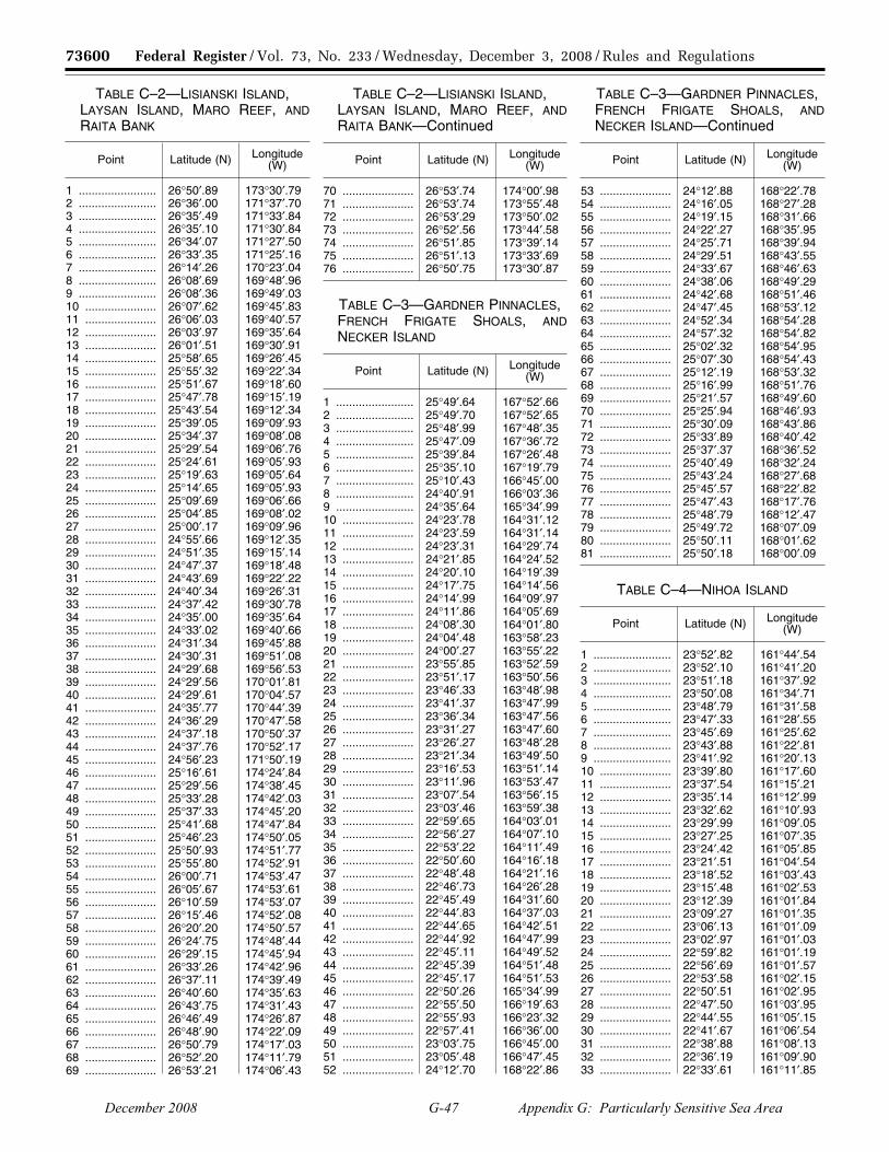
73600 Federal Register / Vol. 73, No. 233 / Wednesday, December 3, 2008 / Rules and Regulations
TABLE C–2—LISIANSKI ISLAND, LAYSAN ISLAND, MARO REEF, AND RAITA BANK
Point Latitude (N) Longitude (W)
1 ........................ 26°50′.89 173°30′.79 2 ........................ 26°36′.00 171°37′.70 3 ........................ 26°35′.49 171°33′.84 4 ........................ 26°35′.10 171°30′.84 5 ........................ 26°34′.07 171°27′.50 6 ........................ 26°33′.35 171°25′.16 7 ........................ 26°14′.26 170°23′.04 8 ........................ 26°08′.69 169°48′.96 9 ........................ 26°08′.36 169°49′.03 10 ...................... 26°07′.62 169°45′.83 11 ...................... 26°06′.03 169°40′.57 12 ...................... 26°03′.97 169°35′.64 13 ...................... 26°01′.51 169°30′.91 14 ...................... 25°58′.65 169°26′.45 15 ...................... 25°55′.32 169°22′.34 16 ...................... 25°51′.67 169°18′.60 17 ...................... 25°47′.78 169°15′.19 18 ...................... 25°43′.54 169°12′.34 19 ...................... 25°39′.05 169°09′.93 20 ...................... 25°34′.37 169°08′.08 21 ...................... 25°29′.54 169°06′.76 22 ...................... 25°24′.61 169°05′.93 23 ...................... 25°19′.63 169°05′.64 24 ...................... 25°14′.65 169°05′.93 25 ...................... 25°09′.69 169°06′.66 26 ...................... 25°04′.85 169°08′.02 27 ...................... 25°00′.17 169°09′.96 28 ...................... 24°55′.66 169°12′.35 29 ...................... 24°51′.35 169°15′.14 30 ...................... 24°47′.37 169°18′.48 31 ...................... 24°43′.69 169°22′.22 32 ...................... 24°40′.34 169°26′.31 33 ...................... 24°37′.42 169°30′.78 34 ...................... 24°35′.00 169°35′.64 35 ...................... 24°33′.02 169°40′.66 36 ...................... 24°31′.34 169°45′.88 37 ...................... 24°30′.31 169°51′.08 38 ...................... 24°29′.68 169°56′.53 39 ...................... 24°29′.56 170°01′.81 40 ...................... 24°29′.61 170°04′.57 41 ...................... 24°35′.77 170°44′.39 42 ...................... 24°36′.29 170°47′.58 43 ...................... 24°37′.18 170°50′.37 44 ...................... 24°37′.76 170°52′.17 45 ...................... 24°56′.23 171°50′.19 46 ...................... 25°16′.61 174°24′.84 47 ...................... 25°29′.56 174°38′.45 48 ...................... 25°33′.28 174°42′.03 49 ...................... 25°37′.33 174°45′.20 50 ...................... 25°41′.68 174°47′.84 51 ...................... 25°46′.23 174°50′.05 52 ...................... 25°50′.93 174°51′.77 53 ...................... 25°55′.80 174°52′.91 54 ...................... 26°00′.71 174°53′.47 55 ...................... 26°05′.67 174°53′.61 56 ...................... 26°10′.59 174°53′.07 57 ...................... 26°15′.46 174°52′.08 58 ...................... 26°20′.20 174°50′.57 59 ...................... 26°24′.75 174°48′.44 60 ...................... 26°29′.15 174°45′.94 61 ...................... 26°33′.26 174°42′.96 62 ...................... 26°37′.11 174°39′.49 63 ...................... 26°40′.60 174°35′.63 64 ...................... 26°43′.75 174°31′.43 65 ...................... 26°46′.49 174°26′.87 66 ...................... 26°48′.90 174°22′.09 67 ...................... 26°50′.79 174°17′.03 68 ...................... 26°52′.20 174°11′.79 69 ...................... 26°53′.21 174°06′.43
TABLE C–2—LISIANSKI ISLAND, LAYSAN ISLAND, MARO REEF, AND RAITA BANK—Continued
Point Latitude (N) Longitude (W)
70 ...................... 26°53′.74 174°00′.98 71 ...................... 26°53′.74 173°55′.48 72 ...................... 26°53′.29 173°50′.02 73 ...................... 26°52′.56 173°44′.58 74 ...................... 26°51′.85 173°39′.14 75 ...................... 26°51′.13 173°33′.69 76 ...................... 26°50′.75 173°30′.87
TABLE C–3—GARDNER PINNACLES, FRENCH FRIGATE SHOALS, AND NECKER ISLAND
Point Latitude (N) Longitude (W)
1 ........................ 25°49′.64 167°52′.66 2 ........................ 25°49′.70 167°52′.65 3 ........................ 25°48′.99 167°48′.35 4 ........................ 25°47′.09 167°36′.72 5 ........................ 25°39′.84 167°26′.48 6 ........................ 25°35′.10 167°19′.79 7 ........................ 25°10′.43 166°45′.00 8 ........................ 24°40′.91 166°03′.36 9 ........................ 24°35′.64 165°34′.99 10 ...................... 24°23′.78 164°31′.12 11 ...................... 24°23′.59 164°31′.14 12 ...................... 24°23′.31 164°29′.74 13 ...................... 24°21′.85 164°24′.52 14 ...................... 24°20′.10 164°19′.39 15 ...................... 24°17′.75 164°14′.56 16 ...................... 24°14′.99 164°09′.97 17 ...................... 24°11′.86 164°05′.69 18 ...................... 24°08′.30 164°01′.80 19 ...................... 24°04′.48 163°58′.23 20 ...................... 24°00′.27 163°55′.22 21 ...................... 23°55′.85 163°52′.59 22 ...................... 23°51′.17 163°50′.56 23 ...................... 23°46′.33 163°48′.98 24 ...................... 23°41′.37 163°47′.99 25 ...................... 23°36′.34 163°47′.56 26 ...................... 23°31′.27 163°47′.60 27 ...................... 23°26′.27 163°48′.28 28 ...................... 23°21′.34 163°49′.50 29 ...................... 23°16′.53 163°51′.14 30 ...................... 23°11′.96 163°53′.47 31 ...................... 23°07′.54 163°56′.15 32 ...................... 23°03′.46 163°59′.38 33 ...................... 22°59′.65 164°03′.01 34 ...................... 22°56′.27 164°07′.10 35 ...................... 22°53′.22 164°11′.49 36 ...................... 22°50′.60 164°16′.18 37 ...................... 22°48′.48 164°21′.16 38 ...................... 22°46′.73 164°26′.28 39 ...................... 22°45′.49 164°31′.60 40 ...................... 22°44′.83 164°37′.03 41 ...................... 22°44′.65 164°42′.51 42 ...................... 22°44′.92 164°47′.99 43 ...................... 22°45′.11 164°49′.52 44 ...................... 22°45′.39 164°51′.48 45 ...................... 22°45′.17 164°51′.53 46 ...................... 22°50′.26 165°34′.99 47 ...................... 22°55′.50 166°19′.63 48 ...................... 22°55′.93 166°23′.32 49 ...................... 22°57′.41 166°36′.00 50 ...................... 23°03′.75 166°45′.00 51 ...................... 23°05′.48 166°47′.45 52 ...................... 24°12′.70 168°22′.86
TABLE C–3—GARDNER PINNACLES, FRENCH FRIGATE SHOALS, AND NECKER ISLAND—Continued
Point Latitude (N) Longitude (W)
53 ...................... 24°12′.88 168°22′.78 54 ...................... 24°16′.05 168°27′.28 55 ...................... 24°19′.15 168°31′.66 56 ...................... 24°22′.27 168°35′.95 57 ...................... 24°25′.71 168°39′.94 58 ...................... 24°29′.51 168°43′.55 59 ...................... 24°33′.67 168°46′.63 60 ...................... 24°38′.06 168°49′.29 61 ...................... 24°42′.68 168°51′.46 62 ...................... 24°47′.45 168°53′.12 63 ...................... 24°52′.34 168°54′.28 64 ...................... 24°57′.32 168°54′.82 65 ...................... 25°02′.32 168°54′.95 66 ...................... 25°07′.30 168°54′.43 67 ...................... 25°12′.19 168°53′.32 68 ...................... 25°16′.99 168°51′.76 69 ...................... 25°21′.57 168°49′.60 70 ...................... 25°25′.94 168°46′.93 71 ...................... 25°30′.09 168°43′.86 72 ...................... 25°33′.89 168°40′.42 73 ...................... 25°37′.37 168°36′.52 74 ...................... 25°40′.49 168°32′.24 75 ...................... 25°43′.24 168°27′.68 76 ...................... 25°45′.57 168°22′.82 77 ...................... 25°47′.43 168°17′.76 78 ...................... 25°48′.79 168°12′.47 79 ...................... 25°49′.72 168°07′.09 80 ...................... 25°50′.11 168°01′.62 81 ...................... 25°50′.18 168°00′.09
TABLE C–4—NIHOA ISLAND
Point Latitude (N) Longitude (W)
1 ........................ 23°52′.82 161°44′.54 2 ........................ 23°52′.10 161°41′.20 3 ........................ 23°51′.18 161°37′.92 4 ........................ 23°50′.08 161°34′.71 5 ........................ 23°48′.79 161°31′.58 6 ........................ 23°47′.33 161°28′.55 7 ........................ 23°45′.69 161°25′.62 8 ........................ 23°43′.88 161°22′.81 9 ........................ 23°41′.92 161°20′.13 10 ...................... 23°39′.80 161°17′.60 11 ...................... 23°37′.54 161°15′.21 12 ...................... 23°35′.14 161°12′.99 13 ...................... 23°32′.62 161°10′.93 14 ...................... 23°29′.99 161°09′.05 15 ...................... 23°27′.25 161°07′.35 16 ...................... 23°24′.42 161°05′.85 17 ...................... 23°21′.51 161°04′.54 18 ...................... 23°18′.52 161°03′.43 19 ...................... 23°15′.48 161°02′.53 20 ...................... 23°12′.39 161°01′.84 21 ...................... 23°09′.27 161°01′.35 22 ...................... 23°06′.13 161°01′.09 23 ...................... 23°02′.97 161°01′.03 24 ...................... 22°59′.82 161°01′.19 25 ...................... 22°56′.69 161°01′.57 26 ...................... 22°53′.58 161°02′.15 27 ...................... 22°50′.51 161°02′.95 28 ...................... 22°47′.50 161°03′.95 29 ...................... 22°44′.55 161°05′.15 30 ...................... 22°41′.67 161°06′.54 31 ...................... 22°38′.88 161°08′.13 32 ...................... 22°36′.19 161°09′.90 33 ...................... 22°33′.61 161°11′.85
VerDate Aug<31>2005 15:34 Dec 02, 2008 Jkt 217001 PO 00000 Frm 00056 Fmt 4700 Sfmt 4700 E:\FR\FM\03DER1.SGM 03DER1yshi
vers
on
PR
OD
1PC
62 w
ith R
ULE
S
December 2008 G-47 Appendix G: Particularly Sensitive Sea Area

73601 Federal Register / Vol. 73, No. 233 / Wednesday, December 3, 2008 / Rules and Regulations
TABLE C–4—NIHOA ISLAND— Continued
Point Latitude (N) Longitude (W)
34 ...................... 22°31′.14 161°13′.97 35 ...................... 22°28′.81 161°16′.25 36 ...................... 22°26′.61 161°18′.69 37 ...................... 22°24′.56 161°21′.26 38 ...................... 22°22′.66 161°23′.97 39 ...................... 22°20′.92 161°26′.80 40 ...................... 22°19′.35 161°29′.74 41 ...................... 22°17′.95 161°32′.78 42 ...................... 22°16′.73 161°35′.90 43 ...................... 22°15′.70 161°39′.10 44 ...................... 22°14′.85 161°42′.37 45 ...................... 22°14′.20 161°45′.68 46 ...................... 22°13′.73 161°49′.03 47 ...................... 22°13′.47 161°52′.41 48 ...................... 22°13′.40 161°55′.80 49 ...................... 22°13′.53 161°59′.18 50 ...................... 22°13′.85 162°02′.55 51 ...................... 22°14′.31 162°05′.45 52 ...................... 22°14′.37 162°05′.89 53 ...................... 22°14′.59 162°06′.88 54 ...................... 22°15′.87 162°12′.18 55 ...................... 22°17′.70 162°17′.31 56 ...................... 22°19′.97 162°22′.20 57 ...................... 22°22′.73 162°26′.84 58 ...................... 22°25′.88 162°31′.15 59 ...................... 22°29′.41 162°35′.09 60 ...................... 22°33′.28 162°38′.61 61 ...................... 22°37′.47 162°41′.72 62 ...................... 22°41′.93 162°44′.34 63 ...................... 22°46′.63 162°46′.47 64 ...................... 22°51′.48 162°48′.05 65 ...................... 22°56′.46 162°49′.09 66 ...................... 23°01′.50 162°49′.58 67 ...................... 23°06′.58 162°49′.49 68 ...................... 23°11′.61 162°48′.89 69 ...................... 23°16′.57 162°47′.70 70 ...................... 23°21′.36 162°45′.98 71 ...................... 23°26′.02 162°43′.75 72 ...................... 23°30′.40 162°41′.01 73 ...................... 23°34′.51 162°37′.83 74 ...................... 23°38′.26 162°34′.18 75 ...................... 23°41′.69 162°30′.18 76 ...................... 23°44′.72 162°25′.79 77 ...................... 23°47′.36 162°21′.11 78 ...................... 23°49′.55 162°16′.16 79 ...................... 23°51′.24 162°10′.99 80 ...................... 23°52′.44 162°05′.63 81 ...................... 23°53′.14 162°00′.25 82 ...................... 23°53′.36 161°54′.75 83 ...................... 23°53′.09 161°49′.28 84 ...................... 23°52′.82 161°47′.09 85 ...................... 23°52′.39 161°44′.67
■ 5. Add Appendix D to Part 404 to read as follows:
Appendix D to Part 404—Boundary Coordinates for Papahanaumokuakea Marine National Monument Ship Reporting Area
Appendix D—Geographical Coordinates
Ship Reporting Area
Papahanaumokuakea Marine National Monument
Reference chart: United States 540, 2008 edition; 19016, 2008 edition; 19019, 2008 edition; 19022, 2008 edition.
These charts are based on World Geodetic System 1984 Datum (WGS–84) and astronomic datum.
TABLE D–1—OUTER BOUNDARY
Point Latitude (N) Longitude (W)
1 ........................ 29°25′.47 178°16′.97 2 ........................ 28°43′.73 175°13′.84 3 ........................ 27°00′.77 173°25′.78 4 ........................ 26°44′.91 171°28′.07 5 ........................ 26°24′.23 170°20′.59 6 ........................ 25°56′.43 167°32′.10 7 ........................ 24°50′.20 165°58′.69 8 ........................ 24°05′.52 161°56′.86 9 ........................ 24°05′.29 161°56′.62 10 ...................... 24°04′.37 161°51′.53 11 ...................... 24°03′.44 161°46′.45 12 ...................... 24°02′.41 161°41′.39 13 ...................... 24°01′.31 161°36′.35 14 ...................... 23°59′.68 161°31′.55 15 ...................... 23°57′.85 161°26′.85 16 ...................... 23°55′.54 161°22′.31 17 ...................... 23°52′.96 161°17′.92 18 ...................... 23°50′.12 161°13′.72 19 ...................... 23°46′.94 161°10′.08 20 ...................... 23°43′.49 161°06′.47 21 ...................... 23°39′.71 161°03′.09 22 ...................... 23°35′.72 161°00′.14 23 ...................... 23°31′.59 160°57′.46 24 ...................... 23°27′.32 160°55′.23 25 ...................... 23°22′.74 160°53′.71 26 ...................... 23°18′.29 160°52′.17 27 ...................... 23°13′.57 160°51′.04 28 ...................... 23°08′.68 160°50′.46 29 ...................... 23°03′.70 160°50′.17 30 ...................... 22°58′.67 160°50′.35 31 ...................... 22°53′.84 160°51′.04 32 ...................... 22°49′.11 160°52′.20 33 ...................... 22°44′.46 160°53′.56 34 ...................... 22°40′.03 160°55′.52 35 ...................... 22°35′.73 160°57′.68 36 ...................... 22°31′.54 161°00′.25 37 ...................... 22°27′.57 161°03′.23 38 ...................... 22°23′.76 161°06′.64 39 ...................... 22°20′.24 161°10′.23 40 ...................... 22°17′.02 161°14′.13 41 ...................... 22°14′.04 161°18′.34 42 ...................... 22°11′.35 161°22′.80 43 ...................... 22°09′.19 161°27′.45 44 ...................... 22°07′.29 161°32′.11 45 ...................... 22°05′.87 161°36′.94 46 ...................... 22°04′.62 161°41′.89 47 ...................... 22°03′.94 161°47′.09 48 ...................... 22°03′.41 161°52′.36 49 ...................... 22°03′.41 161°57′.51 50 ...................... 22°03′.82 162°02′.83 51 ...................... 22°04′.49 162°08′.04 52 ...................... 22°05′.43 162°13′.12 53 ...................... 22°05′.97 162°16′.41 54 ...................... 22°06′.29 162°16′.85 55 ...................... 22°34′.57 164°47′.27 56 ...................... 22°47′.60 166°38′.23 57 ...................... 24°03′.82 168°27′.91 58 ...................... 24°25′.76 170°45′.39 59 ...................... 24°46′.54 171°53′.03 60 ...................... 25°07′.60 174°28′.71 61 ...................... 27°05′.82 176°35′.51 62 ...................... 27°27′.32 178°38′.66 63 ...................... 27°28′.93 178°43′.56 64 ...................... 27°30′.64 178°48′.40 65 ...................... 27°32′.74 178°52′.96 66 ...................... 27°35′.06 178°57′.30 67 ...................... 27°37′.89 179°01′.49
TABLE D–1—OUTER BOUNDARY— Continued
Point Latitude (N) Longitude (W)
68 ...................... 27°40′.90 179°05′.60 69 ...................... 27°44′.17 179°09′.41 70 ...................... 27°47′.74 179°12′.85 71 ...................... 27°51′.45 179°16′.00 72 ...................... 27°55′.32 179°18′.82 73 ...................... 27°59′.33 179°21′.13 74 ...................... 28°03′.49 179°23′.15 75 ...................... 28°07′.82 179°24′.76 76 ...................... 28°12′.31 179°26′.18 77 ...................... 28°16′.95 179°27′.05 78 ...................... 28°21′.61 179°27′.63 79 ...................... 28°26′.18 179°27′.77 80 ...................... 28°30′.87 179°27′.48 81 ...................... 28°35′.61 179°26′.95 82 ...................... 28°40′.09 179°25′.75 83 ...................... 28°44′.46 179°24′.31 84 ...................... 28°48′.70 179°22′.50 85 ...................... 28°52′.81 179°20′.43 86 ...................... 28°56′.71 179°17′.77 87 ...................... 29°00′.58 179°14′.92 88 ...................... 29°04′.18 179°11′.69 89 ...................... 29°07′.62 179°08′.20 90 ...................... 29°10′.86 179°04′.37 91 ...................... 29°13′.76 179°00′.21 92 ...................... 29°16′.24 178°55′.78 93 ...................... 29°18′.51 178°51′.26 94 ...................... 29°20′.45 178°46′.50 95 ...................... 29°22′.26 178°41′.67 96 ...................... 29°23′.52 178°36′.64 97 ...................... 29°24′.53 178°31′.54 98 ...................... 29°25′.16 178°26′.31 99 ...................... 29°25′.42 178°20′.92 100 .................... 29°25′.29 178°16′.70
TABLE D–2—INNER BOUNDARY AROUND KURE ATOLL, MIDWAY ATOLL, AND PEARL AND HERMES ATOLL
Point Latitude (N) Longitude (W)
1 ........................ 27°14′.76 176°29′.87 2 ........................ 27°24′.95 177°33′.31 3 ........................ 27°35′.87 178°29′.90 4 ........................ 27°36′.64 178°33′.93 5 ........................ 27°37′.53 178°37′.32 6 ........................ 27°38′.60 178°40′.65 7 ........................ 27°39′.85 178°43′.90 8 ........................ 27°41′.28 178°47′.05 9 ........................ 27°42′.89 178°50′.10 10 ...................... 27°44′.66 178°53′.03 11 ...................... 27°46′.59 178°55′.83 12 ...................... 27°48′.67 178°58′.49 13 ...................... 27°50′.89 179°01′.00 14 ...................... 27°53′.22 179°03′.39 15 ...................... 27°55′.69 179°05′.61 16 ...................... 27°58′.29 179°07′.61 17 ...................... 28°01′.01 179°09′.47 18 ...................... 28°03′.81 179°11′.10 19 ...................... 28°06′.71 179°12′.53 20 ...................... 28°09′.67 179°13′.75 21 ...................... 28°12′.70 179°14′.75 22 ...................... 28°15′.78 179°15′.54 23 ...................... 28°18′.91 179°16′.11 24 ...................... 28°22′.04 179°16′.45 25 ...................... 28°24′.72 179°16′.56 26 ...................... 28°25′.20 179°16′.57
VerDate Aug<31>2005 15:34 Dec 02, 2008 Jkt 217001 PO 00000 Frm 00057 Fmt 4700 Sfmt 4700 E:\FR\FM\03DER1.SGM 03DER1yshi
vers
on
PR
OD
1PC
62 w
ith R
ULE
S
December 2008 G-48 Appendix G: Particularly Sensitive Sea Area

73602 Federal Register / Vol. 73, No. 233 / Wednesday, December 3, 2008 / Rules and Regulations
TABLE D–2—INNER BOUNDARY AROUND KURE ATOLL, MIDWAY ATOLL, AND PEARL AND HERMES ATOLL—Continued
Point Latitude (N) Longitude (W)
27 ...................... 28°25′.81 179°16′.56 28 ...................... 28°28′.35 179°16′.44 29 ...................... 28°31′.49 179°16′.10 30 ...................... 28°34′.61 179°15′.54 31 ...................... 28°37′.69 179°14′.75 32 ...................... 28°40′.71 179°13′.74 33 ...................... 28°43′.68 179°12′.54 34 ...................... 28°46′.58 179°11′.13 35 ...................... 28°49′.39 179°09′.52 36 ...................... 28°52′.11 179°07′.70 37 ...................... 28°54′.72 179°05′.70 38 ...................... 28°57′.21 179°03′.51 39 ...................... 28°59′.58 179°01′.15 40 ...................... 29°01′.81 178°58′.62 41 ...................... 29°03′.90 178°55′.93 42 ...................... 29°05′.83 178°53′.10 43 ...................... 29°07′.60 178°50′.13 44 ...................... 29°09′.21 178°47′.04 45 ...................... 29°10′.64 178°43′.84 46 ...................... 29°11′.89 178°40′.54 47 ...................... 29°12′.95 178°37′.16 48 ...................... 29°13′.82 178°33′.71 49 ...................... 29°14′.50 178°30′.21 50 ...................... 29°14′.99 178°26′.66 51 ...................... 29°15′.28 178°23′.08 52 ...................... 29°15′.36 178°19′.49 53 ...................... 29°15′.25 178°15′.90 54 ...................... 29°14′.94 178°12′.32 55 ...................... 29°14′.43 178°08′.78 56 ...................... 29°03′.47 177°12′.07 57 ...................... 29°02′.55 177°07′.29 58 ...................... 28°38′.96 175°35′.47 59 ...................... 28°38′.67 175°34′.35 60 ...................... 28°34′.91 175°19′.74 61 ...................... 28°26′.24 175°10′.65 62 ...................... 28°24′.61 175°08′.95 63 ...................... 28°24′.53 175°09′.04 64 ...................... 28°20′.09 175°04′.91 65 ...................... 28°16′.05 175°01′.92 66 ...................... 28°11′.78 174°59′.33 67 ...................... 28°07′.29 174°57′.23 68 ...................... 28°02′.63 174°55′.68 69 ...................... 27°57′.84 174°54′.62 70 ...................... 27°53′.01 174°54′.05 71 ...................... 27°48′.12 174°54′.05 72 ...................... 27°43′.28 174°54′.62 73 ...................... 27°38′.48 174°55′.71 74 ...................... 27°33′.81 174°57′.32 75 ...................... 27°29′.30 174°59′.43 76 ...................... 27°25′.00 175°02′.03 77 ...................... 27°20′.93 175°05′.07 78 ...................... 27°17′.18 175°08′.59 79 ...................... 27°13′.73 175°12′.47 80 ...................... 27°10′.59 175°16′.67 81 ...................... 27°07′.88 175°21′.25 82 ...................... 27°05′.57 175°26′.09 83 ...................... 27°03′.66 175°31′.15 84 ...................... 27°02′.22 175°36′.40 85 ...................... 27°01′.29 175°41′.78 86 ...................... 27°00′.73 175°47′.22 87 ...................... 27°00′.68 175°52′.74 88 ...................... 27°01′.09 175°58′.16 89 ...................... 27°01′.99 176°03′.53 90 ...................... 27°03′.34 176°08′.81 91 ...................... 27°05′.12 176°13′.91 92 ...................... 27°07′.37 176°18′.79 93 ...................... 27°09′.98 176°23′.40
TABLE D–2—INNER BOUNDARY AROUND KURE ATOLL, MIDWAY ATOLL, AND PEARL AND HERMES ATOLL—Continued
Point Latitude (N) Longitude (W)
94 ...................... 27°13′.02 176°27′.74 95 ...................... 27°13′.77 176°28′.70
TABLE D–3—INNER BOUNDARY AROUND LISIANSKI ISLAND, LAYSAN ISLAND, MARO REEF, AND RAITA BANK
Point Latitude (N) Longitude (W)
1 ........................ 26°50′.89 173°30′.79 2 ........................ 26°36′.00 171°37′.70 3 ........................ 26°35′.49 171°33′.84 4 ........................ 26°35′.10 171°30′.84 5 ........................ 26°34′.07 171°27′.50 6 ........................ 26°33′.35 171°25′.16 7 ........................ 26°14′.26 170°23′.04 8 ........................ 26°08′.69 169°48′.96 9 ........................ 26°08′.36 169°49′.03 10 ...................... 26°07′.62 169°45′.83 11 ...................... 26°06′.03 169°40′.57 12 ...................... 26°03′.97 169°35′.64 13 ...................... 26°01′.51 169°30′.91 14 ...................... 25°58′.65 169°26′.45 15 ...................... 25°55′.32 169°22′.34 16 ...................... 25°51′.67 169°18′.60 17 ...................... 25°47′.78 169°15′.19 18 ...................... 25°43′.54 169°12′.34 19 ...................... 25°39′.05 169°09′.93 20 ...................... 25°34′.37 169°08′.08 21 ...................... 25°29′.54 169°06′.76 22 ...................... 25°24′.61 169°05′.93 23 ...................... 25°19′.63 169°05′.64 24 ...................... 25°14′.65 169°05′.93 25 ...................... 25°09′.69 169°06′.66 26 ...................... 25°04′.85 169°08′.02 27 ...................... 25°00′.17 169°09′.96 28 ...................... 24°55′.66 169°12′.35 29 ...................... 24°51′.35 169°15′.14 30 ...................... 24°47′.37 169°18′.48 31 ...................... 24°43′.69 169°22′.22 32 ...................... 24°40′.34 169°26′.31 33 ...................... 24°37′.42 169°30′.78 34 ...................... 24°35′.00 169°35′.64 35 ...................... 24°33′.02 169°40′.66 36 ...................... 24°31′.34 169°45′.88 37 ...................... 24°30′.31 169°51′.08 38 ...................... 24°29′.68 169°56′.53 39 ...................... 24°29′.56 170°01′.81 40 ...................... 24°29′.61 170°04′.57 41 ...................... 24°35′.77 170°44′.39 42 ...................... 24°36′.29 170°47′.58 43 ...................... 24°37′.18 170°50′.37 44 ...................... 24°37′.76 170°52′.17 45 ...................... 24°56′.23 171°50′.19 46 ...................... 25°16′.61 174°24′.84 47 ...................... 25°29′.56 174°38′.45 48 ...................... 25°33′.28 174°42′.03 49 ...................... 25°37′.33 174°45′.20 50 ...................... 25°41′.68 174°47′.84 51 ...................... 25°46′.23 174°50′.05 52 ...................... 25°50′.93 174°51′.77 53 ...................... 25°55′.80 174°52′.91 54 ...................... 26°00′.71 174°53′.47 55 ...................... 26°05′.67 174°53′.61
TABLE D–3—INNER BOUNDARY AROUND LISIANSKI ISLAND, LAYSAN ISLAND, MARO REEF, AND RAITA BANK—Continued
Point Latitude (N) Longitude (W)
56 ...................... 26°10′.59 174°53′.07 57 ...................... 26°15′.46 174°52′.08 58 ...................... 26°20′.20 174°50′.57 59 ...................... 26°24′.75 174°48′.44 60 ...................... 26°29′.15 174°45′.94 61 ...................... 26°33′.26 174°42′.96 62 ...................... 26°37′.11 174°39′.49 63 ...................... 26°40′.60 174°35′.63 64 ...................... 26°43′.75 174°31′.43 65 ...................... 26°46′.49 174°26′.87 66 ...................... 26°48′.90 174°22′.09 67 ...................... 26°50′.79 174°17′.03 68 ...................... 26°52′.20 174°11′.79 69 ...................... 26°53′.21 174°06′.43 70 ...................... 26°53′.74 174°00′.98 71 ...................... 26°53′.74 173°55′.48 72 ...................... 26°53′.29 173°50′.02 73 ...................... 26°52′.56 173°44′.58 74 ...................... 26°51′.85 173°39′.14 75 ...................... 26°51′.13 173°33′.69 76 ...................... 26°50′.75 173°30′.87
TABLE D–4—INNER BOUNDARY AROUND GARDNER PINNACLES, FRENCH FRIGATE SHOALS, AND NECKER ISLAND
Point Latitude (N) Longitude (W)
1 ........................ 25°49′.64 167°52′.66 2 ........................ 25°49′.70 167°52′.65 3 ........................ 25°48′.99 167°48′.35 4 ........................ 25°47′.09 167°36′.72 5 ........................ 25°39′.84 167°26′.48 6 ........................ 25°35′.10 167°19′.79 7 ........................ 25°10′.43 166°45′.00 8 ........................ 24°40′.91 166°03′.36 9 ........................ 24°35′.64 165°34′.99 10 ...................... 24°23′.78 164°31′.12 11 ...................... 24°23′.59 164°31′.14 12 ...................... 24°23′.31 164°29′.74 13 ...................... 24°21′.85 164°24′.52 14 ...................... 24°20′.10 164°19′.39 15 ...................... 24°17′.75 164°14′.56 16 ...................... 24°14′.99 164°09′.97 17 ...................... 24°11′.86 164°05′.69 18 ...................... 24°08′.30 164°01′.80 19 ...................... 24°04′.48 163°58′.23 20 ...................... 24°00′.27 163°55′.22 21 ...................... 23°55′.85 163°52′.59 22 ...................... 23°51′.17 163°50′.56 23 ...................... 23°46′.33 163°48′.98 24 ...................... 23°41′.37 163°47′.99 25 ...................... 23°36′.34 163°47′.56 26 ...................... 23°31′.27 163°47′.60 27 ...................... 23°26′.27 163°48′.28 28 ...................... 23°21′.34 163°49′.50 29 ...................... 23°16′.53 163°51′.14 30 ...................... 23°11′.96 163°53′.47 31 ...................... 23°07′.54 163°56′.15 32 ...................... 23°03′.46 163°59′.38 33 ...................... 22°59′.65 164°03′.01 34 ...................... 22°56′.27 164°07′.10 35 ...................... 22°53′.22 164°11′.49 36 ...................... 22°50′.60 164°16′.18
VerDate Aug<31>2005 15:34 Dec 02, 2008 Jkt 217001 PO 00000 Frm 00058 Fmt 4700 Sfmt 4700 E:\FR\FM\03DER1.SGM 03DER1yshi
vers
on
PR
OD
1PC
62 w
ith R
ULE
S
December 2008 G-49 Appendix G: Particularly Sensitive Sea Area

73603 Federal Register / Vol. 73, No. 233 / Wednesday, December 3, 2008 / Rules and Regulations
TABLE D–4—INNER BOUNDARY AROUND GARDNER PINNACLES, FRENCH FRIGATE SHOALS, AND NECKER ISLAND—Continued
Point Latitude (N) Longitude (W)
37 ...................... 22°48′.48 164°21′.16 38 ...................... 22°46′.73 164°26′.28 39 ...................... 22°45′.49 164°31′.60 40 ...................... 22°44′.83 164°37′.03 41 ...................... 22°44′.65 164°42′.51 42 ...................... 22°44′.92 164°47′.99 43 ...................... 22°45′.11 164°49′.52 44 ...................... 22°45′.39 164°51′.48 45 ...................... 22°45′.17 164°51′.53 46 ...................... 22°50′.26 165°34′.99 47 ...................... 22°55′.50 166°19′.63 48 ...................... 22°55′.93 166°23′.32 49 ...................... 22°57′.41 166°36′.00 50 ...................... 23°03′.75 166°45′.00 51 ...................... 23°05′.48 166°47′.45 52 ...................... 24°12′.70 168°22′.86 53 ...................... 24°12′.88 168°22′.78 54 ...................... 24°16′.05 168°27′.28 55 ...................... 24°19′.15 168°31′.66 56 ...................... 24°22′.27 168°35′.95 57 ...................... 24°25′.71 168°39′.94 58 ...................... 24°29′.51 168°43′.55 59 ...................... 24°33′.67 168°46′.63 60 ...................... 24°38′.06 168°49′.29 61 ...................... 24°42′.68 168°51′.46 62 ...................... 24°47′.45 168°53′.12 63 ...................... 24°52′.34 168°54′.28 64 ...................... 24°57′.32 168°54′.82 65 ...................... 25°02′.32 168°54′.95 66 ...................... 25°07′.30 168°54′.43 67 ...................... 25°12′.19 168°53′.32 68 ...................... 25°16′.99 168°51′.76 69 ...................... 25°21′.57 168°49′.60 70 ...................... 25°25′.94 168°46′.93 71 ...................... 25°30′.09 168°43′.86 72 ...................... 25°33′.89 168°40′.42 73 ...................... 25°37′.37 168°36′.52 74 ...................... 25°40′.49 168°32′.24 75 ...................... 25°43′.24 168°27′.68 76 ...................... 25°45′.57 168°22′.82 77 ...................... 25°47′.43 168°17′.76 78 ...................... 25°48′.79 168°12′.47 79 ...................... 25°49′.72 168°07′.09 80 ...................... 25°50′.11 168°01′.62 81 ...................... 25°50′.18 168°00′.09
TABLE D–5—INNER BOUNDARY AROUND NIHOA ISLAND
Point Latitude (N) Longitude (W)
1 ........................ 23°52′.82 161°44′.54 2 ........................ 23°52′.10 161°41′.20 3 ........................ 23°51′.18 161°37′.92 4 ........................ 23°50′.08 161°34′.71 5 ........................ 23°48′.79 161°31′.58 6 ........................ 23°47′.33 161°28′.55 7 ........................ 23°45′.69 161°25′.62 8 ........................ 23°43′.88 161°22′.81 9 ........................ 23°41′.92 161°20′.13 10 ...................... 23°39′.80 161°17′.60 11 ...................... 23°37′.54 161°15′.21 12 ...................... 23°35′.14 161°12′.99 13 ...................... 23°32′.62 161°10′.93 14 ...................... 23°29′.99 161°09′.05 15 ...................... 23°27′.25 161°07′.35 16 ...................... 23°24′.42 161°05′.85 17 ...................... 23°21′.51 161°04′.54 18 ...................... 23°18′.52 161°03′.43 19 ...................... 23°15′.48 161°02′.53 20 ...................... 23°12′.39 161°01′.84 21 ...................... 23°09′.27 161°01′.35 22 ...................... 23°06′.13 161°01′.09 23 ...................... 23°02′.97 161°01′.03 24 ...................... 22°59′.82 161°01′.19 25 ...................... 22°56′.69 161°01′.57 26 ...................... 22°53′.58 161°02′.15 27 ...................... 22°50′.51 161°02′.95 28 ...................... 22°47′.50 161°03′.95 29 ...................... 22°44′.55 161°05′.15 30 ...................... 22°41′.67 161°06′.54 31 ...................... 22°38′.88 161°08′.13 32 ...................... 22°36′.19 161°09′.90 33 ...................... 22°33′.61 161°11′.85 34 ...................... 22°31′.14 161°13′.97 35 ...................... 22°28′.81 161°16′.25 36 ...................... 22°26′.61 161°18′.69 37 ...................... 22°24′.56 161°21′.26 38 ...................... 22°22′.66 161°23′.97 39 ...................... 22°20′.92 161°26′.80 40 ...................... 22°19′.35 161°29′.74 41 ...................... 22°17′.95 161°32′.78 42 ...................... 22°16′.73 161°35′.90 43 ...................... 22°15′.70 161°39′.10 44 ...................... 22°14′.85 161°42′.37 45 ...................... 22°14′.20 161°45′.68 46 ...................... 22°13′.73 161°49′.03 47 ...................... 22°13′.47 161°52′.41 48 ...................... 22°13′.40 161°55′.80 49 ...................... 22°13′.53 161°59′.18 50 ...................... 22°13′.85 162°02′.55 51 ...................... 22°14′.31 162°05′.45 52 ...................... 22°14′.37 162°05′.89 53 ...................... 22°14′.59 162°06′.88 54 ...................... 22°15′.87 162°12′.18 55 ...................... 22°17′.70 162°17′.31 56 ...................... 22°19′.97 162°22′.20
TABLE D–5—INNER BOUNDARY AROUND NIHOA ISLAND—Continued
Point Latitude (N) Longitude (W)
57 ...................... 22°22′.73 162°26′.84 58 ...................... 22°25′.88 162°31′.15 59 ...................... 22°29′.41 162°35′.09 60 ...................... 22°33′.28 162°38′.61 61 ...................... 22°37′.47 162°41′.72 62 ...................... 22°41′.93 162°44′.34 63 ...................... 22°46′.63 162°46′.47 64 ...................... 22°51′.48 162°48′.05 65 ...................... 22°56′.46 162°49′.09 66 ...................... 23°01′.50 162°49′.58 67 ...................... 23°06′.58 162°49′.49 68 ...................... 23°11′.61 162°48′.89 69 ...................... 23°16′.57 162°47′.70 70 ...................... 23°21′.36 162°45′.98 71 ...................... 23°26′.02 162°43′.75 72 ...................... 23°30′.40 162°41′.01 73 ...................... 23°34′.51 162°37′.83 74 ...................... 23°38′.26 162°34′.18 75 ...................... 23°41′.69 162°30′.18 76 ...................... 23°44′.72 162°25′.79 77 ...................... 23°47′.36 162°21′.11 78 ...................... 23°49′.55 162°16′.16 79 ...................... 23°51′.24 162°10′.99 80 ...................... 23°52′.44 162°05′.63 81 ...................... 23°53′.14 162°00′.25 82 ...................... 23°53′.36 161°54′.75 83 ...................... 23°53′.09 161°49′.28 84 ...................... 23°52′.82 161°47′.09 85 ...................... 23°52′.39 161°44′.67
■ 6. Add Appendix E to Part 404 to read as follows:
Appendix E to Part 404—Content and Syntax for Papahanaumokuakea Ship Reporting System
Immediately upon crossing the reporting area boundary, notification should be sent as a direct e-mail to [email protected] in the prescribed format and data syntax shown. Use of batch message routing services which may delay receipt of a report should not be used. Failure to follow the exact format (e.g., extra information, extraneous characters, or double spacing) may cause the automated computer system to reject your report. Note: Report transmission costs via INMARSAT–C will be assumed by NOAA.
E.1 Entry Notification Format
Immediately upon entering the Reporting Area, vessels required to participate must provide the following information.
TABLE E.1—INFORMATION REQUIRED FOR ENTRY NOTIFICATION
Telegraphy Function Information required Example field text
System identifier CORAL SHIPREP // CORAL SHIPREP //
A .................. Ship ......................... Vessel name/call sign/flag/IMO number/Federal documenta-tion or State registration number if applicable //.
A/OCEAN VOYAGER/C5FU8/BAHAMAS/ IMO 9359165//
B .................. Date, time (UTC), and month of entry.
A 6-digit group giving day of month (first two digits), hours and minutes (last four digits) in coordinated universal time, suffixed by the letter Z (indicating time in UTC), and three letters indicating month //.
B/271107Z DEC//
VerDate Aug<31>2005 15:34 Dec 02, 2008 Jkt 217001 PO 00000 Frm 00059 Fmt 4700 Sfmt 4700 E:\FR\FM\03DER1.SGM 03DER1yshi
vers
on
PR
OD
1PC
62 w
ith R
ULE
S
December 2008 G-50 Appendix G: Particularly Sensitive Sea Area
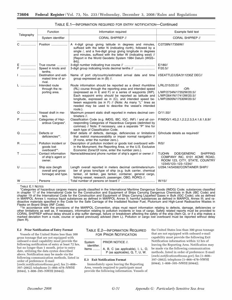
73604 Federal Register / Vol. 73, No. 233 / Wednesday, December 3, 2008 / Rules and Regulations
TABLE E.1—INFORMATION REQUIRED FOR ENTRY NOTIFICATION—Continued
Telegraphy Function Information required Example field text
System identifier CORAL SHIPREP // CORAL SHIPREP //
C .................. Position ................... A 4-digit group giving latitude in degrees and minutes, suffixed with the letter N (indicating north), followed by a single /, and a five-digit group giving longitude in degrees and minutes, suffixed with the letter W (indicating west) // [Report in the World Geodetic System 1984 Datum (WGS– 84)].
C/2728N/17356W//
E .................. True course ............ 3-digit number indicating true course // .................................... E/180// F .................. Speed in knots and
tenths.3-digit group indicating knots decimal tenths // ........................ F/20.5//
I ................... Destination and esti-mated time of ar-rival.
Name of port city/country/estimated arrival date and time group expressed as in (B) //.
I/SEATTLE/USA/311230Z DEC//
L .................. Intended route through the re-porting area.
Route information should be reported as a direct rhumbline (RL) course through the reporting area and intended speed (expressed as in E and F) or a series of waypoints (WP). Each waypoint entry should be reported as latitude and longitude, expressed as in (C), and intended speed be-tween waypoints (as in F) // (Note: As many ‘‘L’’ lines as needed may be used to describe the vessel’s intended route.).
L/RL/215/20.5// -OR-
L/WP/2734N/17352W/20.5// L/WP/2641N/17413W/20.5// L/WP/2605N/17530W/20.5//
O .................. Vessel draft in me-ters.
Maximum present static draft reported in meters decimal cen-timeters //.
O/11.50//
P .................. Categories of Haz-ardous Cargoes*.
Classification Code (e.g. IMDG, IBC, IGC, INF) / and all cor-responding Categories of Hazardous Cargoes (delimited by commas) // Note: If necessary, use a separate ‘‘P’’ line for each type of Classification Code.
P/IMDG/1.4G,2.1,2.2,2.3,3,4.1,6.1,8,9//
Q .................. Defects or deficiencies**.
Brief details of defects, damage, deficiencies or limitations that restrict maneuverability or impair normal navigation // (If none, enter the number zero.).
Q/Include details as required//
R .................. Pollution incident or goods lost overboard**.
Description of pollution incident or goods lost overboard with-in the Monument, the Reporting Area, or the U.S. Exclusive Economic Zone//(If none, enter the number zero.).
R/0//
T .................. Contact information of ship’s agent or owner.
Name/address/and phone number of ship’s agent or owner // T/JOHN DOE/GENERIC SHIPPING COMPANY INC, 6101 ACME ROAD, ROOM 123, CITY, STATE, COUNTRY 12345/123–123–1234//
U .................. Ship size (length overall and gross tonnage) and type.
Length overall reported in meters decimal centimeters/num-ber of gross tons/type of ship (e.g. bulk carrier, chemical tanker, oil tanker, gas tanker, container, general cargo, fishing vessel, research, passenger, OBO, RORO) //.
U/294.14/54592/CONTAINER SHIP//
W ................. Persons ................... Total number of persons on board // ........................................ W/15//
TABLE E.1 NOTES *Categories of hazardous cargoes means goods classified in the International Maritime Dangerous Goods (IMDG) Code; substances classified
in chapter 17 of the International Code for the Construction and Equipment of Ships Carrying Dangerous Chemicals in Bulk (IBC Code) and chapter 19 of the International Code for the Construction and Equipment of Ships Carrying Liquefied Gases in Bulk (IGC Code); oils as defined in MARPOL Annex I; noxious liquid substances as defined in MARPOL Annex II; harmful substances as defined in MARPOL Annex III; and ra-dioactive materials specified in the Code for the Safe Carriage of the Irradiated Nuclear Fuel, Plutonium and High-Level Radioactive Wastes in Flasks on Board Ships (INF Code).
**In accordance with the provisions of the MARPOL Convention, ships must report information relating to defects, damage, deficiencies or other limitations as well as, if necessary, information relating to pollution incidents or loss of cargo. Safety related reports must be provided to CORAL SHIPREP without delay should a ship suffer damage, failure or breakdown affecting the safety of the ship (Item Q), or if a ship makes a marked deviation from a route, course or speed previously advised (Item L). Pollution or cargo lost overboard must be reported without delay (Item R).
E.2 Prior Notification of Entry Format Vessels of the United States less than 300
gross tonnage that are not equipped with onboard e-mail capability must provide the following notification of entry at least 72 hrs, but no longer than 1 month, prior to entry date, utilizing the data syntax described above. Notification may be made via the following communication methods, listed in order of preference: E-mail [[email protected]]; fax [1–808– 397–2662]; telephone [1–866–478–NWHI (6944), 1–808–395–NWHI (6944)].
TABLE E.2—INFORMATION REQUIRED FOR PRIOR NOTIFICATION
System identifier.
PRIOR NOTICE //.
Items ........ A, B, C (as applicable), I, L, O, P (as applicable), Q, T, U, W.
E.3 Exit Notification Format Immediately upon leaving the Reporting
Area, vessels required to participate must provide the following information. Vessels of
the United States less than 300 gross tonnage that are not equipped with onboard e-mail capability must provide the following Exit Notification information within 12 hrs of leaving the Reporting Area. Notification may be made via the following communication methods, listed in order of preference: E-mail [[email protected]]; fax [1–808– 397–2662]; telephone [1–866–478–NWHI (6944), 1–808–395–NWHI (6944)].
VerDate Aug<31>2005 15:34 Dec 02, 2008 Jkt 217001 PO 00000 Frm 00060 Fmt 4700 Sfmt 4700 E:\FR\FM\03DER1.SGM 03DER1yshi
vers
on
PR
OD
1PC
62 w
ith R
ULE
S
December 2008 G-51 Appendix G: Particularly Sensitive Sea Area
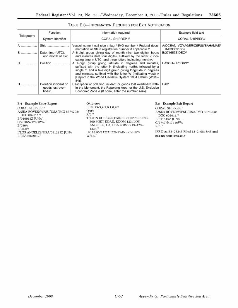
73605 Federal Register / Vol. 73, No. 233 / Wednesday, December 3, 2008 / Rules and Regulations
TABLE E.3—INFORMATION REQUIRED FOR EXIT NOTIFICATION
Telegraphy Function Information required Example field text
System identifier CORAL SHIPREP // CORAL SHIPREP//
A .................. Ship ......................... Vessel name / call sign / flag / IMO number / Federal docu-mentation or State registration number if applicable //.
A/OCEAN VOYAGER/C5FU8/BAHAMAS/ IMO9359165//
B .................. Date, time (UTC), and month of exit.
A 6-digit group giving day of month (first two digits), hours and minutes (last four digits), suffixed by the letter Z indi-cating time in UTC, and three letters indicating month//.
B/271657Z DEC//
C .................. Position ................... A 4-digit group giving latitude in degrees and minutes, suffixed with the letter N (indicating north), followed by a single //, and a five digit group giving longitude in degrees and minutes, suffixed with the letter W (indicating west) // [Report in the World Geodetic System 1984 Datum (WGS– 84)].
C/2605N/17530W//
R .................. Pollution incident or goods lost over-board.
Description of pollution incident or goods lost overboard with-in the Monument, the Reporting Area, or the U.S. Exclusive Economic Zone // (If none, enter the number zero).
R/0//
E.4 Example Entry Report CORAL SHIPREP// A/SEA ROVER/WFSU/USA/IMO 8674208/
DOC 602011// B/010915Z JUN// C/2636N/17600W// E/050// F/20.0// I/LOS ANGELES/USA/081215Z JUN// L/RL/050/20.0//
O/10.90// P/IMDG/3,4.1,6.1,8,9// Q/0// R/0// T/JOHN DOE/CONTAINER SHIPPERS INC,
500 PORT ROAD, ROOM 123, LOS ANGELES, CA, USA 90050/213–123– 1234//
U/199.90/27227/CONTAINER SHIP// W/15//
E.5 Example Exit Report
CORAL SHIPREP// A/SEA ROVER/WFSU/USA/IMO 8674208/
DOC 602011// B/011515Z JUN// C/2747N/17416W// R/0//
[FR Doc. E8–28245 Filed 12–2–08; 8:45 am] BILLING CODE 3510–22–P
VerDate Aug<31>2005 15:34 Dec 02, 2008 Jkt 217001 PO 00000 Frm 00061 Fmt 4700 Sfmt 4700 E:\FR\FM\03DER1.SGM 03DER1yshi
vers
on
PR
OD
1PC
62 w
ith R
ULE
S
December 2008 G-52 Appendix G: Particularly Sensitive Sea Area