Embed Size (px)
Citation preview

------------
--------
APPENDIX G
HI STORICAL SI TE ASSESSMENT INFORMATI ON SOURCES
This appendix provides lists of information sources often useful to site assessment. The lists are organized in two ways:
! Table G.1, beginning on page G-2, identifies information needs by category and lists appropriate information sources for each. The categories are:
General site information, p. G-2Source and waste characteristics, p. G-2Ground water use and characteristics, p. G-3Surface water use and characteristics, p. G-4Soil exposure characteristics, p. G-5Air characteristics, p. G-6
! The reverse approach is provided in Table G.2, beginning on page G-7. Categories of information sources are listed with a brief explanation of the information provided by each source. A contact is provided for additional information. The categories are:
Databases, p. G-7Maps and aerial photographs, p. G-13Files, p. G-17Expert and other sources, p. G-19
More complete listings of site assessment information sources are available in the Site Assessment Information Directory (EPA91e).
August 2000 G-1 MARSSIM, Revision 1

Appendix G
Table G.1 Site Assessment In formation Sources (Organized by Information Needed)
General Site Information
Site Location, Latitude/Longitude
CERCLIS USGS Topographic Maps State Department of Transportation Maps Site Reconnaissance USGS Global Land Information System U.S. Census Bureau Tiger Mapping Services
Type of Operation and Site Status
EPA Regional Libraries State Environmental Agency Files Site Reconnaissance
Owner/Operator Information
EPA Regional Libraries State Environmental Agency Files Local Tax Assessor
Environmental Setting, Size of Site
USGS Topographic Maps Aerial Photographs Site Reconnaissance
Source and Waste Characteristics
Source Types, Locations, Sizes
EPA Regional Libraries State Environmental Agency Files Aerial Photographs Site Reconnaissance DOE Field Offices
Hazardous Substances Present
EPA Regional Libraries State Environmental Agency Files RCRIS Local Health Department Local Fire Department ERAMS Local Public Works Department
Waste Types and Quantities
EPA Regional Office Files State Environmental Agency Files RCRIS Local Fire Department Aerial Photographs Site Reconnaissance Aerial Radiation Surveys
MARSSIM, Revision 1 G-2 August 2000

Appendix G
Table G.1 Site Assessment In formation Sources (continued) (Organized by Information Needed)
Ground Water Use and Character istics
General Stratigraphy
USGS Topographic Maps U.S. Geological Survey State Geological Surveys Geologic and Bedrock Maps Local Experts Local University or College
Private and Municipal Wells
Local Water Authority Local Health Department Local Well Drillers State Environmental Agency Files WellFax WATSTORE
Karst Terrain
USGS Topographic Maps U.S. Geological Survey State Geological Surveys Geologic and Bedrock Maps Local Experts Local University or College
Distance to Nearest Drinking Water Well
USGS Topographic Maps Local Water Authority Local Well Drillers Local Health Department WellFax WATSTORE Site Reconnaissance
Depth to Aquifer
U.S. Geological Survey State Geological Surveys Geologic and Bedrock Maps Local Experts Local Well Drillers WATSTORE
Wellhead Protection Areas
State Environmental Agency Local Water Authority Local Well Drillers Local Health Department EPA Regional Water Officials
August 2000 G-3 MARSSIM, Revision 1

Appendix G
Table G.1 Site Assessment In formation Sources (continued) (Organized by Information Needed)
Sur face Water Use and Characteristics
Surface Water Body Types
USGS Topographic Maps State Department of Transportation Maps Aerial Photographs Site Reconnaissance
Drinking Water Intakes
Local Water Authority USGS Topographic Maps U.S. Army Corps of Engineers State Environmental Agency
Distance to Nearest Surface Water Body
USGS Topographic Maps State Department of Transportation Aerial Photographs Site Reconnaissance
Fisheries
U.S. Fish and Wildlife Service State Environmental Agency Local Fish and Wildlife Officials
Surface Water Flow Characteristics
U.S. Geological Survey State Environmental Agency U.S. Army Corps of Engineers STORET WATSTORE
Sensitive Environments
USGS Topographic Maps State Department of Transportation Maps State Environmental Agency U.S. Fish and Wildlife Service Local Fish and Wildlife Officials National Wetland Inventory Maps Ecological Inventory Maps Natural Heritage Program
Flood Frequency at the Site
Federal Emergency Management Agency State Environmental Agency
MARSSIM, Revision 1 G-4 August 2000

Appendix G
Table G.1 Site Assessment In formation Sources (continued) (Organized by Information Needed)
Soil Exposure Characteristics
Number of People Living Within 200 Feet
Site Reconnaissance USGS Topographic Maps Aerial Photographs U.S. Census Bureau Tiger Mapping Service
Schools or Day Care Within 200 Feet
Site Reconnaissance USGS Topographic Maps Local Street Maps
Number of Workers Onsite
Site Reconnaissance Owner/Operator Interviews
Locations of Sensitive Environment
USGS Topographic State Department of Transportation Maps State Environmental Agency U.S. Fish and Wildlife Service Ecological Inventory Maps Natural Heritage Program
August 2000 G-5 MARSSIM, Revision 1

Appendix G
Table G.1 Site Assessment In formation Sources (continued) (Organized by Information Needed)
Air Pathway Characteristics
Populations Within Four Miles
GEMS NPDC USGS Topographic Maps Site Reconnaissance U.S. Census Bureau Tiger Mapping Services
Locations of Sensitive Environments, Acreage of Wetlands
USGS Topographic Maps State Department of Transportation Maps State Environmental Agency U.S. Fish and Wildlife Service National Wetland Inventory Maps Ecological Inventory Maps Natural Heritage Program
Distance to Nearest Individual
USGS Topographic Maps Site Reconnaissance
MARSSIM, Revision 1 G-6 August 2000

Appendix G
Table G.2 Site Assessment In formation Sources (Organized by Information Source)
Databases
Source: CERCLIS (Comprehensive Environmental Response, Compensation, and Liability Information System)
Provides: EPA’s inventory of potential hazardous waste sites. Provides site name, EPA identification number, site address, and the date and types of previous investigations
Supports: General Site Information
Contact: U.S. Environmental Protection Agency Office of Solid Waste and Emergency Response Office of Emergency and Remedial Response
Mike Cullen 703/603-8881 Fax 703/603-9133
Source: RODS (Records of Decision System)
Provides: Information on technology justification, site history, community participation, enforcement activities, site characteristics, scope and role of response action, and remedy.
Supports: General Site Information, Source and Waste Characteristics
Contacts: U.S. Environmental Protection Agency Office of Solid Waste and Emergency Response Office of Emergency and Remedial Response
Mike Cullen 703/603-8881 Fax 703/603-9133
August 2000 G-7 MARSSIM, Revision 1

Appendix G
Table G.2 Site Assessment In formation Sources (continued) (Organized by Information Source)
Databases
Source: RCRIS (Resource Conservation and Recovery Information System)
Provides: EPA’s inventory of hazardous waste generators. Contains facility name, address, phone number, and contact name; EPA identification number; treatment, storage and disposal history; and date of notification.
Supports: General Site Information, Source and Waste Characteristics
Contacts: U.S. Environmental Protection Agency Office of Solid Waste and Emergency Response Office of Solid Waste
Kevin Phelps 202/260-4697 Fax 202/260-0284
Source: ODES (Ocean Data Evaluation System)
Provides: Information associated with both marine and fresh water supplies with the following programs:
C301(h) sewage discharge CNational Pollutant Discharge Elimination System (NPDES) COcean Dumping CNational Estuary Program C403c Industrial Discharge CGreat Lakes Remedial Action Program CNational Coastal Waters Program
Houses a variety of data pertaining to water quality, oceanographic descriptions, sediment pollutants, physical/chemical characteristics, biological characteristics, and estuary information.
Supports: General Site Information, Source and Waste Characteristics, Surface Water Use and Characteristics
Contact: U.S. Environmental Protection Agency Office of Water
Robert King 202/260-7026 Fax 202/260-7024
MARSSIM, Revision 1 G-8 August 2000

Appendix G
Table G.2 Site Assessment In formation Sources (continued) (Organized by Information Source)
Databases
Source: EMMI (Environmental Monitoring Methods Index)
Provides: U.S. Environmental Protection Agency’s official methods compendium. Serves as a source of standard analytical methods.
Supports: General Site Information
Contact: U.S. Environmental Protection Agency User Support 703/519-1222
Annual updates may be purchased from the National Technical Information Service at 703/487-4650
Source: WellFax
Provides: National Water Well Association’s inventory of municipal and community water supplies. Identifies public and private wells within specified distances around a point location and the number of households served by each.
Supports: Ground Water Use and Characteristics
Contact: National Water Well Association (NWWA) 6375 Riverside Drive Dublin, OH 43017
Source: Geographic Resources Information Data System (GRIDS)
Provides: National access to commonly requested geographic data products such as those maintained by the U.S. Geologic Survey, the Bureau of the Census, and the U.S. Fish and Wildlife Service.
Supports: General Site Information, Ground Water Use and Characteristics, Surface Water Use and Characteristics, Soil Exposure Characteristics, Air Pathway Characteristics
Contact: U.S. Environmental Protection Agency Office of Administration and Resources Management Office of Information Resources Management
Bob Pease 703/235-5587 Fax 703/557-3186
August 2000 G-9 MARSSIM, Revision 1

Appendix G
Table G.2 Site Assessment In formation Sources (continued) (Organized by Information Source)
Databases
Source: National Planning Data Corporation (NPDC)
Provides: Commercial database of U.S. census data. Provides residential populations in specified distance rings around a point location.
Supports: Soil Exposure Characteristics, Air Pathway Characteristics
Contact: National Planning Data Corporation 20 Terrace Hill Ithaca, NY 14850-5686
Source: STORET (Storage and Retrieval of U.S. Waterways Parametric Data)
Provides: EPA’s repository of water quality data for waterways within the U.S. The system is capable of performing a broad range of reporting, statistical analysis, and graphics functions.
Supports: Geographic and descriptive information on various waterways; analytical data from surface water, fish tissue, and sediment samples; stream flow data.
Contact: U.S. Environmental Protection Agency Office of Water Office of Wetlands, Oceans, and Watersheds and Office of Information Resources Management
Louie H. Hoelman 202/260-7050 Fax 202/260-7024
MARSSIM, Revision 1 G-10 August 2000
Appendix G
Table G.2 Site Assessment In formation Sources (continued) (Organized by Information Source)
Databases
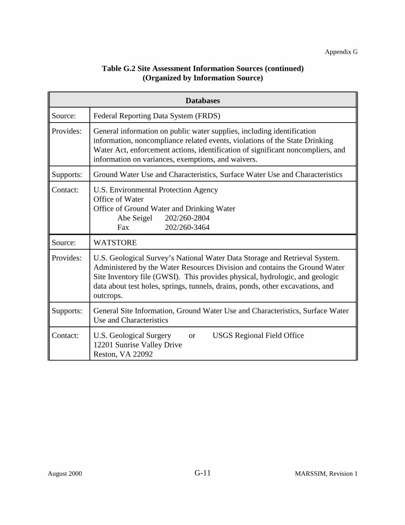
Source: Federal Reporting Data System (FRDS)
Provides: General information on public water supplies, including identification information, noncompliance related events, violations of the State Drinking Water Act, enforcement actions, identification of significant noncompliers, and information on variances, exemptions, and waivers.
Supports: Ground Water Use and Characteristics, Surface Water Use and Characteristics
Contact: U.S. Environmental Protection Agency Office of Water Office of Ground Water and Drinking Water
Abe Seigel 202/260-2804 Fax 202/260-3464
Source: WATSTORE
Provides: U.S. Geological Survey’s National Water Data Storage and Retrieval System. Administered by the Water Resources Division and contains the Ground Water Site Inventory file (GWSI). This provides physical, hydrologic, and geologic data about test holes, springs, tunnels, drains, ponds, other excavations, and outcrops.
Supports: General Site Information, Ground Water Use and Characteristics, Surface Water Use and Characteristics
Contact: U.S. Geological Surgery or USGS Regional Field Office 12201 Sunrise Valley Drive Reston, VA 22092
August 2000 G-11 MARSSIM, Revision 1

Appendix G
Table G.2 Site Assessment In formation Sources (continued) (Organized by Information Source)
Databases
Source: ISI (Information Systems Inventory)
Provides: Abstracts and contacts who can provide information on U.S. Environmental Protection Agency databases.
Supports: All information needs
Contacts: U.S. Environmental Protection Agency Office of Information and Resources Management Information Management and Services Division
ISI System Manager 202/260-5914 Fax 202/260-3923
Source: ERAMS (Environmental Radiation Ambient Monitoring System)
Provides; A direct assessment of the population intake of radioactive pollutants due to fallout, data for developing dose computational models, population exposures from routine and accidental releases of radioactivity from major sources, data for indicating additional measurement needs or other actions required in the event of a major release of radioactivity in the environment, and a reference for data comparison with other localized and limited monitoring programs.
Supports: Source and waste characteristics
Contact: U.S. Environmental Protection Agency National Air and Radiation Environmental Laboratory 540 South Morris Avenue Montgomery, AL 36115
Phone 334/270-3400 Fax 334/270-3454
MARSSIM, Revision 1 G-12 August 2000

Appendix G
Table G.2 Site Assessment In formation Sources (continued) (Organized by Information Source)
Maps and Aerial Photographs
Source: U.S. Geological Survey (USGS) Topographic Quadrangles
Provides: Maps detailing topographic, geographical, political, and cultural features. Available in 7.5- and 15-minutes series.
Supports: Site location and environmental setting; latitude/longitude; houses, schools, and other buildings; distances to targets; surface water body types; drainage routes; wetlands and sensitive environments; karst terrain features.
Contacts: U.S. Geological Survey or USGS Regional or Field Office 12201 Sunrise Valley Drive Reston, VA 22092
Source: National Wetland Inventory Maps
Provides; Maps delineating boundaries and acreage of wetlands.
Supports: Environmental setting and wetlands locations.
Contact: U.S. Geological Survey or U.S. Fish and Wildlife Service 12201 Sunrise Valley Drive 18th and C Street, NW Reston, VA 22092 Washington, DC 20240
Source: Ecological Inventory Maps
Provides: Maps delineating sensitive environments and habitats, including special land use areas, wetlands, study areas, and native plant and animal species.
Supports: Environmental setting, sensitive environments, wetland locations and size.
Contact: U.S. Geological Survey or U.S. Fish and Wildlife Service 12201 Sunrise Valley Drive 18th and C Streets, NW Reston, VA 22092 Washington, DC 20240
August 2000 G-13 MARSSIM, Revision 1
Appendix G
Table G.2 Site Assessment In formation Sources (continued) (Organized by Information Source)
Maps and Aerial Photographs
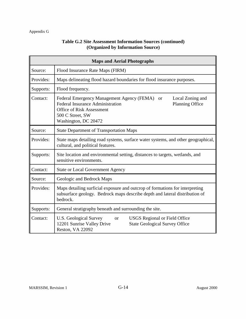
Source: Flood Insurance Rate Maps (FIRM)
Provides: Maps delineating flood hazard boundaries for flood insurance purposes.
Supports: Flood frequency.
Contact: Federal Emergency Management Agency (FEMA) or Local Zoning and Federal Insurance Administration Planning Office Office of Risk Assessment 500 C Street, SW Washington, DC 20472
Source: State Department of Transportation Maps
Provides: State maps detailing road systems, surface water systems, and other geographical, cultural, and political features.
Supports: Site location and environmental setting, distances to targets, wetlands, and sensitive environments.
Contact: State or Local Government Agency
Source: Geologic and Bedrock Maps
Provides: Maps detailing surficial exposure and outcrop of formations for interpreting subsurface geology. Bedrock maps describe depth and lateral distribution of bedrock.
Supports: General stratigraphy beneath and surrounding the site.
Contact: U.S. Geological Survey or USGS Regional or Field Office 12201 Sunrise Valley Drive State Geological Survey Office Reston, VA 22092
MARSSIM, Revision 1 G-14 August 2000

Appendix G
Table G.2 Site Assessment In formation Sources (continued) (Organized by Information Source)
Maps and Aerial Photographs
Source: Aerial Photographs
Provides: Black and white and/or color photographic images detailing topographic, physical, and cultural features.
Supports: Site location and size, location and extent of waste sources, identification of surrounding surficial geology, distances to targets, wetlands and sensitive environments. May provide information on historical site operations, waste quantity, and waste handling practices.
Contact: State Department of Transportation Local Zoning and Planning Office County Tax Assessor’s Office Colleges and Universities (geology or geography departments) EPA’s Environmental Monitoring Services Laboratory (EMSL) EPA’s Environmental Photographic Interpretation Center (EPIC) U.S. Army Corps of Engineers U.S. Department of Agriculture, Forest Service U.S. Geological Survey
Source: Global Land Information System (GLIS)
Provides: An interactive computer system about the Earth’s land surfaces information. GLIS contains abstract, description, and search information for each data set. Through GLIS, scientists can evaluate data sets, determine their availability, place online requests for products, or, in some cases, download products. GLIS also offers online samples of earth science data.
Supports: Site location and environmental setting; latitude/longitude; houses, schools, and other buildings; distances to targets; surface water body types; drainage routes; wetlands and sensitive environments; karst terrain features.
Contact: Internet: http://mapping.usgs.gov or U.S. Geological Survey 12202 Sunrise Valley Drive Reston, VA 20192, USA
August 2000 G-15 MARSSIM, Revision 1

Appendix G
Table G.2 Site Assessment In formation Sources (continued) (Organized by Information Source)
Maps and Aerial Photographs
Source: Topologically Integrated Geographic Encoding and Referencing (TIGER) System
Provides: Automates the mapping and related geographic activities required to support the decennial census and sample survey programs of the U.S. Census Bureau starting with the 1990 decennial census. The topological structure of the TIGER data base defines the location and relationship of streets, rivers, railroads, and other features to each other and to the numerous geographic entities for which the Census Bureau tabulates data from its censuses and sample surveys.
Supports: General Site Information, Soil Exposure Characteristics, Air Pathway Characteristics
Contacts: http://www.census.gov/geo/www/tiger Public Information Office Room 2705, FB-3 Census Bureau U.S. Department of Commerce Washington, DC 20233
MARSSIM, Revision 1 G-16 August 2000

Appendix G
Table G.2 Site Assessment In formation Sources (continued) (Organized by Information Source)
Files
Source: Office project files
Provides: Site investigation reports, logbooks, telecons, references, etc.
Supports: Information on nearby sites such as town populations, public and private water supplies, well locations, targets, and general stratigraphy descriptions.
Source: State Environmental Agency files
Provides; Historical site information, permits, violations, and notifications.
Supports: General site information and operational history, source descriptions, waste quantities and waste handling practices. May provide results of previous site investigations.
August 2000 G-17 MARSSIM, Revision 1

Appendix G
Table G.2 Site Assessment In formation Source (continued) (Organized by Information Source)
Files
Source: EPA Regional Libraries
Provides: Historical information on CERCLIS sites, permits, violations, and notification. Additionally provides interlibrary loan services.
Supports: General site information and operational history, source descriptions, waste quantities and waste handling practices. May provide results of previous site investigations.
Contact: USEPA Region 1 Library JFK Federal Building Boston, MA 02203 617/565-3300
USEPA Region 2 Library 290 Broadway 16th Floor New York, NY 10007-1866 212/264-2881
USEPA Region 3 Information Resources Center, 3PM52 841 Chestnut Street Philadelphia, PA 19107 215/597-0580
USEPA Region 4 Library Atlanta Federal Center 61 Forsyth Street, SW Atlanta, GA 30303-8909 404/562-8190
USEPA Region 5 Library 77 W. Jackson Blvd., 12th Floor Chicago, IL 60604-3590 312/353-2022
USEPA Region 6 Library, 6M-A1 1445 Ross Avenue, Suite 1200 First Interstate Bank Tower Dallas, TX 75202-2733 214/655-6427
USEPA Region 7 Information Resources Center 726 Minnesota Avenue Kansas City, KS 66101 913/551-7358
USEPA Region 8 Library, 8PM-IML 999 18th Street Suite 500 Denver, CO 80202-2405 303/293-1444
USEPA Region 9 Library, MS:P-5-3 75 Hawthorne Street San Francisco, CA 94105 415/744-1510
USEPA Region 10 Library, MD-108 1200 Sixth Avenue Seattle, WA 98101 206/553-1289 or 1259
MARSSIM, Revision 1 G-18 August 2000

Appendix G
Table G.2 Site Assessment In formation Sources (continued) (Organized by Information Source)
Expert and Other Sources
Source: U.S. Geological Survey
Provides: Geologic, hydrogeologic, and hydraulic information including maps, reports, studies, and databases.
Supports: General stratigraphy descriptions, karst terrain, depth to aquifer, stream flow, ground water and surface water use and characteristics.
Contact: U.S. Geological Survey or USGS Regional or Field Office 12201 Sunrise Valley Drive Reston, VA 22092
Source: U.S. Army Corps of Engineers
Provides: Records and data surrounding engineering projects involving surface waters.
Supports: Ground water and surface water characteristics, stream flow, locations of wetlands and sensitive environments.
Contact: U.S. Army Corps of Engineers
Source: State Geological Survey
Provides: State-specific geologic and hydrogeologic information including maps, reports, studies, and databases.
Supports: General stratigraphy descriptions, karst terrain, depth to aquifer, ground water use and characteristics.
Contact: State Geological Survey (Local or Field Office)
Source: Natural Heritage Program
Provides: Information on Federal and State designated endangered and threatened plants, animals, and natural communities. Maps, lists and general information may be available.
Supports: Location of sensitive environments and wetlands.
Contact: State Environmental Agency
August 2000 G-19 MARSSIM, Revision 1

Appendix G
Table G.2 Site Assessment In formation Sources (continued) (Organized by Information Source)
Expert and Other Sources
Source: U.S. Fish and Wildlife Service
Provides: Environmental Information
Supports: Locations of sensitive environments, wetlands, fisheries; surface water characteristics and stream flow.
Contact: U.S. Fish and Wildlife Service or U.S. Fish and Wildlife Service 18th and C Streets, NW Regional office Washington, DC 20240
Source: Local Fish and Wildlife Officials
Provides: Local Environmental Information
Supports: Locations of sensitive environments, wetlands, fisheries; surface water characteristics and stream flow.
Contact: State or Local Environmental Agency State or Local Game or Conservation Office
Source: Local Tax Assessor
Provides: Past and present land ownership records, lot and building sizes, assessors maps. May also provide historical aerial photographs.
Supports: Name of present and past owners/operators, years of ownership, size of site, and operational history.
Contact: Local Town Government Office
MARSSIM, Revision 1 G-20 August 2000

Appendix G
Table G.2 Site Assessment In formation Sources (continued) (Organized by Information Source)
Expert and Other Sources
Source: Local Water Authority
Provides: Public and private water supply information, including service area maps, well locations and depths, well logs, surface water intake locations, information regarding water supply contamination.
Supports: Locations and populations served by municipal and private drinking water sources (wells and surface water intakes), pumpage and production, blended systems, depth to aquifer, general stratigraphic descriptions, ground water and surface water characteristics, stream flow.
Contact: Local Town Government Office
Source: Local Health Department
Provides: Information and reports regarding health-related problems that may be associated with a site. Information on private and municipal water supplies, and onsite monitoring wells.
Supports: Primary/secondary targets differentiation, locations and characteristics of public substances present at the site.
Contact: Local Town Government Office
Source: Local Zoning Board or Planning Commission
Provides: Records of local land development, including historical land use and ownership, and general stratigraphy descriptions.
Supports: General site description and history, previous ownership, and land use.
Contact: Local Town Government Office
August 2000 G-21 MARSSIM, Revision 1

Appendix G
Table G.2 Site Assessment In formation Sources (continued) (Organized by Information Source)
Expert and Other Sources
Source: Local Fire Department
Provides: Records of underground storage tanks in the area, material safety data sheets (MSDS) for local commercial and industrial businesses, and other information on hazardous substances used by those businesses.
Supports: Location and use of underground storage tanks and other potential sources of hazardous substances, identification of hazardous substances present at the site.
Contact: Local Town Government Office
Source: Local Well Drillers
Provides: Public and Private water supply information including well locations and depths, well logs, pumpage and production.
Supports: Populations served by private and municipal drinking water wells, depth to aquifer, general stratigraphic information.
Source: Local University or College
Provides: Geology/Environmental Studies departments may have relevant published materials (reports, theses, dissertations) and faculty experts knowledgeable in local geologic, hydrologic, and environmental conditions.
Supports: General stratigraphic information, ground water and surface water use and characteristics, stream flow.
Source: Site Reconnaissance
Provides: Onsite and /or offsite visual observation of the site and surrounding area.
Supports: General site information; source identification and descriptions; general ground water, surface water, soil, and air pathway characteristics; nearby targets; probable point of entry to surface water.
MARSSIM, Revision 1 G-22 August 2000