Embed Size (px)
Citation preview

TransWest Express Transmission Project December 2016 Record of Decision Appendix F
Appendix F Notice to Proceed Process and Mitigation and Monitoring Requirements
TransWest Express Transmission Project December 2016 Record of Decision Appendix F-i
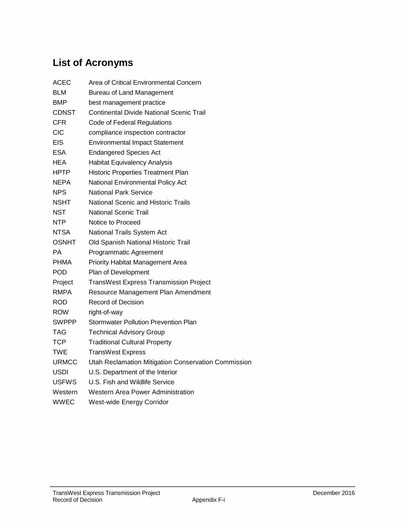
List of Acronyms
ACEC Area of Critical Environmental Concern BLM Bureau of Land Management BMP best management practice CDNST Continental Divide National Scenic Trail CFR Code of Federal Regulations CIC compliance inspection contractor EIS Environmental Impact Statement ESA Endangered Species Act HEA Habitat Equivalency Analysis HPTP Historic Properties Treatment Plan NEPA National Environmental Policy Act NPS National Park Service NSHT National Scenic and Historic Trails NST National Scenic Trail NTP Notice to Proceed NTSA National Trails System Act OSNHT Old Spanish National Historic Trail PA Programmatic Agreement PHMA Priority Habitat Management Area POD Plan of Development Project TransWest Express Transmission Project RMPA Resource Management Plan Amendment ROD Record of Decision ROW right-of-way SWPPP Stormwater Pollution Prevention Plan TAG Technical Advisory Group TCP Traditional Cultural Property TWE TransWest Express URMCC Utah Reclamation Mitigation Conservation Commission USDI U.S. Department of the Interior USFWS U.S. Fish and Wildlife Service Western Western Area Power Administration WWEC West-wide Energy Corridor

TransWest Express Transmission Project December 2016 Record of Decision Appendix F-ii
Contents
1.0 Additional Project-Specific Mitigation Measures ....................................................................... F-1
1.1 Notice to Proceed Requirements.......................................................................................... F-1 1.1.1 Explanation of the Notice to Proceed Process ..................................................... F-1
1.2 Structure Types ..................................................................................................................... F-9
1.3 Additional Required Biological Resources Mitigation to be Added to the NTP POD ....... F-14 1.3.1 Compensatory Mitigation for Impacts to Greater Sage-grouse Habitat ............. F-14 1.3.2 Platte River Species ............................................................................................. F-14 1.3.3 Biological Resources Monitoring and Adaptive Management Plan ................... F-14 1.3.4 Required Migratory Bird Mitigation ...................................................................... F-15
1.4 Cultural Resources Mitigation ............................................................................................. F-16 1.4.1 State-Wide Historic Property Treatment Plans (HPTPs) .................................... F-16 1.4.2 Tribal Monitoring Plan .......................................................................................... F-17 1.4.3 Cultural Resources Survey Requirements .......................................................... F-18
1.5 National Scenic and Historic Trail Mitigation ...................................................................... F-18
1.6 Nevada 368 Corridor of Concern Mitigation ....................................................................... F-19
1.7 Wilderness Characteristics Mitigation ................................................................................ F-20
1.8 Utah Reclamation Mitigation Conservation Commission (URMCC) Requirements ......... F-21
1.9 Dinosaur National Monument Special Use Permit Mitigation ............................................ F-22
2.0 Monitoring and Enforcement ...................................................................................................... F-22
2.1 Compliance Inspection Contractor (CIC) Requirements and CIC Third-party Contractors .......................................................................................................................... F-22
List of Figures
Figure ROD F-1 Selected Alternative and Requirements, Part 1 .................................................. F-11
Figure ROD F-2 Selected Alternative and Requirements, Part 2 .................................................. F-12
Figure ROD F-3 Selected Alternative and Requirements, Part 3 .................................................. F-13
List of Attachments
Attachment F.1 BLM Greater Sage-Grouse Mitigation Framework Plan
Attachment F.2 NPS Requirements for Access to Deerlodge Road

TransWest Express Transmission Project December 2016 Record of Decision Appendix F-1
1.0 Additional Project-Specific Mitigation Measures
The Bureau of Land Management (BLM) has developed mitigation and monitoring measures for the TransWest Express (TWE) Transmission Project (Project) through the National Environmental Policy Act (NEPA) process, to avoid, minimize and compensate for resource impacts associated with the Project. Secretarial Order No. 3330 and the BLM's Draft Regional Mitigation Manual 1794 provide guidance regarding landscape level mitigation for resources impacted by large infrastructure projects. Landscape level mitigation includes avoidance of impacts to the extent possible, then minimization of impacts and finally compensatation for remaining residual impacts by replacing or providing substitute resources within the mosaic of ecosystems where comparable important, scarce, or sensitive resources exist.
Proposed mitigation measures were initially described in Chapter 3 and Appendix C of the Final Environmental Impact Statement (Final EIS) (Section C.5, Table C.5-1). They have been refined and incorporated into the Environmental Protection Plans contained in the Plan of Development (ROD POD) and Table 17, ROD POD Section 8.3.2 Additional Mitigation Measures for the TWE Project (Appendix B of this ROD). Further refinement will occur before BLM issues a Notice to Proceed (NTP) and will be incorporated into the NTP POD for BLM approval.
In addition to the mitigation measures incorporated into the ROD POD (Appendix B of this ROD), prior to the issuance of an NTP (other than geotechnical) and the start of construction the applicant shall prepare an acceptable NTP POD that incorporates all of the mitigation measures required by the ROD including those identified in this Appendix.
1.1 Notice to Proceed Requirements
As explained in the ROD, under the applicable regulations an Applicant cannot initiate any construction or other surface disturbing activities on a ROW without the prior written authorization of the Authorized Officer or his/her delegate in the form of a NTP. Prior to the issuance of an NTP the Applicant shall demonstrate satisfaction of all applicable ROD requirements. This section describes the NTP process for the Project.
1.1.1 Explanation of the Notice to Proceed Process
Although the BLM is issuing a ROW grant for the Project, there are several details concerning Project design, construction, and mitigation actions that cannot be finalized until after BLM issues a decision identifying a selected alternative. Post-ROD requirements consist of completing an acceptable NTP POD which will include meeting BLM NTP requirements and ROW terms, conditions and stipulations before any overall Project NTP is issued. This overall NTP POD covering Project-wide practices and requirements will contain the final plans outlined in the attached ROD POD, including any updates/revisions to those plans required by this ROD. The NTP POD also will include additional NTP requirements outlined in the ROW grant.
Applicant committed measures and identified mitigation analyzed in the Final EIS and reflected in the ROD POD (Appendix B to the ROD) will be implemented Project-wide as described in the Tables found in the Environmental Mitigation Measures Chapter and elsewhere through-out each section of the POD, consistent with the proposed action as analyzed in the Final EIS and as a condition of this decision. Mitigation of impacts to affected resources is a required component of this decision (40 Code of Federal Regulations [CFR] 1508.20).

TransWest Express Transmission Project December 2016 Record of Decision Appendix F-2
Selected mitigation and applicable resource mitigation plans are discussed and included in this appendix and in the ROW grant. The final NTP POD will include adequate details regarding the types of mitigation measures and how they will be implemented. A final project wide NTP will be issued only after acceptance by BLM of the NTP POD and satisfaction of all required mitigation and monitoring and other stipulations as described in the ROD.
The ROW grant establishes the Applicant’s right to use the authorized public lands to construct, operate, maintain and decommission a high-voltage electric transmission line and associated facilities, and set forth the terms and conditions of that authorization (e.g., requiring the Applicant to pay rent in accordance with 43 CFR 2806 from the date the grant is issued). An Applicant is not permitted to use the areas covered by the ROW grant for the proposed Project until the actions listed below are completed and a NTP is issued. Consistent with the requirements of the ROD, the following activities must be performed following the issuance of the ROD and ROW grant and prior to issuance of an NTP for the Project:
• Acquisition of authorizations on state and private lands;
• Completion of biological resources surveys including but not limited to federally listed species under the Endangered Species Act (ESA) as outlined in the Final Biological Assessment (April 8, 2015) including addendums, BLM sensitive species, etc. to inform final engineering and design.
• Completion of final engineering to include final structure locations, final access road layout including field verification of structure locations, and proposed access roads for the selected alternative;
• Layout and field verification of all temporary work areas to include material storage yards, fly yards/laydown areas and portable concrete batch plants;
• Completion of biological preconstruction surveys and reports;
• Completion of Class III cultural resource surveys pursuant to the stipulations in the PA, completion of analysis and preparation of summary reports including preparation and approval of Historic Property Treatment Plans (HPTP), and implementation of mitigation measures at sensitive locations where resources cannot be totally avoided, regardless of jurisdiction;
• Delineation of jurisdictional Waters of the U.S. and any other resource surveys required to support permitting;
• Acquisition of remaining federal permits and acquisition of required state and local permits, stipulations and conditions of approval set forth in the RODs, including fully developed environmental management plans.
• Review and acceptance by BLM of the greater sage-grouse habitat equivalency analysis (HEA) based on the site-specific engineered and designed transmission line including access roads, staging areas, and any other areas of temporary or permanent disturbance related to the Project and other areas of temporary disturbance related to the project.
• Completion of a final greater sage-grouse mitigation and monitoring plan consistent with the plan in the ROD POD and as directed in the Greater Sage-Grouse Mitigation Framework Plan attached to this Appendix F as Attachment F.1.
The Applicant shall not initiate any construction or other surface disturbing activities on the ROW without the prior written authorization of the Authorized Officer or his/her delegate in the form of a NTP. Any NTP shall authorize construction or use only as therein expressly stated and only for the particular location or use therein described. Prior to the issuance of each NTP, all applicable environmental protection and mitigation plans needed will be completed by the Applicant and approved by the Authorized Officer or

TransWest Express Transmission Project December 2016 Record of Decision Appendix F-3
his/her delegate, and proof of possession of all required and applicable federal permits shall be submitted by the Applicant to the BLM. The Authorized Officer may suspend or terminate in whole or in part any NTP which has been issued when, in his/her judgment, unforeseen conditions arise which result in the approved terms and conditions being inadequate to protect the public health and safety or to protect the environment.
1.1.1.1 Master NTP POD Augmentation Requirements through the NTP Process
To demonstrate the satisfaction of the aforementioned requirements, an updated POD is required which demonstrates that a federal ROW Applicant’s construction, operation, rehabilitation, and environmental protection plans (43 CFR Part 2804.25) satisfy applicable requirements. Such an updated POD is referred to as the NTP POD and must be submitted to BLM for acceptance and approval (43 CFR Part 2805.10(a)(2)) prior to NTP issuance. The NTP POD will be based on the current version of the Project’s POD which has been updated as the Project has progressed through the NEPA review and analysis process to:
• Provide the Project description and technical information necessary for the federal agencies to conduct required environmental reviews of the Project, including compliance with the NEPA; and
• Identify the Applicant’s construction plans and specifications, including federal agency stipulations, conditions of approval, environmental requirements and best management practices (BMPs).
An initial Project-wide POD was submitted in May 2007. POD revisions have occurred in 2008 and again in 2009, 2010, 2014 and in 2015. The POD, as amended, was included as an appendix to the Draft and Final EISs to support the analysis contained therein. The POD includes, among other things: (i) a description of the proposed facilities, and temporary and permanent land disturbance estimates; (ii) construction practices, including standard construction activities, schedules and equipment/manpower requirements, and special construction practices to be used in selective or sensitive environments; (iii) operation and maintenance practices, including routine maintenance and vegetation management of the transmission line ROW, emergency response, fire protection, and ROW safety requirements; (iv) design options for TransWest Express and the conditions under which each design option will meet the Project purpose and need; and (v) general environmental mitigation measures, which are part of the TWE Project Description.
The POD iterations supporting the Draft and Final EISs also contained multiple Environmental Protection Plans detailing the Applicant’s commitment to mitigate adverse impacts resulting from construction, operation, and maintenance of the Project (See Appendices of the Final EIS POD). The ROD POD for the Project (Appendix B to the ROD), was revised in November 2015. The ROD POD contains updated framework Environmental Protection Plans; and additional information related to the engineering, micro-siting, contracting and permitting of the Agency Preferred Alternative; and the initial layout of access roads, temporary work areas, and locational constraints (e.g., special status species habitat) of the Agency Preferred Alternative.
Prior to receiving a NTP from the BLM, the Applicant will complete a NTP POD based upon the ROD POD (see below). The NTP POD shall incorporate the results from all completed and BLM-approved resource surveys and reflect all elements required by the ROD, including this Appendix F, the Reasonable and Prudent Measures with Terms and Conditions in the USFWS BO (Appendix C of the ROD), and the requirements of the PA (Appendix E of the ROD). The NTP POD will detail the Applicant’s construction plans and specifications, and construction practices and procedures for the Selected Alternative. The NTP POD will be developed in coordination with the Compliance Inspection Contractor and adequate coordination with all BLM state and field offices, USFWS, and any additional cooperators identified by BLM, which may require multiple agency and Applicant in-person meetings and may include field visits to similar projects to develop acceptable designs and
TransWest Express Transmission Project December 2016 Record of Decision Appendix F-4
site-specific implementation of mitigation measures. It also will contain additional resource mitigation plans as described below as well as a map set that shows Project detail, sensitive resources identified by BLM and Project mitigation proposed to avoid, minimize, and compensate for impacts to those resources. Upon completion, the Applicant will submit the NTP POD for review and acceptance by the BLM and any agencies with jurisdictional or regulatory authority over resources affected by the Project.
The NTP POD also will describe the processes and procedures the Applicant will employ to comply with the requirements of the RODs for the Project and will include the Environmental Compliance Management Plan. Due to the length and complexity of the Project, multiple NTPs are anticipated; therefore, the NTP POD will be organized as follows:
1. Master NTP POD: will address overall Project guidelines, compliance with agency mitigation requirements, and stipulations and conditions of approval common to the entire Project. It will identify the design option, access roads BLM has approved for construction and construction practices and compliance plans common to the entire Project specific for that design option. The overall master NTP POD will contain all additional BLM requirements outlined in the ROD and ROW grant.
2. NTP Construction Spread PODs (as described in the attached ROD POD): will consist of construction segment-specific Project descriptions; final detailed engineering; mapping describing structure locations, access road layouts for approved roads, temporary work areas, etc.; segment-specific construction practices and compliance plans, and stipulations and conditions of approval for the Project segment covered by the request for a NTP.
3. Any changes to the Preliminary Engineered Alignment necessitated by results of preconstruction surveys will be incorporated into the NTP Construction Spread PODs, resulting in a Final Engineered Alignment that will be submitted to BLM for review. A variance may be required if changes to the alignment would move it outside the ROW grant area. Upon BLM’s approval, each NTP Construction Spread POD will be based upon field verified segment-specific construction plans incorporating all known resource data including field survey results.
NTPs for segments of the Project will be issued when the Master NTP POD and applicable NTP construction spread PODs are complete and have been accepted by the BLM and applicable agencies with jurisdictional authority over resources affected by such segments. The final NTP POD, including the Master NTP POD, the Construction Spread PODs, and the Engineering Alignment as described below, will be appended to the BLM ROW grant and become part of the enforceable terms and conditions of the grant, once it is accepted by BLM.
The NTP POD will contain additional resource mitigation plans as described below, as well as a map set that shows Project detail, sensitive resources identified by BLM and Project mitigation proposed where applicable to avoid, minimize, and compensate for impacts to those resources. These resource mitigation plans will be updated/expanded from the ones included in the ROD POD once final survey data and final engineering designs are available. The resource mitigation plans to be updated/expanded include:
• Access Road Siting and Management Plan
• Avian Protection Plan and Common Raven Management Plan
• Blasting Plan
• Cultural Resources Protection and Management Plan
• Dust Control and Air Quality Plan

TransWest Express Transmission Project December 2016 Record of Decision Appendix F-5
• Emergency Preparedness and Response Plan
• Environmental Compliance and Monitoring Plan
• Fire Protection Plan
• Flagging, Fencing, and Signage Plan
• Geotechnical Plan
• Greater Sage-grouse Habitat Equivalency Analysis, Mitigation and Monitoring Plan
• Hazardous Materials Management Plan
• Health and Safety Plan
• Noxious Weed Management Plan
• Operations and Maintenance Plan
• Paleontological Resources Management and Mitigation Plan
• Reclamation Plan
• ROW Preparation and Vegetation Management Plan
• Spill Prevention and Response Plan
• Stormwater Pollution and Prevention Plan (SWPPP)
• Traffic and Transportation Management Plan
• Visual Resources Management Plan
• Water Resources Protection Plan
• Wildlife and Plant Conservation Measures Plan
The required updates to the aforementioned plans include, but are not limited to:
Access Road Siting and Management Plan: This plan will include final field-verified access road layouts specific to each construction segment. The Applicant will be responsible for developing the final Access Road Siting and Management Plan. Local BLM field offices may require field verification to provide approval for the final Access Road Siting and Management Plan. The construction contractor may assist BLM with this. Many requested access roads will be required to be rehabilitated. The plan will clearly mark authorized access routes, identify speed limits in sensitive resource areas, and describe types of ROW access (i.e., existing roads - no improvements, etc.).
BLM will require BMPs developed based on site-specific conditions as required by the Field Offices for linear project access roads to minimize resource impacts including but not limited to erosion.
1. If surface disturbance cannot be avoided on slopes of 21-40 percent, a plan would be required which includes an erosion control strategy, geographic information system modeling, surveying by a certified engineer, and adherence to surface operating standards in the BLM Gold Book (U.S. Department of the Interior [DOI] and U.S. Department of Agriculture [USDA] 2007). For slopes greater than 40 percent, there would be no surface occupancy unless there is a plan and a detailed analysis (e.g., Order I soil survey by soil scientist) finds that conditions would allow occupancy while adequately protecting area from accelerated erosion.
2. Avoid routing through areas with slopes of 30 percent or greater. If avoidance is not practical, an erosion control strategy, reclamation and site plan with detailed survey by certified engineer are required. Avoid soils having high potential for wind erosion.

TransWest Express Transmission Project December 2016 Record of Decision Appendix F-6
3. Wetlands would require additional measures, such as no surface occupancy areas, erosion control strategies, mitigation to protect surface from rutting, compaction, and displacement, and disruption of surface and subsurface function, mitigation or restoration measures to restore hydrologic function to site, survey requirements and design by certified engineer. Certain access roads will be required to be reclaimed and rehabilitated while emergency access may be retained.
Avian Protection Plan: This plan will be updated with the intent that it will be revised and adapted as goals are achieved, innovative solutions are developed to mitigate impacts, agency guidance is adjusted, and conditions of the Project warrant. Although the plan in the ROD POD is identified as complete, additional requirements include but are not limited to:
• The Avian Protection Plan will be specific to Operation and Maintenance activities. Construction activities will be completed in accordance with the Final EIS and the requirements of the Wildlife and Plant Conservation Measures Plan contained in the ROD.
• Providing a communication plan section to indicate details regarding agency oversight and co-ordination.
• Providing for a qualified avian biologist and an avian program coordinator.
• Additional detail regarding mitigation for indirect impacts in addition to direct disturbance.
• Details regarding nest management.
• Identification of nest buffers to avoid direct impacts to nesting birds during the nesting season.
• Adequate monitoring for identified important bird areas that includes annual reporting to BLM and USFWS as well as an adequate adaptive management and monitoring plan to include things such as flight diverters, deterrents and line markings.
• Monitoring will include bird mortality details, tracking and reporting, describing how information will be shared and how adaptive management will be considered to reduce impacts.
• The Plan will include annual reporting to BLM and USFWS as the regulatory agency and an adequate adaptive management and monitoring component to the plan.
• Pre-construction clearance surveys involving nesting passerines will be completed within 14 days of planned vegetation disturbance; however, the NTP process may identify areas where clearance surveys for nesting passerines may be required to be completed within 7 days of planned vegetation disturbance due to timing of planned vegetation disturbance, density of anticipated nesting activities, diversity of avian species, and importance of habitat, etc. This requirement may supersede the 14 days described elsewhere in the ROD POD. In the Mojave, the migratory bird breeding season begins March 1 and extends to August 31 and requires clearance surveys prior to any vegetation disturbance. Biological monitors may be required in advance of vegetation clearing.
• Raptors shall be addressed in accordance with Romin and Muck (2002) and in coordination with recommendations provided by USFWS and BLM to incorporate a Site-specific analysis process into the Biological Resource Survey Plan that would allow BLM to look at each individual raptor nest in consideration of the spatial and seasonal buffer through a variance process.
Blasting Plan: This plan will be updated to include mapping of explosive storage locations and areas where blasting will occur, including identification of blasting within 0.25 mile of a known sensitive resource; as well as blasting in the vicinity of pipelines, and wells and springs that may be impacted. The Blasting Plan also will be reviewed and approved by all agencies with jurisdictional authority over resources that could potentially be impacted by blasting.
TransWest Express Transmission Project December 2016 Record of Decision Appendix F-7
Common Raven Management Plan: During the NTP process the Applicant will adopt the BLM Southern Nevada District’s Raven Management Plan, or create a similar plan through coordination with BLM and USFWS. See Section 1.3.3 for more information on what is required for this plan.
Cultural Resources Protection and Management Plan: This plan will be updated with information contained within the executed Programmatic Agreement (PA), as well as updated information based on completion of cultural inventory studies, mitigation plans, and monitoring plans.
Dust Control and Air Quality Plan: The construction contractor(s) will augment and update as needed based on final design and engineering of the Selected Alternative. Specific guidance applied by Field Offices that is applicable to the Project will be included in the NTP POD.
Emergency Preparedness and Response Plan: This plan will be updated with contact information. The Construction contractor(s) will be responsible for preparing and implementing this plan.
Environmental Compliance and Monitoring Plan: This plan will include fully defined roles, responsibilities and procedures for monitoring and ensuring the environmental compliance of the Project is in accordance with the terms, conditions, and stipulations of this grant.
Fire Protection Plan: This plan will be updated to include a restricted operations section, and a complete notifications section, to ensure regulation compliance and safety. The Construction contractor(s) will be responsible for preparing and implementing the final plan.
Flagging, Fencing, and Signage Plan: This plan will be updated to note that standard survey flags and stakes will be installed before the start of Project construction but not before the NTP has been received or field surveys have been done. The Construction contractor(s) will be responsible for preparing and implementing the final plan, with oversight by the Compliance Inspection Contractor.
Geotechnical Plan: This plan will be updated prior to initiation of any surface disturbing activities. Field surveys for sensitive plant species, Class III cultural resource inventories, and other required resource surveys will be conducted as necessary for the final Geotechnical Plan. Final geotechnical approval will result from an adequate plan in the NTP POD.
Greater Sage-Grouse Habitat Equivalency Analysis, Mitigation and Monitoring Plan: This plan will be refined based on site-specific engineering and design and reviewed by BLM and appropriate cooperating agencies. Prior to a NTP, the Applicant must submit for BLM’s approval a complete mitigation package that describes a robust mitigation project mix that will produce a net balance of habitat services over the lifetime of the Project in accordance with the HEA framework. Additional requirements include but are not limited to meeting current noise limitations near important sage grouse habitat, minimizing vegetation removal in sage brush and other important habitat and including specific disturbance justifications for activities in these habitats. The plan will meet the requirements explained in the greater sage-grouse mitigation framework plan which is Attachment F.1 of this Appendix. This plan will mitigate for direct and indirect impacts that enable BLM to identify a net conservation gain in PHMA and GHMA in Colorado and Utah and no net loss in GHMA (specific to the designated corridor) in Wyoming.
Hazardous Materials Management Plan: The Construction contractor(s) will be responsible for preparing and implementing the final plan.
Health and Safety Plan: The construction contractor(s) will be responsible for preparing and implementing the final plan.

TransWest Express Transmission Project December 2016 Record of Decision Appendix F-8
Noxious Weed Management Plan: This plan will be updated to include noxious weed Global Positioning System location(s) based on the final design and results of noxious weed preconstruction survey. The construction contractor(s) will be responsible for preparing and implementing the final plan.
Operations and Maintenance Plan: This plan will be based on detailed final engineering to include reference to all updated plans, lists of road closures and gate locations, maps with known “sensitive areas”, and agency contacts.
Paleontological Resources Management and Mitigation Plan: This plan will be updated to include the steps outlined for the identification of sensitive resources and appropriate mitigation measures which may include on-the-ground inventory. The Construction contractor will be responsible for preparing and implementing the final plan.
Reclamation Plan: This plan will be updated to include the final engineering and design, results of pre-construction field surveys, and continued agency coordination. The Reclamation Plan also will include details regarding reclamation goals, reclamation activities (including clearing, stockpiling of topsoil, seeding, stabilization, erosion control, noxious weed control, etc.) monitoring protocols, objectives to measure success, and triggers for re-doing reclamation activities if reclamation is unsuccessful. This will be coordinated with and approved by applicable BLM Field Offices and include specific field office requirements. The Construction contractor will be responsible for preparing and implementing the final plan. Acceptable seed mixtures will include locally-adapted native seed if available.
ROW Preparation and Vegetation Management Plan: This plan will be updated to include the final engineering and design, results of pre-construction field surveys, and continued agency coordination. The construction contractor will be responsible for preparing and implementing the final plan. The acceptable plan will limit vegetation removal and express a preference for drive and crush and minimize the blading of tower sites. Las Vegas Buckwheat occupied and potential habitat will be avoided in the Toquop Wash area in the Caliente Field Office. The Beaver Dam Slope and Mormon Mesa Area of Critical Environmental Concern (ACEC’s) require the salvage of cactus and yucca (IM NVL0000-2011-010) and acceptable NTP POD will include an acceptable process.
Additional requirements include but are not limited to:
• All land disturbed by new ROW except authorized new access roads shall be rehabilitated to as close to natural conditions as possible.
Spill Prevention and Response Plan: This plan will be updated as needed based on the final design and engineering, and will include a complete and up-to-date emergency contact list. Construction contractor(s) will be responsible for preparing and implementing the final plan.
Stormwater Pollution Prevention Plan: (SWPPP): This plan will be updated based on final detailed engineering and design layouts and construction segments or spreads. The Construction contractor(s) will be responsible for preparing the final SWPPPs for each state agency and submittal of the Notice of Intent prior to start of construction.
Traffic and Transportation Management Plan: This plan will be updated as needed based on final design and engineering. The Construction contractor(s) will be responsible for preparing and implementing the final plan. The plan will meet access road siting, construction and maintenance requirements explained in the Final EIS based on the Selected Alternative identified in the ROD.
Visual Resources Management Plan: This plan will be updated to include a summary of sensitive visual resources based on the Selected Alternative identified in the ROD, any specific locations of visual resource mitigation requirements, and any updates as required by the appropriate agencies.

TransWest Express Transmission Project December 2016 Record of Decision Appendix F-9
Water Resources Protection Plan: This plan will be updated based on final detailed engineering and design, a complete list of 303(d) of impaired waters, identification of waters of the U.S. and wetlands based on results of pre-construction surveys, and a mitigation plan (if necessary) based on field surveys.
Wildlife and Plant Conservation Measures Plan: This plan will be updated based on final BMPs and mitigation measures identified in the Final EIS, including BLM sensitive and U.S. Forest Service (USFS) management indicator species, Biological Assessment/Biological Opinion, Biological Evaluation, and this ROD and through additional agency consultation for the Selected Alternative, final engineering and design, and the results of the pre-construction field surveys. This plan will identify how specific Field Office seasonal restrictions and stipulations, as identified in the Final EIS for biological resources, will be incorporated into the NTP POD based on biological resource survey results. An acceptable plan will either cross-reference or contain a biological monitoring and survey plan, as well as an adaptive management approach.
The NTP POD will contain a waste management plan that provides for daily disposal and removal of organic and non-construction waste and garbage during Project construction with appropriate containment of all waste in covered wildlife-proof containers.
The NTP POD will contain an adequate construction schedule and detailed plan as to how the schedule will be shared, updated and maintained. An overall Project schedule is suggested and a separate more detailed short term schedule is suggested for 3-4 week construction periods. Additional detail will be required in the preconstruction checklist for NTP issuance. The schedule will include a sequencing of construction activities, and specify that BLM will be timely notified of any changes.
NTP POD development and implementation will ensure agency personnel are involved throughout the Project area and identify specific areas where key resources require intensive agency involvement.
These additional requirements will enable BLM to comply with current regulation and policy. The NTP POD will be updated to include all additional BLM requirements in appropriate or additional POD sections.
1.1.1.2 NTP Construction Spread PODs
The Applicant shall submit construction PODs for each construction spread or work element that supplements the master NTP POD and describes in detail the construction of a portion of the ROW and its associated improvements and/or facilities. Construction spread PODs will tier from the master NTP POD, meaning that the criteria and practices identified in the master NTP POD are explicitly required Project-wide and need not be repeated in the construction spread PODs. Each construction spread POD shall include engineering route maps and alignment sheets that show the designs, locations and workspace for all facilities. The construction spread POD also shall identify spatial and temporal environmental restrictions, document the location of all required mitigation measures, and contain other pertinent project details.
These construction spread PODs will be reviewed, and if appropriate, modified and approved by the Authorized Officer. The number and location of construction spread PODs will be determined by the Applicant and specific construction plans prepared. When approved, a NTP will be issued allowing the Applicant to use the public lands covered by that construction spread POD within the terms and conditions of the ROW grant.
1.2 Structure Types
The ROD includes specific requirements related to transmission line structure types (i.e., power line poles) to minimize Project impacts on recreation and sensitive species.
TransWest Express Transmission Project December 2016 Record of Decision Appendix F-10
With respect to recreation activities, BLM has concluded that the guy wires from guyed structures pose a potential safety risk in high density motorized recreation areas. Accordingly, this decision requires self-supporting steel lattice structures in and adjacent to designated recreation areas in Utah.
With respect to sensitive species impacts, the BLM and U.S. Fish and Wildlife Service (USFWS) have determined that scientific evidence considered in the Final EIS supports the conclusion that predation reduction is achieved by reducing perching opportunities. Accordingly, the BLM and USFWS consider structure types that provide multiple horizontal surfaces (such as the self-supporting steel lattice and guyed steel lattice structures) to have the greatest potential to contribute to increased long-term indirect effects caused by increased predator presence and predation. As a result, self-supported tubular monopole structures and/or measures to reduce perching opportunities and bird strike risk (e.g., perch and nest deterrents and guy wire markers) are required (as outlined below) within habitat occupied by sensitive species, including greater sage-grouse, Mojave Desert tortoise, white-tailed prairie dog, pygmy rabbit, and black-footed ferret, especially in landscapes that are not influenced by existing infrastructure. These measures are designed to minimize the long-term indirect effects to these species. The following minimization measures related to structures types will be required prior to issuance of a NTP and must be incorporated in the NTP POD:
• Tubular self-supporting structures are required for an estimated 11 miles within a greater sage-grouse Priority Habitat Management Area (PHMA) in Colorado where there are no existing above-ground large transmission structures (Figure ROD F-1). Within the 11 miles of greater sage-grouse PHMA in Colorado, special engineering considerations may guide structure needs at the Yampa River crossing.
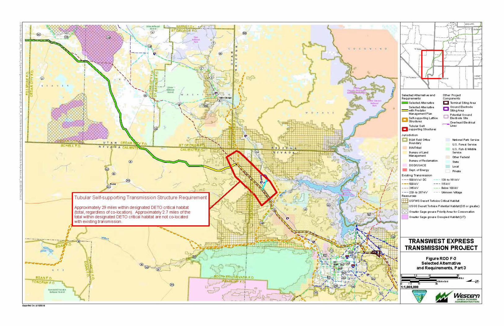
• Tubular self-supporting structures are required for the approximately 2.9 miles of Critical Habitat for Mojave Desert tortoise in Nevada as described in the ROD POD. Additionally, tubular self-supporting structures are required for the remaining designated Critical Habitat for Mojave Desert tortoise as shown in Figure ROD F-3, subject to the Nevada NTP DETO stipulation attached to the ROW grant.
• In addition to the required tubular structures noted in the previous bullet, BLM requires a BLM-approved Common Raven Management and Monitoring Plan for construction in both critical and general Mojave Desert tortoise habitat in Nevada (Figure ROD F-3).
• BLM requires self-supporting steel lattice structures in and adjacent to the following designated recreation areas in Utah: the Sheeprock/Tintic Off-Road Vehicle Area, the Cricket Mountains All-Terrain Vehicle Trails, and Little Sahara Recreation Area. The total mileage for these areas is approximately 35.5 miles. In addition, BLM requires the use of a BLM-reviewed and approved guy wire sleeve marking on BLM lands in open off-highway vehicle use areas where there is a high volume of recreation. Special marking requirements will be finalized in the NTP process for the areas shown in Figure ROD F-2.
• A nest management and monitoring plan to reduce avian predation that includes an acceptable application of perch discouragers, nest deterrents, guy wire markings and effectiveness monitoring, and is approved by BLM and cooperating agencies with regulatory authority, is required for construction in greater sage-grouse PHMA and General Habitat Management Area (GHMA) habitat on BLM land in Wyoming, Colorado, and Utah (Figures ROD F-1 through ROD F-3).


TransWest Express Transmission Project December 2016 Record of Decision Appendix F-14
1.3 Additional Required Biological Resources Mitigation to be Added to the NTP POD
1.3.1 Compensatory Mitigation for Impacts to Greater Sage-grouse Habitat
The Project is one of a limited number of priority projects that were well underway before the development of the greater sage-grouse Land Use Plan Amendments and associated EISs. BLM’s greater sage-grouse RODs and Approved Resource Management Plan Amendments (ARMPAs) were approved September 18, 2015. The plan amendments responded to the threats identified in USFWS’s 2010 “warranted but precluded” finding and were guided by the USFWS’s Conservation Objective Team Report and the BLM National Technical Team Report. The BLM’s greater sage-grouse RODs and RMPAs designated greater sage-grouse habitat areas, including Priority Habitat Management Areas (PHMAs), changed management objectives including realty actions such as transmission rights-of-way, and established conservation standards for designated PHMAs. BLM’s RODs and RMPAs, however, specifically indicated that the land use plan amendments and the management directions for realty action decisions do not apply to several priority transmission projects, including the TransWest Express Project and the portions of the Energy Gateway South Transmission project that are co-located with the TransWest Express Project. Even though the conservation management standards for greater sage-grouse set forth in the BLM’s ROD and RMPAs do not apply to these projects, the BLM identified through the Project-specific NEPA and decision making process conservation measures for greater sage-grouse that are similar to those in the BLM’s ROD and RMPAs.
Pursuant to applicable land use plans and policies and as analyzed in the Final EIS, the BLM prepared a landscape-scale Greater Sage-Grouse Mitigation Framework Plan (GSGMFP) to mitigate direct and indirect impacts associated with the BLM’s authorization of the proposed transmission line in greater sage-grouse habitat. The BLM’s GSGMFP establishes: 1) the process through which the BLM will assess direct and indirect impacts through the Habitat Equivalency Analysis (HEA) processes and will be used to assess final impacts once a final route is engineered; 2) the steps that the BLM and TransWest have already taken to mitigate impacts through avoidance (including siting and co-location) and minimization (application of design features and other measures, such as seasonal buffer restrictions), which were analyzed in the FEIS; and 3) the steps that TransWest must take to identify the residual impacts that may occur even after the application of avoidance and minimization measures. The BLM’s GSGMFP also identifies and requires compensatory mitigation measures necessary to address residual impacts to achieve a net conservation gain (specific to PHMA and GHMA in Colorado and Utah) and no net loss (specific to GHMA in the designated corridor in Wyoming) of greater sage-grouse habitat, similar to the standards in BLM’s land use plans and policies.
The GSGMFP is attached to this Appendix F as Attachment F.1.
1.3.2 Platte River Species
Compliance with the Platte River Recovery Agreement for three endangered and two threatened species in the Platte River drainage require identification of the location and amounts of water withdrawals from the basin. As these sources and quantities for the Project are not yet identified, the BLM is requiring the Applicant to provide that information. Upon consultation with the USFWS and determination that the water withdrawals are in compliance with the Agreement, the BLM will issue a NTP for this item.
1.3.3 Biological Resources Monitoring and Adaptive Management Plan
The NTP POD will require a Biological Resources Monitoring and Adaptive Management Plan approved by BLM and agencies with jurisdictional authority over biological resources being impacted. The plan will explain the survey process for all wildlife and special status species and include advance coordination with BLM prior to all survey work efforts. The plan will require the survey team to operate under the guidance and direction of BLM. No survey work will occur without adequate prior coordination and
TransWest Express Transmission Project December 2016 Record of Decision Appendix F-15
advance guidance by BLM and any agencies with jurisdictional authority over resources being impacted. An acceptable Biological Resources Monitoring Plan will state that if a federally listed species is encountered, all Project activity in the vicinity of the protected species will stop until a biological monitor, in conjunction with the appropriate agencies, determines that the level of impact associated with the Project activity will not go above that which was identified during Section 7 consultation.
For habitats where predation is a concern for greater sage-grouse, white-tailed prairie dog, pygmy rabbit, black footed ferret, and Mojave Desert tortoise, an acceptable Nest Management and Monitoring Plan to Reduce Avian Predation, including an acceptable application of perch discouragers, nest deterrents and guy wire marking as well as adaptive management, monitoring and reporting will be required to be submitted and accepted by BLM before NTP issuance. Final determinations of the application of perch and nest deterrents and guy wire markings will be made based on input of all agencies with jurisdictional and regulatory (USFWS) authority over impacted resources. Within the 11 miles of greater sage-grouse habitat in Colorado, special engineering considerations may guide structure needs at the Yampa River crossing. Additionally, the structure requirements discussed previously for these habitats would be implemented. Please see the structure types discussion found in Section 1.2 of this Appendix F for a detailed description on structure type requirements to minimize impacts to wildlife and motorized recreation.
For Mojave Desert tortoise habitat defined as U.S. Geological Survey model rating of 0.6 or higher in both the Caliente and Southern Nevada Field Offices, BLM requires a Raven Management Plan comparable to the Southern Nevada District's Raven Management Plan. The plan will include, but will not be limited to, monitoring for nests during the entire raven breeding season to reduce impacts to desert tortoises. The acceptable plan will include breeding season information from the Great Basin Bird Observatory, Nevada Department of Wildlife, or other credible sources of bird nesting information that will be used to provide raven breeding season information. The plan will include monitoring for ravens and desert tortoise carcasses during operation and maintenance activities. The Applicant will provide information on the extent of impacts to desert tortoises over the life of the transmission line. Monitoring will be conducted on an agreed upon regular basis which will be between annually and every 5 years. The development of the Raven Management Plan will include appropriate BLM and USFWS specialists. The Raven Management Plan will require approval by all agencies with jurisdictional and regulatory (USFWS) authority over resources impacted by the plan. Avian predation mortalities will be monitored and reported adequately in the Avian Protection Plan; therefore, their inclusion in the Raven Management Plan is not necessary.
1.3.4 Required Migratory Bird Mitigation
The ROD POD commits to appropriate avoidance and minimization measures that would effectively reduce impacts during construction and operation. Reclamation requirements would effectively restore habitats within the areas disturbed during construction and appropriate seed mixes would be considered to restore the habitats back to an ecologically functioning vegetation community similar to what was disturbed within the limitations of the ROD POD’s Vegetation Management Plan for operation and maintenance. The BLM’s obligations under Executive Order 13186 Responsibilities of Federal Agencies to Protect Migratory Birds (January 17, 2001) and resulting MOU between the BLM and USFWS to Promote the Conservation of Migratory Birds (April 12, 2010) are met through the on-site mitigation that is being applied to the projects through avoidance, minimization, and reclamation of disturbed habitats. The BLM’s obligations and conservation responsibilities under the MOU also are met through the many habitat improvement and restoration projects completed on BLM managed lands to benefit multiple species.
In addition to the avoidance and minimization measures, the compensatory mitigation identified through the greater sage-grouse HEA in Utah and Colorado and the sage brush habitat HEA in Wyoming will benefit migratory birds as outlined below.

TransWest Express Transmission Project December 2016 Record of Decision Appendix F-16
Wyoming: The compensatory mitigation for direct effects identified in the sagebrush habitat HEA (greater sage-grouse HEA minus the greater sage-grouse specific variables such as leks) will provide benefits to sagebrush obligate migratory bird species.
Colorado: The compensatory mitigation identified in the greater sage-grouse HEA will benefit sage-brush obligate migratory bird species. The majority of habitat crossed in Colorado is sagebrush and is covered by the greater sage-grouse HEA and associated mitigation or is co-located. The selected alternative does not cross old-growth pinyon-juniper.
Utah: The compensatory mitigation identified in the greater sage-grouse HEA will benefit sagebrush obligate migratory bird species. The selected alternative is largely co-located with existing infrastructure through Utah or crosses non-habitat (i.e., Little Sahara).
Nevada: No additional mitigation is required due to co-location with existing transmission lines and Mojave Desert tortoise mitigation.
1.4 Cultural Resources Mitigation
Section 106 of the National Historic Preservation Act (NHPA), 54 USC § 306108, requires federal agencies to take into account the effects of their undertakings on historic properties (36 CFR 800.1(a)). BLM has elected to prepare a PA to set forth the requirements for complying with the Section 106 process, which the Applicant must satisfy prior to receiving a NTP from BLM. The TransWest Programmatic Agreement (PA) signed and executed by all parties and effective October 18, 2016, is attached to the ROD as Appendix E. The undertaking and the identified area of potential effects covers the entire project regardless of land status or jurisdiction. The PA and its identification, evaluation and mitigation requirements apply to all jurisdictions, not exclusively to BLM or federal lands.
All reports required by the PA will be submitted to the BLM when the final design and engineering of any selected route is completed. As specified in the PA, the reports will be reviewed by BLM and its consulting parties. Upon BLM’s acceptance and approval of the Class III inventory reports and HPTPs, BLM will notify the Applicant in writing that these NTP requirements have been completed. Fulfillment of these requirements will be among the elements to be completed before BLM issues an NTP.
1.4.1 State-Wide Historic Property Treatment Plans (HPTPs)
Guided by the procedures and requirements of the PA titled, “TransWest Programmatic Agreement” signed and executed by all parties and effective on October 18, 2016 and by the results of the completed Class III cultural resources inventories for each state, a HPTP outline for each state affected by the Project will be prepared and submitted by the Applicant to the BLM as part of the NTP process. The BLM and the Consulting Parties will use this outline to determine HPTP content for each state. Based on the final outline as approved by the BLM, the Applicant will prepare an HPTP for each state affected by the Project. Each state-wide HPTP must be finalized and approved by the BLM as specified in the PA prior to the issuance of a NTP for any portion of the Project within that state. This includes but is not limited to the completion of a Treatment Plan for National Historic Trails.
The PA for the TransWest Express Project identifies processes and procedures to identify historic properties and to determine if historic properties are eligible for listing on the National Register of Historic Places and if these properties would be adversely affected by the Project’s construction and/or operations and maintenance. The Class III Inventory Reports will contain this site-specific information for each state. The state-wide HPTPs required by the PA must include site-specific plans for avoidance, minimization, and/or mitigation for each historic property that is determined to be adversely affected by the Project in that state. Identification of cultural resources in the Project area will occur during Class III inventories to be conducted within each state, including National Register eligibility determinations and

TransWest Express Transmission Project December 2016 Record of Decision Appendix F-17
findings of effect. The number and location of historic properties within each state’s HPTP is unknown at this time. The right to use the granted area within each state is withheld until that state’s HPTP is finalized in accordance with the PA procedures and requirements and further, until the avoidance, minimization and/or mitigation of adverse effects for each historic property is completed on the ground in accordance with the PA and the applicable HPTP.
The Applicant will post a BLM approved financial security with the BLM in an amount sufficient to cover all post-fieldwork costs associated with implementing each HPTP, or other treatment activities, as negotiated by the Applicant where they contract for services in support of this PA. Such costs may include, but are not limited to, treatment; post-field analyses; research and report preparation; interim and summary reports preparation; the curation of Project documentation and artifact collections in a BLM approved curation facility; and the repatriation and reburial of any human remains, sacred objects, or objects of cultural patrimony. The Applicant will post a financial security prior to BLM issuing a NTP for the segment where historic property treatment is required. The security posted is subject to forfeiture if the Applicant does not complete tasks within the time period established by the applicable HPTP; provided, however, that the BLM and the Applicant may agree to extend any such time periods. The BLM will notify the Applicant that the security is subject to forfeiture and will allow the Applicant 15 days to respond before action is taken to forfeit the security. The BLM will release the financial security, in whole or in part, as specific tasks are completed and accepted by the BLM.
The BLM shall monitor activities pursuant to the PA and each state’s HPTP. Should the Applicant or its cultural resources contractor fail to comply with any provision of the PA or each HPTP, the BLM may, at its discretion, counsel the Applicant and/or its cultural resources contractor regarding performance requirements, or suspend the permits under which the PA is executed. Such suspension could, at BLM’s discretion, result in the issuance of a “stop work” order for the entire Project if BLM determines it to be warranted based on the severity of the compliance failure.
1.4.2 Tribal Monitoring Plan
As a NTP requirement and a requirement of the PA, the Applicant will develop and submit to BLM for approval, a tribal monitoring plan that will contain the following provisions:
• Tribal monitoring is to be considered as a component of environmental monitoring.
• The Applicant will facilitate and fund tribal monitoring activities for each of the following tribal entities, should they request tribal monitoring: the Eastern Shoshone Tribe, the Northern Arapaho Tribe, the Las Vegas Paiute Tribe, the Moapa Band of Paiutes, the Paiute Tribe of Utah, and the Ute Tribe of the Uintah and Ouray Reservation. Each tribe must request tribal monitoring in writing to the BLM.
• The Applicant will develop the tribal monitoring plan in coordination with BLM and the tribes. Development of the plan will require face to face meetings with BLM and the tribes. The Applicant will submit the draft Plan to BLM for review. After review of the plan by BLM and the tribes and acceptance by the BLM, BLM will notify the Applicant that this NTP requirement has been completed. No surface disturbing activity associated with construction of the transmission line being permitted is to take place prior to receipt of this notification.
• The Applicant will ensure that the Tribal Monitoring Plan includes provisions for tribal participation in Class III inventories; monitoring of archaeological excavations associated with data recovery; monitoring of construction and reclamation activities; and tribal participation in reviewing reports.
• The plan will provide for tribal access to all Class III inventory and data recovery, construction and reclamation locations, as well as reasonable notification times.

TransWest Express Transmission Project December 2016 Record of Decision Appendix F-18
The Tribal Monitoring Plan will lay out roles and responsibilities for the Applicant, the BLM, the tribes, and tribal monitors, including when and to whom tribal monitors should report (generally directly to BLM as opposed to the Applicant or construction contractor).
• The Applicant will ensure that the Tribal Monitoring Plan includes provisions that outline how tribal concerns will be reported to BLM in a timely manner as well as procedures for how such concerns will be documented and how they will be addressed.
• The Applicant will ensure that any tribal concerns documented during the Class III inventory are included in the Class III inventory reports. The Applicant will ensure that any tribal concerns documented during archaeological data recovery and construction and reclamation are included in a monitoring report to be completed at the conclusion of the construction phase with an additional monitoring report to be completed at the conclusion of the reclamation phase.
• The tribal monitoring plan will provide for safety and sensitivity training for all project personnel. Sensitivity training will be developed in coordination with BLM and the tribes. BLM must approve such training in advance and the tribes must be given the opportunity to present portions of the training.
For tribal participation in the Project on tribal lands of the Moapa Band of Paiute Indians and the Ute Tribe of the Uintah and Ouray Reservations, the Tribal Monitoring Plans will comply respectively with the Tribal Consultation Agreement among the Bureau of Land Management, the Moapa Band of Paiute Indians, and TransWest Express LLC Regarding the TransWest Express Transmission Project (signed April 25, 2016) and the Tribal Consultation Agreement among the Bureau of Land Management, the Ute Indian Tribe, Uintah and Ouray Reservation and TransWest Express LLC Regarding the TransWest Express Transmission Project (signed September 7, 2016).
1.4.3 Cultural Resources Survey Requirements
Any Project related cultural resources survey and data recovery work will be coordinated with and authorized by BLM, including (1) review and approval of the scope of work and contractors selected and (2) reporting protocol. No cultural resources survey or data recovery work may be conducted without prior authorization by and coordination with BLM.
1.5 National Scenic and Historic Trail Mitigation
All applicable mitigation measures proposed in the Final EIS and included in Table 17, the ROD POD Section 8.3.2 Additional Mitigation Measures for the Project related to impacts to the Continental Divide National Scenic Trail (CDNST) and other National Historic Trails, including trails under study or recommended as suitable for congressional designation, are required.
To meet the policy and purposes of the National Trails System Act (NTSA Sec. 9(a)), to permit a project which will not substantially interfere with the nature and purposes of the trail (NTSA Sec. 7(c)), and to safeguard the nature and purposes of the National Scenic and Historic Trails (NSHT; BLM MS-6280 1.6.A.3.v.b), the BLM will apply the mitigation hierarchy to address impacts to the NSHT from this Project.
Avoidance and minimization measures to mitigate impacts to National Trails System components, including the CDNST and Old Spanish National Historic Trail (OSNHT), will be applied for the duration of the impacts from the Project. For residual (i.e., unavoidable) effects to the values and settings of the CDNST and OSNHT, that would remain after applying avoidance and minimization measures, compensatory mitigation will be required at a magnitude that is commensurate with the impacts. Compensatory mitigation may include measures such as securing trail land acquisition or perpetual easements along the impacted National Trails System components, and will be required to be applied for

TransWest Express Transmission Project December 2016 Record of Decision Appendix F-19
the duration of the impacts. All mitigation measures will be durable, additional, timely, monitored, adaptively managed, and reported.
The terms and conditions within the permit will include all identified NSHT-related avoidance, minimization, and compensatory mitigation measures, which may include applicant-proposed mitigation measures (e.g., design features), including the associated monitoring, adaptive management, and reporting requirements for these mitigation measures (NTSA Sec. 9(a)).
The OSNHT runs adjacent to the Project for 15 miles in the California Wash area near Moapa. This segment of the OSNHT has high potential for cultural resources that are conducive to recreation and interpretation of native habitats and ecosystems.
Impacts to the OSNHT include visual impacts on the integrity of setting, feeling, and association of the trail. CUL-1 and CUL-3 provide for on-site and off-site mitigation to compensate for cumulative impacts, as well as direct and indirect adverse effects to the OSNHT in Nevada, as directed in the NTSA. The mitigation will support meaningful measures to offset the cumulative impacts from this and other transmission projects in the area.
This mitigation for cumulative effects does not relieve the Applicant of its responsibilities under Section 106 of the NHPA or Project-specific BMPs for cultural resources.
Mitigation for impacts to the Old Spanish Trail consists of buffering the transmission alignment adjacent to the OSNHT for impacts to 45 miles of view shed for the trail. In addition, the Applicant is required to contribute $100,000 for actions including but not limited to interpretation of the OST and restoration of intact portions of the OSNHT.
1.6 Nevada 368 Corridor of Concern Mitigation
The Selected Alternative is located within a designated West-wide Energy Corridor (WWEC) that passes through the Rainbow Gardens ACEC (identified as “corridor of concern” 39-231 in the July 11, 2012, settlement agreement and also acknowledged in the inter-agency Memorandum of Understanding, work plan, and BLM policy guidance providing for the review of WWECs). The Applicant must include in the NTP POD the following mitigation to address the impacts discussed below:
The Gypsum Cave Traditional Cultural Property (TCP) and portions of the OSNHT are impacted by this Project. The Project alignment runs adjacent to the Gypsum Cave TCP, which is held as sacred to the Nuwu (Paiute) people. The TCP designation came about through consultation with the Nuwu and the Nevada State Historic Preservation Office as part of the mitigation of the Harry Allen to Mead transmission line, which was constructed within the WWEC corridor in 2009. The cumulative impacts identified include vandalism and the proliferation of unauthorized roads and trails because of increased access to the cave resources as well as visual, audible and atmospheric impacts on the integrity of setting, feeling and association of the TCP. CUL-2 provides for on-site and off-site mitigation to compensate for cumulative impacts, as well as unavoidable direct and indirect adverse effects to Gypsum Cave.
Impacts to rare plant habitat (Las Vegas bearpoppy [Arctomecon californica]) within the corridor of concern will be mitigated by a required payment of $20,000 per acre of disturbed habitat (15 acres equals $300,000) to be used by BLM for installation of post and cable fencing to protect Las Vegas bearpoppy habitat (estimated at $49/linear foot for 1.1 miles of fencing). This requirement is in lieu of the Applicant restoring Las Vegas bearpoppy individuals to the habitats disturbed by the Project; however, it is not in lieu of application of the Applicant’s Reclamation Plan.

TransWest Express Transmission Project December 2016 Record of Decision Appendix F-20
Mitigation for impacts to Gypsum Cave will consist of an estimated 4 miles of post and cable fencing needed to fence the TCP. The Applicant’s required contribution is $100,000 for construction of approximately 0.5 mile of post and cable fence.
1.7 Wilderness Characteristics Mitigation
Section 201 of FLPMA requires BLM to maintain, on a continuing basis, an inventory of all public lands and their resources and other values, which include wilderness characteristics. BLM conducted an inventory for lands with wilderness characteristics as part of the process of analyzing the resources impacted by the proposed Project and identified several areas within the preferred alternative that met the criteria for lands with wilderness characteristics as described in BLM Manual 6310 (e.g., are larger than 5,000 acres), but which BLM had not evaluated and considered for management as part of a land use planning process. BLM evaluated these newly inventoried lands with wilderness characteristics and analyzed the impacts to these areas in the Final EIS.
The Presidential Memorandum (Mitigating Impacts on Natural Development and Encouraging Related Private Investment, November 3, 2015), Secretarial Order 3330 (Improving Mitigation Policies and Practices of the Department of the Interior) and DOI’s manual section on landscape-scale mitigation (600 DM 6) direct BLM to implement landscape-scale mitigation for impacts from projects, especially for impacts to “important, scarce, and sensitive” resources, and implement mitigation through the mitigation hierarchy, i.e., first seek to avoid impacts, then minimize impacts, and then compensate for impacts. BLM’s interim policy on mitigation (BLM Instruction Memorandum No. 2013-142) also directs the agency to implement similar mitigation standards. Additionally, the Presidential Memorandum on mitigation and DOI’s manual section on landscape-scale mitigation direct the BLM to seek to achieve a no net loss or a net benefit standard for important, scarce, or sensitive resources.
BLM considers wilderness characteristics to be both an important and sensitive resource. Therefore, BLM is requiring the Applicant to provide compensatory mitigation for areas identified as having wilderness characteristics that will be impacted by this Project, but where the BLM has not yet considered, through a land use planning process, whether to manage such areas for protection. The BLM will not require compensatory mitigation for impacts to inventoried lands with wilderness characteristics units that were identified as part of a land use planning process wherein the BLM has made an affirmative management decision not to protect wilderness characteristics, unless the respective land use plan states otherwise.
Wilderness characteristics by their definition are resources that encompass lands that are roadless and predominantly natural with no or only very minor facilities – so it is not possible to implement on-site mitigation for a project that involves road and major facility construction. Residual impacts from this Project include two different types of impacts –
(1) Areas that are directly impacted by the Project footprint. In these areas, the construction of the Project would result in direct resource loss, for which compensatory mitigation is required. These impacts would be calculated as follows:
Total Length of units intersected by Project * Full Corridor Width = Area Impacted by Project Footprint
(2) In addition to areas directly impacted by the Project’s footprint, compensatory mitigation also is required where the Project bisects an inventoried unit creating one or two units that are smaller than 5,000 acres. For these impacts, compensatory mitigation would be required for the bisected

TransWest Express Transmission Project December 2016 Record of Decision Appendix F-21
parcels that are smaller than 5,000 acres (Manual 6310.06(C)(2)(a))1. Mitigation is necessary because the Project’s construction may create areas of lands with wilderness characteristics that no longer meet the criteria to be managed by BLM as such, and therefore for the smaller units (less than 5,000 acres) BLM faces the lost opportunity cost of not being able to make future planning decisions to manage those lands to protect those characteristics.
The Proponent will calculate the final acreage of impacted lands with wilderness characteristics based on the final project design and plan of development. To offset these impacts, BLM requires that the Applicant perform, or provide funding to perform, preservation and/or restoration actions to improve or protect the same amount of acres of wilderness characteristics as outlined below.
The preservation and/or restoration actions will consist of acquiring inholdings (either via conservation easement or fee-simple ownership) from willing sellers in designated wilderness (first priority) or wilderness study areas (second priority) or lands managed to protect wilderness characteristics under an RMP (third priority) within the states with units impacted by the Project. Acquisition of easements or edge holdings to provide public access to these respective areas also would be an example of appropriate mitigation. If acquisition is utilized to mitigate impacts, such impacts will be mitigated on a one-to-one basis. If acquisition is infeasible, as determined by BLM in consultation with the Applicant, actions may be conducted to restore wilderness characteristics in existing wilderness and wilderness study areas pursuant to Manual 6330—Management of BLM Wilderness Study Areas, and Manual 6340—Management of BLM Wilderness. Where restoration is utilized, mitigation will be required on a two-to-one basis to account for the potential uncertainty associated with the outcome of restoration activities. The BLM recognizes that a combination of preservation and restoration may be appropriate to meet the required compensatory mitigation requirements outlined above.
In either case, the wilderness characteristics benefited by the compensatory mitigation measures must be maintained, monitored, and adaptively managed, by the Applicant or an approved third party and according to BLM standards, for the duration of the impact from the Project, which BLM has analyzed in the EIS to be a minimum of 50 years (and potentially longer). Any future renewals of the ROW, if granted, would extend the timeline for compensatory mitigation and may necessitate additional requirements.
The BLM State Director of the affected state(s), considering input from local BLM Field Office Managers, will work with the Applicant to identify the specific compensatory mitigation measures or funding that the Applicant will perform and/or fund in order to fulfill the compensatory mitigation requirements identified in this ROD, including the maintenance, monitoring, and adaptive management of the compensatory mitigation measures. It should be noted that additional NEPA and decision documents may be necessary to implement some of these compensatory mitigation measures. The details of the compensatory mitigation measures will be made publically available. The Applicant will develop a plan and provide the funding and/or begin to perform the actions identified above, prior to the BLM's issuance of the NTP.
1.8 Utah Reclamation Mitigation Conservation Commission (URMCC) Requirements
A greater sage-grouse mitigation plan and other applicable mitigation measures that are reviewed and approved by URMCC are required before BLM will issue the NTP. The attached greater sage-grouse mitigation plan is expected to be augmented and completed so that the plan assesses direct and indirect impacts to greater sage-grouse. The plan is expected to include adequate mitigation across lands that
1 For example, if the line bisected a 10,000 acre unit and created two areas – one 8,000 acres and one 2,000 acres – mitigation would be required to account for the smaller 2,000 acre area (less project footprint, quantified as described in paragraph (1)).
TransWest Express Transmission Project December 2016 Record of Decision Appendix F-22
have improved habitats and whose acquisition and primary purpose is habitat enhancement, especially where the Project crosses the Strawberry Priority Area of Concern.
1.9 Dinosaur National Monument Special Use Permit Mitigation
If the Applicant wishes to seek a variance for the use of Deerlodge Road for any aspect of construction, operation or maintenance, it must incorporate in the NTP POD all requirements identified in the National Park Service (NPS) Requirements for Access to Deerlodge Road (Attachment F.2 to this Appendix F), and submit a detailed plan to meet those requirements to BLM and NPS for review and approval. A plan for compliance with the special use permit requirements from Dinosaur National Monument for commercial vehicle use of Deerlodge Road must be provided prior to NTP issuance.
2.0 Monitoring and Enforcement
The BLM and Western are the federal joint lead agencies for the Project under the NEPA. The BLM is responsible for ensuring compliance with all mitigation measures required in its ROD. These measures will be incorporated into the Applicant’s final NTP POD. The final NTP POD must be reviewed and accepted by the BLM Authorized Officer before BLM will issue any NTP for the Project. The BLM also has incorporated standard terms, conditions, and stipulations into the ROW grant. Failure on the part of the grant holder(s) to adhere to these terms and conditions could result in various administrative actions up to and including suspension or termination of the ROW grant and requirements to remove the facility and rehabilitate disturbances.
The BLM, USFS, URMCC, and U.S. Bureau of Reclamation, will be responsible for enforcement of the terms and conditions of the BLM’s ROW grant, USFS’s special use permit and URMCC’s and U.S. Bureau of Reclamation’s special use authorizations (collectively, “authorizations”) on federal lands during the terms of the respective authorizations. Compliance with state and local permits and authorizations also is an enforceable condition of BLM’s ROW grant. This compliance will be ensured through compliance monitoring contractors (see Section 2.1 below), as well as subsequent post-construction and post-reclamation monitoring by BLM and other applicable agencies with jurisdictional authority. The Compliance Inspection Contractor (CIC) will coordinate actively with the BLM and these applicable agencies throughout all monitored stages of construction and reclamation.
2.1 Compliance Inspection Contractor (CIC) Requirements and CIC Third-party Contractors
The Applicant will retain a qualified independent environmental Compliance Inspection Contractor (CIC) to be approved by the BLM, as the federal land management agency, to monitor activities during the pre-construction, construction, operation and reclamation phases of the Project. The CIC will communicate with BLM during construction and provide reports to designated BLM contacts in accordance with the approved communications plan. The Applicant will be required to reimburse BLM’s costs to review the CIC’s reports and perform other tasks associated with monitoring all phases of the project, including pre-construction, construction, operation and reclamation of the Project (43 CFR 2805.16(a)).
In the event that the Applicant does not identify a CIC that BLM finds suitably qualified, BLM may retain its own CIC in accordance with federal regulations. If BLM directly contracts with a CIC, the Applicant will be required to reimburse BLM for all costs associated with work performed by the CIC, and BLM’s costs to oversee the CIC’s work (43 CFR 2805.16(a)).
The CIC’s primary responsibility will be to observe all work activities, recommend methods to prevent non-compliance, communicate with BLM during construction and provide reports to the BLM including

TransWest Express Transmission Project December 2016 Record of Decision Appendix F-23
reports of non-compliant situations. Additional responsibilities are described in Appendix G of the ROD POD (Appendix B of this ROD). Any conflicting information found in the ROD POD is superseded by the ROD and this Appendix. The CIC’s duties include:
• Monitoring preconstruction, construction, operation, and reclamation activities on federal and non-federal lands, documenting Project disturbance that occurs along the entire Project, and assisting the Applicant in ensuring compliance with the terms and conditions of the federal authorizations. In addition, the CIC must ensure that the Project adheres to any state and local permits that contains conditions to construct.
• Supervising and supporting a team of compliance monitors consisting of individuals with experience with ultra-high voltage transmission construction that includes projects in the Western United States, as well as expertise and experience regarding the resources for which mitigation is required, including biological, cultural, and soil science expertise.
• Ensuring compliance with all avoidance, minimization and mitigation commitments contained in this ROD.
• Performing post-construction and reclamation monitoring for the transmission line, temporary permitted areas and ancillary facilities.
• Maintaining a Project history, developing and implementing an effective communication plan including daily and weekly conference calls, a Project Share Point site, and a record of all Project communications.
BLM approval requests by the Applicant in connection with all NTP requirements will be developed in coordination with the CIC for the Project before being finalized and before BLM will consider issuing any NTP. The BLM will review the scope of work for all CIC contractors and subcontractors proposed to work on the Project and approve the contractor or subcontractor. The contractor or subcontractors may include EIS, biological, cultural resources, compliance, and monitoring contractors or subcontractors.

TransWest Express Transmission Project December 2016 Record of Decision Appendix F.1
Attachment F.1 BLM Greater Sage-grouse Mitigation Framework Plan

TransWest Express Transmission Project December 2016 Record of Decision Appendix F.1-i
Contents
1.0 Introduction .................................................................................................................................. F.1-1
1.1 Background ........................................................................................................................ F.1-1
1.2 Mitigation Hierarchy ........................................................................................................... F.1-2 1.2.1 Best Management Practices ............................................................................... F.1-3 1.2.2 Impact Avoidance and Minimization Measures ................................................. F.1-3
1.3 Framework Purpose and Objectives ................................................................................. F.1-4
2.0 Principles, Standards, and Technical Elements ..................................................................... F.1-6
2.1 Planning for Compensatory Mitigation .............................................................................. F.1-6 2.1.1 Cooperator Participation ..................................................................................... F.1-6 2.1.2 Landscape-scale Approach and Compensatory Mitigation Siting..................... F.1-6
2.2 Principles of Compensatory Mitigation .............................................................................. F.1-7 2.2.1 Duration ............................................................................................................... F.1-7 2.2.2 Durability .............................................................................................................. F.1-7 2.2.3 Mitigation Measures and Project Outcomes, Performance Standards,
Metrics, and Accounting ..................................................................................... F.1-8 2.2.4 Effectiveness Monitoring ................................................................................... F.1-10 2.2.5 Adaptive Management ...................................................................................... F.1-10 2.2.6 Reporting ........................................................................................................... F.1-10 2.2.7 Responsible Parties .......................................................................................... F.1-11 2.2.8 Best Available Science ..................................................................................... F.1-11 2.2.9 Managing Risk and Uncertainty ....................................................................... F.1-11
2.3 Key Attributes of Compensatory Mitigation ..................................................................... F.1-12 2.3.1 Reasonable Relationship .................................................................................. F.1-12 2.3.2 Timeliness ......................................................................................................... F.1-12 2.3.3 Baseline and Additionality ................................................................................. F.1-12
2.4 Summary of Key Components of a Mitigation Plan ........................................................ F.1-13
3.0 Implementation, Management, and Monitoring .................................................................... F.1-14
4.0 Evaluating the Mitigation Plan ................................................................................................. F.1-15
5.0 Contributors and Coordination ............................................................................................... F.1-15
6.0 Literature Cited .......................................................................................................................... F.1-16
7.0 Glossary ...................................................................................................................................... F.1-18

TransWest Express Transmission Project December 2016 Record of Decision Appendix F Attachment F.1-ii
List of Attachments
Attachment A TransWest Express Transmission Project Mitigation Strategy Tables
Attachment B Summary of TAG Issues
Attachment C Technical Advisory Group Greater Sage-grouse Mitigation Guidance for the TransWest Express and Energy Gateway South Transmission Line Projects (SWCA 2016)

TransWest Express Transmission Project December 2016 Record of Decision Appendix F.1-1
1.0 Introduction
1.1 Background
The Bureau of Land Management (BLM) in coordination with U.S. Fish and Wildlife Service (USFWS) developed a framework for analysis of impacts to greater sage-grouse for the TransWest Express Transmission Project (Project) (Final Environmental Impact Statement [FEIS] Appendix J, Exhibit J1: Framework for Sage-grouse Impacts Analysis for the TransWest Express Transmission Project, 2013 [BLM 2015a]). The impact analysis framework was developed during preparation of the FEIS to analyze potential impacts on greater sage-grouse that bear directly on the factors considered by the USFWS when evaluating whether to list a species under the Endangered Species Act (ESA), and was premised on review of the threat assessment/five factor analysis that USFWS conducted as part of the March 23, 2010 (75 FR 13910), listing of the sage-grouse as a Candidate species under the ESA. In support of BLM’s analysis, TransWest Express, LLC (Applicant or TransWest) provided detailed information about compensatory mitigation using habitat equivalency analysis (HEA); this information can be found in the Project FEIS Appendix D (Plan of Development) at Appendix K – Greater Sage-grouse Mitigation Plan (BLM 2015a).
In response to the USFWS 2010 determination that listing of the greater sage-grouse was “warranted but precluded,” the BLM and U.S. Forest Service (USFS) developed a landscape-level strategy to address the threats identified in the USFWS 2010 listing decision and the USFWS Conservation Objectives Team Report (USFWS 2013). This unprecedented science-based planning effort to conserve greater sage-grouse occurred concurrently with the National Environmental Policy Act (NEPA) process for the Project. In September 2015, the BLM and USFS announced the Records of Decision and Approved Resource Management Plans (ARMPAs) for the Great Basin Region Greater Sage-grouse sub-regions of Idaho and Southwestern Montana, Nevada and Northeastern California, Oregon, and Utah (BLM 2015b) (available from: http://www.blm.gov/style/medialib/blm/ut/natural_resources/SageGrouse/ ARMPA_appendices.Par.81455.File.dat/GB%20ROD%209.21.15_508_lowres.pdf), and for the Rocky Mountain Region, including the sub-regions of Lewiston, North Dakota, Northwest Colorado, and Wyoming (BLM 2015c) (available from: https://eplanning.blm.gov/epl-front-office/projects/lup/ 36511/63222/68471/RM_ROD_9.21.15_508_lowres.pdf). The TransWest Express Project, as a Rapid Response Team for Transmission Priority Project, is specifically exempted from the ARMPA decisions, with consideration that the Project’s NEPA process results could achieve mitigation standards that are consistent with the ARMPA standards referenced here.
In October 2015, the USFWS announced a 12-month finding on the petitions to list greater sage-grouse and determined that listing was not warranted at the time based on review of best available science and commercial data (Docket No. FWS–R6–ES–2015–0146).
The TransWest (TWE) FEIS was developed in accordance with current relevant laws, regulations, policies, and plans including those guiding agency decisions that may have an impact on resources and their values, services, and functions. The sequence of mitigation actions follows the mitigation hierarchy (avoid, minimize, rectify, reduce or eliminate over time, and compensate) as identified by the White House Council on Environmental Quality (CEQ) (40CFR 1508.20) and the BLM’s Draft Regional Mitigation Manual Section 1794 (interim policy). During the NEPA process, project siting and design, design features and additional mitigation measures to minimize impacts to resources were developed to consider the full mitigation hierarchy to avoid, minimize, rectify, or reduce impacts over time and last, to compensate for residual impacts on important, scarce, or sensitive resources. For example, the BLM’s selection of the Agency Preferred Alternative involved careful routing and siting to avoid and minimize impacts on resources (e.g., residential areas, agriculture, cultural resources, and visual resources), maximize use of existing utility corridors and roads, and closely parallel existing transmission lines.
TransWest Express Transmission Project December 2016 Record of Decision Appendix F Attachment F.1-2
After initial impacts were identified during the NEPA process, the BLM determined whether agency-required mitigation measures were needed to avoid, minimize, or rectify or restore Project impacts. The agency-required mitigation measures that would be applied to avoid, minimize, or rectify and/or restore the Project effects are analyzed in Chapter 3 of the FEIS and summarized in FEIS Appendix C. Agency-required mitigation measures and Applicant-committed design features and mitigation are summarized in Tables 1 and 2 in Attachment A of this Framework. These measures comprise the first steps of the Project mitigation sequence that involves avoidance, minimization, rectification and compensatory mitigation as engineering is finalized prior to construction. Tables 1 and 2 in Attachment A identify where residual impacts warrant compensatory mitigation based on the impact indicator identified and the residual effects that remain after avoidance and minimization are applied. During final engineering and design, the Applicant will further demonstrate where avoidance and minimization will occur.
1.2 Mitigation Hierarchy
This section provides background on the mitigation hierarchy that resulted from the NEPA process. During the final engineering and design phase of the Project, the Applicant will demonstrate the application of the mitigation hierarchy in the mitigation plan, specifically where avoidance and minimization has been applied. The mitigation hierarchy is described below in both a general context and in the context of the Project in particular and is mitigation that has already been identified through the NEPA process:
• Avoidance. Measures taken to avoid impacts altogether by not taking a certain action or parts of an action. Avoidance measures applied to the TransWest Express Project include reviewing each route’s potential impacts on sensitive resources prior to considering the route for detailed analysis. Avoidance also includes more site-specific avoidance activities, such as those described in the design features of the TransWest Express Project for environmental protection and selective mitigation measures. See Attachment A of this Framework. It also is expected that further avoidance will occur through the Applicant’s final engineering and design of the selected route. The development of the route alignments is described in Chapter 2.0 of the FEIS; the TransWest Express Project was designed to avoid sensitive resources to the extent practicable.
• Minimization. Measures taken to minimize impacts by limiting the degree or magnitude of the action and its implementations. Minimization measures taken by the Project include, for example, actions to decrease effects on wildlife species, such as design components to lessen aerial collisions with the transmission lines and timing restrictions for construction and maintenance. Multiple environmental protection measures designed to minimize impacts have been included as part of the Project and can be found in the Applicant-committed design features and mitigation measures for the Project. Refer to Attachment A of the Framework (specifically Table 2). It also is expected that further minimization methods will be implemented through the Applicant’s final engineering and design of the selected route.
• Rectification/Reduction or Elimination of Impacts over Time. Measures taken to rectify impacts by repairing, rehabilitating, or restoring the affected environment or by reducing or eliminating the impact over time by preservation and maintenance operations during the life of the affecting action. Rectification, reduction, and elimination measures adopted by the Project include identified design features of the Project for environmental protection and selective mitigation measures (for example, surface restoration, recontouring and reseeding disturbed work areas). Refer to Attachment A of this Framework.
The priority is to mitigate impacts at the site of the activity in conformance with the land-use plan goals and objectives through impact avoidance, minimization, rectification, and reduction over time of the impact, including those measures described in laws, regulations, policies, and land-use plans. When
TransWest Express Transmission Project December 2016 Record of Decision Appendix F Attachment F.1-3
these types of mitigation measures are not sufficient to ameliorate anticipated direct, indirect, and cumulative impacts and substantial or significant impacts on important, scarce, or sensitive resources remain, additional compensatory mitigation measures to offset these residual impacts or meet applicable land-use plan goals and objectives may be required.
In general, the identified strategies to avoid, minimize, and rectify and/or restore impacts are presumed to be effective at reducing potential impacts to an acceptable level. Unavoidable (or residual) adverse impacts to important, scarce, or sensitive resources remaining after the application of the first steps of the mitigation hierarchy are considered for compensatory mitigation. Tables 1 and 2 (Attachment A) demonstrate the strategies to avoid, minimize, and rectify and/or restore impacts to provide context for the Framework, the focus of which is on compensatory mitigation and compensatory mitigation projects.
1.2.1 Best Management Practices
The mitigation plan shall require use of best management practices that are state-of-the-art, efficient, appropriate and practicable during implementation of compensatory mitigation projects. In so doing, it will ensure that compensatory mitigation projects are executed in a way that avoids, minimizes, rectifies, and reduces or eliminates impacts of the projects over time.
1.2.2 Impact Avoidance and Minimization Measures
The BLM’s Greater Sage-grouse ARMPAs and associated RODs state:
high voltage transmission lines would be generally avoided in PHMAs. A limited number of priority transmission lines, such as TransWest Express and portions of Gateway South that are co-located with TransWest Express, have been proposed to expand access to renewable sources of energy and to improve the reliability of the western grid. These projects have been underway for several years and are currently being analyzed under NEPA. As part of the decision-making process for those projects, conservation measures for GRSG are being analyzed in the project-specific NEPA processes, which should achieve a net conservation benefit for GRSG (BLM 2015b,c).
Although the Project was specifically exempted from the ARMPA decisions, the BLM has strived, through the TransWest Express NEPA process, to ensure that Project-specific mitigation is consistent with the requirements of the ARMPAs. Potential effects resulting from the construction, operation, and maintenance of the Project identified in the FEIS include: loss of habitat, degradation of habitat, fragmentation/reduction in connectivity among habitats, interruption of greater sage-grouse movement among populations (restricting gene flow), alteration of seasonal movements and breeding, brooding, and wintering bird behavior, decreased nest initiation/success and lower population survival, increased susceptibility to disease and predation and mortality due to collision with transmission structures, equipment, and vehicles. Potential impacts associated with operation of the Project that were identified in the FEIS include: mortalities due to collision with transmission lines, fences, guy wires, and conductors; avoidance of occupied habitat by greater sage-grouse due to presence of tall structures; and avoidance of occupied habitat by greater sage-grouse due to electromagnetic fields. See Table 3.8-22 of the Project FEIS (BLM 2015a). Although it is anticipated that implementation of the impact avoidance and minimization measures identified in Attachment A of this Framework will substantially reduce potential impacts to greater sage-grouse, it is not possible for the Project alternatives to fully avoid impacts to greater sage-grouse general habitat management areas (GHMAs) and priority habitat management areas (PHMAs) through Wyoming, Colorado, and Utah.
The Project’s final Notice to Proceed (NTP) Plan of Development (POD) will include a mitigation plan that incorporates the mitigation measures identified here. The Applicant shall incorporate the specific avoidance and minimization measures found here in the final engineering and design of the Project. The mitigation plan for greater sage-grouse shall provide detail about where and how such mitigation
TransWest Express Transmission Project December 2016 Record of Decision Appendix F Attachment F.1-4
measures were incorporated into the final engineering and design to avoid and minimize impacts to greater sage-grouse.
1.3 Framework Purpose and Objectives
In accordance with Departmental policies on mitigation requirements for large landscape-scale projects, the BLM has developed this Framework for Greater Sage-Grouse Mitigation Plan for the TransWest Express Transmission Project (hereafter Framework) to further address avoidance, minimization, and compensatory mitigation actions and to update the frameworks developed for the Projects.
The overall objectives of this Framework are to:
• Create a common understanding regarding application of the mitigation hierarchy and expectations of compensatory mitigation between the Applicant, the BLM, and other agencies with authorizing decisions on the principles, standards, methods, time frames, and other considerations that will guide the development of the mitigation plan for greater sage-grouse; and
• Provide clear expectations and methods for assessing the adequacy of the mitigation plan and compensatory mitigation projects for greater sage-grouse.
The requirement to appropriately mitigate impacts on resources, objectives, and values, including through compensatory mitigation determined to be warranted for residual impacts (i.e., remaining unavoidable impacts), is consistent with the BLM’s management responsibilities under the Federal Land Policy and Management Act (FLPMA). This Framework is consistent with Secretarial Order No. 3330 on Improving Mitigation Policies and Practices of the Department of the Interior; the Presidential Memorandum on mitigating impacts on natural resources from development of large development projects; the DOI Manual section on landscape-scale mitigation, 600 DM 6; and the BLM’s interim mitigation policy (WO IM-2013-142), which directs the BLM to consider and implement appropriate mitigation (through avoidance, minimization, and compensation for impacts associated with its decisions).
On March 3, 2016, Rocky Mountain Power and TransWest Express, LLC, (the Applicants) convened a Technical Advisory Group (TAG) to review the Applicants’ proposed approach to mitigating impacts to greater sage-grouse for the Energy Gateway South and TransWest Express Transmission Projects (as described in the Energy Gateway South FEIS Appendix F [BLM 2016] and the TransWest Express FEIS Appendix D at Appendix K [BLM 2015a]) and to promote the coordination and collaboration among the Applicants, BLM, USFWS, state and other cooperating agencies and subject-matter experts. The TAG discussed the Applicants’ approach to modeling direct and indirect effects on greater sage-grouse and its habitat through the HEA process. The recommendations resulting from TAG meetings are provided in the Technical Advisory Group Greater Sage-grouse Mitigation Guidance for the TransWest and Energy Gateway South Transmission Line Projects (TAG Recommendations) prepared by SWCA Environmental Consultants for Rocky Mountain Power and TransWest Express LLC, September 2016 (Attachment C [SWCA 2016]). BLM has reviewed and accepted the TAG Recommendations and, through this Framework, requires their implementation as a mandatory component of the HEA process. A summary of issues discussed in the TAG Recommendations is provided in Attachment B of this Framework.
As the name suggests, this Framework is intended primarily to structure the process of refinement of the Applicant’s mitigation plan for greater sage-grouse. The Framework also discusses how the mitigation hierarchy will further be applied to address the impacts of the Project to demonstrate the application of avoidance and minimization during final engineering and design. More specifically, the Framework explains how the Applicant’s greater sage-grouse mitigation plan will: 1) describe the further use of avoidance and minimization to eliminate and/or reduce direct and indirect impacts of the Project;
TransWest Express Transmission Project December 2016 Record of Decision Appendix F Attachment F.1-5
2) identify residual impacts; 3) identify areas where remaining (i.e., residual impacts) impacts warrant compensatory mitigation; and 4) calculate the compensatory mitigation obligation for greater sage-grouse to achieve a mitigation standard of no net loss in GHMAs in Wyoming (specific to the designated utility corridor), and a net conservation gain in PHMAs and GHMAs in Colorado and Utah (hereinafter referred to as the mitigation standard).
Even though, as indicated above, the TransWest Express Transmission Project was specifically exempted from the ARMPA decisions, with consideration that the Project’s NEPA process results could achieve mitigation standards that are consistent with ARMPA mitigation standards referenced here. In Wyoming, the ARMPA (BLM 2015c) designates a mitigation standard in Management Decision MD-SSS-4 for PHMA as follows:
MD-SSS-4 Within PHMAs, specific to management for GRSG, all RMPs are amended as follows: In undertaking BLM management actions, and, consistent with valid existing rights and applicable law, in authorizing third-party actions that result in habitat loss and degradation in PHMAs, the BLM will require and ensure mitigation that provides a net conservation gain to the species including accounting for any uncertainty associated with the effectiveness of such mitigation. This will be achieved by avoiding, minimizing, and compensating for impacts by applying beneficial mitigation actions.
In coordination with the Wyoming Governor’s Office, Wyoming Game and Fish, and USFWS, the BLM has determined that no compensatory mitigation for greater sage-grouse would be required in the Wyoming Governor’s Executive Order (E.O. 2015-4) Core Area Corridor (PHMA) for direct effects. Indirect effects for greater sage-grouse extending beyond the Governor’s corridor would be accounted for in the HEA process. For GHMA in Wyoming, the BLM looked to the Rawlins RMP, which requires the maintenance, restoration, or enhancement of designated BLM State Sensitive Species habitat to prevent listing under the Endangered Species Act (ESA) in coordination and consultation with other local, state, and federal agencies and consistent with other agency plans, policies, and agreements.
In Utah, the ARMPA (BLM 2015b) mitigation standard is as follows: MA-SSS-3 (PHMA) and MA-SSS-5 (GHMA): In PHMA and GHMA, apply the following management:
In all GRSG habitat, in undertaking BLM management actions, and, consistent with valid existing rights and applicable law, in authorizing third-party actions that result in habitat loss and degradation, the BLM will require and ensure mitigation that provides a net conservation gain to the species, including accounting for any uncertainty associated with the effectiveness of such mitigation. This will be achieved by avoiding, minimizing, and compensating for impacts by applying beneficial mitigation actions. Exceptions to net conservation gain for GRSG shall be made for vegetation treatments to benefit Utah prairie dog.
In Colorado, the ARMPA (BLM 2015c) mitigation standard is:
MD SSS-3: In all sage-grouse habitat, in undertaking BLM management actions, and, consistent with valid existing rights and applicable law, in authorizing third-party actions that result in habitat loss and degradation, the BLM will require and ensure mitigation that provides a net conservation gain to the species including accounting for any uncertainty associated with the effectiveness of such mitigation. This will be achieved by avoiding, minimizing, and compensating for impacts by applying beneficial mitigation actions.
Per the BLM ARMPAs, net conservation gain is defined as the actual benefit or gain above baseline conditions.

TransWest Express Transmission Project December 2016 Record of Decision Appendix F Attachment F.1-6
During the NEPA process, the BLM worked with cooperating agencies and the Applicant to develop project-specific mitigation measures to avoid and minimize impacts to greater sage-grouse and their habitat (refer to Attachment A, Tables 1 and 2). Final engineering and design will be completed by the Applicant after BLM issues the ROD. This Framework, including the TAG Recommendations (Attachment C of this Framework), sets forth the standards, principles, and technical elements to help the Applicant further develop their Greater Sage-Grouse Habitat Mitigation Plan (FEIS Appendix D at Appendix K [BLM 2015a]). Consistent with the compensatory mitigation requirements described in the ROD, this Framework describes the specific standards and assumptions to be used to quantify appropriate compensatory mitigation for the Projects.
The Applicant shall submit its proposed greater sage-grouse mitigation plan to the BLM, and the plan will be reviewed by the BLM and appropriate cooperating agencies, including USFWS, Colorado Parks and Wildlife, Utah Division of Wildlife Resources, Utah Reclamation Mitigation and Conservation Commission (URMCC), and Wyoming Game and Fish Department. BLM will advise the Applicant of any required changes to the plan. The Applicant shall submit a final greater sage-grouse mitigation plan based on agency and cooperating agency input for the BLM authorized officer’s review and approval prior to issuance of the Notice to Proceed (NTP).
2.0 Principles, Standards, and Technical Elements
The Applicant’s mitigation plan shall be designed to achieve the mitigation standards using technical elements and principles and standards of mitigation to demonstrate application of avoidance, minimization, and compensatory mitigation actions based on best available science for greater sage-grouse conservation, as well as the recommendations provided through the TAG discussions (Attachment C). The following principles, standards, and technical elements must be considered in the mitigation plan for greater sage-grouse specific to the Project.
2.1 Planning for Compensatory Mitigation
2.1.1 Cooperator Participation
The Applicant shall ensure that the mitigation plan is developed through effective early and frequent communication and coordination with the BLM and cooperating agencies. The mitigation plan will be developed in coordination with an appropriate group of cooperators to ensure consistency with the impacts described in the Project’s FEIS and mitigation requirements described in the Project’s ROD. BLM will confer with those cooperators prior to final approval of the mitigation plan by the BLM’s Authorized Officer and issuance of a NTP. The Applicant shall prepare a detailed schedule for development of the mitigation plan that identifies key opportunities for cooperator review and input and includes regular calls and meetings to ensure that coordination occurs.
2.1.2 Landscape-scale Approach and Compensatory Mitigation Siting
The Applicant will consider baseline conditions and reasonably foreseeable impacts, including impacts that extend beyond BLM administrative boundaries, to provide context and trends for greater sage-grouse populations and habitat functions at an appropriate scale to planned compensatory mitigation projects. A landscape-scale approach to mitigation for greater sage-grouse, in consideration of local plans or state laws that may direct the locations where compensatory mitigation should be sited, allows for the identification of the most effective compensatory mitigation sites. This approach would address opportunities and threats to the species based on regional considerations that would provide for the mitigation standard.

TransWest Express Transmission Project December 2016 Record of Decision Appendix F Attachment F.1-7
The Applicant’s mitigation plan for greater sage-grouse shall not site compensatory mitigation projects in areas that are directly or indirectly impacted by the transmission lines and associated facilities or in areas where the success of the compensatory mitigation project will be diminished over time as a result of incompatible land-uses or authorizations. The Applicant shall coordinate with local experts to determine appropriate placement of compensatory mitigation projects on the landscape to ensure that benefits of the project are not voided due to placement of the project too close to project-level direct and indirect impacts. The Applicant shall consider compensatory mitigation projects where the impact of the authorization can best be mitigated regardless of land ownership. In coordination with the cooperating agencies, the Applicant shall provide a diverse portfolio of compensatory mitigation projects across land ownerships except where opportunities on private or non-federal lands are not readily available or where federal land management policies require that impacts to public lands be mitigated on public lands.
Appropriate compensatory mitigation of residual impacts of the Project in the Strawberry PHMA in Utah shall be developed by TransWest in coordination and in accordance with URMCC and Utah Division of Wildlife Resources. The mitigation plan for the TransWest Express Project is expected to include adequate mitigation across all lands providing baseline habitat services within the Strawberry PHMA. URMCC will notify BLM upon accepting an adequate mitigation plan as part of BLM’s NTP process.
2.2 Principles of Compensatory Mitigation
2.2.1 Duration
The mitigation plan shall clearly articulate how the compensatory mitigation projects will achieve targeted biological conditions in a timeframe commensurate to and proportional with the biological impacts to be offset. Such impacts may extend beyond the term of the right-of-way (ROW) grant.
2.2.2 Durability
The mitigation plan for greater sage-grouse shall include detail to demonstrate that resource, administrative, and financial assurances are sufficient and adequately described in relation to compensatory mitigation measures and compensatory mitigation projects.
1. Resource considerations for greater sage-grouse for durability ensure that compensatory mitigation measures and/or compensatory mitigation projects can achieve and maintain desired outcomes and be resilient to foreseeable change agents (i.e., wildland fire, invasive species, climate change) for the duration of the Project’s impacts.
2. Administrative considerations include actions that limit or exclude land-use activities that are incompatible with compensatory mitigation measures and compensatory mitigation projects (e.g., permit terms and conditions, land-use planning allocation adjustments, and special designations on public lands; deed restrictions and/or conservation easements on private lands).
3. Financial considerations for durability include assurances that financing shall be sufficient to maintain, monitor, and implement adaptive management for compensatory mitigation measures and/or compensatory mitigation projects for the duration of the impacts from the Project. The Project is requesting a 30-year permit for ROW; however, this can be renewed at the end of the permit term. The amount of financing provided to deliver the entire compensatory mitigation action (interim and perpetual actions) shall be determined by an appropriate cost-analysis, such as Property Analysis Record or an equivalent method. The source or sources of financing adequate for the interim and perpetual/long-term operation, management, monitoring, and documentation associated with compensatory mitigation shall be identified and secured. All funds shall be held in a dedicated account and shall be managed based on agreed terms to ensure that compensatory mitigation outcomes will be attained and maintained as necessary. When funds are due, management terms will be

TransWest Express Transmission Project December 2016 Record of Decision Appendix F Attachment F.1-8
determined by the state and federal permitting processes and any third-party (e.g., mitigation bank or in-lieu fee) agreement conditions.
The mitigation plan shall provide sufficient detail that demonstrates the obligations of the responsible party (i.e., through financial assurances) to ensure that a compensatory mitigation measure or compensatory mitigation project will maintain the durability for which it was intended. The responsible party must ensure that any corrective actions needed to address the loss of durability are carried out in accordance with the mitigation plan, except in situations where in its sole discretion the BLM, in coordination with the Applicant, determines that the loss of durability was the direct result of extreme weather, natural disasters, regulations or governmental restrictions or other force majeure event. Note that wildfire is not considered to be a force majeure event due to its reasonably predictable occurrence interval, which should be identified during site selection and evaluation and accounted for under risk and uncertainty.
2.2.3 Mitigation Measures and Project Outcomes, Performance Standards, Metrics, and Accounting
The mitigation plan for the Project must use the HEA, which is a “science-based, peer-reviewed method for quantifying interim and permanent habitat injuries, measured as a loss of habitat services from pre-disturbance conditions, and scaling compensatory habitat requirements to those injuries” (TransWest Express Transmission Project FEIS Appendix D at Appendix K [BLM 2015a]).
The TAG Recommendations report (Exhibit 1 [SWCA 2016]) documents the technical input and guidance provided by the TAG to the Applicant on the company’s proposed HEA model and its use to quantify direct and indirect effects to greater sage-grouse from the Project for the purposes of determining appropriate compensatory mitigation. The TAG worked closely with the Applicant and assessed the greater sage-grouse compensatory mitigation plan as documented in the Project’s FEIS (BLM 2015a), identified potential issues, and provided guidance to the Applicant about ways to address the issues. The TAG members concluded that the Applicant’s compensatory mitigation plan was, in most respects, adequate to quantify Project-level direct effects and the mitigation required to compensate for those impacts using the HEA. The Project’s indirect effects were largely not accounted for in the HEA. Issues identified during the TAG discussions are included in Attachment B (Summary of TAG Issues). BLM has reviewed the TAG Recommendations (Attachment C) and determined that the mitigation plan must conform to the additional guidance contained in this document.
The mitigation plan shall identify in detail a suite of compensatory mitigation projects that, based on best-available science, are expected to deliver the expected results, are reasonably certain to provide the greatest benefits to greater sage-grouse, and are measurable. The Applicant shall work with the BLM and cooperating agencies, to identify site-specific compensatory mitigation projects and to develop goals and objectives that are specific to the compensatory mitigation projects, are science and habitat based, and are measurable.
For greater sage-grouse, the BLM Rawlins, Wyoming Field Office RMP special status species habitat objective supports a mitigation standard of no net loss where projects are located in GHMA. The BLM is requiring as a condition of this ROW grant that the Applicant must achieve a standard of net conservation benefit for greater sage-grouse PHMA in all states and GHMA in Colorado and Utah and a no net loss in GHMA in Wyoming. Additionally, the BLM is requiring that the Applicant’s mitigation plan identify performance standards that will be used to monitor and assess the effectiveness of the applied compensatory mitigation measures and compensatory mitigation projects in achieving the mitigation standard. The plan shall further describe how the compensatory mitigation projects’ metrics through the HEA and accounting systems will be used to document achievement of the mitigation standard. For accountability purposes, a reporting system will be developed to track and document progress towards attainment of the mitigation standard.

TransWest Express Transmission Project December 2016 Record of Decision Appendix F Attachment F.1-9
The HEA, as presented in detail in the Project FEIS (BLM 2015a), provides a way to quantify habitat services using a metric that represents the functionality or quality of habitat. HEA uses a service-to-service approach to scaling and does not assume a one-to-one trade-off in habitat acres. The HEA: 1) quantifies current habitat services provided in a project area or landscape (commonly referred to as the baseline habitat service level); 2) quantifies the interim and permanent injuries to the baseline habitat service level; and 3) determines appropriately scaled restoration and conservation actions to offset habitat services lost as a result of project impacts. The HEA will be updated in the mitigation plan to incorporate the TAG Recommendations to address direct and indirect effects. Metrics that are comparable or the same across jurisdictional boundaries shall be used in order to allow for more meaningful exchanges in a landscape context.
The USFWS and BLM Whitepaper (USFWS and BLM 2015) identifies and describes three indirect effects of transmission lines on greater sage-grouse: 1) behavioral avoidance (reduced use), 2) increased avian presence and predation, and 3) decreased productivity and survival. Because the latter two effects have the same mechanism (i.e., increased predator presence and predation affecting vital rates including productivity and survival) they were combined. Ultimately, the methods to calculate indirect effects due to behavioral avoidance and decreased productivity and survival through the HEA process were incorporated in the TAG Recommendations (Exhibit 1 [SWCA 2016]).
The BLM has required tubular steel monopoles for 11 miles of greater sage-grouse habitat in Colorado to reduce raptor and raven perching and nesting opportunities where there is no existing above-ground transmission-related infrastructure. Due to the reduced number of horizontal cross arms in comparison to the lattice structure, tubular steel monopoles may be more easily managed (e.g., through constructing perch deterrents, detecting and removing nests, etc.) to discourage avian predators from perching and nesting. Therefore, the BLM expects that the monopole tower design may reduce opportunities for perching and nesting thereby reducing associated indirect effects on greater sage-grouse from avian predator presence and predation (i.e., decreased productivity and survival). Nevertheless, the USFWS and BLM do not have evidence indicating that tubular steel monopoles would completely eliminate raptor and raven perching and nesting opportunities and associated indirect effects. Although a reduction in the compensatory mitigation obligation may be appropriate where tubular steel monopoles are used, removal of consideration of these indirect impacts would not be appropriate. In the absence of information from rigorous scientific studies on this topic, it is uncertain whether the use of tubular steel monopoles would provide a conservation benefit and effectively offset indirect effects of transmission lines on greater sage-grouse.
The USFWS and BLM encourage the development of scientific research that includes a rigorous experimental design and employs robust inferential statistics to address the effectiveness of transmission tower designs (tubular steel monopoles in particular) to reduce indirect effects due to avian predator perching and nesting (i.e., decreased productivity and survival). The BLM would support inclusion of information from innovative research and new scientific literature on this topic to update and modify the HEA model. In coordination with BLM, USFWS, and other technical experts, TransWest could enlist a third party to initiate relevant research on this topic, including review of existing data, for consideration in revising the HEA model process and mitigation plan.
The mitigation plan shall include an accounting system that tracks credits and debits. The accounting systems will foster transparency, accountability, and credibility and facilitate connections between compensatory mitigation providers at the lowest transaction costs. Credits from compensatory mitigation projects must be reasonably likely to deliver the expected conservation benefits, i.e., mitigation credits (refer to the Durability section). As compensatory mitigation projects are completed, the BLM will issue credit releases signifying fulfillment of compensatory mitigation obligations associated with the Project. Phased credit releases may be provided based on both ecological and administrative performance. Compensatory mitigation projects requiring large commitments may be considered for greater credit values and potential future credits related to similar impacts. The metrics used in the HEA must tie back
TransWest Express Transmission Project December 2016 Record of Decision Appendix F Attachment F.1-10
to the indicators of greater sage-grouse populations and habitats affected by the Project and clearly show the conservation benefit to greater sage-grouse and the values, services, and functions of greater sage-grouse habitats where compensatory mitigation projects are applied.
2.2.4 Effectiveness Monitoring
The mitigation plan shall identify the type, extent, and duration of effectiveness monitoring for mitigation measures, as guided by the degree of uncertainty associated with a mitigation measure, the amount and type of the mitigation measure, and the potential need for adaptive management. The mitigation plan will identify the party responsible for conducting effectiveness monitoring and, if necessary, the Applicant could enter into a formal and binding agreement with the BLM or another entity to conduct the effectiveness monitoring. Final approval of a responsible party other than the Applicant will be determined by the decision-making agency. The financial cost of implementation and effectiveness monitoring will be the obligation of the Applicant or their delegated agent(s) or assignees. These costs will be included in the determination of the final amount of compensatory mitigation. Monitoring does not count as compensatory mitigation but is an essential component of a mitigation plan to provide assurances.
The mitigation plan shall identify and provide science-based, agency-approved protocols for monitoring the effectiveness of greater sage-grouse compensatory mitigation measures and compensatory mitigation projects, to ensure that the mitigation standard is being achieved as appropriate. Effectiveness monitoring shall be used: 1) to verify whether required and desired outcomes of the greater sage-grouse compensatory mitigation efforts are being achieved, and/or 2) to ensure that adaptive management requirements are being implemented to ensure mitigation standards are being achieved. It is essential that a detailed monitoring plan be included as a component of the mitigation plan and that the monitoring plan includes the type, extent, and duration of effectiveness monitoring for the compensatory mitigation measures and compensatory mitigation projects. Effectiveness monitoring may be guided by the type of compensatory mitigation project, level of uncertainty specific to the compensatory mitigation measure or compensatory mitigation project, and the potential for adaptive management. Monitoring obligations will be defined for the life of the project to ensure that mitigation standards are being achieved.
2.2.5 Adaptive Management
The mitigation plan shall include a thorough adaptive management plan that identifies provisions to respond to lessons learned in the scientific community based on research, implemented compensatory mitigation measures and projects, and associated effectiveness monitoring. An adaptive management program should provide early indication of potential problems and direction on corrective actions to ensure that compensatory mitigation projects are leading towards achieving objectives for the project and mitigation standards. Monitoring of greater sage-grouse habitat structure, processes, and function at the onset of restoration or enhancement can provide the basis for an early indication of potential problems. An adaptive management process that incorporates process-oriented monitoring to evaluate specific components of greater sage-grouse habitat may aid in identifying the source of any problems and allow for corrective actions to be taken. Monitoring and control of noxious weeds and other invasive plant species shall be included as part of the adaptive management program. An effective adaptive management plan and associated science-based monitoring will minimize risk and uncertainty.
2.2.6 Reporting
The mitigation plan shall clearly articulate reporting methods and timeframes for preparation and submission of periodic reports (e.g., quarterly, bi-annual, annual) to the appropriate BLM offices on the implementation and effectiveness of the compensatory mitigation measures and compensatory mitigation projects. Monitoring reports shall include written summaries of implementation actions taken, effectiveness monitoring data verifying that impact avoidance and minimization measures and compensatory mitigation projects are being implemented as required by the ROD and that desired

TransWest Express Transmission Project December 2016 Record of Decision Appendix F Attachment F.1-11
outcomes are being achieved. Reporting will help determine if compensatory mitigation projects are leading towards fulfillment of the mitigation standard and will identify application of adaptive management strategies at the project level to ensure that adaptive management is being implemented appropriately. Reporting requirements will be used by the BLM to respond to data and information requests, determine if the responsible party needs to complete any necessary corrective actions or adaptive management in order to achieve the mitigation standards for greater sage-grouse habitat, and ensure compliance with the mitigation plan.
2.2.7 Responsible Parties
The mitigation plan shall clearly identify the responsible parties who are accountable for fulfilling all aspects of the greater sage-grouse mitigation obligations including ensuring the durability and effectiveness of impact avoidance and minimization measures and compensatory mitigation projects, achieving the desired mitigation measures’ outcomes, and complying with monitoring, adaptive management and reporting. Responsible parties may include state and federal agencies, the Applicants, and third parties; and responsibilities may be assigned among the responsible parties depending on their involvement and obligations to the application of mitigation efforts.
2.2.8 Best Available Science
The mitigation plan shall incorporate best available science (e.g., peer-reviewed research and methods, scientifically robust monitoring data and modeling results, well-documented case studies) and science-based monitoring protocols and methods for identifying compensatory mitigation sites, evaluating compensatory mitigation projects, and assessing habitat-based functions (e.g., rapid assessment procedures, remote sensing). In order for the Applicant to meet the mitigation standard, the mitigation plan shall provide detail on the level and types of scientific monitoring and inventory to be implemented to inform and evaluate sites for compensatory mitigation, document the effectiveness of the compensatory mitigation projects, identify additional maintenance needs to ensure the compensatory mitigation projects are meeting their objectives, and identify needs for adaptive management actions. Monitoring and inventorying shall not constitute compensatory mitigation for greater sage-grouse but they are an essential component of the mitigation plan.
2.2.9 Managing Risk and Uncertainty
The mitigation plan shall identify the risks and uncertainties that exist when predicting the effectiveness of compensatory mitigation projects. Risk and uncertainty shall be considered in the HEA model and areas where adjustments are made to the model to account for uncertainty shall be clearly identified. Implementation and monitoring of the compensatory mitigation projects shall ensure that robust monitoring protocols are established. Such protocols shall include well-defined management benchmarks with trigger points that identify when management strategies for a particular site need to be evaluated. Compensatory mitigation projects need to evaluate risks specific to a site and the mitigation plan shall consider those risks when evaluating a site for compensatory mitigation (e.g., risks associated with treating a sagebrush site to improve perennial grasses and forbs where there is a component of cheatgrass). Areas of uncertainty specific to greater sage-grouse include the effects of climate change, lack of robust information on population connectivity, and lack of understanding of the processes necessary to restore sagebrush communities. Risk and uncertainty in a compensatory mitigation project could result in credit reversals and possibly non-compliance with the mitigation standard.
The mitigation plan also shall consider risk management tools that could be implemented to minimize risk and uncertainty (see the Durability section) at the compensatory mitigation site. Such tools could include using adaptive management strategies, designing project features to minimize edge effects or risks from adjacent land uses or authorizations, devising a credit release schedule that only allows credits to be released when it has been documented that specific performance criteria have been met, and/or establishing a reserve credit account to spread the risk among multiple mitigation providers

TransWest Express Transmission Project December 2016 Record of Decision Appendix F Attachment F.1-12
thereby providing additional assurance that the goals and objectives for the compensatory mitigation project are achieved.
2.3 Key Attributes of Compensatory Mitigation
The mitigation plan shall demonstrate how the compensatory mitigation projects are timely in their implementation and provide additional habitat value relative to baseline conditions expected under existing management and thereby ensure that the compensatory mitigation projects achieve the mitigation standard for the Project.
2.3.1 Reasonable Relationship
The mitigation plan shall provide mitigation options for habitat restoration and enhancement and conservation measures that are reasonably related and proportional to the residual impacts associated with the Project. Compensatory mitigation projects identified in the plan will be evaluated by the BLM and appropriate cooperators to ensure that the projects are achieving the maximum benefit to greater sage-grouse habitat and are proportional to the effects of the Project for which compensatory mitigation is being implemented. Proportionality includes the quality of the habitat at the site impacted by the project and at the compensatory mitigation site, the timeliness of the mitigation, the risk of failure, and the mitigation standard.
2.3.2 Timeliness
The mitigation plan will identify and present opportunities to mitigate for temporal losses (timing of impacts relative to timing of mitigation) through opportunities for preservation, use of higher mitigation ratios, etc. Some temporal credit consideration may be appropriate for contributions to substantively accelerated management actions on a case-by-case basis where benefits can be quantified. Some credit consideration also may be provided for the acquisition and preservation of an important site, if greater sage-grouse habitat resources in that site are under imminent threat of loss. The mitigation plan will provide detail that identifies an appropriate level of timeliness and clearly demonstrates when each compensatory mitigation project’s desired outcome will be achieved. The BLM prefers to have compensatory mitigation precede project disturbance and have compensatory mitigation outcomes be achieved (or making progress towards achievement) in advance of project level impacts on greater sage-grouse; however, this determination will consider the urgency of the compensatory mitigation needs, the magnitude or type of the compensatory mitigation measure or project, and the financial ability of the Applicant. The mitigation plan will account for the increased uncertainty and the time-value associated with a delay in benefits between implementation of a mitigation measure and/or a compensatory mitigation project and full performance and achievement of the compensatory mitigation measure or project’s objectives.
2.3.3 Baseline and Additionality
The mitigation plan shall provide sufficient detail on how compensatory mitigation measures and compensatory mitigation projects will be evaluated to demonstrate a direct improvement to the baseline of greater sage-grouse habitat conditions and function. Compensatory mitigation must be demonstrably new as a direct result of implementing the compensatory mitigation project, and establish that the benefit achieved would not have occurred without the compensatory mitigation. The plan must identify an evaluation process to assess a compensatory mitigation site’s baseline conditions and associated greater sage-grouse habitat values at any given point in time, against which the conservation actions will be measured to determine ecological uplift or additionality.
Compensatory mitigation projects must provide benefits to greater sage-grouse habitat and functionality beyond those that would be achieved under other applicable regulations and/or local land-use management plans. The mitigation plan will evaluate specific compensatory mitigation projects and

TransWest Express Transmission Project December 2016 Record of Decision Appendix F Attachment F.1-13
demonstrate how the project(s) will result in an ecological uplift to the baseline condition and are in addition to existing and/or funded conservation investments, or foreseeably expected investments that would benefit the same mitigation site.
Corrective actions within greater sage-grouse habitat where management has been applied through local plans and actions but is not meeting objectives would not meet the requirements for additionality that must be provided by the compensatory mitigation projects. Also, compensatory mitigation projects that merely maintain existing conditions on sites proposed for compensatory mitigation (even if such sites are meeting greater sage-grouse habitat needs) are not providing offsets to the impacts of the Project and would not provide additionality toward meeting the mitigation standard. For example, acquisition and protection of a compensatory mitigation site for conservation of greater sage-grouse habitat may not result in adequate mitigation to meet the mitigation standards; however, additional restoration and enhancement actions to improve the habitat conditions of the site likely would result in no net loss or net conservation gain of habitat values.
2.4 Summary of Key Components of a Mitigation Plan
The Bureau of Land Management presents the information in this Framework as the minimum necessary to meet the expectations for a mitigation plan. In summary, at a minimum, the Applicant’s mitigation plan for greater sage-grouse shall include the following components of compensatory mitigation projects to ensure consistency with DOI Manual 600 DM 6 (Landscape-Scale Mitigation Policy):
• Type of resource(s) and its value(s), service(s), and function(s), and amounts(s) of such resource(s) to be provided (usually expressed in acres or some other physical measure), the method of compensation (restoration, establishment, enhancement, preservation), and the manner in which a landscape-scale approach has been considered.
• The methodology used to determine the expected debits and credits and mitigation ratios applied (as applicable).
• Factors considered during the compensatory site selection process.
• Compensatory mitigation site protection instruments to ensure resource and administrative durability of the measure.
• Baseline information and the demonstrated additionality of the measure.
• The mitigation value of such resources, including a rationale (e.g., accounting system with metrics and methods) for such a determination.
• A mitigation work plan, including the geographic boundaries of each compensatory mitigation project, construction methods, timing, responsible party(ies) and other considerations.
• A maintenance plan.
• Performance standards to determine whether a compensatory mitigation measure has achieved its intended outcome.
• Monitoring requirements.
• Long-term management.
• Adaptive management commitments.
• Financial assurance provisions sufficient to ensure, with a high degree of confidence, that a compensatory mitigation measure will achieve and maintain its intended outcome, in accordance with the compensatory mitigation measure’s performance standards.

TransWest Express Transmission Project December 2016 Record of Decision Appendix F Attachment F.1-14
• Additional information provided as necessary to determine appropriateness, practicability, and equivalency of compensatory mitigation projects, particularly as they related to the principles, standards, and technical elements described above.
In addition to the above, the mitigation plan shall include:
• Description of the methodology to determine the expected debits and credits based on the HEA and TAG Recommendations (Exhibit 1 [SWCA 2016]) related to: 1) quantification of baseline conditions, 2) quantification of habitat service losses for direct and indirect effects, and 3) guidance regarding application of results to a mitigation package.
3.0 Implementation, Management, and Monitoring
Implementation, management, and monitoring are crucial components of the mitigation plan. Preparation of the final comprehensive mitigation plan by the Applicant shall involve frequent and timely discussions, collaboration, and coordination with the BLM and other state and federal cooperators. Involvement of appropriate county, state, and federal agencies with jurisdiction over the Project will ensure that the mitigation plan is sufficient and consistent with applicable laws and government policies.
The mitigation plan shall include a detailed section that outlines a schedule and sequence for implementing restoration of temporary and permanent habitat disturbances within greater sage-grouse PHMAs and GHMAs, identifies compensatory mitigation project types, and describes specific approaches for securing appropriate compensatory mitigation sites. The mitigation plan shall identify additional needs for compliance with NEPA or other state or federal regulatory requirements for implementation of compensatory mitigation projects.
The Applicant will work in coordination with cooperating agencies to establish timeframes for when each compensatory mitigation action is expected to attain its full mitigation credit (e.g., restoration or enhancement of habitat values, land acquisition) as required to compensate for Project impacts.
The final mitigation plan will provide an overall monitoring and management plan for compensatory mitigation projects. At a minimum, the mitigation plan shall identify locations where Project impact avoidance and minimization measures (identified during the NEPA process) will be applied and locations for site-specific compensatory mitigation projects. The monitoring and management plan will at a minimum:
a. Identify distinct conservation actions (including identification of specific mitigation goals and objectives, requirements for NEPA or other state and federal permits, laws or regulations);
b. Provide a general design concept, identification of a general watershed location for the project, site design plans;
c. Develop ecological performance standards that target sagebrush habitat functions;
d. Develop an implementation plan detailing site acquisition (if appropriate) and treatment methods;
e. Identify methods for measuring or assessing habitat-based functions (e.g., science-based rapid assessment procedures, remote sensing);
TransWest Express Transmission Project December 2016 Record of Decision Appendix F Attachment F.1-15
f. Establish benchmark standards with triggers for management to identify when implementation strategies need to be evaluated for effectiveness and when adaptive management may need to occur; and
g. Establish a certification process that a site meets the required mitigation objectives.
The mitigation plan shall provide for a detailed monitoring report that describes the monitoring regime and methods that will be used to assess the attainment of targeted outcomes of the compensatory mitigation projects over the life of the Project or other appropriate duration. The Applicant shall be responsible for monitoring and reporting to the BLM and other cooperating agencies to confirm compensatory mitigation outcomes are being achieved. Monitoring, a critical component of adaptive management, will identify when resource outcomes are not being achieved and when remedial actions need to be developed and implemented to ensure compensatory mitigation projects are progressing towards meeting the mitigation standard. An effective monitoring program with established science-based protocols approved by the BLM in coordination with cooperators shall be identified so that monitoring begins at the onset of implementation.
The mitigation plan also shall identify on-going maintenance actions needed to ensure that compensatory mitigation projects continue to meet the mitigation standard for the Project.
4.0 Evaluating the Mitigation Plan
The BLM will continue to work with cooperating agencies to evaluate the Project’s mitigation plan in light of the analysis, mitigation measures, and Framework provided in the Project FEIS and ROD to ensure, with a high level of certainty, that the mitigation standard for the project will be achieved. The BLM will assess the mitigation plan to ensure that it meets the expectations described in this Framework. The USFWS evaluates whether energy and infrastructure projects are consistent with the Conservation Objective Team (COT) Report and the Sage-grouse Range-wide Mitigation Framework. The BLM will work with USFWS to assess the detailed mitigation plan for the Project using the COT checklist based on final engineering and design.
5.0 Contributors and Coordination
Bureau of Land Management Contributors Christine Fletcher Wildlife Biologist National Transmission Support Team
Desa Ausmus Wildlife Biologist Little Snake Field Office
Frank Blomquist Wildlife Biologist Rawlins Field Office
Jason Sutter Wildlife Biologist National Transmission Support Team
Jennifer Morton Mitigation Lead Wyoming State Office
Tamara Gertsch WO Project Manager Washington Office
Sharon Knowlton Project Manager Wyoming State Office
Mike Valle Acting Deputy State Director, Lands and Minerals
Wyoming State Office
Scott Whitesides NEPA Specialist National Transmission Support Team
Kerry Schwartz Branch Chief, Renewable Resources Utah State Office

TransWest Express Transmission Project December 2016 Record of Decision Appendix F Attachment F.1-16
The BLM provided the Framework to the following Cooperators for review on October 14, 2016:
U.S. Fish and Wildlife Service
Tyler Abbot
Julie Reeves
Amy Defreese
Jay Martini
Lief Wichman
Heather McPherron
Wyoming Game and Fish
Scott Gamo
Colorado Parks and Wildlife
Brian Holmes
Brad Petch
Utah Division of Wildlife Resources
Bill James
U.S. Bureau of Reclamation
Richard Mingo
Mark Holden
Moffatt County, Colorado
Jeff Comstock
6.0 Literature Cited
Avian Power Line Interaction Committee (APLIC). 2012. Reducing Avian Collisions with Power Lines: The State of the Art in 2012. Edison Electric Institute and APLIC. Washington, D.C.
Avian Power Line Interaction Committee (APLIC). 2006. Suggested Practices for Avian Protection on Power Lines: The State of the Art in 2006. Edison Electric Institute, APLIC, and the California Energy Commission. Washington, D.C., and Sacramento, California.
Bureau of Land Management (BLM). 2016. Final Environmental Impact Statement and Proposed Land-use Plan Amendments for the Energy Gateway south transmission Project. BLM/WY/PL-14/009+5001.

TransWest Express Transmission Project December 2016 Record of Decision Appendix F Attachment F.1-17
Bureau of Land Management (BLM). 2015a. Final Environmental Impact Statement for the TransWest Express Transmission Line Project. Available from http://www.blm.gov/wy/st/en/info/NEPA/documents/ hdd/transwest/FEIS.html.
Bureau of Land Management (BLM). 2015b. September 2015. U.S. Department of Interior, BLM, Washington D.C. Record of Decision and Approved Resource Management Plan Amendments for the Great Basin Region, Including the Greater Sage-Grouse Sub-Regions of Idaho and Southwestern Montana, Nevada and Northeastern California, Oregon Utah.
Bureau of Land Management (BLM). 2015c. September 2015. U.S. Department of Interior, BLM, Washington, D.C. Record of Decision and Approved Resource Management Plan Amendments for the Rocky Mountain Region, Including the Greater Sage-Grouse Sub-Regions of Lewiston, North Dakota, Northwest Colorado, Wyoming and the Approved Resource Management Plans for Billings, Buffalo, Cody, HiLine, Miles City, Pompeys Pillar National Monument, South Dakota, Worland.
Bureau of Land Management (BLM). 2013. Instruction Memorandum No. 2013-142, Interim Policy, Draft - Regional Mitigation Manual Section - 1794, June 13, 2013. Bureau of Land Management, Washington, D.C.
Presidential Memorandum. 2015. Mitigating Impacts on Natural Resources from Development and Encouraging Related Private Investment. Presidential Memorandum, November 3, 2015.
State of Wyoming. Office of the Governor. 2015. Executive Order 2015-4. Greater Sage-Grouse Core Area Protection.
SWCA Environmental Consultants (SWCA). 2016. Technical Advisory Group Greater Sage-Grouse Mitigation Guidelines for the TransWest Express and Energy Gateway South Transmission Line Projects. Prepared for Rocky Mountain Power and TransWest Express, LLC.
U.S. Fish and Wildlife Service (USFWS). 2015. Endangered and Threatened Wildlife and Plants; 12-Month Finding on a Petition to List Greater Sage-Grouse (Centrocercus urophasianus) as an Endangered or Threatened Species. In: Fish and Wildlife Service, Department of the Interior (ed.), FWS-R6-ES-2015-0146. Federal Register, Washington, D.C.
U.S. Fish and Wildlife Service (USFWS). 2010. Endangered and Threatened Wildlife and Plants; 12-Month Findings for Petitions to List the Greater Sage-Grouse (Centrocercus urophasianus) as Threatened or Endangered. P. 107. In: Fish and Wildlife Service, Department of the Interior (ed.), FWS R6-ES-2010-0018. Federal Register, Washington, D.C.
U.S. Fish and Wildlife Service (USFWS). 2013. Greater Sage-Grouse (Centrocercus urophasianus) Conservation Objectives: Final Report. US Fish and Wildlife Service, Denver, Colorado. February 2013.
U.S. Fish and Wildlife Service and Bureau of Land Management. 2015. Indirect Effects Whitepaper (Assessing Indirect Effects of Transmission Lines on Greater Sage-Grouse).
TransWest Express Transmission Project December 2016 Record of Decision Appendix F Attachment F.1-18
7.0 Glossary
For terms identified throughout this Framework, source documents should be fully consulted for full definitions and understanding of the terms provided.
Adaptive Management – A type of natural resource management in which decisions are made as part of an ongoing science-based process. Adaptive management involves testing, monitoring, and evaluating applied strategies and incorporating new knowledge into management approaches that are based on scientific findings and the needs of society. Results are used to modify management policy, strategies, and practices.
Additionality – A compensatory mitigation measure is “additional” when the benefits of compensatory mitigation measure improve upon the baseline conditions of the impacted resources and their values, services, and functions in a manner that is demonstrably new and would not have occurred without the compensatory mitigation measure. Mitigation actions also must exceed what is otherwise required by federal, state, and local regulations.
Avoidance Mitigation – Avoidance of an impact altogether by not taking a certain action or parts of an action (also may include, for example avoidance by moving the proposed action to a different time or locations (40 CFR 1508.20).
Baseline – The existing condition of a defined area or resource that can be quantified by an appropriate measure. During environmental reviews, the baseline is considered the affected environment at the time the review begins and is used to compare predictions of the effects of the proposed action or a reasonable range of alternatives.
Best Management Practices (BMPs) – A suite of techniques that guide or may be applied to management actions to aid in achieving desired outcomes. BMPs are often developed in conjunction with land use plans, but they are not considered a planning decision unless the plans specify that they are mandatory.
Collaboration – A cooperative process in which interested parties, often with widely varied interests, work together to seek solutions with broad support for managing public and other lands. Collaboration may take place with any interested parties, whether or not they are a cooperating agency.
Compensatory Mitigation – Compensation for an impact by replacing or providing substitute resources or environments (40 CFR 1508.20). Means to compensate for remaining unavoidable impacts after all appropriate and practicable avoidance and minimization measures have been applied, by replacing or providing substitute resources or environments through the restoration, establishment, enhancement, or preservation of resources and their values, services, and functions. Compensatory mitigation takes one of three forms: 1) permittee-responsible mitigation, 2) mitigation bank, or 3) in-lieu-fee mitigation. Implementing and monitoring compensatory mitigation also involve the following key concepts:
Ecological Durability – Benefits from compensatory mitigation projects on compensatory mitigation sites persisting and influencing the landscape for as long as or longer than the projected impacts will negatively affect greater sage-grouse.
Protective Durability – Protection of compensatory mitigation sites from future and conflicting land uses or disturbances for as long as or longer than the projected impacts will negatively affect greater sage-grouse.

TransWest Express Transmission Project December 2016 Record of Decision Appendix F Attachment F.1-19
Projects – Specific, on-the-ground actions (mitigation measures) to improve habitats (e.g., chemical vegetation treatments).
Sites – The durable areas where compensatory mitigation projects will occur.
Reversals – Damage to functioning compensatory mitigation sites that may be caused by natural disturbances (unintentional reversal, such as wildfire) or anthropogenic disturbances (intentional reversal, such as development) which shorten the intended duration of compensatory mitigation.
Compensatory Mitigation Projects – The restoration, creation, enhancement, or preservation of impacted resources (adopted and modified from 33 CFR, Part 332), such as on-the-ground actions to improve or protect habitats (e.g., chemical vegetation treatments, land acquisitions, and conservation easements).
Durability – A compensatory mitigation measure is “durable” when the effectiveness of the measure is sustained for the duration of the associated impacts (including direct and indirect impacts) of the authorized action.
General Habitat Management Area (GHMA) – BLM-administered lands where some special management will apply to sustain sage-grouse populations; areas of occupied seasonal or year-round habitat outside of priority habitat management areas.
In-kind Mitigation – Compensation that consists of replacing or substituting resources that are the same type and kind as those being impacted.
In-lieu-fee Mitigation – Payment of funds to the Bureau of Land Management or a natural resource management agency, foundation, or other appropriate organization for mitigation projects or activities that address project impacts.
Landscape – An area encompassing an interacting mosaic of ecosystems and human systems characterized by a set of common management concerns. The landscape is not defined by the size of the area, but rather by interacting elements that are relevant and meaningful in the management context.
Landscape-scale Approach – Landscape-scale approach applies the mitigation hierarchy for impacts to resources and their values, services, and functions at the relevant scale. The approach identifies the needs and baseline conditions of targeted resources and their values, services, and functions, reasonably foreseeable impacts, cumulative impacts of past and likely projected disturbance to those resources, and future disturbance trends.
Minimization Mitigation – Minimization of an impact by limiting the degree or magnitude of the action and its implementation (40 CFR 1508.20).
Mitigation – The Council on Environmental Quality defined mitigation to include: avoiding impacts, minimizing impacts, rectifying impacts, reducing or eliminating impacts over time, and compensating for remaining unavoidable impacts.
Mitigation Hierarchy – The elements of mitigation, summarized as avoidance, minimization, and compensation, provide a sequenced approach to addressing the foreseeable impacts to resources and their values, services, and functions.
Net Conservation Gain – The actual benefit or gain above baseline conditions. Actions that result in habitat loss and degradation include those identified as threats that contribute to sage-grouse disturbance as identified by the USFWS in its 2010 listing decision (75 FR 13910).
TransWest Express Transmission Project December 2016 Record of Decision Appendix F Attachment F.1-20
Notice to Proceed – A notification sent to a project contractor indicating that project work, subject to the conditions of the contract, can officially begin. The Notice to Proceed date typically serves as the project start date.
Priority Habitat Management Area (PHMA) – BLM-administered lands identified as having the highest value to maintaining sustainable sage-grouse populations. Areas of PHMA largely coincide with areas identified as priority areas for conservation in the USFWS COT Report. These areas include breeding, late brood-rearing and winter concentration areas and migration or connectivity corridors.
Rectification Mitigation – Rectification of an impact by repairing, rehabilitating, or restoring the affected environment (40 CFR 1508.20).
Reduction or Elimination Mitigation – Reduction or elimination of an impact over time by preservation and maintenance operations during the life of the action (40 CFR 1508.20).
Residual Impact – An impact from a land use authorization that remains after applying avoidance, minimization, rectification, and reduction/elimination measures; also referred to as “unavoidable impacts.”
TransWest Express Transmission Project December 2016 Record of Decision Appendix F.1A
Attachment A TransWest Express Transmission Project Mitigation Strategy Tables

TransWest Express Transmission Project December 2016 Record of Decision Appendix F Attachment F.1A-1
Table 1. Mitigation Strategy for Greater Sage-Grouse Through Mitigation Measures
Impact Indicator1 Initial Impacts (Agency Preferred Alternative)2
Strategy to Avoid, Minimize, and Rectify Impacts on the Resource Residual Effects (Agency Preferred Alternative)3
Warrant Compensatory Mitigation?
Mitigation Strategy Avoidance4 Minimize5 Rectify/Restore6 Compensatory Mitigation
Wildlife and Special Status Species Mitigation Measures Long-term and temporary
habitat degradation, fragmentation, and loss
Impacts to sage grouse habitat due to construction and operation of project: o Wyoming
• 78.8 miles within general habitat and 13.7 miles within the transmission line corridor designated in WY EO 2011-5
• 13.7 miles in designated corridor through priority habitat within 4 miles of leks
• 47.8 miles of general habitat within 4 miles of leks
o Colorado • 28.0 miles of priority
habitat • 54.5 miles of general
habitat • 25.2 miles of priority
habitat within 4 miles of leks
o Utah • 18.1 miles of priority
habitat • 46.0 miles of general
habitat • 15.2 miles of priority
habitat within 4 miles of leks
WLF-1: No vegetation clearing or trimming, blasting, or other new surface-disturbing activities would occur during the avian breeding season.
SSWS-5 General Measure 2: To minimize fragmentation of suitable sage-grouse breeding, brood-rearing, and wintering habitats, the approved transmission line ROW will use existing roads, create no new permanent roads, be accessed via drive and crush wherever possible, and be micro-sited in coordination with applicable state and federal wildlife management agencies. .
SSWS-5 General Measure 6: Under Applicant Committed Design Feature TWE-26, TransWest has committed to developing a Noxious Weed Management Plan in accordance with existing BLM Pesticide Use Plan requirements. Control of noxious weeds will minimize the potential for weed-related degradation of occupied sage-grouse habitat. Prior to the use of chemical weed control agents, herbicide applications will be reviewed by agency wildlife biologists to ensure consistency with state and local greater sage-grouse conservation goals.
Moderate residual effects: Moderate residual impacts to
sage grouse habitat, including sage grouse Core Areas in Wyoming, Preliminary Priority Habitat (PPH) and Preliminary General Habitat (PGH) in Colorado, and occupied, brood rearing, and wintering habitat in Utah. Disturbance to the slow-growing vegetation communities in these habitats could take decades to recover to pre-disturbance conditions.
Temporary and permanent habitat loss would be minimized through avoiding sensitive areas (WLF-1) minimizing new roads (SSWS-5 General Measure 2) and developing a Noxious Weed Management Plan (SSWS-5, TWE-26, and NX-1), maintaining existing contours (TWE-11 to TWE-13), and implementing reclamation (VG-1,VG-3, and VG-5) However, permanent habitat loss would occur in areas occupied by transmission structures, new access roads, and other Project features for the life of the project. Impacts to sage grouse habitat would disturbance would be minimized through avoidance of sensitive species habitat where possible, implementation of conservation measures impacting sage grouse habitat.
Yes. The nature and extent of residual effects associated with disturbance from Project activities during construction that were identified through the NEPA process warrant compensatory mitigation to mitigate for long-term and temporary habitat loss. Without compensatory mitigation, the residual effects would inhibit achieving BLM Wyoming, Colorado, and Utah approved resource management plan amendment (ARMPA) objectives, and, therefore, warrant compensatory mitigation.
Standard: Net conservation gain. Objective 1: To compensate for long-
term and temporary habitat loss. Measure(s): To be determined in the
Greater Sage-Grouse Compensatory Mitigation Plan using the Habitat Equivalency Analysis Tool.

TransWest Express Transmission Project December 2016 Record of Decision Appendix F Attachment F.1A-2
Table 1. Mitigation Strategy for Greater Sage-Grouse Through Mitigation Measures
Impact Indicator1 Initial Impacts (Agency Preferred Alternative)2
Strategy to Avoid, Minimize, and Rectify Impacts on the Resource Residual Effects (Agency Preferred Alternative)3
Warrant Compensatory Mitigation?
Mitigation Strategy Avoidance4 Minimize5 Rectify/Restore6 Compensatory Mitigation
Mortality due to electrocution, in-flight collisions with transmission line infrastructure, and collisions with construction and maintenance vehicles
Impacts to sage grouse populations due to direct mortality from bird strikes and electrocution
WLF-5: In Audubon Important Bird Areas crossed by the 250-foot-wide transmission line Right of Way, TransWest would follow the recommendations in Reducing Avian Collisions with Power Lines: The State of the Art in 2012 (APLIC 2012). In addition, vegetation management Level 3, as described in the TWE Project ROW Preparation and Vegetation Management Plan, would be employed at the discretion of the appropriate BLM Field Office Manager in Audubon Important Bird Areas crossed by the 250-foot-wide transmission line Right of Way.
WLF-7: In Bird Habitat Conservation Areas crossed by the 250-foot-wide transmission line Right of Way, TransWest would follow the recommendations in Reducing Avian Collisions with Power Lines: The State of the Art in 2012 (APLIC 2012). In addition, vegetation management Level 3, as described in the TWE Project ROW Preparation and Vegetation Management Plan, would be employed at the discretion of the appropriate BLM Field Office Manager in Bird Habitat Conservation Areas crossed by the 250-foot-wide transmission line Right of Way.
WLF-8: To minimize collision potential for avian species, TransWest would design the TWE Project to meet the standards described in the Reducing Avian Collisions
WLF-10: To avoid or minimize long-term disturbance to wildlife associated with public use of the ROW and new access roads during Project operation, these roads would be closed or rehabilitated using methods and monitoring developed through consultation with the landowner or land management agency. Depending on facility and ROW maintenance needs, methods for closure could include gates, obstructions such as berms or boulders, or partial or full restoration to natural contour and vegetation.
Low residual effects. Mortality from electrocution and collisions with transmission line infrastructure is possible but unlikely due to the use of avian-safe design standards (WLF-5, WLF-7, and WLF-8) and flight diverters (SSWS-5 Site Specific Measures 3 and 4). Mortality from vehicle collisions is possible but unlikely due to restrictions on the spatial extent of construction activities (TWE-9, enforcement of a speed limit (SSWS-5 General Measure 5)) and avoidance of Project activities during sensitive periods (SSWS-5 General Measure 4).
No. The nature and extent of residual effects identified through the NEPA process indicate that mortality due to electrocution, in-flight collisions with transmission line infrastructure, and collisions with construction and maintenance vehicles is possible but unlikely and, therefore, do not warrant compensatory mitigation. Also, residual effects would not inhibit achieving Wyoming, Colorado, or Utah ARMPA objectives or compliance with laws, regulations, and/or policies. Finally, residual effects related to this resource indicator have not been previously identified in a mitigation strategy as warranting compensatory mitigation.

TransWest Express Transmission Project December 2016 Record of Decision Appendix F Attachment F.1A-3
Table 1. Mitigation Strategy for Greater Sage-Grouse Through Mitigation Measures
Impact Indicator1 Initial Impacts (Agency Preferred Alternative)2
Strategy to Avoid, Minimize, and Rectify Impacts on the Resource Residual Effects (Agency Preferred Alternative)3
Warrant Compensatory Mitigation?
Mitigation Strategy Avoidance4 Minimize5 Rectify/Restore6 Compensatory Mitigation
with Power Lines: The State of the Art in 2012 (APLIC 2012).
SSWS-5 Site-Specific Measure 3: In areas determined to be unsuitable for the installation of self-supporting tubular steel monopoles, TransWest may be required to install agency-approved guy wire marking devices on all transmission tower guy lines to increase the visibility of each wire and reduce the risk of collision by flying greater sage-grouse.
SSWS-5 Site-Specific Measure 4: Outfit all newly constructed fencing with agency–approved bird diverters/wire markers.
Disturbance during sensitive periods (including during breeding activities at lek locations) resulting from human presence, vehicle use, and noise during construction and maintenance
Interruption and/or alteration of seasonal migrations and movements among populations
Disruption of nesting and breeding activities and avoidance of habitat due to vehicle noise and human presence from public use of new access roads
See long-term and temporary habitat loss
WLF-4/VR-8: Minimize lighting at terminals, substations, series compensation stations, and construction facilities by installing dark-sky lighting to the extent permitted by OSHA and down-shield lights to reduce night-glare and light pollution.
SSWS-5 General Measure 1: Placement of Project structures and access roads will maximize use of topographic features to visually screen Project facilities from high quality greater sage-grouse habitat.
SSWS-5 General Measure 4: To limit disturbance to lekking and nesting activity, disruptive construction and maintenance activities within 4 miles of occupied/active leks will be prohibited between March 1 and June 30.
SSWS-5 General Measure 5: To limit the potential for adverse impacts resulting from
WLF-10: To avoid or minimize long-term disturbance to wildlife associated with public use of the ROW and new access roads during Project operation, these roads would be closed or rehabilitated using methods and monitoring developed through consultation with the landowner or land management agency. Depending on facility and ROW maintenance needs, methods for closure could include gates, obstructions such as berms or boulders, or partial or full restoration to natural contour and vegetation.
Low residual effects: Behavioral modification could
occur from disturbance from Project activities, but would be minimized through limiting disturbance during sensitive periods as specified in Wyoming, Colorado, or Utah ARMPAs.
Interruption and/or alteration of seasonal migrations and movements among populations could occur, but is unlikely due to avoiding disturbance during sensitive periods as specified in the Wyoming, Colorado, or Utah ARMPAs.
Disruption of nesting and breeding activities and avoidance of habitat due to vehicle noise and human presence resulting from public use of new access roads access roads could occur, but would be minimized by providing shielded lighting, screening project facilities, limiting
No. The nature and extent of residual effects identified through the NEPA process indicate that behavioral modification could occur as a result of disturbance from Project activities, but would be minimized through avoiding disturbance during sensitive periods and limiting public accessibility of new or improved access roads. Therefore, compensatory mitigation is not warranted. Also, residual effects would not inhibit achieving Wyoming, Colorado, or Utah ARMPA objectives or compliance with laws, regulations, and/or policies. Finally, residual effects related to this resource indicator (behavioral modifications affecting use of habitat) have not been previously identified in a mitigation strategy as warranting compensatory mitigation.
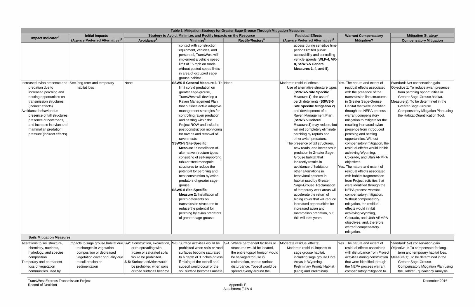
TransWest Express Transmission Project December 2016 Record of Decision Appendix F Attachment F.1A-4
Table 1. Mitigation Strategy for Greater Sage-Grouse Through Mitigation Measures
Impact Indicator1 Initial Impacts (Agency Preferred Alternative)2
Strategy to Avoid, Minimize, and Rectify Impacts on the Resource Residual Effects (Agency Preferred Alternative)3
Warrant Compensatory Mitigation?
Mitigation Strategy Avoidance4 Minimize5 Rectify/Restore6 Compensatory Mitigation
contact with construction equipment, vehicles, and personnel, TransWest will implement a vehicle speed limit of 15 mph on roads without posted speed limits in area of occupied sage-grouse habitat.
access during sensitive time periods limited public accessibility and controlling vehicle speeds (WLF-4, VR-8, SSWS-5 General Measures 1, 4, and 5).
Increased avian presence and predation due to increased perching and nesting opportunities on transmission structures (indirect effects)
Avoidance behavior due presence of tall structures, presence of new roads, and increase in avian and mammalian predation pressure (indirect effects)
See long-term and temporary habitat loss
None SSWS-5 General Measure 3: To limit corvid predation on greater sage-grouse, TransWest will develop a Raven Management Plan that outlines active adaptive management strategies for controlling raven predation and nesting within the Project ROW and includes post-construction monitoring for ravens and removal of raven nests.
SSWS-5 Site-Specific Measure 1: Installation of alternative structure types consisting of self-supporting tubular steel monopole structures to reduce the potential for perching and nest construction by avian predators of greater sage-grouse.
SSWS-5 Site-Specific Measure 2: Installation of perch deterrents on transmission structures to reduce the potential for perching by avian predators of greater sage-grouse.
None Moderate residual effects. Use of alternative structure types
(SSWS-5 Site Specific Measure 1), the use of perch deterrents (SSWS-5 Site Specific Mitigation 2) and development of a Raven Management Plan (SSWS 5 General Measure 3) may reduce, but will not completely eliminate perching by raptors and other avian predators.
The presence of tall structures, new roads, and increases in predation in Greater Sage-Grouse habitat that indirectly results in avoidance of habitat or other alternations in behavioral patterns in habitat used by Greater Sage-Grouse. Reclamation of temporary work areas will accelerate the return of hiding cover that will reduce increased opportunities for increased avian and mammalian predation, but this will take years.
Yes. The nature and extent of residual effects associated with the presence of the transmission line structures in Greater Sage-Grouse Habitat that were identified through the NEPA process warrant compensatory mitigation to mitigate for the resulting increased avian presence from introduced perching and nesting opportunities. Without compensatory mitigation, the residual effects would inhibit achieving Wyoming, Colorado, and Utah ARMPA objectives.
Yes. The nature and extent of residual effects associated with habitat fragmentation from Project activities that were identified through the NEPA process warrant compensatory mitigation. Without compensatory mitigation, the residual effects would inhibit achieving Wyoming, Colorado, and Utah ARMPA objectives, and, therefore, warrant compensatory mitigation.
Standard: Net conservation gain. Objective 1: To reduce avian presence
from perching opportunities in Greater Sage-Grouse habitat.
Measure(s): To be determined in the Greater Sage-Grouse Compensatory Mitigation Plan using the Habitat Quantification Tool.
Soils Mitigation Measures Alterations to soil structure,
chemistry, nutrients, hydrology, and species composition
Temporary and permanent loss of vegetation communities used by
Impacts to sage grouse habitat due to changes in vegetation composition or decreased vegetation cover or quality due to soil erosion or sedimentation
S-2: Construction, excavation, or re-spreading with frozen or saturated soils would be prohibited.
S-5: Surface activities would be prohibited when soils or road surfaces become
S-5: Surface activities would be prohibited when soils or road surfaces become saturated to a depth of 3 inches or less if mixing of the topsoil and subsoil would occur or the soil surface becomes unsafe
S-1: Where permanent facilities or structures would be located, the entire topsoil horizon would be salvaged for use in reclamation, prior to surface disturbance. Topsoil would be spread evenly around the
Moderate residual effects: Moderate residual impacts to
sage grouse habitat, including sage grouse Core Areas in Wyoming, Preliminary Priority Habitat (PPH) and Preliminary
Yes. The nature and extent of residual effects associated with disturbance from Project activities during construction that were identified through the NEPA process warrant compensatory mitigation to
Standard: Net conservation gain. Objective 1: To compensate for long-
term and temporary habitat loss. Measure(s): To be determined in the
Greater Sage-Grouse Compensatory Mitigation Plan using the Habitat Equivalency Analysis

TransWest Express Transmission Project December 2016 Record of Decision Appendix F Attachment F.1A-5
Table 1. Mitigation Strategy for Greater Sage-Grouse Through Mitigation Measures
Impact Indicator1 Initial Impacts (Agency Preferred Alternative)2
Strategy to Avoid, Minimize, and Rectify Impacts on the Resource Residual Effects (Agency Preferred Alternative)3
Warrant Compensatory Mitigation?
Mitigation Strategy Avoidance4 Minimize5 Rectify/Restore6 Compensatory Mitigation
sage-grouse saturated to a depth of 3 inches or less if mixing of the topsoil and subsoil would occur or the soil surface becomes unsafe for vehicular travel.
S-9: Excess subsoil that is excavated for foundations would not be spread on the soil surface (on top of topsoil) or on access roads. Excess subsoil would be disposed of in accordance with federal, state, and local requirements.
for vehicular travel. S-6: During construction, erosion
control measures would be inspected after every storm event and maintained.
S-7: Lands managed by federal agencies would be subject to any restrictions related to construction on steep slopes or sensitive soils under the applicable federal land use plans. For lands not subject to such restrictions, permanent access roads would not be constructed on slopes over 25 percent unless TransWest provides an engineering design and associated Best Management Practices to ensure slope stability and erosion control to be reviewed and approved by the appropriate land management agency or land owner.
S-11: Permanent erosion control measures would be installed on all project access roads used for operations and maintenance. Erosion control measures would be inspected and maintained at least annually or as required by the applicable state Stormwater Pollution Prevention Plan.
permanent structure (not left in piles) and revegetated for future use.
S-3: During reclamation of temporary work areas and temporary construction access roads, compacted areas (typically any area that receives repeated traffic or 3 or more passes by heavy equipment) would be decompacted, to the depth of compaction, as necessary by subsoiling, paraplowing, or parabolic ripping on the contour to the depth of compaction. This would help prepare the seed bed, encourage infiltration and help to prevent accelerated runoff and erosion. Scarification would only be used on shallow soils. The need for decompaction and the compaction depth would be determined on a case by case basis, by a qualified environmental inspector or soil scientist.
S-4: During decommissioning, where a soil sterilizer has been applied, sterile soils would be removed prior to the replacement of topsoil and seeding.
S-8: Newly constructed access roads would be gated to restrict motorized use by the public at the land management agency or landowner’s discretion. In some instances, other methods may need to be employed to prevent public access. After construction is complete, permanent access roads would remain gated at the land management agency or landowner’s discretion. If the road is no longer needed for operations, it would be
General Habitat (PGH) in Colorado, and occupied, brood rearing, and wintering habitat in Utah. Disturbance to the slow-growing vegetation communities in these habitats could take decades to recover to pre-disturbance conditions.
Temporary and permanent habitat loss would be minimized through avoiding sensitive areas (S-2, S-5 and S-9) , minimizing vegetation clearing minimizing the spatial extent of construction activities (TWE-11 to TWE-13 and S-5, S-6, S-7, and S-11)), maintaining existing contours, and implementing effective reclamation (VG-1, VG-3, S-1, S-3, S-4, S-8, and S-13). However, permanent habitat loss would occur in areas occupied by transmission structures, new access roads, and other Project features for the life of the project. Impacts to sage grouse habitat from disturbance would be minimized through avoidance of sensitive species habitat where possible, implementation of conservation measures impacting sage grouse habitat (TWE-29 – TWE-34).
mitigate for long-term and temporary habitat loss. Without compensatory mitigation, the residual effects would inhibit achieving BLM Wyoming, Colorado, and Utah approved resource management plan amendment (ARMPA) objectives, and, therefore, warrant compensatory mitigation.
Tool.
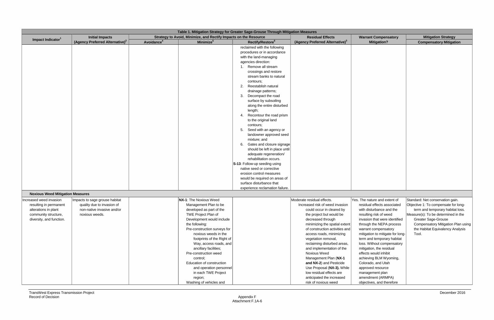
TransWest Express Transmission Project December 2016 Record of Decision Appendix F Attachment F.1A-6
Table 1. Mitigation Strategy for Greater Sage-Grouse Through Mitigation Measures
Impact Indicator1 Initial Impacts (Agency Preferred Alternative)2
Strategy to Avoid, Minimize, and Rectify Impacts on the Resource Residual Effects (Agency Preferred Alternative)3
Warrant Compensatory Mitigation?
Mitigation Strategy Avoidance4 Minimize5 Rectify/Restore6 Compensatory Mitigation
reclaimed with the following procedures or in accordance with the land-managing agencies direction: 1. Remove all stream
crossings and restore stream banks to natural contours;
2. Reestablish natural drainage patterns;
3. Decompact the road surface by subsoiling along the entire disturbed length;
4. Recontour the road prism to the original land contours;
5. Seed with an agency or landowner approved seed mixture; and
6. Gates and closure signage should be left in place until adequate regeneration/ rehabilitation occurs.
S-13: Follow-up seeding using native seed or corrective erosion control measures would be required on areas of surface disturbance that experience reclamation failure.
Noxious Weed Mitigation Measures Increased weed invasion
resulting in permanent alterations in plant community structure, diversity, and function.
Impacts to sage grouse habitat quality due to invasion of non-native invasive and/or noxious weeds.
NX-1: The Noxious Weed Management Plan to be developed as part of the TWE Project Plan of Development would include the following: Pre-construction surveys for
noxious weeds in the footprints of the Right of Way, access roads, and ancillary facilities;
Pre-construction weed control;
Education of construction and operation personnel in each TWE Project region;
Washing of vehicles and
Moderate residual effects. Increased risk of weed invasion
could occur in cleared by the project but would be decreased through minimizing the spatial extent of construction activities and access roads, minimizing vegetation removal, reclaiming disturbed areas, and implementation of the Noxious Weed Management Plan (NX-1 and NX-2) and Pesticide Use Proposal (NX-3). While low residual effects are anticipated the increased risk of noxious weed
Yes. The nature and extent of residual effects associated with disturbance and the resulting risk of weed invasion that were identified through the NEPA process warrant compensatory mitigation to mitigate for long-term and temporary habitat loss. Without compensatory mitigation, the residual effects would inhibit achieving BLM Wyoming, Colorado, and Utah approved resource management plan amendment (ARMPA) objectives, and therefore
Standard: Net conservation gain. Objective 1: To compensate for long-
term and temporary habitat loss. Measure(s): To be determined in the
Greater Sage-Grouse Compensatory Mitigation Plan using the Habitat Equivalency Analysis Tool.

TransWest Express Transmission Project December 2016 Record of Decision Appendix F Attachment F.1A-7
Table 1. Mitigation Strategy for Greater Sage-Grouse Through Mitigation Measures
Impact Indicator1 Initial Impacts (Agency Preferred Alternative)2
Strategy to Avoid, Minimize, and Rectify Impacts on the Resource Residual Effects (Agency Preferred Alternative)3
Warrant Compensatory Mitigation?
Mitigation Strategy Avoidance4 Minimize5 Rectify/Restore6 Compensatory Mitigation
equipment before entering and leaving the Right of Way;
Herbicide spraying; and Annual monitoring and
reporting. Survey information collected
during pre-construction surveys would include species name, GPS location of weed infestations, percent cover, and approximate size of weed infestations. Control of noxious and invasive species could include chemical, physical, and biological methods and would be developed in consultation with the land agencies and private landowners. The plan would identify species of concern for each BLM Field Office and USFS forest and would focus monitoring and control methods on these species. The plan would comply with the existing BLM, USFS, USFWS, state, and federal regulations concerning noxious weed management. Post construction annual monitoring would be determined with the appropriate land management agencies.
NX-2: Herbicide spraying would be conducted following all applicable state and federal laws regarding chemical use, adverse weather, chemical storage, and chemical drift. Further guidelines and protocols for herbicide spraying on BLM land are
invasion remains due to Project-related ground disturbance.
warrant compensatory mitigation.
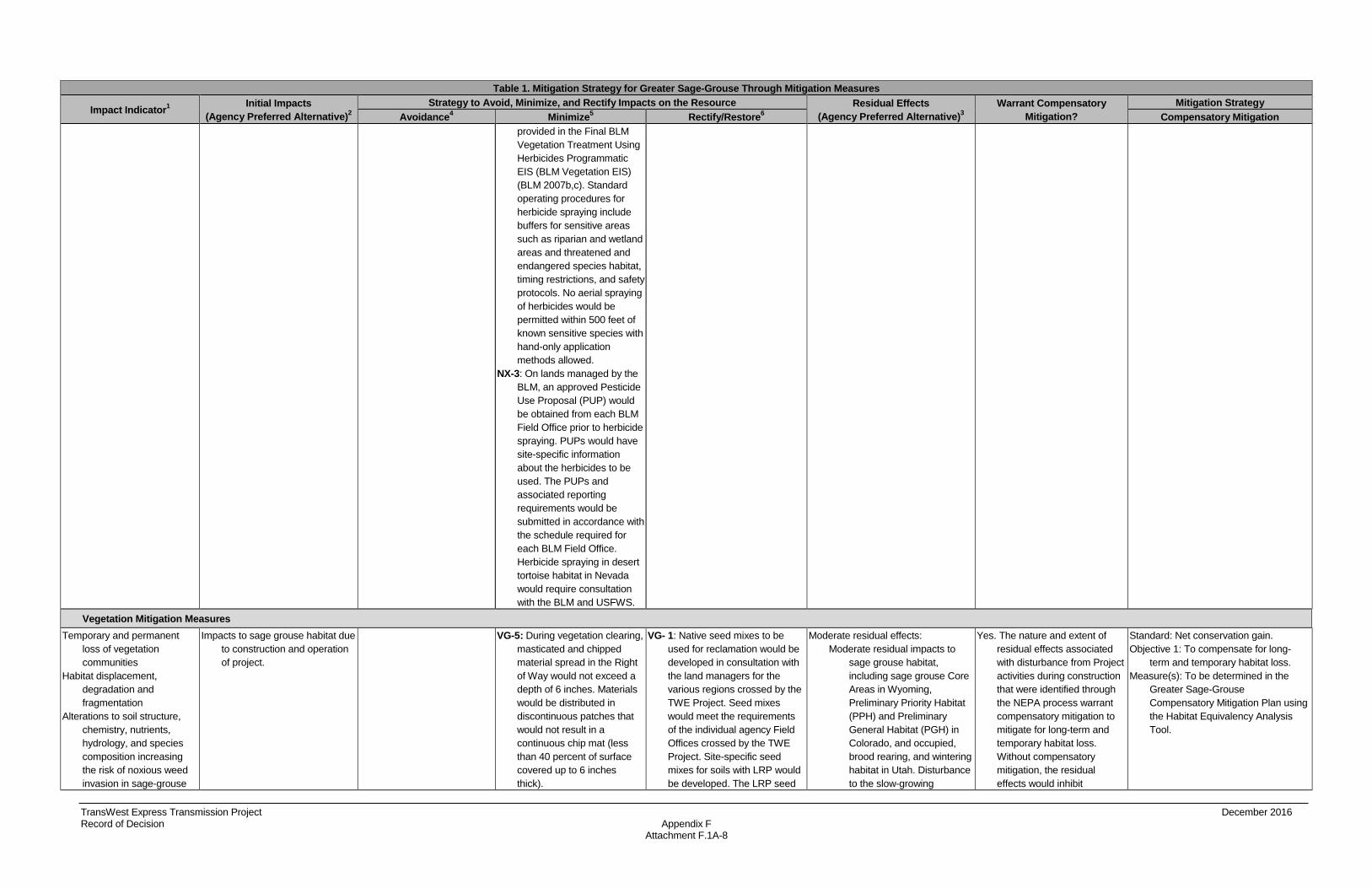
TransWest Express Transmission Project December 2016 Record of Decision Appendix F Attachment F.1A-8
Table 1. Mitigation Strategy for Greater Sage-Grouse Through Mitigation Measures
Impact Indicator1 Initial Impacts (Agency Preferred Alternative)2
Strategy to Avoid, Minimize, and Rectify Impacts on the Resource Residual Effects (Agency Preferred Alternative)3
Warrant Compensatory Mitigation?
Mitigation Strategy Avoidance4 Minimize5 Rectify/Restore6 Compensatory Mitigation
provided in the Final BLM Vegetation Treatment Using Herbicides Programmatic EIS (BLM Vegetation EIS) (BLM 2007b,c). Standard operating procedures for herbicide spraying include buffers for sensitive areas such as riparian and wetland areas and threatened and endangered species habitat, timing restrictions, and safety protocols. No aerial spraying of herbicides would be permitted within 500 feet of known sensitive species with hand-only application methods allowed.
NX-3: On lands managed by the BLM, an approved Pesticide Use Proposal (PUP) would be obtained from each BLM Field Office prior to herbicide spraying. PUPs would have site-specific information about the herbicides to be used. The PUPs and associated reporting requirements would be submitted in accordance with the schedule required for each BLM Field Office. Herbicide spraying in desert tortoise habitat in Nevada would require consultation with the BLM and USFWS.
Vegetation Mitigation Measures Temporary and permanent
loss of vegetation communities
Habitat displacement, degradation and fragmentation
Alterations to soil structure, chemistry, nutrients, hydrology, and species composition increasing the risk of noxious weed invasion in sage-grouse
Impacts to sage grouse habitat due to construction and operation of project.
VG-5: During vegetation clearing, masticated and chipped material spread in the Right of Way would not exceed a depth of 6 inches. Materials would be distributed in discontinuous patches that would not result in a continuous chip mat (less than 40 percent of surface covered up to 6 inches thick).
VG- 1: Native seed mixes to be used for reclamation would be developed in consultation with the land managers for the various regions crossed by the TWE Project. Seed mixes would meet the requirements of the individual agency Field Offices crossed by the TWE Project. Site-specific seed mixes for soils with LRP would be developed. The LRP seed
Moderate residual effects: Moderate residual impacts to
sage grouse habitat, including sage grouse Core Areas in Wyoming, Preliminary Priority Habitat (PPH) and Preliminary General Habitat (PGH) in Colorado, and occupied, brood rearing, and wintering habitat in Utah. Disturbance to the slow-growing
Yes. The nature and extent of residual effects associated with disturbance from Project activities during construction that were identified through the NEPA process warrant compensatory mitigation to mitigate for long-term and temporary habitat loss. Without compensatory mitigation, the residual effects would inhibit
Standard: Net conservation gain. Objective 1: To compensate for long-
term and temporary habitat loss. Measure(s): To be determined in the
Greater Sage-Grouse Compensatory Mitigation Plan using the Habitat Equivalency Analysis Tool.
TransWest Express Transmission Project December 2016 Record of Decision Appendix F Attachment F.1A-9
Table 1. Mitigation Strategy for Greater Sage-Grouse Through Mitigation Measures
Impact Indicator1 Initial Impacts (Agency Preferred Alternative)2
Strategy to Avoid, Minimize, and Rectify Impacts on the Resource Residual Effects (Agency Preferred Alternative)3
Warrant Compensatory Mitigation?
Mitigation Strategy Avoidance4 Minimize5 Rectify/Restore6 Compensatory Mitigation
habitat mixes would be specifically designed for alkaline, saline, or sodic soils and would be used in areas where reclamation would potentially be difficult based on soil conditions. Additional soil amendments may be required in these areas, and would be implemented at the direction of the land manager. Reclaimed areas would be monitored annually by TransWest to ensure successful reclamation is occurring. The length of time for the annual monitoring and the definition of successful reclamation would be determined by the appropriate land management agency. Subsequent actions in areas without successful reclamation would be determined in consultation with the appropriate land management agency.
VG-3: A reclamation plan would be developed as part of the Plan of Development. The reclamation plan would define reclamation success for each vegetation type and management agency, list reclamation seed mixes, and detail reclamation monitoring for both interim and final reclamation. Interim and final reclamation success would be monitored annually, or at intervals as required in the reclamation plan, for at least 3 years, or until reclamation success as defined by the reclamation plan is achieved. Reporting of construction, reclamation progress, and monitoring results would be submitted to each land management agency per each office’s reporting requirements.
vegetation communities in these habitats could take decades to recover to pre-disturbance conditions.
Temporary and permanent habitat loss would be minimized through avoiding sensitive areas, minimizing vegetation clearing minimizing the spatial extent of construction activities (TWE-11 to TWE-13), maintaining existing contours, and implementing reclamation (VG-1,VG-3, and VG-5) However, permanent habitat loss would occur in areas occupied by transmission structures, new access roads, and other Project features for the life of the project. Impacts to sage grouse habitat from disturbance would be minimized through avoidance of sensitive species habitat where possible, implementation of conservation measures impacting sage grouse habitat.
achieving BLM Wyoming, Colorado, and Utah approved resource management plan amendment (ARMPA) objectives, and therefore warrant compensatory mitigation.

TransWest Express Transmission Project December 2016 Record of Decision Appendix F Attachment F.1A-10
Table 1. Mitigation Strategy for Greater Sage-Grouse Through Mitigation Measures
Impact Indicator1 Initial Impacts (Agency Preferred Alternative)2
Strategy to Avoid, Minimize, and Rectify Impacts on the Resource Residual Effects (Agency Preferred Alternative)3
Warrant Compensatory Mitigation?
Mitigation Strategy Avoidance4 Minimize5 Rectify/Restore6 Compensatory Mitigation
Wildland Fire Mitigation Measures
Increased risk of fire starts. Impacts to sage grouse habitat due to changes due to increased fire starts and/or frequency and difficulty in suppressing or otherwise managing fire starts.
FR-6: Where appropriate and feasible, micro-siting of the route would occur in recently burned areas.
FR-1: The fire protection plan to be developed as part of the TWE Project Plan of Development, in addition to the items outlined in TWE-64, would include the following: TransWest would implement
line patrols to inspect the Right of Way for hazard trees, damage to any component of the TWE Project, and other potentially unsafe conditions that could increase wildland fire ignition risk.
TransWest would develop a wildland fire traffic control plan which would stipulate mechanisms through which narrow roads shall be kept passable for emergency service providers in a wildland fire emergency situation; designate the point of contact to administer the wildland fire traffic control plan and facilitate emergency service providers access; identify vehicle parking for construction and maintenance vehicles during wildland fire emergencies; and identify alternative routes for large equipment and vehicle evacuation during wildland fire emergencies.
TransWest would outline communication methods to ensure that immediate reporting of
Low residual effects Changes in wildfire frequency
from increased invasive annual grasses could occur. Additionally, construction activities and operation of the transmission line could increase risk of fire starts. Conversely, clearing of coniferous and deciduous vegetation also would decrease fuel loading, and therefore fire risk, in and around the transmission line. This benefit would be maximized by coordinating with the agency in determining approved vegetation clearing methods. Overall, potential increases in fire frequency would be minimized through minimizing the spatial extent of construction activities and access roads (TWE-7 to TWE-13, TWE-19, TWE-27, and TWE-28, and FR-6), line patrols to remove hazard trees and repair potentially unsafe conditions, minimizing vegetation removal and implementation of the Noxious Weed Management Plan.
Increased risks of starts would be minimized through adapting construction as necessary in response to high fire risk, including eliminating overland travel, using spotters for welders, not burning trash, etc.
Impacts to fire management would be minimized through development of a wildland fire traffic control plan to allow for fire management
No. Residual impacts related to increased fire risk and frequency identified through the NEPA process would be minor and therefore, do not warrant compensatory mitigation. Also, residual effects related to impacts on fire would not inhibit achieving land-use plan objectives or compliance with laws, regulations, and/or policies Also, residual effects would not inhibit achieving Wyoming, Colorado, or Utah ARMPA objectives or compliance with laws, regulations, and/or policies. Finally, residual effects related to this resource indicator have not been previously identified in a mitigation strategy as warranting compensatory mitigation..
TransWest Express Transmission Project December 2016 Record of Decision Appendix F Attachment F.1A-11
Table 1. Mitigation Strategy for Greater Sage-Grouse Through Mitigation Measures
Impact Indicator1 Initial Impacts (Agency Preferred Alternative)2
Strategy to Avoid, Minimize, and Rectify Impacts on the Resource Residual Effects (Agency Preferred Alternative)3
Warrant Compensatory Mitigation?
Mitigation Strategy Avoidance4 Minimize5 Rectify/Restore6 Compensatory Mitigation
fires during construction activities and maintenance activities is feasible. Each crew member would carry a laminated card listing pertinent telephone numbers for reporting fires and defining immediate steps to take if a fire starts. The cards would be updated as needed, and redistributed to crew members.
In consultation with land management agencies, TransWest would identify when and where construction and maintenance work would cease in response to Red Flag Warning events as issued daily by the National Weather Service. Overland drive-and-crush travel would be prohibited or limited (at land management agencies’ discretion) during times of high fire risk.
TransWest would develop its fire protection plan in consultation with the appropriate land management agencies.
FR-2: No open trash burning would occur, unless specifically permitted by the appropriate authorities.
FR-3: Activities that could generate a spark such as refueling, smoking, blasting, and welding would only occur on areas that have been cleared. A spotter would be used for welding
and communication methods to immediately report fires (FR-1–FR-5).
TransWest Express Transmission Project December 2016 Record of Decision Appendix F Attachment F.1A-12
Table 1. Mitigation Strategy for Greater Sage-Grouse Through Mitigation Measures
Impact Indicator1 Initial Impacts (Agency Preferred Alternative)2
Strategy to Avoid, Minimize, and Rectify Impacts on the Resource Residual Effects (Agency Preferred Alternative)3
Warrant Compensatory Mitigation?
Mitigation Strategy Avoidance4 Minimize5 Rectify/Restore6 Compensatory Mitigation
and other similar activities. The spotter would be equipped with water and tools to quickly extinguish any sparks.
FR-4: All engines used in the Right of Way would have an approved spark arrestor. FR-5: TransWest would consult
with the land management agencies to ensure vegetation management activities are in line with land management agencies fire management objectives.

TransWest Express Transmission Project December 2016 Record of Decision Appendix F Attachment F.1A-13
Table 2. Mitigation Strategy for Greater Sage-Grouse Through Design Features
Impact Indicator1 Initial Impacts (Agency Preferred Alternative) 2
Strategy to Avoid, Minimize, and Rectify Impacts on the Resource Residual Effects (Agency Preferred Alternative)3
Warrant Compensatory Mitigation?
Mitigation Strategy Avoidance4 Minimize5 Rectify/Restore6 Compensatory Mitigation
Temporary and permanent loss disturbance to vegetation communities
Impacts to sage grouse habitat due to construction and operation of project
TWE-12: Except for repairs necessary to make roads passable, no widening or upgrading of existing access roads will be undertaken in the area of construction and operation, where soils or vegetation are sensitive to disturbance. In designated areas, structures will be placed to avoid sensitive features such as, but not limited to, riparian areas, water courses and cultural sites, or to allow conductors to clearly span the features within limits of standard structure design. This will minimize the amount of disturbance to the sensitive features or reduce visual contrast.
TWE-7: The alignment of any new access roads will follow the designated area’s landform contours where practical, providing that such alignment does not additionally impact resource values. This will minimize ground disturbance and reduce scarring (visual contrast).
TWE-9: All construction vehicle movement outside the ROW will be restricted to pre-designated access or public roads.
TWE-11: In construction areas where pre-contouring is not required, vegetation will be left in place, wherever possible, and original contour will be maintained to avoid excessive root damage and to allow for re-sprouting.
TWE-19: The POD will include an Erosion Control Plan as part of the Stormwater Pollution Prevention Plan (SWPPP). Grading will be performed to provide adequate drainage around structure sites and sufficient clearance under conductors. Excavated material will be spread around the site where it was excavated. Topsoil will be piled separately and replaced after work completion.
TWE 27: In construction areas where re-contouring is not required, vegetation will be left in place wherever possible and original contour will be maintained to avoid excessive root damage and allow for re-sprouting.
TWE 28: Clearing will be performed in a manner that
TWE-13: In construction areas (e.g., marshalling yards, structure sites, spur roads from existing access roads) where ground disturbance is significant or where re-contouring is required, surface restoration will occur as required by the landowner or land management agency. The method of restoration will normally consist of returning disturbed areas back to their natural contour, reseeding (if required), installing cross drains for erosion control, placing water bars in the road, and filling ditches.
Moderate residual impacts to sage grouse habitat, including sage grouse Core Areas in Wyoming, Preliminary Priority Habitat (PPH) and Preliminary General Habitat (PGH) in Colorado, and occupied, brood rearing, and wintering habitat in Utah. Disturbance to the slow-growing vegetation communities in these habitats could take decades to recover to pre-disturbance conditions.
Temporary and permanent habitat loss would be minimized through avoiding sensitive areas, minimizing vegetation clearing minimizing the spatial extent of construction activities maintaining existing contours, and implementing reclamation. However, permanent habitat loss would occur in areas occupied by transmission structures, new access roads, and other Project features for the life of the project. (TWE-11, TWE-13, TWE-19, TWE-27, TWE-28).
Yes. The nature and extent of residual effects associated with disturbance from Project activities during construction that were identified through the NEPA process warrant compensatory mitigation to mitigate for long-term and temporary habitat loss. Without compensatory mitigation, the residual effects would inhibit achieving BLM Wyoming, Colorado, and Utah approved resource management plan amendment (ARMPA) objectives, and, therefore, warrant compensatory mitigation.
Standard: Net conservation gain Objective 1: To compensate for long-
term and temporary habitat loss Measure(s): To be determined in the
Greater Sage-Grouse Compensatory Mitigation Plan using the Habitat Equivalency Analysis Tool

TransWest Express Transmission Project December 2016 Record of Decision Appendix F Attachment F.1A-14
Table 2. Mitigation Strategy for Greater Sage-Grouse Through Design Features
Impact Indicator1 Initial Impacts (Agency Preferred Alternative) 2
Strategy to Avoid, Minimize, and Rectify Impacts on the Resource Residual Effects (Agency Preferred Alternative)3
Warrant Compensatory Mitigation?
Mitigation Strategy Avoidance4 Minimize5 Rectify/Restore6 Compensatory Mitigation
minimizes the marring and scarring of the countryside and preserves the natural beauty to the maximum extent possible. Except for danger trees, no clearing will be performed outside the limits of the ROW.
Increased weed invasion resulting in permanent alterations in plant community structure, diversity, and function.
Impacts to sage grouse habitat quality due to invasion of non-native invasive and/or noxious weeds.
TWE 26: The POD will include a Reclamation Plan and a Noxious Weed Management Plan. The Reclamation Plan will address plant removal and selective clearing. The Noxious Weed Management Plan will be developed in accordance with appropriate land management agencies’ standards, consistent with applicable regulations and agency permitting stipulations or the control of noxious weeds and invasive species (Executive Order [E.O.] 13112). Included in the Noxious Weed Management Plan will be stipulations regarding construction, restoration, and operation (use of weed-free materials, washing of equipment, etc.).
Moderate residual effects. Increased risk of weed invasion could occur in cleared by the project but would be decreased through minimizing the spatial extent of construction activities and access roads, minimizing vegetation removal, reclaiming disturbed areas, and implementation of the Noxious Weed Management Plan (TWE-26). While low residual effects are anticipated the increased risk of noxious weed invasion remains due to Project-related ground disturbance.
Yes. The nature and extent of residual effects associated with disturbance from Project activities during construction that were identified through the NEPA process warrant compensatory mitigation to mitigate for long-term and temporary habitat loss. Without compensatory mitigation, the residual effects would inhibit achieving BLM Wyoming, Colorado, and Utah approved resource management plan amendment (ARMPA) objectives, and, therefore, warrant compensatory mitigation.
Standard: Net conservation gain Objective 1: To compensate for long-
term and temporary habitat loss Measure(s): To be determined in the
Greater Sage-Grouse Compensatory Mitigation Plan using the Habitat Equivalency Analysis Tool
Impacts to vegetation communities supporting sensitive species and unique habitats
Impacts to sage grouse habitat due to construction and operation of project
TWE-33: Prior to the start of construction, the Applicant will provide training to all Contractor and Subcontractor personnel and others involved in construction activities where/if there is a known occurrence of protected species or habitat in the construction area. Sensitive areas will be considered avoidance areas. Prior to any construction activity, avoidance areas will be marked on the ground
TWE-29: The POD will include a Wildlife and Plant Conservation Measures Plan, which will identify important, sensitive, or unique habitats and BLM sensitive, USFS-sensitive, and state-listed species in the vicinity of the TWE Project. The POD will identify measures to be taken to avoid, minimize, or mitigate impacts to these habitats and species.
TWE-30: In applicable areas, the TWE Project will be designed to meet the raptor safe design standards
Moderate residual effects: Moderate residual impacts to
sage grouse habitat, including sage grouse Core Areas in Wyoming, Preliminary Priority Habitat (PPH) and Preliminary General Habitat (PGH) in Colorado, and occupied, brood rearing, and wintering habitat in Utah. Disturbance to the slow-growing vegetation communities in these habitats could take decades to recover to pre-disturbance conditions.
Temporary and permanent
Yes. The nature and extent of residual effects associated with disturbance from Project activities during construction that were identified through the NEPA process warrant compensatory mitigation to mitigate for long-term and temporary habitat loss. Without compensatory mitigation, the residual effects would inhibit achieving BLM Wyoming, Colorado, and Utah approved resource management plan amendment (ARMPA)
Not applicable

TransWest Express Transmission Project December 2016 Record of Decision Appendix F Attachment F.1A-15
Table 2. Mitigation Strategy for Greater Sage-Grouse Through Design Features
Impact Indicator1 Initial Impacts (Agency Preferred Alternative) 2
Strategy to Avoid, Minimize, and Rectify Impacts on the Resource Residual Effects (Agency Preferred Alternative)3
Warrant Compensatory Mitigation?
Mitigation Strategy Avoidance4 Minimize5 Rectify/Restore6 Compensatory Mitigation
and maintained through the duration of the Contract. The Applicant will remove markings during or following final inspection of the Project.
described in the Suggested Practices for Avian Protection on Power Lines: The State of the Art in 2006 (Avian Power Line Interaction Committee [APLIC] 2006).
TWE-31: Mitigation measures that will be developed during the consultation period with the BLM and the U. S. Fish and Wildlife Service under Section 7 of the ESA and adopted in the ROD will be adhered to, along with mitigation developed in conjunction with state authorities as required in any applicable permit.
TWE-32: Seasonal restrictions may be implemented in certain areas to mitigate impacts on wildlife. With the exception of emergency repair situations, the activities of ROW construction, restoration, maintenance, and decommissioning will be modified or discontinued in designated areas during sensitive periods (e.g., nesting and breeding periods) for candidate, proposed of listed threatened or endangered, or other sensitive animal species, as required by permitting agencies. Potential seasonal restrictions and avoidance buffers for nesting raptors will be identified in the FEIS. The Wildlife and Plant Conservation Measures Plan will incorporate the seasonal restrictions and stipulations contained in the federal agency RODs.
TWE-34: If evidence of a
habitat loss would be minimized through avoiding sensitive areas, minimizing vegetation clearing minimizing the spatial extent of construction activities (TWE-11 to TWE-13, TWE-19, TWE-27, TWE-28), maintaining existing contours, and implementing reclamation (VG-1 - VG-3) However, permanent habitat loss would occur in areas occupied by transmission structures, new access roads, and other Project features for the life of the project. Impacts to sage grouse habitat from disturbance would be minimized through avoidance of sensitive species habitat where possible, implementation of conservation measures impacting sage grouse habitat (TWE-29 – TWE-34).
Indirect impacts to sage grouse would occur due to construction noise and human intrusion. This would be minimized by avoiding sensitive locations (leks, nests, etc.) completely or during breeding and nesting periods (TWE-29 – TWE-34).
objectives, and, therefore, warrant compensatory mitigation.
TransWest Express Transmission Project December 2016 Record of Decision Appendix F Attachment F.1A-16
Table 2. Mitigation Strategy for Greater Sage-Grouse Through Design Features
Impact Indicator1 Initial Impacts (Agency Preferred Alternative) 2
Strategy to Avoid, Minimize, and Rectify Impacts on the Resource Residual Effects (Agency Preferred Alternative)3
Warrant Compensatory Mitigation?
Mitigation Strategy Avoidance4 Minimize5 Rectify/Restore6 Compensatory Mitigation
protected species not previously identified or known is found in the Project area, the Contractor will immediately notify the appropriate land management agencies and provide the location and nature of the findings.
Impacts to vegetation communities due to changes in fire frequency or intensity
Impacts to sage grouse habitat due to changes vegetation cover type, amount, or vigor due to fire.
TWE-64: The POD will include a Fire Protection Plan. The Applicant or its Contractor(s) will notify the BLM of any fires and comply with all rules and regulations administered by the BLM and USFS concerning the use, prevention, and suppression of fires on federal lands, including any fire prevention orders that may be in effect at the time of the permitted activity. The Applicant or its Contractor(s) may be held liable for the cost of fire suppression, stabilization, and rehabilitation. In the event of a fire, personal safety will be the first priority of the Applicant or its Contractor(s). The Applicant or its Contractor(s) will: Operate all internal and
external combustion engines on federally-managed lands per 36 CFR Part 261.52(j), which requires all such engines to be equipped with a qualified spark arrester that is maintained and not modified;
Carry shovels, water, and fire extinguishers that are rated at a minimum as ABC-10 pound on all equipment and vehicles. If a fire
Low residual effects: Changes in wildfire frequency
from increased invasive annual grasses could occur. Additionally, construction activities and operation of the transmission line could increase risk of fire starts. Conversely, clearing of coniferous and deciduous vegetation also would decrease fuel loading, and therefore fire risk, in and around the transmission line. Overall, potential increases in fire frequency due to invasive annual grasses would be minimized through minimizing the spatial extent of construction activities and access roads, minimizing vegetation removal, implementation of a Fire Management Plan (TWE-64) and implementation of the Noxious Weed Management Plan (TWE-26) and weed control mitigation measures (NX-1 and NX-2)
No. Residual impacts related to increased fire risk and frequency identified through the NEPA process would be minor and therefore, do not warrant compensatory mitigation. Also, residual effects related to impacts on fire would not inhibit achieving land-use plan objectives or compliance with laws, regulations, and/or policies.
Not applicable

TransWest Express Transmission Project December 2016 Record of Decision Appendix F Attachment F.1A-17
Table 2. Mitigation Strategy for Greater Sage-Grouse Through Design Features
Impact Indicator1 Initial Impacts (Agency Preferred Alternative) 2
Strategy to Avoid, Minimize, and Rectify Impacts on the Resource Residual Effects (Agency Preferred Alternative)3
Warrant Compensatory Mitigation?
Mitigation Strategy Avoidance4 Minimize5 Rectify/Restore6 Compensatory Mitigation
spreads beyond the suppression capability of workers with these tools, all workers will cease fire suppression action and leave the area immediately via pre-identified escape routes;
Initiate fire suppression actions in the work area to prevent fire spread to or on federally-administered lands. If fire ignitions cannot be prevented or contained immediately, or it may be foreseeable that a fire would exceed the immediate capability of workers, the operation must be modified or discontinued. No risk of ignition or re-ignition will exist upon leaving the operation area;
Notify the appropriate fire center immediately of the location and status of any escaped fire;
Review weather forecasts and the potential fire danger prior to any operation involving potential sources of fire ignition from vehicles, equipment, or other means. Prevention measures to be taken each workday will be included in the specific job briefing. Consideration will be given to additional mitigation measures or temporary discontinuance of the operation during periods of extreme wind and dryness;

TransWest Express Transmission Project December 2016 Record of Decision Appendix F Attachment F.1A-18
Table 2. Mitigation Strategy for Greater Sage-Grouse Through Design Features
Impact Indicator1 Initial Impacts (Agency Preferred Alternative) 2
Strategy to Avoid, Minimize, and Rectify Impacts on the Resource Residual Effects (Agency Preferred Alternative)3
Warrant Compensatory Mitigation?
Mitigation Strategy Avoidance4 Minimize5 Rectify/Restore6 Compensatory Mitigation
Operate all vehicles on designated roads except in designated “drive and crush” areas. Vehicle parking to be restricted to areas free of vegetation on roads or within the permitted ROW and designated work areas.;
Operate welding, grinding, or cutting activities in areas cleared of vegetation within range of the sparks for that particular action. A spotter will be required to watch for ignitions; and
Use only diesel-powered vehicles in areas where excessive heat from vehicle exhaust systems could start brush or grass fires.
TransWest Express Transmission Project December 2016 Record of Decision Appendix F Attachment F.1B
Attachment B Summary of TAG Issues

TransWest Express Transmission Project December 2016 Record of Decision Appendix F Attachment F.1B-1
A number of issues were identified during the TAG discussions and the TAG agency participants provided guidance to the Applicant for resolution of the issues. These are provided in Table 1. Full discussion is found in the Attachment C – TAG Mitigation Guidance (SWCA 2016).
Table 1 Issues Identified During TAG Review (SWCA 2016)
Issue TAG Guidance Resolution
Unclassified, unknown, and undetermined leks
Ensure unclassified leks are included within the HEA model.
While they were not displayed on maps reviewed by the TAG, unclassified, unknown, or undetermined leks were included in the HEA model results presented in the FEIS documents for the Projects. Unclassified, unknown, or undetermined leks will be included in all future HEA model results. Resolution of this issue is further described in following sections of this document.
HEA model results and versioning
Ensure that map books and data depict results of current HEA model (direct and indirect effects)
This issue was related to questions raised regarding HEA model results provided to the TAG during the review process. No further action is required. The Applicant, through SWCA, demonstrated that map books, data, and modeling results presented in the FEIS documents use the HEA model version described in those documents. The HEA model versions used to provide sample direct and indirect model results to the TAG were clarified by SWCA during the TAG review process. All map books, data, and modeling results presented in future versions of the greater sage-grouse mitigation plans will clearly indicate the HEA model version and assumptions used.

TransWest Express Transmission Project December 2016 Record of Decision Appendix F Attachment F.1B-2
Table 1 Issues Identified During TAG Review (SWCA 2016)
Issue TAG Guidance Resolution
Extent of sage-grouse occupied habitat
Ensure that occupied habitat layers used in HEA modeling reflect known distributions of greater sage-grouse. Use available telemetry data and expert opinion to confirm the extent of occupied habitat.
Following review, TAG participants identified that BLM’s Priority Habitat Management Areas (PHMA) and General Habitat Management Areas (GHMA) should be used as extent of occupied habitat where project impacts will occur across the HEA model. This determination was made based on a comparison of available telemetry data to various definitions of occupied habitat that have been used by state or federal agencies. The TAG identified that telemetry data closely matched the BLM PHMA/GHMA boundaries. Where telemetry data were not available, the TAG consulted state and federal wildlife managers and relied on their expert opinion to confirm the adequacy of the PHMA/GHMA boundaries. Resolution of this issue is further described in following sections of this document.
UDWR “Opportunity Areas”
The TAG requested that opportunity areas in Utah be evaluated for potential inclusion into final occupied habitat layers.
As part of the TAG evaluation of the occupied habitat layers, possible inclusion of opportunity areas in the final definition of occupied habitat was explored. Available telemetry data and expert opinion were used to evaluate opportunity areas. The TAG concluded that opportunity areas do not currently support sage-grouse populations on a regular basis. As a result, UDWR and the State of Utah Public Lands Policy Coordination Office planning staff agreed that there is no reason to include opportunity areas in the definition of occupied habitat. Opportunity areas will be evaluated for future habitat improvement and mitigation projects that could expand sage-grouse populations into these areas.
“Sagebrush abundance index” metric
Colorado Parks and Wildlife identified a potential issue with the habitat metric that caused areas near fragmented habitat to be identified as higher quality habitat than habitats in un-fragmented landscapes.
During the TAG review it was identified that the ‘Sagebrush abundance index’ (variable 05 of the habitat service metric) was undervaluing intact patches of habitat that had 95-100% sagebrush abundance. As a result, the habitat service metric was adjusted to ensure that all habitats with 50-100% sagebrush abundance receive the highest possible score for variable 05. This adjusted metric will be used in all future HEA modeling for the Projects. This issue and its resolution are further described in following sections of this document.
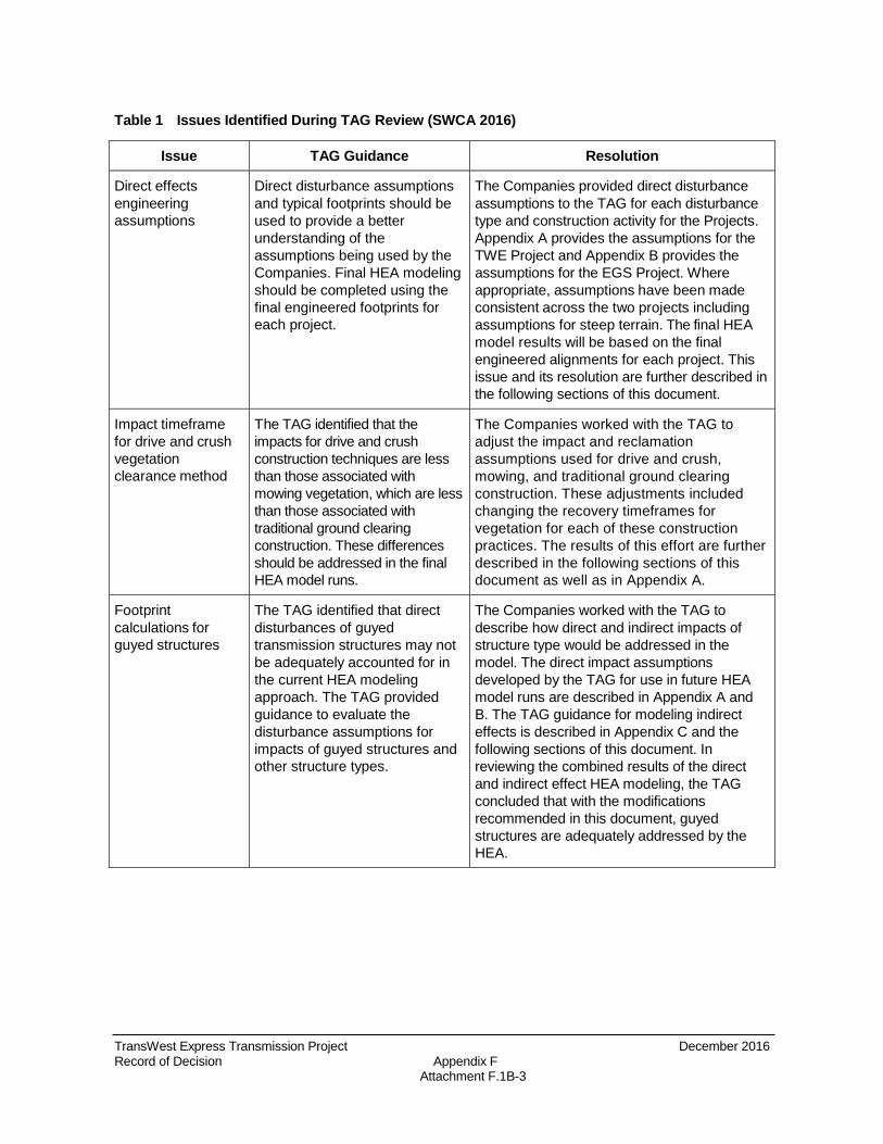
TransWest Express Transmission Project December 2016 Record of Decision Appendix F Attachment F.1B-3
Table 1 Issues Identified During TAG Review (SWCA 2016)
Issue TAG Guidance Resolution
Direct effects engineering assumptions
Direct disturbance assumptions and typical footprints should be used to provide a better understanding of the assumptions being used by the Companies. Final HEA modeling should be completed using the final engineered footprints for each project.
The Companies provided direct disturbance assumptions to the TAG for each disturbance type and construction activity for the Projects. Appendix A provides the assumptions for the TWE Project and Appendix B provides the assumptions for the EGS Project. Where appropriate, assumptions have been made consistent across the two projects including assumptions for steep terrain. The final HEA model results will be based on the final engineered alignments for each project. This issue and its resolution are further described in the following sections of this document.
Impact timeframe for drive and crush vegetation clearance method
The TAG identified that the impacts for drive and crush construction techniques are less than those associated with mowing vegetation, which are less than those associated with traditional ground clearing construction. These differences should be addressed in the final HEA model runs.
The Companies worked with the TAG to adjust the impact and reclamation assumptions used for drive and crush, mowing, and traditional ground clearing construction. These adjustments included changing the recovery timeframes for vegetation for each of these construction practices. The results of this effort are further described in the following sections of this document as well as in Appendix A.
Footprint calculations for guyed structures
The TAG identified that direct disturbances of guyed transmission structures may not be adequately accounted for in the current HEA modeling approach. The TAG provided guidance to evaluate the disturbance assumptions for impacts of guyed structures and other structure types.
The Companies worked with the TAG to describe how direct and indirect impacts of structure type would be addressed in the model. The direct impact assumptions developed by the TAG for use in future HEA model runs are described in Appendix A and B. The TAG guidance for modeling indirect effects is described in Appendix C and the following sections of this document. In reviewing the combined results of the direct and indirect effect HEA modeling, the TAG concluded that with the modifications recommended in this document, guyed structures are adequately addressed by the HEA.
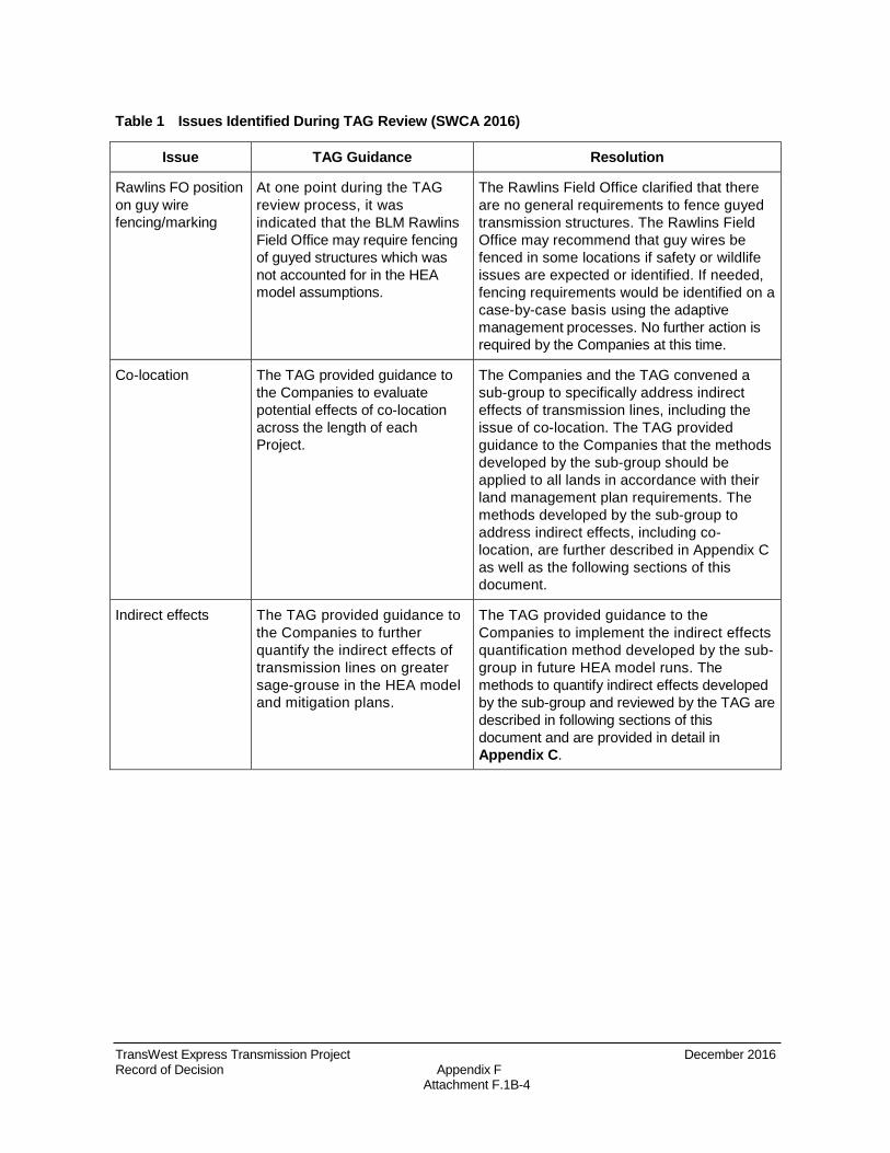
TransWest Express Transmission Project December 2016 Record of Decision Appendix F Attachment F.1B-4
Table 1 Issues Identified During TAG Review (SWCA 2016)
Issue TAG Guidance Resolution
Rawlins FO position on guy wire fencing/marking
At one point during the TAG review process, it was indicated that the BLM Rawlins Field Office may require fencing of guyed structures which was not accounted for in the HEA model assumptions.
The Rawlins Field Office clarified that there are no general requirements to fence guyed transmission structures. The Rawlins Field Office may recommend that guy wires be fenced in some locations if safety or wildlife issues are expected or identified. If needed, fencing requirements would be identified on a case-by-case basis using the adaptive management processes. No further action is required by the Companies at this time.
Co-location The TAG provided guidance to the Companies to evaluate potential effects of co-location across the length of each Project.
The Companies and the TAG convened a sub-group to specifically address indirect effects of transmission lines, including the issue of co-location. The TAG provided guidance to the Companies that the methods developed by the sub-group should be applied to all lands in accordance with their land management plan requirements. The methods developed by the sub-group to address indirect effects, including co-location, are further described in Appendix C as well as the following sections of this document.
Indirect effects The TAG provided guidance to the Companies to further quantify the indirect effects of transmission lines on greater sage-grouse in the HEA model and mitigation plans.
The TAG provided guidance to the Companies to implement the indirect effects quantification method developed by the sub- group in future HEA model runs. The methods to quantify indirect effects developed by the sub-group and reviewed by the TAG are described in following sections of this document and are provided in detail in Appendix C.

TransWest Express Transmission Project December 2016 Record of Decision Appendix F Attachment F.1C
Attachment C Technical Advisory Group Greater Sage-grouse Mitigation Guidance for the TransWest Express and Energy Gateway South Transmission Line Projects (SWCA 2016)

Technical Advisory Group Greater Sage-Grouse Mitigation Guidance for the TransWest Express and Energy Gateway South Transmission Line Projects
Prepared for:
Rocky Mountain Power TransWest Express LLC
Prepared by
SWCA Environmental Consultants
September 2016

Technical Advisory Group Greater Sage Grouse Mitigation Guidance for the TransWest Express and Energy Gateway South Transmission Line Projects
Prepared for:
Rocky Mountain Power TransWest Express LLC
Prepared by
SWCA Environmental Consultants 295 Interlocken Boulevard, Suite 300
Broomfield, Colorado 80021 303-487-1183
September 2016

CONTENTS
1.0 IN2.0 TE
2.1 2.2
2.2.1 2.2.2
2.3 2.3.1 2.3.2 2.3.3 2.3.4 2.3.5 2.3.6 2.3.7
2.4
TRODUCTION ...........................................................................................................1 CHNICAL ADVISORY GROUP GUIDANCE .........................................................4
Guidance Related to the Quantification of Baseline Conditions..................................8 Guidance Related to the Quantification of Habitat Service Losses ...........................10
Direct Effects ......................................................................................................10 Indirect Effects ....................................................................................................12
Guidance Regarding Application of Results to a Mitigation Package .......................12 Siting Standard ....................................................................................................12 Duration Standard ...............................................................................................12 Additionality Standard ........................................................................................12 Timeliness Standard ............................................................................................13 Effectiveness Standard ........................................................................................13 Durability Standard .............................................................................................13 Metrics Standard .................................................................................................13
Guidance Related to Procedure and Policy ................................................................13 3.0 REFERENCES ..............................................................................................................15 TABLES
Table 1. Issues identified during TAG review ............................................................................4 Table 2. Anthropogenic and habitat variables used as a metric of greater sage-grouse habitat services. ....................................................................................................................................... 9 Table 3. Vegetation recovery curves for interim direct impacts. .............................................. 11 Table 4. Procedural and policy issues identified during TAG review ......................................14 APPENDICES
A TWE Direct Effect Assumption Tables B EGS Direct Effect Assumption Tables C Indirect Effects Approach Document
Greater Sage-Grouse Mitigation Guidance for the TWE and EGS Transmission Line Projects
i

Greater Sage-Grouse Mitigation Guidance for the TWE and EGS Transmission Line Projects
1.0 INTRODUCTION
TransWest Express LLC and Rocky Mountain Power (hereafter, the Companies) have proposed the TransWest Express Transmission (TWE) Project and the Energy Gateway South (EGS) Project, respectively. The TWE Project and EGS Project, collectively the Projects, are multi-state high-voltage transmission lines that traverse greater sage-grouse (Centrocercus urophasianus, hereafter sage-grouse or greater sage-grouse) habitat in the states of Wyoming, Colorado, and Utah. The Companies have proposed mitigation for potential unavoidable impacts to the greater sage-grouse and its habitat from the proposed transmission lines for consideration by the BLM in their respective National Environmental Policy Act (NEPA) review processes for the Projects. The greater sage-grouse mitigation plans developed by the Companies in collaboration with the Bureau of Land Management (BLM) and the U.S. Fish and Wildlife Service (USFWS) (hereafter, the Agencies) and other stakeholders quantify and address direct impacts to greater sage-grouse and its habitat, as well as indirect impacts to greater sage-grouse from increased human presence and noise during construction. These plans were included in the Final Environmental Impact Statements (FEIS) for the Projects (BLM 2015 at Appendix D at Appendix K, BLM 2016 at Appendix K).
The FEIS for each Project contemplates additional review and collaboration between the Companies, BLM, and the cooperating agencies to finalize the greater sage-grouse mitigation plans for the Projects, as follows:
For TransWest Express: “In accordance with BLM WO IM 2013-142 and other cooperating agency policies pertaining to offsite mitigation, BLM, the cooperating agencies, and the Applicant are working collaboratively to develop appropriate offsite mitigation that could be implemented to facilitate reasonable development of the Project consistent with applicable agency plans and policies pertaining to greater sage-grouse. To facilitate this collaboration, the Applicant has convened a group of sage-grouse biologists from the BLM and cooperating agencies (the Habitat Equivalency Analysis [HEA] Technical Advisory Group) to provide input and guidance for developing the Applicant’s Sage-grouse Mitigation Plan, including the HEA (refer to EIS Section 3.8.6).” (BLM 2015 at Appendix J page J-7)
For Energy Gateway South: “In accordance with BLM WO IM 2013-142, applicable BLM land and resource management plans, BLM mitigation policy, and other cooperating agency policies pertaining to offsite mitigation, BLM, the cooperating agencies, and the Applicant are working collaboratively to develop appropriate offsite mitigation that could be implemented to facilitate reasonable development of the Project consistent with applicable agency plans and policies pertaining to sage-grouse. To facilitate preliminary collaboration, the Applicant has convened a group of sage-grouse biologists from the BLM and cooperating agencies (the Habitat Equivalency Analysis [HEA] Technical Working Group) to provide input and guidance for developing the Applicant’s Sage-grouse Mitigation Plan, including the HEA (refer to EIS Section 6.2.2.1).” (BLM 2016 Appendix K at Page K-8)
1
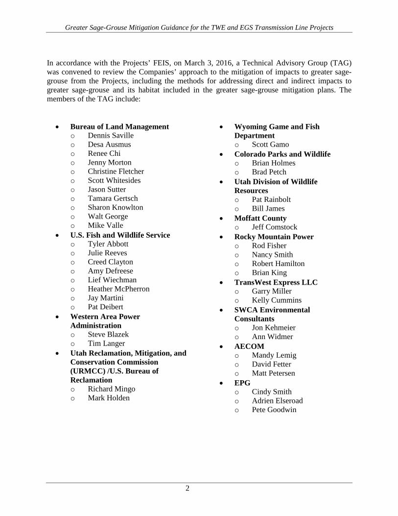
Greater Sage-Grouse Mitigation Guidance for the TWE and EGS Transmission Line Projects
In accordance with the Projects’ FEIS, on March 3, 2016, a Technical Advisory Group (TAG) was convened to review the Companies’ approach to the mitigation of impacts to greater sage-grouse from the Projects, including the methods for addressing direct and indirect impacts to greater sage-grouse and its habitat included in the greater sage-grouse mitigation plans. The members of the TAG include:
• Bureau of Land Management o Dennis Saville o Desa Ausmus o Renee Chi o Jenny Morton o Christine Fletcher o Scott Whitesides o Jason Sutter o Tamara Gertsch o Sharon Knowlton o Walt George o Mike Valle
• U.S. Fish and Wildlife Service o Tyler Abbott o Julie Reeves o Creed Clayton o Amy Defreese o Lief Wiechman o Heather McPherron o Jay Martini o Pat Deibert
• Western Area Power Administration o Steve Blazek o Tim Langer
• Utah Reclamation, Mitigation, and Conservation Commission (URMCC) /U.S. Bureau of Reclamation o Richard Mingo o Mark Holden
• Wyoming Game and Fish Department o Scott Gamo
• Colorado Parks and Wildlife o Brian Holmes o Brad Petch
• Utah Division of Wildlife Resources o Pat Rainbolt o Bill James
• Moffatt County o Jeff Comstock
• Rocky Mountain Power o Rod Fisher o Nancy Smith o Robert Hamilton o Brian King
• TransWest Express LLC o Garry Miller o Kelly Cummins
• SWCA Environmental Consultants o Jon Kehmeier o Ann Widmer
• AECOM o Mandy Lemig o David Fetter o Matt Petersen
• EPG o Cindy Smith o Adrien Elseroad o Pete Goodwin
2
Greater Sage-Grouse Mitigation Guidance for the TWE and EGS Transmission Line Projects
The TAG met routinely between March 3, 2016 and June 6, 2016, including weekly conference calls and three in-person meetings on March 3, March 22, and June 6, 2016.1 During the weekly conference calls and in-person meetings, the TAG reviewed and discussed the Projects’ greater sage-grouse mitigation plans focusing on the technical aspects of the Habitat Equivalency Analysis (HEA) model, specifically the scope of the model, the indirect effects analysis methodology, and the direct effects analysis assumptions.
The TAG meetings were facilitated by SWCA, EPG and AECOM. EPG and AECOM are BLM’s third-party NEPA contractors for the EGS Project and TWE Project, respectively. SWCA is a consultant to the Companies with specific expertise in greater sage-grouse biology. SWCA participated in the TAG meetings on the Companies’ behalf, including participation in a sub-group of the TAG consisting of sage-grouse biologists from the Agencies and SWCA specifically formed to develop an approach to modeling indirect effects of high-voltage transmission lines on greater sage-grouse.
At the Companies’ direction, SWCA has compiled the input and guidance developed by the TAG for consideration by the Companies in finalizing their greater sage-grouse mitigation plans. The Companies have directed SWCA to provide this summary to all TAG participants for their records. The purpose of this report is to document the technical input and guidance provided by the TAG on the HEA model and its use to quantify direct and indirect effects to sage-grouse from the Projects for the purposes of determining appropriate compensatory mitigation. The Companies will consider the guidance provided by the TAG and will coordinate with the Agencies update their greater sage-grouse mitigation plans individually as they deem appropriate. The revised greater sage-grouse mitigation plans will be provided to the Agencies for use in their decision-making process.
1 Additional meetings were held by a sub-group of the TAG formed to develop a methodology to address indirect effects of the Projects on greater sage-grouse. This process and the associated meetings are documented in Appendix C of this report.
3

Greater Sage-Grouse Mitigation Guidance for the TWE and EGS Transmission Line Projects
2.0 TECHNICAL ADVISORY GROUP GUIDANCE
The Companies worked closely with the TAG to review the technical aspects of the greater sage-grouse mitigation plans described in the Projects’ FEIS documents (BLM 2015 Appendix D at Appendix K, BLM 2016 Appendix K), focusing on the methods, assumptions, and scientific basis of the HEA model. In many cases, the TAG found that the greater sage-grouse mitigation plans included in the FEIS documents are adequate to quantify the Projects’ impacts and the mitigation required to compensate for those impacts. Those portions of the greater sage-grouse mitigation plans remain as described in the FEIS documents and are referenced throughout this document. Where the TAG identified a potential need to modify the greater sage-grouse mitigation plans and HEA model, the TAG provided guidance to the Companies on how to modify the approach and how to incorporate any changes into the final HEA modeling and greater sage-grouse mitigation plans. Table 1 documents the issues considered by the TAG, including issues that were resolved during the TAG review process and issues that resulted in guidance to the Companies for modifying the HEA and the greater sage-grouse mitigation plans. This guidance is described in additional detail in the following sections.
Table 1. Issues Identified During TAG Review
Issue TAG Guidance Resolution
Unclassified, Ensure unclassified leks are While they were not displayed on maps reviewed unknown, and included within the HEA model. by the TAG, unclassified, unknown, or undetermined leks undetermined leks were included in the HEA
model results presented in the FEIS documents for the Projects. Unclassified, unknown, or undetermined leks will be included in all future HEA model results. Resolution of this issue is further described in following sections of this document.
HEA model results Ensure that map books and data This issue was related to questions raised regarding and versioning depict results of current HEA model
(direct and indirect effects) HEA model results provided to the TAG during the review process. No further action is required. SWCA confirmed that map books, data, and modeling results presented in the FEIS documents use the HEA model version described in those documents. The HEA model versions used to provide sample direct and indirect model results to the TAG were clarified by SWCA during the TAG review process. All map books, data, and modeling results presented in future versions of the greater sage-grouse mitigation plans will clearly indicate the HEA model version and assumptions used.
4

Greater Sage-Grouse Mitigation Guidance for the TWE and EGS Transmission Line Projects
Issue TAG Guidance Resolution
Extent of sage- Ensure that occupied habitat layers Following review, TAG participants identified that grouse occupied used in HEA modeling reflect BLM’s Priority Habitat Management Areas (PHMA) habitat known distributions of greater sage-
grouse. Use available telemetry data and expert opinion to confirm the extent of occupied habitat.
and General Habitat Management Areas (GHMA) should be used as extent of occupied habitat where project impacts will occur across the HEA model. This determination was made based on a comparison of available telemetry data to various definitions of occupied habitat that have been used by state or federal agencies. The TAG identified that telemetry data closely matched the BLM PHMA/GHMA boundaries. Where telemetry data were not available, the TAG consulted state and federal wildlife managers and relied on their expert opinion to confirm the adequacy of the PHMA/GHMA boundaries. Resolution of this issue is further described in following sections of this document.
UDWR The TAG requested that opportunity As part of the TAG evaluation of the occupied “Opportunity areas in Utah be evaluated for habitat layers, possible inclusion of opportunity Areas” potential inclusion into final
occupied habitat layers. areas in the final definition of occupied habitat was explored. Available telemetry data and expert opinion were used to evaluate opportunity areas. The TAG concluded that opportunity areas do not currently support sage-grouse populations on a regular basis. As a result, UDWR and the State of Utah Public Lands Policy Coordination Office planning staff agreed that there is no reason to include opportunity areas in the definition of occupied habitat. Opportunity areas will be evaluated for future habitat improvement and mitigation projects that could expand sage-grouse populations into these areas.
“Sagebrush abundance index” metric
Colorado Parks and Wildlife identified a potential issue with the habitat metric that caused areas near fragmented habitat to be identified as higher quality habitat than habitats in un-fragmented landscapes.
During the TAG review it was identified that the ‘Sagebrush abundance index’ (variable 05 of the habitat service metric) was undervaluing intact patches of habitat that had 95-100% sagebrush abundance. As a result, the habitat service metric was adjusted to ensure that all habitats with 50100% sagebrush abundance receive the highest possible score for variable 05. This adjusted metric will be used in all future HEA modeling for the Projects. This issue and its resolution are further described in following sections of this document.
5

Greater Sage-Grouse Mitigation Guidance for the TWE and EGS Transmission Line Projects
Issue TAG Guidance Resolution
Direct effects Direct disturbance assumptions and The Companies provided direct disturbance engineering typical footprints should be used to assumptions to the TAG for each disturbance type assumptions provide a better understanding of the
assumptions being used by the Companies. Final HEA modeling should be completed using the final engineered footprints for each project.
and construction activity for the Projects. Appendix A provides the assumptions for the TWE Project and Appendix B provides the assumptions for the EGS Project. Where appropriate, assumptions have been made consistent across the two projects including assumptions for steep terrain. The final HEA model results will be based on the final engineered alignments for each project. This issue and its resolution are further described in the following sections of this document.
Impact timeframe The TAG identified that the impacts The Companies worked with the TAG to adjust the for drive and crush for drive and crush construction impact and reclamation assumptions used for drive vegetation techniques are less than those and crush, mowing, and traditional ground clearing clearance method associated with mowing vegetation,
which are less than those associated with traditional ground clearing construction. These differences should be addressed in the final HEA model runs.
construction. These adjustments included changing the recovery timeframes for vegetation for each of these construction practices. The results of this effort are further described in the following sections of this document as well as in Appendix A and B.
Footprint The TAG identified that direct The Companies worked with the TAG to describe calculations for disturbances of guyed transmission how direct and indirect impacts of structure type guyed structures structures may not be adequately
accounted for in the current HEA modeling approach. The TAG provided guidance to evaluate the disturbance assumptions for impacts of guyed structures and other structure types.
would be addressed in the model. The direct impact assumptions developed by the TAG for use in future HEA model runs are described in Appendix A and B. The TAG guidance for modeling indirect effects is described in Appendix C and the following sections of this document. In reviewing the combined results of the direct and indirect effect HEA modeling, the TAG concluded that with the modifications recommended in this document, guyed structures are adequately addressed by the HEA.
Rawlins FO At one point during the TAG The Rawlins Field Office clarified that there are no position on guy wire review process, it was indicated general requirements to fence guyed transmission fencing/marking that the BLM Rawlins Field Office
may require fencing of guyed structures which was not accounted for in the HEA model assumptions.
structures. The Rawlins Field Office may recommend that guy wires be fenced in some locations if safety or wildlife issues are expected or identified. If needed, fencing requirements would be identified on a case-by-case basis using the adaptive management processes. No further action is required by the Companies at this time.
6

Greater Sage-Grouse Mitigation Guidance for the TWE and EGS Transmission Line Projects
Issue TAG Guidance Resolution
Co-location The TAG provided guidance to the Companies to evaluate potential effects of co-location across the length of each Project.
The Companies and the TAG convened a subgroup to specifically address indirect effects of transmission lines, including the issue of co-location. The TAG provided guidance to the Companies that the methods developed by the subgroup should be applied to all lands in accordance with their land management plan requirements. The methods developed by the sub-group to address indirect effects, including co-location, are further described in Appendix C as well as the following sections of this document.
Indirect effects The TAG provided guidance to the Companies to further quantify the indirect effects of transmission lines on greater sage-grouse in the HEA model and mitigation plans.
The TAG provided guidance to the Companies to implement the indirect effects quantification method developed by the sub- group in future HEA model runs. The methods to quantify indirect effects developed by the sub-group and reviewed by the TAG are described in following sections of this document and are provided in detail in Appendix C.
7
Greater Sage-Grouse Mitigation Guidance for the TWE and EGS Transmission Line Projects
2.1 GUIDANCE RELATED TO THE QUANTIFICATION OF BASELINE CONDITIONS
Quantification of baseline conditions is described in Appendix B of Attachment 2 of the greater sage-grouse mitigation plan for the TWE Project (BLM 2015 Appendix D at Appendix K at Attachment 2 at Appendix B) and Appendix B of Exhibit K2 of the greater sage-grouse mitigation plan for the EGS Project. (BLM 2016 Appendix K at Exhibit K2 at Appendix B). Baseline habitat services are quantified using the greater sage-grouse habitat services metric. The habitat service metric was developed to capture changes in greater sage-grouse habitat services over time due to vegetation removal and recovery. The habitat service metric developed for the Projects includes variables identified by the peer-reviewed scientific literature as having an influence on the quality of greater sage-grouse habitat, including dominant vegetative components and anthropogenic influences.
During review of the baseline habitat service maps for the Projects, the TAG identified two adjustments to the habitat service metric:
1. Guidance was provided to the Companies to change Variable 05 in the habitat service metric (Table 2) such that a habitat service score of 3 would be applied to areas having 50-100% sagebrush abundance. Previous versions of the metric provided a score of 3 to areas having 50-95% sagebrush abundance. This adjustment addressed an issue raised by Colorado Parks and Wildlife that Variable 05 caused habitat in areas near fragmented habitat to be identified as higher quality than habitats in un-fragmented landscapes. Table 2 provides the full list of variables and scores used to establish baseline habitat services, as revised by the TAG.
2. Guidance was provided to the Companies to include all leks with an undetermined or unknown status in Variable 04. The notes for Table 2 clarify that undetermined or unknown status leks are classified as occupied.
In addition to changes to the habitat service metric, the TAG identified that the metric for sage-grouse habitat services should only be applied to occupied sage-grouse habitat. The TAG determined that habitat services and HEA modeling should be completed within the boundaries of the BLM’s PHMA and GHMA and that the PHMA and GHMA layers encompass greater sage-grouse occupied habitat.
8

Greater Sage-Grouse Mitigation Guidance for the TWE and EGS Transmission Line Projects
Table 2. Anthropogenic and Habitat Variables Used as a Metric of Greater Sage-grouse Habitat Services.
Variable Number Variables 3 2 1 0
VAR01 Distance to high-traffic (>6,000 AADT) road, such as an interstate, federal, or state highway (meters)
>1,000 650–1,000 100–650 N/A*
VAR02 Distance to low-traffic (<6,000 AADT) paved roads, heavily travelled gravel roads, well pads, mine footprints, transmission substations (meters)
>200 50–200 25–50 N/A*
VAR03 Percent slope <10 10–30 30–40 >40
VAR04 Distance to occupied lek† (kilometers) 0–6.4 6.4–8.5 >8.5 N/A
VAR05 Sagebrush abundance index (% of vegetation that is sagebrush within a 1square-kilometer moving window)
50–100 30–50 10–30 0–10
VAR06 Percent sagebrush canopy cover 15–35 5–15 or >35 1–5 <1
VAR07 Sagebrush (centimeters)
canopy height 30–80 20 to <30 or >80 5–20 <5
VAR08 Distance of habitat to sage or shrub <90 90–275 275–1,000 >1,000 dominant (meters)
* Lands less than 100 meters from a high traffic road and less than 25 meters from a low traffic paved road or high traffic gravel road were given a total metric score of 0 (provides no habitat services), not just a score of 0 for these individual variables. This is referred to as the road “width” in the direct impacts, although it is larger than the actual physical width of the road. † Leks were classified as occupied if their 10-year attendance average was greater than 0 or if their status is undetermined or unknown. AADT = Average Annual Daily Traffic
9
Greater Sage-Grouse Mitigation Guidance for the TWE and EGS Transmission Line Projects
2.2 GUIDANCE RELATED TO THE QUANTIFICATION OF HABITAT SERVICE LOSSES
Quantification of habitat service losses is described in Appendix C of Attachment 2 of the greater sage-grouse mitigation plan for the TWE Project (BLM 2015 Appendix D at Appendix K at Attachment 2 at Appendix C) and Appendix C of Exhibit K2 of the greater sage-grouse mitigation plan for the EGS Project (BLM 2016 Appendix K at Exhibit K2 at Appendix B). The TAG provided guidance to the Companies on the timing of habitat service losses, specifically that habitat service losses should be calculated based on final engineered footprints, construction schedules, and operation timeline for the Projects. This is consistent with what was presented in the FEIS documents for the Projects and affirms the approach and timing for determining final mitigation.
2.2.1 Direct Effects As described above, the final engineered footprint of the Projects will be provided electronically by the Companies for HEA modeling. The TAG provided guidance that the footprint files should specify the final engineered locations, disturbance footprints and disturbance types for all Project elements. The TAG worked with the Companies to develop the typical case for each type of anticipated disturbance. The typical direct disturbance assumptions for each Project are described in detail in Appendix A (TWE) and B (EGS).
The TAG noted that the modeling approach overestimates the habitat services lost to direct effects because of the model resolution, i.e. habitat service scoring occurs within 30 m x 30 m cells and the habitat service loss that is assumed for the footprint is also assumed for entire area of the cells it intersects. For example, when 100% of habitat services are lost in the footprint during construction, all cells that the footprint intersects receive a service score of 0 during the construction milestone. The TAG provided guidance to the Companies that this approach is sufficient for future HEA modeling.
The TAG also provided guidance to the Companies regarding the return of habitat services with respect to the disturbance type during the reclamation milestone periods. Habitat services in cells intersecting interim direct disturbances return at different rates depending on baseline vegetation type and disturbance condition (Table 3). There are five vegetation types: 1) agriculture and wetland; 2) grassland and riparian, 3) shrubs other than sagebrush; 4) low sagebrush; and 5) big sagebrush. To take into account the project-specific vegetation characteristics and disturbance types, the TAG provided guidance to the Companies to modify recovery endpoints and timeframes, where appropriate for each of three disturbance types: 1) cleared; 2) mowed; and 3) drive and crush (Table 3 and Appendices A and B). The TAG provided further guidance to the Companies suggesting that the recovery timeframe for big sagebrush (Artemisia tridentata ssp.) should be differentiated from the recovery timeframe for other types of sagebrush (i.e., Artemisia nova, Artemisia cana, Artemisia arbuscula) and other shrub species for drive and crush disturbance conditions (Table 3 and Appendices A and B).
10

Greater Sage-Grouse Mitigation Guidance for the TWE and EGS Transmission Line Projects
Table 3. Vegetation recovery curves for interim direct impacts. Percent of Baseline Services Present at Each Milestone by Disturbance Condition and Vegetation Recovery Endpoint
Project Milestone Cleared Mowed Drive and Crush
Baseline • 100% of agricultural and wetland • 100% of agricultural and wetland • 100% of agricultural and wetland • 100% of grassland and riparian • 100% of grassland and riparian • 100% of grassland and riparian • 100% shrub • 100% shrub and low sagebrush • 100% shrub and low sagebrush • 100% of low and big sagebrush • 100% of big sagebrush • 100% of big sagebrush
Construction • 0% of agricultural and wetland • 0% of agricultural and wetland • 0% of agricultural and wetland • 0% of grassland and riparian • 0% of grassland and riparian • 0% of grassland and riparian • 0% shrub • 0% shrub and low sagebrush • 0% shrub and low sagebrush • 0% of low and big sagebrush • 0% of big sagebrush • 0% of big sagebrush
Restoration • 0% of agricultural and wetland • 100% of agricultural, wetland, grassland, and • 100% of agricultural, wetland, grassland, and • 0% of grassland and riparian riparian riparian • 0% shrub • 0% shrub and low sagebrush • 0% shrub and low sagebrush • 0% of low and big sagebrush • 0% of big sagebrush • 0% of big sagebrush
Recovery 1 • 100% of agricultural and wetland • 100% of agricultural, wetland, grassland, and • 100% of agricultural, wetland, grassland, and (1 year after • 20% of grassland and riparian riparian riparian Restoration) • 5% shrub • 10% shrub and low sagebrush • 20% shrub and low sagebrush
• 1% of low and big sagebrush • 2% of big sagebrush • 7% of big sagebrush
Recovery 2 • 100% of agricultural, wetland, grassland, and • 100% of agricultural, wetland, grassland, and • 100% of agricultural, wetland, grassland, and (5 years after riparian riparian riparian, shrub and low sagebrush Restoration) • 25% shrub • 50% shrub and low sagebrush • 33% of big sagebrush
• 5% of low and big sagebrush • 10% of big sagebrush
Recovery 3 • 100% of agricultural, wetland, grassland, • 100% of agricultural, wetland, grassland, and • 100% of agricultural, wetland, grassland, and (10 years after riparian, and shrub riparian, shrub and low sagebrush riparian, shrub and low sagebrush Restoration) • 10% of low and big sagebrush • 20% of big sagebrush • 67% of big sagebrush
Recovery 4 • 100% of agricultural, wetland, grassland, • 100% of agricultural, wetland, grassland, and • 100% of agricultural, wetland, grassland, and (15 years after riparian, and shrub riparian, shrub and low sagebrush riparian, shrub and low sagebrush, big Restoration) • 15% of low and big sagebrush • 30% of big sagebrush sagebrush
Recovery 5 • 100% of agricultural, wetland, grassland, • 100% of agricultural, wetland, grassland, and • 100% of agricultural, wetland, grassland, and (20 years after riparian, and shrub riparian, shrub and low sagebrush riparian, shrub and low sagebrush, big Restoration) • 20% of low and big sagebrush • 40% of big sagebrush sagebrush
Recovery 6 • 100% of agricultural, wetland, grassland, • 100% of agricultural, wetland, grassland, and • 100% of agricultural, wetland, grassland, and (50 years after riparian, and shrub riparian, shrub and low sagebrush, big riparian, shrub and low sagebrush, big Restoration) • 50% of low and big sagebrush sagebrush sagebrush
Recovery 7 • 100% of agricultural, wetland, grassland, • 100% of agricultural, wetland, grassland, and • 100% of agricultural, wetland, grassland, and (100 years after riparian, shrub, and low and big sagebrush riparian, shrub and low sagebrush, big riparian, shrub and low sagebrush, big Restoration) sagebrush sagebrush
11

Greater Sage-Grouse Mitigation Guidance for the TWE and EGS Transmission Line Projects
2.2.2 Indirect Effects The TAG provided guidance to the Companies regarding the modeling of indirect effects. The approach identified by the TAG is a modification to the HEA model described in the Projects’ FEIS documents that more fully incorporates indirect effects in the HEA model. The Projects’ FEIS documents describe the modeling of indirect effects of transmission line construction during the Construction milestone only. The TAG convened a sub-group to develop a science-based approach to quantify indirect effects to greater sage-grouse from operation of transmission lines. The TAG worked with the sub-group to finalize its approach and provided guidance to the Companies to include the final indirect effects approach developed by the TAG into the HEA model and greater sage-grouse mitigation plans. The approach to modeling the indirect effects of transmission line operation developed by the TAG is described in detail in Appendix C.
2.3 GUIDANCE REGARDING APPLICATION OF RESULTS TO A MITIGATION PACKAGE
Examples of mitigation project types that may be included in final mitigation packages and habitat service gains from each of those mitigation project types is described in Appendix D of Attachment 2 of the greater sage-grouse mitigation plan for the TWE Project (BLM 2015 Appendix D at Appendix K at Attachment 2 at Appendix D) and Appendix D of Exhibit K2 of the greater sage-grouse mitigation plan for the EGS Project. (BLM 2016 Appendix K at Exhibit K2 at Appendix D). The TAG provided guidance to the Companies that final mitigation projects should be selected in accordance with the requirements of the BLM RMPs, state management plan requirement, and the USFWS Range-Wide Mitigation Framework including principles, standards, and recommendations for mitigation. The final mitigation plans will describe the process and criteria for how these standards will be evaluated and who will conduct the evaluations. Standards that should be evaluated as part of the final mitigation plan include:
2.3.1 Siting Standard Each mitigation project should be evaluated to ensure that it addresses the conservation objectives of the management plans applying to the area of impact. This approach achieves the goal of siting conservation measures in areas that will be most likely to benefit sage-grouse by considering the overall habitat quality and habitat services provided across the landscape.
2.3.2 Duration Standard Each mitigation project should be evaluated to ensure that it achieves and maintains conservation objectives for no less than the duration of the Project including any residual impacts that may occur after the permit term has expired when vegetation recovery is still ongoing.
2.3.3 Additionality Standard Each mitigation project should be evaluated to ensure that conservation uplift is achieved beyond what would already be expected if the mitigation action was not implemented.
12

Greater Sage-Grouse Mitigation Guidance for the TWE and EGS Transmission Line Projects
Additionality may be met by enhancing or restoring disturbances that would not otherwise be restored, providing land-tenure agreements to protect suitable habitat that would not otherwise be protected, or by removing identified threats to the population (e.g., conifer encroachment and management) that would not be removed without some conservation action.
2.3.4 Timeliness Standard Each mitigation project should be evaluated to ensure that it achieves and maintains conservation objectives in a timely manner that offset the schedule and duration of project impacts. When possible, advanced conservation may be applied to achieve the timeliness standard.
2.3.5 Effectiveness Standard Mitigation and conservation measures used to mitigate for project impacts should be supported by appropriate scientific documentation, monitoring data, and management plans to confirm benefits to greater sage-grouse populations. Implementing agency-recognized conservation measures (e.g., conservation easements, conservation banks, habitat exchanges, conifer removal, sagebrush restoration, fence marking, etc.) will ensure that the measures identified in the mitigation plan are effective. Effectiveness should be evaluated for each mitigation project that is selected as part of the final mitigation plan.
2.3.6 Durability Standard Each mitigation project should be evaluated to ensure that the actions that are taken are durable and supported by appropriate financial, legal, and management assurances. Mitigation measures such as conservation easements or conifer removal may have different durability assurance standards than other mitigation measures such as sagebrush planting or enhancement. These differences should be clearly described and documented in the final mitigation plan.
2.3.7 Metrics Standard Metrics to demonstrate the avoidance, minimization, and compensatory mitigation benefits should be included for each mitigation project identified in the final mitigation plan. A benefit of the HEA model is that it provides a reliable, repeatable, and quantitative science-based metric based on biological conditions and habitat requirements for greater sage-grouse. This should be used to ensure that mitigation projects fully compensate for the interim and permanent losses of habitat services.
2.4 GUIDANCE RELATED TO PROCEDURE AND POLICY
The TAG was convened to provide input and guidance to the Companies for developing their Sage-grouse Mitigation Plans, including the HEA model. The TAG consists of a group of sage-grouse biologists and sage-grouse management experts from the Companies, BLM and cooperating agencies. As such, providing guidance on procedural and policy matters is beyond the scope and expertise of the TAG. Therefore, while the procedural and policy issues raised by the TAG (Table 4) are documented below to provide a complete record of the TAG discussions, these issues were only brought to the attention of Agency and Company representatives, as appropriate.
13

Greater Sage-Grouse Mitigation Guidance for the TWE and EGS Transmission Line Projects
Table 4. Procedural and Policy Issues Identified During TAG Review
Issue Description
Treatment of new or improved access roads used for both projects
The TAG identified that a potential issue may arise as a result of the two projects using the same new or improved access roads. Because the projects will likely not be constructed at the same time, there is a risk that the reclamation activities of the first project would be reversed if the second project used the same new or improved access roads.
HEA The TAG identified that differences in the requirements of the various state sage-grouse application in management plans and the BLM’s Resource Management Plans may require different Wyoming mitigation approaches in each state. Specifically, the State of Wyoming and BLM Governor’s requirements for mitigation in the Wyoming Governor’s Transmission Line Corridors and Transmission outside of core area habitats differs from requirements in other states. Corridor
Timing and The TAG discussed the timing requirements and desired content of the final mitigation content of final plans and their relationship to the Record of Decision for each project. It is the Companies’ mitigation plans intent to complete the final mitigation plans prior to the BLM’s issuance of the Notice to
Proceed for each project. The Companies will prepare a revised mitigation plan for consideration by BLM and each project’s Record of Decision.
Consideration Several siting decisions were evaluated by the BLM and cooperating agencies during the of required alternatives development process. The preferred alternative for both projects requires avoidance, deviations from the Applicant Proposed project alignments to avoid conservation easements minimization, (e.g., Tuttle and Cross Mountain Ranch in Colorado, easement in Strawberry PAC in Utah) and mitigation for purposes of avoiding, minimizing, and mitigating impacts to greater sage-grouse and requirements other resources. The BLM FEIS for both projects also analyzes alternate structure types
that may be required to avoid, minimize, and mitigate impacts to greater sage-grouse. The TAG discussed that if these measures are intended to mitigate impacts to greater sage-grouse, additional mitigation may be unnecessary or may be reduced in its magnitude where appropriate.
Mitigation for During the TAG discussions, the issue of mitigation for sagebrush obligate species other sagebrush than greater sage-grouse was raised. The TAG was convened to provide guidance to the obligate species Companies specific to their greater sage-grouse mitigation plans. The need for mitigation other than for other sagebrush-obligate species is a policy decision that is outside the purview of the greater sage- TAG. grouse
14

Greater Sage-Grouse Mitigation Guidance for the TWE and EGS Transmission Line Projects
3.0 REFERENCES
Bureau of Land Management (BLM) and Western Area Power Administration. 2015. TransWest Express Transmission Project Final Environmental Impact Statement. BLM/WY/PL-15/012+5101. DOE/EIS-0450. April 2015. Available at: http://www.blm.gov/wy/st/en/info/NEPA/documents/hdd/transwest/FEIS.html
BLM. 2016. Final Environmental Impact Statement and Proposed Land-use Plan Amendments for the Energy Gateway South Transmission Project. BLM/WY/PL14/009+5001. May 2016. Available at: https://eplanning.blm.gov/epl-frontoffice/eplanning/planAndProjectSite.do?methodName=dispatchToPatternPage&curre ntPageId=69112
15
Greater Sage-Grouse Mitigation Guidance for the TWE and EGS Transmission Line Projects
APPENDIX A
TWE Direct Effect Assumption Tables
Habitat Equivalency Analysis Model Assumptions for Direct Impacts from the TWE Project on Greater Sage-Grouse
SWCA and TransWest Express LLC have worked with project engineers and the TAG to develop tables that describes the direct effects from the TWE Project on sage-grouse habitat and the modeling approach that will be used for each proposed infrastructure type and construction practice. The direct effects assumptions for the TWE Project, incorporating the TAG guidance, are presented in Table A-1. For the purposes of the HEA analyses, direct effects are defined as those areas where sage-grouse habitat would be physically altered, i.e. vegetation removed or soil disturbed. The vegetation disturbance types described in both tables are defined as follows:
• Cleared. Cleared of all vegetation, no intact root structure. • Mowed. Mowed or bladed, root structure intact. • Drive and Crush. Vegetation and soil left intact, root structure and seed bank remain
in place.
Vegetation recovery times were determined by professional opinion of the TAG and were intended to be conservative (i.e., overestimate the recovery time in most environments in the project area).
TAG guidance that changed content in Table A-1 included the following:
• Detail on the access road types and slopes was added to increase consistency between this document and the project description in the Project EIS,
• Vegetation recovery times for mowed and drive and crush disturbance conditions were lengthened.
A-1

Table A-1. Direct Disturbance Assumptions for Typical Disturbance Types Associated with the TransWest Express Transmission Line Project.
Project Facility/ Direct Disturbance for 600kV DC Transmission Line Model Milestone and Assumption Component Description Typical Disturbance
Disturbance Condition
Temporary or Permanent Construction Reclamation Recovery2
Access Roads General3
Existing, No Improvements
No New Disturbance Paved/ Cleared/ Two-track
Permanent Same as Baseline – Zero additional effect
Same as Baseline – Zero additional effect
Same as Baseline – Zero additional effect
Existing, Improved
No New Disturbance Cleared w/ improvements in existing disturbance
Permanent Same as Baseline – Zero additional effect
Same as Baseline – Zero additional effect
Same as Baseline – Zero additional effect
Existing, Improved
New Cleared Areas Cleared w/ improvements outside existing disturbance
Permanent Total loss of vegetation in new disturbed footprint (0 services)
Total loss of vegetation in new disturbed footprint (0 services)
All reclaimed areas return to baseline conditions following vegetation recovery timelines
Existing, Improved, all terrain types
16-24 feet wide Two-track improved to Cleared
Temporary and permanent
Total loss of vegetation in 30x30 meter cells intersected by road centerline (0 services), service reduction like a secondary road in adjacent cells
Total loss of vegetation in 30x30 meter cells intersected by road centerline (0 services)
Reclaimed areas return to baseline conditions following vegetation recovery timelines
2 Reclaimed areas will return to baseline conditions using the following the vegetation recovery assumptions, unless otherwise stated: Agricultural lands return to baseline habitat values in 1 year; grass dominated and wetland vegetation types return to baseline habitat values in 5 years; non-sagebrush shrub vegetation types return to baseline habitat values in 20 years; sagebrush vegetation types return to baseline habitat values in 100 years. 3 Access roads general are those roads used to access the transmission line right-of-way
A-2

Project Facility/ Direct Disturbance for 600kV DC Transmission Line Model Milestone and Assumption Component Description Typical Disturbance
Disturbance Condition
Temporary or Permanent Construction Reclamation Recovery2
New, all terrain types
16 feet Drive and Crush Temporary Total loss of vegetation in 30x30 meter cells intersected by road centerline (0 services), service reduction like a secondary road in adjacent cells.
Agricultural and, grass/forb-dominated areas return to baseline conditions
Non-big sagebrush shrubs return to baseline habitat values 5 years post-construction. Big sagebrush returns to baseline habitat values 15 years post construction
Access Roads Where Not Co-located with Existing Transmission Line(s)4
New, flat terrain, 0-8% slope
16 feet wide, 1.2 miles of road per one mile of transmission lines
Cleared Permanent Total loss of vegetation in 30x30 meter cells intersected by road centerline (0 services), service reduction like a secondary road in adjacent cells.
16 feet wide, 1.2 miles of road per one mile of transmission lines
Cleared Temporary Total loss of vegetation in 30x30 meter cells intersected by road centerline (0 services), service reduction like a secondary road in adjacent cells.
16 feet wide, 1.2 miles of road per one mile of transmission lines
Mowed Temporary Total loss of vegetation in 30x30 meter cells intersected by road centerline (0 services), service reduction like a secondary road in adjacent cells.
Total loss of vegetation in Reclaimed areas return to 30x30 meter cells baseline conditions intersected by road following vegetation centerline (0 services) recovery timelines
Total loss of vegetation in Reclaimed areas return to 30x30 meter cells baseline conditions intersected by road following vegetation centerline (0 services) recovery timelines
Agricultural and, Non-sagebrush shrub grass/forb-dominated vegetation and sagebrush areas return to baseline vegetation types return to conditions baseline habitat values on
accelerated timeframe5
4 Access Roads Where Not Co-located with Existing Transmission Line(s) are roads used to access transmission structures in areas that do not have existing transmission infrastructure. 5 Non-sagebrush shrub vegetation types return to baseline habitat values in 10 years; sagebrush vegetation types return to baseline habitat values in 50 years
A-3

Project Facility/ Direct Disturbance for 600kV DC Transmission Line Model Milestone and Assumption Component Disturbance Temporary or Description Typical Disturbance Condition Permanent Construction Reclamation Recovery2
New, rolling 18 feet wide, 1.3 miles Cleared Permanent Total loss of vegetation in terrain, 8-15% of road per one mile of 30x30 meter cells slope transmission lines intersected by road
centerline (0 services), service reduction like a secondary road in adjacent cells.
18 feet wide, 1.3 miles Cleared Temporary Total loss of vegetation in of road per one mile of 30x30 meter cells transmission lines intersected by road
centerline (0 services), service reduction like a secondary road in adjacent cells.
18 feet wide, 1.3 miles Mowed Temporary Total loss of vegetation in of road per one mile of 30x30 meter cells transmission lines intersected by road
centerline (0 services), service reduction like a secondary road in adjacent cells.
Total loss of vegetation in Reclaimed areas return to 30x30 meter cells baseline conditions intersected by road following vegetation centerline (0 services) recovery timelines
Total loss of vegetation in Reclaimed areas return to 30x30 meter cells baseline conditions intersected by road following vegetation centerline (0 services) recovery timelines
Agricultural and, Non-sagebrush shrub grass/forb-dominated vegetation and sagebrush areas return to baseline vegetation types return to conditions baseline habitat values on
accelerated timeframe6
New, steep 22 feet wide, 1.8 miles Cleared Permanent Total loss of vegetation in Total loss of vegetation in Reclaimed areas return to terrain, 15-25% of road per one mile of 30x30 meter cells 30x30 meter cells baseline conditions slope transmission lines intersected by road intersected by road following vegetation
centerline (0 services), centerline (0 services) recovery timelines service reduction like a secondary road in adjacent cells.
6 Non-sagebrush shrub vegetation types return to baseline habitat values in 10 years; sagebrush vegetation types return to baseline habitat values in 50 years
A-4
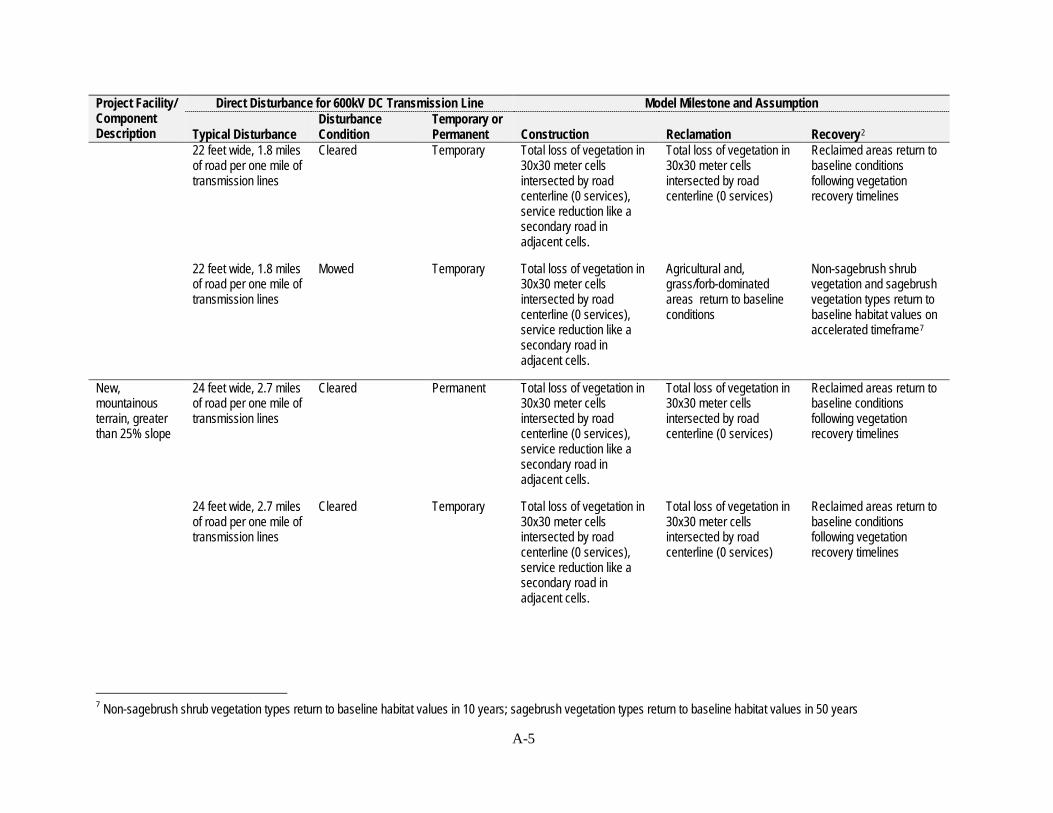
Project Facility/ Direct Disturbance for 600kV DC Transmission Line Model Milestone and Assumption Component Description Typical Disturbance
Disturbance Condition
Temporary or Permanent Construction Reclamation Recovery2
22 feet wide, 1.8 miles of road per one mile of transmission lines
Cleared Temporary Total loss of vegetation in 30x30 meter cells intersected by road centerline (0 services), service reduction like a
Total loss of vegetation in 30x30 meter cells intersected by road centerline (0 services)
Reclaimed areas return to baseline conditions following vegetation recovery timelines
secondary road in adjacent cells.
22 feet wide, 1.8 miles of road per one mile of transmission lines
Mowed Temporary Total loss of vegetation in 30x30 meter cells intersected by road centerline (0 services), service reduction like a
Agricultural and, grass/forb-dominated areas return to baseline conditions
Non-sagebrush shrub vegetation and sagebrush vegetation types return to baseline habitat values on accelerated timeframe7
secondary road in adjacent cells.
New, mountainous terrain, greater than 25% slope
24 feet wide, 2.7 miles of road per one mile of transmission lines
Cleared Permanent Total loss of vegetation in 30x30 meter cells intersected by road centerline (0 services), service reduction like a
Total loss of vegetation in 30x30 meter cells intersected by road centerline (0 services)
Reclaimed areas return to baseline conditions following vegetation recovery timelines
secondary road in adjacent cells.
24 feet wide, 2.7 miles of road per one mile of transmission lines
Cleared Temporary Total loss of vegetation in 30x30 meter cells intersected by road centerline (0 services), service reduction like a
Total loss of vegetation in 30x30 meter cells intersected by road centerline (0 services)
Reclaimed areas return to baseline conditions following vegetation recovery timelines
secondary road in adjacent cells.
7 Non-sagebrush shrub vegetation types return to baseline habitat values in 10 years; sagebrush vegetation types return to baseline habitat values in 50 years
A-5

Project Facility/ Component Description
Direct Disturbance for 600kV DC Transmission Line
Typical Disturbance Disturbance Condition
Temporary or Permanent Construction
Model Milestone and Assumption
Reclamation Recovery2
24 feet wide, 2.7 miles of road per one mile of transmission lines
Mowed Temporary Total loss of vegetation in 30x30 meter cells intersected by road centerline (0 services), service reduction like a
Agricultural and, grass/forb-dominated areas return to baseline conditions
Non-sagebrush shrub vegetation and sagebrush vegetation types return to baseline habitat values on accelerated timeframe8
secondary road in adjacent cells.
Access Roads Where Co-located with Existing Transmission Line(s)9
New, flat terrain, 16 feet wide, 0.8 miles Cleared Permanent 0-8% slope of road per one mile of
transmission lines
16 feet wide, 0.8 miles Cleared Temporary of road per one mile of transmission lines
16 feet wide, 0.8 miles Mowed Temporary of road per one mile of transmission lines
Total loss of vegetation in 30x30 meter cells intersected by road centerline (0 services), service reduction like a secondary road in adjacent cells.
Total loss of vegetation in 30x30 meter cells intersected by road centerline (0 services), service reduction like a secondary road in adjacent cells.
Total loss of vegetation in 30x30 meter cells intersected by road centerline (0 services), service reduction like a secondary road in adjacent cells.
Total loss of vegetation in 30x30 meter cells intersected by road centerline (0 services)
Total loss of vegetation in 30x30 meter cells intersected by road centerline (0 services)
Agricultural and, grass/forb-dominated areas return to baseline conditions
Reclaimed areas return to baseline conditions following vegetation recovery timelines
Reclaimed areas return to baseline conditions following vegetation recovery timelines
Non-sagebrush shrub vegetation and sagebrush vegetation types return to baseline habitat values on accelerated timeframe10
8 Non-sagebrush shrub vegetation types return to baseline habitat values in 10 years; sagebrush vegetation types return to baseline habitat values in 50 years 9 Access Roads Where Co-located with Existing Transmission Line(s) are roads where existing transmission line infrastructure is present. These roads are shorter than Access Roads Where Not Co-located with Existing Transmission Line(s) because they take advantage of the existing roads to reduce surface disturbance. 10 Non-sagebrush shrub vegetation types return to baseline habitat values in 10 years; sagebrush vegetation types return to baseline habitat values in 50 years
A-6

Project Facility/ Direct Disturbance for 600kV DC Transmission Line Model Milestone and Assumption Component Disturbance Temporary or Description Typical Disturbance Condition Permanent Construction Reclamation Recovery2
New, rolling 18 feet wide, 1.1 miles Cleared Permanent Total loss of vegetation in terrain, 8-15% of road per one mile of 30x30 meter cells slope transmission lines intersected by road
centerline (0 services), service reduction like a secondary road in adjacent cells.
18 feet wide, 1.1 miles Cleared Temporary Total loss of vegetation in of road per one mile of 30x30 meter cells transmission lines intersected by road
centerline (0 services), service reduction like a secondary road in adjacent cells.
18 feet wide, 1.1 miles Mowed Temporary Total loss of vegetation in of road per one mile of 30x30 meter cells transmission lines intersected by road
centerline (0 services), service reduction like a secondary road in adjacent cells.
Total loss of vegetation in Reclaimed areas return to 30x30 meter cells baseline conditions intersected by road following vegetation centerline (0 services) recovery timelines
Total loss of vegetation in Reclaimed areas return to 30x30 meter cells baseline conditions intersected by road following vegetation centerline (0 services) recovery timelines
Agricultural and, Non-sagebrush shrub grass/forb-dominated vegetation and sagebrush areas return to baseline vegetation types return to conditions baseline habitat values on
accelerated timeframe11
New, steep 22 feet wide, 1.6 miles Cleared Permanent Total loss of vegetation in Total loss of vegetation in Reclaimed areas return to terrain, 15-25% of road per one mile of 30x30 meter cells 30x30 meter cells baseline conditions slope transmission lines intersected by road intersected by road following vegetation
centerline (0 services), centerline (0 services) recovery timelines service reduction like a secondary road in adjacent cells.
11 Non-sagebrush shrub vegetation types return to baseline habitat values in 10 years; sagebrush vegetation types return to baseline habitat values in 50 years
A-7

Project Facility/ Direct Disturbance for 600kV DC Transmission Line Model Milestone and Assumption Component Description Typical Disturbance
Disturbance Condition
Temporary or Permanent Construction Reclamation Recovery2
22 feet wide, 1.6 miles of road per one mile of transmission lines
Cleared Temporary Total loss of vegetation in 30x30 meter cells intersected by road centerline (0 services), service reduction like a
Total loss of vegetation in 30x30 meter cells intersected by road centerline (0 services)
Reclaimed areas return to baseline conditions following vegetation recovery timelines
secondary road in adjacent cells.
22 feet wide, 1.6 miles of road per one mile of transmission lines
Mowed Temporary Total loss of vegetation in 30x30 meter cells intersected by road centerline (0 services), service reduction like a
Agricultural and, grass/forb-dominated areas return to baseline conditions
Non-sagebrush shrub vegetation and sagebrush vegetation types return to baseline habitat values on accelerated timeframe12
secondary road in adjacent cells.
New, mountainous terrain, greater than 25% slope
24 feet wide, 2.4 miles of road per one mile of transmission lines
Cleared Permanent Total loss of vegetation in 30x30 meter cells intersected by road centerline (0 services), service reduction like a
Total loss of vegetation in 30x30 meter cells intersected by road centerline (0 services)
Reclaimed areas return to baseline conditions following vegetation recovery timelines
secondary road in adjacent cells.
24 feet wide, 2.4 miles of road per one mile of transmission lines
Cleared Temporary Total loss of vegetation in 30x30 meter cells intersected by road centerline (0 services), service reduction like a
Total loss of vegetation in 30x30 meter cells intersected by road centerline (0 services)
Reclaimed areas return to baseline conditions following vegetation recovery timelines
secondary road in adjacent cells.
12 Non-sagebrush shrub vegetation types return to baseline habitat values in 10 years; sagebrush vegetation types return to baseline habitat values in 50 years
A-8

Project Facility/ Direct Disturbance for 600kV DC Transmission Line Model Milestone and Assumption Component Description Typical Disturbance
Disturbance Condition
24 feet wide, 2.4 miles of road per one mile of transmission lines
Mowed
Transmission Line Structures 600kV Guyed Lattice Tangent for DC transmission line
0.0014 acres 5 ft X 5 ft center mast 3 ft X 3 ft per guy location (4 locations)
Cleared at mast foundation and anchor locations
Temporary or Permanent Construction Temporary Total loss of vegetation in
30x30 meter cells intersected by road centerline (0 services), service reduction like a secondary road in adjacent cells.
Permanent Total loss of vegetation in footprint of disturbance (0 services)
Reclamation Agricultural and, grass/forb-dominated areas return to baseline conditions
Total loss of vegetation in footprint of disturbance (0 services)
Recovery2
Non-sagebrush shrub vegetation and sagebrush vegetation types return to baseline habitat values on accelerated timeframe13
Total loss of vegetation in footprint of disturbance (0 services)
600 kV Self-supporting Lattice Tangent for DC transmission line
0.021 acres14
30 ft X 30 ft Cleared around foundation
600 kV Self-supporting Tubular Steel Tangent for DC transmission line
0.00092 acres14
(40 ft2) 7 ft diameter drilled pier
Cleared around foundation
600 kV Self-supporting lattice angle for DC transmission line
0.028 acres14
35 ft X 35 ft Cleared around foundation
Permanent Total loss of vegetation in footprint of disturbance (0 services)
Permanent Total loss of vegetation in footprint of disturbance (0 services)
Permanent Total loss of vegetation in footprint of disturbance (0 services)
Total loss of vegetation in footprint of disturbance (0 services)
Total loss of vegetation in footprint of disturbance (0 services)
Total loss of vegetation in footprint of disturbance (0 services)
Total loss of vegetation in footprint of disturbance (0 services)
Total loss of vegetation in footprint of disturbance (0 services)
Total loss of vegetation in footprint of disturbance (0 services)
13 Non-sagebrush shrub vegetation types return to baseline habitat values in 10 years; sagebrush vegetation types return to baseline habitat values in 50 years 14 Irrespective of structure height
A-9
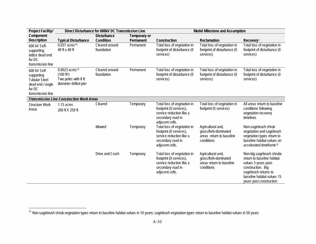
Project Facility/ Component Description
Direct Disturbance for 600kV DC Transmission Line
Typical Disturbance Disturbance Condition
Temporary or Permanent Construction
Model Milestone and Assumption
Reclamation Recovery2
600 kV Self-supporting lattice dead end
0.037 acres14
40 ft x 40 ft Cleared around foundation
Permanent Total loss of vegetation in footprint of disturbance (0 services)
Total loss of vegetation in footprint of disturbance (0 services)
Total loss of vegetation in footprint of disturbance (0 services)
for DC transmission line 600 kV Self 0.0023 acres14 Cleared around Permanent Total loss of vegetation in Total loss of vegetation in Total loss of vegetation in supporting Tubular Steel
(100 ft2) Two poles with 8 ft
foundation footprint of disturbance (0 services)
footprint of disturbance (0 services)
footprint of disturbance (0 services)
dead end / angle diameter drilled pier for DC transmission line Transmission Line Construction Work Areas Structure Work Areas
1.15 acres 200 ft X 250 ft
Cleared Temporary Total loss of vegetation in footprint (0 services), service reduction like a secondary road in adjacent cells.
Total loss of vegetation in footprint (0 services)
All areas return to baseline conditions following vegetation recovery timelines
Mowed Temporary Total loss of vegetation in footprint (0 services), service reduction like a secondary road in adjacent cells.
Agricultural and, grass/forb-dominated areas return to baseline conditions
Non-sagebrush shrub vegetation and sagebrush vegetation types return to baseline habitat values on accelerated timeframe15
Drive and Crush Temporary Total loss of vegetation in footprint (0 services), service reduction like a secondary road in adjacent cells.
Agricultural and, grass/forb-dominated areas return to baseline conditions
Non-big sagebrush shrubs return to baseline habitat values 5 years post-construction. Big sagebrush returns to baseline habitat values 15 years post construction
15 Non-sagebrush shrub vegetation types return to baseline habitat values in 10 years; sagebrush vegetation types return to baseline habitat values in 50 years
A-10

Project Facility/ Component Description
Direct Disturbance for 600kV DC Transmission Line
Typical Disturbance Disturbance Condition
Temporary or Permanent Construction
Model Milestone and Assumption
Reclamation Recovery2
Pulling/ Tensioning /Splicing Site
3.44 acres 600 ft X 250 ft Two at each heavy angle location
Cleared Temporary Total loss of vegetation in footprint (0 services), service reduction like a secondary road in adjacent cells.
Total loss of vegetation in footprint (0 services)
All areas return to baseline conditions following vegetation recovery timelines
Mowed Temporary Total loss of vegetation in footprint (0 services), service reduction like a secondary road in adjacent cells.
Agricultural and, grass/forb-dominated areas return to baseline conditions
Non-sagebrush shrub vegetation and sagebrush vegetation types return to baseline habitat values on accelerated timeframe15
Drive and Crush Temporary Total loss of vegetation in footprint (0 services), service reduction like a secondary road in adjacent cells.
Agricultural and, grass/forb-dominated areas return to baseline conditions
Non-big sagebrush shrubs return to baseline habitat values 5 years post-construction. Big sagebrush returns to baseline habitat values 15 years post construction
Mid-span Pulling/ Tensioning/ Splicing Site
2.87 acres 500 ft X 250 ft
Cleared Temporary Total loss of vegetation in footprint (0 services), service reduction like a secondary road in adjacent cells.
Total loss of vegetation in footprint (0 services)
All areas return to baseline conditions following vegetation recovery timelines
Mowed Temporary Total loss of vegetation in footprint (0 services), service reduction like a secondary road in adjacent cells.
Agricultural and, grass/forb-dominated areas return to baseline conditions
Non-sagebrush shrub vegetation and sagebrush vegetation types return to baseline habitat values on accelerated timeframe16
16 Non-sagebrush shrub vegetation types return to baseline habitat values in 10 years; sagebrush vegetation types return to baseline habitat values in 50 years
A-11
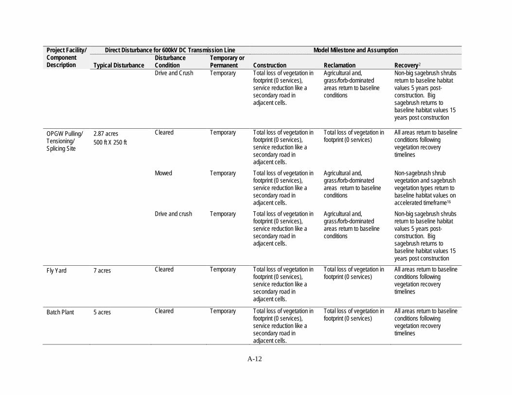
Project Facility/ Direct Disturbance for 600kV DC Transmission Line Model Milestone and Assumption Component Description Typical Disturbance
Disturbance Condition
Temporary or Permanent Construction Reclamation Recovery2
Drive and Crush Temporary Total loss of vegetation in footprint (0 services), service reduction like a secondary road in adjacent cells.
Agricultural and, grass/forb-dominated areas return to baseline conditions
Non-big sagebrush shrubs return to baseline habitat values 5 years post-construction. Big sagebrush returns to baseline habitat values 15 years post construction
OPGW Pulling/ Tensioning/ Splicing Site
2.87 acres 500 ft X 250 ft
Cleared Temporary Total loss of vegetation in footprint (0 services), service reduction like a secondary road in adjacent cells.
Total loss of vegetation in footprint (0 services)
All areas return to baseline conditions following vegetation recovery timelines
Mowed Temporary Total loss of vegetation in footprint (0 services), service reduction like a secondary road in adjacent cells.
Agricultural and, grass/forb-dominated areas return to baseline conditions
Non-sagebrush shrub vegetation and sagebrush vegetation types return to baseline habitat values on accelerated timeframe16
Drive and crush Temporary Total loss of vegetation in footprint (0 services), service reduction like a secondary road in adjacent cells.
Agricultural and, grass/forb-dominated areas return to baseline conditions
Non-big sagebrush shrubs return to baseline habitat values 5 years post-construction. Big sagebrush returns to baseline habitat values 15 years post construction
Fly Yard 7 acres Cleared Temporary Total loss of vegetation in footprint (0 services), service reduction like a secondary road in adjacent cells.
Total loss of vegetation in footprint (0 services)
All areas return to baseline conditions following vegetation recovery timelines
Batch Plant 5 acres Cleared Temporary Total loss of vegetation in footprint (0 services), service reduction like a secondary road in adjacent cells.
Total loss of vegetation in footprint (0 services)
All areas return to baseline conditions following vegetation recovery timelines
A-12

Project Facility/ Direct Disturbance for 600kV DC Transmission Line Model Milestone and Assumption Component Description Typical Disturbance
Disturbance Condition
Temporary or Permanent Construction Reclamation Recovery2
Material Storage Yard
20 acres Cleared Temporary Total loss of vegetation in footprint (0 services), service reduction like a secondary road in adjacent cells.
Total loss of vegetation in footprint (0 services)
All areas return to baseline conditions following vegetation recovery timelines
Fly yard, batch plant, material
No New Disturbance Cleared Temporary or permanent
Same as Baseline – Zero additional effect
Same as Baseline – Zero additional effect
Same as Baseline – Zero additional effect
storage yard colocated with existing disturbance or facility Ancillary Facilities North Terminal 200 acres Cleared Permanent Total loss of vegetation in
footprint (0 services), service reduction like a
Total loss of vegetation in footprint (0 services), service reduction like a
Total loss of vegetation in footprint (0 services), service reduction like a
Ground Electrode Site
0.20 acres Cleared Permanent
secondary road in adjacent cells. Total loss of vegetation in footprint (0 services), service reduction like a
secondary road in adjacent cells. Total loss of vegetation in footprint (0 services),
secondary road in adjacent cells. Total loss of vegetation in footprint (0 services),
Ground Electrode Line tangent Structure
8 ft2 Cleared around foundation
Permanent
secondary road in adjacent cells. Total loss of vegetation in footprint of disturbance (0 services),
Total loss of vegetation in footprint of disturbance (0 services),
Total loss of vegetation in footprint of disturbance (0 services),
Ground Electrode Line dead end Structure
16 ft2 Cleared around foundation
Permanent Total loss of vegetation in footprint of disturbance (0 services),
Total loss of vegetation in footprint of disturbance (0 services),
Total loss of vegetation in footprint of disturbance (0 services),
A-13
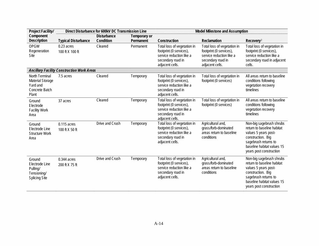
Project Facility/ Direct Disturbance for 600kV DC Transmission Line Model Milestone and Assumption Component Disturbance Temporary or Description Typical Disturbance Condition Permanent Construction Reclamation Recovery2
OPGW 0.23 acres Cleared Permanent Total loss of vegetation in Total loss of vegetation in Total loss of vegetation in Regeneration 100 ft X 100 ft footprint (0 services), footprint (0 services), footprint (0 services), Site service reduction like a service reduction like a service reduction like a
secondary road in secondary road in secondary road in adjacent adjacent cells. adjacent cells. cells.
Ancillary Facility Construction Work Areas North Terminal Material Storage Yard and Concrete Batch Plant Ground Electrode Facility Work Area
Ground Electrode Line Structure Work Area
7.5 acres
37 acres
0.115 acres 100 ft X 50 ft
Cleared
Cleared
Drive and Crush
Temporary
Temporary
Temporary
Total loss of vegetation in footprint (0 services), service reduction like a secondary road in adjacent cells. Total loss of vegetation in footprint (0 services), service reduction like a secondary road in adjacent cells. Total loss of vegetation in footprint (0 services), service reduction like a secondary road in adjacent cells.
Total loss of vegetation in footprint (0 services)
Total loss of vegetation in footprint (0 services)
Agricultural and, grass/forb-dominated areas return to baseline conditions
All areas return to baseline conditions following vegetation recovery timelines
All areas return to baseline conditions following vegetation recovery timelines
Non-big sagebrush shrubs return to baseline habitat values 5 years post-construction. Big sagebrush returns to baseline habitat values 15 years post construction
Ground Electrode Line Pulling/ Tensioning/ Splicing Site
0.344 acres 200 ft X 75 ft
Drive and Crush Temporary Total loss of vegetation in footprint (0 services), service reduction like a secondary road in adjacent cells.
Agricultural and, grass/forb-dominated areas return to baseline conditions
Non-big sagebrush shrubs return to baseline habitat values 5 years post-construction. Big sagebrush returns to baseline habitat values 15 years post construction
A-14
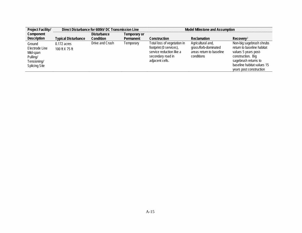
Project Facility/ Component Description
Direct Disturbance for 600kV DC Transmission Line
Typical Disturbance Disturbance Condition
Temporary or Permanent Construction
Model Milestone and Assumption
Reclamation Recovery2
Ground Electrode Line Mid-span Pulling/ Tensioning/ Splicing Site
0.172 acres 100 ft X 75 ft
Drive and Crush Temporary Total loss of vegetation in footprint (0 services), service reduction like a secondary road in adjacent cells.
Agricultural and, grass/forb-dominated areas return to baseline conditions
Non-big sagebrush shrubs return to baseline habitat values 5 years post-construction. Big sagebrush returns to baseline habitat values 15 years post construction
A-15

APPENDIX B
EGS Direct Effect Assumption Tables
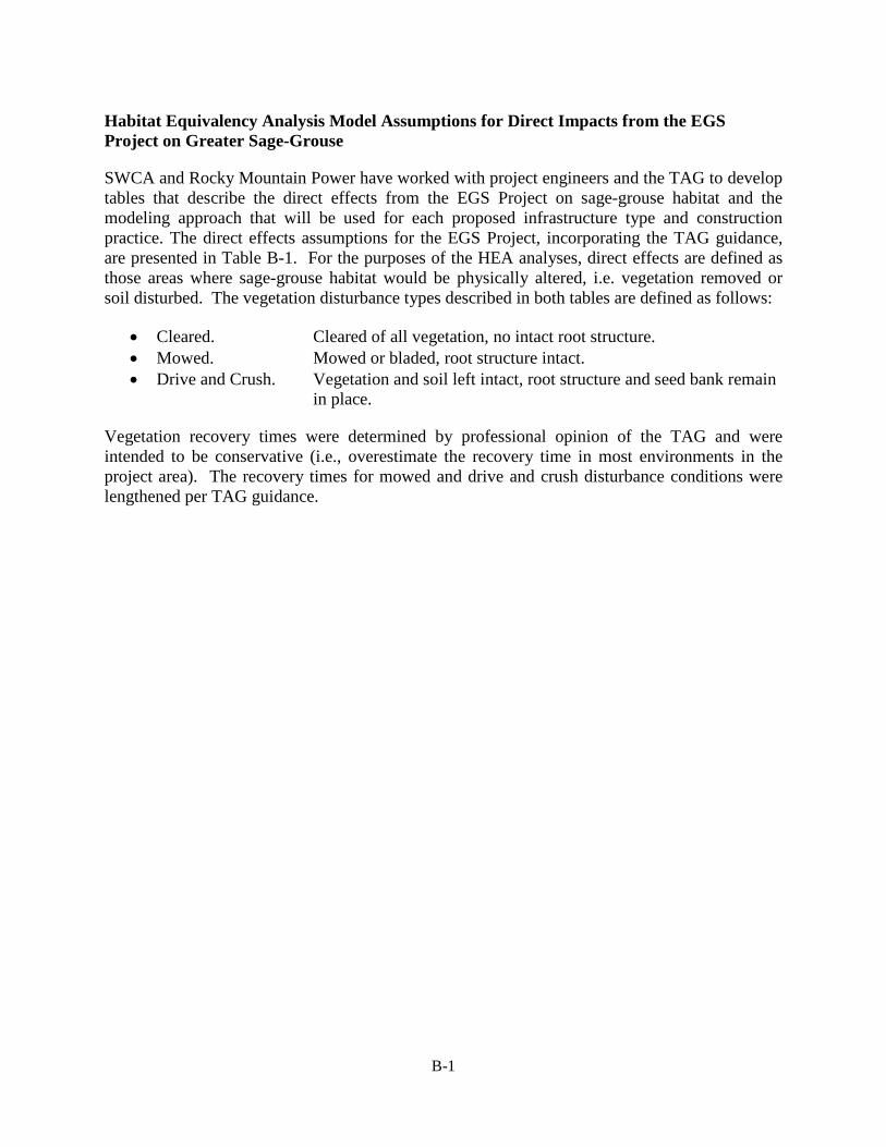
Habitat Equivalency Analysis Model Assumptions for Direct Impacts from the EGS Project on Greater Sage-Grouse
SWCA and Rocky Mountain Power have worked with project engineers and the TAG to develop tables that describe the direct effects from the EGS Project on sage-grouse habitat and the modeling approach that will be used for each proposed infrastructure type and construction practice. The direct effects assumptions for the EGS Project, incorporating the TAG guidance, are presented in Table B-1. For the purposes of the HEA analyses, direct effects are defined as those areas where sage-grouse habitat would be physically altered, i.e. vegetation removed or soil disturbed. The vegetation disturbance types described in both tables are defined as follows:
• Cleared. Cleared of all vegetation, no intact root structure. • Mowed. Mowed or bladed, root structure intact. • Drive and Crush. Vegetation and soil left intact, root structure and seed bank remain
in place.
Vegetation recovery times were determined by professional opinion of the TAG and were intended to be conservative (i.e., overestimate the recovery time in most environments in the project area). The recovery times for mowed and drive and crush disturbance conditions were lengthened per TAG guidance.
B-1

Table B-1. Direct Disturbance Assumptions for Typical Disturbance Types Associated with the Energy Gateway South Transmission Line Project.
Project Direct Disturbance for AC Transmission Line Infrastructure Model Milestone and Assumption Facility/ Component Typical Disturbance Temporary or Description Disturbance17 Condition Permanent Construction Reclamation Recovery18
Access Roads
Existing, No Improvements
No New Disturbance Cleared Permanent Same as Baseline – Zero additional effect
Same as Baseline – Zero additional effect
Same as Baseline – Zero additional effect
Existing, Improved, 0 to 15 percent slope
Final road area is 2.8 acres of ground disturbance per mile (includes pullout areas of 100 ft X 10 ft every 1,000 ft),
Secondary road improved. Areas cleared outside existing disturbance
Permanent Total loss of vegetation in new disturbed footprint (0 services)
Total loss of vegetation in new disturbed footprint (0 services)
All reclaimed areas return to baseline conditions following vegetation recovery timelines
Existing, Improved, 0 to 15 percent slope
Final road area is 2.8 acres of ground disturbance per mile (includes pullout areas of 100 ft X 10 ft every 1,000 ft)
Two-track improved to Cleared
Permanent Total loss of vegetation in 30x30 meter cells intersected by road centerline (0 services), service reduction like a secondary road in adjacent cells
Total loss of vegetation in 30x30 meter cells intersected by road centerline (0 services)
Reclaimed areas return to baseline conditions following vegetation recovery timelines
17 Typical disturbance represents the typical or average anticipated disturbance associated with each project facility or component based on preliminary engineering. Following final project micro-siting and engineering, the project design will be updated and the HEA model will be run using the complete detailed project design.
18 Reclaimed areas will return to baseline conditions using the following vegetation recovery assumptions, unless otherwise stated: Agricultural lands return to baseline habitat values in 1 year; grass dominated and wetland vegetation types return to baseline habitat values in 5 years; non-sagebrush shrub vegetation types return to baseline habitat values in 20 years; sagebrush vegetation types return to baseline habitat values in 100 years
B-2

Project Direct Disturbance for AC Transmission Line Infrastructure Model Milestone and Assumption Facility/ Component Typical Disturbance Temporary or Description Disturbance17 Condition Permanent Construction Reclamation Recovery18
Existing, Final road area is 6.7 Secondary road Permanent Total loss of vegetation in Total loss of vegetation in All reclaimed areas return Improved, acres of ground improved. Areas new disturbed footprint (0 new disturbed footprint (0 to baseline conditions greater than 15 disturbance per mile cleared outside services) services) following vegetation percent slope (includes pullout areas existing disturbance recovery timelines
of 100 ft X 10 ft every 1,000 ft)
Existing, Final road area is 6.7 Two-track improved Temporary and Total loss of vegetation in Total loss of vegetation in Reclaimed areas return to Improved, acres of ground to cleared permanent 30x30 meter cells 30x30 meter cells baseline conditions greater than 15 disturbance per mile intersected by road intersected by road following vegetation percent slope (includes pullout areas centerline (0 services), centerline (0 services) recovery timelines
of 100 ft X 10 ft every service reduction like a 1,000 ft) secondary road in adjacent
cells New, 0-8 3.2 acres of ground Cleared Temporary and percent slope disturbance per mile Permanent
(includes pullout areas of 100 ft X 10 ft every 1,000 ft)
Mowed Temporary and Permanent
Drive and Crush Temporary and Permanent
Total loss of vegetation in Total loss of vegetation in All reclaimed areas return 30x30 meter cells 30x30 meter cells to baseline conditions intersected by road intersected by road following vegetation centerline (0 services), centerline (0 services), recovery timelines service reduction like a secondary road in adjacent cells. Total loss of vegetation in Agricultural and, Non-sagebrush shrub 30x30 meter cells grass/forb-dominated vegetation types return to intersected by road areas return to baseline baseline habitat values in centerline (0 services), conditions 10 years; sagebrush service reduction like a vegetation types return to secondary road in adjacent baseline habitat values in cells. 50 years Total loss of vegetation in Agricultural and, Non-big sagebrush shrubs 30x30 meter cells grass/forb-dominated return to baseline habitat intersected by road areas return to baseline values 5 years post-centerline (0 services), conditions construction. Big service reduction like a sagebrush returns to secondary road in adjacent baseline habitat values 15 cells. years post construction
B-3
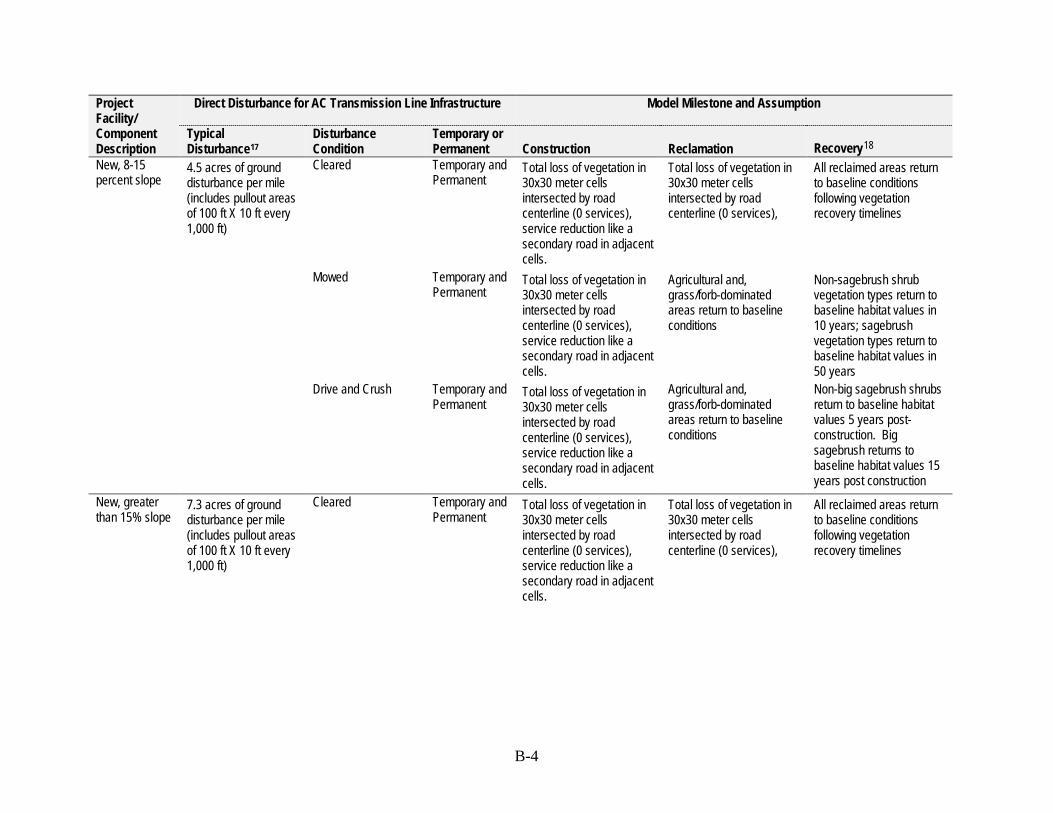
Project Direct Disturbance for AC Transmission Line Infrastructure Model Milestone and Assumption Facility/ Component Typical Disturbance Temporary or Description Disturbance17 Condition Permanent Construction Reclamation Recovery18
New, 8-15 4.5 acres of ground Cleared Temporary and percent slope disturbance per mile Permanent
(includes pullout areas of 100 ft X 10 ft every 1,000 ft)
Mowed Temporary and Permanent
Drive and Crush Temporary and Permanent
Total loss of vegetation in Total loss of vegetation in All reclaimed areas return 30x30 meter cells 30x30 meter cells to baseline conditions intersected by road intersected by road following vegetation centerline (0 services), centerline (0 services), recovery timelines service reduction like a secondary road in adjacent cells. Total loss of vegetation in Agricultural and, Non-sagebrush shrub 30x30 meter cells grass/forb-dominated vegetation types return to intersected by road areas return to baseline baseline habitat values in centerline (0 services), conditions 10 years; sagebrush service reduction like a vegetation types return to secondary road in adjacent baseline habitat values in cells. 50 years Total loss of vegetation in Agricultural and, Non-big sagebrush shrubs 30x30 meter cells grass/forb-dominated return to baseline habitat intersected by road areas return to baseline values 5 years post-centerline (0 services), conditions construction. Big service reduction like a sagebrush returns to secondary road in adjacent baseline habitat values 15 cells. years post construction
New, greater 7.3 acres of ground Cleared Temporary and Total loss of vegetation in Total loss of vegetation in All reclaimed areas return than 15% slope disturbance per mile Permanent 30x30 meter cells 30x30 meter cells to baseline conditions
(includes pullout areas intersected by road intersected by road following vegetation of 100 ft X 10 ft every centerline (0 services), centerline (0 services), recovery timelines 1,000 ft) service reduction like a
secondary road in adjacent cells.
B-4

Project Direct Disturbance for AC Transmission Line Infrastructure Model Milestone and Assumption Facility/ Component Typical Disturbance Temporary or Description Disturbance17 Condition Permanent Construction Reclamation Recovery18
Mowed Temporary and Permanent
Drive and Crush Temporary and Permanent
Total loss of vegetation in 30x30 meter cells intersected by road centerline (0 services), service reduction like a secondary road in adjacent cells. Total loss of vegetation in 30x30 meter cells intersected by road centerline (0 services), service reduction like a secondary road in adjacent cells.
Agricultural and, grass/forb-dominated areas return to baseline conditions
Agricultural and, grass/forb-dominated areas return to baseline conditions
Non-sagebrush shrub vegetation types return to baseline habitat values in 10 years; sagebrush vegetation types return to baseline habitat values in 50 years Non-big sagebrush shrubs return to baseline habitat values 5 years post-construction. Big sagebrush returns to baseline habitat values 15 years post construction
Transmission Line Structures
500kV Guyed Tangent for AC transmission line
0.0014 acres 5 ft X 5 ft center mast plus 3 ft X 3 ft at each guy location – 4 guys
Cleared at mast foundation and anchor locations
Permanent Total loss of vegetation in footprint of disturbance (0 services)
Total loss of vegetation in footprint of disturbance (0 services)
Total loss of vegetation in footprint of disturbance (0 services)
500kV H-Frame Tangent for AC transmission
0.008 acres 35 ft X 10 ft
Cleared around foundation
Permanent Total loss of vegetation in footprint of disturbance (0 services)
Total loss of vegetation in footprint of disturbance (0 services)
Total loss of vegetation in footprint of disturbance (0 services)
line 500kV H-Frame Deadend for AC
0.01 acres 45 ft X 10 ft
Cleared around foundation
Permanent Total loss of vegetation in footprint of disturbance (0 services)
Total loss of vegetation in footprint of disturbance (0 services)
Total loss of vegetation in footprint of disturbance (0 services)
transmission line
B-5
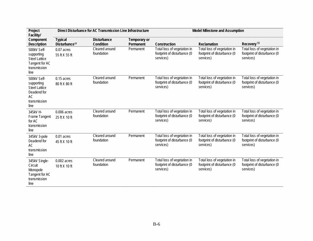
Project Direct Disturbance for AC Transmission Line Infrastructure Model Milestone and Assumption Facility/ Component Description 500kV Self-supporting Steel Lattice Tangent for AC transmission
Typical Disturbance17
0.07 acres 55 ft X 55 ft
Disturbance Condition Cleared around foundation
Temporary or Permanent Permanent
Construction Total loss of vegetation in footprint of disturbance (0 services)
Reclamation Total loss of vegetation in footprint of disturbance (0 services)
Recovery18
Total loss of vegetation in footprint of disturbance (0 services)
line 500kV Self-supporting Steel Lattice Deadend for
0.15 acres 80 ft X 80 ft
Cleared around foundation
Permanent Total loss of vegetation in footprint of disturbance (0 services)
Total loss of vegetation in footprint of disturbance (0 services)
Total loss of vegetation in footprint of disturbance (0 services)
AC transmission line 345kV H-Frame Tangent for AC transmission
0.006 acres 25 ft X 10 ft
Cleared around foundation
Permanent Total loss of vegetation in footprint of disturbance (0 services)
Total loss of vegetation in footprint of disturbance (0 services)
Total loss of vegetation in footprint of disturbance (0 services)
line 345kV 3-pole Deadend for AC transmission
0.01 acres 45 ft X 10 ft
Cleared around foundation
Permanent Total loss of vegetation in footprint of disturbance (0 services)
Total loss of vegetation in footprint of disturbance (0 services)
Total loss of vegetation in footprint of disturbance (0 services)
line 345kV Single-Circuit Monopole Tangent for AC transmission
0.002 acres 10 ft X 10 ft
Cleared around foundation
Permanent Total loss of vegetation in footprint of disturbance (0 services)
Total loss of vegetation in footprint of disturbance (0 services)
Total loss of vegetation in footprint of disturbance (0 services)
line
B-6

Project Direct Disturbance for AC Transmission Line Infrastructure Model Milestone and Assumption Facility/ Component Description
Typical Disturbance17
Disturbance Condition
Temporary or Permanent Construction Reclamation Recovery18
345kV Single-Circuit Monopole Deadend for
0.009 acres 20 ft X 20 ft
Cleared around foundation
Permanent Total loss of vegetation in footprint of disturbance (0 services)
Total loss of vegetation in footprint of disturbance (0 services)
Total loss of vegetation in footprint of disturbance (0 services)
AC transmission line 345kV Double-Circuit Monopole Tangent for AC transmission
0.005 acres 15 ft X 15 ft
Cleared around foundation
Permanent Total loss of vegetation in footprint of disturbance (0 services)
Total loss of vegetation in footprint of disturbance (0 services)
Total loss of vegetation in footprint of disturbance (0 services)
line 345kV Double-Circuit Monopole Deadend for
0.014 acres 25 ft X 25 ft
Cleared around foundation
Permanent Total loss of vegetation in footprint of disturbance (0 services)
Total loss of vegetation in footprint of disturbance (0 services)
Total loss of vegetation in footprint of disturbance (0 services)
AC transmission line Transmission Line Construction Work Areas
500kV 1.43 acres Cleared Temporary Total loss of vegetation in Total loss of vegetation in All reclaimed areas return Structure Work 250 ft X 250 ft footprint (0 services), footprint (0 services). to baseline conditions Area service reduction like a following vegetation
secondary road in adjacent recovery timelines cells.
B-7
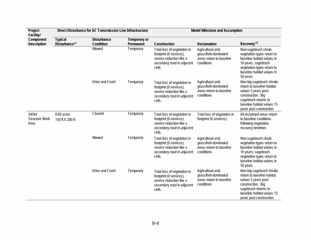
Project Direct Disturbance for AC Transmission Line Infrastructure Model Milestone and Assumption Facility/ Component Typical Disturbance Temporary or Description Disturbance17 Condition Permanent Construction Reclamation Recovery18
Mowed Temporary Total loss of vegetation in footprint (0 services), service reduction like a secondary road in adjacent cells.
Drive and Crush Temporary Total loss of vegetation in footprint (0 services), service reduction like a secondary road in adjacent cells.
Agricultural and, Non-sagebrush shrub grass/forb-dominated vegetation types return to areas return to baseline baseline habitat values in conditions 10 years; sagebrush
vegetation types return to baseline habitat values in 50 years
Agricultural and, Non-big sagebrush shrubs grass/forb-dominated return to baseline habitat areas return to baseline values 5 years postconditions construction. Big
sagebrush returns to baseline habitat values 15 years post construction
345kV Structure Work Area
0.69 acres 150 ft X 200 ft
Cleared Temporary Total loss of vegetation in footprint (0 services), service reduction like a secondary road in adjacent cells.
Total loss of vegetation in footprint (0 services).
All reclaimed areas return to baseline conditions following vegetation recovery timelines
Mowed Temporary Total loss of vegetation in footprint (0 services), service reduction like a
Agricultural and, grass/forb-dominated areas return to baseline
Non-sagebrush shrub vegetation types return to baseline habitat values in
secondary road in adjacent cells.
conditions 10 years; sagebrush vegetation types return to baseline habitat values in 50 years
Drive and Crush Temporary Total loss of vegetation in footprint (0 services), service reduction like a secondary road in adjacent cells.
Agricultural and, grass/forb-dominated areas return to baseline conditions
Non-big sagebrush shrubs return to baseline habitat values 5 years post-construction. Big sagebrush returns to baseline habitat values 15 years post construction
B-8

Project Direct Disturbance for AC Transmission Line Infrastructure Model Milestone and Assumption Facility/ Component Typical Disturbance Temporary or Description Disturbance17 Condition Permanent Construction Reclamation Recovery18
500kV 2.3 acres Cleared Temporary Pulling/Tension 250 ft X 400 ft ing Site Two sites every 3 to 5
miles
Mowed Temporary
Drive and Crush Temporary
Total loss of vegetation in Total loss of vegetation in All reclaimed areas return footprint (0 services), footprint (0 services). to baseline conditions service reduction like a following vegetation secondary road in adjacent recovery timelines cells. Total loss of vegetation in Agricultural and, Non-sagebrush shrub footprint (0 services), grass/forb-dominated vegetation types return to service reduction like a areas return to baseline baseline habitat values in secondary road in adjacent conditions 10 years; sagebrush cells. vegetation types return to
baseline habitat values in 50 years
Total loss of vegetation in Agricultural and, Non-big sagebrush shrubs footprint (0 services), grass/forb-dominated return to baseline habitat service reduction like a areas return to baseline values 5 years postsecondary road in adjacent conditions construction. Big cells. sagebrush returns to
baseline habitat values 15 years post construction
345kV Pulling/Tension ing Site
1.38 acres 150 by 400 feet One site per 345kV segment
Cleared Temporary Total loss of vegetation in footprint (0 services), service reduction like a secondary road in adjacent cells.
Total loss of vegetation in footprint (0 services).
All reclaimed areas return to baseline conditions following vegetation recovery timelines
Mowed Temporary Total loss of vegetation in footprint (0 services), service reduction like a
Agricultural and, grass/forb-dominated areas return to baseline
Non-sagebrush shrub vegetation types return to baseline habitat values in
secondary road in adjacent cells.
conditions 10 years; sagebrush vegetation types return to baseline habitat values in 50 years
B-9
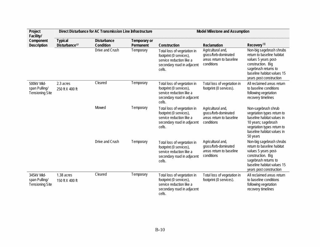
Project Direct Disturbance for AC Transmission Line Infrastructure Model Milestone and Assumption Facility/ Component Description
Typical Disturbance17
Disturbance Condition Drive and Crush
Temporary or Permanent Temporary
Construction Total loss of vegetation in footprint (0 services), service reduction like a secondary road in adjacent cells.
Reclamation Agricultural and, grass/forb-dominated areas return to baseline conditions
Recovery18
Non-big sagebrush shrubs return to baseline habitat values 5 years post-construction. Big sagebrush returns to baseline habitat values 15 years post construction
500kV Mid-span Pulling/ Tensioning Site
2.3 acres 250 ft X 400 ft
Cleared
Mowed
Drive and Crush
Temporary
Temporary
Temporary
Total loss of vegetation in footprint (0 services), service reduction like a secondary road in adjacent cells. Total loss of vegetation in footprint (0 services), service reduction like a secondary road in adjacent cells.
Total loss of vegetation in footprint (0 services), service reduction like a secondary road in adjacent cells.
Total loss of vegetation in footprint (0 services).
Agricultural and, grass/forb-dominated areas return to baseline conditions
Agricultural and, grass/forb-dominated areas return to baseline conditions
All reclaimed areas return to baseline conditions following vegetation recovery timelines
Non-sagebrush shrub vegetation types return to baseline habitat values in 10 years; sagebrush vegetation types return to baseline habitat values in 50 years Non-big sagebrush shrubs return to baseline habitat values 5 years post-construction. Big sagebrush returns to baseline habitat values 15 years post construction
345kV Mid-span Pulling/ Tensioning Site
1.38 acres 150 ft X 400 ft
Cleared Temporary Total loss of vegetation in footprint (0 services), service reduction like a secondary road in adjacent cells.
Total loss of vegetation in footprint (0 services).
All reclaimed areas return to baseline conditions following vegetation recovery timelines
B-10

Project Direct Disturbance for AC Transmission Line Infrastructure Model Milestone and Assumption Facility/ Component Typical Disturbance Temporary or Description Disturbance17 Condition Permanent Construction Reclamation Recovery18
Mowed Temporary Total loss of vegetation in footprint (0 services), service reduction like a secondary road in adjacent cells.
Drive and Crush Temporary Total loss of vegetation in footprint (0 services), service reduction like a secondary road in adjacent cells.
Agricultural and, Non-sagebrush shrub grass/forb-dominated vegetation types return to areas return to baseline baseline habitat values in conditions 10 years; sagebrush
vegetation types return to baseline habitat values in 50 years
Agricultural and, Non-big sagebrush shrubs grass/forb-dominated return to baseline habitat areas return to baseline values 5 years postconditions construction. Big
sagebrush returns to baseline habitat values 15 years post construction
500kV and 0.23 acres Cleared Temporary 345kV Splice 100 ft X 100 ft Site One every 9,000 feet
Mowed Temporary
Drive and Crush Temporary
Total loss of vegetation in footprint (0 services), service reduction like a secondary road in adjacent cells.
Total loss of vegetation in footprint (0 services).
All reclaimed areas return to baseline conditions following vegetation recovery timelines
Total loss of vegetation in footprint (0 services), service reduction like a
Agricultural and, grass/forb-dominated areas return to baseline
Non-sagebrush shrub vegetation types return to baseline habitat values in
secondary road in adjacent cells.
conditions 10 years; sagebrush vegetation types return to baseline habitat values in 50 years
Total loss of vegetation in footprint (0 services), service reduction like a secondary road in adjacent cells.
Agricultural and, grass/forb-dominated areas return to baseline conditions
Non-big sagebrush shrubs return to baseline habitat values 5 years post-construction. Big sagebrush returns to baseline habitat values 15 years post construction
B-11

Project Direct Disturbance for AC Transmission Line Infrastructure Model Milestone and Assumption Facility/ Component Typical Disturbance Temporary or Description Disturbance17 Condition Permanent Construction Reclamation Recovery18
500kV and 0.26 acres Cleared Temporary 350kV Guard 150 ft X 75 ft Structures Site Approximately 1.4
structures per 1 mile
Mowed Temporary
Drive and Crush Temporary
Total loss of vegetation in Total loss of vegetation in All reclaimed areas return footprint (0 services), footprint (0 services). to baseline conditions service reduction like a following vegetation secondary road in adjacent recovery timelines cells. Total loss of vegetation in Agricultural and, Non-sagebrush shrub footprint (0 services), grass/forb-dominated vegetation types return to service reduction like a areas return to baseline baseline habitat values in secondary road in adjacent conditions 10 years; sagebrush cells. vegetation types return to
baseline habitat values in 50 years
Total loss of vegetation in Agricultural and, Non-big sagebrush shrubs footprint (0 services), grass/forb-dominated return to baseline habitat service reduction like a areas return to baseline values 5 years postsecondary road in adjacent conditions construction. Big cells. sagebrush returns to
baseline habitat values 15 years post construction
500kV Multi-Purpose Construction Yards
30-acre site Approximately every 20 miles
Cleared Temporary Total loss of vegetation in footprint (0 services), service reduction like a secondary road in adjacent cells.
Total loss of vegetation in footprint (0 services).
All reclaimed areas return to baseline conditions following vegetation recovery timelines
Mowed Temporary Total loss of vegetation in footprint (0 services), service reduction like a
Agricultural and, grass/forb-dominated areas return to baseline
Non-sagebrush shrub vegetation types return to baseline habitat values in
secondary road in adjacent cells.
conditions 10 years; sagebrush vegetation types return to baseline habitat values in 50 years
B-12

Project Direct Disturbance for AC Transmission Line Infrastructure Model Milestone and Assumption Facility/ Component Typical Disturbance Temporary or Description Disturbance17 Condition Permanent Construction Reclamation Recovery18
Drive and Crush Temporary Total loss of vegetation in Agricultural and, Non-big sagebrush shrubs footprint (0 services), grass/forb-dominated return to baseline habitat service reduction like a areas return to baseline values 5 years postsecondary road in adjacent conditions construction. Big cells. sagebrush returns to
baseline habitat values 15 years post construction
345kV Multi- 10-acre site Cleared Temporary Purpose One site per 345kV Construction segment Yard
Mowed Temporary
Drive and Crush Temporary
Total loss of vegetation in Total loss of vegetation in All reclaimed areas return footprint (0 services), footprint (0 services). to baseline conditions service reduction like a following vegetation secondary road in adjacent recovery timelines cells. Total loss of vegetation in Agricultural and, Non-sagebrush shrub footprint (0 services), grass/forb-dominated vegetation types return to service reduction like a areas return to baseline baseline habitat values in secondary road in adjacent conditions 10 years; sagebrush cells. vegetation types return to
baseline habitat values in 50 years
Total loss of vegetation in Agricultural and, Non-big sagebrush shrubs footprint (0 services), grass/forb-dominated return to baseline habitat service reduction like a areas return to baseline values 5 years postsecondary road in adjacent conditions construction. Big cells. sagebrush returns to
baseline habitat values 15 years post construction
500kV 15-acre site Cleared Temporary Total loss of vegetation in Total loss of vegetation in All reclaimed areas return Helicopter Fly Approximately every 5 footprint (0 services), footprint (0 services). to baseline conditions Yards miles service reduction like a following vegetation
secondary road in adjacent recovery timelines cells.
B-13

Project Direct Disturbance for AC Transmission Line Infrastructure Model Milestone and Assumption Facility/ Component Typical Disturbance Temporary or Description Disturbance17 Condition Permanent Construction Reclamation Recovery18
Mowed Temporary Total loss of vegetation in footprint (0 services), service reduction like a secondary road in adjacent cells.
Drive and Crush Temporary Total loss of vegetation in footprint (0 services), service reduction like a secondary road in adjacent cells.
Agricultural and, Non-sagebrush shrub grass/forb-dominated vegetation types return to areas return to baseline baseline habitat values in conditions 10 years; sagebrush
vegetation types return to baseline habitat values in 50 years
Agricultural and, Non-big sagebrush shrubs grass/forb-dominated return to baseline habitat areas return to baseline values 5 years postconditions construction. Big
sagebrush returns to baseline habitat values 15 years post construction
345kV 15-acre site Cleared Temporary Helicopter Fly One site per 345kV Yards segment
Mowed Temporary
Drive and Crush Temporary
Total loss of vegetation in footprint (0 services), service reduction like a secondary road in adjacent cells.
Total loss of vegetation in footprint (0 services).
All reclaimed areas return to baseline conditions following vegetation recovery timelines
Total loss of vegetation in footprint (0 services), service reduction like a
Agricultural and, grass/forb-dominated areas return to baseline
Non-sagebrush shrub vegetation types return to baseline habitat values in
secondary road in adjacent cells.
conditions 10 years; sagebrush vegetation types return to baseline habitat values in 50 years
Total loss of vegetation in footprint (0 services), service reduction like a secondary road in adjacent cells.
Agricultural and, grass/forb-dominated areas return to baseline conditions
Non-big sagebrush shrubs return to baseline habitat values 5 years post-construction. Big sagebrush returns to baseline habitat values 15 years post construction
B-14

Project Direct Disturbance for AC Transmission Line Infrastructure Model Milestone and Assumption Facility/ Component Typical Disturbance Temporary or Description Disturbance17 Condition Permanent Construction Reclamation Recovery18
Ancillary Facilities
500kV OPGW 0.23 acres Cleared Permanent Total loss of vegetation in Total loss of vegetation in Total loss of vegetation in footprint (0 services), footprint (0 services), footprint (0 services), Communication 100 ft X 100 ft typical
Regeneration service reduction like a service reduction like a service reduction like a One every 55 milesStation secondary road in adjacent secondary road in adjacent secondary road in adjacent
cells. cells. cells. 500kV Series 160 acres for each Cleared Permanent Total loss of vegetation in Total loss of vegetation in Total loss of vegetation in Compensation Two sites footprint (0 services), footprint (0 services), footprint (0 services), Station service reduction like a service reduction like a service reduction like a
secondary road in adjacent secondary road in adjacent secondary road in adjacent cells. cells. cells.
B-15

APPENDIX C
Indirect Effects Approach Document

Indirect Effects Modeling Approach Six members of the Technical Advisory Group (TAG) for the TransWest Express Transmission Projects (TWE Project) and Energy Gateway South Transmission Line Project (GWS Project) were selected to form a sub-group to develop a science-based approach to quantify indirect effects to greater sage-grouse (Centrocercus urophasianus, sage-grouse) for the TWE and GWS Projects. The HEA developed for the projects quantified direct and select indirect effects of transmission lines and associated infrastructure. The group of six was convened to develop methods that quantify additional indirect effects of transmission lines using the most current scientific information. Participants of the sub-group were:
• Dennis Saville, BLM • Jason Sutter, BLM • Lief Wiechman, USFWS • Heather McPherron, USFWS • Jon Kehmeier, SWCA Environmental Consultants • Ann Widmer, SWCA Environmental Consultants
The U.S. Fish and Wildlife Service (USFWS) and the Bureau of Land Management (BLM) had previously developed an Indirect Effects Whitepaper (Assessing Indirect Effects of Transmission Lines on Greater Sage-Grouse; hereafter, Whitepaper), which they provided to TransWest Express LLC and Rocky Mountain Power in June 2015. The approach described in the Whitepaper was updated by the subgroup to incorporate new science and site-specific data, as well as to make the analytical approach compatible with the Habitat Equivalency Analysis (HEA) models developed for mitigation planning for the TWE and EGS projects (direct effects mitigation approach published in the FEIS for TWE [Appendix J, BLM 2015] and the DEIS for EGS [Appendix F, BLM 2014]). Two authors of the Whitepaper, Heather McPherron and Jason Sutter, participated in the sub-group.
The sub-group reviewed the literature describing indirect effects of transmission lines on sage-grouse, reaching out to the authors of relevant literature for clarification as needed. For each effect identified, the sub-group identified the mechanism, seasonal timing, extent, magnitude, and affected population (e.g., males/females, adults/chicks, nests/broods) to develop an analytical approach. The sub-group relied on the scientific literature for this information to the greatest extent possible, and then applied professional judgment where appropriate.
The sub-group met on the following dates:
• March 24, 2016 conference call • April 6, 2016 conference call and webinar • April 19, 2016 in person (Jason Sutter attended via call and webinar) • April 21, 2016 conference call and webinar • April 27, 2016 conference call and webinar • April 29, 2016 conference call and webinar • May 2, 2016 conference call and webinar • May 17, 2016 conference call and webinar • June 7, 2016 conference call
September 2016— Sage-grouse Habitat Mitigation Plan for TransWest Express Transmission Project C-1

The TAG reviewed drafts of the approach developed by the sub-group and met with the sub-group to discuss the details of its application. Comments submitted to the sub-group on the approach were considered by the sub-group and incorporated as appropriate into the approach. These review meetings occurred on the following dates:
• May 16, 2016 conference call and webinar (stakeholders only) • June 2, 2016 conference call and webinar (TransWest Express and Rocky Mountain Power) • June 9, 2016 in person (entire TAG)
INDIRECT EFFECTS OF TRANSMISSION LINES The Whitepaper identifies and describes three indirect effects: 1) avoidance (reduced use); 2) increased avian predator presence and predation; and 3) decreased productivity and survival. The sub-group elected to combine the latter two effects because the mechanisms of impact were the same (i.e., increased predator presence and predation affecting vital rates including productivity and survival). The two indirect effects evaluated by the sub-group were avoidance and increased avian predator presence and predation, which are the same effects identified in the Whitepaper. Consistent with the flexibilities identified in the Whitepaper, the sub-group updated the recommended methodology for quantifying the magnitude of indirect effects of transmission lines based on the best available scientific information combined with site-specific datasets and expert opinion. The following sections describe the subgroup’s review of the literature and the mechanisms for indirect impacts from transmission lines.
Avoidance There is evidence for decreased use of habitat (avoidance) by sage-grouse near power lines and transmission lines (e.g., Braun 1998)19, however the specific mechanism, magnitude, and extent of avoidance is unknown. A spatial analysis of sage-grouse telemetry data from west-central Idaho detected significantly fewer occurrences of sage-grouse within 600-m of power lines than was predicted by the null model (Gillan et al. 2013); however the change in the magnitude of use was not evaluated (J. Gillan, New Mexico State University, personal communication with A. Widmer, SWCA, 7/7/2015). Models of sage-grouse scat (i.e., pellets) locations in the Wyoming Basin Ecoregional Assessment areas that considered biotic, abiotic, and anthropogenic effects identified distance to power line (POWER500 variable = e[Euclidean distance to feature in km/-500]) to be a significant predictor of sage-grouse habitat use (Hanser et al. 2011). The results of the study indicate an avoidance effect that decreases with distance from the line. However, the size, number, location, and configuration of power lines evaluated were not described by Hanser et al. (2011), creating uncertainty in how to incorporate other aspects of the results to the model of a new transmission line.
Expert opinion-based models of sage-grouse movement developed in Washington state predicted that power lines would significantly reduce sage-grouse movement to distances greater than 500-m; spatial patterns in gene flow and lek activity were consistent with model predictions (WHCWG 2012; Shirk et al. 2015). These results provide evidence of power line impacts suggesting that avoidance behavior has the potential to result in a population-level effect.
19 In this document, 115 kilovolts was used as the threshold to differentiate between transmission lines and distribution (power) lines.
September 2016— Sage-grouse Habitat Mitigation Plan for TransWest Express Transmission Project C-2
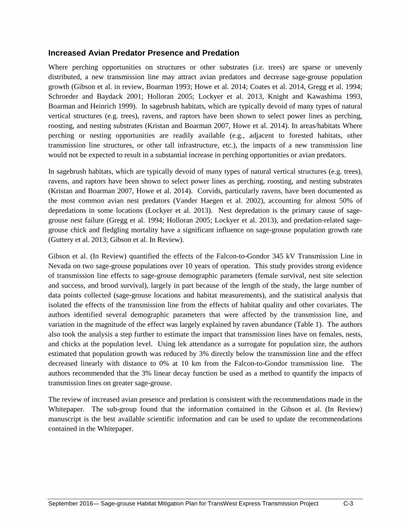
Increased Avian Predator Presence and Predation Where perching opportunities on structures or other substrates (i.e. trees) are sparse or unevenly distributed, a new transmission line may attract avian predators and decrease sage-grouse population growth (Gibson et al. in review, Boarman 1993; Howe et al. 2014; Coates et al. 2014, Gregg et al. 1994; Schroeder and Baydack 2001; Holloran 2005; Lockyer et al. 2013, Knight and Kawashima 1993, Boarman and Heinrich 1999). In sagebrush habitats, which are typically devoid of many types of natural vertical structures (e.g. trees), ravens, and raptors have been shown to select power lines as perching, roosting, and nesting substrates (Kristan and Boarman 2007, Howe et al. 2014). In areas/habitats Where perching or nesting opportunities are readily available (e.g., adjacent to forested habitats, other transmission line structures, or other tall infrastructure, etc.), the impacts of a new transmission line would not be expected to result in a substantial increase in perching opportunities or avian predators.
In sagebrush habitats, which are typically devoid of many types of natural vertical structures (e.g. trees), ravens, and raptors have been shown to select power lines as perching, roosting, and nesting substrates (Kristan and Boarman 2007, Howe et al. 2014). Corvids, particularly ravens, have been documented as the most common avian nest predators (Vander Haegen et al. 2002), accounting for almost 50% of depredations in some locations (Lockyer et al. 2013). Nest depredation is the primary cause of sage-grouse nest failure (Gregg et al. 1994; Holloran 2005; Lockyer et al. 2013), and predation-related sage-grouse chick and fledgling mortality have a significant influence on sage-grouse population growth rate (Guttery et al. 2013; Gibson et al. In Review).
Gibson et al. (In Review) quantified the effects of the Falcon-to-Gondor 345 kV Transmission Line in Nevada on two sage-grouse populations over 10 years of operation. This study provides strong evidence of transmission line effects to sage-grouse demographic parameters (female survival, nest site selection and success, and brood survival), largely in part because of the length of the study, the large number of data points collected (sage-grouse locations and habitat measurements), and the statistical analysis that isolated the effects of the transmission line from the effects of habitat quality and other covariates. The authors identified several demographic parameters that were affected by the transmission line, and variation in the magnitude of the effect was largely explained by raven abundance (Table 1). The authors also took the analysis a step further to estimate the impact that transmission lines have on females, nests, and chicks at the population level. Using lek attendance as a surrogate for population size, the authors estimated that population growth was reduced by 3% directly below the transmission line and the effect decreased linearly with distance to 0% at 10 km from the Falcon-to-Gondor transmission line. The authors recommended that the 3% linear decay function be used as a method to quantify the impacts of transmission lines on greater sage-grouse.
The review of increased avian presence and predation is consistent with the recommendations made in the Whitepaper. The sub-group found that the information contained in the Gibson et al. (In Review) manuscript is the best available scientific information and can be used to update the recommendations contained in the Whitepaper.
September 2016— Sage-grouse Habitat Mitigation Plan for TransWest Express Transmission Project C-3

Table 1. Summary of the transmission line effects to sage-grouse demographic parameters evaluated by Gibson et al. (In Review). **All numbers are provisional pending peer review and publication.**
Demographic Parameter Evaluated Effect of the Falcon-Gondor Transmission Line (FG) Correlation of Effect With Raven Abundance
Nesting propensity (locations of female grouse during the breeding season)
• First nests: no significant effect • Second nests: nesting propensity decreased 0.038
per km with distance from FG
None noted
Nest site selection (locations of nests)
• Landscape scale: evidence for an effect dissipating at 10.5 km
• Local scale: probability of nest site selection increases from approximately 0.5 adjacent to FG to approximately 0.69 at 10.5 km from FG
Raven abundance explained significant annual variation in the effect
Nest survival • Nests within 9.2 km of FG had reduced probability
of hatching • Nest survival increased by 0.011 for each
additional km a nest was located from FG
Raven abundance explained significant annual variation in the effect
Brood site selection • Landscape scale: no effect • Local scale: Some evidence of avoidance,
attributed by authors to patterns in nest placement.
Raven abundance explained significant annual variation in the effect
Pre-fledging chick survival (first two weeks)
• Survival increased 0.017 for every 1 km moved from FG.
• Effect dissipated with age (>2 weeks)
Raven abundance explained significant annual variation in the effect
Female survival • Survival increased 0.003 for every 1 km moved
from FG (weak effect) None noted
Male survival • No effect
None noted
Lek recruitment and population growth rates
• Leks further from FG had higher population growth rates as measured by lek attendance
• Population growth rates increased 0.003 per 1 km moved from the FG to 10 km (i.e., there was a 3% reduction in population growth beneath FG which decreased linearly to 0% at 10 km from FG)1
Raven abundance explained significant annual variation in the effect
1 Larger in magnitude than the effect of the FG alone, population growth rates increased 0.008 per 1 km moved from the lines for all power lines (transmission lines and distribution lines) to 10 km.
September 2016— Sage-grouse Habitat Mitigation Plan for TransWest Express Transmission Project C-4
INDIRECT EFFECTS ANALYTICAL APPROACH The following sections describe the analytical approach developed by the sub-group to quantify indirect effects of transmission lines on greater sage-grouse for the TWE and GWS Projects. The approach is based on the sub-group’s review of the best available scientific literature while also considering site-specific datasets and expert knowledge of the habitats and populations that could be impacted by these transmission line projects.
Baseline Habitat Services Map Transmission line indirect effects for the TWE and GWS Projects would be measured in habitat service losses to be compatible with the HEAs the projects are using for mitigation planning. Advantages of using the HEA process include: 1) the effects assessment can account for variations in habitat quality (i.e., an impact to high quality habitat would result in more mitigation than the same impact to low quality habitat); 2) the habitat service loss is modeled over time; 3) habitat improvement projects suitable for mitigation have already been identified and their benefit quantified in habitat service gains.
Baseline maps of habitat services have been developed for both projects at a 30 m2 grid cell resolution using a sage-grouse habitat service metric (BLM 2015 at Appendix D at Appendix K, BLM 2016 at Appendix K), where every cell is scored independently. The habitat service score for each cell is a measure of habitat quality adjusted for anthropogenic influences and other disturbances; however, the baseline habitat services modeled to date do not account for the indirect effects of existing transmission lines. The sub-group’s approach applies the effects of the existing transmission lines to the baseline maps to create “new” baseline maps to which the modeled project effects would be applied, assuming that existing transmission lines have the same level of effect as the proposed transmission lines.
Habitat Service Reduction Effect Zones Two indirect effect zones were identified:
• Avoidance (0-600 m) • Decreased Population Growth (0 m to 10,000 m)
Avoidance is a behavioral response by sage-grouse that that has been documented in proximity transmission lines, although the mechanism for avoidance is unknown. It results in decreased use of habitat in areas within 600 meters of a transmission line. Using professional judgment, the sub-group decided that avoidance effect would increase with the number of transmission lines, where the lines are sited less than 600 m apart.
Decreased population growth is not behavioral and instead is a result of changes in population demographics (e.g., nest success, brood survival, etc.) that lead to the population level impact described in Gibson et al. (In Review). Raven abundance is the primary mechanism identified by the sub-group for decreased population growth.
Both effects occur across all seasons; apply to both sexes and all age groups; and occur for the operating lifetime of the project. The magnitude of the indirect effect is described for each zone below.
September 2016— Sage-grouse Habitat Mitigation Plan for TransWest Express Transmission Project C-5

Avoidance (0-600 m)
The sub-group concluded that reduced use (avoidance) near transmission line is greatest directly under the line, decreasing out to 600 m based on peer-reviewed literature. The subgroup’s approach models the avoidance effect only in cells with relatively high habitat service scores, which represents the high quality habitat where sage-grouse telemetry data from Wyoming, Colorado, and Utah indicate the majority of sage-grouse habitat use occurs. The sub-group determined that this approach was appropriate because the impacts of avoidance would primarily occur where sage-grouse use is consistently observed. Marginal or unsuitable habitats would not have the avoidance impact applied because, although these areas are occasionally used by sage-grouse, use is often associated with movement patterns between patches of high quality, suitable habitat. These movement patterns include use of habitats within and adjacent to transmission line corridors and other energy corridors.
The sub-group’s approach models avoidance as a habitat service loss that decreases linearly from 75% loss immediately below the line to 0% loss 600 m from the line20. This is expressed [1.25(0.6 - x)*habitat service score], where ‘x’ is the distance from the transmission line (in km)21. The sub-group’s approach applies avoidance effects to the range of scores that contain 85% of sage-grouse re-locations in site-specific telemetry datasets provided for each state (Figures 1-3)22. Because of the relatively small sample size in Utah (N = 6,300), the data from Colorado and Utah were pooled (N = 35,300) to determine the range of scores that would be included. For consistency purposes, 85% was also used in Wyoming although this resulted in a slightly broader distribution of habitat service scores. Where this avoidance effect zone overlaps the decreased population growth zone described below, the highest level of habitat service loss is applied.
20 Professional judgment was used by the sub-group to develop the 75% reduction in use immediately below the line with the likelihood of use increasing with increasing distance from the transmission line. Gaussian, negative exponential and linear decay curves were considered by the sub-group. The sub-group recommends using the linear decay function because it falls in between the other two curves and is straightforward to apply in the model. 21 1.25 is calculated by dividing 0.75 by 0.6. The equation produces a line that crosses the x axis at 0.6 and has a y intercept of 0.75. 22 The use of an 85% confidence level is consistent with the literature. Gibson et al. (In Review) considered an effect to be significant if the 80% confidence intervals on the effect estimate did not overlap zero. The use of 85% would be more conservative than the thresholds recommended by Gibson et al (In Review). In Wyoming, avoidance zone impacts would be applied to all habitat service scores between 17 and 24 (Figure 1). In Colorado and Utah, avoidance zone impacts would be applied to all habitat service scores between 20 and 24 (Figures 2 and 3).
September 2016— Sage-grouse Habitat Mitigation Plan for TransWest Express Transmission Project C-6

Figure 1. Histogram and outlier box plot of HEA scores extracted to 356,000 sage-grouse locations for Wyoming using data collected in support of the Chokecherry and Sierra Madre Wind Energy Project in Carbon, County, Wyoming. X axis is HEA score* 100, Y axis is percentage of total.
Figure 2. Histogram and outlier box plot of HEA scores extracted to 29,000 sage-grouse locations collected by Colorado Parks and Wildlife. X axis is HEA score* 100, Y axis is percentage of total.
September 2016— Sage-grouse Habitat Mitigation Plan for TransWest Express Transmission Project C-7

Figure 3. Histogram and outlier box plot of HEA scores extracted to 6,300 sage-grouse locations collected by Brigham Young University. X axis is HEA score* 100, Y axis is percentage of total.
September 2016— Sage-grouse Habitat Mitigation Plan for TransWest Express Transmission Project C-8

Decreased Population Growth (0 m to 10,000 m)
The sub-group’s approach models decreased population growth in all occupied habitat, regardless of habitat service score. For the purposes of the approach, occupied habitat is defined as the BLM’s Priority Habitat Management Area (PHMA) and General Habitat Management Area (GHMA) boundaries as defined in BLM’s 2015 Approved Resource Management Plan Amendment for greater sage-grouse issued for each state, which closely matches each state’s sage-grouse management area boundaries. The subgroup reviewed the boundaries with representatives from each state wildlife management agency and concluded that use of the BLM PHMA and GHMA boundaries adequately captures the known occupied range of sage-grouse in each state.
The sub-group’s approach models decreased population growth as a habitat service loss that decreases linearly from 3%23 directly below the line to 0% loss 10,000 m (10 km) from the line24. This is expressed [0.003(10-x)*habitat service score], where ‘x’ is the distance from the line (in km). The extent of the impact would be 10 km to either side of the transmission line to be consistent with recommendations made by Gibson et al. (In Review) for the Falcon-to-Gondor Transmission Line.
APPLICATION OF THE INDIRECT EFFECTS ANALYTICAL APPROACH The following sections describe how the sub-group’s Indirect Effects Analytical Approach would be applied for a number of scenarios including new transmission line rights-of-way and co-location with existing lines.
Service Reductions to Account for Single Transmission Lines Calculation of the indirect effects of a single transmission line would follow the approach illustrated in Figure 4. In this example, the avoidance impacts and population level impacts described above would be applied where the indirect effects of other transmission lines have not already resulted in decreases to baseline habitat conditions, or where only the decreased population growth buffers overlap. The baseline habitat service score is the habitat quality adjusted for anthropogenic influences and other disturbances, excluding transmission lines, as calculated using the metric described in BLM 2015 and BLM 2016. Calculation examples are provided in Attachment A.
23 This value is provisional until Gibson et al. (In Review) is published, because it has the potential to change during the peer review process. 24 Another magnitude of effect was considered by the sub-group which corresponded with the decreased population growth measured by Gibson et al. (In Review) around all transmission and distribution lines (“all power lines”). This effect was a combined 8% decreased population growth when considering all transmission and distribution lines on the landscape, including FG. Ultimately, the sub-group decided that application of the all power lines level effect was not appropriate for these projects because distribution line data is not available for the entire project area. Without accurate and complete distribution line data, the baseline condition with existing power lines could not be accurately characterized and the baseline habitat service scores would be inaccurate.
September 2016— Sage-grouse Habitat Mitigation Plan for TransWest Express Transmission Project C-9

Figure 4. Calculation of the habitat service loss with the construction of a single transmission line in each of the indirect impact zones. Note that impacts in the avoidance zone would only be applied to the state-specific range of habitat service values that account for 85% of tagged bird locations.
September 2016— Sage-grouse Habitat Mitigation Plan for TransWest Express Transmission Project C-10
Service Reductions Where Transmission Lines are Co-located Co-location of transmission lines is an important factor considered by the sub-group in developing its approach for quantifying indirect effects. Where transmission lines25 are located within 10 km of one another, the indirect effect zones would overlap. The sub-group’s approach calculates the cumulative impact of the avoidance and decreased population growth zones differently depending on the distance between the transmission lines and which zones are overlapping.
Ravens use transmission structures for perching and nesting (Howe et al. 2014), and the predation pressure by nesting ravens accounts for a large proportion of sage-grouse nest depredation (Lockyer et al. 2013). Nesting ravens are territorial and generally nest more than 1,000 m apart (Burton and Mueller 2006). Where the transmission lines are located less than 1,000 m apart, this territorial behavior is expected to largely exclude new ravens and prevent a substantial increase in local predation pressure. Where the transmission lines are located more than 1,000 m apart, new potential nesting territories could be created and the predation pressure would be expected to increase in the overlap between the two 10km effect zones. This same approach would be used when the transmission line is proximate to forested habitats. Where the transmission lines are located less than 1,000 m from forested habitats26, existing territorial behavior is expected to largely exclude new ravens and prevent a substantial increase in local predation pressure. Where the transmission lines are located more than 1,000 m from forested habitats, new potential nesting territories could be created and the predation pressure would be expected to increase in the overlap between the two 10-km effect zones.
Overlapping Zones Where the Transmission Lines are Spaced <1,000 m Apart
This section describes the sub-group’s approach for modeling the cumulative impact of transmission lines that are less than 1,000 m apart, where nesting ravens on the first line are expected to territorially exclude new ravens and prevent a substantial increase in local avian predation pressure. While a substantial increase in avian predation pressure is not anticipated, the addition of a new transmission line to an existing transmission line corridor is still expected to increase the impact of the corridor on sage-grouse at some level and increase the habitat services lost.
Avoidance Zone (0 m to 600 m)
Where the avoidance zone of a new transmission line overlaps the avoidance zone or the decreased population growth zone of an existing transmission line, the service level would be proportionally reduced.
Decreased Population Growth Zone (0 m to 10,000 m)
Where the decreased population growth zone of one transmission line overlaps an avoidance zone or a decreased population growth zone of another, the service level would be adjusted to reflect the largest level effect (i.e., the effect of the closest transmission line) and the change in the habitat service level with the addition of the new transmission line would be calculated. Where the habitat service reduction for a new transmission line is less than the habitat service reduction for the existing transmission line (when the
25 These rules apply to all transmission lines on the landscape, not just TWE and GWS.
26 Treed habitats found within the sage-grouse landscape, excluding pinion-juniper.
September 2016— Sage-grouse Habitat Mitigation Plan for TransWest Express Transmission Project C-11

existing transmission line is closer to the habitat being impacted), the effect would be attributable to the existing transmission line so that no additional mitigation would be due for the new transmission line.
The calculation of habitat service scores to account for the indirect effects of two transmission lines spaced <1,000 m apart are described in Attachment B. The baseline habitat service score is the habitat quality adjusted for anthropogenic influences and other disturbances, excluding transmission lines, as calculated using the metric described in BLM 2015 and BLM 2016.
Overlapping Zones Where the Transmission Lines are Spaced >1,000 m Apart
This section describes the sub-group’s approach for modeling the cumulative indirect effects of transmission lines that are more than 1,000 m apart, where ravens are expected to nest on both transmission lines and increase the local predation pressure and the associated population level impact.
Avoidance Zone (0 m to 600 m)
The calculation method would be the same as described for transmission lines spaced <1,000 m apart.
Decreased Population Growth Zone (0 m to 10,000 m)
Where the decreased population growth zone overlaps an avoidance zone or a decreased population growth zone, the service level is proportionally reduced.
The calculation of habitat service scores that have been adjusted for the indirect effects of two transmission lines co-located spaced >1,000 m apart are described in Attachment C. The baseline habitat service score is the habitat quality adjusted for anthropogenic influences and other disturbances, excluding transmission lines, as calculated using the metric described in BLM 2015 and BLM 2016.
September 2016— Sage-grouse Habitat Mitigation Plan for TransWest Express Transmission Project C-12
LITERATURE CITED Boarman, W. I. 1993. When a native predator becomes a pest: A case study. In Conservation and
Resource Management (S.K. Majumdar, E.W. Miller, D.E. Baker, E.K. Brown, J.R. Pratt, and R.F. Schmalz, Editors). Pennsylvania Academy of Science, Easton, PA, USA. 191- 206pp.
Boarman, W.I. and B. Heinrich. 1999. Common raven (Corvus corax). Pages 1-31 in: A. Poole and F. Gill, editors.
Braun, C.E. 1998. Sage-grouse declines in western North America: what are the problems? Proceedings of the Western Association of State Fish and Wildlife Agencies 78:139-156.
Bureau of Land Management (BLM). 2015. Final Environmental Impact Statement for the TransWest Express. Available from http://www.blm.gov/wy/st/en/info/NEPA/documents/hdd/transwest/FEIS.html. Accessed 5-12016.
__________. 2016. Final Environmental Impact Statement and Proposed Land-use Plan Amendments for the Energy Gateway South Transmission Project. BLM/WY/PL-14/009+5001. May 2016. Available at: https://eplanning.blm.gov/epl-frontoffice/eplanning/planAndProjectSite.do?methodName=dispatchToPatternPage¤tPageId=6 9112. Accessed 7-1-2016.
Burton, J. P., & Mueller, J. M. (2006). Chihuahuan raven (Corvus cryptoleucus) reproductive success and nest spacing in the southern high plains of Texas. The Southwestern Naturalist 51(1): 48-51.
Coates, P.S., K.B. Howe, M.L. Casazza, D.J. Delehanty. 2014. Common raven occurrence in relation to energy transmission line corridors transiting human-altered sagebrush steppe. Journal of Arid Environments 111 (2014): 68-78.
Gibson, D., E. J. Blomberg, M. T. Atamian, S. P. Espinosa, and J. S. Sedinger. In review. Effects of transmission lines on demography and population dynamics of greater sage-grouse (Centrocercus urophasianus).
Gillan, J.K., E. Strand, J. Karl, K. Reese, and T. Laninga. 2013. Using spatial statistics and point pattern simulations to assess the spatial dependency between greater sage-grouse and anthropogenic features. Wildlife Society Bulletin 37(2): 301-310.
Gregg, M. A., J.A. Crawford, M.S. Drut, and A.K. DeLong. 1994. Vegetational cover and predation of sage-grouse nests in Oregon Journal of Wildlife Management 58:162-166.
Guttery, M.R., D.K. Dahlgren, T.A. Messmer, J.W. Connelly, K.P. Reese, P.A. Terletzky, N. Burkepile, and D.N. Koons. 2013. Effects of landscape-scale environmental variation on greater sage-grouse chick survival. PLoS ONE 8(6): e65582.
Hanser, S.E., C.L. Aldridge, M. Leu, M.M. Rowland, S.E. Nielsen, and S.T. Knick. 2011. Chapter 5: Greater Sage-grouse: general use and roost site occurrence with pellet counts as a measure of relative abundance. Sagebrush Ecosystem Conservation and Management: 112-140.
September 2016— Sage-grouse Habitat Mitigation Plan for TransWest Express Transmission Project C-13

Holloran, M.J. 2005. Greater sage-grouse population response to natural gas field development in western Wyoming. Dissertation. University of Wyoming, Laramie, USA.
Howe, K. B., P.S. Coates, D.J. Delehanty. 2014. Selection of anthropogenic features and vegetation characteristics by nesting common ravens in the sagebrush ecosystem. Condor (116): 35-49.
Knight, R. L., and J. Y. Kawashima. 1993. Responses of raven and Red-tailed Hawk populations to linear right-of-ways. Journal of Wildlife Management 57:266–271.
Kristan, W.B.III, and W.I. Boarman. 2007. Effects of anthropogenic developments on common raven nesting biology in the west Mojave Desert. Ecological Applications 17: 1703-1713.
Lockyer, Z.B., P. S. Coates, M.L. Casazza, S. Espinosa, D.J. Delehanty. 2013. Greater sage-grouse nest predators in the Virginia Mountains of northwestern Nevada. Journal of Fish and Wildlife Management 4(2): 242-254.
Schroeder, M.A., R.K. Baydack. 2001. Predation and the management of prairie grouse. Wildlife Society Bulletin 29(1): 24-32.
Shirk, A. J., M.A. Schroeder, L.A. Robb, S.A. Cushman. 2015. Empirical validation of landscape resistance models: insights from the greater sage-grouse (Centrocercus urophasianus). Landscape Ecology DOI 10.1007/s10980-015-0214-4.
Vander Haegen, W.M., M.A. Schroeder, and R.M. DeGraaf. 2002. Predation on Real and Artificial Nests in Shrubsteppe Landscapes Fragmented by Agriculture. The Condor: 104: 496-506.
Washington Wildlife Habitat Connectivity Working Group (WHCWG). 2010. Washington Connected Landscapes Project: Statewide Analysis. Washington Departments of Fish and Wildlife, and Transportation, Olympia, WA.
September 2016— Sage-grouse Habitat Mitigation Plan for TransWest Express Transmission Project C-14

ATTACHMENT A: Calculation of Habitat Service Reductions to Account for Single Transmission Lines
September 2016— Sage-grouse Habitat Mitigation Plan for TransWest Express Transmission Project C-15

This attachment provides the equations and examples for the calculation of habitat service losses due to indirect effects of a single transmission line. Habitat service losses at any one point in time are calculated as the difference between the habitat services present at that milestone (M1) and those that were present at baseline (M0). The equations for the habitat services present are provided in Figure A-1. In the case of a single transmission line, the baseline condition includes no existing transmission line effects and is quantified using the HEA metric published in the Project EIS.
Example A-1. Cell is 5 km from the transmission line (T1) and falls within the reduced population growth zone. The baseline habitat service score is 20.
M0 = 20
M1 = BL*(1 - PT1) = 20*(1 - 0.003*[10 - 5]) = 19.7
M0 – M1 = 20 - 19.7 = 0.3 habitat services lost due to T1
Example A-2. Cell is 0.3 km of the transmission line (T1) and falls within the avoidance zone. The baseline habitat service score is 20. Note that the avoidance zone impacts would only be applied using the state-specific habitat service score thresholds (20-24 in Colorado and Utah and 17-24 in Wyoming).
M0 = 20
M1 = BL*(1 - AT1) = 20*(1 – 1.25*[0.6 – 0.3]) = 12.5
M0 – M1 = 20 – 12.5 = 7.5 habitat services lost due to T1
These calculations of habitat services lost are completed for every 30x30-meter cell within 10 km of the project footprint for every year of the lifetime of the project to produce the input for the HEA that is used to calculate the mitigation due for indirect effects.
September 2016— Sage-grouse Habitat Mitigation Plan for TransWest Express Transmission Project C-16

Example A-1
Example A-2
Figure A-1. Calculation of remaining habitat service score by applying the indirect effects of one transmission line to the baseline service score. Note that impacts in the avoidance zone would only be applied to the state-specific range of habitat service values that account for 85% of tagged bird locations. This approach would be used for all existing transmission lines to establish new baseline habitat services and would be applied for new transmission lines where they are not located within 10 km of an existing transmission line.
September 2016— Sage-grouse Habitat Mitigation Plan for TransWest Express Transmission Project C-17
ATTACHMENT B: Calculation of Habitat Service Reductions Where Transmission Lines are Co-located and Spaced <1,000 m Apart
September 2016— Sage-grouse Habitat Mitigation Plan for TransWest Express Transmission Project C-18
This attachment provides the equations and examples for the calculation of habitat service losses due to indirect effects of two or more transmission lines located less than 1,000 m apart. Habitat service losses at any one point in time are calculated as the difference between the habitat services present at that milestone (M1) and those that were present at baseline (M0). In the case of two transmission lines, as illustrated in Figure B-1, the habitat services at M0 account for the effects of an existing transmission line (T1) and the effect of that single transmission line is calculated using the equations in Figure A-1. The equations in Figure B-1 are used to calculate the habitat services present after the addition of a second transmission line (T2) at M1 or more than one transmission line at M0.
Example B-1. Cell is 9.5 km from the existing transmission line (falls within the reduced population growth zone of T1) and greater than 10 km from the new transmission line (no effect of T2). The unadjusted metric habitat service score is 20.
M0 = BL*(1 - PT1) = 20*(1 - 0.003*[10 – 9.5]) = 19.97
M1 = BL*(1 - PT1) = 20*(1 - 0.003*[10 – 9.5]) = 19.97
M0 – M1 = 0 habitat services lost with the addition of T2
Example B-2. Cell is 5 km from the existing transmission line (falls within the reduced population growth zone of T1) and 5.8 km from the new transmission line (falls within the reduced population growth zone of T2, but the addition of T2 does not increase the effect). The unadjusted metric habitat service score is 20.
M0 = BL*(1 - PT1) = 20*(1 - 0.003*[10 – 5.0]) = 19.7
M1 = BL*(1 - PT1) = 20*(1 - 0.003*[10 – 5.0]) = 19.7
M0 – M1 = 0 habitat services lost with the addition of T2
Example B-3. Cell is 0.3 km from the existing transmission line (falls within the avoidance zone of T1) and 1.1 km from the new transmission line (falls within the reduced population growth zone of T2, but the addition of T2 does not increase the effect). The unadjusted metric habitat service score is 20. Note that the avoidance zone impacts would only be applied using the state-specific habitat service score thresholds (20-24 in Colorado and Utah and 17-24 in Wyoming).
M0 = BL*(1 - AT1) = 20*(1 – 1.25*[0.6 – 0.3]) = 12.5
M1 = BL*(1 - AT1) = 20*(1 – 1.25*[0.6 – 0.3]) = 12.5
M0 – M1 = 0 habitat services lost with the addition of T2
Example B-4. Cell is 0.4 km from the existing transmission line (falls within the avoidance zone of T1) and 0.4 km from the new transmission line (falls within the avoidance zone of T2, and the services are proportionally reduced). The unadjusted metric habitat service score is 20. Note that the avoidance zone impacts would only be applied using the state-specific habitat service score thresholds (20-24 in Colorado and Utah and 17-24 in Wyoming).
M0 = BL*(1 - AT1) = 20*(1 – 1.25*[0.6 – 0.4]) = 15
September 2016— Sage-grouse Habitat Mitigation Plan for TransWest Express Transmission Project C-19

M1 = BL*(1 -AT1)*(1-AT2) = 20*(1 – 1.25*[0.6 – 0.4]) *(1 – 1.25*[0.6 – 0.4]) = 11.25
M0 – M1 = 15 – 11.25 = 3.75 habitat services lost with the addition of T2
Example B-5. Cell is 0.9 km from the existing transmission line (falls within the reduced population growth zone of T1) and 0.1 km from the new transmission line (falls within the avoidance zone of T2, and the effect is increased). The unadjusted metric habitat service score is 20. Note that the avoidance zone impacts would only be applied using the state-specific habitat service score thresholds (20-24 in Colorado and Utah and 17-24 in Wyoming).
M0 = BL*(1 - PT1) = 20*(1 - 0.003*[10 – 0.9]) = 19.454
M1 = BL*(1-AT2) = 20*(1 – 1.25*[0.6 – 0.1]) = 7.5
M0 – M1 = 19.454 – 7.5 = 11.954 habitat services lost with the addition of T2
Example B-6. Cell is 5.8 km from the existing transmission line (falls within the reduced population growth zone of T1) and 5 km from the new transmission line (falls within the reduced population growth zone of T2, and the effect is increased). The unadjusted metric habitat service score is 20.
M0 = BL*(1 - PT1) = 20*(1 - 0.003*[10 – 5.8]) = 19.748
M1 = BL*(1 - PT2) = 20*(1 - 0.003*[10 – 5.0]) = 19.70
M0 – M1 = 19.748 – 19.70 = 0.048 habitat services lost with the addition of T2
Example B-7. Cell is 10.3 km from the existing transmission line (no effect of T1) and 9.5 km from the new transmission line (falls within the reduced population growth zone of T2). The unadjusted metric habitat service score is 20.
M0 = 20
M1 = BL*(1 - PT2) = 20*(1 - 0.003*[10 – 9.5]) = 19.97
M0 – M1 = 20 – 19.97 = 0.03 habitat services lost with the addition of T2
These calculations of habitat services lost are completed for every 30x30-meter cell within 10 km of the project footprint for every year of the lifetime of the project to produce the input for the HEA that is used to calculate the mitigation due for indirect effects.
September 2016— Sage-grouse Habitat Mitigation Plan for TransWest Express Transmission Project C-20
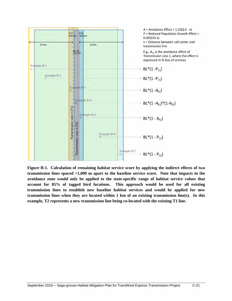
Example B-1
Example B-2
Example B-3
Example B-4
Example B-5
Example B-6
Example B-7
Figure B-1. Calculation of remaining habitat service score by applying the indirect effects of two transmission lines spaced <1,000 m apart to the baseline service score. Note that impacts in the avoidance zone would only be applied to the state-specific range of habitat service values that account for 85% of tagged bird locations. This approach would be used for all existing transmission lines to establish new baseline habitat services and would be applied for new transmission lines when they are located within 1 km of an existing transmission line(s). In this example, T2 represents a new transmission line being co-located with the existing T1 line.
September 2016— Sage-grouse Habitat Mitigation Plan for TransWest Express Transmission Project C-21
ATTACHMENT C: Calculation of Habitat Service Reductions Where Transmission Lines are Co-
located and Spaced >1,000 m Apart
September 2016— Sage-grouse Habitat Mitigation Plan for TransWest Express Transmission Project C-22

This attachment provides the equations and examples for the calculation of habitat service losses due to indirect effects of two or more transmission lines located greater than 1,000 m apart. Habitat service losses at any one point in time are calculated as the difference between the habitat services present at that milestone (M1) and those that were present at baseline (M0). In the case of two transmission lines, as illustrated in Figure C-1, the habitat services at M0 account for the effects of an existing transmission line (T1) and the effect of that single transmission line is calculated using the equations in Figure A-1. The equations in Figure C-1 are used to calculate the habitat services present after the addition of a second transmission line (T2) at M1 or more than one transmission line at M0.
Example C-1. Cell is 9.5 km from the existing transmission line (falls within the reduced population growth zone of T1) and greater than 10 km from the new transmission line (no effect of T2). The unadjusted metric habitat service score is 20.
M0 = BL*(1 - PT1) = 20*(1 - 0.003*[10 – 9.5]) = 19.97
M1 = BL*(1 - PT1) = 20*(1 - 0.003*[10 – 9.5]) = 19.97
M0 – M1 = 0 habitat services lost with the addition of T2
Example C-2. Cell is 3 km from the existing transmission line (falls within the reduced population growth zone of T1) and 5.5 km from the new transmission line (falls within the reduced population growth zone of T2, and the services are proportionally reduced). The unadjusted metric habitat service score is 20.
M0 = BL*(1 - PT1) = 20*(1 - 0.003*[10 – 3.0]) = 19.58
M1 = BL*(1 - PT1)*(1 - PT2) = 20*(1 - 0.003*[10 – 3.0])*(1 - 0.003*[10 – 5.5]) = 19.316
M0 – M1 = 0.264 habitat services lost with the addition of T2
Example C-3. Cell is 0.3 km from the existing transmission line (falls within the avoidance zone of T1) and 2.8 km from the new transmission line (falls within the reduced population growth zone of T2, and the services are proportionally reduced). The unadjusted metric habitat service score is 20. Note that the avoidance zone impacts would only be applied using the state-specific habitat service score thresholds (20-24 in Colorado and Utah and 17-24 in Wyoming).
M0 = BL*(1 - AT1) = 20*(1 – 1.25*[0.6 – 0.3]) = 12.5
M1 = BL*(1 - AT1)*(1 - PT2) = 20*(1 – 1.25*[0.6 – 0.3])*(1 - 0.003*[10 – 2.8]) = 12.23
M0 – M1 = 12.5 - 12.23 = 0.27 habitat services lost with the addition of T2
Example C-4. Cell is 1.2 km from the existing transmission line (falls within the reduced population growth zone of T1) and 1.3 km from the new transmission line (falls within the reduced population growth zone of T2, and the services are proportionally reduced). The unadjusted metric habitat service score is 20.
M0 = BL*(1 - PT1) = 20*(1 - 0.003*[10 – 1.2]) = 19.472
September 2016— Sage-grouse Habitat Mitigation Plan for TransWest Express Transmission Project C-23
M1 = BL*(1 - PT1)*(1 - PT2) = 20*(1 - 0.003*[10 – 1.2])*(1 - 0.003*[10 – 1.3]) = 18.964
M0 – M1 = 19.472 - 18.964 = 0.508 habitat services lost with the addition of T2
Example C-5. Cell is 2.4 km from the existing transmission line (falls within the reduced population growth zone of T1) and 0.1 km from the new transmission line (falls within the avoidance zone of T2, and the services are proportionally reduced). The unadjusted metric habitat service score is 20. Note that the avoidance zone impacts would only be applied using the state-specific habitat service score thresholds (20-24 in Colorado and Utah and 17-24 in Wyoming).
M0 = BL*(1 - PT1) = 20*(1 - 0.003*[10 – 2.4]) = 19.544
M1 = BL*(1 - PT1)*(1 - AT2) = 20*(1 - 0.003*[10 – 2.4])*(1 – 1.25*[0.6 – 0.1]) = 7.329
M0 – M1 = 19.544 – 7.329 = 12.215 habitat services lost with the addition of T2
Example C-6. Cell is 4.5 km from the existing transmission line (falls within the reduced population growth zone of T1) and 2 km from the new transmission line (falls within the reduced population growth zone of T2, and the services are proportionally reduced). The unadjusted metric habitat service score is 20.
M0 = BL*(1 - PT1) = 20*(1 - 0.003*[10 – 4.5]) = 19.67
M1 = BL*(1 - PT1)*(1 - PT2) = 20*(1 - 0.003*[10 – 4.5])*(1 - 0.003*[10 – 2.0]) = 19.198
M0 – M1 = 19.67 – 19.198 = 0.472 habitat services lost with the addition of T2
Example C-7. Cell is 12 km from the existing transmission line (no effect of T1) and 9.5 km from the new transmission line (falls within the reduced population growth zone of T2). The unadjusted metric habitat service score is 20.
M0 = 20
M1 = BL*(1 - PT2) = 20*(1 - 0.003*[10 – 9.5]) = 19.97
M0 – M1 = 20 – 19.97 = 0.03 habitat services lost with the addition of T2
These calculations of habitat services lost are completed for every 30x30-meter cell within 10 km of the project footprint for every year of the lifetime of the project to produce the input for the HEA that is used to calculate the mitigation due for indirect impacts.
September 2016— Sage-grouse Habitat Mitigation Plan for TransWest Express Transmission Project C-24

Example C-1
Example C-2
Example C-3
Example C-4
Example C-5
Example C-6
Example C-7
Figure C-1. Calculation of remaining habitat service score by applying the indirect effects of two transmission lines spaced >1,000 m apart to the baseline service score. Note that impacts in the avoidance zone would only be applied to the state-specific range of habitat service values that account for 85% of tagged bird locations. This approach would be used for all existing transmission lines to establish new baseline habitat services and would be applied for new transmission lines when they are located more than 1 km from an existing transmission line(s) and less than 10 km from an existing transmission line(s). In this example, T2 represents a new transmission line being co-located more than 1 km from the existing T1 line.
September 2016— Sage-grouse Habitat Mitigation Plan for TransWest Express Transmission Project C-25

TransWest Express Transmission Project December 2016 Record of Decision Appendix F Attachment F.2
Attachment F.2 NPS Requirements for Access to Deerlodge Road

TransWest Express Transmission Project December 2016 Record of Decision Appendix F Attachment F.2-1
National Park Service (NPS) Preliminary Requirements for Access to Deerlodge Road During Construction of the Transmission Lines
1.0 Permits – No work may be undertaken on National Park Service (NPS) property until any and all required NPS permits have been: (1) fully processed; (2) executed by the Permittee; and (3) executed by the proper NPS official. The terms listed below are expected to be incorporated as terms and conditions in any future permit that NPS may issue regarding this project, and any plans listed must be approved by NPS prior to issuance of any permits. However, NPS reserves the right to include additional details and terms and conditions based on specific applications received and activities proposed.
2.0 Transportation/Traffic Maintenance Plan – The Traffic Maintenance Plan must meet the requirements of the Federal Highway Administration Manual on Uniform Traffic Control Devices (MUTCD). Prior to construction activities, the applicant must complete the following:
• Develop a Traffic Control Plan.
• Develop related plans, including Staging, Spill and Fire Prevention, Communications, Storm Water Management, Invasive / Noxious Weed Prevention Plans (see below), and others as appropriate.
• Identify appropriate best management practices (BMPs) for other potential impacts, including Dust Suppression, Noise, Lighting, Wildlife, and Site Maintenance (see below).
• Develop a plan for the control of unauthorized public access and use on NPS lands that could result from the proposed project. The plan will address various provisions related to unauthorized access, such as the following:
− Additional measures to be taken to discourage unauthorized use of the project corridor and associated access roads, such as: periodic inspection for unauthorized access and any resulting damage; repair of any damage from unauthorized access.
− Constructing deterrents to off-highway vehicles / all-terrain vehicles (OHV/ATV) prior to construction activities.
3.0 Staging Locations – The staging of equipment, vehicles, and materials must be set back an appropriate distance from Deerlodge Road, the NPS visitor’s kiosk, and the park entry to maintain road safety and reduce visible intrusion of the scenery along the roadway, except during periods of construction in the immediate area. When not in immediate use, vehicles should not be parked along the road shoulder or at the road pullout for the NPS kiosk. Deerlodge Road driving must be maintained in a safe and aesthetically consistent manner with our road right-of- way (ROW) and congressional intent. The Park Superintendent or his designee will work with the State Lands Office and BLM on the future siting of any staging locations along the road. Any damage to, or destruction of, portions of the road due to construction activities must be repaired to its pre-construction condition (or better) at the cost of the developer.
4.0 Spill/Fire Prevention Plan – Spill and fire prevention plans must include BMPs, particularly with regards to vehicles and other heavy equipment along the roadways. The fire prevention plan must include a smokers plan for workers to reduce the potential for grass fires in the area.
5.0 Communication Plan – Developer must provide a communication plan regarding use of Deerlodge Road and activity in the area. Also, because park visitors may be affected by temporary road closures and delays, the plan must include a process for notifying boaters during phases of planned construction activities.

TransWest Express Transmission Project December 2016 Record of Decision Appendix F Attachment F.2-2
As part of proper communication, Developer must provide clear and appropriate signage meeting the following requirements:
• Signage must be at entrance to Deerlodge Road from Route 40 and indicate construction timeframe and boundaries.
• Developer must obtain a solar powered, electric road construction sign at least 1-2 weeks prior to start of construction to be placed on Route 40 indicating scope and duration of project on Deerlodge Road. Sign must be on timer so that it does not display at night.
• Developer must construct an appropriate kiosk to display information for park visitors about the project(s) during all phases of construction. Kiosk will be located and designed according to Park Superintendent’s, or his proxy’s, specifications.
6.0 Stormwater Management Plan – Storm Water Construction Permit coverage is required by State and Federal regulations for storm water discharged from any construction activity that disturbs at least 1 acre of land (or is part of a larger common plan of development or sale that will disturb at least 1 acre). If greater than one acre of land is disturbed, contractor must have an approved plan which will include erosion control procedures as there is a non-delineated wetland along Deerlodge Road that must be protected.
7.0 Dust Suppression – Water must be trucked in to provide dust suppression on Deerlodge Road and entry into park and visitor areas.
8.0 Noise Mitigation
Audible noise mitigation for installed transmission lines: If transmission lines pass near sensitive NPS receiver locations, such as visitor kiosks, and audible noise is predicted to be perceptible, clearly noticeable, or greater (doubling or more), reasonable noise mitigation measures will be implemented along the transmission line sections closest to the receiver. Such measures might include addition of insulator materials or cable bundle designs that emit less audible noise.
Audible noise mitigation for transmission line construction: If transmission line construction is anticipated near sensitive NPS receiver locations or visitor access roads, noisy construction equipment will be located a reasonable distance from those roads to the extent practicable, in order to minimize noise impacts at the NPS locations. For example, continuously operating generators and idling vehicles, as well as equipment staging areas, will be located away from NPS visitor access roads as much as possible.
9.0 Construction Lighting / Night Skies
Best lighting practices for transmission line construction: If transmission line construction is anticipated to occur at night or if lighting is required for other purposes during construction, best lighting practices will be implemented. Best practices include:
• Light only where needed;
• Light only when it is needed;
• Shield lights and direct them downward;
• Select lamps with warmer colors (less blue light);
• Use the minimum amount of light necessary; and
• Select the most energy efficient lamps and fixtures.
TransWest Express Transmission Project December 2016 Record of Decision Appendix F Attachment F.2-3
If staging areas need to be lit at night, those staging areas should be located away from NPS visitor access roads.
10.0 Site Maintenance and Daily Cleanup – Developer must maintain cleanliness at the jobsite because food and garbage can attract and habituate wild animals, plastic or string can be ingested or ensnare wildlife, and trash can be wind-distributed far from the jobsite. Each evening, and during other periods of time when work is not taking place, work areas must be cleared of food, loose materials, debris, water, and other wildlife attractants. When possible, construction vehicles must be moved so they do not pose a safety hazard at night. Food or garbage attractants must be secured in a closed vehicle or a bear proof container.
11.0 Invasive / Noxious Weed Prevention – Developer must abide by the following BMPs to avoid and minimize impacts resulting from construction related activities (note: these BMPs assume that no ground disturbance of NPS owned and managed lands will occur during this project aside from temporary use of Deerlodge Road; otherwise, additional measures will be required):
11.1 During Construction
• Promptly seed areas disturbed during construction of the TL with a conservation mix seed, that is reviewed and approved by park staff or a representative selected by the park and is certified ‘weed free’, and monitor these areas for the spread of invasive plant species.
• Minimize areas of vegetation clearing, in particular any disturbance to native plant species, during construction to prevent the spread of nonnative species.
• Follow best management practices to ensure contractor equipment is checked and cleaned for non-native plants/seeds, i.e., provide staging areas to exclude invasive seeds (equipment washing stations) from entering sites.
• Use construction materials (e.g., gravel) from sources that have been inspected and found to be free of invasive species.
• Use timber mats during construction in areas outside the access roads to minimize soil compaction.
11.2 Over Life of Project – Developer must develop and implement a long-term, area-specific vegetation management plan for the operation and maintenance of the line. Developer must receive NPS approval for this plan prior to issuance of any NPS permits. This plan will focus on retaining habitat within the constraints of the North American Electric Reliability Corporation (NERC) guidelines, and the control of invasive species. This plan will address invasive species management, including early detection, monitoring, and treatment for target invasive species using an integrated pest management approach. Other topics the vegetation management plan must address are:
• Contracts should include: a) clear requirements for contractors to hire qualified revegetation sub-contractors, and b) clear performance criteria based on resource outcomes and not outputs (example: Outcome of total native plant cover, number of native plant species established, etc., vs an output of one hydro-seed application)
• Use of existing roads with minimal development of new access roads;
• Requirement that maintenance crews enter the ROW on foot and use handheld equipment for vegetation maintenance in sensitive areas;
• Equipment cleaning plan that will address techniques for removal of any invasive seed sources prior to entering the area;
• Measures for the annual suppression of invasive plants within the ROW for the life of the project;
TransWest Express Transmission Project December 2016 Record of Decision Appendix F Attachment F.2-4
• Possible spread of invasive species via wooden spools used to supply wire;
• Vegetation restoration (native seeding and plantings, with annual monitoring and re-treatment as needed to achieve minimum acceptable outcomes, including an increase in biodiversity);
• Management of sensitive species and sensitive habitats during routine maintenance;
• Management of the ROW vegetation that will increase habitat for scrub shrub species;
• Restrictions on use of machinery and equipment time-of-year restrictions on vegetation in sensitive areas; and
• Pre-approval for pesticide and herbicide use.
12.0 Landscape Connectivity, Wildlife Habitat, and Wildlife – (Note: these BMPs assume that no ground disturbance of NPS owned and managed lands will occur during this project aside from temporary use of Deerlodge Road; otherwise, additional measures will be required):
• Developer must consult with land management agencies on deposition of brush piles. Where approved, leave brush piles alongside the ROW to provide habitat for wildlife species following the clearing of vegetation.
MBTA and BGEPA - Developer will follow mitigation measures provided by U.S. Fish and Wildlife Service (FWS) for golden eagle electrocution prevention. NPS also requires compliance with the following BMPs with regards to migratory birds and eagles:
• Remove spur roads following construction and maintain the ROW to provide bird habitat.
• Clear vegetation outside the breeding season of migratory birds to reduce the likelihood of disturbing nesting birds.
• Avoid the taking of, and minimize disturbance to, eagles during construction and operation of the line.
• Complete construction activities within 660 feet of any important eagle use area (breeding, foraging, or roosting) outside the season of use.
• Prohibit loud and disruptive impacts, such as pile driving or blasting, within one-half mile of an important eagle use area during the season of use.
13.0 Boundary Determinations – It is imperative that all construction activities and ground disturbances occur on lands not owned by NPS. Prior to a permit being issued, the following requirements must be met:
• Detailed pre-construction engineering survey plans as prepared under Section 5.1.4 of the TransWest Express Transmission Project Plan of Development will be provided to NPS staff for review. The entire plan set is not required; only those map sheets and indexes that pertain to construction activities within the proposed permit area are needed.
• Field staking of all NPS boundary lines in project area. This includes all lands in which NPS holds a land interest (fee or easement interest). In cases where private or state-owned lands are within the legislated boundary and proposed permit area, the legislated boundary will be staked. Field stakes will be clearly visible and identifiable as boundary line markers.
• Field staking of all project-related activities within 1000 feet of NPS boundary lines. This includes areas of planned disturbance, laydown or staging areas, planned facilities or structures and temporary access roads. Field stakes will be clearly visible and identifiable as project related features.

TransWest Express Transmission Project December 2016 Record of Decision Appendix F Attachment F.2-5
• Any known cultural or archaeological sites within a legislated park boundary that could be impacted by construction activities will be staked and protected. One known site of concern is a grave site located in Dinosaur National Monument along Deerlodge Road, approximately 1.5 miles north of the intersection of Deerlodge Road and U.S. Hwy 40.
• Existing NPS infrastructure that is removed or damaged during construction activities (fences, sidewalks, roads, retaining walls, vegetation, etc.) will be restored or replaced to original specifications.
If NPS determines the survey plan set or field staking does not adequately identify the location of NPS lands in relation to the project area, Applicant will be required to conduct or contract additional land survey services to correct any deficiencies as identified.