Embed Size (px)
Citation preview

APPENDIX B
HANDOUTS
Make all checklists in same format. Include a checkbox/cell so people can actually use
them the “check off” equipment as they pack it.

B-2
1. Checklists

B-3
CHECK LIST OF MATERIALS AND SUPPLIES FOR STREAM SAMPLING SITE VISITS.
� Collection permits and entry permits, if required.
Standard Items
� Site Documentation Forms (for new sites)
� Site Documentation Reports (compiled as folders for existing sites)
� Stream Water Sampling Record Forms
� Insulated container with ice or frozen refrigerant (packed in sealed plastic bags or other containers)
� Small insulated container (with ice) for hike-in sites
� Watch for recording time
� Digital field camera with free memory and extra charged battery
� GPS unit with extra batteries
� Compass
� Field thermometer (with string attached)
� Pre-processed sample bottle(s) with completed sample label attached (in clean plastic bag). Include a second bottle if sampling at that site is to be replicated
� Plastic gloves in sealed plastic bag
� 60 mL plastic syringes (with Luer type tip) with completed sample labels attached Plastic container with snap-on lid to hold filled syringes
� Syringe valves (Mininert® with Luer type adapter, or equivalent, available from a chromatography supply company)
� Water Chemistry labels (if not already filled out and attached to sample containers at base site)
� Soft-lead pencils and write in rain type pens for filling out field data forms and notebook entries
� Fine-tipped indelible markers for filling out labels
� Roll or box of tape strips
� Field operations and methods documents
� First Aid Kit � Backpack
� Extra Ziploc Bags

B-4
� Calibrated multiparameter sonde, data logger and cable, with extra batteries
Optional Items (may be required for specific studies)
� Calibration standards, quality control check samples, deionized water, rinse bottles, waste tray and container, calibration cup, and sensor guard for sonde (multiple sensors combined in a unit that is lowered into the water)
� Sonde calibration and post-calibration record forms
� Measurement tape
� Waders or high-top water proof boots for wading
� Clear packaging tape to cover labels Dissolved oxygen/Temperature meter with probe
� DO repair kit containing additional membranes and probe filling solution
� Conductivity meter with probe
See discharge measurement checklist
To measure discharge:
B-5
CHECKLIST OF MATERIAL NEEDED FOR USE IN FIELD FOR SITE DOCUMENTATION A. Available site documentation records for previously established sites:
o site location maps, topographic maps and road maps
o site descriptions and access notes
o site tag numbers and tag tree descriptions (where applicable)
o site coordinates
o site photos
B. Preliminary site documentation for new sites:
o site location maps, topographic maps and road maps, indicating approximate site locations
o general site descriptions and access notes
C. General material for site documentation
o regional-scale topographic and road maps
o Stream or Lake Water Sampling Site Documentation Forms on water-proof paper
o clipboard or field notebook and pens for use with water proof paper
o GPS unit with replacement batteries
o digital camera with charged battery and charged replacement battery
o site tags, aluminum nails, and hammer (if applicable)
o measuring tape
o blaze orange material for flagging tag trees in photos (if applicable)
o gate keys (if needed )
o cell phone with numbers of project staff and management agency offices
B-6
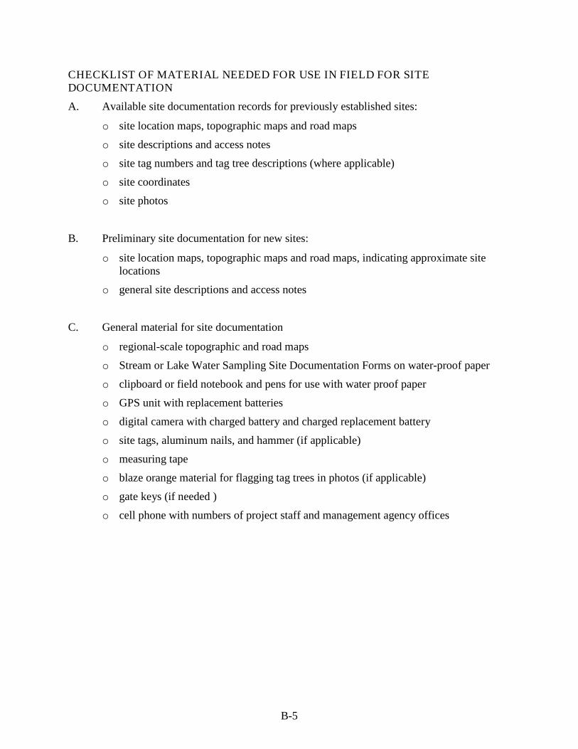
EQUIPMENT AND SUPPLY CHECKLIST FOR MEASURING STREAM DISCHARGE
Quantity Item
1 Surveyor’s telescoping leveling rod (7-m long, metric scale, round cross-section; optional)
1 50-m fiberglass measuring tape and reel
1 Small bubble level to make sure the tape is level
1 Current velocity meter, probe, and operating manual
1-2 Extra batteries for velocity meter
1 Top-set wading rod (metric or English scale) for use with current velocity meter
1 Portable weir with 60/ “V” notch (optional)
1 Plastic sheeting to use with weir (optional)
1 Plastic bucket (or similar container) with volume graduations
1 Stopwatch
1 Covered clipboard
Soft (#2) pencils
1 copy Field operations and methods documents
1 set Laminated sheets of procedure tables and/or quick reference guides for stream discharge

B-7
CHECKLIST OF EQUIPMENT AND SUPPLIES FOR SAMPLING LAKE WATER CHEMISTRY AND SECCHI DEPTH
Quantity Item
1 Standard Items
Field thermometer 1-2 Sample bottle(s) with completed sample label attached (in clean plastic bag).
Include a second bottle if sampling at that site is to be replicated 2-4 60 mL plastic syringes (with Luer type tip) with completed sample labels attached 1 Plastic container with snap-on lid to hold filled syringes 2-4 Syringe valves (Mininert® with Luer type adapter, or equivalent, available from a
chromatography supply company) 1 Cooler with 4 to 6 plastic bags (1-gal) of ice or a medium or large opaque garbage
bag to store the water sample at shoreline 1 Lake Water Sampling Record form 1 set Water Chemistry labels (if not filled out and attached at base site) 2-4 Soft-lead pencils and write in rain type pens for filling out field data forms and
notebook entries 2-4 Fine-tipped indelible waterproof markers for filling out labels 1 copy Field operations and methods documents 2-4 Plastic gloves stored in a secure plastic bag 1 Survey grade global positioning system (GPS) and compass 1 Digital camera with extra memory cards and batteries 1 Backpack with waterproof cover (if site is not accessible by vehicle) 1 Van Dorn sampler with messenger and cable 1 Raft or float tube with pump for inflating 1 First aid kit 1 Locally determined safety equipment 1 Secchi disk and line (with depth increments) 1 Tape measure
roll or box of tape strips
Optional Items Clear packaging tape to cover labels
1 Dissolved oxygen/Temperature meter with probe 1 DO repair kit containing additional membranes and probe filling solution 1 Conductivity meter with probe 1 250-mL or 500-mL plastic bottle of conductivity QCCS labeled RINSE (in plastic
bag) 1 250 mL or 500-mL plastic bottle of conductivity QCCS labeled TEST (in plastic
bag)

B-8
2. Sample Label

B-9
Blank label for lake or stream sample.
Note that if multiple aliquots (samples collected into plastic bottle, glass bottle, and/or syringe)
are collected for the same sampling location (site) and time (thus the two or more aliquots
represent the same sample), those aliquots should receive the same labeling and sample
ID/barcode. Never use the same barcode on different samples (replicates at same site). Duplicate
or triplicate samples should each receive a different sample ID/barcode. Each should be
identified by type as normal (N), Replicate 1 (R1) or Replicate 2 (R2). The recorded times of
collection of replicated samples (duplicates or triplicates) should differ by one minute.
The following label is sized to fit the standard bottle used by the Ft. Collins Waterlab. The
sample ID barcode will need to be placed below the label.
Lake or Stream Name: __________________
Site ID Number: _______________________
Date: ______________________________
Time (24 hr.): ____ ____ ____ ____
Sampler: ____________________________
Sample Type (check one):
Normal (N) Rep 1 (R1) Rep 2 (R2)
Container type (check one)
Plastic bottle Glass bottle Syringe
Sample ID/Barcode: ___________________

B-10

B-11
3. Forms and Instructions

B-12
CHAIN OF CUSTODY FORM (Also fill out detailed site and sample information on either the Lake or Stream Water Sampling Record Form)
Sender: Please send original of this form and accompanying samples to the contracted laboratory. Keep a legible copy for your local files.
Forest / Wilderness / Park / Other (Circle One) Name: ______________________________________________ Contact Individual and Affiliation: ______________________ ____________________________________________________
Shipped to (Lab Name and Address): _______________________________________________________________________________________________________________________________________________________________
Page ____ of ____
Address _____________________________________________ ____________________________________________________ Phone Number _______________________________________
Lab Phone # _______________________ Lab Contact _______________________ Lab Email _________________________
Shipped by: UPS/ FedEx/USPS/Other ___________ Shipping # ___________________________________
Date Sampled
Time Sampled (24-hour)
Standard Daylight Savings
Sample ID (Barcode)
Sample Location Lake/Stream Name or
Latitude/Longitude
Sample Type (Normal, Rep 1,
Rep 2, Blank, Split)
Filtered (Y/N)
Where? (Field or
Field Lab) Preserved
(Y/N/Type) Analyses Requested Lab ID Assigned
_ _/_ _ _ _ _ _ __ __ __ __
_ _/_ _ _ _ _ _ __ __ __ __
_ _/_ _ _ _ _ _ __ __ __ __
_ _/_ _ _ _ _ _ __ __ __ __
_ _/_ _ _ _ _ _ __ __ __ __
Comments:
Received/Relinquished by:
Print Name Signature Date & Time Relinquished Date & Time Received
Received at Laboratory by:
Print Name Signature Date Received Time Received

B-13
Chain of Custody Form Instructions Forest/Wilderness/Park/Other (Circle one): Circle one of these options and write the name of the Forest/Wilderness/Park or Other (e.g., separate Unit within the Forest) in the space below. Provide the name and affiliation of the project contact individual. Address and Phone Number: Provide address and phone number of the Forest, Wilderness, Park or Other. Please include the city, state, and zip code. Shipped to (Lab Name): Name, address, and email of the laboratory the water samples and original Chain of Custody Form will be sent to. Lab Phone #: Phone number of the laboratory the water samples and original Chain of Custody Form will be sent to. Lab Contact and Email: Contact person and email address in the analytical laboratory. Shipped by UPS/Fed Ex/USPS/Other: Identify the carrier you used. (Remember to consider the arrival date of the shipped samples because on weekends and government holidays there may not be anyone to receive samples in the laboratory). In general, you should try to ship samples on Monday, Tuesday, or Wednesday. Shipping #: Tracking number assigned to the shipment by the carrier. Page ___ of ___: Page number(s) of Chain of Custody forms sent. Date Sampled: Date sample was taken (mm/dd/yyyy). Time Sampled: Time sample was taken (24-hr __ __ __ __). Indicate whether standard or daylight savings time. Sample ID: Unique identification number assigned to the sample in the field for tracking purposes. (i.e., bar code or unique identifier used to identify the sample for connectivity of field analysis with the laboratory analysis). Ideally, multiple stick-on copies of the sample ID label are prepared as a computer-generated barcode which can be affixed in the field to multiple forms and sample containers. Location: Location description of sample site including lake or stream name, latitude and longitude in decimal degrees. Sample Type (normal, blank, replicate, etc.): Type of sample collected, such as normal water sample, field blank, replicate, etc. A Replicate (R1, R2) samples. are collected at the same location as the normal water sample but at slightly different times (at least one minute apart). Replicates are usually collected for quality assurance purposes or as backup samples should the normal sample be damaged. ; A field blank is a prepared sample of deionized water that is carried into the field and then shipped to the laboratory with the samples; a field split is the second bottle when a normal sample has been split in the field into two bottles. The first bottle is labeled as the normal sample; the second is labeled as the field split (S).
B-14
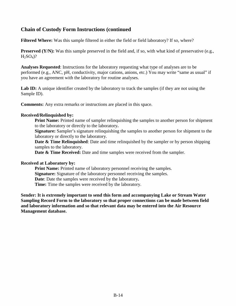
Chain of Custody Form Instructions (continued Filtered Where: Was this sample filtered in either the field or field laboratory? If so, where? Preserved (Y/N): Was this sample preserved in the field and, if so, with what kind of preservative (e.g., H2SO4)? Analyses Requested: Instructions for the laboratory requesting what type of analyses are to be performed (e.g., ANC, pH, conductivity, major cations, anions, etc.) You may write “same as usual” if you have an agreement with the laboratory for routine analyses. Lab ID: A unique identifier created by the laboratory to track the samples (if they are not using the Sample ID). Comments: Any extra remarks or instructions are placed in this space. Received/Relinquished by:
Print Name: Printed name of sampler relinquishing the samples to another person for shipment to the laboratory or directly to the laboratory. Signature: Sampler’s signature relinquishing the samples to another person for shipment to the laboratory or directly to the laboratory. Date & Time Relinquished: Date and time relinquished by the sampler or by person shipping samples to the laboratory. Date & Time Received: Date and time samples were received from the sampler.
Received at Laboratory by: Print Name: Printed name of laboratory personnel receiving the samples. Signature: Signature of the laboratory personnel receiving the samples.
Date: Date the samples were received by the laboratory. Time: Time the samples were received by the laboratory.
Sender: It is extremely important to send this form and accompanying Lake or Stream Water Sampling Record Form to the laboratory so that proper connections can be made between field and laboratory information and so that relevant data may be entered into the Air Resource Management database.

B-15
STREAM SAMPLING SITE DOCUMENTATION FORM
A) BASIC INFORMATION
Stream Name: USGS - Local -
Sample Site Name: Sample Site ID Number:
Forest/Wilderness/Park/Other (circle one) Name: ____________________________________________
Date of Visit: __ __/__ __/__ __ __ __ Visit Number: Initial Subsequent
Field Team Leader: Name: __________________________________ Affiliation: ___________________________________ Phone: __________________________________ Email: ______________________________________
Access: Vehicle Short Hike (< 1 hr) Long Hike (> 1 hr) Overnight Hike
B) STREAM SITE VERIFICATION
Stream verified Yes No
Stream site verified by ( all that apply) GPS Roads
Local Contact Topo Map
Signs Photos
Vegetation Other
Site Tag Has Been Affixed: Yes No New Tag Existing Tag
Tag Tree Species _____________________ Tag Tree Description and Location Relative to Stream Sampling Site: ___________________________________________________________________
C) GPS COORDINATES
Latitude (Decimal Degrees)
Longitude (Decimal Degrees)
Resolution (from manual) Elevation
Sample Site: __ __ . __ __ __ __ __ __ - __ __ __ . __ __ __ __ __ __ _____ m ft ______ m
Do GPS coordinates and elevation correspond to map? Yes No Datum: ______________ Explain ___________________________________________________________________________________
D) SAMPLING SITE DESCRIPTION AND COMMENTS
Travel Directions to Stream Sampling Site and Access Information: Description of Stream at Sampling Site:

B-16
E) SAMPLE SITE ASSESSMENT
Dominant Land Use in Vicinity of Sampling Site: Forest/Shrub Agriculture Open Herbaceous Developed Wetland
If Known, What are the Dominant Plant Species? ______________________________________________ ____________________________________________________________________________________
If Forest, Dominant Age Class: 0-10 yrs 10-25 yr 25-50 yrs > 50 yr
Beaver Activity in Vicinity of Sampling Site: Beaver Signs: None Rare Common Beaver Flow Modifications: None Minor Major
F) WATERSHED ASSSESSMENT (Through GIS project in office)
Lithology: Percent of Watershed Above Stream Sampling Site in: Hardwoods ____% Conifers ____% Mixed Forest ____% Exposed Rock ____% Herbaceous/Shrubs ____% Tallus ____% Catchment Area Above Sample Point: ______ km2 Watershed Aspect (e.g., N, SW, etc.) ________________ Average Slope of Catchment: ______% Stream Order:
G) PHOTOS
Attach photos with file name, date, and description.
H) OTHER NOTES
Completed by (initial) _______

B-17
Stream Sampling Site Documentation Form Instructions
Stream Name: Enter the name of the stream to be sampled. Provide both the USGS name (from topo map) and local name that the stream is known by. Sample Site Name and ID Number Each sample site (location) will have a unique Name and ID number assigned to it. These are generated locally for the Project. The identification number will appear on all sample bottles used for sampling this stream at this location. It is especially important to have a unique Site ID when more than one sample location is located on a stream. Forest/Wilderness/Park/Other: Circle one of these options and write the name of the Forest/Wilderness/Park or Other (e.g., separate Unit within the Forest) in the space below. Date of Visit: Enter the date of visiting the stream sampling site. Visit Number: Check whether this is the first (initial) visit to this site to establish it as part of a survey or monitoring effort, or if this site has been visited and documented previously and therefore this is a subsequent visit. Field Team Leader: Enter the name, affiliation, phone number, and email address of the responsible field person. Access: Check the box that best represents the mode of site access. Stream Site Verification: Do the available data match conditions observed on the ground sufficient to verify that the intended sampling site has been located (Yes/No)? Check all methods used to verify that you have located the correct site. Tree Tag: If allowed by applicable regulations, has a metal tree tag been affixed to a prominent tree in proximity to the sampling site? If so, indicate what species, if known. If the species is not known, indicate as such. Was the tag affixed to the tree on a previous trip (existing tag) or newly placed on this trip (new tag)? Describe the tree and its location relative to the sampling site. Include in the description the height above the ground and compass bearing of the tag. GPS Coordinates: Enter the latitude and longitude in decimal degrees (to at least 6 places after the decimal) of the sampling site. Enter from the GPS manual its approximate resolution and whether that resolution is expressed in meters or feet. Enter the Datum used (eg. WGS-84) Sampling Site Description and Comments: Describe the travel directions and any access issues or difficulties. Describe the sampling site itself. Sample Site Assessment: Estimate land use and vegetation within the immediate vicinity of the sample site. What is the dominant land use in the vicinity of the sampling site? What are the dominant plant species (if known to the sampler)? If forest, what is the approximate age class? To what extent have beaver influenced the general vicinity of the sampling site?

B-18
Watershed Assessment: Most of this information can be obtained through a GIS project prior to, or after, visiting the sample site. It can be helpful to have this information already filled in prior to the sampling trip. It can help to verify that you have located the targeted sample location, or conversely to indicate that available mapped information may be in error. Photos: Attach photos of the sampling site looking both upstream and downstream. Attach any additional photos of the stream, sampling site location, or access route that might be helpful in locating or accessing this site. Label each photo with file name, date photographed, and description of where photo was taken. Notes: Add any additional information that may help to identify, locate, or describe this site. Initials: Place your initials on the bottom of the form.
B-19
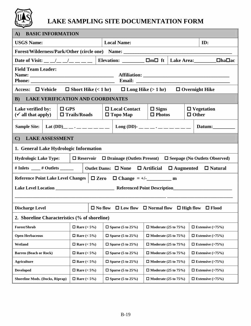
LAKE SAMPLING SITE DOCUMENTATION FORM
A) BASIC INFORMATION
USGS Name: Local Name: ID:
Forest/Wilderness/Park/Other (circle one) Name: ____________________________________________
Date of Visit: __ __/__ __/__ __ __ __ Elevation: _________ m ft Lake Area:_________haac
Field Team Leader: Name: __________________________________ Affiliation: ___________________________________ Phone: __________________________________ Email: ______________________________________
Access: Vehicle Short Hike (< 1 hr) Long Hike (> 1 hr) Overnight Hike
B) LAKE VERIFICATION AND COORDINATES
Lake verified by: ( all that apply)
GPS Trails/Roads
Local Contact Topo Map
Signs Photos
Vegetation Other
Sample Site: Lat (DD)__ __ . __ __ __ __ __ __ Long (DD)- __ __ __ . __ __ __ __ __ __ Datum:_________
C) LAKE ASSESSMENT
1. General Lake Hydrologic Information
Hydrologic Lake Type: Reservoir Drainage (Outlets Present) Seepage (No Outlets Observed)
# Inlets ____ # Outlets ______ Outlet Dams: None Artificial Augmented Natural
Reference Point Lake Level Changes Zero Change = +/-__________ m
Lake Level Location __________________________ Referenced Point Description__________________________
___________________________________________________________________ _____________________________
Discharge Level No flow Low flow Normal flow High flow Flood
2. Shoreline Characteristics (% of shoreline)
Forest/Shrub Rare (< 5%) Sparse (5 to 25%) Moderate (25 to 75%) Extensive (>75%)
Open Herbaceous Rare (< 5%) Sparse (5 to 25%) Moderate (25 to 75%) Extensive (>75%)
Wetland Rare (< 5%) Sparse (5 to 25%) Moderate (25 to 75%) Extensive (>75%)
Barren (Beach or Rock) Rare (< 5%) Sparse (5 to 25%) Moderate (25 to 75%) Extensive (>75%)
Agriculture Rare (< 5%) Sparse (5 to 25%) Moderate (25 to 75%) Extensive (>75%)
Developed Rare (< 5%) Sparse (5 to 25%) Moderate (25 to 75%) Extensive (>75%)
Shoreline Mods. (Docks, Riprap) Rare (< 5%) Sparse (5 to 25%) Moderate (25 to 75%) Extensive (>75%)
B-20
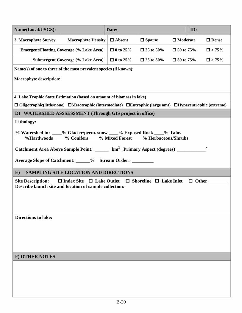
Name(Local/USGS): Date: ID:
3. Macrophyte Survey Macrophyte Density Absent Sparse Moderate Dense
Emergent/Floating Coverage (% Lake Area) 0 to 25% 25 to 50% 50 to 75% > 75%
Submergent Coverage (% Lake Area) 0 to 25% 25 to 50% 50 to 75% > 75%
Name(s) of one to three of the most prevalent species (if known): Macrophyte description:
4. Lake Trophic State Estimation (based on amount of biomass in lake)
Oligotrophic(little/none) Mesotrophic (intermediate) Eutrophic (large amt) Hypereutrophic (extreme)
D) WATERSHED ASSSESSMENT (Through GIS project in office)
Lithology: % Watershed in: ____% Glacier/perm. snow ____% Exposed Rock ____% Talus ____%Hardwoods ____% Conifers ____% Mixed Forest ____% Herbaceous/Shrubs Catchment Area Above Sample Point: ______ km2 Primary Aspect (degrees) ____________˚ Average Slope of Catchment: ______% Stream Order: _________
E) SAMPLING SITE LOCATION AND DIRECTIONS
Site Description: Index Site Lake Outlet Shoreline Lake Inlet Other ________ Describe launch site and location of sample collection:
Directions to lake:
F) OTHER NOTES

B-21
Name(Local/USGS): Date: ID:
G) LAKE SKETCH
Provide “North” arrow Mark site: L = Launch I = Index Site S = Shoreline Site O = Outlet Site
G) PHOTOS
Attach photos with file name, date, and description.
Completed by (initial) _______

B-22
Lake Sampling Site Documentation Form Instructions Lake Names and ID Number: Enter the official USGS name of the lake to be sampled, the local name if applicable, and the identification number assigned to it. This identification number will appear on all sample bottles used for sampling this lake at this location. Forest/Wilderness/Park/Other: Circle one of these options and write the name of the Forest/Wilderness/Park or Other (e.g., separate Unit within the Forest) in the space. Date of Visit: Enter the date of visiting the lake sampling site. Visit Number: Check whether this is the first (initial) visit to this site to establish it as part of a survey or monitoring effort, or if this site has been visited and documented previously and therefore this is a subsequent visit. Elevation: From GIS or mapped data available in the office, what is the elevation of this lake? Is it expressed in meters or feet? Having these data available in advance of the site visit will help verify that you have found the correct lake Lake Area: From GIS or mapped data available in the office, what is the approximate area of this lake? Is it expressed in hectares or acres? Having these data available in advance of the site visit will help verify that you have found the correct lake. Field Team Leader: Enter the name, affiliation, phone number, and email of the team leader. Access: Check the box that best represents the mode of site access. Lake Verification: Check () all means used to verify the lake identity. Coordinates: Enter the latitude and longitude in decimal degrees (to at least 6 places after the decimal) of the sampling site. Enter the Datum used for the coordinates (NAD83, WGS84, or NAD27). Lake Assessment: Indicate the hydrologic type of the lake based on the presence of an artificial human-made dam (reservoir), or as a drainage lake (outlet stream present; may or may not be flowing at time of visit) or seepage lake (no outlet stream present, regardless of whether or not it is flowing at the time of visit). # Inlets/# Outlets: Indicate the number of inlets and outlets to the lake. Dam: Is there a dam present? If so, is it an artificial structure that creates, or largely creates, the subject lake? Is it a smaller feature that serves to raise the stage of a previously existing lake (augmented)? Is it a natural dam, such as from a rockslide or lava flow? Reference Point Lake Level Changes: Record change in the lake level in meters relative to the fixed gage or point. Describe where the measurement was taken and the reference point.
B-23
Discharge Level Estimate: Indicate the general level of discharge in the lake outlet stream at the time of sampling. Shoreline: Indicate the relative percentages of vegetation types around the shoreline to a distance of about 20 meters from the lake. Lake Name/Date/ID: Repeat lake name (circle whether it is the official USGS name or a local name), date of sampling, and Lake ID. Macrophytes: From a quick visual survey of the lake, what is the average density of macrophytes (aquatic plants large enough to be seen without magnification)? Estimate the percent coverages of emergent and submergent macrophytes. Identify (if known) the one to three most prevalent macrophyte species. Describe the general macrophyte community. Lake Trophic State: Based on the amount of biomass in the lake, indicate your estimation of the lake’s trophic state. Watershed Assessment: Most of this information can be obtained through a GIS project prior to, or after, visiting the sample site. It can be helpful to have this information already filled in prior to the sampling trip. It can help to verify that you have located the targeted sample location, or conversely to indicate that available mapped information may be in error. Lithology: If you have GIS coverage of bedrock geology/lithology, indicate the primary lithology type in the watershed above the lake. Cover: Percentages in cover types indicated; the totals must equal 100%. If you know actual vegetation cover types, use them instead. Catchment area: the area of the catchment feeding the lake in square kilometers. Primary aspect: the primary aspect of the catchment as indicated in degrees with North being 0˚, East 90˚, South 180˚, and West 270˚. Average slope: average slope of the catchment in %. Stream order: stream order Site Location: Check whether the sample was collected from the index site, lake outlet, shoreline site or lake inlet. Describe the sampling site and (if applicable) the launch site. Directions: Describe how to get to the lake, including any access issues or difficulties. Notes: Add any additional information that may help to identify, locate, or describe this site. Lake Name/Date/ID: Repeat lake name (circle whether it is the official USGS name or a local name), date of sampling, and Lake ID. Lake Sketch: Provide a sketch of the lake, showing the major inlets and outlets. Include a “North” arrow (labeled “N”) and arrows to indicate the flow direction of the tributary streams. Mark the sampling site (either Index [I], Shoreline [S], or Outlet [O]), or Inlet [IL]. If Index, also indicate raft/float tube launch location (L). Photos: Attach photos of the sampling site looking both upgradient and downgradient. Label each photo with file name, date photographed, and description of where photo was taken. Attach and describe any other photographs taken at the sampling site or along the access route. Initials: Place your initials on the bottom of the form.

B-24
STREAM WATER SAMPLING RECORD FORM
A) SITE INFORMATION
Stream Name: USGS Local
Sample Site Name: Sample Site ID Number:
Date Sampled: _____________ Arrival Time (24 hr) __ __ __ __ Standard Daylight Savings
Field Team Leader: Name ____________________________ Affiliation ________________________
Telephone __________________________ Email ______________________________
B) SUGGESTED REVISIONS TO STREAM SAMPLING SITE DOCUMENTATION
GPS Coordinates Stream Description Sampling Site Description Travel Directions Describe Suggested Revisions:
C) GENERAL OBSERVATIONS
Air Temperature o C o F Time Measured (24 hr) __ __ __ __
Collection Day Weather Up to Time of Sampling
Clear Partly cloudy Overcast Light rain Occasional rain Persistent rain Snow or sleet Hail
Weather During Preceding 3 Days Generally dry Occasional rain/snow Generally wet Very wet
Discharge Level No flow Low flow Normal flow High flow flood
D) STAGE AND DISCHARGE DATA
Time Obtained (24 hr): ___ ___ ___ ___ Not Obtained in Field
Method of Determining Discharge (Check [] all that apply): None
Cross section of depth measurements
Velocity meter (number of measurements taken ____)
Salt dilution method
Relative comparison with nearby fixed gage
Stage measurement with pressure transducer
Stage measurement with staff gage
Timed filling procedure
Discharge Relative to Fixed Gage _____ cfs L/s
Location of Measurement Relative to Stream Sampling Site ________________________________________
Approximate Stream Depth at Sampling Location _____ m ft cm in
Approximate Stream Width at Sampling Location _____ m ft cm in
Discharge Measurement With Staff Gage cfs L/s
Location of Measurement Relative to Stream Sampling Site ________________________________________
Approximate Stream Depth at Sampling Location _____ m ft cm in

B-25
Approximate Stream Width at Sampling Location _____ m ft cm in
Existing Rating Curve: yes no If yes, referenced to what? _________________________________
________________________________________________________________________________________
Gage Height: __________ m ft cm in
Velocity-Area Procedure: yes no Depth: m ft cm in Velocity: m/s ft/s Stream Width at Sampling Location _____ m ft cm in
Interval 1 2 3 4 5 6 7 8 9 10
Depth ___ ___ ___ ___ ___ ___ ___ ___ ___ ___
Velocity ___ ___ ___ ___ ___ ___ ___ ___ ___ ___
Interval 11 12 13 14 15 16 17 18 19 20
Depth ___ ___ ___ ___ ___ ___ ___ ___ ___ ___
Velocity ___ ___ ___ ___ ___ ___ ___ ___ ___ ___
Timed Filling Procedure: yes no Time: min sec Volume: L gal
Spillway Number
Time to Fill Measured Volume
Trial 1 Trial 2 Trial 3 Trial 4 Trial 5
Time Volume Time Volume Time Volume Time Volume Time Volume
1 ____ ____ ____ ____ ____ ____ ____ ____ ____ ____
2 ____ ____ ____ ____ ____ ____ ____ ____ ____ ____
3 ____ ____ ____ ____ ____ ____ ____ ____ ____ ____
E) WATER SAMPLES and REPLICATES
Normal Sample:
Collection Time (24 hour): __ __ __ __
Sample Identification Code: __________________________
Number of Plastic Bottles ______ Number of Syringes ______
Replicate 1: Collected? Yes No
Collection Time (24 hour): __ __ __ __
Sample Identification Code: __________________________
Number of Plastic Bottles ______ Number of Syringes ______
Replicate 2: Collected? Yes No

B-26
Collection Time (24 hour): __ __ __ __
Sample Identification Code: __________________________
Number of Plastic Bottles ______ Number of Syringes ______
Method of Delivery to Laboratory: Vehicle Overnight Shipping Other Explain: ____________________
Collection Location: Explain any deviation from targeted sampling location ___________________________ ____________________________________________________________________________________________

B-27
F) IN SITU WATER DATA
Time Obtained: __ __ __ __ (24 hr) Air Temperature: ______ oC oF Instrument Used: _________________________ Water Temperature at Sample Location: _____ oC oF Instrument Used: ______________________ Multiparameter Sonde Data (Optional):
Parameter Value/UOM Equipment (Make/Model) Method (EPA/SM/USGS) Reference
Specific Conductance ____________uS/cm (corrected to 25o C)
pH
Turbidity ____________NTU
Dissolved Oxygen ____________mg/l ____________%DO
Other: ___________(_____) G) PHOTOS
Attach photos with file name, date, and description.
H) NOTES
Completed by (initial) ____________

B-28
Stream Water Sampling Record Form Instructions Stream Name: Enter the name of the stream to be sampled. Provide both the USGS name (from topo map) and local name that the stream is known by. Sample Site Name and ID Number Each sample site (location) will have a unique Name and ID number assigned to it. These are generated locally for the Project. The identification number will appear on all sample bottles used for sampling this stream at this location. It is especially important to have a unique Site ID when more than one sample location is located on a stream. Date Sampled: Enter the date of visiting the sampling site. Arrival Time: Indicate time of arrival at sampling location. Use 24-hour (mititary time)format. Indicate whether standard local time or daylight savings local time. Field Team Leader: Enter the name, affiliation, phone number, and email address of the responsible field person. Suggested Revisions to Site Documentation: Examine information given on the Stream Sampling Site Documentation Form, and indicate any suggested revisions. Place a check mark () in any box requiring revision, and explain the suggested revision in the space below. Air Temperature: Enter air temperature to the nearest degree. Record whether expressed in degrees C or degrees F. Weather: Check the boxes that best describe the collection day weather up to the time of sampling and the average weather over the previous 3 days (if known). General Discharge Level: Indicate the general level of discharge in the stream at the time of sampling. Stage and Discharge - General Information: Indicate what methods were used to obtain an estimate of stream discharge. If discharge measurements (estimates) were made in the field, record the measured value and indicate whether the units were recorded in cubic feet per second (cfs) or liters per second (L/s). Describe the location of discharge measurement. Record the approximate depth (deepest part of cross section) and width of the stream at the sampling location. If a rating curve has been developed with which to estimate discharge from stage measurements at this location, indicate what the stage is referenced to (i.e., fixed staff gage, permanent landscape feature), and record the gage height (stage) measured. Discharge: Velocity - Area Procedure: If the velocity-area procedure was used to measure discharge, check “yes” and indicate the units of measurement for water depth and velocity. Record the water depth and velocity in each of up to 20 evenly spaced intervals of the stream cross section. Discharge – Timed Filling Procedure: If the timed filling method was used to measure discharge, check “yes” and indicate the units of measurement for time and water volume. Record
B-29
the time and volume measurements for five separate trials at each of up to three spillway locations. Sample ID: Enter the unique identification code assigned to the sample (ideally prepared barcodes). The sample ID represents a sample of water (plastic bottle and/or syringe) intended to represent conditions at a particular location, on a particular day, at a particular time. Note that multiple containers (plastic bottle and syringes) obtained within one time window represent the SAME sample and receive the SAME ID code. Replicated samples receive different ID codes. The ID code may be prepared as a computer-generated barcode. Multiple stick-on copies of the barcode can be prepared prior to field sampling and subsequently be affixed to the Stream Water Sampling Record Form, the Chain of Custody Form, and to each container (bottle or syringe) for the sample. Collection Time: Indicate time of routine sample collection, using a 24-hour clock (thus, 4 pm is 1600). Note that the time recorded on the bottle(s) and syringe(s) for the replicates should differ from the time recorded for the normal sample. This is important! The recommended protocol is to separate the sampling times for normal and replicate samples by one minute. Samples: Indicate the number and type of sample aliquots collected for the normal (routine) sample and any replicates that may have been collected. How was the sample shipped or transported to the lab? Explain any deviation from the intended sampling location. In Situ Water Data: If any in situ water data were collected, provide the measured values. At what time were the in situ measurements taken? Indicate whether temperatures are expressed in Celsius or Fahrenheit. Express DO in units of mg/L and, if possible, % DO. Correct specific conductance to 25 oC. Indicate the instruments and methods used. Photos: Attach photos of sampling site looking both upstream and downstream. Label each photo with file name, date photographed, and description of where photo was taken. Attach and describe other photos, as appropriate. Notes: Add any additional information that may help to identify, locate, or describe this site. Initials: Place your initials on the bottom of the form.

B-30
LAKE WATER SAMPLING RECORD FORM
A) SITE INFORMATION
USGS Name: _____________________________ Local Name: _______________________ ID: ___________
Date Sampled: __________________________ Arrival Time (24 hr): __ __ __ __
Field Team Leader: Name ____________________________ Affiliation ________________________
Telephone __________________________ Email ______________________________
B) SAMPLING LOCATION AND PROTOCOL DEVIATIONS
Collection Location: Index Site Shoreline Other __________________
Sample Depth (m) ________ Zone: Surface Epilimnion Hypolimnion Deep Other ____________
Protocol or Target Site Deviation? No Yes Explain:
C) GENERAL OBSERVATIONS
Air Temperature o C o F
Collection Day Weather Clear Partly Cloudy Overcast Light Rain Occasional Rain Persistent Rain Snow or Sleet Hail
Weather during Preceding 3 Days Generally Dry Occasional Showers Not Known Generally Wet Very Wet
D) WATER SAMPLES
Normal : #Plastic Bottles ______ # Glass Bottles _____ # Syringes ______
Sample Identification Code: ___________________________________ Collection Time (24 hour): ______
Replicate 1 Type: Duplicate/Field Split (circle one) # Plastic Bottles _______ # Glass _____ #Syringes______
Sample Identification Code: __________________________________________ Collection Time (24 hour): __ __
Replicate 2 Type: Duplicate/Field Split (circle one) # Plastic Bottles _______ # Glass _____ #Syringes______
Sample Identification Code: __________________________________________ Collection Time (24 hour): __

B-31
Name(Local/USGS):__________________________ Date: ID:
F) FIELD WATER DATA
Time Obtained: ____ (24 hr) Air Temperature: ______ oC oF
Secchi Depth: Depth Disappeared ______ m ft Clear to Bottom? Depth Appeared ______ m ft
Water Temp: _____ oC oF Equip (Make Model): ___________________________________________________
Field Measurements
Spec. Conductance (uS/cm)
Parameter
(Correct to 25oC? Yes No)
pH
Turbidity (NTU)
DO ( units: % mg/L)
_______
Value
_______
_______
_______
_____________________EPA/SM/USGS
Method
_____________________EPA/SM/USGS
_____________________EPA/SM/USGS
_____________________EPA/SM/USGS
__________________________
Equipment (Make/Model)
__________________________ __________________________
__________________________
Other: ________units: ______ _____________________EPA/SM/USGS ________ __________________________
Depth Profile: Method ___________________________Instrument Make/Model:______________________________ Index Location? Yes No If no, describe: ________________________________________________________ Depth: m ft Sp. Cond 25˚C: Yes No Temperature: oC oF DO units: % mg/L Turb=NTU
Depth Temp
DO pH Cond Turb Depth Temp
DO pH Cond Turb Depth Temp
DO pH Cond
_____
Turb
_____ _____ _____ _____ _____ _____ _____ _____ _____ _____ _____ _____ _____ _____ _____ _____ _____
_____ _____ _____ _____ _____ _____ _____ _____ _____ _____ _____ _____ _____ _____ _____ _____ _____ _____
_____ _____ _____ _____ _____ _____ _____ _____ _____ _____ _____ _____ _____ _____ _____ _____ _____ _____
_____ _____ _____ _____ _____ _____ _____ _____ _____ _____ _____ _____ _____ _____ _____ _____ _____ _____
_____ _____ _____ _____ ____ _____ _____ _____ _____ _____ _____ _____ ____ _____ ____ ___ ____ ____
H) NOTES
Completed by (initial) __________

B-32
Lake Water Sampling Record Form Instructions Lake Names and ID Number: Enter the official USGS name of the lake to be sampled, the local name if applicable, and the identification number assigned to it. This identification number will appear on all sample bottles used for sampling this lake at this location. Date Sampled: Enter the date of visiting the lake sampling site. Arrival Time: Indicate time of arrival at sampling location. Use 24-hour clock format. Field Team Leader: Enter the name, affiliation, phone number, and email of the team leader. Collection Location: check the box for the location of this sample and its replicates. If you are collecting the sample from the lake outlet (or inlet), use the Stream Water Sampling Record form. Sample Depth: Write the depth in meters at which the sample was collected. Indicate the limnetic zone of the collection. If you don’t know, check surface or deep. Protocol or Target Site Deviation: If there were any deviations from the protocols, SOP’s or planned site of collection check Yes and explain these deviations. Air Temperature: Enter air temperature to the nearest degree and the unit of measure. Weather: Check the boxes that best describe the collection day weather and the average weather over the previous 3 days. Sample ID: Enter the unique identification code assigned to the sample. The sample ID represents a sample of water (bottle and/or syringe) intended to represent conditions at a particular location, on a particular day, at a particular time. Note that multiple containers (bottles and syringes) obtained within one time window represent the SAME sample and receive the SAME ID code. Replicated samples and their syringes receive different ID codes. The ID code may be received from the lab or prepared as a computer-generated barcode label prior to field sampling and then affixed to the Lake Water Sampling Record Form, the Chain of Custody Form, and to each container (bottle or syringe) for the sample. Collection Time: Indicate time of normal sample collection, using a 24-hour clock. Note that the time recorded on the bottle(s) and syringe(s) for the second sample of a duplicate pair, or for the second and third samples of a triplicate set, should differ from the time recorded for the routine sample. The recommended protocol is to separate the sampling times for replicate samples by one minute. Lake Name/Date/ID: Repeat lake name (circle whether it is the official USGS name or a local name), date of sampling, and Lake ID. Field Water Data: Time Obtained: time the field water measurements taken. Air Temperature: Record air temperature and whether it is in ˚F or ˚C. Secchi Depth: Record both the depth of the secchi disk disappearance and reappearance and unit of measurement. If it was clear all the way to the bottom of the lake, check the box. Water Temperature: Record water temperature and whether it is in ˚F or ˚C as well as what equipment with make and model was used. Field Measurements: For each surface field measurement taken, enter the value, method used (circle EPA, SM for Standard Method or USGS), and the equipment make and model used for the measurement. For Specific Conductance, check whether the value was corrected to 25 oC, If you measure
B-33
Dissolved Oxygen (DO), check the box for the unit of measure. Put the parameter (e.g. NO3) for any other parameters measured in Other. Depth Profile: Enter the EPA/SM/USGS method used for the measurements as well as the Make and Model of the equipment used for the profile. Indicate if the depth profile was measured at the index site, or at some other location (describe). What is the total depth at the location of the profile? Check the appropriate box for units of measure for temperature and DO. Indicate whether specific conductance measurements are corrected to 25 oC. At each measured depth, provide the depth and results of each measurement taken at that depth. Notes: Add any additional information about the sample collection and measurements that might help in understanding results. Photos: Attach photos of sampling site looking both upgradient and downgradient. Label each photo with file name, date photographed, and description of where photo was taken. Attach and describe other photos, as appropriate. Initials: Place your initials on the bottom of the form.