Embed Size (px)
Citation preview

A-1
Short Field Takeoff Distance at 2,450 Pounds for a Cessna Model 172R
Performance Data for Cessna Model 172R and Challenger 605
Appendix A

A-2
Time, Fuel, and Distance to Climb at 2,450 Pounds for a Cessna Model 172R

A-3
Cruise Performance for a Cessna Model 172R

A-4
Short Field Landing Distance at 2,450 Pounds for a Cessna Model 172R

A-5
0 500 1,000 1,500 2,000 2,500 3,000 3,500 4,000 4,500
4,219
3,600
5,840
4,940
3,465
3,401
SLISA
6,432
5,234
9,400
7,755
4,804
4,535
5,000 ftISA +20°C
40,000
35,000
50,000
46,000
30,000
2:00 4:00 6:00 8:00 9:50
Conditions: 26,985 lb BOW, M 0.74 cruise speed, ISA, zero wind, NBAA
IFR reserves (200 NM)
Note: Fuel burn figures provided ontop of graph are based on 1,000 lb
payload performance computations.
Range (NM)
Takeoff Field Length (feet) 3,190 6,570 10,230 14,200 18,105Fuel
Burn (lb)
Time (hour)Gross
TakeoffWeight (lb)
MaxPayload
3,000 lbPayload
1,000 lbPayload Zero Payload
Challenger 605 Range/Payload Profile

A-6
0:00 1:00 2:00 3:00 4:00 5:00 6:00 7:00 8:00 9:00 10:00 11:00
500
1,000
2,000
1,500
2,500
3,500
3,000
4,500
4,000
0
Conditions: 26,985 lb BOW, 1,000 lb payload, ISA, zero wind, NBAA
IFR reserves (200 NM)
M0.80 Cruise SpeedM0.74 Cruise Speed
Time (hour)
Dis
tanc
e (N
M)
771 NM3,550 lb
1,685 NM7,570 lb
730 NM3,190 lb
1,577 NM6,570 lb
2,599 NM11,980 lb
2,424 NM10,230 lb
3,512 NM16,820 lb
3,272 NM14,200 lb
3,700 NM18,105 lb
CHALLENGER 605 TIME AND FUEL VERSUS DISTANCE
M0.80 Cruise Speed Time 0:00 2:00 4:00 6:00 8:00 8:25Distance (NM) 0 771 1,685 2,599 3,512 3,701
Fuel (lb) 0 3,550 7,570 11,980 16,820 18,105M0.74 Cruise Speed Time 0:00 2:00 4:00 6:00 8:00 9:50
Distance (NM) 0 730 1,577 2,424 3,272 4,045Fuel (lb) 0 3,190 6,570 10,230 14,200 18,105
Conditions: 1,000 lb payload, ISA, zero wind, NBAA IFR reserves (200 NM alternate), 26,985 lb BOW
Note: All Challenger 605 performance data are for discussion purposes only. By this document, Bombardier Inc., does not intend to make, and is not making, any offer, commitment, representation or warranty of any kind whatsoever.
All data are subject to change without prior notice.
4,045 NM18,105 lb
Challenger 605 Time and Fuel Versus Distance

A-7
420 430 440 450 460 470 480 490
0.160
0.150
0.180
0.170
0.190
0.210
0.200
0.230
0.240
0.220
Conditions: 40,000 lb mid-cruise weight, zero wind, ISA
Speed (KTAS)
Spe
cific
Ran
ge (
NM
/lb)
CHALLENGER 605 SPECIFIC RANGE
Note: All Challenger 605 performance data are for discussion purposes only. By this document, Bombardier Inc., does not intend to make, and is not making, any offer, commitment, representation or warranty of any kind whatsoever.
All data are subject to change without prior notice.
M 0.74 Cruise Speed
M 0.80 Cruise Speed
M 0.82 Cruise Speed
FL 390
FL 370FL 350
FL 330
FL 310
Plotting of constant FL linesFlight Level
M0.82 M0.80 M0.74290 SpeedSpc Range
310 Speed 481 469 434Spc Range 0.165 0.178 0.199
330 Speed 477 465 430Spc Range 0.174 0.188 0.208
350 Speed 473 461 427Spc Range 0.181 0.197 0.216
370 Speed 470 459 424Spc Range 0.185 0.204 0.222
390 Speed 459 424Spc Range 0.205 0.223
Plotting of Long Range Cruise and High Speed Cruise lines
FL290 FL310 FL330 FL350 FL370 FL390M0.74 "X" 434 430 427 424 424M0.74 "Y" 0.199 0.208 0.216 0.222 0.223
M0.80 "X" 469 465 461 459 459M0.80 "Y" 0.178 0.188 0.197 0.204 0.205
M0.82 "X" 481 477 473 470M0.82 "Y" 0.165 0.174 0.181 0.185
Note: Based on 40,000 lb mid-cruise weight, ISA Conditions, zero wind
Challenger 605 Time and Fuel Versus Distance

A-8

B-1
AA/C—aircraftA/FD—airport/facility directoryA/G—air to groundA/HA—altitude/heightAAF—Army Air FieldAAI —arrival aircraft intervalAAP—advanced automation programAAR—airport acceptance rateABDIS—Automated Data Interchange System Service BABN—aerodrome beaconABV—aboveACAIS—air carrier activity information systemACAS—aircraft collision avoidance systemACC—area control center; Airports Consultants CouncilACCT—accounting recordsACCUM—accumulateACD—Automatic Call DistributorACDO—Air Carrier District OfficeACF—Area Control FacilityACFO—Aircraft Certification Field OfficeACFT—aircraftACID—aircraft identificationACI-NA—Airports Council International-North AmericaACIP—airport capital improvement planACLS—automatic carrier landing systemACLT—actual landing time calculatedACO—Office of Airports Compliance and Field Operations; Aircraft Certification OfficeACR—air carrierACRP—Airport Cooperative Research ProgramACS—Airman Certification StandardACT—active, activated, or activityADA—air defense areaADAP—Airport Development Aid ProgramADAS—AWOS data acquisition systemADCCP—advanced data communications control procedureADDA—administrative dataADF—automatic direction findingADI—automatic de-ice and inhibitor
Acronyms, Abbreviations, and NOTAM Contractions
Appendix B
ADIN—AUTODIN serviceADIZ—air defense identification zoneADJ—adjacentADL—aeronautical data-linkADLY—arrival delayADO—airline dispatch officeADP—automated data processingADS—automatic dependent surveillanceADSIM —airfield delay simulation modelADSY—administrative equipment systemsADTN—Administrative Data Transmission NetworkADTN2000—Administrative Data Transmission Network 2000ADVO—administrative voiceADZD—advisedAEG—Aircraft Evaluation GroupAERA—automated en route air traffic controlAEX—automated executionAF—airway facilitiesAFB—Air Force BaseAFIS—automated flight inspection systemAFP—area flight planAFRES—Air Force Reserve StationAFS—airways facilities sectorAFSFO—AFS field officeAFSFU—AFS field unitAFSOU—AFS field office unit (standard is AFSFOU)AFSS—automated flight service stationAFTN—Automated Fixed Telecommunications NetworkAGIS—airports geographic information systemAGL—above ground levelAID—airport information deskAIG—Airbus Industries GroupAIM—Airman’s Information ManualAlP—airport improvement planAIRMET—Airmen’s Meteorological InformationAIRNET—Airport Network Simulation ModelAIS—aeronautical lnformation serviceAlT—automated information transferALP—airport layout plan
This is a list of common acronyms and abbreviations used in the aviation industry as well as NOTAM contractions. For a more complete list of contractions used in aviation, see FAA Order JO 7340.2 (as amended). Additional information regarding NOTAMs can be found at pilotweb.nas.faa.gov/PilotWeb/.
B-2
ALS—approach light systemALSFl—ALS with sequenced flashers IALSF2—ALS with sequenced flashers IIALSIP—Approach Lighting System Improvement PlanALSTG—altimeter settingALT—altitudeALTM—altimeterALTN—alternateALTNLY—alternatelyALTRV—altitude reservationAMASS—airport movement area safety systemAMCC—ADF/ARTCC Maintenance Control CenterAMDT—amendmentAMGR—Airport ManagerAMOS—Automatic meteorological observing systemAMP—ARINC Message Processor; Airport Master PlanAMVER—automated mutual assistance vessel rescue systemANC—alternate network connectivityANCA—Airport Noise and Capacity ActANG—Air National GuardANGB—Air National Guard BaseANMS—automated network monitoring systemANSI—American National Standards GroupAOA—air operations areaAP—airport; acquisition planAPCH—approachAPL—airport lightsAPP—approach; approach control; Approach Control OfficeAPS—airport planning standardAQAFO—Aeronautical Quality Assurance Field OfficeARAC—Army Radar Approach Control (AAF); Aviation Rulemaking Advisory CommitteeARCTR—FAA Aeronautical Center or AcademyARF—airport reservation functionARFF—aircraft rescue and fire fightingARINC—Aeronautical Radio, Inc.ARLNO—Airline OfficeARO—Airport Reservation OfficeARP—airport reference pointARR—arrive; arrivalARRA—American Recovery and Reinvestment Act of 2009ARSA—airport service radar areaARSR—air route surveillance radarARTCC—air route traffic control centerARTS—automated radar terminal systemASAS—aviation safety analysis systemASC—AUTODIN switching centerASCP—Aviation System Capacity PlanASD—aircraft situation displayASDA—accelerate-stop distance availableASLAR—aircraft surge launch and recoveryASM—available seat mileASOS—automated surface observing system
ASP—arrival sequencing programASPH—asphaltASQP—airline service quality performanceASR—airport surveillance radarASTA—airport surface traffic automationASV—airline schedule vendorAT—air trafficATA—Air Transport Association of AmericaATAS—airspace and traffic advisory serviceATC—air traffic controlATCAA—air traffic control assigned airspaceATCBI—air traffic control beacon indicatorATCCC—Air Traffic Control Command CenterATCO—Air Taxi Commercial OperatorATCRB—air traffic control radar beaconATCRBS—air traffic control radar beacon systemATCSCC—Air Traffic Control System Command CenterATCT—airport traffic control towerATIS—automatic terminal information serviceATISR—ATIS recorderATM—air traffic management; asynchronous transfer modeATMS—advanced traffic management systemATN—Aeronautical Telecommunications NetworkATODN—AUTODIN terminal (FUS)ATOMS—air traffic operations management systemATOVN—AUOTVON (facility)ATS—air traffic serviceATSCCP—ATS contingency command postAUTH—authorityAUTOB—automatic weather reporting systemAUTODIN—DoD Automatic Digital NetworkAUTOVON—DoD Automatic Voice NetworkAVBL—availableAVN—Aviation Standards National Field Office, Oklahoma CityAVON—AUTOVON serviceAWlS—airport weather informationAWOS—automatic weather; observing/reporting systemAWP—Aviation Weather ProcessorAWPG—aviation weather products generatorAWS—air weather stationAWY—airwayAZM—azimuth
B BA FAIR—braking action fairBA NIL—braking action nilBA POOR—braking action poorBANS—BRITE alphanumeric systemBART—billing analysis reporting tool (GSA software tool)BASIC—basic contract observing stationBASOP—military base operations

B-3
BC—back courseBCA—benefit/cost analysisBCN—beaconBCR—benefit/cost ratioBDAT—digitized beacon dataBERM—snowbank(s) containing earth/gravelBLW—belowBMP—best management practicesBND—boundBOC—Bell Operating Companybps—bits per secondBRG—bearingBRI—basic rate interfaceBRITE—bright radar indicator terminal equipmentBRL—building restriction lineBUEC—back-up emergency communicationsBUECE—back-up emergency communications equipmentBYD—beyond
C C/S/S/N—capacity/safety/security/noise CAA—civil aviation authority; Clean Air ActCAAS—Class A AirspaceCAB—civil aeronautics boardCARF—Central Altitude Reservation FacilityCASFO—Civil Aviation Security OfficeCAT—category; clear-air turbulenceCAU—Crypto Ancillary UnitCBAS—Class B airspaceCBI—computer based instructionCBSA—Class B surface areaCC&O—customer cost and obligationCCAS—Class C AirspaceCCC—Communications Command CenterCCCC—staff communicationsCCCH—central computer complex hostCCLKWS—counterclockwiseCCS7-NI—Communication Channel Signal-7-Network InterconnectCCSA—Class C surface areaCCSD—Command Communications Service DesignatorCCU—Central Control UnitCD—clearance delivery; common digitizerCDAS—Class D AirspaceCDR—cost detail reportCDSA—Class D surface areaCDT—controlled departure timeCDTI—cockpit display of traffic informationCEAS—Class E AirspaceCENTX—central telephone exchangeCEP—capacity enhancement programCEQ—council on environmental quality
CERAP—center radar approach control; combined center radar approach controlCESA—Class E surface area CFC—central flow controlCFCF—Central Flow Control FacilityCFCS—central flow control serviceCFR—Code of Federal RegulationsCFWP—central flow weather processorCFWU—central flow weather unitCGAS—Class G Airspace; Coast Guard Air StationCHG—changeCIG—ceilingCK—checkCL—centerlineCLC—course line computerCLIN—contract line itemCLKWS—clockwiseCLR—clearance, clear(s), cleared toCLSD—closedCLT—calculated landing timeCM—commercial service airportCMB—climbCMSND—commissionedCNL—cancelCNMPS—Canadian Minimum Navigation Performance Specification AirspaceCNS—consolidated NOTAM systemCNSP—consolidated NOTAM system processorCO—central officeCOE—U.S. Army Corps of EngineersCOM—communicationsCOMCO—command communications outletCONC—concreteCONUS—Continental United StatesCORP—private corporation other than ARINC or MITRECPD—coupledCPE—customer premise equipmentCPMIS—consolidated personnel management information systemCRA—conflict resolution advisoryCRDA—converging runway display aidCRS—courseCRT—cathode ray tubeCSA—communications service authorizationCSIS—centralized storm information systemCSO—customer service officeCSR—communications service requestCSS—central site systemCTA—controlled time of arrival; control areaCTA/FIR—control area/flight information regionCTAF—common traffic advisory frequencyCTAS—center-TRACON automation system

B-4
CTC—contactCTL—controlCTMA—Center Traffic Management AdvisorCUPS—consolidated uniform payroll systemCVFR—controlled visual flight rulesCVTS—compressed video transmission serviceCW—continuous waveCWSU—Central Weather Service UnitCWY—clearway
D DA—direct access; decision altitude/decision height; Descent AdvisorDABBS—DITCO automated bulletin board systemDAIR—direct altitude and identity readoutDALGT—daylightDAR—Designated Agency RepresentativeDARC—direct access radar channeldBA—decibels A-weightedDBCRC—Defense Base Closure and Realignment CommissionDBE—disadvantaged business enterpriseDBMS—database management systemDBRITE—digital bright radar indicator tower equipmentDCA—Defense Communications AgencyDCAA—dual call, automatic answer deviceDCCU—Data Communications Control UnitDCE—data communications equipmentDCMSND—decommissionedDCT—directDDA—dedicated digital accessDDD—direct distance dialingDDM—difference in depth of modulationDDS—Digital Data ServiceDEA—Drug Enforcement AgencyDEDS—data entry and display systemDEGS—degreesDEIS—Draft Environmental Impact StatementDEP—depart/departureDEPPROC—departure proceduresDEWIZ—distance early warning identification zoneDF—direction finderDFAX—digital facsimileDFI—direction finding indicatorDGPS—Differential Global Positioning Satellite (System)DH—decision heightDID—direct inward dialDIP—drop and insert pointDIRF—direction findingDISABLD—disabledDIST—distanceDITCO—Defense Information Technology Contracting Office Agency
DLA—delay or delayedDLT—deleteDLY—dailyDME—distance measuring equipmentDME/P—precision distance measuring equipmentDMN—Data Multiplexing NetworkDMSTN—demonstrationDNL—day-night equivalent sound level (also called Ldn)DOD—direct outward dialDoD—Department of DefenseDOI—Department of InteriorDOS—Department of StateDOT—Department of TransportationDOTCC—Department of Transportation Computer CenterDOTS—dynamic ocean tracking systemDP—dew point temperatureDRFT—snowbank(s) caused by wind actionDSCS—digital satellite compression serviceDSPLCD—displacedDSUA—dynamic special use airspaceDTS—dedicated transmission serviceDUAT—direct user access terminalDVFR—defense visual flight rules; day visual flight rulesDVOR—doppler very high frequency omni-directional rangeDYSIM—dynamic simulator
E E—east EA—environmental assessmentEARTS—en route automated radar tracking systemEB—eastbound ECOM—en route communicationsECVFP—expanded charted visual flight proceduresEDCT—expedite departure pathEFC—expect further clearanceEFIS—electronic flight information systemsEIAF—expanded inward access featuresEIS—environmental impact statementELEV—elevationELT—emergency locator transmitterELWRT—electrowriterEMAS—engineered materials arresting systemEMPS—en route maintenance processor systemEMS—environmental management systemE-MSAW—en route automated minimum safe altitude warning ENAV—en route navigational aidsENG—engineENRT—en routeENTR—entireEOF—emergency Operating FacilityEPA—Environmental Protection AgencyEPS—Engineered Performance Standards

B-5
EPSS—enhanced packet switched serviceERAD—en route broadband radarESEC—en route broadband secondary radarESF—extended superframe formatESP—en route spacing programESYS—en route equipment systemsETA—estimated time of arrivalETE—estimated time en routeETG—enhanced target generatorETMS—enhanced traffic management systemETN—Electronic Telecommunications NetworkEVAS—enhanced vortex advisory systemEVCS—emergency voice communications systemEXC—except
F F&E—facility and equipment FAA—Federal Aviation AdministrationFAAAC—FAA aeronautical centerFAACIS—FAA communications information systemFAATC—FAA technical centerFAATSAT—FAA telecommunications satelliteFAC—facility/facilitiesFAF—final approach fixFAN—MKR fan markerFAP—final approach pointFAPM—FTS2000 associate program managerFAR—Federal Aviation RegulationFAST—final approach spacing toolFAX—facsimile equipmentFBO—fixed base operatorFBS—fall back switchFCC—Federal Communications CommissionFCLT—freeze calculated landing timeFCOM—FSS radio voice communicationsFCPU—Facility Central Processing UnitFDAT—flight data entry and printout (FDEP) and flight data serviceFDC—flight data centerFDE—flight data entryFDEP—flight data entry and printoutFDIO—flight data input/outputFDIOC—flight data input/output centerFDIOR—flight data input/output remoteFDM—frequency division multiplexingFDP—flight data processingFED—federalFEIS—Final Environmental Impact StatementFEP—front end processorFFAC—from facilityFI/P—flight inspection permanentFI/T—flight inspection temporaryFIFO—Flight Inspection Field Office
FIG—flight inspection groupFINO—Flight Inspection National Field OfficeFIPS—federal information publication standardFIR—flight information regionFIRE—fire stationFIRMR—Federal Information Resource Management RegulationFL—flight levelFLOWSIM—traffic flow planning simulationFM—fromFMA—final monitor aidFMF—facility master fileFMIS—FTS2000 management information systemFMS—flight management systemFNA—final approachFNMS—FTS2000 network management systemFOIA—Freedom Of Information ActFONSI—finding of no significant impactFP—flight planFPM—feet per minuteFRC—request full route clearanceFREQ—frequencyFRH—fly runway headingFRI—FridayFRZN—frozenFSAS—flight service automation systemFSDO—Flight Standards District OfficeFSDPS—flight service data processing systemFSEP—facility/service/equipment profileFSP—flight strip printerFSPD—freeze speed parameterFSS—flight service stationFSSA—flight service station automated serviceFSTS—federal secure telephone serviceFSYS—flight service station equipment systemsFTS—federal telecommunications systemFT—feet/footFTS2000—Federal Telecommunications System 2000FUS—functional units or systemsFWCS—flight watch control station
G GA—general aviationGAA—general aviation activityGAAA—general aviation activity and avionicsGADO—General Aviation District OfficeGC—ground controlGCA—ground control approachGIS—geographic information systemGNAS—general national airspace systemGNSS—global navigation satellite systemGOES—Geostationary Operational Environmental SatelliteGOESF—GOES feed point
B-6
GOEST—GOES terminal equipmentGOVT—governmentGP—glide pathGPRA—Government Performance Results ActGPS—global positioning systemGPWS—ground proximity warning systemGRADE—graphical airspace design environmentGRVL—gravelGS—glide slope indicatorGSA—General Services AdministrationGSE—ground support equipment
H H—non-directional radio homing beacon (NDB)HAA—height above airportHAL—height above landingHARS—high altitude route systemHAT—height above touchdownHAZMAT—hazardous materialsHCAP—high capacity carriersHDG—headingHDME—NDB with distance measuring equipmentHDQ—FAA headquartersHEL—helicopterHELI—heliportHF—high frequencyHH—NDB, 2kw or moreHI-EFAS—high altitude EFASHIRL—high intensity runway lightsHIWAS—Hazardous lnflight Weather Advisory ServiceHLDC—high level data link controlHLDG—holdingHOL—holidayHOV—high occupancy vehicleHP—holding patternHR—hourHSI—horizontal situation indicatorsHUD—housing and urban developmentHWAS—hazardous in-flight weather advisoryHz—Hertz
I I/AFSS—international AFSSIA—indirect accessIAF—initial approach fixIAP—instrument approach proceduresIAPA—instrument approach procedures automationIBM—International Business MachinesIBP—international boundary pointIBR—intermediate bit rateICAO—International Civil Aviation OrganizationICSS—international communications switching systems
ID—identificationIDAT—interfacility dataIDENT—identify/identifier/identificationIF—intermediate fixIFCP—interfacility communications processorIFDS—interfacility data systemIFEA—in-flight emergency assistanceIFO—International Field OfficeIFR—instrument flight rulesIFSS—international flight service stationILS—instrument landing systemIM—inner markerIMC—instrument meteorological conditionsIN—inch/inchesINBD—inboundINDEFLY—indefinitelyINFO—informationINM—integrated noise modelINOP—inoperativeINS—inertial navigation systemINSTR—instrumentINT—intersectionINTL—internationalINTST—intensityIR—ice on runway(s)IRMP—information resources management planISDN—integrated services digital networkISMLS—interim standard microwave landing systemITI—interactive terminal interfaceIVRS—interim voice response systemIW—inside wiring
K Kbps—Kilobits per secondKhz—KilohertzKT—knotsKVDT—keyboard video display terminal
L L—leftLAA—local airport advisoryLAAS—low altitude alert systemLABS—leased A B serviceLABSC—LABS GS-200 computerLABSR—LABS remote equipmentLABSW—LABS switch systemLAHSO—land and hold short operationLAN—local area networkLAT—latitudeLATA—local access and transport areaLAWRS—limited aviation weather reporting stationLB—pound/pounds

B-7
LC—local controlLCF—local control facilityLCN—local communications networkLCTD—locatedLDA—localizer-type directional aid; landing directional aidLDG—landingLDIN—lead-in lightsLEC—local exchange carrierLF—low frequencyLGT—light or lightingLGTD—lightedLINCS—leased interfacility NAS CLIRL—low intensity runway lightsLIS—logistics and inventory systemLLWAS—low level wind shear alert systemLLZ—localizerLM—compass locator at ILS middle markerLM/MS—low/medium frequencyLMM—locator middle markerLO—compass locator at ILS outer markerLOC—local; locally; location; localizerLOCID—location identifierLOI—letter of intentLOM—compass locator at outer markerLONG—longitudeLPV—lateral precision performance with vertical guidanceLRCO—limited remote communications outletLRNAV—long range navigationLRR—long range radarLSR—loose snow on runway(s)LT—left turn
M MAA—maximum authorized altitudeMAG—magneticMAINT—maintain, maintenanceMALS—medium intensity approach light systemMALSF—medium intensity approach light system with sequenced flashersMALSR—medium intensity approach light system with runway alignment indicator lightsMAP—maintenance automation program; military airport program; missed approach point; modified access pricingMAPT—missed approach pointMbps—megabits per secondMCA—minimum crossing altitudeMCAS—Marine Corps air stationMCC—maintenance control centerMCL—middle compass locaterMCS—maintenance and control systemMDA—minimum descent altitudeMDT—maintenance data terminalMEA—minimum en route altitude
MED—mediumMETI—meteorological informationMF—middle frequencyMFJ—modified final judgmentMFT—meter fix crossing time/slot timeMHA—minimum holding altitudeMhg—MeghertzMIA—minimum IFR altitudesMIDO—Manufacturing Inspection District OfficeMIN—minuteMIRL—medium intensity runway lightsMIS—Meteorological Impact StatementMISC—miscellaneousMISO—Manufacturing Inspection Satellite OfficeMIT—miles in trailMITRE—Mitre CorporationMLS—microwave landing systemMM—middle markerMMAC—Mike Monroney Aeronautical CenterMMC—maintenance monitoring consoleMMS—maintenance monitoring systemMNM—minimumMNPS—minimum navigation performance specificationMNPSA—minimum navigation performance specifications airspaceMNT—monitor; monitoring; monitoredMOA—memorandum of agreement; military operations areaMOC—minimum obstruction clearanceMOCA—minimum obstruction clearance altitudeMODE C—altitude-encoded beacon reply; altitude reporting mode of secondary radarMODE S—mode select beacon systemMON—MondayMOU—memorandum of understandingMPO—Metropolitan Planning OrganizationMPS—maintenance processor subsystem or master plan supplementMRA—minimum reception altitudeMRC—monthly recurring chargeMSA—minimum safe altitude; minimum sector altitudeMSAW—minimum safe altitude warningMSG—messageMSL—mean sea levelMSN—message switching networkMTCS—modular terminal communications systemMTI—moving target indicatorMU—mu metersMUD—mudMUNI—municipalMUX—multiplexorMVA—minimum vectoring altitudeMVFR—marginal visual flight rules

B-8
N N—northNA—not authorizedNAAQS—national ambient air quality standardsNADA—ADIN concentratorNADIN—National Airspace Data Interchange NetworkNADSW—NADIN switchesNAILS—National Airspace Integrated Logistics SupportNAMS—NADIN IANAPRS—National Airspace Performance Reporting SystemNAS—National Airspace System or Naval Air StationNASDC—National Aviation Safety DataNASP—National Airspace System PlanNASPAC—National Airspace System Performance Analysis CapabilityNATCO—National Communications Switching CenterNAV—navigationNAVAID—navigation aidNAVMN—navigation monitor and controlNAWAU—National Aviation Weather Advisory UnitNAWPF—National Aviation Weather Processing FacilityNB—northboundNCAR—National Center for Atmospheric Research, Boulder, CONCF—National Control FacilityNCIU—NEXRAD Communications Interface UnitNCP—noise compatibility programNCS—national communications systemNDB—non-directional radio beaconNDNB—NADIN IINE—northeastNEM—noise exposure mapNEPA—National Environmental Policy ActNEXRAD—next generation weather radarNFAX—National Facsimile ServiceNFDC—National Flight Data CenterNFIS—NAS Facilities Information SystemNGT—nightNI—network interfaceNICS—national interfacility communications systemNM—nautical mile(s)NMAC—near mid-air collisionNMC—National Meteorological CenterNMCE—network monitoring and control equipmentNMCS—network monitoring and control systemNMR—nautical mile radiusNOAA—National Oceanic and Atmospheric AdministrationNOC—notice of completionNONSTD—nonstandardNOPT—no procedure turn requiredNOTAM—notice to airmenNPDES—National pollutant discharge elimination systemNPE—non-primary airport entitlement
NPIAS—national plan of integrated airport systemsNR—numberNRC—non-recurring chargeNRCS—national radio communications systemsNSAP—National Service Assurance PlanNSRCATN—National Strategy to Reduce Congestion on America’s Transportation NetworkNSSFC—National Severe Storms Forecast CenterNSSL—National Severe Storms Laboratory, Norman, OKNSWRH—NWS Regional HeadquartersNTAP—Notices To Airmen PublicationNTP—National Transportation PolicyNTSB—National Transportation Safety BoardNTZ—no transgression zoneNW—northwestNWS—National Weather ServiceNWSR—NWS weather excluding NXRDNXRD—advanced weather radar system
O OAG—official airline guideOALT—operational acceptable level of trafficOAW—off-airway weather stationOBSC—obscuredOBST—obstructionODAL—omnidirectional approach lighting systemODAPS—oceanic display and processing stationOEP—operational evolution plan/partnershipOFA—object free areaOFDPS—offshore flight data processing systemOFT—outer fix timeOFZ—obstacle free zoneOM—outer markerOMB—Office Of Management and BudgetONER—Oceanic Navigational Error ReportOPLT—operational acceptable level of trafficOPR—operateOPS—operationOPSW—operational switchOPX—off premises exchangeORD—operational readiness demonstrationORIG—originalOTR—oceanic transition routeOTS—out of service; organized track systemOVR—over
P PABX—private automated branch exchangePAD—packet assembler/disassemblerPAEW—personnel and equipment workingPAM—peripheral adapter modulePAPI—precision approach path indicatorPAR—precision approach radar; preferential arrival route
B-9
PARL—parallelPAT—patternPATWAS—Pilots Automatic Telephone Weather Answering ServicePAX—passengerPBCT—proposed boundary crossing timePBRF—pilot briefingPBX—private branch exchangePCA—positive control airspacePCL—pilot controlled lightingPCM—pulse code modulationPD—Pilot DeviationPDAR—preferential arrival and departure routePDC—pre-departure clearance; program designator codePDN—Public Data NetworkPDR—preferential departure routePERM—permanent/permanentlyPFC—passenger facility chargePGP—planning grant programPIC—principal interexchange carrierPIDP—programmable indicator data processorPIREP—pilot weather reportPJE—parachute jumping exercisePLA—practice low approachPLW—plow/plowedPMS—program management systemPNR—prior notice requiredPOLIC—police stationPOP—point of presencePOT—point of terminationPPIMS—personal property information management systemPPR—prior permission requiredPR—primary commercial service airportPREV—previousPRI—primary rate interfacePRM—precision runway monitorPRN—pseudo random noisePROC—procedurePROP—propellerPSDN—public switched data networkPSN—packet switched networkPSR —packed snow on runway(s)PSS—packet switched servicePSTN—public switched telephone networkPTC—presumed-to-conformPTCHY—patchyPTN—procedure turnPUB—publicationPUP—principal user processorPVC—permanent virtual circuitPVD—plan view displayPVT—private
R RAIL—runway alignment indicator lightsRAMOS—remote automatic meteorological observing systemRAPCO—radar approach control (USAF)RAPCON—radar approach control (FAA)RATCC—Radar Air Traffic Control CenterRATCF—Radar Air Traffic Control Facility (USN)RBC—rotating beam ceilometerRBDPE—radar beacon data processing equipmentRBSS—Radar Bomb Scoring SquadronRCAG—remote communications air/ground facilityRCC—Rescue Coordination CenterRCCC—Regional Communications Control CentersRCF—Remote Communication FacilityRCIU— Remote Control Interface UnitRCL— runway centerline; radio communications linkRCLL—runway centerline light systemRCLR—RCL repeaterRCLT—RCL terminalRCO—remote communications outletRCU—remote control unitRDAT—digitized radar dataRDP—radar data processingRDSIM—runway delay simulation modelREC—receive/receiverREIL—runway end identifier lightsRELCTD—relocatedREP—reportRF—radio frequencyRL—General Aviation Reliever AirportRLLS—runway lead-in lights systemRMCC—Remote Monitor Control CenterRMCF—Remote Monitor Control FacilityRML—radio microwave linkRMLR—RML repeaterRMLT—RML terminalRMM—remote maintenance monitoringRMMS—remote maintenance monitoring systemRMNDR—remainderRMS—remote monitoring subsystemRMSC—remote monitoring subsystem concentratorRNAV—area navigationRNP—required navigation performanceROD—record of decisionROSA—report of service activityROT—runway occupancy timeRP—restoration priorityRPC—restoration priority codeRPG—radar processing groupRPLC—replace

B-10
RPZ—runway protection zoneRQRD—requiredRRH—remote reading hygrothermometerRRHS—remote reading hydrometerRRL—runway remaining lightsRRWDS—remote radar weather displayRRWSS—RWDS sensor siteRSA—runway safety areaRSAT—runway safety action teamRSR—en route surveillance radarRSS—remote speaking systemRSVN—reservationRT—right turn; remote transmitterRT & BTL—radar tracking and beacon tracking levelRTAD—remote tower alphanumerics displayRTCA—Radio Technical Commission for AeronauticsRTE—routeRTP—regional transportation planRTR—remote transmitter/receiverRTRD—remote tower radar displayRTS—return to serviceRUF—roughRVR—runway visual rangeRVRM—runway visual range midpointRVRR—runway visual range rolloutRVRT—runway visual range touchdownRW—runwayRWDS—same as RRWDSRWP—real-time weather processorRWY—runway
S S—southS/S—sector suiteSA—sand, sandedSAC—Strategic Air CommandSAFI—semi-automatic flight inspectionSALS—short approach lighting systemSAT—SaturdaySATCOM—satellite communicationsSAWR—Supplementary Aviation Weather Reporting StationSAWRS—Supplementary Aviation Weather Reporting SystemSB—southboundSBGP—state block grant programSCC—System Command CenterSCVTS—Switched Compressed Video Telecommunications ServiceSDF—simplified directional facility; simplified direction finding; software defined networkSDIS—switched digital integrated serviceSDP—service delivery point
SD-ROB—radar weather report SDS—switched data serviceSE—southeastSEL—single event levelSELF—simplified short approach lighting system with sequenced flashing lightsSFAR-38—Special Federal Aviation Regulation 38SFL—sequence flashing lightsSHPO—State Historic Preservation OfficerSIC—service initiation chargeSID— standard instrument departure; station identifier SIGMET—significant meteorological informationSIMMOD—airport and airspace simulation modelSIMUL—simultaneousSIP—state implementation planSIR—packed or compacted snow and ice on runway(s)SKED—scheduledSLR—slush on runway(s)SM—statute milesSMGC—surface movement guidance and controlSMPS—sector maintenance processor subsystemSMS—safety management system; simulation modeling systemSN—snowSNBNK—snowbank(s) caused by plowingSNGL—singleSNR—signal-to-noise ratio, also: S/NSOAR—system of airports reportingSOC—service oversight centerSOIR—simultaneous operations on intersecting runwaysSOIWR—simultaneous operations on intersecting wet runwaysSPD—speedSRAP—sensor receiver and processorSSALF—simplified short approach lighting system with sequenced flashersSSALR—simplified short approach lighting system with runway alignment indicator lightsSSALS—simplified short approach lighting systemSSB—single side bandSSR—secondary surveillance radarSTA—straight-in approachSTAR—standard terminal arrival routeSTD—standardSTMUX—statistical data multiplexerSTOL—short takeoff and landingSUN—SundaySURPIC—surface pictureSVC—serviceSVCA—service ASVCB—service BSVCC—service C

B-11
SVCO—service OSVFB—interphone service F (B)SVFC—interphone service F (C)SVFD—interphone service F (D)SVFO—interphone service F (A)SVFR—special visual flight rulesSW—southwestSWEPT—swept or broom/broomed
T T—temperatureT1MUX—T1 multiplexerTAA—terminal arrival areaTAAS—terminal advance automation systemTACAN—tactical air navigationTACR—TACAN at VOR, TACAN onlyTAF—terminal area forecastTAR—terminal area surveillance radarTARS—terminal automated radar serviceTAS—true air speedTATCA—terminal air traffic control automationTAVT—terminal airspace visualization toolTCA—traffic control airport or tower control airport; terminal control areaTCACCIS—Transportation Coordinator Automated Command And Control Information SystemTCAS—Traffic Alert and Collision Avoidance SystemTCC—DOT Transportation Computer CenterTCCC—Tower Control Computer ComplexTCE—tone control equipmentTCLT—tentative calculated landing timeTCO—Telecommunications Certification OfficerTCOM—Terminal CommunicationsTCS—tower communications systemTDLS—Tower Data-Link ServicesTDMUX—time division data multiplexerTDWR—terminal doppler weather radarTDZ—touchdown zoneTDZ LG—touchdown zone lightsTELCO—telephone companyTELMS—telecommunications management systemTEMPO—temporaryTERPS—terminal instrument proceduresTFAC—to facilityTFC—trafficTFR—temporary flight restrictionTGL—touch-and-go landingsTH—thresholdTHN—thinTHR—thresholdTHRU—throughTHU—ThursdayTIL—until
TIMS—telecommunications information management systemTIPS—terminal information processing systemTKOF—takeoffTL—taxilaneTM—traffic managementTM&O—telecommunications management and operationsTMA—Traffic Management AdvisorTMC—Traffic Management CoordinatorTMC/MC—Traffic Management Coordinator/Military CoordinatorTMCC—terminal information processing system; Traffic Management Computer ComplexTMF—Traffic Management FacilityTML—television microwave linkTMLI—television microwave link indicatorTMLR—television microwave link repeaterTMLT—television microwave link terminalTMP—Traffic Management ProcessorTMPA—traffic management program alertTMS—traffic management systemTMSPS—traffic management specialistsTMU—traffic management unitTNAV—terminal navigational aidsTODA—takeoff distance availableTOF—time of flightTOFMS—time of flight mass spectrometerTOPS—Telecommunications Ordering And Pricing System (GSA software tool)TORA—take-off run availableTR—telecommunications requestTRACAB—terminal radar approach control in tower cabTRACON—Terminal Radar Approach Control FacilityTRAD—terminal radar serviceTRB—Transportation Research BoardTRML—terminalTRNG—trainingTRSN—transitionTSA—taxiway safety area; Transportation Security AdministrationTSEC—terminal secondary radar serviceTSNT—transientTSP—telecommunications service priorityTSR—telecommunications service requestTSYS—terminal equipment systemsTTMA—TRACON Traffic Management AdvisorTTY—teletypeTUE—TuesdayTVOR—terminal VHF omnidirectional rangeTW—taxiwayTWEB—transcribed weather broadcastTWR—towerTWY—taxiwayTY—type (FAACIS)

B-12
U UAS—unmanned aircraft systemsUFN—until further noticeUHF—ultra high frequencyUNAVBL—unavailableUNLGTD—unlightedUNMKD—unmarkedUNMNT—unmonitoredUNREL—unreliableUNUSBL—unusableURA—Uniform Relocation Assistance and Real Property Acquisition Policies Act of 1970USAF—United States Air ForceUSC—United States CodeUSOC—Uniform Service Order Code
V V/PD—Vehicle/pedestrian deviationVALE—voluntary airport low emissionVASI—visual approach slope indicatorVDME—VOR with distance measuring equipmentVDP—visual descent pointVF—voice frequencyVFR—visual flight rulesVGSI—visual glide slope indicatorVHF—very high frequencyVIA—by way ofVICE—instead/versusVIS—visibilityVLF—very low frequencyVMC—visual meteorological conditionsVNAV—visual navigational aidsVNTSC—Volpe National Transportation System CenterVOL—volumeVON—virtual on-netVOR—VHF omnidirectional rangeVOR/DME—VHF omnidirectional range/distance measuring equipmentVORTAC—VOR and TACAN (collocated)VOT—VOR Test FacilityVP/D—vehicle/pedestrian deviationVRS—voice recording systemVSCS—voice switching and control systemVTA—vertex time of arrivalVTAC—VOR and TACAN (collocated)VTOL—vertical takeoff and landingVTS—voice telecommunications system
W W—westWAAS—Wide Area Augmentation SystemWAN—wide area networkWB—westboundWC—work centerWCP—Weather Communications ProcessorWECO—Western Electric CompanyWED—WednesdayWEF—with effect from; effective fromWESCOM—Western Electric Satellite CommunicationsWI—withinWIE—with immediate effect, or effective immediatelyWKDAYS—Monday through FridayWKEND—Saturday and SundayWMSC—Weather Message Switching CenterWMSCR—Weather Message Switching Center ReplacementWND—windWPT—waypointWSCMO—Weather Service Contract Meteorological ObservatoryWSFO—Weather Service Forecast OfficeWSMO—Weather Service Meteorological ObservatoryWSO—Weather Service OfficeWSR—wet snow on runway(s)WTHR—weatherWTR—water on runway(s)WX—weather
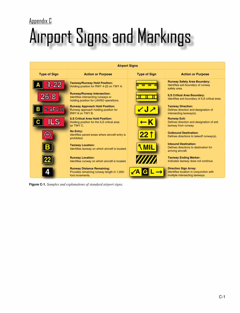
C-1
Figure C-1. Samples and explanations of standard airport signs.
Airport Signs
Type of Sign Action or Purpose Action or Purpose Type of Sign
4
B
22
4-22A
8-APCHB
ILSC
26-8J
K22 MIL
A L G
Taxiway/Runway Hold Position:Holding position for RWY 4-22 on TWY A.
Runway Approach Hold Position:Runway approach holding position forRWY 8 on TWY B.
ILS Critical Area Hold Position:Holding position for the ILS critical areaon TWY C.
No Entry:Identifies paved areas where aircraft entry isprohibited.
Taxiway Location:Identifies taxiway on which aircraft is located.
Runway Location:Identifies runway on which aircraft is located.
Runway Distance Remaining:Provides remaining runway length in 1,000-foot increments.
Runway/Runway Intersection:Identifies intersecting runways orholding position for LAHSO operations.
Runway Exit:Defines direction and designation of exit taxiway from runway.
Taxiway Direction:Defines direction and designation of intersecting taxiway(s).
Runway Safety Area Boundary:Identifies exit boundary of runwaysafety area.
ILS Critical Area Boundary:Identifies exit boundary of ILS critical area.
Outbound Destination:Defines directions to takeoff runway(s).
Inbound Destination:Defines directions to destination forarriving aircraft.
Taxiway Ending Marker:Indicates taxiway does not continue.
Direction Sign Array:Identifies location in conjunction withmultiple intersecting taxiways.
Airport Signs and MarkingsAppendix C

C-2
15
18
15-3315-3315-33
1515
ILS
15-APCH
15-APCH
33-15
15-33
33-15
A1
A2
A A A
D
15
A1
A2
A2
A2
18-36A
A2
A1
D
D
D
D
A A A
36-1
8A
15
2 2a
3
5
1
8
1
1
1
1
12
14
1
1
7
13 11
1
1
1 1
7
9
9 9
10
3
33
4
4 2a
2a
6
6
66
9
1
9
1
9
1
8
3a
3a
5
8
15
16
44
2a
1
17
1
2
2a
3
3a
4
5
6
7
8
Taxiway location sign
Runway holding position sign at takeoff end
Runway holding position sign at other than takeoff end
Runway holding position marking
Holding position marking for runway approach area
Elevated runway guard lights
Surface painted runway hold position sign
Enhanced centerline marking (located 150' prior to runway hold position marking)
Holding position sign for a runway approach area
Runway safety area boundary sign (located on the backside of holding position sign)
Taxiway direction sign
Surface painted destination sign
Holding position sign for ILS critical area
Surface painted ILS critical area boundary marking
ILS critical area boundary sign (located on backside of ILS hold sign)
Blast pad
Runway holding position sign and marking for Land and Hold Short Operations (LAHSO)
Runway hold position sign for intersecting runways
Outbound destination sign
9
10
11
12
13
14
15
16
17
Figure C-2. A sample runway with various possible markings and signs.

C-3
1518
15-3315-3315-33
1515
ILS
15-APCH
15-APCH
33-15
15-33
33-15
A1
A2
A A A
D
15
A1
A2
A2
A2
18-36A
A2
A1
D
D
D
D
A A A
36-1
8A
15
2 2a
3
5
1
8
1
1
1
1
12
14
1
1
7
13 11
1
1
1 1
7
9
9 9
10
3
33
4
4 2a
2a
6
6
66
9
1
9
1
9
1
8
3a
3a
5
8
15
16
44
2a
1
17
1
2
2a
3
3a
4
5
6
7
8
Taxiway location sign
Runway holding position sign at takeoff end
Runway holding position sign at other than takeoff end
Runway holding position marking
Holding position marking for runway approach area
Elevated runway guard lights
Surface painted runway hold position sign
Enhanced centerline marking (located 150' prior to runway hold position marking)
Holding position sign for a runway approach area
Runway safety area boundary sign (located on the backside of holding position sign)
Taxiway direction sign
Surface painted destination sign
Holding position sign for ILS critical area
Surface painted ILS critical area boundary marking
ILS critical area boundary sign (located on backside of ILS hold sign)
Blast pad
Runway holding position sign and marking for Land and Hold Short Operations (LAHSO)
Runway hold position sign for intersecting runways
Outbound destination sign
9
10
11
12
13
14
15
16
17

C-4
Figure C-3. Samples and explanations of standard airport markings.
Airport Markings
Action or PurposeType of Marking
Holding Position:Denotes entrance to a runway from a taxiway, approach hold position on a taxiway, or LAHSO holding position on a runway.
ILS Critical Area Boundary:Denotes entrance to an area to be protected for an ILS signal.
Taxiway/Taxiway Holding Position:Denotes location on taxiway or apron where aircraft hold short of another taxiway.
Non-Movement Area Boundary:Delineates movement area under control of ATC, from non-movement area.
Surface Painted Holding Position:Denotes entrance to a runway from a taxiway.
Enhanced Taxiway Centerline:Provides visual cue to help identify location of a runway holding position on a taxiway. These markings are installed 150 feet prior to the holding position markings.
Surface Painted Taxiway Direction:Defines designation/direction of intersecting taxiway(s).
Surface Painted Taxiway Location:Identifies taxiway on which the aircraft is located.
Taxiway Edge: Solid Double Yellow LinesDefines edge of usable, full strength taxiway. Adjoining
pavement IS NOT intended for use by aircraft.
4-22 4-22
T
B
Taxi
dire
ctio
nTa
xi d
irect
ion
Type of Marking
NON-USEABLE
Action or Purpose
Type of Marking
Taxiway Edge: Dashed Double Yellow LinesDefines taxiway edge where adjoining pavement
IS USABLE, such as along an apron or ramp.
Action or Purpose
NON-USEABLE
USEABLEUSEABLE