Embed Size (px)
Citation preview

Final Report
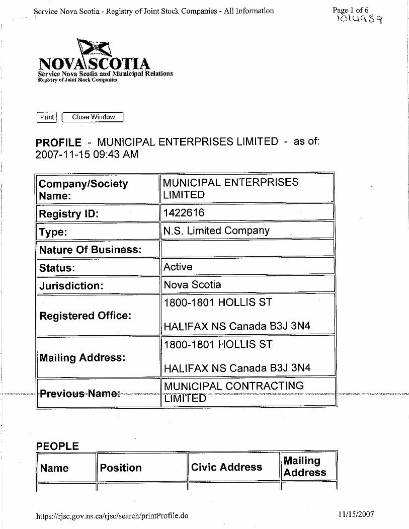
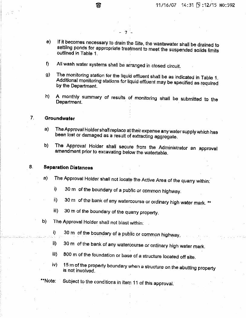
APPENDIX A Registry of Joint Stocks and Industrial Approval


Final Report
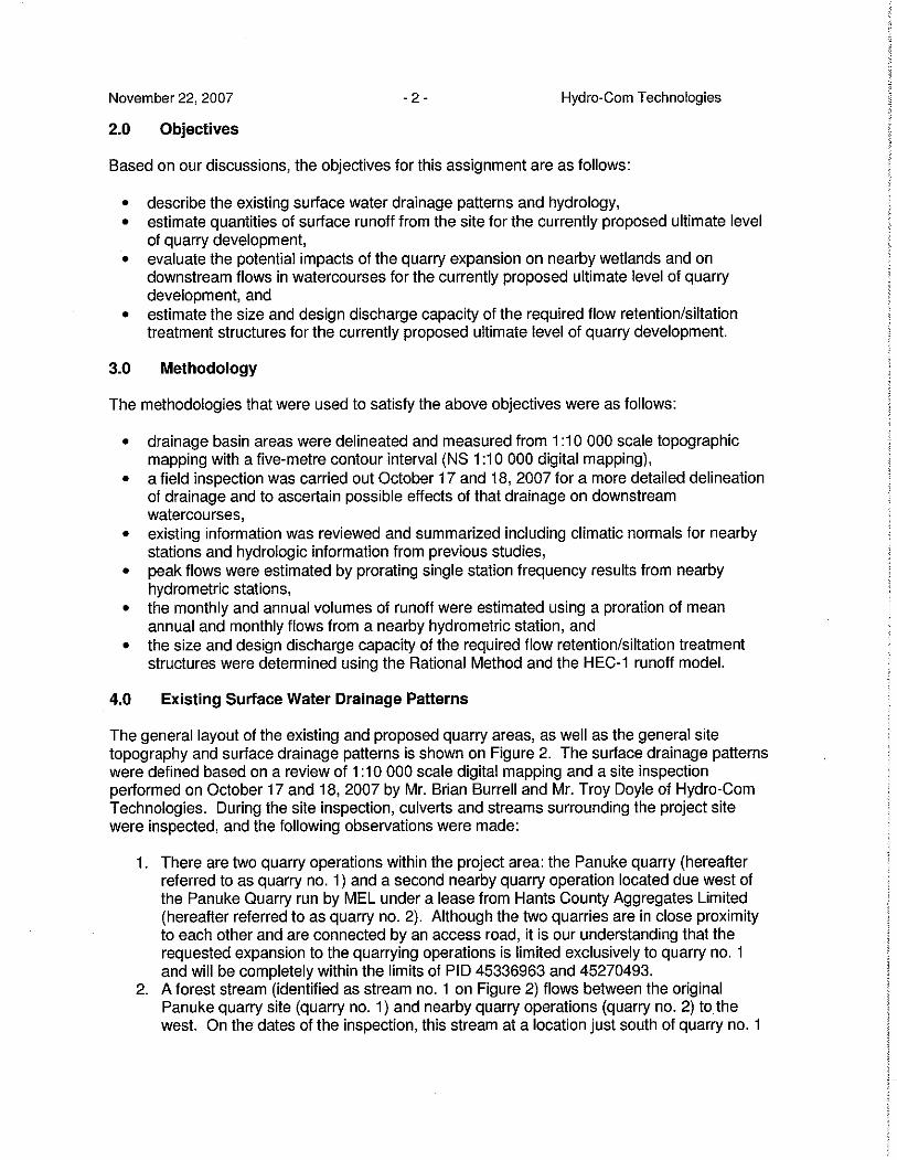
APPENDIX B Panuke Quarry Hydrology Study


Final Report
APPENDIX C Project Information Bulletin and Letters


P:\envsci\101xxx\1014939 panuke quarry\Draft EA\Appendix C project info bulletin and first nations letters\Municipal Enterprises Limited info sheet.doc
Municipal Enterprises Limited Panuke Quarry Project
Project Information Sheet _______________________________________________________________________________________________
Project Overview Municipal Enterprises Limited (MEL) has been operating a quarry for over five years at its facility on Panuke Road, Municipality of West Hants, Nova Scotia. The Nova Scotia Department of Environment and Labour (NSEL) granted approval for this quarry under DOE No. 2001-019700, effective September 14, 2001 and expiring September 9, 2011. This quarry is currently operated in accordance with the Nova Scotia Pit and Quarry Guideline (NSEL 1999). MEL owns land adjacent to its existing quarry site and is in the process of applying to NSEL to amend its existing permit to allow the company to blast, crush, and stockpile aggregate on this adjoining parcel of land. The quarried quartzite is primarily used for local construction such as road building. The primary markets for the products are government and non-government purchasers. The proposed activities on this adjacent property will be developed in various phases over the next five years depending on market demand. Approximately 10 hectares (25 acres) of land will be developed over that time. Proposed project activities will be consistent with current quarry operations on the adjacent site. Aggregate production begins with drilling and blasting, which will be conducted by a licensed blasting contractor. Blasting will take place approximately two to four times per year depending upon market demand. After blasting, portable crushing equipment will be brought to the site to process the blasted rock. Various products (i.e. various aggregate sizes) will be stockpiled at the quarry site until they are transported to local markets via tandem trucks or tractor trailer trucks via the existing truck route. The average number of trucks hauling aggregates from the quarry is expected to remain unchanged and is currently in the range of 2,000 per year. The anticipated average production rate will remain the same unless there is a significant contract awarded to the company. Production is now at the rate of approximately 60,000 tons per year. There are no limits on the current operating schedule, based on 15 hrs/day, 7 days/week, weather permitting, although peak demand may require operations to continue for 24 hrs/day, 7 days per week, weather permitting. The proposed schedule is consistent with the current operating schedule. Environmental Assessment Process MEL is required to register this project as a Class I Undertaking pursuant to the Nova Scotia Environment Act and Environmental Assessment Regulations. The environmental assessment registration is currently being prepared by environmental consultants Jacques
Whitford Limited, on behalf of MEL, to fulfill these regulatory requirements. Other relevant provincial regulations include the Activities Designation Regulations, which requires an Industrial Approval from the Nova Scotia Department of Environment and Labour for the quarry operation, and the General Blasting Regulations made pursuant to the Nova Scotia Occupational Health and Safety Act (1996). Provincial guidelines to be adhered to include the Nova Scotia Pit and Quarry Guidelines (NSEL 1999). The environmental assessment registration will evaluate potential environmental effects of the project and identify appropriate mitigation and monitoring to minimize these effects. The environmental assessment registration document will be available for public review and comment once it is filed with the NSEL. Environmental Document Components The environmental registration document focuses on those aspects of the environment of most concern. Components to be evaluated include: • rare and sensitive flora; • wildlife; • surface and groundwater resources; • wetlands; • archaeological and heritage resources; • atmospheric environment (includes dust & noise);
and • socio-economic environment. Potential effects of quarry activities on these components will be addressed in the registration document. Preliminary results of an environmental evaluation identified at least one small stream on the property. No other sensitive features have been identified onsite; however, field data is still being complied following this field season. Assuming the implementation of standard mitigative measures and government guidelines and approvals, no significant adverse environmental or socio-economic effects are considered likely. Contacts If you have any questions or concerns please contact: Mr. Alan Hayman Municipal Enterprises Limited P.O. Box 48100 RPO Mill Cove Bedford, NS B4A 3Z2 (902) 442-8311 (tel.): (902) 420-9326 (fax) Ms. Angela Swaine, Project Manager Jacques Whitford Limited 3 Spectacle Lake Drive Dartmouth, NS B3B 1W8 (902) 468-7777 ext. 210 (tel.): (902) 468-9009 (fax)

Project No. 1014939 October 10, 2007 Chief Brian Toney The Annapolis Valley First Nation P.O. Box 89 Cambridge Station, NS B0P 1G0 Dear Mr. Toney: Re: Municipal Enterprises Ltd. Panuke Quarry Expansion Project This letter is to inform you of a project that may be located close to your area of interest. The Project consists of an expansion of quarry activities at the existing facility near Windsor, West Hants County, Nova Scotia. The developer, Municipal Enterprises Limited, is proposing to expand the area of the existing quarry while maintaining approximately the same level of production. Municipal Enterprises Limited is currently preparing the documentation required to register this Project under the Environmental Assessment Regulations pursuant to the Nova Scotia Environment Act. Please find enclosed the Project Information Sheet and the corresponding Figure, which provide more details regarding the Project and the site location. Please contact the undersigned or the contacts listed on the Project Information Sheet with any comments, concerns, or questions you may have regarding the project by October 31, 2007. Yours truly, JACQUES WHITFORD LIMITED Angela Swaine Project Manager AS/vy Enclosure P:\envsci\101xxx\1014939 panuke quarry\letters\to be sent\panuke letter annapolis valley.doc
Project No. 1014939 October 10, 2007 Mr. Donald M. Julien The Confederacy of Mainland Mi’kmaq P.O. Box 1590 57 Martin Cres. Truro, NS B0N 5V3 Dear Mr. Julien: Re: Municipal Enterprises Ltd. Panuke Quarry Expansion Project This letter is to inform you of a project that may be located close to your area of interest. The Project consists of an expansion of quarry activities at the existing facility near Windsor, West Hants County, Nova Scotia. The developer, Municipal Enterprises Limited, is proposing to expand the area of the existing quarry while maintaining approximately the same level of production. Municipal Enterprises Limited is currently preparing the documentation required to register this Project under the Environmental Assessment Regulations pursuant to the Nova Scotia Environment Act. Please find enclosed the Project Information Sheet and the corresponding Figure, which provide more details regarding the Project and the site location. Please contact the undersigned or the contacts listed on the Project Information Sheet with any comments, concerns, or questions you may have regarding the project by October 31, 2007. Yours truly, JACQUES WHITFORD LIMITED Angela Swaine Project Manager AS/vy Enclosure P:\envsci\101xxx\1014939 panuke quarry\letters\to be sent\panuke letter CMM.doc

Project No. 1014939 October 10, 2007 Chief Alexander MacDonald The Shubenacadie First Nation 522 Church Street Micmac Post Office Hants County, NS B0N 2H0 Dear Mr. MacDonald: Re: Municipal Enterprises Ltd. Panuke Quarry Expansion Project This letter is to inform you of a project that may be located close to your area of interest. The Project consists of an expansion of quarry activities at the existing facility near Windsor, West Hants County, Nova Scotia. The developer, Municipal Enterprises Limited, is proposing to expand the area of the existing quarry while maintaining approximately the same level of production. Municipal Enterprises Limited is currently preparing the documentation required to register this Project under the Environmental Assessment Regulations pursuant to the Nova Scotia Environment Act. Please find enclosed the Project Information Sheet and the corresponding Figure, which provide more details regarding the Project and the site location. Please contact the undersigned or the contacts listed on the Project Information Sheet with any comments, concerns, or questions you may have regarding the project by October 31, 2007. Yours truly, JACQUES WHITFORD LIMITED Angela Swaine Project Manager AS/vy Enclosure P:\envsci\101xxx\1014939 panuke quarry\letters\to be sent\panuke letter shubenacadie.doc
Final Report
APPENDIX D Fish Habitat Study

Panuke Quarry Fish Habitat Survey 1.0 INTRODUCTION 1.1 Project Title: Panuke Quarry Fish Habitat Survey
This report describes the preliminary fish habitat assessment that was conducted by Jacques Whitford (JW) on September 20th, 2006. The study consisted of surveying an un-named stream flowing northwards alongside the western perimeter of the Panuke Road Quarry site in Windsor, Nova Scotia, and assessing its potential as fish habitat.
1.2. Regulatory Context
The presence of fish and the quality of fish habitat may influence expansion plans of the Panuke Road Quarry site. Standards for the protection of fish bearing habitat in Nova Scotia are stipulated by both federal and provincial regulatory agencies, such as Fisheries and Oceans Canada (DFO) and Nova Scotia Environment and Labour (NSEL).
A key piece of legislation is the Fisheries Act, which is administered by DFO. The Fisheries Act deals primarily with the proper management and control of fisheries, the conservation and protection of fish, the protection of fish habitat and prevention of pollution. The definitions outlined in the Act are important in understanding what constitutes ‘fish’ and ‘fish habitat’ under Canadian Law.
The Act defines ‘fish habitat’ as:
“spawning grounds and nursery, rearing, food supply and migration areas on which fish depend directly or indirectly in order to carry out their life processes.”
Fish habitat includes physical (e.g. substrate, temperature, flow velocity and volumes, water depth), chemical (e.g. dissolved oxygen, pH, nutrients) and biological (e.g. fish, benthic invertebrates, plankton, aquatic plants) attributes of the environment that are required by fish to carry out life cycle processes (e.g., spawning, rearing, feeding, over-wintering, migration).
The federal Fisheries Act defines ‘fish’ to mean
“all fish, shellfish, crustaceans, aquatic animals and any parts of shellfish, crustaceans or marine animals, and the eggs, sperm, spawn, larvae, spat and juvenile stages of fish, shellfish, crustaceans and aquatic animals.”
Therefore, all animals in habitats defined as fish habitat are considered fish under the Act.
1.3 General description The following section describes the general aspects of the study area and findings of the fish habitat survey of the Panuke Road Quarry site. Several locations along the stream were identified as fish habitat. Generally, the stream showed little evidence of impacts from the quarry operations and water clarity was good, with no signs of turbidity due to silt run-off. In fact, sections along the perimeter of the quarry have been mitigated for silt run-off by the erection of appropriate silt screens (Photo 1). The stream bed was completely dry in many places leaving isolated pools along several stretches. Where water was present, the flow conditions were extremely low, but the stream did support abundant aquatic life, including unidentified fish species, amphibians and invertebrates. The water appeared well oxygenated despite the limited
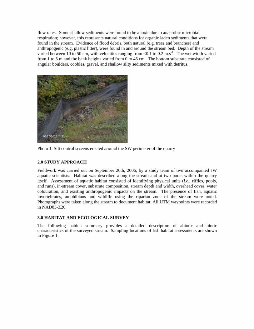
flow rates. Some shallow sediments were found to be anoxic due to anaerobic microbial respiration; however, this represents natural conditions for organic laden sediments that were found in the stream. Evidence of flood debris, both natural (e.g. trees and branches) and anthropogenic (e.g. plastic litter), were found in and around the stream bed. Depth of the stream varied between 10 to 50 cm, with velocities ranging from <0.1 to 0.2 m.s-1. The wet width varied from 1 to 5 m and the bank heights varied from 0 to 45 cm. The bottom substrate consisted of angular boulders, cobbles, gravel, and shallow silty sediments mixed with detritus.
Photo 1. Silt control screens erected around the SW perimeter of the quarry
2.0 STUDY APPROACH
Fieldwork was carried out on September 20th, 2006, by a study team of two accompanied JW aquatic scientists. Habitat was described along the stream and at two pools within the quarry itself. Assessment of aquatic habitat consisted of identifying physical units (i.e., riffles, pools, and runs), in-stream cover, substrate composition, stream depth and width, overhead cover, water colouration, and existing anthropogenic impacts on the stream. The presence of fish, aquatic invertebrates, amphibians and wildlife using the riparian zone of the stream were noted. Photographs were taken along the stream to document habitat. All UTM waypoints were recorded in NAD83-Z20. 3.0 HABITAT AND ECOLOGICAL SURVEY
The following habitat summary provides a detailed description of abiotic and biotic characteristics of the surveyed stream. Sampling locations of fish habitat assessments are shown in Figure 1.

Photo 2. View facing up stream at the start of the survey, Site 1.
Site 1, UTM Grid (20414186, 4976004): The stream at this location had a dry width of 2.8 m and a wet width of 1.2 m. The flow rate was <0.1 m.s-1 and the maximum water depth was 10 cm. Substrates consisted of leaf detritus, orange flocculent material and fine sediments, which were up to 5 cm deep, overlaying well embedded angular rocks and cobbles. There were no obvious signs of anthropogenic impacts. Both banks consisted of rocks which were covered with sphagnum moss and ferns. The banks were 30-40 cm high and offered no overhangs. There was 70% overhead canopy cover from mixed deciduous trees. The stream at this location also supported abundant aquatic vegetation and frogs.
Photo 3. The first culvert and aquatic plants showing direction of brook flow, Site 2.
Site 2, UTM Grid (20414141, 4976037): The stream at this location had a dry width of 3.0 m and a wet width of 2.8 m, passing through a 60 cm culvert underneath a forest track road. At this location, the stream consisted of a shallow pool with low flow where the maximum water depth was 25 cm. Substrates consisted of decaying leaves, detritus, and soft sediments overlaying well embedded angular rocks and cobbles. There were no obvious signs of anthropogenic impacts. Both banks consisted of rocks which were covered with sphagnum moss and ferns. The banks were 40 cm high and had slight undercutting. There was between 50-70% overhead canopy cover from mixed deciduous trees. Water striders were present at this site.

Photo 4. Dry stream bed, which would normally be a pool, Site 3.
Site 3, UTM Grid (20414105, 4976063): The dry stream bed at this location had a maximum width of 3.0 m, which would normally be a pool. Substrates consisted of decaying leaves, detritus, and soft sediments which were up to 5 cm deep and covered by dried orange flocculent material. These sediments were overlaying well embedded angular cobbles. There were no obvious signs of anthropogenic impacts. Both banks consisted of rocks which were covered with sphagnum moss and ferns. There was between 90-95% overhead canopy cover from mixed deciduous and coniferous trees at this site.
Photo 5. Had the stream not been dry a series of cascades would exist, Site 4.
Site 4, UTM Grid (20414061, 4976072): At this location, the partially dry stream bed exhibits several isolated pools of water with almost no flow. Had the stream been running there would be a series of cascades and runs. The stream had a dry width of 2.6 m, a wet width of 2.5 m and a maximum water depth of 50 cm in the deepest pool. Substrates consisted of decaying leaves, detritus, and soft sediments overlaying well embedded angular cobbles. Both banks consisted of rocks which were covered with sphagnum moss and ferns. There was 100% overhead canopy cover from mixed deciduous and coniferous trees. Along this 18 m section there would be a series of cascades and runs with a 7.5% slope as the stream descends 1.35 m.

Photo 6. Dried stream bed covered with leaf detritus and dried aquatic vegetation, Site 5.
Site 5, UTM Grid (20414026, 4976119): At this location, the dry stream bed exhibits a 20 m straight run with a 5.6% slope. The stream would have a dry width of 2.6 m. Substrates consist of dried aquatic vegetation overlaying well embedded angular cobbles and gravel. Banks consist of rocks covered with sphagnum moss and ferns. There was 100% overhead canopy cover from mixed deciduous and coniferous trees. At this site, the quarry was only 40-50 m NE from the stream.
Photo 7. Partially filled stream bed with large embedded weed covered boulders, Site 6.
Site 6, UTM Grid (20413996, 4976159): Under normal conditions the stream at this location would have riffles along this section, but now exhibits almost no flow. The stream had a width of 2.1 m and a maximum water depth of 22 cm in the deepest of 3 isolated shallow pools. Substrates consisted of decaying leaves, detritus, and soft silty sediments overlaying well embedded angular cobbles. Both banks consisted of rocks which were covered with sphagnum moss, and tree roots offering a small amount of overhang. There was 90% overhead canopy cover from mixed deciduous and coniferous trees. Along this section there was <5% slope.

Photo 8. Dry stream bed, Site 7.
Site 7, UTM Grid (20413938, 4976193): Under normal conditions, the stream at this site would have riffles along this section, but is now completely dry; with a maximum width of 5.5 m. Substrates consisted of embedded angular cobbles and gravel. Both banks consisted of rocks, which were covered with sphagnum moss and tree roots up to 40 cm high offering no overhang. There was 70% overhead canopy cover from mixed deciduous and coniferous trees. Along this section there was 7% slope and remnants of flood debris, such as tree branches and logs.
Photo 9. Dried stream bed showing flood debris, Site 8.
Site 8, UTM Grid (20413915, 4976240): Under normal conditions the stream at this site would have runs and riffles along this section, but is now completely dry, with a maximum width of 3.0 m. Substrates consisted of embedded angular rocks and cobbles covered by moist aquatic vegetation. Both banks consisted of rocks, which were covered with sphagnum moss and tree roots up to 30 cm high offering no overhang. There was 90% overhead canopy cover from mixed deciduous and coniferous trees. Along this section there was more evidence of flood debris such as tree branches and logs.

Photo 10. Poorly defined dried stream bed, Site 9.
Site 9, UTM Grid (20413937, 4976313): The stream here was again dry, but under normal conditions would have three poorly defined channels along this section. Combined, the three channels would have a maximum width of 20 m. Substrates consisted of embedded angular rocks and cobbles covered by aquatic vegetation. Banks are poorly defined at this site, but consist of rocks which were covered with sphagnum and other unidentified mosses, offering no overhang. There was 90% overhead canopy cover from mixed deciduous and coniferous trees. Along this section there was a steeper 15% slope and more evidence of flood debris, such as tree branches and logs.
Photo 11. Second culvert with dried stream bed, Site 10.
Site 10, UTM Grid (20413954, 4976418): The stream at this location had a maximum width of 5.5 m and passed through a 60 cm culvert underneath a forest track road. Substrates consisted of decaying leaves, detritus, and soft sediments overlaying well embedded angular cobbles and gravel, along with some boulders. Both banks consisted of rocks which were covered with sphagnum moss and roots. There was 50% overhead canopy cover from mixed deciduous trees. Along this section there was a 4% slope and more evidence of flood debris, such as tree branches and logs.

Photo 12. Stagnant pool with no flow, Site 11.
Site 11, UTM Grid (20413985, 4976470): The stream at this location had a dry width of 2.4 m and a wet width of 1.4 m. There was a stagnant pool with virtually no flow rate and maximum water depth was 30 cm. This pool was preceded by a wide ill-defined stream bed. Substrates consisted of leaf detritus, and fine soft sediments, which were up to 20 cm deep. Banks were covered with sphagnum moss and ferns up to 30-40 cm high, offering small overhangs. There was 80-90% overhead canopy cover from mixed deciduous trees. Along this section there was <4% slope and the stream also supported water striders.
Photo 13. Dried stream bed, Site 12.
Site 12, UTM Grid (20414014, 4976519): Under normal conditions the stream would have runs and riffles along this section, but is now completely dry, with a maximum width of 3.0 m. Substrates consisted of embedded angular cobbles and gravel, covered dried aquatic vegetation. Banks are well defined, consisting of rocks which were covered with sphagnum moss, but offering no overhang. There was 50-60% overhead canopy cover from mixed deciduous and coniferous trees.

Photo 14. Tributary stream entering dried stream bed, Site 13.
Site 13, UTM Grid (20414041, 4976573): This is a tributary stream which enters the dry stream bed. The tributary has a flow rate of 0.2 m.s-1 and originates from ground water out of rocks behind the quarry. The tributary has a wet width of 85 cm and a maximum water depth of 5 cm. Substrates consisted of leaf detritus, and fine soft sediments covering embedded angular cobbles and gravel. Banks were covered with sphagnum moss and ferns up to 30-40 cm high, offering small overhangs. There was 50-60% overhead canopy cover from mixed deciduous trees at this location.
Photo 15. Small pool containing unidentified fish, Site 14.
Site 14, UTM Grid (20414046, 4976618): This section of the stream becomes a small pool with a maximum water depth of 25 cm and a width of 1.0 m. Substrates consisted of leaf detritus, and fine soft sediments covering embedded angular cobbles with almost no slope. Banks were covered with sphagnum moss and ferns up to 40 cm high offering small overhangs, where unidentified fish (2-3 cm long) were seen. There were also lots of water striders at this site. There was 70-90% overhead canopy cover from mixed deciduous trees.

Photo 16. Stream containing unidentified fish, Site 15.
Site 15, UTM Grid (20414073, 4976677): This section of the stream becomes more defined with a slow run with low flow, maximum water depth of 30 cm and width of 1.0 m. Substrates consisted of leaf detritus, and fine soft sediments, with a depth of 10 cm. No cobbles were seen here. Banks were covered with sphagnum moss and ferns up to 40 cm high, offering multiple overhangs, where unidentified fish (3-4 cm long) were seen. There were also lots of water striders at this site. There was 90% overhead canopy cover from mixed deciduous and coniferous trees.
Photo 17. Small pool within the quarry supporting juvenile fish, Site 16.
Site 16, UTM Grid (20414049, 4976493): At this location there is a small pool (10 x 1.5 m) in the western corner of the quarry, choking with weed and surrounded by cat tails. The maximum water depth was 40 cm with soft quarry silts up to 10 cm deep. This pool contains >20 unidentified fish. The out flow of the pool passes through a culvert and forms the tributary stream at site 13.

Photo 18. Large pool within the quarry supporting juvenile fish, Site 17.
Site 17, UTM Grid (20414061, 4976072): At this site there is a large pool in the western corner of the quarry, containing weed and surrounded by cat tails. The maximum water depth was 35 cm with soft quarry silts up to 10 cm deep. This pool contains >50 unidentified fish. The out flow of the pool passes through a culvert which feeds into the small pool and ultimately forms the tributary stream at site 13.
4.0 SUMMARY
Small fish were observed along several stretches of the stream, at sites 14 and 15, and in the pools within the quarry itself, at sites 16 and 17. However, none of the fish were caught for identification, as DFO regulations prohibit electro-fishing in the waters and tributaries of the St. Croix River. The presence of fish indicates that the stream provides feeding habitat and shelter for fish, and likely provides spawning and rearing habitat (as indicated by the presence of small fish).

Final Report
APPENDIX E Vascular Plants Recorded in Study Area
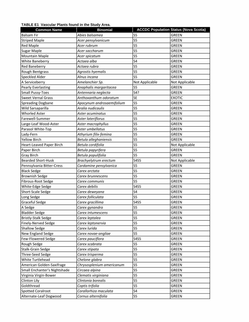
Common Name BinomialBalsam Fir Abies balsamea S5 GREENStriped Maple Acer pensylvanicum S5 GREENRed Maple Acer rubrum S5 GREENSugar Maple Acer saccharum S5 GREENMountain Maple Acer spicatum S5 GREENWhite Baneberry Actaea alba S4 GREENRed Baneberry Actaea rubra S5 GREENRough Bentgrass Agrostis hyemalis S5 GREENSpeckled Alder Alnus incana S5 GREENA Serviceberry Amelanchier Sp. Not Applicable Not ApplicablePearly Everlasting Anaphalis margaritacea S5 GREENSmall Pussy‐Toes Antennaria neglecta S4? GREENSweet Vernal Grass Anthoxanthum odoratum SE EXOTICSpreading Dogbane Apocynum androsaemifolium S5 GREENWild Sarsaparilla Aralia nudicaulis S5 GREENWhorled Aster Aster acuminatus S5 GREENFarewell‐Summer Aster lateriflorus S5 GREENLarge‐Leaf Wood‐Aster Aster macrophyllus S5 GREENParasol White‐Top Aster umbellatus S5 GREENLady‐Fern Athyrium filix‐femina S5 GREENYellow Birch Betula alleghaniensis S5 GREENHeart‐Leaved Paper Birch Betula cordifolia S5 Not ApplicablePaper Birch Betula papyrifera S5 GREENGray Birch Betula populifolia S5 GREENBearded Short‐Husk Brachyelytrum erectum S4S5 Not ApplicablePennsylvania Bitter‐Cress Cardamine pensylvanica S5 GREENBlack Sedge Carex arctata S5 GREENBrownish Sedge Carex brunnescens S5 GREENFibrous‐Root Sedge Carex communis S5 GREENWhite‐Edge Sedge Carex debilis S4S5 GREENShort‐Scale Sedge Carex deweyana S4 GREENLong Sedge Carex folliculata S5 GREENGraceful Sedge Carex gracillima S4S5 GREENA Sedge Carex gynandra S5 GREENBladder Sedge Carex intumescens S5 GREENBristly‐Stalk Sedge Carex leptalea S5 GREENFinely‐Nerved Sedge Carex leptonervia S5 GREENShallow Sedge Carex lurida S5 GREENNew England Sedge Carex novae‐angliae S5 GREENFew‐Flowered Sedge Carex pauciflora S4S5 GREENRough Sedge Carex scabrata S5 GREENStalk‐Grain Sedge Carex stipata S5 GREENThree‐Seed Sedge Carex trisperma S5 GREENWhite Turtlehead Chelone glabra S5 GREENAmerican Golden‐Saxifrage Chrysosplenium americanum S5 GREENSmall Enchanter's Nightshade Circaea alpina S5 GREENVirginia Virgin‐Bower Clematis virginiana S5 GREENClinton Lily Clintonia borealis S5 GREENGoldthread Coptis trifolia S5 GREENSpotted Coralroot Corallorhiza maculata S4 GREENAlternate‐Leaf Dogwood Cornus alternifolia S5 GREEN
TABLE E1 Vascular Plants found in the Study Area.ACCDC Population Status (Nova Scotia)
Common Name BinomialTABLE E1 Vascular Plants found in the Study Area.
ACCDC Population Status (Nova Scotia)Dwarf Dogwood Cornus canadensis S5 GREENBeaked Hazelnut Corylus cornuta S5 GREENPink Lady's‐Slipper Cypripedium acaule S5 GREENFlattened Oatgrass Danthonia compressa S4 GREENPoverty Oat‐Grass Danthonia spicata S5 GREENWild Carrot Daucus carota SE EXOTICEastern Hay‐Scented Fern Dennstaedtia punctilobula S5 GREENNorthern Bush‐Honeysuckle Diervilla lonicera S5 GREENSpinulose Shield Fern Dryopteris carthusiana S5 GREENCrested Shield‐Fern Dryopteris cristata S5 GREENEvergreen Woodfern Dryopteris intermedia S5 GREENMarginal Wood‐Fern Dryopteris marginalis S5 GREENTrailing Arbutus Epigaea repens S5 GREENWoodland Horsetail Equisetum sylvaticum S5 GREENFlat‐Top Fragrant‐Golden‐Rod Euthamia graminifolia S5 GREENAmerican Beech Fagus grandifolia S5 GREENHair Fescue Festuca filiformis SE EXOTICRed Fescue Festuca rubra S5 GREENVirginia Strawberry Fragaria virginiana S5 GREENWhite Ash Fraxinus americana S5 GREENRough Bedstraw Galium asprellum S5 GREENTeaberry Gaultheria procumbens S5 GREENFowl Manna‐Grass Glyceria striata S5 GREENNorthern Oak Fern Gymnocarpium dryopteris S5 GREENAmerican Witch‐Hazel Hamamelis virginiana S5 GREENMeadow Hawkweed Hieracium caespitosum SE EXOTICShining Fir‐Clubmoss Huperzia lucidula S5 GREENAmerican Water‐Pennywort Hydrocotyle americana S5 GREENSpotted Jewel‐Weed Impatiens capensis S5 GREENBlueflag Iris versicolor S5 GREENSoft Rush Juncus effusus S5 GREENLettuce Lactuca Sp. Not Applicable Not ApplicableTwinflower Linnaea borealis S5 GREENAmerican Fly‐Honeysuckle Lonicera canadensis S5 GREENHairy Woodrush Luzula acuminata S5 GREENCommon Woodrush Luzula multiflora S5 GREENStiff Clubmoss Lycopodium annotinum S5 GREENRunning Pine Lycopodium clavatum S5 GREENTreelike Clubmoss Lycopodium dendroideum S4? GREENHickey's Clubmoss Lycopodium hickeyi S2? UndeterminedTree Clubmoss Lycopodium obscurum S5 GREENNorthern Bugleweed Lycopus uniflorus S5 GREENWild Lily‐of‐The‐Valley Maianthemum canadense S5 GREENOstrich Fern Matteuccia struthiopteris S5 GREENIndian Cucumber‐Root Medeola virginiana S5 GREENAmerican Cow‐Wheat Melampyrum lineare S5 GREENPartridge‐Berry Mitchella repens S5 GREENIndian‐Pipe Monotropa uniflora S5 GREENSensitive Fern Onoclea sensibilis S5 GREENCinnamon Fern Osmunda cinnamomea S5 GREENInterrupted Fern Osmunda claytoniana S5 GREEN

Common Name BinomialTABLE E1 Vascular Plants found in the Study Area.
ACCDC Population Status (Nova Scotia)Eastern Hop‐Hornbeam Ostrya virginiana S5 GREENWhite Wood‐Sorrel Oxalis acetosella S5 GREENNorthern Beech Fern Phegopteris connectilis S5 GREENWhite Spruce Picea glauca S5 GREENRed Spruce Picea rubens S5 GREENEastern White Pine Pinus strobus S5 GREENLarge Roundleaf Orchid Platanthera orbiculata S2S3 GREENDrooping Bluegrass Poa saltuensis S4S5 GREENA Grass Poa Sp. Not Applicable Not ApplicableDowny Solomon's‐Seal Polygonatum pubescens S4S5 GREENFringed Black Bindweed Polygonum cilinode S5 GREENRock Polypody Polypodium virginianum S5 GREENChristmas Fern Polystichum acrostichoides S5 GREENLarge‐Tooth Aspen Populus grandidentata S5 GREENQuaking Aspen Populus tremuloides S5 GREENTall Rattlesnake‐root Prenanthes altissima S4 GREENThree‐Leaved Rattlesnake‐root Prenanthes trifoliolata S5 GREENSelf‐Heal Prunella vulgaris S5 GREENFire Cherry Prunus pensylvanica S5 GREENBracken Fern Pteridium aquilinum S5 GREENShinleaf Pyrola elliptica S5 GREENNorthern Red Oak Quercus rubra S5 GREENCreeping Butter‐Cup Ranunculus repens SE EXOTICWatercress Rorippa nasturtium‐aquaticum SE GREENSmooth Blackberry Rubus canadensis S5 GREENDwarf Red Raspberry Rubus pubescens S5 GREENMad Dog Skullcap Scutellaria lateriflora S5 GREENHemlock Water‐Parsnip Sium suave S5 GREENSolomon's‐Plume Smilacina racemosa S4S5 GREENCanada Goldenrod Solidago canadensis S5 GREENEarly Goldenrod Solidago juncea S5 GREENDowny Goldenrod Solidago puberula S5 GREENRough‐Leaf Goldenrod Solidago rugosa S5 GREENRosy Twistedstalk Streptopus roseus S5 GREENCommon Dandelion Taraxacum officinale SE EXOTICCanadian Yew Taxus canadensis S5 GREENNew York Fern Thelypteris noveboracensis S5 GREENNorthern Starflower Trientalis borealis S5 GREENIll‐Scent Trillium Trillium erectum S3 GREENPainted Trillium Trillium undulatum S5 GREENEastern Hemlock Tsuga canadensis S4S5 GREENLate Lowbush Blueberry Vaccinium angustifolium S5 GREENVelvetleaf Blueberry Vaccinium myrtilloides S5 GREENGypsy‐Weed Veronica officinalis S5SE EXOTICAlderleaf Viburnum Viburnum alnifolium S5 GREENPossum‐Haw Viburnum Viburnum nudum S5 GREENMarsh Blue Violet Viola cucullata S5 GREENSmooth White Violet Viola macloskeyi S5 GREENKidney‐Leaf White Violet Viola renifolia S4 GREEN

Final Report
APPENDIX F Bird Species Recorded in Study Area
Bird
CC
- C
lear
-cut
DA
- D
istu
rbed
Are
a
FO -
Flew
Ove
r
HU
- H
abita
t Unk
now
n
IH -
Imm
atur
e H
ardw
ood
IM -
Imm
atur
e M
ixed
woo
d
LS -
Low
Shr
ub S
wam
p
MM
- M
atur
e M
ixed
woo
d
MH
- Mat
ure
Har
dwoo
d
MTS
- M
ixed
woo
d Tr
eed
Swam
p
TS -
Tall
Shru
b Sw
amp
Grand Total
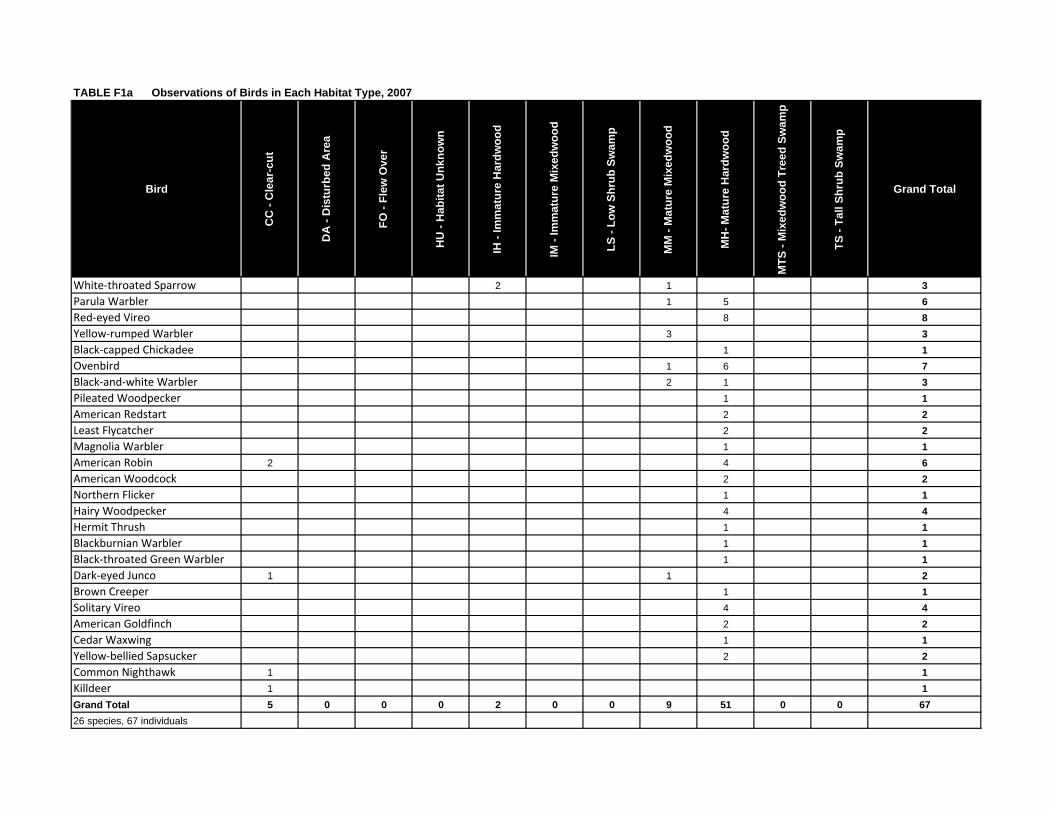
White‐throated Sparrow 2 1 3Parula Warbler 1 5 6Red‐eyed Vireo 8 8Yellow‐rumped Warbler 3 3Black‐capped Chickadee 1 1Ovenbird 1 6 7Black‐and‐white Warbler 2 1 3Pileated Woodpecker 1 1American Redstart 2 2Least Flycatcher 2 2Magnolia Warbler 1 1American Robin 2 4 6American Woodcock 2 2Northern Flicker 1 1Hairy Woodpecker 4 4Hermit Thrush 1 1Blackburnian Warbler 1 1Black‐throated Green Warbler 1 1Dark‐eyed Junco 1 1 2Brown Creeper 1 1Solitary Vireo 4 4American Goldfinch 2 2Cedar Waxwing 1 1Yellow‐bellied Sapsucker 2 2Common Nighthawk 1 1Killdeer 1 1Grand Total 5 0 0 0 2 0 0 9 51 0 0 6726 species, 67 individuals
TABLE F1a Observations of Birds in Each Habitat Type, 2007

Bird
CC
- C
lear
-cut
DA
- D
istu
rbed
Are
a
FO -
Flew
Ove
r
HU
- H
abita
t Unk
now
n
IH -
Imm
atur
e H
ardw
ood
IM -
Imm
atur
e M
ixed
woo
d
LS -
Low
Shr
ub S
wam
p
MM
- M
atur
e M
ixed
woo
d
MH
- Mat
ure
Har
dwoo
d
MTS
- M
ixed
woo
d Tr
eed
Swam
p
TS -
Tall
Shru
b Sw
amp
Grand Total
American Goldfinch 1 3 4American Redstart 1 1American Robin 2 1 2 5Barred Owl 1 1Black‐and‐white Warbler 2 2Blackburnian Warbler 1 1 2Black‐capped Chickadee 2 7 1 10Black‐throated Blue Warbler 1 2 3Black‐throated Green Warbler 4 5 9Brown Creeper 1 1Canada Warbler 1 1Cedar Waxwing 2 2Common Raven 1 1Dark‐eyed Junco 1 1Downy Woodpecker 1 1Eastern Wood Pewee 1 1Hermit Thrush 1 3 1 5Least Flycatcher 3 3Northern Flicker 2 2Ovenbird 1 10 9 20Parula Warbler 3 2 5Pileated Woodpecker 1 1Red‐eyed Vireo 2 5 7Red‐tailed Hawk 1 1Ruby‐crowned Kinglet 1 1Spotted Sandpiper 4 4Swainson's Thrush 1 1Tree Swallow 1 1White‐throated Sparrow 4 4Winter Wren 1 1Yellow‐bellied Sapsucker 4 4Yellow‐rumped Warbler 2 2Grand Total 0 9 4 5 0 0 0 45 44 0 0 10732 species, 107 individuals
TABLE F1b Observations of Birds in Each Habitat Type, 2006

Common Name Scientific Name Breeding Status (BBA Data)
Breeding Status (Field Survey, 2006)
Breeding Status (Field Survey, 2007)
NSDNR Rank ACCDC Rank
Alder Flycatcher Empidonax alnorum Possible Not Observed Not Observed Green S5BAmerican Crow Corvus brachyrhynchos Possible Not Observed Not Observed Green S5
American Goldfinch Carduelis tristis Possible Possible Probable Green S5American Kestrel Falco sparverius Possible Not Observed Not Observed Green S5B
American Redstart Setophaga ruticilla Confirmed No Evidence Possible Green S5BAmerican Robin Turdus migratorius Confirmed Probable Probable Green S5B
American Woodcock Scolopax minor Not Observed Not Observed Possible Green S4S5B
Bald Eagle Haliaeetus leucocephalus Confirmed Not Observed Not Observed Green S5B,S4N
Bank Swallow Riparia riparia Possible Not Observed Not Observed Green S4BBarn Swallow Hirundo rustica Confirmed Not Observed Not Observed Yellow S4BBarred Owl Strix varia Not Observed Possible Not Observed Green S5
Belted Kingfisher Ceryle alcyon Possible Not Observed Not Observed Green S5BBlack-and-white Warbler Mniotilta varia Possible Possible Possible Green S5B
Blackburnian Warbler Dendroica fusca Confirmed Possible Possible Green S4S5BBlack-capped Chickadee Parus atricapillus Confirmed Probable Possible Green S5
Black-throated Blue Warbler Dendroica caerulescens Not Observed Possible Not Observed Green S4BBlack-throated Green Warbler Dendroica virens Possible Possible Possible Green S5B
Blue Jay Cyanocitta cristata Confirmed Not Observed Not Observed Green S5Boreal Chickadee Parus hudsonicus Possible Not Observed Not Observed Yellow S4Brown Creeper Certhia Americana Not Observed Possible Possible Green S5
Brown-headed Cowbird Molothrus ater Possible Not Observed Not Observed Green S4BCanada Warbler Wilsonia canadensis Confirmed Possible Not Observed Yellow S4BCedar Waxwing Bombycilla cedrorum Probable Possible Possible Green S5B
Chestnut-sided Warbler Dendroica pensylvanica Possible Not Observed Not Observed Green S5BChipping Sparrow Spizella passerina Confirmed Not Observed Not Observed Green S5BCommon Grackle Quiscalus quiscula Possible Not Observed Not Observed Green S5B
Common Loon Gavia immer Possible Not Observed Not Observed Yellow S4B,S4NCommon Nighthawk Chordeiles minor Possible Not Observed Possible Yellow S4B
Common Raven Corvus corax Possible Possible Not Observed Green S5Common Yellowthroat Geothlypis trichas Probable Not Observed Not Observed Green S5B
Dark-eyed Junco Junco hyemalis Confirmed Probable Possible Green S5Downy Woodpecker Picoides pubescens Possible Possible Not Observed Green S5
Eastern Kingbird Tyrannus tyrannus Possible Not Observed Not Observed Green S4BEastern Wood-Pewee Contopus virens Possible Possible Not Observed Green S4B
European Starling Sturnus vulgaris Confirmed Not Observed Not Observed Exotic SE
Evening Grosbeak Coccothraustes vespertinus Confirmed Not Observed Not Observed Green S5
Golden-crowned Kinglet Regulus satrapa Possible Not Observed Not Observed Green S5BGray Catbird Dumetella carolinesis Confirmed Not Observed Not Observed Green S5B
Hairy Woodpecker Picoides villosus Possible Not Observed Confirmed Green S5Hermit Thrush Catharus guttatus Confirmed Possible Probable Green S5B
House Sparrow Passer domesticus Possible Not Observed Not Observed Exotic SEKilldeer Charadrius vociferus Not Observed Not Observed Probable Green S5B
Least Flycatcher Empidonax minimus Not Observed Probable Possible Green S5BMagnolia Warbler Dendroica magnolia Confirmed Not Observed Possible Green S5BNorthern Flicker Colaptes auratus Possible Possible Possible Green S5B
Northern Parula Warbler Parula americana Not Observed Possible Possible Green S5BNorthern Waterthrush Seiurus noveboracensis Possible Not Observed Not Observed Green S5B
Ovenbird Seiurus aurocapillus Possible Probable Probable Green S5BPileated Woodpecker Dryocopus pileatus Not Observed No Evidence Possible Green S5
Purple Finch Carpodacus purpureus Confirmed Not Observed Not Observed Green S5BRed-breasted Nuthatch Sitta canadensis Possible Not Observed Not Observed Green S5
Red-eyed Vireo Vireo olivaceus Possible Probable Possible Green S5BRed-tailed Hawk Buteo jamaicensis Possible Possible Not Observed Green S5B
Red-winged Blackbird Agelaius phoeniceus Confirmed Not Observed Not Observed Green S5BRing-necked Pheasant Phasianus colchius Possible Not Observed Not Observed Exotic SEB
Rock Dove Columba livia Possible Not Observed Not Observed Exotic SEBRose-breasted Grosbeak Pheucticus ludovicianus Possible Not Observed Not Observed Green S4B
Ruby-crowned Kinglet Regulus calendula Possible Possible Not Observed Green S5BRuby-throated Hummingbird Archilochus colubris Possible Not Observed Not Observed Green S5B
Savannah Sparrow Passerculus sandwichensis Possible Not Observed Not Observed Green S5B
Solitary Vireo Vireo solitarius Confirmed Not Observed Probable Green S5BSong Sparrow Melospiza melodia Confirmed Not Observed Not Observed Green S5B
Spotted Sandpiper Actitis macularia Confirmed Probable Not Observed Green S5BSwainson's Thrush Catharus ustulatus Confirmed Possible Not Observed Green S5BSwamp Sparrow Melospiza georgiana Confirmed Not Observed Not Observed Green S5B
Tennessee Warbler Vermivora peregrina Confirmed Not Observed Not Observed Green S5BTree Swallow Tachycineta bicolor Not Observed No Evidence Not Observed Green S5B
Veery Catharus fuscescens Possible Not Observed Not Observed Green S5BWhite-throated Sparrow Zonotrichia albicollis Confirmed Probable Confirmed Green S5B,SZN
Winter Wren Troglodytes troglodytes Possible Possible Not Observed Green S5BYellow Warbler Dendroica petechia Confirmed Not Observed Not Observed Green S5B
Yellow-bellied Flycatcher Empidonax flaviventris Possible Not Observed Not Observed Green S5BYellow-bellied Sapsucker Sphyrapicus varius Possible Confirmed Probable Green S5BYellow-rumped Warbler Dendroica coronata Possible Confirmed Probable Green S5B
TABLE F2 Breeding Status and Population Status of Birds Recorded in the Study Area and the Breeding Bird Atlas Square within which the Study Area is Located.