Embed Size (px)
Citation preview

53
Appendix A Historical Heritage Consultation Log

Western Highway Project Section 2 Historical Heritage Consultation
Date Organisation / Individual Location Attendance Theme Notes
26 August 2011 Ararat Historical Society Telephone conversation
Sarah Rood, Alan Wetton Discussion of research undertaken and community consultation process. Meeting request.
Community consultation meeting arranged for 14 September 2011 at LangiMorgalla in Ararat.
29 August 2011 Stawell Historical Society Telephone conversation and follow up email
Sarah Rood, Gary Withers Discussion of research undertaken and explanation of community consultation process. Request to set up a meeting.
Community consultation meeting arranged for 15 September 2011 at LangiMorgalla in Ararat. Additional information on potentially impacted sites emailed to Sarah Rood after the phone call (these were then emailed to ALA).
8 September 2011 Lorraine Huddle Lorraine Huddle Pty Ltd Pyrenees Shire Heritage Advisor
Telephone Conversation and follow up email
Sarah Rood, Lorraine Huddle Discussion of research undertaken and explanation of community consultation process. Feedback sought on sites of importance.
Lorraine was invited to attend the community consultation meetings scheduled in Ararat. Agreement made to send final maps and list of impacted sites to Lorraine for feedback as she is Melbourne based.
8 September 2011 Neil Manning Manager Planning and Development, Ararat Rural City Council
Telephone conversation
Sarah Rood, Neil Manning Discussion of research undertaken and community consultation process.
Meeting scheduled for 14 September 2011.
9 September 2011 Wendy Jacobs Northern Grampian Shire Heritage Adviser
Telephone conversation
Sarah Rood, Wendy Jacobs Discussion of research undertaken and community consultation process. Feedback sought on sites of importance.
Agreed to provide consultation should additional sites be identified on which little information could be found.
14 September 2011 (11am)
Ararat Rural City Council Ararat Rural City Council Offices, Ararat
Neil Manning, Fiona Poulton, Sarah Rood
Presentation of geo-referenced maps and presentation of historical data summary table.
Positive feedback given on process, no additional sites identified. Additional secondary source recommended.
14 September 2011 (12pm)
Ararat Historical Society LangiMorgalla, Ararat
8 members of the Ararat Historical Society, Fiona Poulton, Sarah Rood
Presentation of geo-referenced maps and presentation of historical data summary table.
Several additional sites identified and robust discussion on the location and significance of these sites. Secondary material provided to consultants. Follow-up meetings 15 September 2011.
15 September 2011 (10am)
Judy Barry, local historian Residence of Judy Barry
Judy Barry, Fiona Poulton, Sarah Rood
Presentation of geo-referenced maps and presentation of historical data summary table.
Additional information provided on sites identified by the members of the Ararat Historical Society. Additional secondary source material provided.
15 September 2011 (12pm)
Stawell Historical Society Premises of the Stawell Historical Society, Stawell
3 members of the Stawell Historical Society, Fiona Poulton, Sarah Rood
Presentation of geo-referenced maps and presentation of historical data summary table.
Robust discussion of proposed alignments and their impact. Additional sites identified and copies of secondary material given to consultants.
15 September 2011 (2.30pm)
Ararat Historical Society LangiMorgalla, Ararat
5 members Ararat Historical Society, Fiona Poulton, Sarah Rood
Further discussion of sites identified at the previous meeting.
Digital copies of photographs relating to identified sites given to consultants.

55
Appendix B Heritage Inventory (HI) Site Context Maps
(Sites outside proposed alignment)

56
Map 13: Context Map H7423-0061 Armstrong 2

57
Map 14: Context Map H7423-0064 Garden Gully Road House Site 2
58
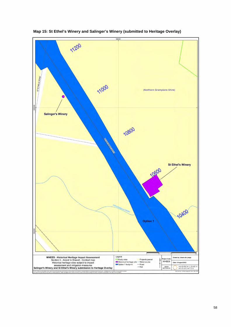
Map 15: St Ethel’s Winery and Salinger’s Winery (submitted to Heritage Overlay)

59
Appendix C Historical Heritage Site Cards

Heritage Inventory No: -
Site Card must be completed in conjunction with the Guidelines for Conducting Historical Archaeological Surveys atwww.heritage.vic.gov.au.
Name .................................................................................................................................................................
Other/former names ............................................................................................................................................
Current site description
Victorian Heritage Register Number ........................ Victorian Heritage Register
Heritage Overlay Number ........................ Heritage Overlay, Local Planning Scheme
Surface cultural material Sub-surface cultural deposits Archaeological potential
Features
Artefacts / Artefact scatter
Disturbance
High Medium Low None Unknown
Site location (where known) ................................................................................................................................
Street number ..................... Street ...............................................................................................................
Suburb ............................................................................... State Postcode ..................................
Local Government Area .......................................................................................................................................
Full AMG co-ordinates Easting ................... Northing .............
Mapsheet name and number (1:100,000 only) .....................................
County ................................. Parish ........................................ Township ......................................................
Section ................................ Allotment ................................... SPI................................................................

Site has known Indigenous values Victorian Aboriginal Heritage Register Number ...........................
(Inventory, VHR, HO or other)
early 19th century
mid 19th century
late 19th century
early 20th century
mid 20th century
mid-late 20th century
urban
outside urban
pastoral
agricultural
timber
mining
transport
communication
recreation
domestic
industrial
commercial
religious
maritime infrastructure
civic
military
Please attach separate plan. All features on the plan must be labelled and scale noted (eg 1:100,000).
(attach sheet if necessary)

(Include phases in the development of the site, functions and activities represented)
Statement of Significance attached
Historical significance

Scientific significance
Aesthetic significance
Social or spiritual significance

_____________________________________________________________________________________
Please attach as separate sheet.
Please attach separate plan.
Map must clearly identify assessed area and include any street addresses (eg excerpt from Melway and its reference numbers.)

Agency .................................................................................................................................................................
Owner’s name ......................................................................................................................................................
Contact name ......................................................................................................................................................
Postal address .....................................................................................................................................................
Telephone ............................................................... Facsimile ..................................................................
Email address ......................................................................................................................................................
Occupier’s name .................................................................................................................................................
Postal address .....................................................................................................................................................
Telephone ............................................................... Facsimile ..................................................................
Email address ......................................................................................................................................................
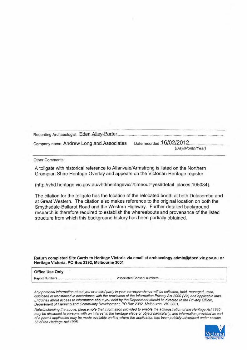
Recording Archaeologist .....................................................................................................................................
Company name……………………………………..…. Date recorded .......................................................... (Day/Month/Year)
Other Comments:
Report Numbers.............................................................. Associated Consent numbers ..........................................................................
Any personal information about you or a third party in your correspondence will be collected, held, managed, used, disclosed or transferred in accordance with the provisions of the Information Privacy Act 2000 (Vic) and applicable laws. Enquiries about access to information about you held by the Department should be directed to the Privacy Officer, Department of Planning and Community Development, PO Box 2392, Melbourne, VIC 3001. Notwithstanding the above, please note that information provided to enable the administration of the Heritage Act 1995 may be disclosed to persons with an interest in the heritage place or object particularly, and information provided as part of a permit application may be made available on-line where the application has been publicly advertised under section 68 of the Heritage Act 1995.


Heritage Inventory No: -
Site Card must be completed in conjunction with the Guidelines for Conducting Historical Archaeological Surveys atwww.heritage.vic.gov.au.
Name .................................................................................................................................................................
Other/former names ............................................................................................................................................
Current site description
Victorian Heritage Register Number ........................ Victorian Heritage Register
Heritage Overlay Number ........................ Heritage Overlay, Local Planning Scheme
Surface cultural material Sub-surface cultural deposits Archaeological potential
Features
Artefacts / Artefact scatter
Disturbance
High Medium Low None Unknown
Site location (where known) ................................................................................................................................
Street number ..................... Street ...............................................................................................................
Suburb ............................................................................... State Postcode ..................................
Local Government Area .......................................................................................................................................
Full AMG co-ordinates Easting ................... Northing .............
Mapsheet name and number (1:100,000 only) .....................................
County ................................. Parish ........................................ Township ......................................................
Section ................................ Allotment ................................... SPI................................................................

Site has known Indigenous values Victorian Aboriginal Heritage Register Number ...........................
(Inventory, VHR, HO or other)
early 19th century
mid 19th century
late 19th century
early 20th century
mid 20th century
mid-late 20th century
urban
outside urban
pastoral
agricultural
timber
mining
transport
communication
recreation
domestic
industrial
commercial
religious
maritime infrastructure
civic
military
Please attach separate plan. All features on the plan must be labelled and scale noted (eg 1:100,000).
(attach sheet if necessary)

(Include phases in the development of the site, functions and activities represented)
Statement of Significance attached
Historical significance

Scientific significance
Aesthetic significance
Social or spiritual significance

_____________________________________________________________________________________
Please attach as separate sheet.
Please attach separate plan.
Map must clearly identify assessed area and include any street addresses (eg excerpt from Melway and its reference numbers.)

Agency .................................................................................................................................................................
Owner’s name ......................................................................................................................................................
Contact name ......................................................................................................................................................
Postal address .....................................................................................................................................................
Telephone ............................................................... Facsimile ..................................................................
Email address ......................................................................................................................................................
Occupier’s name .................................................................................................................................................
Postal address .....................................................................................................................................................
Telephone ............................................................... Facsimile ..................................................................
Email address ......................................................................................................................................................
Recording Archaeologist .....................................................................................................................................
Company name……………………………………..…. Date recorded .......................................................... (Day/Month/Year)
Other Comments:
Report Numbers.............................................................. Associated Consent numbers ..........................................................................
Any personal information about you or a third party in your correspondence will be collected, held, managed, used, disclosed or transferred in accordance with the provisions of the Information Privacy Act 2000 (Vic) and applicable laws. Enquiries about access to information about you held by the Department should be directed to the Privacy Officer, Department of Planning and Community Development, PO Box 2392, Melbourne, VIC 3001. Notwithstanding the above, please note that information provided to enable the administration of the Heritage Act 1995 may be disclosed to persons with an interest in the heritage place or object particularly, and information provided as part of a permit application may be made available on-line where the application has been publicly advertised under section 68 of the Heritage Act 1995.

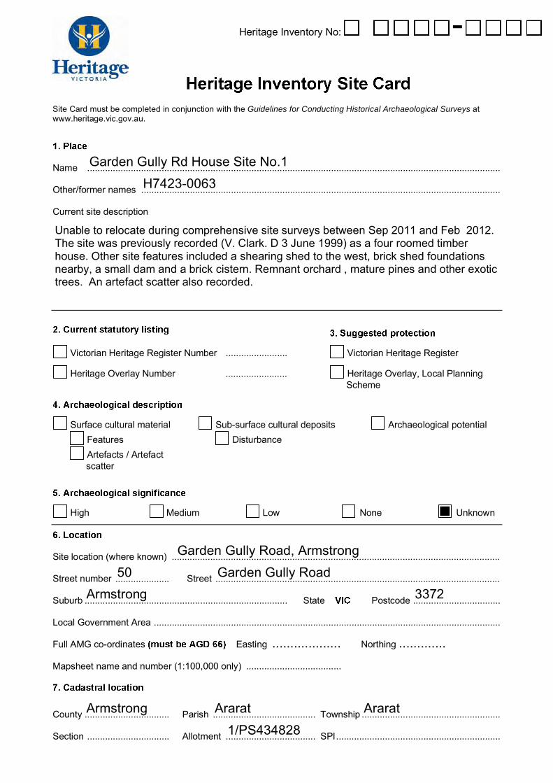
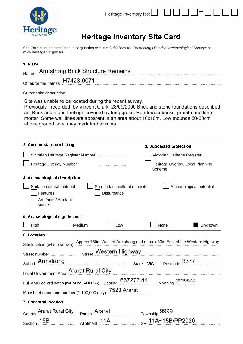
Information Update H7423-0060 Armstrong No.1 H7423-0062 Garden Gully Road Ruin H7423-0063 Garden Gully Road House Site No.1 H7423-0071 Armstrong Brick Structure Ruins Clark and Murphy (1999) surveyed four possible route options for the realignment of the Western Highway at Armstrong, approximately 10km northwest of Ararat. Seven historical archaeological sites [VHI] were recorded. These included:
7423-0060: Armstrong No 1. A ruined structure, possible hearth and possible out buildings. GPS co-ordinates E667100 /N5880000 (0.1km W of hwy; 9km N of Ararat)
7423-0062: Garden Gully Road Ruin Site. A ruined structure, remnants of a stone fireplace. GPS
co-ordinates E667150 / N5880350 (0.1km W of hwy; 9km N of Ararat)
7423-0063: Garden Gully Road House Site No. 1. A ruinous, four roomed timber house with a lean-to kitchen, veranda and a cellar. Outside the house there was a cistern and a shearing shed, a remnant orchard, scattered historic artefacts and equipment, and exotic trees. GPS not provided, 300m W of hwy; 9km N of Ararat.
7423-0072: Armstrong Hotel Ruins Structure. GPS E667170 / N5879920 (40m W of hwy,
9km NW of Ararat) Clark et al (2002) excavated four historical archaeological sites at Armstrong (approximately 10km northwest of Ararat), prior to the realignment of the Western Highway. The sites included 7423-0062, and 0071. Excavation of site 7423-0062 [VHI] confirmed that the site was a fireplace, although no evidence was found of the remainder of the structure, which they considered was probably a hut. The artefacts were primarily domestic and architectural in nature. Excavation of site 7423-0071 demonstrated that this site was part of a single large and complex site of the Armstrong Hotel. The site 7423- 0071 [VHI] presented two distinct periods of occupation; 1870s to 1920, at which point a fire destroyed the structure, after which a brick floor was laid and stables constructed (associated with the Hotel). Recommendations included monitoring of destructive works at sites 7423-0071. While comprehensive in historical description, unfortunately the reports on excavation included in Clarke etal 2002, and Ellis and Dolling 2003 include no images, drawings or plans of the remains they encountered and investigated. Noble, Kiddell and Clarke (2008) discuss these sites but similarly lack any illustration or plans of such ruins. Plans and images are however provided for three sites excavated, including 7423-0071 in Clark and Langberg (2002. 16-24). From these reports it is apparent that comprehensive vegetation clearance was frequently required to initially find or further identify these overgrown sites (Clarke and Langberg 2002.1. 23; Clarke etal 17ff) Clark,V., and Murphy A., 1999 Western Highway Armstrong Deviation Highway Realignment:
Archaeology and Heritage Study. Unpublished Report to VicRoads.

Clarke, V., and Langberg, V. 2002. Archaeological Test Excavations of Three Historical Sites at Armstrong Western Highwa y, Results and Interim Recommendations. (Volume I). Unpublished Report to VicRoads.
Clark, V., Dolling, W., Ellis, A., Langberg, V., & A. Stevens. 2002 Historical Sites at Armstrong in Western Victoria. Victorian Inventory Sites H7423-0071, H7423-0072, H7423-0073, H7423-0062. A Report on Archaeological Investigations. Unpublished report to VicRoads.
Ellis, A., and Dolling, W. 2003. Historical Sites at Armstrong in Western Victoria. Volume II: A Report
on the Material Culture. Unpublished Report to VicRoads Noble, A., Kiddell, H., and V. Clarke. 2008. Western Highway Duplication: Burrumbeet To Stawell.
City Of Ballarat, Pyrenees Shire, Ararat Rural City and Northern Grampians Shire Council Cultural Heritage Desktop Study. Unpublished Report to VicRoads


Heritage Inventory No: -
Site Card must be completed in conjunction with the Guidelines for Conducting Historical Archaeological Surveys at www.heritage.vic.gov.au.
Name .................................................................................................................................................................
Other/former names ............................................................................................................................................
Current site description
Victorian Heritage Register Number ........................ Victorian Heritage Register
Heritage Overlay Number ........................
Heritage Overlay, Local Planning Scheme
Surface cultural material Sub-surface cultural deposits Archaeological potential Features Artefacts / Artefact scatter
Disturbance
High Medium Low None Unknown
Site location (where known) ................................................................................................................................
Street number ..................... Street ...............................................................................................................
Suburb ............................................................................... State Postcode ..................................
Local Government Area .......................................................................................................................................
Full AMG co-ordinates Easting ................... Northing .............
Mapsheet name and number (1:100,000 only) .....................................
County ................................. Parish ........................................ Township ......................................................
Section ................................ Allotment ................................... SPI................................................................

Site has known Indigenous values Victorian Aboriginal Heritage Register Number ...........................
(Inventory, VHR, HO or other)
early 19th century
mid 19th century
late 19th century
early 20th century
mid 20th century
mid-late 20th century
urban
outside urban
pastoral
agricultural
timber
mining
transport
communication
recreation
domestic
industrial
commercial
religious
maritime infrastructure
civic
military
Please attach separate plan. All features on the plan must be labelled and scale noted (eg 1:100,000).
(attach sheet if necessary)

(Include phases in the development of the site, functions and activities
represented)
Statement of Significance attached Historical significance

Scientific significance
Aesthetic significance
Social or spiritual significance

_____________________________________________________________________________________
Please attach as separate sheet.
Please attach separate plan.
Map must clearly identify assessed area and include any street addresses (eg excerpt from Melway and its reference numbers.)

Agency .................................................................................................................................................................
Owner’s name ......................................................................................................................................................
Contact name ......................................................................................................................................................
Postal address .....................................................................................................................................................
Telephone ............................................................... Facsimile ..................................................................
Email address ......................................................................................................................................................
Occupier’s name .................................................................................................................................................
Postal address .....................................................................................................................................................
Telephone ............................................................... Facsimile ..................................................................
Email address ......................................................................................................................................................
Recording Archaeologist .....................................................................................................................................
Company name……………………………………..…. Date recorded .......................................................... (Day/Month/Year)
Other Comments:
Report Numbers.............................................................. Associated Consent numbers ..........................................................................
Any personal information about you or a third party in your correspondence will be collected, held, managed, used, disclosed or transferred in accordance with the provisions of the Information Privacy Act 2000 (Vic) and applicable laws. Enquiries about access to information about you held by the Department should be directed to the Privacy Officer, Department of Planning and Community Development, PO Box 2392, Melbourne, VIC 3001. Notwithstanding the above, please note that information provided to enable the administration of the Heritage Act 1995 may be disclosed to persons with an interest in the heritage place or object particularly, and information provided as part of a permit application may be made available on-line where the application has been publicly advertised under section 68 of the Heritage Act 1995.

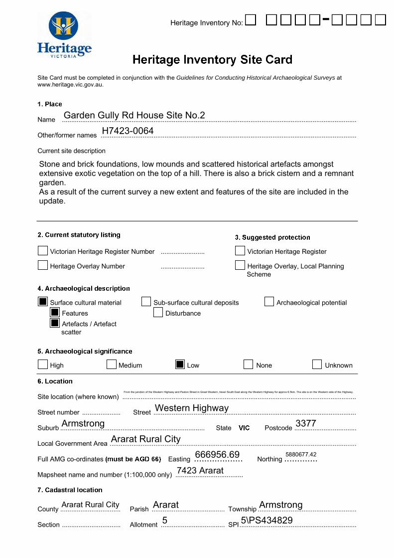
Information Update H7423-0060 Armstrong No.1 H7423-0062 Garden Gully Road Ruin H7423-0063 Garden Gully Road House Site No.1 H7423-0071 Armstrong Brick Structure Ruins Clark and Murphy (1999) surveyed four possible route options for the realignment of the Western Highway at Armstrong, approximately 10km northwest of Ararat. Seven historical archaeological sites [VHI] were recorded. These included:
7423-0060: Armstrong No 1. A ruined structure, possible hearth and possible out buildings. GPS co-ordinates E667100 /N5880000 (0.1km W of hwy; 9km N of Ararat)
7423-0062: Garden Gully Road Ruin Site. A ruined structure, remnants of a stone fireplace. GPS
co-ordinates E667150 / N5880350 (0.1km W of hwy; 9km N of Ararat)
7423-0063: Garden Gully Road House Site No. 1. A ruinous, four roomed timber house with a lean-to kitchen, veranda and a cellar. Outside the house there was a cistern and a shearing shed, a remnant orchard, scattered historic artefacts and equipment, and exotic trees. GPS not provided, 300m W of hwy; 9km N of Ararat.
7423-0072: Armstrong Hotel Ruins Structure. GPS E667170 / N5879920 (40m W of hwy,
9km NW of Ararat) Clark et al (2002) excavated four historical archaeological sites at Armstrong (approximately 10km northwest of Ararat), prior to the realignment of the Western Highway. The sites included 7423-0062, and 0071. Excavation of site 7423-0062 [VHI] confirmed that the site was a fireplace, although no evidence was found of the remainder of the structure, which they considered was probably a hut. The artefacts were primarily domestic and architectural in nature. Excavation of site 7423-0071 demonstrated that this site was part of a single large and complex site of the Armstrong Hotel. The site 7423- 0071 [VHI] presented two distinct periods of occupation; 1870s to 1920, at which point a fire destroyed the structure, after which a brick floor was laid and stables constructed (associated with the Hotel). Recommendations included monitoring of destructive works at sites 7423-0071. While comprehensive in historical description, unfortunately the reports on excavation included in Clarke etal 2002, and Ellis and Dolling 2003 include no images, drawings or plans of the remains they encountered and investigated. Noble, Kiddell and Clarke (2008) discuss these sites but similarly lack any illustration or plans of such ruins. Plans and images are however provided for three sites excavated, including 7423-0071 in Clark and Langberg (2002. 16-24). From these reports it is apparent that comprehensive vegetation clearance was frequently required to initially find or further identify these overgrown sites (Clarke and Langberg 2002.1. 23; Clarke etal 17ff) Clark,V., and Murphy A., 1999 Western Highway Armstrong Deviation Highway Realignment:
Archaeology and Heritage Study. Unpublished Report to VicRoads.

Clarke, V., and Langberg, V. 2002. Archaeological Test Excavations of Three Historical Sites at Armstrong Western Highwa y, Results and Interim Recommendations. (Volume I). Unpublished Report to VicRoads.
Clark, V., Dolling, W., Ellis, A., Langberg, V., & A. Stevens. 2002 Historical Sites at Armstrong in Western Victoria. Victorian Inventory Sites H7423-0071, H7423-0072, H7423-0073, H7423-0062. A Report on Archaeological Investigations. Unpublished report to VicRoads.
Ellis, A., and Dolling, W. 2003. Historical Sites at Armstrong in Western Victoria. Volume II: A Report
on the Material Culture. Unpublished Report to VicRoads Noble, A., Kiddell, H., and V. Clarke. 2008. Western Highway Duplication: Burrumbeet To Stawell.
City Of Ballarat, Pyrenees Shire, Ararat Rural City and Northern Grampians Shire Council Cultural Heritage Desktop Study. Unpublished Report to VicRoads
Heritage Inventory No: -
Site Card must be completed in conjunction with the Guidelines for Conducting Historical Archaeological Surveys at www.heritage.vic.gov.au.
Name .................................................................................................................................................................
Other/former names ............................................................................................................................................
Current site description
Victorian Heritage Register Number ........................ Victorian Heritage Register
Heritage Overlay Number ........................
Heritage Overlay, Local Planning Scheme
Surface cultural material Sub-surface cultural deposits Archaeological potential Features Artefacts / Artefact scatter
Disturbance
High Medium Low None Unknown
Site location (where known) ................................................................................................................................
Street number ..................... Street ...............................................................................................................
Suburb ............................................................................... State Postcode ..................................
Local Government Area .......................................................................................................................................
Full AMG co-ordinates Easting ................... Northing .............
Mapsheet name and number (1:100,000 only) .....................................
County ................................. Parish ........................................ Township ......................................................
Section ................................ Allotment ................................... SPI................................................................

Site has known Indigenous values Victorian Aboriginal Heritage Register Number ...........................
(Inventory, VHR, HO or other)
early 19th century
mid 19th century
late 19th century
early 20th century
mid 20th century
mid-late 20th century
urban
outside urban
pastoral
agricultural
timber
mining
transport
communication
recreation
domestic
industrial
commercial
religious
maritime infrastructure
civic
military
Please attach separate plan. All features on the plan must be labelled and scale noted (eg 1:100,000).
(attach sheet if necessary)

(Include phases in the development of the site, functions and activities
represented)
Statement of Significance attached Historical significance

Scientific significance
Aesthetic significance
Social or spiritual significance

_____________________________________________________________________________________
Please attach as separate sheet.
Please attach separate plan.
Map must clearly identify assessed area and include any street addresses (eg excerpt from Melway and its reference numbers.)

Agency .................................................................................................................................................................
Owner’s name ......................................................................................................................................................
Contact name ......................................................................................................................................................
Postal address .....................................................................................................................................................
Telephone ............................................................... Facsimile ..................................................................
Email address ......................................................................................................................................................
Occupier’s name .................................................................................................................................................
Postal address .....................................................................................................................................................
Telephone ............................................................... Facsimile ..................................................................
Email address ......................................................................................................................................................
Recording Archaeologist .....................................................................................................................................
Company name……………………………………..…. Date recorded .......................................................... (Day/Month/Year)
Other Comments:
Report Numbers.............................................................. Associated Consent numbers ..........................................................................
Any personal information about you or a third party in your correspondence will be collected, held, managed, used, disclosed or transferred in accordance with the provisions of the Information Privacy Act 2000 (Vic) and applicable laws. Enquiries about access to information about you held by the Department should be directed to the Privacy Officer, Department of Planning and Community Development, PO Box 2392, Melbourne, VIC 3001. Notwithstanding the above, please note that information provided to enable the administration of the Heritage Act 1995 may be disclosed to persons with an interest in the heritage place or object particularly, and information provided as part of a permit application may be made available on-line where the application has been publicly advertised under section 68 of the Heritage Act 1995.

Information Update H7423-0060 Armstrong No.1 H7423-0062 Garden Gully Road Ruin H7423-0063 Garden Gully Road House Site No.1 H7423-0071 Armstrong Brick Structure Ruins Clark and Murphy (1999) surveyed four possible route options for the realignment of the Western Highway at Armstrong, approximately 10km northwest of Ararat. Seven historical archaeological sites [VHI] were recorded. These included:
7423-0060: Armstrong No 1. A ruined structure, possible hearth and possible out buildings. GPS co-ordinates E667100 /N5880000 (0.1km W of hwy; 9km N of Ararat)
7423-0062: Garden Gully Road Ruin Site. A ruined structure, remnants of a stone fireplace. GPS
co-ordinates E667150 / N5880350 (0.1km W of hwy; 9km N of Ararat)
7423-0063: Garden Gully Road House Site No. 1. A ruinous, four roomed timber house with a lean-to kitchen, veranda and a cellar. Outside the house there was a cistern and a shearing shed, a remnant orchard, scattered historic artefacts and equipment, and exotic trees. GPS not provided, 300m W of hwy; 9km N of Ararat.
7423-0072: Armstrong Hotel Ruins Structure. GPS E667170 / N5879920 (40m W of hwy,
9km NW of Ararat) Clark et al (2002) excavated four historical archaeological sites at Armstrong (approximately 10km northwest of Ararat), prior to the realignment of the Western Highway. The sites included 7423-0062, and 0071. Excavation of site 7423-0062 [VHI] confirmed that the site was a fireplace, although no evidence was found of the remainder of the structure, which they considered was probably a hut. The artefacts were primarily domestic and architectural in nature. Excavation of site 7423-0071 demonstrated that this site was part of a single large and complex site of the Armstrong Hotel. The site 7423- 0071 [VHI] presented two distinct periods of occupation; 1870s to 1920, at which point a fire destroyed the structure, after which a brick floor was laid and stables constructed (associated with the Hotel). Recommendations included monitoring of destructive works at sites 7423-0071. While comprehensive in historical description, unfortunately the reports on excavation included in Clarke etal 2002, and Ellis and Dolling 2003 include no images, drawings or plans of the remains they encountered and investigated. Noble, Kiddell and Clarke (2008) discuss these sites but similarly lack any illustration or plans of such ruins. Plans and images are however provided for three sites excavated, including 7423-0071 in Clark and Langberg (2002. 16-24). From these reports it is apparent that comprehensive vegetation clearance was frequently required to initially find or further identify these overgrown sites (Clarke and Langberg 2002.1. 23; Clarke etal 17ff) Clark,V., and Murphy A., 1999 Western Highway Armstrong Deviation Highway Realignment:
Archaeology and Heritage Study. Unpublished Report to VicRoads.
Clarke, V., and Langberg, V. 2002. Archaeological Test Excavations of Three Historical Sites at Armstrong Western Highwa y, Results and Interim Recommendations. (Volume I). Unpublished Report to VicRoads.
Clark, V., Dolling, W., Ellis, A., Langberg, V., & A. Stevens. 2002 Historical Sites at Armstrong in Western Victoria. Victorian Inventory Sites H7423-0071, H7423-0072, H7423-0073, H7423-0062. A Report on Archaeological Investigations. Unpublished report to VicRoads.
Ellis, A., and Dolling, W. 2003. Historical Sites at Armstrong in Western Victoria. Volume II: A Report
on the Material Culture. Unpublished Report to VicRoads Noble, A., Kiddell, H., and V. Clarke. 2008. Western Highway Duplication: Burrumbeet To Stawell.
City Of Ballarat, Pyrenees Shire, Ararat Rural City and Northern Grampians Shire Council Cultural Heritage Desktop Study. Unpublished Report to VicRoads
Heritage Inventory No: -
Site Card must be completed in conjunction with the Guidelines for Conducting Historical Archaeological Surveys at www.heritage.vic.gov.au.
Name .................................................................................................................................................................
Other/former names ............................................................................................................................................
Current site description
Victorian Heritage Register Number ........................ Victorian Heritage Register
Heritage Overlay Number ........................
Heritage Overlay, Local Planning Scheme
Surface cultural material Sub-surface cultural deposits Archaeological potential Features Artefacts / Artefact scatter
Disturbance
High Medium Low None Unknown
Site location (where known) ................................................................................................................................
Street number ..................... Street ...............................................................................................................
Suburb ............................................................................... State Postcode ..................................
Local Government Area .......................................................................................................................................
Full AMG co-ordinates Easting ................... Northing .............
Mapsheet name and number (1:100,000 only) .....................................
County ................................. Parish ........................................ Township ......................................................
Section ................................ Allotment ................................... SPI................................................................

Site has known Indigenous values Victorian Aboriginal Heritage Register Number ...........................
(Inventory, VHR, HO or other)
early 19th century
mid 19th century
late 19th century
early 20th century
mid 20th century
mid-late 20th century
urban
outside urban
pastoral
agricultural
timber
mining
transport
communication
recreation
domestic
industrial
commercial
religious
maritime infrastructure
civic
military
Please attach separate plan. All features on the plan must be labelled and scale noted (eg 1:100,000).
(attach sheet if necessary)

(Include phases in the development of the site, functions and activities
represented)
Statement of Significance attached Historical significance

Scientific significance
Aesthetic significance
Social or spiritual significance

_____________________________________________________________________________________
Please attach as separate sheet.
Please attach separate plan.
Map must clearly identify assessed area and include any street addresses (eg excerpt from Melway and its reference numbers.)

Agency .................................................................................................................................................................
Owner’s name ......................................................................................................................................................
Contact name ......................................................................................................................................................
Postal address .....................................................................................................................................................
Telephone ............................................................... Facsimile ..................................................................
Email address ......................................................................................................................................................
Occupier’s name .................................................................................................................................................
Postal address .....................................................................................................................................................
Telephone ............................................................... Facsimile ..................................................................
Email address ......................................................................................................................................................
Recording Archaeologist .....................................................................................................................................
Company name……………………………………..…. Date recorded .......................................................... (Day/Month/Year)
Other Comments:
Report Numbers.............................................................. Associated Consent numbers ..........................................................................
Any personal information about you or a third party in your correspondence will be collected, held, managed, used, disclosed or transferred in accordance with the provisions of the Information Privacy Act 2000 (Vic) and applicable laws. Enquiries about access to information about you held by the Department should be directed to the Privacy Officer, Department of Planning and Community Development, PO Box 2392, Melbourne, VIC 3001. Notwithstanding the above, please note that information provided to enable the administration of the Heritage Act 1995 may be disclosed to persons with an interest in the heritage place or object particularly, and information provided as part of a permit application may be made available on-line where the application has been publicly advertised under section 68 of the Heritage Act 1995.


Heritage Inventory No: -
Site Card must be completed in conjunction with the Guidelines for Conducting Historical Archaeological Surveys atwww.heritage.vic.gov.au.
Name .................................................................................................................................................................
Other/former names ............................................................................................................................................
Current site description
Victorian Heritage Register Number ........................ Victorian Heritage Register
Heritage Overlay Number ........................ Heritage Overlay, Local Planning Scheme
Surface cultural material Sub-surface cultural deposits Archaeological potential
Features
Artefacts / Artefact scatter
Disturbance
High Medium Low None Unknown
Site location (where known) ................................................................................................................................
Street number ..................... Street ...............................................................................................................
Suburb ............................................................................... State Postcode ..................................
Local Government Area .......................................................................................................................................
Full AMG co-ordinates Easting ................... Northing .............
Mapsheet name and number (1:100,000 only) .....................................
County ................................. Parish ........................................ Township ......................................................
Section ................................ Allotment ................................... SPI................................................................

Site has known Indigenous values Victorian Aboriginal Heritage Register Number ...........................
(Inventory, VHR, HO or other)
early 19th century
mid 19th century
late 19th century
early 20th century
mid 20th century
mid-late 20th century
urban
outside urban
pastoral
agricultural
timber
mining
transport
communication
recreation
domestic
industrial
commercial
religious
maritime infrastructure
civic
military
Please attach separate plan. All features on the plan must be labelled and scale noted (eg 1:100,000).
(attach sheet if necessary)

(Include phases in the development of the site, functions and activities represented)
Statement of Significance attached
Historical significance

Scientific significance
Aesthetic significance
Social or spiritual significance

_____________________________________________________________________________________
Please attach as separate sheet.
Please attach separate plan.
Map must clearly identify assessed area and include any street addresses (eg excerpt from Melway and its reference numbers.)

Agency .................................................................................................................................................................
Owner’s name ......................................................................................................................................................
Contact name ......................................................................................................................................................
Postal address .....................................................................................................................................................
Telephone ............................................................... Facsimile ..................................................................
Email address ......................................................................................................................................................
Occupier’s name .................................................................................................................................................
Postal address .....................................................................................................................................................
Telephone ............................................................... Facsimile ..................................................................
Email address ......................................................................................................................................................
Recording Archaeologist .....................................................................................................................................
Company name……………………………………..…. Date recorded .......................................................... (Day/Month/Year)
Other Comments:
Report Numbers.............................................................. Associated Consent numbers ..........................................................................
Any personal information about you or a third party in your correspondence will be collected, held, managed, used, disclosed or transferred in accordance with the provisions of the Information Privacy Act 2000 (Vic) and applicable laws. Enquiries about access to information about you held by the Department should be directed to the Privacy Officer, Department of Planning and Community Development, PO Box 2392, Melbourne, VIC 3001. Notwithstanding the above, please note that information provided to enable the administration of the Heritage Act 1995 may be disclosed to persons with an interest in the heritage place or object particularly, and information provided as part of a permit application may be made available on-line where the application has been publicly advertised under section 68 of the Heritage Act 1995.

Information Update H7423-0060 Armstrong No.1 H7423-0062 Garden Gully Road Ruin H7423-0063 Garden Gully Road House Site No.1 H7423-0071 Armstrong Brick Structure Ruins Clark and Murphy (1999) surveyed four possible route options for the realignment of the Western Highway at Armstrong, approximately 10km northwest of Ararat. Seven historical archaeological sites [VHI] were recorded. These included:
7423-0060: Armstrong No 1. A ruined structure, possible hearth and possible out buildings. GPS co-ordinates E667100 /N5880000 (0.1km W of hwy; 9km N of Ararat)
7423-0062: Garden Gully Road Ruin Site. A ruined structure, remnants of a stone fireplace. GPS
co-ordinates E667150 / N5880350 (0.1km W of hwy; 9km N of Ararat)
7423-0063: Garden Gully Road House Site No. 1. A ruinous, four roomed timber house with a lean-to kitchen, veranda and a cellar. Outside the house there was a cistern and a shearing shed, a remnant orchard, scattered historic artefacts and equipment, and exotic trees. GPS not provided, 300m W of hwy; 9km N of Ararat.
7423-0072: Armstrong Hotel Ruins Structure. GPS E667170 / N5879920 (40m W of hwy,
9km NW of Ararat) Clark et al (2002) excavated four historical archaeological sites at Armstrong (approximately 10km northwest of Ararat), prior to the realignment of the Western Highway. The sites included 7423-0062, and 0071. Excavation of site 7423-0062 [VHI] confirmed that the site was a fireplace, although no evidence was found of the remainder of the structure, which they considered was probably a hut. The artefacts were primarily domestic and architectural in nature. Excavation of site 7423-0071 demonstrated that this site was part of a single large and complex site of the Armstrong Hotel. The site 7423- 0071 [VHI] presented two distinct periods of occupation; 1870s to 1920, at which point a fire destroyed the structure, after which a brick floor was laid and stables constructed (associated with the Hotel). Recommendations included monitoring of destructive works at sites 7423-0071. While comprehensive in historical description, unfortunately the reports on excavation included in Clarke etal 2002, and Ellis and Dolling 2003 include no images, drawings or plans of the remains they encountered and investigated. Noble, Kiddell and Clarke (2008) discuss these sites but similarly lack any illustration or plans of such ruins. Plans and images are however provided for three sites excavated, including 7423-0071 in Clark and Langberg (2002. 16-24). From these reports it is apparent that comprehensive vegetation clearance was frequently required to initially find or further identify these overgrown sites (Clarke and Langberg 2002.1. 23; Clarke etal 17ff) Clark,V., and Murphy A., 1999 Western Highway Armstrong Deviation Highway Realignment:
Archaeology and Heritage Study. Unpublished Report to VicRoads.

Clarke, V., and Langberg, V. 2002. Archaeological Test Excavations of Three Historical Sites at Armstrong Western Highwa y, Results and Interim Recommendations. (Volume I). Unpublished Report to VicRoads.
Clark, V., Dolling, W., Ellis, A., Langberg, V., & A. Stevens. 2002 Historical Sites at Armstrong in Western Victoria. Victorian Inventory Sites H7423-0071, H7423-0072, H7423-0073, H7423-0062. A Report on Archaeological Investigations. Unpublished report to VicRoads.
Ellis, A., and Dolling, W. 2003. Historical Sites at Armstrong in Western Victoria. Volume II: A Report
on the Material Culture. Unpublished Report to VicRoads Noble, A., Kiddell, H., and V. Clarke. 2008. Western Highway Duplication: Burrumbeet To Stawell.
City Of Ballarat, Pyrenees Shire, Ararat Rural City and Northern Grampians Shire Council Cultural Heritage Desktop Study. Unpublished Report to VicRoads


Heritage Inventory No: -
Site Card must be completed in conjunction with the Guidelines for Conducting Historical Archaeological Surveys atwww.heritage.vic.gov.au.
Name .................................................................................................................................................................
Other/former names ............................................................................................................................................
Current site description
Victorian Heritage Register Number ........................ Victorian Heritage Register
Heritage Overlay Number ........................ Heritage Overlay, Local Planning Scheme
Surface cultural material Sub-surface cultural deposits Archaeological potential
Features
Artefacts / Artefact scatter
Disturbance
High Medium Low None Unknown
Site location (where known) ................................................................................................................................
Street number ..................... Street ...............................................................................................................
Suburb ............................................................................... State Postcode ..................................
Local Government Area .......................................................................................................................................
Full AMG co-ordinates Easting ................... Northing .............
Mapsheet name and number (1:100,000 only) .....................................
County ................................. Parish ........................................ Township ......................................................
Section ................................ Allotment ................................... SPI................................................................

Site has known Indigenous values Victorian Aboriginal Heritage Register Number ...........................
(Inventory, VHR, HO or other)
early 19th century
mid 19th century
late 19th century
early 20th century
mid 20th century
mid-late 20th century
urban
outside urban
pastoral
agricultural
timber
mining
transport
communication
recreation
domestic
industrial
commercial
religious
maritime infrastructure
civic
military
Please attach separate plan. All features on the plan must be labelled and scale noted (eg 1:100,000).
(attach sheet if necessary)

(Include phases in the development of the site, functions and activities represented)
Statement of Significance attached
Historical significance
Scientific significance
Aesthetic significance
Social or spiritual significance

_____________________________________________________________________________________
Please attach as separate sheet.
Please attach separate plan.
Map must clearly identify assessed area and include any street addresses (eg excerpt from Melway and its reference numbers.)

Agency .................................................................................................................................................................
Owner’s name ......................................................................................................................................................
Contact name ......................................................................................................................................................
Postal address .....................................................................................................................................................
Telephone ............................................................... Facsimile ..................................................................
Email address ......................................................................................................................................................
Occupier’s name .................................................................................................................................................
Postal address .....................................................................................................................................................
Telephone ............................................................... Facsimile ..................................................................
Email address ......................................................................................................................................................
Recording Archaeologist .....................................................................................................................................
Company name……………………………………..…. Date recorded .......................................................... (Day/Month/Year)
Other Comments:
Report Numbers.............................................................. Associated Consent numbers ..........................................................................
Any personal information about you or a third party in your correspondence will be collected, held, managed, used, disclosed or transferred in accordance with the provisions of the Information Privacy Act 2000 (Vic) and applicable laws. Enquiries about access to information about you held by the Department should be directed to the Privacy Officer, Department of Planning and Community Development, PO Box 2392, Melbourne, VIC 3001. Notwithstanding the above, please note that information provided to enable the administration of the Heritage Act 1995 may be disclosed to persons with an interest in the heritage place or object particularly, and information provided as part of a permit application may be made available on-line where the application has been publicly advertised under section 68 of the Heritage Act 1995.

Information Update H7423-0060 Armstrong No.1 H7423-0062 Garden Gully Road Ruin H7423-0063 Garden Gully Road House Site No.1 H7423-0071 Armstrong Brick Structure Ruins Clark and Murphy (1999) surveyed four possible route options for the realignment of the Western Highway at Armstrong, approximately 10km northwest of Ararat. Seven historical archaeological sites [VHI] were recorded. These included:
7423-0060: Armstrong No 1. A ruined structure, possible hearth and possible out buildings. GPS co-ordinates E667100 /N5880000 (0.1km W of hwy; 9km N of Ararat)
7423-0062: Garden Gully Road Ruin Site. A ruined structure, remnants of a stone fireplace. GPS
co-ordinates E667150 / N5880350 (0.1km W of hwy; 9km N of Ararat)
7423-0063: Garden Gully Road House Site No. 1. A ruinous, four roomed timber house with a lean-to kitchen, veranda and a cellar. Outside the house there was a cistern and a shearing shed, a remnant orchard, scattered historic artefacts and equipment, and exotic trees. GPS not provided, 300m W of hwy; 9km N of Ararat.
7423-0072: Armstrong Hotel Ruins Structure. GPS E667170 / N5879920 (40m W of hwy,
9km NW of Ararat) Clark et al (2002) excavated four historical archaeological sites at Armstrong (approximately 10km northwest of Ararat), prior to the realignment of the Western Highway. The sites included 7423-0062, and 0071. Excavation of site 7423-0062 [VHI] confirmed that the site was a fireplace, although no evidence was found of the remainder of the structure, which they considered was probably a hut. The artefacts were primarily domestic and architectural in nature. Excavation of site 7423-0071 demonstrated that this site was part of a single large and complex site of the Armstrong Hotel. The site 7423- 0071 [VHI] presented two distinct periods of occupation; 1870s to 1920, at which point a fire destroyed the structure, after which a brick floor was laid and stables constructed (associated with the Hotel). Recommendations included monitoring of destructive works at sites 7423-0071. While comprehensive in historical description, unfortunately the reports on excavation included in Clarke etal 2002, and Ellis and Dolling 2003 include no images, drawings or plans of the remains they encountered and investigated. Noble, Kiddell and Clarke (2008) discuss these sites but similarly lack any illustration or plans of such ruins. Plans and images are however provided for three sites excavated, including 7423-0071 in Clark and Langberg (2002. 16-24). From these reports it is apparent that comprehensive vegetation clearance was frequently required to initially find or further identify these overgrown sites (Clarke and Langberg 2002.1. 23; Clarke etal 17ff) Clark,V., and Murphy A., 1999 Western Highway Armstrong Deviation Highway Realignment:
Archaeology and Heritage Study. Unpublished Report to VicRoads.

Clarke, V., and Langberg, V. 2002. Archaeological Test Excavations of Three Historical Sites at Armstrong Western Highwa y, Results and Interim Recommendations. (Volume I). Unpublished Report to VicRoads.
Clark, V., Dolling, W., Ellis, A., Langberg, V., & A. Stevens. 2002 Historical Sites at Armstrong in Western Victoria. Victorian Inventory Sites H7423-0071, H7423-0072, H7423-0073, H7423-0062. A Report on Archaeological Investigations. Unpublished report to VicRoads.
Ellis, A., and Dolling, W. 2003. Historical Sites at Armstrong in Western Victoria. Volume II: A Report
on the Material Culture. Unpublished Report to VicRoads Noble, A., Kiddell, H., and V. Clarke. 2008. Western Highway Duplication: Burrumbeet To Stawell.
City Of Ballarat, Pyrenees Shire, Ararat Rural City and Northern Grampians Shire Council Cultural Heritage Desktop Study. Unpublished Report to VicRoads

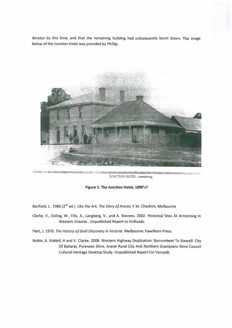
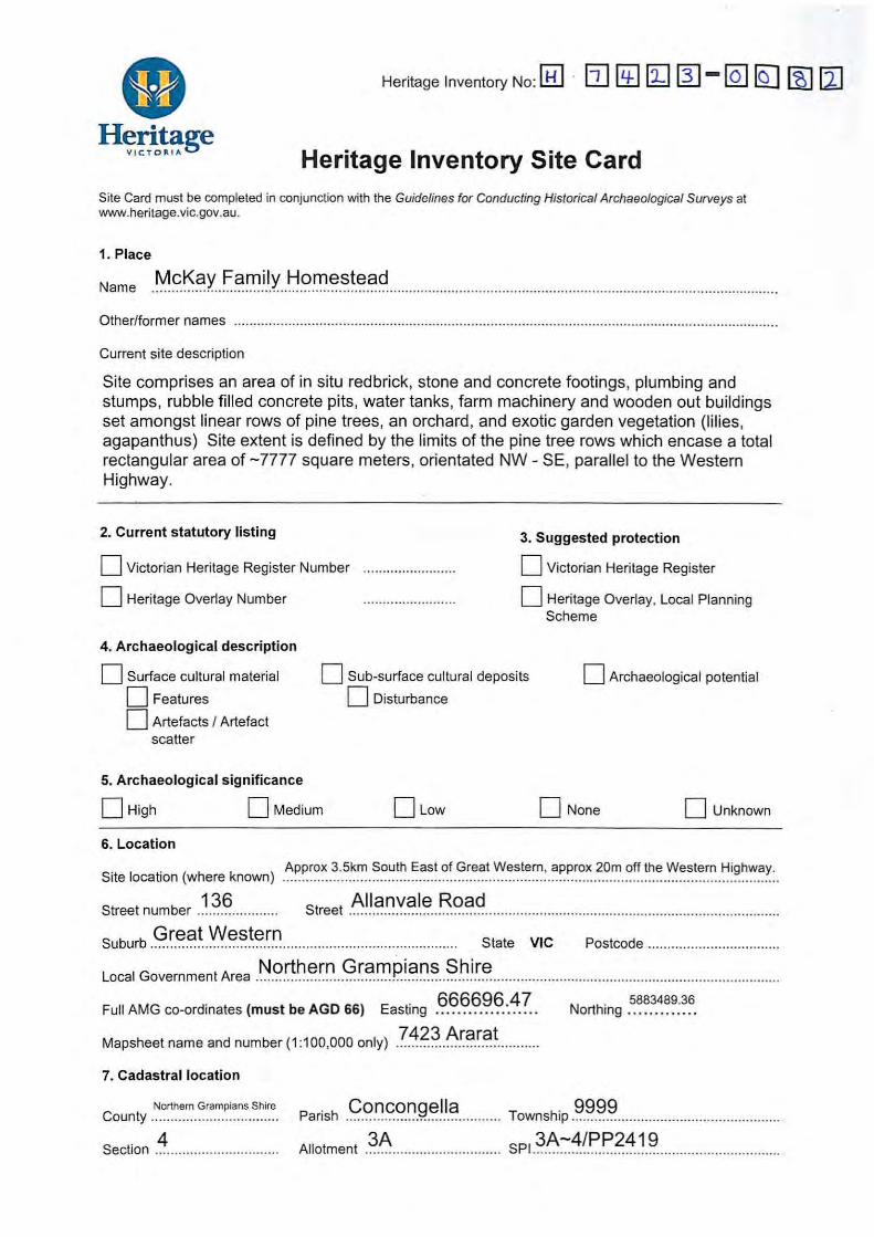
Place History Armstrong Hotel Ruins Several archaeological and historical studies have been undertaken on the Armstrong Hotel and associated ruins. These are: Clarke and Langberg 2002, Clarke etal 2002 and, Ellis and Dolling 2003. Some of the results of these studies can be found with added information in Noble, Kiddell and Clarke 2008. These reports include details of excavation undertaken at the Armstrong Hotel and descriptions of its remains. The following focuses on the background and history of the hotel during its use. The area of Armstrong takes its name from one of the most renowned pioneering sheep farmers in Victorian history. John Armstrong was a member of a very old Scottish Border family of that name, and came out from Scotland arriving in Port Phillip in 1839. He had married in Scotland on 27th February, 1829, Vair Scott, a connection of Sir Walter Scott, the great Scottish novelist. He was accompanied by his wife and four sons - William, Robert Grieve, Thomas and John; also one daughter, Jemima Scott. Another son was born during the voyage out. On arrival at Port Phillip, John Armstrong, who had brought some stock out with him, took up Bush Station, also known as River Station, which included the site of the present city of Geelong, and it is said that the homestead was situated where Geelong College now stands. The original station extended as far as Barwon Heads and Torquay.
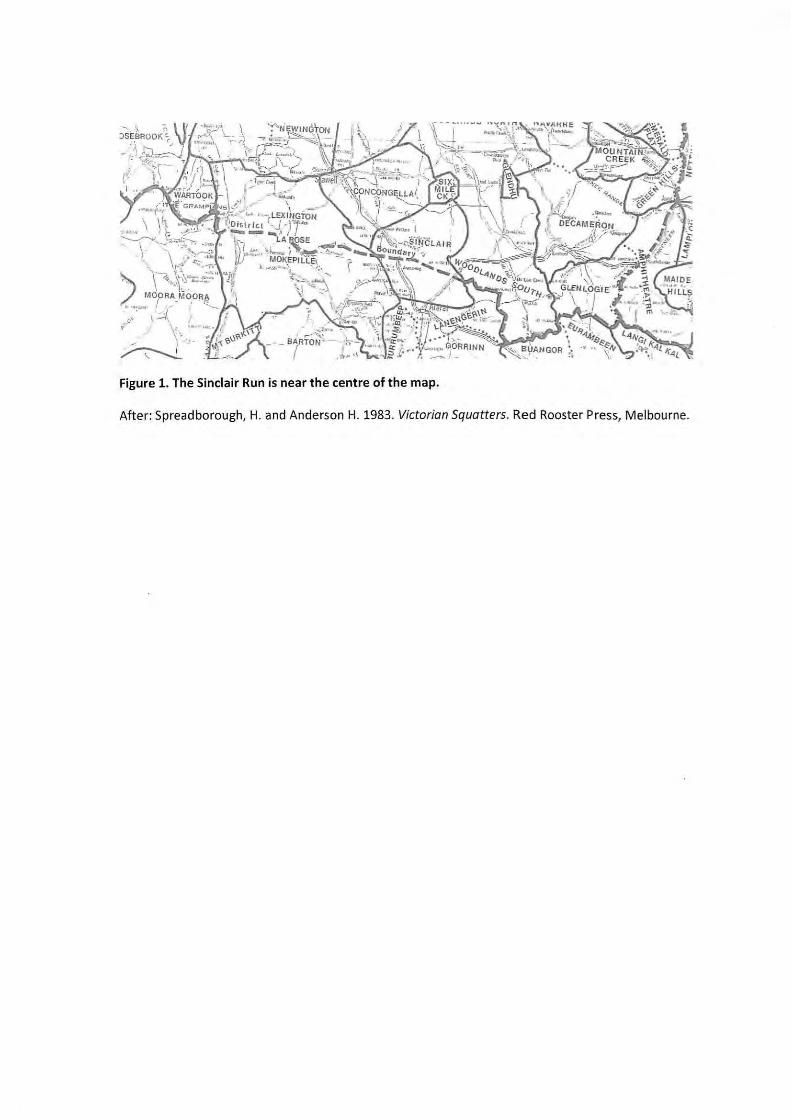
John Armstrong had come from a family that had been engaged in sheep farming in Scotland for generations, and possessed all the knowledge necessary about stock, particularly sheep. This knowledge no doubt accounted for his success as a pioneer pastoralist in Victoria. He was for many years recognised as the most perfect sheep master in Victoria, and was the first to adopt the well-known remedy for dipping sheep to cure scab and all insect pests. When the town of Geelong took shape, portion of the rights of Bush run were cancelled, but John Armstrong later obtained further grazing rights at Black Forest, formerly Werribee Plains, in 1850. He also held Allanvale or Sinclair's Station, 80,000 acres, near Great Western, from 1854-57, and when gold was discovered in the latter year, he had about 30,000 sheep being shepherded in the vicinity of the diggings.
Several Highland families that John Armstrong had brought out from Scotland were working for him on Allanvale, and despite the lure of the goldfields, remained loyal to their employer and did their utmost to prevent the dispersal of his flocks by the diggers, but it was a hopeless task, the flocks having to be moved further out (The Pastoral Times, Deniliquin, June 23, 1939).
Residential settlement at Armstrong was largely a result of gold discovery in the district (Noble, Kiddell and Clarke 2008). One of the earliest was in 1855 by a group of miners, who made
1986). By 1857
no field 1986(Banfield 1986). In 1861 there was estimated to be about 200 Europeans and 150
Chinese working the area (Banfield 1986). Such large numbers of people passing through the town would have caused considerable damage to the roads, and in 1862 a toll bar was erected to finance road maintenance and improvements (Noble, Kiddell and Clarke 2008).
or four hundred converged on the dormant town, once again bringing it back to life.

contained two breweries, a railway station and a population of 120. The closest hotel was stated to be at Great Western. Armstrong lay within a significant gold mining district, between the best known diggings of Ararat and Stawell.
The Armstrong Hotel
According to some historical sources, the ruins of the larger structure investigated in the above studies was a hotel known as Armstrong's or Brine's. Clarke etal undertook extensive historical research on this hotel, the results of which are partially reproduced here (Clarke etal 2002:7-9).
Licensed as a hotel between 1873 and 1921, the building hosted a variety of owners and residents. At least four stages of its transformation from residential dwelling to hotel and store have been identified, namely in the years 1866, 1873, 1889 and 1897.
In 1863, the Ararat rate books recorded William Brine as having a dwelling at Armstrong's. Brine's name appears on the title deed, dated 7 December 1864, for what was originally known as Crown Allotment 153. 13 In Brine's will the property was described, and in the rate books is given as having a dwelling, brewery and garden in 1866, with a rateable value of £20 in 1869.
Notice of application for a publican's license appeared in the Ararat Advertiser of 18 November 1873 which read: 'I, William Lane Brine, of Armstrong's, do hereby give notice that I desire to obtain, and will at the next Licensing Meeting apply for a Publican's Licence for a house situated at Armstrong's, containing six rooms, exclusive of those required for the use of the family'. This application is the first official record of Brine's association with a hotel at Armstrong's. It confirms that his property, which already contained a dwelling, was extended for the purposes of establishing a hotel.
On 16 December 1873, William L Brine was granted a publican's license. The license was renewed in 1874 and on 2 November 1877, the title deeds for the property were returned to Brine. No information pertaining to license renewals could be found for the period 1874 to 1889; however, Brine is noted as holding a 'business license' in 1878.
A rate book entry for 1879 shows a hotel and land with joint ratepayers, William Brine and John Kofoed. According to Freeland (1966) it was not an uncommon alliance for a 'prospective licensee' to 'enlist the help of a brewer to help finance extensions to their existing hotels' (Freeland 1966:143). The licensee would then be obliged to sell the brewer's produce. However, this arrangement would often be more favourable to the brewer - if the hotelkeeper wished to leave the partnership, sometimes the only way was to sell out his business to the brewer. Brine and Kofoed may have entered into such an agreement, although a 'sell out' situation does not appear to have occurred.
During the 1880s, the Hotel led a more stable existence. There is evidence to suggest that Brine's hotel served as a meeting place to discuss local issues. A letter from Brine to the Secretary of Lands, dated 20 January 1880 - found among the Ararat and Stawell District Mining Board papers - reports that 'a meeting was held at Brine's Armstrong Hotel on the 19th, William Brine in the chair. The subject of the meeting was whether to allow a Mr Rich to graze his sheep on the local farmers' common extension.

From 1884 to 1889, the Wise's Post Office Directory contained an entry for 'William Brine, Publican' during which time the annual recorded population of Armstrong's was seven persons. Brine's children had all reached adulthood by this time, and only the youngest, Camilla, was still living at home. During 1886 and 1887 Edward Seymour had lodged and resided with Brine, he being married to Brine's daughter, Jeanetta.
After Brine's death in 1889, the title deeds for his property were transferred to his wife, Helena. Brine's will described the property at the time as 'a piece of freehold ... containing two acres two roods and thirty-nine perches ...on which is erected a stone house and building formerly occupied and used by the deceased containing eleven rooms'. In addition to this property, Brine also held another piece of freehold land 'containing one acre on allotment 168, Parish of Concongella, partially used as a vineyard. From 1891 to 1896 Mrs Brine was entered in Wise's as 'Publican, Armstrong's Hotel'. In 1897 the entry was altered to include 'Armstrong's Hotel and store', and remained so until 1900. She also renewed a hotel license annually from 1890 to 1898. Between these years, the recorded population at Armstrong's was eight persons, except in 1893 and 1894 when baker, John Cuthill was added. In 1900, Edward Wilson and Mrs Brine held joint title to both CA 153 and 154. By 1903, the titles had changed hands; Mr Deanes taking CA 154 and Mr Wilson without Mrs Brine - taking on CA 153. A transfer of a Victualler's License by Wilson to George Taylor in 1900 suggests that Wilson may have been operating the hotel for the years just before the turn of the century. From this time, the hotel and the property were subject to a number of ownership and managerial changes, and the allotments had been divided into CA 12 and CA 13, with CA 13 itself being divided in 1903.
Patrick Byrne was said to have been operating the Armstrong Hotel, possibly from 1907. In 1916, Byrne held title to the south portion of CA 13 (on which the hotel was situated) and all of CA 12. Robert Lennox held title of the north portion of CA 13, while the south portion had a succession of owners.
The final change occurred in October 1923 when the Armstrong Hotel went up for auction. The Ararat Advertiser gave a description of the remaining buildings: two weatherboard rooms 10x25ft, a weatherboard storeroom 12x ft, three weatherboard rooms 32x31 ft including two passages, wood ceiling and part wood dado, a small weatherboard room 8x6ft, an iron-roofed lean-to 23x7ft, and a stable 29x13ft partly constructed of slab with iron walls and an iron roof. Also on the four acre property were two stone rooms 31xl6ft with veranda, and a dam with underground tank. Title deeds were held by Thomson and White, and included CA 12. The last owner of the northern section of CA 13 was a labourer named Robert Lennox. He passed away in 1937, and had left 'freehold land, being part of CA 153, at Armstrong's, Parish of Ararat, County of Borung, with a hut thereon, valued at
. A local Ararat resident bought the weatherboard remains of the Armstrong Hotel and carted it to the town where they occupied a property on Campbell Street.
Banfield, L . 1986 (2nd ed.) Like the Ark. The Story of Ararat, F.W. Cheshire, Melbourne
Clarke, V., Doling, W., Ellis, A., Langberg, V., and A. Stevens. 2002. Historical Sites At Armstrong In Western Victoria . Unpublished Report to VICROADS.

Clarke, V., and Langberg, V. 2002. Archaeological Test Excavations of Three Historical Sites at Armstrong Western Highwa y, Results and Interim Recommendations. (Volume I). Unpublished Report to VICROADS
Ellis, A., and Dolling, W. 2003. Historical Sites at Armstrong in Western Victoria. Volume II: A Report on the Material Culture. Unpublished Report to VICROADS
Freeland, J.M. 1966. The Australian Pub. Melbourne University Press, Melbourne.
Flett, J. 1970. The History of Gold Discovery in Victoria. Melbourne: Hawthorn Press
Noble, A., Kiddell, H., and V. Clarke. 2008. Western Highway Duplication: Burrumbeet To Stawell. City Of Ballarat, Pyrenees Shire, Ararat Rural City and Northern Grampians Shire Council Cultural Heritage Desktop Study. Unpublished Report to VICROADS