Embed Size (px)
Citation preview

APPENDIX A
HISTORIC RESOURCES


7.24.08
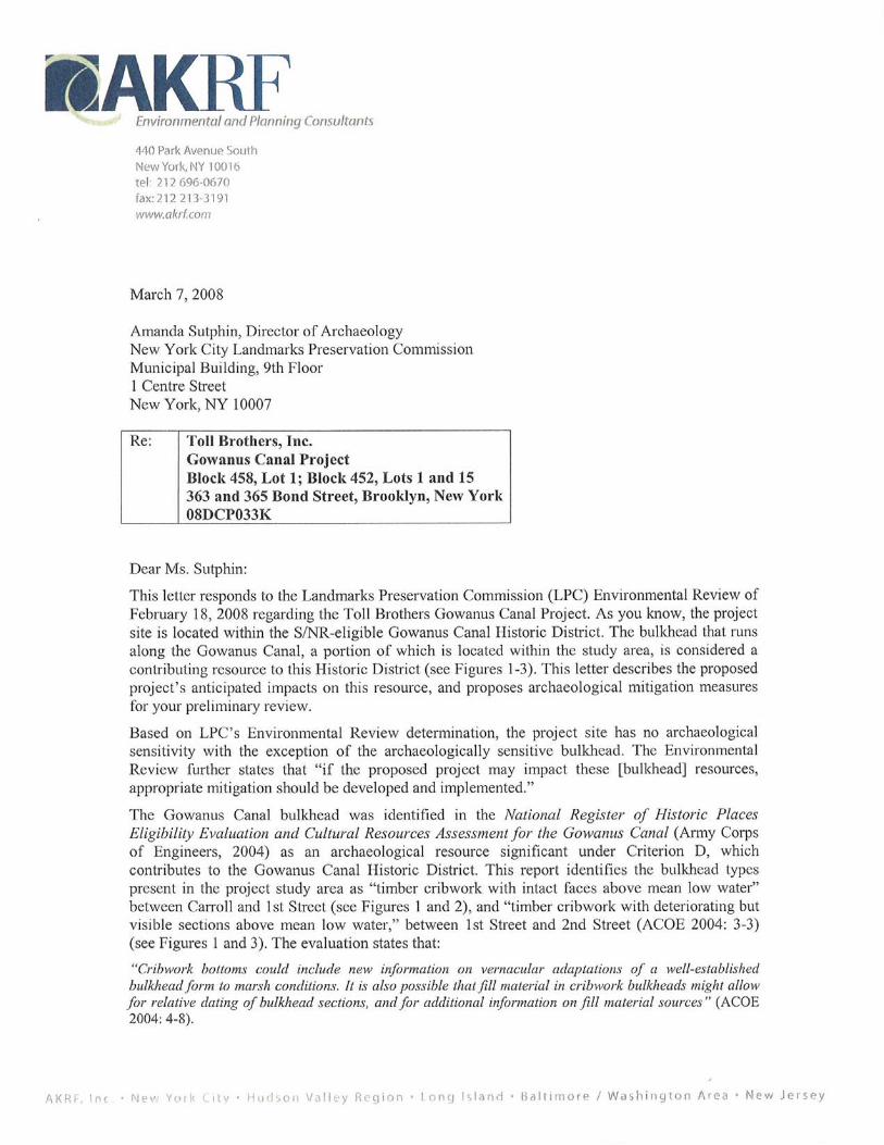
363-365 BOND STREET
Existing
Proposed
Bond Street at Third Street Looking North Figure 1

7.24.08
363-365 BOND STREET
Existing
Proposed
West Bank of Gowanus Canal at 2nd Street,Looking North
Figure 2

7.24.08
363-365 BOND STREET
Looking southeast towards Third Street Bridge from First Street at Gowanus Canal
Figure 3
Existing
Proposed

36
3-3
65
BO
ND
ST
RE
ET
7.24
.08
N
SC
AL
E
040
80 F
EE
T
Site
Pla
nF
igu
re 4
NOTE
: For
Illu
stra
tive
Purp
oses
Onl
y
Rezo
ning
Are
a Bo
unda
ry
Proj
ect S
ite B
ound
ary
(Cot
erm
inou
s w
ithGL
SD B
ound
ary)
4-5
Floo
rs
6 Fl
oors
7-8
Floo
rs
11-1
2 Fl
oors
Priv
ate
Cour
t Yar
d
Publ
icily
-Acc
essi
ble
Open
Spa
ce

Attachments

Attachment A: Architectural Resources in Secondary Study Area
ARCHITECTURAL RESOURCES
SECONDARY STUDY AREA
The secondary study area for the project extends from Wyckoff Street on the north to 12th Street on the south, and from Smith Street on the west to 4th Avenue on the east (see Figure A-1). Two previously identified individually designated architectural resources and two historic districts are located in the secondary study area. Four previously identified architectural resources that contribute to the State/National Register of Historic Places (S/NR)-eligible Gowanus Canal Historic District are also located in the secondary study area. These known architectural resources within them are illustrated on Figure A-1.
Known Architectural Resources Cobble Hill High School (S/NR-Eligible)Cobble Hill High School is located at 347 Baltic Street, with facades on Baltic and Warren Streets between Smith and Hoyt Streets, on the border of the Cobble Hill and Boerum Hill neighborhoods. The four-story school, originally built as a public elementary school, has an H-plan with courtyards facing both Baltic and Warren Streets. It is constructed of brick, with stone trim, including Gothic door surrounds and pronounced quoins.
IND Subway 4th Avenue Station (S/NR-Eligible)
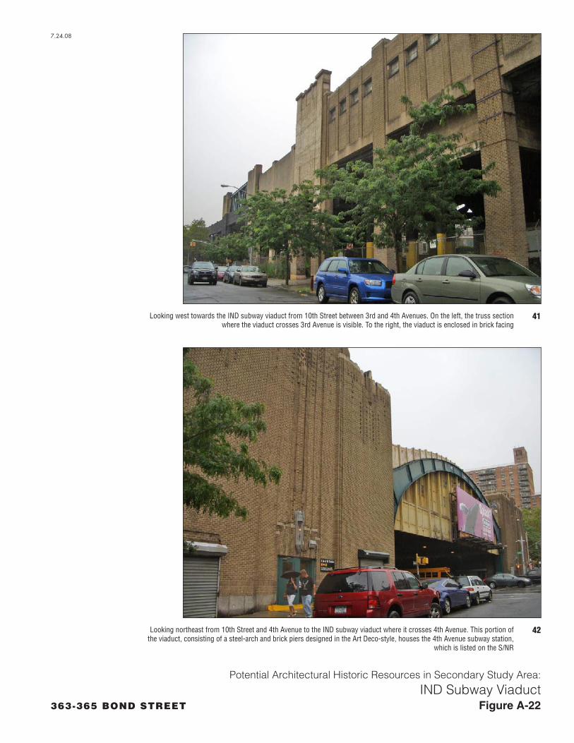
The 4th Avenue Station of the IND Subway (6th Avenue Line) is situated within a bridge that carries the elevated railroad across 4th Avenue along the north side of 10th Street. Constructed in 1933, the bridge has a steel arch and massive brick piers designed in the Art Deco-style, and featuring brickwork patterns and decorative exterior wall sconces. The station entry, ticketbooth, and stairway are located in the piers on the east and west sides of 4th Avenue, while the subway platform is located on the deck of the steel arch bridge. The station was identified as S/NR-eligible as part of the New York City Transit Authority’s Historic Properties Survey in 1995.
Carroll Gardens Historic District (S/NR-Listed; New York City Landmark)
The Carroll Gardens Historic District is located roughly 500 feet from the project site. The historic district comprises President and Carroll Streets between Smith and Hoyt Streets. It is known for mid-rise brick and brownstone rowhouses in the Italianate and neo-Grec styles as well as the unusually large set-backs of the structures from the streets allowing spacious front gardens. Surveyor Richard Butts planned the development in 1846, designing an unusual street grid characterized by off-set blocks creating secluded feeling. The majority of the houses in the district were constructed between 1869 and 1884.
Gowanus Canal Historic District (S/NR-Eligible)
The following architectural resources were previously identified by the United States Army Corps of Engineers (ACOE) National Register of Historic Places Eligibility Evaluation and Cultural Resources Assessment for the Gowanus Canal as contributing to the S/NR-eligible Gowanus Canal Historic District and are located within the secondary study area. In addition to the resources listed below and illustrated on Figure 1, the ACOE study also flagged the Gowanus Canal Flushing Tunnel, an underground brick
A-1

tunnel that runs from the Pump Station at the northern terminus and thence westward beneath Butler Street. Furthermore, the 1st and 5th Street basins, which are now filled along 1st Street between the Canal and 3rd Avenue, and along 5th Street between the Canal and 4th Avenue, have also been considered significant.
Burns Brothers Coal Pockets
Located between 2nd Avenue, 6th Street, and the Canal, the Burns Brothers Coal Pockets consist of 18 coal storage silos. The cylindrical concrete structures are elevated on 15-foot high concrete legs. Eight of the silos were built between 1915 and 1924, while the additional 10 were built between 1932 and1938. The coal pockets are considered significant for their association with one of the Canal’s most important transports. Coal was essential to 19th and early 20th century urban society, and coal was transported to a large portion of developing Brooklyn via the Canal.
Third Avenue Bridge
The Third Avenue Bridge is located along 3rd Avenue at 5th Street, having crossed the 5th Street basin of the canal (now filled) east of 3rd Avenue. The bridge was constructed in 1870, and was extensively rebuilt in 1889.
Brooklyn Improvement Company Office Building
The Brooklyn Improvement Company Building, also known as the Litchfield Office Building, is located at 360 3rd Avenue at the southwest corner of 3rd Street. This Renaissance Revival-style structure was constructed in the 1880s as the office of Edwin C. Litchfield, a prominent Brooklyn citizen, and the driving force behind the Brooklyn Improvement Company, which was largely responsible for the construction of the Canal. The small two-story three-bay building features classical detailing including pedimented entryway with Ionic columns; it is constructed largely of cast stone.
Pumping Station
The Pumping Station located between Butler and Douglass Streets was constructed between 1905 and 1911 as part of the flushing system of the canal. The small gambrel-roofed brick building remains intact today despite the removal and/or reconstruction of much of the equipment associated with the system which occurred in the 1990s.
Potential Historic Resources Potential Historic Resources Contributing to the S/NR-Eligible Gowanus Canal Historic District
R.G. Dun & Company Building (Butler Street)
The R. G. Dun & Company Building is located on the northwest corner of Butler and Nevins Streets, immediately across Butler Street from the Gowanus Pump Station and northern terminus of the Gowanus Canal (see Figure A-1 and A-2). It is a four-story building with a parged face; it has a flat roof hidden behind a parapet which features rounded and stepped sections at the corner and ends of the building along Butler and Nevins Streets. The four-story building has large rectangular ribbon windows arranged in groups of three along the first three stories of the building. The upper story contains large segmental-arched windows. While many of the windows have been sealed, others contain three-over-three-light double-hung sash. The bays of the concrete building are defined by concrete pilasters designed to suggest rusticated stone blocks. The facades are further ornamented by the use of decorative blue-colored terra-cotta tiles forming chevrons, diamonds, and other geometric shapes. A small parged smokestack rises from the roof of the structure at its southwest corner.
Historic Sanborn maps indicate that this building was constructed in 1914 as the publishing department for R. G. Dun & Co. The history of this company was put in context in a book by James D. Norris
A-2

published in 1978 and entitled R.G. Dun & Co.: 1841-1900: The Development of Credit Reporting in the Nineteenth Century. R. G. Dun was established in 1859 and by the 1880s had hundreds of thousands of subscribers. According to Norris, R. G. Dun was at the forefront of the development of modern credit reporting and thereby influenced the development of the United States economic system. The company was reorganized to form Dun & Bradstreet in the 1930s. As historic Sanborn maps indicate, this building functioned as the company’s “publishing department,” which, based on the industrial character of the building, likely included printing facilities. It is likely, if not certain, that the Gowanus Canal would have been utilized to transport goods to and/or from the facility.
American Can Company
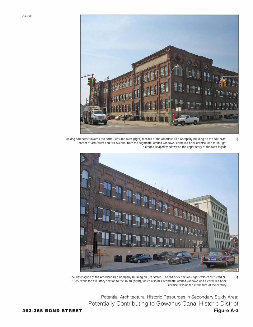
The American Can Company Complex consists of two brick buildings at the southeast corner of 3rd Avenue and 3rd Street. A three- to four-story building occupies the corner while a five-story building is attached on the south end of the first (see Figures A-1 and A-3). The corner building is a flat-roofed building faced in red brick and designed an industrial interpretation of the Renaissance Revival style. The building has a four-story central section with two long three-story wings at right angles to the first, which front on 3rd Street and 3rd Avenue respectively. The building has a complex decorative corbelled brick cornice featuring large diamond windows on the upper story of the 3rd Avenue façade. Both facades include pilasters and segmental- and round-arch windows with slightly projecting brick lintels. Stone floor bands accent the story and mid-story divisions. A masonry-faced basement story is visible, partly within an areaway below street level. The six-story south section of the structure is somewhat plainer in design, but also includes a substantial corbelled brick cornice and segmental-arched windows with brick lintels.
The main corner section of the building was constructed ca. 1885, and in 1886 was occupied by the Somers Bros. Decorated Tinware Company, as indicated on a historic Sanborn map. By the 1920s, however, the structure was occupied by the American Can Company, and the six-story portion of the complex had been added. The Fifth Street basin of the Gowanus Canal formerly ran immediately south of the complex, and it is likely that the American Can Company utilized the canal for the transport of materials and goods.
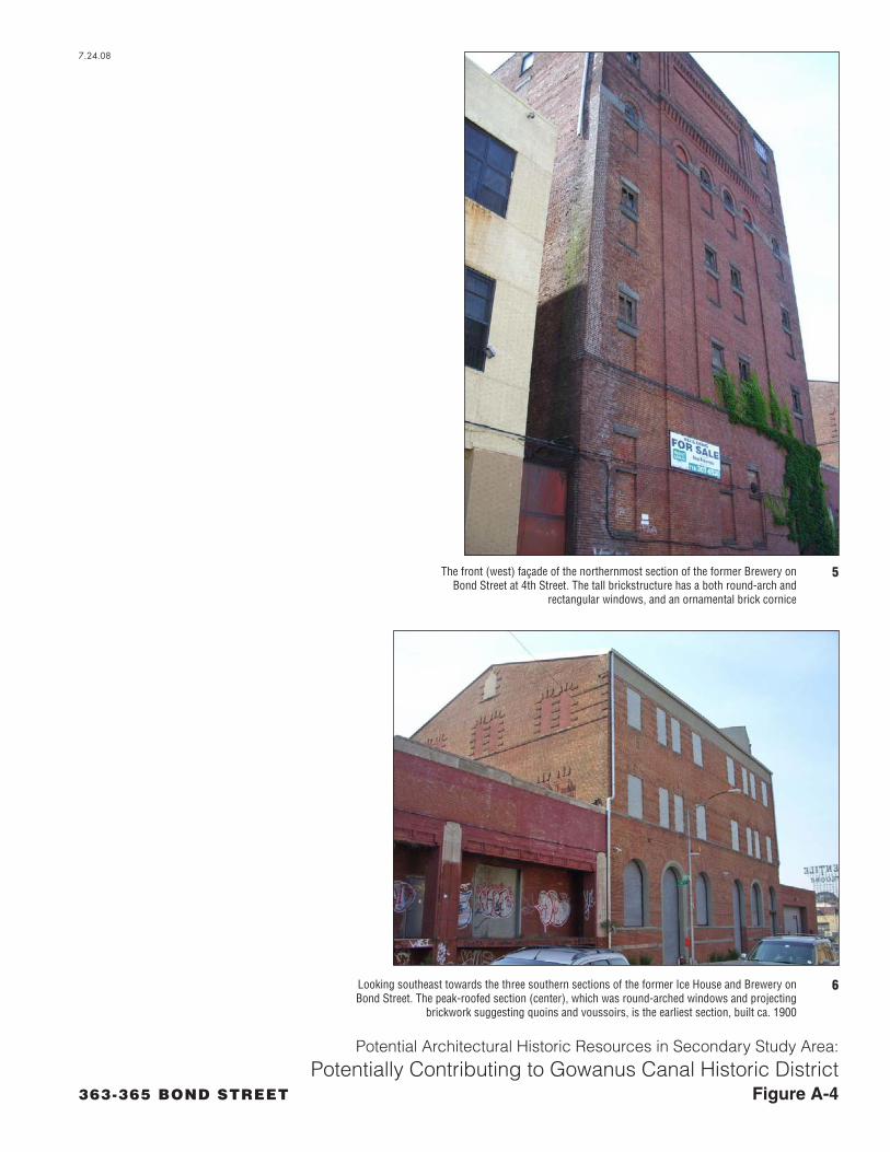
Ice House/Brewery
The former Ice House and Brewery complex is situated on the east side of Bond Street between 3rd and 4th Street, immediately west of the Gowanus Canal (see Figures A-1 and A-4). The complex consists of four contiguous sections, all constructed of brick and ranging in height from one to six stories. The two tallest sections are designed in the Romanesque Revival style. The northernmost section is six stories high and six bays wide, with a flat roof and shallow stepped parapet. The uppermost story contains a recessed panel and corbelled cornice, while the story immediately beneath it contains round-arch windows. Many of the windows on the façade have been sealed with brick while others retain multi-light wood sash. Immediately south of this section is a single-story brick storage section with minimal Art Deco-style cast stone trim featuring stylized chevrons and other ornamentation. Immediately south of this is a large three-story section with a side-gable peaked roof. The Bond Street façade of this section is three bays wide, containing large round-arch windows on the first story and rectangular windows on the upper stories; most of which have been sealed. Projecting brickwork suggests stylized quoins and voussoirs. The side facades of the buildings are treated similarly and feature paired and single round-arched and rectangular windows. The southernmost section of the building is a narrow single-story garage with simple brickwork patterning consisting of recessed horizontal striations. A large doorway with a metal roll-down door is located in the center of the façade.
Historic Sanborn maps indicate that in 1904 the site was used by Empire City Hygeia Ice Company. Of the structures that currently stand on the site, only the peak-roofed three-story brick section appears on the 1904 map. This building contained condensers, filter rooms, ice engines, and a coal shed. By 1906, the largest, six-story section of complex had been constructed, and the facility served as Leonhard Michel
A-3
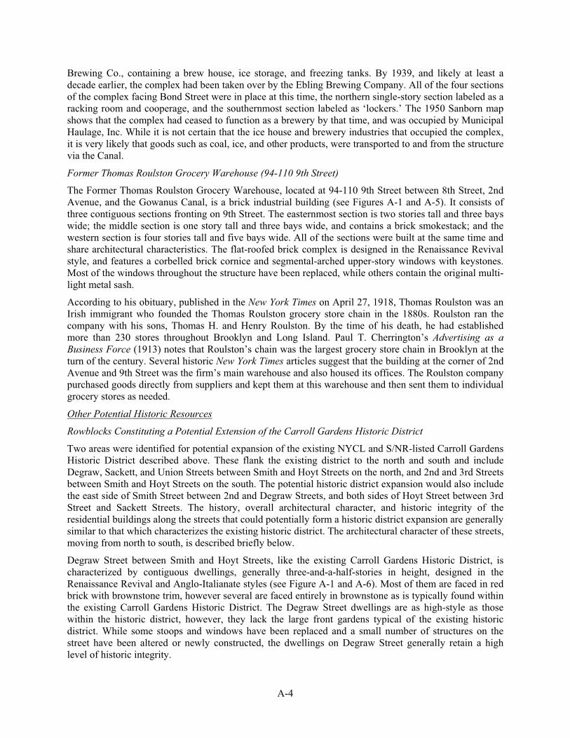
Brewing Co., containing a brew house, ice storage, and freezing tanks. By 1939, and likely at least a decade earlier, the complex had been taken over by the Ebling Brewing Company. All of the four sections of the complex facing Bond Street were in place at this time, the northern single-story section labeled as a racking room and cooperage, and the southernmost section labeled as ‘lockers.’ The 1950 Sanborn map shows that the complex had ceased to function as a brewery by that time, and was occupied by Municipal Haulage, Inc. While it is not certain that the ice house and brewery industries that occupied the complex, it is very likely that goods such as coal, ice, and other products, were transported to and from the structure via the Canal.
Former Thomas Roulston Grocery Warehouse (94-110 9th Street)
The Former Thomas Roulston Grocery Warehouse, located at 94-110 9th Street between 8th Street, 2nd Avenue, and the Gowanus Canal, is a brick industrial building (see Figures A-1 and A-5). It consists of three contiguous sections fronting on 9th Street. The easternmost section is two stories tall and three bays wide; the middle section is one story tall and three bays wide, and contains a brick smokestack; and the western section is four stories tall and five bays wide. All of the sections were built at the same time and share architectural characteristics. The flat-roofed brick complex is designed in the Renaissance Revival style, and features a corbelled brick cornice and segmental-arched upper-story windows with keystones. Most of the windows throughout the structure have been replaced, while others contain the original multi-light metal sash.
According to his obituary, published in the New York Times on April 27, 1918, Thomas Roulston was an Irish immigrant who founded the Thomas Roulston grocery store chain in the 1880s. Roulston ran the company with his sons, Thomas H. and Henry Roulston. By the time of his death, he had established more than 230 stores throughout Brooklyn and Long Island. Paul T. Cherrington’s Advertising as a Business Force (1913) notes that Roulston’s chain was the largest grocery store chain in Brooklyn at the turn of the century. Several historic New York Times articles suggest that the building at the corner of 2nd Avenue and 9th Street was the firm’s main warehouse and also housed its offices. The Roulston company purchased goods directly from suppliers and kept them at this warehouse and then sent them to individual grocery stores as needed.
Other Potential Historic Resources
Rowblocks Constituting a Potential Extension of the Carroll Gardens Historic District
Two areas were identified for potential expansion of the existing NYCL and S/NR-listed Carroll Gardens Historic District described above. These flank the existing district to the north and south and include Degraw, Sackett, and Union Streets between Smith and Hoyt Streets on the north, and 2nd and 3rd Streets between Smith and Hoyt Streets on the south. The potential historic district expansion would also include the east side of Smith Street between 2nd and Degraw Streets, and both sides of Hoyt Street between 3rd Street and Sackett Streets. The history, overall architectural character, and historic integrity of the residential buildings along the streets that could potentially form a historic district expansion are generally similar to that which characterizes the existing historic district. The architectural character of these streets, moving from north to south, is described briefly below.
Degraw Street between Smith and Hoyt Streets, like the existing Carroll Gardens Historic District, is characterized by contiguous dwellings, generally three-and-a-half-stories in height, designed in the Renaissance Revival and Anglo-Italianate styles (see Figure A-1 and A-6). Most of them are faced in red brick with brownstone trim, however several are faced entirely in brownstone as is typically found within the existing Carroll Gardens Historic District. The Degraw Street dwellings are as high-style as those within the historic district, however, they lack the large front gardens typical of the existing historic district. While some stoops and windows have been replaced and a small number of structures on the street have been altered or newly constructed, the dwellings on Degraw Street generally retain a high level of historic integrity.
A-4

Sackett Street between Smith and Hoyt Streets is also characterized by Renaissance and Italianate-style contiguous townhouses of similar height and style (see Figure A-1 and A-7). Roughly half of the buildings on the block are faced in brick, while the others are faced in brownstone. The block lacks the large front gardens that the houses within the existing historic district possess. While a few residences have been reclad or otherwise altered, most of the buildings retain a high level of integrity, some retaining their original windows, doors, and cast-iron stoop balustrades. The house on the southwest corner of Sackett and Hoyt Streets is unique: it is a larger brick Italianate-style mansion with a hipped roof, fronting on Sackett Street. The three-bay façade features a central entryway with a double door trimmed in a wood rope motif. The building has a large cornice with decorative brackets, and retains multi-light wood-sash windows and brownstone trim. According to the current owner this dwelling is known as the Bacchus House, after its original owner who was an entrepreneur who made his fortune on canal-related industries.
The residences that line Union Street, the block located immediately north of the existing Carroll Gardens Historic District, are particularly similar to those which characterize the historic district (see Figure A-1, A-8, and A-9). Buildings along this block possess the large front gardens that typify the existing district; many of these front gardens retain their original cast iron perimeter fences. Furthermore, with the exception of two slightly larger brick apartment buildings located on the north side of Union Street (designed in the Renaissance Revival style), the contiguous three-and-a-half-story dwellings along Union Street are faced in brownstone. Most retain their cornices, brownstone door surrounds, and other detailing.
Immediately south of the existing Carroll Gardens Historic District, 2nd Street between Smith and Hoyt Streets, is also characterized by contiguous dwellings with large front gardens contained within cast-iron fences (see Figure A-1 and A-10). Houses along the north side of 2nd Street in this area are generally faced in brownstone, while those on the south side of the street are more often faced in brick with brownstone trim. Several buildings on the eastern end of the block, on both the north and south sides of the street, are somewhat shorter than is typical for the Carroll Gardens Historic District, rising to two-and-a-half rather than three-and-a-half stories.
The block of 3rd Street between Smith and Hoyt Streets is a wider and more heavily trafficked street and therefore has a slightly less insular feeling than the existing Carroll Gardens Historic District (see Figure A-1 and A-11). Nevertheless, it is lined with dwellings constructed in similar architectural styles and faced in brownstone and red brick. Some of the dwellings on the block have slate-clad mansard roofs. While they lack the large front gardens that typify portions of Carroll Gardens, the dwellings generally retain a high degree of historic integrity.
Wyckoff Street Rowblocks (Boerum Hill Historic District Extension)
Two rows of residential structures along the south side of Wyckoff Street (along the northern edge of the secondary study area), between Smith and Hoyt Streets, and between Bond and Nevins Streets, respectively, are comprised largely of contiguous single-family residential rowhouses constructed in the late 19th century. These rowblocks are located across the street diagonally from the southern edge of the Boerum Hill Historic District (NYCL; S/NR-listed), which is located immediately north of the secondary study area. The Renaissance Revival and Italianate-style residences that characterize these streets, are similar in period and style to the character of the buildings that typify the existing Boerum Hill Historic District. Two late 20th century housing projects, including the Gowanus Houses and Wyckoff Gardens, intervene in the area: one between the two rowblocks between Hoyt and Bond Street and the other immediately east of the rowblocks, between Nevins Street and 3rd Avenue.
The south side of Wyckoff Street between Smith and Hoyt Streets is characterized by three-story brick residences with brownstone trim, often including doorway pediments and window surrounds, and metal bracketed cornices (see Figure A-1 and A-12). The buildings are accessed via low stoops with cast iron railings. A large light-colored-brick commercial building, which ranges in height from four to six stories, is located on the southeast corner of Wyckoff and Smith Streets. This Renaissance Revival style structure,
A-5

which now functions as a bank, features patterned brickwork suggesting quoins, voussoirs, and rusticated pilasters. The building features decorative metal cornices.
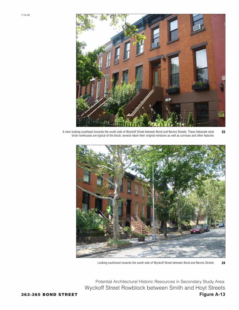
The south side of Wyckoff Street between Bond and Nevins Streets includes three-story brick and brownstone-faced rowhouses designed in the Italianate and Renaissance Revival styles (see Figure A-1 and A-13). They are typified by large metal bracketed cornices and brownstone trim including pedimented entryways. The buildings have stoops, some of which retain cast-iron balustrades. Most of the lots also include small front gardens contained within cast-iron fences.
American Society for the Prevention of Cruelty to Animals Shelter (233 Butler Street)
The American Society for the Prevention of Cruelty to Animals (ASPCA) building is located at 233 Butler Street on the north side between Bond and Nevins Streets (see Figure A-1 and A-14). The two-story flat-roofed building has a scalloped corbelled brick cornice punctuated with blue-colored terra-cotta tile ornamentation. The ground story has a central entryway with a stone surround which includes pilasters supporting an entablature that reads “THE ROGERS MEMORIAL.” Above it is a round stone seal featuring the name and logo of the ASPCA. Flanking this central doorway are two large round-arched doorways. The second story contains ribbons of small narrow rectangular windows.
The ASPCA was founded in New York City in 1866. The ASPCA maintained a branch in Brooklyn. However, in the early 20th century, the organization’s Brooklyn headquarters had become outdated and needed to be replaced with a more modern facility. The northern half of the building was constructed as an animal shelter in 1913. The building was extended to the south in 1922. The New York Times reported on June 19, 1922 that the new facilities at 233 Butler Street would not only include an animal shelter, but would also house the Brooklyn branch of the ASPCA’s executive offices and include an ambulance and a garage.
Saint Agnes Church Complex
The Saint Agnes Church Complex consists of four buildings, including a large stone church located on the south side of Hoyt Street between Degraw, Sackett, and Bond Streets; a two-and-a-half-story brick Parish Hall, located on the east side of Sackett Street between Hoyt and Bond Streets; the Saint Vincent’s Residence, a three-story brick building on the east side of Degraw Street, between Hoyt and Bond Streets; and the Saint Agnes Roman Catholic School, immediately east of the Residence (see Figure A-1, A-15, and A-6).
Saint Agnes Church is a massive stone church designed in the Gothic Revival style. Its steeple and spirelets are roofed in stone, while its main roof is clad in slate tiles and features decorative copper coping. It has stained glass windows with stone tracery, and retains very good historic integrity. The interior of the church was not accessed. The Parish House is also designed in the Gothic Revival style. The pointed-arch windows of the brick building are trimmed in stone, and the roof is clad in slate, with copper coping. Saint Agnes Roman Catholic School is four-story brick, brownstone, and terra-cotta Romanesque Revival-style building. Saint Vincents Residence is exhibits elements of the Romanesque and Gothic Revival styles.
The Saint Agnes parish had been founded in 1878 by Bishop Loughlin who installed Father James Duffy as the first pastor. Duffy initially had a temporary frame church constructed at Hoyt and Degraw streets, while planning the current St. Agnes Church. The cornerstone for the church was laid in 1881 and construction proceeded slowly and steadily. The church was completed in 1888, and consecrated in 1893. When the church was completed, it was one of the largest Catholic churches in Brooklyn being 200 feet wide and 92 feet wide with a steeple rising 130 feet. Its architecture, including arched ceilings, frescoed interior walls, stained glass windows depicting scenes in the life of St. Agnes, marble alters and pillars of onyx, was extensively praised in the New York Times.
A-6

Five years after the consecration of the church, in 1898, Father Duffy filed plans for the construction of a parochial school to be associated with Saint Agnes Roman Catholic Church. The school building would be “brick with stone trimmings and a peaked mansard roof. . . [and] equipped with the most modern improvements and will be one of the finest of its kind in Brooklyn.” Thomas Houghton was hired as the architect for the project. Houghton, who had probably designed Saint Agnes Church itself a few years earlier, was the son-in-law of Patrick C. Keely, the well-known Irish-born architect, and worked in Keely’s office for several years. Houghton designed a number of distinguished Neo-Grec rowhouses and several other Catholic churches in the Brooklyn, including Our Lady of Victory Roman Catholic Church (1891-1895) and Saint Francis Xavier Church (1900-1904).
Saint Agnes Roman Catholic School continued to serve as a parochial institute through most of the twentieth century. In 1987, it was abandoned, and remained vacant for over a decade. In 1999, the building was converted for use as a medium-income apartment complex called the School House in Carroll Gardens. The exterior of the building, including terra-cotta and brownstone ornament, was conserved, and no substantial alterations were made to the exterior. The interior space was reconfigured to accommodate seven floors within an interior that had originally consisted of four stories. However, according to a New York Times article of September 17, 1999, the adaptive reuse was planned with an aim of retaining historic elements and “interior features like marble wainscoting, mosaic tile flooring and wrought iron railings, were saved whenever possible.” Saint Agnes Roman Catholic Church continues to function as a church.
The News Brooklyn Garage
The News Garage Building is a single-story concrete garage building with a large rectangular plan, occupying the east side of 3rd Avenue between Degraw and Douglass Streets (see Figure A-1 and A-16, Photo 31). Designed in the Art Modern style, each of the three facades of the flat-roofed building is characterized by stepped and rounded parapets decorated with simple vertical striations and slightly projecting piers. Each of the facades are inscribed with the words “The News Brooklyn Garage,” and feature a small camera logo associated with the New York Daily News.
This building functioned as a garage for News Syndicate, Inc., the newspaper company that published the New York Daily News. The paper’s main Brooklyn plant was located at 700 Pacific Street, and the structure apparently served as the main parking Brooklyn parking garage for employees of the company.
Our Lady of Peace Roman Catholic Church Complex
The potentially S/NR-eligible Our Lady of Peace Roman Catholic Church complex is located along Carroll Street between Whitwell and Denton Places (two single-block streets), and includes a church at mid-block, flanked by a school to the west and a rectory and war memorial to the east (see Figure A-1; Figure A-16, Photo 31; and Figure A-17). The church, built in 1902-4, is constructed in the Romanesque Revival style. It is a three-story brick building with stone trim composed of a central section flanked by two square-plan hip-roofed towers. The roof of the church is clad in slate and bears a metal cross at the front apex of each of the three sections. The church features round-arched windows, which are paired in many locations and form a continuous ribbon on second story above the main entryway. This entry consists of paired round-arched doorways surmounted by heavily ornamented pediments. In the center of the third story are pedimented niches containing statues and flanking a small stained-glass rose window.
The school located immediately west of the church, which was constructed in 1922, stands on the corner of Carroll Street and Whitwell Place. Architecturally, it exhibits and unusual combination of the Art Deco, Romanesque Revival, and Gothic Revival styles. The four-story brick building with stone trim has a flat roof with a low parapet culminating in a stepped gable crowed with a stone cross on the center of the front (Carroll Street) façade. The central doorway has a round-arch with a pronounced keystone. The windows throughout the building have slightly-rounded Gothic arches with label moldings. They are
A-7

arranged in ribbons and set within continuous stone surrounds extending three stories on both the front and side facades. A large clock, which appears original, is located on front gable of the façade.
The rectory, on the corner of Carroll Street and Denton Place, is a relatively simple three-story brick building with a hipped roof, built prior to 1933. A stone war memorial, commemorating local servicemen who fought in World War II, is located in front of the rectory building. This memorial was erected in the 1950s, and includes a bronze plaque listing names; it is surmounted by a large gilded eagle.
The Church of Our Lady of Peace was constructed to serve the large Italian population that inhabited this area of Brooklyn in the early 20th century. The parish was established on the present location, in what was considered Brooklyn’s “Little Italy,” in 1902 and the cornerstone of the church was laid in 1904. On August 8, 1904, the day the cornerstone was laid (construction had already been underway for some time), the New York Times reported that a crowd of 7,000, made up mostly of Italians and Italian-Americans from throughout New York City, came to view the ceremony. The church was originally run by the Vincentian Fathers, an order of Italian priests, but by 190 was taken over by the Franciscan Fathers, which according to a New York Times article published on December 30, 1906, caused some dissent among the local Italian community. A parochial school was constructed to the north of the church in 1922.
In their 1938 work Italians of New York, the Federal Writers’ Project stated that the church was designed to seat 1,200 parishioners, although the congregation numbered 1,800, and 600 students were enrolled in the parochial school. In addition, Adrienne Onofri’s Walking Brooklyn (2007) notes that Frank Sinatra sang at the church during a charity event in the 1940s.
Former Washington Park Ballfield Wall
A brick wall extends along the east side of 3rd Avenue between 1st and 3rd Streets and wraps around the corners of 1st and 3rd Streets to extend roughly one-quarter of the block towards 4th Avenue (see Figure A-1 and Figure A-18). Now forming the western wall of a large Con Edison facility, this wall is purported to have been constructed as part of a baseball field known as Washington Park in the early 20th century. This baseball field has sometimes been called Washington Park II in order to distinguish it from an earlier park of the same name which stood a short distance to the southeast.
The Brooklyn Dodgers played in this location between 1898 and 1914. Although baseball historians’ opinions differ, this wall is believed to date to either the time when the Brooklyn Dodgers played in this location or immediately thereafter, ca. 1914. The wall, roughly 20 feet high and constructed of brick, contains a row of short recessed segmental arches, which presumably were once open, but are now sealed. These are set within slightly recessed panels with simple brick corbelling at the upper edge. The wall was later incorporated as the western wall of a large utilitarian brick structure built as part of the Con Edison facility that now occupies the site.
The original home field of the Brooklyn Dodgers, known also as the Trolley Dodgers, Bridegrooms, and Superbas, was the original Washington Park, located on the present site of J.J. Byrne Park, between 4th and 5th Avenues and between 3rd and 5th Streets. With the exception of a brief stint in the 1890s, the club played at the original Washington Park from 1883 to 1898. In 1898, they purportedly moved to the site bounded by 3rd and 4th Avenues and 1st and 3rd Streets, where the wall now stands. Fifteen thousand fans attended at the Dodgers’ opening day in 1898. In 1914, the club’s owner, Charles Ebbetts, moved the team to Ebbetts Field in Flatbush, Brooklyn, and the Dodgers left Washington Park. Immediately after the removal of the Dodgers in 1914, a federal league team called the Brooklyn Tip-Tops, owned by Robert B. Ward of the Ward Brothers Bread Company, moved into Washington Park, where they played for two years. Photographic documentation of Washington Park II is limited, and therefore, it is not certain when the wall was constructed. Baseball historian Bill Shannon, author of TheBallparks (1975) notes that the field infrastructure was extensively reconstructed when the Tip-Tops took
A-8

over the field in 1914. Neil DeMause, co-author of Field of Schemes (2002), has opined that the current brick wall dates to 1914 when the Tip-Tops rather than the Dodgers occupied Washington Park .
Eagle Clothes Building & Sign
The Eagle Clothes Building, is a large low two-story manufacturing building located on 6th Street between 3rd and 4th Avenues (see Figure A-1 and Figure A-19, Photo 37). The square-plan brick structure has a flat roof. Fenestration is limited to the upper story, which has ribbons of large rectangular windows with multi-light metal sash, which are almost continuous across the facades. While the Eagle Clothes building lacks ornamentation or architectural distinction, the large neon sign appended to a metal framework atop the building’s roof, is aesthetically interesting and highly visible. The 1950-1 neon sign reads “Home of Eagle Clothes” and features a globe and shield logo.
Eagle Clothes, Inc., a menswear manufacturing company, was founded by Benjamin Goldman who also served as the company's president for many years. On February 8, 1951, the New York Times reported that the company was consolidating its manufacturing operations into one central location near 4th Avenue and 6th Street in Brooklyn. On May 21 of that year, the paper again reported on the development of the company's new headquarters. The building was being designed and built to be an "ideal factory" for workers, featuring air conditioning, adequate lighting, vibration reduction equipment, and twice as much workspace per individual as other similar factories. More importantly, the factory was designed to provide approximately 1,200 local jobs. When the factory opened later that year, it was applauded by worker's unions. As stated by Mark Jacobson in an article published in New York Magazine in 2001, the factory was successful for several decades after its opening, under the leadership of Stanley and Fred Goldman. The factory continued to employ hundreds of local workers, many of whom were Italian immigrants. However, as fashions changed, the company fell on hard times and on February 1, 1990 the New York Times reported that the company had filed for bankruptcy.
Kentile Building and Sign
The Kentile Building is located at the northwest corner of 9th Street and 2nd Avenue (see Figure A-1 and Figure A-19, Photo 38). The building has a large footprint, but stands only one-story tall, with the exception of a roughly eight-story-tall red neon sign on a massive metal support structure. The sign, which bears the large capitalized words “Kentile Floors” can be seen at a great distance, particularly from points south of the building. While historic Sanborn maps suggest that a small section of the building (the northeastern) was standing by the 1930s, most of the present building, including the neon sign, was constructed in the early 1940s. The building is currently characterized numerous individual facades along the 9th Street and 2nd Avenue frontages. In general, the façade is brick and lacks ornamentation. The various sections of the facade differ in window type and brick color, suggesting that they have been altered at various times by individual businesses operating in the structure. Three bays of the building in the middle of the 9th Street façade feature stone trim in the Neoclassical style, including a pedimented entry.
The Kentile Floors company was established by David E. Kennedy in the late 19th century. The company’s name was changed from Kentile, Inc. to Kentile Floors, Inc. in 1964. Kentile Floors manufactured do-it-yourself resilient asphalt, vinyl, cork, rubber and vinyl asbestos tile flooring and special adhesive. Because the tiles could be installed by the homeowner, they became very popular as they could “reduce by as much as 40 percent the amount of time a housewife [spent] on the care of her floors” (New York Times 6/1/1958: R8). Kentile’s floor tiles were later introduced in a variety of colors and patterns. The neon sign on the building was erected in the 1940s, at the height of Kentile’s popularity (Jacobson 2005). At the end of the 20th century, the company was plagued by legal troubles as a result of the use of asbestos in their products. Representatives from Kentile testified at congressional hearings on asbestos and the company was the defendant of multiple lawsuits relating to asbestos (Bartrip 2006 and Jacobson 2005). The company eventually closed as a result of this issue.
A-9

A-10
IND 9th and 10th Street Subway Viaduct
The 4,400-foot long viaduct was built in 1933 to carry the IND subway (F & G lines), elevated in this area between Smith Street and 2nd Place and 10th Street between 4th and 5th Avenues (see Figure A-1, A-20, and A-21). The viaduct crosses the canal at 9th Street and curves in a southeast direction to 10th Street at 2nd Avenue. Where the viaduct crosses the canal it passes over the 9th Street vehicular bridge (previously determined not S/NR-eligible) and carries the Smith-9th Street subway station (also previously determined not S/NR-eligible). The viaduct consists of a steel trestle. Through much of the study area, it runs along the north side of 10th Street, passing over buildings that line that street. Truss sections are located where the viaduct crosses the canal; immediately west of 2nd Avenue; and where the viaduct crosses 3rd Avenue. Between the 3rd and 4th Avenues the viaduct declines slightly in elevation and has concrete and brick piers and stepped parapets with patterned brickwork and small windows containing six-light fixed metal sash. In several locations the brick face of these features has been chipped off, possibly as part of on-going repairs. The viaduct crosses 4th Avenue with a single-span steel arch with two massive brick piers designed in the Art Deco style and featuring brickwork patterning and exterior metal sconces. The piers and deck of this section contain the 4th Avenue subway station, which was previously listed on the S/NR. Metal panels with Art Deco-style geometric patterns enclose the steel-arch bridge.
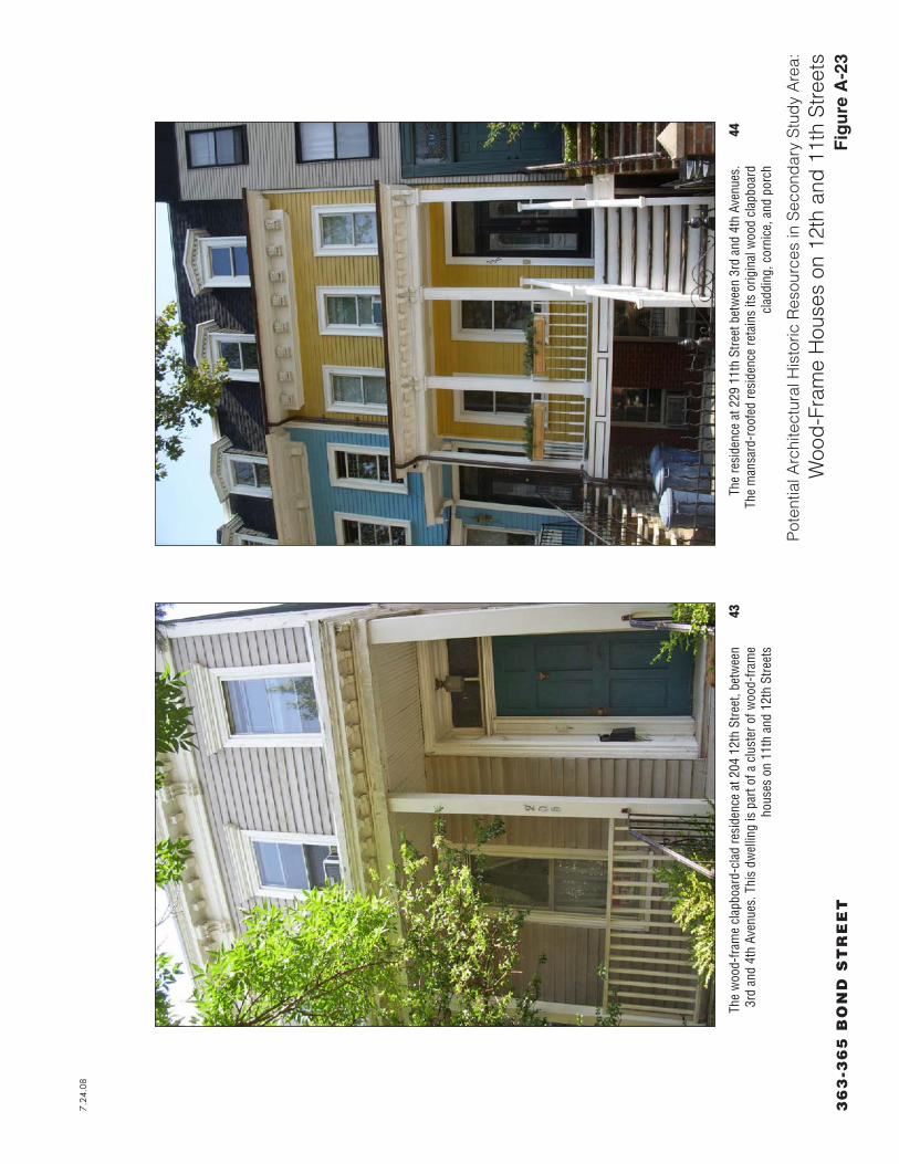
Wood-frame houses on 11th and 12th Street
There are relatively few intact examples of nineteenth century wood-frame houses clad in wood siding in Brooklyn, however, a cluster of such residences remains on 11th and 12th Streets between 3rd and 4th Avenues in the eastern portion of Park Slope (see Figures A-1, A-22, and A-23). While several wood-frame structures remain on these two blocks, particularly on 11th Street, only a few retain original exterior features such as original clapboard siding, and wood porches. These structures, which are concentrated on 11th and 12th Street towards 4th Avenue, include the following addresses: 205 12th Street; 216, 217, 218, 219, 221, 223, 226, 229, and 232 11th Street. The two- to three-story structures were designed in the Italianate style, and most likely date to the third quarter of the 19th century. They retain wood cornice with decoratively carved wood brackets. Most retain original wood clapboard cladding, wood window and door surrounds, and ornamented front porches. While none of the original window sash remain, all of the structures retain their original fenestration, and transoms, and several retain their original wood paneled doors.

1
9
2 3
4
5
6
8
7
10
11
12
Wyckoff Rowblock 1 Wyckoff Rowblock 2
Potential Carroll Gardens Historic District Extension
Potential Carroll Gardens Historic District Extension
American CanCompany Building
409-431 Bond St.Ice House/Brewery
The News Brooklyn Garage
R.G. Dun & Co.BuildingASPCA
Our Lady of Peace RC Church Complex
Washington Park Wall
Kentile Building& Sign
11th & 12th St.Wood-frame
Houses
94-110 9th St.Former Wholesale
Grocer
St. AgnesChurch
Complex
Eagle Clothes Building & Sign
IND Subway Viaduct
3 ST
3 A
V
9 ST
6 ST
SM
ITH
ST
12 ST
2 A
V
8 ST
9 ST
10 ST
11 ST
7 ST
BERGEN ST
HO
YT
ST
UNION ST
BO
ND
ST
BALTIC ST
5 A
V
4 ST
NE
VIN
S S
T1 ST
WYCKOFF ST
BUTLER ST
CO
UR
T S
T
5 ST
DEGRAW ST
SACKETT ST
DOUGLAS ST
PRESIDENT ST
HAMILTO
N AV
4 PL
3 PL
1 PL
2 PL
WARREN ST
EIL
EE
N D
UG
AN
BLV
D
ST MARKS PL
W 9 ST
GO
WANUS EXW
Y
HUNTINGTON ST
GARNET ST
LORRAINE ST
NELSON ST
LUQUER ST
GARFIELD PL
BUSH ST
DE
NT
ON
PL
MIL
TO
N P
L
WH
ITW
ELL P
L
SM
ITH
PRESIDENT ST
CARROLL ST
3 A
V
DU
GA
N B
LV
D
CARROLL ST
5 ST
1 ST
5 ST
4 ST
WARREN ST
DEGRAW ST
2 ST
SACKETT ST
WARREN ST
2 ST
BUTLER ST
7.24.08
Historic ResourcesFigure A-1363-365 BOND STREET
N
Project Site Boundary
Primary Study Area Boundary (400-Foot Perimeter)
Secondary Study Area Boundary
New York City Landmark and S/NR-Eligible
Contributing Feature to the Gowanus Canal Historic District (S/NR-eligible)
New York City Landmark and S/NR-Listed
S/NR-Eligible
S/NR-Listed
Potentially Contributing to Gowanus Canal Historic District
Potential Historic Resource (Individual)
Potential Historic District Extension
Gowanus Canal Waterway and Bulkheads
Burns Brothers Coal Pockets
Third Avenue Bridge
Brooklyn Improvement Company Office Building
Former Brooklyn Rapid Transit Power House
59-97 Second Street
Carroll Street Bridge
Carroll Gardens Historic District
Pumping Station
Boerum Hill Historic District
Cobble Hill High School
IND Subway 4th Avenue Station
Architectual Resources
1
2
3
4
8
9
5
6
7
10
11
12
SCALE
0 200 500 FEET

7.24.08
Figure A-2
Potential Architectural Historic Resources in Secondary Study Area:
Potentially Contributing to Gowanus Canal Historic District363-365 BOND STREET
Looking northeast towards the south façade of the R.G. Dun & Co. Building on Butler Street. The parged concrete building is ornamented with blue terra-cotta tiles
2
The R. G. Dun & Co. Building, located on the corner of Nevins and Bond Streets, immediately across Butler Street from the northern terminus of the Gowanus Canal. The structure, was built in 1914 to house the printing department for the large
credit reporting company, R. G. Dun & Co. This photograph shows the south (left) and east (right) facades of the building
1
7.24.08
Figure A-3
Potential Architectural Historic Resources in Secondary Study Area:
Potentially Contributing to Gowanus Canal Historic District363-365 BOND STREET
4The west façade of the American Can Company Building on 3rd Street. The red brick section (right) was constructed ca. 1885, while the five-story section to the south (right), which also has segmental-arched windows and a corbelled brick
cornice, was added at the turn of the century
Looking southeast towards the north (left) and west (right) facades of the American Can Company Building on the southeast corner of 3rd Street and 3rd Avenue. Note the segmental-arched windows, corbelled brick cornice, and multi-light
diamond-shaped windows on the upper story of the west façade
3
7.24.08
363-365 BOND STREET
Potential Architectural Historic Resources in Secondary Study Area:
Potentially Contributing to Gowanus Canal Historic DistrictFigure A-4
6Looking southeast towards the three southern sections of the former Ice House and Brewery on Bond Street. The peak-roofed section (center), which was round-arched windows and projecting
brickwork suggesting quoins and voussoirs, is the earliest section, built ca. 1900
The front (west) façade of the northernmost section of the former Brewery on Bond Street at 4th Street. The tall brickstructure has a both round-arch and
rectangular windows, and an ornamental brick cornice
5

7.24.08
Figure A-5
Potential Architectural Historic Resources in Secondary Study Area:
Potentially Contributing to Gowanus Canal Historic District363-365 BOND STREET
Looking southeast towards the eastern portion of the Thomas Roulston Grocery Warehouse. All of the sections of the building share similar architectural details, including corbelled cornice and round- and segmental-arched windows with
pronounced keystones
8
Looking southwest towards the former Thomas Roulston Grocery Warehouse. The brick structure, which is composed of three sections, ranging in height from one to four stories, was built as a wholesale warehouse for what was Brooklyn’s
largest grocery chain at the turn of the century
7

7.24.08
Potential Architectural Historic Resources in Secondary Study Area:
Potential Carroll Gardens Historic District Expansion Area363-365 BOND STREET Figure A-6
Looking southwest towards the south side of Degraw Street between Smith and Hoyt Streets
A view looking northwest towards the north side of Degraw Street between Smith and Hoyt Streets
10
9

7.24.08
Potential Architectural Historic Resources in Secondary Study Area:
Potential Carroll Gardens Historic District Expansion Area363-365 BOND STREET Figure A-7
Looking southeast towards the south side of Sackett Street from just east of the corner of Smith Street. Note the early 20th century brick apartment building (right) and single-family brick and brownstone-faced townhouses
Looking northeast towards the north side of Sackett Street from just east of the corner of Smith Street
12
11

7.24.08
Potential Architectural Historic Resources in Secondary Study Area:
Potential Carroll Gardens Historic District Expansion Area363-365 BOND STREET Figure A-8
A view of the Bacchus House, an Italianate-style brick dwelling on the southeast corner of Hoyt and Sackett Streets
Looking southeast towards the brownstone-faced rowhouses on the south side of Sackett Street from the middle of the block between Smith and Hoyt Streets
14
13

7.24.08
Potential Architectural Historic Resources in Secondary Study Area:
Potential Carroll Gardens Historic District Expansion Area363-365 BOND STREET Figure A-9
Looking southwest from the corner of Union and Hoyt Streets towards the south side of Union Street. While many of the windows and some of the cornices of these rowhouses have been replaced, the residences retain much of their historic character
The north side of Union Street between Smith and Hoyt Streets, looking northwest. Note the brownstone-faced single-family residences with large front gardens
16
15

7.24.08
Potential Architectural Historic Resources in Secondary Study Area:
Potential Carroll Gardens Historic District Expansion Area363-365 BOND STREET Figure A-10
Looking southeast towards the south side of 2nd Street between Smith and Hoyt Streets. This side of Union Street includes a large number of brick rowhouses with front gardens
Looking northwest towards the north side of 2nd Street between Smith and Hoyt Streets, showing the brownstone-faced dwellings with large front gardens that line this row
18
17

7.24.08
Potential Architectural Historic Resources in Secondary Study Area:
Potential Carroll Gardens Historic District Expansion Area363-365 BOND STREET Figure A-11
The south side of 3rd Street between Smith and Hoyt Streets, looking southeast from the middle of the block. Note the mansard-roofed rowhouses on the right, and the Renaissance Revival-style apartment houses on the left
A view of the north side of 3rd Street between Smith and Hoyt Streets, looking northwest from near the corner of Hoyt Street
20
19

7.24.08
Potential Architectural Historic Resources in Secondary Study Area:
Wyckoff Street Rowblock between Smith and Hoyt Streets363-365 BOND STREET Figure A-12
A view looking southeast towards the south side of Wyckoff Street between Smith and Hoyt, from the middle of the block. The late 19th-century three-story Renaissance Revival-style brick rowhouses are typical of this block
A view looking southeast from the corner of Wyckoff and Smith Streets, showing the large brick commercial building on the southeast corner
22
21
7.24.08
Potential Architectural Historic Resources in Secondary Study Area:
Wyckoff Street Rowblock between Smith and Hoyt Streets363-365 BOND STREET Figure A-13
Looking southwest towards the south side of Wyckoff Street between Bond and Nevins Streets
A view looking southeast towards the south side of Wyckoff Street between Bond and Nevins Streets. These Italianate-style brick rowhouses are typical of the block; several retain their original windows as well as cornices and other features
24
23

7.24.08
Figure A-14
Potential Architectural Historic Resources in Secondary Study Area:
ASPCA Shelter363-365 BOND STREET
A close-up view of the stone frame of the central entryway, which includes a round shield with the ASPCA’s logo 26
The south (front) façade of 233 Butler Street, constructed in 1913 and rebuilt in 1922 as a shelter and office building for the American Society for the Prevention of Cruelty to Animals (ASPCA)
25

7.24.08
363-365 BOND STREET Figure A-15
Potential Architectural Historic Resources in Secondary Study Area:
Saint Agnes Church Complex
Looking northeast from Sackett Street just east of Hoyt Street towards the brick Gothic Revival-style Parish House (right) associated with Saint Agnes Church (left)
A view of Saint Agnes Church, looking southeast from the corner of Hoyt and Degraw Streets. The large stone Gothic Revival-style church, constructed 1881-8, is located on the
east side of Hoyt Street between Degraw and Sackett Streets
28
27

7.24
.08
36
3-3
65
BO
ND
ST
RE
ET
Fig
ure
A-1
6
Pot
entia
l Arc
hite
ctur
al H
isto
ric R
esou
rces
in S
econ
dar
y S
tud
y A
rea:
Sai
nt A
gne
s C
hurc
h C
omp
lex
Sain
t Vin
cent
’s Re
side
nce,
a b
rick
Goth
ic R
eviv
al-s
tyle
bui
ldin
g, a
ssoc
iate
d w
ith th
e Sa
int A
gnes
Chu
rch
com
plex
, and
loca
ted
imm
edia
tely
wes
t of t
he fo
rmer
sch
ool
build
ing
show
n ab
ove
The
Sain
t Agn
es S
choo
l, no
w a
partm
ents
, loc
ated
at 4
21 D
egra
w S
treet
, on
the
north
sid
e of
the
stre
et b
etw
een
Hoyt
and
Bon
d St
reet
s30
29

7.24.08
363-365 BOND STREET Figure A-17
Potential Architectural Historic Resources in Secondary Study Area:
Saint Agnes Church Complex
Looking southeast towards the south side of Carroll Street between Whitwell and Denton Place, showing the Our Lady of Peace Roman Catholic Church, constructed in 1902-4. The church is flanked by a brick hip-roofed rectory to the east (right)
and a school to the west (left)
A view looking northeast of the south façade (Degraw Street frontage) of The News Brooklyn Garage Building. The building has three facades: on 3rd Avenue, Douglass Street, and Degraw Street, all of which are very similar. The Art Moderne-style concrete garage was built the Brooklyn plant of the
New York Daily News newspaper, located nearby. The small camera inscribed in the façade between the words ‘The’ and ‘News’ is the company’s logo
32
31

7.24.08
363-365 BOND STREET Figure A-18
Potential Architectural Historic Resources in Secondary Study Area:
Our Lady of Peace Roman Catholic Church
A view looking southeast from the corner of Carroll Street and Whitwell Place, showing the front and side (west) facades of the school associated with Our Lady of Peace Roman Catholic Church
Looking southwest towards the school (right) constructed in 1922 in association with Our Lady of Peace Roman Catholic Church (left)
34
33

7.24.08
363-365 BOND STREET Figure A-19
Potential Architectural Historic Resources in Secondary Study Area:
Wall of Former Washington Park Baseball Field
A close-up view of the wall, showing the recessed panels and brick segmental arches along the middle portion of the structure along 3rd Avenue
36
35Looking southeast towards what is now the wall of a Con Edison facility on 3rd Avenue between 1st and 3rd Streets. The wall is purported to have been built in the 1910s as part of the second Washington Park, a ball field where the Brooklyn Dodgers
played from 1912-14, and where the Brooklyn Tip-Tops played from 1914-1916

7.24.08
Figure A-20363-365 BOND STREET
Potential Architectural Historic Resources in Secondary Study Area:
Wall of Former Washington Park Baseball Field
38The Kentile Building and large neon sign, looking northwest at the corner of 2nd Avenue and 9th Street
Looking northeast towards the Eagle Clothes Company Building with large neon sign atop the roof. The building is located on 6th Street between 3rd and 4th Avenues, and was constructed in 1950-1
37

7.24.08
Figure A-21363-365 BOND STREET
Potential Architectural Historic Resources in Secondary Study Area:
IND Subway Viaduct
40The IND subway viaduct (looking east) where it passes over buildings between 9th and 10th Street just west of 2nd Avenue
Looking west along 9th Street near 2nd Avenue towards the IND subway viaduct where it crosses over the Gowanus Canal. In this location, the viaduct passes over the 9th Street vehicular bridge, which has been determined not S/NR-eligible
39
7.24.08
Figure A-22363-365 BOND STREET
Potential Architectural Historic Resources in Secondary Study Area:
IND Subway Viaduct
42Looking northeast from 10th Street and 4th Avenue to the IND subway viaduct where it crosses 4th Avenue. This portion of the viaduct, consisting of a steel-arch and brick piers designed in the Art Deco-style, houses the 4th Avenue subway station,
which is listed on the S/NR
Looking west towards the IND subway viaduct from 10th Street between 3rd and 4th Avenues. On the left, the truss section where the viaduct crosses 3rd Avenue is visible. To the right, the viaduct is enclosed in brick facing
41
7.24
.08
36
3-3
65
BO
ND
ST
RE
ET
Fig
ure
A-2
3
Pot
entia
l Arc
hite
ctur
al H
isto
ric R
esou
rces
in S
econ
dar
y S
tud
y A
rea:
Woo
d-F
ram
e H
ouse
s on
12t
h an
d 1
1th
Stre
ets
The
resi
denc
e at
229
11t
h St
reet
bet
wee
n 3r
d an
d 4t
h Av
enue
s.
The
man
sard
-roo
fed
resi
denc
e re
tain
s its
orig
inal
woo
d cl
apbo
ard
clad
ding
, cor
nice
, and
por
ch
44Th
e w
ood-
fram
e cl
apbo
ard-
clad
resi
denc
e at
204
12t
h St
reet
, bet
wee
n 3r
d an
d 4t
h Av
enue
s. T
his
dwel
ling
is p
art o
f a c
lust
er o
f woo
d-fra
me
hous
es o
n 11
th a
nd 1
2th
Stre
ets
43

7.24.08
Figure A-24363-365 BOND STREET
Potential Architectural Historic Resources in Secondary Study Area:
Wood-Frame Houses on 12th and 11th Streets
46The wood-frame residences at 216-218 11th Street
The wood-frame residences at 217-223 11th Street 45


Attachment B: Descriptions and Histories of Project Site Buildings
The following structures are located on the project site and were not designated as contributing elements within the State/National Register-eligible Gowanus Canal Historic District.
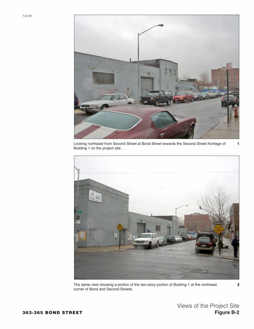
Building 1: The brick-and-concrete-block warehouse located at 365-379 Bond Street (a.k.a. 109-129 Second Street), is located in the southwestern portion of the project site, on Second Street between Bond Street and the Gowanus Canal (see Figures B-1 to B-3). This one- and two-story complex was built in numerous stages, chiefly between 1920 and 1956. The building’s Second Street frontage consists of three separate elements, which include (from west to east) a single-story brick structure with two large garage doors; a two-story two-bay stucco-clad structure; and a low single-story brick structure. The portion of the building that fronts on Bond Street is a two-story flat-roofed brick structure, built in two phases, as described below. It has a simple brick cornice and no other ornamentation. All of the original window and door openings have been entirely or partly blocked. This section of the building wraps around to front on First Street. Also contiguous on First Street is a long narrow single-story structure, which was built in four phases (the first prior to 1915 and the last after 1951, as described below). This single consolidated structure is faced in brick and concrete block, and it has no window or door openings.
A 1915 Sanborn fire insurance map shows that the land on which the building stands included all or portions of seven separate parcels at that time. The entire north half of the block between First, Second, and Bond Streets and the Gowanus Canal was owned by Standard Oil Company of New York. The south half of the block was owned in part by Frank D. Creamer & Co. Building Materials; and also included several privately owned dwellings. Most of the buildings shown on the location in the 1915 Sanborn map (including dwellings, oil tanks, a wagon house, and pump room, among others) are no longer standing; however, three non-contiguous buildings shown on the map appear to have been incorporated into what is now Building 1. These three buildings, which comprise roughly 20% of the building’s current footprint, include a narrow two-story L-shaped building fronting on Bond and First Streets, and a single-story “Auto House,” fronting on First Street (both on the Standard Oil property); as well as a small two story “Auto House/Office” fronting on Second Street (on the Frank D. Creamer Company property).
A 1951 Sanborn map shows that the location where Building 1 now stands was owned entirely by Standard Oil Company of New York at this time; and Fleer & Fleer, Inc. is listed as the tenant. A narrow two-story rectangular-plan structure fronting on Bond Street has been built to connect with and extend the existing L-shaped building to Second Street, the consolidated structure is designated for “Storage.” A large single-story brick “Auto House” has been built in the center of the property (noted as having been built in 1920). Both of these structures are also now integrated into Building 1. Additionally, a single-story “Garage” has been added to the east end of the existing single-story “Auto House” fronting on First Street, and this structure also appears to have been incorporated into the current building. Several oil storage tanks and a storage structure, no longer extant, are also shown on portions of the property now occupied by Building 1. The portion of the building that fronts on Bond Street is labeled ‘storage.’ A recent Sanborn map indicates that a large portion of Building 1, fronting on Second Street and comprising roughly 50% of the total footprint of the structure, was built in 1956. The structure has most recently been occupied by the Fiber Wave Company.
B-1

B-2
Building 2: The single-story brick building at 363 Bond Street (a.k.a. 63-87 First Street) between First and Carroll Streets is a warehouse structure with simple diamond-shaped brickwork on a low parapet (see Figure 1; and Figure 4, View 5). Although the building appears to have had several windows and doors originally, these have been sealed. The building does not appear on a 1915 Sanborn map; however, it does appear to be the same building shown on a 1951 Sanborn map, labeled as a garage and auto repair shop.
Building 3: The brick and concrete warehouse building at 89-107 First Street, on the north side of First Street between Bond Street and the Gowanus Canal, adjoins Building 2 (see Figure B-1; Figure B-4, View 6; and Figure B-5). Faced in concrete, the former windows of the two-story building are delineated by slightly projecting piers; most of the windows have been sealed with concrete blocks; others with modern metal roll-down gates. According to a 1951 Sanborn map, the building was constructed in 1916 as a warehouse, and became associated with the Pure Oil Company in 1951.
Two cylindrical reinforced-concrete buildings, former containment structures, are located between Carroll and First streets. One of these structures, Building 4, was substantially rebuilt in the late 20th century; its walls were augmented, and small windows and a conical roof was added to the structure (see Figure B-1; Figure B-5, View 8; and Figure B-6). Most recently, it has been used primarily for storage. Another former containment structure, Building 5, also concrete cylinder, with a low conical roof and picture windows added in the late 20th century (see Figure B-1; and Figure B-6, View 10). These structures do not appear on the 1915 Sanborn map of the property, but are shown on the 1951 Sanborn map as part of the Pure Oil Company Property (to which Building 6, described below also belonged). Buildings 4 and 5 are indicated as containing 100,000 gallon gasoline tanks. Also located on the property were three additional containment structures, a pump house, and two additional structures, none of which are extant.
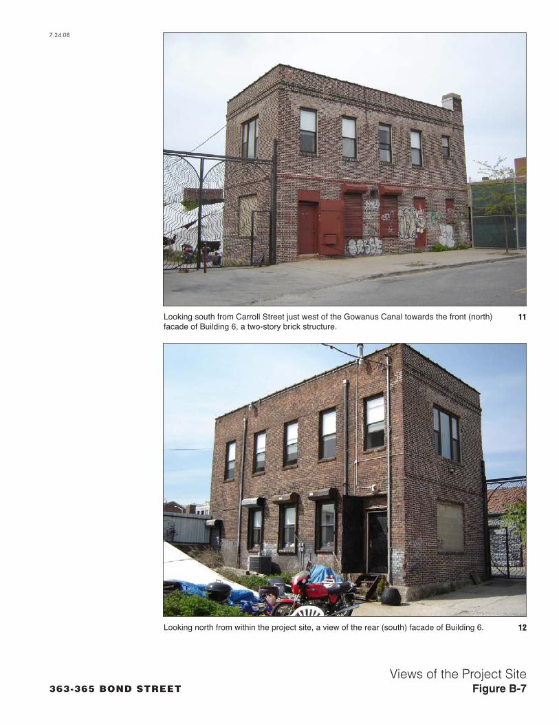
Building 6: The two-story five-bay rectangular-plan brick building at 388 Carroll Street has a flat roof with a small chimney on the northwest corner (see Figures B-1 and B-8). The building has a simple brick cornice and floor band, but is otherwise unornamented. The window openings contain retrofitted one-over-one-light double-hung sash windows, or sealed or covered with corrugated metal awnings. The building does not appear on the 1915 Sanborn map of the property. It is shown on the 1951 Sanborn as part of the Pure Oil Company property, labeled as an office.
Summary
None of the buildings on the project site appear to meet the State/National Register of Historic Places eligibility criteria. None of the buildings are remarkable for architecture or design. Many of the buildings were built in numerous phases, and passed through numerous ownerships and uses. All of the buildings were substantially altered during the second half of the 20th century and no longer retain historic integrity.

2ND
ST.
1ST
ST.
3RD
ST.
CA
RR
OLL S
T.
7.24
.08
363-365 BOND STREETKey to Photographs
Figure B-1
SCALE
0 200 FEET
N
BOND ST.BOND ST.
Project Site Boundary
Primary Study Area Boundary (400-Foot Perimeter)
Rezoning Area Boundary
Photograph View Direction and Reference Number
Building 1
Building 2
Building 3
Building 4
Building 5
Building 6
1
2
1
3
7
4 5
9
8
6
16
12
10
11
20
363-365 BOND STREET
7.24.08
Looking northeast from Second Street at Bond Street towards the Second Street frontage of Building 1 on the project site.
1
The same view showing a portion of the two-story portion of Building 1 at the northeast corner of Bond and Second Streets.
2
Views of the Project SiteFigure B-2

363-365 BOND STREET
View from Bond Street at Second Street, looking northeast towards the Bond Street facade of Building 1.
3
View from Bond Street at First Street looking east towards the Gowanus Canal and the First Street facade of Building 1.
4
Views of the Project SiteFigure B-3
7.24.08

363-365 BOND STREET
View from Bond Street at First Street looking northeast towards Building 2. 5
Looking northeast from First Street between Bond Street and the Gowanus Canal towards Building 3. 6
Views of the Project SiteFigure B-4
7.24.08

363-365 BOND STREET
View from First Street and the west side of the Gowanus Canal, looking northwest towards Building 3 on the project site.
7
View from the east side of the Carroll Street Bridge looking west towards the project site. The rear of Building 3 is visible on the left. Building 4, a reinforced concrete former containment structure is visible on the right.
8
Views of the Project SiteFigure B-5
7.24.08

363-365 BOND STREET
View from Carroll Street looking southeast towards the northeast corner of the project site. Note Building 4, the two-story brick office pictured on the left, and Building 5, the cylindrical former containment structure, on the right.
9
Looking southwest from the Carroll Street Bridge towards Buildings 4 and 5. 10
Views of the Project Site and Study AreaFigure B-6
7.24.08
363-365 BOND STREET
Looking south from Carroll Street just west of the Gowanus Canal towards the front (north) facade of Building 6, a two-story brick structure.
11
Looking north from within the project site, a view of the rear (south) facade of Building 6. 12
Views of the Project SiteFigure B-7
7.24.08

Attachment C: Additional Archaeological Sensitivity Evaluation
EVALUATION OF POTENTIAL FOR BURIAL GROUNDS IN PROJECT SITE VICINITY
No information regarding the presence of a Native American burial ground in the vicinity of Freeke’s Mill could be identified. Various published texts documenting Brooklyn’s history were consulted, including Stiles’ 1869 History of Brooklyn, as well as works summarizing its precontact history, such as Grumet’s Native American Place Names of New York City (1981), Ritchie’s The Archaeology of New York State (1980), and Tooker’s Indian Names of Places in the Borough of Brooklyn (1901), and previously conducted cultural resources studies such as Army Corps of Engineers (ACOE) 2004 NationalRegister of Historic Places Eligibility Evaluation and Cultural Resources Assessment for the Gowanus Canal. These works refer to various Native American villages and campsites which have been documented in the vicinity of the project area (including the Werpoes site, identified as Site 4 on Figure 7-2 of the preliminary DEIS), but none indicate that a Native American burial ground was situated there.
Historic maps dating to the 18th and 19th centuries suggest that the project area was occupied by the Gowanus Creek and the low-lying marshland that bordered it. Such an environment would most likely not have been conducive to human burials. The only documented human burials in the vicinity appear to be those associated with the soldiers, many from Maryland, killed during the Battle of Brooklyn in 1776 and buried near the Gowanus Canal. Most sources (ACOE 2004; Williams 1998; Carroll 1991) suggest that the burials were located near Third Avenue between 7th and 8th Streets, on the eastern side of the Gowanus Canal, roughly 1,200 feet southeast of the project site (identified as Site 1 on Figure 7-2 of the preliminary DEIS). Fraser (1909) suggests that the burials were located on an island within the Gowanus Creek. Fraser appears to be referring to the small island depicted on Ratzer’s 1766 map of the area at the mouth of Denton’s Mill Pond, roughly 400 feet east of the project site, across the present canal. Most sources agree that more than 20 feet of fill was deposited on the site of the burial ground.
In summary, no documentary evidence has been found for Native American burials on or in the immediate vicinity of the project site. Furthermore, the project site would historically have been marshy in character, and therefore, the terrain would have been unfavorable as a Native American burial ground. It is possible that the Revolutionary War-period burial ground described above could be present below substantial fill, though between 400 and 1,200 feet southeast of the project site.
EVALUATION OF PROJECT SITE’S POTENTIAL FOR MILL-RELATED ARCHAEOLOGICAL RESOURCES
As described in the preliminary DEIS and the Army Corps report, three mills were located along the Gowanus Creek in the 18th and 19th centuries (see preliminary DEIS Figure 7-2). There are no indications that any structures or dams associated with the three mills were situated within the project site. Two of the mills, Freeke’s Mill, to the roughly 600 feet northeast of the project area, and Denton’s Mill, roughly 300 feet east, are better documented than the third. Many 18th and 19th century maps depict these mills though none indicate that any portion of the mills, including the mill ponds, were located within the boundaries of the project site (see Figure C-1).
Cole’s Mill, named after miller Jordan Coles, was located a substantial distance south of the project site; however, the mill pond associated with it extended north of the mill building. Based on historic map analysis, Coles Mill pond would have terminated roughly half a block south of the project site (see Figure
C-1

C-2
C-1). This mill was constructed within the marshland surrounding the Gowanus Creek circa 1700 (Stiles 1869), although the mill pond was not depicted on maps until the 19th century. Coles’ house was located on Ninth Street between the Canal and Smith Street (ibid). The mill pond appears to have been filled in after 1837.
Therefore, no archaeological resources associated with Freeke’s, Denton’s or Cole’s Mill would be expected to exist on the project site.
Sources:
Army Corps of Engineers
May 2004 National Register of Historic Places Eligibility Evaluation and Cultural Resources Assessment for the Gowanus Canal.
Carroll, Charles
1991 “Maryland’s Brave 400 at Long Island,” published on the Sons of the American Revolution website, http://www.rsar.org/military/mdatli.htm, accessed May 2008.
Fraser, Georgia
1909 The Stone House At Gowanus. New York: Witter and Kintner.
Tooker, William Wallace
1901 Indian Names of Places in the Borough of Brooklyn: With Historical and Ethnological Notes. New York: Francis P. Harper.
Williams, Monte
5/26/1998 “Brooklyn Fire May Lead to Revolutionary Graves,” The New York Times. Accessed through the New York Times Digital Archive May, 2008.

3rd
Ave
4th
Ave
9th St3rd St
7th St
6th St
Union St
5th
Ave
8th St
Sm
ith S
t
Baltic St
Hoy
t St
Co
urt
St
Bon
d S
t
10th St
I 278
1st St
5th St
Carroll St
6th
Ave
Dean St
12th St
11th St
Bergen St
Nev
ins
St
4th St
13th St
2nd
Ave
2nd St
14th St
Wyckoff St
Pacific St
Clin
ton
St
Butler St
President St
7th
Ave
Sackett St
1st Pl
Degraw St
15th St
State St
Kane St
Garfield Pl
Atlantic Ave
2nd Pl
Ham
ilton Ave
Douglass St
3rd Pl
Ram
p
Hen
ry S
t Warren St
16th St
Saint Marks Pl
Luquer St
Huntington St
Str
on
g P
l
Flatbush Ave
Centre St
Tom
pki
ns
Pl
Berkeley Pl
Ch
eeve
r P
l
Garnet St
Lincoln Pl
Ham
ilton
Pl
Schermerhorn St
Den
ton
Pl
Whi
twel
l Pl
Den
net
t P
l
Gre
gory
Pl
Mill St
Nelson St
4th St
Warren St
2nd St
Warren St
2nd St
I 278
Ham
ilton Ave
1st St
5th St
President St
Sackett St
Degraw St
Ram
p
Carroll St
Carroll St
Butler St
Douglass St
President St
President St
Baltic St
5th St
Ram
p
Base
Map
: 176
6 Br
ookl
yn R
atze
r Sur
vey;
Ove
rlays
: Col
e's
Mill
Pond
from
178
2 Br
itish
Hea
d Q
uarte
rs M
ap, 1
848
Dra
inag
e Pl
an fo
r The
Gow
anus
Can
al, 1
880
Broo
klyn
War
ds M
ap (B
rom
ley)
Atla
s;
2
006
New
Yor
k C
ity D
epar
tmen
t of C
ity P
lann
ing
Build
ing
Dat
a
Cole's Mill
Pond
Denton's (Yellow) Mill Pond
Freeke's
MillPond
Cole's Mill
Freeke's Mill
Denton's Mill
Gowanus Rd
Cole's Mill Rd
Project Site
2006 Buildings
1766 Buildings
1782 Buildings
1782 Coles Mill Pond
1848 Coles Mill Pond
1766 Roads
1782 Roads
2004 Gowanus Canal Bulkheads
1766 Gowanus Marshes
Location of Former MillsRelative to Project Site
Figure C-1
7.24
.08
363-365 BOND STREET
N
SCALE
0 1000 FEET

Attachment D: Soil Investigation Data
(Can be Requested from New York City Department of City Planning)

Attachment E: Carroll Street Bridge Evaluation


Attachment F: Gowanus Canal Bulkhead Alternatives Analysis and Bulkhead Sections and Elevations
Halcrow HPA22 Cortlandt Street, New York NY 10007 USA
Tel (212) 608-4963 Fax (212) 566-5059
www.halcrowhpa.com
Memo
Reconstruction of the Existing Bulkhead - Revised July 16 2008.doc
To David Yudelson Ref DWDGOWFrom Joseph Silva, P.E. Date 7/16/08
Copy David Von Spreckelson, Nimita Shah
Project: Toll Brothers 363-365 Bond Street Development
Subject: Reconstruction of the Existing Bulkhead
The original replacement design of the bulkhead consists of positioning and installing a new steelsheet pile wall outboard of the existing rock filled timber crib bulkhead as close as constructability willallow. This is the optimal solution for providing long term shoreline stabilization with no loss ofupland real estate. However, based on a conference call held on Friday, December 21, 2007,HalcrowHPA understands that the DEC no longer allows an existing bulkhead to be reconstructed 18 inchesoutboard of the existing bulkhead face without substantial justification and/or necessity. As such,reconstruction of the bulkhead under these restrictions will greatly complicate constructionprocedures and cause a large degree of disturbance to the surrounding environment and additionalcost burden to the Owner.
The following is a discussion on the possible alternatives considered for this project site as well as thedifficulties associated with each alternative based on the newDEC restrictions. These solutions werecarefully considered and ultimately rejected prior to selecting the design approach currently proposed:
� No Action
� Repair the existing rock filled timber crib bulkhead
� Install new steel sheet pile bulkhead behind the existing timber bulkhead
� Complete demolition, excavation, removal, and replacement of the existing bulkhead
ALTERNATIVE 1: No Action
If no action takes place, the existing bulkhead will continue to deteriorate and eventually collapseunder its own weight and/or newly imposed loads. Further deterioration and/or collapse of thebulkhead will result in a threat to public safety and property, especially with the addition of theproposed development. Therefore, this alternative is not considered an effective option.

To David Yudelson Ref DWDGOW
From Joseph Silva, P.E. Date 7/16/08
Reconstruction of the Existing Bulkhead - Revised July 16 2008.doc
ALTERNATIVE 2: Repair the existing rock filled timber crib bulkhead
Repairs to the existing rock filled timber crib bulkhead would provide only a short-term solution tothe ongoing deterioration and eventual failure of the bulkhead. Repairs would consist of patching thebulkhead and possibly fortifying it along selected portions. However, the deterioration of thebulkhead is so widespread that these types of repairs would be only partially effective and temporaryat best. Therefore, this alternative is not considered an effective solution.
ALTERNATIVE 3: Install new steel sheet pile bulkhead behind the existing timber bulkhead
Bulkhead replacement behind the existing timber bulkhead (upland side), in lieu of the outboard(water) side, of the existing bulkhead was considered. The existing rock filled timber crib wallbulkhead extends back into the upland approximately ten feet and is most likely composed of varyingtypes and sizes of rock fill material enclosed by timber framing members. The timber membersmakeup the overall framework of the crib and are necessary to maintain stability of the existing bulkhead.These timber members would directly impede construction of the new steel sheet pile bulkhead andneed to be removed in their entirety to permit installation of the new bulkhead. Removal of thesetimbers could cause the existing bulkhead to fail abruptly. Therefore, a piece-by-piece removal andreplacement of the bulkhead was considered as a possible means of avoiding widespread failure andlimiting unsupported portions of the bulkhead to relatively short segments. It was ultimatelyconcluded that there is too much risk of failure for each bulkhead segment during these operations,due to the advanced state of deterioration. It is also anticipated that the infill may contain a significantamount of oversized rock fragments, miscellaneous debris, and other obstructions that may not allowfor installation of the sheeting. Therefore, this alternative was not considered an feasible solution.
ALTERNATIVE 4: Complete demolition, excavation, removal, and replacement of the existingbulkhead
Complete demolition, excavation and removal of the existing bulkhead and backfill was considered.This alternative would require complete removal of the bulkhead, fill materials, installation of newsteel sheet pile bulkhead and the placement of new clean backfill. Excavation of the materials willrequire a temporary slope extending a minimum of forty feet upland to provide room for removal ofall bulkhead components and maintain a safe working slope. Removal of the bulkhead will cause asignificant portion of the existing backfill material to slough into the resulting excavation andsignificant disturbance to the surrounding water environment. Based on the results of the Phase IIEnvironmental Investigation, Halcrow HPA understands the existing site soils contain some

To David Yudelson Ref DWDGOW
From Joseph Silva, P.E. Date 7/16/08
Reconstruction of the Existing Bulkhead - Revised July 16 2008.doc
contaminants and will require special consideration. As such, this alternative was deemed to be toextreme in scope, very disruptive to the environment and cost prohibitive to the project.
In light of the above, Halcrow HPA recommends pursuing the original design approach forreconstruction of the bulkhead. In this case, construction of the new steel sheet pile wall will consistof a 12 inches deep sheetpile placed up against the existing bulkhead. This approach will be the mostoptimal solution to ensure proper constructability, minimal impact to the surrounding environmentand reasonable cost. Furthermore, this method of bulkhead replacement has been granted by theDEC to numerous property owners along the Gowanus Canal with good results and clearly is aprecedent that should be applied to this Owner’s situation.


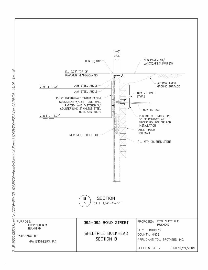


363-365 BOND STREET
7.24.08
The Gowanus Canal bulkhead along the western side of the canal between 1st and Carroll Streets within the project site
1
2
Gowanus Canal Bulkhead: Existing ConditionsFigure F-1

363-365 BOND STREET
7.24.08
The Gowanus Canal bulkhead along the western side of the canal between 1st and 2nd Street.
3
4
Gowanus Canal Bulkhead: Existing ConditionsFigure F-2

Attachment G: Landscape Plan
(Can be Requested from New York City Department of City Planning)

Attachment H: Evaluation of Proposed Project as per OPRHP’s Guide to Compatible New Construction
The proposed project is located adjacent to the Gowanus Canal, a contributing resource of the S/NR-eligible Gowanus Canal Historic District. Other contributing resources include non-contiguous structures and buildings: the Carroll Street Bridge, the Third Avenue Bridge, the former Brooklyn Rapid Transit Power House, the Burns Brothers Coal Pockets, the S.W. Bowne Grain Storehouse, the Brooklyn Improvement Company Building, the Gowanus Canal Flushing Tunnel, and the Gowanus Canal Pumping Station. AKRF has identified 4 additional properties that appear to meet S/NR eligibility criteria as contributing structures to the Gowanus Canal Historic District—the R.G. Dun & Co. Building at 220 Nevins Street (see Figures A-1 and A-2), the National Can Company Building at 361-385 3rd Avenue (see Figures A-1 and A-3), the ice house/brewery at 409-431 Bond Street (see Figures A-1 and A-4), and the former Thomas Roulston wholesale grocer complex at 94-110 9th Street (see Figures A-1 and A-5)—which are described in Attachment A. Similar to the previously identified contributing resources, these are a non-contiguous group of buildings that differ in use, design, height, massing, fenestration, and materials.
Keeping in mind that 1) the project site is located only adjacent to the Gowanus Canal, a waterway whose primary architectural features are bulkheads, and 2) there is no unified historic district with contiguous buildings that possesses a cohesive architectural vocabulary, and 3) the fact that the proposed project is a primarily residential development that would be built subject to a rezoning approval by the New York City Department of City Planning, the proposed development’s compatibility to the existing and proposed contributing buildings of the Gowanus Canal Historic District has been assessed as per the criteria contained in the New York State Office of Parks, Recreation and Historic Preservation’s (OPRHP) “Guide to Compatible New Construction.” Taking into account these considerations, the project is consistent with the guidelines for the reasons set forth below.
1. Siting
The proposed development will be sited along the Gowanus Canal as is the S.W. Bowne Grain Storehouse, the Burns Brothers Coal Pockets, the former Brooklyn Rapid Transit Power House, and the former ice house/brewery at 409-431 Bond Street. Both the S.W. Bowne Grain Storehouse and the Brooklyn Rapid Transit Power House are set back from the canal. The S.W. Bowne Grain Storehouse is set back from the canal behind paved parking and the Brooklyn Rapid Transit Power House is set back from the canal behind parking and trees and shrub grass. The new development would also be set back from the canal behind a paved walkway that will be lined with trees and shrubs.
The buildings will be parallel with the streets as are the other contributing buildings in the district. They will primarily be built to the sidewalk, including on Bond Street as are other contributing and proposed contributing buildings. They will also be placed parallel to the Gowanus Canal, following the trajectory of the waterway. The proposed landscaping would be set around a paved walkway along the canal. As described above, there is vegetation along the canal, including trees, such as located across the canal on the site of the Brooklyn Rapid Transit Power House.
2. Scale
H-1

The proposed new development is adjacent to the Gowanus Canal. There is no point of comparison between a bulkheaded waterway and a building. Therefore, the proposed new development will be evaluated in comparison to the non-adjacent contributing buildings in the historic district.
The proposed development will consist of two separate buildings, one between Carroll and First Streets and one between First and Second Streets. The buildings will have large footprints as do other non-adjacent contributing buildings in the district. These include the Brooklyn Rapid Transit Power House, which is the closest contributing resource, located across the Gowanus Canal. In addition, the Bowne Grain Storehouse, the National Can Company Building, and the R.G. Dun & Co. Building also are large structures or complexes.
The buildings have been designed with heights ranging from 4- to 12-stories. The majority of the proposed buildings will range in height from four to six stories. This is comparable to the height of the S.W. Bowne Grain Storehouse, the Burns Brothers Coal Pockets, the National Can Company Building, and the R.G. Dun & Co. Building. Closer to the canal, the building steps up with the sections of the buildings at the south and north corners of First Street reaching 12-stories. The Brooklyn Rapid Transit Power House and the six-story portion of the former ice house/brewery at 409-431 Bond Street along the canal are taller structures. The Brooklyn Rapid Transit Power House is a massive, approximately 80 foot tall building. The tallest (6-story) portion of the brewery is approximately 90 feet in height. Though portions of the new buildings would have elements that would be 12-stories, they would be located only at the corners of First Street and they would be primarily clad in glass so as to create greater transparency.
3. Massing
As described above, the building would be designed with variable heights. The variety in heights is not unlike that of industrial complexes, which frequently have buildings or sections of buildings of different heights, as is the case with the ice house/brewery complex and the former wholesale grocer complex at 94-110 9th Street.
Near Bond Street, the mid-block portions of the buildings have been organized as 4-story sections designed to read as rowhouses as a result of narrow setbacks which will be set in the façade. These design elements are compatible with the S/NR eligible rowhouses located on the north side of 2nd Street between Bond and Hoyt Streets that likely housed canal industry workers. In addition, other sections of the buildings have been designed with 5-story sections that slightly project out from the façades and that are comparable to the heights of several of the contributing buildings in the district including the S.W. Bowne Grain Storehouse, the National Can Company Building, the R.G. Dun & Co. Building, and portions of the ice house/brewery complex and former wholesale grocer complex.
The proposed buildings will have flat roofs as does the Brooklyn Rapid Transit Power House, the Brooklyn Improvement Company Office Building, the R.G. Dun Co. building, the National Can Company Building and the former wholesale grocer complex. The other contributing buildings have peaked roofs, including the S.W. Bowne Grain Storehouse and the Gowanus Canal Pumping Station, as well as portions of the ice house/brewery.
4. Materials
The OPRHP guidelines state that new buildings should be constructed of the same materials as their neighbors. As described above, the neighboring contributing resource is the Gowanus Canal itself, which has wooden bulkheads at the project site. Since the proposed project involves new buildings, the proposed development has been compared to the non-adjacent contributing buildings in the historic district.
The new buildings will be clad in brick, masonry, and glass. Windows would mostly be set within brick facades. At the base, windows/storefronts would be set between brick piers or would be set above a masonry base. Masonry or stone may also be used as coping and for window sills. Windows would be set within metal frames with metal muntins dividing the panes. Most of the contributing buildings in the
H-2

historic district are clad in brick, and, therefore, the proposed project is compatible with this aesthetic. The use of masonry or stone at the base or at the windows is also found in the district; the Brooklyn Improvement Company Office Building and the American Can Company have masonry bases. Other structures, include these two buildings, as well as the Gowanus Canal Pumping Station have masonry or stone window trim or parapet coping. The Carroll Street Bridge and the Third Avenue Bridge are built of steel, and metal framing and window divisions relate to this industrial aesthetic.
Since the proposed project will utilize brick, masonry, glass and metal, which are all materials utilized in the historic district, the materials of the proposed development would be compatible with the historic district.
5. Windows
Some resources, such as the bridges and the Burns Brothers Coal Pockets, do not have windows. In buildings, window openings in the historic district are round and flat arched. Window placement and treatment varies. Windows are widely spaced on the S.W. Bowne Grain Storehouse, but more closely spaced and grouped vertically as in the Brooklyn Rapid Transit Power House. The majority of the contributing buildings have had all or most of their windows sealed. The Brooklyn Improvement Company Office Building is an exception, but the windows on this structure have been fitted with modern replacements. Therefore, there is no consistent precedent for window placement or divisions within the openings.
Windows in the proposed project will mostly be set within large masonry openings, flat arched, and with metal sashes. This would be consistent with the industrial character of the R.G. Dun & Co. Building and the former wholesale grocer complex. Both complexes have large openings that make up a significant portion of the facades. While a number of windows have been sealed in the R.G. Dun & Co. Building, or covered in security mesh at the former wholesale grocer complex, and windows have been replaced in both structures, original windows are metal (grouped double-hung sash at the R.G. Dun & Co. Building and multi-light metal sash at the former wholesale grocer complex).
6. Design Features
As described above, the massing of the mid-block portions of the buildings have been organized as 4-story rowhouses. These portions of the buildings will also have stoops. These design elements make reference to the S/NR eligible rowhouses located on the north side of 2nd Street between Bond and Hoyt Streets. A stoop is also located at the front entrance to the Brooklyn Improvement Company Office Building and at the Third Street entrance of the American Can Company.
Also as described above, the use of brick piers and masonry at the base as well are details that relate to buildings in the historic district, including the Brooklyn Rapid Transit Power House, which façade is organized by brick piers dividing window bays, and the Brooklyn Improvement Company Office building and the American Can Company, which have masonry bases.
7. Relief
The projecting sections and narrow setbacks will provide relief and texture to the façades of the new buildings. The windows will be recessed within the facade, providing a relief between the windows and the facades as found in the contributing buildings in the historic district, where windows are typically shallowly recessed within the façades. The use of recessed entrances and stoops will also create a play of light and shadow as found in the contributing buildings, including the Brooklyn Improvement Company Office Building, whose entrance is recessed within a portico and which also has a projecting stoop, and the American Can Company, whose entrance on Third Street is accessed via a short stoop.
H-3

H-4


W:\Projects\10770 - GOWANUS - TOLL BROTHERS\ADMIN\TASKS\07_Historic\Historic Correspondence for Appendix\4_Appendix A Historic Correspondence.doc Page 1 of 1
THE CITY OF NEW YORK LANDMARKS PRESERVATION COMMISSION1 Centre Street, 9N, New York, NY 10007 (212) 669-7700 www.nyc.gov/landmarks
ENVIRONMENTAL REVIEW
DEPARTMENT OF CITY PLANNING/08DCP033K 8/4/2008
Project number Date received
Project: 363-365 BOND STREET REZONING
Comments: The LPC is in receipt of the preliminary draft historic resources chapter of the EIS dated 8/1/08. Additionally, LPC is in receipt of the SHPO findings of 8/7/08. LPC concurs with the SHPO findings.
Comments on the EIS text for architecture are as follows.
Page 7-3. Shadow studies for the Carroll Gardens HD should be provided for review and comment.
LPC determinations for the properties within the Project Site and Study Area are as follows.
The Brooklyn Improvement Company Office Building is LPC designated and appears S/NR eligible.
The Rowblocks constituting a potential extension of the Carroll Gardens Historic District appear LPC and S/NR eligible. The Wyckoff Street Rowblocks (Boerum Hill District Extension) appear LPC and S/NR eligible. The ASPCA Shelter at 233 Butler St., and the St. Agnes Church Complex appear LPC and S/NR eligible. The remaining properties and the project site properties do not appear LPC eligible.
Page 7-27. “Secondary Study Area”. Shadow studies for the project should be submitted for review and comment. Historic resources under the shadow study should include but are not limited to: the LPC and S/NR eligible Carroll Gardens extension, Our Lady of Peace R.C. Church Complex, and the St. Agnes R. C. Church Complex.
Cc: SHPO
As amended 8/8/08 ___________________________________________________________8/7/2008 SIGNATURE DATE