Embed Size (px)
Citation preview

Appendix A
Agency Coordination

CITY OF BATESVILLE
RICK ELUMBAUGH, MAYOR
DENISE JOHNSTON, CLERK
SCOTT STALKER. ATTORNEY
September 29, 2010
Damon Johnson City of Batesville Engineer 500 E. Main Street Batesville, Arkansas 7250 I
500 East Main
BATESVILLE, ARKA"ISAS 72501
Phone 870-698-2400
FAX 870-698-2406
Re: Pedestrian Bridge Project Stillhouse Branch, White River Tributary
Mr. Johnson,
COUNCIL
THOMAS E. BRYANT
MARGARETT HENLEY
DAVY INSELL
FRED KRUG
DOUGLAS MATTHEWS
MATI McDONALD
RICHARD O'NEAL
DAVID SHETRON
The proposed project of a new pedestrian bridge crossing the Still house Branch has been reviewed and appears acceptable to the flood plain management regulations based upon the fact that the flood carrying capacity has not been diminished and that the project does not adversely impact any other lands during a flood event. If you have any questions please feel free to contact me,
Sincerely,
Chad McClure City of Batesville Flood Plain Administrator
"CITY OF HOSPITALITY"

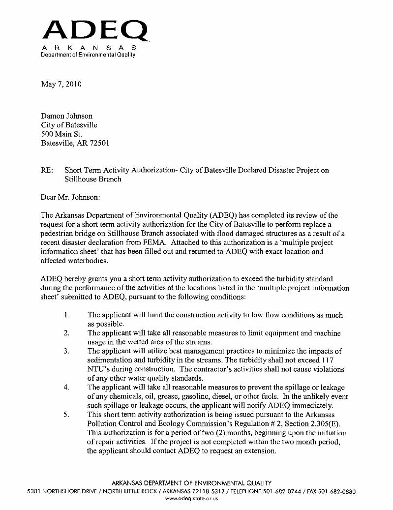
ADEQ ARK A N S A S Department of Environmental Quality
May 7, 2010
Damon Johnson City of Batesville 500 Main St. Batesville, AR 72501
RE: Short Tenn Activity Authorization- City of Batesville Declared Disaster Project on Stillhouse Branch
Dear Mr. Johnson:
The Arkansas Department of Environmental Quality (ADEQ) has completed its review of the request for a short tenn activity authorization for the City of Batesville to perfonn replace a pedestrian bridge on Stillhouse Branch associated with flood damaged structures as a result of a recent disaster declaration from FEMA. Attached to this authorization is a 'multiple project infonnation sheet' that has been filled out and returned to ADEQ with exact location and affected waterbodies.
ADEQ hereby grants you a short tenn activity authorization to exceed the turbidity standard during the perfonnance of the activities at the locations listed in the 'multiple project infonnation sheet' submitted to ADEQ, pursuant to the following conditions:
1. The applicant will limit the construction activity to low flow conditions as much as possible.
2. The applicant will take all reasonable measures to limit equipment and machine usage in the wetted area ofthe streams.
3. The applicant will utilize best management practices to minimize the impacts of sedimentation and turbidity in the streams. The turbidity shall not exceed 117 NTU's during construction. The contractor's activities shall not cause violations of any other water quality standards.
4. The applicant will take all reasonable measures to prevent the spillage or leakage of any chemicals, oil, grease, gasoline, diesel, or other fuels. In the unlikely event such spillage or leakage occurs, the applicant will notify ADEQ immediately.
5. This short tenn activity authorization is being issued pursuant to the Arkansas Pollution Control and Ecology Commission's Regulation # 2, Section 2.305(E). This authorization is for a period of two (2) months, beginning upon the initiation of repair activities. If the project is not completed within the two month period, the applicant should contact ADEQ to request an extension.
ARKANSAS DEPARTMENT OF ENVIRONMENTAL QUALITY 5301 NORTHSHORE DRIVE / NORTH LlTILE ROCK / ARKANSAS 72118·5317 /TELEPHONE 501·682·0744 / FAX 501-682·0880
www.adeq.stote.ar.U5

6. The contractor shall cease construction activity immediately if the ADEQ Director rescinds or revokes this short term activity authorization in writing.
In issuing this authorization, ADEQ does not assume any liability for the following: (A) Damages to the proposed project, or uses thereof, as a result of other
permitted or unpermitted activities or from natural causes. (B) Damages to persons, property, or to other permitted or unpermitted activities
or structures caused by this authorization. (C) Design or construction deficiencies associated with this proposed project.
If you have any questions, please contact Mr. Jason Hooks ofthe Water Division at (501) 682-0028.
Sincerely,
~~ Teresa Marks Director
Cc: Mike Kennedy, ADEQ District 11 Inspector Christopher Hurst, DHS

MU
LTIP
LE P
RO
JEC
T IN
FOR
MAT
ION
SH
EET
FOR
WAT
ERW
AYS
AN
D W
ETLA
ND
SA
pplic
ant:
dam
onjo
hnso
n@sw
bell.
net
2010
-004
41**
*UP
DAT
ED
Mar
ch 2
010*
**PO
C:
500
Mai
n S
treet
Fem
a 17
51Ph
one
#:
Bat
esvi
lle, A
r 725
01
Proj
ect I
D #
Lo
catio
n of
Pro
ject
(roa
d nu
mbe
r or
nam
e &
"ne
ar"
addr
ess)
GPS
Lat
itude
GPS
Lon
gitu
deW
ater
Bod
y
Dam
age
Des
crip
tion
&C
urre
nt D
ista
nces
, Siz
e, e
tc
(roa
d cr
ossi
ng w
asho
ut, b
ank
eros
ion,
ut
ility
line
was
hout
)
Incr
ease
in s
ize
or
maj
or
mod
ifica
tion?
Ye
s or
no
Has
em
erge
ncy
wor
k al
read
y st
arte
d/co
mpl
ete?
yes
or n
o
Will
mor
e pe
rman
ent r
epai
rs
be re
quire
d?ye
s or
no
Perm
it R
equi
red
yes
or n
o
Nat
ionw
ide
Perm
it #
3, 1
2, 1
3, 1
4
Prec
onst
ruct
ion
notif
icat
ion
requ
ired
yes
or n
oIf
no, J
ustif
icat
ion
for w
hy
Fem
a 17
51, P
W
#429
7C
hene
y D
rive
35.7
5873
5-9
1.63
5842
Stil
lhou
se B
ranc
h,
tribu
tary
to W
hite
R
iver
.
Rep
lace
ped
estri
an b
ridge
, at n
ew lo
catio
n,
10' w
ide
by 3
0' s
pan.
yes
nono
Yes
14ye
sR
egio
nal C
ondi
tion
#5 re
quire
s pr
econ
stru
ctio
n no
tific
atio
n fo
r NW
P #1
4 fo
r Ind
epen
denc
e C
ount
y
2 3 4 5 6 7 8 9 10 11 12 13 14 15 16 17 18 19 20
Mai
ling
addr
ess:
CO
E R
egul
ator
y A
ctio
n #
Dis
aste
r #
Cor
ps o
f Eng
inee
r Dis
trict
PO
C's
Li
ttle
Roc
k - J
ason
Gra
mlic
h -
(501
) 324
-529
6,
Jaso
n.V.
Gra
mlic
h@us
ace.
arm
y.m
il
Mem
phis
-
Tim
Dav
is -
(9
01) 5
44-0
734,
Ti
mot
hy.L
.Dav
is@
usac
e.ar
my.
mil
Vi
cksb
urg
- Ton
y Lo
bred
-
(60
1) 6
31-5
470,
A
ntho
ny.R
.Lob
red@
usac
e.ar
my.
mil
AD
EQ
PO
C -
Jas
on H
ooks
-
(501
) 682
-002
8,
Hoo
ks@
adeq
.sta
te.a
r.us
Add
ition
al in
form
atio
n*
Plea
se c
ompl
ete
form
on
the
com
pute
r and
em
ail t
o Ja
son
Hoo
ks(A
DE
Q) a
nd th
e P
OC
for t
he C
orps
of E
ngin
eers
for y
our a
rea.
* N
atio
nwid
e P
erm
its a
re re
quire
d to
follo
w c
ondi
tions
that
are
app
licab
le fo
r tha
t spe
cific
NW
P.
CO
RPS
OF
ENG
INEE
R P
UR
POSE
S
City
of B
ates
ville
Dam
on J
ohns
on(8
70)6
9824
13A
PPLI
CA
NT
PUR
POSE
S
Emai
l Add
ress
:

August 10, 2010
Margaret Hamey, Team Leader U.S. Fish and Wildlife Service 110 South Amity Road, Suite 300 Conway, Arkansas 72032
U.S. Department of Homeland Security Federal Emergency Management Agency Region VI 8900 N Loop 288, Denton, TX 76209
RE: Request for Review of the City of Batesville Proposed Replacement of a Pedestrian Bridge on New Location, FEMA-1751-AR
Undertaking:
Applicant:
Dear Ms. Harney:
Replacement of a Pedestrian Bridge on New Location, City of Batesville, Arkansas Latitude: 35.75875, Longitude: -91.63548
City of Batesville, Arkansas
As part of the response and recovery efforts associated with severe thunderstorms, tornadoes, and flooding beginning on March 18, 2008 (FEMA-1751-DR-AR), it is proposed that federal funding through FEMA's Public Assistance Program be provided to replace a pedestrian bridge on a new location in the City of Batesville, Arkansas. The previous pedestrian bridge, which was damaged during the flooding event, was located near a subdivision north of the City of Batesville (Latitude: 35.785953, Longitude: -91.644869). The proposed project area is located in the City of Batesville, approximately 0.6 mile southeast of the intersection between Batesville Boulevard (South St. Louis Street) and Chaney Drive (River Road). The adjacent city park, Riverside, consists of public facilities such as picnic areas, playgrounds, a golf course, and open recreation areas. The project site is located in the riparian corridor of the Stillhouse Branch of the White River. The areas immediately adjacent to the site include a maintained lawn with scattered trees to the south and a narrow wooded area to the north. A project location map is enclosed for your reference.
The City of Batesville has proposed to construct a pedestrian bridge on a new location which would cross the Stillhouse Branch of the White River. This would be a 31-foot long and 10-foot wide precast concrete bridge. Concrete footers on both stream banks would support the bridge over the stream. A schematic plan provided by the City of Batesville is enclosed for your reference. As proposed, the pedestrian bridge would have minimal effects on the water flow in the Stillhouse Branch because the bridge deck would

11s.11argaretlIarney August 10, 2010 Page 2
be elevated above the 100-year flood elevations and both footers would be placed outside the stream channel. that carries normal base flow. This pedestrian bridge would support the city's comprehensive plan of a walking trail that connects the recreational areas to the commercial areas of town.
Within the project area, the Stillhouse Branch stream corridor is dominated by a narrow hardwood forest buffer that is located in the floodplain of the nearby White River. The White River supports a diverse riparian habitat that is heavily influenced by human development. An artificial lake (Lake Unico) has been created on the White River by a nearby hydroelectric dam. Riverside Park and Chaney Drive (River Road) separates the project area from the White River. The park consists of a maintained lawn with passive recreation areas. Chaney Drive (River Road) is a maintained paved road that provides access to the park and to other regional roads. To the north of the project area is the City of Batesville wastewater treatment plant.
The regional vegetation is composed mostly of upland hardwood forest trees and understory vegetation. The area is dominated by blackgum (Nyssa sylvatica), black oak (Quercus velutina), northern red oak (Quercus rubra) , red maple (Acer rubrum) , and white oak (Quercus alba), with an understory of poison-ivy (Toxicodendron radicans), and Virginia creeper (Parthenocissus quinquefolia). lIerbaceous vegetation observed in the project area included dogbane (Apocynum cannabinum), goldemods (Solidago spp.), horse nettle (Solanum carolinense), Queen Anne's lace (Da:ucus carota), and tall fescue (F estuca arundinacea).
Four species are listed as endangered by the USFWS in Independence County: the gray bat (11yotis grisescens), Indiana bat (11yotis sodalis), pink mucket pearlymussel (Lampsilis abrupta), and running buffalo clover (Trifolium stoloniferum). The Ozark hellbender (Cryptobranchus alleganiensis bishopi) is known to occur within Independence County and is listed as a candidate species. The bald eagle (lIaliaeetus leucocephalus) is known to occur within Independence County, and is protected under the Bald and Golden Eagle Protection Act and the 11igratory Bird Treaty Act.
Gray bat roost sites are nearly exclusively restricted to caves throughout the year. Forested areas along the banks of streams and lakes are important for feeding and the protection of young bats. Gray bats feed mostly upon flying insects. The Indiana bat hibernates in caves; maternity sites generally are behind loose bark of dead or dying trees or in tree cavities. This bat often feeds in riparian areas, upland forests, ponds, and fields. The pink mucket pearlymussel occupies shallow riffles and shoals in the White River. The running buffalo clover is a perennial herbaceous plant that grows in woodlands, floodplains, and streambanks where there is moderate periodic disturbance, such as mowing, trampling, or grazing. It is most often found in regions underlain with limestone or other calcareous bedrock. The Ozark hellbender can be found in rocky, clear creeks and rivers, usually where there are large shelter rocks. Crayfish are the most important food item, though fishes and other aquatic invertebrates are also eaten as well. The bald eagle frequents waterways, primarily feeding on fish and waterfowl. It typically migrates to the region in early winter and returns to northern breeding grounds in the spring.

Ms. Margaret Harney August 10,2010 Page 3
The project area is located within the Ozark-Ouachita Plateau of the Mississippi Flyway. The mixed habitat of forest and open parkland within the project area has the potential to provide resting, feeding, and breeding grounds for migratory birds. However, the immediate study area does not contain suitable habitat because it is an area disturbed regularly by public visitation to the park and park maintenance that includes mowing. Higher quality habitat exists in the undisturbed areas of forest east of the project site.
As suggested by the USFWS letter dated March 9, 2009, a mussel survey was conducted on June 13, 2009, for the recently constructed City of Batesville wastewater treatment facility and sewer line to determine whether the pink mucket pearlymussel occurs in the White River and the Stillhouse Branch. This survey was conducted directly adjacent to the project site for the proposed pedestrian bridge. The survey found no pink mucket pearlymussels and the survey report concluded that pink mucket pearlymussel would not be adversely affected by the wastewater treatment facility/sewer line project. In an electronic mail message dated July 10,2009, Chris Davidson with the USFWS concurred with the results of the mussel survey report. This USFWS concurrence is enclosed for your reference.
ConstruCtion for the proposed project will be restricted to a walking trail right-of-way for the pedestrian bridge. A few trees may be removed along the stream corridor during the bridge construction. To addresS' potential water quality degradation that could occur during construction, appropriate best management practices (BMP) listed below will be required and will be part of the project analyzed in the Environmental Assessment being prepared for this proj ect.
, FEMA has determined the development of the pedestrian bridge project may affect, but is not likely to adversely affect any listed threatened or endangered species, the Ozark hellbender, or the bald eagle, and seeks USFWS concurrence with this determination. FEMA has also determined that there will be no impact to migratory birds because these species typically use areas only on a temporary basis. Therefore, development of this site will have no significant effect on the migratory population and a negligible effect on the general habitat available in this area.
Construction BMPs
• Best available techniques to control erosion and sedimentation must be used. At minimum, erosion and sediment controls must include silt fences, seeding, rock ditch checks, and sediment basins. All BMPs must follow the National Pollutant Discharge Elimination System (NPDES) guidelines
• Erosion and sedimentation devices must be constructed, stabilized, and functional before site disturbance can occur.
• Temporary erosion and sediment control devices must be maintained In a satisfactory condition during site construction.

11s.11argaretfIarney August 10,2010 Page 4
• Any disturbed area on which site construction has ceased must be stabilized immediately.
• After final site stabilization has been achieved, temporary erosion and sediment controls must be removed.
Thank you for your attention and assistance. Should you have any questions, please contact Kevin Jaynes, the Region VI, Regional Environmental Officer at 940-383-7224 ([email protected]) or Alan fIermely at 215-390,-2164 [email protected]).
Enclosures as noted
Sincerely,
/~ ~~~----
Ar Kevin Jaynes, CfI1111 FE11A Region VI Regional Environmental Officer

11s.11argaretlIarney August 10,2010 Page 5
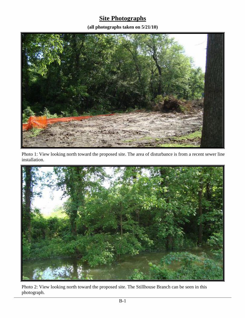
Photo 1: View looking north toward the proposed site. The area of disturbance is from a recent sewer line installation.
Photo 2: View looking north toward the proposed site. The Stillhouse Branch can be seen in this photograph.

Ms. Margaret Harney August 10, 2010 Page 6
Photo 3: View looking southwest toward the area of maintained lawn with scattered trees.
Photo 4: View looking south toward the project area.

Ms. Margaret Harney August 10,2010 Page 7
Photo 4: View looking northwest toward the wastewater treatment facility adjacent to the proj ect area.

From: Chris [email protected] Date: July 10,20098:51:46 AM COT To: Bruce Shackleford <[email protected]> Subject: Re: City of Batesville Mussel Survey
Bruce,
The FWS concurs with the results included in the draft mussel survey report submitted to the City of Batesville. Please use this email as official concurrence from the FWS . regarding the report. The FWS has no further ESA concerns at this time. Should the scope of the project change, please notify the FWS for further review of proposed changes and any additional requirements. Survey results are valid for one year, unless otherwise specified by the FWS.
Chris Davidson Endangered Species Coordinator
u. S. Fish & Wildlife Service Arkansas Field Office 110 South Amity Road, Suite 300 Conway, AR 72032
office: 501-513-4481 cell: 501-730-3268 fax: 501-513-4480 email: chris [email protected] cBruce Shackleford <[email protected]>

" 'Project
Project No. Sheet No. ___ Of
By ________ ' Date ____ _ __---=>,.--____ Date ___ _
~h ~ W <;r ,..
~ f$ is' .. ~
~ ~ --I
g'
i ~
T ~
1 HOBAS PIPE USA '1413 E. Richey Road' Houston, TX • Tel: 800-856-7473 • Fax: 281·821·7715
, [email protected] • www.hobaspipe.com
HOBAS(

.. Project
Project No. Sheet No. Of
By _________ Date _____ Chkd. By ____ ~----
---~ --~----"
-" ---_ .. ,,-.. _- _ ..
---~
"-.. _----- " ~_N._. ______ .__.. __
"------"-
.--HOBAS PIPE USA '1413 E. Richey Road' Houston. TX ' li I: 800-856-7473 ' Fax: 281-821-7715
[email protected] ' www.hobspipe.com
"

IN REPLY REFER TO:
Reference: TA0076
Kevin Jaynes FEMA 8900 N Loop 288 Denton, TX 76209
Dear Mr. Jaynes,
United States Department of the Interior
HcCEhitrfJ~:tI:AJ:',fL1:'WILDLIFE SERVICE fELV\, 8t.CtlO\S'!!Amity Road, Suite 300
Conway, Arkansas 72032
ZmD ['lO:!~'8 5P':y51~tt1° Fax: 501/513-4480
October 27, 2010
U.s. FISH & WILDLIFE
SERVICE
~ .:., t!tt
5iii , .. "J~~ ~OF~
The Fish and Wildlife Service (Service) has reviewed the information supplied in your letter dated August 10, 2010, regarding the proposed replacement of a pedestrian bridge in Batesville, Independence County, Arkansas. Our comments are submitted in accordance with the Endangered Species Act (87 Stat. 884, as amended 16 U.S.C. 1531 et seq.).
The following endangered species are known to occur in Independence County: gray bat (Myotis grisescens), Indiana bat (Myotis sodalis), pink mucket (Lampsilis abrupta), and running buffalo clover (Trifolium stoloniferum). The Service has concluded that this project may affect, but is not likely to adversely affect these listed species, provided the following recommendations are implemented.
The true extent of underground environments are difficult to delineate and features such as caves, sinkholes, springs, losing streams, and underground passages may occur on or near your project site, even in previously developed areas. Therefore, the Service recommends the following precautionary measures to avoid impacts to groundwater and sensitive/endangered species not previously known. These include:
1. Survey for karst features including caves, springs, sinkholes, and losing streams prior to initiating project activities. If such a feature is found, please establish a 300 foot conservation zone around its location and contact the Service for an onsite karst evaluation.
2. If caves are encountered during construction activities, the Service requests that work efforts cease within 300 feet of the opening. The opening should be adequately marked, fill material should not be placed in the cave, personnel should not enter the cave, and the Service should be contacted immediately.
Best management practices (BMPs) should be properly installed and maintained throughout construction to minimize erosion. These BMPs should be maintained until the site is adequately re-vegetated to prevent soil loss and sedimentation in nearby streams.

We appreciate your interest in the conservation of endangered species. If you have any questions, please call Chris Davidson at (501) 513-4481 or Sarah Pavan at (501) 513-4487.
Sincerely,
!fI 11argaretllarney Environmental Coordinator


) .
March 26, 2010
George H. McCluskey Senior Archaeologist and Section 106 Review Coordinator Arkansas Historic Preservation Program 1500 Tower Building 323 Center Street Little Rock, AR 73201
U.5. Department ofllomeland Security Federal Emergency Management Agcncy 800 N Loop 288 Denton. TX 76209
FEMA
RE: Section 106 Review Consultation, FEMA-DR-1751-AR, Severe Storms and Flooding Request for Concurrence with Finding of "No Historic Properties Affected" Replacement of pedestrian bridge in new location (UTM I5S 623356 3958056; Latitude 35.7588, Longitude -91.6355), Independence County, Arkansas, PW # 4297
Dear Mr. McCluskey:
The Federal Emergency Management Agency (FEMA) will be providing funds authorized under the Robert T. Stafford Disaster Relief and Emergency Assistance Act, P.L. 93-288, as amended, in response to FEMA Region VI, DR-175I-AR. FEMA is initiating the Section 106 review process for the above referenced property in accordance with the National Historic Preservation Act and its implementing of regulations in 36 CFR part 800. It is proposed that federal funding through FEMA's Public Assistance program be provided to the City of Batesville (Applicant) for the replacement of a walking bridge damaged by floodwaters in an alternate location (Undertaking).
Heavy rains and flooding from Poke Bayou damaged the Hiking Trail Park including a pedestrian bridge. In order to reduce the likelihood of future damage and to make the bridge more functional in relation to the trails, the Applicant proposes to move the pedestrian bridge to a new area of the park (UTM I5S 623356 3958056; Latitude 35.7588, Longitude -1.6355).
On July 14,2009, the University of Arkansas (UA) Archeological Survey conducted the cultural resources survey of the area for a sewer line and water project. This survey area is approximately 70 meters from the location of the proposed pedestrian bridge. The July 2009 survey report notes that none of the subsurface investigations found evidence of archeological deposits. The UA Archeological Survey concluded that the proposed water and sewer lines would not adversely affect cultural resources and no further work was recommended. The UA Archeological Survey transmitted a copy of the report "Archeological Survey of the Batesville Sewer Improvements, Independence County, Arkansas" to the Arkansas Historic Preservation Program on August 3, 2009. Deputy SHPO Frances McSwain responded to the submittal of the report in a letter dated August

J
.George H. McCluskey • March 26, 2010
Page 2
In that letter Ms. McSwain concluded that on the basis of the information contained in the report, the undertaking will have no effect on historic properties.
Based upon the recent survey of the area; the results of that survey and the survey area's location less that 70 meters from the site of the new pedestrian bridge, FEMA has determined that there will be No Historic Properties Affected by the proposed pedestrian bridge. Additionally, FEMA will condition this project with the following statement: "In the event that archeological deposits, including any Native American pottery, stone tools, bones, or human remains, are uncovered, the project shall be halted and the applicant shall stop all work immediately in the vicinity of the discovery and take reasonable measures to avoid or minimize harm to the finds. All archeological findings will be secured and access to the sensitive area restricted. The applicant will inform FEMA immediately and FEMA wiIl consult with the SHPO or THPO and Tribes and work in sensitive areas cannot resume until consultation is completed and appropriate measures have been taken to ensure that the project is in compliance with the National Historic Preservation Act." FEMA requests your concurrence with this determination.
If you have any questions, please contact Leah Anderson at (940) 383-7288 or via email at leah .anderson!a{dhs.gov.
Enclosures
Sincerely,
~~~ Teresa L. Lukes Deputy Regional Environmental Officer FEMA Region VI

George H. McCluskey ) "March 26,2010
Page 3
u.s. Department of Homeland Security Federal Emergency Management Agency Section 106 Review: USGS Quad Location Map
Resource Name: Pedestrian Bridge, Independence County, Arkansas
Resource Coordinates: (UTM 15S 623356 3958056; Latitude 35.7588, Longitude -91.6355)

·George H. McCluskey • March 26, 2010
Page 4
U.S. Department of Homeland Security Federal Emergency Management Agency Section 106 Review: Location Map
Resource Name: Pedestrian Bridge, Independence County, Arkansas
Resource Coordinates: (UTM 1556233563958056; Latitude 35.7588, Longitude -91.6355)


Mr. George McCluskey
AHPP
APR 222010
April 22, 2010
State Historic Preservation Office Department of Arkansas Heritage 323 Center Street, Suite 1500 Little Rock, AR 72201
u.s. Department of Homeland Security Federal Emergency Management Agency Little Rock Joint Field Office FEMA-1872-DR-AR 2637 Lakewood Village Dr. North Little Rock, AR 72116 Office: (501) 918-5000 Fax: (501) 753-6143
72-<.-4-1
~J?~
RE: Request to Continue Consultation under Section 106 of the National Historic Preservation Act for FEMA-DR-1751-AR, Replacement of pedestrian bridge in new location, City of Batesville, Independence County, AR PW #4297
Undertaking: Bridge Relocation
Latitude: 35.7588; Longitude:-91.6355 UTM: 15623356958056 Quad Map: Batesville
Applicant: City of Batesville
Determination: No Effect to Historic Properties
Dear Mr. McCluskey:
Date 0 Iy / .:L..;:L I I c) No known historic properties will be a'ffected by this undertaking. This
effect determination could change . I • n~ lffiormation come to light.
0u.JQ LtA... Frances McSwain, Deputy Sk .. ,te
HistoriC Preservation Officar
The Federal Emergency Management Agency (FEMA) will be providing funds authorized under the Robert T. Stafford Disaster Relief and Emergency Assistance Act, P.L. 93-288, as amended, in response to FEMA Region VI, DR-1751-AR. FEMA is continuing the Section 106 review process for the above referenced property in accordance with the National Historic Preservation Act and its implementing of regulations in 36 CFR part 800. It is proposed that federal funding through FEMA's Public Assistance program be provided to the City of Batesville (Applicant) for the replacement of a walking bridge damaged by floodwaters in an alternate location (Undertaking) .
Heavy rains and flooding from the Poke Bayou damaged the Hiking Trail Park including a pedestrian bridge. In order to reduce the likelihood of future damage and to make the bridge more functional in location to the trails, the Applicant proposes to move the pedestrian bridge to a new area of the park (UTM 15S 623356 3958056; Latitude 35.7588, Longitude -91.6355).

Mr. George McCluskey April 22, 2010 Page 2 On March 26, 2010, FEMA initiated consultation with the Arkansas Historic Preservation Program (AHPP), AHPP Staff Archeologist Steve Imhoff responded in a letter dated April 5, 2010 requesting more information regarding the proposed project. The location of the damaged bridge is (UTM 15S 622468E 3961055S, Latitude 35.785953, Longitude -91.644869) and is to be abandoned in place. The bridge no longer connects the walking trails and the subdivision on the west side of the remains has turned the bridge into a fishing pier. Per personal communication with the City of Batesville’s Public Works Engineer, the bridge is about 10 years old; however, he is unsure of the actual age. A review of the National Register listings on the AHPP website for Independence County revealed that this bridge is not currently listed on the National Register of Historic Places. A review of the Arkansas State Highway and Transportation Department listings for historic bridges did not have this bridge listed on their files. A review of the Automated Management of Archeological Site Data in Arkansas (AMASDA) revealed that this bridge is not listed in their files. Photos of the bridge are attached. Should you need additional information, please contact Chelsea Klein, Historic Preservation Specialist at (501) 918-5035.
Sincerely,
Lynn Starnes
Environmental Advisor FEMA-1872-DR-AR Attachments: (3)
Aerial photographs of site Topographic Map Photographs

U.S. Department of Homeland Security Federal Emergency Management Agency Section 106 Review: Aerial View Location Map
Resource Name: Bridge Relocation Project, Damaged Bridge, Batesville, Resource Address: off of highway 25, Batesville, Independence County, AR Resource Coordinates: Latitude: 35.7588; Longitude:-916355

U.S. Department of Homeland Security Federal Emergency Management Agency Section 106 Review: USGS Topographic Map
Resource Name: Bridge Relocation Project, Damaged Bridge, Batesville, Resource Address: off of highway 25, Batesville, Independence County, AR Resource Coordinates: Latitude: 35.7588; Longitude:-916355
0 0.5 Mi
0 2000 Ft
State: Arkansas
Topo Map Source: Batesville
Source Scale: 1:24000
Map Source Year: 1989
PLSS Township:9 T13.0N, R6.0W
PLSS Section: 9

View of bridge looking south. Bridge to be abadoned in place.

Appendix B
Eight-Step Process Checklist for Floodplains

Disaster/Program: DR-4297, Environmental, Floodplain Management PW #: 04297 Reviewer: Alan Hermely, CFM
Page 1 4/22/2011
8- STEP CHECKLIST - EO 11988 and EO 11990
FLOODPLAIN MANAGEMENT – CHECKLIST (44 CFR Part 9)
Project
Amount
≤$5,000 No 8-Step Required
$5,000-$25,000 Steps 1, 4, 5, 8 Abbreviated process (only steps 1, 4, 5, 8) unless it is in floodway or coastal high hazard area, it is not repair (it is actually new construction or 'substantial improvement") or it is a structure or facility that has sustained repetitive damage from flooding from a disaster.
$25,000-$100,000
Steps 1, 2, 4, 5, 8 Abbreviated process (only steps 1, 2, 4, 5, and 8) unless it is in a floodway or coastal high hazard area, it is not repair (it is actually new construction or substantial improvement) or it is a structure or facility that has sustained repetitive damage from flooding from a disaster.
≥$100,000 Full 8-Step
PROJECT TITLE: City of Batesville Pedestrian Bridge on New Location
PROPOSED ACTION: The applicant proposes to construct a pedestrian bridge on new location through a flood zone to maintain access on a public walking trail.
Actions which have the potential to be located in a Floodway or Coastal High
Hazard Area.
YES NO Does the project include encroachments, including fill, new construction substantial improvements of structures or facilities, or other development within a designated regulatory floodway?
Proposed action: (The City of Batesville floodplain administrator has reviewed the project and has indicated that the project appears acceptable to the floodplain management regulations based upon the fact that the flood carrying capacity has not been diminished and that the project does not adversely impact any other lands during a flood event).
YES NO The proposed action is located in a V-Zone as identified on the current effective Flood Insurance Rate Map (FIRM) or more recent best available data such as Advisory Base Flood Elevations (ABFE) or preliminary DFIRM.
YES NO Is the project functionally dependent upon being near the water?
YES NO Does the project facilitate open space use?
STEP NO. 1 Determine whether the proposed action is located in a wetland and/or the 100-year
floodplain (500-year floodplain for critical actions); and whether it has the potential to affect or
be affected by a floodplain or wetland (see Sec. 9.7);

Disaster/Program: DR-4297, Environmental, Floodplain Management PW #: 04297 Reviewer: Alan Hermely, CFM
Page 2 4/22/2011
.Flood Hazard data available (check the box that applies)
YYEESS NNOO TThhee pprroojjeecctt iiss llooccaatteedd iinn aa 110000 yyeeaarr ffllooooddppllaaiinn aass mmaappppeedd bbyy
FFIIRRMM NNoo:: 05063C0195D,, DDaatteedd:: 3/17/2010
YYEESS NNOO The project is located in a 500 year floodplain as mapped by FIRM Panel No. , Dated .
YES NO The project is located in a floodplain as mapped by a FEMA draft/preliminary study. Name Dated .
YES NO The project is located in a floodplain as mapped by the local community. Name Dated .
YES NO The project is located in a floodplain as mapped by another Agency (State, Corps, USGS, NRCS, and etc.) Agency, Name Dated
Flood Hazard data not available
YES NO The proposed action is subject to flooding based on evaluation from soil surveys, aerial photos, site visits and other available data. Evaluation material used in determination:
YES NO FEMA assumes the proposed action is subject to flooding based upon on previous flooding of the facility/structure.
IF ANY OF THE ABOVE ANSWERS ARE YES, CONTINUE WITH THE FOLLOWING
STEPS, OTHERWISE REVIEW IS COMPLETE.
STEP NO. 2 Notify the public at the earliest possible time of the intent to carry out an action in a
floodplain or wetland, and involve the affected and interested public in the decision-making
process (see Sec. 9.8);
Notice was provided as part of a disaster cumulative notice.
Project Specific Notice was provided by: City of Batesville
Type of Public Notice:
Newspaper, (name: Batesville Guard)
Post Site, (location: )
Broadcast, (station: )
Direct Mailing, (area: )
Public Meeting, (dates: )
Other:

Disaster/Program: DR-4297, Environmental, Floodplain Management PW #: 04297 Reviewer: Alan Hermely, CFM
Page 3 4/22/2011
Date of Public Notice: The public notice will be incorporated into the notice of availability for the Draft Environmental Assessment.
STEP NO. 3 Identify and evaluate practicable alternatives to locating the proposed action in a
floodplain or wetland (including alternative sites, actions and the ``no action'' option) (see Sec.
9.9). If a practicable alternative exists outside the floodplain or wetland FEMA must locate the
action at the alternative site.
Alternative Options
YES NO Is there a practicable alternative site location outside of the 100-year floodplain?
Site location:
YES NO For Critical Actions, is there a practicable alternative site location outside of the 500-year floodplain?
Site location:
YES NO Is there a practicable alternative action outside of the 100-year floodplain that will not affect the floodplain?
Proposed action: (The applicant proposes to construct a pedestrian bridge through a flood zone because the structure is functionally water dependent).
YES NO Is there a practicable alternative located outside of an identified wetland which will not affect the wetland or wetland values?
YES NO Is the NO Action alternative the most practicable alternative?
IF ANY ABOVE ANSWER IS YES, THEN FEMA SHALL TAKE THAT ACTION AND THE
REVIEW IS CONCLUDED. EXPLAIN WHY EACH ALTERNATIVE WAS NOT CHOSEN.
STEP NO. 4 Identify the potential direct and indirect impacts associated with the occupancy or
modification of floodplains and wetlands and the potential direct and indirect support of
floodplain and wetland development that could result from the proposed action (see Sec. 9.10);
YES NO Is the Proposed Action based on incomplete information?
YES NO Is the proposed action in compliance with the NFIP?
Proposed action: (The City of Batesville floodplain administrator has reviewed the project and has indicated that the project appears acceptable to the floodplain management regulations based upon the fact that the flood carrying capacity has not been diminished and that the project does not adversely impact any other lands during a flood event).

Disaster/Program: DR-4297, Environmental, Floodplain Management PW #: 04297 Reviewer: Alan Hermely, CFM
Page 4 4/22/2011
YES NO Does the proposed action increase the risk of flood loss?
YES NO Will the proposed action result in an increased base discharge or increase the flood hazard potential to other properties or structures?
YES NO Does the proposed action minimize the impact of floods on human health, safety and welfare?
YES NO Will the proposed action induce future growth and development, which will potentially adversely affect the floodplain?
YES NO Does the proposed action involve dredging and/or filling of a floodplain or wetland? Applicant will have to use fill to install the new bridge.
YES NO Will the proposed action result in the discharge of pollutants into the floodplain or wetland?
YES NO Does the proposed action avoid long and short-term adverse impacts associated with the occupancy and modification of floodplains or wetlands?
YES NO Will the proposed action result in any indirect impacts that will affect the natural values and functions of floodplains or wetlands?
YES NO Will the proposed action forego an opportunity to restore the natural and beneficial values served by floodplains?
YES NO Does the proposed action restore and/or preserve the natural and beneficial values served by floodplains and/or wetlands?
YES NO Will the proposed action result in an increase to the useful life of a structure or facility?
STEP NO. 5 Minimize the potential adverse impacts and support to or within floodplains and
wetlands to be identified under Step 4, restore and preserve the natural and beneficial values
served by floodplains, and preserve and enhance the natural and beneficial values served by
wetlands (see Sec. 9.11);
YES NO Were flood hazard reduction techniques (see technical bulletins) applied to the proposed action to minimize the flood impacts if site location is in the 100-year floodplain?
If No, Identify flood hazard reduction techniques required as a condition of the grant:
YES NO Were avoidance and minimization measures applied to the proposed action to minimize the short and long term impacts on the 100-year floodplain or wetland?
If no, identify measures required as a condition of the grant:
YES NO Were measures implemented to restore and preserve the natural and beneficial values of the floodplain and/or wetlands.

Disaster/Program: DR-4297, Environmental, Floodplain Management PW #: 04297 Reviewer: Alan Hermely, CFM
Page 5 4/22/2011
If no, identify measures required as a condition of the grant:
IF ANY ABOVE ANSWER IS NO, EXPLAIN WHY:
STEP NO. 6 Reevaluate the proposed action to determine first, if it is still practicable in light of
its exposure to flood hazards, the extent to which it will aggravate the hazards to others, and its
potential to disrupt floodplain and wetland values and second, if alternatives preliminarily
rejected at step 3 are practicable in light of the information gained in Steps 4 and 5. FEMA shall
not act in a floodplain or wetland unless it is the only practicable location (see Sec. 9.9);
YES NO The action is still practicable at a floodplain site in light of the exposure to flood risk and ensuing disruption of natural values;
YES NO The floodplain site is the only practicable alternative.
YES NO There is no potential for limiting the action to increase the practicability of previously rejected non-floodplain sites and alternative actions.
YES NO Minimization of harm to or within the floodplain can be achieved using all practicable means.
YES NO The action in a floodplain clearly outweighs the requirement of E.O. 11988.
STEP NO. 7 Prepare and provide the public with a finding and public explanation of any final
decision that the floodplain or wetland is the only practicable alternative (see Sec. 9.12);
Final Notice was provided as part of the floodplain notice. See EO 11988 checklist.
Notice was provided as part of a disaster cumulative notice.
Project Specific Notice was provided by: City of Batesville
Type of Public Notice:
Newspaper, ()
Post Site, (location: )
Broadcast, (station: )
Direct Mailing, (area: )
Public Meeting, (dates: )
Other:
Date of Public Notice: The City of Batesville must prepare and provide Public Notice issued 15 days prior to the start of construction of any final decision where proposed floodplain or wetland project is the only practicable alternative.

Disaster/Program: DR-4297, Environmental, Floodplain Management PW #: 04297 Reviewer: Alan Hermely, CFM
Page 6 4/22/2011
STEP NO. 8 Review the implementation and post-implementation phases of the proposed action
to ensure that the requirements stated in Sec. 9.11 are fully implemented. Oversight responsibility
shall be integrated into existing processes.
YES NO Was Grant conditioned on review of implementation and post-implementation phases to insure compliance of EO 11988? This step is completed with the NEPA determination.

Appendix C
Photograph Log
Site Photographs (all photographs taken on 5/21/10)
B-1
Photo 1: View looking north toward the proposed site. The area of disturbance is from a recent sewer line installation.
Photo 2: View looking north toward the proposed site. The Stillhouse Branch can be seen in this photograph.

Site Photographs (all photographs taken on 5/21/10)
B-2
Photo 3: View looking southwest toward the area of maintained lawn with scattered trees.
Photo 4: View looking south toward the project area.

Site Photographs (all photographs taken on 5/21/10)
B-3
Photo 5: View looking northwest toward the city park adjacent to the project area.
Photo 6: View looking northwest toward the wastewater treatment facility adjacent to the project area.


![Wetted Mobile Packed Bed [Compatibility Mode]](https://img.dokumen.tips/doc/110x75/577c77921a28abe0548ca292/wetted-mobile-packed-bed-compatibility-mode.jpg)


