Embed Size (px)
Citation preview

APPENDIX-4
Utility Survey Report

P a g e | 1
TABLE OF CONTENTS Page No. EXECUTIVE SUMMARY............................................................................................................ 3 1. INTRODUCTION................................................................................................................... 4 2. SURVEY LOCATION............................................................................................................. 5 3. SCOPE OF WORK................................................................................................................ 9 4. SURVEY DESIGN.............................................................................................................. .10 5. PERSONNEL...................................................................................................................... 11 6. SURVEY CONTROL............................................................................................................ 12 7. FIELD PHOTOGRAPHS ......................................................................................................13 8. Conclusions ......................................................................................................................18
AP4-1

P a g e | 2 List of tables
Table No. Description Page No. Table 1 Sections of Survey area 9 Table 2 Survey Personal 10Table 3 Utility and Obstacle coming under MTHL
alignment 12
List of Figure
Figure number.
Description Page No.
Figure 1 Key plan of Survey Location 5 Figure 2 Survey location on Eastern freeway Interchange side 5 Figure 3 Survey area Shivaji Nagar side 6 Figure 4 Survey area at Chirle side 7 Figure 5 HP Oil pipe line at Sewri side 13 Figure 6 BP LUBE Oil pipe line at Sewri side 14 Figure 7 Indian Oil petrol pipe line Sewri Side 14 Figure 8 Hindustan Petrolium petrol pipe line Sewri Side 15 Figure 9 Indian oil pipe line Sewri Side 15 Figure 10 Railway line at Jasai crossing the MTHL alignment and
electric transformer16
Figure 11 Transmission tower and electric line at Gavan gaon 16 Figure 12 Water pipe line of CIDCO at Jasai Village 17
AP4-2

P a g e | 3 EXECUTIVE SUMMARY
SOWiL Ltd. was contracted by Oriental Consultant Global Co. Ltd. Japan vide service agreement between them on 19th May 2015 to carry out the utility and obstacle surveys (the Works) to be conducted for The Preparatory Survey on the Project for Construction of Mumbai Trans Harbour Link (MTHL) across the Mumbai Bay between Mumbai and Navi-Mumbai City which conducted by the JICA Study Team The Works is carried out to obtain utility information at bridge sites on proposed MTHL alignment. The objectives of the survey to clarifying the utility and obstacle (under-ground utilities, aerial line, power pole, hazardous objects, marine structures, etc.) and their condition (authority, location, kind, size, construction year, future plan, etc.) to make a plan of MTHL. Utility Survey on landside was commence on 25th May and completed on 30th June.
This report consist the information about the utility and obstacle crossing and along the proposed alignment of MTHL project.
Utility of different owners namely HPC, IOCL, BPCL, MBPT, Tata Power , MJP , Reliance, Cidco, etc. where contacted contractors and information collected from the utility owner and marked on the drawings and drawings are included in this report
AP4-3

P a g e | 4 1. INTRODUCTION
Mumbai Trans Harbor Link (MTHL), also known as Sewri-Nhava Sheva Trans Harbor Link, is a proposed 22 km, freeway grade road bridge connecting the Indian city of Mumbai with Navi Mumbai. It would be the longest sea bridge in India after completion. The bridge will begin in Sewri, Mumbai and cross Thane Creek north of Elephanta Island and will terminate at Chirle village, near Nhava Sheva. The road will be linked to the Mumbai Pune Expressway in the east, and to the proposed Western Freeway along the west coast of Mumbai. SOWiL Ltd. was contracted by Oriantal Consultant Global Co. Ltd. Japan vide service agreement between them on 19th May 2015 to carry out the utility and obstacle surveys (the Works) to be conducted for The Preparatory Survey on the Project for Construction of Mumbai Trans Harbour Link (MTHL) across the Mumbai Bay between Mumbai and Navi-Mumbai City which conducted by the JICA Study Team Survey was based on the survey area details provided by the client .
AP4-4

P a g e | 5 2. SURVEY LOCATION The survey area specified by the client is shown in the Google image below. The coordinates of the survey routes were extracted from the drawing provided by the client.
Figure 1:- Key plan of Survey location
Figure 2:- Survey location on Eastern freeway Interchange side
AP4-5

P a g e | 6
Figure 3:- Survey area Shivaji Nagar side
AP4-6

P a g e | 7
Figure 4:- Survey area at Chirle side
AP4-7

P a g e | 8 3. SCOPE OF WORK
1) Utilities Survey which includes the preparation of survey sheets / drawings and the site
reconnaissance, along the proposed route of MTHL. 2) Collecting information on obstacles from related organizations. In the information, the
facility name, location, type of utility , utility size and the opinion to the alignment of proposed bridge , When possible, collection of as as-built drawing and future plan .
3) Carry out the site reconnaissance except for the Marine section. 4) Preparation of survey drawings, survey sheets, reports, site photograph and other
references, based on the Engineer-supplied survey-sheet Preparation of report After completion of field report the report preparation is done which includes the following points 1) Evaluation of the survey results 2) Drawing of Surveys (Plan drawings of Obstacles location with having coordinates of UTM-WGS84, Typical cross-section drawing only for main and complicated structures, etc.) 3) Reports including Survey sheet, Site photograph, etc. 4) Reference data (As-built drawings, future plan, other references, etc.)
AP4-8

P a g e | 9 4. Survey Design
Survey area is constuted by marine section and land section on both the side. The survey area on the main line is 50m on the up stream side and 50 down stream side of the MTHL alignment as given in the table below.
Section Length Assumed Main Utility and Obstacle
Remark
1 Mumbai Side 0.49 km Power Cable/Pole Under-ground Utilities Existing Road Existing Railway Others
2 Marine (Mumbai Bay Section)
18.33 km Tata Intake/Discharge Channel Tata Coal Berth Channel Oil Product, Freshwater Pipelines Power, Telephone Cables Pir Pau Jetty Thane Creek ONGC*&BPLC Pipelines Panvel Creek Others
3 Navi Mumbaiside (Chirle) Land section
3 39 km Power Cable/Pole Under ground Utilities Existmg Road Proposed Road Existing Railway others
Table 1. Sections of Survey area
AP4-9

P a g e | 10 5. PERSONNEL The following survey personnel were involved in the survey. Topographic Survey Name Designation Duration Binno Kuruvilla Chief Surveyor consultant Project Duration Arun Traffic Engineer Project Duration Prakash Gode Surveyor Project Duration Prashant Draftsman Project Duration Hari Surveyor Assistant Project Duration
Table 2:-Survey Personal 5.1 HSE Management System The project manager took responsibility for all HSE related issues during the survey. Prior to survey, the party chief carried out a safety briefing for the survey personnel. The survey operations were performed in day-light hours and regular safety “tool-box” meetings were conducted to ensure smooth deck operations for the deployment and recovery of survey sensors. All HSE related measures were fully implemented to the survey team during the course of the survey.
AP4-10

P a g e | 11 6. SURVEY CONTROL The survey operations were conducted visiting the survey locations
1) Visible inspections and observations for utilities 2) At site alignment marker, post for underground utility 3) Information regarding the utility owner collected and contacted their respective office/
project locations 4) Utility owener informed the about the proposed MTHL alignment plan and given
drawings to marked there utilities on the drawings 5) The drawings marking the utilities from the owner collected .
List of the utility owners, there contact details location of the utility type and size of utility is given in the table below.
AP4-11

P
ag
e | 12
1 RELIANCE JNPT, MR. SANJAY CHOPRA - 9920546112 SHIVAJI NAGAR, KOPAR G/S PETROLIUM PIPE LINE
2 MJP MJP,PANVEL MR. JASAI, SH G WATER PIPE LINE 445 mm DIA.
3 DEEPAK FERTILIZER TALOGA MIDC, MR ANTHONY ROADRISK, 9765568126 JASAI G GAS PIPE LINE 300 mm Dia.
4 IOCLSEWRI TERMINAL Mr. Sanjay Talukdar, 022 24147129, MR. A.T. Khobarekar (Deputy Manager) Mob. 88791
96222 email - [email protected] G PETROLIUM PIPE LINE, dia
300 mm
5 BPCL MR. Sunil Mali , Mob. 9930765237 SEWRI G Lube Oil pipe line dia. 300 mm
6 BPCL REFINERY
MR. Mangesh jadhav Mob. 9920666544, email - [email protected], Mr. Deepak
Chinta (Dy manager) 9820219683 email- [email protected]
SEA (Co-ordinates given in the drawings)
S LPG GAS PIPE LINE
7 BMC PAREL - WARD -F BPT AREA G WATER PIPE LINE
8 CIDCO CBD BELAPUR - RAIIGAD BHAWAN Mr. Sai Madvi Mob. 9619263535 JASAI G 825 mm Dia water pipe line
9 MBPT MR. D.Vishwanathan (9820020572) ADD. Chief Machanical Engineer)
SEA (Co-ordinates given in the drawings)
S OIL PIPE LINE
10 HPCLLube gate, Mahul gaon, opp. Tata power, Mr. V.K. Singh (
022 2554 5810) Mob. 97020 44207 . Email [email protected]
SEWRI G PETROLIUM PIPE LINE, dia 300 mm
11 TATA POWER (CABLE DETAILS)
1) Mr. N.R. Sirdesai (Head EHV Cable) Lower parel - Mob. 92233 11454, e-mail [email protected]. 2) Mr.
K B Pawar, mob. 90290 16881 SEWRI S CABLE
12 TATA POWER (JETTTY) Mr. J. Dsouza, Phone no. 022 6717 5110, email - [email protected], MOB- 92233 83841 SEWRI S JETTY, CABLE
13 GAIL INDIA LIMITEDGAIL INDIA LIMITED, CBD BELAPUR CONTACT PERSON
MR. GONDANE, MOB. 9819734375 NH4-B GGAS PIPE LINE 300 mm Dia. DEPTH BELOW GROUND IS
1.5 M.
Table number 3 UTILITY AND OBSTACLES COMING UNDER MTHL ALIGNMENT
SR. NO. UTILITY OWNER NAME CONTACT DETAILS LOCATION SEA / GROUND
TYPE OF UTILITY
AP4-12

P a g e | 13 7. Field Photograph
Figure 5 HP Oil pipe line at Sewri side
HP Oil pipe line
AP4-13
P a g e | 14
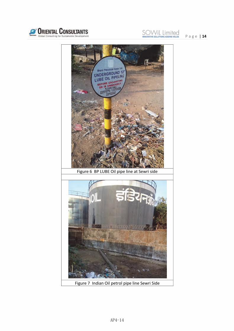
Figure 6 BP LUBE Oil pipe line at Sewri side
Figure 7 Indian Oil petrol pipe line Sewri Side
AP4-14

P a g e | 15
Figure 8 Hindustan Petrolium petrol pipe line Sewri Side
Figure 9 Indian oil pipe line Sewri Side
AP4-15

P a g e | 16
Figure 11 Transmission tower and electric line at Gavan gaon
Figure 10 Railway line at Jasai crossing the MTHL alignment and electric transformer
AP4-16

P a g e | 17
Figure 12 Water pipe line of CIDCO at Jasai Village
AP4-17

P a g e | 18 8.0 Conclusion
On completion of the survey information collected from different utility agencies marked on autocad drawings in WGS84 system and they are included in the drawings and included into the report
DRAWING LIST OF MTHL TOPOGRAPHY SURVEY Sl. No. Drawing No. Drawing Title Rev. Submissio
n DATE 1 SOWiL/MTHL/TOPO/LAND-01 LAYOUT TOPOGRAPHY DETAILS
OF MTHL R0 04.07.2015
2 SOWiL/MTHL/TOPO/LAND-02 LAYOUT TOPOGRAPHY DETAILS OF MTHL R0 04.07.2015
3 SOWiL/MTHL/TOPO/LAND-03 LAYOUT TOPOGRAPHY DETAILS OF MTHL R0 04.07.2015
4 SOWiL/MTHL/TOPO/LAND-04 LAYOUT TOPOGRAPHY DETAILS OF MTHL R0 04.07.2015
5 SOWiL/MTHL/TOPO/LAND-05 LAYOUT TOPOGRAPHY DETAILS OF MTHL R0 04.07.2015
6 SOWil/MTHL/CM/01 SH. 1 OF 7 CONTOUR MAP R0 11.07.15
7 SOWil/MTHL/CM/01 SH. 2 OF 7 CONTOUR MAP R0 11.07.15
8 SOWil/MTHL/CM/01 SH. 3 OF 7 CONTOUR MAP R0 11.07.15
9 SOWil/MTHL/CM/01 SH. 4 OF 7 CONTOUR MAP R0 11.07.15
10 SOWil/MTHL/CM/01 SH. 5 OF 7 CONTOUR MAP R0 11.07.15
11 SOWil/MTHL/CM/01 SH. 6 OF 7 CONTOUR MAP R0 11.07.15
12 SOWil/MTHL/CM/01 SH. 7 OF 7 CONTOUR MAP R0 11.07.15
7 SOWil/MTHL/SC/01 SH. 1 OF 9
SECTIONAL DETAILS OF GROUND LEVEL AT SEWRI SIDE R0 10.06.15
8 SOWil/MTHL/SC/01 SH. 2 OF 9
SECTIONAL DETAILS OF GROUND LEVEL AT SEWRI SIDE R0 10.06.15
9 SOWil/MTHL/SC/01 SH. 3 OF 9
SECTIONAL DETAILS OF GROUND LEVEL AT SEWRI SIDE R0 10.06.15
10 SOWil/MTHL/SC/01 SH. 4 OF 9
SECTIONAL DETAILS OF GROUND LEVEL AT SHIVAJINAGAR AND CHIRLE
R0 10.06.15
11 SOWil/MTHL/SC/01 SH. 5 OF 9
SECTIONAL DETAILS OF GROUND LEVEL AT SHIVAJINAGAR AND CHIRLE
R0 10.06.15
12 SOWil/MTHL/SC/01 SH. 6 OF 9
SECTIONAL DETAILS OF GROUND LEVEL AT SHIVAJINAGAR AND R0 10.06.15
AP4-18

P a g e | 19
CHIRLE
13 SOWil/MTHL/SC/01 SH. 7 OF 9
SECTIONAL DETAILS OF GROUND LEVEL AT SHIVAJINAGAR AND CHIRLE
R0 10.06.15
14 SOWil/MTHL/SC/01 SH. 8 OF 9
SECTIONAL DETAILS OF GROUND LEVEL AT SHIVAJINAGAR AND CHIRLE
R0 10.06.15
15 SOWil/MTHL/SC/01 SH. 9 OF 9
SECTIONAL DETAILS OF GROUND LEVEL AT SHIVAJINAGAR AND CHIRLE
R0 10.06.15
8 SOWiL/MTHL/SURVEY/GL/01 VERTICAL PROFILE OF SEA AND LAND PORTION.. R0 11.07.2015
9 SOWiL/MTHL/SURVEY/COMBINED(SEA&LAND)-01
ROUTE 1 BATHYMETRY (Sheet 1 of 3) R0 11.06.2015
10 SOWiL/MTHL/SURVEY/COMBINED(SEA&LAND)-01
ROUTE 1 BATHYMETRY (Sheet 2 of 3) R0 11.06.2015
11 SOWiL/MTHL/SURVEY/COMBINED(SEA&LAND)-01
ROUTE 1 BATHYMETRY (Sheet 3 of 3) R0 11.06.2015
12 SOWiL/MTHL/SURVEY/COMBINED(SEA&LAND)-02 ROUTE 2 & 3 BATHYMETRY R0 11.06.2015
13 OSaS/P19415/SOWiL/Mum/Bathy/01 Route 1 bathematry R0 04.06.2015
14 OSaS/P19415/SOWiL/Mum/Bathy/02 Route 2 and 3 bathematry R0 04.06.2015
15 Utility report MTHL TOPO & UTILITY FINAL as on 030.08.15_R2.dwg
DRAWING LIST OF MTHL UTILITY SURVEY
1 SOWiL/MTHL/UTILITY/BPCL-01
LOCATION OF EXISTING UTILITY OF BPCL R0 04.07.2015
2 SOWiL/MTHL/UTILITY/IOCL-01
LOCATION OF EXISTING UTILITY OF IOCL R0 04.07.2015
3 SOWiL/MTHL/UTILITY/BMC-01
LOCATION OF EXISTING UTILITY OF BMC R0 04.07.2015
4 SOWiL/MTHL/UTILITY/RIL-01 LOCATION OF EXISTING UTILITY OF RELIANCE R0 04.07.2015
5 SOWiL/MTHL/UTILITY/RIL-02 LOCATION OF EXISTING UTILITY OF RELIANCE R0 04.07.2015
6 SOWiL/MTHL/UTILITY/CIDCO-01
LOCATION OF EXISTING UTILITY OF CIDCO R0 04.07.2015
7 SOWiL/MTHL/UTILITY/CIDCO-01
LOCATION OF EXISTING UTILITY OF CIDCO R0 04.07.2015
8 SOWiL/MTHL/UTILITY/DF-01 LOCATION OF EXISTING UTILITY OF D. FERTILIZER R0 04.07.2015
9 SOWiL/MTHL/UTILITY/GAIL-01
LOCATION OF EXISTING UTILITY OF GAIL INDIA R0 04.07.2015
10 SOWiL/MTHL/UTILITY/CIDCO-01
LOCATION OF EXISTING UTILITY OF MJP R0 04.07.2015
11 SOWiL/MTHL/UTILITY/MBPT-01
LOCATION OF EXISTING UTILITY OF MBPT R0 04.07.2015
AP4-19

P a g e | 20
DRAWINGS RECEIVED FROM MBPT
1 J034/MBPT/AS-BUILT-BT-PL_SF/2000/02/634
BATHYMETRY & PIPELINE AND SEABED FEATURES KP 2.100 TO KP 4.070 (JAWAHAR DEEP TO PIRPAU)
R1 04.07.2015
2 J034/MBPT/AS-BUILT/SP-PP/2000/01/636
LONGITUDINAL SEABED & PIPELINE PROFILE KP 0.014 TO KP 0.680 (JAWAHAR DEEP TO PIRPAU)
R0 04.07.2015
3 J034/MBPT/AS-BUILT/SP-PP/2000/02/636
LONGITUDINAL SEABED & PIPELINE PROFILE KP 0.680 TO KP 1.580(JAWAHAR DEEP TO PIRPAU)
R0 04.07.2015
4 J034/MBPT/AS-BUILT/SP-PP/2000/03/636
LONGITUDINAL SEABED & PIPELINE PROFILE KP 2.360 TO KP 2.520(JAWAHAR DEEP TO PIRPAU)
R0 04.07.2015
5 J034/MBPT/AS-BUILT/SP-PP/2000/04/636
LONGITUDINAL SEABED & PIPELINE PROFILE KP 2.520 TO KP 3.420(JAWAHAR DEEP TO PIRPAU)
R0 04.07.2015
6 J034/MBPT/AS-BUILT/SP-PP/2000/05/636
LONGITUDINAL SEABED & PIPELINE PROFILE KP 3.420 TO KP 4.070(JAWAHAR DEEP TO PIRPAU)
R0 04.07.2015
7 J034/MBPT/AS-BUILT/PL-SF-SP/2000/01/639
PIPELINE AND SEABED FETURES CENTRAL LINE SEABED PROFILE (KP. 0.000 TO 4.128)
R1 04.07.2015
DRAWINGS RECEIVED FROM BPCL
1 BPCL/PDIL/JPL/LOBS/AG/01 OF 07
12" DIA. LUBE OIL PIPE LINE AT CH. 00.00 TO 00.687 KM. R0 04.07.2015
2 BPCL/PDIL/JPL/LOBS/AG/02 OF 07
12" DIA. LUBE OIL PIPE LINE AT CH. 00.00 TO 00.960 KM. R0 04.07.2015
3 BPCL/PDIL/JPL/LOBS/AG/03 OF 07
12" DIA. LUBE OIL PIPE LINE AT CH. 00.960TO 01.920 KM. R0 04.07.2015
4 BPCL/PDIL/JPL/LOBS/AG/04 OF 07
12" DIA. LUBE OIL PIPE LINE AT CH. 00.920 TO 02.880 KM. R0 04.07.2015
5 BPCL/PDIL/JPL/LOBS/AG/05 OF 07
12" DIA. LUBE OIL PIPE LINE AT CH. 02.880 TO 03.840 KM. R0 04.07.2015
6 BPCL/PDIL/JPL/LOBS/AG/07 OF 07
12" DIA. LUBE OIL PIPE LINE AT CH. 04.800 TO 005.165 KM. R0 04.07.2015
7 BPCL/PDIL/JPL/LOBS/UG/01 OF 06
12" DIA. LUBE OIL PIPE LINE AT CH. 05.175 TO 06.300 KM. R0 04.07.2015
8 BPCL/PDIL/JPL/LOBS/UG/02 OF 06
12" DIA. LUBE OIL PIPE LINE AT CH. 06.300 TO 07.300 KM. R0 04.07.2015
9 BPCL/PDIL/JPL/LOBS/UG/03 OF 06
12" DIA. LUBE OIL PIPE LINE AT CH. 07.300 TO 08.300 KM. R0 04.07.2015
10 BPCL/PDIL/JPL/LOBS/UG/04 OF 06
12" DIA. LUBE OIL PIPE LINE AT CH. 08.300 TO 09.300 KM. R0 04.07.2015
11 BPCL/PDIL/JPL/LOBS/UG/05 OF 06
12" DIA. LUBE OIL PIPE LINE AT CH. 09.300 TO 10.300 KM. R0 04.07.2015
12 BPCL/PDIL/JPL/LOBS/UG/06 OF 06
12" DIA. LUBE OIL PIPE LINE AT CH. 10.300 TO 10.700 KM. R0 04.07.2015
AP4-20

P a g e | 21
DRAWINGS RECEIVED FROM DEEPAK FERTILIZER
1 DFPCL-99/GL/001 ROUTE MAP - GAS PIPELINE 41.5 KMS. 04.09.1999
BPCL Drawing
1 Seabed Coordinates from BPCL
Coordinates of BPCL seabed pipeline of 12 kms 17.08.15
Tata power Cable
1 Acknowledgement copy from SOWIL.pdf
Ltr from TATA to Sowil regarding Utility details 24.07.2015
2 Authority letter from MMRDA.pdf Document and Drawing in PDF 24.07.2016
3 Letter Reply from EHV Team.PDF Ltr from TATA to Sowil regarding EVH 24.07.2017
4 MMRDA BRIDGE ON TPCL PROPERTY.(11-07-15)-Model (1).pdf
TATA property and Utility 24.07.2018
5 Past communication to MMRDA from Engineering team.pdf
Communication with MMRDA in 2012 regarding Laying og HDVC cables
24.07.2019
6 PROPOSED MTHL ALIGNMENT (1).pdf Document and Drawing in PDF 24.07.2020
7 Request letter from sowil.PDF Document in PDF 24.07.20218 TATA cable on land_1 (1).PDF TATA cables on Sewri (Land)-1 24.07.20229 TATA cable on land_2 (1).PDF TATA cables on Sewri (Land)-2 24.07.2023
10 TPCL PROPERTY ON MMRDA BRIDGE DWG.(14-07-15)-Model (1).pdf
Document and Drawing in PDF 24.07.2024
AP4-21

APPENDIX-5
Letter of Shipping Channels

AP5-1

AP5-2

AP5-3

AP5-4

APPENDIX-6
MTHL Drawings over Railways

AP6-1

MUMBAI TRANS HARBOUR LINKIllustrative Design Drawing
TENDER R42011090_RH_NHAI_NH-4B_GAD_001
ELEVATION(SCALE : 1:1 @ A1 SIZE)
PLAN(SCALE : 1:1 @ A1 SIZE)
MUMBAIMUMBAI
NAVI MUMBAINAVI MUMBAI
MAIN LINE GENERAL ARRANGMENTCHAINAGE - 21+082 TO 21+716
AP6-2

AP6-3

APPENDIX-7
Gap Analysis Between Applicable Land Acts with
CIDCO Schemes and JICA Environmental Social
Guidelines 2010

Gap Analysis Between Applicable Land Acts with CIDCO Schemes and JICA Environmental Social Guidelines 2010 Sr. No.
JICA Guidelines 2010
LA1894 + MMRDA Act
CIDCO 12.5 Scheme
GAP LARR 2013 CIDCO 22.5 Scheme
GAP MUTP2000 with minor updat LA2013
1 Involuntary resettlement and loss of means of livelihood are to be avoided when feasible by exploring all viable alternatives.
No such provision of minimization of resettlement effect.
No such provision but CIDCO while acquiring avoids settlement part of the village.
No Gap Only the minimum area of land required for the project is acquired.
The appropriate government shall examine to ensure minimum displacement of people, minimum disturbance to the infrastructure, ecology and minimum adverse impact on the individuals affected.
No irrigated
No such provision but CIDCO while acquiring avoids settlement part of the village.
No Gap Involuntary resettlement should be avoided or minimized where feasible, exploring all viable alternative project designs. A
P7-1

multi-cropped land shall be acquired under this Act.
2 When population displacement is unavoidable, effective measures to minimize impact and to compensate for losses should be taken.
Only compensation is paid for the lost assets. No provision for minimization of impacts.
Compensation paid as per LA Act 1894. CIDCO tries to reduce impacts by minimizing land acquisition in settlement areas.
No Gap Whenever the appropriate Government intends to acquire land for a public purpose, it will carry out a Social Impact Assessment study in consultation with affected people.
A Rehabilitation and Resettlement Scheme shall be prepared including the particulars of the rehabilitation and resettlement entitlements of
Compensation paid as per LA Act 1894. CIDCO tries to reduce impacts by minimizing land acquisition in settlement areas.
No Gap Where displacement is unavoidable, resettlement plans should be developed. All involuntary resettlement should be conceived and executed as development programs
AP7-2

each landowner and landless whose livelihoods are primarily dependent on the lands being acquired and where resettlement of affected families is involved.
3 People who must be resettled involuntarily and people whose means of livelihood will be hindered or lost must be sufficiently compensated and supported, so that they can improve or at least restore their standard of living, income
Only compensation is paid at market value. No provision for livelihood restoration, income opportunities and restoration of standard of living.
PAPs will be provided with compensatory developed land which is 12.5% of the land acquired. 8.75% of the developed land is directly provided to PAP and 3.75% is used to provide civic amenities.
No Gap
Adequate provisions for affected persons for their rehabilitation and resettlement and for ensuring that the cumulative outcome of compulsory acquisition should be that affected persons become
PAPs will be provided with compensatory developed land which is 22.5% of the land acquired. 15.75% of the developed land is directly provided to PAP and 6.75% is used to provide civic amenities.
No Gap
PAPs should be assisted in their efforts to improve their former living standards, income earning capacity, and production levels, or at least to restore them.
AP7-3

opportunities and production levels to pre-project levels.
partners in development leading to an improvement in their post-acquisition social and economic status.
4 Compensation must be based on the full replacement cost as much as possible.
Only compensation is paid at market value.
Additional to the compensation provided in LA Act 1894 the 8.75% developed land is provided with 1.5 FSI of which 15% can be used as commercial. This provides more value than replacement cost to the PAPs.
No Gap
Payment of compensation at market value multiplied by factor determined by the government. Additional payment of solatium of one hundred percent of compensation amount.
Additional compensation in case of multiple displacement.
The scheme provides for 7.0% developed land is provided with 2.5 FSI and 8.75 land with 1.5 FSI of which 15% can be used as commercial. This provides more value than replacement cost to the PAPs.
No Gap The policy ensures benefits of R & R to PAPs for lost assets at replacement value.
PAPs should be compensated for their losses at full replacement cost.
AP7-4

5 Compensation and other kinds of assistance must be provided prior to displacement.
Compensation is paid prior to displacement but there is no provision for assistance.
Compensation is paid prior to displacement. Assistance is provided in the form of scholarships to students, vocational training, reserved jobs which continues lifelong.
No Gap Possession of land after ensuring that full payment of compensation as well as rehabilitation and resettlement entitlements are paid or tendered to the entitled persons within a period of three months for the compensation and a period of six months for the monetary part of rehabilitation and resettlement entitlements.
Compensation is paid prior to displacement. Assistance is provided in the form of scholarships to students, vocational training, reserved jobs which continues lifelong
No Gap
PAPs should be compensated for their losses at full replacement cost prior to the actual move; and should be assisted with the move and supported during the transition period in the resettlement site.
AP7-5

6 For projects that entail large-scale involuntary resettlement, resettlement action plans must be prepared and made available to the public
No provision of preparation of Resettlement Action Plan.
Master plan for entire development and total land acquisition was prepared by CIDCO in 1973. The scheme is part of the resettlement and rehabilitation efforts by CIDCO.
The scheme widely published and is open for public comments and has been updated from time to time as per inputs provided by PAPs. The scheme was first published in 1987 and was modified
No Gap
The Act ensures participation of affected stakeholders in each stages of SIA and development of R&R package.
The act also ensure that public hearing is held at the affected area, after giving adequate publicity about the date, time and venue for the public hearing, to ascertain the views of the affected families to be recorded and included in the Social Impact Assessment
Master plan for entire development and total land acquisition was prepared by CIDCO in 1973. The scheme is part of the resettlement and rehabilitation efforts by CIDCO.
The scheme widely published and is open for public comments and has been updated from time to time as per inputs provided by PAPs. The scheme was first published in 1987 and was modified
No Gap
The policy ensures meaningful consultations with stakeholders in planning and implementation of the resettlement program in order to suitably accommodate their inputs and make rehabilitation and resettlement plan more participatory and broad based.
AP7-6

as per public demand in 1990 and again in 1994.
The scheme documents are available in local language (Marathi) and are made easily accessible through publication of small booklets and availability on internet.
Report.
Social Impact Assessment study report and the Social Impact Management Plan are made available in the local language to the Panchayat, Municipality or Municipal Corporation, as the case may be, and the offices of the District Collector the Sub Divisional Magistrate and the Tehsil, and shall be published in the affected areas' in such manner and uploaded on the website of
as per public demand in 1990 and again in 1994.
The scheme documents are available in local language (Marathi) and are made easily accessible through publication of small booklets and availability on internet.
AP7-7

the appropriate Government.
7 In preparing a resettlement action plan, consultations must be held with the affected people and their communities based on sufficient information made available to them in advance.
8 When consultations
AP7-8

are held, explanations must be given in a form, manner, and language that are understandable to the affected people.
9 Appropriate participation of affected people must be promoted in planning, implementation, and monitoring of resettlement action plans.
10 Appropriate and accessible grievance mechanisms must be established for the affected people and their communities.
No provision for Grievance Redressal Mechanism.
CIDCO Grievance Redressal System is an online system through which citizens will be able to register complaints and seek redressal.
No Gap The act has provision of Rehabilitation and resettlement committee at project level with representative from all section of stakeholders,
CIDCO Grievance Redressal System is an online system through which citizens will be able to register complaints and seek redressal.
No Gap
The Grievance Redressal Committee appointed by R&R Agency comprising its officials shall have the power to consider and dispose of all complaints
AP7-9

subject to acquisition of more than 100 acres of land.
relating to resettlement and rehabilitation issues
11 Affected people
are to be identified and recorded as early as possible in order to establish their eligibility through an initial baseline survey (including population census that serves as an eligibility cut-off date, asset inventory, and socioeconomic survey), preferably at the project identification stage, to
No provision of baseline survey.
The scheme puts a cut of date of 1971 census and give rights to the officials to take decision based on availability of documents to prove eligibility.
No provision of baseline survey may be considered as a gap but it is compensated by using Census survey of India records as on 1971.
Provision of social impact assessment at early stage to ascertain project impact and census and socioeconomic survey to identify affected families and person with interest for preparation of rehabilitation and resettlement package.
The scheme puts a cut of date of 1971 census and give rights to the officials to take decision based on availability of documents to prove eligibility.
No Gap
Baseline Socio Economic Survey of affected people should be carried out at the initial stage of the project. The policy ensures benefits of R&R to PAPs including non-title holders if they are enumerated during baseline survey
AP7-10

prevent a subsequent influx of encroachers of others who wish to take advance of such benefits. (WB OP4.12 Para.6)
12 Eligibility of benefits includes, the PAPs who have formal legal rights to land (including customary and traditional land rights recognized under law), the PAPs who don't have formal legal rights to land at the time of census but have a claim to such land or assets and the PAPs who have no recognizable
Non-title holders are not eligible.
The scheme provides 40 sq. m. developed plots to all farm workers and village craftsman who do not have formal legal rights.
Gap exists in identification of PAP but CIDCO provides plots as well as vocational training for non title holders.
(1) a family whose land or other immovable property has been acquired; (ii) a family which does not own any land but a member or members of such family may be agricultural labourers, tenants including any form of tenancy or holding of usufruct right,
The scheme provides 40 sq. m. developed plots to all farm workers and village craftsman who do not have formal legal rights.
Gap in RFCTLARR Act 2013, with condition of three year for recognition of non-titleholders. CIDCO provides plots as well as vocational training for non title holders.
The policy will confirm identification of PAPs who are present on the site at the time of baseline survey which will act as a cut of date for identification of PAPs whether title holder or not.
AP7-11

legal right to the land they are occupying. (WB OP4.12 Para.15)
share-croppers or artisans or who may be working in the affected area for three years prior to the acquisition of the land, whose primary source of livelihood stand affected by the acquisition of land; (iii) the Scheduled Tribes and other traditional forest dwellers who have lost any of their forest rights recognised under the Scheduled Tribes and Other Traditional Forest
AP7-12

Dwellers (Recognition of Forest Righ6) Act, 2006 due to acquisition of land (iv) family whose primary source of livelihood for three years prior to the acquisition of the land is dependent on forests or water bodies and includes gatherers of forest produce, hunters, fisher folk and boatmen and such livelihood is. affected due to acquisition of land; (v) a member of the family who has been assigned
AP7-13

land by the State Government or the Central Government under any of its schemes and such land is under acquisition; (vi) a family residing on any land in the urban areas for preceding three years or more prior to the acquisition of the land or whose primary source of livelihood for three years prior to the acquisition of the land is affected by the acquisition of such land.
13 Preference should be given to land-based
No provision of land for land option.
The scheme provides developed
No Gap
Land for Land - In the case of irrigation
The scheme provides for 7.0%
No Gap The policy offers two resettlement
AP7-14

resettlement strategies for displaced persons whose livelihoods are land-based. (WB OP4.12 Para.11)
land for agricultural land. The developed land is provided with 1.5 FSI which includes 15% commercially development permission. These aspects provide potential for land based income.
project, as far as possible and in lieu of compensation to be paid for land acquired, each affected family owning agricultural land in the affected area and whose land has been acquired or lost.
developed land is provided with 2.5 FSI and 8.75 land with 1.5 FSI of which 15% can be used as commercial. These aspects provide potential for land based income PAPs.
options to the affected community. First is township option wherein a fully developed plot of 25 sq.m in a green field site is allotted and second option is a tenement of 20.91 sq.m in multi-storeyed buildings.
14 Provide support for the transition period (between displacement and livelihood restoration). (WB OP4.12 Para.6)
No provision for transition period.
CIDCO provides assistance in many forms viz. Scholarships are provided to all PAP students till 12th standard. Vocational training institutes are provided to improve skill
No Gap Offer for Developed Land - In case the land is acquired for urbanisation purposes, twenty per cent. of the developed land will be reserved and offered to land owning project affected
The scheme has provision for monitory support as lump sum payment for displacement and transition allowance.
No Gap The policy provides for providing cost of shifting to PAPs or free transport arrangements. For those who permanently lose their jobs, the rehabilitation package shall include access to employment
AP7-15

set of PAPs. CIDCO also provides reservations in CIDCO jobs for all the PAPs as way of livelihood restoration.
families, in proportion to the area of their land acquired and at a price equal to the cost of acquisition and the cost of development:
information through employment exchange and training facilities.
15 Particular attention must be paid to the needs of the vulnerable groups among those displaced, especially those below the poverty line, landless, elderly, women and children, ethnic minorities etc. (WB OP4.12 Para.8)
There is no provision for vulnerable group.
There is no provision for vulnerable group.
Special treatment to vulnerable is gap.
Vulnerable group such as SC and ST are provided with additional provisions under the Act.
There is no provision for vulnerable group.
Gap because of limited definition of vulnerable group in the RFTCLARR Act 2013.
Vulnerable households such as women headed households, handicapped and the aged will extended an additional package of rehabilitation services to help them overcome the difficulties on account of resettlement. This will include preference in
AP7-16

allotment of dwelling units on the ground floor for handicapped. Any further assistance required for vulnerable PAPs will be determined during SIA preparation.
AP7-17

APPENDIX-8
Fishing Survey Track and Photos

Fishing Survey Track and Photos Mumbai Trans Harbour Link – Sea Link Section
Centre Line (light blue), Survey Boat Track (Yellow) on Google Earth
Survey Boat Track (Yellow) on Nautical Chart
Fishing Boats Close to JNPT Fishing Boat Around the Project Area
AP8-1

Fishing Net Marks (Black Buoys) Placing Fishing Nets
Bamboo Fencing Bamboo Fencing and Fishing Boat 2nd Fishing Survey Guided by the Representative of Trombay Fishing Society with A Fisherman Boat
2nd Fishing Survey Track (Pink) / 1st Survey Track (Yellow) Fishing Jetty (restricted access for security reasons)
Mud Crab Catching/Fishing Fishing Net Recovery
Rich Catch (normal catch/1-tide, commonly two tide-fishing/d) Another Type of Fishing Nets under Buoys Source: JICA Study Team AP8-2

APPENDIX-9
Navi Mumbai Land Use Survey Track and Photos

Navi Mumbai Land Use Survey Track and Photos Confirmation of Land Use Type along Navi Mumbai Section on 24th June, 2015
Light Blue (Center Ling of MTHL), Red (Survey Track)
1: Small/Poor Mangroves <toward SE> 2: Small but Healthy Mangroves <toward NW>
3: Small/Poor Mangroves (far), wetland (front) <toward W> 4: wetland (front), unused land & buildings(far) <toward N>
1&2
3&4 5 67 8&9 10 11
12
13/14/1516/17/18
19/20
AP9-1

5: ROW (unused land(front) & hills(far)) <toward E> 6: Hills adjacent to ROW <toward E>
7: Land Fill(front) & Unsed land in ROW(far) <toward NW> 8: ROW (Rock & Sand Mining)
9: ROW (Rock & Sand Mining) 10: Adjacent to ROW (hills)
11: Adjacent to ROW (access roads of mining sites) 12: ROW (rock & sand crashing plant)
13: road crossing point with existing trunk road<toward N> 14: ROW (temporay truck garage) <toward E>
AP9-2
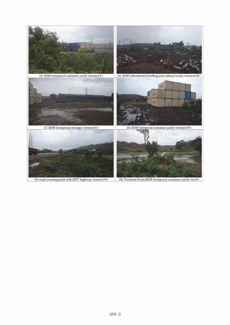
15: ROW (temporal container yard) <toward E> 16: ROW (abondoned buidling and railway track) <toward W>
17: ROW (temporay storage) <toward E> 18: ROW (temporal container yard) <toward W>
19: road crossing point with JNPT highway <toward N> 20: Terminal Point/ROW (temporay container yard) <tw.E>
AP9-3
APPENDIX-10
Sample Grievance Registration Form

Sample Grievance Registration Form
Reference No. Date
Aggrieved party Individual Group Community Full Name/ description in case of group or community Address
Phone no.
Date, time & venue of FLGRC meeting
Description of Grievance (add page if space is not sufficient)
Description of FLGRC* decision (add page if space is insufficient): -
Description of HLGRC* decision (add page if space is insufficient): - Signature/thumb impression of complainant
Signature of NGO representative
*FLGRC: Field Level Grievance Redress Committee, HLGRC: High Level Grievance Redress Committee
AP10-1

APPENDIX-11
Monthly Progress Report on R&R Implementation

Monthly Progress Report on R&R Implementation Report for the month of Part-I: Quantitative monitoring format
Act
ivity
Indi
cato
r
Tota
l Tar
get
Prog
ress
for t
he
repo
rtin
g m
onth
Cum
ulat
ive
prog
ress
of
repo
rtin
g m
onth
pl
us m
onth
prio
r to
that
% to
tota
l tar
get
Rem
arks
Verification of impact
No. of project affected households
No. of project affected people
No. of people loss residence
No. of people loss business
No. of people loss livelihood
No. of people displace
No. of venerable PAPs
No. of community assets affected
Resettlement No. of families provided with ID Card
No. of families provided with alternate residential accommodation
No. of business families provided with alternate shops
No. of people received compensation before starting construction activities
Area of Govt. land transferred
No. of religious properties relocated
No. of community properties relocated
No. of societies registered
No. of Govt. properties relocated
Rehabilitation No. of people undergone skill development training
AP11-1

Act
ivity
Indi
cato
r
Tota
l Tar
get
Prog
ress
for t
he
repo
rtin
g m
onth
Cum
ulat
ive
prog
ress
of
repo
rtin
g m
onth
pl
us m
onth
prio
r to
that
% to
tota
l tar
get
Rem
arks
No. of people restarted their income restoration activities
No. of PAPs received travel passes
No. of PAPs received transitional allowance
No. of PAPs received vulnerability allowance
No. of new enterprises started
Grievance Redress
No. grievances received
No. of FLGRCmeetings conducted
No. of SLGRC meetings conducted
No. of grievances resolved
Stakeholders Meeting and disclosure
No. of meetings organised
No. of participants
Awareness programme
No. of awareness Programs conducted for PAPs about life in flat living.
Fund No. of household community revolving fund has been transferred
AP11-2

APPENDIX-12
Terms of Reference for Qualitative Independent
Evaluation Specialist/ Agency

Terms of Reference for Qualitative Independent Evaluation Specialist/Agency 1. Project Description This project is being implemented by MMRDA with financial support of Japan International Corporation Agency (JICA). The project gives utmost importance to the Rehabilitation and Resettlement (R&R) of project affected families. Accordingly, a SIA has been developed for implementation. The project includes a provision for monitoring and evaluation of the implementation of the R&R by an external monitor. Therefore, the Executing Agency (EA) requires services of a reputed Social Sector specialist individual /firm for monitoring and evaluation of R&R implementation referred to as the “Qualitative Independent Evaluation Agency” (IEA). 2. Scope of Work - Generic To review and verify the progress in resettlement implementation as outlined in the RAP To monitor the effectiveness and efficiency of Social Development Cell (SDC) of MMRDA and the concerned agency in RAP implementation. To assess whether resettlement objectives, particularly livelihoods and living standards of the affected persons have been restored or enhanced To assess the efforts of SDC/MMRDA and concerned agency in implementation of the ‘Community Participation strategy’ with particular attention on participation of vulnerable groups namely (i) those who are below poverty line (BPL), (ii) those who belong to Scheduled Castes (SC) and Scheduled Tribes (ST), (iii) Women headed families, (iv) elderly and (v) disabled persons. To assess resettlement efficiency, effectiveness, impact and sustainability, drawing both on policies and practices and to suggest any corrective measures, if necessary. 3. Scope of work- Specific The qualitative independent evaluation specialist/agency will evaluate the resettlement efforts by the EA. The major tasks expected from the external evaluator are: Review pre-displaced baseline data on income and expenditure, occupational and livelihood patterns, arrangements for use of common property, social organization, community organizations and cultural parameters. To review and verify the progress in land acquisition/resettlement implementation of subproject on a sample basis and prepare reports for the EA. To evaluate and assess the livelihood opportunities and income as well as quality of life of affected persons of project induced changes. To evaluate and assess the adequacy and effectiveness of consultative process with affected persons, particularly those vulnerable, including the adequacy and effectiveness of grievance procedures and legal redress available to the affected parties and dissemination of information about these. Identify an appropriate set of indicators for gathering and analyzing information on resettlement impacts; the indicators shall include but not
AP12-1

limited to issues like restoration of income and living standards and level of satisfaction by the APs in post-resettlement period. Review results of internal monitoring and verify claims through random checking at the field level to assess whether resettlement objectives have been generally met. Involve the APs, host population, and community groups in assessing the impact of resettlement for monitoring and evaluation purposes. Conduct both individual and community level impact analysis through the use of formal and informal surveys, key informant interviews, focus group discussions, community public meetings, and in-depth case studies of APs and host population from various social classes to assess the impact of resettlement. Identify the strengths and weaknesses of basic resettlement objectives and approaches, implementation strategies, including institutional issues, and provides suggestions for improvements in future resettlement policy making and planning 4. Time frame and Reporting The specialist/ agency will be responsible for independent evaluation of the R&R implementation. The work is scheduled to start halfway through the R&R implementation period and end six month after the implementation of R&R. During the engagement period, the qualitative evaluation specialist/agency shall submit two reports, viz. (1) first evaluation report after six months into the SIA implementation; (2) six months after the implementation the R&R. The duration of SIA implementation is as per the given time schedule in SIA report. The monitoring and evaluation report should be submitted to EA. 5. Qualifications The qualitative independent evaluation specialist/agency will have significant experience in resettlement policy analysis and RAP implementation. Further, work experience and familiarity with all aspects of resettlement operations would be desirable. Interested specialist/agencies should submit proposal for the work with a brief statement of the approach, methodology, staff strength, and relevant information concerning previous experience on monitoring and evaluation of resettlement and rehabilitation implementation and preparation of reports. 6. Budget and Logistics Copies of the proposal- both Technical and Financial- should be submitted and the budget should include all cost, taxes and any other logistics details necessary for resettlement monitoring. Additional expense claims whatsoever outside the budget will not be entertained.
AP12-2

APPENDIX-13
Minutes of Meeting – SIA 2nd Stakeholder
Consultation for Sewri Section

Preparatory Survey on the Project for Construction of Mumbai Trans Harbour Link
Minutes of Meeting – SIA 2nd Stakeholder Consultation for Sewri Section
MINUTES OF MEETING – SIA Second Stakeholders Consultation at Sewri section
Name of Organization/ Place of Visit: Sewri section of MTHL Project Purpose of Meeting: To discuss with PAPs at the Sewri section of MTHL Project
Date: 25/08/2015 Time: 5.30 pm – 7.00 pm Venue : Sewri Koli Samaj Hall, Near KoliSamaj Building, Sewri (E), Mumbai - 400 015. Members Represent Project Proponent and the Key Representative of PAPs
1) Mr. Vishram Patil – Chief Social Development Cell, MMRDA, Mumbai. 2) Mr. Konishi – Dy. Team Leader, JICA Study team, Oriental Consultants Global, Japan. 3) Mr. Hrushikesh Kolatkar – Project Coordinator & MD of BEIPL, Mumbai 4) Mr. Vivek Kulkarni – CEO of BEIPL 5) Dr. Nilambari Bhingarde – Social Expert, BEIPL 6) Mr. T. B. Patil – Managing Director of Komal Engineering (BSES surveyor) 7) Mr. Indradeo (Baba) Mishra – Representative of PAPs of Sewri site.
Initially, the JICA Study Team made a presentation about project description with necessity of land acquisition, findings of socio economic survey, and expected MMRDA’s compensation packages. Then, as the responses to project affected person’s (PAPs) questions, either MMRDA representative or JICA Study Team gave the salient features of the MUTP R&R1 Policy including the eligibility and entitlement framework for various types of PAPs, grievance redress mechanism, need for verification of survey details by concerned PAPs and common amenities and funds that will be provided to the registered Co-operative Housing Societies of the resettled PAPs.
1 Mumbai Urban Transport Project Resettlement and Rehabilitation (2000), Government of Maharashtra
AP13-1

Preparatory Survey on the Project for Construction of Mumbai Trans Harbour Link
Minutes of Meeting – SIA 2nd Stakeholder Consultation for Sewri Section
Records of the Points/ Questions asked by the PAPs
ID.No.
Name of the Stakeholder/
PAP who asked the question
Position/ Role
played by Stakeholde
r
Questions asked by
Stakeholders
Response Given by
OCG/BEIPL or MMRDA
Response in detail
479 Mr. Harshad Bait
Commercial PAP
Is there any area for resettlement other than Bhakti Park ?
Can they be resettled in nearby areas since all facilities are available there ?
MMRDA response
The Bhakti Park resettlement site was suggested because it was the nearest site as compared to other sites and where all the PAPs could be accommodated due to availability of required no. of tenements.
Other resettlement sites are located at farther locations such as Mankhurd, Mahul, Govandi, Oshiware etc. and it will be possible to resettle PAPs at such sites if so desired by the PAPs in writing.
The MMRDA does not own any land or there are no resettlement sites in the nearby areas including in the MPT area.
The resettlement sites are developed as per the applicable Development Control Regulations for Greater Mumbai and are accordingly provided various amenities and facilities as per such rules.
486 Mr. Rajesh Lahu Pawar
Chairman, Om Sai Dutta Housing Society
Some PAPs are lessees of Mumbai Port Trust (MPT). The cases are in court. Will they be considered as legal title holders in deciding their resettlement entitlement ?
MMRDA response
It is understood from the experience of the Eastern Freeway project that occupants of most structures on MPT land do not have legally valid claims. However, the concerned PAPs should submit to MMRDA the relevant documents, which will be scrutinized and verified for legal validity of
AP13-2

Preparatory Survey on the Project for Construction of Mumbai Trans Harbour Link
Minutes of Meeting – SIA 2nd Stakeholder Consultation for Sewri Section
ID.No.
Name of the Stakeholder/
PAP who asked the question
Position/ Role
played by Stakeholde
r
Questions asked by
Stakeholders
Response Given by
OCG/BEIPL or MMRDA
Response in detail
such claims. Entitlements in such cases will be considered depending on the outcome of such scrutiny.
08 Mr. Santosh Shukla
PAP What are the details about other resettlement sites?
When is the project implementation likely to start?
Is Lallubhai Compound site for footpath dwellers ? What is the area of tenements at other resettlement sites?
MMRDA response
The other resettlement sites are at Mankhurd, Mahul, Govandi, Oshiware etc.
At present details of the project and its funding are being worked out and various arrangements are yet to be finalized. It is hence not possible to indicate accurate project commencement schedule.
All resettlement sites are planned and developed under the same Regulations and most of the stock of tenements is of 225 sq.ft. carpet area.
AP13-3

Preparatory Survey on the Project for Construction of Mumbai Trans Harbour Link
Minutes of Meeting – SIA 2nd Stakeholder Consultation for Sewri Section
ID.No.
Name of the Stakeholder/
PAP who asked the question
Position/ Role
played by Stakeholde
r
Questions asked by
Stakeholders
Response Given by
OCG/BEIPL or MMRDA
Response in detail
48 Dr.Qaisar Jamal
Physician Is JICA using Resettlement & Rehabilitation policy of the World Bank ?
Is MUTP Policy also as per World Bank policy?
What is the agreement between MPT and MMRDA? We are not encroachers we have lease agreement with MPT and our case with MPT is in court.
JICA Study team, OCG,Mr. Konishi’s response - MMRDA response
Yes, JICA uses its own guidelines but referring to World Bank OP 4.12.
Yes, the MUTP R&R Policy was formulated as per the requirement of World Bank, which had funded the MUTP. The final Policy was approved by Govt. of Maharashtra in 2000 after consulting the World Bank. The MUTP policy is proposed to be applied to this project.
The execution of the project will be carried out as per the approval of MPT. The concerned PAPs should submit to MMRDA the relevant documents, which will be scrutinized and verified for legal validity of such claims. Entitlements in such cases will be considered depending on the outcome of such scrutiny.
104 Shankar Maruti Maskare
Residential PAP
How will the occupants of partially affected structures resettled ? Can people staying in the same settlement but not affected by the project be resettled ?
MMRDA response
In case of partially affected structures, the PAPs would have a choice of either shifting to resettlement site or surrendering the affected part of the structure without any entitlement and staying in the remaining unaffected part of the structure.
The MMRDA is not required to shift the unaffected
AP13-4

Preparatory Survey on the Project for Construction of Mumbai Trans Harbour Link
Minutes of Meeting – SIA 2nd Stakeholder Consultation for Sewri Section
ID.No.
Name of the Stakeholder/
PAP who asked the question
Position/ Role
played by Stakeholde
r
Questions asked by
Stakeholders
Response Given by
OCG/BEIPL or MMRDA
Response in detail
people. However, if unaffected people want to get resettled, they should together make a written request to MMRDA, the feasibility of which will be considered and a decision will be taken in consultation with all stakeholders.
2nd Consultation Notices in the PAP’s Community 2nd Consultation Notices in the PAP’s Community
Consultation Room Registration
AP13-5

Preparatory Survey on the Project for Construction of Mumbai Trans Harbour Link
Minutes of Meeting – SIA 2nd Stakeholder Consultation for Sewri Section
PAPs PAPs (Behind) and BSES Surveyor (Front)
Presentation Given By JICA Study Team (BEIPL) MMRDA/Local Representative/JICA Study Team/JICA
Study Team (Local)
Questioned by Local Representative Questioned by a Local Resident
AP13-6

Preparatory Survey on the Project for Construction of Mumbai Trans Harbour Link
Minutes of Meeting – SIA 2nd Stakeholder Consultation for Sewri Section
Discussion After The Consultation Discussion After the Consultation
AP13-7

APPENDIX-14
Interview with Wildlife Specialist in Japan

Interview with Wildlife Specialist in Japan
Impacted Item Interview with Experts Name Forecast Case Example Mitigation Measures Condition
in CRZ Clearance
Measures in Rapid
EIA
New Measures according
to JICA (supplementary
EIA)
Covered by
Baseline Survey
Durin
g Co
nstr
uctio
n Reclamation of Wetland, etc.
In the case in Manko of Okinawa, the drying of mudflats has proceeded and mangrove forests have expanded after construction, because the tide changes due to change of micro topography around the piers. Therefore, stopovers for migratory birds have been lost.
Murata - It is concerned about impacts on aquatic fauna and flora by the inflow of turbid water due to development.
- By the reclamation of wetland and mudflat, there is the change of micro topography. However, the tide does not greatly change and may promote a great variety of algal growth.
- Feeding resources of the migratory birds may change since benthic fauna changes by expansion of the mangrove forests.
[Measures in Manko, Okinawa] - Implementation of natural environmental
surveys for factor analyses - Cutting mangrove in mangrove area where
feeding environments of mudflat are left. - Cutting and arrangement of the mangrove area
to reduce the environment where sediment is easy to deposit in back of the mangrove (To form water flow)
- Removal of seedlings after the mangrove cutting [Measures in Shikoku-Odan Expressway] - Implementation of measures for water pollution,
noise and vibration during construction - Examination of disposal methods of dredging
sediment with a little environmental impact - Preparation and implementation of
environmental monitoring survey plan [Measures in Kita-Kyushu urban planning road] - As conservation measures of mudflat at the
mouth of a river, Preparation and implementation of transplant and migration of principal species and monitoring survey plan.
- To prevent generation of turbid water during construction*1
(bored-pilling methods) Need -- Carried
out Survey of water quality
- Minimization of the Alteration range
(Adoption of not embankment but bridge)
-- -- Carried out --
In the case in Manko of Okinawa, he drying of mudflats has proceeded due to bridge construction and mangrove forests have expanded.
Furota - Monitoring survey for mudflat area during construction
-- -- Monitoring
Mudflat confirmation
survey
Deforestation (including Mangrove)
When the bridge construction is carried out, it seems that the mangrove forests at the area rather spread.
Murata It is expected that scales of the mangrove forests are reduced by implementation of development projects. But there is a possibility that a range of mangrove forests will spread since the mudflat will be becoming dry.
- Monitoring survey of mangrove area -- ○ Monitori
ng Survey
- Replantation for cutting mangrove Need ○ Carried
out --
Operation of Construction Equipment and Vehicles
When Lesser Flamingos felt the danger, there is a case to give up breeding and/or feeding area. Flamingos may avoid and fly away to other mudflat temporarily due to the construction activities near the feeding area (mudflat) in the project area.
Murata It is concerned about temporary impacts on feeding environments of flamingos during construction.
[Measures in Shikoku-Odan Expressway/ Isewangan Expressway]
- Shortening of construction periods not to overlap and concentrate works with sudden noise/ vibration for the breeding season and the rest season in consideration of migratory seasons
- Selection of construction methods such as adoption of low noise/ low vibration method (Example: low noise machines are adopted when crawler cranes, vibrohammer, earth drills, engine generator and the like are used.)
- Establishment of construction plan in consideration of migratory seasons (shortening construction periods, construction section)
(Construction of temporary jetty during rainy season if possible)
-- ○ Carried out if
possible --
- device of low noise and low vibration Need ○ Carried
out The consideration of Flamingos for “during construction” is necessary. “During construction”, it is expected that sudden sounds are generated and low-frequency sounds continue.
Murata - Monitoring survey of flamingos during construction
-- ○ Monitoring Survey
In consideration of peak period of incoming, construction periods should be shortened and construction section should be limited.
Murata
Inflow of Construction Workers and Installation of Base Camp
When Lesser Flamingos felt the danger, there is a case to give up breeding and/or feeding area. Flamingos may avoid and fly away to other mudflat temporarily due to the construction activities near the feeding area (mudflat) in the project area.
Murata It is concerned about impacts on feeding environments of flamingos due to inflow of construction workers and installation of base camp.
[Measures in Fukuoka island city line] - Minimization of volume the modified quantity of
natural environments from a point of view of conservation of focus species and associations (indicator) of ecosystem
- Preparation and implementation of post-project evaluation (monitoring) plan
- Minimization of the Alteration range
(Adoption of not embankment but bridge)
-- -- Carried out --
- Monitoring survey of flamingos before and after construction of base camp
- Education about natural environments to the workers
-- -- Carried out Survey
AP14-1

Impacted Item Interview with Experts Name Forecast Case Example Mitigation Measures Measures
in CRZ Clearance
Measures in Rapid
EIA
New Measures according
to JICA
Covered by
Baseline Survey
Afte
r Con
stru
ctio
n Increase of Through Traffic
I have never heard the information about Road-kills of flamingos.
Murata Road-kills of migratory birds at sections where the height of viaduct is low are expected.
[Rail-kills in Keiyo line] - There are a lot of reports such as collision with a
wild bird while a train is moving, death and injury on railways, and straying into subway tracks.
- Action to prevent birds from crashing against trains (Implementation of soft measures such as using horn, turning off a headlight, and slowdown at hazardous sections)
- Installation of shielding facilities (double as sound barrier) for CRZ section and mudflat section
Need -- Carried out --
Because the Rail-kills of migratory birds are confirmed by Keiyo Line which passes through the coast, it is desirable to install cover boards of cars (around 2m).
Furota
Appearance/ Occupancy of Roads and related building structures
It is thought that flamingos fly across the upper bridge after the bridge was built in the area. Because there is no knowledge about the flight height of flamingos, I would like you to calculate it from photographs taken locally.
Murata Existence of bridge possibly disturbs the flying courses of the flamingos, but an evasion action it is estimated that they take evasive action.
[Measures in Shikoku-Odan Expressway] ・Adoption of the bridge form (the upper aspect
does not have facilities like cable-stayed bridge) in consideration of flying courses of migratory birds (There is no facility which cable-stayed bridges have above viaduct)
Figure: Image of flying courses and bridge piers (Reference from “Action of environmental conservation
for Shikoku-Odan Expressway Yoshinogawa river crossing point”)
- Adoption of bridge type in consideration for flying courses of migratory birds
- Height limitation for road structures (such as shielding facilities) on the flying course
-- -- Carried out --
Flamingos which are large birds may have avoiding action by the existence of the bridge piers.
Furota - Monitoring of flying course of flamingos
-- -- Monitoring Survey
There is a method to examine impacts for flying course of the flamingos at the both points of view of daily (movement between their roosts and feeding areas) and monthly (migratory seasons).
Furota
It is desirable that the design was considered not to light up roosts (rest area) with vehicle lightings and the like.
Murata It is concerned about impacts on habitation (roost) of the flamingos due to road lightings.
[Measures in Isewangan Expressway] - Promotion of tree planting and installation
shading fence to control leaking light from road/ vehicle lightings
Figure: Example of sound barriers on East-Kanto
Expressway (Reference form “Technical methods of road
environmental impact assessment, separate volume casebook”)
- Mitigation of impacts on roosts of migratory birds and flamingos by road lighting (bridge railing light)
Need -- Carried out --
Mudflat PathwayNH357 NH357
Cross-section view
Sound barrierEast-Kanto EXPWY
Sound barrier
Image of flying courses
Roost *Current flying coursesAdopt
feeding area
Birds can fly above a girder bridge lower than above a suspension bridge
girder b. suspension b.
AP14-2

Impacted Item Interview with Experts Name Forecast Case Example Mitigation Measures Measures
in CRZ Clearance
Measures in Rapid
EIA
New Measures according
to JICA
Covered by
Baseline Survey
Afte
r Con
stru
ctio
n Appearance/ Occupancy of Roads and related building structures
If there is a change of tidal flow and ebb and flood tide with project implementation, it is thought that feeding environment of flamingos and the vegetation greatly change.
Murata It is thought that there is little impact on tidal flow and ebb and flood tide by the existence of the road, and the impacts on ecosystem in the mudflats are not significant. In addition, as for the change of the tide on micro scale and the micro topography, it is assumed that ecosystem diversifies.
[Measures in Manko, Okinawa] - Implementation of surveys and analyses about
the population change of fishes and benthos which are feeding resource of migratory birds
- Investigation of vegetation to become the factor of the population change mentioned above (such as change of areas of mangrove forests)
- Cutting and arrangement of the mangrove area to reduce the environment where sediment is easy to deposit in back of the mangrove (including simulations)
- Minimization of reclamation by adoption of bridge structure and reduction of bridge piers
-- -- Carried out --
With the environmental change around the bridge, it is predicted that the benthic fauna which are principal diets for flamingos changes definitely.
Furota - Monitoring of ecosystem in the mudflat, tidal flow and mudflat figure.
-- -- Monitoring Survey
Based on the existing study results, it is thought that there are few changes of the mudflat from the macro view point. However, it is predicted that micro topography (such as sediment quality and salinity) changes definitely since turbulence flow are generated around the bridge.
Furota
Because the micro topography changes by the project, the biota may rather become diversified.
Furota
(Note) "Black-headed Ibis (Threskiornis melanocephalus) : It is designated as “Near Threatened”“ in IUCN Red List. But in this survey area, only 18 birds and 4 young birds were confirmed and their roosts are not confirmed in a survey in February 2008. Thus, it is expected that there is little impact on the project. A
P14-3

APPENDIX-15
MTHL Drawings over SH54

AP15-1

AP15-2
APPENDIX-16
Breakdown for Operation and Maintenance

Breakdown for Operation and Maintenance
Operation and Maintenance Cost
≪Routine Maintenance≫
■MMRDA:
- Personnel Expenses for Inhouse
Chief Engineer: 1 person, Superintending Engineer: 1 person, Executive Engineer: 2 people,
Deputy Engineer: 2 people
■Project Management Consultant
- Personnel Expenses for Outsource
Resident Engineer: 1 person, Site Engineer: 2 people, Assistant Site Engineer: 3 people,
Support staff (Office Manager, Typist, Office boy): 1 person each
■Inspection and Maintenance
- Personnel Expenses for Outsource
Administration: Chief Engineer: 1 person, Engineer (Road): 1 person, Engineer (Facility): 1 person
Contractor: Inspector (Road): 3 people, Engineer (Road): 3 people, Skilled Labor (Road): 3 people,
Unskilled Labor (Road): 20 people, Engineer (Facility): 2 people,
Electrical Engineer (Facility): 1 people x (3 shiftwork + 1 additional shiftwork),
IT Engineer (Facility): 1 people, Technicians (Facility): 2 people,
Operator (Bridge inspection vehicle, etc): 1 people, Operator (Road sweeper): 1 people,
Driver: 1 people
Unit: million INR
Year MMRDA
ProjectManage
mentConsulta
nt
Inspection &
Maintenance
TollManage
ment
TrafficManage
ment
Others(Electrici
ty)
RoutinO/MTotal
Pavement
Roadmarking
Touch-up
painting
Repainting
Expansion
deviceBearing
Bridgeinspectio
npassage
Noisebarrier
TrafficManage
mentsystem
TollManage
mentsystem
PeriodicMaintena
nceO/M Total
1 16 15 95 101 40 10 276 0 0 0 0 0 0 0 0 0 0 0 2762 16 15 95 101 40 10 276 0 0 0 0 0 0 0 0 0 0 0 2763 16 15 95 101 40 10 276 0 0 0 0 0 0 0 0 0 0 0 2764 16 15 95 101 40 10 276 0 0 0 0 0 0 0 0 0 0 0 2765 16 15 95 101 40 10 276 0 0 0 0 0 0 0 0 0 0 0 2766 16 15 95 101 40 10 276 0 8 0 0 0 0 0 0 0 0 8 2857 16 15 95 101 40 10 276 0 8 0 0 0 0 0 0 0 0 8 2858 16 15 95 101 40 10 276 0 8 0 0 0 0 0 0 0 0 8 2859 16 15 95 101 40 10 276 0 8 0 0 0 0 0 0 0 0 8 285
10 16 15 95 101 40 10 276 0 8 0 0 0 0 0 0 448 200 657 93311 16 15 95 101 40 10 276 0 0 0 0 0 0 0 0 0 0 0 27612 16 15 95 101 40 10 276 0 0 0 0 0 0 0 0 0 0 0 27613 16 15 95 101 40 10 276 0 0 0 0 0 0 0 0 0 0 0 27614 16 15 95 101 40 10 276 0 0 0 0 0 0 0 0 0 0 0 27615 16 15 95 101 40 10 276 0 0 0 0 0 0 0 0 0 0 0 27616 16 15 95 101 40 10 276 85 8 12 0 0 0 0 0 0 0 106 38217 16 15 95 101 40 10 276 85 8 12 0 0 0 0 0 0 0 106 38218 16 15 95 101 40 10 276 85 8 12 0 0 0 0 0 0 0 106 38219 16 15 95 101 40 10 276 85 8 12 0 0 0 0 0 0 0 106 38220 16 15 95 101 40 10 276 85 8 12 0 0 0 0 128 448 200 883 1,15921 16 15 95 101 40 10 276 0 0 12 0 33 0 24 0 0 0 69 34522 16 15 95 101 40 10 276 0 0 12 0 33 0 24 0 0 0 69 34523 16 15 95 101 40 10 276 0 0 12 0 33 0 24 0 0 0 69 34524 16 15 95 101 40 10 276 0 0 12 0 33 0 24 0 0 0 69 34525 16 15 95 101 40 10 276 0 0 12 0 33 0 24 0 0 0 69 345
AP16-1

■Toll Management
- Personnel Expenses for Outsource
Administration: Toll Manager: 1 person
Contractor: Cashier: 2 people, Clerk: 2 people x (3 shiftwork + 1 additional shiftwork),
Shift-in-charge: 1 people x (3 shiftwork + 1 additional shiftwork),
Supervisor: 2 people x (3 shiftwork + 1 additional shiftwork),
Toll Collector: 24 people x (3 shiftwork + 1 additional shiftwork),
Lane Assistant: 24 people x (3 shiftwork + 1 additional shiftwork),
Security shift in charge: 1 people x (3 shiftwork + 1 additional shiftwork),
Security Guards: 24 people x (3 shiftwork + 1 additional shiftwork)
- Electrical and Communications Expenses
Fare system, Communication expense, Electrical expense
■Traffic Management
- Personnel Expenses for Outsource
Administration: Traffic Manager: 1 person
Contractor: Shift-in-charge (Traffic control): 1 people x (3 shiftwork + 1 additional shiftwork),
Operator (Traffic control): 2 people x (3 shiftwork + 1 additional shiftwork),
Shift-in-charge (Patrol): 1 people x (3 shiftwork + 1 additional shiftwork),
Road Patrol (Patrol): 2 people x (3 shiftwork + 1 additional shiftwork),
Driver (Emergency Vehicle): 2 people x (3 shiftwork + 1 additional shiftwork)
- Electrical and Communications Expenses
Traffic management system, Communication expense, Electrical expense
■Others
- Electrical expense
Road facilities (lighting system etc.)
≪Periodic Maintenance≫
■Pavement
- Base cost: Construction cost of surface pavement
- Maintenance interval: 15 years (proportional division during 5 years)
■Road Marking
- Base cost: Construction cost of road marking
- Maintenance interval: 5 years (proportional division during 5 years)
■Touchup Painting
- Base cost: Construction cost of touchup painting for steel bridge x 0.7%
- Maintenance interval: 15 years (10 years)
AP16-2

■Repainting
- Base cost: Construction cost of surface repainting for steel bridge
- Maintenance interval: 25 years (15 years)
■Expansion device
- Base cost: Construction cost of expansion joint x 1/4
- Maintenance interval: 20 years (proportional division during 5 years)
■Bearing
- No maintenance plan during services
■Bridge Inspection Passage
- Base cost: Construction cost of inspection way
- Maintenance interval: 20 years (proportional division during 5 years)
■Noise Barrier
- Base cost: Construction cost of noise barrier
- Maintenance interval: 20 years
■Traffic Management System
- Base cost: Construction cost of traffic management system
- Maintenance interval: 10 years
■Toll Management System
- Base cost: Construction cost of toll management system
- Maintenance interval: 10 years
AP16-3