Embed Size (px)
Citation preview

Page 43 of 54
Appendix 3 - Mount Pleasant Project Table 1 The following table provides a summary of important assessment and reporting criteria used at the Mount
Pleasant Project (MTP) for the reporting of exploration results and Mineral Resources in accordance with
the Table 1 checklist in The Australasian Code for the Reporting of Exploration Results, Mineral Resources and Ore Reserves (The JORC Code, 2012 Edition). Criteria in each section apply to all preceding and succeeding sections.
SECTION 1 SAMPLING TECHNIQUES AND DATA Criteria Commentary
Sampling
techniques • A combination of open hole (predominantly for structural definition) and cored
(for coal quality (CQ), geotechnical, and gas sampling) have been used.
Drilling techniques • Note that Rio Tinto Coal Australia drilled from 1992 until 2010, with no drilling
having taken place from 2011 to present day.
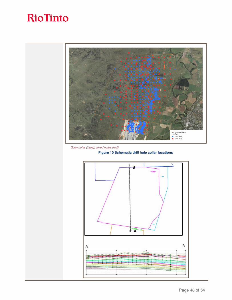
• 682 drill holes (79,050 metres) support the Resource estimate. This total includes some holes strictly belonging to the dataset from the adjoining Bengalla deposit. Cored drilling represents 31% of the total metres drilled and open hole drilling 69%. The drill holes are up to 312m in length and average 198m. Of the holes modelled, 278 are part of the drilling programme completed at the neighbouring Bengalla Mine and have been included to increase Mount Pleasant (MTP)’s model resolution.
• The drill holes were all nominally recorded as vertical.
• Coring has predominantly been done using a HQ-sized (96mm) bit and open hole drilling to an equivalent hole diameter size. In addition 22 large diameter (LD) holes at 200mm (8”) have been drilled.
Drill sample
recovery • Standardised Rio Tinto Coal Australia logging systems were utilised for all
drilling logging and sampling.
• Core recovery is recorded by the geologist while logging the drillhole. Overall, core recovery is >95% or that section of the hole is re-drilled.
• Ply samples are checked for representativeness against a theoretical mass after raw CQ analysis and prior to composite definition.
• Open hole chip recovery is assessed qualitatively by the rig geologist.
Logging • Core was logged for geology and geotechnical changes, Open hole chip
samples were taken every 1m and logged for lithology changes. Quantitative logging for lithology, stratigraphy, texture, and hardness is conducted using standard dictionary definitions. Colour and any additional qualitative comments are also recorded.
• All holes were logged using a comprehensive suite of down-hole geophysics tools (calliper, gamma, density, neutron, resistivity and sonic), with acoustic scanner/dipmeter (for geotechnical assessment) also run on cored holes.

Page 44 of 54
Sub-sampling
techniques and
sample preparation
• Core sampling was completed at the drill site and based on a set of standard criteria (determined by lithology and structure). Samples were bagged at the drill site and then transported to an external accredited laboratory for analysis as a complete hole batch.
• All samples are weighed, air-dried, and then re-weighed before being crushed to an assumed 11.2mm top size. A rotary splitter was used to divide the sample into portions available for further CQ analysis.
• CQ analysis is by a three-stage method involving raw analysis on all plies followed by washability and product testing on composite samples as defined by the geologist.
• All sample treatment and analysis was conducted according to procedures which adhere to Australian (or International equivalent) standards.
Quality of assay
data and laboratory
tests
• Non-formalised quality assurance/quality control (QA/QC) involving duplicate samples has been completed and all results are assessed via cross-plots and statistics for precision and accuracy.
Verification of
sampling and
assaying
• All CQ sampling and analysis was overseen and checked by other Rio Tinto personnel.
Location of data
points • The MTP topography surface is derived from a computer-based grid file which
was updated using drill hole collars – the original provenance of this file is not clear however it has been benchmarked against publically available 5m digital terrain model contours. The digital terrain model was created with a 20m × 20m cell size triangulation at 0.2m decimation.
• All surveyed coordinates are within Map Grid of Australia 1994 (MGA94) Zone 56 projection using the datum AGD94.
• Drill hole collars were surveyed post drilling by licensed surveyors.
• Downhole surveying has been undertaken using downhole verticality and calliper tools since 1992. Some earlier downhole survey work was completed prior to 1992 however the details of these surveys are unclear.
Data spacing and
distribution • The majority of drilling on the MTP deposit has been conducted on a 250m
square grid. Some structural definition drilling was also completed at 250m and 125m spacings.
Orientation of data
in relation to
geological structure
• The coal measures show a relatively consistent layering and are not subject to steep dips. The orientation of drilling is therefore suitable for flat lying stratified deposits.
Sample security • Core/chip samples were taken at the drill site and then transported daily to the
locked on site core shed for storage. At the completion of drilling, CQ samples are transported to the laboratory for testing.
Audits or reviews • No external audits have been completed.

Page 45 of 54
SECTION 2 REPORTING OF EXPLORATION RESULTS
Criteria Commentary
Mineral tenement
and land tenure
status
• The MTP deposit is 100% owned by Coal & Allied Industries Limited (CNA), resulting in the Rio Tinto Group owning an 80% stake in the project.
• The project consists of mining leases and authorisations as outlined below (see, Figure 6):
o one mining lease
o three mining lease applications
o one prospecting authorisation.
Figure 8 Mount Pleasant Project tenements

Page 46 of 54
Exploration done by
other parties • Prior to the awarding of the Mount Pleasant Tenement to CNA in 1992 the
following exploration was conducted:
o 1890-1930: Kayuga Colliery operated a small underground mine
o 1970: Buchanan Borehole Collieries Ltd. drilled 8 holes
o 1970-71: Amoco (Australia) Pty Ltd drilled 14 holes (including Bengalla)
o 1975: the NSW Department of Mineral Resources commissioned a 26 hole exploration programme
Geology • MTP is located in the Hunter Coalfield in the northern part of the Sydney Basin,
which contains numerous important coal producing intervals in the Permian stratigraphy. The Late Permian Wittingham Coal Measures are further sub-divided into the Vane (Lower most seams) and Jerrys Plains sub-groups, which host the main coal deposits within the Mount Pleasant tenement. The main rock types of these sub-groups are sandstone, siltstone, and conglomerate, which occur with subordinate coal and tuffaceous claystone.
Drill hole
information • Following is a drilling data summary from Rio Tinto Coal drilling campaigns
between 1992 and 2010, inclusive of some Bengalla data:
1992 1993 - 1996 2003 - 2005 2006 - 2007 2010
Open Holes - 150 7 41 -
Core Holes 32 117 1 21 7
LD Holes 7 15 - - -
Data aggregation
methods • Ply samples were combined to create composites (for washability and product
coal analyses) representing mineable seam working sections .
Relationship
between
mineralisation
widths and
intercept lengths
• Based on the drilling techniques, and stratigraphy, the coal seam intercepts approximate the true vertical thickness of the coal.
Diagrams

Page 47 of 54
Figure 9 Mount Pleasant Project location
Page 48 of 54
Open holes (blue); cored holes (red)
Figure 10 Schematic drill hole collar locations

Page 49 of 54
Shown with 3x vertical
Figure 11 Schematic MTP cross-section: north to south
Shown with 3x vertical
Figure 12 Schematic MTP cross-section: west to east
Balanced reporting • Not applicable. Rio Tinto Coal Australia has not specifically released exploration
results for these deposits.
Other substantive
exploration data • In addition to drilling, both aerial and high-resolution ground magnetic surveys
have been conducted for the tenement. In 1993 ground radar was completed to better delineate dyke structures.
Further work • The MTP Resource is currently at a feasibility study stage, with much of the
Resource developed to Measured status. As such, exploratory work for this Resource is not currently being undertaken. However a programme of pre-production drilling is planned pending an investment decision to proceed to mining.
SECTION 3 ESTIMATION AND REPORTING OF MINERAL RESOURCES
Criteria Commentary
Database integrity • All drill hole data are securely stored in a database which is duplicated on
multiple servers (Bengalla Mine and Singleton) and is backed up daily.
Page 50 of 54
• Data are validated at the drill site and also prior to loading into the database by the responsible geologist.
• The database contains automated validation processes, during data loading and prevents invalid data loading.
Site visits • The Resources Competent Person visited MTP in 2014.
Geological
interpretation • The deposit is well known and tabular with all major structures and coal seam
continuity (including coal quality) and limits (i.e. LOX, sub-crop and igneous intrusions) defined. Infill drilling, mining exposure and mapping has supported and refined the model. The current interpretation is thus considered robust.
Dimensions • The deposit trends 5km north to south and is 6km in width. The deposit extends
to a depth of ~220m below the topographic surface.
Estimation and
modelling
techniques
• Modelling was completed using resource modelling software. For structural modelling a proprietary fine element method (FEM), interpolator is used and for CQ an inverse distance squared interpolator is used. All surfaces and coal
qualities are interpolated into grids with 20m × 20m node spacing.
• The model is of the coal seams only with waste modelled by default. Resource estimates are therefore of the coal seams only and restricted on a whole seam group basis only.
• Modelling is completed on an iterative basis by checking cross-sections and contours of structural and CQ attributes. Database values are posted on contours as a further check. A volume/tonnage check between the model and its predecessor are completed as a final validation.
Moisture • All tonnages are estimated on an in situ moisture basis, which is determined as
air-dried moisture content plus 5%. This figure is based on calculations and assumptions completed during the 2007 feasibility study.
Cut-off parameters • It is assumed that MTP will produce thermal products to sit within Rio Tinto Coal
Australia’s marketing strategy with assumed 11% product moisture. Air-dried is quoted at a 4.5% moisture basis.
• A minimum coal thickness of 0.25m and density of 1.8 g/m3 are applied as a cut-
off parameters for reporting coal.
• Economic resources are defined by a “break even” ($0 margin) Lerchs-Grossman optimised shell for opencast coal – this effectively sets the maximum depth or lowermost seam considered.
Mining factors or
assumptions • Development of this Mineral Resource estimate assumes mining using standard
Rio Tinto Coal Australia equipment. The assumed mining method is overburden removal via draglines, and conventional truck and shovel open-cut coal mining.
Mining practices utilise detailed extraction plans to effectively manage quality control. These extraction plans are generated from real time blast hole drill compliance monitoring, in pit visual inspections and survey monitoring and control.
Metallurgical
factors or
assumptions
• It is assumed that a combination of density separation (magnetite/water) and fines flocculation processes used by Rio Tinto Coal Australia will be applicable for the processing of MTP coal.
Environmental
factors or • Rio Tinto Coal Australia has an extensive environmental and heritage approval
and compliance process. No issues are expected that would affect the Mineral

Page 51 of 54
assumptions Resource estimate.
Bulk density • Tonnages have been calculated using apparent relative density (ARD) and air-
dried moisture.
• Relationships between apparent relative density (ARD) and relative density (RD) were determined and used to populate the calculated RD for all ARD values:
o converting ARD to RD
o RDcalc = 1.0016 X ARD + 0.0645, where R2 = 0.956
• The in situ relative density (i.e. the density of materials at an in situ moisture basis) is calculated using the Preston and Sanders equation:
RD2= [RD1*(100-M1)]/ [100+RD1*(M2-M1)-M2] Where RD1 is true RD (ad), M1 is moisture (ad) and M2 is the in situ moisture (M1 + 4).
Classification • The classification of the Mineral Resources into varying confidence categories is
based on a standardised process of utilising points of observation (PoO). Drill holes are assessed according to their reliability and value in estimation. The PoOs are used to categorise structure and quality continuity.
• Radii of influence are then plotted around PoO maps for structure and quality. The radii of influence were determined by consideration of the observed variability in structure and CQ for seam groups, and by examining histograms and statistics of ash content of seam groups. As there are many plies at Mount Pleasant, seam groups (equivalent to the seam names) were used for categorisation.
• Areas of confidence (low, medium, high) are produced from these plots (structure, CQ for each seam group) and finally these are combined to produce areas of Measured, Indicated and Inferred which are used to subdivide the Resource tonnage estimates.
• In summary structural radii range 175-225m for high confidence, 350-450m for medium and 1,050-1,350m for low; and, for CQ 350-450m radii for high, 700-900m for medium and 2,800-3,600m for low confidence respectively. The ranges reflect variability within the twelve seam groups modelled at Mount Pleasant.
• The Competent Person is satisfied that the stated Mineral Resource classification reflects the geological controls interpreted and the estimation constraints of the deposits.
Audits or reviews • The estimation was carried out by Rio Tinto personnel and external consultants
and an informal audit had been conducted by Rio Tinto personnel over the whole process.
Discussion of
relative accuracy/
confidence
• Rio Tinto Coal Australia operate multiple mines in New South Wales (NSW) and Queensland (QLD). The Mineral Resource data collection and estimation techniques used for the MTP deposit are consistent with those applied at other deposits which are being mined.
• Accuracy and confidence in the Mineral Resource estimation has been accepted by the Competent Person.
SECTION 4 ESTIMATION AND REPORTING OF ORE RESERVES Criteria Commentary

Page 52 of 54
Mineral Resource
estimate for
conversion to Ore
Reserves
• A three dimensional gridded Resource model of topography, structure and quality is used for in situ Resource definition.
• Mine design strips and blocks are applied to the in situ Resource model to generate the raw Reserves used to create a separate mine schedule database. The mine schedule database also reflects working sections or seam aggregations, mining methods and associated loss and dilution impacts. The mine schedule database is used as the basis for Ore Reserves reporting.
Site visits • The Reserves Competent Person undertook a field visit of MTP in 2014.
Study status • MTP has been studied to Feasibility Study level in 2011. During 2014 a study
refresh has been carried out, in order to test additional mine and infrastructure options under recent market conditions. The reportable Ore Reserve is based on this current 2014 study which has identified a mine plan that is technically achievable and economically viable, and considers appropriate Modifying Factors.
Cut-off parameters • The 2014 study included a pit optimisation study to delineate the economic pit
limits for the MTP mine plan. The study used a range of estimates for operating costs and future coal prices to identify a robust mine plan.
• For annual JORC Reserves reporting purposes, detailed mine design and schedules are constructed to generate detailed cash flow schedules. This work includes identifying the mining sequence, equipment requirements, incremental and sustaining capital.
• A discounted cashflow analysis is conducted to re-assess under the latest economic assumptions the potential Reserves that remain net cashflow positive.
Mining factors or
assumptions • The 2014 study proposes to utilise dragline, as well as truck and shovel, for
waste movement while coal is to be loaded using a combination of loaders and excavators. Haulage to the run of mine (ROM) hopper would be by rear dump trucks. The operations would be supported by additional equipment including dozers, graders and water carts.
• All pit end-walls have benched and battered designs based on typical Rio Tinto Coal Australia practice with allowances made for increasing depth of mining. The design provides for mining roadways and catch benches.
• Working section or seam aggregation logic pre-determines what is defined as mineable coal by applying working section tests based on minimum practical coal thickness (typically 30cms), and a maximum raw ash of 51.6% on an air-dried basis.
• Coal loss and dilution factors are also applied. Typical assumed roof and floor coal loss thickness ranges from 2cm–10cm. Typical roof and floor waste dilution thickness ranges from 2cm–6cm.
• Any Inferred Resources included in the mine plan are not considered to be Reserves. Neither are they reported in JORC or Securities and Exchange Commission compliant Reserve statements.
• MTP has only very limited (<2%) Inferred coal within the mine plan.
Metallurgical
factors or
assumptions
• MTP proposes to wash the ROM coal using conventional techniques to produce a final saleable product. Rio Tinto Coal Australia has extensive local experience within the region, with operating mines at Bengalla, Hunter Valley Operations, and Mount Thorley Warkworth.
Page 53 of 54
• The processes assumed for MTP are standard for the coal industry and so are well tested technologies.
• All samples are wash/cut-point tested and so the representativeness of test work undertaken is implicit in the Resource classification status.
• In-seam dilution is included in sample testing.
• Ore Reserve estimation is based on existing product specifications.
Environmental • MTP has a current 21 year development consent that allows for coal mining and
processing operations on site. This development consent permits operations until 2020. All necessary future government approvals are expected to be received within the timeframes anticipated in the project plan.
• Coarse rejects are consented to be stored within the mines overburden dumps, while the fines coal washery rejects are to be stored within dedicated tailings dams. Rejects material and completed tailings dams will be covered by inert waste rock material, in line with consent conditions.
Infrastructure • The 2011 feasibility study plus current 2014 study has examined the
infrastructure requirements for MTP. The site is located in close proximity to the town of Muswellbrook, and is immediately adjacent to the operational Bengalla Mine. The availability of land for plant development, power, water, transportation, labour, and accommodation has been assessed as part of the Feasibility Study.
Costs • The 2011 Feasibility study capital estimates were prepared consistent with Rio
Tinto study guidance. The estimates were based on material take offs and generally three quoted estimates for each portion of the estimate. The accuracy of the estimate is in the range -10% to +15% at a 90% confidence level. The current study has refreshed the cost estimates based on current market information.
• The operating cost estimate supporting the current study was generated based on a combination of input costs supplied by Rio Tinto Economics and Markets Team (RTEM) benchmarked costs derived from Rio Tinto’s other operating mines located in the Hunter Valley.
• Commodity prices have been supplied by RTEM, based on expected demand, and current supply, known expansions, and expected incentivised supply.
• Exchange rates have been supplied by RTEM.
• Transport charges have been obtained from Rio Tinto coal chain team based on existing contracts and expected tonnages.
• Allowances have been made for NSW State Government royalties based on current legislation.
Revenue factors • The MTP deposit has been valued assuming all coal is sold out of the Port of
Newcastle as an export thermal coal, using an energy adjusted price formula.
• Rio Tinto applies a common process to the generation of commodity prices across the group. This involves generation of long-term price curves based on current sales contracts, industry capacity analysis, global commodity consumption and economic growth trends. In this process, a price curve rather than a single price point is used to develop estimates of mine returns over the life of the project. The detail of this process and of the price point curves is commercially sensitive and is not disclosed.
Market assessment • The supply and demand situation for coal is affected by a wide range of factors,

Page 54 of 54
and coal consumption changes with economic development and circumstances. Rio Tinto Coal Australia delivers products aligned with its Mineral Resources and Ore Reserves; these products have changed over time and successfully competed with coal products supplied by other companies.
Economic • Economic inputs such as foreign exchange rates, carbon pricing, and inflation
rates are generated internally at Rio Tinto. The detail of this process is commercially sensitive and is not disclosed.
Social • There are no Native Title Claims over MTP. No Reserves have been omitted on
this basis.
• Rio Tinto Coal Australia established the Upper Hunter Valley Cultural Heritage Working Group as a consultation and management process to negotiate cultural heritage issues with local Aboriginal communities. As part of releasing a ground disturbance permit on site, authority must be gained to destroy/remove sites of cultural interest. This involves archaeological mapping and removal of artefacts prior to ground disturbance.
• There are no European Cultural Heritage sites requiring preservation at MTP.
Other • There are no material naturally occurring risks expected to have any material
impact on MTP.
• MTP has entered into an agreement with the Bengalla Mining Company to support management of interface issues between the two operations. The agreement deals with land and tenement matters and infrastructure matters.
• All major approvals are in place for MTP including NSW Government development consent, mining lease and Federal Environmental Protection and Biodiversity (EPBC) approval. The NSW Government environmental protection licence (EPL) is pending and is expected to be granted prior to the project proceeding into the construction phase.
Classification • 100% of the Ore Reserves are classified as Probable Reserves.
• The Competent Person is satisfied that the stated Ore Reserve classification is appropriate for the MTP deposit.
• Approximately 65% of Probable Ore Reserves have been derived from Measured Mineral Resources.
Audits or reviews • No external audits have been performed.
• Internal Rio Tinto Coal Australia peer review processes have been completed. These reviews concluded that the fundamental data collection techniques are appropriate.
Discussion of
relative accuracy/
confidence
• Rio Tinto Coal Australia operates multiple mines in NSW and QLD. The Mineral Resource data collection and estimation techniques used for the MTP deposit are consistent with those applied at other deposits which are being mined.
• Accuracy and confidence of the Mineral Resource estimate has been accepted by the Competent Person.