Embed Size (px)
Citation preview

Appendix 3: Asset Register
State Highway Database Operations Manual Effective date: 1st January 2014 Manual No.: SM050 Page A3:1
APPENDIX 3
ASSET REGISTER
Purpose This appendix outlines NZ Transport Agency’s (NZTA) asset register used to
describe the various elements of the road corridor.
Ownership and updating
CJN Technologies and NZTA are the owners of the RAMM data structure. The information supplied in this appendix cannot be used for the purposes of recreating RAMM.
The Asset Management team, NZTA National Office, maintains the “Required by NZTA” field. Refer to the Asset Information Engineer, Highways and Network Operations Group, NZTA National Office for any proposed modifications.
References The Asset Register is to be used in accordance with the Location Referencing
Management System Manual (LRMS), SM051 and section 8, Field Validation Procedures.

Appendix 3: Asset RegisterTable: roadnames Description: Road Name Table - Road names
Field Name Type Required Generated Required Description Allowed Valuesby Software Value by NZTA
road_id iteger(6) Y G T Road identification codesh_ne_unique char(20) G T Highways Unique Road Element Coderoad_name char(35) Y T Name of the roadsuburb char(25) The name of the suburbtown char(30) T The name of the townpostal_code smallint(4) The postal codesh_state_hway char(3) T State Highway Number e.g. 01Nsh_element_type char(3) T Road Element Type (RSL, RMP, RND) RSL RS Length, RMP Ramp
RND Roundaboutsh_ref_station_no smallint(4) T Reference Station Number e.g. 0014 Looks up on reference_stationsh_rp_km decimal(4,2) T Displacement in km along RSL to Road Elementsh_direction char(1) T The Direction of Traffic Flow (B/I/D) I Increasing
D DecreasingB Both
sh_common char(3) T State Highway Number of common SH e.g. 01N - if applicablesh_int_rnd_no smallint(4) T Interchange or Roundabout Number - if applicablesh_ramp_no smallint(2) T Ramp number 1, 2, 3, etc.sh_ramp_type char(3) T The Type of Ramp. (ON/OFF) OFF Offramp
ON Onrampsh_ramp_hier char(1) T Ramp Hierarchy (1,2,3) - if applicable 1 Primary
2 Secondary3 Tertiary
external_name char(35) T The Local Nameexternal_id char(10) An external ID reference numberroad_region smallint(2) T The Territorial Region code Looks up on road_regionroad_council smallint(2) T Local Authority identifier Looks up on road_councilroad_type char(1) Y T Road Type Looks up on road_typeadded_on date today T The date this row was addedadded_by char(20) T The logname of the consultant who added this rowchgd_on date T The date this row was last changedchgd_by char(20) T The logname of the consultant who last changed this row
State Highway Database Operations ManualManual No.: SM050 Page A3:2 Effective date: 1st December 2008

Appendix 3: Asset Register
Table: carr_way Description: Carriageway Table - Dimensional & General Information
Field Name Type Required Generated Required Description Allowed Valuesby Software Value by NZTA
carr_way_no serial(8) Y G T The unique carriageway serial numberroad_id integer(6) Y T RAMM Road ID Looks up on roadnamescarrway_start_m integer(5) Y T Start displacement in metres from the road origin between 0 and 99999 carrway_end_m integer(5) Y T End displacement(m) in metres from the road origin between 1 and 99999start_name char(35) T Name of the road or feature at the start of the sectionend_name char(35) T Name of the road or feature at the end of the sectioncway_area char(15) T Area within which road section falls - suburb, ward, etc. Looks up on cway_areacway_sub_area smallint(4) T Sub Networks Looks up on cway_sub_areamaint_group integer(1) The maintenance grouping as per state highways 1 Maintenance Group 1 through to
and inc. 7 Maintenance Group 7pavement_type char(1) Y T T Pavement type for calculation B Bridge, C Concrete,
S Structural Asphaltic ConcreteT Thin Surfaced FlexibleU Unsealed
pavement_use smallint(1) Y 1 T Pavement Use Code categories 1 ADT < 1002 ADT 100-5003 ADT 500-20004 ADT 2000-40005 ADT 4000-100006 ADT 10000-200007 ADT > 20000
road_class char(1) Y 1 T Road Class e.g. 1, C road_class IN ("1", "C")urban_rural char(1) Y U T Type of area. e.g. Rural, Urban (U/R) R Rural
U Urbancway_hierarchy char(15) T Functional classification of road section Looks up on cway_hierarchylanes smallint(1) Y 2 T Number of traffic lanes lanes between 1 and 9lane_width decimal(3,1 T Lane width in metreslength_m integer(5) Y T Carriageway length in metres length_m between 0 and 30000length_adjust_m integer(5) Length of the Asset above or below the calculated length length_adjust_m between -30000 and
30000 or length_adjust_m is nulllen_adjust_rsn char(5) Reason for Adjusting the Calculated Length of the Asset looks up on len_adjust_rsncway_width decimal(3,1) Y 1.0 T Carriageway width in metres to one decimal place e.g. 8.6m lane between 0.5 and 99.9 or is nullirr_width char(1) Y R T Carriageway width regularity indicator. Regular / Irregular(R/I)
res_width decimal(3,1) T Road reserve width in metres to one decimal place e.g. 20.1 between 1 and 60.0 or is nullmisc_area smallint(4) Y 0 Extra areas in m2 e.g. Parking bays misc_area between 0 and 9999bus_bays smallint(4) Y 0 Area of bus bays in m2 bus_bays between 0 and 9999islands smallint(4) Y 0 Area traffic islands in m2 islands between 0 and 9999intersection smallint(4) Y 0 Additional area at intersections in m2 intersection between -9999 and 9999
State Highway Database Operations ManualManual No.: SM050 Page A3: 3 Effective date: 1st December 2008
Appendix 3: Asset Register
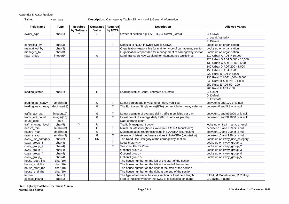
Table: carr_way Description: Carriageway Table - Dimensional & General Information
Field Name Type Required Generated Required Description Allowed Valuesby Software Value by NZTA
owner_type char(1) Y L T Owner of section e.g. LA, PTE, CROWN (L/P/C) C CrownL Local AuthorityP Private
controlled_by char(3) T Defaults to NZTA if owner type is Crown Looks up on organisationmaintained_by char(3) Organisation responsible for maintenance of carriageway section Looks up on organisationmanaged_by char(3) Organisation responsible for management of carriageway section Looks up on organisationroad_group integer(4) G Land Transport New Zealand for Maintenance Guidelines 110 Urban A ADT > 10,000
120 Urban B ADT 5,000 - 10,000130 Urban C ADT 1,000 - 5,000140 Urban D ADT 200 - 1,000150 Urban E ADT < 200220 Rural B ADT > 5,000 230 Rural C ADT 1,000 - 5,000240 Rural D ADT 200 - 1,000250 Rural E ADT 50 - 200260 Rural F ADT < 50
loading_status char(1) G Loading status: Count, Estimate or Default C CountD DefaultE Estimate
loading_pc_heavy smallint(3) G T Latest percentage of volume of heavy vehicles between 0 and 100 or is nullloading_esa_heavy decimal(4,3) G T The Equivalent Single Axles(ESA) per vehicle for heavy vehicles between 0 and 9.9 or is null
traffic_adt_est integer(10) G T Latest estimate of average daily traffic in vehicles per day between 1 and 999000 or is nulltraffic_adt_count integer(10) G T Latest count of average daily traffic in vehicles per day between 1 and 999000 or is nullcount_date date Date of traffic counttraff_manage_level char(5) Y U Traffic Management Level looks up on traff_manage_levelnaasra_min smallint(3) G T Minimum latest roughness value in NAASRA (counts/km) between 10 and 999 or is nullnaasra_max smallint(3) G T Maximum latest roughness value in NAASRA (counts/km) between 10 and 999 or is nullnaasra_avg smallint(3) G T Average of latest roughness values in NAASRA (counts/km) between 10 and 999 or is nullcway_use_category char(2) Y UN T The Road Use Category of the carriageway section Looks up on cway_use_categorycway_group_1 char(4) T Legal Motorway Looks up on cway_group_1cway_group_2 char(4) T Seasonal Factor Zone Looks up on cway_group_2cway_group_3 char(4) Optional group 3 Looks up on cway_group_3cway_group_4 char(4) Optional group 4 Looks up on cway_group_4cway_group_5 char(4) Optional group 5 Looks up on cway_group_5house_start_lhs char(10) The house number on the left at the start of the sectionhouse_end_lhs char(10) The house number on the left at the end of the sectionhouse_start_rhs char(10) The house number on the right at the start of the sectionhouse_end_rhs char(10) The house number on the right at the end of the sectionterrain char(1) The type of terrain in the cway section or treatment length F Flat, M Mountainous, R Rollingcoastal_inland char(1) Flag to indicate whether the cway or tl is coastal or inland C Coastal, I Inland
State Highway Database Operations ManualManual No.: SM050 Page A3: 4 Effective date: 1st December 2008

Appendix 3: Asset Register
Table: carr_way Description: Carriageway Table - Dimensional & General Information
Field Name Type Required Generated Required Description Allowed Valuesby Software Value by NZTA
est_mmp char(2) Unique identifier for the Estimated Mean Monthly Precipitation Looks up on cway_est_mmpasset_owner char(3) Unique identifier for the asset owner Looks up on asset_ownerleft_lanes smallint(1) T The number of lanes on the left hand side of the road between 1 and 9 or is nullright_lanes smallint(1) T The number of lanes on the right hand side of the road between 1 and 9 or is nulllighting_category char(3) Lighting category code for this carriageway section looks up on lighting_categorycollect_name char(3) Name of personal or organisation who collected this data looks up on organisationcollect_date date Date when this data was collectedtravel_direction char(1) Y B T Direction of travel permitted on this carriageway B Both, D Decreasing, I Increasingcondition_wt decimal(5,3) Calculated Weighting from Assessmentcondition char(1) U The condition of this Carriageway Section 1 Excellent, 2 Good, 3 Average,
4 Poor, 5 Very Poor, U Unknowncondition_date date The date the Condition of the asset was establishedliklihood_wt decimal(5,3) Calculated Weighting from Assessmentrisk_liklihood char(1) U Liklihood of this asset failing 1 Rare, 2 Unlikely, 3 Possible, 4 Likely,
5 Almost Certain, U Unknownconsequence_wt decimal(5,3) Calculated Weighting from Assessmentrisk_consequence char(1) U Consequence of this asset failing 1 Insignificant, 2 Minor, 3 Moderate,
4 Major, 5 Extreme, U Unknownrisk char(1) U The Risk of this asset failing 1 Very Low, 2 Low, 3 Medium, 4 High,
5 Extreme, U Unknownrisk_date date Date the Risk value was last updatedeasting decimal(12,4) Easting at the start of the Carriageway between -99.9999 and 9999999.9 or is nullnorthing decimal(12,4) Northing at the start of the Carriageway between -99.9999 and 9999999.9 or is nulleasting_end decimal(12,4) Easting at the end of the Carriageway between -99.9999 and 9999999.9 or is nullnorthing_end decimal(12,4) Northing at the end of the Carriageway between -99.9999 and 9999999.9 or is nullgps_date date Date when the GPS was collectedgps_by char(3) The organisation that collected the GPS data looks up on organisationgps_method_id interger(5) Unique ID for the gps_method table looks up on gps_methodmap_gps_date date Populated when new GPS cororinates are supplied by the usermap_gps_by char(20) The logname of the user who set the map_gps_datemap_import_date date Populated with the data of the Critchlow mapmap_import_by char(20) The logname of the person who ran the initial populationrnm_edit_date date The date this section was last changed using Network Managerrnm_edit_by char(20) The logname of the person who changed using Network Managernotes vchar(255) General commentsas_tip_note char(255) General tip for the Assessor when assessing this assetadded_on date today T The date this row was addedadded_by char(20) T The logname of the consultant who added this rowchgd_on date T The date this row was last changedchgd_by char(20) T The logname of the consultant who last changed this row
State Highway Database Operations ManualManual No.: SM050 Page A3: 5 Effective date: 1st December 2008

Appendix 3: Asset Register
Table: c_surface Description: Carriageway surfacings
Field Name Type Required Generated Required Description Allowed Valuesby Software Value by NZTA
c_surface_id serial(5) Y G - The unique number of the surfacingroad_id integer(6) Y T(M) RAMM Road ID Looks up on roadnamesstart_m integer(5) Y T(M) Surfacing start displacement (m) from the road origin between 0 and 99999end_m integer(5) Y T(M) Surfacing end displacement (m) from the road origin between 1 and 99999start_name char(35) Name of the road or feature at the start of the surfacing sect.end_name char(35) Name of the road or feature at the end of the surfacing sectionnorthing number northing of the start of the surface treatmenteasting number easting at the start of the surface treatmentnorthing_end number northing at the end of the surface treatmenteast_end number easting at the end of the surface treatmentgps_date date time date the GPS was collectedgps_by char(3) The organisation that collected the GPS data looks up on organisationgps_method_id number Unique identifier for the GPS method looks up on gps_methodsurface_date date Y T(M) Date surfacing placed
removed_date date T(C) Date the surface was removed (C) Only applicable to existing surface records which have been removed
surf_width decimal(3,1) T(M) Width of surfacing in metres to 1 decimal place. e.g. 8.6 between 0.5 and 60.0 or is nullfull_width_flag char(1) Y Y Surface covers the full width of the carriageway? Yes or No N No, Y Yessurf_offset decimal(3,1) Y 0 T(M) Dist. from LHS of c/way to LHS of surface in metres between 0 and 60.0
design_life smallint(5) T(M) Expected life of surface at time of design and is site specific. Determined by surfacing designer (not default life). Not to be changed during life of surface. between 1 and 60 or is null
default_life smallint(5) G - Original NZTA default life (from surface life table default field), assigned by RAMM on entry and never updated (yrs) between 1 and 60 or is null
mod_default_life smallint(5) G - Current NZTA Default Life derived from the surface life table between 1 and 60 or is nullsurf_material char(5) Y T(M) Construction material used for carriageway surface Looks up on surf_materialsurf_function char(1) Y T(M) Function of the surface: 1st Coat, 2nd Coat, Reseal, Membrane 1 1st Coat, 2 2nd Coat, R Reseal, M Membrane
surf_depth smallint(3) Y 0 T(M) Depth of surface layer. For chipseals enter 0. For thin asphaltic surfacing, slurry & cape seals enter known seal depth >0. between 0 and 500
use_calc_depth char(1) Y Y T(M) Calculate depth for this surface or Not (use entered surf_depth) Enter Y for all chipseals, N for thin asphaltic surfacing, slurry & cape seals use_calc_depth IN ("Y","N")
chip_size smallint(2) Y T(M) Record either Grade of chip, or mix design (e.g. mix 10 as per M specifications). Or Slurry: 1, 2, 3 or 4 depending on type. between 1 and 40
chip_2nd_size smallint(2) T(C) Grade of 2nd chip used on multiple chip seals & cape seals. (C) Only applicable to mulitple chip seals, including cape seals between 1 and 40
pave_source char(20) T(M) Source of aggregate for chips or mix. For multiple chip seals and cape seals this refers to the largest chip. Looks up on pave_source
surf_binder char(4) Y T(M) Base Binder type only: E180, E80, B180, B80, B60, etc. Record polymer modification under polymer_additive. Looks up on surf_binder
flux smallint(1) Y 0 T(C) Amount of flux in binder (C) 0 if not used or the value of the amount of flux added between 0 and 9
cutter smallint(2) Y 0 T(C) Amount of cutter in binder (C) 0 if not used or the value of the amount of cutter added between 0 and 20
State Highway Database Operations ManualManual No.: SM050 Page A3: 6 Effective date: 1st January 2014

Appendix 3: Asset Register
Table: c_surface Description: Carriageway surfacings
Field Name Type Required Generated Required Description Allowed Valuesby Software Value by NZTA
cutter_type char(4) T(C) Type of cutter used (KERO / TURP / OTHR) (C) Required if cutter amount is not 0
KERO Kerosene OTHR Other TURP Turpentine
adhesion decimal(2,1) Y 0 T(C) Amount of adhesion agent in binder (C) 0 if not used or the value of the amount of adhesion agent added between 0 and 5.0
surf_adhesion char(4) T(C) Type of adhesion agent used (C) Required if adhesion amount is not 0 Looks up on surf_adhesion
additive smallint(2) Y 0 T(C) Amount of non-polymer additive in binder, e.g plastic, epoxy etc.(C) 0 if not used or the value of the amount of additive added between 0 and 99
surf_additive char(4) T(C) Type of non-polymer additive used in the binder (largest component)(C) Required if additive amount is not 0 Looks up on surf_additive
polymer_type integer(10) T(C) Type of polymer used in the binder (largest component) - in RAMM 6.1(C) Required if polymer is used in binder Looks up on surf_polymer_type
polymer_mod_pcnt smallint(2) T(C) Percentage polymer modification (%)(C) Null if not used or value if polymer_type is not null between 0 and 100 or is null
elastic_recovery smallint(2) T(C) Minimum torsional recovery (%) to test method AG:PT/T122 (C) Applicable to polymer modified binders only
softening_point smallint(2) T(C) Minimum softening point (degrees Celsius) to test method ASTM D36(C) Applicable to polymer modified binders only between 0 and 100 or is null
rate decimal(3,2) T(C) Residual bitumen application rate in l/m2 at 15 degrees celsius (C) Only applicable to chipseals, including capeseals between 0.2 and 9.99 or is null
sealed_area integer(8) T(M) The total area covered by the seal (square metres) including all extra areas associated with the surface record (as measured).
sealed_area_ok char(1) Y T(M) Yes/No (confirmation the provided sealed area is acceptable) Y Yes, N Nocontract_number char(12) T(M) The Principal Contract number under which the sealing was performedorganisation char(3) T(M) The Organisation who constructed the surfacing (physical works). Looks up on organisationsurf_spec char(10) T(M) Details of the end user specification of the constructed surfacing. Looks up on surf_spec
polished_stone smallint(2) T(C) Polished stone value (PSV), of largest grade chip, or uppermost layer (C) Not applicable to membrane seals
average_dim decimal(4,2) T(C) Average least dimension (ALD) units in mm for the largest chip (C) Only applicable to chipseals, including capeseals between 3.00 and 20.00
recycling boolean Y FALSE T(M) Is this surfacing using Recycled Material? (e.g. recycled asphalt or other added recycled materials). Not to be used for recycled pavements. True or False
pct_recycled smallint(3) T(C) Percentage of the Surface containing Recycled Component(C) Only required if recycled material is used <=100
surf_recycled_cpnt char(7) T(C) Type of recycled component(C) Only required if recycled material is used Looks up on surf_recycled_cpnt
surf_reason char(5) T(M) Primary Reason for surfacing as per Chipsealing in New Zealand Chapter 6: Practice Note 1 looks up on surf_reason
fw_treatment char(7) - Treatment code in forward work programming Looks up on fw_treatmentru_life number Expected life (in years) of the asset or asset componentrul_reset char(1) Has the RUL been reset from zero to equal zero N Not Reset, R Reset to Zerocondition_wt number Calculated Weighting from Assessment
State Highway Database Operations ManualManual No.: SM050 Page A3: 7 Effective date: 1st January 2014

Appendix 3: Asset Register
Table: c_surface Description: Carriageway surfacings
Field Name Type Required Generated Required Description Allowed Valuesby Software Value by NZTA
condition char(1) Y U The condition of this surface 1 Excellent, 2 Good, 3 Average, 4 Poor, 5 Very Poor, U Unkown
condition_date date time The date the Condition of this asset was establishedasset_owner char(3) Unique identifier of the Asset Owner Looks up on asset_ownerstandard_rc number Unique identifier for the Asset Valuation Standard Replacement Cost Looks up on av_standard_rcuse_default_rc char(1) Y D Does this asset use the default RC definition D Default, U Useroriginal_cost money Original cost of installing or constructing this assetrc_value money Replacement cost for this assetdrc_value money Depreciated Replacement Value of the asset or componentannual_drc_value money Annual Depreciation for this assetvaluation_date date time Date of the last valuation for this asset
notes vchar(255) T(C)General comments(C) If SS is selected for surf_reason supply an appropriate reason. (Traffic Threshold, Urban Issues, Damage, High Skid Resistance, Rumble strips)
activity char(5) The type of work that was done such as Reseal, Rehabilitation, Original Construction or Reseal
OC Original Construction, RC Reconstruction, RH Rehabilitation, RS Reseal
added_on date today T(M) The date this row was addedadded_by char(20) T(M) The logname of the person who added this row looks up on staff
chgd_on date T(C) The date this row was last changed (C) Only required if an existing record is edited
chgd_by char(20) T(C) The logname of the person who last changed this row (C) Only required if an existing record is edited looks up on staff
(C) Conditional Mandatory, (M) Mandatory
State Highway Database Operations ManualManual No.: SM050 Page A3: 8 Effective date: 1st January 2014

Appendix 3: Asset Register
Table: drainage Description: Drainage Table - drainage features within road reserve (not SWC)
Field Name Type Required Generated Required Description Allowed Valuesby Software Value by NZTA
road_id integer(6) Y T RAMM Road ID Looks up on roadnamescarrway_start_m integer(5) Y T Start displacement in metres from the road origin Looks up on carr_waydrainage_id serial(5) Y G T The unique number of the drainage featuredrain_type char(5) Y T Type of drainage feature Looks up on drain_typeconstruct_date date T Date of construction if knownculv_number decimal(6,2) T Culvert number if knownlocation integer(5) Y T Displacement in metres from road origin Between 0 & 99999offset_kerb decimal(4,1) Offset from the nearest kerb to the Drain Between 0 & 120.0 or is nulloffset decimal(4,1) T Distance from the road centreline to drain in metres Between 0 & 120.0 or is nulloffset_lhs decimal(4,1) Offset from the left hand side to the Drain Between 0 & 120.0 or is nulloffset_side char(1) T Side of carriageway. Left, Right, End, Centre (L/R/E/C) E End, L Left, R Right,
C Centre, A Acrossdrain_length decimal(5,1) T Length of feature (m) to 1 decimal place eg.8.6, if applicable Between 1.0 & 15000.0 or is nulldrain_size integer(5) T Height of culvert or depth of cesspit , soakpit etc (mm) Between 50 & 9000 or is nulldrain_material char(5) T Material used. (CON/STEEL/AC/EW/ARMCO/WOOD/PVC/NG Looks up on drain_materialinlet char(2) T Inlet Type if present Looks up on drain_entryoutlet char(2) T Outlet Type if present Looks up on drain_entrydrain_culvert char(9) T Type (CIRC/BOX/ARCH/TWIN_CIRC/TWIN_BOX/TWIN_ARCH/OTHER Looks up on drain_culvertcul_width integer(5) T Width of box or arch in mm Between 100 & 9000 or is nullcul_area decimal(5,2) G T Area of box or arch in m2 Between 0.01 & 200.0 or is nullinspect_date date Last inspection datehazard char(1) Y U Existence of a hazard due to feature (Y/N/U) N No, Y Yes, U Unknownadequacy char(1) Adequacy of feature. (Y/N) N No, Y Yesmaint_type char(6) Maint. type required (GRADER/DIGGER/HAND/SP) DIGGER Digger
GRADER GraderHAND By HandSP Suction Pump
organisation char(3) Organisation responsible for the maintenance of this facility Looks up on organisationfile_ref char(10) File ref. regarding joint and other party responsibilitymaint_date date Date drainage feature last maintainedmaint_cycle integer(3) Maintenance cycle in weeks Between 1 & 999 or is nullwway char(30) T The name of the waterway crossed by the bridge Looks up on br_waterwayasset_owner char(3) Unique identifier for the asset owner Looks up on asset_ownerdepth_of_cover decimal(3,1) Depth of cover at the Centreline (metres)wall_thickness smallint(3) Thickness of the Drain Wall (mm)drain_shape char(1) T Shape of the Drain O Oval
R RoundS Square
bridge_id integer(5) Unique bridge ID Looks up on br_bridgeState Highway Database Operations ManualManual No.:SM050 Page A3 :9 Effective date: 1st December 2008

Appendix 3: Asset Register
Table: drainage Description: Drainage Table - drainage features within road reserve (not SWC)
Field Name Type Required Generated Required Description Allowed Valuesby Software Value by NZTA
drain_lining char(3) Culvert invert lining Looks up on drain_liningfish_passage boolean Y FALSE T Does this drain have a fish passage installed True or Falseflow_direction char(1) Y N T Direction in which the water flows through the culvert N Not Applicable, L Left to right
R Right to left, I Increasing,D Decreasing
northing decimal(12,4) NZ Map Grid Northing Co-ordinate Between -99.9999 & 9999999.9 or is null
easting decimal(12,4) NZ Map Grid Easting Co-ordinate Between -99.9999 & 9999999.9 or is null
gps_date date Date when the GPS was collectedgps_by char(3) The organisation that collected the GPS data Looks up on organisationgps_method_id integer(5) Unique ID for the gps_method table Looks up on gps_methodcondition_wt decimal(5,3) Calculated Weighting from Assessmentcondition char(1) Y U The condition of this Drainage asset 1 Excellent, 2 Good, 3 Average,
4 Poor, 5 Very Poor, U Unknowncondition_date date The date the Condition of the asset was establishedlikelihood_wt decimal(5,3) Calculated Weighting from Assessmentrisk_likelihood char(1) Y U Likelihood of this asset failing 1 Rare, 2 Unlikely, 3 Possible,
4 Likely, 5 Almost Certainconsequence_wt decimal(5,3) Calculated Weighting from Assessmentrisk_consequence char(1) Y U Consequence of this asset failing 1 Insignificant, 2 Minor, 3 Moderate,
4 Major, 5 Extreme, U Unknownrisk char(1) Y U The Risk of this asset failing 1 Very Low, 2 Low, 3 Medium,
4 High, 5 Extreme, U Unknownrisk_date date Date the Risk value was last updatedru_life smallint(3) Expected life (in years) of the asset or asset componentrul_reset char(1) Y N Has the RUL been reset from below zero to equal zero N Not Reset, R Reset to Zerostandard_rc integer(8) Unique identifier for the Standard RC definitionuse_default_rc char(1) Y D Flag to indicate whether the GRV is the matrix default or not D Default, U Useroriginal_cost money(12,2) Original Cost of Installing or Constructing this Assetrc_value money(12,2) Replacement Cost of this assetdrc_value money(12,2) Depreciated Replacement Cost of this assetannual_drc_value money(12,2) Annual Depreciation for this assetvaluation_date date Date of the last valuation of the assetnotes char(255) T General comments or notesas_tip_note char(255) General tip for the Assessor when assessing this assetcollect_name char(3) Name of the person or organisation who collected this data Looks up on organisationcollect_date date Date when this data was collectedadded_on date today T The date this row was added
State Highway Database Operations ManualManual No.:SM050 Page A3 :10 Effective date: 1st December 2008

Appendix 3: Asset Register
Table: drainage Description: Drainage Table - drainage features within road reserve (not SWC)
Field Name Type Required Generated Required Description Allowed Valuesby Software Value by NZTA
added_by char(20) T The logname of the person who added this row Looks up on staffchgd_on date T The date this row was last changedchgd_by char(20) T The logname of the person who last changed this row Looks up on staff
State Highway Database Operations ManualManual No.:SM050 Page A3 :11 Effective date: 1st December 2008

Appendix 3: Asset Register
Table: features Description: Miscellaneous features within the road reserve
Field Name Type Required Generated Required Description Allowed Valuesby Software Value by NZTA
road_id integer(6) Y T RAMM Road ID Looks up on roadnamescarrway_start_m integer(5) Y T Start displacement in metres from the road origin Looks up on carr_waylocation integer(5) Y T Displacement (m) of feature from the road origin Between 0 & 99999side char(1) Y T Side of the cway on which feature is located (L/R/B/C/N) L Left, R Right, B Both,
C Centre, N Not applicableoffset decimal(4,1) Offset the feature from the Centreline Between 0 & 120.0 or is nulloffset_lhs decimal(4,1) Offset the feature from the Left Hand Side of the cway Between 0 & 120.0 or is nulloffset_kerb decimal(4,1) Offset of the Feature to the nearest kerb Between 0 & 120.0 or is nullfeature_type char(6) Y T Lookup code to the Feature Type table Looks up on feature_typenorthing decimal(12,4) NZ Map Grid Co-ordinate Between -99.9999 & 9999999.9
or is nulleasting decimal(12,4) NZ Map Grid Co-ordinate Between -99.9999 & 9999999.9
or is nullgps_date date Date when the GPS was collectedgps_by char(3) Responsibility code Looks up on organisationgps_method_id integer(5) Unique ID for the gps_method table Looks up on gps_methodconstructed date The date the Feature was constructedru_life smallint(3) Remaining Useful Life of the assetrul_reset char(1) Y N Has the RUL been reset from below zero to equal zero N Not Reset, R Reset to Zerocondition_wt decimal(5,3) Calculated Weighting from Assessmentcondition char(1) Y U The condition of this feature 1 Excellent, 2 Good, 3 Average,
4 Poor, 5 Very Poor, 6 Unknowncondition_date date The date the Condition of the asset was establishedlikelihood_wt decimal(5,3) Calculated Weighting from Assessmentrisk_likelihood char(1) Y U Likelihood of this asset failing 1 Rare, 2 Unlikely, 3 Possibleconsequence_wt decimal(5,3) Calculated Weighting from Assessmentrisk_consequence char(1) Y U Consequence of this asset failing 1 Insignificant, 2 Minor, 3 Moderate,
4 Major, 5 Extreme, U Unknownrisk char(1) Y U The Risk of this asset failing 1 Very Low, 2 Low, 3 Medium,
4 High, 5 Extreme, U Unknownrisk_date date Date the Risk value was last updatedasset_owner char(3) Unique identifier for the asset owner Looks up on asset_ownerstandard_rc integer(8) Unique identifier for the Standard RC definition Looks up on av_standard_rcuse_default_rc char(1) Y D Flag to indicate whether the GRV is the matrix default or not D Default, U Useroriginal_cost money(12,2) Original Cost of Installing or Constructing this Assetrc_value money(12,2) Gross Replacement Value in Dollars of the asset or componentdrc_value money(12,2) Depreciated Replacement value of the asset or component
State Highway Database Operations ManualManual No.: SM050 Page A3 :12 Effective date: 1st December 2008

Appendix 3: Asset Register
Table: features Description: Miscellaneous features within the road reserve
Field Name Type Required Generated Required Description Allowed Valuesby Software Value by NZTA
annual_drc_value money(12,2) Annual DRC valuevaluation_date date Date of the last valuation of the assetnotes char(255) T Description of featureas_tip_note char(255) General tip for the Assessor when assessing this assetfeature_id serial(5) Y G T Feature Unique Identifiercollect_name char(3) T Name of the person or organisation who collected the data Looks up on organisationcollect_date date T Date when this data was collectedadded_on date today T The date this row was addedadded_by char(20) T The logname of the person who added this row Looks up on staffchgd_on date T The date this row was last changedchgd_by char(20) T The logname of the person who last changed this row Looks up on staff
State Highway Database Operations ManualManual No.: SM050 Page A3 :13 Effective date: 1st December 2008

Appendix 3: Asset Register
Table: ud_its Description: General placeholder for ITS assets
Field Name Type Required by Generated Description Allowed ValuesSoftware Value Type Notes
system_id serial(10) Y G T(M) Unique Identifier for the Custom Asset
road_id integer(6) Y T(C)
Not mandatory if GPS provided. Mobile or in store assets will be Road ID 3177 (SH0/RS0) / Non SH assets will be assigned to applicable SH section Road ID & location
RAMM Road ID (related to where asset is located along SH corridor or SH section asset is managing for non SH located assets).
Looks up on roadnames
location integer(5) Y T(M)Not mandatory if GPS provided. RP 0 for in store & mobile assets / RP of applicable SH section for non SH assets
Displacement in metres from the road origin for all fixed assets (RP location) Between 0 & 99999
street_address varchar(18) O The street address of the asset (for areas where this is applicable)
site char(8) O
The name of the site this asset is located at (The grouped name of a number of assets e.g. Northwestern Motorway. The grouping can be geographical or other.).
Looks up on site
location_general char(254) T(M) Required for mobile or in-store assets to describe location
The location of the asset in general terms (e.g. Hobson St - on footpath behind barrier) to assist with locating asset & describing possible access issues
nma char(8) Y T(M) What NMA is the asset in? Looks up on nma
gps_by char(3) Y T(C) Not mandatory for mobile, in store & disposed assets
The organisation that collected the GPS data
Looks up on organisation
northing decimal(12,4) T(C) Mandatory if no road location details provided (road_id, location, side & offset)
NZ Map Grid Co-ordinate of the asset (in meters)
Between -99999999.9999 & 99999999.9999 or is null
easting decimal(12,4) T(C) Mandatory if no road location details provided (road_id, location, side & offset)
NZ Map Grid Co-ordinate of the asset (in meters)
Between -99999999.9999 & 99999999.9999 or is null
gps_date date T(C) Date when the GPS was collected
gps_method_id integer(10) Y T(C) Unique Identifier for the GPS Method (e.g. map, GPS device etc.)
Looks up on gps_method
Required by NZTA
State Highway Database Operations ManualManual No.: SM050 Page A3 :14 Effective date: 1st January 2014

Appendix 3: Asset Register
Table: ud_its Description: General placeholder for ITS assets
Field Name Type Required by Generated Description Allowed ValuesSoftware Value Type Notes
Required by NZTA
offset decimal(4,1) T(C) Not mandatory if GPS provided or for mobile, in store & disposed assets
Distance from the centreline (Standard offsets of 0m, 6m, 15m can be used if offset cannot be safely measured)
Between -999.9 & 999.9 or is null
side char(1) T(C) Not mandatory if GPS provided or for mobile, in store & disposed assets
Side of road asset is located on (L=Left hand side, R=Right hand side, B=Both, C=Centre) including when not adjacent to SH
Looks up on side
transit_region char(8) Y T(M)Which NZTA Reporting Region is the asset in? (e.g. Waikato, Northland etc.)
Looks up on transit_region
field_name varchar(30) O The unique name of the asset (e.g. PTZ1, SLV01)
its_state char(8) Y 1 T(M)Current status of the asset (e.g. In service, In store, Unavailable, Disposed).
Looks up on its_state
its_state_date date Y Today T(M) The date this status changed.
asset_type char(8) Y T(M) The asset main type (group) e.g. Camera, Electronic Signs etc.
Looks up on asset_type
asset_sub_type char(8) Y T(M) The asset sub-type e.g. CCTV Camera, Variable Message Sign etc.
Looks up on asset_sub_type
asset_description varchar(254) OOptional but required to be completed if Type & Sub Type does not sufficiently describe asset (e.g. VMS Type B)
An overall description of the asset (details not provided by Type & subtype)
manufacturer char(8) Y T(M)Manufacturer of the asset (e.g. Sony). Not the organisation who installed the asset.
Looks up on manufacturer
model char(8) O Model number of the asset Looks up on modelserial_no char(254) O Manufacturers serial number
supplier char(8) Y T(M)The supplier of this asset (who it was purchased from for installation / not the manufacturer or origin)
Looks up on supplier
support_type char(8) O Support type Looks up on support_type
State Highway Database Operations ManualManual No.: SM050 Page A3 :15 Effective date: 1st January 2014

Appendix 3: Asset Register
Table: ud_its Description: General placeholder for ITS assets
Field Name Type Required by Generated Description Allowed ValuesSoftware Value Type Notes
Required by NZTA
owner char(8) Y NZTA T(M)Who is the owner of the asset (includes important ITS assets within SH corridor not owned by NZTA)
Looks up on owner
control_system char(8) O
The control system used to access the asset (e.g. Dynac etc.) or None for assets not on-line yet or mechanical
Looks up on control_system
comms char(8) OThe type of communications connection (if any) e.g. XT-cellular, DSL etc.
Looks up on comms
mtce_contract_no varchar(30) Y T(M)
he NZTA Contract number under which the asset is maintained (e.g. TNZ606N). This will be different during and after DLP (Construction contract number during DLP & maintenance contract number after)
maintained_by char(3) Y T(M)
Organisation responsible for maintaining this asset based on the current contract (including during DLP).
Looks up on organisation
expected_replace date O
The year in which the asset is assessed to require renewal (e.g. condition, technology etc.) Assessed during condition inspections (6 month / annual)
construct_contract varchar(30) O NZTA Contract number under which the asset was constructed
contract_mgd_by char(8) Y 1 M The organisation which manages this asset (also includes non NZTA)
Looks up on contract_mgd_by
ip_address varchar(30) O Internet Protocol addressnotes varchar(255) O General Comments
installation_date date Y T(M)Installation Date or acquired date for assets kept in store and not installed immediately.
design_life integer Y 0 T(M) The design life, in years, of this asset design_life between 0 and 50
State Highway Database Operations ManualManual No.: SM050 Page A3 :16 Effective date: 1st January 2014

Appendix 3: Asset Register
Table: ud_its Description: General placeholder for ITS assets
Field Name Type Required by Generated Description Allowed ValuesSoftware Value Type Notes
Required by NZTA
condition_rating char(8) O What is the asset condition? Looks up on condition_rating
condition_rat_date date O When was the asset condition determined (assessed).
purchase_cost integer Y 0 MThe original cost at time of installation (the total asset purchase cost)
dlp_start_date date T(C) Only required for assets currently under DLP Start of defects liability period (DLP), if applicable.
dlp_end_date date T(C) Only required for assets currently under DLP End of defects liability period (DLP), if applicable.
criticality char(8) OWhat is the impact of the asset failing (as per the NZTA guidelines provided).
Looks up on criticality
added_on date Y Today M The date this row was added
added_by varchar(20) Y User M The logname of the person who added this row
chgd_on date Y O The date this row was last changed
chgd_by varchar(20) Y O Person who last changed the record
(C) Conditional Mandatory, (M) Mandatory, (O) Optional
State Highway Database Operations ManualManual No.: SM050 Page A3 :17 Effective date: 1st January 2014

Appendix 3: Asset Register
Table: markings Description: Pavement markings - Regulatory only
Field Name Type Required Generated Required Description Allowed Valuesby Software Value by NZTA
road_id integer(6) Y T RAMM Road ID Looks up on roadnamesstart_m integer(5) Y T Distance in metres from road origin to the start of the marking Between 0 & 99999end_m integer(5) T Distance in metres from road origin to the end of the marking Between 1 & 99999 or is nullstart_name char(35) Name of the road or feature at the start of the markingend_name char(35) Name of the road or feature at the end of the markingnorthing decimal(12,4) Norting at the start of the Marking Between -99.9999 & 9999999.9 or is nulleasting decimal(12,4) Easting at the start of the Marking Between -99.9999 & 9999999.9 or is nullnorthing_end decimal(12,4) Northing at the end of the Marking Between -99.9999 & 9999999.9 or is nulleasting_end decimal(12,4) Easting at the end of the Marking Between -99.9999 & 9999999.9 or is nullgps_date date Date when the GPS was collectedgps_by char(3) The organisation that collected the GPS data Looks up on organisationgps_method_id integer(5) Unique ID for the gps_method table Looks up on gps_methodmarking_id serial(7) Y G T Unique serial number of markingslength_m integer(5) T Length in metres Between 1 & 99999 or is nulllength_adjust_m integer(5) Adjusted length above or below the calculated length Betwwen -30000 & 30000 or is nulllen_adjust_rsn char(5) Reason for Adjusting the Calculated Length of the Asset Looks up on len_adjust_rsnquantity integer(5) Y 1 The number of markings Between 1 & 32000 offset_kerb decimal(4,1) Offset from the nearest kerb to the Marking Between 0 & 120.0 or is nulloffset decimal(4,1) Dist. from road centreline to the Marking Between 0 & 120.0 or is nulloffset_lhs decimal(4,1) Offset from the left hand side of the Marking Between 0 & 120.0 or is nulloffset_kerb_end decimal(4,1) Offset from the nearest kerb to the end of the Marking Between 0 & 120.0 or is nulloffset_end decimal(4,1) Offset from the centreline at the end of the Marking Between 0 & 120.0 or is nulloffset_lhs_end decimal(4,1) Offset from the left hand side at the end of the Marking Between 0 & 120.0 or is nullside char(1) Y T Side of the carriageway section that the marking is located C Centre, L Left, R Right, U Unknownmarking_type char(8) Y T The type of marking at this location Looks up on marking_typeangle smallint(3) Angle of the markingmarking_colour char(2) T The predominant colour of the marking Looks up on marking_colourindividual_length smallint(3) The individual length for multiple markings in metresspacing smallint(3) The interval between multiple markings in metresthickness smallint(4) The thickness of the marking in micronspaint_make char(2) The manufacturer of the paint used for the marking Looks up on paint_makepaint_brand_name char(8) The brand name of the paint within the manufacturer Looks up on paint_brand_namereflectorised char(1) T Is the marking reflectorised N Normal, R Reflectorisedapplication_rate integer(5) The application rate used when applying the marking per m2
paint_apply_type char(2) Paint application type Looks up on paint_apply_typemarking_attach char(8) Type of attachments used on this marking Looks up on marking_attachpainted_date date The date the marking was mademarking_material char(2) T The code for the marking material Looks up on marking_material
State Highway Database Operations ManualManual No.: SM050 Page A3 :18 Effective date: 1st December 2008

Appendix 3: Asset Register
Table: markings Description: Pavement markings - Regulatory only
Field Name Type Required Generated Required Description Allowed Valuesby Software Value by NZTA
ru_life smallint(3) Remaining Useful Life of the assetrul_reset char(1) Y N Has the RUL been reset from below zero to equal zero N Not Reset, R Reset to Zerocondition_wt decimal(5,3) Calculated Weighting from Assessmentcondition char(1) Y U The condition of this marking 1 Excellent, 2 Good, 3 Average, 4 Poor,
5 Very Poor, U Unknowncondition_date date The date the Condition of the asset was establishedlikelihood_wt decimal(5,3) Calculated Weighting from Assessmentrisk_likelihood char(1) Y U Likelihood of this asset failing 1 Rare, 2 Unlikely, 3 Possible, 4 Likely,
5 Almost Certain, U Unknownconsequence_wt decimal(5,3) Calculated Weighting from Assessmentrisk_consequence char(1) Y U Consequence of this asset failing 1 Insignifiacnt, 2 Minor, 3 Moderate,
4 Major, 5 Extreme, U Unknownrisk char(1) Y U The Risk of this asset failing 1 Very Low, 2 Low, 3 Medium, 4 High,
5 Extreme, U Unknownrisk_date date Date the Risk value was last updatedasset_owner char(3) Unique identifier for the asset owner Looks up on asset_ownerstandard_rc integer(8) Unique identifier for the Standard RC definition Looks up on av_standard_rcuse_default_rc char(1) Y D Does this asset use the Default RC definition D Default, U Useroriginal_cost money(12,2) Original Cost of Installing or Constructing this Assetrc_value money(12,2) Replacement Cost of this assetdrc_value money(12,2) Depreciated Replacement value of the asset or componentannual_drc_value money(12,2) Annual Depreciation of this assetvaluation_date date Date of the last valuation of the assetnotes char(250) T Note to 250 charactersas_tip_note char(255) General tip for the Assessor when assessing this assetcollect_name char(3) Name of the person or organisation who collected this data Looks up on organisationcollect_date date Date when this data was collectedadded_on date today T The date this row was addedadded_by char(20) T The logname of the person who added this row Looks up on staffchgd_on date T The date this row was last changedchgd_by char(20) T The logname of the person who last changed this row Looks up on staff
State Highway Database Operations ManualManual No.: SM050 Page A3 :19 Effective date: 1st December 2008

Appendix 3: Asset Register
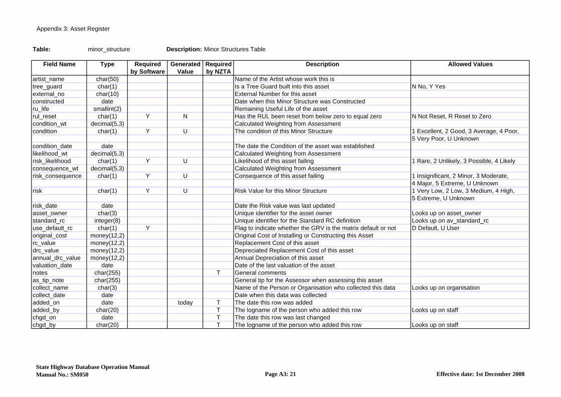
Table: minor_structure Description: Minor Structures Table
Field Name Type Required Generated Required Description Allowed Valuesby Software Value by NZTA
minor_structure_id serial(5) Y G T Minor Structure Unique Identifierroad_id integer(6) Y T RAMM Road ID Looks up on roadnamesstart_m integer(5) Y Start displacement in metres from the road origin Between 0 & 99999 srart_desc char(40) Description of the Start Locationend_m integer(5) End displacement(m) in metres from the road origin Between 1 & 99999 or is nullend_desc char(40) Description of the End Locationms_type char(6) Y T Minor structure type code Looks up on ms_typems_subtype char(5) T Minor structure subtype code Looks up on ms_subtypequantity integer(5) Y 1 The Number of Minor Structures at this Displacement Between 1 & 32000northing decimal(12,4) NZ Map Grid Co-ordinate Between -99.9999 & 9999999.9 or is nulleasting decimal(12,4) NZ Map Grid Co-ordinate Between -99.9999 & 9999999.9 or is nullnorthing_end decimal(12,4) NZ Map Grid Co-ordinate Between -99.9999 & 9999999.9 or is nulleasting_end decimal(12,4) NZ Map Grid Co-ordinate Between -99.9999 & 9999999.9 or is nullgps_date date Date when the GPS was collectedgps_by char(3) The organisation that collected the GPS data Looks up on organisationgps_method_id integer(5) Unique ID for the gps_method table Looks up on gps_methodside char(1) Y T Side of the Road where the Minor Structure is located C Centre, L Left, R Right, U Unknownoffset_kerb decimal(4,1) Offset of the Minor Structure to the nearest kerb Between 0 & 120.0 or is nulloffset decimal(4,1) T Offset of the Minor Structure from the Centreline Between 0 & 120.0 or is nulloffset_lhs decimal(4,1) Offset of the Minor Structure from the Left Hand Side Between 0 & 120.0 or is nulloffset_kerb_end decimal(4,1) Offset from the Kerb at the End of the Minor Structure Between 0 & 120.0 or is nulloffset_end decimal(4,1) Offset from the Centreline of the end of the Minor Structure Between 0 & 120.0 or is nulloffset_lhs_end decimal(4,1) Offset from the Left Hand Side at the end of the Minor Struct Between 0 & 120.0 or is nulllength_m decimal(6,1) T The length of an asset but as a decimal Between 0.0 & 30000.0 or is nulllength_adjust_m integer(5) Adjusted Length above or below the calculated Length Between -30000 & 30000 or is nulllen_adjust_rsn char(5) Reason for Adjusting the Calculated Length of the Asset Looks up on len_adjust_rsnwidth decimal(6,1) T Width of the Minor Structure Between 0.0 & 30000.0 or is nullheight_m decimal(6,1) T Height of the Minor Structure Between 0.0 & 30000.0 or is nullclearance decimal(6,1) T Clearance to the Minor Structure Between 0.0 & 30000.0 or is nullarea decimal(6,1) Area covered by the Minor Structure Between 0.0 & 30000.0 or is nullms_material char(5) T Minor structure material code Looks up on ms_materialloc_house_start char(10) Number of the House nearest the Start of the Minor Structureloc_house_end char(10) House No. of the 2nd House nearest to the Minor Structurems_surf_treat char(5) Minor Structure Surface Treatment Code Looks up on ms_surf_treatms_colour char(5) Minor Structure Colour Code Looks up on ms_colourms_style char(5) T Minor Structure Style Code Looks up on ms_stylelockable char(1) Is this asset Lockable or not? M Mixture of Permanent & Removable,
P Permanent, R Removable
State Highway Database Operation ManualManual No.: SM050 Page A3: 20 Effective date: 1st December 2008
Appendix 3: Asset Register
Table: minor_structure Description: Minor Structures Table
Field Name Type Required Generated Required Description Allowed Valuesby Software Value by NZTA
artist_name char(50) Name of the Artist whose work this istree_guard char(1) Is a Tree Guard built into this asset N No, Y Yesexternal_no char(10) External Number for this assetconstructed date Date when this Minor Structure was Constructedru_life smallint(2) Remaining Useful Life of the assetrul_reset char(1) Y N Has the RUL been reset from below zero to equal zero N Not Reset, R Reset to Zerocondition_wt decimal(5,3) Calculated Weighting from Assessmentcondition char(1) Y U The condition of this Minor Structure 1 Excellent, 2 Good, 3 Average, 4 Poor,
5 Very Poor, U Unknowncondition_date date The date the Condition of the asset was establishedlikelihood_wt decimal(5,3) Calculated Weighting from Assessmentrisk_likelihood char(1) Y U Likelihood of this asset failing 1 Rare, 2 Unlikely, 3 Possible, 4 Likelyconsequence_wt decimal(5,3) Calculated Weighting from Assessmentrisk_consequence char(1) Y U Consequence of this asset failing 1 Insignificant, 2 Minor, 3 Moderate,
4 Major, 5 Extreme, U Unknownrisk char(1) Y U Risk Value for this Minor Structure 1 Very Low, 2 Low, 3 Medium, 4 High,
5 Extreme, U Unknownrisk_date date Date the Risk value was last updatedasset_owner char(3) Unique identifier for the asset owner Looks up on asset_ownerstandard_rc integer(8) Unique identifier for the Standard RC definition Looks up on av_standard_rcuse_default_rc char(1) Y Flag to indicate whether the GRV is the matrix default or not D Default, U Useroriginal_cost money(12,2) Original Cost of Installing or Constructing this Assetrc_value money(12,2) Replacement Cost of this assetdrc_value money(12,2) Depreciated Replacement Cost of this assetannual_drc_value money(12,2) Annual Depreciation of this assetvaluation_date date Date of the last valuation of the assetnotes char(255) T General commentsas_tip_note char(255) General tip for the Assessor when assessing this assetcollect_name char(3) Name of the Person or Organisation who collected this data Looks up on organisationcollect_date date Date when this data was collectedadded_on date today T The date this row was addedadded_by char(20) T The logname of the person who added this row Looks up on staffchgd_on date T The date this row was last changedchgd_by char(20) T The logname of the person who added this row Looks up on staff
State Highway Database Operation ManualManual No.: SM050 Page A3: 21 Effective date: 1st December 2008
Appendix 3: Asset Register
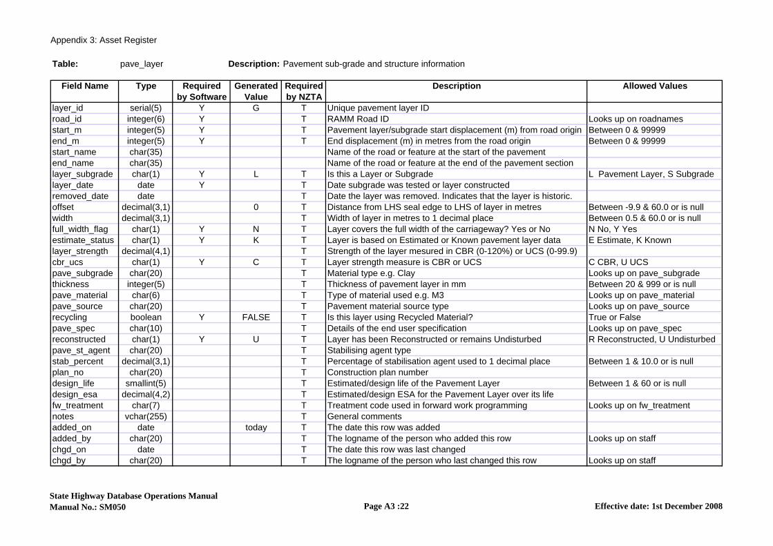
Table: pave_layer Description: Pavement sub-grade and structure information
Field Name Type Required Generated Required Description Allowed Valuesby Software Value by NZTA
layer_id serial(5) Y G T Unique pavement layer IDroad_id integer(6) Y T RAMM Road ID Looks up on roadnamesstart_m integer(5) Y T Pavement layer/subgrade start displacement (m) from road origin Between 0 & 99999 end_m integer(5) Y T End displacement (m) in metres from the road origin Between 0 & 99999 start_name char(35) Name of the road or feature at the start of the pavementend_name char(35) Name of the road or feature at the end of the pavement sectionlayer_subgrade char(1) Y L T Is this a Layer or Subgrade L Pavement Layer, S Subgradelayer_date date Y T Date subgrade was tested or layer constructedremoved_date date T Date the layer was removed. Indicates that the layer is historic.offset decimal(3,1) 0 T Distance from LHS seal edge to LHS of layer in metres Between -9.9 & 60.0 or is nullwidth decimal(3,1) T Width of layer in metres to 1 decimal place Between 0.5 & 60.0 or is nullfull_width_flag char(1) Y N T Layer covers the full width of the carriageway? Yes or No N No, Y Yesestimate_status char(1) Y K T Layer is based on Estimated or Known pavement layer data E Estimate, K Knownlayer_strength decimal(4,1) T Strength of the layer mesured in CBR (0-120%) or UCS (0-99.9)cbr_ucs char(1) Y C T Layer strength measure is CBR or UCS C CBR, U UCSpave_subgrade char(20) T Material type e.g. Clay Looks up on pave_subgradethickness integer(5) T Thickness of pavement layer in mm Between 20 & 999 or is nullpave_material char(6) T Type of material used e.g. M3 Looks up on pave_materialpave_source char(20) T Pavement material source type Looks up on pave_sourcerecycling boolean Y FALSE T Is this layer using Recycled Material? True or Falsepave_spec char(10) T Details of the end user specification Looks up on pave_specreconstructed char(1) Y U T Layer has been Reconstructed or remains Undisturbed R Reconstructed, U Undisturbedpave_st_agent char(20) T Stabilising agent typestab_percent decimal(3,1) T Percentage of stabilisation agent used to 1 decimal place Between 1 & 10.0 or is nullplan_no char(20) T Construction plan numberdesign_life smallint(5) T Estimated/design life of the Pavement Layer Between 1 & 60 or is nulldesign_esa decimal(4,2) T Estimated/design ESA for the Pavement Layer over its lifefw_treatment char(7) T Treatment code used in forward work programming Looks up on fw_treatmentnotes vchar(255) T General comments added_on date today T The date this row was addedadded_by char(20) T The logname of the person who added this row Looks up on staffchgd_on date T The date this row was last changedchgd_by char(20) T The logname of the person who last changed this row Looks up on staff
State Highway Database Operations ManualManual No.: SM050 Page A3 :22 Effective date: 1st December 2008

Appendix 3: Asset Register
Table: pave_test_pit Description: Pavement test pit survey results for a single layer
Field Name Type Required Generated Required Description Allowed Valuesby Software Value by NZTA
test_pit_no integer(5) Y T Unique system generated id for this test pi Looks up on pave_test_pit_hdlayer_type char(1) Y L T test pit layer is C Surface, L Pavement layer, S Subgrade C Surface, L Pavement layer
S Subgradestart_depth smallint(4) Y T Start depth measured from the top of the basecourse (mm Between 0 & 3000 or is nulend_depth smallint(4) Y T Ens depth (start depth of following layer) (mm Between 0 & 3000 or is nulpave_material char(6) T Test pit layer material if this is a pavement laye Looks up on pave_materiapave_subgrade char(20) Test pit material type for subgrade layers e.g. Clay Looks up on pave_subgradelayer_strength decimal(4,1) Strength of the layer mesured in CBR (0-120%) or UCS (0-99.9)cbr_ucs char(1) Y C Layer strength measure is CBR or UCS C CBR, U UCSpave_st_agent char(20) Stabilising agent type found in this test pit layer Looks up on pave_st_agentnotes vchar(255) General comments added_on date today T The date this row was addedadded_by char(20) T The logname of the person who added this row Looks up on staffchgd_on date T The date this row was last changedchgd_by char(20) T The logname of the person who last changed this row Looks up on staff
State Highway Database Operations ManualManual No.: SM050 Page A3:23 Effective date: 1st December 2008

Appendix 3: Asset Register
Table: pave_test_pit_hdr Description: Pavement test pit survey header
Field Name Type Required Generated Required Description Allowed Valuesby Software Value by NZTA
test_pit_no serial(5) Y G T Unique system generated id for this test pitroad_id integer(6) Y T RAMM Road IDlocation integer(5) Y T Displacement in metres from the road origin Between 0 & 99999 or is nulloffset decimal(3,1) Y T Distance from LHS of c/way to test pit location Between 0 & 60.0 or is nullhistoric char(1) Y C Set to historic if pavement layers are altered since test date C Current: Pavement layers are
undisturbed since test dateH Historic: Pavement layers have beenaltered since test date
test_date date Y T The date of the test pit surveypave_tp_method char(1) Y T Test pit survey method Looks up on pave_tp_methodtest_consultant char(30) The survey was performed by this group C CBR, U UCSjob_no char(20) Consultants job number/job name ref for this surveysnp decimal(4,2) Adjusted Structural Number (SNP)snp_method char(5) Method used to calculate the SNP Looks up on snp_methodsnp_organisation char(3) Person or organisationwho calculated the SNP Looks up on organisationsnp_date date Date when the SNP was calculatedtest_notes char(255) T General comments added_on date today T The date this row was addedadded_by char(20) T The logname of the person who added this row Looks up on staffchgd_on date T The date this row was last changedchgd_by char(20) T The logname of the person who last changed this row Looks up on staff
State Highway database Operations ManualManual No.: SM050 Page A3:24 Effective date: 1st December 2008

Appendix 3: Asset Register
Table: railings Description: Railings
Field Name Type Required Generated Required Description Allowed Valuesby Software Value by NZTA
road_id integer(6) Y T RAMM Road ID Looks up on roadnamesstart_m integer(5) Y T Distance in metres from road origin to the start of the railing Between 0 & 99999 end_m integer(5) T End Displacement(m) in metres from the road origin Between 1 & 99999 or is nullstart_name char(35) Name of the road or feature at the start of the railingend_name char(35) Name of the road or feature at the end of the railingrailing_id serial(7) Y G T Unique number of railinglength_m integer(5) Y T Length in metres Between 0 & 30000length_adjust_m integer(5) Adusted Length above or below the calculated length Between -30000 & 30000 or is nulllen_adjust_rsn char(5) Reason for Adjusting the Calculated Length of the Asset Looks up on len_adjust_rsnnorthing decimal(12,4) Northing at the start of the Railing Between -99.9999 & 9999999.9 or is nulleasting decimal(12,4) Easting at the start of the Railing Between -99.9999 & 9999999.9 or is nullnorthing_end decimal(12,4) Northing at the end of the Railing Between -99.9999 & 9999999.9 or is nulleasting_end decimal(12,4) Easting at the end of the Railing Between -99.9999 & 9999999.9 or is nullgps_date date Date when the GPS was collectedgps_by char(3) The organisation that collected the GPS data Looks up on organisationgps_method_id integer(5) Unique ID for the gps_method table Looks up on gps_methodoffset_kerb decimal(4,1) Offset of the start of the Railing from the nearest kerb Between 0 & 120.0 or is nulloffset decimal(4,1) T Offset at the start of the Railing from the centreline Between 0 & 120.0 or is nulloffset_lhs decimal(4,1) Offset of the start of the Railing from the LHS Between 0 & 120.0 or is nulloffset_kerb_end decimal(4,1) Offset of the end of the Railing from the nearest Kerb Between 0 & 120.0 or is nulloffset_end decimal(4,1) Offset of the end of the Railing from the centreline Between 0 & 120.0 or is nulloffset_lhs_end decimal(4,1) Offset of the end of the Railing from the left hand side Between 0 & 120.0 or is nullside char(1) Y T Side of the carriageway section that the railing is located B Both, C Centre, E End, L Left,
N Not Applicablerailing_type char(5) Y T Type of railing Looks up on railing_typeinstall_date date T The date the asset was installedground_height decimal(4,1) T Height of the railing from the ground (m)railing_width decimal(4,1) Width of railing (m)railing_make char(5) T Railing manufacturer Looks up on railing_makeshape char(1) T General shape of railing C Curved, S S Bend, T Straightrailing_colour char(2) Major colour of railing Looks up on railing_colourrailing_material char(5) T Predominate material that the railing is constructed from Looks up on railing_materialrailing_attach char(2) T Attachments found on the railing Looks up on railing_attachrail_start_style char(5) T Start style used on railing Looks up on rail_end_stylerail_end_style char(5) T Ending style used on railing Looks up on rail_end_stylesafe_height char(1) Does the Handrail conform to the current Safety Standard N No, Y Yesrailing_ground_fix char(4) T How the railing is set in the ground Looks up on railing_ground_fix
State Highway Database Operations ManualManual No.: SM050 Page A3 :25 Effective date: 1st December 2008

Appendix 3: Asset Register
Table: railings Description: Railings
Field Name Type Required Generated Required Description Allowed Valuesby Software Value by NZTA
railing_purpose char(100) The purpose the railing was erectedloc_house1_no char(10) House Number nearest to the start of this Railingloc_house2_no char(10) House nearest to the End of this Railingother_road_id integer(6) Road ID if the railing is situated on an intersection Looks up on roadnamesother_side char(1) The side of the other road the pole is located on C Centre, L Left, R Right, U Unknownother_start_m integer(5) Start displacement of carriageway section in metres Between 0 & 99999 or is nullru_life smallint(3) Remaining Useful Life of the assetrul_reset char(1) Y N Has the RUL been reset from below zero to equal zero N Not Reset, R Reset to Zerocondition_wt decimal(5,3) Calculated Weighting from Assessmentcondition char(1) Y U The condition of this railing 1 Excellent, 2 Good, 3 Average, 4 Poor,
5 Very Poor, U Unknowncondition_date date The date the Condition of the asset was establishedlikelihood_wt decimal(5,3) Calculated Weighting from Assessmentrisk_likelihood char(1) Y U T Likelihood of this asset failing 1 Rare, 2 Unlikely, 3 Possible, 4 Likely,
5 Almost Certain, U Unknownconsequence_wt decimal(5,3) Calculated Weighting from Assessmentrisk_consequence char(1) Y U T Consequence of this asset failing 1 Insignificant, 2 Minor, 3 Moderate,
4 Major, 5 Extreme, U Unknownrisk char(1) Y U The Risk of this asset failing 1 Very Low, 2 Low, 3 Medium, 4 High,
5 Extreme, U Unknownrisk_date date Date the Risk value was last updatedasset_owner char(3) Unique identifier for the asset owner Looks up on asset_ownerpost_count smallint(2) 0 Number of posts supporting this railing Between 0 & 99post_material char(5) Material of posts Looks up on railing_materialpost_condition char(1) Y U The condition of this post 1 Excellent, 2 Good, 3 Average, 4 Poor,
5 Very Poor, U Unknownbridge_id integer(5) Unique bridge ID Looks up on br_bridge
retaing_wall_id integer(5) Retaining Wall Unique Identifier Looks up on retaining_wallpaint_system char(3) Y Paint System Used Looks up on br_paint_systemstandard_rc integer(8) Unique identifier for the Standard RC definition Looks up on av_standard_rcuse_default_rc char(1) Y D Does this asset use the Default RC definition D Default, U Useroriginal_cost money(12,2) Original Cost of Installing or Constructing this Assetrc_value money(12,2) Replacement Cost of this assetdrc_value money(12,2) Depreciated Replacement value of the asset or componentannual_drc_value money(12,2) Annual Depreciation of this assetvaluation_date date Date of the last valuation of the asset
State Highway Database Operations ManualManual No.: SM050 Page A3 :26 Effective date: 1st December 2008

Appendix 3: Asset Register
Table: railings Description: Railings
Field Name Type Required Generated Required Description Allowed Valuesby Software Value by NZTA
notes char(255) T General commentspost_notes char(255) General Comments on Railing Postsas_tip_note char(255) General tip for the Assessor when assessing this assetcollect_name char(3) Name of the person or organisation who collected this data Looks up on organisationcollect_date date Date when this data was collectedadded_on date today T The date this row was addedadded_by char(20) T The logname of the person who added this row Looks up on staffchgd_on date T The date this row was last changedchgd_by char(20) T The logname of the person who last changed this row Looks up on staff
State Highway Database Operations ManualManual No.: SM050 Page A3 :27 Effective date: 1st December 2008

Appendix 3: Asset Register
Table: retaining_wall Description: Retaining Wall table
Field Name Type Required Generated Required Description Allowed Valuesby Software Value by NZTA
retaining_wall_id serial(5) Y G T Retaining Wall Uinique identifierroad_id integer(6) Y T RAMM Road ID Looks up on roadnamesstart_m integer(5) Y T Start displacement in metres from the road origin Between 0 & 99999start_desc char(40) Description of the Start Locationend_m integer(5) T End displacement in metres from the road origin Between 1 & 99999 or is nullend_desc char(40) Description of the End locationret_wall_type char(5) T Retaining Wall type Looks up on ret_wall_typequantity integer(5) Y 1 The number of reatining walls at this displacement Between 1 & 32000 northing decimal(12,4) T NZ map grid co-ordinate Between -99.9999 & 9999999.9 or is nulleasting decimal(12,4) T NZ map grid co-ordinate Between -99.9999 & 9999999.9 or is nullnorthing_end decimal(12,4) T NZ map grid co-ordinate Between -99.9999 & 9999999.9 or is nulleasting_end decimal(12,4) T NZ map grid co-ordinate Between -99.9999 & 9999999.9 or is nullgps_date date T Date when the GPS was collectedgps_by char(3) The organisation that collected the GPS data Looks up on organisationgps_method_id integer(5) Unique ID for the gps_method table Looks up on gps_methodside char(1) Y T Side of the road where the retaining wall is located C Centre, L Left, R Right, U Unknownoffset_kerb decimal(4,1) Offset from the retaining wall to the nearest kerb Between 0 & 120.0 or is nulloffset decimal(4,1) T Offest of the retaining wall from the centreline Between 0 & 120.0 or is nulloffset_lhs decimal(4,1) Offset of the retaining wall from the left hand side Between 0 & 120.0 or is nulloffset_kerb_end decimal(4,1) Offest from the kerb of the end of the reatining wall Between 0 & 120.0 or is nulloffset_end decimal(4,1) Offset from the centreline of the end of the retaining wall Between 0 & 120.0 or is nulloffset_lhs_end decimal(4,1) Offset from the left hand side at the end of the retaining wall Between 0 & 120.0 or is nullloc_house_start char(10) Number of the house nearest to the start of the retaining wallloc_house_end char(10) House number of the 2nd house nearest to the retaining walllength_m decimal(6,1) T The length of the retaining wall Between 0.0 & 30000.0 or is nulllength_adjust_m integer(5) Adjusted length above or below the calculated length Between -30000.0 & 30000.0 or is nulllen_adjust_rsn char(5) Reason for adjusting the calculated length of the asset Looks up on len_adjust_rsnwidth decimal(6,1) The width of the retaining wall Between 0.0 & 30000.0 or is nullheight_m_avg decimal(6,1) T Average height of the retaining wall Between -30000.0 & 30000.0 or is nullheight_m_min decimal(6,1) Minimum height of the retaining wall Between -30000.0 & 30000.0 or is nullheight_m_max decimal(6,1) Maximum height of the retaining wall Between -30000.0 & 30000.0 or is nullarea decimal(6,1) Area covered by the retaining wall Between 0.0 & 30000.0 or is nulloverburden_avg smallint(2) Average angle of overburden for the retaining wall Between -90 & 90 or is nulloverburden_min smallint(2) Minimum angle of overburden for the retaining wall Between -90 & 90 or is nulloverbuden_max smallint(2) Maximum angle of overburden for the retaining wall Between -90 & 90 or is nulllean_angle_avg smallint(2) Average lean angle for the retaining wall Between -90 & 90 or is null
State Highway Database Operations ManualManual No.: SM050 Page A3: 28 Effective date: 1st December 2008

Appendix 3: Asset Register
Table: retaining_wall Description: Retaining Wall table
Field Name Type Required Generated Required Description Allowed Valuesby Software Value by NZTA
lean_angle_min smallint(2) Minimum lean angle for the retaining wall Between -90 & 90 or is nulllean_angle_max smallint(2) Maximum lean angle for the retaining wall Between -90 & 90 or is nulledge_offset_avg_a decimal(4,1) Average offset to the edgeline of the retaining wall - above Between 0 & 120.0 or is nulledge_offset_min_a decimal(4,1) Minimum offset to the edgeline of the reatining wall - above Between 0 & 120.0 or is nulledge_offset_max_a decimal(4,1) Maximum offset to the edgeline of the retaining wall - above Between 0 & 120.0 or is nulledge_offset_avg_b decimal(4,1) Average offset to the edgeline of the retaining wall - below Between 0 & 120.0 or is nulledge_offset_min_b decimal(4,1) Minimum offset to the edgeline of the reatining wall - below Between 0 & 120.0 or is nulledge_offset_max_b decimal(4,1) Maximum offset to the edgeline of the retaining wall - below Between 0 & 120.0 or is nullms_material char(5) T Retaining wall material Looks up on ms_materialland_use_above char(50) Land use above the retaining wallland_use_below char(50) Land use below the retaining wallret_wall_cat char(5) Retaining wall category code Looks up on ret_wall_catret_wall_fnd char(5) Retaining wall foundation code Looks up on ret_wall_fndexternal_id char(10) External identifier for this retaining wall outside RAMMconstructed date Date when this retaining wall was constructedru_life smallint(2) Remaining useful life of the assetrul_reset char(1) Y N Has the RUL been reset from below zero to equal zero N Not Reset, R Reset to Zerocondition_wt decimal(5,3) Calculated weighting from assessmentcondition char(1) Y U The condition of this retaining wall 1 Excellent, 2 Good, 3 Average, 4 Poor,
5 Very Poor, U Unknowncondition_date date The date the condition of the asset was establishedlikelihood_wt decimal(5,3) Calculated weighting from assessmentrisk_likelihood char(1) Y U Likelihood of this asset failing 1 Rare, 2 Unlikely, 3 Possible, 4 Likely,
5 Almost Certain, U Unknownconsequence_wt decimal(5,3) Calculated weighting from assessmentrisk_consequence char(1) Y U Consequence of this asset failing 1 Insignificant, 2 Minor, 3 Moderate,
4 Major, 5 Extreme, U Unknownrisk char(1) Y U The risk value for this retaining wall 1 Very low, 2 Low, 3 Medium, 4 High,
5 Extreme, U Unknownrisk_date date Date the risk value was last updatedasset_owner char(3) Unique identifier for the asset owner Looks up on asset_ownerstandard_rc integer(8) Unique identifier for the standard rc definition Looks up on av_standard_rcuse_default_rc char(1) Y D Flag to indicate whether the GRV is the matrix default or not D Default, U Useroriginal_cost money(12,2) Original cost of installing or constructing this assetrc_value money(12,2) Replacement cost of this assetdrc_value money(12,2) Depreciated replacement cost of this asset
State Highway Database Operations ManualManual No.: SM050 Page A3: 29 Effective date: 1st December 2008

Appendix 3: Asset Register
Table: retaining_wall Description: Retaining Wall table
Field Name Type Required Generated Required Description Allowed Valuesby Software Value by NZTA
annual_drc_value money(12,2) Annual depreciation of this assetvaluation_date date Date of the last valuation of the assetnotes char(255) General commentsas_tip_note char(255) General tip for the assessor when assessing this assetcollect_name char(3) Name of the person or arganisation who collected this data Looks up on organisationcollect_date date Date when this data was collectedadded_on date today T The date this row was addedadded_by char(8) T The logname of the person who added this row Looks up on staffchgd_on date T The date this row was last changedchgd_by char(8) T The logname of the person who last changed this row Looks up on staff
State Highway Database Operations ManualManual No.: SM050 Page A3: 30 Effective date: 1st December 2008

Appendix 3: Asset Register
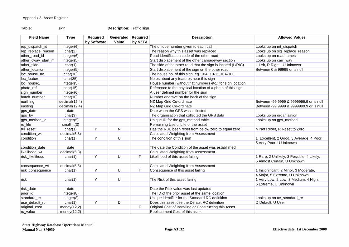
Table: sign Description: Traffic sign
Field Name Type Required Generated Required Description Allowed Valuesby Software Value by NZTA
road_id integer(6) Y T RAMM Road ID Looks up on roadnamescarrway_start_m integer(5) T Start displacement in metres from the road origin Looks up on carr_waysign_id serial(8) Y G T Unique sign IDpost_count smallint(2) Y 0 The number of posts attached to this sign Between 0 & 99sign_group char(7) The group that this sign is part of Looks up on sign_groupsign_class char(3) Y The classification of the sign Looks up on sign_classsign_type char(7) Y T The Sign type code Looks up on sign_typelocation integer(5) T Displacement in metres from the road origin Between 0 & 99999 or is nullside char(1) Y T Side of the carriageway section that the sign is located on C Centre, L Left, R Right,
U Unknownoffset_kerb decimal(4,1) Offset from the nearest kerb to the sign Between 0 & 120.0 or is nulloffset decimal(4,1) Dist. from road centreline to sign in metres Between 0 & 120.0 or is nulloffset_lhs decimal(4,1) Offset from the left hand side to the Sign Between 0 & 120.0 or is nullsign_angle smallint(3) Angle in degrees clockwise from road forward direction Between 0 & 359 or is nullquantity integer(5) Y 1 T Number in section of this sign type (multiple signs only) Between 1 & 32000latest char(1) Y N Status of the road-speed record L Latest, N Not Latestindicating_dir char(1) Y N The direction this sign is indicating. Left, Right or N/A A Against, B Both, F For, L Left,
N Not applicable, R Right, S Side, U Unknown
sign_owner char(2) The owner of the sign / post Looks up on sign_ownerlegend_note char(255) Y T The legend that is on the signlegend2_note char(255) T Sign legend on the reverse side of the signlegend_material char(2) Y T The type of material used for the legend Looks up on sign_materiallegend_colour char(2) Y T The colour of the legend Looks up on sign_colourbground_material char(2) Y T The type of material used for the background Looks up on sign_materialbground_colour char(2) Y T The colour of the background Looks up on sign_coloursign_substrate char(2) Y The sign substrate material Looks up on sign_substratesign_width integer(5) T The sign width in mm Between 0 & 99999 or is nullsign_height integer(5) T The sign height in mm Between 0 & 99999 or is nullground_height integer(5) Height of sign from ground Between 0 & 99999 or is nullframe char(1) Y N Is the sign Framed, Not framed or Unknown F Framed, N Not framed, U Unknowninstall_date date T The date the sign was installedin_contract_id smallint(2) The contract number for this work Looks up on mt_contractin_dispatch_id integer(6) The unique number given to each call Looks up on mt_dispatchin_replace_reason char(2) T The reason why this asset was replaced Looks up on sig_replace_reasonreplace_date date T The date the asset was replacedrep_contract_id smallint(2) The contract number for this work Looks up on mt_contract
State Highway Database Operations ManualManual No.: SM050 Page A3 :31 Effective date: 1st December 2008
Appendix 3: Asset Register
Table: sign Description: Traffic sign
Field Name Type Required Generated Required Description Allowed Valuesby Software Value by NZTA
rep_dispatch_id integer(6) The unique number given to each call Looks up on mt_dispatchrep_replace_reason char(2) The reason why this asset was replaced Looks up on sig_replace_reasonother_road_id integer(6) Road identification code of the other road Looks up on roadnamesother_cway_start_m integer(5) Start displacement of the other carriageway section Looks up on carr_wayother_side char(1) The side of the other road that the sign is located (L/R/C) L Left, R Right, U Unknownother_location integer(5) Start displacement of the sign on the other road Between 0 & 99999 or is nullloc_house_no char(10) The house no. of this sign. eg. 10A, 10-12,10A-10Eloc_feature char(35) Notes about any features near this signloc_house1 integer(5) House number (without flat numbers etc.) for sign locationphoto_ref char(15) Reference to the physical location of a photo of this signsign_number integer(6) A user defined number for the signbatch_number char(10) Number engrave on the back of the signnorthing decimal(12,4) NZ Map Grid Co-ordinate Between -99.9999 & 9999999.9 or is nulleasting decimal(12,4) NZ Map Grid Co-ordinate Between -99.9999 & 9999999.9 or is nullgps_date date Date when the GPS was collectedgps_by char(3) The organisation that collected the GPS data Looks up on organisationgps_method_id integer(5) Unique ID for the gps_method table Looks up on gps_methodru_life smallint(3) Remaining Useful Life of the assetrul_reset char(1) Y N Has the RUL been reset from below zero to equal zero N Not Reset, R Reset to Zerocondition_wt decimal(5,3) Calculated Weighting from Assessmentcondition char(1) Y U The condition of this sign 1 Excellent, 2 Good, 3 Average, 4 Poor,
5 Very Poor, U Unknowncondition_date date The date the Condition of the asset was establishedlikelihood_wt decimal(5,3) Calculated Weighting from Assessmentrisk_likelihood char(1) Y U T Likelihood of this asset failing 1 Rare, 2 Unlikely, 3 Possible, 4 Likely,
5 Almost Certain, U Unknownconsequence_wt decimal(5,3) Calculated Weighting from Assessmentrisk_consequence char(1) Y U T Consequence of this asset failing 1 Insignificant, 2 Minor, 3 Moderate,
4 Major, 5 Extreme, U Unknownrisk char(1) Y U The Risk of this asset failing 1 Very Low, 2 Low, 3 Medium, 4 High,
5 Extreme, U Unknownrisk_date date Date the Risk value was last updatedprior_id integer(8) The ID of the prior asset at the same locationstandard_rc integer(8) Unique identifier for the Standard RC definition Looks up on av_standard_rcuse_default_rc char(1) Y D Does this asset use the Default RC definition D Default, U Useroriginal_cost money(12,2) T Original Cost of Installing or Constructing this Assetrc_value money(12,2) Replacement Cost of this asset
State Highway Database Operations ManualManual No.: SM050 Page A3 :32 Effective date: 1st December 2008

Appendix 3: Asset Register
Table: sign Description: Traffic sign
Field Name Type Required Generated Required Description Allowed Valuesby Software Value by NZTA
drc_value money(12,2) Depreciated Replacement value of the asset or componentannual_drc_value money(12,2) Annual Depreciation of this assetvaluation_date date Date of the last valuation of the assetgeneral_note char(255) T General commentsas_tip_note char(255) General tip for the Assessor when assessing this assetcollect_name char(3) Name of the person or organisation who collected this data Looks up on organisationcollect_date date Date when this data was collectedadded_on date today T The date this row was addedadded_by char(20) T The logname of the person who added this row Looks up on staffchgd_on date T The date this row was last changedchgd_by char(20) T The logname of the person who last changed this row Looks up on staff
State Highway Database Operations ManualManual No.: SM050 Page A3 :33 Effective date: 1st December 2008

Appendix 3: Asset Register
Table: sl_bracket Description: SLIM (Street Lights)
Field Name Type Required Generated Required Description Allowed Valuesby Software Value by NZTA
bracket_id serial(6) Y G T Unique bracket numberpole_id serial(6) Y T Unique numeric identifier of pole Looks up on sl_polebracket_type char(4) Y T Bracket type code Looks up on sl_bracket_typebracket_angle smallint(3) T Angle in degrees clockwise from road forward direction 0 0, 120 120, 135 135, 150 150, 180 180,
210 210, 240 240, 255 255, 270 270, 285 285, 30 30, 300 300, 315 315, 330 330,345 345, 45 45, 60 60, 75 75, 90 90
bracket_height decimal(3,1) T Height of the bracket from the base of the pole Between 0 and 99.9 or is nullheight_ind char(1) T Is the bracket height an estimate or measure E Estimate, M Measured, N Not applicableoutreach decimal(3,1) T Outreach of bracket in metres Between 0 and 99.9 or is nullcoating char(4) Coating for bracket Looks up on sl_coatingbracket_colour char(30) The colour of the bracketbracket_status char(1) Installation: New, Reconditioned or Unknown N New, R Reconditioned, U Unknowninstall_date date T Installation date of the bracketin_replace_reason char(2) T The reason code as to why this asset is being replaced Looks up on sl_replace_reasonin_contract_id smallint(2) The contract number for this workin_dispatch_id integer(6) The unique number given to each callreplace_date date T The date this bracket was replacedrep_replace_reason char(2) The reason code as to why this bracket was replaced Looks up on sl_replace _reasonrep_contract_id smallint(2) The contract number for this workrep_dispatch_id integer(6) The dispatch id to replace this bracketprior_id integer(8) The id of the prior asset at the same locationru_life smallint(2) Remaining useful life of the assetrul_reset char(1) Y N Has the RUL been reset from below zero to equal zero N Not Reset, R Reset to Zerocondition_wt decimal(5,3) Calculated weighting from assessmentcondition char(1) Y The condition of this retaining wall 1 Excellent, 2 Good, 3 Average, 4 Poor,
5 Very Poor, U Unknowncondition_date date The date the condition of the asset was establishedlikelihood_wt decimal(5,3) Calculated weighting from assessmentrisk_likelihood char(1) Y U Likelihood of this asset failing 1 Rare, 2 Unlikely, 3 Possible, 4 Likely, consequence_wt decimal(5,3) Calculated weighting from assessmentrisk_consequence char(1) Y U Consequence of this asset failing 1 Insignificant, 2 Minor, 3 Moderate,
4 Major, 5 Extreme, U Unknownrisk char(1) Y U The risk of this asset failing 1 Very low, 2 Low, 3 Medium, 4 High,
5 Extreme, U Unknownrisk_date date Date the risk value was last updatedstandard_rc integer(8) Unique identifier for the standard rc definition Looks up on av_standard_rcuse_default_rc char(1) Y D Does this asset use the Default RC definition D Default, U Useroriginal_cost money(12,2) Original cost of installing or constructing this asset
State Highway Database Operations ManualManual No: SM050 Page A3: 34 Effective date: 1st December 2008

Appendix 3: Asset Register
Table: sl_bracket Description: SLIM (Street Lights)
Field Name Type Required Generated Required Description Allowed Valuesby Software Value by NZTA
rc_value money(12,2) Replacement cost of this assetdrc_value money(12,2) Depreciated replacement value of the asset or componentannual_drc_value money(12,2) Annual depreciation of this assetvaluation_date date Date of the last valuation of the assetnotes char(255) General commentsas_tip_note char(255) General tip for the assessor when assessing this assetcollect_name char(3) Name of the person or arganisation who collected this data Looks up on organisationcollect_date date Date when this data was collectedadded_on date today T The date this row was addedadded_by char(8) T The logname of the person who added this row Looks up on staffchgd_on date T The date this row was last changedchgd_by char(8) T The logname of the person who last changed this row Looks up on staff
State Highway Database Operations ManualManual No: SM050 Page A3: 35 Effective date: 1st December 2008
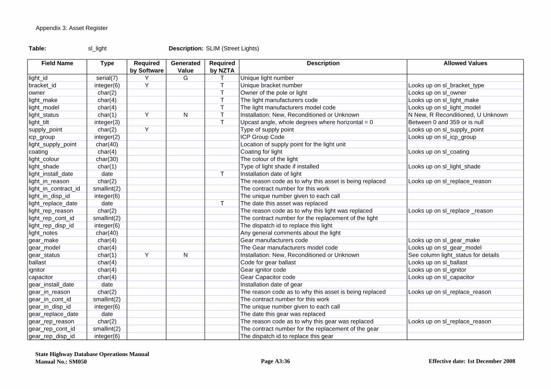
Appendix 3: Asset Register
Table: sl_light Description: SLIM (Street Lights)
Field Name Type Required Generated Required Description Allowed Valuesby Software Value by NZTA
light_id serial(7) Y G T Unique light numberbracket_id integer(6) Y T Unique bracket number Looks up on sl_bracket_typeowner char(2) T Owner of the pole or light Looks up on sl_ownerlight_make char(4) T The light manufacturers code Looks up on sl_light_makelight_model char(4) T The light manufacturers model code Looks up on sl_light_modellight_status char(1) Y N T Installation: New, Reconditioned or Unknown N New, R Reconditioned, U Unknownlight_tilt integer(3) T Upcast angle, whole degrees where horizontal = 0 Between 0 and 359 or is nullsupply_point char(2) Y Type of supply point Looks up on sl_supply_pointicp_group integer(2) ICP Group Code Looks up on sl_icp_grouplight_supply_point char(40) Location of supply point for the light unitcoating char(4) Coating for light Looks up on sl_coatinglight_colour char(30) The colour of the lightlight_shade char(1) Type of light shade if installed Looks up on sl_light_shadelight_install_date date T Installation date of lightlight_in_reason char(2) The reason code as to why this asset is being replaced Looks up on sl_replace_reasonlight_in_contract_id smallint(2) The contract number for this worklight_in_disp_id integer(6) The unique number given to each calllight_replace_date date T The date this asset was replacedlight_rep_reason char(2) The reason code as to why this light was replaced Looks up on sl_replace _reasonlight_rep_cont_id smallint(2) The contract number for the replacement of the lightlight_rep_disp_id integer(6) The dispatch id to replace this lightlight_notes char(40) Any general comments about the lightgear_make char(4) Gear manufacturers code Looks up on sl_gear_makegear_model char(4) The Gear manufacturers model code Looks up on sl_gear_modelgear_status char(1) Y N Installation: New, Reconditioned or Unknown See column light_status for detailsballast char(4) Code for gear ballast Looks up on sl_ballastignitor char(4) Gear ignitor code Looks up on sl_ignitorcapacitor char(4) Gear Capacitor code Looks up on sl_capacitorgear_install_date date Installation date of geargear_in_reason char(2) The reason code as to why this asset is being replaced Looks up on sl_replace_reasongear_in_cont_id smallint(2) The contract number for this workgear_in_disp_id integer(6) The unique number given to each callgear_replace_date date The date this gear was replacedgear_rep_reason char(2) The reason code as to why this gear was replaced Looks up on sl_replace_reasongear_rep_cont_id smallint(2) The contract number for the replacement of the geargear_rep_disp_id integer(6) The dispatch id to replace this gear
State Highway Database Operations ManualManual No.: SM050 Page A3:36 Effective date: 1st December 2008
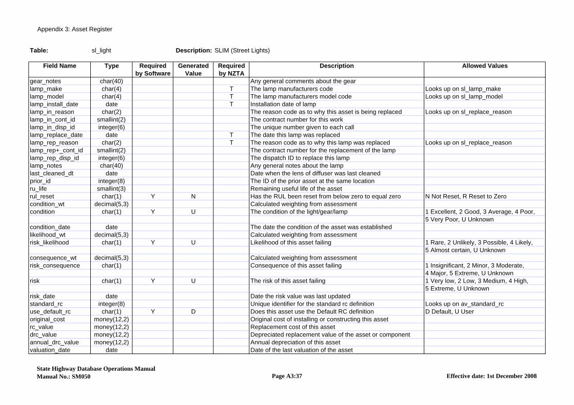
Appendix 3: Asset Register
Table: sl_light Description: SLIM (Street Lights)
Field Name Type Required Generated Required Description Allowed Valuesby Software Value by NZTA
gear_notes char(40) Any general comments about the gearlamp_make char(4) T The lamp manufacturers code Looks up on sl_lamp_makelamp_model char(4) T The lamp manufacturers model code Looks up on sl_lamp_modellamp_install_date date T Installation date of lamplamp_in_reason char(2) The reason code as to why this asset is being replaced Looks up on sl_replace_reasonlamp_in_cont_id smallint(2) The contract number for this worklamp_in_disp_id integer(6) The unique number given to each calllamp_replace_date date T The date this lamp was replacedlamp_rep_reason char(2) T The reason code as to why this lamp was replaced Looks up on sl_replace_reasonlamp_rep+_cont_id smallint(2) The contract number for the replacement of the lamplamp_rep_disp_id integer(6) The dispatch ID to replace this lamplamp_notes char(40) Any general notes about the lamplast_cleaned_dt date Date when the lens of diffuser was last cleanedprior_id integer(8) The ID of the prior asset at the same locationru_life smallint(3) Remaining useful life of the assetrul_reset char(1) Y N Has the RUL been reset from below zero to equal zero N Not Reset, R Reset to Zerocondition_wt decimal(5,3) Calculated weighting from assessmentcondition char(1) Y U The condition of the light/gear/lamp 1 Excellent, 2 Good, 3 Average, 4 Poor,
5 Very Poor, U Unknowncondition_date date The date the condition of the asset was establishedlikelihood_wt decimal(5,3) Calculated weighting from assessmentrisk_likelihood char(1) Y U Likelihood of this asset failing 1 Rare, 2 Unlikely, 3 Possible, 4 Likely,
5 Almost certain, U Unknownconsequence_wt decimal(5,3) Calculated weighting from assessmentrisk_consequence char(1) Consequence of this asset failing 1 Insignificant, 2 Minor, 3 Moderate,
4 Major, 5 Extreme, U Unknownrisk char(1) Y U The risk of this asset failing 1 Very low, 2 Low, 3 Medium, 4 High,
5 Extreme, U Unknownrisk_date date Date the risk value was last updatedstandard_rc integer(8) Unique identifier for the standard rc definition Looks up on av_standard_rcuse_default_rc char(1) Y D Does this asset use the Default RC definition D Default, U Useroriginal_cost money(12,2) Original cost of installing or constructing this assetrc_value money(12,2) Replacement cost of this assetdrc_value money(12,2) Depreciated replacement value of the asset or componentannual_drc_value money(12,2) Annual depreciation of this assetvaluation_date date Date of the last valuation of the asset
State Highway Database Operations ManualManual No.: SM050 Page A3:37 Effective date: 1st December 2008
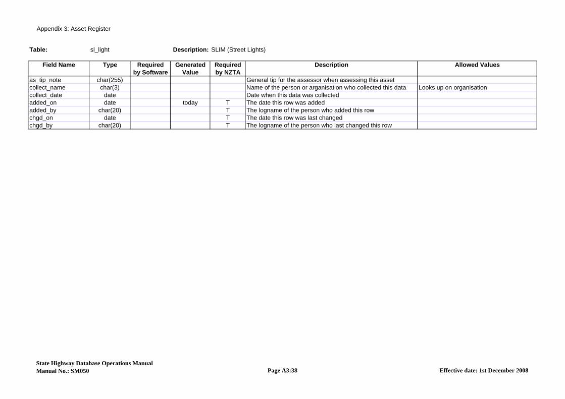
Appendix 3: Asset Register
Table: sl_light Description: SLIM (Street Lights)
Field Name Type Required Generated Required Description Allowed Valuesby Software Value by NZTA
as_tip_note char(255) General tip for the assessor when assessing this assetcollect_name char(3) Name of the person or arganisation who collected this data Looks up on organisationcollect_date date Date when this data was collectedadded_on date today T The date this row was addedadded_by char(20) T The logname of the person who added this rowchgd_on date T The date this row was last changedchgd_by char(20) T The logname of the person who last changed this row
State Highway Database Operations ManualManual No.: SM050 Page A3:38 Effective date: 1st December 2008

Appendix 3: Asset Register
Table: sl_pole Description: SLIM (Street Lights)
Field Name Type Required Generated Required Description Allowed Valuesby Software Value by NZTA
pole_id serial(6) Y G T Unique numeric identifier of poleroad_id integer(6) Y T RAMM Road ID Looks up on roadnamescarrway_start_m integer(5) T Start displacement in metres from the road origin Looks up on carr_waylocation integer(5) Displacement in metres from the road origin Between 0 & 99999 or is nulloffset_kerb decimal(4,1) Offset from the nearest kerb of the Pole Between 0 & 120.0 or is nulloffset decimal(4,1) T Offest from the centreline to the pole Between 0 & 120.0 or is nulloffset_lhs decimal(4,1) 0 Distance from lhs of carriageway to the pole in metres Between 0 & 250 or is nulloffset_side char(1) Y T Side of the road, left, right or centre C Centre, L Left, R Right, U Unknownvertical_distance decimal(3,1) Vertical distance from left hand side seal to pole base Between -10 & 99.9 or is nullvertical_ind char(1) Y N Is the vertical level an estimate, measure or n/a E Estimate, M Measured, N Not applicablepole_material char(4) Y T Pole material code Looks up on sl_pole_materialpole_shape char(4) Y T The pole shape code Looks up on sl_pole_shapepole_make char(4) T The pole manufacturer code Looks up on sl_pole_makepole_model char(4) The model number or code of the polepole_mount char(2) Y T Pole mounting type Looks up on sl_pole_mountpole_attach char(5) Pole attachment code Looks up on sl_pole_attachmax_base_dim smallint(4) Pole maximum dimension at base, dia if round or multi sided Between 0 & 9999 or is nullmin_base_dim smallint(4) Pole minimum dimension at base (mm) Between 0 & 9999 or is nullpole_purpose char(1) Y T Main purpose of pole Looks up on sl_pole_purposeowner char(2) Y U T Owner of the pole or light Looks up on sl_ownercoating char(4) T Coating applicable to pole Looks up on sl_coatingpole_colour char(30) The colour of the assetpole_status char(1) Y N T Installation: New, Reconditioned or Unknown N New, R Reconditioned, U Unknowninstall_date date T Installation date of polein_replace_reason char(2) T The reason code as to why this asset is being replaced Looks up on sl_replace_reasonin_contract_id smallint(2) The contract number for this workin_dispatch_id integer(6) The unique number given to each callreplace_date date T The date this pole was replacedrep_replace_reason char(2) T The reason code as to why this pole was replaced Looks up on sl_replace_reasonrep_contract_id smallint(2) The contract number for the replacement of this polerep_dispatch_id integer(6) The dispatch id to replace this poleuse_height decimal(3,1) Estimated height of the highest point for mounting a light Between 0 & 99.9 or is nullpole_in_use char(1) Y Y T Is the pole being used for lighting Yes, No, Unknown N No, Y Yes, U Unknownpole_control char(1) Y U T The light control mechanism for the pole Looks up on sl_pole_controllux smallint(3) Light illumination reading Between 0 & 9999 or is nullpower_company char(2) T The name of the power supply company Looks up on sl_power_companyloc_house1 integer(5) House number adjacent to poleloc_house1_a char(1) Letter of the 1st house adjacent to the poleloc_house2 integer(5) 2nd house number adjacent to pole, if near side boundary
State Highway Database Operations ManualManual No.: SM050 Page A3:39 Effective date: 1st December 2008
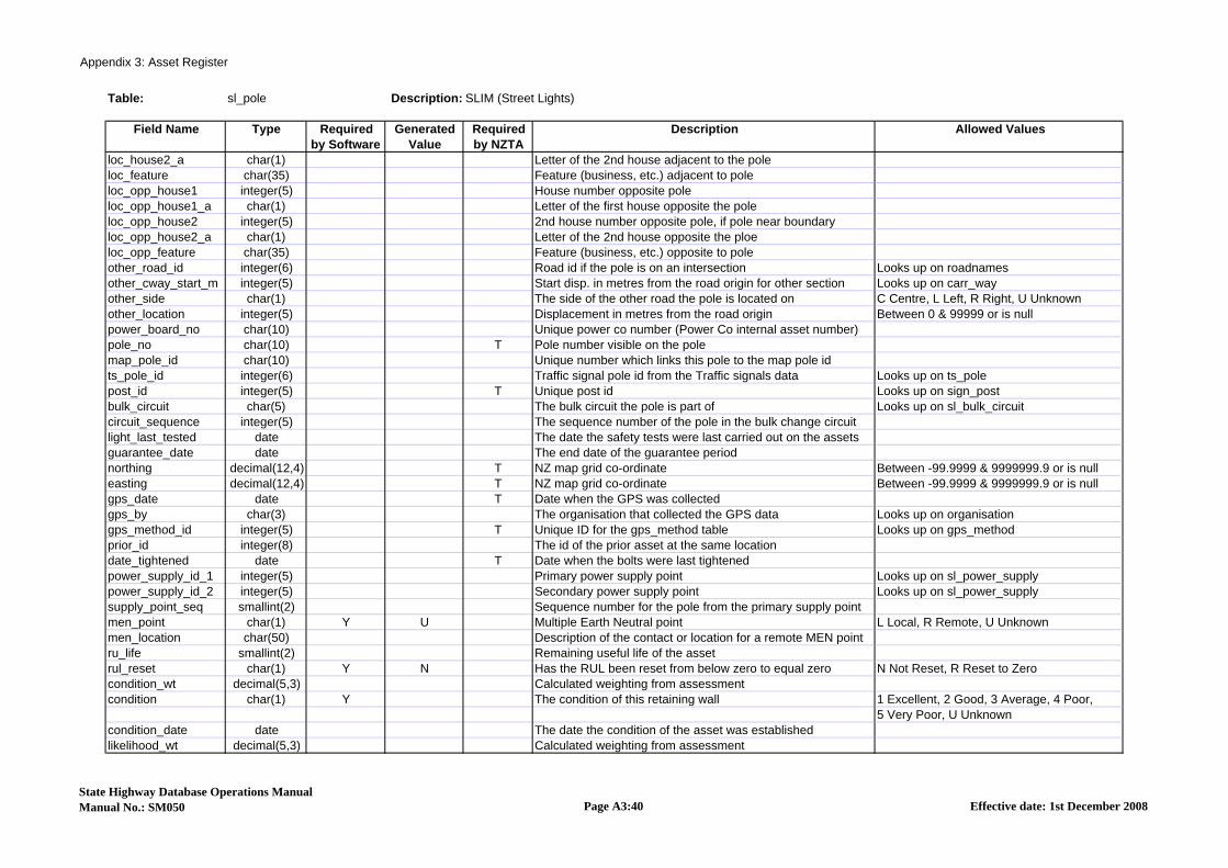
Appendix 3: Asset Register
Table: sl_pole Description: SLIM (Street Lights)
Field Name Type Required Generated Required Description Allowed Valuesby Software Value by NZTA
loc_house2_a char(1) Letter of the 2nd house adjacent to the poleloc_feature char(35) Feature (business, etc.) adjacent to poleloc_opp_house1 integer(5) House number opposite poleloc_opp_house1_a char(1) Letter of the first house opposite the poleloc_opp_house2 integer(5) 2nd house number opposite pole, if pole near boundaryloc_opp_house2_a char(1) Letter of the 2nd house opposite the ploeloc_opp_feature char(35) Feature (business, etc.) opposite to poleother_road_id integer(6) Road id if the pole is on an intersection Looks up on roadnamesother_cway_start_m integer(5) Start disp. in metres from the road origin for other section Looks up on carr_wayother_side char(1) The side of the other road the pole is located on C Centre, L Left, R Right, U Unknownother_location integer(5) Displacement in metres from the road origin Between 0 & 99999 or is nullpower_board_no char(10) Unique power co number (Power Co internal asset number)pole_no char(10) T Pole number visible on the polemap_pole_id char(10) Unique number which links this pole to the map pole idts_pole_id integer(6) Traffic signal pole id from the Traffic signals data Looks up on ts_polepost_id integer(5) T Unique post id Looks up on sign_postbulk_circuit char(5) The bulk circuit the pole is part of Looks up on sl_bulk_circuitcircuit_sequence integer(5) The sequence number of the pole in the bulk change circuitlight_last_tested date The date the safety tests were last carried out on the assetsguarantee_date date The end date of the guarantee periodnorthing decimal(12,4) T NZ map grid co-ordinate Between -99.9999 & 9999999.9 or is nulleasting decimal(12,4) T NZ map grid co-ordinate Between -99.9999 & 9999999.9 or is nullgps_date date T Date when the GPS was collectedgps_by char(3) The organisation that collected the GPS data Looks up on organisationgps_method_id integer(5) T Unique ID for the gps_method table Looks up on gps_methodprior_id integer(8) The id of the prior asset at the same locationdate_tightened date T Date when the bolts were last tightenedpower_supply_id_1 integer(5) Primary power supply point Looks up on sl_power_supplypower_supply_id_2 integer(5) Secondary power supply point Looks up on sl_power_supplysupply_point_seq smallint(2) Sequence number for the pole from the primary supply pointmen_point char(1) Y U Multiple Earth Neutral point L Local, R Remote, U Unknownmen_location char(50) Description of the contact or location for a remote MEN pointru_life smallint(2) Remaining useful life of the assetrul_reset char(1) Y N Has the RUL been reset from below zero to equal zero N Not Reset, R Reset to Zerocondition_wt decimal(5,3) Calculated weighting from assessmentcondition char(1) Y The condition of this retaining wall 1 Excellent, 2 Good, 3 Average, 4 Poor,
5 Very Poor, U Unknowncondition_date date The date the condition of the asset was establishedlikelihood_wt decimal(5,3) Calculated weighting from assessment
State Highway Database Operations ManualManual No.: SM050 Page A3:40 Effective date: 1st December 2008

Appendix 3: Asset Register
Table: sl_pole Description: SLIM (Street Lights)
Field Name Type Required Generated Required Description Allowed Valuesby Software Value by NZTA
risk_likelihood char(1) Y U Likelihood of this asset failing 1 Rare, 2 Unlikely, 3 Possible, 4 Likely, consequence_wt decimal(5,3) Calculated weighting from assessmentrisk_consequence char(1) Y U Consequence of this asset failing 1 Insignificant, 2 Minor, 3 Moderate,
4 Major, 5 Extreme, U Unknownrisk char(1) Y U The risk of this asset failing 1 Very low, 2 Low, 3 Medium, 4 High,
5 Extreme, U Unknownrisk_date date Date the risk value was last updatedstandard_rc integer(8) Unique identifier for the standard rc definition Looks up on av_standard_rcuse_default_rc char(1) Y D Does this asset use the Default RC definition D Default, U Useroriginal_cost money(12,2) Original cost of installing or constructing this assetrc_value money(12,2) Replacement cost of this assetdrc_value money(12,2) Depreciated replacement value of the asset or componentannual_drc_value money(12,2) Annual depreciation of this assetvaluation_date date Date of the last valuation of the assetnotes char(255) General commentsas_tip_note char(255) General tip for the assessor when assessing this assetcollect_name char(3) Name of the person or arganisation who collected this data Looks up on organisationcollect_date date Date when this data was collectedadded_on date today T The date this row was addedadded_by char(20) T The logname of the person who added this row Looks up on staffchgd_on date T The date this row was last changedchgd_by char(20) T The logname of the person who last changed this row Looks up on staff
State Highway Database Operations ManualManual No.: SM050 Page A3:41 Effective date: 1st December 2008
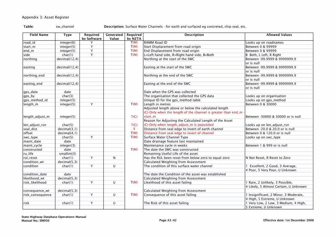
Appendix 3: Asset Register
Table: sw_channel Description: Surface Water Channels - for earth and surfaced eg concreted, chip seal, etc.
Field Name Type Required Generated Required Description Allowed Valuesby Software Value by NZTA
road_id integer(6) Y T(M) RAMM Road ID Looks up on roadnamesstart_m integer(5) Y T(M) Start Displacement from road origin Between 0 & 99999 end_m integer(5) Y T(M) End Displacement from road origin Between 0 & 99999side char(1) Y T(M) L=Left hand side, R=Right hand side, B=Both B Both, L Left, R Rightnorthing decimal(12,4) Northing at the start of the SWC Between -99.9999 & 9999999.9
or is nulleasting decimal(12,4) Easting at the start of the SWC Between -99.9999 & 9999999.9
or is nullnorthing_end decimal(12,4) Northing at the end of the SWC Between -99.9999 & 9999999.9
or is nulleasting_end decimal(12,4) Easting at the end of the SWC Between -99.9999 & 9999999.9
or is nullgps_date date Date when the GPS was collectedgps_by char(3) The organisation that collected the GPS data Looks up on organisationgps_method_id integer(5) Unique ID for the gps_method table Looks up on gps_methodlength_m integer(5) Y T(M) Length in metres Between 0 & 30000
length_adjust_m integer(5) T(C)
Adjusted length above or below the calculated length (C) Only when the length of the channel is greater than end_m - start_m Between -30000 & 30000 or is null
len_adjust_rsn char(5) T(C)Reason for Adjusting the Calculated Length of the Asset(C) Only when length_adjust_m is populated Looks up on len_adjust_rsn
seal_dist decimal(3,1) T Distance from seal edge to invert of earth channel Between -20.0 & 20.0 or is nulloffset decimal(4,1) T(M) Distance from seal edge to invert of channel Between 0 & 120.0 or is nullswc_type char(5) Y T(M) Surface Water Channel Type Looks up on swc_typemaint_date date Date drainage feature last maintainedmaint_cycle integer(3) Maintenance cycle in weeks Between 1 & 999 or is nullconstructed date T(M) The date the SWC was constructedru_life smallint(3) Remaining Useful Life of the assetrul_reset char(1) Y N Has the RUL been reset from below zero to equal zero N Not Reset, R Reset to Zerocondition_wt decimal(5,3) Calculated Weighting from Assessmentcondition char(1) Y U The condition of this surface water channel 1 Excellent, 2 Good, 3 Average,
4 Poor, 5 Very Poor, U Unknowncondition_date date The date the Condition of the asset was establishedlikelihood_wt decimal(5,3) Calculated Weighting from Assessmentrisk_likelihood char(1) Y U T(M) Likelihood of this asset failing 1 Rare, 2 Unlikely, 3 Possible,
4 Likely, 5 Almost Certain, U Unknownconsequence_wt decimal(5,3) Calculated Weighting from Assessmentrisk_consequence char(1) Y U T(M) Consequence of this asset failing 1 Insignificant, 2 Minor, 3 Moderate,
4 High, 5 Extreme, U Unknownrisk char(1) Y U The Risk of this asset failing 1 Very Low, 2 Low, 3 Medium, 4 High,
5 Extreme, U Unknown
State Highway Database Operations ManualManual No.: SM050 Page A3 :42 Effective date: 1st December 2008

Appendix 3: Asset Register
Table: sw_channel Description: Surface Water Channels - for earth and surfaced eg concreted, chip seal, etc.
Field Name Type Required Generated Required Description Allowed Valuesby Software Value by NZTA
risk_date date Date the Risk value was last updatedasset_owner char(3) Unique identifier for the asset owner Looks up on asset_ownersw_channel_id serial(5) Y G T(M) Surface Water Channel Unique Identifierstandard_rc integer(8) Unique identifier for the Standard RC definition Looks up on av_standard_rcuse_default_rc char(1) Y Does this asset use the Default RC definition D Default, U Useroriginal_cost money(12,2) Original Cost of Installing or Constructing this Assetrc_value money(12,2) Replacement Cost of this assetdrc_value money(12,2) Depreciated Replacement value of the asset or componentannual_drc_value money(12,2) Annual Depreciation of this assetvaluation_date date Date of the last valuation of the asset
notes char(255) T(C)General comments(C) Only required where additional clarification is useful
as_tip_note char(255) General tip for the Assessor when assessing this assetcollect_name char(3) Name of the person or organisation who collected the data Looks up on organisationcollect_date date Date when this data was collectedadded_on date today T(M) The date this row was addedadded_by char(20) T(M) The logname of the person who added this row Looks up on staffchgd_on date T(M) The date this row was last changedchgd_by char(20) T(M) The logname of the person who last changed this row Looks up on staff
State Highway Database Operations ManualManual No.: SM050 Page A3 :43 Effective date: 1st December 2008