Embed Size (px)
Citation preview

PROJECT 4 – ALL-SEASON ROAD ENVIRONMENTAL IMPACT STATEMENT
Appendix 3-2:
Representative Watercourse Crossing
Design Drawings

AE PROJECT No.SCALEAPPROVEDDATEREVDESCRIPTION
SCALE(S) SHOWN ARE INTENDED FOR LETTER (8.5X11) SIZE DRAWINGS UNLESS NOTED OTHERWISE25 mmIF NOT 25 mm ADJUST SCALES
C:\C
ivil
3DP
roje
cts\
Eas
tSid
eR
oads
\8x1
1S
heet
.dw
gD
ATE
:20
15-0
9-17
20154676-00NTSJ. BETKE2015 09 160ISSUED FOR EIAREPORT
FIGURE No. 2
MANITOBA EAST SIDE ROAD AUTHORITYP4 ALL-SEASON ROAD
BERENS RIVER FN TO POPLAR RIVER FNTYPICAL SINGLE AND MULTI CSP CULVERTS
ELEVATION
RIPRAP FOR EROSIONPROTECTION (TYP.)
2.5 to 3.01.0
SINGLE ROUND CORRUGATEDSTEEL PIPE CULVERTSIZE TBD
GRAVEL ROAD SURFACE
ROAD EMBANKMENTCROSS SLOPE
GRAVEL ROAD SURFACE
ROAD EMBANKMENTCROSS SLOPE
BURIED INVERT FOR FISH PASSAGENOT BURIED FOR DRAINAGE ANDEQUALIZATION CULVERTS
RIPRAP FOR EROSIONPROTECTION (TYP.)
BURIED INVERT FOR FISH PASSAGENOT BURIED FOR DRAINAGE ANDEQUALIZATION CULVERTS
MULTIPLE ROUND CORRUGATEDSTEEL PIPE CULVERTSSIZE TBD
NATURAL OR RIPRAPSTREAM BOTTOM
IN CULVERT
NATURAL OR RIPRAPSTREAM BOTTOM
IN CULVERT
2.5 to 3.01.0
Q100
0.3
MIN
.
Q100
0.3
MIN
.
ELEVATION
AE PROJECT No.SCALEAPPROVEDDATEREVDESCRIPTION
SCALE(S) SHOWN ARE INTENDED FOR LETTER (8.5X11) SIZE DRAWINGS UNLESS NOTED OTHERWISE25 mmIF NOT 25 mm ADJUST SCALES
C:\C
ivil
3DP
roje
cts\
Eas
tSid
eR
oads
\8x1
1S
heet
.dw
gD
ATE
:20
15-0
9-17
20154676-00NTSB. BETKE2015 09 160ISSUED FOR EIAAPPROVAL
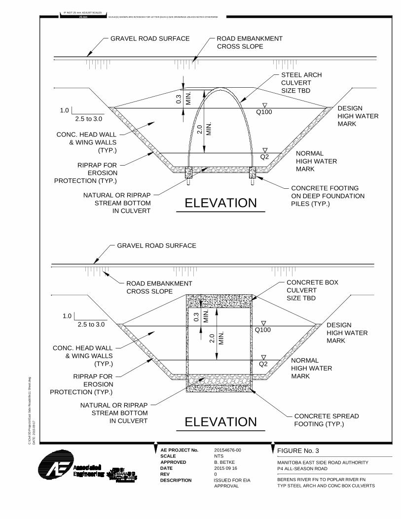
FIGURE No. 3
MANITOBA EAST SIDE ROAD AUTHORITYP4 ALL-SEASON ROAD
BERENS RIVER FN TO POPLAR RIVER FNTYP STEEL ARCH AND CONC BOX CULVERTS
CONCRETE BOXCULVERTSIZE TBD
GRAVEL ROAD SURFACE
ROAD EMBANKMENTCROSS SLOPE
CONCRETE SPREADFOOTING (TYP.)
2.5 to 3.01.0
RIPRAP FOREROSION
PROTECTION (TYP.)
STEEL ARCHCULVERTSIZE TBD
GRAVEL ROAD SURFACE ROAD EMBANKMENTCROSS SLOPE
ELEVATIONCONCRETE FOOTINGON DEEP FOUNDATIONPILES (TYP.)
CONC. HEAD WALL& WING WALLS
(TYP.)
ELEVATION
Q100
0.3
MIN
.
Q2
2.5 to 3.01.0
2.0
MIN
.
DESIGNHIGH WATERMARK
NORMALHIGH WATERMARK
CONC. HEAD WALL& WING WALLS
(TYP.)
NATURAL OR RIPRAPSTREAM BOTTOM
IN CULVERT
Q100
Q2
DESIGNHIGH WATERMARK
NORMALHIGH WATERMARK
0.3
MIN
.
RIPRAP FOREROSION
PROTECTION (TYP.)
NATURAL OR RIPRAPSTREAM BOTTOM
IN CULVERT
2.0
MIN
.

AE PROJECT No.SCALEAPPROVEDDATEREVDESCRIPTION
SCALE(S) SHOWN ARE INTENDED FOR LETTER (8.5X11) SIZE DRAWINGS UNLESS NOTED OTHERWISE25 mmIF NOT 25 mm ADJUST SCALES
C:\C
ivil
3DP
roje
cts\
Eas
tSid
eR
oads
\8x1
1S
heet
.dw
gD
ATE
:20
15-0
9-17
20154676-00NTSJ. BETKE2015 09 160ISSUED FOR EIAREPORT
FIGURE No. 4
MANITOBA EAST SIDE ROAD AUTHORITYP4 ALL-SEASON ROAD
BERENS RIVER FN TO POPLAR RIVER FNTYPICAL CLEAR SPAN BRIDGE
2.5 to 3.01.0
RIPRAP FOR EROSIONPROTECTION (TYP.)
GRAVEL APPROACHROAD SURFACE
ROAD EMBANKMENTCROSS SLOPE
ELEVATION
CONCRETE FOOTINGON DEEP PILEFOUNDATIONS (TYP.)
ABUTMENT(TYP.)
BRIDGE SUPERSTRUCTUREWITH CONCRETE OR ASPHALTWEARING SURFACE
0.3
MIN
.
2.5
MIN
. Q100
Q2
DESIGNHIGH WATERMARK
NORMALHIGH WATERMARK

AE PROJECT No.SCALEAPPROVEDDATEREVDESCRIPTION
SCALE(S) SHOWN ARE INTENDED FOR LETTER (8.5X11) SIZE DRAWINGS UNLESS NOTED OTHERWISE25 mmIF NOT 25 mm ADJUST SCALES
C:\C
ivil
3DP
roje
cts\
Eas
tSid
eR
oads
\8x1
1S
heet
.dw
gD
ATE
:20
15-0
9-17
20154676-00NTSJ. BETKE2015 06 190ISSUED FOR EIAREPORT
FIGURE No. 5
MANITOBA EAST SIDE ROAD AUTHORITYP4 ALL-SEASON ROAD
BERENS RIVER FN TO POPLAR RIVER FNTYPICAL 2 SPAN BRIDGE
2.5 to 3.01.0
RIPRAP FOR EROSIONPROTECTION (TYP.)
GRAVEL APPROACHROAD SURFACE
ROAD EMBANKMENTCROSS SLOPE
ELEVATION
CONCRETE FOOTINGON DEEP PILEFOUNDATIONS (TYP.)
ABUTMENT(TYP.)
BRIDGE SUPERSTRUCTUREWITH CONCRETE OR ASPHALTWEARING SURFACE
0.3
MIN
.
2.5
MIN
. Q100
Q2
DESIGNHIGH WATERMARK
NORMALHIGH WATERMARK
PIER (TYP.)

PROJECT 4 – ALL-SEASON ROAD ENVIRONMENTAL IMPACT STATEMENT
Appendix 3-3:
Potential Quarry Site Locations

!
!
!
!
!
!
!
!
!
!
!
!
!
!
!
!
!
!
!
!
!
!
!
!
!
!
!
!
!
!
!
!
!
!
!
!
!
!
!
!
!
!
!
!
!
!
!
!
!
!
!
!
!
!
!
!
!
!
!
!
!
!
!
!
!
!
!
!
!
!
!!
!!
!!
!!
!!
!!
!!
!
!!
!!
!!
!!
!!
!!
!!
!
!
!
!
!
!
!
!
!
!
!
!
!
!
!
!
!
!
!
!
!
!
!
!
!
!
!
!
!
!
!
!
!
!
!
!
!
!
!
!
!
!
!
!
!
!
!
!
!
!
!
!
!
!
!
!
!
!
!
!
!
!
!
!
!
!
!
!
!
!
E
E
_
E
E
E
E
E
E
E
EE
E
E
POPLARRIVER 16
Area:4.2ha
Area:4ha
Area:1.1ha
Area:4.1ha
Area:2.1ha
Okesk imun neseCreek
Kapawekapuk Creek
226
222 224
216
228
218
240
236
230
242
238
238
23623423223
0226
236234
226
238232
228
234
230
236
230
226
222
228224
234232
232230
228
226
232230
234
230
232 228
236
232
236234
232
230
226
230226
234232
236234
236
234
236232236234
236232
236232
234
230
230
228
232230
228
232
228
238236
234
232
236232
236
234
236
234
236234
236234
232
230
232230
234
232
234232
234232
230
228
232230
230
228
228226
230
228
226224
228226
226
224
222220
238236
236 234
236
234
234
232
234
232
234232
234
232
232 230
232
230
232230
230228
230228
228226
228
226228226
228
226
228226
226
224
224222
220
234
230
232228
226
230
232
230
228
228
228
230
232
232 236
236 238
234232
230
230
228
232
230
232
234
230232
228
224
238
238
236
234
234
234
232
232
232
230
23223
2
232
234230
234
230
228
230
230
228
230
230
230
230
228
230
230
232
230
232
226
228
228
228 230
228
23022
8
228
226
226
226 228
228
226
224
226
220218
238
240
240 238
236
238
238
236
234
234236
236
236
236
236
236
236
236
236
236
236
234
236
236
234
236
236
234
232
232
232
232
234
232
234
234
234
234
234
234
234
234
234
234
234
234
234
234
234
232
232
234
232
232
232
230
230
230
230
232
230
230230
232
232
232
232
232
232
232
232
232
232
232
232
232
232
232
232
230
232
230
230
230
230
230
230230 230
232
228
230
230
228
230
230
230
230
228
230
228
230
230
230
230
228
230
230
230
230
230
228
228
228
228
228
228
228
228
228
228228
228
228
226
226
226
226
226
226226
226228
226
226
226
228
226
226 226
226
226
226
226
226
226
226226
226
226
224
224224
226
226
226
226226
226
226
224
224
224
224224
222
224
222
222 222
222
220
220220
230
228
Distance toWaterbody:335m
Distance toWaterbody:1362m
Distance toWaterbody:
730m
Distance toWaterbody:1802m
E Drainage Flow Direction
Watersheds Boundary
Contours
²
Overview of P4 All-Season Road and Quarries
P4 All-Season Road AlignmentP1 All-Season Road (South of Berensto PTH 304) - Under Construction2013/2014 Manitoba Winter Road
Map Drawing Information:ESRI Base Layers, Province of Manitoba, CanVec, GeoGratis, Dillon Consulting LimitedManitoba Mineral Resources 2015d
Map Created By: ECHMap Checked By: MG/PS/LDMap Projection: NAD 1983 UTM Zone 14N
DATE: 12/2/2015
Project 4 - All-Season Road Connecting Berens River to Poplar River First Nation
Figure 3-3 Grid 1
Transmission Line
!
!!
!
!!
!!
!!
!!
!!
!!
! !
!
!
!
!
!
!
!
!
!
!
!
!!
!!
!!
!!
!!
!!
!!
!!
!!
!
!
!
!
!
!
!
!!
!!
!!
!
!
!
!
!!
!!
!!
!!
!
!
!
!
!
!
!
!
!
!
!
!
!
!
!
!
!
!
!
!
!
!!
!!
!
!!
!!
!!
!!
!!
!!
!
!
!
!
!
!
!
!
!
!
!
!
!
!!
!
!!
!!
!!
!!
!!
!!
!!
!
!
!
!!
!
!
!
!
!
!
!
!
!!
!
!
!
!
!
!
!
!
!
!
!
!
!
!
!
!
!
!
!
!
!
!
!
!
!
!
!
!
!
!
!
!
!
!!
!
!
!
!
!
!
!
!
!
!
!
!
!
!
!
!
!
!
!
!
!
!
!
!
!
!
!
!
!
!
!
!
!
!
!
!
!
!
!
!
!
!
!
!
!
!
!
!
!
!
!
!
!
!
!
!
!
!
!
!
!
!
!
!
!
!
!
!
!
!
!
!
!
!
!
!
!
!
!
!
!
!
!
!
!
!
!
!
!
!
!
!
!
!
!
!
!
!
!
!!
!!
!!
!!
!!
!!
!!
!
!
!!
!!
!!
!!
!!
!!
!
!
!
!
!
!
!
!
!
!
!
!
!
!
!
!
!
!
!
!
!
!
!
!
!
!
!
!
!
!
!
!
!
!
!
!
!
!
!
!
!
!
!
!
!
!
!
!
!
!
!
!
!
!
!
!
!
!
!
!
!
!
!
!
!
!
!
!
!
!
!
!
!
!
!
!
!
!
!
!
!
!
!
!
!
!
!
!
!
!
!
!
!
!
!
!
!
!
!
!
!!
!
!
!
!
!
!
!
!
!
!
!
!
!
!
!
!
!
!
!
!
!
!
!
!
!
!
!
!
!
!
!
!
!
!
!
!
!!
!
!
!
!
!
!
!!
!
!
!!
!!
!!
!!
!!
!!
!!
!
!!
!
!
!
!
!
!
!
!
!
!
!
!
!!
!
!!
!!
!!
!!
!!
!
!!
!!
!
!
!
!
!
!
!
!
!
!
!
!
!
!
!
!
!
!
!
!
!
!!
!!
!!
!!
!
!
!
!
!
!!
!!
!
!
!
!
!
!
!
!
!!
!!
!!
!!
!!
!!
!!
!!
!!
!
!
!
!
!
!
!
!
!
!
!
E
E E
E
E
E
E
E
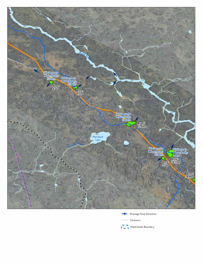
EPoplarRiver
MarchandLake
Area:14.9ha
Area:16.1haArea:
3.7ha
Area:13.6ha
Area:4.3ha
Area:4.2ha
MarchandCreek
262
252
246
242
264
240
248
234
244
238
242
238
242
232
246244240
236234232
242
238
238
230236234
230
228
242
236
240
236
232
240
238
242
240
244
240
244
238
234
242
238
242238
244240
238236
242
240
244238
236
234
236232
236
234
250
246
246244
248
244
246242
240236
238
236240238
242
238
242
238
242236
238236
238
236
238236
240236
240 238
240238
236 234
238234
236
234
234
232
242
240242
240
244240
244
240
240
238
242240
242240
238236
238
236
238
236
238
236
240238
236234
236234
236
234
238236
238236
238
236
238236
234
232
234
232
236234
234232
236
234
236232
236
234
236
234
232230
232
230232
230
262260
242240
242240
242240
242240
242
240
240238
238
236
238
236
238236
238236
236234
236234
236
234
236234
236
234
232230
228
226
242
240
236234
234
232
230
238
236
230
228
234
232
240
238
236
232
232
230
234
232
230
248
242
234
234
246
236
238
230
252
254
242
242
240
240
240
240
240
238
236
232
232
238236
232
232
230
228
254
246
244244
244
242
242
242
244
242
242
244
240
240
242
242
240
240
238238
238238
240
240
238240
240
238
238
238
238
236
236
236
236
234
236
238
236
236
234
234234
236
236
236
234
234
232232
234232
232
232
232
230
228
228
228
250
248
246
244
246
246
242
242
244
244
244
244
244
244
244244
242
240
240
240
240240
240
240
242
242
242
242
242
242
240
242
240
238
238
238
238
238
240
240
240
240
240
240
240
240
240
240
238
240
240
238
236
236
236
236
238
236
236
238
238
238
238
238
23823
8236
238
236238
238
238
238
236 238
238
236
238
238
238
238
238
238
238
238
238
236
236
236
236
236
236
236
234
234
234
234
234
234
234
236
236
236
236
234
236
236
236
236
236
236
236
236
236
236
236
234
234
234
234
234
236
234
234
236
232
232
232
234
234
234
232
232
232
232
232
232
232
232
232
232
232
230
232
232 230
230
230
230230
230
230
230
230
228
228
228
228
228 228
228
228
228
226
226 226
226
Distance toWaterbody:360m
Distance toWaterbody:
2500m
Distance toWaterbody:
1000m
Distance toWaterbody:
1196m
Distance toWaterbody:
1330m
E Drainage Flow Direction
Watersheds Boundary
Contours
²
Overview of P4 All-Season Road and Quarries
P4 All-Season Road AlignmentP1 All-Season Road (South of Berensto PTH 304) - Under Construction2013/2014 Manitoba Winter Road
Map Drawing Information:ESRI Base Layers, Province of Manitoba, CanVec, GeoGratis, Dillon Consulting LimitedManitoba Mineral Resources 2015d
Map Created By: ECHMap Checked By: MG/PS/LDMap Projection: NAD 1983 UTM Zone 14N
DATE: 12/2/2015
Project 4 - All-Season Road Connecting Berens River to Poplar River First Nation
Figure 3-3 Grid 2
Transmission Line
!!
!!
!
!!
!
!!
!!
!
!
!!
!
!
!
!!
!
!
!
!
!
!
!
!
!
!
!
!
!
!
!
!
!
!
!
!
!
!
!
!!
!!
!
!
!
!
!
!
!
!
!
!
!
!
!
!
!
!
!
!
!
!
!
!
!
!!
!
!
!
!!
!
!
!
!!
!!
!!
!
!
!
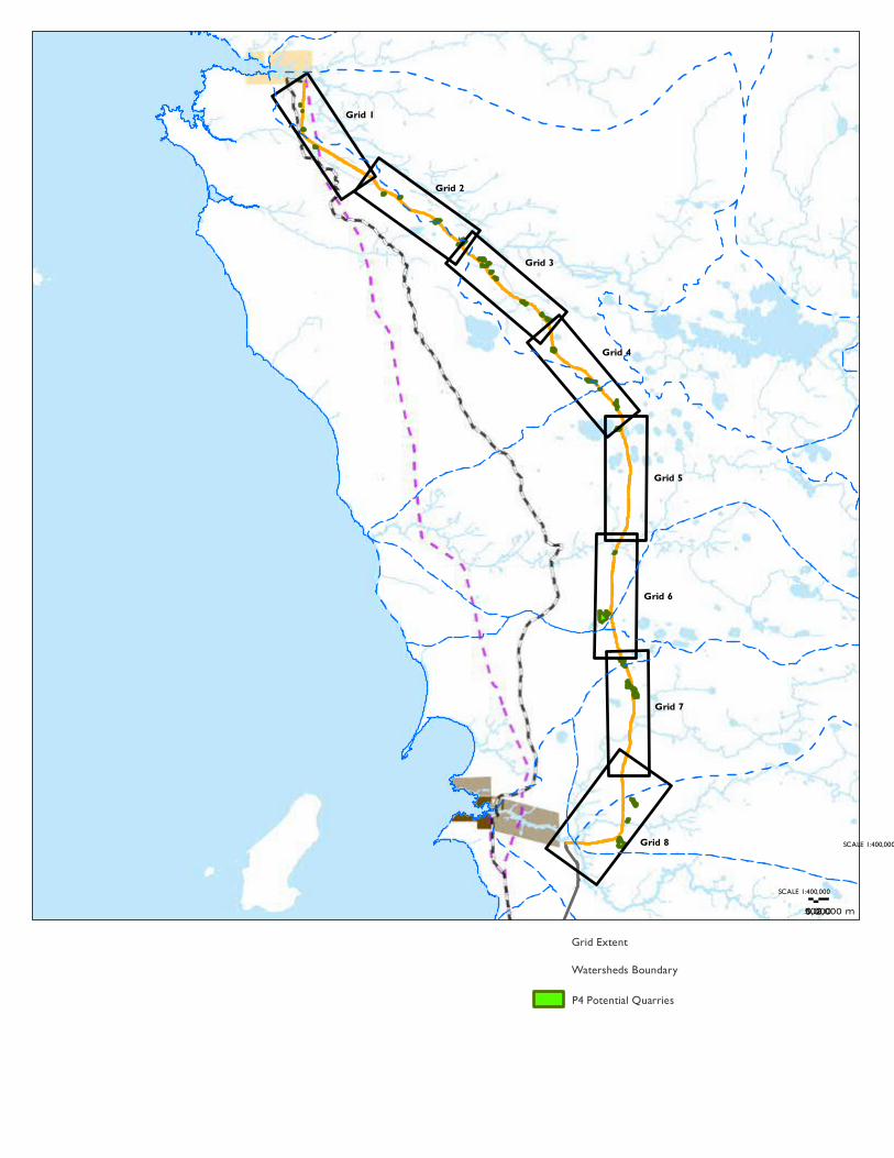
Grid 1
Grid 2
Grid 3
Grid 4
Grid 5
Grid 6
Grid 7
Grid 8 SCALE 1:400,000
P4 Potential Quarries
Grid Extent
Watersheds Boundary
01,0002,000500 mSCALE 1:400,000
²
Overview of P4 All-Season Road and Quarries
P4 All-Season Road AlignmentP1 All-Season Road (South of Berensto PTH 304) - Under Construction2013/2014 Manitoba Winter Road
Map Drawing Information:ESRI Base Layers, Province of Manitoba, CanVec, GeoGratis, Dillon Consulting LimitedManitoba Mineral Resources 2015d
Map Created By: ECHMap Checked By: MG/PS/LMMap Projection: NAD 1983 UTM Zone 14N
DATE: 12/2/2015
Project 4 - All-Season Road Connecting Berens River to Poplar River First Nation
Figure 3-3
Transmission Line
Lake Winnipeg
Berens Ri ver
Poplar R iver
Weaver Lake
Many Bays Lake
North Etomami River
Etomami River
Bull Lake
Leaf River
Poplar River First Nation
Berens River First Nation
Berens River NAC

!
!
!!
!!!
!!
!
!!
! ! !!
!!
!
!
!
!
!
!
!
!
!
!
!
!!
!!
!!
!!
!!
!!
!!
!!
!!
!!
!
!
!
!
!
!
!
!!
!!
!!
!
!
!
!
!!
!!
!!
!!
!
!
!
!
!
!
!
!
!
!
!
!
!
!
!
!
!
!
!
!
!
!
!!
!!
!
!!
!!
!!
!!
!!
!!
!
!
!
!
!
!
!
!
!
!
!
!
!
!!
!
!
!!
!!
!!
!!
!!
!!
!!
!
!
!
!!
!
!
!
!
!
!
!!
!
!
!
!
!
!
!
!
!
!
!
!
!
!
!
!
!
!
!
!
!
!
!
!
!
!
!
!
!
!
!
!
!
!
!
!
!!
!
!
!
!
!
!
!
!
!
!
!
!
!
!
!
!
!
!
!
!
!
!
!
!
!
!
!
!
!
!
!
!
!
!
!
!
!
!
!
!
!
!
!
!
!
!
!
!
!
!
!
!
!
!
!
!
!
!
!
!
!
!
!
!
!
!
!
!
!
!
!
!
!
!
!
!
!
!
!
!
!
!
!
!
!
!
!
!
!
!
!
!
!
!
!
!
!
!
!
!
!
!
!
!!
!!
!!
!!
!!
!!
!
!
!
!!
!!
!!
!!
!!
!!
!!
!
!
!
!
!
!
!
!
!
!
!
!
!
!
!
!
!
!
!
!
!
!
!
!
!
!
!
!
!
!
!
!
!
!
!
!
!
!
!
!
!
!
!
!
!
!
!
!
!
!
!
!
!
!
!
!
!
!
!
!
!
!
!
!
!
!
!
!
!
!
!
!
!
!
!
!
!
!
!
!
!
!
!
!
!
!
!
!
!
!
!
!
!
!
!
!
!
!
!
!
!
!
!!
!
!
!
!
!
!
!
!
!
!
!
!
!
!
!
!
!
!
!
!
!
!
!
!
!
!
!
!
!
!
!
!
!
!
!
!
!
!!
!
!
!
!
!
!
!!
!
!
!!
!!
!!
!!
!!
!!
!!
!
!
!!
!
!
!
!
!
!
!
!
!
!
!
!
!!
!!
!!
!!
!!
!!
!!
!
!!
!!
!
!
!
!
!
!
!
!
!
!
!
!
!
!
!
!
!
!
!
!
!
!
!!
!!
!!
!!
!
!
!
!
!!
!!
!!
!
!
!
!
!
!
!
!!
!!
!!
!!
!!
!!
!!
!!
!!
!
!
!
!
!
!
!
!
!
!
!
!
E
E
EE
EE
E
E
E
E
E
E EE
E EE
E
Poplar River
Poplar River
Many BaysLake
Area:12.5ha
Area:14.9ha
Area:16.1ha
Area:16.6ha
Area:3.7ha
Area:6ha
Area:6.5ha
Area:4.9ha
Area:3.2ha
Area:8.7ha
Area:4.7ha
Okeyakkoteinewin Cr eek
244
238236
246
230
258
252248
250
240
254244
242240234
242
240248
238
250246
254252
246248244
254
248
248
244
240
250248244
250
248
252244
246 242
242
240
246
236
244242
254
248
244242
246
242
246242
240238
244242
246242
238
252
248
254248
252246
248246242
248 244
246244
254
252
254
252
248
246
250
246
248246244
246242
244242
246242240
242 240
240
238
242
240
242238
242240238
244
240
238
236
234
264
260
252
250
250
246 246
244
242
240
242
240
242
240244
242
240238
242240
240
238
240238
238
236
240238
238
236
238236
252250
250248
250
248
246244
244
242
244242
242240242
240
242
240
240
238
240238234232
234
232
232
22825
4
242
240
244
238238
236
236
234
230
238
242
236
236
234
240
246
244
236
238
240
238
256
250
244
248
242
244
244
242
242
242
246
258
252
254
250
248
248
246
244
244
244
246
244
238
244 240
240
240
238240
256
254
252254
252
250
248
248
248248
246
246
244
246
246
246
244248
246246
246
244
244
244
244
244
246
240
242
242
242
242
244
240
242
244
244242
242
240
240
240
240
240
240
238
240
238 238
238
238
236
232
232
230
230
262
252
252
252
252
252252
252
252
250
250
250
248
250
246
248248
248
248
248
248
248
248
248
244
246
244
246
246 246246
246
244
246
246
246
246246
244
244
244
244
242
244
244
244
244
244
244
244
244
244
244
244
244
244
244
242
242
242
240242
242
240
240
240
242
242
242
242
242
242
242
242
242
242
242
242
242
242
242
242
242
242
240
240
240240
240
240
238
238
238 238
238
238
238
240
240
240
240
240
240
240
238
240
240
240
240
238238
238238
238
238
238
238
238
236
236238
236
236
234234
232 232
23223
2
230
230
230
228
228
242
238
Distance to Waterbody:1001m
Distanceto Waterbody:929m
Distance to Waterbody:360m
Distance toWaterbody:
300m
Distance toWaterbody:
2500m
Distance toWaterbody:260m
Distance toWaterbody:
550m
Distance toWaterbody:
900m
Distance toWaterbody:
250m
Distance toWaterbody:200m
Distanceto Waterbody:175m
E Drainage Flow Direction
Watersheds Boundary
Contours
²
Overview of P4 All-Season Road and Quarries
P4 All-Season Road AlignmentP1 All-Season Road (South of Berensto PTH 304) - Under Construction2013/2014 Manitoba Winter Road
Map Drawing Information:ESRI Base Layers, Province of Manitoba, CanVec, GeoGratis, Dillon Consulting LimitedManitoba Mineral Resources 2015d
Map Created By: ECHMap Checked By: MG/PS/LDMap Projection: NAD 1983 UTM Zone 14N
DATE: 12/2/2015
Project 4 - All-Season Road Connecting Berens River to Poplar River First Nation
Figure 3-3 Grid 3
Transmission Line

!
!
!!
!
!!
!!!
!
!
!! !
!!
!
!!
!
!
!
!
!
!
!
!
!
!
!
!
!!
!!
!!
!!
!!
!!
!!
!!
!!
!!
!
!
!
!
!
!
!
!
!!
!!
!!
!
!
!
!
!
!!
!!
!!
!!
!
!
!
!
!
!
!
!
!
!
!
!
!
!
!
!
!
!
!
!
!
!
!
!
!!
!!
!
!
!!
!!
!!
!!
!!
!
!!
!
!
!
!
!
!
!
!
!
!
!
!
!
!
!!
!
!!
!!
!!
!!
!!
!!
!!
!!
!
!
!
!!
!
!
!
!
!
!
!
!
!
!
!
!
!
!
!
!
!
!
!
!
!
!
!
!
!
!
!
!
!
!
!
!
!
!
!
!
!
!
!
!
!
!
!
!
!
!
!
!
!!
!
!
!
!
!
!
!
!
!
!
!
!
!
!
!
!
!
!
!
!
!
!
!
!
!
!
!
!
!
!
!
!
!
!
!
!
!
!
!
!
!
!
!
!
!
!
!
!
!
!
!
!
!
!
!
!
!
!
!
!
!
!
!
!
!
!
!
!
!
!
!
!
!
!
!
!
!
!
!
!
!
!
!
!
!
!
!
!
!
!
!
!
!
!
!
!
!
!
!
!
!
!
!
!
!
!
!
!
!
!
!!
!!
!!
!!
!!
!!
!!
!
!
!
!!
!!
!!
!!
!!
!!
!!
!
!
!
!
!
!
!
!
!
!
!
!
!
!
!
!
!
!
!
!
!
!
!
!
!
!
!
!
!
!
!
!
!
!
!
!
!
!
!
!
!
!
!
!
!
!
!
!
!
!
!
!
!
!
!
!
!
!
!
!
!
!
!
!
!
!
!
!
!
!
!
!
!
!
!
!
!
!
!
!
!
!
!
!
!
!
!
!
!
!
!
!
!
!
!
!
!
!
!
!
!
!
!
!
!
!
!
!
!
!
!
!!
!
!
!
!
!
!
!
!
!
!
!
!
!
!
!
!
!
!
!
!
!
!
!
!
!
!
!
!
!
!
!
!
!
!
!
!
!
!!
!
!!
!
!
!
!
!
!
!!
!
!
!
!!
!!
!!
!!
!!
!!
!!
!!
!
!!
!
!
!
!
!
!
!
!
!
!
!
!
!
!!
!!
!!
!!
!!
!!
!!
!
!
!!
!!
!
!
!
!
!
!
!
!
!
!
!
!
!
!
!
!
!
!
!
!
!
!
!
!!
!!
!!
!!
!!
!
!
!
!
!!
!!
!!
!
!
!
!
!
!
!
!
!!
!!
!!
!!
!!
!!
!!
!!
!!
!!
!
!
!
!
!
!
!
!
!
!
!
!
E
E
E
E
E
E
EBullLake
PamatakakowinLake
StagLake
Area:12.5ha
Area:5.6ha
Area:9.1ha
Area:1.7ha
Area:13.9ha
Area:6ha
Area:10.3ha
Area:8.7ha
256
244
25425
2
242
240
246242
250244
248
246
244
248242
254
246
254252250
254
248 246242
248246
246244
252244
250
248
250246
242
240
244240
250
246
250
248
252
246
246
244
242240
246240
246
242
244240
252
250
254252
256252
25024
8
248246
246244
250246
244
242
248 244
246
242
242 240
240
238
244240
244
242
240238
238
236
252250
252
250
252250
250246
250248
248
246
246
244
248246
244
242
244242
242 240
240
238
242238
238236
254252
248246
246 244
242 240
242
240
240
238
240238
240
238
240
238
240
238
240
238
240
238
248
252
244
240
244
242
246
246
246
250244
250
244
248
242
238
246
244
248
242
246
242
258
256
254
252
252
250
248
250
252
248
248
250
244
248246
246
242246
246
246
246248
246
246
244 246
242
244
244
252
252
250
250
252
250
248
248
248
248
250
246
246
248
248
244
244
244
244
242
240
240
238
256
256
254
254
254
254
252
252
252
252
252
252
252
250
250
250
250248
250
250
250
248
250
248 250
248
250
250250
246
248
248
248
246
248248
248
248
248
248
246
246
246
248
246
246
244
246
244 246
246
244
246
244 244
244
244
244
244
244
244
242
244
242
244244
242
244
244
242
244
242
242242
242
242
242
242242
242
240
240
240
240
242
240
240
242
240
242
242
242
242242
240
240
240
240
240
240
240
240
238
238238
238
238
240
238
240
240
240
240
240
238240
240
240
240
240
238
240
240
240
240
238
238
238
238
238
236
238
238
238
238
236246
240
240
238
238
Distanceto Waterbody:1001m
Distanceto Waterbody:1398m
Distance toWaterbody:
1778m
Distanceto Waterbody:2892m
Distance toWaterbody:
3763m
Distanceto Waterbody:501m
Distance toWaterbody: 200m
E Drainage Flow Direction
Watersheds Boundary
Contours
²
Overview of P4 All-Season Road and Quarries
P4 All-Season Road AlignmentP1 All-Season Road (South of Berensto PTH 304) - Under Construction2013/2014 Manitoba Winter Road
Map Drawing Information:ESRI Base Layers, Province of Manitoba, CanVec, GeoGratis, Dillon Consulting LimitedManitoba Mineral Resources 2015d
Map Created By: ECHMap Checked By: MG/PS/LDMap Projection: NAD 1983 UTM Zone 14N
DATE: 12/2/2015
Project 4 - All-Season Road Connecting Berens River to Poplar River First Nation
Figure 3-3 Grid 4
Transmission Line

!
!
!!
!
!!
!!!!
!
! !! !
!
! !!
!
!
!
!
!
!
!
!
!
!
!
!!
!!
!!
!!
!!
!!
!!
!!
!!
!!
!
!
!
!
!
!
!
!!
!!
!!
!
!
!
!
!
!!
!!
!!
!!
!
!
!
!
!
!
!
!
!
!
!
!
!
!
!
!
!
!
!
!
!
!
!
!
!!
!!
!
!!
!!
!!
!!
!!
!
!!
!
!
!
!
!
!
!
!
!
!
!
!
!
!
!!
!
!!
!!
!!
!!
!!
!!
!!
!!
!
!
!!
!
!
!
!
!
!
!
!
!
!
!
!
!
!
!
!
!
!
!
!
!
!
!
!
!
!
!
!
!
!
!
!
!
!
!
!
!
!
!
!
!
!
!
!
!
!
!
!!
!
!
!
!
!
!
!
!
!
!
!
!
!
!
!
!
!
!
!
!
!
!
!
!
!
!
!
!
!
!
!
!
!
!
!
!
!
!
!
!
!
!
!
!
!
!
!
!
!
!
!
!
!
!
!
!
!
!
!
!
!
!
!
!
!
!
!
!
!
!
!
!
!
!
!
!
!
!
!
!
!
!
!
!
!
!
!
!
!
!
!
!
!
!
!
!
!
!
!
!
!
!
!
!
!
!
!
!
!!
!!
!!
!!
!!
!!
!!
!
!
!!
!!
!!
!!
!!
!!
!!
!
!
!
!
!
!
!
!
!
!
!
!
!
!
!
!
!
!
!
!
!
!
!
!
!
!
!
!
!
!
!
!
!
!
!
!
!
!
!
!
!
!
!
!
!
!
!
!
!
!
!
!
!
!
!
!
!
!
!
!
!
!
!
!
!
!
!
!
!
!
!
!
!
!
!
!
!
!
!
!
!
!
!
!
!
!
!
!
!
!
!
!
!
!
!
!
!
!
!
!
!
!
!
!
!
!
!
!
!!
!
!
!
!
!
!
!
!
!
!
!
!
!
!
!
!
!
!
!
!
!
!
!
!
!
!
!
!
!
!
!
!
!
!
!
!
!!
!
!!
!
!
!
!
!
!
!!
!
!
!!
!!
!!
!!
!!
!!
!!
!!
!
!!
!
!
!
!
!
!
!
!
!
!
!
!
!
!!
!!
!!
!!
!!
!!
!!
!
!!
!!
!
!
!
!
!
!
!
!
!
!
!
!
!
!
!
!
!
!
!
!
!
!
!
!!
!!
!!
!!
!!
!
!
!
!
!!
!!
!!
!
!
!
!
!
!
!
!!
!!
!!
!!
!!
!!
!!
!!
!!
!!
!
!
!
!
!
!
!
!
!
!
!
E
LeafRiver
Gun Lake
BlackFox Lake
SekakLake
SchaschakaywayanLake
BullLake
PamatakakowinLake
KanasosaykinLakes
GreenwoodLake
StagLake Asenchekonak
Lake
FrogLake
Area:10.3ha
LeafRive r
Matawan
Creek
SouthLeafRive r
Gun Creek
248242
242
240 244
242
25024
8
248244
238
236
244242
236
252
244
242240
248240
244242240
236
244242
250248
246
250
246
250244
244238
246242
244
242
246242 246
240
240238236236234 240238
242
238
248246
250 246
246
242
244242
242 238
242
238
244238
246
240
242 238
248
244
250244246
244
246244
248246
248244
244
240
246242
242240
240238
242
240
244
240
242
238
244 240
244
242
244
240
242238
242
238
240 236
248
246
250 246
250248
246
248 246
244
242
246242
242
240
242
240
242
240
242240
242
240
242
240
242240
240
238
242240
242238
242
240
242
238
242238
242240 242
240
240238
236
234
236
234
248246
248
246
248
246
248
246246
244
244
242
244242
244
242
244242
242
240
242
240
242
240
240
238
240
238
240
238
240
238
240
238
238
236
236234
236
234
234232
244
240
238
246
238242
234
248
246
240
244
240
242
236
248
246
240 244
238
240
246
244
246
246
244
242
244
242
242240
238
242240
238
236
234
248
244
246
246
248
244
244
244
242
244
246
246
244246
244
242
240
240
242
244
240
242
242
242
244
244
244
240
244
242
240
240
240
240
240
240
240
240
240
242
242
242
240
240
240
240
240
238
238
236
238
238
238
240
240
240 238
238
236
234
236
236
236
252
248
250
246
246
248
248
248
248
248
248
248
248
246
246
244
244244
246
246
246
246
24624
6246
246
244
242
242
244
242
244
244
244
244
244
244
244
244
244
244
244
244
242242
244244
242
242
242
240
240
240
242
242
240
242
240
242
242
242
242
242
242
242
242
242
242
242
242
240
242
242
242
242
242
240
240240
240
240 240
240
238
238
238
238
238
240
240
240
240
240
240
238240
240
240
240
240
240
240
238
238
240
240
238
238
238
238
238
238
238
238
238 238
238
238
238
238
238
238
238
238
236236
238
238
238238
236
236
236
236236
236
234
234
236
234
234
234
234
234
234
232
240
240
238
238Distanceto Waterbody:501m
E Drainage Flow Direction
Watersheds Boundary
Contours
²
Overview of P4 All-Season Road and Quarries
P4 All-Season Road AlignmentP1 All-Season Road (South of Berensto PTH 304) - Under Construction2013/2014 Manitoba Winter Road
Map Drawing Information:ESRI Base Layers, Province of Manitoba, CanVec, GeoGratis, Dillon Consulting LimitedManitoba Mineral Resources 2015d
Map Created By: ECHMap Checked By: MG/PS/LDMap Projection: NAD 1983 UTM Zone 14N
DATE: 12/2/2015
Project 4 - All-Season Road Connecting Berens River to Poplar River First Nation
Figure 3-3 Grid 5
Transmission Line

!
!
!!
!
!!
!!
!!
!!
!!
!!
!!
!
!
!
!
!
!
!
!
!
!
!
!
!!
!!
!!
!!
!!
!!
!!
!!
!!
!!
!
!
!
!
!
!
!
!!
!!
!!
!
!
!
!
!
!!
!!
!!
!!
!
!
!
!
!
!
!
!
!
!
!
!
!
!
!
!
!
!
!
!
!
!
!
!
!!
!!
!
!!
!!
!!
!!
!!
!
!!
!
!
!
!
!
!
!
!
!
!
!
!
!
!
!!
!
!!
!!
!!
!!
!!
!!
!!
!!
!
!
!!
!
!
!
!
!
!
!
!
!
!!
!
!
!
!
!
!
!
!
!
!
!
!
!
!
!
!
!
!
!
!
!
!
!
!
!
!
!
!
!
!
!
!
!
!
!
!
!!
!
!
!
!
!
!
!
!
!
!
!
!
!
!
!
!
!
!
!
!
!
!
!
!
!
!
!
!
!
!
!
!
!
!
!
!
!
!
!
!
!
!
!
!
!
!
!
!
!
!
!
!
!
!
!
!
!
!
!
!
!
!
!
!
!
!
!
!
!
!
!
!
!
!
!
!
!
!
!
!
!
!
!
!
!
!
!
!
!
!
!
!
!
!
!
!
!
!
!
!
!
!
!
!
!
!
!
!
!!
!!
!!
!!
!!
!!
!!
!
!
!!
!!
!!
!!
!!
!!
!!
!
!
!
!
!
!
!
!
!
!
!
!
!
!
!
!
!
!
!
!
!
!
!
!
!
!
!
!
!
!
!
!
!
!
!
!
!
!
!
!
!
!
!
!
!
!
!
!
!
!
!
!
!
!
!
!
!
!
!
!
!
!
!
!
!
!
!
!
!
!
!
!
!
!
!
!
!
!
!
!
!
!
!
!
!
!
!
!
!
!
!
!
!
!
!
!
!
!
!
!
!
!
!
!
!
!
!
!
!!
!
!
!
!
!
!
!
!
!
!
!
!
!
!
!
!
!
!
!
!
!
!
!
!
!
!
!
!
!
!
!
!
!
!
!
!
!
!
!
!
!
!
!
!
!
!
!
!!
!
!
!!
!!
!!
!!
!!
!!
!!
!!
!
!!
!
!
!
!
!
!
!
!
!
!
!
!
!
!!
!
!
!!
!!
!!
!!
!!
!
!!
!!
!
!
!
!
!
!
!
!
!
!
!
!
!
!
!
!
!
!
!
!
!
!
!
!!
!!
!!
!!
!
!
!
!
!
!!
!!
!!
!
!
!
!
!
!
!
!
!!
!!
!!
!!
!!
!!
!!
!!
!!
!!
!
!
!
!
!
!
!
!
!
!
!
_
EE
E
E
E
E
Leaf River
BoggyLake
OvalLake
BigRockLake
Area:53.4ha
Area:4.1ha
Area:7.7ha
Matawan Creek
Paskis
ekun
C ree
k South Lea f Ri ver244242
234
242240
236
232
250
246
244
248246
240242
234
246244
246
244
240
246240
240
236
238234
236234
244
242
248 244
244242
242
240
244242 246
244
240
238
242
240
242
240
240236
240236
24023
4
248
244
244
242
244
242246
242
242240
244242
240
240
238
240
238
240
238236
234238236
238236
238
236
236
232
236
232
234
232
250248
244
242
244242
244
242
244242
242
240
240
238
240238
240238
240
238
238
236
238236
236234
234
232
234232
234232
234232 234232
234
232
232
230
232
230
238
238
236
236
240
238
240
248
244
242238
242
234
246
240
244
240
238
240
238
250
248
244
248
244
244
244
244
246
240
242
240
242
240
244
242
244
242
244
240
244
242
240
240
240
242
242 240
238
238
238
238
236
238
238
238
236
234
238
236
234
232
236
236
234
234
248
250
246
246
246
246
246
246
246
246
246
246
246
246
246
242242
242
242
242
244
244
244242
244
244
244
244
244
244
244
244
244
242
244
244
244
244
244
244
244
244
244
244
244
242
242
242
244242
242
242
240
240
240
242
240
240
242
242
242
242
242
242
242
242
242
240
240
240
240
240
238
238
240
240
240
240
240
240
240
240
240
238238
238
238
238
236
238
236
238
238
238
238
238
238
238
236
236
236
234
234234
234
236
236
236
234
234
234
234
234
234
234
234
232
232
232
232
232
232
232
232
234
234
234
234
234
234
232234
234
232
232
232
232
232
230
232
232
232
232
232
230
232
232
232
Distance toWaterbody:
835m
Distance toWaterbody:277m
Distance toWaterbody:1177m
E Drainage Flow Direction
Watersheds Boundary
Contours
²
Overview of P4 All-Season Road and Quarries
P4 All-Season Road AlignmentP1 All-Season Road (South of Berensto PTH 304) - Under Construction2013/2014 Manitoba Winter Road
Map Drawing Information:ESRI Base Layers, Province of Manitoba, CanVec, GeoGratis, Dillon Consulting LimitedManitoba Mineral Resources 2015d
Map Created By: ECHMap Checked By: MG/PS/LDMap Projection: NAD 1983 UTM Zone 14N
DATE: 12/2/2015
Project 4 - All-Season Road Connecting Berens River to Poplar River First Nation
Figure 3-3 Grid 6
Transmission Line

!
!
!!
!!
!!!
!!
!!
!!
!!
!!
!
!
!
!
!
!
!
!
!
!
!
!
!!
!!
!!
!!
!!
!!
!!
!!
!!
!!
!
!
!
!
!
!
!
!!
!!
!!
!
!
!
!
!
!!
!!
!!
!!
!
!
!
!
!
!
!
!
!
!
!
!
!
!
!
!
!
!
!
!
!
!
!
!
!!
!!
!
!!
!!
!!
!!
!!
!!
!!
!
!
!
!
!
!
!
!
!
!
!
!
!!
!
!
!!
!!
!!
!!
!!
!!
!!
!!
!
!
!!
!
!
!
!
!
!
!!
!
!!
!
!
!
!
!
!
!
!
!
!
!
!
!
!
!
!
!
!
!
!
!
!
!
!
!
!
!
!
!
!
!
!
!
!
!
!
!!
!
!
!
!
!
!
!
!
!
!
!
!
!
!
!
!
!
!
!
!
!
!
!
!
!
!
!
!
!
!
!
!
!
!
!
!
!
!
!
!
!
!
!
!
!
!
!
!
!
!
!
!
!
!
!
!
!
!
!
!
!
!
!
!
!
!
!
!
!
!
!
!
!
!
!
!
!
!
!
!
!
!
!
!
!
!
!
!
!
!
!
!
!
!
!
!
!
!
!
!
!
!
!
!
!
!
!
!!
!!
!!
!!
!!
!!
!!
!
!
!!
!!
!!
!!
!!
!!
!!
!
!
!
!
!
!
!
!
!
!
!
!
!
!
!
!
!
!
!
!
!
!
!
!
!
!
!
!
!
!
!
!
!
!
!
!
!
!
!
!
!
!
!
!
!
!
!
!
!
!
!
!
!
!
!
!
!
!
!
!
!
!
!
!
!
!
!
!
!
!
!
!
!
!
!
!
!
!
!
!
!
!
!
!
!
!
!
!
!
!
!
!
!
!
!
!
!
!
!
!
!
!
!
!
!
!
!
!
!!
!
!
!
!
!
!
!
!
!
!
!
!
!
!
!
!
!
!
!
!
!
!
!
!
!
!
!
!
!
!
!
!
!
!
!
!
!!
!
!!
!
!
!
!
!
!
!!
!
!
!!
!!
!!
!!
!!
!!
!!
!!
!
!!
!
!
!
!
!
!
!
!
!
!
!
!
!
!!
!
!
!!
!!
!!
!!
!!
!
!!
!!
!
!
!
!
!
!
!
!
!
!
!
!
!
!
!
!
!
!
!
!
!
!
!
!!
!!
!!
!!
!
!
!
!
!
!
!!
!!
!!
!
!
!
!
!
!
!
!!
!!
!!
!!
!!
!!
!!
!!
!!
!!
!
!
!
!
!
!
!
!
!
!
!
E
E
E
E
EE
E
North
Etoma
miRiv
er
OmocheLake
Area:30.7ha
Area:16.6ha
Area:6.6ha
Area:9.6ha
Munnominikan Creek
248246
244
240
238238
234
230 228
240238
242
238
238236
240
234
236
234
234230
236232
246242
248
246
244
242
240238
242238238
236236
232
238
236
234
232 230
234230
234230
228
248
246
242
248
244
244 242
242240
242240
238
236
238236 240 238
238
234234232
236
234
236234
236
232236 234
232230234
232
248246
246
244
244242
240238
242
240
242
240
238
236
232
230
234 232
230228 232230
230228
248
246
246244
246244
244 242
244
242
242
240
242
240
242
240
240 238
238
236
238236
238236
236234
236234
234 232
234
232
232 230
232
230
230
228230
228
228226
250
242
242232
246
244
240
240
238
234
230
248
242240
240
238
240
236
236
246
246
242
240
242
242
240
236
238
240
240
236
236
236
230
248
246 246
248
244
244
246
242
242
240
240
240
240
238
242242238
238
23823
8
240
238
236
236
236
236
236
234
232
236
234
230
230
230
232
232
228
246
246
248
248
248
248
244
244244
246
244
246
246
244
244
242
244
242
242
242244
242
242
244
244
242
244
244
244
244
244
242
242
242
242
242
242242
242 242
240
240
240
240
238
238
240
240
240
240
240
238
236
236
236
236
238238
238
238
238
238
238
236236
238
238
238
238
238
238
238
236 236
236
236
236236
234
234
234
234
234
234
234
236
236
236
236
236
236
236236
236
234
234 234
234
234
234234
234
232
232
232
232
232
232
234
234
234
234
232
234
234234
234 234
232
232
232
232
232
230
230
232
232
232
232
232
232
230
230
230
230
228
230
230
230
230
244
232232
230 230
230
Distanceto Waterbody:1329m
Distance toWaterbody:
1180m
Distance toWaterbody:
982m
Distance toWaterbody:
1053m
E Drainage Flow Direction
Watersheds Boundary
Contours
²
Overview of P4 All-Season Road and Quarries
P4 All-Season Road AlignmentP1 All-Season Road (South of Berensto PTH 304) - Under Construction2013/2014 Manitoba Winter Road
Map Drawing Information:ESRI Base Layers, Province of Manitoba, CanVec, GeoGratis, Dillon Consulting LimitedManitoba Mineral Resources 2015d
Map Created By: ECHMap Checked By: MG/PS/LDMap Projection: NAD 1983 UTM Zone 14N
DATE: 12/2/2015
Project 4 - All-Season Road Connecting Berens River to Poplar River First Nation
Figure 3-3 Grid 7
Transmission Line

!
!!
!
!!!
!!
!
!!
!!
!
!
! !
!
!
!
!
!
!
!
!
!
!
!!
!!
!!
!!
!!
!!
!!
!!
!!
!
!
!
!
!
!
!
!
!!
!!
!
!
!
!
!
!!
!!
!!
!!
!
!
!
!
!
!
!
!
!
!
!
!
!
!
!
!
!
!
!
!
!
!
!
!
!
!
!!
!!
!!
!!
!
!
!
!
!!
!!
!!
!
!
!
!
!
!
!!
!!
!!
!!
!!
!!
!!
!!
!!
!
!
!
!
!
!
!
!
!
!
!
_
E
EE
E
E
North
Etoma
miRiv
er
Etomami River
Berens River
BERENSRIVER 13
Area:6.9ha
Area:8.5ha
Area:33.8ha
Area:4ha
Area:6.2ha
Omoannaskway Creek
232
228
234
230
236
232
238
232
236
228
232 226
228
222
236232
230
226230
228
232226
232230
236234
234232
234
232
234 232
234
232
238
230
238232
230
228
230 228
234
230
234230
234230
232228
226224
238236
238236
240238
236234
236234
238232
238236
232
230
232 230
234232
234232
236232
232
230
230
228
230226
230228
228
226
230228
228
224
238
236
238
236
232230
230228
232230
232230
230
226
226
224
228 226
226224
226
224222220
240238
236
234
236
234
232230
232
230
232230
232
230
230228
230228
228
226
228226
228
226
226224226
224
236
234
230
238
238
234
234234
238
236
234
228
226
226
220
240
234
236
238
238
234
230
234
234
230
234236
234
232
230232
230
22823
2234
232
230
228
228
226
228
226
240
238
238
240
236
234
236
236
236
236
234
234
234
232
234
234
236
234
232
232
232232
232
234
234 23423
4
232
234
232
234
228
232
230
230
232
232
230
230
230
228
228
228
228
228
224
226
226
224
228
226
226
226
224
226224
224224
226
222
220
220
220
238
240
238
240
236
236
236
236
238
238
238
238
238
238
238
238
238
238
238
238
238
234234
234
236
236
236
236
236
236
234
236
236
234234
234
236
236
236
234
234
236
232
232
232
232
232
232
232
232
234
232234
234
234234
234
234
232
234
234
234
234
234
234
234
234
234
234
234
234
234
232
234
232
232
232
232
230
230
230
230
230
230
230
230
232
232
232
232
232
232
232
232
232
232
232
232
232232
232
232
232
232
232
232
232
230
230
230
230
230
230
230
228
230
230
230
230
230
230
230
230
230
228
228
228
228
228
228
226
226
226
228
226
228
228
228
228
228
228
228
228
228
228
228228
228
228
228
228
228
228
228
228
228
228
228
228228
226
226
226
224
224
226
226
226
226
226
226
226
226
226226
226
226
226
224
226
224
224
224
222
222
220
220
220
220
220
220
218
218232
226
226
226
Distanceto Waterbody:2189m
Distanceto Waterbody:
1828m
Distanceto Waterbody:1704m
Distanceto Waterbody:
1220m
Distanceto Waterbody:285m
E Drainage Flow Direction
Watersheds Boundary
Contours
²
Overview of P4 All-Season Road and Quarries
P4 All-Season Road AlignmentP1 All-Season Road (South of Berensto PTH 304) - Under Construction2013/2014 Manitoba Winter Road
Map Drawing Information:ESRI Base Layers, Province of Manitoba, CanVec, GeoGratis, Dillon Consulting LimitedManitoba Mineral Resources 2015d
Map Created By: ECHMap Checked By: MG/PS/LDMap Projection: NAD 1983 UTM Zone 14N
DATE: 12/2/2015
Project 4 - All-Season Road Connecting Berens River to Poplar River First Nation
Figure 3-3 Grid 8
Transmission Line
PROJECT 4 – ALL-SEASON ROAD ENVIRONMENTAL IMPACT STATEMENT
Appendix 3-4:
Examples of Erosion and Sedimentation
Control Methods


PROJECT 4 – ALL-SEASON ROAD ENVIRONMENTAL IMPACT STATEMENT
Appendix 3-5:
Culvert Installation at Environmentally
Sensitive Watercourse Crossings


PROJECT 4 – ALL-SEASON ROAD ENVIRONMENTAL IMPACT STATEMENT
Appendix 3-6:
ESRA’s Native Seed Mix for
Revegetation

PROJECT 4 – ALL-SEASON ROAD ENVIRONMENTAL IMPACT STATEMENT
Appendix 3-6 Page i
TABLE OF CONTENTS
Page
MANITOBA EAST SIDE ROAD AUTHORITY RE-VEGETATION STRATEGY ................................................. 1
1.1 Executive Summary ............................................................................................................. 1
1.1.1 Overview ................................................................................................................ 1
1.1.2 Consultation with Re-Vegetation Specialists ......................................................... 1
1.1.3 Custom Seed Mixes/Seeding Rates/Seeding Specifications .................................. 1
1.1.4 Other Re-Vegetation Strategies ............................................................................. 2
1.1.5 Targeted Weed Control Programs ......................................................................... 2
1.1.6 Field Supervision .................................................................................................... 3
1.1.7 Specialized Construction Related Specifications and Practices ............................. 3
1.1.8 Native Seed Programs & Varietal Field Trials ........................................................ 3
1.1.9 Ongoing Evaluation and Improvement .................................................................. 4

PROJECT 4 – ALL-SEASON ROAD ENVIRONMENTAL IMPACT STATEMENT
Appendix 3-6 Page 1
MANITOBA EAST S IDE R OAD AUTHORITY RE -
VEGETAT ION STRATEGY
1.1 Executive Summary
Prepared by: Marc Gauthier
September 2015
1.1.1 Overview
As part of its overall construction program Manitoba East Side Road Authority (ESRA) is committed to
the restoration, re-vegetation and re-naturalization of its construction areas with native plant species.
ESRA achieves this through a tailor made, long term strategy of creating a robust native seed stock and
developing re-vegetation specifications designed for the species used and the field conditions specific to
the east side of Lake Winnipeg. The strategy is designed to be continually improved and to minimize
long term costs. ESRA’s re-vegetation strategy can be broken down into the following components:
Consultation with re-vegetation specialists;
Custom seed mixes/seeding rates/seeding specification;
Other re-vegetation strategies;
Targeted weed control programs;
Field supervision;
Specialized construction related specifications and practices;
Native seed programs and varietal field trials; and
Ongoing evaluation and improvement.
1.1.2 Consultation with Re-Vegetation Specialists
The scope of ESRA’s re-vegetation needs necessitated the inclusion of consultants with the necessary
training and experience to develop and oversee the re-vegetation program. Through an open tender
process, ESRA entered into a 3 year contract with Scatliff + Miller + Murray (SMM) in March of 2012.
During its 3 year contract SMM was instrumental in developing, refining, and overseeing every aspect of
ESRA’s re-vegetation strategy. Below is a brief synopsis of the program.
1.1.3 Custom Seed Mixes/Seeding Rates/Seeding Specifications
SMM needed to develop seed mixes that satisfied 6 main constraints:
1. The seed mixes need to consist of native grass species. The goal is to prevent the
introduction/spread of invasive/non-native species.
2. The seed mixes need to consist of species that are either commercially available or can be
obtained/produced through ESRA’s capture/harvest or capture/sow programs.

PROJECT 4 – ALL-SEASON ROAD ENVIRONMENTAL IMPACT STATEMENT
Appendix 3-6 Page 2
3. The seed mixes need to consist of species that would thrive in planting locations/conditions
needed for ESRA projects.
4. The seed mixes need to consist of an adequate variety of species to fill many different soil
conditions within a planting area.
5. The seed mixes need to consist of species that are not cost prohibitive. A key cost control
measure was the development of seeding rates and specification that achieve a successful
planting with a very low seeding rate.
6. The seed mixes need to provide a significant level or erosion control quickly.
Originally, SMM developed four seed mixes: a high prairie mix for higher and drier areas, a right of way
(standard) mix, a wet meadow mix for use in ditches, and a shoulder mix that was similar to the right of
way mix but without tall species. Over time, the standard right of way mix replaced the use of shoulder
mix as it was found the tall species in the standard right of way mix didn’t grow to heights that impede
sight lines, and conditions along the PR304 to Berens River All-Season Road project were found to be not
ideal for the high prairie mix. The species lists for each of the two seed mixes in current use are as
follows:
Ditch Mix Species: Canada wild rye, Virginia wild rye, Fowl blue grass, Slough grass, Western wheat
grass, Slender wheat grass, Tufted hair grass, Tall manna, Burreed, Alpine rush.
ROW Species: Northern wheat grass, Western wheat grass, Slender wheat grass, Awned wheat
grass, Nodding brome, Fowl blue grass, Canada wild rye, Hairy wild rye, Virginia
wild rye.
In sensitive and erosion prone areas, oats were added to the seed mix to provide a quick germinating,
non- competing cover crop.
1.1.4 Other Re-Vegetation Strategies
Due to the large variety of soil, moisture and terrain conditions, other re-vegetation strategies have
been implemented. The two main types are the use of bio bags and the transplanting of propagules.
Bio bags consist of small jute bags filled with soil and grass seed. They are used to stabilize steep slopes
and to act as ditch checks. Propagules are marsh reeds/grasses and can be harvested locally and
transplanted either by hand or by heavy equipment. Both bio bags and propagules transplant establish
quickly and offer quick erosion controls.
1.1.5 Targeted Weed Control Programs
Part of the ESRA seeding specification is a targeted and well timed weed control program consisting of
one pre-planting herbicide application and up to two post emergent applications with Lontrel 360,
MCPA Arnine or Glyphosate via a boom sprayer. The goal of the program is to control the growth of

PROJECT 4 – ALL-SEASON ROAD ENVIRONMENTAL IMPACT STATEMENT
Appendix 3-6 Page 3
undesirable species during the planting year, allowing the seedlings to establish. Once established, the
native species out compete non-native species.
1.1.6 Field Supervision
The use of different seed mixes, low application rates and detailed seeding specifications necessitates
field supervision of seeding activity. Both SMM and ESRA provided staff to oversee and direct the work.
Their duties included: determination of mix design, calibration of equipment, area measurements,
approval of seed bed preparation, directing herbicide applications, ongoing quality assurance checks,
and on site seed inventory control.
1.1.7 Specialized Construction Related Specifications and Practices
Overall the strategy is to take practical steps to maximize the likelihood of a successful planting, while
controlling the cost of every step, including:
Minimizing seed bed preparation work by overseeing the road/bridge contractors to ensure
specifications related to final site conditions are achieved;
Specifying the equipment to be used and the final seed placement criteria in order to maximise
the final seed establishment rate;
Creating performance specification for the seeding contractor;
Scheduling the work within proven seeding window; and
Implementing a well timed weed control program that targets undesirable species present in
order to minimise the amounts and types of herbicides used.
1.1.8 Native Seed Programs & Varietal Field Trials
Many of the plant species selected are not available commercially or in the hardiness zone required. A
native seed capture program was developed and implemented in the summer of 2012 through to 2014
by SMM along the Rice River Road, in the Bloodvein River area and in the north Interlake region. The
seed collected was allocated to propagation programs to increase ESRA’s native seed inventory, direct
addition to current seed mixes, northern field trials at the Northeast Agriculture Research Foundation
Research Farm in Melfort Saskatchewan.
Desirable species that would likely be good candidates for inclusion in the seed mixes were identified by
SMM. They located promising harvest sites through field surveys, then organised capture operations.
The capture program within ESRA’s planning area was supervised by SMM and carried out by local
community members from Bloodvein, Berens River and Hollow Water. Samples from many species
collected were sent to the Melfort research farm for a 3 year field trial to determine long term viability
of commercially increasing specific species. Depending on the species and quantity collected, the
remainder of captured seed was either mixed into current seed mixes or sent out to commercial
growers to increase ESRA’s seed bank.
PROJECT 4 – ALL-SEASON ROAD ENVIRONMENTAL IMPACT STATEMENT
Appendix 3-6 Page 4
1.1.9 Ongoing Evaluation and Improvement
SMM and ESRA provided ongoing evaluation of the re-vegetation process in order to continually
improve the process to better fit ESRA’s requirements. This included refinements to ESRA’s construction
and seeding specifications. SMM also provided follow up inspections and reporting on both the success
of the planting and of the planting process. Areas that required remedial work were identified and a
course of action would be provided. Construction issues and successes were discussed in order to
improve the process moving forward.


![Appendix 3 - Directorate General of Foreign Trade SCOMET List... · 2020. 6. 18. · 03/2015-20 dated 24.04.2019]. Appendix 3 – SCOMET List 2 APPENDIX-3 ... principal element of](https://img.dokumen.tips/doc/110x75/614a78e712c9616cbc697019/appendix-3-directorate-general-of-foreign-trade-scomet-list-2020-6-18.jpg)