Embed Size (px)
Citation preview
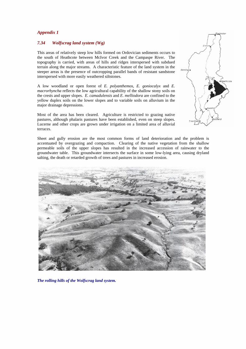
Appendix 1 7.34 Wolfscrag land system (Wg) This areas of relatively steep low hills formed on Ordovician sediments occurs to the south of Heathcote between McIvor Creek and the Campaspe River. The topography is carried, with areas of hills and ridges interspersed with subdued terrain along the major streams. A characteristic feature of the land system in the steeper areas is the presence of outcropping parallel bands of resistant sandstone interspersed with more easily weathered siltstones. A low woodland or open forest of E. polyanthemos, E. goniocalyx and E. macrorhyncha reflects the low agricultural capability of the shallow stony soils on the crests and upper slopes. E. camadulensis and E. melliodora are confined to the yellow duplex soils on the lower slopes and to variable soils on alluvium in the major drainage depressions. Most of the area has been cleared. Agriculture is restricted to grazing native pastures, although phalaris pastures have been established, even on steep slopes. Lucerne and other crops are grown under irrigation on a limited area of alluvial terraces. Sheet and gully erosion are the most common forms of land deterioration and the problem is accentuated by overgrazing and compaction. Clearing of the native vegetation from the shallow permeable soils of the upper slopes has resulted in the increased accession of rainwater to the groundwater table. This groundwater intersects the surface in some low-lying area, causing dryland salting, the death or retarded growth of trees and pastures in increased erosion.
The rolling hills of the Wolfscrag land system.

Appendix 1 (continued)
The shallow rocky soils only support native pastures, and the level of animal production is low.
Salting, sheet erosion and gully erosion signify extreme land deterioration and management of the land.

Appendix 1 (continued) WOLFSCRAG LAND SYSTEM (Wg) Area 237km 2 5.8% of the catchment CLIMATE Rainfall, mean (mm) Temperature mean ( C) Seasonal growth limitations
Annual, 550-700; lowest January (30-35) highest June or August (60-70) Annual, 14; lowest July (8), highest February (22)
Temperature less than 10 C (av): May-august Rainfall less than potential evapotranspiration: October-early April
GEOLOGY Age, rock, type
Ordovician, sandstone and mudstone
PHYSIOGRAPHY Landform pattern Elevation range (m) Relative relief (m) Drainage pattern Channel spacing
Rolling low hills 200-450
50 Dendritic
Moderate to close
LAND COMPONENT Number Percentage of land system
1 55
2 5
3
35
4 5
PHYSIOGRAPHY Landform element Slope; modal, range (%) Site drainage
Steep crest and slope with outcropping
Rock strata 20, 10-40
Excessively drained
Minor drainage depression
4, 1-6
Moderately well drained
Gentle lower crest and slope
5, 1-12
Well drained
Major drainage depression
1, 0-2
Somewhat poorly drained SOIL Parent material Description Classification Surface texture Depth to hardpan or bedrock (m) Nutrient status Available water capacity Permeability Exposed rock/stone (%) Sampled site number
Sandstone and mudstone
Reddish brown or brown gradational soils, frequently stony; minor loams
Gn3.14, Gn3.71, UM; minor Dy2.11 Gn3.17 Loam
0.1-0.7 Very low
Low
Moderate
10-80 1090,1093
Alluvium and colluvium
Yellowish brown duplex soils with bleached A2 horizons
Dy3.41; minor Gn3.04, Gn4.51
Loam 1.0-1.5
Low to moderate Low surface, low to moderate subsoil
Moderate surface, slow subsoil
0 1092
Sandstone and mudstone
Yellowish brown duplex soils with bleached A2 horizons; occasional red
duplex or red or yellowish brown gradational soils
Dy3.41; minor Dy3.21, Gn3.14, Gn3.84, Dr2.41
Loam 0.5-1.5
Low surface, moderate subsoil Low surface, moderate subsoil
Moderate surface, slow subsoil
0-10 1091
Alluvium
Variable; commonly mottled yellow Duplex soils overlain by a loamy wash
Dy3.41, Um over Dy3.41L minor Um
Sandy loam >2.0
Low surface, moderate subsoil Low surface, moderate subsoil
Moderate to rapid surface, slow
subsoil 0
1089
NATIVE VEGETATION Structure Characteristic species (+ indicates predominant species)
Open forest I/II
E.polyanthemos+, E.goniocalyx+, E.macroorhyncha+, W. microcarpa+,
E.melliodora, E.radiata (west)
Open forest II
E.camaldulensis+ E.melliodora, E.microcarpa+, E.polyanthemos, E.macrorhyncha, E.goniocalys
Open forest II
E.microcarpa+, E.polyanthemos, E.goniocalyx, E.macroryhncha,
E.melliodora, E.albens
Open forest II
E.camaldulensis+, E.mlliodora, E.rubida
PRESENT LAND USE Grazing on native introduced pastures Grazing on native and introduced pastures
Grazing on native and introduced pastures; minor cropping
Grazing on native and introduced pastures
OBSERVATION SOIL DETERIORATION
Sheet erosion common and locally severe
Gully erosion and salting common Minor sheet erosion and salting Gully erosion common and often severe. Salting common

Appendix 1 (continued) SUSCEPTIBILITY OF LAND TO PROCESSES OF SOIL DETERIORATION – Wolfscrag Compt. Process Susceptibility Critical land factors Off-site effects Comments 1 Sheet and rill
erosion high - moderate to steep slopes
- hydrophobic topsoil
- sedimentation Numerous rock outcrops impede overland flow, thereby increasing the infiltration of water; the shallow topsoils have a low tolerance of erosion
Leaching of nutrients
moderate -moderate soil permeability -moderate cation exchange capacity -low percentage base saturation
- -
Compaction of topsoil
moderate -loamy texture -low organic matter content -weak topsoil structure
-increased run-on
-
2 Gully erosion moderate -minor accumulations of alluvium -subsoils that slake/disperse
-sedimentation -turbid run-on
-
Compaction of topsoil
Moderate -loamy texture -topsoil often moist
salting moderate -saline groundwater table at shallow depth
-saline stream flows water turbidity
Loss of the protective vegetative cover due to salt toxicity can initiate erosion problems
3 Sheet and rill erosion
moderate -gentle slopes -hydrophobic topsoil -clayey subsoils of low permeability
-sedimentation -
Compaction of topsoil
moderate -loamy texture -low organic matter content
-increased run-on
-
salting moderate -saline groundwater table at shallow depth -stored salts in soil and parent material
-saline stream flows -water turbidity
As for component 2
4 Stream-bank erosion
moderate -accumulations of alluvium -subsoils that slake/disperse
-sedimentation -turbid stream flows
-
salting high -saline water table at shallow depth -stored salts in soil and parent material
-saline stream flows
As for component 2
Compaction of topsoil
moderate -loamy texture -topsoil often moist low-moderate organic matter content
- -
The dry, rocky slopes contrast with the west, saline drainage depressions; only the low productivity is common