Embed Size (px)
Citation preview
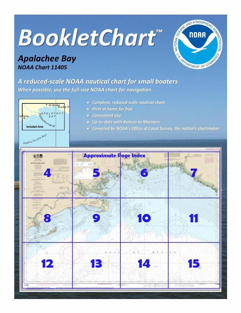
BookletChart™ Apalachee Bay NOAA Chart 11405
A reduced-scale NOAA nautical chart for small boaters When possible, use the full-size NOAA chart for navigation.
Included Area

2
Published by the National Oceanic and Atmospheric Administration
National Ocean Service Office of Coast Survey
www.NauticalCharts.NOAA.gov 888-990-NOAA
What are Nautical Charts?
Nautical charts are a fundamental tool of marine navigation. They show water depths, obstructions, buoys, other aids to navigation, and much more. The information is shown in a way that promotes safe and efficient navigation. Chart carriage is mandatory on the commercial ships that carry America’s commerce. They are also used on every Navy and Coast Guard ship, fishing and passenger vessels, and are widely carried by recreational boaters.
What is a BookletChart?
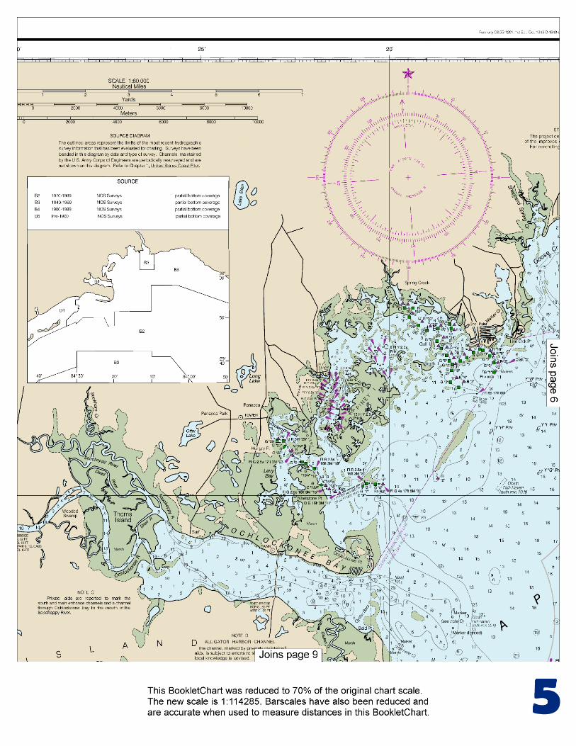
This BookletChart is made to help recreational boaters locate themselves on the water. It has been reduced in scale for convenience, but otherwise contains all the information of the full-scale nautical chart. The bar scales have also been reduced, and are accurate when used to measure distances in this BookletChart. See the Note at the bottom of page 5 for the reduction in scale applied to this chart.
Whenever possible, use the official, full scale NOAA nautical chart for navigation. Nautical chart sales agents are listed on the Internet at http://www.NauticalCharts.NOAA.gov.
This BookletChart does NOT fulfill chart carriage requirements for regulated commercial vessels under Titles 33 and 44 of the Code of Federal Regulations.
Notice to Mariners Correction Status
This BookletChart has been updated for chart corrections published in the U.S. Coast Guard Local Notice to Mariners, the National Geospatial Intelligence Agency Weekly Notice to Mariners, and, where applicable, the Canadian Coast Guard Notice to Mariners. Additional chart corrections have been made by NOAA in advance of their publication in a Notice to Mariners. The last Notices to Mariners applied to this chart are listed in the Note at the bottom of page 7. Coast Pilot excerpts are not being corrected.
For latest Coast Pilot excerpt visit the Office of Coast Survey website at http://www.nauticalcharts.noaa.gov/nsd/searchbychart.php?chart=11405.
(Selected Excerpts from Coast Pilot)St. Apalachee Bay, about 170 miles NW of Tampa Bay, is formed by the bend in the coastline from a NW to a SW direction. Depths range from 6 to 20 feet with numerous shoals and rocks, some bare at low water. The bay is the approach to St. Marks River. Danger zone.–An Air Force rocket-firing range has been established in the Gulf S of Apalachee Bay. (See 334.640, chapter 2, for limits and regulations.)
Econfina River, entering the E part of Apalachee Bay, is shallow and navigable by boats drawing about 2 feet at half tide or better; although lesser depths may be found during protracted periods of offshore winds.
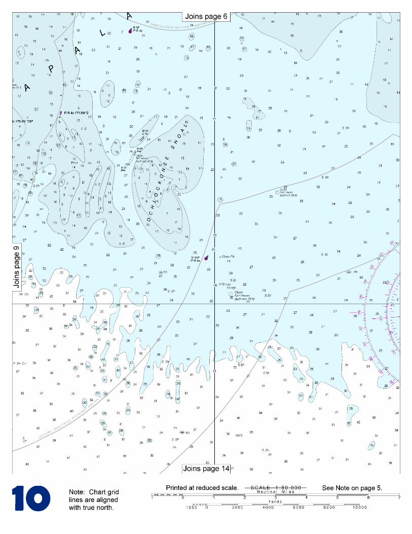
A private light marks the E side of the entrance to the river. The river channel is rocky and should be used only with local knowledge. Econfina Landing, on the W bank 2 miles above the mouth, has facilities for small craft. Gasoline, water, ice, a launching ramp, and limited berthage are available. State Route 14 leads to U.S. Route 98. Aucilla River flows into Apalachee Bay 4.5 miles NW of Econfina River. The approach for a distance of 3 miles is a narrow winding channel that is difficult for strangers. A private light on Gamble Point marks the entrance to the river. The river above the mouth is reported to be poorly marked, fast-flowing, and with depths of over 5 feet. It has been further reported that by giving the bends in the river a good berth, and by avoiding the rocks in the channel which are discernible by ripples, boats drawing 4 feet will have little difficulty. Local knowledge is advised. St. Marks National Wildlife Refuge covers much of the coastal area between Aucilla River and Ochlockonee Bay, about 12 miles SW of St. Marks River. A beach resort is at Shell Point (30°03.4'N., 84°17.4'W.), 5 miles W of St. Marks River. The mean range of tide is 2.5 feet. Shell Point Light (30°02'21"N., 84°17'41"W.), 17 feet above water and shown from a pile with a green and white diamond-shaped daymark, marks the approach. Panacea Harbor, in Dickerson Bay, is about 11 miles SW of St. Marks Light. A dredged channel leads from Apalachee Bay to the public wharf at the town of Panacea. In 2011, the midchannel controlling depth was 5 feet to the public wharf. The channel is marked by lights, buoys, and daybeacons. Panacea is a summer resort and fishing center with a seafood processing plant in the harbor and several more in town. Gasoline and some supplies can be obtained in town. Ochlockonee Bay, on the W side of Apalachee Bay, is a shallow bay 5 miles long and a mile wide. The approach from Apalachee Bay is obstructed by shoals, which probably shift from time to time. The S half of the mouth is closed entirely by oyster bars. The entrance is between Ochlockonee Point on the N and Bald Point on the S. Ochlockonee Bay Light OB (29°56'00"N., 84°18'00"W.), shown from a dolphin with a green square daymark, about 3 miles SE of Ochlockonee Point, marks the approach to the bay. The mean range of tide is 2.0 feet. Ochlockonee River, emptying into the head of Ochlockonee Bay, leads W to the junction of Crooked River and then turns N and finally E. A depth of 5 feet, with local knowledge, can be found for 29 miles. U.S. Route 319 highway bridge about 6 miles above the mouth has a fixed span with a clearance of 10 feet. The river is little used. About 8 miles above the mouth, piling of a former railroad bridge is a hazard in the river. A launching ramp is available at a State park on the N side of the river, about 4.5 miles above the mouth. Crooked River, a narrow, crooked tidal stream 22 miles long, connects Ochlockonee River with Carrabelle River. Crooked River is completely blocked by trees and growth about 10 miles above the E mouth. Ochlockonee Shoal, lying about 8 miles SE of Ochlockonee Point, has depths of 3 to 17 feet. Although the shoal is separated from St. James Island by lanes of moderate depths, there is no safe passage between the shoal and the island except for small craft. A lighted bell buoy is SE of the shoal. The buoy also marks the approach to St. Marks River and Apalachee Bay. There are three fish havens in Apalachee Bay. The first is 2.2 miles 167° from Shell Point Light, the second about 4.6 miles 161° from St. Marks Light, and the third about 4.5 miles 108° from Ochlockonee Bay Light 2. The first two are unmarked; the third is marked by private buoys.
U.S. Coast Guard Rescue Coordination Center 24 hour Regional Contact for Emergencies
RCC New Orleans Commander
8th CG District (504) 589-6225 New Orleans, LA

G
NOAA’s navigation managers serve as ambassadors to the maritime community. They help identify navigational challenges facing professional and recreational mariners, and provide NOAA resources and information for safe navigation. For additional information, please visit nauticalcharts.noaa.gov/service/navmanagers
To make suggestions or ask questions online, go to nauticalcharts.noaa.gov/inquiry. To report a chart discrepancy, please use ocsdata.ncd.noaa.gov/idrs/discrepancy.aspx.
Lateral System As Seen Entering From Seaward on navigable waters except Western Rivers
PORT SIDE
ODD NUMBERED AIDS
GREEN LIGHT ONLY
FLASHING (2)
PREFERRED CHANNEL
NO NUMBERS – MAY BE LETTERED
PREFERRED CHANNEL TO
STARBOARD
TOPMOST BAND GREEN
PREFERRED CHANNEL
NO NUMBERS – MAY BE LETTERED
PREFERRED CHANNEL
TO PORT
TOPMOST BAND RED
STARBOARD SIDE
EVEN NUMBERED AIDS
RED LIGHT ONLY
FLASHING (2)
FLASHING FLASHING
OCCULTING GREEN LIGHT ONLY RED LIGHT ONLY OCCULTING QUICK FLASHING QUICK FLASHING
ISO COMPOSITE GROUP FLASHING (2+1) COMPOSITE GROUP FLASHING (2+1) ISO
"1"
Fl G 6s
G "9"
Fl G 4s
GR "A"
Fl (2+1) G 6s
RG "B"
Fl (2+1) R 6s
"2"
Fl R 6s
8
R "8"
Fl R 4s
LIGHT
G
C "1"
LIGHTED BUOY
G
"5"
GR
"U"
GR
C "S"
RG
N "C"
RG
"G"
LIGHT
6
R
N "6"
LIGHTED BUOY
R
"2
"
CAN DAYBEACON
CAN NUN NUN
DAYBEACON
For more information on aids to navigation, including those on Western Rivers, please consult the latest USCG Light List for your area.
These volumes are available online at http://www.navcen.uscg.gov
Navigation Managers Area of Responsibility
Northeast
Lt. Meghan McGovern
Northwest and
Pacific Islands
Crescent Moegling
Great Lakes Region
Tom Loeper
Chesapeake and
Delaware Bay
Steve Soherr
California
Jeff Ferguson
[email protected] Mid-Atlantic
Lt. Ryan Wartick
Alaska
Lt. Timothy M. Smith
Western Gulf Coast
Alan Bunn
Central Gulf Coast
Tim Osborn
[email protected] South Florida
Puerto Rico
U.S. Virgin Islands
Michael Henderson
Southeast
Kyle Ward
2
2 C U 5
1


VHF Marine Radio channels for use on the waterways:Channel 6 – Inter-ship safety communications.Channel 9 – Communications between boats and ship-to-coast.Channel 13 – Navigation purposes at bridges, locks, and harbors.Channel 16 – Emergency, distress and safety calls to Coast Guard and others, and to initiate calls to other
vessels. Contact the other vessel, agree to another channel, and then switch.Channel 22A – Calls between the Coast Guard and the public. Severe weather warnings, hazards to navigation and safety warnings are broadcast here.Channels 68, 69, 71, 72 and 78A – Recreational boat channels.
Getting and Giving Help — Signal other boaters using visual distress signals (flares, orange flag, lights, arm signals); whistles; horns; and on your VHF radio. You are required by law to help boaters in trouble. Respond to distress signals, but do not endanger yourself.
EMERGENCY INFORMATION
Distress Call Procedures
• Make sure radio is on.• Select Channel 16.• Press/Hold the transmit button.• Clearly say: “MAYDAY, MAYDAY, MAYDAY.”• Also give: Vessel Name and/or Description;Position and/or Location; Nature of Emergency; Number of People on Board.• Release transmit button.• Wait for 10 seconds — If no responseRepeat MAYDAY call.
HAVE ALL PERSONS PUT ON LIFE JACKETS!
This Booklet chart has been designed for duplex printing (printed on front and back of one sheet). If a duplex option is not available on your printer, you may print each sheet and arrange them back-to-back to allow for the proper layout when viewing.
QR
Quick ReferencesNautical chart related products and information - http://www.nauticalcharts.noaa.gov
Interactive chart catalog - http://www.charts.noaa.gov/InteractiveCatalog/nrnc.shtmlReport a chart discrepancy - http://ocsdata.ncd.noaa.gov/idrs/discrepancy.aspx
Chart and chart related inquiries and comments - http://ocsdata.ncd.noaa.gov/idrs/inquiry.aspx?frompage=ContactUs
Chart updates (LNM and NM corrections) - http://www.nauticalcharts.noaa.gov/mcd/updates/LNM_NM.html
Coast Pilot online - http://www.nauticalcharts.noaa.gov/nsd/cpdownload.htm
Tides and Currents - http://tidesandcurrents.noaa.gov
Marine Forecasts - http://www.nws.noaa.gov/om/marine/home.htm
National Data Buoy Center - http://www.ndbc.noaa.gov/
NowCoast web portal for coastal conditions - http://www.nowcoast.noaa.gov/
National Weather Service - http://www.weather.gov/
National Hurrican Center - http://www.nhc.noaa.gov/
Pacific Tsunami Warning Center - http://ptwc.weather.gov/
Contact Us - http://www.nauticalcharts.noaa.gov/staff/contact.htm
NOAA’s Office of Coast Survey The Nation’s Chartmaker
For the latest news from Coast Survey, follow @NOAAcharts
NOAA Weather Radio All Hazards (NWR) is a nationwide network of radio stations broadcasting continuous weather information directly from the nearest National Weather Service office. NWR broadcasts official Weather Service warnings, watches, forecasts and other hazard information 24 hours a day, 7 days a week. http://www.nws.noaa.gov/nwr/