Embed Size (px)
Citation preview

APACHE NORTH SEA LIMITED
Bacchus Production Increase
Environmental Statement BEIS Project Reference: D/4256/2020
July 2020

Environmental Statement Bacchus Production Increase
Apache North Sea Limited July 2020
This page is intentionally blank

Environmental Statement Bacchus Production Increase
Apache North Sea Limited July 2020
STANDARD INFORMATION SHEET
Project name Bacchus Production Increase
Project reference number
D/4256/2020
Type of project Production increase
Undertaker name Apache North Sea Limited
Undertaker address Caledonia House Prime Four Business Park Kingswells Causeway, Aberdeen AB15 8PU
Short description The assessment of the environmental impacts from an increase in production from the Bacchus Field in excess of 500 tonnes of oil per day over the current consent threshold, and the drilling of a new infill well.
Dates
Anticipated commencement of works
Q4 2020
Date and reference number of any earlier Statement related to this project
D/4066/2009; December 2009
Significant environmental impacts identified
None
Statement prepared by
Apache North Sea Limited Hartley Anderson Limited

Environmental Statement Bacchus Production Increase
Apache North Sea Limited July 2020
This page is intentionally blank

Environmental Statement Bacchus Production Increase
Apache North Sea Limited July 2020
CONTENTS Glossary and Abbreviations ........................................................................................ i
Non-Technical Summary ............................................................................................ vi
1 Introduction .......................................................................................................... 1
1.1 Background ................................................................................................... 1
1.2 Apache Environmental Management ............................................................ 2
1.3 Environmental Statement .............................................................................. 2
1.4 Marine Planning ............................................................................................ 5
2 Bacchus Production Increase .............................................................................. 6
2.1 Introduction ................................................................................................... 6
2.2 Bacchus and Bacchus South ........................................................................ 6
2.3 Bacchus Facilities ......................................................................................... 7
2.4 Rationale for Further Development ............................................................... 9
2.5 Bacchus South .............................................................................................. 9
2.6 Forties Alpha ............................................................................................... 10
2.7 Bacchus Production Forecasts .................................................................... 13
2.8 Drilling Programme ..................................................................................... 15
2.9 Subsea works .............................................................................................. 18
2.10 Operation ................................................................................................. 19
2.11 Schedule .................................................................................................. 20
2.12 Decommissioning ..................................................................................... 20
3 Environmental Description ................................................................................. 21
3.1 Location ...................................................................................................... 21
3.2 Seabed Topography and Substrates ........................................................... 21
3.3 Climate and Meteorology ............................................................................ 21
3.4 Oceanography and Hydrography ................................................................ 22
3.5 Plankton ...................................................................................................... 22
3.6 Benthos ....................................................................................................... 23
3.7 Fish, Shellfish and Cephalopods ................................................................. 25
3.8 Seabirds ...................................................................................................... 30
3.9 Marine Mammals ......................................................................................... 33
3.10 Conservation Sites and Species .............................................................. 34

Environmental Statement Bacchus Production Increase
Apache North Sea Limited July 2020
3.11 Users of the Sea and Offshore Environment ........................................... 35
4 Identification and Screening of Potentially Significant Issues ............................ 42
4.1 Introduction ................................................................................................. 42
4.2 Method ........................................................................................................ 42
4.3 Sources of Potential Environmental Effects ................................................ 44
5 Evaluation of Potentially Significant Issues ........................................................ 51
5.1 Issues Related to Incremental Production ................................................... 51
5.2 Bacchus South Well and Subsea Connection ............................................. 56
5.3 Accidental Events and Major Environmental Incidents ................................ 67
5.4 Cumulative Effects ...................................................................................... 87
5.5 Transboundary Effects ................................................................................ 89
6 Issue Management and Conclusion ................................................................... 91
References ............................................................................................................... 93

Environmental Statement Bacchus Production Increase
Apache North Sea Limited July 2020
Page i
GLOSSARY AND ABBREVIATIONS
Apache Apache North Sea Limited
API American Petroleum Institute
ATK Helifuel
bbl(s) Barrel(s) of oil
BECPELAG Biological Effects Monitoring in Pelagic Ecosystems
BEIS Department for Business Energy & Industrial Strategy (formerly DECC, the
Department of Energy and Climate Change)
BOP Blow-out Preventer
Cefas Centre for Environmental, Fisheries, and Aquaculture Science
CH4 Methane
CIP Communication and Interface Plan
CNS Central North Sea
CO2 Carbon Dioxide
CO2 eq. CO2 equivalent
DP Dynamic Positioning
DHSV Down Hole Safety Valve
DSV Diving Support Vessel
EC European Commission
ECMWF European Centre for Medium-Range Weather Forecasts
EEMS Environmental Emissions Monitoring System
EH&S Environmental, Health and Safety
EIA Environmental Impact Assessment
EMS Environmental Management System
ERRV Emergency Response and Rescue Vessel
ES Environmental Statement
EROD enzymatic induction
EU European Union
EUOSD Directive 2013/30/EU on safety of offshore oil and gas operations
FASP Forties Alpha Satellite Platform
FPS Forties Pipeline System
GHG Greenhouse Gas
GOR Gas:Oil Ratio
GWP Global Warming Potential. Emissions metric used to indicate the
contribution of a certain gas species to radiative forcing, accounting for the
atmospheric lifetime of a given gas relative to CO2, which has a value of 1
(IPCC 2007).

Environmental Statement Bacchus Production Increase
Apache North Sea Limited July 2020
Page ii
HQ Hazard Quotient
HP High Pressure
HYCOM Hybrid Coordinate Ocean Model
ICES International Council for the Exploration of the Sea
IPCC Intergovernmental Panel on Climate Change
JNCC Joint Nature Conservation Committee
km kilometre
km2 square kilometres
µm micrometre
m metre
m3/d Rate: cubic metres (oil, gas or water) per day
mD millidarcy
MAH Major Accident Hazards
MEG mono-ethylene glycol
mg milligram
MCZ Marine Conservation Zone
MEI Major Environmental Incident
MER Maximising Economic Recovery
MIV Manifold Isolation Valve
MoD Ministry of Defence
MPA Marine Protected Area – MPAs in Scottish waters made under the Marine
(Scotland) Act 2010 as amended and Marine and Coastal Access Act 2009
(as amended)
Mt million tonnes
NAO North Atlantic Oscillation
NCMPA Nature Conservation Marine Protected Area
NEC No Effect Concentration
NGL Natural Gas Liquids
NOx Oxides of nitrogen
NSMB North Sea Member States
LTOBM Low Toxicity Oil Based Muds
OCES Operators Co-operative Emergency Services
OBM Oil Based (drilling) Mud
OCNS Offshore Chemical Notification Scheme
OGA Oil and Gas Authority
OGUK Oil and Gas UK
OIW Oil in Water

Environmental Statement Bacchus Production Increase
Apache North Sea Limited July 2020
Page iii
OPEP Oil Pollution Emergency Plan
OPPC The Offshore Petroleum Activities (Oil Pollution Prevention and Control)
Regulations 2005
OPRED Offshore Petroleum Regulator for Environment and Decommissioning
OSCAR Oil Spill Contingency and Response
OSPAR The Convention for the Protection of the Marine Environment of the North
East Atlantic 1992
OVI Offshore Vulnerability Index
PAH Polycyclic Aromatic Hydrocarbons
PEC Predicted Environmental Concentration
PETS Portal Environmental Tracking System
PEXA Practice and Exercise Areas (for military use)
PHB Prehydrated bentonite
PIMS Pipeline Integrity Management System
PLONOR Pose Little Or No Risk
PMF Priority Marine Feature
PNEC Predicted no Effect Concentration
POB Persons on Board
psi Unit of pressure – pounds per square inch
PTS Permanent Threshold Shif
PWRI Produced Water Re-Injection
Ramsar Wetlands of international importance designated under the Ramsar
Convention
ROV Remotely Operated Vehicle
SAC Special Areas of Conservation – established under the Habitats Directive
scf Standard Cubic Feet (Gas). Equal to 0.028m3
SEA Strategic Environmental Assessment
SECEs Safety and Environmentally Critical Elements
SEMS Safety and Environmental Management System
SFG Scope for Growth
SL Source Level
SNH Scottish Natural Heritage
SO2 Sulphur dioxide
SOPEP Shipboard Oil Pollution Emergency Plan
SOSI Seabird Oil Sensitivity Index
SOTEAG Shetland Oil Terminal Environmental Advisory Group
SPA Special Protection Areas - established under Birds Directive
SPL Sound Pressure Level

Environmental Statement Bacchus Production Increase
Apache North Sea Limited July 2020
Page iv
SSIV Sub-Sea Isolation Valve
SWI Seawater Injection
TVDSS True Vertical Depth subsea
TCC Thermal Cuttings Processing
UK United Kingdom
UKCS UK Continental Shelf
UKHO United Kingdom Hydrographic Office
VMS Vessel Monitoring System
VOC Volatile Organic Compound
VSP Vertical Seismic Profiling
WBM Water Based Mud

Environmental Statement Bacchus Production Increase
Apache North Sea Limited July 2020
Page v
This page is intentionally blank

Environmental Statement Bacchus Production Increase
Apache North Sea Limited July 2020
Page vi
NON-TECHNICAL SUMMARY
This Environmental Statement (ES) presents the findings of the environmental assessment conducted
by Apache North Sea Limited (Apache) for a production increase and infill well (Bacchus South) at the
Bacchus Field, which lies in United Kingdom Continental Shelf (UKCS) Block 22/6c. The Bacchus
South well will be drilled using a semi-submersible drilling rig, and will be connected to the existing
Bacchus Field manifold. Hydrocarbons produced from the Bacchus South well will be processed along
with existing Bacchus production at the Forties Alpha platform in UKCS Block 21/10 and exported
along with Forties Field production through the Forties Pipeline System to Cruden Bay. Bacchus South
is located approximately 172km east of Peterhead and 55km from the UK-Norway median line. The
Bacchus Field, and Block 22/6c, is covered by licence P.255, acquired by Apache in December 2011.
Location of the Bacchus South well, the Bacchus Field, Forties Field and related pipelines
The ES has been produced in accordance with The Offshore Petroleum Production and Pipe-lines
(Assessment of Environmental Effects) Regulations 1999 (as amended). The submission of an ES to
the Secretary of State for the Department for Business Energy & Industrial Strategy (BEIS) is required
when an application for consent for increased production of hydrocarbons from an existing field,
exceeds incremental thresholds of 500 tonnes of oil per day, or 500,000m3 of gas per day. Production
forecasts following the drilling of the Bacchus South infill well indicate that production will exceed that
already consented beyond the threshold for oil noted above, for the Bacchus Field. Apache has therefore
completed an assessment of the potential environmental impacts of the increase in production, and
prepared this ES in support of an application for a revised production consent for the Bacchus Field.

Environmental Statement Bacchus Production Increase
Apache North Sea Limited July 2020 Page vii
Environmental characteristics of the area
The main environmental features of the Bacchus and Forties area are summarised in the following table.
Aspect Description
Location The Bacchus Field is located in Block 22/6c and is located some 172km from the nearest UK landfall (Peterhead) and 55km from the UK/Norwegian median line.
Sediments and topography
Thin surficial seabed sediments are generally homogenous, consisting of a sparse mosaic of small cobbles among a silt and sand matrix overlying coarser material. Boulders are found scattered across the area.
Climate
The area generally has a mild climate for the latitude. Winds in the area are variable and may blow from any direction, through directions between the west and south-west dominate in February and north and south in August. Annual mean wind speed is 10.2m/s. In January, winds of Beaufort force 7 or greater may be experienced at a frequency of approximately 20% in the central-northern North Sea, reducing to between 2 and 4% in July.
Hydrography
The water column stratifies thermally in summer. The depth of the thermocline increases from May to September and by August/September is typically 50m. The thermocline is broken down in autumn with increased wind and convective mixing. Sea surface temperatures range typically from 6.5-7°C in winter and 13.5-14.0°C in summer. Tidal energy is fairly low, and swell direction ranges from southwest to north throughout the year. Annual mean significant wave height is approximately 2.24m.
Plankton
The plankton community present in the Bacchus area is strongly influenced by the region hydrography of the region and is typical of the northern and central North Sea. The phytoplankton community is dominated by the dinoflagellate genus Ceratium, with diatoms such as Skeletonema costatum, Thalassiosira spp. and Chaetoceros spp. also abundant, particularly during the spring bloom. The zooplankton community is dominated by calanoid copepods (Calanus finmarchicus and C. helgolandicus), although other zooplankton groups such as Paracalanus and Pseudocalanus, Euphausiids and Acartia, are also abundant.
Jan Feb Mar Apr May Jun Jul Aug Sep Oct Nov Dec
Key: Period of increased plankton abundance shown in darker blue
Benthos
Habitat in the area has been characterised by slightly rippled sands with varying proportions of shell fragments and sparse epifauna including hermit crabs, crabs, sponges, sea cucumbers, sea pend and sea stars. Sampling of infauna between Bacchus and Forties Alpha indicated the polychaete Paramphinome jeffreysii was numerically dominant, being found in every sample, with the second and third most abundant taxa also being polychaetes, Galathowenia occulata agg. and Paradoneis lyra.
Commercial fish and shellfish
The area overlaps with spawning grounds of cod, lemon sole, mackerel, Norway pout and sandeel. The area also supports nursery areas several species including for cod, hake, ling, herring, mackerel, Norway pout, Nephrops, plaice, sprat, spotted ray, Spurdog, anglerfish and whiting.
Jan Feb Mar Apr May Jun Jul Aug Sep Oct Nov Dec
4 4 3 4 3 3 3 3 2 1 2 2
Key: 1 = 1 species spawning, 2 = 2 species spawning, 4 = 4 species spawning

Environmental Statement Bacchus Production Increase
Apache North Sea Limited July 2020 Page viii
Aspect Description
Seabirds and water birds
Seabird sensitivity in Blocks 21/10 and 22/6 and neighbouring Blocks is low, for those months with data, with the exception of a small number adjacent block-months which are scored as medium. Note that for six months of the year no data are available; where possible sensitivity scores have been interpolated. The area is a considerable distance from important coastal water bird sites and seabird breeding colonies, and beyond the mean foraging range of most seabird species during the breeding season.
Jan Feb Mar Apr May Jun Jul Aug Sep Oct Nov Dec Block
5 5 5 5 5 5 5 5 5 5 N N 21/10
5 5 5 5 5 5 5 5 5 5 N N 22/06
Key: Extremely
High Very high High Medium Low
No coverage
Marine mammals
Harbour porpoise are frequently sighted throughout the central North Sea area. White-beaked dolphins, although generally less abundant, are also sighted in the area throughout the year and low numbers of Atlantic white-sided dolphins have been recorded in the area. During summer months, minke whales are widely distributed throughout the central and northern North Sea. The Moray Firth and the coast of eastern Scotland has the only resident population of bottlenose dolphins in the North Sea; however, this is a primarily coastal species and thus unlikely to be present frequently in the Bacchus and Forties area. Harbour and grey seals may occur in the area, but in low numbers.
Conservation sites
The coasts of north-east Scotland have a variety of important habitats and species protected under international, national and local designations; however, these are at least 160km from the Bacchus Field. These sites have year round importance. The closest Natura 2000 site is the Scanner Pockmark SAC which is located 58km to the north of Bacchus, and the closest MPAs are the East of Gannet and Montrose Fields, located 33km to the south and the Norwegian Boundary Sediment Plain 44km to the east.
Other users
There is a very low to low shipping density in the Bacchus area throughout the year, although moderate levels occur within the nearby Forties Field. Fishing effort is low throughout the year, with no we-defined seasonal pattern. Other energy infrastructure (~2.7km), cables (~3.5km) and military training areas (~35km) are all some distance from the Bacchus Field.
Potential sources of effect
The additional production from the Bacchus Field will contribute to security of energy supply and result
in a variety of positive commercial and fiscal benefits through the production and sale of the
hydrocarbon resource. Through a systematic evaluation of the issues associated with the increased
production, and their interactions with the environment, a variety of potential sources of environmental
effect were identified. The majority were of limited extent and duration, and deemed negligible. No
potential issues of concern were identified through the assessment process, which could not be mitigated
to meet regulatory requirements and company policy. The following section provide a summary of the
assessment.
Sources of effect relating to the incremental production increase
Effects relating to the operation of the Bacchus Field from the production increase are relatively few,
as the hydrocarbons will be similar to that from the existing Bacchus wells and be received, processed
and exported at Forties Alpha with no platform modifications. Consequently, the fuel gas/diesel
consumption on Forties Alpha, and any associated combustion emissions, should not be significantly
increased as a result of the proposed production increment. The only modification to Forties Alpha will

Environmental Statement Bacchus Production Increase
Apache North Sea Limited July 2020
Page ix
be the addition of an asphaltene tank and related pumps, to deliver asphaltene inhibitor to the Bacchus
South well to help prevent the deposition of organic solids.
There is no gas export route from Forties Alpha or the wider Forties Field, and any associated gas from
Forties is used as fuel gas, to provide gas lift, or is flared. Bacchus South gas will be used as fuel gas
(92%), with the remaining gas flared. Fuel gas use will offset that already being imported from the
Aviat Field, such that there is expected to be no net change in the atmospheric emissions resulting from
fuel gas use. Flaring will result in emissions of carbon dioxide equivalent of up to 0.7% on 2018 UKCS
emissions levels or up to 0.012% of the fourth carbon budget for the relevant period (2023-2027), and
are considered to be minor.
Water production is expected to rise from Bacchus. It is expected that ~40% of this water will be
discharged to sea, with the remainder being re-injected for reservoir support. This will result in a
corresponding worst case increase in oil discharged in produced water from of 0.009 tonnes in 2023
(assuming a discharge oil-in-water (OIW) concentration of 20mg/l). The increase in the use of
chemicals (methanol, 10% and, scale inhibitor, 15%) and additional use of asphaltene, will be risk
assessed via the relevant Bacchus Chemical Permit, as necessary.
Sources of effect relating to the drilling of the Bacchus South well
The production increase will be delivered from the Bacchus South well, to be drilled using a semi-
submersible drilling rig which will be on location at Bacchus for a maximum of 112 days (including all
contingencies) and supported by a standby, supply vessel and helicopter for crew changes. The drilling
of the well will result in a number of emissions (to atmosphere) and discharges (including of treated
drill cuttings), as well as generating physical disturbance to the seabed and representing a source of
potential interaction with other users of the sea. The well will be subject to further assessment via the
Portal Environmental Tracking System (PETS) process.
Atmospheric emissions relating to the drilling of the well are minor in the context of potential air
quality-related impacts and their contribution to global atmospheric greenhouse gas loading,
representing ~0.02% of wider 2018 UKCS carbon dioxide emissions, or 0.003% of the third carbon
budget for the relevant period (2018-2022).
Drilling fluids, cementing and completion chemicals of low toxicity will preferentially be selected for
use during the Bacchus South drilling programme. The well will be drilled using a combination of
seawater (and some low hazard chemicals added to increase the viscosity to help sweep cuttings out of
the wellbore) for the surface hole, and low toxicity oil-based mud for the lower hole sections. Material
from the surface hole section of the well will be discharged directly to the seabed, and consist of
sediments derived from the seabed and shallow geological formations. This material will form a small
pile on the seabed, which will be re-mobilised over time by water currents and burrowing fauna activity.
The predicted environmental effects are very localised and of short duration, involving smothering of
benthic habitat and animals, with rapid faunal re-colonisation.
Oil-based mud and cuttings from the lower hole sections will be returned to the drilling rig and treated
onboard, with the mud being retained for reuse, and the treated cuttings discharged from the rig, just
below sea-level. The treatment facilities ensure that the oil content of the cuttings is less than 1% such
that their discharge is consistent with obligations under OSPAR 2000/3. In the event that the treatment
processing plant is not available, contaminated cuttings will be contained and returned to shore for
treatment and disposal.
The physical presence of the drilling rig and vessel used to make the subsea connections for Bacchus
South to the Bacchus manifold, have been identified as a potential cause of effect, primarily for fisheries
and navigation. Fishing effort in the Bacchus area is low through the year, with no clear seasonal

Environmental Statement Bacchus Production Increase
Apache North Sea Limited July 2020
Page x
pattern. A 500m exclusion zone is already in place for the Bacchus Field, centred on the Bacchus
manifold, and the Bacchus South well and its related pipeline and jumper connection will all be within
the existing area. A separate 500m zone centred on the Bacchus South well location will be in place
for the duration of drilling. The semi-submersible rig used to drill the wells will use eight anchors
deployed radially at a distance of 1,200-1,800m. As the anchors and their related chains/cables will be
outside of the rig 500m safety zone, as laid positions will be notified to fishermen and others. All
aspects of the subsea infrastructure (wellhead, pipeline, jumper) will be publicised through Notices to
Mariners, and marked on navigation and fisheries charts.
Physical disturbance primarily relates to drill rig anchoring and well cuttings. The majority of seabed
species recorded from the European continental shelf are known, or believed to have, short lifespans (a
few years or less) and relatively high reproductive rates, indicating the potential for rapid population
recovery, typically between one to five years. Polychaete species which dominate infaunal assemblages
at stations between Bacchus to Forties A platform are characterised by short lifespans and are likely to
have high recovery rates. Epifauna is relatively sparse in comparison with infauna and most species
are mobile. It would be expected that animals would be able to move away from, and then rapidly
recolonise, recently disturbed sediment. It is considered probable that both the physical habitat
consequences and benthic community effects of physical disturbance of the seabed from future drilling
activities will fully recover within a five to ten year period.
Accidental events
Risk assessment of accidental events involves the identification of credible accident scenarios,
evaluation of the probability of incidents, and assessment of their ecological and socio-economic
consequences. Evaluating spill risk requires consideration of the probability of an incident occurring
and the consequences of the impact.
Historic data for the North Sea shows that the majority of accidental spills are of very small volumes;
the probability of a large spill occurring is extremely low.
Spills can impact environmental and socio-economic sensitivities at distance from their source, and risk
assessment, therefore, requires the prediction of slick trajectory. For a given scenario, with defined
spill volume and weather/metocean conditions, the behaviour of a slick can be modelled. A spill of oil
representative of a blowout of Bacchus crude was modelled stochastically, this having been identified
as the worst case potential release of hydrocarbons. A diesel spill was not modelled As the diesel
inventory would be limited to that on the rig and support vessels, and any resulting spill expected to
break up relatively quickly; diesel has very high levels of light ends, evaporating quickly on release and
the low asphaltene content prevents emulsification, reducing its persistence. Modelling of a Bacchus
well blowout was undertaken seasonally (December-February, March-May, June-August and
September to November) for a well blowout scenario, with the shortest time and related probability for
oil to cross the median line or reach the coast calculated for the UK and adjacent states.
Stochastic modelling of a Bacchus blowout (58,446 m3/day on day 1, declining to 3,708 m3/day at day
120) is estimated to result in a maximum accumulation of oil onshore of 51,225m3 after 130 days. It is
estimated that oil would reach the nearest UK coastline (Shetland) between 6 and >20 days depending
on season (December-February and June-August respectively), with a shoreline oiling probability of
40-50% and 30-40% respectively. There is a high probability (90-100%) that surface oil would cross
the UK/Norwegian median lines in 18 (December-February and March-May) 24 (June-August) hours
and a similarly high probability (up to 100%) that oil would beach in Norway within 7-11 days
(September-November and December-February, and June-August, respectively). The probability of
surface oiling in the adjacent states of Sweden and Denmark remains relatively high at up to 90% in 7
days and 100% in 10 days respectively. Probabilities for German (up to 30% in 19 days, March-May)
and Dutch (up to 20%, March-May) waters are comparatively lower.

Environmental Statement Bacchus Production Increase
Apache North Sea Limited July 2020
Page xi
The potential impact from a Bacchus well blowout was assessed for its potential to result in a Major
Environmental Incident (MEI); an MEI can only occur as a consequence of a major accident. This
assessment was done with reference to the key environmental receptors, including the protected sites of
the UK and the bordering states; for protected species and natural habitats, the definition of a MEI
describes this as an incident which results in any damage that has significant adverse effects on reaching
or maintain the favourable conservation status of such habitats or species.
Seabirds and marine mammals are generally considered the most vulnerable components of the
ecosystem to oil spills in offshore and coastal environments, because of their close association with the
sea surface. Benthic habitats and species may also be sensitive to deposition/sedimentation of oil.
Effects on sediment communities are typically associated with deoxygenation and organic enrichment.
Mechanisms of impact on seabird populations include oiling of plumage and loss of insulating
properties, and ingestion of oil during preening causing liver and kidney damage. Indirect effects
associated with bioaccumulation of contaminants from prey, and reduced prey availability, are also
possible. The vulnerability of seabirds to surface oiling is related to individual species’ behavioural
patterns, distribution and ecological characteristics, such as potential rate of population recovery –
vulnerability in Blocks 21/10 and 22/6 is low (or with no data) throughout the year (see Section 3.8).
Generally, marine mammals (which rely on blubber for insulation) are less vulnerable than seabirds to
fouling by oil, but they are at risk from hydrocarbons and other chemicals that may evaporate from the
surface of an oil slick at sea within the first few days. In contrast to seabirds there is relatively little
evidence of direct mortality associated with oil spills, although the aggregated distribution of some
species (especially dolphins) may expose large numbers of individuals to localised oiling. In the
unlikely event of mortality from a spill, population recovery rates are likely to be lower than for most
bird species.
Any spilled oil would be expected to float on the sea surface (SG of Bacchus being lower than that of
seawater), some low viscosity oils (Bacchus has a viscosity of 13.9) may disperse naturally within the
top few metres of the water column. Concentrations of oil in the upper levels of the water column may
be sustained close to the release point, in the event the release of oil is continuous. However, spilled
oil, with the Bacchus SG, is not expected to penetrate the lower depths of the water column, and as such
the impact on species in these lower levels, or on the seabed, is expected to be low.
The sensitivity of planktonic and pelagic communities (e.g. fish and cephalopods) is believed to be
lower, both in terms of exposure pathways and the higher recovery potential associated with
reproductive capacity. In the unlikely event of oil reaching the seabed, there is potential for localised
smothering of habitats used by fish, either as spawning, feeding or nursery grounds, and other benthic
fauna. In addition to direct toxicity of oil and dispersants, oil and certain chemicals have the potential
to introduce taint (defined as the ability of a substance to impart a foreign flavour or odour to the flesh
of fish and shellfish, following prolonged and regular discharges of tainting substances).
Perceived or actual contamination of target species with hydrocarbons or other chemicals may result in
economic damage to the fishing industry and associated industries. Following a spill or other incident,
in some circumstances exclusion orders may be issued preventing marketing of seafood from areas
considered to be contaminated, resulting in economic impacts on both the fishing and processing
industries. Loss of public confidence in seafood quality from an affected area may also impact on sales
revenues. The landings from Scottish vessels include fish from the Bacchus and wider Forties Area,
which lies to the south of a large area of moderate to high level of fishing effort over the Fladen Ground.
Monthly fishing effort over the period 2016-2018 was variable, though is low through most of the year,
with no well-defined seasonal pattern, with fisheries targeting both demersal and pelagic species, as
well as Nephrops.

Environmental Statement Bacchus Production Increase
Apache North Sea Limited July 2020 Page xii
A number of protected sites where the probability of surface oil meeting or exceeding 0.3µm was >30%
were identified, these were considered key sites where the impact of an uncontrolled release could
potentially be significant; sites where the probability was <30% were also identified, and although these
could also be impacted, the impact on these was not considered potentially significant. Of those key
protected sites, thirteen were marine sites, and primarily designated for physical features and seabed
habitats (e.g. reef, pockmarks, offshore deep sea muds) and biological features including
Arctica islandica aggregations and sandeels; where sites are fully submerged, it is unlikely that a spill
from Bacchus would result in damage to affect the conservation status of these, Bacchus oil being light
and expected to remain primarily on the sea surface and not penetrate deep into the water column. The
remaining sites include coastal sites and marine area Special Protection Area (SPAs) (e.g. extensions
of existing, or marine areas around existing sites, to protect foraging grounds for seabirds) and Special
Areas of Conservation (SAC), the qualifying habitats from this latter group not considered particularly
sensitive to spills. Of those SPAs identified, in the unlikely event of a major crude oil spill from
Bacchus, weathered spilled oil could theoretically affect the qualifying features (e.g. breeding seabirds
and wintering waterbirds) when present and when foraging within and outside the boundaries of the
SPA.
Fortunately, there is little experience of major oil spills in the vicinity of seabird colonies in the UK.
And, where spills have occurred, e.g. the Braer (Shetland), long term effects on wildlife have proved
to be less than feared with the most notable impact on breeding populations of resident seabirds closest
to the spill. For Bacchus, the risk of the potential impact on qualifying features of SPAs is further
reduced due to the time of year and abundance (drilling expected during Q3/Q4, outwith the breeding
season when the majority of birds are away from breeding colonies and not yet returned in great
numbers).
Evaluating spill risk also requires consideration of the probability of an incident occurring. While it is
evident from the Deepwater Horizon incident that well blowouts with environmentally significant
consequences can and do happen, historically, spills of this magnitude, as a result of well blowouts,
have not occurred on the UKCS or in the wider North Sea, and the probability remains remote.
Overall, while the spill modelling scenario for Bacchus does demonstrate the potential for an MEI as
described in the EUOSD and SCR (2015) for protected sites and species, this is a worst case scenario
that assumes no intervention and response, and the probability of an incident occurring is remote due
to preventative measures and response strategies in place.
Cumulative effects
Incremental, cumulative and synergistic effects have been systematically reviewed. Minor incremental
or cumulative risks (i.e. effects acting additively or in combination with those of other human activities)
were identified in relation to discharges, physical presence and disturbance of the seabed, spills and
emissions to atmosphere. None of these were considered to represent more than a small impact in a
regional context. No significant synergistic effects – where the joint effect of two or more processes is
greater than the sum of individual effects – are predicted.
Transboundary effects
The UK has ratified the Convention on Environmental Impact Assessment in a Transboundary Context
(Espoo Convention 1991) and thus an assessment is needed of the potential for the proposed activities
to result in significant transboundary effects. The production increase and infill well have a limited
likelihood of transboundary effects, though the Bacchus Field is located relatively close to the
UK/Norwegian median line (55km east). Noise, atmospheric and aqueous emissions from the rig and
support vessels are unlikely to be detectable or to significantly affect Norwegian national waters and

Environmental Statement Bacchus Production Increase
Apache North Sea Limited July 2020 Page xiii
air quality, nor are any operational discharges including atmospheric emissions from incremental flare
and produced water discharges.
Conclusion
The conclusions of the assessment are that the production increase, and the drilling of the Bacchus
South well, will not result in significant adverse effects on the environment or other users of the area.

Apache North Sea Limited July 2020 Page 1 of 122
Environmental Statement Beryl Area Production Increase
1 INTRODUCTION
This Environmental Statement (ES) presents the findings of an Environmental Impact Assessment
(EIA) conducted by Apache North Sea Limited (Apache), in relation to an increase in hydrocarbon
production from the Bacchus Field of more than 500 tonnes of oil per day, and the drilling of a new
infill well. The objective of the new well and production increase is to extend field life and contribute
to maximising the economic recovery of UK oil and gas. Drilling activities are expected to commence
in Q3/Q4 2020, and consent for the production increase is currently anticipated to commence from
Q2 of 2021.
1.1 Background
The Bacchus Field is located in Block 22/6c which is covered by licence P.255, acquired by Apache in
December 2011. Apache has operatorship of the Bacchus and Forties Fields. Bacchus is located some
172km from the nearest UK landfall (Peterhead) and 55km from the UK/Norwegian median line (Figure
1.1).
Figure 1.1: Location of the Bacchus Field, Forties Field and related pipelines
The Bacchus Field was discovered in May 2005 (well 22/6a-14), and was developed as a subsea tie-
back to Forties Alpha; production from Bacchus commenced in 2012. The Bacchus manifold is located
approximately 6.8km to the north east of the Forties Alpha platform, and is connected via a subsea
bundle containing export, water injection and service utility lines. Bacchus, and Forties Alpha, are part
of the wider Forties Field complex which includes five fixed platforms (Forties Alpha, Forties Bravo,

Apache North Sea Limited July 2020 Page 2 of 122
Environmental Statement Beryl Area Production Increase
Forties Charlie, Forties Delta and Forties Echo). Oil from all five Forties platforms, which includes
that from Bacchus, is exported via the INEOS operated Forties Unity platform into the Forties Pipeline
System (FPS)1.
A detailed description of the Bacchus Field and the proposed production increase and infill well drilling
is provided in Section 2.
1.2 Apache Environmental Management
Apache operates an Environmental Management System (EMS) which is certified as meeting the
requirements of the ISO14001:2015 international standard. The EMS is subject to periodic review and
assessment by both internal audits and external third-party audits. The most recent certification audit
was completed in June 2020.
Apache’s Environmental, Health and Safety Policy applies to operations within the remit of the EMS.
The policy is shown in Figure 1.2.
The Vice President both endorses and has responsibility for the implementation of the HSSE Policy.
The success of its implementation is reviewed annually as part of the Environmental Management
review.
As part of Apache’s continuing programme of improvements in environmental management, an annual
HSSE Management Plan is compiled that details specific projects to be undertaken in relation to
improving performance in discharges to sea, management of chemicals, atmospheric emissions, energy
efficiency and waste management.
1.3 Environmental Statement
1.3.1 Purpose
Environmental Impact Assessment (EIA) is an integral part of Apache’s management processes, which
satisfies the company's environmental policy objectives with regard to the assessment of potential risks
to the environment from its activities. This Environmental Statement (ES) documents the results of the
EIA process, highlighting environmental sensitivities, identifying potential hazards,
assessing/predicting risks to the environment and identifying practical mitigation and monitoring
measures to be carried forward.
The Environmental Statement has been produced in accordance with the Offshore Petroleum
Production and Pipe-lines (Assessment of Environmental Effects) Regulations 1999 (as amended).
Under these Regulations, the submission of an ES to the Secretary of State for the Department for
Business, Energy and Industrial Strategy (BEIS) is required when an application for consent for
increased production of hydrocarbons from an existing Field exceeds incremental thresholds of
500 tonnes of oil per day, or 500,000m3 of gas per day.
1 The Forties Pipeline System, including the Forties Unity riser platform, is operated by INEOS and carries oil
from a number of offshore fields. The pipeline has a landfall at Cruden Bay from where it travels underground to
Kinneil on the Firth of Forth.

Apache North Sea Limited July 2020 Page 3 of 122
Environmental Statement Beryl Area Production Increase
Figure 1.2: Apache Environmental, Health and Safety Policy

Apache North Sea Limited July 2020 Page 4 of 122
Environmental Statement Beryl Area Production Increase
The current production consent for the Bacchus Field extends to 31st of December 2021. The Bacchus
South infill well has the purpose of improving recovery of hydrocarbons from the Bacchus Field, which
has seen declining performance from existing wells in recent years. The well will extend field life, and
is in keeping with the Oil & Gas Authority’s (OGA) Maximising Economic Recovery (MER) UK
strategy, the central obligation of which is, “Relevant persons2 must, in the exercise of their relevant
functions, take the steps necessary to secure that the maximum value of economically recoverable
petroleum is recovered from the strata beneath relevant UK waters” (also see Section 2.2). The MER-
UK Strategy is presently being updated to take account of the UK’s commitment to achieving net zero
greenhouse gas emissions by 20503. Numerous changes to the strategy are proposed, however, an
additional paragraph to the central obligation is that relevant persons must, “take appropriate steps to
assist the Secretary of State in meeting the net zero target, including by reducing as far as reasonable
in the circumstances greenhouse gas emissions from sources such as flaring and venting and power
generation, and supporting carbon capture and storage projects.” While this consultation is ongoing,
the contribution of Bacchus to greenhouse gas emissions from flaring and power generation is
considered in this assessment.
1.3.2 Environmental Assessment Process
The EIA process was initiated when the potential to exceed the production threshold was identified.
Information on the environment and existing sensitivities was collated and used in the assessment
process.
For this ES, the potential impacts of increased production to the environment (in its broad sense) were
identified using defined severity criteria (Section 4). Those interactions with the potential to result in
significant environmental effects were then assessed in more detail (Section 5). Where appropriate,
mitigation measures were identified to avoid or reduce effects (Section 6).
1.3.3 Consultation
Apache consulted a number of organisations as part of the EIA process which included the Offshore
Petroleum Regulator for Environment and Decommissioning (OPRED), Marine Scotland and the Joint
Nature Conservation Committee (JNCC). Issues raised by those consulted and where they are addressed
in the, ES are provided below. Note that JNCC were present at a consultee meeting, and while
confirming those issues raised by OPRED and Marine Scotland (below), did not raise any additional
concerns.
Consultee Issue/Concern Response
OPRED & Marine Scotland
Options selection for the facilities. Options selection provided in Section 2.4.
OPRED Inclusion of the Major Environmental Incident (MEI) assessment.
MEI assessment provided in Section 5.3.
Marine Scotland Option selection for tophole riserless drilling.
The well can only be drilled riserless due to the seabed sediment type at location. Assessment provided in Section 5.2.3.
The ES will be subject to formal statutory public consultation.
2 Defined under Section 9C of the Petroleum Act 1998 (as amended), i.e. the holder of a petroleum licence; an
operator under a petroleum licence; the owner of (a) a relevant offshore installation, or (b) upstream petroleum
infrastructure. 3 https://www.gov.uk/government/news/uk-becomes-first-major-economy-to-pass-net-zero-emissions-law and
https://www.ogauthority.co.uk/news-publications/consultations/2020/consultation-on-new-oga-strategy/

Apache North Sea Limited July 2020 Page 5 of 122
Environmental Statement Beryl Area Production Increase
1.3.4 Areas of Uncertainty
Where definition is lacking, generic information has been used and best estimates of emissions,
discharges and other sources of interaction are used in the consideration of possible effects. Any
underlying assumptions with regard to these are presented.
1.4 Marine Planning
Bacchus is within an area covered by Scotland’s National Marine Plan (Scottish Government 2015).
Apache is aware of Scotland’s National Marine Plan and policies which are relevant to its operations in
Scottish waters, including those which are consistent with wider MER-UK strategy (e.g. policy
Oil&Gas 1). The increase in production does reflect a long-term activity, but it will be undertaken with
consideration to other existing users (e.g. consistent with policy GEN 4 Co-existence and also those
interactions with other users notes in policy Oil&Gas 1 and consistent with Oil&Gas 3 and 6),
environmental sensitivities of the area (policies GEN 9 Natural Heritage, GEN 12 Water Quality and
Resource, GEN 13 Noise and GEN 14 Air Quality) and cumulative effects (policy GEN 21 Cumulative
Impacts).

Apache North Sea Limited July 2020 Page 6 of 122
Environmental Statement Beryl Area Production Increase
2 BACCHUS PRODUCTION INCREASE
2.1 Introduction
The Bacchus Field was discovered in 2005 following the drilling of a discovery well in Block 22/6a
(22/6a-14). The Field was developed as a subsea tie-back to Forties Alpha (Figures 2.1 and 2.2) using
a subsea bundle and towhead, such that the manifold, pipeline and umbilical system were manufactured
onshore, and transported and installed in a single campaign. The subsea bundle connecting Forties
Alpha to Bacchus is surface-laid and consists of two production and water injection lines (6’’ and 4’’
respectively), 4’’ gas lift and 3’’ scale squeeze lines, a 2’’ methanol line along with power, hydraulic
and other control lines. Oil and gas are exported from Bacchus to Forties Alpha where it is comingled
with Forties crude and exported via the FPS. The Bacchus Field is covered by offshore production
licence P.255.
The production increase will be achieved by the drilling of an infill well, Bacchus South, which will
necessitate the use of a mobile drilling rig. The exact rig will depend on rig availability which is
considered to meet operational, safety and environmental criteria. The rig will have in place all
necessary permits and certification for operations on the UKCS. A range of drilling, cementing and
completion chemicals will be necessary to drill the well. A proportion of these chemicals will be
discharged with the cuttings, dependent on their nature and function, and will be assessed in the
application to BEIS for a chemical term permit through the Portal Environmental Tracking System
(PETS) process, along with all other relevant permits required for offshore drilling and production
increase.
2.2 Bacchus and Bacchus South
The Bacchus reservoir structure is a tilted fault-block with dip closure to the south-west, fault closure
along the south east and north east flanks and stratigraphic closure to the north west. The reservoir is
at a depth of 3,670-3,830m TVDSS (true vertical depth subsea) and comprises moderate quality Fulmar
shoreface sandstones containing 35º API oil with a GOR (gas:oil ratio) of 320scf/bbl (standard cubic
feet/barrel). The reservoir is overpressured and moderately high temperature with initial reservoir
conditions of 9,474psi and 143°C. Permeability varies from ca. 4mD (millidarcy) in the lower reservoir
section to 80mD in the upper section. There are two NNE-SSW conjugate faults with significant offset
in the reservoir structure forming three, potentially isolated reservoir compartments. The existing
Bacchus wells access the three main Bacchus reservoir compartments, with the wells intersecting major
faults between and within the compartments to mitigate potential compartmentalisation risk.
The remaining potential of the Bacchus Field and the immediate surrounding area, was evaluated
through a reinterpretation of the structure using broadband processed seismic data acquired in 2016,
updated seismic inversions, 4D seismic, reservoir surveillance data and updated reservoir models.
Bacchus South is located immediately to the west of the Bacchus Field (Figure 2.1) and fluids are
assumed to be comparable to Bacchus Field fluids as a consequence of their proximity and likely similar
charge history. The following reservoir parameters have been estimated for Bacchus South:
• Reservoir Pressure: Virgin pressure of 9,472 psia at 3,755 m TVDSS is expected;
• Temperature: 143°C at 3,755 m TVDSS
• Gas:Oil Ratio (GOR): 321scf/stb

Apache North Sea Limited July 2020 Page 7 of 122
Environmental Statement Beryl Area Production Increase
Figure 2.1: Forties Area Fields, including Bacchus South
2.3 Bacchus Facilities
2.3.1 Overview of current Bacchus and Host Facilities
Bacchus facilities include a four slot towhead manifold which is tied back to the Forties Alpha platform
via a 6.8km subsea bundle (Figure 2.2). Three subsea wells have been drilled to date (22/06c-B1 (B1),
22/06c-B2 (B2), 22/06c-B3y (B3)) and are connected to the manifold via flexible jumpers; these wells
initially flowed naturally (reservoir pressure of ±9,600psi), but as the reservoir pressure declined, one
well was converted to providing water injection (22/06c-B3y, converted in 2016) and the remaining
production wells require gas lift to produce.
The bundle provides for the routing of fluids and services to the wellhead jumpers as well as providing
isolation to the bundle from individual wells by means of Manifold Isolation Valves (MIVs). The
bundle terminates at the Forties Alpha Sub-Sea Isolation Valve (SSIV) manifold, which is in turn tied
back to a riser caisson at the platform. The bundle and riser caisson incorporate two 6” production
lines, a 4” gas lift supply line, and hydraulic, chemical and power/signal supplies. Two 4” heating lines
are provided within the bundle which have a dual purpose. The heating lines prevent wax and hydrate
formation, making use produced water supplied from Forties Alpha. The two pipelines are designated
as supply and return, allowing the heating medium to flow in a loop and return to the Forties Alpha
platform using a subsea crossover at the Bacchus subsea manifold. The heating medium is obtained
from a tie-in at the Forties Alpha platform produced water reinjection (PWRI) manifold and the return
pipeline is tied into the existing Produced Water Degasser Produced water from the Forties Alpha PWRI
manifold is also used to provide a motive force for Bacchus pigging operations.
The Bacchus wells require both methanol dosing at the Xmas trees on start-up, to mitigate hydrate risk,
and the injection of scale inhibitor at the tree as water cut rises, to protect against scale deposition in the
flowline.

Apache North Sea Limited July 2020 Page 8 of 122
Environmental Statement Beryl Area Production Increase
Forties Alpha
Bacchus fluids are processed at the Forties Alpha installation (Figure 2.1). Forties Alpha supports
equipment packages for, amongst other processes, drilling and workover, oil processing and export, and
water treatment and injection.
Forties Alpha processes fluids produced at both Forties Alpha and Forties Echo (and, currently via the
Maule Field well and the Bacchus Field wells). Gas and water are initially separated from the produced
oil in two, three-phase bulk separators. Oil is subsequently filtered prior to export to Forties Charlie
via a 20” pipeline. Separated gas is initially treated to remove water and condensate before being
transferred to the Natural Gas Liquids (NGL) plant for further water and condensate removal.
Following processing, the gas may be used as fuel or lift gas on Forties Alpha, or be exported to the
Forties gas distribution system. In line with the mature production status of Forties, the oil/water
interface of the reservoir has risen leading to an increased water cut and a resultant increase in the
hydrostatic head and a reduced well flow rate.
Produced water may be discharged following treatment (with a statutory requirement not to exceed an
oil in water content of 30mg/l per month) or reinjected, and facilities for both treated seawater (SWI)
and PWRI are maintained on Forties Alpha. Water generated from the bulk separators passes through
a set of hydrocyclones which separate the denser water from the less dense oil. Any oil is routed to a
reclaimed oil vessel from where it is pumped back to the bulk separators. The water is passed to
degassing vessels which gather any remaining oil which is passed to the reclaimed oil vessel, which in
turn is routed back to bulk separation. Prior to injection of produced water, the water is filtered to
remove particles >50μm (primarily sand) which may over time reduce water injection performance.
The sand may have a residual oil content which if deemed too great for discharge (>1%) will be subject
to a washing process prior to disposal. The filtered water is routed to two electrically driven
High Pressure (HP) injection pumps which increase the pressure of the water for discharge via the PWRI
manifold.
The Forties Alpha Satellite Platform (FASP) was installed in 2013. The FASP is linked to the west of
Forties Alpha by a 90m bridge which carries processed fluids, gas, electrical power and personnel
between the two installations. On installation, the platform provided 18 new well slots, additional
liquids processing and gas compression capacity for Forties Alpha, and extra power generation for the
Forties Field to be exported via the existing power ring main, but relies on Forties Alpha for oil export
and flaring facilities.
In 2015, the Aviat shallow gas development was tied-back to Forties Alpha to provide a source of fuel
gas so as to offset the use of diesel for fuel generation, as associated gas from the Forties production
continues to decline. Due to the lack of a gas export route from Forties, and a fuel gas deficit, all
Bacchus associated gas is utilised for energy production either at Forties Alpha, or else exported to
other installations in the Forties Field.

Apache North Sea Limited July 2020 Page 9 of 122
Environmental Statement Beryl Area Production Increase
Figure 2.2: Forties Alpha and the FASP
2.4 Rationale for Further Development
A number of factors limit the existing and future productivity from the Bacchus development which
provide the rationale for the Bacchus South well. These include historical issues with well management,
including a decrease in gas lift injection pressure at well B2 and historical wax/asphaltene deposits.
Wellbore cleanout and gas lift valve change out intervention was carried out in June 2018, and the
wax/asphaltene deposits were removed by jetting with coiled tubing whilst routing fluid back to Forties
Alpha. The unloading valves were then changed out, the tubing punched (to deepen the gas lift injection
point).
Flow problems were identified with well B1 such that it was shut in during January 2018. The impact
of re-instating production at the well has been investigated and found to be detrimental to overall
produced volumes when combined with the B2 well. The B2 well appears to be accessing all the decline
reserves for the B1 well, in addition to seeing a rate benefit due, in part, to improved reservoir pressures
associated with the shut in of well B1. The Field, therefore, is solely produced from well B2 at present.
The B3y water injection well is performing below expectations due to the poorer than expected reservoir
properties encountered. However, given the current understanding of the subsurface through a dynamic
simulation model, moving the injector location is deemed to be uneconomical. Bacchus has an existing
export route and an available well slot to tie a future well into, therefore it is proposed that this available
capacity is used rather than separate, dedicated facilities. A new well, Bacchus South (Section 2.5), is
proposed in order to enhance the production from Bacchus and extend field life, consistent with OGA’s
MER-UK Strategy (Section 1.3.1). The new well will account for historical Bacchus well maintenance
issues (e.g. by providing for downhole chemical injection of asphaltene inhibitor).
2.5 Bacchus South
Flow from well B2 is routed via both of the 6” Bacchus production lines to optimise production rate,
however, it is proposed that production from B2 and Bacchus South would be segregated from each
other subsea, by routing each well to one of the production lines, which will be isolated at the manifold
(see Figure 2.3 for an overview of connections at the Bacchus manifold). Although likely to impact on

Apache North Sea Limited July 2020 Page 10 of 122
Environmental Statement Beryl Area Production Increase
B2 well production rates, if production from the wells were not isolated, due to the anticipated virgin
reservoir pressure at Bacchus South the flowing wellhead pressure would back out production from the
B2 well, where flowing wellhead pressure is lower due to production related reservoir pressure
depletion. Once reservoir pressure at Bacchus South depletes it may be possible to comingle production
through both lines to optimise the total Bacchus rate by utilising the full available capacity.
The Bacchus South well will be equipped for downhole chemical injection of asphaltene dispersant to
mitigate against the deposition of organic solids in the well, as noted in Section 2.4. The well slot to be
used for Bacchus South is not currently tied into the chemical service lines in the manifold. It is
proposed to install flexible lines to the chemical interface plate from the unused methanol and scale
inhibitor chemical interface plate at the B3y slot, and to tie into one of the unused ¾” chemical injection
cores in the bundle for delivery of asphaltene inhibitor.
As the proposed Bacchus South well will utilise the last free slot on the manifold, further expansion at
Bacchus would require repurposing the disused B3y (water injection) or B1 production well slots and
facilities, with some additional installation or repurposing of gas lift or chemical services possibly
required.
A new, ~94m, flexible, 6” production pipeline will be installed between the Bacchus South well and
the Bacchus towhead manifold, connected at each end with rigid spoolpieces. Additionally, a jumper
providing hydraulic, chemical and control services will be installed between the well and manifold.
A 4” gas lift pipeline will also be installed. This will initially be positively isolated at the manifold until
gas lift is required.
2.6 Forties Alpha
The Bacchus South fluids will use the existing Bacchus reception facilities at Forties Alpha, and will
comingle with the Bacchus production from well B2. Flow from Bacchus can be routed to the inlet
separators of either of the two main processing trains on Forties Alpha, or direct to the test separator
and recycled back to one of the bulk inlet separators. Reservoir fluid composition and properties from
the Bacchus South well are expected to be of a similar nature to the currently produced Bacchus fluids.
Flow assurance, production chemistry and process separation management of the fluids are well
understood, and it is not anticipated that the Bacchus South well will introduce any additional challenges
to process separation and produced water quality. Production from Bacchus South, along with other
Forties oil, will be exported to Cruden Bay via the FPS.
Topside modifications are not required for production flowlines, separation and gas processing. The
principal modifications are to the chemical supply systems for Bacchus. This includes the addition of
an atmospheric chemical storage tank (3,000l, or 3m3) for asphaltene inhibitor and related duty/standby
pumps rated to match existing Bacchus bundle design pressure.

Apache North Sea Limited July 2020 Page 11 of 122
Environmental Statement Beryl Area Production Increase
Figure 2.3: Slot connections at the Bacchus manifold

Apache North Sea Limited July 2020 Page 12 of 77
Environmental Statement Bacchus Production Increase
Figure 2.4: Bacchus and Forties Alpha infrastructure, showing Bacchus South

Apache North Sea Limited July 2020 Page 13 of 122
Environmental Statement Bacchus Production Increase
2.7 Bacchus Production Forecasts
2.7.1 Oil and Gas
The Bacchus production consent runs to 2021, with currently consented volumes for up to 600 m3
(approximately 645 tonnes) per day of oil, and up to 42,850m3 (approximately 590 tonnes) of gas per
day. When accounting for forecast production from the Bacchus B2 well, the addition of Bacchus South
is predicted to result in oil and gas exceeding currently consented levels from 2021 and up to 2026, with
the incremental rates also exceeding the threshold4 requiring environmental impact assessment from
2021. Forecast production figures for Bacchus South are provided below (Table 2.1) and are charted
in the context of whole Bacchus production (i.e. that expected from the B2 well) over the same period
in Figure 2.5.
Table 2.1: Bacchus South oil and gas projections
Year Oil Gas
t/day m3/day t/day m3/day
Bacchus South
2021 838 780 710 51,638
2022 1,182 1,100 1,001 72,829
2023 1,175 1,094 995 72,385
2024 727 677 616 44,782
2025 351 327 298 21,634
2026 425 396 360 26,209
2027 298 277 252 18,328
2028 213 199 181 13,139
2029 98 91 83 6,020
Wider Bacchus Production
2021 1,347 1,254 1,141 82,978
2022 1,655 1,541 1,402 101,986
2023 1,608 1,497 1,363 99,092
2024 1,119 1,042 948 68,928
2025 702 654 595 43,279
2026 739 688 626 45,518
2027 577 537 489 35,542
2028 463 431 392 28,505
2029 322 299 273 19,809
4 Incremental thresholds of 500 tonnes of oil per day or 500,000m3 of gas per day

Apache North Sea Limited July 2020 Page 14 of 122
Environmental Statement Bacchus Production Increase
Figure 2.5: Bacchus and Bacchus South production rates
2.7.2 Produced Water
There will be a small increment in water production and related processing at Forties Alpha as a result
of Bacchus South (Table 2.2). Water rates are expected to be zero initially, but later rise to a maximum
of 3.1 m3/d in 2023. Relative to the wider water rate from Bacchus, the Bacchus South well would
represent an increment of up to 1.9% at peak production in 2023, and is therefore extremely minor. It
is expected that ~ 60% of this water will be re-injected, with the rest being discharged at Forties Alpha.
Assuming an average oil in water concentration of 20mg/l (note recent Forties Alpha discharges are
lower than this; 2018: 17.6 mg/l 2019: 13.3 mg/l and 2020: 11.2 mg/l), and that 60% of produced water
is re-injected, it is estimated that oil discharged in produced water would be negligible, at just
0.009 tonnes/year at peak production in 2023 (Table 2.2).
Table 2.2: Bacchus South produced water and oil in water projections
Year Produced water total volume (m3/day) Estimated oil discharged (tonnes/year)
2021 0.5 0.0015
2022 2.0 0.0058
2023 3.1 0.0091
2024 2.7 0.0079
2025 1.5 0.0044
2026 1.9 0.0055
2027 1.3 0.0038
2028 0.9 0.0026
2029 0.4 0.0012
0
20,000
40,000
60,000
80,000
100,000
120,000
0
200
400
600
800
1,000
1,200
1,400
1,600
1,800
Gas r
ate
(m
3/d
)
Oil
rate
(t/day)
Bacchus Oil rate (t/day)
Bacchus South oil rate (t/day)
Bacchus Gas rate (m3/d)
Bacchus South gas rate (m3/d)
Presently consented oil and gas rates (2020-21)

Apache North Sea Limited July 2020 Page 15 of 122
Environmental Statement Bacchus Production Increase
2.8 Drilling Programme
Bacchus South will be drilled using a semi-submersible drilling rig. A range of drilling, cementing and
completion chemicals are necessary to drill the well; a proportion of these chemicals may be discharged
with the cuttings, dependent on their nature and function, and will be assessed in the application to BEIS
for a chemical term permit through the PETS process. The impact of drilling operations to the
environment will be assessed in an application to BEIS for a direction via the PETS, and is also
considered here (Section 5.2).
2.8.1 Drilling Rig and Support
The rig will have in place all the necessary permits and certification for operation on the UKCS. Apache
have experience in the use of such rigs at its assets across the North Sea and a representative example
of the type of rig that will drill the Bacchus South well for the purposes of assessment.
A semi-submersible drilling rig is a floating facility, effectively a deck supported on pontoons which
contain ballast tanks. The height of the deck can be altered above the sea surface by pumping seawater
in or out of the ballast tanks. The main deck supports the drilling derrick and associated equipment and
storage facilities, with fuel stored in separate tanks in the pontoons. The rig will have deck
measurements of approximately 75x63m, and the draught during drilling is in the region of
approximately 23.5m. The drilling derrick, which is located above the drill floor, bears the weight of
the “drillstring”, a series of long sections of hollow pipe, screwed together and to the bottom of which
is attached the rotating drill bit. A series of heavy drill collars is added to the lower drill string to give
the drill bit extra weight.
The rig used will already be operating in the wider UKCS and will be towed to site using three anchor
handling vessels. Mooring is achieved via eight ~12 tonne anchors connected to the rig by 3.25” chain,
a proportion of which will lie on the seabed. Hauling or paying out of anchor chain can subsequently
make minor adjustments to the rig position. The precise arrangement of anchors around the rig will be
defined by a mooring analysis which will be undertaken prior to bringing the rig into the Field and
taking account of the water depth, tidal and other currents, winds and seabed features.
A 500m safety zone will be established around the rig during drilling activities into which unauthorised
vessels are not permitted access. This zone will largely overlap the existing subsea safety zone present
at Bacchus. The Forties Field standby vessel will be on-station throughout the drilling operations in
case of any emergency necessitating evacuation or in the case of man-overboard situation and to warn
any non-authorised vessels approaching the exclusion zone. In view of the water depths at Bacchus
South (Section 3.2) and experience of previous use of semi-submersibles at such depths, the rig is
expected to have an anchor spread of approximately 1,200-1,700m, which extends the anchor locations
to beyond the 500m safety zone. As laid positions of the anchors will be notified to fishermen.
Mobile rigs have facilities for drilling, power generation, supporting utilities and accommodation. For
cuttings cleaning and mud conditioning, a rig is normally equipped with high efficiency shale shakers
together with centrifuges and the drilling area has a sealed drainage system. Spilled mud is returned to
the mud tanks.
The rig will require refuelling (bunkering) during the drilling programme; bunkering will take place
once every two weeks. Refuelling would be undertaken in favourable sea states and under continual
monitoring according to the selected rig operator’s procedures. Bunkering procedures are audited by
Apache as part of the rig selection and contracting process. Hoses will be subject to formal management
and inspection, have colour coded markings according to service and be fitted with dry breakaway
fittings. Helifuel (ATK) supplies have a capacity of 8,000 litres across two tanks and are replenished
when necessary by replacing an empty with a full tank.

Apache North Sea Limited July 2020 Page 16 of 122
Environmental Statement Bacchus Production Increase
2.8.2 Well Design
The Bacchus South well design is summarised in Table 2.3 and is described below.
The surface hole will be drilled using seawater and sweeps, and conductors (metal pipes) will be
installed inside the well bore and cement pumped in the gap (annulus) between it and the hole wall to
hold it in place. The surface hole will be drilled riserless, with cuttings associated with this section
discharged at the seabed. The seabed sediments and shallow geological formations are not considered
to be suitable for alternative methods to create the surface hole, such as jetting or conductor driving
(i.e. piling).
Drilling muds are used to cool the drill bit, provide a hydrostatic head to control the well, stabilise the
well bore and to circulate rock cuttings out of the hole. Drilling muds are made up of a weighting agent
(commonly the dense mineral barite) suspended in a fluid (the base fluid). The base fluid can be Water
Based Mud (WBM) or Oil Based Mud (OBM), dependent on the requirements of the well section. The
well is relatively long (>5,500m) will be drilled through unstable and reactive shales, and will require
a high mud weight to control pressures and wellbore stability. For the relevant well sections (16", 12¼",
8½"), this is best addressed through the use of a Low Toxicity Oil Based Mud (LTOBM). While a
relatively large quantity of cuttings will be produced across these three sections (Table 2.3), they will
be returned to the rig and treated using a thermal cuttings processing unit (TCC rotomill5). The thermal
processing unit heats up the cuttings to a temperature at which hydrocarbons are released from the
solids, leaving solids with <1% oil in cuttings content, which will reduce LTOBM to a level that the
cuttings may be discharged. The cuttings discharge point for these sections is from the rig, at ~11.5m
below mean sea level.
Sampling will be undertaken on the cuttings being sent to the rotomill and on the recovered oil three
times in each 12 hour shift, with the recovered water being tested once per shift and also in the case of
operational issues with the mill, prior discharge.
The recovered cuttings material will have a very fine particle size distribution following processing,
with almost all of the material likely measuring <100µm. This material is sampled (50g) once every
three hours, with the sampling for each shift amalgamated and mixed to create a composite sample.
These representative samples will be collected in a manner consistent with BEIS (2018) sampling
guidance. Each sample will be labelled and stored appropriately. Following testing the sample will be
sent for further analysis onshore, and further testing of two random composite samples from each well
section will be undertaken, both by the rotomill vendor and an independent third party. Samples will
be retained for six months.
In the event that the sampling indicates that concentrations of <1% are not met, or the rotomill becomes
unavailable, cuttings from the well sections drilled with LTOBM will be retained on the rig in lidded
skips and returned to shore for treatment and disposal.
The use of this system eliminates the need to return contaminated cuttings to shore for disposal, as it
meets the requirements of OSPAR Recommendation 2000/3, which allows for the discharge of cuttings
with oil concentrations below 1%. This oil will include the LTOBMs used to drill the lower hole
sections (that cleaned from the cuttings will be recovered and reused), but also a quantity of reservoir
hydrocarbons for the well section which coincides with the producing hydrocarbons. While the
discharges from the rotomill are not subject to OPPC Regulations (BEIS 2018), the discharge of any
reservoir hydrocarbons will require an oil discharge permit (DECC 2014, BEIS 2018); the associated
discharge of LTOBM residue will be permitted under the Offshore Chemical Regulations 2002 (as
amended).
5 http://www.twma.co.uk/solutions/tcc-rotomill

Apache North Sea Limited July 2020 Page 17 of 122
Environmental Statement Bacchus Production Increase
As each hole section is completed, the bore is lined with steel casing which is cemented in place to
maintain the integrity of the well. The majority of the cement remains between the casing and the rock.
A surface Blowout Preventer (BOP) assembly is fitted as soon as the first string of casing has been run.
The BOP assembly comprises a series of rams or packers which can be closed around the drillpipe
within 10 to 30 seconds. When activated the BOP assembly seals off the annular space between the
casing and the drillpipe. If the drillpipe is out of the hole at the time the pressure develops, the BOP
shuts off the hole itself so that the entire wellhead is closed.
Where drilling encounters problems, a mechanical sidetrack may be required. This is not a routine
event, and therefore is included here as a contingency. A mechanical sidetrack could be drilled in the
8½" section, having similar characteristics to the 8½" section noted in Table 2.3.
Table 2.3: Bacchus well design, indicative section lengths and cuttings volumes
Ho
le S
ecti
on
Secti
on
dep
th
(m b
elo
w
seab
ed
)
Secti
on
Len
gth
(m)
Cu
ttin
gs
Dis
ch
arg
e
Po
int
Mu
d S
yste
m
Est.
Vo
lum
e o
f
cu
ttin
gs (
m3)
Est.
weig
ht
of
cu
ttin
gs
(to
nn
es)
Vo
lum
e o
f M
ud
Dis
ch
arg
ed
(m3)
Mu
d d
en
sit
y
(g/c
m3)
36" 183 82 Seabed SW & PHB 339 898 445 1.20
26" 418 235 Seabed SW & PHB 506 1,342 470 1.20
16" 2,752 2,334 TCC
Rotomill LTOBM 1,904 1,120 <1%1 1.35
12 ¼" 3,917 1,165 TCC
Rotomill LTOBM 557 328 <1% 1.45
8½" 2 5,777 1,860 TCC
Rotomill LTOBM 252 1,135 <1% 1.82
Notes: 1for the purposes of assessment it has been assumed that there is a worst case concentration of 1% on cuttings before discharge, equating to a total discharge of oil of 17 tonnes (or 19.9 tonnes including a contingency sidetrack). Historical lab data indicates an average performance of <0.1% of oil content. 2 the assessment considers the potential for a contingency 8½” sidetrack to also be drilled. SW = Sea Water; PHB = prehydrated bentonite
No wireline, coring, Vertical Seismic Profiling (VSP), checkshots or well testing is planned.
2.8.3 Well Schedule
The indicative schedule shown in Table 2.4 relates to the drilling of one well, including contingency
time for issues which could generate downtime (e.g. adverse weather). A mechanical 8½" sidetrack
could take up to an additional 20 days to drill, such that the total potential schedule is up to 112 days.
Table 2.4: Indicative schedule for the Bacchus well
Phase Days
Mobilise & Prep 5.7
Drill 36" Hole 0.9
Run 30" Conductor 2.6
Drill 26" Hole 1.5
Run 20" Casing 2.2

Apache North Sea Limited July 2020 Page 18 of 122
Environmental Statement Bacchus Production Increase
Phase Days
N/U BOP's & Drill Out 20" Shoe Track 4.5
Drill 16" Hole 7.9
Run 13-3/8" Casing 5.4
Drill 12-1/4" Hole 8.1
Run 9-5/8" Casing 3.8
Suspend Well & Recover BOP's 2.9
Install Subsea Tree 5.7
Drill 8-1/2" Hole 17.2
Drill 8-1/2" mechanical sidetrack (contingency) 20
Run 5.1/2'" Pre-Drilled Liner c/w ICDs 3.5
Run Intermediate Completion 2.5
Wellbore Cleanup 5.0
Run Upper Completion 5.2
Suspend Well 4.6
Demobilise 2.3
Estimated total including weather & contingencies 112
2.8.4 Rig and Vessel Fuel Use
Estimates of fuel use have been made for drilling of the Bacchus South well (Table 2.5). These
quantities are based on typical consumption rates of vessels which will be used and the estimated
duration of activities involving these, and emissions relating to this fuel use are assessed in Section 5.1.
Table 2.5: Estimated fuel use for the drilling campaign
Activity and vessels
Number of vessels
Number of days/trips (including contingency)
Consumption rate tonnes/day
(approximate)
Total fuel consumption
tonnes Fuel type
Anchor handlers
3 4 days 20 240 Diesel
Drilling rig on location
1 112 days (including all
contingencies) 11.5 (drilling)/7 (on
standby) 800 Diesel
Standby vessel1
1 112 days (including all
contingencies) 3.5 320 Diesel
Support shipping
1 60 days 5 300 Diesel
Personnel transport2
- 48 trips (up to 8
additional ad hoc flights may be needed)
- 51 Helifuel
Notes: Total fuel consumption is rounded up to the nearest whole number and assumes: 1. A standby vessel will be in attendance during the drilling and completion operations, note this vessel is on station as part of wider Forties Field activities and therefore emissions from its use during the drilling of Bacchus South have not been estimated. 2. Average of three helicopter round trips per week will be required for drilling activity, with a total of 48 trips for a 112 day campaign, and up to another eight (two per month) possible.
2.9 Subsea works
A new, flexible, 6” production pipeline and control jumper providing hydraulic, chemical and power
services are to be installed between the Bacchus South well and the Bacchus towhead manifold. The

Apache North Sea Limited July 2020 Page 19 of 122
Environmental Statement Bacchus Production Increase
pipeline will be protected by 32 concrete mattresses, and grout bags will be used as a contingency
(up to 600).
The pipeline and spools will be pre-filled onshore with 100% MEG, and fitted by divers between the
Bacchus South well tree and the manifold. Biocide and dye sticks will be inserted at each flange
connection. A proportion of these chemicals will be discharged at Forties Alpha in produced water,
with the remainder forming part of the PWRI. A permit for the use and discharge of chemicals
associated with the subsea programme will be applied for, with approval sought prior to offshore
activities being undertaken. All connections will be within the existing Bacchus manifold 500m safety
zone.
Fuel use has been estimated for the subsea connection works (Table 2.6) and related atmospheric
emissions are presented and assessed in Section 5.1.
Table 2.6: Estimated fuel use for the subsea programme of works
Activity and vessels Number
of vessels
Number of days1 (including
contingency)
Consumption rate tonnes/day
(approximate)
Total fuel consumption
tonnes Fuel type
Subsea Installation
DSV – pipeline/jumper installation
1 5 16 80 Diesel
DSV – protection material placement and commissioning
1 2 16 32 Diesel
DSV – tie-in 1 5 16 80 Diesel
Inspection survey
Survey vessel 1 5 per year2 16 80 Diesel
Notes: 1includes mobilisation/demobilisation, transit and working time, therefore, fuel usage will be an over-estimate as this is based on usage while active in the Field. 2the frequency of inspection and maintenance will be defined as part of the Pipeline Integrity Management System (PIMS) process. However, for the purposes of this impact assessment, it has been assumed that one survey lasting five days will occur shortly after production and every year thereafter (i.e. until predicted end of field life).
2.10 Operation
2.10.1 Chemical use and discharge
An incremental increase in methanol (10%) and scale inhibitor (15%) use is expected, relative to
existing usage rates of 50 tonnes and 20 tonnes per year respectively. The dosage of the asphaltene
dispersant is not yet calculated. The assessment of the increase and the addition of the asphaltene
dispersant will be undertaken as part of the Production Operation Chemical Permit application review.
2.10.2 Gas lift, fuel gas and flare
There is no gas export route from Forties Alpha or the wider Forties Field, and any associated gas from
Forties is used as fuel gas, to provide gas lift, or is flared.
Production from Bacchus South will not result in appreciable additional power demands. Following
the gas lift system for Bacchus being filled, a proportion of Bacchus South gas will be used as fuel gas
(92%), with the remaining gas flared. This amounts to fuel gas use of approximately up to 67,000m3/day
and up to 5,800m3/day flared at maximum production rates (2022). As there no appreciable additional
power requirements for Bacchus South, and Forties area diesel use is already offset through the use of
gas as far as is possible from Aviat Field production (Aviat’s exclusive function being to provide a

Apache North Sea Limited July 2020 Page 20 of 122
Environmental Statement Bacchus Production Increase
source of fuel gas to the Forties area), gas production from Aviat will be reduced to accommodate the
Bacchus South gas in the fuel gas system. As a result, there will be no significant net change in
atmospheric emissions as a result of Bacchus South.
2.11 Schedule
Drilling is anticipated to commence in Q3/Q4 2020, with subsea work being undertaken in Q1/Q2 2021,
with an aim of first oil being achieved by Q2 2021. The minor modifications to Forties Alpha are
anticipated to take place in Q4 2020.
2.12 Decommissioning
The Bacchus South well will be decommissioned at a time when production is at a level where it is no
longer feasible to economically recover further hydrocarbons. The nature of decommissioning will be
consistent with legislative requirements and regulator guidance prevailing at the time, however, at the
time of decommissioning the well will be plugged and abandoned, and all surface components of the
well and its connection to the Bacchus manifold removed. These works may, or may not, coincide with
the decommissioning of the wider Bacchus facilities.

Apache North Sea Limited July 2020 Page 21 of 122
Environmental Statement Bacchus Production Increase
3 ENVIRONMENTAL DESCRIPTION
3.1 Location
The Bacchus Field is located in the central North Sea in UKCS Block 22/6c. The Block is located
approximately 172km east of the UK mainland (Peterhead), 55km west of the UK/Norwegian median
line, and is immediately adjacent to the Forties Field (Figure 1.1). Forties Alpha is located 7km to the
south west of the Bacchus towhead manifold.
3.2 Seabed Topography and Substrates
Generally the seabed topography is uniform with a gentle slope from Bacchus to Forties Alpha (pipeline
route surveys, Gardline 2006c, Fugro 2011). The water depth at Bacchus is approximately 89m,
deepening only slightly to 90m at the Bacchus South location (Gardline 2019), and is 106m at Forties
Alpha.
Surficial seabed sediments are generally homogenous, consisting of a sparse mosaic of small cobbles
among a silt and sand matrix. Shell debris is abundant across the area, where the highest concentrations
are linked to areas of abundant cobbles. Two sediment types were interpreted at the Bacchus site,
slightly silty sand with numerous shells and shell fragments and occasional small cobbles and elongated
patches of gravelly silty sand with numerous shells and shell fragments and occasional small cobbles
orientated in a north/south direction (Fugro 2011). Boulders are found scattered across the area. Grab
samples suggest that the surficial silty sand sediments are a relative thin veneer overlying coarser
material beneath (Fugro 2010a, b, 2011). Holocene sands are considered to have a thickness of <0.5m
at Bacchus South, which overly the slightly silty sand underlying soft clays of the Witch Ground
Formation, which is up to 3m deep at Bacchus South. The Witch Ground Formation deepens to the
north, in turn overlying the firm sandy clay with boulders of the Coal Pit Formation (Gardline 2019).
Previous site and pipeline route surveys have not shown the presence of pockmark features in the
Bacchus area (Fugro 2011), nor have any been interpreted around Forties Alpha (Fugro 2005), though
they have been noted in surveys in the wider Forties Field area (Gardline 2004, 2006a, b).
In addition to natural topographic features, seabed mapping shows evidence of anthropogenic
influences. Spudcan depressions and linear debris are located in the vicinity of the Bacchus wells
(Gardline 2019), and linear scars are widespread (Fugro 2011, Gardline 2019).
Moderate hydrocarbon concentrations (between 3.0μg.g-1 and 5.7μg.g-1) have been previously
recorded in sediments around Bacchus, with highest concentrations in the areas of fine sediment. There
was a relatively low level of n-alkanes. All heavy metal concentrations in the study were above
concentrations previously recorded in the area and all, with the exception of barium, lead and chromium,
were above mean background concentrations (Fugro 2010a).
3.3 Climate and Meteorology
The climate of the area is mild for its latitude, and is strongly influenced by Atlantic Water inflow
(see Section 3.4) and westerly weather systems with frequent depressions (OSPAR 2000) and affected
by the North Atlantic Oscillation (NAO) (Turrell et al. 2003). Air temperatures vary seasonally and are
usually in the range 4-13°C except in extended durations of easterly winds which can lead to extreme
cold in winter and warm summer conditions (UKHO 2013). Air temperatures below 0°C and above
19°C are rarely recorded (UKHO 2013). Fog (visibility <1km) is not common over the open sea though
neither is visibility in excess of 10 miles. Fog is most frequent (~3% of observations) in summer where

Apache North Sea Limited July 2020 Page 22 of 122
Environmental Statement Bacchus Production Increase
warm SE-SW winds blow over a relatively cold sea, and is very infrequent (<1% observations) in
winter.
Annual rainfall across the North Sea averages 425mm (OSPAR 2000). Seasonal variability is small,
with February to April usually the driest period of the year, and October to December being wetter
(UKHO 2013).
Fog (visibility <1km) is not common over the open sea. In this part of the North Sea, fog is most frequent
(3-4% of observations) in summer where warm SE-SW winds blow over a relatively cold sea, and is
very infrequent (<1%) in winter.
Winds in the area are variable and may blow from any direction, through directions between the west
and south-west dominate in February and north and south in August (UKHO 2013). Annual mean wind
speed at 100m in the Bacchus and Forties area is 10.24m/s, varying seasonally as follows: 9.65m/s
(spring), 8.1m/s (summer), 10.91m/s (autumn) and 12.46m/s (winter) (BERR 2008). In January, winds
of Beaufort force 7 or greater may be experienced at a frequency of approximately 20% in the central-
northern North Sea, reducing to between 2 and 4% in July (UKHO 2013).
3.4 Oceanography and Hydrography
The area is influenced by oceanic waters entering the North Sea from the north by Atlantic inflow along
the east of the Shetland Isles, from the northwest through the Fair Isle current (Turrell et al. 1992), and
a deeper northern inflow over the North Sea Plateau and along the western edge of the Norwegian
Trench (Iverson et al. 2002). The main circulation flow in the region is cyclonic with the primary
outflow of water from the North Sea, the Norwegian Coastal Current flowing northwards along the west
coast of Norway in the upper 50-100m of the water column (Ikeda et al. 1989). Water movement is
dominated by tides running approximately north and south at peak flows, although this pattern may be
influenced strongly by short-medium term weather conditions, resulting in considerable seasonal and
inter-annual variability. However, tracer studies and modelling have shown a predominantly east to
southeast flowing component from residual oceanic circulation in the Bacchus and Forties area, with
values <1m2/s-1 (Holt & Proctor 2008). Tidal energy is fairly low, with a mean range of 0.5-1m and
peak flow of 0.35m/s and 0.18m/s during spring and neap tides respectively (BERR 2008).
Swell direction ranges from southwest to north throughout the year, with north and northwest swells
most common during summer (UKHO 1997). Annual mean significant wave height is approximately
2.24m, varying seasonally as follows: 2.1m (spring), 1.5 (summer), 2.45 (autumn) and 2.95m (winter)
(BERR 2008).
The water column stratifies thermally in summer. The depth of the thermocline increases from May to
September and by August/September is typically 50m. The thermocline is broken down in autumn with
increased wind and convective mixing. Sea surface temperature and salinity values in the Central North
Sea are to a large extent influenced by the flow of oceanic Atlantic waters into the North Sea through
the Fair Isle Channel (Turrell et al. 1992). Sea surface temperatures range typically from 6.5-7°C in
winter and 13.5-14.0°C in summer, while bottom temperatures range from 6.5-7.0°C in winter to 7.0-
8.0°C in summer. Surface and bottom salinities are approximately 35.0 ppt and 35.1ppt respectively,
with very little seasonal variation (BODC 1998).
3.5 Plankton
The plankton community present in the Bacchus area is strongly influenced by the region hydrography
of the region and is typical of the northern and central North Sea. The phytoplankton community is
dominated by the dinoflagellate genus Ceratium (C. fusus, C. furca, C. lineatum), with diatoms such as

Apache North Sea Limited July 2020 Page 23 of 122
Environmental Statement Bacchus Production Increase
Skeletonema costatum, Thalassiosira spp. and Chaetoceros spp. also abundant, particularly during the
spring bloom (Johns & Reid 2001).
Zooplankton species richness is greater in the northern North Sea than in the southern North Sea and
displays greater seasonal variability (Lindley & Batten 2002). This community is dominated by
calanoid copepods (Calanus finmarchicus and C. helgolandicus), which constitute a major food
resource for many commercial fish species (Brander 1992). Other zooplankton groups such as
Paracalanus and Pseudocalanus, Euphausiids and Acartia, are also abundant, as are the larval stages
of Calanus, with larval stages of fish and most seabed animals also present (Johns & Reid 2001).
Common jellyfish in the region include Aurelia aurita, Cyanea capillata and Cyanea lamarckii
(Pikesley et al. 2014).
The spring bloom begins generally in March, reaching a peak in May, and there is often a smaller peak
in production in the autumn. Diatoms are the first to bloom, then as nutrients essential for diatoms
become depleted, other groups bloom such as flagellates, followed later by dinoflagellates.
Zooplankton abundance increases in response to greater phytoplankton abundance.
In recent decades, a community change in the plankton community as a northwards shift in the warmer-
water C. helgolandicus has been observed, with a corresponding decline in the colder-water
C. finmarchicus (Beaugrand 2003). The population of C. finmarchicus tends to peak in the cooler,
spring months, and observations have indicated that the peak in abundance is arising earlier in the year,
with the springtime Calanus community between 2009-2014 dominated by C. finmarchicus for the first
time in almost two decades (Edwards et al. 2014, Edwards et al. 2016). However, total Calanus
biomass has declined by 70% since the late 1950s (Edwards et al. 2016).
3.6 Benthos
In regional-scale classifications of North Sea benthos, Künitzer et al. (1992) indicated that benthic
infaunal communities in waters north of the 70m depth contour were typified by finer sediments and
the indicator species Spiophanes kroyeri, Prionospio cirrifera and Myriochele spp. (polychaetes).
Similarly, Reiss et al. (2010) identified a northern and central North Sea infaunal assemblage in water
depths averaging ~100m (range 40-185m) characterised by Myriochele spp., Amphiura filiformis
(echinoderm), Spiophanes spp. and Paramphinome jeffreysii (polychaete). Callaway et al. (2002)
described the area as a region of transition in the epibenthic community with species typical of water
>100m deep such as Astropecten irregularis (echinoderm), Hyalinoecia tubicola (polychaete),
Echinus spp. (echinoderm), Anapagurus laevis and Pagurus pubescens (crustaceans), and the anemone
Hormathia digitata, as well as species more characteristic of shallower water, including crabs
Hyas coarctatus and Pagurus bernhardus, the whelks Neptunea antiqua and Colus gracilis, starfish
Asterias rubens and the hydroid Hydractinia echinata. Reiss et al. (2010) reported a similar transition
between epifaunal communities in the area.
According to EUNIS (Version 2019) habitat classification, predicted seabed habitats in the Bacchus
area comprise deep circalittoral sand, transitioning to deep circalittoral mud in the slightly deeper waters
of the Forties area (Figure 3.1). According to the Marine Habitat Classification for Britain and Ireland
Version 04.05 (Connor et al. 2004), one biotope complex was identified from the 2010 Bacchus habitat
investigation: circalittoral mixed sediment (SS.SMx.CMx) (Fugro 2011).
The habitat was characterised by slightly rippled sands with varying proportions of shell fragments with
sparse epifauna (Figure 3.2) including: polychaete worms (e.g. the sand mason, Lanice conchilega),
hermit crabs, crabs, sponges, sea cucumbers (Holothuroidea), horseshoe worms (Phoronida), sea pens
(Virgularia mirabilis) and sea stars (Asteroidea) (Fugro 2011).

Apache North Sea Limited July 2020 Page 24 of 122
Environmental Statement Bacchus Production Increase
Analysis of 12 grabs taken at 4 stations between Bacchus to Forties A platform found 191 discrete
macrofaunal taxa, the majority of these were polychaete worms (Fugro 2010b). The polychaete
Paramphinome jeffreysii was numerically dominant, being found in every sample at mean abundance
of 87 individuals. The second and third most abundant taxa (again found in all samples) were also
polychaetes, Galathowenia occulata agg. and Paradoneis lyra. Multivariate analysis indicated 2 weak
clusters in the data, distinguished by variation in the abundance of P. jeffreysii, the anemone
Cerianthus lloydii and the polychaete Minuspio cirrifera (Fugro 2010b, 2011).
No Annex I habitats or communities of conservation significance (including both methane-derived
authigenic carbonates and potential stony reefs) were considered to be present within the survey area.
Areas containing relatively high levels of coarse material such as cobbles and shell debris exhibited no
topographical relief and thus could not be considered a reef (Fugro 2011).
Figure 3.1: Predicted seabed habitats

Apache North Sea Limited July 2020 Page 25 of 122
Environmental Statement Bacchus Production Increase
Figure 3.2: Representative seabed photos
a) Station Bacchus01 (Fugro 2011) b) Station Bac01 (Fugro 2010a)
Note: both stations located in close proximity to the Bacchus towhead manifold
3.7 Fish, Shellfish and Cephalopods
The demersal fish community of the North Sea was investigated by Callaway et al. (2002), including
sampling at a site in 100m water, close to the Bacchus location. This was found to be dominated by
dab (Limanda limanda), long rough dab (Hippoglossoides platessoides) and the hagfish
(Myxine glutinosa), with Norway pout (Trisopterus esmarkii), haddock (Melanogrammus aeglefinus),
whiting (Merlangius merlangus), plaice (Pleuronectes platessa), grey gurnard (Eutrigla gurnardus) and
lemon sole (Microstomus kitt) also present. Pelagic species found in the area include herring
(Clupea harengus), mackerel (Scomber scombrus) and sprat (Sprattus sprattus). Many of these species
are abundant in the deeper waters of the central and northern North Sea. Species diversity within the
fish community is not as great in the central and northern North Sea as in the southern North Sea
(Callaway et al. 2002).
Blocks 22/06 and 21/10 are located within ICES rectangles 44F1 and 44F0, respectively, and the
spawning grounds for five species of fish (cod, (Gadus morhua), lemon sole, mackerel, Norway pout
and sandeel) overlap with these rectangles (Table 3.1 and Figure 3.3). Spawning grounds for both
sandeel and mackerel are present within 44F1; however, these do not extend over Block 22/6
(Coull et al. 1998). In addition, from their work building on that of Coull et al. (1998), Ellis et al.
(2012) also identified spawning (low intensity) for cod throughout the area. Nursery areas for several
species overlap with these rectangles, and throughout the year spawning and nursery grounds for
Nephrops are also present (Table 3.1, Figure 3.4). These features are dynamic and likely to show some
degree of spatial and temporal variability (Coull et al. 1998).
Less is known about the abundance and distribution in the North Sea of skates and rays.
Ellis et al. (2004) identified and recorded 26 species throughout the North Sea and surrounding areas,
a few of which, including the spurdog (Squalus acanthias) (Table 3.1) and starry ray
(Amblyraja radiata) were recorded from waters in the region.

Apache North Sea Limited July 2020 Page 26 of 122
Environmental Statement Bacchus Production Increase
Figure 3.3: Fish spawning areas, ICES rectangles 44F1 and 44F0

Apache North Sea Limited July 2020 Page 27 of 122
Environmental Statement Bacchus Production Increase
Table 3.1: Spawning and nursery periods for fish and shellfish in the Bacchus Area
Species Spawning Spawning period (peak spawning) Nursery
Anglerfish* - - Low intensity2
Blue whiting* - - Low intensity1,2
Cod* (Low)2 January-April (February-March)1 Low intensity2 (44F0) High intentisty2 (44F1)
European hake - - Low intensity2
Lemon Sole 1 April-September1 -
Ling* - - Low intensity2
Haddock - - 1
Herring* - - Low intensity2
Mackerel* 1 May-August (May-July)1 Low intensity2
Nephrops 1 January-December (April-June)1
1
Norway pout* 1 January-April (February-March)1
1
Plaice - - Low intensity2
Sandeel* 1 November-February1 -
Sprat - - 1
Spotted ray - - Low intensity2
Spurdog - - Low intensity2
Whiting* - - Low intensity2
Notes: * Priority Marine Features in Scottish seas (Nature Scot website) Source: 1Coull et al. (1998), 2Ellis et al. (2012)
Aires et al. (2014) identified areas of significant probability of large aggregations of 0-group fish (fish
within the first year of their lives) in Scottish waters. Although no such major aggregations were
identified in either 44F1 or 44F0, haddock, hake, Norway pout juveniles, and to a lesser extent whiting
and monkfish juveniles, may be present in the Bacchus and Forties area (Figure 3.5).

Apache North Sea Limited July 2020 Page 28 of 122
Environmental Statement Bacchus Production Increase
Figure 3.4: Fish and shellfish nursery areas, ICES rectangles 44F1 and 44F0

Apache North Sea Limited July 2020 Page 29 of 122
Environmental Statement Bacchus Production Increase
Figure 3.5: Probability of 0-group fish aggregations

Apache North Sea Limited July 2020 Page 30 of 122
Environmental Statement Bacchus Production Increase
3.8 Seabirds
Seabird distribution and abundance in the central North Sea varies throughout the year, with offshore
areas, in general, containing peak numbers of birds during late summer/early autumn, following the
breeding season, and through winter. The most numerous species will include northern fulmar
(Fulmaris glacialis), northern gannet (Morus bassanus), herring gull (Larus argentatus), black-legged
kittiwake (Rissa tridactyla), common guillemot (Uria aalge), razorbill (Alca torda) and Atlantic puffin
(Fratercula arctica) (Tasker & Pienkowski 1987, Skov et al. 1995). Other species also present include
Arctic skua (Stercorarius parasiticus) and great skua (Stercorarius skua), lesser black-backed gull
(Larus fuscus) and great black-backed gull (Larus marinus) (Batty 2008).
From January to March, northern fulmar is present in most offshore waters, with spring migration in
January in most years. During February, there are concentrations of common guillemot in the Moray
Firth, and puffins are present in large numbers and widely distributed. Herring gull, black-legged
kttiwake, common guillemot and razorbill are widespread throughout the area at this time, and are
among species starting to return to breeding colonies towards the end of March (Skov et al. 1995, Tasker
& Pienkowski 1987).
During the breeding season (early spring/summer), the numbers of birds in offshore areas are typically
low, as most birds are concentrated around colonies. Information on bird foraging ranges during the
breeding season (reviews in Thaxter et al. 2012 and Woodward et al. 2019) identifies five species with
mean maximum foraging ranges of >170km: European storm petrel (336km), northern fulmar (542km),
Manx shearwater (1,347km), northern gannet (315km) and great skua (443km). While these distances
are large and suggest the potential for birds from many distant colony SPAs to be present in the Bacchus
area, seabird density declines with distance from the colony with density-dependent competition,
coastal morphology and habitat preferences (Wakefield et al. 2017). For example oceanographic
features at which seabirds preferentially forage including shelf-edge fronts, upwelling and tidal-mixing
fronts, offshore banks and internal waves, regions of stratification, and topographically complex coastal
areas subject to strong tidal flow (Cox et al. 2018), resulting in highly non-uniform distributions. In the
case of the very wide-ranging Manx shearwater and northern fulmar, the results of tagging studies
suggest that the longest foraging trips largely correspond to birds ranging far offshore in deep waters
west of Britain and Ireland (Edwards et al. 2016, Wischnewski et al. 2019). Consequently, it is those
protected sites on the east coast of Scotland for the aforementioned species which are of greatest
relevance to the Bacchus area. Of these, northern fulmar is a feature of the Buchan Ness to Collieston
Coast Special Protection Area (SPA), which lies between 143-165km from the Forties-Bacchus area
(see Section 3.10). It is noted that the distance offshore of the Bacchus area exceeds the mean foraging
range (i.e. the range within which the majority of breeding seabirds will forage from their colonies) of
all relevant species reported in Woodward et al. (2019) with the exception of Leach’s storm petrel,
which are largely distributed off the shelf west of Scotland during the breeding season (Kober et al.
2010).
June is typically the peak of the breeding season, at which time numbers of birds offshore is low. As
the breeding season comes to an end (~July), adult and juvenile birds start to disperse from colonies.
In early autumn, rafts of moulting auks (common guillemot and razorbill) can be found widely dispersed
in many areas of the North Sea, particularly off the eastern coast of Scotland and northern England.
Atlantic puffins, which do not moult until spring, can be found concentrated in the area around the
Buchan Front, ca. 60-100km off the Aberdeenshire coast during this time. Young gannets start to leave
and are flightless for a short period with areas close to colonies containing vulnerable concentrations.
Fledglings ringed on sea below a colony on Noss moved on average 60km/day during the first 10-16
days; there is also a gannet colony at Troup Head on the Scottish east coast (Furness 2015).
From autumn and into winter (September-December) seabirds are widely dispersed offshore, with the
continuation of the southwards shift in numbers (e.g. common guillemot and razorbill) seen in early

Apache North Sea Limited July 2020 Page 31 of 122
Environmental Statement Bacchus Production Increase
September. Large concentrations of razorbill can be found off the Moray Firth and east of the Forth
and Tay, with these areas also important for Atlantic puffins (Skov et al. 1995). Great skuas become
widespread in the North Sea as they leave their breeding sites in the Northern Isles and move south. At
this time, winter visitors become more common, with the arrival of gulls (e.g. herring and great black-
backed gulls) in offshore waters from Norway, to areas of the North Sea including the Fladen Ground,
while little auk arrive into the (northern) and central North Sea from their Arctic breeding grounds
(Furness 2015).
3.8.1 Seabird vulnerability to pollution
The vulnerability of seabird species to oil pollution at sea is dependent on a number of factors and varies
considerably throughout the year. The Offshore Vulnerability Index (OVI), developed by JNCC, was
used to assess the vulnerability of bird species to surface pollution, taking into consideration four
factors: amount of time spent on the water; total biogeographical population; reliance on the marine
environment; and potential rate of population recovery (Williams et al. 1994, see JNCC 1999).
A revised index was devised and published in 2016 as the Seabird Oil Sensitivity Index (SOSI)
(Webb et al. 2016). The SOSI is presented as a series of monthly UKCS block gridded maps, with each
block containing a score on a scale of low to extremely high; these scores indicate where the highest
seabird sensitivities might lie, if there were to be a pollution incident. Seabird sensitivity in Blocks
21/10 and 22/6 and neighbouring Blocks is low, for those months with data, with the exception of a
small number adjacent block-months which are scored as medium. However, it should be noted that
for six months of the year no data are available (see Table 3.2 and Figure 3.6). Data availability is
highlighted by Webb et al. (2016) as a wider issue for the index which requires extended data coverage
to be improved. JNCC devised guidance to help reduce coverage gaps (JNCC 2017), the first step of
which is to utilise data from adjacent months. For Bacchus, this has been sufficient to populate a further
four months for both Blocks, which are marked red in Table 3.2 and highlighted yellow. For the
remaining months (November and December), gaps in coverage could not be reduced by using the
JNCC guidance and have been denoted by N and also highlighted yellow. The Blocks of interest, 21/10
and 22/06, have been shown in bold.
Table 3.2: Monthly seabird oil sensitivity index scores
Block Jan Feb Mar Apr May Jun Jul Aug Sep Oct Nov Dec
21/04 5 5 5 4 4 5 5 5 5 5 N N
21/05 5 5 5 5 5 5 5 5 5 5 N N
21/14 5 5 5 5 5 5 5 5 5 5 N 5
21/15 5 5 5 N N 5 5 5 5 N N 5
21/09 5 5 5 5 5 5 5 5 5 5 N N
21/10 5 5 5 5 5 5 5 5 5 5 N N
22/06 5 5 5 5 5 5 5 5 5 5 N N
22/07 4 5 5 5 5 5 5 5 5 5 N 4
22/01 5 5 5 5 5 5 5 5 5 5 N N
22/02 5 5 5 4 4 5 5 5 5 5 N N
22/11 5 5 5 5 5 5 5 5 5 5 N 5
22/12 5 5 5 5 5 5 5 5 5 5 N 5
Notes:
1 = Extremely high 2 = Very high 3 = High 4 = Medium 5 = Low N = No
coverage
Source: JNCC (2017)

Apache North Sea Limited July 2020 Page 32 of 122
Environmental Statement Bacchus Production Increase
Figure 3.6: Seabird oil sensitivity in the Bacchus and wider area

Apache North Sea Limited July 2020 Page 33 of 122
Environmental Statement Bacchus Production Increase
3.9 Marine Mammals
The central North Sea has a moderate diversity and density of cetaceans, with a general trend of
increasing diversity and abundance of cetaceans with increasing latitude (Reid et al. 2003). Harbour
porpoise (Phocoena phocoena) are frequently sighted throughout the central North Sea area. While
present throughout the year, peak numbers are generally recorded in summer months from June to
October. White-beaked dolphins (Lagenorhynchus albirostris), although generally less abundant, are
also sighted in the area and throughout the year, most frequently from July to October. Low numbers
of Atlantic white-sided dolphins (Lagenorhynchus acutus) have been recorded in the area, with
sightings in the northern and central North Sea most frequent from June to September. During summer
months, minke whales (Balaenoptera acutorostrata) are widely distributed throughout the central and
northern North Sea, particularly in the west.
A small, largely resident population of bottlenose dolphins (Tursiops truncatus) exists off the east coast
of Scotland. They typically range from coastal waters of the Moray Firth to the Firth of Forth; sightings
are most frequent within 15km of the coast in the inner Moray Firth (Thompson et al. 2011), although
areas of persistent high use also occur along the southern coast of the Moray Firth, off the east coast
between Aberdeen and Montrose and around the mouth of the Tay (Culloch & Robinson 2008, Cheney
et al. 2013, Quick et al. 2014). Observations of bottlenose dolphins in offshore waters of the central
and northern North Sea are rare (Reid et al. 2003, Thompson et al. 2011).
Hammond et al. (2017) provides the latest information on cetacean densities in the North Sea from the
SCANS-III survey conducted in summer 2016; the Bacchus area lies within survey stratum ‘Q’, which
covers offshore waters of the central North Sea either side of the UK-Norway median line. Survey
stratum ‘R’ lies within 2km to the west of the Bacchus area, which extends into coastal waters of eastern
Scotland and northeast England. Estimated densities (animals per km2) of surveyed species in strata
‘Q’ and ‘R’, respectively, were: 0.333 and 0.599 for harbour porpoise, and 0.007 and 0.039 for minke
whales. A small number of white-beaked dolphins were observed in the north of stratum ‘Q’, but in
insufficient numbers to estimate abundance; waters to the west supported higher densities, with an
average of 0.243 animals per km2 across the adjacent stratum ‘R’ (Hammond et al. 2017).
No bottlenose, common, Risso’s, or white-sided dolphins were observed in stratum ‘Q’ during the
surveys, although a small number of bottlenose dolphin and white-sided dolphin sightings were
recorded in the adjacent stratum ‘R’. Bottlenose dolphin desnity in stratum ‘R’ was estimated to be
0.03 animals per km2. These observed densities in offshore waters of the central North Sea are relatively
low for the species concerned, particularly compared to nearshore waters or, for the harbour porpoise,
designated sites such as the Southern North Sea SAC.
Model-based assessments of the at-sea distribution of grey and harbour seals around the UK and Ireland
have been derived from satellite tagging data and haul-out count data, including several dozen seals
tagged at colonies on the east coast of Scotland and Orkney (Jones et al. 2015, Russell et al. 2017).
Results show that grey seals use offshore areas (up to 100km from the coast) connected to their haul-
out sites by prominent corridors, while harbour seals primarily stay within 50km of the coastline
(Jones et al. 2015). Models of marine usage highlight the importance of Scottish territorial waters to
both species. Off the northeast coast of Scotland, higher densities of grey seals radiate out from colonies
and haul-outs north of Aberdeen, the inner Moray Firth and Orkney; for harbour seals, the majority of
animals in water of north east Scotland occur within the inner Moray firth and Orkney inshore waters.
Models show both species to be present in low numbers in the Bacchus area, with an estimated <1
harbour and grey seal per 5x5km grid cell (Russell et al. 2017).
The JNCC and SNH have developed a list of Priority Marine Features (PMFs) in Scotland to help focus
future research, planning and conservation. The list, adopted in 2014, includes grey and harbour seals
and most species of cetaceans occurring in UK waters, including all those species mentioned above
which may be present in the Bacchus area (Tyler-Walters et al. 2016).

Apache North Sea Limited July 2020 Page 34 of 122
Environmental Statement Bacchus Production Increase
3.10 Conservation Sites and Species
The UK coastline has a variety of important habitats and species which are protected under
international, national and local conservation designations. The principal international designations are
Special Protection Areas (SPAs) established under Birds Directive6, and Special Areas of Conservation
(SACs) under the Habitats Directive7. SPAs and SACs collectively form part of the European
ecological network of Natura 2000 sites. Ramsar sites are wetlands of international importance
designated under the Ramsar Convention8, and often have the same or similar spatial coverage to certain
Natura 2000 sites designated for qualifying wetland features. More recently, offshore conservation sites
may be designated at a national level under the Marine and Coastal Access Act 2009 (as amended) or
the Marine (Scotland) Act 2010 (as amended) in UK offshore and Scottish territorial waters
respectively. In Scotland, designations for habitats and species under this legislation are termed, Nature
Conservation Marine Protected Areas (NCMPAs), 30 of which have been designated to date. The range
of features for which such sites can be designated has been decided at a UK constituent country level,
and both these and the approach to their conservation differ from that of Natura 2000 sites.
Many sites designated under the above legislation, and other nationally significant sites (e.g. Sites of
Special Scientific Interest), are located along the east coast of Scotland and in territorial waters, the
closest of these being some 165km from Forties Alpha and Bacchus. There are no offshore conservation
sites in the vicinity of the Forties and Bacchus Fields. The closest Natura 2000 site is the Scanner
Pockmark SAC which is located 58km to the north. The site is designated to protect the Annex I habitat,
‘submarine structures made by leaking gases’, containing a total of 67 pockmarks four of which have a
considerably larger volume than those others within the site boundaries (Judd & Hovland 2007). The
closest NCMPAs are the East of Gannet and Montrose Fields, located 33km to the south of the Bacchus
Field, and the Norwegian Boundary Sediment Plain NCMPA 44km to the east (Figure 3.7). Both sites
are designated for ocean quahog (Arctica islandica) aggregations, with East of Gannet and Montrose
Fields also featuring the deep sea muds habitat.
Seabed mapping surveys (Gardline 2006, Fugro 2010, 2011) found no potential Annex 1 habitats or
communities of conservation significance in the Bacchus area.
Several marine species occurring in the central and northern North Sea are of conservation concern.
These are listed in a variety of international and national documents such as the OSPAR Initial List of
Threatened and/or Declining Species and Habitats, the IUCN Red List of Threatened Species, the
Wildlife and Countryside Act 1981, UK Biodiversity Action Plans and Annex IV of the Habitats
Directive. Of these species, those known or most likely to occur in waters around the Bacchus and
Forties area includes: cod, the bivalve Arctica islandica, harbour porpoise, minke whale, white-beaked
dolphin and black-legged kittiwake. All cetacean species are protected under Annex IV of the Habitats
Directive, while the harbour porpoise, bottlenose dolphin, grey seal and harbour seal are listed in
Annex II.
Many marine birds, including puffin, guillemot, gannet, lesser black backed gull, fulmar and kittiwake,
are also afforded protection in UK waters. All cetacean species are protected under Annex IV of the EC
Habitats Directive, while grey and harbour seals are protected under Annex II.
6 Council Directive 2009/147/EC on the conservation of wild birds (the consolidated version of Council Directive
79/409/EEC as amended) 7 Council Directive 92/43/EEC on the conservation of natural habitats of wild flora and fauna 8 The Convention on Wetlands of International Importance, especially as Waterfowl Habitat

Apache North Sea Limited July 2020 Page 35 of 122
Environmental Statement Bacchus Production Increase
Figure 3.7: Relevant conservation sites
3.11 Users of the Sea and Offshore Environment
3.11.1 Offshore Energy Infrastructure
Bacchus is located ca. 6.5km north-east of the Forties Field which covers an extensive area and is
produced by six fixed platforms Forties Alpha, the Forties Alpha Satellite Platform, Forties Bravo
Charlie, Delta (Block 21/10) and Echo (Block 22/6a) (Figure 3.8). Other existing oil and gas fields in
the vicinity of the Bacchus development include the Nelson (Block 22/6 and 22/11), the Howe (22/12)
and the Aviat Fields (Block 22/7a). Aside from the Bacchus to Forties Alpha pipeline, the closest
pipeline to the Bacchus development is the Everest to Forties oil pipeline, located 2.7km to the
northwest.
There are currently no renewable energy activities in the vicinity of the Forties and Bacchus Fields.
The closest area of relevance is the draft Scottish sectoral wind plan area, E2, which is located
approximately 50km to the southwest of the Forties and Bacchus Fields.

Apache North Sea Limited July 2020 Page 36 of 122
Environmental Statement Bacchus Production Increase
Figure 3.8: Overview of offshore energy infrastructure
3.11.2 Commercial Fisheries
Bacchus and Forties Alpha are located in ICES rectangles 44F1 and 44F0 respectively. Over the period
2016-2018, demersal species constituted the greatest total live weight of landings followed by pelagic
and then shellfish species (Table 3.3, also see Figure 3.9 and Figure 3.10). Landings of demersal species
were dominated by haddock, cod, monks/anglers, whiting, hake and saithe, while pelagic species were
dominated by herring and mackerel, and shellfish by Nephrops. Monthly landings varied, with the peak
effort between April and November, though note that data was not disclosed for a number of months
across the three years of data.
The vast majority of vessels operating in the area were UK registered with the most common type of
gear in operation being demersal trawling. Mackerel and Nephrops were the two highest value species
landed from the North Sea in 2018, making up 29% and 11% of total value respectively, followed by
the demersal species cod, haddock and monks/anglers, which represented 22% of the value landed
(Marine Scotland 2019).

Apache North Sea Limited July 2020 Page 37 of 122
Environmental Statement Bacchus Production Increase
Table 3.3: Weight and value of landings taken from ICES rectangles 44F0 & 44F1
Species type
2016 2017 2018
Liveweight (tonnes)
Value (£) Liveweight
(tonnes) Value (£)
Liveweight (tonnes)
Value (£)
44F0
Demersal 1,494 2,400,712 1,648 2,578,986 905 1,310,096
Pelagic 421 202,050 1,187 670,664 4 3,536
Shellfish 685 3,082,597 860 2,998,443 576 1,766,341
Total 2,600 5,685,359 3,694 6,248,093 1,485 3,079,973
44F1
Demersal 554 824,202 449 673,359 370 511,381
Pelagic - - 662 259,409 1 834
Shellfish 145 678,098 104 372,014 34 112,610
Total 699 1,502,300 1,215 1,304,782 405 624,825
Note: All landings into UK ports. Figures rounded to nearest tonne/£, Source: Scottish Government website, accessed May 2020
Figure 3.9: Landings weight for 44F0, 44F1 and surrounding rectangles, 2018

Apache North Sea Limited July 2020 Page 38 of 122
Environmental Statement Bacchus Production Increase
Figure 3.10: Landings value for 44F0, 44F1 and surrounding rectangles, 2018
Effort is relatively low throughout the year and showed a degree of month-month variability. Weather
patterns can have a major influence on levels of effort, but no well-defined seasonal patterns were
observed.
Table 3.4: Number of days fished per month (all gears) in ICES rectangles 44F1
Year Jan Feb Mar Apr May Jun Jul Aug Sep Oct Nov Dec Total
2016 30 23 D 49 - D D 9 10 83 113 36 352
2017 5 D 46 5 D 9 11 62 3 35 18 D 193
2018 20 - D D D D D 24 20 17 24 D 104
Note: Monthly fishing effort by UK vessels >10m; ‘days fished’ includes time travelling within rectangles; green = 0 – 50 days fished, yellow = 51 – 100, orange = 101-150, blue = >151. D= disclosive data Source: Scottish Government website, accessed May 2020
Vessel Monitoring System (VMS) for 2016 shows fishing activity in the area relative to the wider
central and northern North Sea, although is restricted to larger vessels (>15m in length) (Figure 3.11).

Apache North Sea Limited July 2020 Page 39 of 122
Environmental Statement Bacchus Production Increase
This shows the Bacchus area to lie just off the southeastern edge of a large area of moderate to high
level of fishing effort over the Fladen Ground.
Figure 3.11: Mean annual density of fishing effort by UK vessels (>15m length), 2016
3.11.3 Ports, Shipping and Vessel Traffic
The North Sea contains some of the world’s busiest shipping routes, with significant traffic generated
by vessels trading between ports at either side of the North Sea and the Baltic. Oil and gas support
vessels generate moderate traffic, principally operating from Peterhead, Aberdeen, Montrose and
Dundee in the north (UKHO 2013), which in turn results in busy port approaches at these locations
(DECC 2016).
Shipping information presented as part of the 29th Seaward licensing round9 indicates a very low to low
level of shipping in the Forties and Bacchus Field areas. Vessel traffic in the area is expected to be as
a result of vessels travelling between the UK and Scandinavia and ship movements to/from the many
offshore oil and gas installations in the central-northern North Sea. The highest vessel densities in UK
wates are generally concentrated along the coast and along major shipping routes (Figure 3.12), which
are some distance from the Forties and Bacchus areas. Higher densities of vessel traffic in and around
Forties and Bacchus areas (Figure 3.12) are associated with support and supply activities.
9 https://www.ogauthority.co.uk/media/1419/29r_shipping_density_table.pdf

Apache North Sea Limited July 2020 Page 40 of 122
Environmental Statement Bacchus Production Increase
Figure 3.12: Vessel density, 2018
3.11.4 Military Activity
The closest Ministry of Defence (MoD) practice and exercise area occupies a significant area off the
east coast of Scotland (35km to the west). Demarcated as danger areas (D613A), it is used by the
airforce for air combat training and high energy manoeuvres, although they do not impinge on the
Bacchus area (Figure 3.13).
3.11.5 Cables
There are no cables in close proximity to the Bacchus Field area (Figure 3.13). The closest (CNS Fibre
Optic telecom cable) passes ~3.5km to the north of the proposed Bacchus South well location.
3.11.6 Archaeology and wrecks
No archaeological sites or artefacts have been identified in the Bacchus area to date.
Flemming (2004a, b), Wessex Archaeology (2008), Cohen et al. (2017) and Dawson et al. (2017)
summarise the status of marine archaeology in the North Sea to date. These reports indicate that
prehistoric submarine archaeological remains dating to ca. 12,000 years BP could occur with low
probability anywhere between the northern mainland coast out to approximately 1°E. Earlier finds may
be precluded by a lack of appropriate site taphonomy, however, the potential for site survival even
across marine transgressions should not be dismissed (Flemming et al. 2012).

Apache North Sea Limited July 2020 Page 41 of 122
Environmental Statement Bacchus Production Increase
In addition to finds that may be associated with the palaeolandscapes of the North Sea (see Gaffney et
al. 2007, 2009, 2017), the importance of maritime trade routes and fishing grounds in the region, and
past military conflicts, has led to a large number of ship and aircraft wrecks. While many of the
locations of these wrecks have been identified and listed by the UK Hydrographic Office (note that
none are close to the Bacchus Field), many more remain uncharted. No wrecks designated under the
Protection of Military Remains Act 1986 or the Marine (Scotland) Act 2010 are close to Bacchus and
no wrecks were observed in previous surveys of the area.
Figure 3.13: PEXAs and subsea cables
3.11.7 Tourism and Recreation
The Bacchus area is located at a significant distance from the coast and is not used for recreation, with
the possible exception of the occasional yacht on passage.

Apache North Sea Limited July 2020 Page 42 of 122
Environmental Statement Bacchus Production Increase
4 IDENTIFICATION AND SCREENING OF POTENTIALLY SIGNIFICANT ISSUES
4.1 Introduction
The production increase, drilling and subsea activities, have the potential to affect the environment in a
number of ways. This section describes the process used to identify and screen the relative significance
of the potential environmental effects associated with these. The production increase, drilling and
subsea activities will also be subject to assessment as part of their related PETS permits and consents
process
4.2 Method
The activity/environment interactions were identified using a range of sources, in particular:
• Regional and site specific environmental data
• Reservoir information
• Engineering descriptions and drawings
• Experience of comparable activities (i.e. activities will increase in frequency rather than
representing a new activity or one requiring modifications to installations)
• Reviews and assessments of the environmental effects of oil and gas operations
• Scientific papers describing the effects of specific interactions e.g. Neff et al. (1989)
• BEIS Offshore Energy SEA programme environmental reports (DECC 2016), underpinning
studies and appropriate assessments
These interactions were then systematically screened against the defined consequence and likelihood
criteria in Table 4.1. The results of this screening are given in Section 4.3 (also see Table 4.2).

Apache North Sea Limited July 2020 Page 43 of 122
Environmental Statement Bacchus Production Increase
Table 4.1: Screening criteria for potential environmental effects from the Bacchus production increase
Effect Consequences
None Foreseen
No detectable effects
Positive Activity may contribute to recovery of habitats Positive benefits to local, regional or national economy
Negligible Change is within scope of existing variability but potentially detectable
Moderate Change in ecosystem leading to short term damage, with likelihood for recovery within 2 years, to an offshore area less than 100 hectares, or less than 2 hectares of a benthic fish spawning ground Possible but unlikely effect on human health Possible transboundary effects Possible contribution to cumulative effects Issue of limited public concern May cause nuisance Possible short term minor loss to private users or public finance
Major Change in ecosystem leading to medium term (2+ year) damage, with recovery likely within 2-10 years, to an offshore area 100 hectares or more, or 2 hectares of a benthic fish spawning ground or coastal habitat, or to internationally or nationally protected populations, habitats or sites Transboundary effects expected Moderate contribution to cumulative effects Issue of public concern Possible effect on human health Possible medium term loss to private users or public finance
Severe Change in ecosystem leading to long term (10+ year) damage, with poor potential for recovery, to an offshore area 100 hectares or more or 2 hectares of a benthic fish spawning ground or coastal habitat, or to internationally or nationally protected populations, habitats or sites Major transboundary effects expected Major contribution to cumulative effects Issue of acute public concern Likely effect on human health Long term, substantial loss to private users or public finance
Frequency with which activity or event might occur Likelihood
Unlikely to occur during the lifetime of operation Unlikely
Once in the life of the rig or facility Low
Once a year Medium
Once a month or regular short term events High
Continuous or regular planned activity Very High
Likelihood
Consequences Very High High Medium Low Unlikely
Severe
Major
Moderate
Negligible
Positive
None foreseen
Issues requiring detailed consideration in the ES See Section 5
Positive or minor or negligible issues
No effects expected

Apache North Sea Limited July 2020 Page 44 of 122
Environmental Statement Bacchus Production Increase
4.3 Sources of Potential Environmental Effects
From the screening process, a number of environmental interactions were identified as being of potential significance. These are identified in Table 4.2 and
discussed in Section 5. Section 5 also considers sources of cumulative and synergistic effects (Section 5.4) and potential transboundary effects
(Section 5.5).
Table 4.2: Sources of potential effects, relevant environmental factors and related environmental receptors
Potential for significance Minor issue
Environmental factor
Po
pu
lati
on
& H
um
an
Healt
h10
Biodiversity, with particular attention to species and habitats protected under Directive 92/43/EEC and Directive 2009/147/EC
Land, soil, water, air,
climate
Material assets, cultural heritage and landscape
Tra
ns
bo
un
da
ry e
ffects
Description
Activity/Source of Potential Effect
Ben
thic
Fa
un
a
Pla
nk
ton
Fis
h &
Sh
ell
fish
Ma
rin
e M
am
mals
Wate
rbir
ds &
Seab
ird
s
Co
ns
erv
ati
on
sit
es/s
pe
cie
s
So
ils &
Seab
ed
A
Wate
r Q
uality
Air
& c
lim
ate
Fis
he
ries
Oth
er
Uses &
Reso
urc
es
B
Sh
ipp
ing
Waste
Tre
atm
en
t &
La
nd
fill
reso
urc
e o
nsh
ore
Cu
ltu
ral H
eri
tag
eC
La
nd
scap
e/s
eascap
e
Incremental Bacchus Production
Flaring
Approximately 8% of Bacchus South gas is expected to be flared, which will make associated minor contributions to local air quality effects and global atmospheric carbon dioxide loading. See Section 5.1.1.
Power generation (operational emissions)
No significant increase in power demand is expected as a result of the increase in production. Associated gas will contribute to native fuel gas use as part of the wider Forties Field fuel gas distribution and electrical ring main system, avoiding use of diesel for power generation. Aviat Field gas import will be reduced to accommodate Bacchus gas in the fuel gas system, such that there will be appreciable change in the emissions from Forties Alpha. There is no potential for significance.
10 This topic is largely considered in the context of other environmental factors, for example effects on air quality, climate, other users, landscape/seascape.

Apache North Sea Limited July 2020 Page 45 of 122
Environmental Statement Bacchus Production Increase
Potential for significance Minor issue
Environmental factor
Po
pu
lati
on
& H
um
an
Healt
h10
Biodiversity, with particular attention to species and habitats protected under Directive 92/43/EEC and Directive 2009/147/EC
Land, soil, water, air,
climate
Material assets, cultural heritage and landscape
Tra
ns
bo
un
da
ry e
ffects
Description
Activity/Source of Potential Effect
Ben
thic
Fa
un
a
Pla
nk
ton
Fis
h &
Sh
ell
fish
Ma
rin
e M
am
mals
Wate
rbir
ds &
Seab
ird
s
Co
ns
erv
ati
on
sit
es/s
pe
cie
s
So
ils &
Seab
ed
A
Wate
r Q
uality
Air
& c
lim
ate
Fis
he
ries
Oth
er
Uses &
Reso
urc
es
B
Sh
ipp
ing
Waste
Tre
atm
en
t &
La
nd
fill
reso
urc
e o
nsh
ore
Cu
ltu
ral H
eri
tag
eC
La
nd
scap
e/s
eascap
e
Fugitive emissions No incremental fugitive emissions are expected as a result of the increase in production. There is no potential for significance.
Production chemical use and discharge
A minor increment to production chemical use and discharge will result from enhanced production from Bacchus. See Section 5.1.2.
Water production management and disposal
There will be a minor increment to produced water production and processing, 40% of which will be re-injected, with the remainder discharged to sea. See Section 5.1.3.
Bacchus South Well and Subsea Connection Works
Rig positioning (anchoring)
Seabed disturbance will be generated from anchor lay and catenary action of anchor chain, having interactions with seabed sediments and related benthic fauna. See Section 5.2.2.
Physical presence of drilling rig and vessels
Interactions with other users, particular fisheries, are limited by a 500m subsea exclusion zone established around the rig, and an existing exclusion zone centred on the Bacchus manifold. There will, however, be the temporary presence of rig anchors and anchor chain beyond these exclusion zones. Limited potential for interaction with ecological features sensitive to physical presence. See Section 5.2.3.
Surface noise and light
Incremental lighting and surface noise from the rig and any additional supply trips will be temporary and not significantly add to existing lighting or noise levels in the area. It is not considered that there is the potential for a significant effect.

Apache North Sea Limited July 2020 Page 46 of 122
Environmental Statement Bacchus Production Increase
Potential for significance Minor issue
Environmental factor
Po
pu
lati
on
& H
um
an
Healt
h10
Biodiversity, with particular attention to species and habitats protected under Directive 92/43/EEC and Directive 2009/147/EC
Land, soil, water, air,
climate
Material assets, cultural heritage and landscape
Tra
ns
bo
un
da
ry e
ffects
Description
Activity/Source of Potential Effect
Ben
thic
Fa
un
a
Pla
nk
ton
Fis
h &
Sh
ell
fish
Ma
rin
e M
am
mals
Wate
rbir
ds &
Seab
ird
s
Co
ns
erv
ati
on
sit
es/s
pe
cie
s
So
ils &
Seab
ed
A
Wate
r Q
uality
Air
& c
lim
ate
Fis
he
ries
Oth
er
Uses &
Reso
urc
es
B
Sh
ipp
ing
Waste
Tre
atm
en
t &
La
nd
fill
reso
urc
e o
nsh
ore
Cu
ltu
ral H
eri
tag
eC
La
nd
scap
e/s
eascap
e
Potential for introduction of alien species in ballast & on hard structures
The rig used will be operational in the North Sea and therefore the potential for introduction of alien species will be limited. Any ballasting would be undertaken in keeping with Ballast Management Plans under the Ballast Water Management Convention. It is not considered that there is the potential for a significant effect.
Rig & vessel emissions
There will be atmospheric emissions associated with the combustion of fuel in rig, support vessel and DSV/survey vessel engines, and in helicopters used for crew changes. These emissions will contribute to local air quality effects and global atmospheric greenhouse gas loading. See Section 5.2.1.
Drill cuttings, cement and chemical discharge
A quantity of drilling chemicals and cement will be discharged as part of the drilling programme. Surface hole cuttings will be discharged at the seabed, and lower hole section cuttings discharged from the rig following processing. A quantity of drilling and reservoir hydrocarbons will be discharged along with the treated lower hole section cuttings, at concentrations of <1% by dry weight. See Section 5.2.4.
Well completion & clean-up
Any discharges and emissions will be minor and not significant.

Apache North Sea Limited July 2020 Page 47 of 122
Environmental Statement Bacchus Production Increase
Potential for significance Minor issue
Environmental factor
Po
pu
lati
on
& H
um
an
Healt
h10
Biodiversity, with particular attention to species and habitats protected under Directive 92/43/EEC and Directive 2009/147/EC
Land, soil, water, air,
climate
Material assets, cultural heritage and landscape
Tra
ns
bo
un
da
ry e
ffects
Description
Activity/Source of Potential Effect
Ben
thic
Fa
un
a
Pla
nk
ton
Fis
h &
Sh
ell
fish
Ma
rin
e M
am
mals
Wate
rbir
ds &
Seab
ird
s
Co
ns
erv
ati
on
sit
es/s
pe
cie
s
So
ils &
Seab
ed
A
Wate
r Q
uality
Air
& c
lim
ate
Fis
he
ries
Oth
er
Uses &
Reso
urc
es
B
Sh
ipp
ing
Waste
Tre
atm
en
t &
La
nd
fill
reso
urc
e o
nsh
ore
Cu
ltu
ral H
eri
tag
eC
La
nd
scap
e/s
eascap
e
Fugitive emissions from fuel and chemical storage
Emissions include those from cement tanks, mudpits, diesel storage and cooling/refrigeration systems and therefore have the potential to make minor contribution to air quality effects. Such emissions are minor in the context of that from combustion of fuel for power generation and in view of the location and prevailing meteorological conditions, these emissions are not considered to be a significant source of air pollutants. It is not considered that there is the potential for a significant effect.
Drainage, sewage and other discharges
Rig discharges will contribute to local water quality changes, and associated interactions with water column biota. Rig discharges will include sewage and grey water from accommodation, and deck surface drainage. The rig and vessels will meet MARPOL requirements (e.g. in relation to Annex I and Annex IV on the prevention of pollution by oil and sewage from ships respectively). Vessels and drilling rigs are also required to hold a Shipboard Oil Pollution Emergency Plan (SOPEP). It is not considered that there is the potential for a significant effect.
Other solid and liquid wastes to shore
Materials returned to shore contribute to onshore activities such as materials processing and landfill. It is not considered that there is the potential for a significant effect.

Apache North Sea Limited July 2020 Page 48 of 122
Environmental Statement Bacchus Production Increase
Potential for significance Minor issue
Environmental factor
Po
pu
lati
on
& H
um
an
Healt
h10
Biodiversity, with particular attention to species and habitats protected under Directive 92/43/EEC and Directive 2009/147/EC
Land, soil, water, air,
climate
Material assets, cultural heritage and landscape
Tra
ns
bo
un
da
ry e
ffects
Description
Activity/Source of Potential Effect
Ben
thic
Fa
un
a
Pla
nk
ton
Fis
h &
Sh
ell
fish
Ma
rin
e M
am
mals
Wate
rbir
ds &
Seab
ird
s
Co
ns
erv
ati
on
sit
es/s
pe
cie
s
So
ils &
Seab
ed
A
Wate
r Q
uality
Air
& c
lim
ate
Fis
he
ries
Oth
er
Uses &
Reso
urc
es
B
Sh
ipp
ing
Waste
Tre
atm
en
t &
La
nd
fill
reso
urc
e o
nsh
ore
Cu
ltu
ral H
eri
tag
eC
La
nd
scap
e/s
eascap
e
Underwater noise from drilling and vessels, including DP
Vessels will contribute to underwater noise, which has the potential to have a minor impact on noise sensitive species. Activities generating significant, impulsive noise, are not proposed, and Bacchus is not located in or close to an area of significance for noise sensitive species, including marine mammals. It is not considered that there is the potential for a significant effect.
Physical disturbance from subsea connection works
Subsea works will include the placement of concrete mattresses and contingency grout bags at strategic locations on the pipeline route. Placement is localised and within the existing Bacchus 500m subsea safety zone. See Section 5.2.2.
Accidental Events
Spills of oil There will an incremental risk of an oil spill relating to the
Bacchus South well. See Section 5.3.
Spills of diesel fuel
There is the risk of spills of diesel from bunkering operations or in the worst case, from vessel collision/complete loss of rig diesel inventory. See Section 5.3.
Chemical spills
Appropriate chemical handling and storage procedures will be in place. No significant increment in risk of chemical spills is predicted. There is no potential for significance.
Dropped objects No significant increment in risk of dropped objects is predicted.
There is no potential for significance.
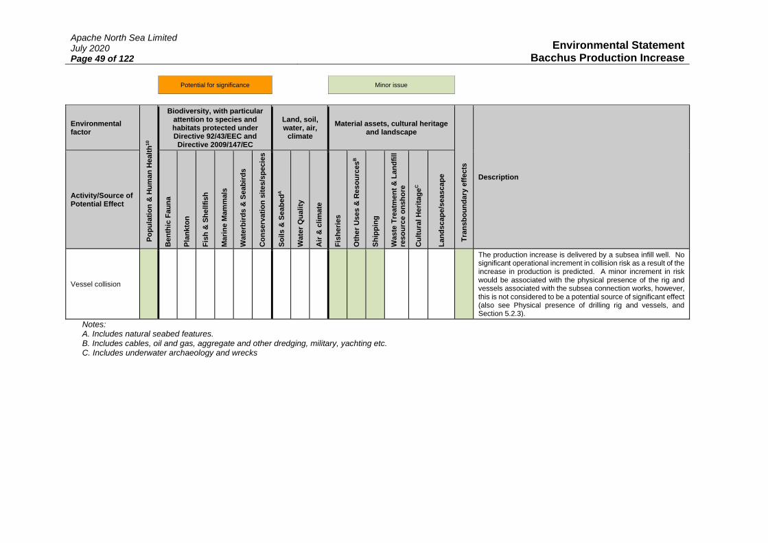
Apache North Sea Limited July 2020 Page 49 of 122
Environmental Statement Bacchus Production Increase
Potential for significance Minor issue
Environmental factor
Po
pu
lati
on
& H
um
an
Healt
h10
Biodiversity, with particular attention to species and habitats protected under Directive 92/43/EEC and Directive 2009/147/EC
Land, soil, water, air,
climate
Material assets, cultural heritage and landscape
Tra
ns
bo
un
da
ry e
ffects
Description
Activity/Source of Potential Effect
Ben
thic
Fa
un
a
Pla
nk
ton
Fis
h &
Sh
ell
fish
Ma
rin
e M
am
mals
Wate
rbir
ds &
Seab
ird
s
Co
ns
erv
ati
on
sit
es/s
pe
cie
s
So
ils &
Seab
ed
A
Wate
r Q
uality
Air
& c
lim
ate
Fis
he
ries
Oth
er
Uses &
Reso
urc
es
B
Sh
ipp
ing
Waste
Tre
atm
en
t &
La
nd
fill
reso
urc
e o
nsh
ore
Cu
ltu
ral H
eri
tag
eC
La
nd
scap
e/s
eascap
e
Vessel collision
The production increase is delivered by a subsea infill well. No significant operational increment in collision risk as a result of the increase in production is predicted. A minor increment in risk would be associated with the physical presence of the rig and vessels associated with the subsea connection works, however, this is not considered to be a potential source of significant effect (also see Physical presence of drilling rig and vessels, and Section 5.2.3).
Notes: A. Includes natural seabed features. B. Includes cables, oil and gas, aggregate and other dredging, military, yachting etc. C. Includes underwater archaeology and wrecks
Apache North Sea Limited July 2020 Page 50 of 122
Environmental Statement Bacchus Production Increase
4.3.1 Potential Effects to be Considered Further
The potential for significant effects were identified in relation to environmental factors for relatively
few activities related to the Bacchus production increase (Table 4.2). The major sources of potentially
significant effect have been grouped against those activities identified as likely to, directly or indirectly,
affect one or more relevant environmental factors (and interactions between these). These have been
listed below and are described and assessed in detail in Section 5.
Issues related to incremental production:
• Atmospheric emissions relating to the flaring of a proportion of Bacchus South associated gas
• Production chemical use and discharge
• Produced water management and disposal
• Incremental risk of spills of oil and chemicals
Issues Related to the drilling of the Bacchus South well and subsea tie-in:
• Rig and vessel atmospheric emissions
• Physical disturbance from rig positioning (anchoring) and subsea works
• Physical presence of drilling rig and vessels (supply, support and subsea works)
• Drill cuttings, cement and chemical discharge
• Effects of underwater noise
• Accidental events: spills of oil and rig diesel inventory
The potential for cumulative or transboundary effects associated with the Bacchus production increase
are considered in Sections 5.4 and 5.5, taking into account the assessment made in Sections 5.1-5.3.

Apache North Sea Limited July 2020 Page 51 of 122
Environmental Statement Bacchus Production Increase
5 EVALUATION OF POTENTIALLY SIGNIFICANT ISSUES
5.1 Issues Related to Incremental Production
The following sections assess sources of potentially significant effect associated with the incremental
increase in production from Bacchus. These include:
• Atmospheric emissions relating to the flaring of a proportion of Bacchus South associated gas
• Production chemical use and discharge
• Produced water management and disposal
• Incremental risk of spills of oil and chemicals (covered in Section 5.3)
5.1.1 Atmospheric Emissions
Anthropogenically enhanced levels of greenhouse gases (GHGs, principally CO2) have been linked to
global climate change (IPCC 2013). Predicted effects include inter alia an increase in global temperate
(Kirtman et al. 2013, Collins et al. 2013), rising sea-levels (Lowe et al. 2009, Church et al. 2013,
Horsburgh et al. 2020), changes in ocean circulation (Collins et al. 2013) and potentially more frequent
extreme weather events (Wolf et al. 2020), and other effects including ocean acidification generated by
enhanced atmospheric acid gas loading, deposition and exchange (see Humphreys et al. 2020). These
effects, most recently summarised in the Intergovernmental Panel on Climate Change (IPCC) 5th
assessment report (IPCC 2013, also see Dolan 2015), are the rationale on which global carbon dioxide
reduction measures such as the Paris Accord and the UK Government commitment to achieving net
zero GHG emissions on 1990 levels, by 2050, are based.
In addition to effects associated with atmospheric greenhouse gases, emissions also have the potential
to have negative effects on air quality. Poor air quality can result in effects on human health, the wider
environment and infrastructure. Reduction in local air quality through inputs of contaminants such as
oxides of nitrogen (NOX), volatile organic compounds (VOCs) and particulates (e.g. PM10, PM2.5), may
contribute to the formation of local tropospheric ozone and photochemical smog, which in turn can
result in human health effects (see WHO 2013, EPA 2017).
Present climate change projections (see Lowe et al. 2009, Palmer et al. 2018, Pörtner et al. 2019) are
unlikely to significantly alter prevailing conditions during the time horizon of the development activities
or operational life of the field.
The principal GHG of concern is CO2 as it constitutes both the largest component of global combustion
emissions (generally ~80% of total GHG emissions), and has a long atmospheric residence time such
that emissions made today continue to contribute to radiative forcing for some time11. Emissions of
relevant gas species and their associated Global Warming Potential (GWP) have been estimated for the
incremental gas flaring for Bacchus (see Section 2.10). This has involved the use of standard
Environmental and Emissions Monitoring System (EEMS) conversion factors (DECC 2008) to estimate
the relative quantity of each gas species from flaring, and the most recent GWP metrics (Myhre et al.
2013, Table 5.1). The result is a value in tonnes of CO2 equivalent (CO2 eq.) based on the radiative
forcing effect of each GHG species relative to CO2 and the atmospheric residence time of each gas. The
GWP factor therefore changes depending on the “time horizon” considered (see IPCC 2001, 2007,
Myhre et al. 2013, and Shine 2009 for a synthesis and critical review). GWP factors for CO have
previously been calculated as 1.9 at 100 years, and that for NOx is considered highly uncertain (Forster
et al. 2007), and these are therefore not calculated.
11 Figures vary widely from between 5-200 years (Houghton et al. 2001) to ca.1,000 years (Archer 2005); Ciais
et al. (2013) indicate that, based on emissions projections, 15-40% of CO2 emitted until 2100 will remain in the
atmosphere longer than 1,000 years.

Apache North Sea Limited July 2020 Page 52 of 122
Environmental Statement Bacchus Production Increase
Table 5.1: Emissions Factors
Gas CO2 N2O CH4 CO NOx SO2 NMVOC
Gas flaring (associated gas)
2.8 0.000081 0.01 0.0067 0.0012 0.0000128 0.01
GWP at 100 years
1 265 28 - - - -
Source: IPCC (1996), DECC (2008), Myhre et al. (2013), AEA-Ricardo (2015)
As noted in Section 2.7, rates for oil and gas production exceed those currently consented in 2021-2024,
and exceed the threshold requiring EIA only in 2022-2023. The only source of incremental emissions
identified was from the flaring of a proportion of the associated gas from Bacchus (equivalent to 8% of
produced gas). Emissions associated with this incremental flaring are presented below in Table 5.2 –
note that only emissions from the incremental production above that level presently consented has been
calculated.
Table 5.2: Emissions from Bacchus South Flaring (tonnes/year)
Year CO2 N2O CH4 SO2 CO NOx VOC GWP
(CO2 eq.) %carbon budget1
2021 58,050 1.68 207 139 25 0.27 207 64,291 0.006
2022 81,874 2.37 292 196 35 0.37 292 90,678
2023 81,376 2.35 291 195 35 0.37 291 90,148
0.012
2024 50,348 1.46 180 120 22 0.23 180 55,774
2025 24,324 0.70 87 58 10 0.11 87 26,946
2026 29,466 0.85 105 71 13 0.13 105 32,632
2027 20,604 0.60 74 49 9 0.09 74 22,834
2028 14,774 0.43 53 35 6 0.07 53 16,371 0.001
2029 6,770 0.20 24 16 3 0.03 24 7,494
Notes: the percentage of the carbon budgets for the periods 2018-2022 (3rd carbon budget), 2023-2027 (4th carbon budget) and 2028-2032 (5th carbon budget), set at 2,544, 1,950 and 1,765MtCO2eq. respectively.
As noted in Section 2.10, gas which is not flared (approximately 92% of the associated gas) will be
used as fuel gas for the Forties Field which will be accommodated in the Forties fuel gas system by
reducing production from the Aviat Field, which has the exclusive purpose of providing fuel gas to the
Forties area. There will, therefore, be no significant net change in emissions from Forties as there is no
appreciable increase in power demand as a result of the increase in production. The use of associated
gas as fuel gas, as opposed to using diesel for power generation, reduces the need to transport large
quantities of diesel to the field, and has comparably lower GHGs when consumed in turbines.
To place the CO2eq. emissions from activities associated with Bacchus in context, in 2019 UK
emissions of the basket of seven greenhouse gases covered by the Kyoto Protocol are provisionally
estimated to be 435.2 million tonnes (Mt) CO2 eq.; CO2 being the most dominant of these, accounting
for ca. 81% of the emissions (361.5 Mt). The total emissions were 3.6% lower than the 2018 figure of
451.5 million tonnes CO2 eq., and net CO2 emissions were 3.9% lower than the 2018 figure (365.7 Mt);
primarily related to a decrease in the use of coal in electricity generation (BEIS 2020). Approximately
13.2 MtCO2 was attributable to installations in the UKCS in 2018 (OGUK 2019). The flaring would
contribute a maximum annual increment of 0.02% and 0.7% respectively on these values at peak
production (2022). To consider the implications of the production increase at Bacchus on the UK’s

Apache North Sea Limited July 2020 Page 53 of 122
Environmental Statement Bacchus Production Increase
carbon budget12, the above flaring emissions have been considered in relation to the targets set for each
carbon accounting period, which can be seen to be minor.
Conclusion
The consideration of effects from the emission of GHGs has been limited to the operation of the Bacchus
Field, and specifically those emissions which are relevant to the production increase which is the subject
of this EIA. As hydrocarbons are traded commodities, their end use (the carbon intensity of which
would be highly varied) is outside of the control of the project and cannot be meaningfully quantified
and assessed here, but will likely include both use in fuel generation and in finished goods. Apache are
cognisant of the UK Government’s commitment to achieving net zero GHG emissions by 2050 which
has also been legislated for under The Climate Change Act 2008 (2050 Target Amendment) Order 2019,
and is also aware of its own obligations under the MER-UK strategy to maximise economic recovery
of hydrocarbons, and the proposed changes to this strategy to account for the net zero commitment.
While the updated strategy is yet to be formally published, in keeping with its proposals, Apache will
maximise the use of associated Bacchus gas as fuel gas to avoid the use of diesel in power generation –
as there is no feasible gas export route from Forties, the use of such gas as fuel gas is considered to
presently be the most feasible option to limit upstream production emissions from Bacchus.
Additionally, Apache will minimise, as far as possible, any flaring relating to the production increase
(noting those quantities estimated above).
See environmental management issue 5 and 8, and associated actions in Table 6.1.
5.1.2 Production Chemical Use and Discharge
Chemicals/substances for use on the UKCS have to be notified and tested under the Offshore Chemical
Notification Scheme (OCNS); the OCNS list includes a ranking for each chemical (Hazard Quotient
(HQ) values or OCNS group). Final chemical selection for drilling and completion activities, flowline
testing and operational use will be based on least harmfulness consistent with technical function. Permit
applications for the use and discharge of chemicals are required by The Offshore Chemicals Regulations
2002 (as amended) and will be submitted to BEIS via the PETS process in advance of the
commencement of the various development and production operations.
Additional production chemical use is expected to be limited. The chemicals presently used for Bacchus
production are methanol and scale inhibitor, with the latter categorised as OCNS E/Gold and with no
substitution warning. There will be a minor increase in use for these production chemicals, in
proportion to the increase in production. It is anticipated that there would be an increase in methanol
use by ~10% (5 tonnes/year), and of scale inhibitor by ~15% (3 tonnes/year). Asphaltene dispersant
will also be used to mitigate against the deposition of organic solids in the well. This was not previously
used at Bacchus and minor modifications to Forties Alpha (in the form of a storage tank and pumps)
will be made to accommodate this. The assessment of the incremental operational chemical use, and
the addition of the asphaltene dispersant, will be made as part of the relevant permit application,
however, chemicals which are marked for substitution, with heavy metal or other warnings, will be
avoided unless there is no technical alternative. Significant effects from operational chemical use are
not predicted.
See environmental management issue 4 and associated actions in Table 6.1.
12 The mechanism under the Climate Change Act 2008 (as amended) which sets targets to progressively reduce
the level of GHGs which the UK should be emitting, set by UK Government on advice from the Climate Change
Committee, with a view to reducing net emissions by 57% in 2030, and 100% by 2050 (on 1990 levels).

Apache North Sea Limited July 2020 Page 54 of 122
Environmental Statement Bacchus Production Increase
5.1.3 Produced Water
Treated produced water may contain low concentrations of dispersed and dissolved reservoir
hydrocarbons, dissolved other organic and inorganic compounds that were present in the geological
formation, along with some of the chemicals added during the production process.
The impact of produced water on water quality is dependent on a number of physical, chemical and
biological processes, including the volume and density of the discharge, dilution, volatilisation or low
molecular weight hydrocarbons and biodegradation of organic compounds. Most studies of produced
water toxicity and dispersion have concluded that the necessary dilution to achieve a No Effect
Concentration (NEC) would be reached at <10 to 100m, and usually less than 500m from the discharge
point (E&P Forum 1994, OLF 1998, Riddle et al. 2001, Berry & Wells 2004). Kenny et al. (2005)
reviewed studies and data (including analyses of produced water composition from Irish Sea facilities),
and reached a similar conclusion. However, under some circumstances (e.g. strong stratification:
Washburn et al. 1999), a plume concentration sufficient to result in sub-lethal effects may persist for
>1,000m (Burns et al. 1999).
Plankton abundance is influenced strongly by the physical environment and variables such as water
temperature, current velocity, stratification in the water column and nutrient concentration. As a result,
they are particularly vulnerable to discharges and spills of chemicals and hydrocarbons. Plankton may
be exposed to these contaminants through passive diffusion, active uptake or through eating
contaminated prey. As plankton spend most of their lives in the water column, they will be exposed to
those contaminants that remain in solution (Sheahan et al. 2001). Produced water can affect recruitment
in calanoid copepods (Hay et al. 1988), with lowered fecundity and increased offspring mortality
reported for some plankton, as outcomes of hydrocarbon contamination (van Beusekom & Diel-
Christiansen 1993). Strømgren et al. (1995) found that acute toxicity in the diatom Skeletonema spp.
was only likely in individuals in the immediate vicinity of the source of produced water, where
concentrations of contaminants are highest.
The ICES Biological Effects Monitoring in Pelagic Ecosystems workshop (BECPELAG), analysed
samples from caged organisms and passive samplers using a wide range of biomarkers and bioassays
for chemical, molecular, cellular and physiological changes (e.g. toxicity bioassays, enzymatic
induction (EROD), lysosomal damage, Scope for Growth (SFG), genotoxicity, endocrine disruption
effects, metallothionein induction, polycyclic aromatic hydrocarbon (PAH) metabolites,
acetylcholinesterase inhibition and bacterial diversity). Although a variety of detectable responses (in
caged organisms) around an oil platform were observed and attributed to produced water effects, there
was not a gradient of effect and the ecological significance of these responses is unclear.
The QSR 2010 noted that water column monitoring to determine possible effects from PAHs and other
chemicals such as alkyl phenols discharged with produced water has been carried out to a limited extent
in the OSPAR area. Monitoring with caged mussels in the Netherlands and Norwegian sectors of the
North Sea has shown that mussels exposed to produced water discharges may accumulate PAH and
show biological responses up to 1000m from the discharge. Concentrations of PAHs and alkyl phenols
and measured biological responses in wild fish such as cod and haddock caught in the vicinity of
offshore installations from Norwegian waters in 2002 and 2005 showed a mixed pattern mostly with no
increased concentrations, but some elevated biological responses suggesting past exposure. Exposure
of cod sperm cells to environmentally relevant concentrations (100, 200, 500 ppm) of produced water
from the Hibernia platform, Newfoundland, did not result in a strong toxicity to the cells (only subtle
changes were observed) or a significant change in fertilisation rate (Hamoutene et al. 2010).
Bakke et al. (2013) reviewed research on the biological effects of offshore produced water (and drill
cuttings, see Section 5.2.3) discharges, with focus on the Norwegian waters. Produced water discharges
are a continuous source of contaminants to continental shelf ecosystems, and alkylphenols and PAHs
were found to accumulate in cod and mussels caged near the discharge points, but these compounds are

Apache North Sea Limited July 2020 Page 55 of 122
Environmental Statement Bacchus Production Increase
rapidly metabolized in cod. Such compounds may affect reproductive functions, and various chemical,
biochemical and genetic biomarkers but Bakke et al. (2013) concluded that the risk of widespread
impact from such operational discharges is low.
Produced water at Forties Alpha may be discharged following treatment or re-injected, and facilities for
both SWI and PWRI are maintained on Forties Alpha. Produced water at Forties Alpha which is not
re-injected is discharged to sea with oil-in-water (OIW) concentrations typically in the range 11-17mg/l
(based on yearly average concentrations 2018-2020). Water production from Bacchus is predicted to
increase from 0.5m3/d in the first year of production, peaking at 3.1m3/d in 2023, and declining
thereafter through field life (see Table 2.2). It is expected that 40% of this water will be discharged to
sea, with the remainder being re-injected for reservoir support. This will result in a corresponding
discharge of oil in produced water of just 0.009 tonnes/year at the peak water production rate in 2023
(for the purposes of assessment, an OIW concentration of 20mg/l has been assumed).
Conclusion
Any effects from the increment in produced water discharges from Bacchus are considered to be
negligible; significant effects are not considered to be likely. No further management measures or
mitigation is considered to be required.

Apache North Sea Limited July 2020 Page 56 of 122
Environmental Statement Bacchus Production Increase
5.2 Bacchus South Well and Subsea Connection
The following sections assess those sources of potentially significant effect for the drilling and
completion of the Bacchus South well, and the short subsea programme to connect the well to the
Bacchus manifold and associated works. These include:
• Rig and vessel atmospheric emissions
• Physical disturbance from rig positioning (anchoring) and subsea works
• Physical presence of drilling rig and vessels (supply, support and subsea works)
• Drill cuttings, cement and chemical discharge
• Effects of underwater noise
• Accidental events: spills of oil and rig diesel inventory (covered in Section 5.3)
5.2.1 Atmospheric Emissions
The basis for considering atmospheric emissions (i.e. in terms of their contribution to local air quality
and climate change related effects) has already been outlined in Section 5.1.1. The emissions factors
relevant to the drilling of the Bacchus South well and completing the subsea tie-in works are provided
in Table 5.3, and tabulations of emissions associated with the drilling and subsea works is provided in
Table 5.4 and Table 5.5 respectively.
Table 5.3: Emissions Factors
Gas CO2 N2O CH4 CO NOx SO2 NMVOC
Diesel (engine) 3.22 0.00022 0.00018 0.0157 0.0594 0.004 0.002
Aviation fuel (helicopter)
3.15 0.00012 0.00035 0.00953 0.012 0.0009 0.00306
Diesel (turbines) 3.2 0.00022 0.0000328 0.00092 0.0135 0.004 0.000295
GWP at 100 years
1 265 28 - - - -
Notes: 1sulphur content of marine diesel fuel assumed to be 0.1% based on requirements for Emissions Control Areas: IMO website (accessed June 2020). Source: IPCC (1996), DECC (2008), Myhre et al. (2013), AEA-Ricardo (2015)
Table 5.4: Estimated Drilling Emissions
Helico
pte
r tr
aff
ic
Su
pp
ly v
ess
el
An
ch
or
han
dlin
g
Rig
on
lo
cati
on
To
tal m
ass
GW
P
To
tal G
WP
CO2 133 960 768 2,562 4,423 1 4,423
N2O 0.00 0.07 0.05 0.18 0.3 265 79
CH4 0.01 0.05 0.04 0.14 0.26 28 7
NOX 0.50 17.82 14.26 47.56 80.14 - -
SO2 0.04 1.20 0.96 3.20 5.40 - -
CO 0.40 4.71 3.77 12.57 21.45 - -
VOC 0.13 0.60 0.48 1.60 2.81 - -
Total GWP (tCO2 eq.) at 100-years 4,510
Note: if required, the contingent 8 ½” mechanical sidetrack is estimated to result in an additional ~780tCO2 eq.

Apache North Sea Limited July 2020 Page 57 of 122
Environmental Statement Bacchus Production Increase
Table 5.5: Estimated Emissions from Subsea Works
DS
V (
tie
-in
)
DS
V (
pro
tecti
on
mate
ria
l an
d
co
mm
issio
nin
g)
Insp
ecti
on
su
rve
y1
To
tal m
ass
GW
P
To
tal G
WP
CO2 512 102 2,304 2,918 1 2,918
N2O 0.04 0.01 0.16 0.2 265 53.17
CH4 0.03 0.01 0.13 0.16 28 4.60
NOX 9.5 1.9 42.77 54.17 - -
SO2 0.64 0.13 2.88 3.65 - -
CO 2.51 0.5 11.30 14.32 - -
VOC 0.32 0.06 1.44 1.82 - -
Total GWP (tCO2 eq.) at 100-years 2,976
Note: 1 incorporates an annual inspection survey of the Bacchus facilities, through field life.
To place the CO2 eq. emissions from activities associated with the drilling of the Bacchus South well
(including sidetrack) in context, they represent 0.01% of 2019 UK CO2eq. emissions (BEIS 2020), or
0.04% of CO2 emission relating to UKCS operations in 2018 (OGUK 2019). The subsea works and
inspection surveys represent just 0.0007% of 2019 UK emissions, or just 0.02% of 2018 UKCS
emissions, and are therefore very minor in a regional context. Though minor, the implications of the
emissions from the drilling and subsea programme taken together are recognised, including their
contribution to the current UK carbon budget (2018-2022), which is equivalent to 0.003% of the
2,544MtCO2 eq. level.
Conclusion
Emissions associated with the drilling of the Bacchus South well, subsequent subsea connection works
and annual survey, are temporary and minor in significance. Apache will make use of the existing
Forties standby vessel such that there will be no additional emissions from providing this function.
See environmental management commitments 1, 5, 8 and 9, and associated actions in Table 6.1.
5.2.2 Physical Disturbance
Drilling rig
The main source of physical disturbance from drilling the Bacchus South well is the use of anchors to
maintain the station of the semi-submersible drilling rig. Each anchor will produce a linear scar on
installation in the order of 50m length, with additional disturbance generated by surface scrape as a
result of catenary contact of the anchor chain with the seabed. The total seabed area affected by semi-
submersible anchoring is partly a function of water depth, for example an area of seabed 0.032km2 was
affected by anchoring a rig in ~140m of water (see BP 2010). The area to be affected by rig positioning
would be less than the above given the depth over the Bacchus South well location (90m).
Physical effects of seabed disturbance may include mortality to benthic fauna as a result of physical
trauma, smothering by re-suspended sediment, and habitat modification due to changed physico-
chemical characteristics, including from the introduction and removal of hard substrates.
Anchor scars will be formed by the placement of the rig, but these will be localised features and are not
expected to be permanent. Given the water depths and low tidal energy over the area, physical recovery

Apache North Sea Limited July 2020 Page 58 of 122
Environmental Statement Bacchus Production Increase
of the seabed will be over the medium to long term. For example, the recent Gardline (2019) survey
identified four depressions interpreted as spud-can depressions associated with Well 22/6a-14z drilled
in 2006.
The surface hole section of the well will be drilled riserless, producing a localised (and transient) pile
of surface-hole cuttings around the surface conductor (also see Section 5.2.4). These cuttings are
derived from shallow geological formations and a proportion will be similar to surficial sediments in
composition and characteristics. The persistence of cuttings discharged at the seabed is largely
determined by the potential for it to be redistributed by tidal and other currents. After installation of
the surface casing (which will result in a small quantity of excess cement returns being deposited on the
seabed), the blowout preventer (BOP) is positioned on the wellhead housing. These operations (and
associated activities such as Remotely Operated Vehicle (ROV) operations) may result in physical
disturbance of the immediate vicinity (a few metres) of the wellhead. At the time of decommissioning,
and on well abandonment, the conductor and casing are plugged with cement and cut below the mudline
(seabed sediment surface) using a mechanical cutting tool usually deployed from a rig and the wellhead
assembly is removed. The seabed “footprint” of the well is therefore removed on decommissioning,
although post-well sediments may vary in the immediate vicinity of the well compared to the
surrounding seabed (see for example, Jones et al. (2012)).
The duration of effects on benthic community structure are related to individual species biology and to
successional development of community structure. The majority of seabed species recorded from the
European continental shelf are known, or believed to have, short lifespans (a few years or less) and
relatively high reproductive rates, indicating the potential for rapid population recovery, typically
between one to five years (Jennings & Kaiser 1998). In general, macrofaunal population levels are
limited by post-settlement factors rather than larval availability. Polychaete species which dominate at
stations between Bacchus to Forties Alpha (Fugro 2010b) are characterised by short lifespans and are
likely to have high recovery rates. Given the localised nature of the seabed disturbance, recruitment by
adult mobility from neighbouring areas will be possible and therefore the resilience of the benthic
community to the physical disturbance is likely to be high. It is therefore considered probable that both
the physical habitat consequences and benthic community effects of physical disturbance of the seabed
from future drilling activities will fully recover within a five to ten year period.
Subsea connection works
The installation of a flexible 6” production pipeline, jumper and 4” gas lift pipeline between the Bacchus
South well and the Bacchus towhead manifold will have a limited seabed footprint. The pipelines and
jumper will each be less than 100m long and protected by concrete mattresses along their length. Based
on a mattress size (6x3m, 32 mats covering each 100m length) and a contingency buffer of 2m around
each mat to account for potential disturbance during their installation, the maximum extent of physical
disturbance associated with the subsea works is estimated at 0.001km2. Additionally, up to 600 grout
bags with dimensions 0.45x0.3m could be used as a contingency. In the worst case that all of the bags
were used, their footprint would be ~0.00008km2. Given the localised nature of the seabed disturbance,
recruitment by adult mobility from neighbouring areas will be possible and therefore the resilience of
the benthic community to the physical disturbance is likely to be high. It is therefore considered
probable that both the physical habitat consequences and benthic community effects of physical
disturbance of the seabed from subsea works will fully recover within a five to ten year period.
Conclusion
Incremental disturbance from the positioning of a mobile rig and installation of the pipelines, jumpers,
spools and related protection materials, would result in some temporary physical disturbance to the
seabed. The nature and inferred general resilience of the seabed, habitat and species, leads to the
conclusion that effects at the seabed would not be significant. See environmental management
commitments 6, 7 and 8, and associated actions in Table 6.1.

Apache North Sea Limited July 2020 Page 59 of 122
Environmental Statement Bacchus Production Increase
5.2.3 Physical Presence
Potential effects on other users
The physical presence of the rig, associated support and supply vessels, the vessel used to complete the
subsea connection of the well to the Bacchus manifold, and the subsea well and its connections, have
the potential to affect other users of the sea through disruption of their activities. This includes for
shipping and fishing.
The potential scale of the effect on shipping is limited as vessel density in the area is low to very low
(see Section 3.11.3), and offshore activities will be temporary and small in scale. Data for the wider
ICES rectangles which contain Bacchus, which include Bacchus South, and Forties Alpha (44F1 and
44F0) indicate a moderate level of fishing, with trawls generally targeting demersal species and
Nephrops, but with variable levels of fishing for pelagic species in recent years (see Section 3.11.2).
Vessel Monitoring System (VMS) data for the area (whilst limited to vessels of >15m in length)
indicates that the majority of effort is to the north and west over the Fladen Ground, with a relatively
low level of fishing taking place at and around Bacchus. Considering the years 2016-2018, fishing is
undertaken throughout the year in the area, with no well-defined seasonal pattern.
The rig will have a temporary 500m safety exclusion zone in place for the duration of the drilling and
completion activities, and vessels in the area will be monitored by the Emergency Response and Rescue
Vessel (ERRV) which will communicate with them as appropriate. The drilling rig will use eight
anchors to maintain station, and the anchor spread is expected to be approximately 1,200-1,700m, which
extends the physical footprint of the rig to outside of the 500m safety zone. The as laid positions of
anchors will be notified to fishermen and others through the normal routes, including publication in
Notice to Mariners and in Kingfisher bulletins, detailing rig position, activities and timing. In addition,
other measures to minimise the risk of interactions between shipping, fishing and the rig include full
navigation lighting on the rig and associated vessels.
The Bacchus manifold and existing wells are covered by an established 500m safety zone13, and the
Bacchus South well, its connection to the Bacchus manifold and related protection materials will also
be within this area. A Deposit Consent Application will be included for an estimated use of up to
32 mattresses and 600 grout bags. In view of the proximity of Bacchus South to the manifold, and the
presence of an existing, established safety zone, there will be no incremental exclusion to fisheries from
Bacchus South during its operation.
Potential effects on sensitive species
The physical presence of vessels and rig associated with Bacchus South activities may potentially cause
low level displacement and/or other behavioural responses in birds. Seabird distribution and abundance
in the central North Sea varies throughout the year, but the area as a whole is of low importance, due to
the distance from shore, and availability of prey; the offshore area in general, containing peak numbers
of birds following the breeding season and through winter (see Section 3.8), with birds present likely to
be on transit through the area. From the mean and mean maximum (km) foraging distances for seabird
species during the breeding season, (as described in Woodward et al. 2019), Bacchus South is
considered too far offshore (>172km) for the majority of these to forage during this period, although
non-breeding adults may be present. Of those species that could be present, such as northern fulmar,
northern gannet, European storm petrel and great skua, these are not judged to be highly sensitive to
ship traffic (Garthe & Hüppop 2004, Furness et al. 2015, Fliessbach et al. 2019). The location of
Bacchus South precludes interaction with the most sensitive species to vessel movement such as divers
and scoters, which generally forage in coastal waters of ≤20m depth (Fox et al. 2003). While rafting
13 The Offshore Installations (Safety Zones) (No. 4) Order 2012

Apache North Sea Limited July 2020 Page 60 of 122
Environmental Statement Bacchus Production Increase
birds may move in response to vessels in transit, such effects are of low magnitude and short duration,
and will represent negligible additional disturbance over routine vessel movements. Significant effects
on bird species are therefore not considered to be likely.
In addition to potential disturbance to birds, the physical presence of the vessels may influence the
distribution and movements of sensitive species in the water column, namely migratory fish and marine
mammals. As hearing specialists, any displacement of marine mammals is most likely associated with
acoustic disturbance, which is discussed in 5.2.5. There may also be responses from marine mammals
and fish to the general physical presence of infrastructure and vessels (Sparling et al. 2015), along with
the risk of collisions from vessels in transit.
A moderate density and diversity of marine mammals is present in the Bacchus area, and wider central
North Sea (Section 3.9), which include harbour porpoise, white-beaked dolphin, Atlantic white-sided
dolphin and minke whale, while observed densities of marine mammals for relevant strata of the
SCANS-III survey conducted in summer 2016 (Hammond et al. 2017) were relatively low. Activities
associated with the drilling of the Bacchus South well and the subsea connection works will result in
the temporary presence of the rig (up to 112 days) and associated support and standby vessels, and that
of a Diving Support Vessel (DSV) (up to 12 days in total) and survey vessel (5 days/year), and not
significantly add to existing levels of shipping in the wider Bacchus and Forties area (Section 3.11.3).
These activities are anticipated to cause no more than temporary and localised low-level behavioural
responses similar to those from normal operations, such that significant effects are not predicted.
Conclusion
It is not considered that the rig is at significant risk from collision given both statutory notification and
lighting, and protection afforded by a standby vessel. Interactions with other users of the area,
specifically fishing and navigation, are considered to be short lived (days or weeks) for the drilling and
subsea connection programme, and negligible throughout the expected life of the Field as there is no
incremental exclusion to other users from Bacchus South. The subsea well will be within an existing
500m safety zone, be publicised through Notices to Mariners, and marked on navigation and fisheries
charts.
Species sensitive to the physical presence of the rig and vessels are either not present, or are in low
abundance; any effect would be temporary, minor and not significant.
See environmental management commitments 7 and associated actions in Table 6.1.
5.2.4 Discharges: Bacchus South and Subsea Connections
Drill cuttings, Cement and Chemical Discharge
The UK is a contracting party to the 1992 OSPAR Convention under which it has a requirement to,
amongst other things, register and assess chemicals used and discharged by the oil and gas industry. In
the UK this is done under the Offshore Chemical Notification Scheme (ONCS) administered by BEIS,
using scientific and environmental advice from the CEFAS (the Centre for Environmental, Fisheries,
and Aquaculture Science). Information required on the OCNS includes a ranking for each chemical,
either their HQ (Hazard Quotient) value (categories being Gold, Silver, White, Blue, Orange, Purple)
or OCNS Group (A, B, C, D and E), which gives an indication of whether they would have a significant
environmental effect; HQ Gold and OCNS E representing the least potential hazard (see CEFAS
website: https://www.cefas.co.uk/data-and-publications/ocns/). Using expert judgement and after
assessment, the OSPAR Commission also regularly publish a list of PLONOR substances, which are
considered to Pose Little or No Risk to the environment, and as such the use and discharges of which
do not require strong regulation.

Apache North Sea Limited July 2020 Page 61 of 122
Environmental Statement Bacchus Production Increase
The well design and mud systems proposed for the Bacchus South well are described in Section 2.8.
The well will utilise a combination of seawater and high viscosity (bentonite) sweeps for the drilling of
the surface holes and Low Toxicity Oil Based Muds (LTOBMs) for the lower and bottom hole sections.
Some 845m3 of cuttings will be discharged direct to the seabed around the wellbore from the riserless
drilling of the 36” and 26” hole sections. Surface hole cuttings are derived from shallow geological
formations and a proportion will be similar to surficial sediments in composition and characteristics.
This material will smother an oval area of seabed extending ca. 30m by 25m to a depth of around 1m,
with thicker deposits immediately around the wellhead and rapidly thinning depths at the periphery.
The predicted effects are localised and of short duration, involving smothering of benthic habitats and
fauna with relatively rapid recovery through faunal re-colonisation. Relevant information on the
recovery of benthic habitats to smothering mainly comes from studies of dredge disposal areas (see
Newell at al. 1998). Recovery following disposal occurs through a mixture of vertical migration of
buried fauna, together with sideways migration into the area from the edges, and settlement of new
larvae from the plankton. Defaunated sediments will be rapidly recolonised, likely by a combination
of opportunistic species and the species more typical of the Bacchus area (Eagle & Rees, 1973). Harvey
et al. (1998) suggest that it may take more than two years for a community to return to a closer
resemblance of its original state (although if long lived species were present this could be much longer).
In contrast to habitats in energetic shallow waters, a stable sand and gravel habitat in deeper water is
believed to take years to recover (see Newell et al. 1998, Foden et al. 2009).
In addition to surface hole cuttings, a small quantity of excess cement used to locate the conductor will
be returned to the seabed. Cement returns to seabed surface will be monitored by ROV so pumping of
cement can be stopped when returns appear at the seabed. The cement and cement chemicals will be
subject to individual chemical risk assessment as part of the permit application process for the Bacchus
South well. After installation of the surface casing, the BOP is positioned on the wellhead housing.
These operations (and associated activities such as ROV operations) may result in physical disturbance
of the immediate vicinity (a few metres) of the wellhead.
All other well sections are to be drilled using LTOBMs, which will be returned to the rig for treatment
in a Rotomill (as described in Section 2.8). Such treatment pulverises the cuttings and removes the
majority of the base oil (to meet or exceed the OSPAR standard for discharge of <1% oil by weight of
dry cuttings). The cleaned solids will be subject to a sampling programme to ensure these standards are
met. The processed cuttings will be discharged from the rig, at approximately 11.5m below mean sea
level.
Trannum et al. (2016) provide a representative particle size distribution of treated cuttings from the
Martin Linge field (Norwegian sector) which have been used here as a basis for cuttings dispersion
modelling using the Cornell Mixing Zone Expert System (CORMIX) Version 11 (www.cormix.info).
CORMIX is a steady state model which assumes a continuous discharge release.
The model examines the composite sediment accumulation over a range of particle size distributions,
each having calculated constant settling velocities. Particle separation and settling from the discharge
plume in the near-field is limited by the turbulent jet behaviour of the plume. CORMIX uses a number
of simulation modules executed sequentially, corresponding to different flow processes and associated
spatial regions. Particle size distributions of representative drill cuttings and fluids were used to
estimate the settling velocities for ten particle size classes derived from the Martin Linge thermally
treated cuttings (TCC) cuttings data. Finer particle sizes are typically transported over greater distances
than larger or more dense particles.
All particles are carried horizontally at the same velocity as the tidal and other currents. The model
permits a single horizontal current speed applied throughout the water column and an average current
speed was used from regional hydrographic data (Figure 5.1). The dominant surface tidal current
direction (flowing towards the south) was applied. Plume excess over background levels attenuates
over distance.

Apache North Sea Limited July 2020 Page 62 of 122
Environmental Statement Bacchus Production Increase
Figure 5.1: Modelled cuttings dispersion plume of excess over background
The bulk (77%) of the Martin Linge cuttings were fine particles ranging in diameter from <2µm (clay)
and 250µm (fine sand), with 26% being between 125-250µm in diameter. The modelling for Bacchus
South TCC cuttings discharges indicated that the bulk of the material would settle within 500m of the
well location with a proportion of the finer particulates likely to spread several tens of kilometres from
the discharge point and eventually settle to the seabed over a wide area at imperceptible thicknesses.
Aquateam COWI (2014) summarise SINTEF dispersion modelling of discharged TCC OBM cuttings
from the three lower hole sections of a representative well on Ivar Aasen (water depth 113m and
discharge one metre below the sea surface) for summer and winter scenarios. The modelling indicated
that a maximum concentration of TCC cuttings in the water column of 1-5mg/l, and that the maximum
thickness of the cuttings on the seabed occurred 250-300m from the discharging rig. In an area
equivalent to 50 x 50 metres, the thickness of cuttings deposition was up to 1.8mm.
Trannum et al. (2016) undertook mesocosm and bottle slurry experiments to assess the effects of a
6.3mm layer of (Rotomill) TCC and to contrast them with those of WBM cuttings. The effects on
benthic community structure, oxygen microprofiles and biogeochemical fluxes were investigated.
Results from both experimental approaches showed significantly increased biodegradation indicated by
consumption of oxygen and nitrate & nitrite in both the WBM and the TCC treatments compared to
controls. Based on the mesocosm experiments results WBM cuttings were characterized as non-
detrimental to macrofauna but the TCC cuttings caused mass mortality and reduction in macrofaunal
biomass. The adverse effect of TCC cuttings was considered possibly due to the calcium oxide content
of the cuttings resulting in strongly alkaline conditions. It was also noted that such effects may not be
evident in the field as a result of buffering and dissolution by the seawater during the passage of the
cuttings through the water column. It should also be noted that the high calcium oxide concentrations
are a feature of the particular mud formulation used at Martin Linge, not as a consequence of thermal
treatment of the cuttings.
From the predicted maximum depth of deposited TCC cuttings, significant effects on the benthic fauna
around the Bacchus South well are not predicted, i.e. the maximum depth of deposited material is within
the burial movement or particulate clearance abilities of the benthic faunal species known from the area.

Apache North Sea Limited July 2020 Page 63 of 122
Environmental Statement Bacchus Production Increase
Subsea works
The pipeline and spools will be pre-filled onshore with 100% MEG, and fitted by divers between the
Bacchus South well tree and the manifold. Biocide and dye sticks will be inserted at each flange
connection with no discharges expected upon insertion. A proportion of these chemicals will be
discharged at Forties Alpha in produced water, with the remainder forming part of the PWRI. A permit
for the use and discharge of chemicals associated with the subsea programme, will be applied for, with
approval sought prior to offshore activities being undertaken.
Conclusion
Drilling (including well clean-up) and rig discharges from the proposed Bacchus South well are not
predicted to result in significant effects on the marine environment, such effects as are predicted will be
localised and of relatively short duration. This conclusion is based on the nature of the proposed
operations, mitigation measures undertaken or planned and the physical and biological conditions in the
vicinity of the well. It is also supported by a number of studies of the effects of similar drilling in the
North Sea and elsewhere.
Final chemical selection for the drilling fluids to be used has not yet been made although chemicals will
be selected for least harmfulness consistent with technical function. Chemicals with substitution or other
warnings will be avoided, where possible and preference will be given to those chemicals which have
the lowest Hazard Quotient (Gold or OCNS Group E), where it is technically feasible to do so. All
chemicals will be further assessed during the relevant permit applications for the use and discharge of
chemicals.
See environmental management commitments 1, 4, 6, 7 and 8 and related actions in Section 6.
5.2.5 Effects of Noise
Underwater Noise Sources and Propagation
No high intensity impulsive noise generating activities are proposed as part of the Bacchus production
increase; all noise sources will be of a non-impulsive nature, the characteristics of which result in a far
lower potential to cause injury to marine fauna. Non-impulsive sound occurs when the acoustic energy
is spread over a significant time (several seconds to hours); it may contain broadband noise and/or tonal
(narrowband) noise at specific frequencies and its amplitude may vary. Mechanisms for non-impulsive
noise generation from offshore activities include propeller cavitation and rotating machinery from
vessels, rigs and ROVs, and the use of underwater cutting tools.
The key noise sources associated with the proposed activities include:
• positioning of the rig including running anchors and associated vessels;
• operation of the rig, including drilling, power generation and other machinery involved in rig
operations such as such as hydraulic systems and compressors;
• standby, supply, survey and dive vessel operations; and,
• helicopter movements.
Drilling and rig operations
Drilling and completion will be undertaken from a semi-submersible rig. The rig will be towed to the
location by three tugs, with anchoring taking place while on site with the assistance of anchor-handling
vessel(s), assisted by dynamic positioning (DP) thrusters. At the end of operations, the rig’s anchors
will be retrieved before being towed off location by tugs. The rig is anticipated to be on-site for up to

Apache North Sea Limited July 2020 Page 64 of 122
Environmental Statement Bacchus Production Increase
112 days (excluding mob/de-mob and contingencies), within which up to 56 days is allocated to active
drilling (including up to 20 days to drill a contingency mechanical sidetrack).
Underwater noise associated with a jack-up rig is of a very similar dominant frequency range as that
from large merchant vessels, albeit of lower average intensity. Measurements alongside a three-legged
jack-up rig drilling in shallow water on the Dogger Bank showed that sound levels were in the order of
Lp,rms 120dB re 1µPa broadband with most energy between 2-1,200Hz; sound levels dropped off rapidly
above 8kHz and were in the region of 15-20dB quieter during operations other than drilling (Todd &
White 2012). It was noted that, at lower frequencies, the rig was considerably quieter than its associated
support vessels (Todd & White 2012). Slightly higher source levels are likely from semi-submersible
rigs due to greater rig surface area contact with the water column.
Vessel noise
In addition to the use of tugs to mobilise/de-mobilise and position the rig, supply and standby vessels
will support the rig while on-site. A supply vessels will support the rig for 60 days of the drilling
programme, and a single standby vessel will be on-station throughout the well operations in case of
emergency necessitating evacuation, or in case of person-overboard situations. In addition to noise
generated by vessels in transit, cavitational noise is important when vessels are operating under high
load conditions (high thrust) and when DP systems are in use (Spence et al. 2007, Abrahamsen 2012).
For example, the use of thrusters for DP has been reported to result in increased sound generation of
ca.10dB compared to the same vessel in transit: measurements at 600m range to an offshore supply
vessel of 79m length recorded broadband Lp,rms (18-3,000Hz) of 148.0dB re 1μPa when in DP mode,
compared to 135.5dB re 1μPa when in transit at a speed of 10 knots (Rutenko & Ushchipovskii 2015).
Acoustic modelling in support of oil & gas operations have shown that across a variety of vessels,
activities and localities, exposure to Lp,rms >180dB re 1 μPa is highly unlikely; levels >160dB re 1 μPa
are encountered only within the immediate vicinity of the activity (<50m), while levels >
120dB re 1 μPa are encountered up to a few kilometres (Neptune LNG 2016, Fairweather 2016, Owl
Ridge Natural Resource Consultants 2016).
Helicopter operations
Helicopters will be used to transfer personnel to and from the rig, with approximately three helicopter
flights per week and an additional two ad hoc flights possibly required. Measurements of an air-sea
rescue helicopter over the Shannon estuary (Berrow et al. 2002) indicated that due to the large
impedance mismatch when sound travels from air to water, the penetration of airborne sound energy
from the rotor blades was largely reflected from the surface of the water with only a small fraction of
the sound energy coupled into the water. The limited number of helicopter flights will occur within
established routes.
Potential impacts
Anthropogenic noise in the marine environment is widely recognised as a potentially significant
concern, especially in relation to marine mammals. Potential (and postulated) effects of anthropogenic
noise on receptor organisms range from acute trauma to subtle behavioural and indirect ecological
effects, complicating the assessment of significant effect. The sources, measurement, propagation,
ecological effects and potential mitigation of underwater noise have been extensively reviewed and
assessed (e.g. Richardson et al. 1995, McCauley et al. 2000, MMS 2004, Southall et al. 2007), while
the Offshore Energy SEAs (DECC 2009, 2011, 2016) provided a detailed strategic assessment of the
effects of underwater noise associated with offshore energy activities at a regional scale for the UK
marine environment.

Apache North Sea Limited July 2020 Page 65 of 122
Environmental Statement Bacchus Production Increase
Marine mammals, for which sound is fundamental across a wide range of critical natural functions,
show high sensitivity to underwater sound. Generally, the severity of effects tends to increase with
increasing exposure to noise with both sound intensity and duration of exposure being important.
A distinction can be drawn between effects associated with physical (including auditory) injury and
effects associated with behavioural disturbance. With respect to injury, risk from an activity can be
assessed using threshold criteria of sound levels (Southall et al. 2007, 2019). In addition, auditory
capabilities are frequency-dependent and vary between species. Table 5.6 provides details of the
relevant marine mammals listed by functional hearing group, their relevant auditory bandwidth and
proposed injury criteria, defined as the sound level at which a permanent threshold shift (PTS;
permanent hearing damage) is estimated to occur (Southall et al. 2019). Thresholds have been
suggested for both impulsive (e.g. seismic airgun pulses, pile-driving, explosions) and non-impulsive
(e.g. vessel noise, drilling) sounds, due to the characteristics of impulsive sounds (e.g. steep rise time)
having a greater potential for injury than non-impulsive sounds.
It is noted that two metrics are provided for proposed injury threshold criteria (Table 5.6). Broadband
SPL, annotated as Lp,pk, is a more straightforward calculation best suited to single pulses and for all
sounds which include intense peak pressure components. The second metric, sound exposure level (LE)
refers to the total sound energy received over time relative to a reference value in water of 1µPa2s; this
allows sounds of different durations to be compared in terms of total energy and is better suited to
assessing cumulative exposure. The LE thresholds presented in Table 5.6 correspond to a cumulative
exposure over a 24h period with a frequency weighting to compensate quantitatively for the differential
frequency response between functional hearing groups.
Table 5.6: Marine mammal auditory injury criteria to impulsive and non-impulsive sounds by functional hearing group
Functional hearing group (species relevant to the Bacchus/Forties area)
Estimated hearing range (region of
greatest sensitivity) [frequency of peak
sensitivity]
Proposed injury (PTS onset) threshold criteria
Impulsive sounds Lp,pk (dB re re 1
µPa)
Non-impulsive sounds LE,24h (dB re
1 µPa²s)
Low-frequency cetaceans Minke whale (Balaenoptera acutorostrata)
7Hz to 35kHz (200Hz to 19kHz) [5.6kHz]
219 199
High-frequency cetaceans White-beaked dolphin (Lagenorhynchus albirostris) Atlantic white-sided dolphin (L. acutus)
150 Hz to 160 kHz (8.8 kHz to 110 kHz) [58 kHz]
230 198
Very High-frequency cetaceans Harbour porpoise (Phocoena phocoena)
275 Hz to 160 kHz (12 kHz to 140 kHz) [105 kHz]
202 173
Phocid seals in water Grey seal (Halichoerus grypus) Harbour seal (Phoca vitulina)
50 Hz to 86 kHz (1.9 kHz to 30 kHz) [13 kHz]
218 201
Notes: Lp,pk = unweighted peak sound pressure level (SPL); LE,24h = cumulative sound exposure level over 24 hours, weighted according to functional hearing group. Source: Southall et al. (2019)

Apache North Sea Limited July 2020 Page 66 of 122
Environmental Statement Bacchus Production Increase
Of the species likely to occur in the Bacchus area, the harbour porpoise (very high-frequency hearing
group) has the lowest threshold criteria for the onset of PTS from both impulsive and non-impulsive
sounds, at Lp,pk 202dB re 1µPa and LE,24h 173dB re 1µPa2s; thresholds for all other functional hearing
groups are Lp,pk ≥218dB re 1µPa and LE,24h ≥198dB re 1µPa2s.
Source levels from sources of non-impulsive noise including rig operations and vessel movements may
achieve source sound pressure levels of ca.180dB re 1µPa; however, received levels within the general
vicinity of operations (i.e. hundreds of metres to a few kilometres) are likely to be of the order of
120-160dB re 1µPa. Consequently, it can be concluded that the proposed activities will not result in
auditory injury to any species of marine mammal.
Underwater noise from rig and vessel operations could potentially cause behavioural disturbance of
marine mammals present in the area. It has proved difficult to establish broadly applicable threshold
criteria for disturbance of marine mammals based on exposure alone. This is due, in part, to the
challenges encountered in studies of wide-ranging species with complex behaviour, but also because
many behavioural responses are context-specific.
Reported responses of marine mammals to vessels include avoidance, changes in swimming speed,
direction and surfacing patterns, and alteration of the intensity and frequency of calls and increases in
stress-related hormones (review in Erbe et al. 2019). Harbour porpoises, white-sided dolphins and
minke whales have been shown to respond to survey vessels by moving away from them, while white-
beaked dolphins have shown attraction (Palka & Hammond 2001).
While some behavioural disturbance of harbour porpoise and other cetaceans may occur, the increase
in underwater noise from vessel traffic associated with the proposed activities, relative to existing levels
in the wider area, is expected to be small. In UK waters, a modelling study indicated a negative
relationship between the number of ships and the presence and abundance of harbour porpoises within
relevant management units when shipping intensity exceeded a suggested threshold of approximately
80 ships per day (within any of the model’s 5km grid cells) in the North Sea (Heinänen & Skov 2015).
AIS data (see Section 3.11.3) for 2018 suggests that the majority of 1km2 grid cells in the Bacchus area
experience <10 vessel hours per month; although moderate levels of activity (~75 vessel hours per
month) occurs around the Forties Field platforms reflecting ongoing operations at these facilities.
It is noted that the Bacchus does not overlap and is not close to any designated or proposed marine
protected areas for marine mammals, and is not an area identified as of particular importance to marine
mammals. The density of grey and harbour seals in the area is expected to be very low.
Considering the characteristics of the relevant noise sources, the evidence for limited potential of short-
term behavioural disturbance, the open nature of the habitat, the generally low densities of marine
mammals likely to be present in the area and its apparent low importance relative to other areas within
the North Sea (for example: the southern North Sea for harbour porpoise; waters further west for white-
beaked dolphin), it is concluded that the proposed activities involving a drilling rig and vessels will not
result in significant behavioural disturbance to any species of marine mammal.
Fish and fisheries
There is no evidence of mortality or potential mortal injury to fish from ship noise (Popper et al. 2014).
While it is recognised that impulsive noise, vessel and other continuous noise may influence several
aspects of fish behaviour, including inducing avoidance and altering swimming speed, direction and
schooling behaviour, (e.g. De Robertis & Handegard 2013, Popper et al. 2014), any such effects will
be localised and short-term.
Given the source level characteristics and the context of similar contributions to the ambient
anthropogenic noise spectrum of the area over several decades (i.e. the oil and gas associated

Apache North Sea Limited July 2020 Page 67 of 122
Environmental Statement Bacchus Production Increase
installations, vessels and rigs movements in and around the Forties and wider central North Sea area),
no injury or significant behavioural disturbance to fish populations is anticipated.
Diving birds
Evidence for underwater noise impacts on diving seabirds is very limited. While exposure to very high
amplitude low frequency underwater noise (i.e. with tens of metres of underwater explosions) has been
shown to cause acute trauma to diving seabirds (Danil & St Leger 2011), no activities which could
generate such high intensity impulsive noise will occur during the proposed activities.
Hearing sensitivity for species measured so far peaks between 1 and 3kHz, with a steep roll-off after
4kHz (Crowell et al. 2015). The observed region of greatest hearing sensitivity suggests limited overlap
with peak energy from rig and vessel operations. As such, and given the short-term duration of vessel
presence, in the context of many decades of shipping and fishing activity in the region, and the relatively
low importance of the Bacchus area to diving seabirds, significant disturbance to diving seabirds is
assessed as highly unlikely.
Conclusion
Considering the characteristics of all the relevant noise sources, the evidence for limited potential of
short-term behavioural disturbance among the most sensitive receptors (harbour porpoise), the open
nature of the habitat, the generally low densities of marine mammals, diving birds and fishing activity
likely to be present in the area and its apparent low importance relative to other areas within the North
Sea, it is concluded that the proposed activities will not result in significant behavioural disturbance to
relevant species.
5.3 Accidental Events and Major Environmental Incidents
Risk assessment of accidental events involves the identification of credible accident scenarios,
evaluation of the probability of incidents, and assessment of their ecological and socio-economic
consequences. The principle source of significant effect which could occur as a result of an accident is
a large spill of liquid hydrocarbons (blowout). Evaluating spill risk requires consideration of the
probability of an incident occurring and the consequences of the impact. The following section
considers:
• Historical data, including frequency of relevant incidents
• Possible spill mechanisms, including blowouts and other accidental events
• Fate and behaviour of spilled oil and chemicals
• Oil spill modelling
• Environmental and socio-economic sensitivities and the impacts of an oil spill incident on these
sensitivities
• Mitigation measures and response strategy
5.3.1 Historical Frequency of Spill Events on the UKCS
Oil spills on the UKCS have been subject to statutory reporting since 1974 under PON1 (formerly under
CSON7); annual summaries of which were initially published in the “Brown Book” series, now
superseded by on-line data available from the BEIS website14. Discharges, spills and emissions data
from offshore installations are also reported by OSPAR (e.g. OSPAR 2019). BEIS data indicates that
the most frequent types of spill from mobile drilling rigs have been of chemicals, with fewer numbers
of spills of oils which mainly relate to hydraulic fluid, diesel, and a small number of drilling mud losses.
14 https://www.gov.uk/guidance/oil-and-gas-environmental-alerts-and-incident-reporting#pon-1

Apache North Sea Limited July 2020 Page 68 of 122
Environmental Statement Bacchus Production Increase
Topsides couplings, valves and tank overflows are the most frequent sources of spills from production
operations, with most spills being <1 tonne.
Since the mid-1990s, the reported number of spills has increased consistent with more rigorous
reporting of very minor incidents (e.g. the smallest reported crude spill in 2019 was 2x10⁻⁹ tonnes).
However, the underlying trend in oil spill quantity (excluding specifically-identified large spills)
suggests a consistent annual average of 30 tonnes or less (2014-2019 PON1 data). In comparison, oil
discharged with produced water from the UKCS in 2017 totalled 2,139 tonnes (OSPAR 2019).
In 2019 there were a total of 205 oil spills, two of which were greater than one tonne. The 2019 annual
total of number recorded spills was the lowest recorded since 1995 and 72 less than the mean annual
total of 277 releases reported between 2013 and 2018. Analysis of oil types showed that 40% of
reported releases were lubrication and hydraulic oils, followed by fuel oils at 19% and crude oils at
12%, with the remaining spills being releases, largely from drainage systems. The majority of spills
were small, with some 80% of releases being less than 10kg, and 51% less than 1kg.
5.3.2 Well Related Scenarios
A number of incidents – loss of well control (blowout), loss of containment, oil and/or chemical spills
due to handling and transfers, dropped objects, drilling contingencies (e.g. kicks, downhole mud loss,
stuck pipe, etc.), fire/explosion, collision with other vessels – may lead to the loss of hydrocarbons or
other chemicals to the sea.
Well control incidents (i.e. “blowouts” involving uncontrolled flow of fluids from a wellbore or
wellhead) have been too infrequent on the UKCS for a meaningful analysis of frequency based on UK
data. A review of blowout frequencies cited in UKCS Environmental Statements as part of the OESEA2
gave occurrence values in the range 1/1,000-10,000 well-years. Analysis of the SINTEF Offshore
Blowout Database which is based on blowout data from the US Gulf of Mexico, UKCS and Norwegian
waters for period 1980 to 2014, provided blowout frequencies (per drilled well) for North Sea standard
operations, for exploration drilling of normal oil (1.3x10⁻⁴) and gas wells (1.6x10⁻⁴), as well as deep
high pressure high temperature oil (8.0x10⁻⁴) and gas (9.8x10⁻⁴) wells (IOGP 2019). Accident statistics
for offshore units on the UKCS estimated an annual average frequency of blowouts15 for mobile drilling
units of 6.6x10⁻³ per unit year for the period between 2000 and 2007 (based on analysis of a total of
455 unit years, OGUK 2009).
Possible release locations of reservoir fluids from a blowout may be subsurface (with possible escape
to seabed outside the well conductor), subsea through loss of containment at the riser, or from the rig
(e.g. at the drill floor). Blowout rates and duration may vary significantly according to the reservoir
and the formation conditions and to the intervention. Under most conditions, initial flow rates reduce
quickly due to natural bridging (reduction in permeability of the rock formations and well bore).
5.3.3 Fate and Behaviour of Spilled Oil
The primary processes of spilled oil on the water are drifting, spreading, and weathering. Drifting is
the process of lateral transport of the oil due to the driving force of winds and currents, and is the
primary driving mechanism for oil spills. Oil typically moves at 3% of the wind speed and 100% of the
current speed. Expected hydrocarbons from Bacchus South are mainly oil, and are expected to be
comparable to Bacchus Field fluids, which are a relatively light (35º API) oil.
Diesel is a low viscosity distillate fuel and contains a significant proportion of light-ends, which means
that evaporation will be an important process contributing to the reduction in mass balance. Diesel will
15 An uncontrolled flow of gas, oil or other fluids from the reservoir, i.e. loss of 1.barrier (i.e. hydrostatic head) or
leak and loss of 2. barrier, i.e. BOP/ Down Hole Safety Valve (DHSV).

Apache North Sea Limited July 2020 Page 69 of 122
Environmental Statement Bacchus Production Increase
spread rapidly on water and should evaporate within a few days, upon release onto the sea surface, and
a small percentage may also dissolve. Evaporation can be enhanced by higher wind speeds, warmer
water and air temperatures.
In the event of an OBM mud spill, the spilled material will sink rapidly due to the density of the mud
weighting agents, and degradation will take place through the water column and at the seabed (Daan
and Mulder, 1996). Sheen may appear at the sea surface due to the base fluids however evaporation
and dispersion process will accelerate the natural attenuation.
5.3.4 Fate and Behaviour of Chemicals
The fate of a spilled substance is determined by its volatility, solubility and density. In general terms, a
substance spilled at sea will behave in one or more of the following ways: dissolve, evaporate, float, or
sink. In addition, some substances may biodegrade or photo-oxidise. The hazard presented by a
chemical spill would also reflect the toxicity, flammability, reactivity, explosivity, corrosiveness, etc.
of the substance.
5.3.5 Oil Spill Modelling
Spills can impact environmental and socio-economic sensitivities at distance from their source, and risk
assessment, therefore, requires the prediction of slick trajectory. For a given scenario, with defined
spill volume and weather/metocean conditions, the behaviour of a slick can be modelled.
A spill of oil representative of a blowout of Bacchus crude was modelled stochastically using the Oil
Spill Contingency and Response (OSCAR) model v11.0.1. Modelling was undertaken seasonally
(December-February, March-May, June-August and September to November) for a well blowout
scenario, with the shortest time and related probability for oil to cross the median line or reach the coast
calculated for the UK and adjacent states. The results are summarised in Table 5.9 and in Figure 5.2
and Figure 5.3. Metocean parameters used in the model are summarised in Table 5.7.
Table 5.7: Metocean and hydrocarbon parameters used in oil spill scenarios
Release parameter Crude blowout
Release rate/quantity 58,446 m3/day on day 1, declining to 3,708 m3/day at day 120
Total simulation time 130 days1
Release period Multi-year statistic (seasonal)
Number of simulations 25 per year
Total number of simulations Total number of simulations per season in excess of 100
Diameter of release pipe 9-5/8”
Density of released gas 1.6 kg/m3
Metocean parameters
Air temperature Variable Sea temperature Variable
Wind data (years covered)
2008 – 2014 Wind data reference European Centre for Medium-Range Weather Forecasts (ECMWF)
Current data (years covered)
2008 – 2014 Current data reference Hybrid Coordinate Ocean Model (HYCOM)
Notes: 1release duration assumed to be arrested after 120 days, as indicted by worst case relief well drilling estimated timings.

Apache North Sea Limited July 2020 Page 70 of 122
Environmental Statement Bacchus Production Increase
Table 5.8: Probability (≥1%) and shortest time of surface oil crossing median line
Member States Dec – Feb Mar – May Jun – Aug Sep – Nov
Norwegian Waters 90 – 100% 90 – 100% 90 – 100% 90 – 100%
18 hours 18 hours 24 hours 21 hours
Danish Waters 90 – 100% 90 – 100% 90 – 100% 70 – 80%
7 days 7 days 8 days 8 days
Swedish Waters 80 – 90% 90 – 100% 90 – 100% 70 – 80%
13 days 16 days 15 days 13 days
German Waters 60 – 70% 90 – 100% 60 – 70% 50 – 60%
14 days 13 days 15 days 7 days
Dutch Waters 50 – 60% 80 – 90% 40 – 50% 40 – 50%
12 days 13 days 18 days 11 days
Faroese Waters 1 – 5% 10 – 20% - 1 – 5%
>20 days >20 days - >20 days
Table 5.9: Shoreline oiling probability: shortest time (days) to beach and % probability for shoreline oiling
Shoreline Dec-Feb Mar-May Jun-Aug Sep-Nov
United Kingdom
Scotland
Shetland 40 – 50% 30 – 40% 30 – 40% 50 – 60%
6 days 11 days >20 days 7 days
Orkney 30 – 40% 5 – 10% 1 – 5% 10 – 20%
5 days 5 days >20 days 16 days
Highlands 20 – 30% 5 – 10% - 10 – 20%
14 days 14 days - >20 days
Grampian 50 – 60% 20 – 30% 10 – 20% 50 – 60%
10 days 7 days >20 days 7 days
Tayside 20 – 30% 10 – 20% 5 – 10% 30 – 40%
15 days 11 days >20 days 8 days
Fife 30 – 40% 10 – 20% 5 – 10% 30 – 40%
15 days 13 days >20 days 11 days
Lothian 20 – 30% 10 – 20% 1 – 5% 20 – 30%
14 days 15 days >20 days 13 days
Borders 30 – 40% 10 – 20% 1 – 5% 20 – 30%
14 days 16 days >20 days 19 days
England
North East 20 – 30% 10 – 20% 1 – 5% 30 – 40%
17 days 17 days >20 days >20 days
Yorkshire and The Humber
10 – 20% 10 – 20% 1 – 5% 10 – 20%
>20 days >20 days >20 days >20 days

Apache North Sea Limited July 2020 Page 71 of 122
Environmental Statement Bacchus Production Increase
Shoreline Dec-Feb Mar-May Jun-Aug Sep-Nov
East Midlands - - - 5 -10%
- - - >20 days
North Sea Member States
Norway 90 – 100% 90 – 100% 90 – 100% 90 – 100%
7 days 8 days 11 days 7 days
Denmark 80 – 90% 90 – 100% 90 – 100% 40 – 50%
11 days 10 days 12 days 10 days
Sweden 60 – 70% 80 – 90% 80 – 90% 60 – 70%
17 days 17 days 17 days 15 days
Germany 20 – 30% 20 – 30% 5 – 10% 10 – 20%
>20 days 19 days >20 days 19 days
Netherlands 5 – 10% 10 – 20% - -
>20 days >20 days - -
Maximum accumulations onshore
After 130 days16 51,225 m3 48,659 m3 46,414 m3 40,477 m3
16 1This is the maximum mass accumulated onshore across all beaching locations from one of the 100+
simulations. Highlighted/bold figures indicate the greatest shoreline oiling likelihood and shortest time to
beaching for each area

Apache North Sea Limited July 2020 Page 72 of 122
Environmental Statement Bacchus Production Increase
Figure 5.2: Probability (>10%) of Surface Oiling Meeting or Exceeding 0.3 μm
Mar - May
Mar - May
Dec - Feb
Dec - Feb
Sep - Nov
Sep - Nov
Jun - Aug

Apache North Sea Limited July 2020 Page 73 of 122
Environmental Statement Bacchus Production Increase
Figure 5.3: Probability (>1%) of Surface Oil (≥0.3 μm) Crossing Median Line
Dec - Feb
Dec - Feb
Jun - Aug
Mar - May
Mar - May
Sep - Nov
Sep - Nov

Apache North Sea Limited July 2020 Page 74 of 122
Environmental Statement Bacchus Production Increase
Figure 5.4: Arrival Time of Surface Oil
Dec - Feb
Dec - Feb
Dec - Feb
Dec - Feb
Mar - May
Mar - May
Mar - May
Mar - May
Jun - Aug
Jun - Aug
Jun - Aug
Jun - Aug
Sep - Nov
Sep - Nov
Sep - Nov
Sep - Nov

Apache North Sea Limited July 2020 Page 75 of 122
Environmental Statement Bacchus Production Increase
5.3.6 Spill Risk and Major Environmental Incident Assessment
There is a requirement under the EIA Regulations to assess the worst case oil spill scenarios,
summarising the likely fate and impact of the potential release. – see Sections 5.3.1-5.3.6 above.
The publication of Directive 2013/30/EU on safety of offshore oil and gas operations (EUOSD) and
The Offshore Installations (Offshore Safety Directive) (Safety Case etc) Regulations 2015 (SCR 2015)
that transpose the requirements of the Directive into UK law, acknowledged the environmental element
associated with major accident hazards (MAH), with the regulations now including a further definition
of Major Accident, a Major Environmental Incident (MEI). A MEI is an incident which results, or is
likely to result in, significant adverse effects on the environment and for an incident to be a MEI, it must
have as a precursor, a safety related major accident; an MEI can only occur as a consequence of a major
accident. There is now significant overlap with the SCR 2015 and EIA requirements and as such, it
should be determined if the uncontrolled release of hydrocarbons will result in a significant impact that
would constitute an MEI.
In its definition of MEI, the EUOSD describes this as an incident which results, or is likely to result, in
a significant adverse effects on the environment in accordance with Directive 2004/35/EC. From this
Directive, and in respect to significant adverse effects, environmental damage is defined as:
• damage to protected species and natural habitats which is any damage that has significant
adverse effects on reaching or maintaining the favourable conservation status of such habitats
or species. The significance of such effects is to be assessed with reference to the baseline
conditions, taking account of the criteria set out in Annex I (of the Directive)
• water damage which is any damage that significantly adversely affects the ecological, chemical
and/or quantitative status and/or ecological potential as defined in Directive 2000/60/EC or
the waters concerned
• land damage, which is any land contamination that creates a significant risk of human health
being adversely affected as a result of the direct or indirect introduction in, on or under land,
of substances, preparations, organisms or micro-organisms
Here, “damage” is defined as a measurable adverse change in natural resource or measurable
impairment of a natural resource service which may occur directly or indirectly.
The impact that may be caused by a spill is dependent on the location of the spill, spill size, the
hydrocarbon properties, the prevailing weather and metocean conditions at the time of the spill, the
sensitivities of environmental receptors that could be impacted by the spill, and the success of the spill
response process.
The loss of diesel inventory and inventories of chemicals are expected to rapidly disperse to levels
where their impact would not be considered significant. Therefore, the impact from these accident
hazards would not constitute an MEI, in terms of the above, and have not been considered further.
The remaining uncontrolled release of a liquid hydrocarbon related to a major accident from Bacchus
South is a well blowout during drilling of the infill well (based on a loss of 58,445.9m3/day, declining
to 3,708.3m3/day at day 120). The results of this modelling and the impact of oil on relevant sensitivities
are shown in section 5.3.5 above.
The impact from the well blowout has been identified as a MEI, due to the potential environmental
impacts on protected sites and species (if the release were to occur in the absence of mitigation and
response). An uncontrolled spill of Bacchus oil is not expected to result in water or land damage as
described above, and are not considered further, with the focus of this assessment therefore the potential
damage to protected species and natural habitats. The impact that may be caused by a spill is dependent
on the location of the spill, spill size, the hydrocarbon properties, the prevailing weather and metocean

Apache North Sea Limited July 2020 Page 76 of 122
Environmental Statement Bacchus Production Increase
conditions at the time of the spill, the sensitivities of environmental receptors that could be impacted by
the spill, and the success of the spill response process.
Protected Sites and Species
Coastal sensitivities to oil spills are well-recognised, and despite the controls and mitigation measures
in place, the possibility of a crude oil spill resulting in oiling of the coast (assuming a worst-case
scenario) cannot be ruled out, though the probability of such a spill occurring and affecting the coast is
considered extremely remote.
Special Protection Areas (SPA) are classified for rare and vulnerable birds, listed in Annex I of the
Birds Directive (2009/147/EC), and for regularly occurring migratory species, and Special Areas for
Conservation (SAC) are classified for habitats and species most in need of conservation at a European
level, as listed in Annex I and Annex II of the Habitats Directive (92/43/EEC) respectively. These sites
are collectively referred to as Natura 2000. Several offshore SACs have been classified in UK waters,
and those of adjacent EU Member States, however there are comparatively fewer offshore SPAs, and
none in the UK North Sea. At a national level, the other principal offshore designated areas established
for the protection of species and habitats are Nature Conservation Marine Protected Areas (NCMPA)
and Marine Conservation Zones (MCZ) (see Section 3.10). Both Natura 2000 and national designations
are also present along the coastlines of Europe.
The offshore and coastal sites potentially affected by oiling as a result of an uncontrolled release (well
blowout) from the proposed activities are shown in Figure 5.5 to Figure 5.9. These sites were selected
for inclusion/exclusion with respect to whether there was the potential for an interaction with the marine
features for which they are designated, and an oil spill. Sites relevant to UK coasts and waters are also
listed in
Table 5.10: Selected UK protected sites and species potentially impacted by uncontrolled release of hydrocarbons
Site name Feature present1
Designated features
Special Protection Areas (SPA)
Hermaness, Saxa Vord and Valla Field
B Qualifying feature: red-throated diver, gannet, great skua, breeding seabird assemblage
Fetlar B
Qualifying feature: Arctic tern, red-necked phalarope, dunlin, great skua, whimbrel, breeding seabird assemblage
Otterswick and Graveland
B Qualifying feature: Red-throated diver
Ronas Hill-North Roe and Tingon
B Qualifying feature: Red-throated diver, skua
Papa Stour B Qualifying feature: Arctic tern
East Mainland Coast, Shetland pSPA
B Qualifying feature: red-throated diver, great northern diver, Slavonian grebe, eider, long-tailed duck, red-breasted merganser
Bluemull and Colgrave Sounds pSPA
B Qualifying feature: Red-throated diver
Noss B
Qualifying feature: gannet, great skua, guillemot, breeding seabird assemblage
Sumburgh Head B Qualifying feature: Arctic tern, breeding seabird assemblage
Papa Westray (North Hill and Holm)
B Qualifying feature: Arctic tern
East Sanday Coast W Qualifying feature: purple sandpiper, turnstone

Apache North Sea Limited July 2020 Page 77 of 122
Environmental Statement Bacchus Production Increase
Site name Feature present1
Designated features
North Orkney pSPA B, W
Qualifying feature: red-throated diver, great northern diver, Slavonian grebe, eider, long-tailed duck, velvet scoter, red-breasted merganser, shag
Orkney Mainland Moors
B Qualifying feature: hen harrier, red-throated diver, short-eared owl, hen harrier
Auskerry B Qualifying feature: arctic tern, storm petrel
Copinsay B Qualifying feature: Breeding seabird assemblage
Hoy B
Qualifying feature: peregrine, red-throated diver, breeding seabird assemblage
Scapa Flow pSPA B, W
Qualifying feature: red-throated diver, great northern diver, black-throated diver, Slavonian grebe, shag, eider, long-tailed duck, goldeneye, red-breasted merganser
Foula B Qualifying feature: Arctic tern, Leach’s storm petrel, red-throated diver, great skua, common guillemot, Atlantic puffin, European shag, breeding seabird assemblage
Seas off Foula -
Qualifying feature: Proposed marine area encompassing Foula, covering the marine foraging habitat and prey supporting the currently protected seabird colony and waters immediately surrounding it
Mousa B Qualifying feature: Storm petrel, Arctic tern, common guillemot
Fair Isle R, B Qualifying feature: Fair Isle wren, Arctic tern, breeding seabird assemblage
Sumburgh Head B Qualifying feature: Breeding seabird assemblage
Pentland Firth Islands B Qualifying feature: Arctic tern, and breeding seabird assemblage
Pentland Firth17 - Qualifying feature: Proposed waters within the Pentland Firth between the north coast of Caithness and the south of Orkney mainland. Breeding Arctic ten and seabird assemblage.
East Caithness Cliffs B
Qualifying feature: peregrine, razorbill, herring gull, shag, kittiwake, guillemot, seabird assemblage
Moray Firth pSPA
W, B
Qualifying feature: great northern diver, , red-throated diver, Slavonian grebe, shag, scaup, eider, long-tailed duck, common scoter, velvet scoter, common goldeneye, red-breasted merganser, shag
Troup, Pennan and Lion's Heads
B Qualifying feature: guillemot, breeding seabird assemblage
Loch of Strathbeg B, W
Qualifying feature: sandwich tern, whooper swan, teal, greylag goose, pink-footed goose, goldeneye, waterfowl assemblage
Buchan Ness to Collieston Coast
B Qualifying feature: Breeding seabird assemblage
Ythan Estuary, Sands of Forvie and Meikle Loch
B Qualifying feature: common tern, little tern, Sandwich tern, pink-footed goose, waterfowl assemblage
Ythan Estuary, Sands of Forvie and Meikle Loch pSPA (extension)
B Qualifying feature: Sandwich tern, little tern
Fowlsheugh B
Qualifying feature: guillemot, kittiwake, breeding seabird assemblage
Montrose Basin W
Qualifying feature: greylag goose, knot, pink-footed goose, oystercatcher, redshank, waterfowl assemblage
17 Further consultation on proposed Special Protection Areas in Scotland is underway: https://consult.gov.scot/marine-scotland/sea-and-site-classification/. It has been recommended that the Pentland Firth pSPA be removed from the network. This site is still listed here as a decision on whether to take the site forward for classification has not yet been made by Scottish Ministers.

Apache North Sea Limited July 2020 Page 78 of 122
Environmental Statement Bacchus Production Increase
Site name Feature present1
Designated features
Firth of Tay and Eden Estuary
B, W Qualifying feature: little tern, marsh harrier, bar-tailed godwit, greylag goose, pink-footed goose, redshank, waterfowl assemblage
Outer Firth of Forth and St Andrews Bay Complex
B, W, P
Qualifying feature: Proposed (pSPA) area stretching from Arbroath to St Abb’s Head, encompassing the Firth of Forth, the outer Firth of Tay and St Andrews Bay, supports important populations of 21 species of marine birds. Includes breeding common tern, Arctic tern, shag, gannet; over-wintering red-throated diver, little gull, Slavonian grebe, eider; seabird and waterfowl assemblages.
St Abb's Head to Fast Castle SPA
B Qualifying feature: Breeding seabird assemblage
Northumberland Marine B Qualifying feature: Arctic tern, common tern, common guillemot, little tern Atlantic puffin, roseate tern, sandwich tern, breeding seabird assemblage
Northumbria Coast B, W Qualifying feature: little tern, arctic tern, purple sandpiper, turnstone
Coquet Island B Qualifying feature: Arctic tern, common tern, roseate tern, Sandwich tern, breeding seabird assemblage
Farne Islands B Qualifying feature: Arctic tern, Common tern, Sandwich tern, guillemot, breeding seabird assemblage
Teesmouth and Cleveland Coast
B, W, P Qualifying feature: avocet, sandwich tern, common tern, ruff, knot, redshank, waterfowl assemblage
Lindisfarne B, W, P
Qualifying feature: little tern, roseate tern, bar-tailed godwit, golden plover, whooper swan, ringed plover, grey plover, greylag goose, light-bellied brent goose, sanderling, wigeon, dunlin, ringed plover, long-tailed duck, red-breasted merganser, eider, shelduck
Flamborough and Filey Coast
B Qualifying feature: kittiwake, gannet, guillemot, razorbill, breeding seabird assemblage
Special Areas of Conservation (SAC)
Mousa YR Qualifying feature: Harbour sea, Reefs, Submerged or partially submerged sea caves
Fair Isle YR Qualifying feature: Vegetated sea cliffs of the Atlantic and Baltic Coasts, European dry heaths.
Yell Sound Coast YR Qualifying feature: otter, harbour seal
Buchan Ness to Collieston Coast
YR Qualifying feature: Vegetated sea cliffs of the Atlantic and Baltic Coasts
Scanner Pockmark YR Qualifying feature: Submarine structures made by leaking gas
Pobie Bank Reef YR Qualifying feature: Reefs
Braemar Pockmarks YR Qualifying feature: Submarine structures made by leaking gases
Sanday YR Qualifying feature: Sandbanks, Mudflats and sandflats, harbour seal
East Caithness Cliffs YR Qualifying feature: Sea cliffs
River Naver YR Qualifying feature: freshwater pearl mussel, Atlantic salmon
River Thurso YR Qualifying feature: Atlantic salmon
Berriedale and Langwell Waters
YR Qualifying feature: Atlantic salmon
Moray Firth YR Qualifying feature: Bottlenose dolphin
River Spey YR
Qualifying feature: freshwater pearl mussel, sea lamprey, Atlantic salmon, otter
Sands of Forvie YR Qualifying feature: coastal dunes
River Dee YR Qualifying feature: freshwater pearl mussel, Atlantic salmon, otter
River South Esk YR Qualifying feature: freshwater pearl mussel, Atlantic salmon
River Tay YR
Qualifying feature: Atlantic salmon, sea lamprey, brook lamprey, river lamprey, otter

Apache North Sea Limited July 2020 Page 79 of 122
Environmental Statement Bacchus Production Increase
Site name Feature present1
Designated features
Firth of Tay and Eden Estuary
YR Qualifying feature: sandbanks, mudflats and sandflats, harbour seal
Isle of May YR Qualifying feature: reefs, grey seal
St Abb's Head to Fast Castle
YR Qualifying feature: Sea cliffs
River Tweed YR
Qualifying feature: Atlantic salmon, sea lamprey, brook lamprey, river lamprey, otter
Tweed Estuary YR
Qualifying feature: estuaries, mudflats and sandflats, sea lamprey, river lamprey
Dogger Bank YR Qualifying feature: Sandbanks which are slightly covered by seawater all the time
Berwickshire and North Northumberland Coast
YR Qualifying feature: Mudflats and sandflats not covered by seawater at low tide, Large shallow inlets and bays, Reefs, Submerged or partially submerged sea caves, Grey seal
Southern North Sea YR Qualifying feature: Harbour porpoise
Nature Conservation Marine Protected Areas (NCMPA)
Mousa to Boddam YR Qualifying feature: Sandeels, Marine geomorphology of the Scottish Shelf Seabed.
Southern Trench YR, M
Qualifying feature: Proposed area for Burrowed mud, fronts, minke whale and shelf deeps, Quaternary of Scotland – sub-glacial tunnel valleys and moraines, submarine mass movement – slide scars
Central Fladen YR Qualifying feature: Burrowed mud (seapens and burrowing megafauna and tall seapen components), Sub-glacial tunnel valley representative of the Fladen Deeps
Norwegian Boundary Sediment Plain
YR Qualifying feature: Arctica islandica aggregations
East of Gannet and Montrose Fields
YR Qualifying feature: Offshore deep sea muds, Arctica islandica aggregations
Turbot Bank YR Qualifying feature: Sandeels
Firth of Forth Banks Complex
YR Qualifying feature: Arctica islandica aggregations, offshore subtidal sands and gravels, shelf banks and mounds, moraines representative of Wee Bankie Kay Geodiversity Area
Marine Conservation Zones (MCZ)
North East of Farnes Deep
YR Qualifying feature: Subtidal coarse sediment, subtidal sand, subtidal mixed sediments, subtidal mud, Arctica islandica aggregations
Farnes East YR
Qualifying feature: Moderate energy circalittoral rock, subtidal coarse sediment, subtidal sand, subtidal mud, subtidal mixed sediments, sea-pen and burrowing megafauna communities, Arctica islandica aggregations
Swallow Sand YR Qualifying feature: Subtidal coarse sediment, Subtidal sand, North Sea glacial tunnel valley
Fulmar YR Qualifying feature: Subtidal sand, Subtidal mud, Subtidal mixed, sediments, Arctica islandica aggregations
Berwick to St Mary's YR Qualifying feature: Common eider
Runswick Bay YR Qualifying feature: High and moderate and low energy intertidal rock, and circalittoral/infralittoral rock; subtidal sand, mud, and coarse and mixed sediments, Arctica islandica aggregations
Any weathered oil as a result of a well blowout from Bacchus, is not expected to have, or likely to have,
a significant effect on certain habitat features of those sites identified, for example sandbanks covered
by seawater all of the time, submarine structures made by leaking gases, or reefs (e.g. features of Dogger
Bank, Scanner pockmark, Pobie Bank); and geological features of NCMPAs (e.g. those of Mousa to

Apache North Sea Limited July 2020 Page 80 of 122
Environmental Statement Bacchus Production Increase
Boddam, Southern Trench and Central Fladen), as these features are not generally considered sensitive
to oil spills.
Seabirds and marine mammals are generally considered the most vulnerable components of the
ecosystem to oil spills in offshore and coastal environments, because of their close association with the
sea surface. Benthic habitats and species may also be sensitive to deposition/sedimentation of oil.
Effects on sediment communities are typically associated with deoxygenation and organic enrichment.
Mechanisms of impact on seabird populations include oiling of plumage and loss of insulating
properties, and ingestion of oil during preening causing liver and kidney damage (Furness & Monaghan
1987). Indirect effects associated with bioaccumulation of contaminants from prey, and reduced prey
availability, are also possible. The impact of the Macondo (Deepwater Horizon) well blowout on birds
offshore is difficult to quantify due to the low resolution of antecedent seabird surveys and the paucity
of observed carcasses during the oil spill response, potentially due to the rapid decomposition rates of
bird carcasses in the relatively warm seas, opportunistic scavenging (e.g. by tiger sharks), and due to in
situ burning of surface oil slick (Haney et al. 2014a). Modelling (Haney et al. 2014a, b) estimated
mortality of 200,000 in coastal and open waters immediately after the blowout, when considered across
the range of species known to be affected by the spill, would represent <10% of their breeding
population. When considering those birds exposed in coastal and estuarine environments, Haney et al.
(2014b) estimated that bird mortality was approximately 700,000. Within coastal waters, mortality was
estimated to have mainly affected four species: northern gannet Morus bassanus (8%), brown pelican
Pelecanus occidentalis (12%), royal tern Thalasseus maximus (13%) and laughing gull Leucophaeus
atricilla (32%). Both studies suggested future work is required to understand the demographic
consequences to the Gulf's coastal birds from this large marine spill. Sackmann and Becker (2015)
criticised the study by Haney et al, who suggested there was an overestimation of bird deaths, from the
underestimation of carcass transport probability to shoreline, this subsequently refuted by Haney et al.
(2015) (Beyer et al. 2016).
The vulnerability of seabirds to surface oiling is related to individual species’ behavioural patterns,
distribution and ecological characteristics, such as potential rate of population recovery. Seabirds are
considered one of the groups most vulnerable to oil spills in offshore and coastal environments. There
are a number of SPAs along the north east coast of the UK, such as the East Caithness Cliffs and Troup,
Pennan and Lion’s Head, as well as the SPAs located within the various Firths of the region (Cromarty
Firth and Inner Moray Firth), and some in adjacent states including Germany (Seevogelschutzgebiet
Helgoland SPA) which have breeding seabird features. There is the potential for these mobile
qualifying species of relevant sites to interact with waters where surface oil has the potential to meet or
exceed 0.3µm in thickness. There is, therefore, the potential that if a major spill from Bacchus were to
occur, weathered oil could theoretically affect these mobile species; seabird sensitivity in Blocks 21/10
and 22/6 and neighbouring Blocks is low, for those months with data, with the exception of a small
number adjacent blocks scored as medium (see Table 3.2). However, for six months of the year no data
are available.
Fortunately, there is little experience of major oil spills in the vicinity of seabird colonies in the UK. In
January 1993 the Braer ran aground at Garth’s Ness in Shetland and began leaking Norwegian Gulfaks
crude oil, spilling a total 85,000 tonnes of oil. 207 birds were received at the cleaning centre set up to
deal with oiled birds, of these 23 were successfully rehabilitated, while an estimated 31 out of 34 seals
were successfully rehabilitated. There was difficulty in determining the number of birds that died as a
result of the oil as some would never have been found and stormy weather at the time of the spill caused
a high mortality of storm victims that became oiled after death. 1,538 dead birds were found on the
beaches including shag (857), black guillemot (203), kittiwake (133), and long-tailed duck (96), as well
as great northern diver (13), eider (70) and great black-backed gull (45). There was a clear excess of
females over males found. The main groups of breeding seabirds affected by the spill were locally
resident species, as summer visitors were not in Shetland waters at the time of the spill. In general the
1993 breeding season was successful for most species that may have been affected by the oil spill, with

Apache North Sea Limited July 2020 Page 81 of 122
Environmental Statement Bacchus Production Increase
the exception of shag and black guillemot (Heubeck and Mellor 1993, DTI 2003). The stormy weather
during the Braer spill resulted in the rapid dispersion of the oil in the water column. Long term effects
on wildlife have proved to be less than first feared with the most notable impact on breeding populations
of resident seabirds closest to the spill (Heubeck and Mellor 1993).
Generally, marine mammals (which rely on blubber for insulation) are less vulnerable than seabirds to
fouling by oil, but they are at risk from hydrocarbons and other chemicals that may evaporate from the
surface of an oil slick at sea within the first few days. In contrast to seabirds there is relatively little
evidence of direct mortality associated with oil spills (Geraci & St. Aubin 1990, Hammond et al. 2003),
although the aggregated distribution of some species (especially dolphins) may expose large numbers
of individuals to localised oiling. In the unlikely event of mortality from a spill, population recovery
rates are likely to be lower than for most bird species.
Grey seals (e.g. Berwickshire and North Northumberland Coast SAC) and harbour seals (e.g. Mousa
SAC, Firth of Tay and Eden Estuary SAC) come ashore regularly throughout the year between foraging
trips and additionally spend significantly more time ashore during the moulting period (February-April
in grey seals and August-September in harbour seals) and particularly the pupping season (October-
December in grey seals and June-July in harbour seals). Animals most at risk from oil coming ashore
on seal haulout sites and breeding colonies are neonatal pups, which rely on their prenatal fur and
metabolic activity to achieve thermal balance during their first few weeks of life, and are therefore more
susceptible than adults to external oil contamination. Direct mortality of seals as a result of contaminant
exposure associated with major oil spills has been reported, e.g. following the Exxon Valdez oil spill in
Alaska in 1989. Animals exposed to oil over a period of time developed pathological conditions
including brain lesions. Additional pup mortality was reported in areas of heavy oil contamination
compared to un-oiled areas.
Any spilled oil would be expected to float on the sea surface (SG of Bacchus being lower than that of
seawater), some low viscosity oils (Bacchus has a viscosity of 13.9) may disperse naturally within the
top few metres of the water column. Concentrations of oil in the upper levels of the water column may
be sustained close to the release point, in the event the release of oil is continuous. However, spilled
oil, with the Bacchus SG, is not expected to penetrate the lower depths of the water column, and as such
the impact on species in these lower levels, or on the seabed, is expected to be low (ITOPF 2014).
The sensitivity of planktonic and pelagic communities (e.g. fish and cephalopods) is believed to be
lower, both in terms of exposure pathways and the higher recovery potential associated with
reproductive capacity. In the unlikely event of oil reaching the seabed, there is potential for localised
smothering of habitats used by fish, either as spawning, feeding or nursery grounds, and other benthic
fauna. In addition to direct toxicity of oil and dispersants, oil and certain chemicals have the potential
to introduce taint (defined as the ability of a substance to impart a foreign flavour or odour to the flesh
of fish and shellfish, following prolonged and regular discharges of tainting substances). A number of
coastal SACs in the UK (Berriedale and Langwell Waters SAC), and adjacent states (e.g. Nissum Fjord
SAC, Nordre älvs estuarium SAC), are designated for migratory and diadromous fish which have the
potential for an interaction with any spill, however, fish are at greatest risk from contamination by oil
spills when the water depth is very shallow
Perceived or actual contamination of target species with hydrocarbons or other chemicals may result in
economic damage to the fishing industry and associated industries. Following a spill or other incident,
in some circumstances exclusion orders may be issued preventing marketing of seafood from areas
considered to be contaminated, resulting in economic impacts on both the fishing and processing
industries. Loss of public confidence in seafood quality from an affected area may also impact on sales
revenues. The landings from Scottish vessels include fish from the Bacchus and wider Forties Area,
which lies to the south of a large area of moderate to high level of fishing effort over the Fladen Ground.
Monthly fishing effort over the period 2016-2018 was variable, though is low through most of the year,
with no well-defined seasonal pattern, with fisheries targeting both demersal and pelagic species, as

Apache North Sea Limited July 2020 Page 82 of 122
Environmental Statement Bacchus Production Increase
well as Nephrops from ICES rectangles coinciding with the Bacchus area (44F0 and 44F1) –
see Section 3.11.2.
The modelling scenario indicates the oil from an unconstrained release, without emergency response,
has the potential to beach on the UK coastline (Scotland and England) and the coastline of a number of
other North Sea Member States (NSMB) (Norway, Denmark, Sweden, Germany and the Netherlands),
with Shetland and Grampian in the UK (50-60% each) and Norway and Denmark from the NSMBs
(90-100%) having the highest probability for oil beaching. Orkney in the UK has the shortest estimated
time for oil reaching the shoreline, at 5 days, with the probability of this being 30-40% (Dec-Feb). The
worst case beaching accumulation (total across all beaching locations) is estimated at 51,225m3 (Dec-
Feb).
The extent to which beached oil can have an impact will depend on a number of factors, including the
oil characteristics, (Bacchus oil is a light crude), the volume of oil beaching, the levels of energy to
which the shoreline is exposed, as well as the sensitivities present and their tolerance/recovery rates.
High energy rocky shores, exposed to the scouring effects of wave action and tidal currents, which
elicits the natural break up of oil, with any beached oil on rock surface exposed to weathering, are
generally more resilient to the effects of an oil spill. More sheltered, low energy areas, not exposed to
the same rigorous wave and tidal regimes, are less resilient and more sensitive to spill.
While the modelling scenario indicates there is a 50-60% probability of beaching in some areas along
the UK coast, or up to 100% in Norway and Denmark, the corresponding probability that this surface
oil will reach, or exceed 0.3µm can be much lower; and, while it is difficult to determine the quantity
of oil that will give rise to damage to a protected site or species to significantly affect it from reaching
or maintaining its conservation status, it can be assumed the greater the volume of oil beaching, the
greater the potential for a significant environmental impact.
Evaluating spill risk also requires consideration of the probability of an incident occurring. While it is
evident from the Deepwater Horizon incident that well blowouts with environmentally significant
consequences can and do happen, historically, spills of this magnitude, as a result of well blowouts,
have not occurred on the UKCS or in the wider North Sea, and the probability remains remote.
Overall, while the spill modelling scenario for Bacchus does demonstrate the potential for an MEI as
described in the EUOSD and SCR (2015) for protected sites and species, this is a worst case scenario
that assumes no intervention and response, and the probability of an incident occurring is remote due
to preventative measures and response strategies in place.

Apache North Sea Limited July 2020 Page 83 of 122
Environmental Statement Bacchus Production Increase
Figure 5.5 Protected areas potentially impacted by uncontrolled release of hydrocarbons
Figure 5.6: Protected areas potentially impacted by uncontrolled release of hydrocarbons (continued)

Apache North Sea Limited July 2020 Page 84 of 122
Environmental Statement Bacchus Production Increase
Figure 5.7: Protected areas potentially impacted by uncontrolled release of hydrocarbons (continued)
Figure 5.8: Protected areas potentially impacted by uncontrolled release of hydrocarbons (continued)

Apache North Sea Limited July 2020 Page 85 of 122
Environmental Statement Bacchus Production Increase
Figure 5.9: Protected areas potentially impacted by uncontrolled release of hydrocarbons (continued)1
Note: 1Protected Norwegian Sites include Nature Reserves, Protected Landscapes, Natural Monuments, Wildlife Conservation Areas, sites for Zoological Protection of Species, Botanical Conservation Areas, Wildlife/Botanical Conservation Areas, National Parks, Protected Geotopes and, Habitat management areas only where these have significant marine components, and also Marine Protected Areas.
5.3.7 Prevention, Mitigation and Response
Spills from production facilities, drilling rigs and support vessels, are largely preventable through
provision of appropriate equipment (e.g. the primary and secondary well control features of the chosen
rig), maintenance, procedures and training. Awareness of environmental sensitivities and practical
measures to reduce risks will be integral to the contractual and management arrangements for the
proposed well and specific measures which will be implemented for the well are described below.
Preventative Measures
Apache have a well examination scheme operated by independent well examiners to ensure there is an
independent check on well design, construction, maintenance and operation. These barriers (including
well barriers) and preventative controls are in place to minimise the occurrence of a Bacchus well
blowout, including those at design stage, such as analysis of analogues wells, drill fluid design, and
during operation through the deployment of a tested and maintained Blowout Preventor (BOP).
Safety and environmentally critical elements (SECEs) are identified and are part of a maintenance
programme and these include, for example, emergency shut down vales, non-return valves, and isolation
valves, all of which are in place to control design failure. Systems are also in place to mitigate against
over pressurisation of equipment, such as pressure alarms, and velocity checks.

Apache North Sea Limited July 2020 Page 86 of 122
Environmental Statement Bacchus Production Increase
Safety and Environmental Management system (SEMS) is in place, along with documented interfaces
between contracted parties and Apache have well established practices and procedures in place to also
ensure effective training and competence.
For the drilling of the well, Apache will develop a Communication and Interface Plan (CIP) which will
include the actions and notifications, and the roles and responsibilities of the offshore personnel in the
event of an oil spill incident.
Smaller spills of for e.g. diesel can also occur through bunkering and supply operations, storage of
fuel/chemicals and rig operations. These are prevented and controlled through measures including
adequate storage and maintenance of hoses, with couplings subject to inspection, critical valves being
locked and controlled by permits to work, storage in bunded areas, presence of drip trays and provision
of deck spill containment and clean up kits on the rig.
Measures to stem the well flow
Well procedures and equipment are in place to control the well, including killing the well and the
deployment of a BOP. Well kill typically involves the pumping of a higher density mud into the
wellbore, while the BOP is, typically, a large specialised valve, when closed stops the flow of
hydrocarbons in the event of an emergency.
Another measure is a capping device, this designed to seal off the well and regain control in the event
of a blowout.
If primary and secondary well control is lost and oil flows uncontrollably from the well to the
environment (blowout), then a relief well may be required to stop the flow and bring the well back under
control. Apache estimate that approximately 120 days would be required to both source a suitable
replacement rig, and to drill a relief well and regain well control (including time to rent in a surface
wellhead system, use a combination of conductor from stock/purchase and gather any other equipment
requirements, through the existing call-off contracts Apache have with suppliers). Apache’s strategy
for obtaining a suitable relief well drilling rig, is as follows:
• Review rigs involved in Apache operations to assess the suitability of each available unit for
drilling a relief well.
• Contact partners involved in the well operation, to establish which rigs they have on contract
and assess the suitability of each unit for drilling a relief well.
• Contact the drilling contractor involved in the well operation, to establish which rigs it has
operating on the UKCS and assess the suitability of each unit for drilling a relief well.
• Contact other operators and drilling contractors to establish which rigs they have operating in
the UKCS and assess the suitability of each unit for drilling a relief well.
Oil Spill Response Measures
During the drilling of the Bacchus well, the Forties standby vessel will be available, this is equipment
with dispersant and spraying equipment.
Apache is a member of the Operators Co-operative Emergency Services (OCES), an organisational
framework under which oil and gas companies operating in the North Sea and adjacent waters of the
North West European Continental Shelf co-operate and share resources in the event of an emergency
situation. Apache will cover the costs associated with suspending well operations and operations
associated with getting the well operation back to where it was, prior to suspension, to allow release of
a suitable drilling unit.

Apache North Sea Limited July 2020 Page 87 of 122
Environmental Statement Bacchus Production Increase
Apache follows the international and UK best practice regarding oil spill response, and adheres to the
three tiered approach defined in the UK National Contingency Plan. Apache has the capability to
employ a number of oil spill response strategies for an oil spill incident of any severity. Apache
maintain oil spill response equipment on the field standby vessel, which includes 5 tonnes of dispersant,
that can be used if deemed part of the response strategy. The procedures to mobilise equipment and
respond to an oil spill are detailed in the Forties Field Offshore OPEP. Apache will update the Forties
Field Offshore OPEP to include the Bacchus South well once drilled and operational. Any rig to be
used will have its own Non Production Installation OPEP.
The CIP developed by Apache for the Bacchus well will include an outline of field specific data on the
fate of hydrocarbons and environmental sensitivities, and a relevant spill response strategy, including
response effectiveness (referencing the OGUK Oil Spill Response Effectiveness Register). Both the
Forties Field Offshore OPEP and CIP will be submitted to the relevant statutory agencies for
consultation and approval before work commences. Apache will be the well operator during the drilling
and subsequent operational phases.
Overall, it may be concluded that risks of significant environmental or socio-economic impacts resulting
from an accidental spill from Bacchus South are extremely low. Principal considerations are:
• Low historical frequency of significant incidents associated with well completion and
production operations
• Technical, operational and management measures in place to prevent spills
• Spill response strategies to effectively respond to a spill
Protected sites are largely located on the east coast of Scotland, Orkney and Shetland, located 165km
west, and along the coast of Germany, Denmark, Sweden and Norway. The closest offshore
conservation sites are the East of Gannet and Montrose MPA, Norwegian Sediment Boundary Plain
MPA and Scanner Pockmark SAC, located 33km, 44km and 58km from the Bacchus South well
respectively (Figure 3.7).
See environmental management commitments 1, 3 and 7, and associated actions in Table 6.1.
5.4 Cumulative Effects
Consistent with The Offshore Petroleum Production and Pipe-lines (Assessment of Environmental
Effects) Regulations 1999 (as amended), current BEIS (2020) guidance requires the assessment to
consider, where relevant to do so, the impacts of other existing, consented or planned activities in the
development area, and determine whether there are likely to be any significant in-combination or
cumulative impacts. As such, consideration has been given to the potential for cumulative effects to
arise from the Bacchus production increase in the context of all other activities taking place in the area.
DTI (2003) defined three categories of “additive” effects in the context of Strategic Environmental
Assessment:
Incremental effects are considered within the EIA process as effects from licensing exploration and
production (E&P) activities, which have the potential to act additively with those from other oil and gas
activity, including:
• forecast activity in newly licensed areas
• new exploration and production activities in existing licensed areas
• existing production activities
• forecast decommissioning activities

Apache North Sea Limited July 2020 Page 88 of 122
Environmental Statement Bacchus Production Increase
• “legacy” effects of previous E&P activities, post-decommissioning (e.g. unrecovered debris
and cuttings material)
Cumulative effects are considered in a broader context, to be potential effects of E&P activities which
act additively or in combination with those of other human activities (past, present and future), notably:
• fishing
• shipping
• other Oil and gas and other industrial related activity (e.g. exploration, appraisal, development)
• oil and gas decommissioning
Synergistic effects – synergy occurs where the joint effect of two or more processes is greater than the
sum of individual effects – in this context, synergistic effects may result from physiological interactions
(for example, through inhibition of immune response systems) or through the interaction of different
physiological and ecological processes (for example through a combination of contaminant toxicity and
habitat disturbance).
The proposed increase in production from the Bacchus Field is not anticipated to result in any adverse
incremental or cumulative effects. There will be a minor positive incremental effect in terms of UK
energy supplies and balance of payments, with only minor increment to emissions and discharges.
The principal incremental effects are those from additional chemical use and discharge, and flaring,
during the operational phase, and mobile drilling rig physical disturbance and presence, however these
are expected to be extremely minor (Section 5.2) or spatially and temporally limited in extent. No
synergistic effects are anticipated.
Physical presence
Incremental: the presence of the drilling rig, associated vessels and vessels for the subsea installation will be of a temporary nature, and signify a small and transient incremental increase in surface infrastructure (rig) and vessels in the area. The temporary 500m safety exclusion zone around the rig during drilling activities is largely covered by the existing Bacchus safety zone, such that incremental exclusion is negligible (~0.11km2), This area is not regarded as commercially significant in terms of loss of access for fishing; the area records low overall fishing effort. Similarly, the physical presence of the pipeline system will not result in loss of fishing area as it is within the established Bacchus subsea safety zone. Cumulative: No other significant access restrictions to navigation in the area; there are existing Duration of the drilling/subsea activities is such that cumulative effect with shipping of the wider North Sea is not considered significant. Synergistic: none
Physical disturbance
Incremental: There will be minor incremental disturbance to the seabed as a result of rig placement and subsea works associated with the Bacchus South well, however, the total area affected is small. Disturbance from semi-submersible rig anchor placement will be incremental to that which was the result of the previous drilling of the Bacchus production wells, and subsequent well intervention. Cumulative: fishing effort is low in comparison to other areas, with both demersal and pelagic fishing gear types used. Demersal trawls probably represent the principal source of seabed disturbance in this and the wider area. In view of the subsea safety zone in place around Bacchus which should minimise interaction between Bacchus and fisheries, significant cumulative effects from the scale of activities proposed for Bacchus South are not predicted. Synergistic: none
Discharges (drilling,
operational)
Incremental: Discharges associated with drilling and subsea activities will be incremental to that resulting from previous exploration, appraisal and development wells and pipeline installations in the area. The vast majority of chemicals are expected to be E, PLONOR or Gold, with the lowest hazard potential. Discharges of chemicals associated with the production increase are not expected to be significant. Operational discharge of produced water will be very minor (maximum of 3.1m3/day in 2023) with a related maximum annual oil in water content

Apache North Sea Limited July 2020 Page 89 of 122
Environmental Statement Bacchus Production Increase
of 0.009 tonnes. These will be incremental to wider Bacchus Field production, and also wider Forties Field production Cumulative: Discharges from drilling will be of short duration, and operational discharges will be minor; significant cumulative effects with other discharge sources, including the wider Forties Field, are not predicted. Synergistic: none
Emissions
Incremental: Emissions associated with power generation on the drilling rig, support and subsea construction vessels, and additional gas flaring, will represent an increment to North Sea oil and gas emissions during the period in which these activities are undertaken, though in the context of annual UK and UKCS emissions, represent a very small increment (see Sections 5.1.1 and 5.2.1). In terms of air quality, there is very high available dispersion, and the emissions sources (rig and Forties Alpha) are some distance from and landfall (at least 172km). There will be no appreciable power load requirement to support the production increase, and the majority (92%) of Bacchus gas will be used as fuel gas. Cumulative: The drilling of the well and subsequent operations will result in greenhouse gas emissions that will be cumulative in global context, though they are relatively small in scale, and will be minimised as far as practically possible. Synergistic: none
Noise
Incremental: The rig and vessels will be the primary source of underwater noise during activities, and will be incremental to other similar activities in the Bacchus and adjacent areas. However, the increment will be small and short-term, and is not considered to have significant synchronous effects (i.e. additive to other acoustic disturbance at the time) or significant temporal effects (i.e. additive to previous and subsequent disturbance by seismic and other activities). Cumulative: Other sources of anthropogenic noise include shipping – the cumulative increment from the development of Bacchus will be minor in the context of existing noise levels from shipping transiting the area. Noise sources associated with Bacchus will be spatially and temporally minimal. Synergistic: In addition to those noise sources identified above, high contaminant burdens and their effects on reproductive success are a concern for many species of marine mammal in the north-east Atlantic (e.g. Murphy et al. 2015, Jepson et al. 2016), while other stressors may include changes in oceanographic conditions, prey availability, predator distribution and outbreaks of pathogens. No synergistic effects between noise and other stressors have been conclusively demonstrated to date, with the identification of interactions between multiple stressors being notoriously difficult to study, particularly among marine mammals (The National Academies of Sciences 2017). Nonetheless, given the limited potential for the effects of noise associated with the drilling of Bacchus South, the low potential for incremental or cumulative effects identified above, alongside many decades of human activity in the wider area, synergistic effects arising from the development of Bacchus are considered to be highly unlikely.
Accidental events
Incremental: The combined probability of ecologically significant oil spills from drilling and production activity in the Bacchus, Forties, and surrounding area is extremely low. Cumulative: The adjacent coasts (the closest coastal conservation site is ~165km away) are exposed to risks associated with oil/product tanker and other vessel traffic through the region and adjacent ports (Peterhead/Aberdeen/Dundee). The contribution to overall risk of the proposed Bacchus South drilling, subsea works and subsequent production increase is small. Synergistic: none
5.5 Transboundary Effects
The activities associated with the proposed increase in production are not considered likely to alter the
existing risk of transboundary effects occurring, although the site is located relatively close to the
UK/Norwegian median line (~55km east). Routine noise, atmospheric and aqueous emissions from the

Apache North Sea Limited July 2020 Page 90 of 122
Environmental Statement Bacchus Production Increase
production of Bacchus South are unlikely to be detectable or to significantly affect Norwegian waters
and air quality.
In the event of a large oil spill, it is noted in Section 5.3 that there is a risk that the slick could cross the
median line into Norwegian, Danish, Swedish, German or Dutch waters. In the case of Norway, should
a slick cross into Norwegian waters the NORBRIT Agreement would be implemented. For all adjacent
states, the UK would notify relevant parties under the terms of the Bonn Agreement.

Apache North Sea Limited July 2020 Page 91 of 122
Environmental Statement Bacchus Production Increase
6 ISSUE MANAGEMENT AND CONCLUSION
The activities associated with the production increase will be conducted in accordance with Apache’s
HSSE Policy. The Apache EMS is consistent with the ISO 14001:2015 International Standard for
Environmental Management Systems. A number of contractors will be involved in the detailed
planning and execution of the well and subsea works, and Apache has established contractor selection
and management procedures which include evaluations of HS&E aspects and environmental
management and compliance. The Bacchus South well will be subject to further assessment via the
PETS process.
The increase in use and discharge of production chemicals will be risk assessed and a variation to the
relevant Chemical Permit sought, as necessary. Similarly, the flaring of Bacchus gas will be considered
in relation to currently consented levels. Chemical use and discharge associated with drilling of the
wells and subsea connection works will be risk assessed as part of permit applications related to these
activities.
The additional production from Bacchus will contribute to security of energy supply and result in a
variety of positive commercial and fiscal benefits through the production and sale of this UK
hydrocarbon resource. Through a systematic evaluation of the issues associated with the increased
production and their interactions with the environment, a variety of potential sources of environmental
effect were identified. The majority were of limited extent and duration and deemed negligible. Those
activities which were identified as being of potentially greater concern were assessed further in Section
5. No potential issues of concern were identified through the assessment process which could not be
mitigated to reduce them to meet regulatory and company policy requirements. The incremental risk
of spill has been considered and there are preventative measures and procedures already in place to
minimise the likelihood of their occurrence and potential environmental damage.
Table 6.1 presents a summary of environmental management commitments identified through the
assessment process and actions for the activities, matched with their responsible team; the table below
does not include legal requirements, e.g. obtaining and complying with approved permits, and the
required oil spill response documents (i.e. OPEPs). These are to be taken forward into project execution
and operations.
Table 6.1: Summary of commitments and actions
Issue Action Responsibility
1 Environmental objectives
Monitor and review performance against indicators, targets and environmental policy, ensuring remedial action is instigated where necessary.
Environmental Team
3 SECEs Maintain the register of SECEs, ensuring that scheduled maintenance checks are undertaken and that items are appropriately prioritised.
Maintenance Team
4
Chemical use and discharge (operation and well related)
Replace chemicals with substitution or other warnings when technically feasible.
Operations & Environmental
Teams
5 Atmospheric emissions
Minimise atmospheric emissions as far as practically possible by minimising flaring, and maximising associated gas use for fuel gas.
Operations Team
6 Seabed disturbance
Minimise protection material, and related seabed disturbance, as far as possible.
Wells Team

Apache North Sea Limited July 2020 Page 92 of 122
Environmental Statement Bacchus Production Increase
Issue Action Responsibility
7 Contractor management – field operations
Ensure contractor management assurance processes are applied.
Supply Chain Team
8 Review Monitor accuracy of ES predictions in the context of actual emissions, discharges, durations etc.
Environmental Team
The overall conclusion of the EIA is that the production increase as outlined in Section 2 will not result
in significant adverse effects on the environment or other users of the area.

Environmental Statement Bacchus Production Increase
Apache North Sea Limited June 2020
Page 93 of 122
REFERENCES
Abrahamsen K (2012). The ship as an underwater noise source. Proceedings of Meetings on Acoustics 17: ECUA 2012 11th European Conference on Underwater Acoustics, Edinburgh, Scotland, July 2012, Acoustical Society of America, 10pp.
AEA-Ricardo (2015). Emissions Factors and Calorific Values for 2015.
https://www.gov.uk/government/uploads/system/uploads/attachment_data/file/425887/2015_EUETS_CEFs_and_GCVs-April_2015_for_publishing.xls
Aires C, González-Irusta JM & Watret R (2014). Updating fisheries sensitivity maps in British waters. Scottish Marine and Freshwater Science Report Vol 5 No 10, 93pp.
Aquateam COWI (2014). Characterising Thermal Treated OBM Drill Cuttings. Sampling, characterisation, environmental analysis and risk assessment of offshore discharges Aquateam COWI AS Report No: 14-02 for the Norwegian Oil and Gas Association, 87pp.
Archer D (2005). Fate of fossil fuel CO2 in geologic time. Journal of Geophysical Research, 110: 1-6.
Bakke T, Klungsøyr J & Sanni S (2013). Environmental impacts of produced water and drilling waste discharges from the Norwegian offshore petroleum industry. Marine Environmental Research 92: 154-169.
Batty A (2008). Seabird and marine mammal survey: FRV Scotia, 5-29th August 2008. Report for Cork Ecology, produced as part of the UK DECC SEA programme.
Beaugrand G (2003). Long-term changes in copepod abundance and diversity in the north-east Atlantic in relation to fluctuations in the hydroclimatic environment. Fisheries Oceanography 12: 270-283.
BEIS (2018). Methodology for the Sampling and Analysis of Produced Water and other Hydrocarbon Discharges, 82pp.
BEIS (2020). 2019 UK greenhouse gas emissions: provisional figures – statistical release. 19pp.
BERR (2008). Atlas of UK marine renewable energy resources. Report No. R.1432. Report to the Department for Business, Enterprise & Regulatory Reform. ABP Marine Environmental Research, UK.
Berrow S, Holmes B & Goold J (2002). The distribution and intensity of ambient and point source noises in the Shannon estuary. Final report to the Heritage Council, 22pp.
Beyer J, Trannum HC, Bakke T, Hodson PV & Collier TK (2016). Environmental effects of the Deepwater Horizon oil spill: a review. Marine Pollution Bulletin, 110: 28-51.
Berry JA & Wells PG (2004). Integrated fate modelling for exposure assessment of produced water on the Sable Island Bank (Scotian Shelf, Canada). Environmental Toxicology and Chemistry, 23: 2483-2493.
BODC (1998). United Kingdom Digital Marine Atlas. 3rd Edition, British Oceanographic Data Centre, Natural Environment Research Council, UK.
BP (2010). Clair Ridge Development Environmental Statement. BP Exploration Operating Company,
Farburn Industrial Estate, Dyce, Aberdeen, UK
Brander K (1992). A re-examination of the relationship between cod recruitment and Calanus finmarchicus in the North Sea. ICES Marine Science Symposia 195: 393-401.

Environmental Statement Bacchus Production Increase
Apache North Sea Limited June 2020
Page 94 of 122
Burns K, Codi S, Furnas M, Heggie D, Holway D, King B & McAllister F (1999). Dispersion and fate of produced formation water constituents in an Australian Northwest shelf shallow water ecosystem. Marine Pollution Bulletin 38: 597-603.
Callaway R, Alsvåg J, de Boois I, Cotter J, Ford A, Hinz H, Jennings S, Kröncke I, Lancaster J, Piet G, Prince P & Ehrich S (2002). Diversity and community structure of epibenthic invertebrates and fish in the North Sea. ICES Journal of Marine Science 59: 1199–1214.
Cheney B, Thompson PM, Ingram SN, Hammond PS, Stevick PT, Durban JW, Culloch RM, Elwen SH, Mandleberg L, Janik VM, Quick NJ, Islas-Villanueva V, Robinson KP, Costa M, Eisfield SM, Walters A, Phillips C, Weir CR, Evans PGH & Anderwald P (2013). Integrating multiple data sources to assess the distribution and abundance of bottlenose dolphins Tursiops 94icrobent in Scottish waters. Mammal Review 43: 71-88.
Church JA, Clark PU, Cazenave A, Gregory JM, Jevrejeva S, Levermann A, Merrifield MA, Milne GA, Nerem RS, Nunn PD, Payne AJ, Pfeffer WT, Stammer D & Unnikrishnan A (2013). Sea Level Change. In: Stocker TF, Qin D, Plattner G-K, Tignor M, Allen SK, Boschung J, Nauels A, Xia Y, Bex V & Midgley PM (Eds.) Climate Change 2013: The Physical Science Basis. Contribution of Working Group I to the Fifth Assessment Report of the Intergovernmental Panel on Climate Change. Cambridge University Press, Cambridge, United Kingdom and New York, NY, USA, pp. 1137-1216.
Ciais P, Sabine C, Bala G, Bopp L, Brovkin V, Canadell J, Chhabra A, DeFries R, Galloway J, Heimann M, Jones C, Le Quéré C, Myneni RB, Piao S & Thornton P (2013). Carbon and Other Biogeochemical Cycles. In: Stocker TF, Qin D, Plattner G-K, Tignor M, Allen SK, Boschung J, Nauels A, Xia Y, Bex V & Midgley PM (Eds.) Climate Change 2013: The Physical Science Basis. Contribution of Working Group I to the Fifth Assessment Report of the Intergovernmental Panel on Climate Change. Cambridge University Press, Cambridge, United Kingdom and New York, NY, USA, pp. 465-570.
Cohen KM, Westley K, Erkens G, Hijma MP & Weerts HTJ (2017). The North Sea. In: Flemming NC, Harff J, Moura D, Burgess A, Bailey G (eds) Submerged landscapes of the European continental shelf. Quaternary paleoenvironments. Wiley-Blackwell, Chichester, pp 147–186
Collins M, Knutti R, Arblaster J, Dufresne J-L, Fichefet T, Friedlingstein P, Gao X, Gutowski WJ, Johns T, Krinner G, Shongwe M, Tebaldi C, Weaver AJ & Wehner M (2013). Long-term Climate Change: Projections, Commitments and Irreversibility. In: Stocker TF, Qin D, Plattner G-K, Tignor M, Allen SK, Boschung J, Nauels A, Xia Y, Bex V & Midgley PM (Eds.) Climate Change 2013: The Physical Science Basis. Contribution of Working Group I to the Fifth Assessment Report of the Intergovernmental Panel on Climate Change. Cambridge University Press, Cambridge, United Kingdom and New York, NY, USA. 1029-1136.
Connor DW, Allen JH, Golding N, Howell KL, Lieberknecht LM, Northen KO & Reker JB (2004). The Marine Habitat Classification for Britain and Ireland Version 04.05. Joint Nature Conservation Committee, Peterborough, UK, 49pp.
Coull KA, Johnstone R & Rogers SI (1998). Fisheries Sensitivity Maps in British Waters. Report to United Kingdom Offshore Operators Association, Aberdeen, UK, 58pp.
Cox SL, Embling CB, Hosegood PJ, Votier SC & Ingram SN (2018). Oceanographic drivers of marine mammal and seabird habitat-use across shelf-seas: A guide to key features and recommendations for future research and conservation management. Estuarine, Coastal and Shelf Science 212: 294-310.
Crowell S.C., Wells-Berlin A.M., Carr C.E., Olsen G.H., Therrien R.E., Yannuzzi S.E. and Ketten D.R. (2015). A comparison of auditory brainstem responses across diving bird species. J. Comp. Physiol. A201: 803-815.
Culloch RM & Robinson KP (2008). Bottlenose dolphins using coastal regions adjacent to a Special Area of Conservation in north-east Scotland. Journal of the Marine Biological Association of the UK 88: 1237-1243.

Environmental Statement Bacchus Production Increase
Apache North Sea Limited June 2020
Page 95 of 122
Daan R & Mulder M (1996). On the short-term and long-term impact of drilling activities in the Dutch sector of the North Sea. ICES Journal of Marine Science 53: 1036-1044.
Danil K & St. Leger JA (2011). Seabird and dolphin mortality associated with underwater detonation exercises. Marine Technology Society Journal 45: 89-95.
Dawson S, Bates R, Wickham-Jones C & Dawson A (2017) Northern North Sea and Atlantic Northwest approaches. In: Flemming NC, Harff J, Moura D, Burgess A, Bailey GN (eds) Submerged landscapes of the European continental shelf: quaternary paleoenvironments. Wiley, Chichester, pp 187–209
De Robertis A & Handegard NO (2013). Fish avoidance of research vessels and the efficacy of noise reduced vessels: a review. ICES Journal of Marine Science 70: 34-45.
DECC (2008). EEMS Atmospheric Emissions Calculations. Issue 1.810a, Oil & Gas UK and the Department of Energy and Climate Change, 53pp.
DECC (2009). Offshore Energy Strategic Environmental Assessment, Environmental Report. Department of Energy & Climate Change, UK, 307pp plus appendices.
DECC (2011). UK Offshore Energy Strategic Environmental Assessment: OESEA2 Environmental Report. Department of Energy and Climate Change, UK, 443pp plus appendices.
DECC (2014). The Offshore Petroleum Activities (Oil Pollution Prevention and Control) Regulations 2005 (as amended), 46pp.
DECC (2016). Offshore Energy Strategic Environmental Assessment 3 Environmental Report. Future leasing/licensing for offshore renewable energy, offshore oil & gas, hydrocarbon gas and carbon dioxide storage and associated infrastructure. Department of Energy & Climate Change, UK, 652pp plus appendices.
Dolan P (2015). Ensemble of regional climate model projections for Ireland. Prepared for the Environmental Protection Agency by Irish Centre for High-End Computing and Meteorology and Climate Centre, School of Mathematical Sciences, University College Dublin, 68pp
DTI (2003). Strategic Environmental Assessment Area North and West of Orkney and Shetland. Report to the Department of Trade and Industry, 257pp.
E&P Forum (1994). North Sea produced water: Fate and effects in the marine environment. Exploration and Production Forum Report No. 2.62/204. May 1994. 48pp.
Eagle RA & Rees EIS (1973). Indicator species: A case for caution. Marine Pollution Bulletin 4: 25
Edwards M, Beaugrand G, Helaouet P, Alheit J & Coombs S (2014). Marine ecosystem response to the Atlantic Multidecadal Oscillation. PloS ONE 8: e57212.
Edwards M, Helaouet P, Alhaija R, Batten S, Beaugrand G, Chiba S, Horeab R, Hosie G, McQuatters-Gollop A, Ostle C, Richardson A, Rochester W, Skinner J, Stern R, Takahashi K, Taylor C, Verheye H & Wootton M (2016a). Global Marine Ecological Status Report: results from the global CPR survey 2014/2015. SAHFOS Technical Report 11: 1-32.
Edwards EWJ, Quinn LR and Thompson PM (2016b). State-space modelling of geolocation data reveals sex differences in the use of management areas by breeding northern fulmars. Journal of Applied Ecology 53: 1880-1889.
Ellis JR, Cruz-Martínez A, Rackham DB & Rogers SI (2004). The Distribution of Chondrichthyan Fishes Around the British Isles and Implications for Conservation. Journal of Northwest Atlantic Fishery Science 35: 195-213.
Ellis JR, Milligan SP, Readdy L, Taylor N, & Brown MJ (2012). Spawning and nursery grounds of selected fish species in UK waters. Science Series Technical Report, Cefas Lowestoft 147: 56.

Environmental Statement Bacchus Production Increase
Apache North Sea Limited June 2020
Page 96 of 122
EPA (2017). Air Quality Indicators in Ireland 2016. Indicators or Air Quality. Environmental Protection Agency, 34pp.
Erbe C, Marley SA, Schoeman RP, Smith JN, Trigg LE & Embling CB (2019). The Effects of Ship Noise on Marine Mammals – A Review. Frontiers in Marine Science 6: 606.
Fairweather (2016). Application for incidental harassment authorization for 2016 anchor retrieval program Chukchi and Beaufort Seas Alaska. Prepared for Fairweather LLC by Fairweather Science LLC, April 2016.
Flemming NC (2004a). The scope of Strategic Environmental Assessment of North Sea SEA5 in regard to prehistoric archaeological remains. Technical Report to the DTI, 42pp.
Flemming NC (Ed.) (2004b). The prehistory of the North Sea floor in the Context of the Continental Shelf archaeology from the Mediterranean to Nova Zemlya. Submarine Archaeology of the North Sea: Research priorities and collaboration with industry. Council for British Archaeology Research Report 141, York. Pp. 11-20.
Flemming NC, Bailey GN & Sakellariou D (2012). Migration: Value of submerged early human sites. Nature 486: doi:10.1038/486034a (correspondence).
Fliessbach KL, Borkenhagen K, Guse N, Markones N, Schwemmer P & Garthe S (2019). A Ship Traffic Disturbance Vulnerability Index for Northwest European Seabirds as a Tool for Marine Spatial Planning. Frontiers in Marine Science 6: 192, doi: 10.3389/fmars.2019.00192.
Foden J, Rogers SI & Jones AP (2009). Recovery rates of UK seabed habitats after cessation of aggregate extraction. Marine Ecology Progress Series 390: 15-28.
Forster, P., Ramaswamy V., Artaxo P., Berntsen T., Betts R., Fahey D.W., Haywood J., Lean J., Lowe D.C., Myhre G., Nganga J., Prinn R., Raga G., Schulz M. and Van Dorland R. (2007). Changes in Atmospheric Constituents and in Radiative Forcing. In : Climate Change 2007 : The Physical Science Basis. Contribution of Working Group I to the Fourth Assessment Report of the Intergovernmental Panel on Climate Change [Solomon, S., D. Qin, M. Manning, Z. Chen, M. Marquis, K.B. Averyt, M.Tignor and H.L. Miller (eds.)]. Cambridge University Press, Cambridge, United Kingdom and New York, NY, USA.
Fox AD (2003). Diet and habitat use of scoters Melanitta in the Western Palearctic – a brief overview. Wildfowl 54: 163-182.
Fugro (2005). Site survey UKCS block 21/10 Forties Alpha Platform. Volume 1 survey results. Report number: 658519.3, 32pp.
Fugro (2010a). Environmental survey Bacchus to Forties Alpha, UKCS blocks 21/10 & 22/6. Volume 1 habitat investigation results. Report number: 00277.4v1.0, 21pp.
Fugro (2010b). Environmental survey Bacchus to Forties Alpha, UKCS blocks 21/10 & 22/6. Volume 2 Environmental Baseline Survey Report number: 00277.4v2.01, 50pp.
Fugro (2011). Bacchus to Forties Alpha UKCS Blocks 21/10 & 22/6 Volume 2 Habitat Investigation Results, Project No. 00527.3V2.0 20pp
Furness RW & Monaghan P (1987). Seabird Ecology. Blackie & Son, Glasgow.
Furness RW (2015). Non-breeding season populations of seabirds in UK waters: Population sizes for Biologically Defined Minimum Population Scales (BDMPS). Natural England Commissioned Reports, Number 164.

Environmental Statement Bacchus Production Increase
Apache North Sea Limited June 2020
Page 97 of 122
Gaffney V, Allaby R, Bates R, Bates M, Ch’ng E, Fitch S, Garwood P, Momber G, Murgatroyd P, Pallen M, Ramsey E, Smith D & Smith O (2017). Doggerland and the Lost Frontiers Project (2015–2020). In: Bailey GN, Harff J & Sakellariou D (eds) Under the sea: archaeology and palaeolandscapes of the continental shelf. Springer, Cham, pp 305–319
Gaffney V, Fitch S & Smith D (2009). Europe’s lost world: The rediscovery of Doggerland. Council for British Archaeology Research Report 160, 202pp.
Gaffney V, Thomson K & Fitch S (2007). Mapping Doggerland: The Mesolithic Landscapes of the Southern North Sea. Institute of Archaeology and Antiquity, University of Birmingham. Archaeopress, Oxford 131pp.
Gardline (2004). Bravo North site survey, September and October 2004. Gardline Geosurvey Limited project 6270 report to Apache North Sea Ltd, 92pp.
Gardline (2006a). Bacchus to Forties Alpha pipeline route survey, June/July 2006. Survey report, 90pp.
Gardline (2006b). Forties Bravo site survey UKCS block 21/10, June 2006. Survey report, 132pp.
Gardline (2006c). Forties Delta site survey UKCS block 21/10, June 2006. Survey report, 138pp.
Gardline (2019). UKCS 22/6 Bacchus Site Survey: Seafloor and HR Seismic Hazards Assessment, 28pp. + appendices.
Garthe S & Hüppop O (2004). Scaling possible adverse effects of marine windfarms on seabirds: developing and applying a vulnerability index. Journal of Applied Ecology 41: 724-734.
Geraci JR & St. Aubin DJ (1990). Sea Mammals and Oil: Confronting the Risks. Academic Press, San Diego.
Hammond PS, Lacey C, Gilles A, Viquerat S, Börjesson P, Macleod K, Ridoux V, Santos MB, Scheidat M, Teilmann J, Vingada J & Øien N (2017). Estimates of cetacean abundance in European Atlantic waters in summer 2016 from the SCANS-III aerial and shipboard surveys. 39pp.
Hammond PS, Lacey C, Gilles A, Viquerat S, Börjesson P, Macleod K, Ridoux V, Santos MB, Scheidat M, Teilmann J, Vingada J & Øien N (2107). Estimates of cetacean abundance in European Atlantic waters in summer 2016 from the SCANS-III aerial and shipboard surveys, 39pp.
Hammond PS, MacLeod K, Northridge SP, Thompson D & Matthiopoulos J (2003). Background information on marine mammals relevant to Strategic Environmental Assessment 4. Sea Mammal Research Unit, Gatty Marine Laboratory, University of St Andrews, St Andrews, Fife.
Hamoutene D, Samuelson S, Lush L, Burt K, Drover D, King T & Lee K (2010). In vitro effect of produced water on cod, Gadus morhua, sperm cells and fertilization. Bulletin of Environmental Contamination and Toxicology 84: 559-563.
Haney JC, Geiger HJ & Short JW (2014a). Bird mortality from the Deepwater Horizon oil spill. I. Exposure probability in the offshore Gulf of Mexico. Marine Ecology Progress Series 513: 225–237.
Haney JC, Geiger HJ & Short JW (2014b). Bird mortality from the Deepwater Horizon oil spill. II. Carcass sampling and exposure probability in the coastal Gulf of Mexico. Marine Ecology Progress Series 513: 239–252.
Haney JC, Geiger HJ & Short JW (2015). Bird mortality due to the Deepwater Horizon oil spill: reply to Sackmann & Becker (2015). Marine Ecology Progress Series, 534: 279-283.
Harvey M, Gauthier D & Munro J. (1998). Temporal changes in the composition and abundance of the 97icrobenthic invertebrate communities at dredged material disposal sites in the Anseà Beaufils, Baie des Chaleurs, Eastern Canada. Marine Pollution Bulletin 36:41–55.

Environmental Statement Bacchus Production Increase
Apache North Sea Limited June 2020
Page 98 of 122
Hay SJ, Evans GT & Gamble JC (1988). Birth, growth and death rates for enclosed populations of calanoid copepods. Journal of Plankton Research 10: 431-454.
Heinänen S & Skov H (2015). The identification of discrete and persistent areas of relatively high harbour porpoise density in the wider UK marine area. JNCC Report No. 544, Joint Nature Conservation Committee, Peterborough, UK, 108pp.
Heubeck M. & Mellor M. (1993). Thirty-eight years of monitoring show a large-scale oil development has had little long-term impact on local seabird populations. Aberdeen Institute for Coastal Science and Management, University of Aberdeen (SOTEAG).
Holt J & Proctor R (2008). The seasonal circulation and volume transport on the northwest European continental shelf: A fine-resolution model study. Journal of Geophysical Research 113: C06021.
Horsburgh, K., Rennie, A. and Palmer, M. (2020). Impacts of climate change on shelf sea stratification relevant to the coastal and marine environment around the UK. MCCIP Science Review. 116-131.
Houghton JT, Ding Y, Griggs DJ, Noguer M, Van der Linden PJ Dai X, Maskell K & Johnson CA (Eds.) (2001). Climate Change 2001: The Scientific Basis. Contribution of Working Group I to the Third Assessment Report of the Intergovernmental Panel on Climate Change. University Press, Cambridge, United Kingdom and New York, NY, USA, 881pp.
Humphreys MP, Artioli Y, Bakker DCE, Hartman SE, León P, Wakelin S, Walsham P & Williamson P (2020). Air–sea CO2 exchange and ocean acidification in UK seas and adjacent waters. MCCIP Science Review 2020, 54–75.
Ikeda M, Johannessen JA, Lygre K & Sandven S (1989). A process study of mesoscale meanders and eddies in the Norwegian coastal current. Journal of Physical Oceanography 19: 20-35.
IOGP (2019). Risk assessment data directory – Blowout frequencies. IOGP Report 434-02.
IPCC (2001). Climate Change 2001: The Scientific Basis. Contribution of Working Group I to the Third Assessment Report of the Intergovernmental Panel on Climate Change (IPCC). JT Houghton, Y Ding, DJ Griggs, M Noguer, PJ van der Linden and D Xiaosu Eds. Cambridge University Press, UK pp 944.
IPCC (2007). Climate Change 2007: The Physical Science Basis. In: S Solomon, D Qin, M Manning, Z Chen, M Marquis, KB Averyt, M Tignor & HL Miller Eds. Contribution of Working Group I to the Fourth Assessment Report of the Intergovernmental Panel on Climate Change. Cambridge University Press, Cambridge, United Kingdom and New York, NY, USA, 996pp
IPCC (1996). Climate Change 1995. The Science of Climate Change. Contribution of Working Group I to the Second Assessment Report of the Intergovernmental Panel on Climate Change. Cambridge University Press, 531pp. + appendices.
IPCC (2013). Summary for Policymakers. In: Stocker TF, Qin D, Plattner G-K, Tignor M, Allen SK, Boschung J, Nauels A, Xia Y, Bex V & Midgley PM (Eds.) Climate Change 2013: The Physical Science Basis. Contribution of Working Group I to the Fifth Assessment Report of the Intergovernmental Panel on Climate Change. Cambridge University Press, Cambridge, United Kingdom and New York, NY, USA.
ITOPF (2014). Fate of Marine Oil Spills. Technical Information Paper No 2.
Iversen SA, Skogen MD & Svendsen E (2002). Availability of horse mackerel (Trachurus trachurus) in the north-eastern North Sea, predicted by the transport of Atlantic water. Fisheries Oceanography 11: 245-250.
Jennings S & Kaiser MJ (1998). The effects of fishing on marine ecosystems. Advances in Marine Biology 34: 201–352.

Environmental Statement Bacchus Production Increase
Apache North Sea Limited June 2020
Page 99 of 122
JNCC (1999). Seabird vulnerability in UK waters: block specific vulnerability. Joint Nature Conservation Committee, Aberdeen, UK, 66pp.
JNCC (2017). Using the Seabird Oil Sensitivity Index to inform contingency planning (updated guidance to reduce data coverage gaps)
http://jncc.defra.gov.uk/PDF/Using%20the%20SOSI%20to%20inform%20contingency%20planning%202017.pdf
Johns DG & Reid PC (2001). An overview of plankton ecology in the North Sea – Technical report produced for SEA 2. Report to the Department of Trade and Industry. The Sir Alister Hardy Foundation for Ocean Science (SAHFOS), 29pp.
Jones DOB, Gates AR & Lausen B (2012). Recovery of deep-water megafaunal assemblages from hydrocarbon drilling disturbance in the Faroe-Shetland Channel. Marine Ecology Progress Series 461: 71-82.
Jones EL, McConnell BJ, Smout S, Hammond PS, Duck CD, Morris CD, Thompson D, Russel DJF, Vincent C, Cronin M, Sharples RJ & Matthiopoulos J (2015). Patterns of space use in sympatric marine colonial predators reveal scales of spatial partitioning. Marine Ecology Progress Series 534: 235-249
Judd AG & Hovland M (2007). Seabed Fluid Flow. The Impact on geology, biology and the marine environment. Cambridge University Press, 475pp.
Kenny A, Reynolds W, Sheahan D, McCubbin D, Kershaw P, Rycroft R, Smith A, Brooks S, Kelly C, Allchin C & Lawton E (2005). A review of the contaminant status of the Irish Sea. CEFAS Report C2436/01 for the Department for Trade and Industry Strategic Environmental Assessment 6, 90pp.
Kirtman B, Power SB, Adedoyin JA, Boer GJ, Bojariu R, Camilloni I, Doblas-Reyes FJ, Fiore AM, Kimoto M, Meehl GA, Prather M, Sarr A, Schär C, Sutton R, van Oldenborgh GJ, Vecchi G & Wang HJ (2013). Near-term Climate Change: Projections and Predictability. In: Stocker TF, Qin D, Plattner G-K, Tignor M, Allen SK, Boschung J, Nauels A, Xia Y, Bex V & Midgley PM (Eds.) Climate Change 2013: The Physical Science Basis. Contribution of Working Group I to the Fifth Assessment Report of the Intergovernmental Panel on Climate Change. Cambridge University Press, Cambridge, United Kingdom and New York, NY, USA, pp. 953-1028.
Kober K, Webb A, Win I, Lewis M, O’Brien S, Wilson LJ & Reid JB (2010). An analysis of the numbers and distribution of seabirds within the British Fishery Limit aimed at identifying areas that qualify as possible marine SPAs. JNCC Report No. 431, Joint Nature Conservation Committee, Peterborough, UK, 83pp.
Künitzer A, Basford D, Craeymeersch JA, Dewarumez JM, Dörjes J, Duineveld GCA, Eleftheriou A, Heip C, Herman P, Kingston P, Niermann U, Rachor E, Rumohr H & de Wilde PAJ (1992). The benthic infauna of the North Sea: species distribution and assemblages. ICES Journal of Marine Science, 49: 127-143.
Lindley JA & Batten SD (2002). Long-term variability in the diversity of North Sea zooplankton. Journal of the Marine Biological Association UK 82: 31-40.
Lowe JA, Howard TP, Pardaens A, Tinker J, Holt J, Wakelin S, Milne G, Leake J, Wolf J, Horsburgh K, Reeder T, Jenkins G, Ridley J, Dye S & Bradley S (2009). UK Climate Projections science report: Marine and coastal projections. Met Office Hadley Centre, Exeter, UK, 95pp.
Marine Scotland (2019). Scottish Sea Fisheries Statistics 2018. 115pp.
McCauley RD, Fewtrell J, Duncan AJ, Jenner C, Jenner M-N, Penrose JD, Prince RIT, Adhitya A, Murdoch J & McCabe K (2000). Marine seismic surveys: analysis and propagation of air-gun signals; and effects of air-gun exposure on humpback whales, sea turtles, fishes and squid. Report to the Australian Petroleum Production Exploration Association, 185pp.

Environmental Statement Bacchus Production Increase
Apache North Sea Limited June 2020
Page 100 of 122
MMS (Minerals Management Service) (2004). Geological and Geophysical Exploration for Mineral Resources on the Gulf of Mexico Outer Continental Shelf. Final Programmatic Environmental Assessment. Report no. MMS 2004-054. Report to the U.S. Department of the Interior Minerals Management Service, New Orleans, 487pp.
Myhre G, Shindell D, Bréon F-M, Collins W, Fuglestvedt J, Huang J, Koch D, Lamarque J-F, Lee D, Mendoza B, Nakajima T, Robock A, Stephens G, TTakemura T & Zhang H (2013). Anthropogenic and Natural Radiative Forcing. In: Stocker TF, Qin D, Plattner G-K, Tignor M, Allen SK, Boschung J, Nauels A, Xia Y, Bex V & Midgley PM (Eds.) Climate Change 2013: The Physical Science Basis. Contribution of Working Group I to the Fifth Assessment Report of the Intergovernmental Panel on Climate Change. Cambridge University Press, Cambridge, United Kingdom and New York, NY, USA. 659-740.
Neff JM, Bothner MH, Maciolek NJ & Grassle JF (1989). Impacts of exploratory drilling for oil and gas on the benthic environment of Georges Bank. Marine Environmental Research 27: 77-114.
Neptune LNG (2016). Application for incidental harassment authorization for the non-lethal taking of marine mammals – Neptune LNG Deepwater Port. Prepared for Neptune LNG LLC by CSA Ocean Sciences, Inc. June 2016.
Newell RC, Seiderer LJ & Hitchcock DR (1998). The impact of dredging works in coastal waters: A review of the sensitivity to disturbance and subsequent recovery of biological resources on the seabed. Oceanography and Marine Biology: An Annual Review 36: 127-178.
OGUK (2019). Environment Report 2019, 61pp.
OGUK (2009). Accident Statistics for Offshore Units on the UKCS 1990-2007: Issue 1, 45pp. + Appendices.
OLF (1998). Produced water discharges to the North Sea: Fate and effects in the water column. Summary Report. 39pp.
OSPAR (2000). Quality Status Report 2000, Region II – Greater North Sea. OSPAR Commission, London, 136 + xiii pp.
OSPAR (2019). Discharges, Spills and Emissions from Offshore Oil and Gas Installations in 2017. Offshore Oil & Gas Industry Series, 64pp.
Owl Ridge Natural Resource Consultants (2016). Application for incidental harassment authorization for the taking of marine mammals in conjunction with proposed Alaska Phase of the Quintillion Subsea Project 2016. Prepared for Quintillion Subsea Operations LLC by Owl Ridge Natural Resource Consultants, January 2016.
Palka DL & Hammond PS (2001). Accounting for responsive movement in line transect estimates of abundance. Canadian Journal of Fisheries and Aquatic Sciences 58: 777-787.
Palmer M, Howard T, Tinker J, Lowe J, Bricheno L, Calvert D, Edwards T, Gregory J, Harris G, Krijnen J, Pickering M, Roberts C & Wold J (2018). UKCP18 Marine Report, 133pp.
Pikesley SK, Godley BJ, Ranger S, Richardson PB & Witt MJ (2014). Cnidaria in UK coastal waters: description of spatio-temporal patterns and inter-annual variability. Journal of the Marine Biological Association of the United Kingdom 94: 1401-1408.
Popper AN, Hawkins AD, Fay RR, Mann DA, Bartol S, Carlson TJ, Coombs S, Ellison WT, Gentry RL, Halvorsen MB, Løkkeborg S, Rogers PH, Southall BL, Zeddies DG & Tavolga WN (2014). Sound exposure guidelines for fishes and sea turtles: A technical report prepared by ANSI-Accredited Standards Committee S3/SC1 and registered with ANSI.
Pörtner H-O Roberts DC, Masson-Delmotte V, Zhai P, Tignor M, Poloczanska E, Mintenbeck K, Nicolai M, Okem A, Petzold J, Rama B, Weyer N (eds.) )2019). IPCC Special Report on the Ocean and Cryosphere in a Changing Climate. 1170pp.

Environmental Statement Bacchus Production Increase
Apache North Sea Limited June 2020
Page 101 of 122
Quick N, Arso M, Cheney B, Islas V, Janik V, Thompson PM & Hammond PS (2014). The east coast of Scotland bottlenose dolphin population: improving understanding of ecology outside the Moray Firth SAC. Document produced as part of UK Department of Energy and Climate Change’s offshore energy Strategic Environmental Assessment Programme. URN 14D/086, 87pp.
Reid J, Evans PGH & Northridge S (2003). An atlas of cetacean distribution on the northwest European continental shelf. Joint Nature Conservation Committee, Peterborough, 77pp.
Reiss H, Degraer S, Duineveld GCA, Kröncke I, Aldridge J, Craeymeersch JA, Eggleton JD, Hillewaert H, Lavaleye MSS, Moll A, Pohlmann T, Rachor E, Robertson M, Vanden Berghe E, van Hoey G & Rees HL (2010). Spatial patterns of infauna, epifauna and demersal fish communities in the North Sea. ICES Journal of Marine Science 67: 278-293.
Richardson WJ, Greene CR Jr, Malme CI & Thompson DH (1995). Marine mammals and noise. Academic Press, San Diego. 576pp.
Riddle AM, Beling EM & Murray-Smith RJ (2001). Modelling the uncertainties in predicting produced water concentrations in the North Sea. Environmental Modelling & Software 16: 659-668.
Russell DJF, Jones EL & Morris CD (2017). Updated seal usage maps: the estimated at-sea distribution of grey and harbour seals. Scottish Marine and Freshwater Science Vol 8 No 25, 25pp.
Rutenko AN & Ushchipovskii VG (2015). Estimates of noise generated by auxiliary vessels working with oil-drilling platforms. Acoustical Physics 61: 556-563.
Sackmann BS & Becker DS (2015). Bird mortality due to the Deepwater Horizon oil spill: comment on Haney et al (2014a,b). Marine Ecology Progress Series, 534: 273-277.
Scottish Government (2015). Scotland’s National Marine Plan: A Single Framework for Managing Our Seas, 136pp.
Sheahan D, Rycroft R, Allen Y, Kenny A, Mason C & Irish R (2001). Contaminant status of the North Sea – Technical report produced for SEA 2. Report to the Department of Trade and Industry. Centre for Environment, Fisheries and Aquaculture Science (CEFAS), 101pp.
Shine K (2009). The global warming potential—The need for an interdisciplinary retrial. Climatic Change, 96: 467-472.
Skov H, Durinck J, Leopold MF & Tasker ML (1995). Important bird areas for seabirds in the North Sea, including the Channel and the Kattegat. Birdlife International.
SOTEAG (1993). Dealing with the Wildlife Casualties of the Braer Oil Spill, Shetland, January 1993. Report by the Shetland Oil Terminal Environmental Advisory Group.
Southall BL, Bowles AE, Ellison WT, Finneran JJ, Gentry RL, Greene Jr. CR, Kastak D, Ketten DR, Miller JH, Nachtigall PE, Richardson WJ, Thomas JA & Tyack PL (2007). Marine mammal noise exposure criteria: Initial scientific recommendations. Aquatic Mammals 33: 411-522.
Southall BL, Finneran JJ, Reichmuth C, Nachtigall PE, Ketten DR, Bowles AE, Ellison WT, Nowacek DP & Tyack PL (2019). Marine Mammal Noise Exposure Criteria: Updated Scientific Recommendations for Residual Hearing Effects. Aquatic Mammals 45: 125-232.
Sparling C, Smith K, Benjamins S, Wilson B, Gordon J, Stringell T, Morris C, Hastie G, Thompson D & Pomeroy P (2015). Guidance to inform marine mammal site characterisation requirements at wave and tidal stream energy sites in Wales. NRW Evidence Report No. 82. Report to Natural Resources Wales, 88pp.
Spence J, Fischer R, Bahtiarian M, Borodotsky L, Jones N & Dempsey R (2007). Review of existing and future potential treatments for reducing underwater sound from oil and gas industry activities. NCE Report 07-001 to the Joint Industry Programme on E&P Sound and Marine Life, 193pp.

Environmental Statement Bacchus Production Increase
Apache North Sea Limited June 2020
Page 102 of 122
Strømgren T, Sørstrøm SE, Schou L, Kaarstad L, Aunaas T, Brakstad OG & Johansen Ø (1995). Acute toxic effects of produced water in relation to chemical composition and dispersion. Marine Environmental Research 40(2): 147-169.
Tasker ML & Pienkowski MW (1987). Vulnerable concentrations of birds in the North Sea. Nature Conservancy Council, Peterborough, 38pp.
Thaxter CB, Lascelles B, Sugar K, Cook ASCP, Roos S, Bolton M, Langston RHW & Burton NHK (2012). Seabird foraging ranges as a preliminary tool for identifying candidate Marine protected Areas. Biological Conservation 156: 53-61.
Thompson PM, Cheney B, Ingram S, Stevick P, Wilson B & Hammond PS (Eds.) (2011). Distribution, abundance and population structure of bottlenose dolphins in Scottish waters. Scottish Government and Scottish Natural Heritage funded report. Scottish Natural Heritage Commissioned Report No. 354.
Todd VLG & White PR (2012). Proximate Measurements of Acoustic Emissions Associated with the Installation and Operation of an Exploration Jackup Drilling Rig in the North Sea. In: Popper AN & Hawkins A (Eds.). The Effects of Noise on Aquatic Life. Advances in Experimental Medicine and Biology 730: 463-468.
Turrell WR, Hansen B, Hughes SL & Østerhus S (2003). Hydrographic variability during the decade of the 1990s in the northeast Atlantic and southern Norwegian Sea. ICES-Symposium: Hydrobiological Variability in the ICES Area, 1990-1999, 111-120.
Trannum HC, Schaanning MT, Johansen JT, Moodley L,Westerlund S & Baussant T (2016). Mesocosm study with thermally treated (TCC) and water-based drill cuttings (WBM). Norwegian Institute for Water Research Report No. 7033-2016 for Total E&P Norge AS and Norog, 61pp.
Turrell WR, Henderson EW, Slesser G, Payne R & Adams RD (1992). Seasonal changes in the circulation of the northern North Sea. Continental Shelf Research 12: 257-286.
Tyler-Walters H, James B, Carruthers M (eds.), Wilding C, Durkin O, Lacey C, Philpott E, Adams L, Chaniotis PD, Wilkes PTV, Seeley R, Neilly M, Dargie J & Crawford-Avis OT (2016). Descriptions of Scottish Priority Marine Features (PMFs). Scottish natural Heritage Commissioned Report No. 406.
UKHO (1997). North Coast of Scotland Pilot: North and North-East Coasts of Scotland from Cape Wrath to Rattray Head including the Caledonian Canal, Orkney islands, Shetland Islands and Føroyar (Færoe Islands). 3rd edition. The Hydrographer of the Navy, UK, 290pp.
UKHO (2013). North Sea (West) Pilot: East coasts of Scotland and England from Rattray Head to Southwold. 9th edition. The Hydrographer of the Navy, UK, 232pp.
van Beusekom J & Diel-Christiansen S (1993). A synthesis of phyto- and zooplankton dynamics in the North Sea environment. WWF International Report, 146pp.
Wakefield ED, Owen E, Baer J, Carroll MJ, Daunt F, Dodd SG, Green JA, Guilford T, Mavor RA, Miller PI, Newell MA, Newton SF, Robertson GS, Shoji A, Soanes LM, Votier SC, Wanless S & Bolton M (2017). Breeding density, fine-scale tracking and large-scale modeling reveal the regional distribution of four seabird species. Ecological Applications 27: 2074-2091.
Washburn L, Stone S & MacIntyre S (1999). Dispersion of produced water in a coastal environment and its biological implications. Continental Shelf Research 19: 57-78.
Webb A, Elgie M, Irwin C, Pollock C & Barton C (2016). Sensitivity of offshore seabird concentrations to oil pollution around the United Kingdom. Report to Oil and Gas UK, 102pp.
Wessex Archaeology (2008). UKCS offshore oil and gas and wind energy Strategic Environmental Assessment: Archaeological baseline. Technical Report prepared for the Department of Energy and Climate Change, Wessex Archaeology, Salisbury, 89pp.

Environmental Statement Bacchus Production Increase
Apache North Sea Limited June 2020
Page 103 of 122
WHO (2013). Review of evidence on health aspects of air pollution – REVIHAAP project: final technical report, 302pp.
Williams JM, Tasker ML, Carter IC & Webb A (1994). Method for assessing seabird vulnerability to surface pollutants. Ibis 137: 147-152.
Wischnewski S, Arneill GE, Bennison AW, Dillane E, Poupart TA, Hinde CA, Jessopp MJ & Quinn JL (2019). Variation in foraging strategies over a large spatial scale reduces parent-offspring conflict in Manx shearwaters. Animal Behaviour 151: 165-176.
Woodward I, Thaxter CB, Owen E & Cook ASCP (2019). Desk-based revision of seabird foraging ranges used for HRA screening. Report of work carried out by the British Trust for Ornithology on behalf of NIRAS and The Crown Estate. BTO Research Report No. 724, 139pp.
Wolf J, Woolf D & Bricheno L (2020). Impacts of climate change on storms and waves relevant to the coastal and marine environment around the UK. MCCIP Science Review 2020, 132–157.


![NORMAS APA [Resumen] - Webnode...NORMAS APA LA CITAS Y LAS REFERENCIAS ESTILOS DE CITACIÓN EN INVESTIGACIÓN Citas Es cuando dentro un documento se hace referencia a otro, ya sea](https://img.dokumen.tips/doc/110x75/601a75a521889711727e6dd4/normas-apa-resumen-webnode-normas-apa-la-citas-y-las-referencias-estilos.jpg)