Embed Size (px)
Citation preview

AP Human Geography Summer Assignment Calvary Christian High School Mr. Perkins Hello GeoScholars (and parents). Welcome to AP Human Geography for 2015-16. People often ask, “What is AP?” An Advanced Placement (AP) course is taught as a college course taken in high school. An AP class differs from an “honors” class because the textbook and materials are college level. All AP courses are college-level and require college-level work, effort, maturity, and discipline. Additionally, students have the opportunity to earn college credit by making a qualifying score on the AP exam taken in May. The class moves at the pace required to be ready for the AP exam. For most of you, this will be your first experience with an Advanced Placement course and exam. AP Human Geography is a very interesting, but also very challenging course that will help to set you up for later AP and college success…but not before it stretches you to new levels of academic performance. This summer assignment is designed to help you “hit the ground running” in the class.
1. AP Human Geography is about how man interacts with his environment and with one another. Maps are one of the important tools we use to do this. Thus, the summer map assignment gives us a great foundation for the rest of the course. It may seem at first as though there are a lot of countries. But, going region by region will make the task easier.
2. Likewise, the first chapter of your textbook is an introduction to many basic concepts you will use almost
daily in the class. Thus, you will also read and take careful notes on Chapter 1 – Basic Concepts. At the end of this letter, I have included a “Learning Guide” to assist you. For most of you, this will be the first college-level text you have ever read. College texts have longer chapters and a higher vocabulary than you are probably used to. Leave plenty of time to read carefully, look up unfamiliar terms, and take careful notes. It may seem difficult or time-consuming the first few times, but you will adjust to this level of reading and it will become less difficult as the year unfolds.
3. Finally, be sure to log into, and get familiar with, your MasteringGeography online tools. The access
card/code is included with your textbook. This is where most of your assignments and resources will be accessed for this course, including practice quizzes, helpful video tutorials, outside readings, and the e-text. MasteringGeography can be accessed either from your iPad or laptop. I will set up a few basic assignments from Chapter 1 later in the summer to make sure you know how to access and utilize these tools. Be sure to register, log in, and complete them.
To recap, there are three first-steps for you to take this summer: (1) learn the map, (2) read & take notes for Chapter 1 in the textbook, and (3) get to know your MasteringGeography online resources. If you find you need assistance in completing part of the assignment or have any questions, please email me anytime at [email protected]. If I cannot answer your questions via email, we’ll arrange a time to video conference and work through the difficulty. And, look for my emails throughout the summer. In them I will begin to orient you to the class, as well as offer study guidance and reminders. I am so very excited about launching out on the AP Human Geography course with you this year! Please pray for me, as I am already praying for you, that God will prepare our minds and hearts for the exciting and challenging work ahead. Kindly,
-Mr. Perkins

A. Map Assignment (50 points)
Follow the link below for clarifying instructions on how to properly shade and label your maps. The specific items for your maps are listed below. You may use any appropriate map/atlas resource to help you. This will be a reference that stays in your binder all year. Test your map memory by printing additional copies of the map or using one of the online practice quiz sites below.
There will be a map memory test during the first week of class – this is where you will get your points.
REQUIRED ITEMS FOR MEMORIZATION:
Countries of the World http://www.internetworldstats.com/list1.htm#geo
50 United States http://state.1keydata.com/
Major lines of Latitude & Longitude http://www.geolounge.com/latitude-longitude/
7 Continents & 5 World Oceans http://www.7continents5oceans.com/
BLANK MAPS
https://geography.byu.edu/Pages/Resources/outlineMaps.aspx ONLINE MAP PRACTICE QUIZZES
http://lizardpoint.com/geography/index.php
http://online.seterra.net/en
http://www.wiley.com/college/kuby/0471701211/mapquizzes/index.html?newwindow=true
General Instructions for Maps
1. Neatness is a major requirement for all maps. You don’t have to be an artist to be neat and accurate. Very messy maps will not be accepted for grading. 2. All labeling, including the title, should be neatly printed. Keep your printing small and it will be neater than large printing. You don’t have to fill space just because it is there.
3. The title should be centered in the top margin of the map. 4. Oceans and seas are to be labeled and shaded lightly in blue. 5. The title and names of countries (political) should be labeled in black. 6. On a political map, it is customary to color individual countries separately. Shade with all horizontal or all vertical pencil strokes as your work will be neater. Be sure your map is on a smooth surface as you work; textures will be reproduced in the shading and that is undesirable.

B. Text Assignment (25 points)
As soon as you can, please purchase your text through MBS, the official textbook provider for CCHS, to ensure that you have the correct edition of the text and the correct access card to the MasteringGeography online suite, which includes a host of interactive learning tools and multimedia resources designed to complement our textbook and help you learn the material.
Be sure to look for a specific textbook-related email to come from Mr. Kilgore during the next few weeks which will clarify the process for ordering textbooks.
Read and Take Notes for Chapter 1 – Basic Concepts. The Learning Guide below will help guide you through the reading and note-taking process. Remember, I know that you probably haven’t tackled a text this complicated before. This guide will walk you step-by-step through the text. You have two options for taking these notes:
(1) print out the note-taking guide and write on it
(2) use the printed note-taking guide as a model for creating your own hand-written notes
Your notes will be collected and scored the first week of class –
this is where you will get your points.
C. Online Assignment (25 points)
This assignment will not be available until late July. I will email students to let you know when this assignment is active. Access the MasteringGeography Website. Follow the link provided in on your e-text access card. After activating your account, begin to get familiar with the resources designed to help you master the material from our text, including review quizzes, interactive maps, and summaries. You will use these tools regularly throughout the year. The online practice quizzes will be especially useful in helping to prepare you for the kinds of questions you will be asked. Complete the three basic assignments from Chapter 1 which have been created to ensure that you are familiar with these tools.
These assignments are scored online – this is where you will get your points.

Name:_____________________________
Date:________________ Period:_______
AP Human Geography Learning Guide | Directed Reading & Note-taking 1: Basic Concepts
Introducing Basic Concepts
p.4
Kant’s distinctions between Geographer and Historian:
Summarize the difference in your own words:
Key Issue 1: How do geographers describe where things are?
p.5
Origins of the term GEOGRAPHY:
MAP CARTOGRAPHY
Purposes Maps Serve
As a reference tool… As a communication tool…
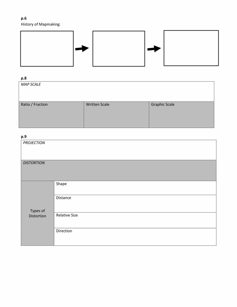
p.6
History of Mapmaking:
p.8
MAP SCALE
Ratio / Fraction Written Scale Graphic Scale
p.9
PROJECTION
DISTORTION
Types of Distortion
Shape
Distance
Relative Size
Direction

PROJECTIONS Advantages Disadvantages
Equal Area
Robinson
Mercator
P.10
MERIDIAN Longitude
Prime Meridian
PARALLEL Latitude
p.11
Briefly explain how time zones work:
GREENWHICH MEAN TIME
INTERNATIONAL DATE LINE

p.12-13
GEOGRAPHIC INFORMATION SCIENCE (GIScience)
REMOTE SENSING
GLOBAL POSITIONING SYSTEM (GPS)
GEOGRAPHIC INFORMATION SYSTEM (GIS)
The importance of layering for geographic study:
Examples of type of data stored in a single layer: MASHUP
Learning Outcomes:
1.1.1 Explain differences between early maps and contemporary maps.
1.1.2 Describe the role of map scale and projection in the making of maps.
1.1.3 Explain how latitude and longitude are used to locate points on Earth’s surface.
1.1.4 Identify contemporary analytic tools, including remote sensing, GPS, and GIS.
Check-In | How do geographers describe where things are?

Key Issue 2: Why is each point on earth unique?
p.14-15
PLACE
LOCATION
Place Name / TOPONYM SITE SITUATION
p.16-17
REGION
CULTURAL LANDSCAPE
CULTURAL LANDSCAPE / REGIONAL STUDIES APPROACH
3 Types of Regions
Formal / Uniform Functional / Nodal Vernacular / Perceptual

p.18-19
CULTURE
To care about… To take care of…
Briefly explain how Spatial Association impacts the study of geography:
Learning Outcomes:
1.2.1 Identify geographic characteristics of places, including toponym, site, and situation.
1.2.2 Identify the three types of regions.
1.2.3 Describe two geographic definitions of culture.
Check-In | Why is each point on earth unique?

Key Issue 3: Why are different places similar?
p.20-21
SCALE
GLOBALIZATION
Globalization of Economy Globalization of Culture
SPACE
DISTRIBUTION

p.22-23
Distribution Properties
DENSITY CONCENTRATION PATTERN
p.24-25
Examples of Patterns in Space
BEHAVIORAL GEOGRAPHY
HUMANISTIC GEOGRAPHY
POSTSTRUCTURALIST GEOGRAPHY

p.26-27
CONNECTION
HEARTH
DIFFUSION
RELOCATION DIFFUSION
EXPANSION DIFFISION
Results From…
HIERARCHICAL CONTAGIOUS STIMULUS

p.28-29
Cultural Connection
DISTANCE DECAY SPACE-TIME COMPRESSION
NETWORK
How are modern networks distinct?
Briefly explain the issue of Unequal Access:
UNEVEN DEVELOPMENT
Learning Outcomes:
1.3.1 Give examples of changes in economy and culture occurring at global and local scales.
1.3.2 Identify the three properties of distribution across space.
1.3.3 Describe different ways in which geographers approach aspects of cultural identity such as gender,
ethnicity, and sexuality.
1.3.4 Describe how characteristics can spread across space over time through diffusion.
1.3.5 Explain how places are connected through networks and how inequality can hinder connections.
Check-In | Why are different places similar?

Key Issue 4: Why are some human actions not sustainable?
p.30-31
RESOURCE
RENEWABLE RESOURCE NONRENEWABLE RESOURCE
SUSTAINABILITY
Three Pillars of Sustainability
Origin of this model:
Environment Economy Society
CONSERVATION PRESERVATION
Who criticizes sustainability? Why?

Three Pillars of Sustainability
p.32-33
BIOTIC ABIOTIC
Four Physical Systems
ATMOSPHERE
CLIMATE
HYDROSPHERE
Monsoon
LITHOSPHERE
Geomorphology
BIOSPHERE

p.34-35
Human-Environment Relationships:
In the Biosphere…
ECOSYSTEM ECOLOGY
EROSION DELETION OF NUTRIENTS
In Culture…
CULTURAL ECOLOGY
ENCIEONMENTAL DETERMINISM POSSIBILISM
Possibilism & Sustainability

p.36-37
What makes each of the following ecosystems sustainable vs. unsustainable?
SUSTAINABLE UNSUSTAINABLE
Netherlands South Florida
Learning Outcomes:
1.4.1 Describe the three pillars of sustainability.
1.4.2 Describe the three abiotic physical systems.
1.4.3 Explain how the biosphere interacts with Earth’s abiotic systems.
1.4.4 Compare ecosystems in the Netherlands and southern Florida.
Check-In | Why are some human actions not sustainable?
Chapter Review:
See Summary & Review (p.38-41) for the following features:
Key terms (with definitions and page number references)
Key Terms will also be accessible online through Quizlet
Brief summaries of each Key Issue
Concise answers to “Learning Outcomes” questions
See Check-In at conclusion to each Key Issue section for concise answers to questions
Additional review and reinforcement on MasteringGeography