Embed Size (px)
Citation preview
- GEOPHYSICAL REPORT
ON A _- INDUCED POLARIZATION SURVEY
OVER PORTIONS OF THE
I ANOMLY & THREE CORNERS AREA GRID
and Camp Vein Extension Grid
,.,<$
SJ GEOPHYSICS LTD. JANUARY - FEBRUARY 2005
REPORT BY
SHAWN RASTAD, B.Sc. SYD VISSER, B.Sc., P.GEo. S.J.V. CONSULTANTS Lm.
APRIL 2005
.
r .
TABLE OF CONTENTS 1 Summary ................................................................................................................................... 1 2 Introduction ............................................................................................................................... 2 3 Location and Access ................................................................................................................. 2 4 Climate and Physiography ........................................................................................................ 4 5 Property Descnption and Ownership ........................................................................................ 4 6 Geological setting ..................................................................................................................... 6 7 History of Property .................................................................................................................... 8
Pre 1985 History - Silver Queen Property: ...................................................................... 8 Pre 1985 History . Cole Lake Property: ........................................................................ 10
. .
7.1 7.2 7.3 Post 1985 History ............................................................................................................ 11
8 Disclaimer ............................................................................................................................... 13 9 Technical Data and Interpretation ........................................................................................... 14
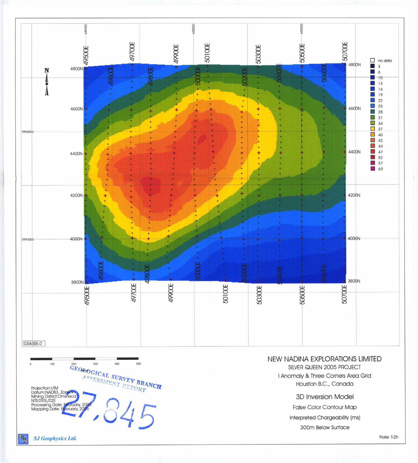
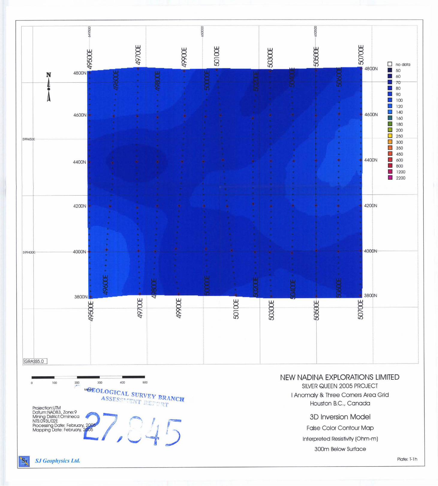
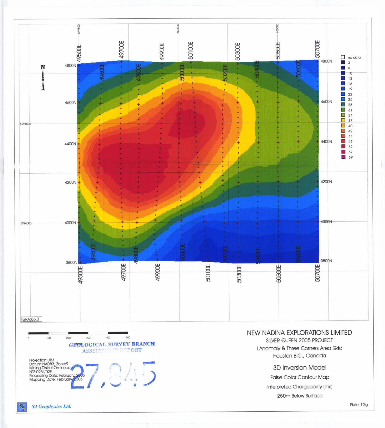
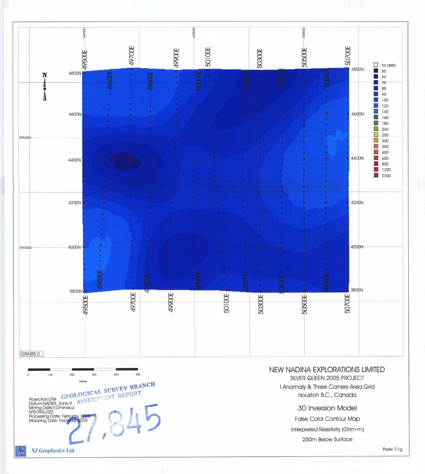
9.1 Project Location and Grid Information ........................................................................... 14 9.2 Field Work and Instrumentation ..................................................................................... 15 9.3 Geophysical Techniques .................................................................................................. 16 9.3.1 IP Method ..................................................................................................................... 16 9.3.2 3D-IP Method ............................................................................................................... 16 9.3.3 Inversion Programs ....................................................................................................... 17 9.4 Data Presentation ............................................................................................................. 18 9.4.1 Cross Sections .............................................................................................................. 18 9.4.2 Plan Maps ..................................................................................................................... 18 9.4.3 Inversion Model ........................................................................................................... 18 9.5 Discussion of Geophysical Results ................................................................................. 20 9.5.1 Camp Vein Extension Grid .......................................................................................... 20 9.5.2 I Anomaly & Three Corners Grid ................................................................................ 22
10 Conclusions and Recommendations ..................................................................................... 24 1 1 Itemized Cost Statement ....................................................................................................... 26 12 References ............................................................................................................................. 27 13 Appendix 1 - Statement of Qualifications ............................................................................ 28
13.1 E . Trent Pezzot .............................................................................................................. 28 13.2 Shawn Rastad ................................................................................................................ 29
14 Appendix 2 - Summary Tables ............................................................................................. 30 14.1 Camp Vein Extension ................................................................................................... 30 14.2 I Anomaly & Three Corners Grid ................................................................................. 30
15 Appendix 3 - Instrument Specifications ............................................................................... 32 15.1 IRIS ELREC 10 IP Receiver ......................................................................................... 32 1 5.1 GDD Tx I1 IP Transmitter .......................................................................................... 33
SJ Geophysics Ltd . /S.J. V. Consultants Ltd . 11762-94” Ave., Delta. BC Canada Tel: (604) 582-1 100 F a : (604) 589- 7466 E-mail: svdv(iisiPeovhvsics.com -
i
ILLUSTRATIONS Figure 1 : Location Map .............................................................................................................. 2
Figure 2: Claim Map ................................................................................................................. 4
Figure 3: Grid Map of Both Grids ........................................................................................... 13
Figure 4: Interperted Chargeability and Resistivity Volumes @ 25m Depth ........................ 19
Figure 6: Grid map of Camp Vein Anomaly showing cultural features .................................. 20
Figure 5: Chargeability Isosurface @ 33 Ohm-m, view from southeast .................................. 20
Fiugre 7: Grid Map of I Anomaly & Three Corners Grid in Relation to 1996 EM survey ..... 21
Figure 8: 3D Image of I Anomaly & Three Corner's Features ................................................. 22
Figure 9: Cross Sectional view of I Anomaly & Three Corners Grid - chargeability volume.23
Figure 10: 3D Image of a Plausible Drill Target ...................................................................... 23
SJ Geophysics Ltd . /S.J V. Consultants Ltd . 11762-94" Ave., Delta. BC Canada Tel: (604) 582-1 100 Fax: (604) 589-7466 E-mail: svdvOsigeouhvsics.com
ii
LIST OF PLATES (situated in map pockets at end of report)
I Anomaly & Three Corners Area Grid
Plate # -
1:SOOO Scale - 3D IP Inverted Plan Maps - -
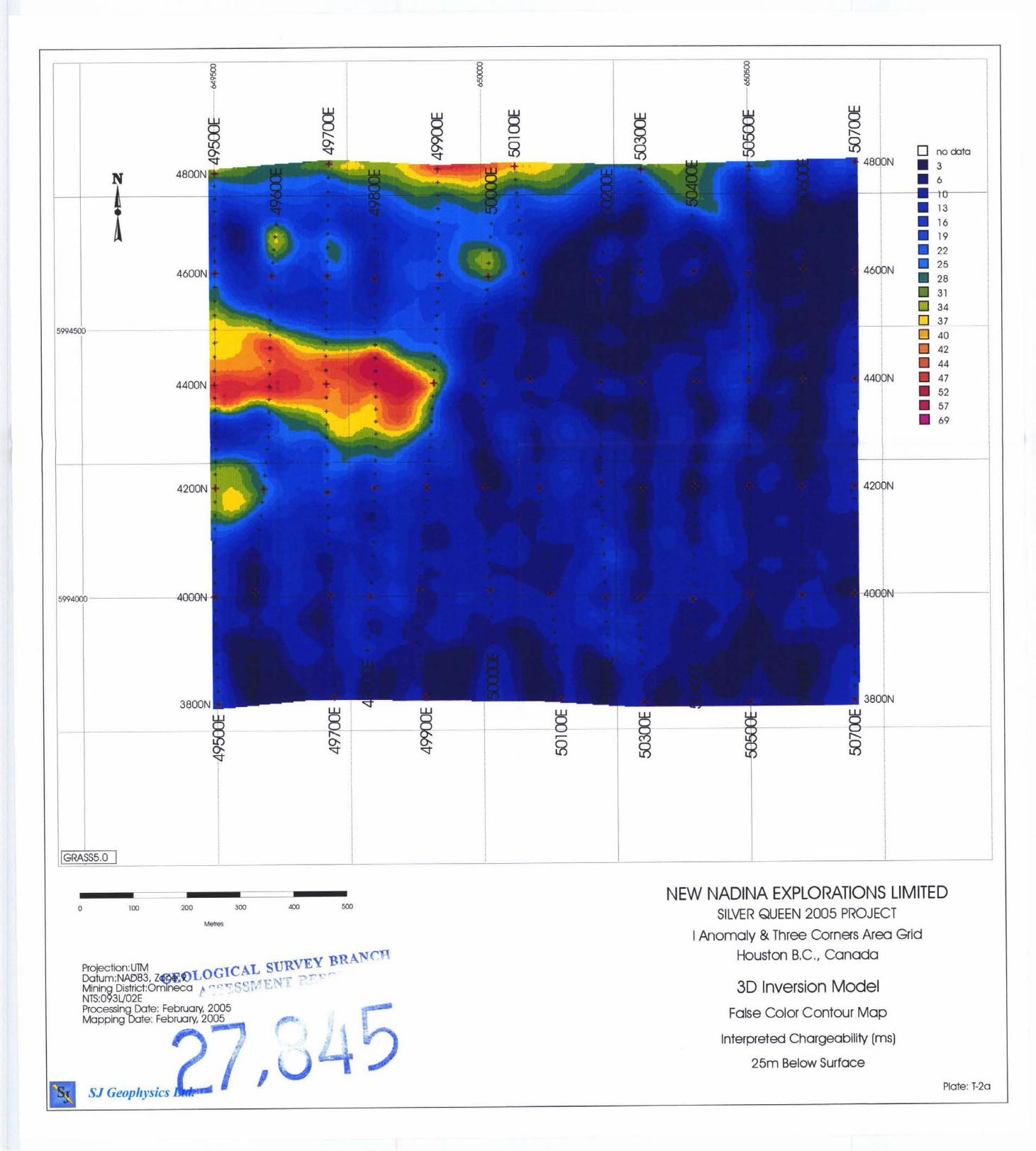
T-1A Interpreted Resistivity - 25m Below Surface
Interpreted Chargeability - 25m Below Surface
Interpreted Resistivity - 50m Below Surface
_ _ _ --
-~ -- I T-2A
T-1B
T-2B Interpreted Chargeability - 50m Below Surface
Interpreted Resistivity - 75m Below Surface ~- - ~-
~- _. T-1C
--
Interpreted Chargeability - 75m Below Surface
Interpreted Resistivity - 1 OOm Below Surface
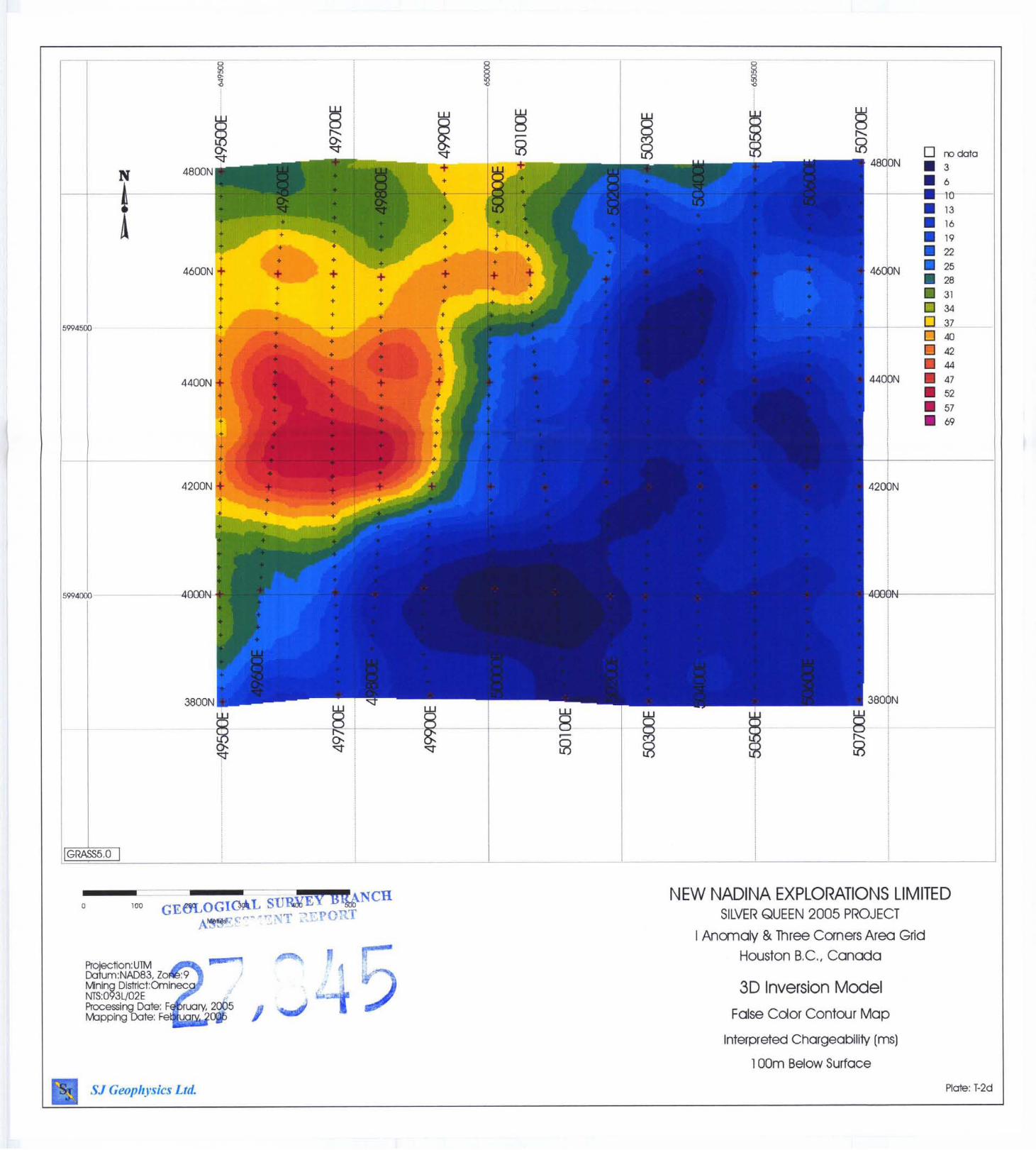
Interpreted Chargeability - lOOm Below Surface
_ _ -
- p ~ ~ ~ _ _
- T-2D ~-
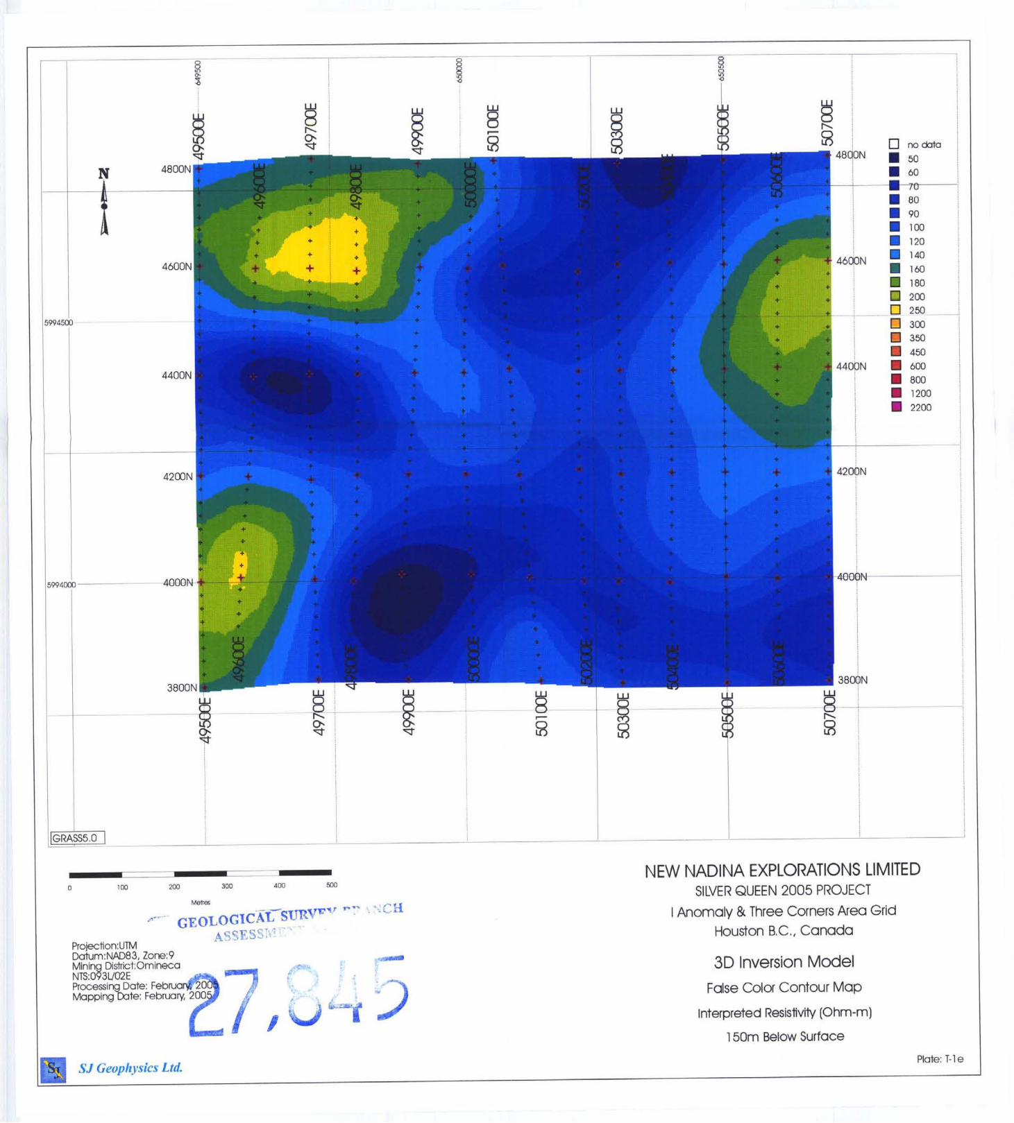
T-1E I Interpreted Resistivity - 150m Below Surface ~~
p-
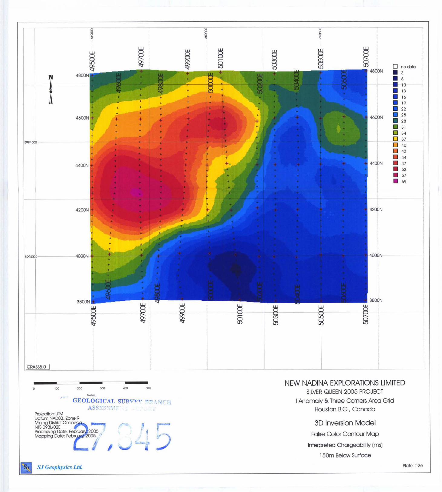
T-2E Interpreted Chargeability - 150m Below Surface
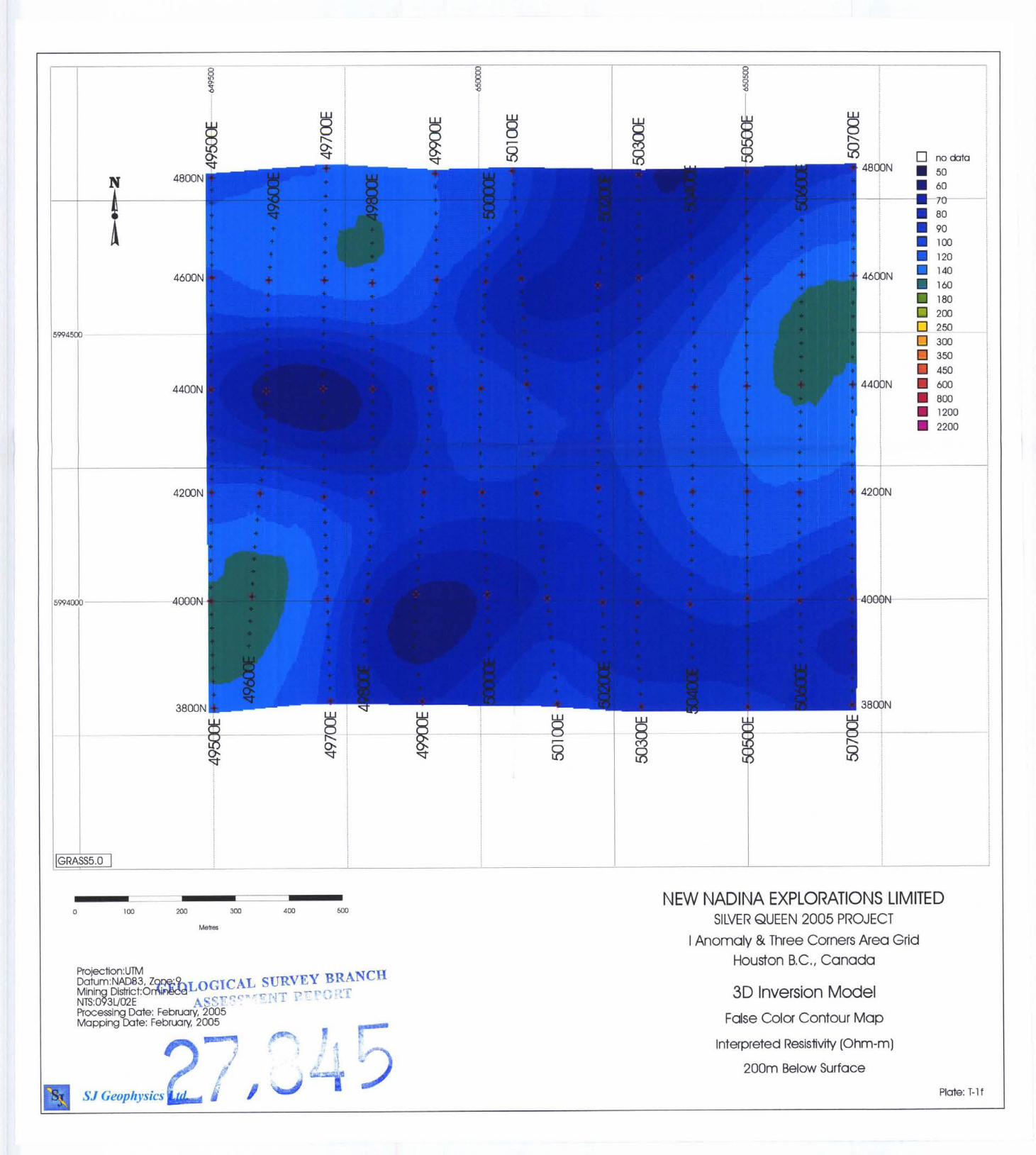
Interpreted Resistivity - 200m Below Surface
Interpreted Chargeability - 200m Below Surface
-~ - ~~
-~ --
r- T-IF
T-2F
~ T-1G 1 Interpreted Resistivity - 250m Below Surface
I T-2G Interpreted Chargeability - 250m Below Surface
Interpreted Resistivity - 300m Below Surface
Interpreted Chargeability - 300m Below Surface
- -
~~ - - ~
-~
I -- T-1H
I T-2H
iii SJ Geophysics Ltd. /S.J. V. Consultants Ltd. 1 1762-94" Ave., Delta, BC Canada Tel: (604) 582-1 I00 Far: (604) 589- 7466 E-mail: [email protected]

c
,
v-
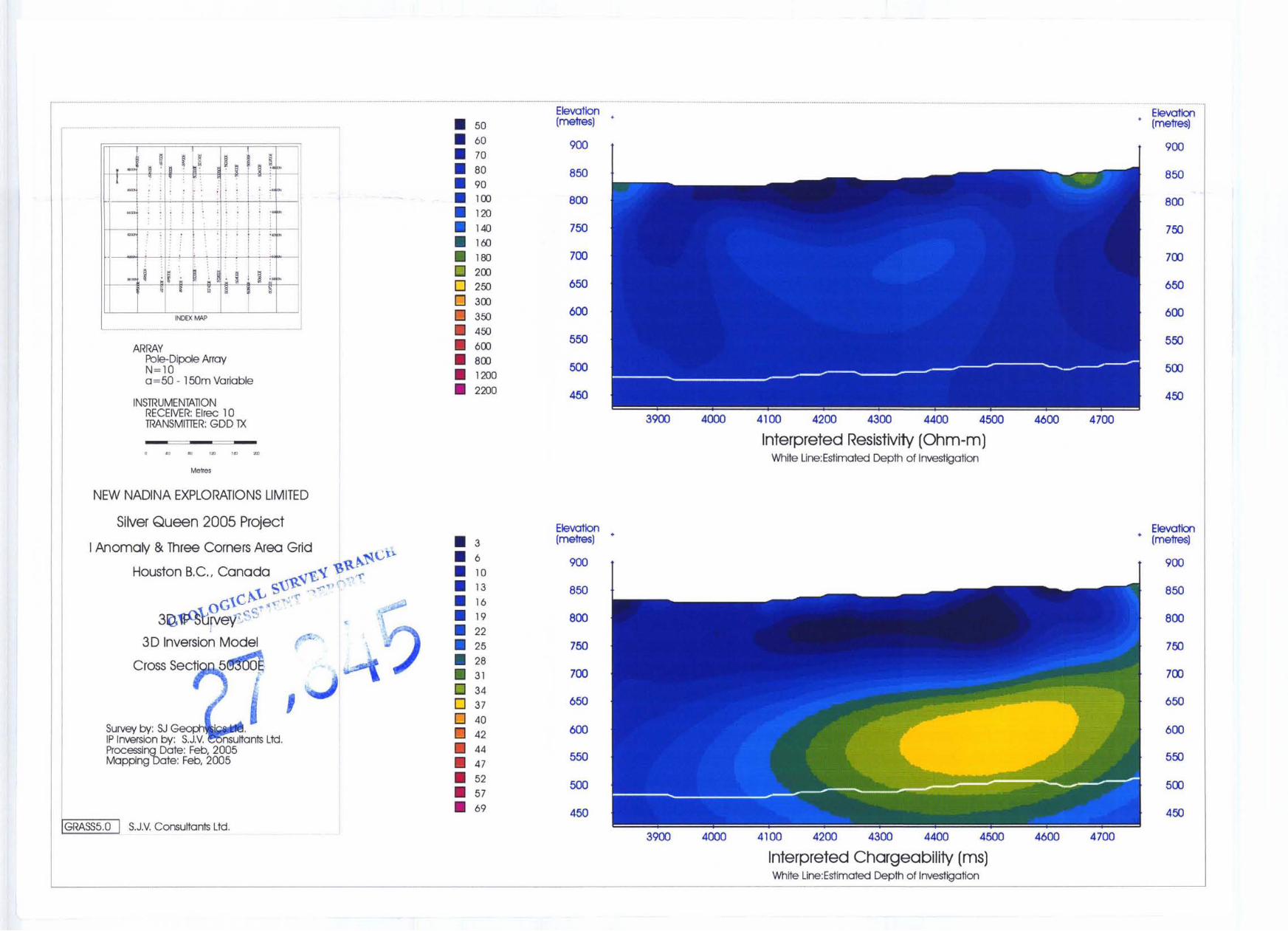
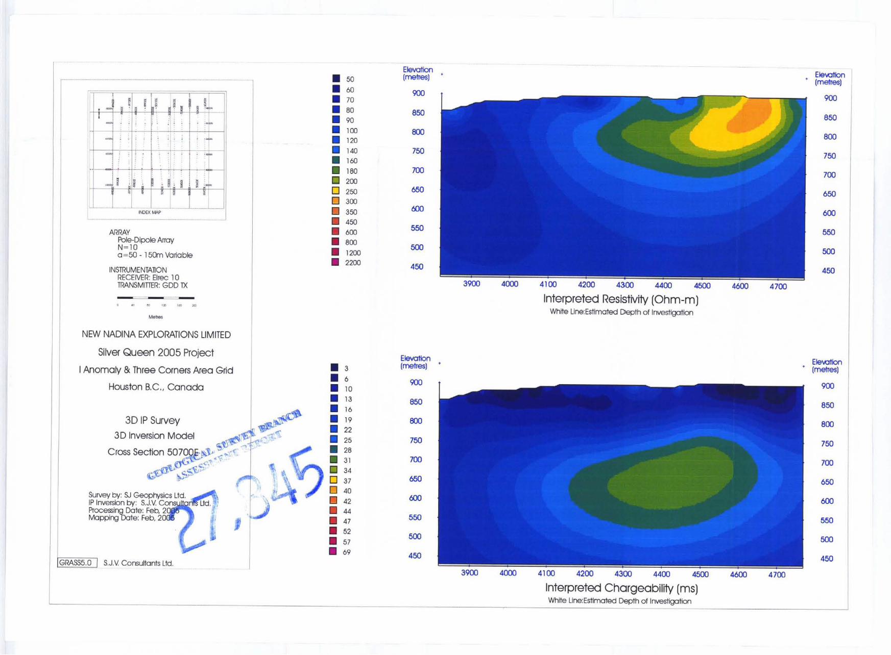
1 LineNumber I I Anomaly & Three Corners Area Grid
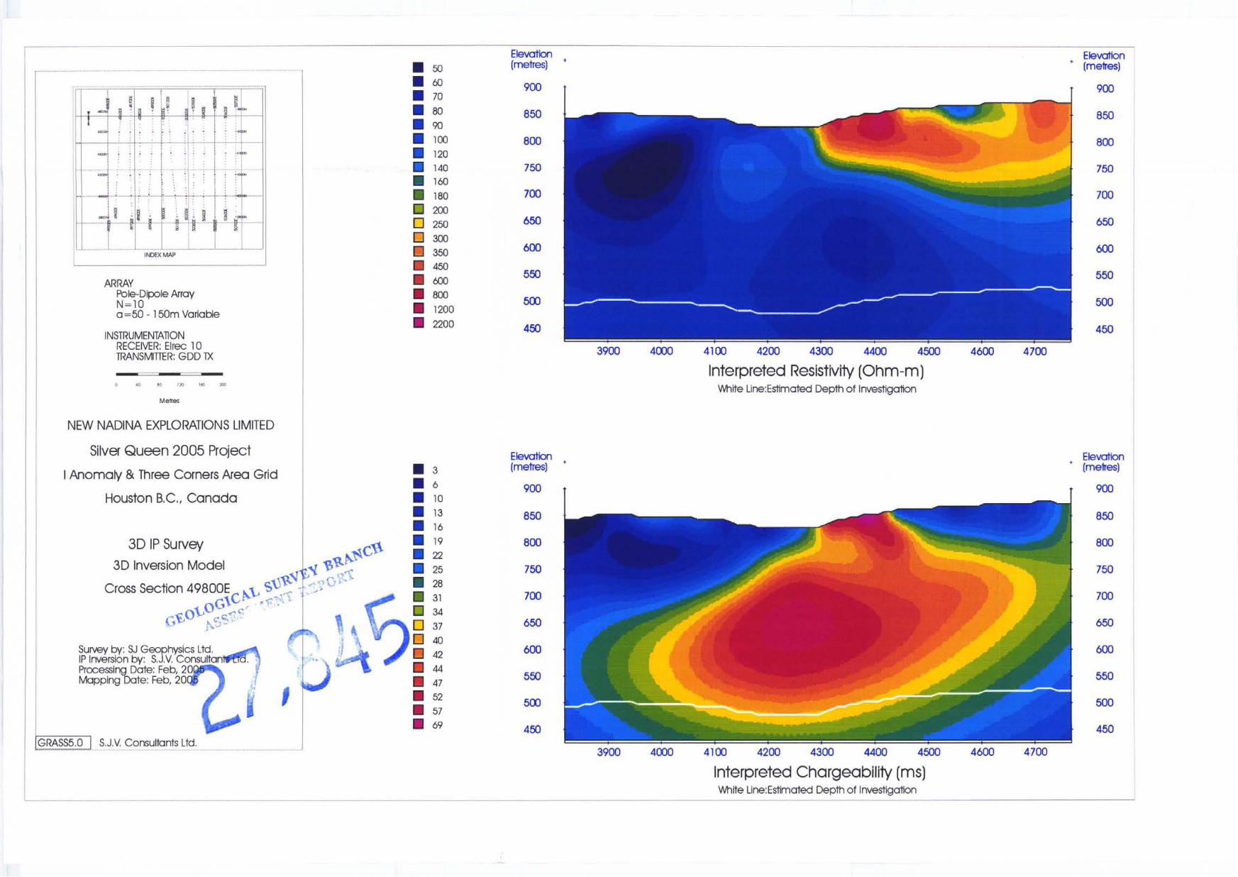
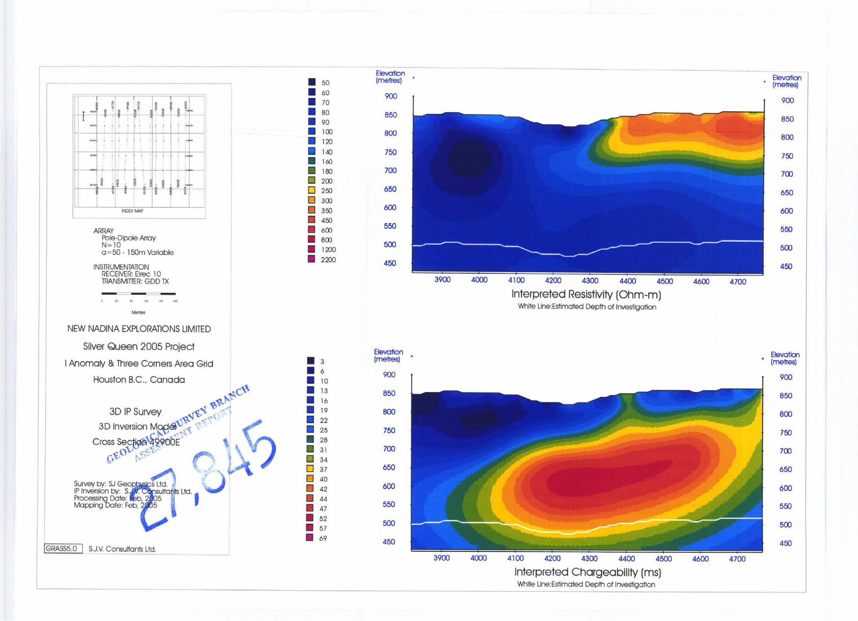
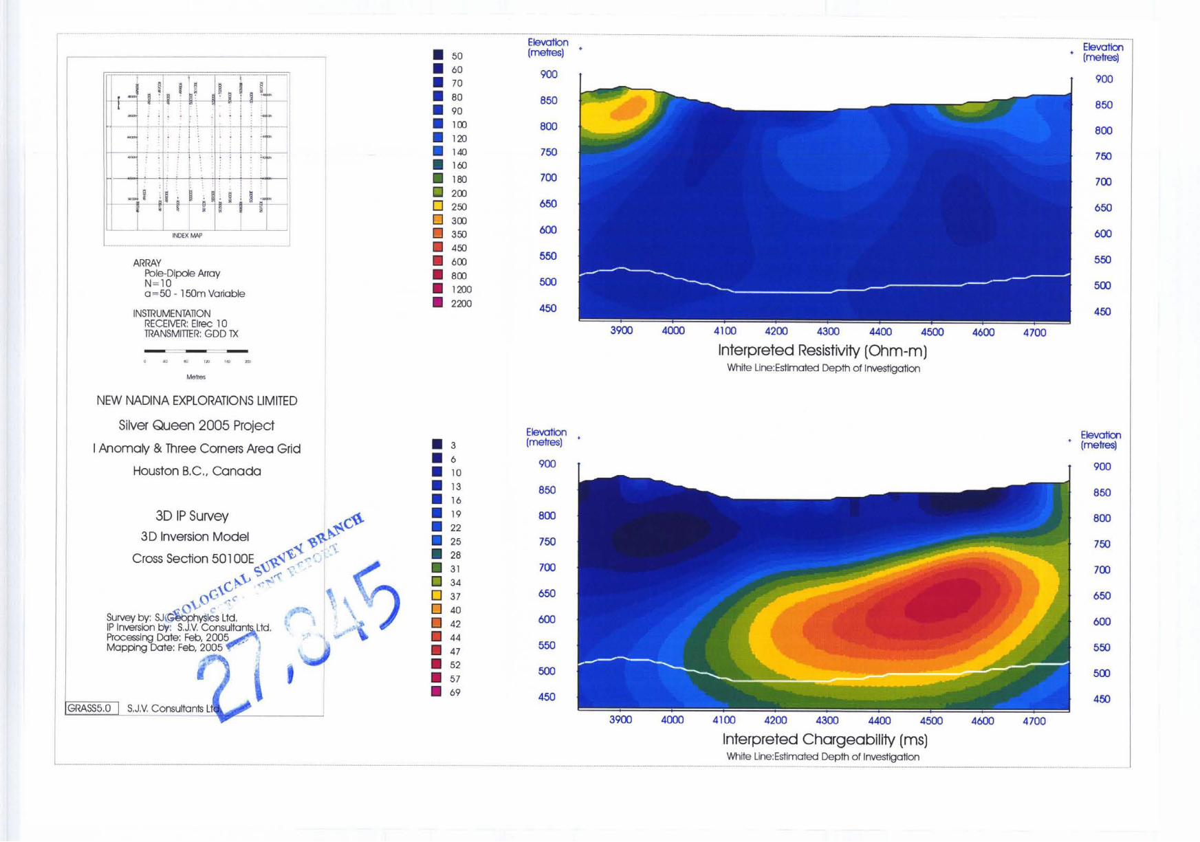
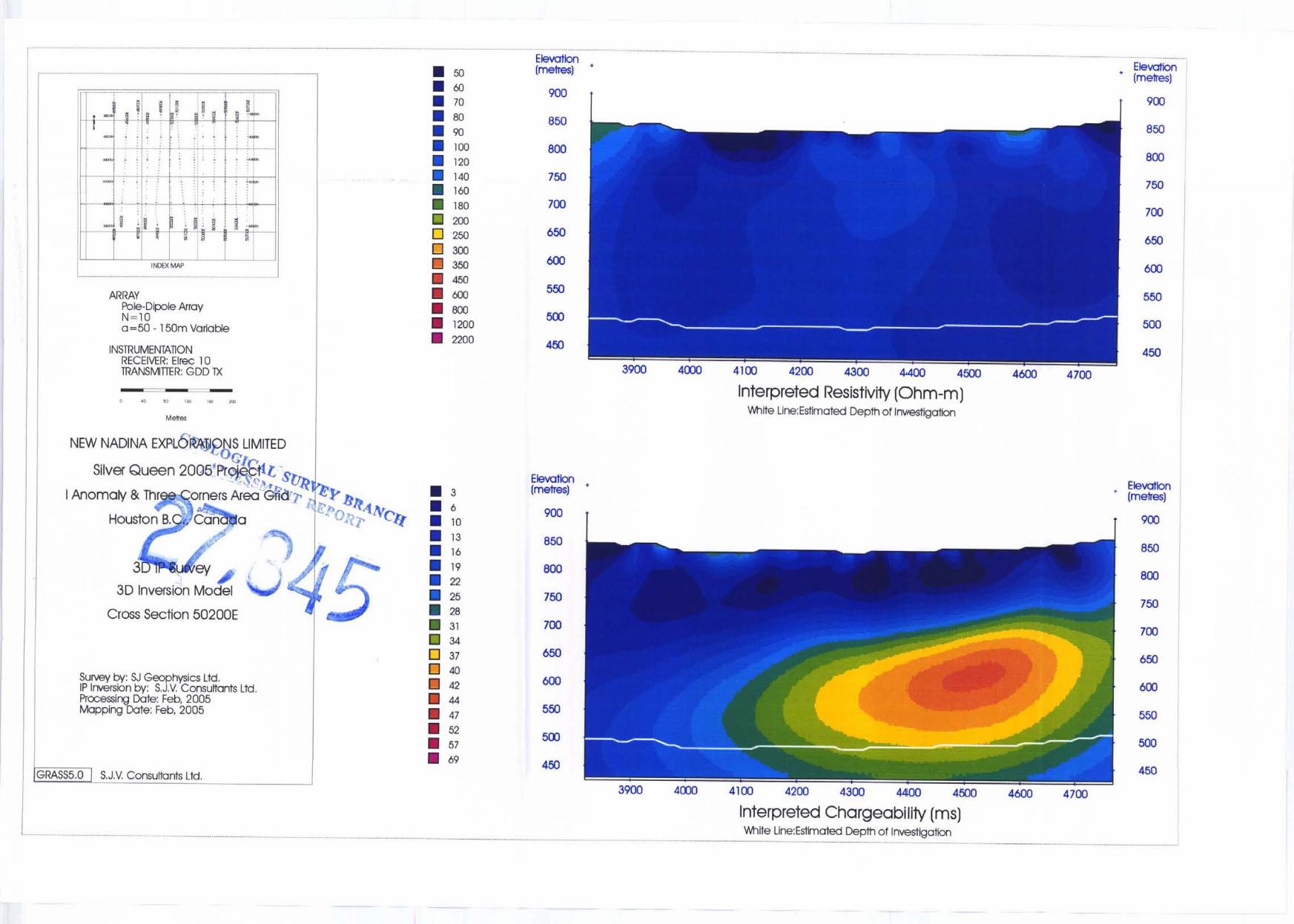
3D-IP Cross Sectional Maps : Lines 495003 to 50700E
3D Interpreted Resistivity / Interpreted Chargeability ~- -- I 1 49600E
I 49700E
1 49800E
1 49900E
1 50000E
1 3D Interpreted Resistivity / Interpreted Chargeability - ~ -
-1
3D Interpreted Resistivity / Interpreted Chargeability
3D Interpreted Resistivity / Interpreted Chargeability I I 3D Interpreted Resistivity / Interpreted Chargeability
1 3D Interpreted Resistivity / Interpreted Chargeability
3D Interpreted Resistivity / Interpreted Chargeability
3D Interpreted Resistivity / Interpreted Chargeability -. __ ~ ~~~~~ -- ~~~
1 50300E 1 3D Interpreted Resistivity / Interpreted Chargeability
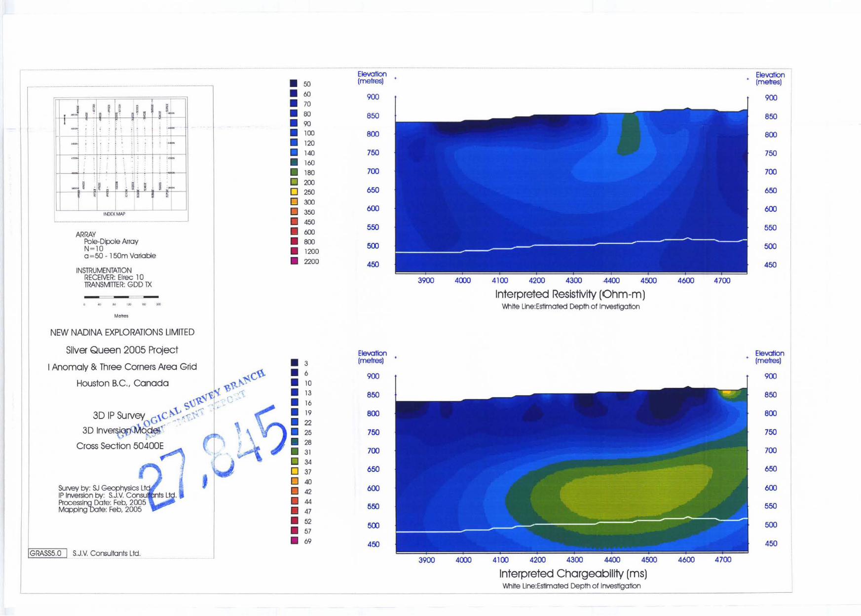
I 50400E I 3D Interpreted Resistivity / Interpreted Chargeability
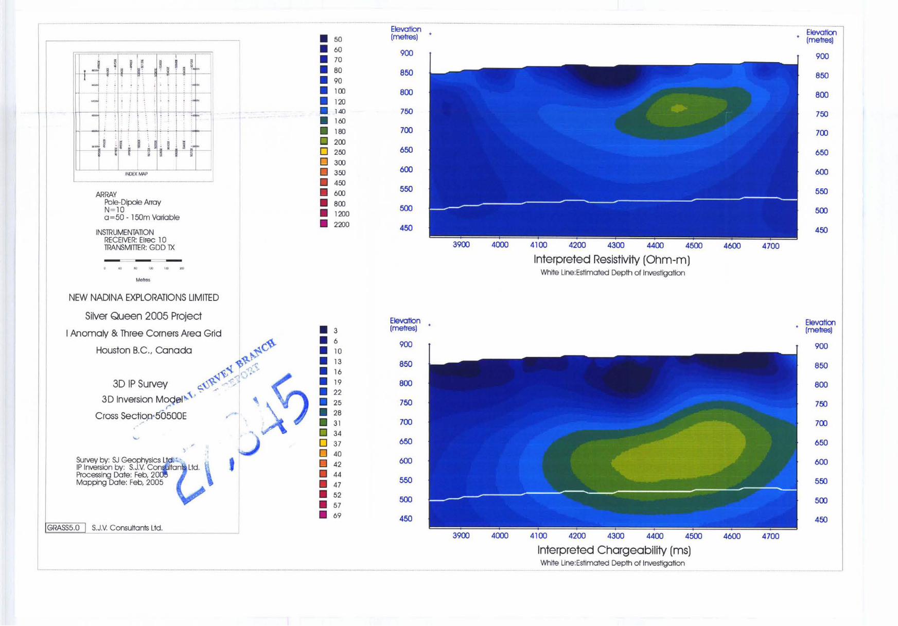
50500E
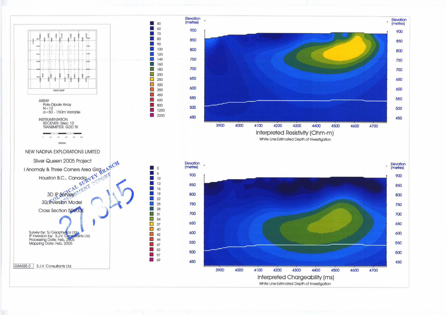
50600E
50700E
3D Interpreted Resistivity / Interpreted Chargeability
3D Interpreted Resistivity / Interpreted Chargeability
3D Interpreted Resistivity / Interpreted Chargeability ~~ ~ ~~ ~ - -- -
XJGeophysics Ltd. /S.J. V. Consultants Ltd. I I 762-94Ih Ave., Delta, BC Canada Tel: (604) 582-1 I00 Fax: (604) 589-7466 E-mail: [email protected]
iv

t
G-1A
Camp Vein Extension Grid
15000 Scale - 3D IP Inverted Plan Maps _. -
Interpreted Resistivity - 25m Below Surface ~
G-2A 1 Interpreted Chargeability - 25m Below Surface
G-1B
G-2B
1 Interpreted Resistivity - 50m Below Surface
Interpreted Chargeability - 50m Below Surface ~ ~~ ~~ i
I G-1C 1 Interpreted Resistivity - 75m Below Surface I G-2C 1 Interpreted Chargeability - 75m Below Surface
~ . . . . - - ~ - ~ ~ - ~
I G-1D I Interpreted Resistivity - lOOm Below Surface I G-2D
~ Interpreted Chargeability - 1 OOm Below Surface
I G- 1E 1 Interpreted Resistivity - 150m Below Surface - -~~ ~ ~~~~~
G-2E 1 Interpreted Chargeability - 150m Below Surface ~ ~ ~~~~~ ~~~~~~~~~~~~
I G-1F 1 Interpreted Resistivity - 200m Below Surface I G-2F
~ Interpreted Chargeability - 200m Below Surface
SJ Geophysics Ltd. / S . J. V. Consultants Ltd. I I 762-94Ih Ave., Delta, BC Canada Tel: (604) 582-1 100 Fax: (604) 589-7466 E-mail: svdvGilJiaeouhvsics.com
V
Silver Queen Project: 3D-IP 2005
1 SUMMARY Ic'
F
New Nadina Exploration Limited carried out a geophysical program to further investigate and
delineate existing veins, in addition to ascertain the extent of the known gold and silver
mineralization in the area. Two 3D Induced Polarization surveys were conducted during the
winter months of 2005: the I Anomaly & Three Corners grid and the Camp Vein Extension grid.
The Camp Vein Extension grid was to further delineate the known Camp Vein system and to
further understand the geophysical response from the feature. Determining such geophysical
response allowed easier interpretation by comparing the known response with those obtained in
newly investigated regions, such as the I Anomaly & Three Corners grid. This grid focused on
anomalous features, specifically the I Anomaly, outlined by a MaxMin survey conducted in 1996.
The detailed 3DIP survey on the Camp Vein extension geophysical response gave an
anomalous resistivity low in the region of the vein. On the edges of this resistivity low exists a
zone of of higher chargeability material. A similar response was noted on western edge of the
new target area, I Anomaly & Three Corners grid. Further results of the geophysical survey
highlighted a large structural feature, possibly a fault. However, no new evidence was provided
in relation to the I Anomaly MaxMin feature.
The collected data set and subsequently the inverted depth sections were then to be used to
determine the location of future drill targets on possible polymetallic veins similar to that of the
existing Camp Vein.
This geophysical assessment report has been reviewed by Syd Visser, P.Geo of S.J.V.
Consultants Ltd. Statement of Qualifications for Shawn Rastad and Syd Visser can be found in
Appendix 1 of this report.
SJ Geophysics Ltd. /S.J. V . Consultants Ltd. 11 762-94Ih Ave., Delta, BC Canada Tel: (604) 582-1 100 Fax: (604) 589-7466 E-mail: [email protected]
1
Silver Queen Project: 3D-IP 2005
2 INTRODUCTION
During January and February of 2005, SJ Geophysics Ltd. was contracted by the New Nadina
Explorations Ltd. to conduct a geophysical study on its Silver Queen property within central
British Columbia. The acquired geophysical data consisted of 3D Induced Polarization (3D-IP).
The geophysical survey consisted of two separate grids: the I Anomaly & Three Corners grid
and the Camp Vein Extension grid. The Camp Vein Extension grid was situated to further
delineate the known vein system and consisted of a detailed 3D-IP survey (25m dipoles). The I
Anomaly & Three Corners grid focused on a region covered by a MaxMin survey conducted in
1996. The focus of this survey was to follow up on anomalous feature outlined in the
interpretation of the data. This grid was situated approximately 1.5km to the east of the Camp
Vein Extension grid and was acquired with a standard 3D-IP configuration (50m dipoles).
This report's interpretation of the acquired IP dataset is solely based on this geophysical
program, and little was derived from local geology or previous conclusions.
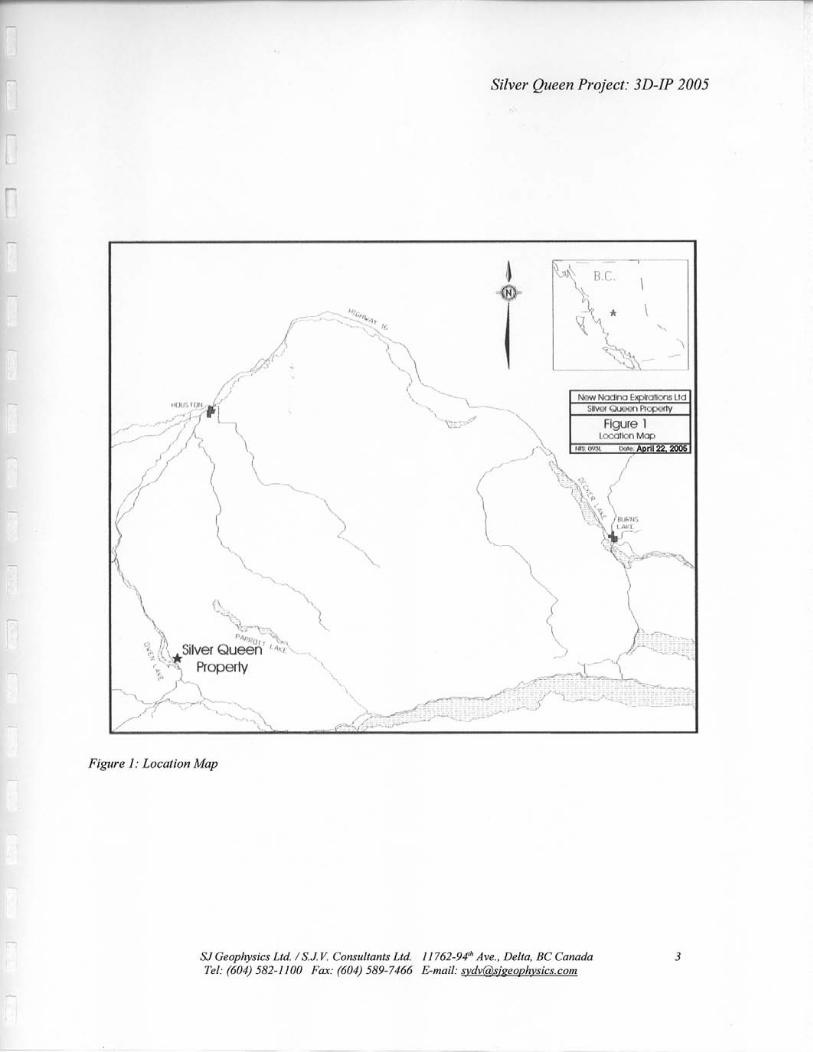
3 LOCATION AND ACCESS
The Silver Queen property is situated in central B.C., about 36 km south of Houston, and 30
km southwest of the Equity Silver Mine, on NTS map sheet 93L/2E as shown in Figure 1.
Access to the property is south from Houston on the Morrice River-Owen Lake Forestry road, a
good all-weather road which branches south from Highway 16 three kilometres west of Houston.
The two grids were situated just east of Owen Lake and south of George Lake.
SJ Geophysics Ltd. /S.J. V. Consultants Ltd. I I 762-94rh Ave., Delta, BC Canada Tel: (604) 582-1 100 Fax: (604) 589-7466 E-mail: [email protected]
2
Silver Queen Project: 3D-IP 2005
Figure I : Location Map
SJ Geophysics Ltd. /S.J K Consultants Ltd I I762-94" Ave., Delta, BC Canada Tel: (604) 582-1100 Far: (604) 589-7466 E-mail: [email protected]
3
Silver Queen Project: 3D-IP 2005
4 CLIMATE AND PHYSIOGRAPHY
The property is situated just east of Owen Lake. Much of the property occupies a moderate
southwest facing slope. Close to Owen Lake and in the southeastern portion of the property, the
ground is relatively flat. Vegetation is generally heavy, with poplar, willows and heavy ground
cover, and with local spruce and fir forest. Elevations range from 2,500 feet at Owen Lake, to
more than 4,000 feet at the top of Tip Top Hill. Outcrop is relatively scarce and overburden
exceeds 100 feet in some areas.
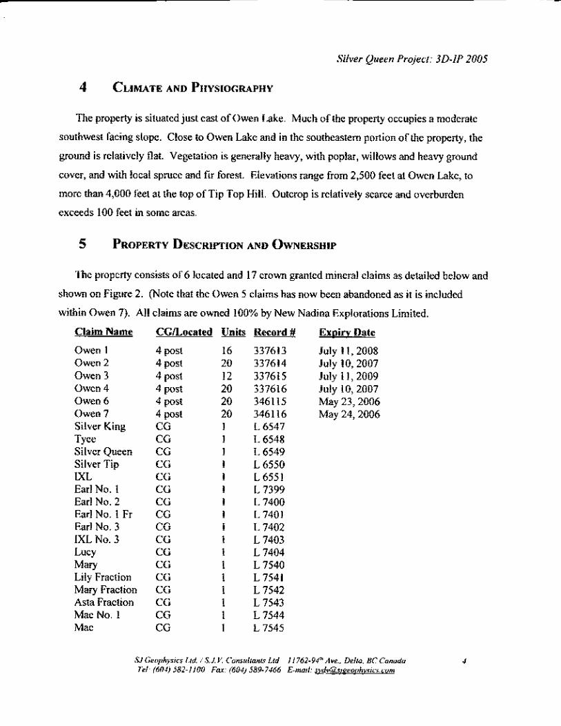
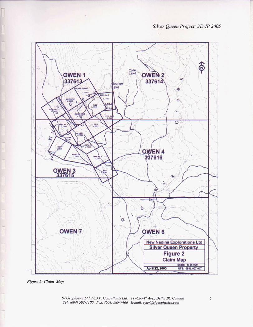
5 PROPERTY DESCRIPTION AND OWNERSHIP
The property consists of 6 located and 17 crown granted mineral claims as detailed below and
shown on Figure 2. (Note that the Owen 5 claims has now been abandoned as it is included
within Owen 7). All claims are owned 100% by New Nadina Explorations Limited.
Claim Name CGLocated Units Record # Exoirv Date
Owen 1 4 post 16 337613 July 1 1,2008 Owen 2 4 post 20 337614 July 10,2007 Owen 3 4 post 12 337615 July 1 1,2009 Owen 4 4 post 20 337616 July 10,2007 Owen 6 4 post 20 346115 May 23,2006 Owen 7 4 post 20 346116 May 24,2006 Silver King CG 1 L 6547 Tyee CG 1 L 6548 Silver Queen CG 1 L 6549 Silver Tip CG 1 L 6550 IXL CG 1 L 6551 Earl No. 1 CG 1 L 7399 Earl No. 2 CG 1 L 7400 EarlNo. 1 Fr CG 1 L 7401 Earl No. 3 CG 1 L 7402 IXL No. 3 CG 1 L 7403 Lucy CG 1 L 7404 Mary CG 1 L 7540 Lily Fraction CG 1 L 7541 Mary Fraction CG 1 L 7542 Asta Fraction CG 1 L 7543 MaeNo. 1 CG 1 L 7544 Mae CG 1 L 7545
SI Geophysics Ltd. /S.J. Y Consultants Ltd. I I 762-94Ih Ave., Delta, BC Canada Tel: (604) 582-1 I00 F a r (604) 589-7466 E-mail: &@sieeovhvsics.com
4
. .
? Silver Queen Project: 3D-IP 2005
r 6 GEOLOGICAL SETTING
The following section is an excerpt from a previous assessment report written by Linda Caron,
P. Eng. in March 1997. The author of this report is unfamiliar with the geology of this region.
The regional geology of the Silver Queen area has been described by a number of workers
and will not be repeated in any detail here. The reader is referred to Church and Barakso (1990),
Cheng (1995), Hood (1991) and Leitch, et a1 (1991) for excellent in-depth descriptions of the
area geology. In brief, the property is situated on the western edge of what has been referred to
as the Buck Creek Basin. Past workers have classified this as a resurgent caldera, however recent
work by Struik and others in the Nechako area has identified similar features which are a result
of Tertiary extensional faulting. A re-interpretation of the “Buck Creek Basin” suggests that this
is true here also. A prominent regional structure (interpreted as a release fracture due the
extensional faulting) passes through the Equity Silver Mine and the Silver Queen Mine, and may
be an important regional control to mineralization. In the southwest portion of the property,
Telkwa Formation conglomerate of the Early to Mid Jurassic Hazelton Group occurs,
unconformably overlain by volcanics and sediments of the Upper Cretaceous Kasalka Group.
Known veins at the Silver Queen property are hosted by the Kasalka Group rocks. A basal
polymictic conglomerate is overlain by a thick sequence of tuffs and lahars, followed by a thick
andesite flow and sill unit, and intruded by microdiorite intrusives. Eocene andesitic flows cover
the older rocks in part. At least three different Tertiary dykes or stocks are recognized cutting the
older rocks and constraining the age of vein mineralization at ahout 51 Ma.
The rocks in the mine area are tilted as a result of block faulting and dip gently north to
northwest. Two main sets of faults cut the rock sequence, an early, pre to syn-mineral northwest
trending set, and a later post-mineral northeast trending set. Most of the veins occur along
northwest trending structures, and are offset by the post-mineral, northeast trending faults.
A considerable amount of exploration has been devoted to the series of polymetallic
veins on the property. Veins are typically 1 - 2 metres in width, with disseminated to massive
pyrite, sphalerite, galena, chalcopyrite, tennantite and tetrahedrite, and with Cu-Ph-Ag-Bi
sulfosalts and electrum, in a gangue of quartz, carbonate or barite. The veins are strongly zoned
SJCeophysics Ltd. /S.J. Y Consultants Ltd. 11762-94Ih Ave., De/ta, BC Canada 6 Tel: (604) 582-1 100 F a : (604) 589-7466 E-mail: [email protected]
Silver Queen Project: 3D-IP 2005
from south to north and much effort has been made to study changes in alteration and mineralogy
within the veins (ie. Hood, 1991, Cheng, 1995). These and other studies, suggest a fluid flow
from south to north, with gold enrichment in the higher temperature southern zones.
r
r
I
A property scale alteration study was completed to define a high temperature zone
prospective for bulk tonnage gold mineralization, south of the known veins. Portable infrared
spectrometry techniques were used to observe the change from sericite to illite, and thus define a
zone of higher temperature alteration. This area is largely covered by deep overburden and
detailed geological and alteration mapping is not possible. Most of the geological information in
this overburden covered area comes from the limited amount of diamond drillling done in the
spring of 1996 and during this program. The area is largely covered by a thick sequence of fine,
medium and coarse grained, feldspar porphyritic volcanics of dacitic composition, with minor
interbedded pyroclastics (crystal lapilli tuffs) of similar composition and lesser sediments
(conglomerate, wacke, mudstone). Evidence from drilling suggests moderate to steep northerly
dips to the rocks, roughly parallel to the orientation of major structures known in this area. Two
very significant fault zones, up to 200’ in width, have been intersected by drilling in the vicinity
of the ranch gate (EM conductors H and I). Both structures have an assumed strike length of in
excess of 600 metres, and are open to the east.
SlGeophysics Ltd. / S . J Y consult on:^ Ltd. lI762-94lh Ave., Delta, BCCanada Tel: (604) 582-1 100 Far: (604) 589-7466 E-mail: [email protected]
7

Silver Queen Project: 3D-IP 2005
7 HISTORY OF PROPERTY
The following section was provided by the client, New Nadina Exploration, to be included in
this report for completeness. The author is unfamiliar with the history of these property claims.
At the time of this report, no information of work on the since since 1997 was been provided.
There has been very little work done on the property since then.
The present Silver Queen property was historically comprised of two separate properties, the
Silver Queen and the Cole Lake properties which were managed separately (except for the period
1928-43), until 1985. A considerable amount of exploration and development has been done on
the property. A summary of this work is presented in point form below. For simplicity, the pre-
1985 history of exploration of the two properties is discussed separately.
7.1 Pre 1985 History - Silver Queen Property:
1912 - mineralization discovered, three adits driven on the Wrinch vein system
1915 - 38 tons of ore (3 1% Pb and 6 oz Ag) shipped from two shallow shafts
1923 - optioned to Federal Mining and Smelting Co., more than 500 ft of drifting done
from the three adits
1928 - Silver Queen and Cole Lake properties acquired by Owen Lake Mining and
Development Company, Cole Shaft sunk, a 3,000 ft cross-cut driven
1941 - Canadian Exploration (now Placer Development) purchased Silver Queen claims,
and optioned Cole Lake property; surface and underground mapping and sampling completed
1943 -
until 1947
option on the Cole Lake ground dropped, work continued on Silver Queen veins
SJGeophysics Ltd. 1S.J. K Consultants Ltd. 11762-9b Ave., Delta, BC Canada Tel: (604) 582.1 100 Fa: (604) 589-7466 E-mail: svdv~si~eovhvsics.com
8
r Silver Queen Project: 3D-IP 2005 I
1963 - Nadina Explorations Ltd optioned Silver Queen claims; aggressive program of
diamond drilling, trenching, and underground development on the No. 3 vein - traced Wrinch
vein system south to the "Ruby Extension zone"
r-
1966 - Nadina continued underground and surface work on the property
1967 - property optioned to Kennco Explorations; geological mapping, soil sampling and
IP survey done; several deep holes drilled to test for porphyry copper mineralization
1968 - Nadina continued work on Silver Queen veins; soil sampling, trenching, diamond
drilling and underground mapping done
1969 - BC Ministry of Energy, Mines and Petroleum Resources mapped entire property
in detail, as well as the area surrounding Owen Lake. Nadina completed 4,000 ft of drifting, 51
drill holes (both underground and surface) plus airborne geophysical surveys
1970 - Northgate Explorations optioned the property from Nadina; did extensive
underground check sampling, 13,500 ft of surface drilling, 1,500 ft of underground drilling and
4,200 ft of drifting and raising
1971 - Bralorne Can Fer Resources Limited and Pacific Petroleum Ltd. optioned the
property, and formed the Bradina Joint Venture; feasibility study prepared by Dolmage Cambell
and Associates, surface EM and IP surveys, 6,000 ft of surface drilling and 800 ft of drifting and
raising done
1972 - property put into production in March, 1972, using equipment fiom Bralorne's
recently closed gold mine in southern B.C.
1973 - operations ceased September, 1973 due to an over design of the mill and complex
metallurgy. 200,000 tons of ore milled. Drill indicated reserves on the Wrinch vein system at
SI Geophysics Ltd. / S.J. Y Consultants Ltd. I I 762-94'h Ave., Delia, BC Canada 9 Tel: (604) 582-1 100 Far: (604) 589-7466 E-mail: svdv(ir)sipeoDhvsics.com

7 Silver Queen Project: 3D-IP 2005
mine closure were 577,600 tonnes averaging 3.7 g/t Au, 257 g!t Ag, 6.53% Zn, 1.49% Pb, and
0.49% Cu. During 1972-73,47 surface holes and 68 underground holes, totalling over 20,000 ft
drilled.
r
?.
1974 - 5,900 ft of drilling done, JV agreement terminated
1977 - Nadina purchased Silver Queen property outright in 1977; Placer retained backin
right, which hampered the involvement of larger companies in the property. Property optioned
by New Frontier Petroleum Ltd, the successor company to Frontier Explorations Ltd. which held
the Cole Lake property. Limited deep surface drilling done and the option dropped in 1978.
1980 - Nadina reorganized as New Nadina Explorations Ltd.; a major program of backhoe trenching done, as well as surface drilling and rehabilitation of underground workings.
1981 - rehabilitation completed, additional drifting done, and 28 underground and 4
surface drill holes drilled (a total of over 8,000 ft).
1982 - Campbell Resources did detailed re-evaluation of the Silver Queen property in
1982, completed limited metallurgical testing
1983-84 - New Nadina completed 7,500 ft of surface diamond drilling in 15 holes
7.2 Pre 1985 History - Cole Lake Property:
1915 - Cole vein system staked as the Diamond Belle group
1928 - property was acquired, along with the Silver Queen property, by the Owen Lake
Mining and Development Company; Cole shaft sunk
SI Geophysics Ltd. /S.J Y Consultants Lid. I 1762-96 Ave., Delia, BC Canada 10 Tel: (604) 582-1 100 Fax: (604) 589-7466 E-mail svdvirSsireoDhvsics.com
r Silver Queen Project: 3D-IP 2005
F
1941 - Canadian Exploration optioned property, completed mapping and sampling.
Option dropped in 1943.
1967 - considerable trenching and some drilling was done on the Cole Lake veins by
Frontier Explorations Ltd, who had acquired the ground in this area in 1960, and done minor
work in the early 1960's
1972 - Frontier Explorations did EM survey, as well as percussion drilling and 1,500 ft of
diamond drilling on George Lake Lineament Vein
1980 - backhoe trenching done by Frontier
1981 - New Frontier sold all its mining interests to Bulkley Silver Resources Ltd, who
attempted to raise money to complete the Earl Adit which would intersect the Cole Vein system
at depth. Insufficient funds were raised and only 100 feet of this drive was completed.
7.3 Post 1985 History
1985 - Bulkley Silver optioned the New Nadina ground to put the entire camp under one
management; a max-min EM survey and 6 diamond drill holes were completed
1987 - JV formed between Pacific Houston Resources Inc (previously Houston Metals
Corp, the successor to Bulkley Silver), and New Nadina. In excess of $7,500,000 was spent on
exploration on the property during 1987 and 1988, including 35,000 fi of diamond drilling and
8,100 ft of tunnelling, cross-cutting, and declining; minor metallurgical work done
1988 - indicated reserves estimated at 1.7 million tons of 2.7 g/t Au, 328 g/t Ag, and
6.19% Zn; significant levels of Cd, Ga, Ge, In, Sb and Bi contained in the ore
1989 - University of British Columbia became involved under NSERC grant; Numerous
SJ Geophysics Lld. /S .J V. Conrullants Ltd 11762-94" Ave., Delta, BC Canada I 1 Tel: (604) 582-1 100 Fax: (604) 589-7466 E-mail: [email protected]
L
Silver Queen Project: 3D-IP 2005 r
studies done including geological mapping, structural studies, 2 MSc. theses (mineralogy, ore
reserves), 1 PhD thesis (alteration) F
"in situ mining resource" determined to be:
Central area: 708,134 tons at 0.086 opt Au, 4.78 opt Ag, 0.19% Cu,0.82% Pb, 5.43% Zn
South area: 220,266 tons at 0.152 opt Au, 8.15 opt Ag, 0.54% Cu, 0.89% Pb, 5.67% Zn
c
1990 - Pacific Houston bankrupt, New Nadina assumed the debts and purchased the
claims outright from Pacific Houston. Also in 1990, an agreement was reached with Placer,
whereby Placer signed over all remaining rights to the property.
1991 - New Nadina addressed site remediation through a study by consultant Tom Higgs,
to develop a system of treating zinc rich mine drainage prior to release into the environment.
1992 - A tailings pondwetland passive treatment system was implemented to treat mine
drainage.
1993 -present
Ongoing water sampling by New Nadina to test mine drainage, as required by the
Ministry of Environment
1995 - New Nadina Explorations abandoned the old Silver 4 claim and restaked the
property as the current Owen 1 - 5 claims. A thorough compilation of previous data was
initiated. Reclamation work was done to address water contamination concerns.
1996 - New Nadina Explorations completed a PIMA alteration study of the property,
identifying a prospective high temperature zone to the south. The Owen 6 and 7 claims were
staked to the south and the Owen 5 abandoned, as it was included within the Owen 7. The Cole
Creek grid was established in the high temperature zone, and soilhock sampling and geological
mapping done. 5 diamond drill holes, totalling 3,041 feet, were drilled in the spring of 1996, as
detailed in an assessment report dated September 1996. A Max-Min EM survey was completed
SI Geophysics Ltd. /S.J. V. Consultants Lld. I 1762-94'h Ave., Delta, BC Canada I 2 Tel: (604) 582-1 100 Fax: (604) 589-7466 E-mail: svdv6isieeoDhvsics.com
Silver Queen Project: 3D-IP 2005
by Frontier Geosciences, in the prospective southern area, to look in particular for southern
extensions of known mineralized structures ie. Church, S26, George Lake Lineament, etc.
(Candy, 1996). A number of strong EM conductors were identified, 5 of which were tested by a
5 hole, 3,027 foot drill program in November 1996, as described in this report. Reserves on the
South and Central portions of the No. 3 vein were recalculated during 1996, and results are as
follows:
IF
L
r
r
South Zone: 456,000 tons at 0.22 odt Au, 1 1.62 odt Ag and 6.99% Zn
Central Zone: 517,000 tons at 0.08 odt Au, 4.8 odt Ag and 7.43% Zn
1996 - New Nadina Explorations completes a Fall drilling program. Five NQ diamond
drill holes, a total of 3,027 feet, were drilled from November 16 to 27, 1996.
1998 -
the region.
New Nadina Explorations contracts ERA-Maptec to conduct a structural study of
No additional work have been located in the literature nor has the client specified any work
performed on the property to the author.
8 DISCLAIMER
SJ Geophysics Ltd. is writing this report on the request of New Nadina Exploration Limited;
therefore, the author strengths is with the geophysical work provided and is unfamilar or has
limited knowledge on some aspects of the property. Hence portions of this report, specifically
the geology and history of the property, were supplied by outside sources to ensure completeness
of this report.
The author has not verified the titles to the Mineral Claims held by New Nadina Exploration
Limited and hereby disclaims all responsibility for such matters.
SlCeophysics Lld. /S.J. Y Consultants Ltd. I 1 762-94" Ave., Della, BC Conada Tel: (604) 582-1100 Fox: (604) 589-7466 E-mail: svdv~~i~eoohvs ics .com
13
Silver Queen Project: 3D-IP 2005
9 TECHNICAL DATA AND INTERPRETATION
9.1 Project Location and Grid Information
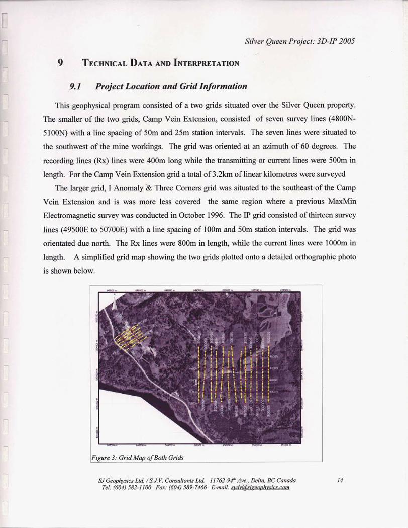
This geophysical program consisted of a two grids situated over the Silver Queen property.
The smaller of the two grids, Camp Vein Extension, consisted of seven survey lines (4800N-
5100N) with a line spacing of 50m and 25m station intervals. The seven lines were situated to
the southwest of the mine workings. The grid was oriented at an azimuth of 60 degrees. The
recording l i e s (Rx) lines were 40Om long while the transmitting or current lines were 500111 in
length. For the Camp Vein Extension grid a total of 3.2km of linear kilometres were surveyed
The larger grid, I Anomaly '62 Three Corners grid was situated to the southeast of the Camp
Vein Extension and is was more less covered the same region where a previous M a i n
Electromagnetic survey was conducted in October 1996. The IP grid consisted of thirteen survey
lines (49500E to 50700E) with a line spacing of lOOm and 5Om station intervals. The grid was
orientated due north. The Rx l i e s were 800m in length, while the current lines were lOOOm in
length. A simplified grid map showing the
is shown below.
otted onto a detailed ortho
IFigure 3: Grid Map of Both Grids
SJ Geophysics Ltd ants Ltd I I762-94* Ave., Delta, BC Canada Tel: (604) 582-11 589-7466 E-mail:
. .
. . . . . .
Silver Queen Project: 3D-IP 2005
9.2 Field Work and Instrumentation
The SJ Geophysics Ltd. crew consisted of five SJ Geophysics employees: Neil Visser
(Geophysical Technician), Robert Ewen (Geophysical Technician), Murray Gauthier, Lauren
Devlin and Brandon Wilbur. The crew conducted the 3D-IP survey from January 18, 2005 to
February 5, 2005, which included 3 days for mobilizatioddemobilization, 6 days of line cutting
and grid preparation and 10 days of IP production. Discussions of the geophysical methods used
for this survey are presented in Section 9.3, “Geophysical Techniques”.
r-
For the Camp Vein Extension grid a modified pole-dipole 3D-IP configuration array was
used with a combination of 10 dipoles of a combination of 25m, 50m and 75m spaced dipoles.
The current injection was situated on the adjacent lines to the north and south of the Rx line and
was located near the centre of the receiving dipole array.
As for the I Anomaly & Three Comers grid, a modified pole-dipole 3D-IP configuration array
was also used except the array used a combination of 10 dipoles of 50m, lOOm and 150m spaced
dipoles. Similary as the Camp Vein Extension, the current injections were on the adjacent lines
to the west and east of the Rx line.
For the two survey grids, all data was collected using an Elrec 10 receiver (Rx). The current
was injected with a 2 seconds on, 2 seconds off duty cycle into the ground via a GDD 3.6Kw
transmitter (Tx).
The dipole array was implemented using a set of 8 conductor cables, one configured with
50m takeouts used for the grid. At each current station, the electrodes used consisted of 518”
stainless steel rods of approximately lm in length. For the potential line, the electrodes consisted
of 3/8” stainless steel “pins” of 0.5m in length. The exact location of the remote current is used
in the geophysical calculations.
SIGeophysics Ltd. 1S.J. V Consultants Ltd. I ! 762-94“ Ave., Della, BC Canada Tel: (604) 582-1 I00 F a : (604) 589-7466 E-mail: svdvii3sizeovhvsics.com
I5
Silver Queen Project: 3D-IP 2005
The IP readings from each day's surveying were downloaded to a computer and entered into a
database archive every evening. The database program allows the operator to display the IP decay
curves in an efficient manner, and this provides a visual review of the data quality. The data is
then processed further to produce field products such as pseudosections of the apparent resistivity
and selected chargeability channels and if time permits. The data is then forwarded back to the
office where the data is quickly checked over again for quality purposes and then processed
further to create a inverted depth volume of the grid.
9.3 Geophysical Techniques
r-
-
9.3.1 IP Method
The time domain IP technique energizes the ground surface with an alternating square wave
pulse via a pair of current electrodes. On most surveys, such as this one, the IPlResistivity
measurements are made on a regular grid of stations along survey lines.
After the transmitter (Tx) pulse has been transmitted into the ground via the current
electrodes, the IP effect is measured as a time diminishing voltage at the receiver electrodes. The
IP effect is a measure of the amount of IP polarizable materials in the subsurface rock. Under
ideal circumstances, IP chargeability responses are a measure of the amount of disseminated
metallic sulfides in the subsurface rocks.
Unfortunately, there are other rock materials that give rise to IP effects, including some
graphitic rocks, clays and some metamorphic rocks (serpentinite for example). So from a
geological point of view, IP responses are almost never uniquely interpretable. Because of the
non-uniqueness of geophysical measurements it is always prudent to incorporate other data sets
to assist in interpretation.
Also, from the IP measurements the apparent (bulk) resistivity of the ground is calculated
from the input current and the measured primaIy voltage.
IPhesistivity measurements are generally considered to be repeatable to within about five
percent. However, they will exceed that if field conditions change due to variable water content
or variable electrode contact.
IPhesistivity measurements are influenced, to a large degree, by the rock materials nearest the
SJ Geophysics Ltd. /S .J V Consultants Ltd. I I 762-94Ih Ave., Delta, BC Canada 16 Tel: (604) 582-1 I00 Fax: (604) 589-7466 E-mail: [email protected]
Silver Queen Project: 3D-IP 2005
surface (or, more precisely, nearest the measuring electrodes), and the interpretation of the
traditional pseudosection presentation of IP data in the past has often been uncertain. This is
because stronger responses that are located near surface could mask a weaker one that is located
at depth.
9.3.2 3D-IP Method
Three dimensional IP surveys are designed to take advantage of the interpretational
functionality offered by 3D inversion techniques. Unlike conventional IP, the electrode arrays
are no longer restricted to in-line geometry. Typically, current electrodes and receiver electrodes
are located on adjacent lines. Under these conditions, multiple current locations can be applied to
a single receiver electrode array and data acquisition rates can be significantly improved over
conventional surveys.
In a common 3D-IP configuration, a receiver array is established, end-to-end along a survey
line while current electrodes are located on two adjacent lines. The survey typically starts at one
end of the line and proceeds to the other end. A typical 8 dipole array normally consists of two
100111 dipoles, followed by four 50m dipoles and then two more lOOm dipoles at the end of the
array. In some areas these spacings are modified to compensate for local conditions such as
inaccessible sites, streams, and overall conductivity of ground. Current electrodes are advanced
along the adjacent lines, starting at approximately 200m from the centre of the array and
advancing approximately 400m through the array at 50m increments. At this point, the receiver
array is advanced 400111 and the process is repeated down the line. Receiver arrays are typically
established on every second line (200m apart) thereby providing subsurface coverage at lOOm
increments.
9.3.3 Inversion Programs
“Inversion” programs have recently become available that allow a more definitive
interpretation, although the process remains subjective.
The purpose of the inversion process is to convert surface IPlResistivity measurements into a
realistic “Interpreted Depth Section.” However, note that the term is left in quotation marks.
The use of the inversion routine is a subjective one because the input into the inversion routine
SI Geophysics Lfd. /S.J Y Comultanfs Lid. 11762-94“ Ave., Delta, BC Canada 17 Tel: (604) 582-1 100 Far: (604) 589-7466 E-mail: [email protected]
Silver Queen Project: 3D-IP 2005
calls for a number of user selectable variables whose adjustment can greatly influence the output.
The output from the inversion routines do assist in providing a more reliable interpretation of
IPksistivity data, however, they are relatively new to the exploration industry and are, to some
degree, still in the experimental stage. r
The inversion programs are generally applied iteratively to evaluate the output with regard to
what is geologically known, to estimate the depth of detection, and to determine the viability of
specific measurements.
The Inversion Program (DCINV3D) used by the SJ Geophysical Group was developed by a
consortium of major mining companies under the auspices of the UBC-Geophysical Inversion
Facility. It solves two inverse problems. The DC potentials are first inverted to recover the
spatial distribution of electrical resistivity, and, secondly, the chargeability data (IP) are inverted
to recover the spatial distribution of IP polarizable particles in the rocks.
The interpreted depth section maps represent the cross sectional distribution of polarizable
materials, in the case of IP effect, and the cross sectional distribution of the apparent resistivity,
in the case of the resistivity parameter.
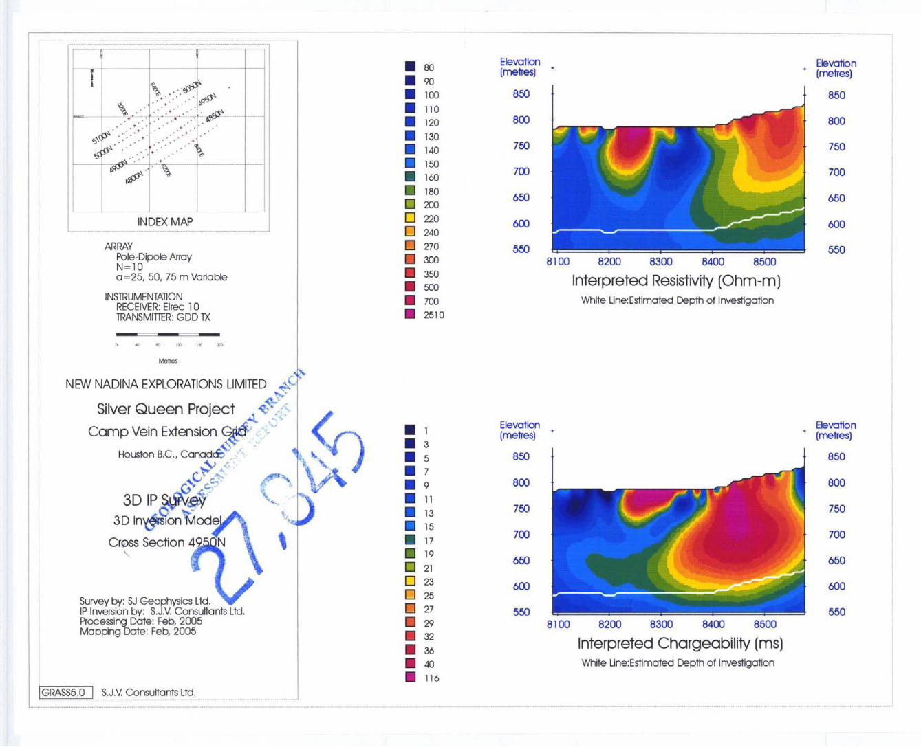
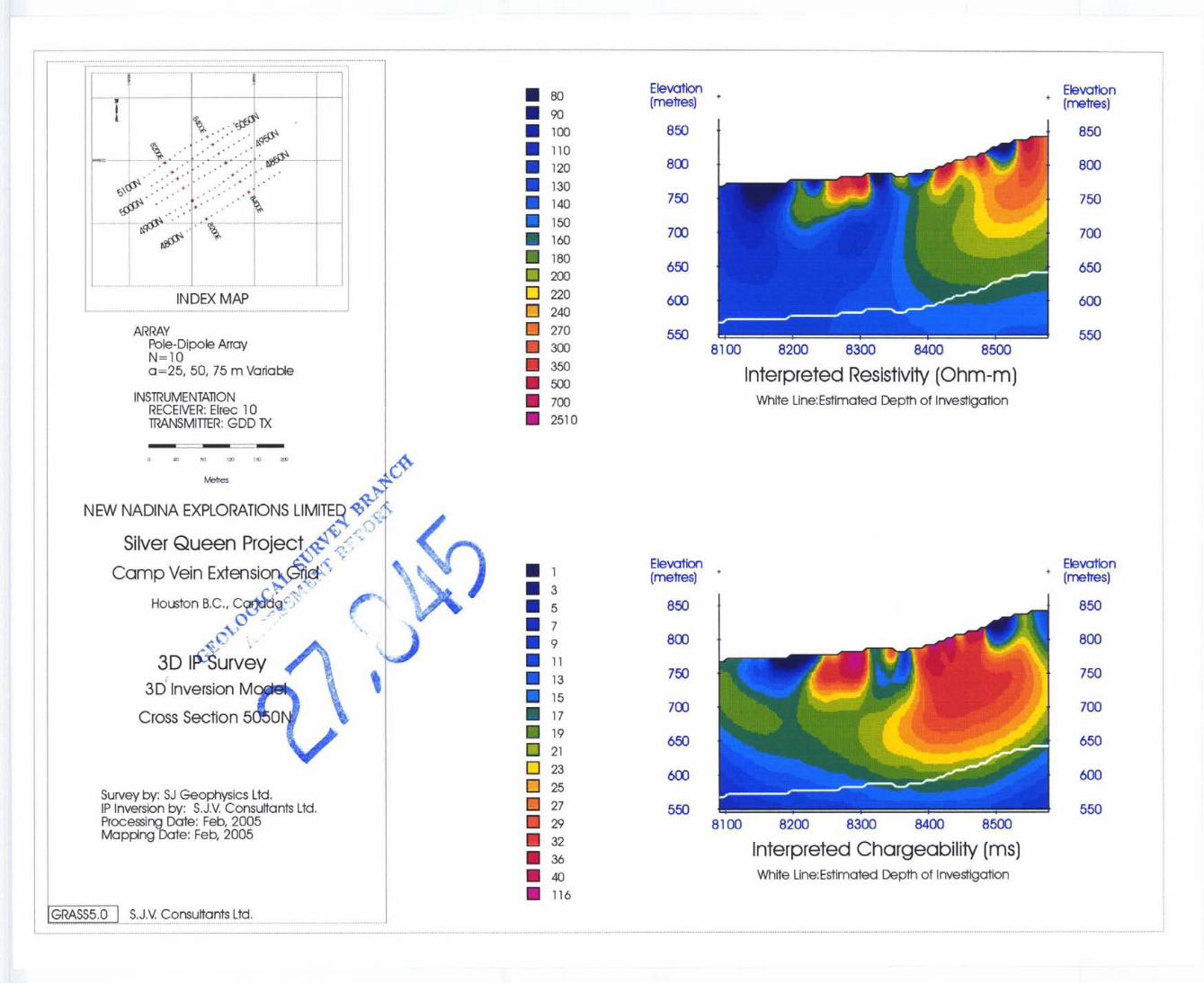
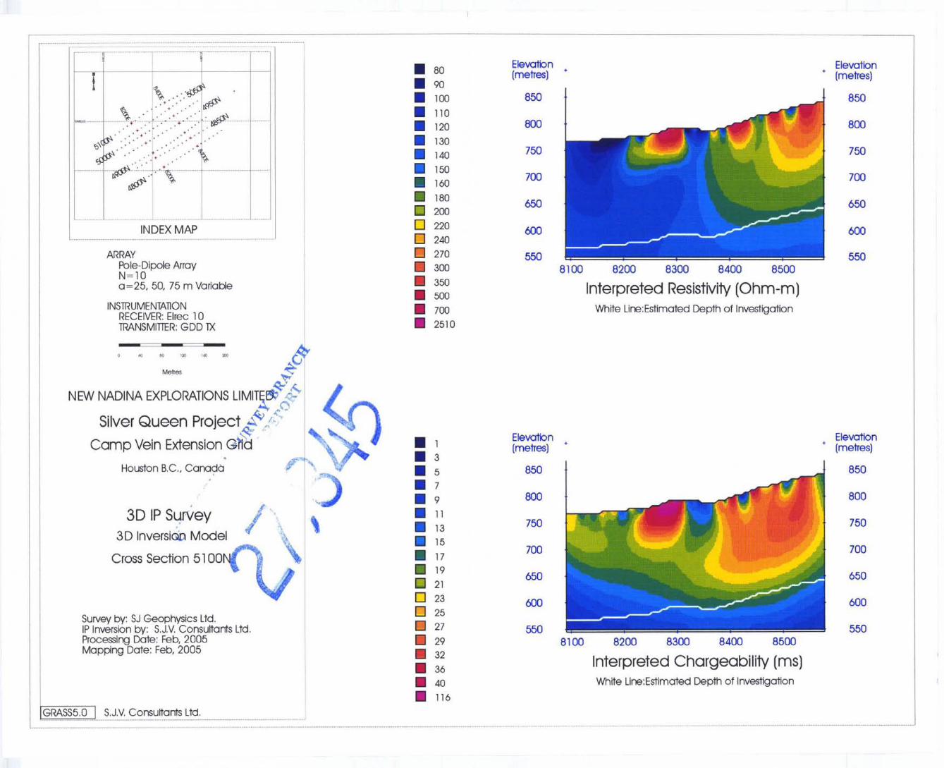
9.4 Data Presentation
9.4.1 Cross Sections
As described above, the IP data is processed through an inversion program that outputs one
possible subsurface distribution of resistivity and polarizable materials that would produce the
observed data. These results are presented in a false-colour cross section and these displays can
be directly interpreted as geological cross sections.
Cross sections are presented as 15000 scale plots in map folders at the back of this report.
9.4.2 Plan Maps
False colour contour maps of the inverted resistivity and chargeability results can be
produced for selected depths. Data is positioned using UTM coordinates gathered during the field
work. This display illustrates the areal distribution of the geophysical trends, outlining strike
orientations and possible fault offsets.
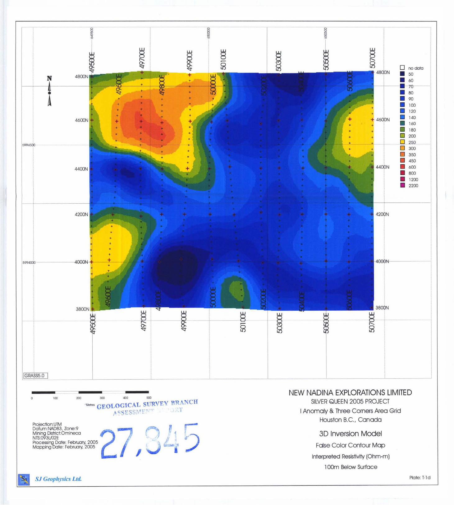
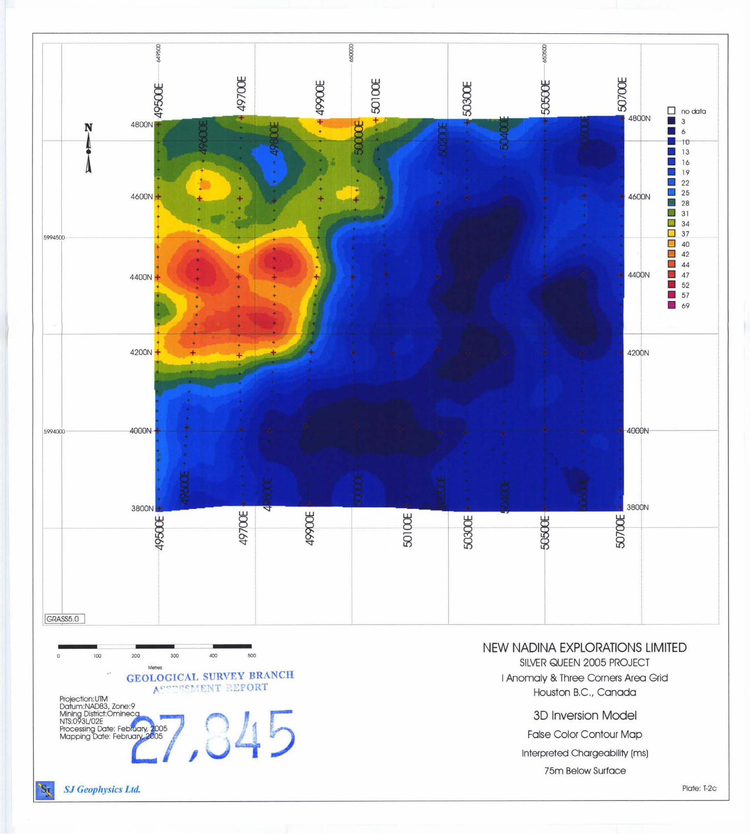
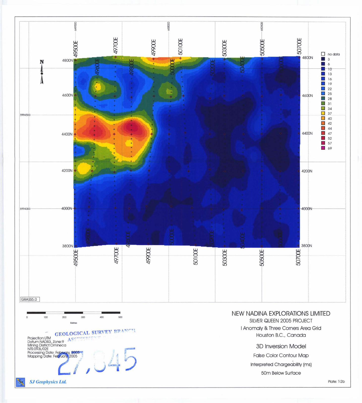
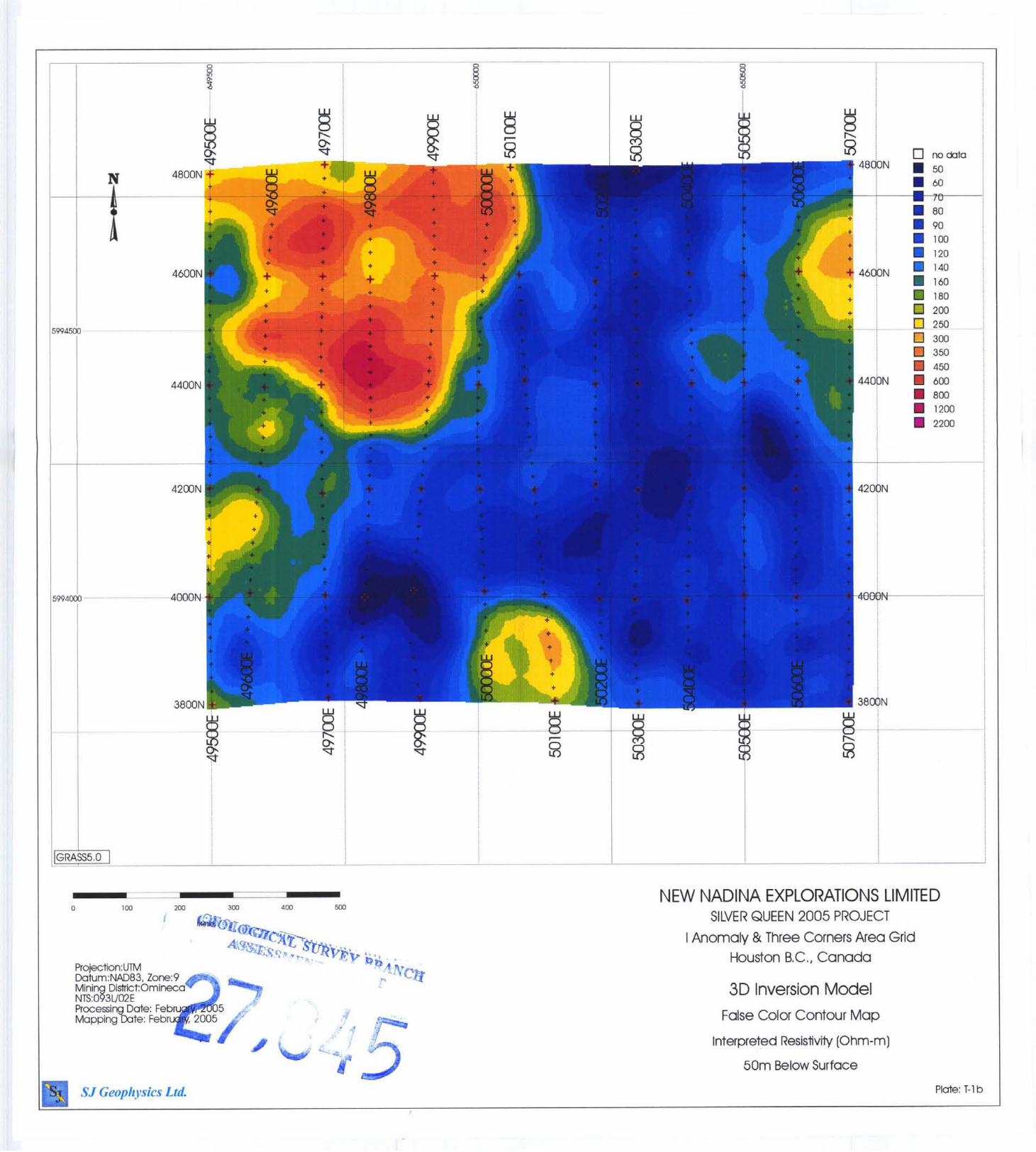
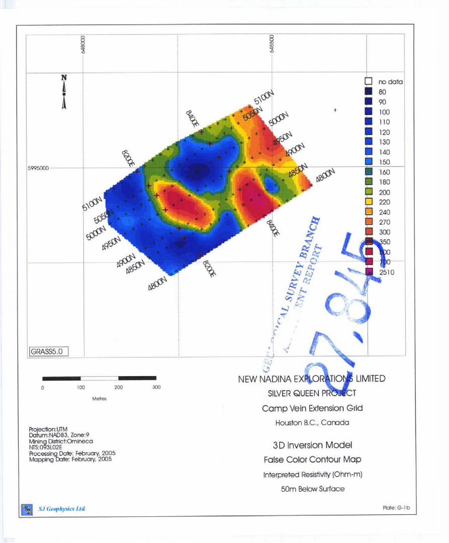
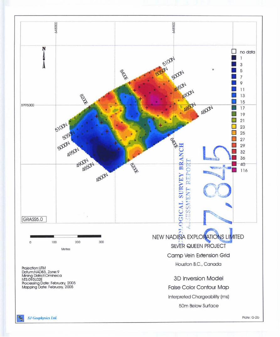
Plan maps are plotted for both resistivity and chargeability at depths of 25m, 50m, 75m,
SIGeophysirs Ltd. /S.J. Y Consultants Ltd. l 1762-94Ih Ave., Delta, BC Canada 18 Tel: (604) 582-1100 Fox: (604) 589-7466 E-mail: [email protected]
Silver Queen Project: 3D-IP 2005
loom, 150m and 200m below surface at a 1:SOOO scale and included in map folders at the back
of this report.
r 9.4.3 Inversion Model
With computer technology that exists today, the 3D inversion results can be easily viewed
using a 3D visualization program such as UBC-GIF's Dicer3d program or open-source software
packages such as Paraview. These programs use a block model format to manipulate the data
and allow a user to view the model from infinite viewing angles, or to create infinite cross-
sections or plan maps. In addition, these visualization programs allow the user to isolate
different isosurfaces/volumes to facilitate interpretation of the data.
SJGeophysics Lid. / S . J Y Consultants Lid. 11762-94" Ave.. Delta, BC Canada Tel: (604) 582-1 100 Far: (604) 589-7466 E-mail: [email protected]
19
Silver Queen Project: 3D-IP 2005
y.3 uiscusscon OJ Geophysical Results
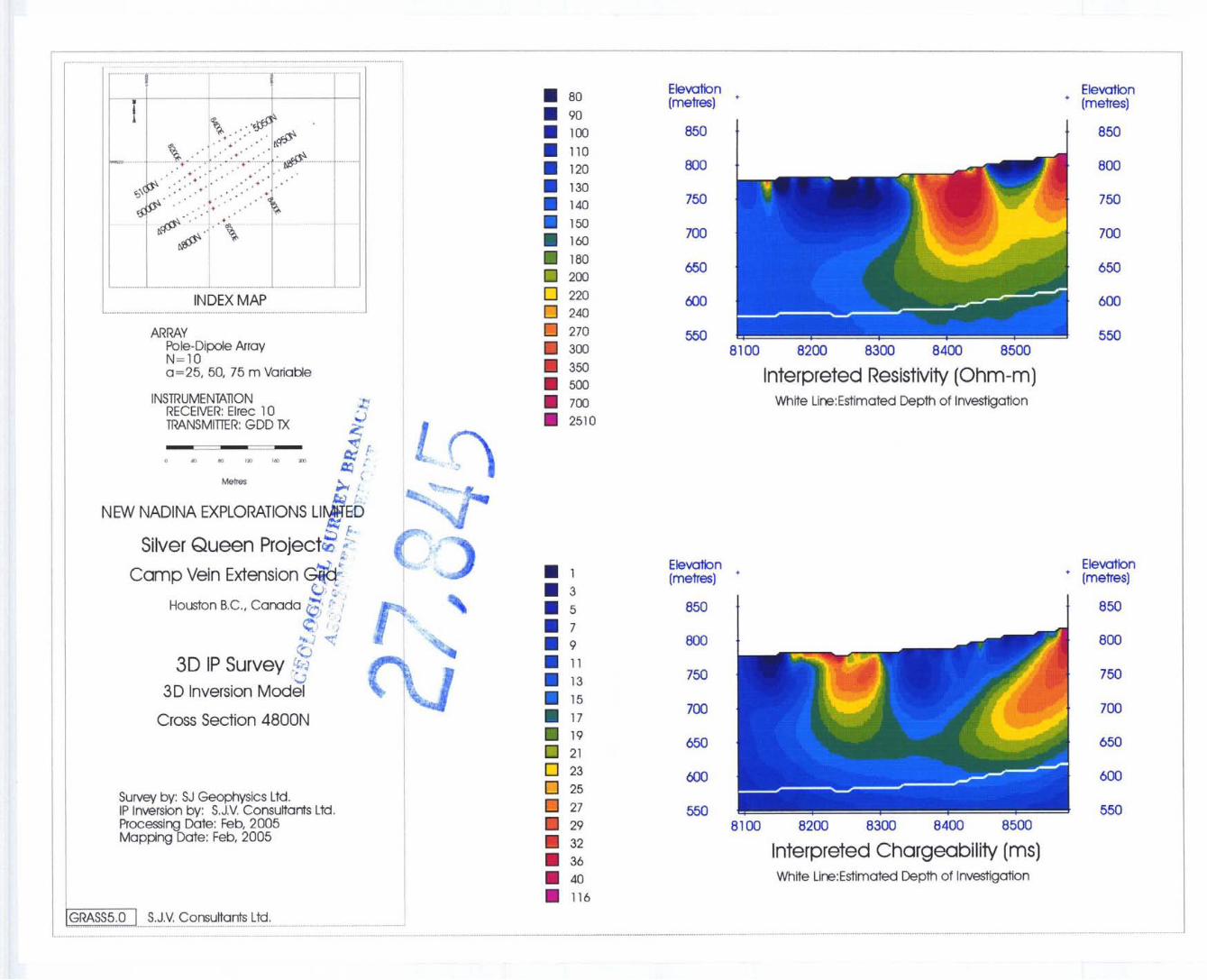
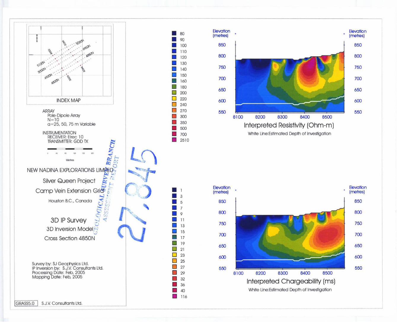
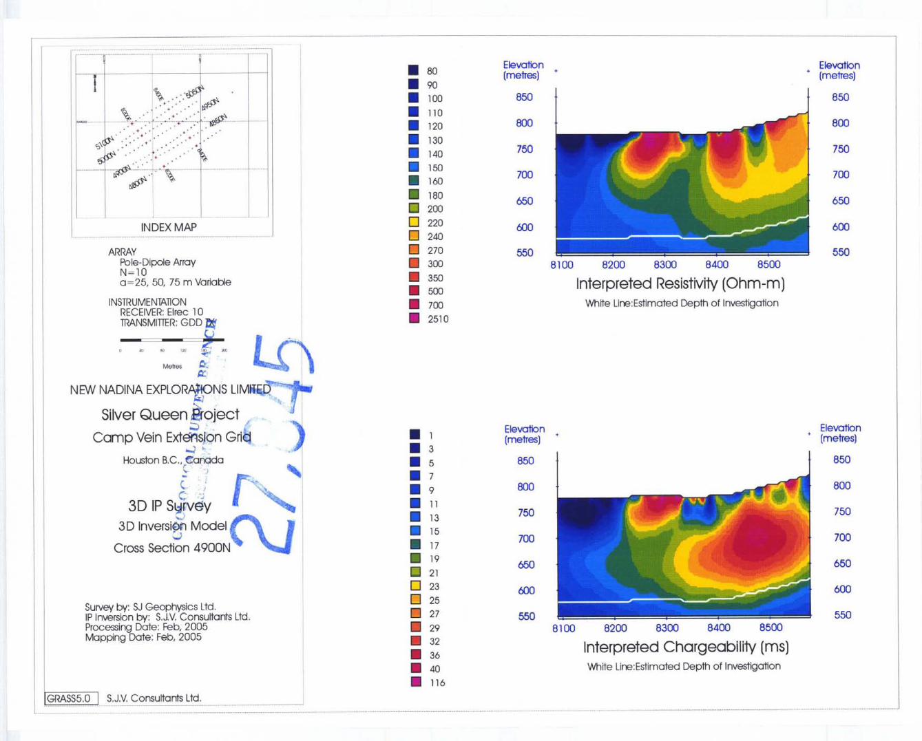
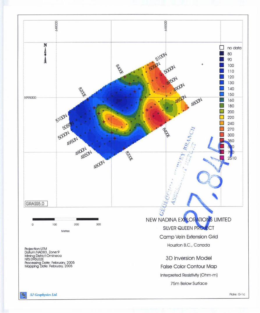
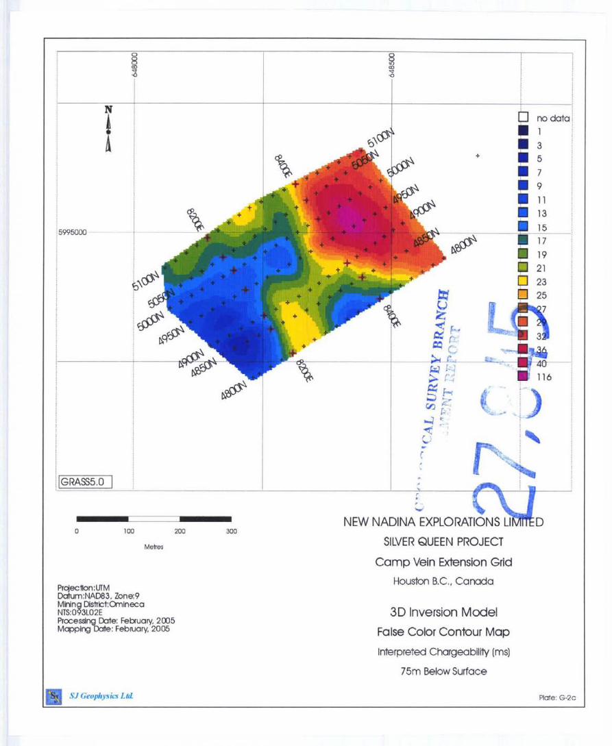
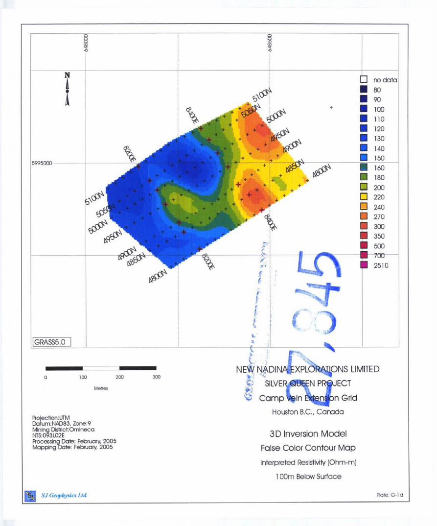
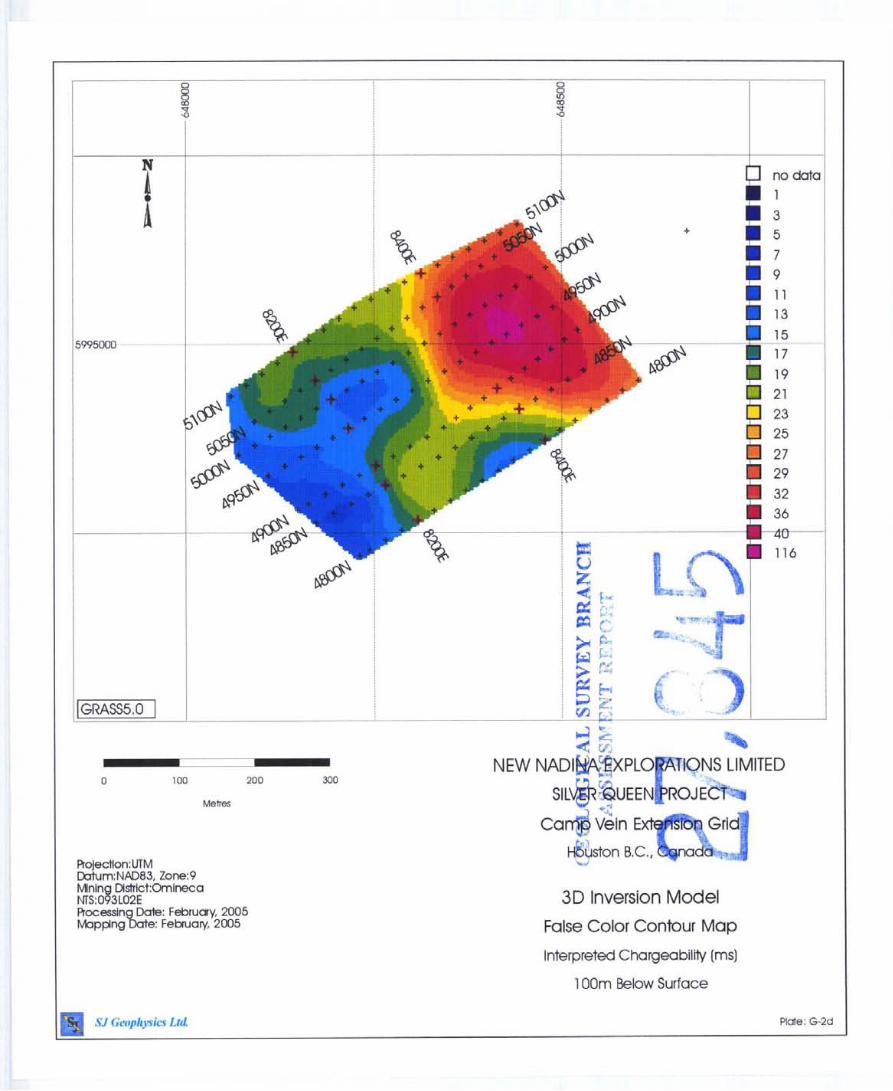
9.5.1 Camp Vein Extension Grid
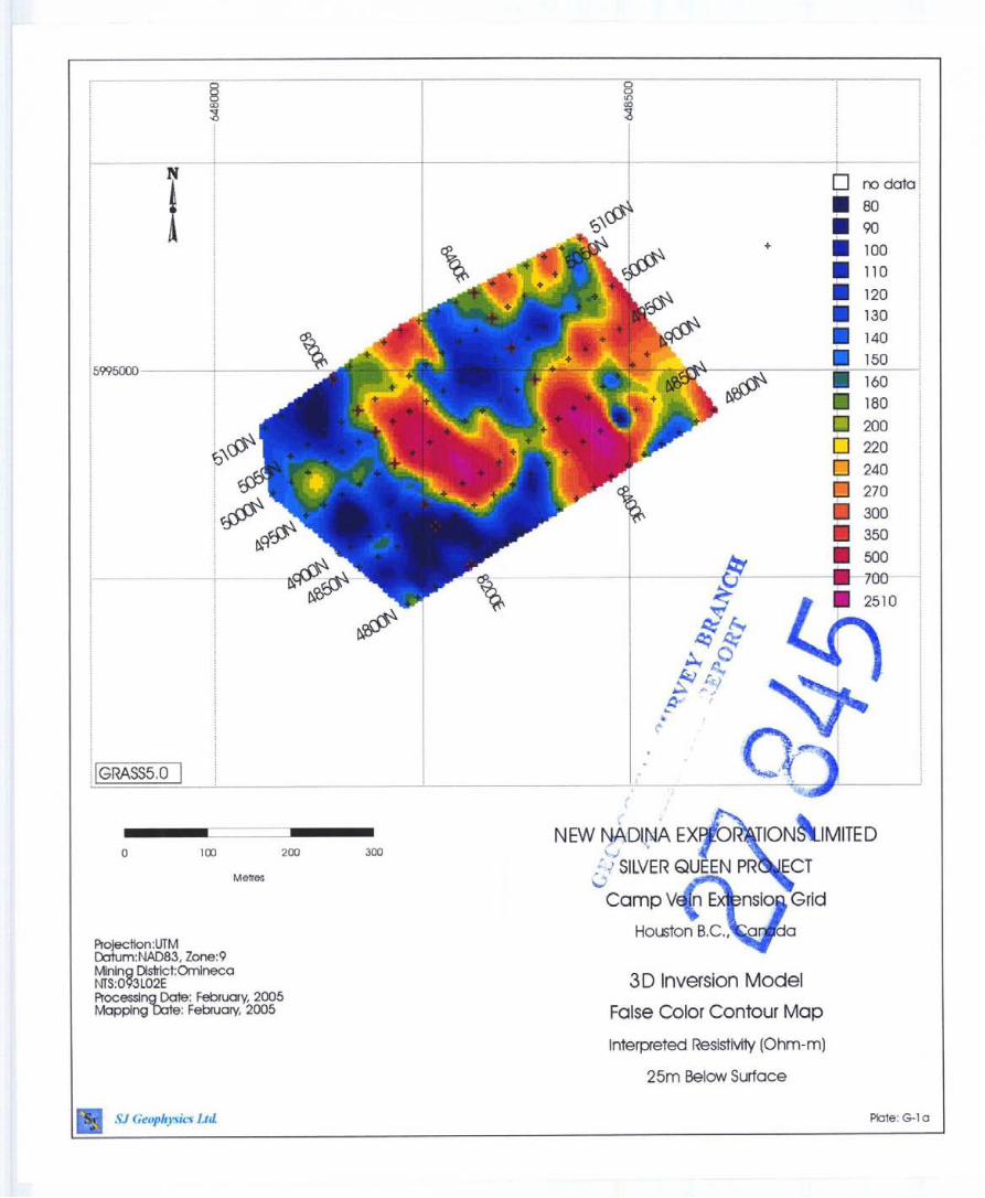
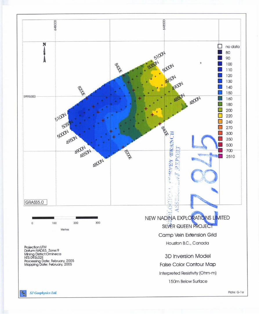
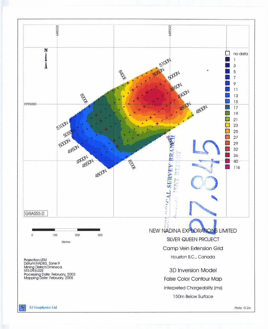
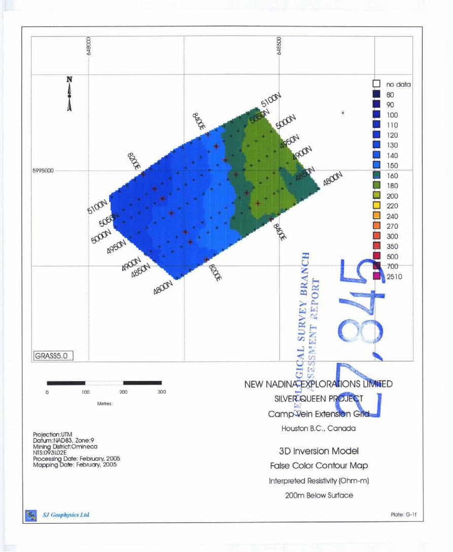
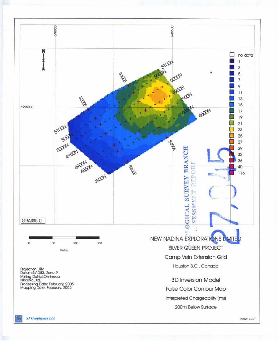
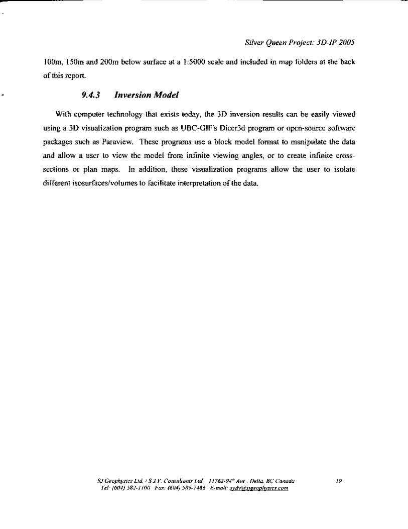
The inverted chargeability volume for the Camp Vein Extension grid shows two distinctive
regions of anomalous high chargeability material. The first and most southern region indicates a
linear feature trending NW-SE across the survey traverses. This feature is defined as the region
between the black annotated lines A and B in Figure x below. The second feature, is the region
north (local coords) of Station 8400E (Line C in Figure 2).
Examination of both the chargeability and resistivity volumes for the two above regions
indicate that these two chargeability features have different characteristics; therefore, indicating
they are not the result of the same geological setting. The following three dimensional view
(Figure 3 below) of the chargeability volume at an arbitrary isosurfaces of 33ms highlight this
point. From the image, it can be clearly seen that the southern chargebility feature is confined to
a depth of approximately 50m ; whereas, the northern feature is a more continuous body
extendmg to depths greater than 100m. The resistivity values indicate a strong correlation with
the linear feature suggesting it may be vein like feature. The continuous body may be the result
of an intrusive body.
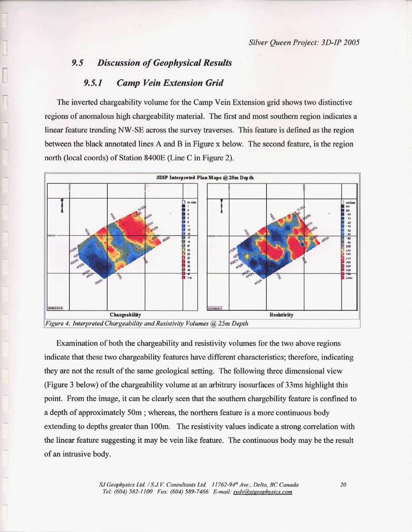
SI Geophysics Ltd /S J V. Consultants Ltd I 1 762-94* Ave , Delta, BC Canada 20 TEI. (604) 582-1100 Fax. (604) 589-7466 E-mail. svdv63sieeovhvsics com
-- - - -
geophysical grid overlayed onto an aerial photo shows many cultural features within the grid.
For example, was there waste rock dumped at this site which give a response to a shallow surface
feature? . . . . . .
XJGeophysics Ltd. /S.J Y. Consultants Ltd. I 1 762-94Ik Aye., Delta, BC Camda Tel: (604) 582-1100 Far: (604) 589-7466 E-mail: svdv(iisizeoohvsics.com
The 1996 Max-Min EM survey is annotated by the red northerly lines, whereas, the yellow
points indicate the present geophysical survey. The east-west lines with the white lettered label
denote the interpretation of the Em survey. The underlying raster is the plan map for
chargeability at loom depth below the surface.
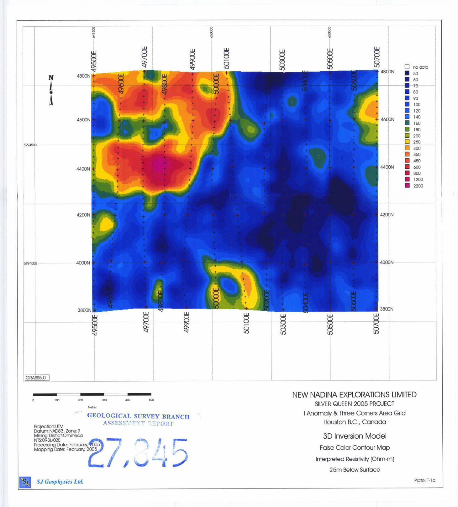
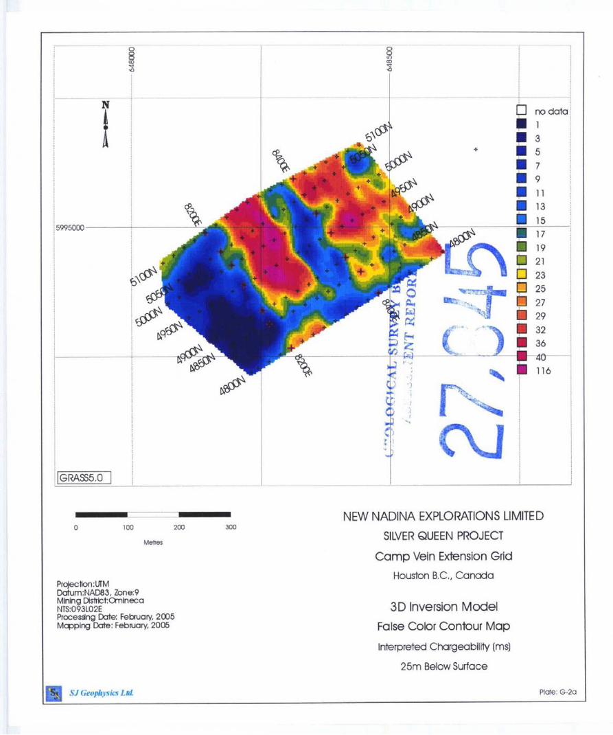
The results of the IP survey indicate that the majority of the surveyed grid is comprised of
relatively low chargeable material. The northwest corner of the survey is the only region that
indicates an anomalous chargeable feature. This sharp contrast between the northwest corners
and the remainder of the survey grid may indicate a geological contact. The resistivity plan maps
correlates with the chargeability data and suggests a similar break in the geology.
Two prominent features exist in the northwest comer. One at the surface and the other at
depth. The surface feature runs east-west and is approximately 150 m long and extends 50m
SJ Geophysics Lid / S J V Conrultants Lld I 1762.98 Ave , Delta, BC Canada 22 Tel (604) 582-1100 Fax (604) 589-7466 E-mail [email protected]
. . Silver Queen Project 3D-IP 2005
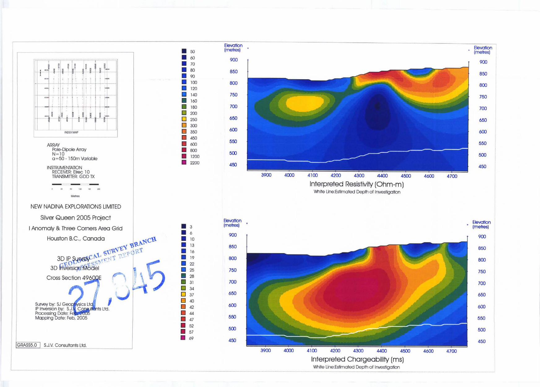
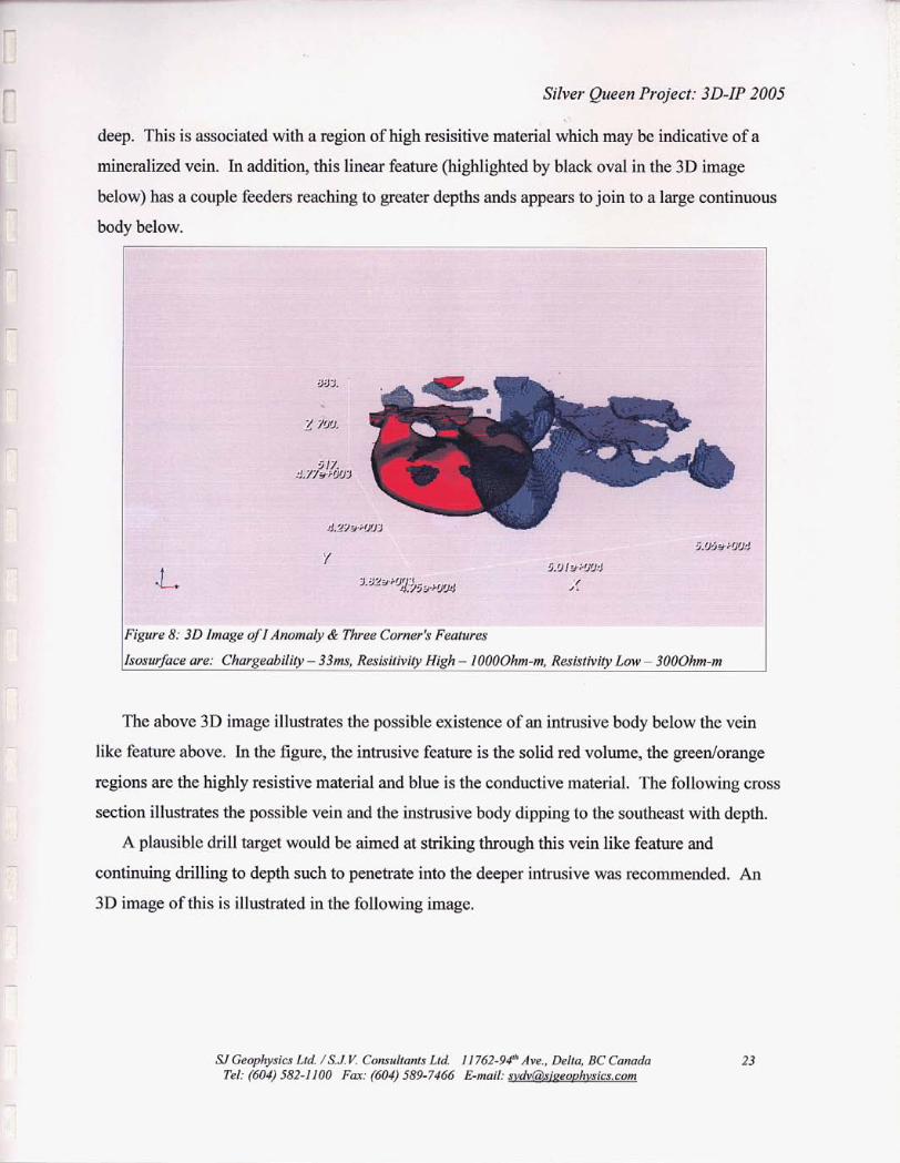
mineralized vein. In addition, this linear feature (highlighted by black oval in the 3D image
below) has a couple feeders reaching to greater depths ands appears to join to a large continuous
. . . .
. . . .
. . . .
SJGeophysics Ltd. /S.J V. Consultants 62-94" Ave., Delta, BC Canada
Silver Queen Project: 3D-IP 2005 .:
665
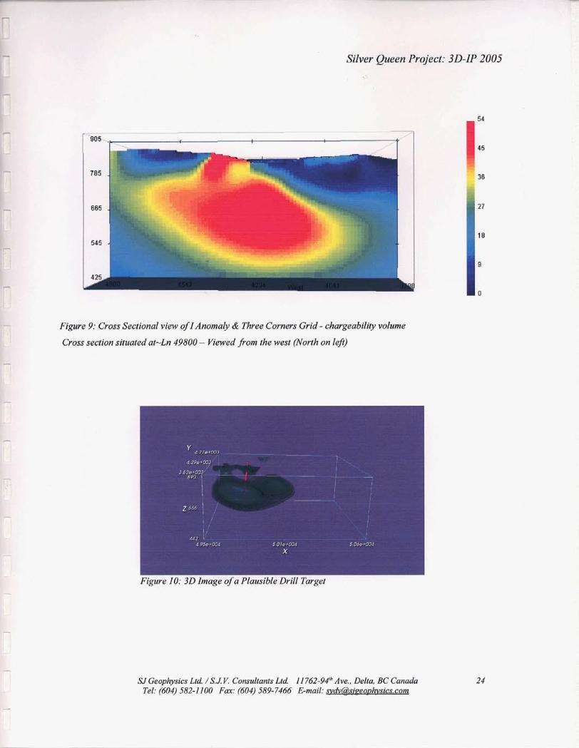
545 .
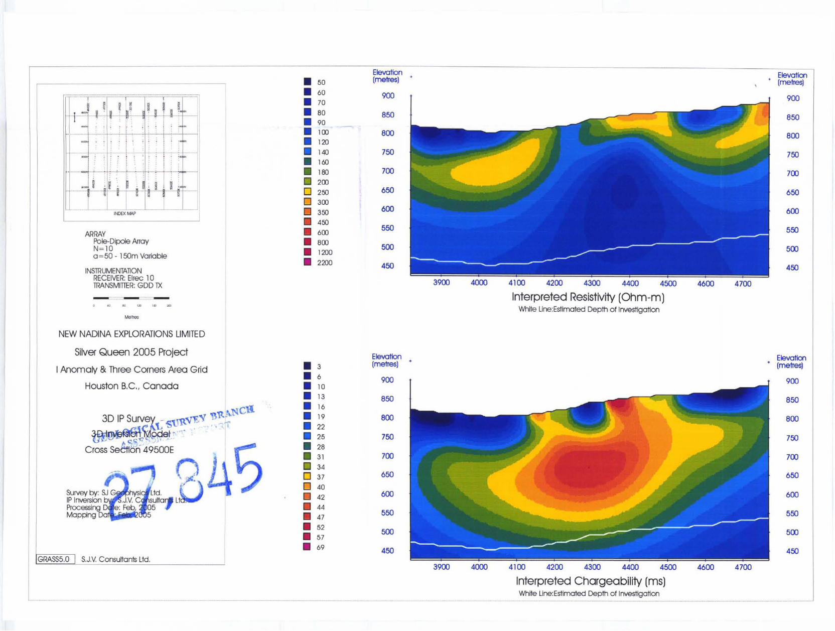
. . . . Figure 9: Cross Sectional view ofIAnomoly & Three Corners Grid - chargeability volume
Cross section situated at-Ln 49800 - Viewed from the west (North on leji) . . .
. . . .
I Figure 10: 3 0 Image of a Plausible Drill Target
SI Geophysics Ltd. /SJ V. Consultants Ltd. I 1 762-94Ih Ave., Delta, BC Canada Tel: (604) 582-1100 Fax: (604) 589-7466 E-mail: [email protected]
- -
Silver Queen Project: 3D-IP 2005
10 CONCLUSIONS AND RECOMMENDATIONS
Thc Camp Vein Extension grid indicates that the known vein system in the region continues
to the west. Although the geophysical linear vein feature outlined appears to be geophysical
appropriate, caution should be taken with this interpretation in regards to the cultural noise that
exists within the grid. An interesting deeper feature appears uphill from this feature and warrants
further investigation.
Similarly, to the Camp Vein Extension, the I Anomlay & Three Corners grid show similar
features on its western portion of the grid. Its vein like feature lies directly above a large
chargeable body of depth which may be indicative of an intrusive body. This region should be
considered for any future drilling in the region. One of the main purposes for this geophysical
survey was to further investigate the anomalous features outlined by the 1996 MaxMin survey,
especially the I Anomaly. Unfortunately, east of a strong feature outlined by the IP survey, the IP
data provided no additional information on those features. The lack of information does not rule
out the significance of the MaxMin features outlined in 1996.
Respectfully Submitted,
per S.J.V. Consultants Ltd.
Shawn Rastad, BSc.
Geophysics, Geology
UGeophysics Lld !SJ. Y. Consullunts Ltd 11?62-9X" rlve.. Delta. BC Cunada Tel: (604) 582-1100 Fax: (604) 589-7466 E-mail: -ic s. COIII
25
. -
?-A
Silver Queen Project: 3D-IP 2005
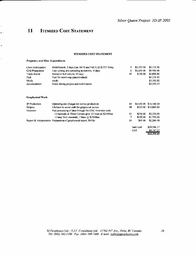
11 ITEMIZED COST STATEMENT
ITEMIZED COST STATEMENT
Prepatory and Misc. Expenditures
Crew mobilization Grid Preparation Truck Rental Fuel Fuel for crew's equipmentlvehicle Meals meals Accomodation
Mobmemob; 3 days (Jan 18/19 and Feb 5) @ $1237.5/day Line cutting and surveying in stations, 6 days Rental of 4x4 vehicle; 19 days
hotels during project and mobilization
Geophysical Work
IP Production Helpers Inversion
Operating day charges for survey production 3 helpers to assist with the geopysical survey Post processing of data through the UBC Inversion code
- I Anomaly & Three Corners grid; 13 lines @ $250fline - Camp Vein Anomaly; 7 lines @ $250fline
Report & Interpretation Preparation of geophysical report; $ 9 5 h
3 $1,237.50 $3,712.50 6 $1,650.00 $9,900.00
19 $150.00 $2,850.00 $1,270.42 $3,381.02 $3,552.23
10 $1,650.00 $16,500.00 48 $225.00 $10,800.00
13 $250.00 $3,250.00 7 $250.00 $1,750.00
24 $95.00 $2,280.00
SubTotal $59,246.17 GST $4,147.23
$63393.40
SI Geophysics Ltd. / S.J. V. Consultants Ltd. I I 762-94'h Ave., Delta, BC Canada Tel: (604) 582-1 100 Fax: (604) 589-7466 E-mail: s v d v ~ ~ i ~ e o u h v s i c s . c o m
26

c.-
Silver Queen Project: 3D-IP 2005
12 REFERENCES
Candy, C., 1996. Report of a Max-Min Electromagnetic Survey, Silver Queen Project, Houston, B.C. by Frontier Geosciences Inc. In-house report #837.
Caron, L, 1996. Assessment Report on 1996 Spring Drill Program, Silver Queen Property, for New Nadina Explorations Limited. September 1996.
Cheng, X.L., 1995. A Quantitative Evaluation of Hydrothermal Alteration at Silver Queen Deposit, A Precious- and Base-Metal Epithermal Vein System in Volcanic Rocks. PhD thesis, University of British Columbia, 1995.
Church, B.N. and J.J. Barasko, 1990. Geology, Lithogeochemistry and Mineralization in the Buck Creek Area, British Columbia. B.C. Geological Survey Branch, Paper 1990-2.
Hood, C., 1991. Mineralogy, Paragenesis, and Mineralogical Zonation of the Silver Queen Vein System, Owen Lake, Central British Columbia. M.Sc. Thesis, University of British Columbia, 1991.
Leitch, C.H.B., C.T. Hood, X.L. Cheng and A.J. Sinclair, 1991. Tip Top Hill volcanics: Late Cretaceous Kasalka Group rocks hosting Eocene epithermal base- and precious-metal veins at Owen Lake, west-central British Columbia. Canadian Journal of Earth Sciences, Vol29, p. 854-864.
SJ Geophysics Ltd. / S. J. V. Consultants Ltd. I I 762-94" Ave., Delta, BC Canada Tel: (604) 582-1 I00 Fax: (604) 589-7466 E-mail: [email protected]
27
P
,-
Silver Queen Project: 3D-IP 2005
13 APPENDIX 1 - STATEMENT OF QUALIFICATIONS
13.1 Syd Visser, P. Geo
I, Syd J. Visser, of 11762 - 94th Avenue, Delta, British Columbia, hereby certify that,
1) I am a graduate from the University of British Columbia, 198 1 , where I obtained a
B.Sc. (Hon.) Degree in Geology and Geophysics.
2) I am a graduate from Haileybury School of Mines, 1971.
3) I have been engaged in mining exploration since 1968
ritish Columbia
-c
.- ....-- -*,,-.,* Syd Visser, B.Sc., P.Geo.
Geophysicist/Geologist
SJ Geophysics Ltd. /S.J. V. Consultants Ltd. I 1762-94" Ave., Delta, BC Canada Tel: (604) 582-1 I00 Fax: (604) 589-7466 E-mail: svdvkdMzeouhvsics.com
28
Silver Queen Project: 3D-IP 2005
13.2 Shawn Rastad
I, Shawn Rastad, of the city of Coquitlam, Province of British Columbia, hereby certify that:
I graduated from the University of British Columbia in 1996 with a Bachelor of Science
degree majoring in geophysics.
I have been working in mineral and oil exploration since 1997.
I have no interest in New Nadina Resources Limited, or in any property within the scope
of this report, nor do I expect to receive any.
Signed by: 55z32fgg Shawn Rastad, B.Sc.
Geophysics
Date: A c/ 0 2 . h r
.%I Ceopbsics hd. S. J. V. Consultants Ltd I I762-94” .Ire.. Delta, BC Canada Teiel: (604) S82- I I00 Fax: f604) 589- 7466 E-mail: b o D h v s i m
29

Silver Queen Project: 3D-IP 2005
Line
49500 49600
49700 49800 49900
50000 50100 50200
50300 50400 50500
- p ~
. --
14 APPENDIX 2 - SUMMARY TABLES
LSeries BOL StSeries EOL StSeries Length
-- -pp -~ Station
p -
Station N 3800 E 4800 E 1000 N 4700 E 800 E 3900 N 3 800 E 4800 E 1000
800 N 3900 E 4700 E E 4800 E 1000 N
800 N 3900 E 4700 E 1000 E 4800 E N
N 3900 E 4700 E 800 1000 N 3 800 E 4800 E
N 3900 E 4700 E 800
N 3 800 4800 1000
- --
-~ ~p . p -
- p p~ ~p
---
3800 -p . -
p - - -~
- % ~-
3800 --p --
-~ -~
~ ~%
-p-- -
14.1 Camp Vein Extension % - --
Line LSeries BOL StSeries EOL StSeries Length
Station - - -
Station ~~ -
N 8050 E 8550 E N 8100 E 8500 E
N 8050 E 8550 E 4950 N 8100 E 8500 E
_ _ -p -- -
_ _
400 N 8050 E 8550 E 500
-- --pp --
14.2 IAnomaly & Three Corners Grid
SJ Geophysics Ltd. /S.J. V. Consultants Ltd. 11 762-94" Ave., Delta, BC Canada Tel: (604) 582-1 100 Fax: (604) 589-7466 E-mail: svdv@&eovhvsics.com
1000
30
Silver Queen Project: 3D-IP 2005
P
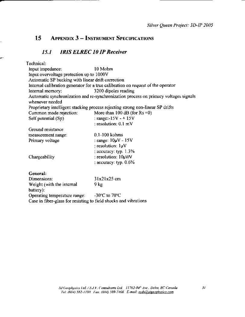
15 APPENDIX 3 - INSTRUMENT SPECIFICATIONS
15.1 IRIS ELREC 10 IP Receiver
Technical: Input impedance: 10 Mohm Input overvoltage protection up to 1 OOOV Automatic SP bucking with linear drift correction Internal calibration generator for a true calibration on request of the operator Internal memory: 3200 dipoles reading Automatic synchronization and re-synchronization process on primary voltages signals whenever needed Proprietary intelligent stacking process rejecting strong non-linear SP drifts Common mode rejection: Self potential (Sp)
Ground resistance
Primary voltage
More than 100 dB (for Rs =0) : range:-15V - + 15V : resolution: 0.1 mV
measurement range: 0.1-100 kohms : range: lOvV - 15V : resolution: luV : accuracy: typ. 1.3%
: accuracy: typ. 0.6% Chargeability : resolution: 1OpVN
General: Dimensions: 31x21~25 cm
battery): Operating temperature range: Case in fiber-glass for resisting to field shocks and vibrations
Weight (with the internal 9 kg
-30°C to 70°C
SJ Geophysics Ltd. / S. J. V. Consultants Ltd. I I 762-94" Ave., Delta, BC Canada Tel: (604) 582-1 I00 Fax: (604) 589-7466 E-mail: [email protected] -
31

r c -
-
*’
-
Silver Queen Project: 3D-IP 2005
15.1 GDD Tx 11 IP Transmitter
Input voltage:
Output power: Output voltage: Output current: Time domain: Operating temp. range Display Dimensions (h w d): Weight:
120V / 60 Hz or 240V / 50Hz (optional)
1.4 kW maximum. 150 to 2000 Volts 5 ma to IOAmperes Transmission cycle is 2 seconds ON, 2 seconds OFF
Digital LCD read to 0.001A 34x21 x39cm 20kg.
-4OOto +65O C
SY Geophysics Ltd /S.J V. Consultants Lid I 1762-94” Ave., Delta, BC Canada Tel: (604) 582-1 100 Fax: (604) 589-7466 E-mail: svdvk3siPeouhvsics.com
32