Embed Size (px)
Citation preview

303 Second Street, 300 South San Francisco, California 94107
415-243-2150 FAX 415-896-0999
Annual Report 2014 Water Year
Scotts Valley Water District Groundwater Management
Program
16 June 2015
Prepared for
Scotts Valley Water District Two Civic Center Drive
Scotts Valley, California 95066
K/J Project No. 1468003*00
Annual Report 2014 Water Year Scotts Valley Water District i Groundwater Management Program g:\is-group\admin\job\14\1468003.00_svwd\09-reports\2014-annual-report\text.doc
Table of Contents
List of Tables ................................................................................................................................ iii
List of Figures............................................................................................................................... iii
Executive Summary ................................................................................................................ ES-1
Section 1: Introduction .................................................................................. 1
1.1 District Overview .................................................................................... 1 1.2 Groundwater Management Goals and Objectives ................................. 1 1.3 Annual Report Format ............................................................................ 2
Section 2: Groundwater Management Area .................................................. 3
2.1 Groundwater Basin ................................................................................ 3 2.1.1 Santa Margarita Groundwater Basin ........................................... 3 2.1.2 DWR Groundwater Basins .......................................................... 3 2.1.3 Reported Groundwater Basin ...................................................... 4
2.2 Groundwater Management Area ............................................................ 5 2.3 Historic Groundwater Issues .................................................................. 5
Section 3: Water Supply Summary ................................................................ 7
3.1 Precipitation Summary ........................................................................... 7 3.2 SVWD Water Supply .............................................................................. 7
3.2.1 Recycled Water Usage ............................................................... 8 3.2.2 Changes in Water Use Trends .................................................... 9
3.3 Regional Groundwater Production ......................................................... 9 3.4 SVWD Production Wells ....................................................................... 11
3.4.1 Groundwater Production by Well .............................................. 11 3.4.2 Groundwater Production Wells ................................................. 11 3.4.3 Groundwater Levels in Production Wells .................................. 12
Section 4: Groundwater Quality Assessment ............................................. 13
4.1 SVWD Groundwater Quality and Treatment ........................................ 13 4.1.1 Groundwater Quality ................................................................. 13 4.1.2 Groundwater Treatment ............................................................ 14
4.2 Environmental Compliance Sites ......................................................... 15 4.2.1 Watkins-Johnson Superfund Site .............................................. 15 4.2.2 Scotts Valley Dry Cleaners ....................................................... 16 4.2.3 Camp Evers Combined Site ...................................................... 16 4.2.4 Shaffer, Meisser & Rogers Property ......................................... 17 4.2.5 Hacienda Drive Shell Site ......................................................... 17 4.2.6 King’s Cleaners ......................................................................... 18 4.2.7 Frank’s Auto Dismantlers .......................................................... 18
4.3 Recycled Water Monitoring Program ................................................... 18

Table of Contents (cont’d)
ii Annual Report 2014 Water Year Scotts Valley Water District Groundwater Management Program g:\is-group\admin\job\14\1468003.00_svwd\09-reports\2014-annual-report\text.doc
Section 5: Groundwater Conditions ............................................................ 19
5.1 Aquifer Conditions ................................................................................ 19 5.1.1 Santa Margarita Aquifer ............................................................ 19 5.1.2 Monterey Aquifer ...................................................................... 20 5.1.3 Lompico Aquifer ........................................................................ 20 5.1.4 Butano Aquifer .......................................................................... 21
5.2 Aquifer Storage Analysis ...................................................................... 21
Section 6: Groundwater Management Programs ........................................ 24
6.1 Groundwater Augmentation Projects ................................................... 24 6.1.1 Water Conservation Program ................................................... 24 6.1.2 Recycled Water Program .......................................................... 24 6.1.3 Low Impact Development Projects ........................................... 24 6.1.4 Regional Intertie Project............................................................ 25 6.1.5 Prop 84 Santa Margarita Groundwater Modeling Project ......... 25
6.2 Groundwater Management Monitoring Program .................................. 26 6.2.1 SVWD Data Collection .............................................................. 26 6.2.2 CASGEM Program ................................................................... 27
6.3 Stakeholder Outreach .......................................................................... 28
Section 7: Upcoming Groundwater Management Topics ........................... 29
7.1 Drought Mandatory Water Restrictions ................................................ 29 7.2 Sustainable Groundwater Management Act ........................................ 29 7.3 Groundwater Management Programs .................................................. 30 7.4 Groundwater Monitoring ...................................................................... 30
References ................................................................................................................................. 32
Annual Report 2014 Water Year Scotts Valley Water District iii Groundwater Management Program g:\is-group\admin\job\14\1468003.00_svwd\09-reports\2014-annual-report\text.doc
List of Tables
1 WY2007 to WY2014 SVWD Groundwater Production by Aquifer and Recycled Water Usage (in Acre-Feet)
2 WY2007 to WY2014 Groundwater Production in the GWRA by Aquifer (in Acre-Feet) 3 WY2007 to WY2014 SVWD Groundwater Pumping by Well (in Acre-Feet) 4 Summary of Well Completion Data for Currently-Active SVWD Production Wells 5 WY2014 Summary of Key Water Quality Constituents in Groundwater 6 Summary of Water Treatment Processes Applied by SVWD 7 Model-Simulated Change in Aquifer Storage for the GWRA by Aquifer (in Acre-Feet) 8 Wells Used for the Groundwater Management Monitoring Program
List of Figures
1 Scotts Valley Water District and Location of Key Wells 2 Santa Margarita Groundwater Basin 3 Cross-Section Across Scotts Valley Area 4 DWR Groundwater Basins 5 SVWD Groundwater Management and Reporting Areas 6 Annual Precipitation for Scotts Valley by Water Year 7 Annual SVWD Groundwater Production 8 Annual and Cumulative Recycled Water Usage 9 SVWD Monthly Groundwater Production Comparison 10 Regional Groundwater Production in GWRA by User Type 11 Locations of Environmental Compliance Sites 12 Groundwater Management and Recycled Water Monitoring Program Sampling Locations 13 Groundwater Elevation Hydrographs for Santa Margarita Aquifer 14 Santa Margarita Groundwater Elevation Contour Map, September 2014 15 Groundwater Elevation Hydrographs for Monterey Aquifer 16 Groundwater Elevation Hydrographs for Lompico Aquifer 17 Lompico Groundwater Elevation Contour Map, September 2014 18 Groundwater Elevation Hydrographs for Butano Aquifer 19 Butano Groundwater Elevation Map, September 2014 20 Model-Simulated Change in Groundwater Storage by Aquifer for GWRA
Annual Report 2014 Water Year Scotts Valley Water District ES - 1 Groundwater Management Program g:\is-group\admin\job\14\1468003.00_svwd\09-reports\2014-annual-report\text.doc
Executive Summary
The Scotts Valley Water District (SVWD or District) serves water to residents in the Scotts Valley area. Groundwater from the Santa Margarita Groundwater Basin (SMGB) is the sole source of potable water supply for the District. SVWD formally adopted its Groundwater Management Plan in 1994. Annual reports describing the groundwater conditions in the Scotts Valley area and the District’s management programs have been prepared since 1994.
The Scotts Valley region is experiencing a period of extended drought. The 19.8 inches of precipitation in WY2014 represents the lowest annual rainfall recorded in Scotts Valley based on records through 1947. Over the past three years, rainfall is a cumulative 43 inches below normal. The period from February 2013 to January 2014 was the driest 12-month period on record in Scotts Valley, with only 6.1 inches of rain (about 15% of average rainfall) which is 36.1 inches below normal.
Groundwater production by SVWD in Water Year (WY) 2014 was 1,376 acre-feet, which was 23 acre-feet less than WY2013. Since WY2003, the District’s annual groundwater production has declined by more than 700 acre-feet per year (about 34%), and declines have occurred in eight of the past eleven years. SVWD derives nearly all of its potable groundwater supply from the Lompico and Butano aquifers. In WY2014, approximately 70% of SVWD’s groundwater production was from the Lompico and 25% was from the Butano.
SVWD maintains a number of ongoing programs to support the sustainable management of the groundwater resource including water conservation, use of recycled water and stormwater recharge projects. In WY2014, recycled water deliveries were approximately 199 acre-feet. Since 2002, approximately 1,630 acre-feet of recycled water has been delivered for use. Since it is assumed that an equivalent volume of groundwater remains in the SMGB, recycled water use has saved more than one-year’s equivalent of groundwater pumping by SVWD.
To estimate the change in aquifer storage during WY2013 and WY2014, the updated SMGB Model (Kennedy/Jenks, 2015) was updated with data through WY2014. The model results indicate that groundwater in aquifer storage decreased by 699 and 922 acre-feet for WY2013 and WY2014 in the Scotts Valley area with the declines distributed across the Santa Margarita, Lompico and Butano Aquifers. At the current lower groundwater levels, the change in aquifer storage is distributed over a much larger area compared to conditions in the 1980’s, so observed groundwater level declines are less at comparable levels of aquifer storage decline. However, the change in aquifer storage in WY2013 and WY2014 due to the drought is significant although not as severe as observed during the WY1987 to WY1992 drought.
SVWD also monitors remediation activities at regulated environmental compliance sites within the District. Several sites are moving towards case closure including the Watkins-Johnson Superfund Site and the Camp Evers Combined Site. However, investigations by Watkins-Johnson indicate previously undetected downgradient plume migration from the Scotts Valley Dry Cleaner Site leading towards renewed regulatory attention on remediation of this site.
The closure of the Watkins-Johnson Superfund Site and Camp Evers Combined Site would entail destruction of the existing groundwater monitoring wells. SVWD has incorporated groundwater level data from these two sites as part of the Groundwater Management Monitoring Program. It is recommended that the District consider taking ownership of a limited number of these wells t as part of the Groundwater Management Monitoring Program.

Annual Report 2014 Water Year Scotts Valley Water District Page 1 Groundwater Management Program g:\is-group\admin\job\14\1468003.00_svwd\09-reports\2014-annual-report\text.doc
Section 1: Introduction
The Scotts Valley Water District (SVWD or District) presents the 2014 Annual Report of the Groundwater Management Program describing the groundwater conditions in the Scotts Valley area.
1.1 District Overview The Scotts Valley Water District was formed under County Water District Law, specifically California Water Code Section (CWC§) 30321, and received certification from the California Secretary of State in 1961. SVWD covers an area of about 5.5 square miles (Figure 1) in northern Santa Cruz County and provides water to a majority of the residents in and around the City of Scotts Valley. Groundwater is the sole source of potable water supply for the District, so careful management is necessary to sustain the groundwater resource.
SVWD has been actively managing groundwater since the early 1980’s with the goal to increase water supply reliability and to protect local water supply sources. In 1983, SVWD instituted a Water Resources Management Plan to monitor and manage water resources in the Scotts Valley area. In 1994, SVWD formally adopted a Groundwater Management Plan ([GWMP], Todd Engineers, 1994) in accordance with Assembly Bill 3030 (AB 3030), also known as the Groundwater Management Act under CWC§10750 et. seq.
1.2 Groundwater Management Goals and Objectives The overall purpose of the GWMP is to develop a planning tool that will help guide the District in the management of the quantity and quality of the groundwater supply and to comply with the requirements of AB 3030. The main goal of the GWMP is to better manage the sole source aquifer serving the community’s drinking water. The goal of the SVWD GWMP is stated as:
“By implementation of a groundwater management plan for Scotts Valley, SVWD hopes to preserve and enhance the groundwater resource in terms of quality and quantity, and to minimize the cost of management by coordination of efforts among agencies.”
Development of Basin Management Objectives (BMOs) are required for the GWMP under CWC§ 10753.7(a)(1) as a systematic process to support groundwater basin management. The BMOs for SVWD are currently summarized as:
Encouragement of public participation through an annual report of groundwater management activities and its presentation at one or more public meetings.
Coordination with other local agencies.
Continued monitoring and evaluation of groundwater conditions.
Implementation of groundwater augmentation projects.
Investigation of groundwater quality and prevention of groundwater contamination.
These BMOs continue to guide the SVWD groundwater management program and serve as the major objectives of groundwater management for the District.

Page 2 Annual Report 2014 Water Year Scotts Valley Water District Groundwater Management Program g:\is-group\admin\job\14\1468003.00_svwd\09-reports\2014-annual-report\text.doc
1.3 Annual Report Format A key part of implementing the GWMP is to provide an Annual Report for reporting progress on meeting the GWMP goals and BMOs. The Annual Report is intended as a management-level summary of groundwater conditions and groundwater management activities by the District during 2014. Each annual report is presented to the SVWD Board of Directors, distributed among local agencies and stakeholders, and made available to the public at the SVWD office and website.
The District has been producing the Annual Report since 1994. The format of the annual report has changed over time to meet the evolving needs of the District. Starting with the 2013 report, the format of the annual reports will follow a two year cycle. Based on past experience, there are only incremental year-to-year changes; therefore, the two-year cycle provides a more cost-effective approach to accomplish the objectives of the Annual Report.
The 2013 annual report was a concise summary focused on District operations whereas the 2014 provides a more regional assessment that includes an evaluation of data from other neighboring water districts and private suppliers, an assessment of water quality issues, an assessment of Basin conditions and the results from of the basinwide groundwater model updated through 2014.
For evaluating groundwater conditions in context with the California climate, data in the Annual Report are typically reported over a water year (WY) defined as the period from October through September. This period captures the cause and effect relationship on groundwater conditions of the typical rainy winter season followed by the low rainfall and higher pumping during the summer.

Annual Report 2014 Water Year Scotts Valley Water District Page 3 Groundwater Management Program g:\is-group\admin\job\14\1468003.00_svwd\09-reports\2014-annual-report\text.doc
Section 2: Groundwater Management Area
This section defines the groundwater management area covered by the SVWD GWMP and the reporting area included in this Annual Report.
2.1 Groundwater Basin SVWD primarily relies on local groundwater for its water supply. The following provides a description of the groundwater basin.
2.1.1 Santa Margarita Groundwater Basin The Santa Margarita Groundwater Basin (SMGB) covers over 30 square miles in the Santa Cruz Mountains. The Basin forms a roughly triangular area that extends from Scotts Valley in the east, to Boulder Creek in the northwest, to Felton in the southwest (Figure 2). Groundwater is an important source of water supply for many of the residents living within the SMGB.
The SMGB consists of a sequence of sandstone, siltstone, and shale that are underlain by granite that lie within a geologic trough called the Scotts Valley Syncline. This sequence of sedimentary rocks is divided into several geologic formations. These units are defined on the basis of the type of rock and their relative geologic age based on studies by the United States Geological Survey (Clark, 1996, 1981, Muir, 1981, Brabb et al, 1997, McLaughlin et al, 2001). In the SMGB, the sandstone units serve as the primary aquifers that provide the majority of groundwater production for the local water supply. The main aquifers in the Basin include:
Santa Margarita Sandstone (Santa Margarita),
Monterey Formation (Monterey),
Lompico Sandstone (Lompico), and
Butano Formation (Butano).
The SMGB is a geologically complex area that was formed by the same tectonic forces that created the Santa Cruz Mountains. The Basin is bounded by two regional faults, the Ben Lomond Fault to the west and the Zayante Fault to the north (Figure 2).
Figure 3 presents a cross section illustrating the highly folded sedimentary layers in the SMGB. The geologic layers can be near the surface or several hundred to a thousand feet below the ground surface in other areas. The deepest part of the basin is located near SVWD Wells #3B and #7A where the basin is over 1,500 feet thick. Geological complexity is also reflected by variability of the layers. For example, in areas the Santa Margarita and Lompico are separated by the Monterey, whereas in other parts of the basin the Santa Margarita and Lompico are in contact with one another. This geological complexity also exerts a strong influence on groundwater in the basin.
2.1.2 DWR Groundwater Basins Currently, DWR Bulletin 118 (DWR 2003) does not identify the SMGB as a groundwater basin. However, DWR does recognize three basins in the vicinity; however, these do not coincide with the SMGB. The SMGB covers a significantly larger area than those depicted in Bulletin 118 (Figure 4). These designated DWR groundwater basins include:

Page 4 Annual Report 2014 Water Year Scotts Valley Water District Groundwater Management Program g:\is-group\admin\job\14\1468003.00_svwd\09-reports\2014-annual-report\text.doc
• Scotts Valley Groundwater Basin (DWR Basin 3-27);
• Felton Area Groundwater Basin (DWR Basin 3-50),
• Santa Cruz Purisima Formation Highlands Groundwater Basin (DWR Basin 3-21).
The Scotts Valley Groundwater Basin (DWR Basin 3-27) describes a portion of the SMGB mapped as a “J”-shaped outline of alluvial deposit along Scotts Valley Drive and Mount Hermon Road in Scotts Valley (Figure 4). The basin boundary is defined as the contact edge of the Quaternary alluvial fill with the surrounding Tertiary sedimentary units (DWR 2003). However, these Tertiary sedimentary units, including the Santa Margarita, Monterey and Lompico are identified as the primary water bearing formation. The groundwater resource area that contributed groundwater to DWR Basin 3-27 includes a 20 square mile area consisting of the Tertiary sedimentary units that generally approximates the current definition of the SMGB.
The Felton Area Groundwater Basin (DWR Basin 3-50) also describes a portion of the SMGB. It is defined as the alluvium along the San Lorenzo River, Zayante Creek, Newell Creek, and Love Creek (Figure 4). The basin boundary is the contact of the Quaternary alluvium with the surrounding Tertiary sedimentary units (DWR 2003). Similarly, these Tertiary sedimentary units, including the Santa Margarita and Lompico are identified as the primary water bearing formation. DWR notes that confidence in the basin boundary is low because most of the groundwater pumping is from the Tertiary sedimentary units. Thus the groundwater pumping is derived from the SMGB rather than the alluvium.
The Santa Cruz Purisima Formation Highlands Groundwater Basin (DWR Basin 3-21) is limited to the Purisima Formation and extends further to the south (Figure 4). A portion of DWR Basin 3-21 overlies the SMGB with the purpose of including the extent of Purisima outcrops to define the upgradient recharge areas to the groundwater basin (DWR 2003). Within the SMGB, the Purisima is discontinuously exposed along ridge tops separated by deeply eroded stream valleys. Because of this discontinuous nature, groundwater in the Purisima within the SMGB would discharge groundwater to local springs and not contribute to recharge to the south.
2.1.3 Reported Groundwater Basin This Annual Report and other technical reports by SVWD discuss the SMGB as the physical groundwater basin that is defined by the hydrogeology rather than the administrative boundaries represented by the three recognized DWR Basins (Figure 4).
It is considered that DWR Basins 3-27 and 3-50 were early attempts to define the SMGB before a clear hydrogeological understanding was developed for the region. These early basin interpretations were more focused on the alluvial deposits that underappreciated the key role of the underlying Tertiary sedimentary units of the Santa Margarita, Monterey, Lompico and Butano in providing the local groundwater supply. The current DWR basin designations are obsolete and are not used by local water managers for groundwater management planning. It is recommended that the DWR Basin boundaries be reconciled with the current hydrogeological understanding of the SMGB.

Annual Report 2014 Water Year Scotts Valley Water District Page 5 Groundwater Management Program g:\is-group\admin\job\14\1468003.00_svwd\09-reports\2014-annual-report\text.doc
2.2 Groundwater Management Area This Annual Report focuses on the portion of the SMGB that underlies the SVWD and adjacent areas. To help facilitate the discussion, the following subareas are defined to provide for easier reference to key portions of the basin. These area areas include:
• The SVWD Groundwater Management Area (SVWD GWMA) includes the portion of the SMGB served primarily by the SVWD. The SVWD GWMA is bounded by Bean Creek on the north, Hanson Quarry on the west, and the SMGB boundary to the south and east (Figure 5).
• The Groundwater Reporting Area (GWRA) is the area of reported data included in the Annual Report that includes the SVWD Groundwater Management Area and the Pasatiempo Groundwater Subarea. The Pasatiempo Groundwater Subarea includes the portion of the SMGB served by the San Lorenzo Valley Water District Southern District and by the Mount Hermon Association, and is bounded by the SVWD GWMA on the east, Bean Creek to the north, and the SMGB boundary to the south and east (Figure 5).
The SVWD Management Area represents the portion of the SMGB where the District is actively involved with groundwater management. The SVWD Groundwater Reporting Area adds adjacent areas to provide additional data to provide a broader context for a more regional approach to groundwater management. For the most part, the Annual Report collects and assesses data from the GWRA that is used to support SVWD’s groundwater management activities in the SVWD GWMA.
2.3 Historic Groundwater Issues Over the past 25 years, groundwater levels in many parts of the SMGB, especially in the Lompico Aquifer, have experienced significant groundwater levels declines of over 200 feet in some areas. The greatest declines occurred between the late 1960s and mid-1990s. A variety of factors probably contributed to these declines, including:
• Increased groundwater pumping due to growth in the area.
• Reduced recharge from the surface to groundwater due to an increase in paved areas and other land use changes associated with urbanization.
• Reduced groundwater recharge due to the drought.
Since the mid-1990’s, groundwater levels in the GWRA have generally stabilized at these lower groundwater levels. While the relative stabilization of groundwater levels in recent years is promising, understanding the history and controlling factors that influence these groundwater level trends provides an important context for making sound groundwater management decisions in the future.
The decreases in groundwater levels have resulted in less groundwater available in aquifer storage for water supply. As a result of groundwater level declines, groundwater storage in the SMGB has been reduced by an estimated 25,000 acre-feet with about 3,000 acre-feet in the Santa Margarita and 13,000 acre-feet in the Lompico in the GWRA. However, the areas of

Page 6 Annual Report 2014 Water Year Scotts Valley Water District Groundwater Management Program g:\is-group\admin\job\14\1468003.00_svwd\09-reports\2014-annual-report\text.doc
greatest historical decline in groundwater levels provides the greatest aquifer storage potential that could be utilized by conjunctive use or other enhanced aquifer recharge projects.

Annual Report 2014 Water Year Scotts Valley Water District Page 7 Groundwater Management Program g:\is-group\admin\job\14\1468003.00_svwd\09-reports\2014-annual-report\text.doc
Section 3: Water Supply Summary
This section provides a summary of the water supply by SVWD and regionally for the GWRA.
3.1 Precipitation Summary Precipitation is the primary source of groundwater recharge is through both direct percolation of rainfall through the soil and the infiltration of runoff through streambeds. Therefore, evaluation of the annual precipitation is a key component to understanding water supply trends and groundwater conditions in the SVWD GWMA. Average annual precipitation in Scotts Valley is 42.4 inches based on measurements collected since 1947 (Figure 6). Since 1947, the highest annual rainfall in Scotts Valley was 86.2 inches in WY1983, and the lowest annual rainfall was 19.9 inches in WY1976.
The region has been experiencing a period of extended drought. Over the past three years (from October 2011 through September 2014) rainfall is a cumulative 43 inches below normal. In addition, six of the past eight years have been below average precipitation with a cumulative rainfall deficit of 65 inches over the eight year period from October 2006 through September 2014. The extreme drought conditions throughout California caused Governor Jerry Brown to issue a Drought Emergency Proclamation on January 17, 2014.
With only 19.8 inches, WY2014 had the lowest precipitation total ever recorded in Scotts Valley. For WY2014, precipitation was 22.5 inches, or about 50%, below average. Over 50% of the WY2014 rainfall (11.0 inches) occurred during one month in February 2014. The period from February 2013 to January 2014 was the driest 12-month period on record with only 6.1 inches of rain during that period (15% of average rainfall) and is 36.1 inches below normal.
3.2 SVWD Water Supply SVWD relies on groundwater sources from the SMGB for providing potable water to its customers. Recycled water is also available for non-potable uses such as landscape irrigation. SVWD Groundwater Production
Groundwater production by SVWD in WY2014 was 1,376 acre-feet (Figure 7), which was 23 acre-feet less than WY2013 continuing a general declining trend in groundwater production continues over the past 11 years. Since WY2003, the District’s groundwater production has declined by more than 700 acre-feet per year (about 34%), and declines have occurred in eight of the past eleven years.
In WY2014, the District obtains about 97% of its water supply from the Lompico and the Butano (Table 1). In WY2014, an estimated 989 acre-feet were produced from the Lompico, making it the highest producing aquifer. The Butano is the second highest producing aquifer for the District, with 365 acre-feet in WY2014.
The aquifers are currently being operated well below their historical maximum annual production (Table 1). The annual groundwater pumping from the Lompico and Butano has declined over the past few years. For the Lompico, annual groundwater pumping in WY2014 had decreased 33% since a high of 1,483 acre-feet in WY2003. Similarly, annual groundwater pumping in the Butano had decreased 50% from a high of 735 acre-feet in WY1997.

Page 8 Annual Report 2014 Water Year Scotts Valley Water District Groundwater Management Program g:\is-group\admin\job\14\1468003.00_svwd\09-reports\2014-annual-report\text.doc
Table 1: WY2007 to WY2014 SVWD Groundwater Production by Aquifer and Recycled Water Usage (in Acre-Feet)
Aqu
ifer
His
toric
al
Max
imum
WY2
007
WY2
008
WY2
009
WY2
010
WY2
011
WY2
012
WY2
013
WY2
014
Monterey 426 (1984) 65 68 16 3 3 4 35 23
Lompico 1,483 (2003) 1,179 1,246 1,047 1,009 969 964 1,020 989
Butano 735 (1997) 519 382 443 346 320 383 345 365
GW 2,077 (2003) 1,764 1,696 1,507 1,357 1,292 1,351 1,400 1,376
RW 200 (2013) 129 147 146 134 163 184 200 199
Total 2,096 (2003) 1,893 1,843 1,653 1,491 1,455 1,535 1,600 1,575
Notes: GW – Water Year Groundwater Pumping total RW – Water Year Recycled Water Usage total
SVWD Wells #10, #10A, #11A and #11B produce exclusively from the Lompico whereas SVWD Wells #3B and #7A are screened across both the Lompico and Butano. Based on results of the updated groundwater model (Kennedy/Jenks, 2015), it is assumed that 60% of the production from SVWD Wells #3B and #7A is from the Butano and 40% is from the Lompico. This change in pumping distribution has been applied for past pumping (Table 1), so the values differ from past annual reports.
The revised geologic interpretation now has SVWD Well #9 screened completely within the Monterey rather than the Santa Margarita. This change is reflected on Table 1. The maximum estimated groundwater production from the Monterey was 426 AF in WY1984 when groundwater levels were about 200 feet higher. Due to low groundwater levels, SVWD #9 has been utilized sparingly over the past seven years, and the Monterey accounts for less than 2% of the total SVWD production in WY2014.
3.2.1 Recycled Water Usage Recycled water deliveries have continuously increased since the program started in WY2002. In WY2014, recycled water deliveries were approximately 199 acre-feet (Table 1). The Recycled Water Program has issued 45 permits, with three new permits issued in WY2014 (Figure 8).
Since 2002, approximately 1,630 acre-feet of recycled water had been delivered to customers (Figure 8). The Recycled Water Program has saved the equivalent groundwater pumping greater than the total District groundwater pumping in WY2014. Since recycled water is used in lieu of pumped groundwater, it is assumed that an equivalent volume of groundwater has remained in the SMGB and is available for to support future water supply needs.

Annual Report 2014 Water Year Scotts Valley Water District Page 9 Groundwater Management Program g:\is-group\admin\job\14\1468003.00_svwd\09-reports\2014-annual-report\text.doc
3.2.2 Changes in Water Use Trends Groundwater production is highest in the dry season months of May through October and lowest in the winter months of December through March due to seasonal changes in outdoor use. The timing of the increased outdoor water use typically shifts with the amount of springtime precipitation. If March through May rainfall is above average, outdoor water usage tends to below average, whereas below-average spring rain would tend to increase outdoor water use.
To assess changes in the trends in SVWD water use, a comparison of the District’s recent monthly groundwater production is compared to average groundwater production from earlier periods when water use was higher. The results are shown on Figure 9.
Two historical monthly groundwater production average rates were calculated. The first period represents the period of highest historical water use from WY1997 through WY2004, when the average annual groundwater production was about 1,980 acre-feet. The second period presents the period of recent declining groundwater production from WY2005 to WY2011, when the average annual groundwater production was about 1,630 acre-feet.
Comparing these historical averages to monthly groundwater production for the WY2012 through WY2014 drought years, monthly groundwater production has been well below both historical averages, and is most pronounced during the summer months of May through October (Figure 9). Because these are drought years, above-average groundwater demand would have been anticipated; however, the opposite was observed. This indicates that the water conservation measures focused on reducing outdoor water usage, primarily landscape irrigation, are effective.
SVWD maintains a number of ongoing programs to support the sustainable management of the groundwater resource including the use of recycled water and water conservation. These programs have contributed to the reduced water demand that results in less groundwater production. Other factors that also influence water demand include variations in the weather, economic conditions, and the number and type of customers.
3.3 Regional Groundwater Production Groundwater production in the GWRA includes pumping from wells by other water districts and private wells in addition to SVWD. Figure 10 provides a summary of annual groundwater production by user type in the GWRA. The users include:
• San Lorenzo Valley Water District (SLVWD) – Groundwater production by SLVWD in the GWRA was about 371 acre-feet in WY2014, down from a high of 447 acre-feet in WY2002. SLVWD pumping from wells outside the GWRA is not included here. Recent production is derived from the Lompico.
• Mount Hermon Association (MHA) – Pumping by MHA was not reported in WY2014, but is assumed to be similar to the 172 acre-feet reported in WY2012, which is down from a high of 232 acre-feet in WY2008. Production is derived from the Lompico.
• Industrial Wells – Industrial usage primarily accounted for pumping by the Hanson Quarry before the quarry was closed in 2004. Currently, no large industrial wells are identified in the GWRA. The maximum industrial pumping was 485 acre-feet in WY1987. Groundwater pumping was primarily from the Santa Margarita and Lompico.

Page 10 Annual Report 2014 Water Year Scotts Valley Water District Groundwater Management Program g:\is-group\admin\job\14\1468003.00_svwd\09-reports\2014-annual-report\text.doc
• Environmental Remediation – Groundwater pumped for the environmental remediation has steadily declined from 465 acre-feet in WY1986 to an estimated 55 acre-feet in WY2014. Groundwater pumping is primarily from the Santa Margarita.
• Private Wells – Pumping from private wells for domestic use, landscape ponds and irrigation is not reported but is estimated at approximately 286 acre-feet. The maximum private pumping was 381 acre-feet in WY1987 (Todd, 1998). Private pumping is assumed to have remained relatively stable over recent years, and is derived from the Santa Margarita, Monterey and Lompico.
The annual groundwater pumping from the GWRA has continued to decline over the past several years. Total groundwater pumping in the GWRA was estimated at 2,261 acre-feet in WY2014 (Table 2). This represents a 58 acre-foot decrease in GWRA pumping over WY2013. Total GWRA pumping has decreased about 40% from a high of 3,679 acre-feet in WY1997 (Figure 10). This long-term reduction is due to lower pumping by the water purveyors combined with declines in industrial and environmental remediation pumping.
Table 2 provides a summary of total groundwater pumping in the GWRA by aquifer. In the GWRA for WY2014, about 78% of the total pumping is from the Lompico, 16% is from the Butano, and the remaining 6% is from the Santa Margarita and Monterey. Larger municipal and private wells typically pump from the Lompico and Butano which can sustain higher pumping rates in the GWRA. Santa Margarita and Monterey pumping is generally from smaller wells or for environmental remediation.
Table 2: WY2007 to WY2014 Groundwater Production in the GWRA by Aquifer (in Acre-Feet)
Aqu
ifer
His
toric
al
Max
imum
WY2
007
WY2
008
WY2
009
WY2
010
WY2
011
WY2
012
WY2
013
WY2
014
Santa Margarita
894 (1987) 136 127 40 53 63 56 74 72
Monterey 587 (1984) 111 114 62 49 49 50 81 69
Lompico 2,705 (2003) 2,063 2,138 1,862 1,782 1,743 1,739 1,815 1,752
Butano 738 (1997) 522 385 446 349 323 386 348 368
Total 3,679 (1997) 2,831 2,765 2,410 2,233 2,178 2,231 2,319 2,261

Annual Report 2014 Water Year Scotts Valley Water District Page 11 Groundwater Management Program g:\is-group\admin\job\14\1468003.00_svwd\09-reports\2014-annual-report\text.doc
3.4 SVWD Production Wells SVWD currently operates six production wells: SVWD Wells #3B, #7A, #9, #10A, #11A, and #11B. The locations of these wells are shown on Figure 1.
3.4.1 Groundwater Production by Well Groundwater production varies from year to year to meet the local water demand. To meet this changing demand, production is shifted between the different production wells. Groundwater production is also shifted between wells to allow for maintenance. In WY2014, SVWD Wells #3B, #7A, #10A, and #11B were the highest producing wells and provided nearly all (about 97%) of SVWD’s potable groundwater supply (Table 3). However, these wells are currently being operated well below their historical maximum annual production.
Table 3: WY2007 to WY2014 SVWD Groundwater Pumping by Well (in Acre-Feet)
SVW
D
Wel
l
His
toric
al
Max
imum
WY2
007
WY2
008
WY2
009
WY2
010
WY2
011
WY2
012
WY2
013
WY2
014
#3B 409 409 186 235 150 226 143 208 273 #7A 991 456 452 504 427 312 501 368 335 #9 426 65 68 16 3 3 4 35 23 #10 489 60 0 1 1 <1 0 0 0 #10A 544 92 544 397 357 362 378 391 429 #11A 152 132 84 36 20 1 13 59 19 #11B 683 550 365 319 400 397 323 339 298
Total 2,077
(2003) 1,764 1,696 1,507 1,357 1,292 1,351 1,400 1,376
3.4.2 Groundwater Production Wells Understanding the condition of the currently-active SVWD production wells is necessary to help insure a reliable water supply for the District. Table 4 provides additional details regarding well completion. The service life of a well is difficult to predict and is dependent on several variables. Age of the well is one key indicator. The ages of the SVWD wells range from 7 to 34 years old.
SVWD Wells #9 and #11A have limited capacity due to its inability to sustain pumping rates. A replacement well for SVWD Well #11A is being planned for construction in 2015.
The service life of wells is difficult to predict and is dependent on a wide range of variables. Corrosion of the metal in well screens and casing is typically the result of chemical processes related to the high content of dissolved gases (e.g. carbon dioxide, oxygen or hydrogen sulfide) or high concentrations of certain constituents such as chloride. Conditions at the existing SVWD production wells will continue to be monitored for signs of corrosion.

Page 12 Annual Report 2014 Water Year Scotts Valley Water District Groundwater Management Program g:\is-group\admin\job\14\1468003.00_svwd\09-reports\2014-annual-report\text.doc
Table 4: Summary of Well Completion Data for Currently-Active SVWD Production Wells
Well Name Year Installed
Screened Interval Depth (ft bgs)(a) Casing Materials(a)
Well #3B 1995 700-730, 880-1050, 1180-1370, 1400-1670
16-inch diameter stainless-steel well casing, 0.040-inch slot well screen
Well #7A 1991 700-900, 1000-1150, 1250-1450
16-inch diameter stainless-steel well casing, 0.040-inch louver well screen
Well #9 1980 155-195, 315-355 12-inch diameter mild steel casing, 0.080-inch slot well screen
Well #10A 2007 280-380, 400-450 12-inch diameter well casing, HLSA steel to 154 ft and stainless steel below; 0.040-inch
stainless steel wire-wrap screen
Well #11A 1997 399-419, 459-469, 495-515
mild steel well casing, 12-inch diameter to 401 ft and 10-inch diameter below, 0.012-inch
stainless steel wire-wrap screen
Well #11B 1999 348-388, 423-468, 500-515
mild steel well casing, 14-inch diameter to 343 ft and 12-inch diameter below, 0.012-inch
stainless steel wire-wrap screen Note: (a) ft bgs = feet below ground surface
3.4.3 Groundwater Levels in Production Wells The historical groundwater levels reporting for the production wells include both pumping (dynamic) and non-pumping (static) conditions, which provide means for evaluating well performance. When groundwater levels decline into the well screen, there is the potential to reduce well efficiency from air entrapment, mineral precipitation, biofouling, or corrosion resulting in lower production and higher operating costs. An analysis of dynamic and static groundwater levels in the production wells show the following for 2014:
SVWD #3B: both the dynamic and static water levels were above the top of the upper well screen.
SVWD #7A, #10A, #11A, and #11B: the dynamic water levels were below the top of the upper well screen and static water levels for these wells were above the top of the upper well screen.
SVWD #9: both the static and dynamic water levels were below the top of the upper well screen.
If the well efficiency declines over time, as indicated by increasing differences between static and dynamic water levels, this could indicate that the well is in need of maintenance.

Annual Report 2014 Water Year Scotts Valley Water District Page 13 Groundwater Management Program g:\is-group\admin\job\14\1468003.00_svwd\09-reports\2014-annual-report\text.doc
Section 4: Groundwater Quality Assessment
SVWD promotes water quality protection by monitoring both groundwater quality and by operating water treatment facilities to ensure that water delivered to customers meets all drinking water standards. SVWD also reviews activities at environmental remediation sites and provides feedback to the regulatory agencies responsible for these sites.
4.1 SVWD Groundwater Quality and Treatment SVWD monitors water quality at the groundwater production wells for the constituents required by the Safe Drinking Water Act and under Title 22 of the California Code of Regulations. Groundwater is sampled from the SVWD production wells for inorganic minerals, trace metals, total dissolved solids (TDS), pH, volatile organic compounds (VOCs), and methyl-tert-butyl ether (MTBE). Results of water quality analysis are reported to the California Department of Drinking Water (CDDW, formerly the California Department of Public Health [CDPH]).
4.1.1 Groundwater Quality Under the Safe Drinking Water Act, the USEPA and CDDW have set primary maximum contaminant levels (MCL) associated with public health risks as drinking water standards for various chemicals and constituents. These include industrial chemicals including volatile organic compounds (VOCs) and methyl-tert-butyl-ether (MTBE), and naturally occurring constituents such as arsenic. Secondary MCLs (SMCL) exist for constituents that are not defined as public health risks, but require treatment for taste, odor, and other aesthetic issues. These include iron, manganese, sulfate and total dissolved solids (TDS). MTBE has both an MCL and SMCL. Table 5 provides a brief summary of the constituents of concern for untreated groundwater in the SVWD production wells.
Table 5: WY2014 Summary of Key Water Quality Constituents in Groundwater
SVWD Well VOCs MTBE Arsenic Iron and
Manganese Sulfate TDS
#3B ND ND ND Below SMCL Below SMCL Above SMCL #7A ND ND ND Below SMCL Below SMCL Above SMCL #9 ND ND ND Below SMCL Below SMCL Above SMCL
#10A ND ND ND Above SMCL Below SMCL Below SMCL #11A Below MCL ND Below MCL Below SMCL Below SMCL Above SMCL #11B ND ND Above MCL Above SMCL Below SMCL Below SMCL
Notes: ND – not detected in any samples collected in 2013 Above MCL or SMCL – At least one sample in 2013 exceeded respective primary MCL or secondary MCL Below MCL or SMCL – Constituent detected in levels below respective primary MCL or secondary MCL
Historically, the VOCs tetrachloroethene (PCE), trichloroethylene (TCE) and cis-1,2-dichloroethylene (cis-1,2-DCE) along with MTBE have been detected in low concentrations in SVWD Well #9; however, there were no detections of these compounds during WY2014. In

Page 14 Annual Report 2014 Water Year Scotts Valley Water District Groundwater Management Program g:\is-group\admin\job\14\1468003.00_svwd\09-reports\2014-annual-report\text.doc
WY2014, chlorobenzene was detected in SVWD Well #11A in concentrations below 1.0 µg/L, consistent with historical trends, and well below the MCL of 70 µg/L. In both cases, the source of these contaminants has not been defined but is considered to be related to one of the known environmental compliance sites in the area.
For SVWD, several naturally-occurring constituents occur in groundwater resulting from the dissolution of minerals within the aquifer in levels about their MCL. Of those, arsenic is the only constituent where the concentrations occur near or above its primary MCL (of 10 µg/L) in an SVWD production well. In WY2014, arsenic concentrations ranged from 7.6 to 10 µg/L in SVWD Well #11B. Arsenic concentrations in SVWD Well #11A ranged from <2 to 3.6 µg/L. All other SVWD wells were below the detection limit of 2 µg/L.
Other natural constituents occur that are regulated by a secondary MCL for aesthetic issues such as a taste, odor, or staining. These constituents require treatment but are not considered to represent public health concerns. There were no significant changes in the concentration or occurrence of these constituents in WY2014. Table 5 provides a summary for iron, manganese, sulfate and TDS.
4.1.2 Groundwater Treatment SVWD applies treatment technologies to raw water extracted from wells to compensate for groundwater with concentration levels for certain constituents above or approaching MCLs or SMCLs. In addition, the District also treats for hydrogen sulfide for aesthetic reasons even through this is not a regulated compound. SVWD treats groundwater at four water treatment plants (WTPs) prior to distribution. Table 6 summarizes the groundwater treatment utilized by SVWD. By applying the appropriate treatment technology, the District is able to deliver potable water that meets regulatory standards and is safe to drink.
Table 6: Summary of Water Treatment Processes Applied by SVWD
Water Treatment
Plant SVWD Wells
Aquifer Formation
Chemicals of Concern Treatment Type
Orchard Run
Wells #3B and #7A
Butano and Lompico
Iron, manganese, and hydrogen
sulfide
Air stripper, chlorination, dual media filtration, and sequestering agent.
SVWD Well #9 Well #9 Monterey
Sulfate, VOCs, and hydrogen
sulfide
Chlorination and granular activated carbon (GAC) filtration
SVWD Well #10
Wells #10 and #10A Lompico
Iron, manganese, VOCs, and
hydrogen sulfide
Air stripper, chlorination, dual media filtration, sequestering agent, and
standby GAC filtration.
El Pueblo Wells
#11A and #11B
Lompico Iron, manganese, and arsenic
pH adjustment, chlorination, dual media filtration, and sequestering agent
The District annually prepares and distributes the “Scotts Valley Water District Water Quality Report” to keep customers informed on water quality issues. This report provides the public with detailed results of water-quality testing, a description of the water source, answers to common questions about water quality, and other useful water quality information. The District Water Quality Reports are available at www.svwd.org/index/Water_Quality_Report.

Annual Report 2014 Water Year Scotts Valley Water District Page 15 Groundwater Management Program g:\is-group\admin\job\14\1468003.00_svwd\09-reports\2014-annual-report\text.doc
4.2 Environmental Compliance Sites SVWD actively monitors environmental compliance sites where groundwater quality has been impacted by pollution or chemical spills in the SVWD GWMA. Figure 11 shows the locations of the environmental sites with known groundwater impact, and their relationship to the SVWD groundwater production wells. These include the following sites:
The Watkins-Johnson Superfund site at 440 Kings Village Road
The Scotts Valley Dry Cleaners Site located at 272 Mount Hermon Road
The Camp Evers Combined Site associated with four current and former gasoline stations located at the intersection of Scotts Valley Drive and Mount Hermon Road
The Shaffer, Meisser & Rogers Property at 4556 Scotts Valley Drive
The Hacienda Drive Shell Site located at 1 Hacienda Drive
The King’s Cleaners site at 222 Mount Hermon Road
The former Frank’s Auto Dismantlers at 700 Mount Hermon Road
The following is a brief overview of the remaining active environmental compliance sites. More detailed information for these sites is available from the State Water Resources Control Board GeoTracker web site at geotracker.swrcb.ca.gov and the Department of Toxic Substances Control (DTSC) Envirostor web site at www.envirostor.dtsc.ca.gov/public.
4.2.1 Watkins-Johnson Superfund Site The Watkins-Johnson Site, a former semiconductor manufacturer, is located at 440 Kings Village Road in Scotts Valley (Figure 11). The site is classified as a Federal Superfund Site, and remediation activities are under the jurisdiction of USEPA Region 9. The site is of interest to SVWD because its proximity to SVWD Well #9, located approximately 400 ft to the south.
During WY2014, the maximum PCE concentration at an onsite well was 27 μg/L (WJ-43) and was 77 μg/L at an offsite well (KV-7). The maximum TCE at an onsite well was 2.1 μg/L (WJ-37A) and 3.6 μg/L at an offsite well (KV-6). Site remediation currently consists of groundwater extraction from one well (RA-2) at a typical pumping rate of 30 gallons per minute. A total of 17,900,000 gallons (about 40 acre-feet) of groundwater was extracted and treated in WY2014, and then discharged to Bean Creek.
On December 17, 2014, The “Remedy Optimization Report” (ARCADIS, 2014) was submitted to the USEPA, by the current owner of the site, TriQuint Semiconductor, Inc. (TriQuint) to summarize the various activities completed in accordance with the approved Final Remedy Optimization Work Plan ([Work Plan], ARCADIS, 2012). The findings of the report were that TCE has not been detected above the MCL in any onsite wells since July 2011. PCE, which began appearing in wells located in the southern area of the Site in 1999, is now the only onsite constituent of concern above the MCL. As a result of the delineation and investigatory work efforts required by the USEPA, the Scotts Valley Dry Cleaners was identified as the likely source of the PCE. Through the installation of additional monitoring wells, the regional zone groundwater flow in the Santa Margarita aquifer is shown towards the northeast and that PCE has migrated towards the RA-2 remediation well.

Page 16 Annual Report 2014 Water Year Scotts Valley Water District Groundwater Management Program g:\is-group\admin\job\14\1468003.00_svwd\09-reports\2014-annual-report\text.doc
Based on the findings of the report, TriQuint has requested USEPA’s concurrence that remediation of the Site is complete, and that remaining PCE onsite is the responsibility by the parties responsible for the upgradient PCE release. This request is pending approval by the USEPA.
If the USEPA approves the request that the Remedial Action at the Watkins-Johnson Site is complete, work would begin on decommissioning the Site. One component of that work would be to destroy the existing monitoring wells at the site. SVWD has incorporated groundwater level data reported from the Watkins-Johnson Site as part of the Groundwater Management Monitoring Program. It is recommended that negotiations occur with the owner of the Watkins-Johnson site for the District to take ownership of a limited number of the existing monitoring wells to maintain monitoring of groundwater levels as part of the Groundwater Management Monitoring Program to continue to assess groundwater conditions in the SMGB in the Santa Margarita along Bean Creek.
4.2.2 Scotts Valley Dry Cleaners The Scotts Valley Dry Cleaners Site is located at 272 Mount Hermon Road (Figure 11). The site is overseen by the Central Coast Regional Water Quality Control Board (RWQCB). This site is of interest to SVWD because of its proximity to SVWD Well #10A. SVWD has installed a GAC treatment system at the SVWD Well #10 WTP as a precautionary measure.
PCE concentrations as high as 600 µg/L are still detected in shallow groundwater at the site in WY2014. Groundwater extracted from shallow (perched) zone wells is treated and discharged to the City storm drain system under an NPDES Permit. In 2012, the extraction system removed 67,400 gallons (about 0.2 acre-feet) of groundwater.
As noted above, the findings of the Watkins-Johnson Site “Remedy Optimization Report” (ARCADIS, 2014) identified the Scotts Valley Dry Cleaners as the likely source of the PCE on the Watkins-Johnson site. The RWQCB is currently working with the site owners regarding the RQWCB’s concerns for the assessment and containment needed to address the deeper groundwater contamination identified in the Watkins-Johnson report.
Three early-detection monitoring wells have been installed between the plume and Well #10A, one shallow and two deeper (over 300 ft deep). In 2014, PCE continued to be detected at concentrations up to 12 µg/L in the shallow well (MW-13A), but continued to be non-detect in both of the deeper wells, located approximately 100 and 250 ft (MW-23 and MW-13B, respectively) from SVWD Well #10A. These results are consistent with the findings of the Watkins-Johnson report (ARCADIS, 2014) that migration of PCE in the regional aquifers is through the Santa Margarita towards the north away from SVWD Well #10A.
4.2.3 Camp Evers Combined Site The Camp Evers Combined Site is associated with four current and former gasoline stations located at the intersection of Scotts Valley Drive and Mount Hermon Road. The primary contaminants of concern at this site are MTBE and other fuel-related compounds. The Camp Evers Combined Site is overseen by the RWQCB. Historically, the plume has extended at least 1,700 feet north of Mañana Woods Well #2 (Figure 11). In 2014, the maximum concentration of MTBE in the offsite monitoring wells was 17 μg/L and 110 μg/L in the onsite monitoring wells.

Annual Report 2014 Water Year Scotts Valley Water District Page 17 Groundwater Management Program g:\is-group\admin\job\14\1468003.00_svwd\09-reports\2014-annual-report\text.doc
The groundwater extraction and treatment system was not operated since 2010. SLVWD continues to use treated groundwater from the Mañana Woods wells. In 2012, the Mañana Woods Well #2 was destroyed and pumping continues from the Mañana Woods Well #1. SLVWD pumped and treated about 6,100,000 gallons (about 19 acre-feet) during WY2014, with pre-treatment for low MTBE concentrations.
The RWQCB has recommended the Camp Evers Combined Site and the individual gasoline stations for case closure under the SWRCB Low-Threat Underground Storage Tank Case Closure Policy. Based on the soil investigation, groundwater monitoring, and cleanup results, the RWQCB believes the site is no longer a significant threat to groundwater. The RWQCB noted that fuel hydrocarbon concentration trends are downward, and remaining residual soil and groundwater contamination are well characterized and contracting or declining in size and concentration. The RWQCB further stated that contaminant mass has been removed from the site to the maximum extent practicable, and historical monitoring data indicate contaminant concentrations in groundwater will likely decrease to below cleanup goals in a reasonable time.
Following the public comment period and resolution of any comments, and pending proper monitoring well destruction, the RWQCB Executive Officer will issue a case closure letter pursuant to California Underground Storage Tank Regulations. All monitoring wells must be retained the RWQCB issues a directive to properly destroy the wells.
This is another instance where SVWD has incorporated groundwater level data reported from the Camp Evers Cooperative Site as part of the Groundwater Management Monitoring Program. It is recommended that negotiations occur with the RWQCB and owners of the Camp Evers Cooperative Site for the District to take ownership of a limited number of the existing monitoring wells to maintain monitoring of groundwater levels as part of the Groundwater Management Monitoring Program to continue to assess groundwater conditions in the SMGB in the SVWD GWMA.
4.2.4 Shaffer, Meisser & Rogers Property The Shaffer, Meisser & Rogers Property is located at 4556 Scotts Valley Drive (Figure 11). The primary contaminant of concern at this site is chlorobenzene. Remedial soil excavation removed about 600 cubic yards of contaminated soil in 2007 near an abandoned sewer pipe. Concentrations of chlorobenzene compounds and chloroform in groundwater from onsite monitoring wells were below MCLs. Therefore, the RWQCB has been approved the site for closure.
Chlorobenzene compounds have been detected in SVWD production wells SVWD Wells #11, #11A, and #11B since the 1990’s. Although no source for the chlorobenzene compounds was determined, it is likely that the Shaffer, Meisser & Rogers Property. Due to sporadic detection of chlorobenzene compounds in SVWD Wells at concentrations well below MCLs and the closure of the Shaffer, Meisser & Rogers Property site, no further discussion of this site will be included in future Annual Reports.
4.2.5 Hacienda Drive Shell Site The Hacienda Drive Shell Site is located at 1 Hacienda Drive (Figure 11). The primary contaminants of concern at this site are MTBE and other fuel-related compounds. The site has been approved by the RWQCB for closure as a low risk case and site decommissioning work is

Page 18 Annual Report 2014 Water Year Scotts Valley Water District Groundwater Management Program g:\is-group\admin\job\14\1468003.00_svwd\09-reports\2014-annual-report\text.doc
underway. Due to the site closure, no further discussion of this site will be included in future Annual Reports.
4.2.6 King’s Cleaners The King’s Cleaners site at 222 Mount Hermon Road (Figure 11) is a dry cleaning facility that has used PCE. The site was reopened in 2009 to complete a closure investigation to document if soils were impacted beneath the facility and because the site was identified as a potential source of PCE at the Watkins-Johnson site. Based on the results of the Watkins-Johnson Site “Remedy Optimization Report” (ARCADIS, 2014), no indication of PCE from this site was found. Based on these findings, no further discussion of this site will be included in future Annual Report unless there is a change in the site status by the RWQCB.
4.2.7 Frank’s Auto Dismantlers The former Frank’s Auto Dismantlers at 700 Mount Hermon Road (Figure 11) was contacted by SCCEHS in a January 29, 2013 letter to submit a work plan to further identify and characterize soil contamination from metals, including arsenic and lead, based on an earlier 2003 investigation. Since no significant detections of total petroleum hydrocarbons or VOCs were found, this site poses little threat to groundwater. Therefore, no further discussion of this site will be included in future Annual Reports.
4.3 Recycled Water Monitoring Program The Regional Water Quality Control Board permit for recycled water use includes a Monitoring and Reporting Program (MRP), which requires effluent monitoring and system performance monitoring. The MRP Order No. 01-067 details recycled water monitoring requirements, standard observations, distribution system inspections, and reporting requirements.
The presence of nitrate in recycled water has been noted in effluent samples, which is typical of treated wastewater. USEPA has established a primary drinking water MCL of 10 milligrams per liter (mg/L) for nitrate reported as nitrogen (nitrate as N). Reported recycled water nitrate as N levels in 2014in City of Scotts Valley recycled water ranged from 1.0 to 6.8 mg/L with an average of 4.2 mg/L (City of Scotts Valley, 2015). Nitrogen removal efficiency at the plant ranged from 90% to 97%.
Although ground or surface water monitoring is not required by the permit, the District has performed this monitoring as part of meeting the basin management objective of monitoring changes in water quality. During WY2014, however, no samples were collected from surface water sites or groundwater wells. There has been no evidence of increases in nutrients or salts based on the sampling data conducted in previous years.

Annual Report 2014 Water Year Scotts Valley Water District Page 19 Groundwater Management Program g:\is-group\admin\job\14\1468003.00_svwd\09-reports\2014-annual-report\text.doc
Section 5: Groundwater Conditions
This section provides a summary of the data and analysis of groundwater conditions in the GWRA including an assessment of changes in groundwater levels and aquifer storage.
5.1 Aquifer Conditions The Santa Margarita Aquifer is the shallowest primary aquifer in the SMGB, so it was developed first by both municipal and domestic water users. The following discussion provides a summary of the hydrogeological characteristics of the Santa Margarita Aquifer.
5.1.1 Santa Margarita Aquifer The Santa Margarita Aquifer is composed on the Santa Margarita Sandstone that has widespread surface exposures throughout the Scotts Valley area. As part of the revised geological interpretations in this area, the Santa Margarita is considered to be about 30 to 50 feet thick over much of the Scotts Valley area, but it thickens to the north and west towards the Bean Creek and Pasatiempo subareas (Kennedy/Jenks, 2015). Figure 3 shows a cross section illustrating the variable thickness of the Santa Margarita.
Figure 13a provides groundwater elevation hydrographs from 1984 to 2014 for three representative Santa Margarita wells from different locations across the GWRA. Figure 13 has a vertical scale of 300 feet to show the groundwater elevation variations of the Santa Margarita, Monterey, Lompico and Butano at the same scale. Overall, the groundwater elevations vary by a range of 5 to 20 feet over the time period with a pattern that more closely corresponds to the climatic conditions. In general, groundwater levels in the Santa Margarita have remained relatively stable for the past 30 years.
During WY2013 and WY2014, the area experienced a significant drought. A hydrograph for TW-18 (Figure 13b), measured continuously with an electronic data transducer, indicates that the Santa Margarita groundwater levels remained relatively stable during this drought period with only minor changes in groundwater levels of less than one foot. This trend is consistent with data shown on the historical hydrographs for earlier drought periods (Figure 13a).
Figure 14 presents a groundwater elevation map of the Santa Margarita for September 2014. In general, groundwater in the Santa Margarita flows from areas of higher elevation where the Santa Margarita is exposed at the surface and direct recharge occurs. Groundwater flows towards areas of lower elevations where groundwater is discharged at springs or creeks. The highest groundwater elevations in the Santa Margarita are found in the in the uplands south and northeast of Scotts Valley. The lowest groundwater elevations are found along Bean Creek, where groundwater discharges into the creek. As shown with the hydrographs, little change in the overall groundwater flow pattern has occurred.
Portions of the Santa Margarita are unsaturated. As shown on Figure 14, there are areas where the Lompico directly underlies the Santa Margarita. Declining groundwater levels in the Lompico have caused the Santa Margarita in these areas to become either unsaturated or have depressed groundwater levels. Percolating precipitation and surface water in this area passes through the Santa Margarita as groundwater recharge to the Lompico.

Page 20 Annual Report 2014 Water Year Scotts Valley Water District Groundwater Management Program g:\is-group\admin\job\14\1468003.00_svwd\09-reports\2014-annual-report\text.doc
5.1.2 Monterey Aquifer The Monterey Formation is primarily composed of mudstone, shale, and siltstone. This composition makes the Monterey a regional aquitard that separates the Santa Margarita and Lompico Aquifers. However, the gradational geologic transition from the underlying Lompico Sandstone means that the lower Monterey contains several sandstone interbeds that can locally produce groundwater for small municipal and domestic wells.
As noted in Section 3.2.1, the revised geologic interpretation for SVWD #9 is that it is screened completely within the Monterey (Kennedy/Jenks, 2015). SVWD #9 experienced over 200 feet of water level decline during the 1980’s and early 1990’s that diminished its water supply potential (Figure 15a). Groundwater levels in SVWD #9 have risen slowly since WY2006, but are still about 150 feet below historical levels prior to 1980.
The historic groundwater trend in SVWD #9 follows a trend similar to that observed in wells completed in the Lompico. The interpretation is that in the 1980’s when groundwater levels in the Lompico were higher, it was able to recharge the sand layers in the lower Monterey where SVWD #9 was completed. After the Lompico groundwater levels declined, this recharge was greatly diminished such that SVWD #9 was no longer able to sustain its earlier pumping rates.
There are few wells completed within the Monterey, so a groundwater elevation contour map cannot be constructed for the Monterey.
5.1.3 Lompico Aquifer The Lompico is typically 300 to 400 feet thick medium-grained sandstone, but it does become thinner and more fine-grained to the north and east across the SMGB (Clark, 1981, Brabb et al, 1997). The Lompico Sandstone is found throughout most of the basin; however, the unit outcrops along the basin margins. Figure 3 shows a cross section illustrating the complex character of the Lompico across the area.
The Lompico Aquifer is the primary water producing aquifer in the SMGB that provides a large percentage of the municipal water supply especially in the Scotts Valley area. In WY2014, approximately 78% of the GWRA groundwater production was from the Lompico. This pumping has contributed to declines in groundwater levels in the Lompico.
Figure 16a provides groundwater elevation hydrographs from 1984 to 2014 for four representative Lompico wells from different locations across the GWRA. As shown on Figure 16a, Lompico groundwater levels have declined by 150 to 200 feet relative to pre-pumping levels across the GWRA. The greatest decline in groundwater levels was about 150 to 200 feet that occurred from 1984 to 1994. From 1995 to 2004, groundwater levels stabilized or increased in some areas. From 1999 to 2004, groundwater levels declined another 50 feet. Since 2005, groundwater levels have fluctuated within a more narrow range; however, groundwater levels in Pasatiempo MW-1 have declined about 20 feet since 2005.
Figure 16b is a hydrograph for TW-19 measured continuously with an electronic data transducer during the WY2013 and WY2014 drought. Groundwater levels in TW-19 are influenced by pumping at SVWD Well #11B. The hydrograph appears to indicate that the pumping response is greater than the drought response. Groundwater levels in September 2014 are about 2 feet lower than in October 2012.

Annual Report 2014 Water Year Scotts Valley Water District Page 21 Groundwater Management Program g:\is-group\admin\job\14\1468003.00_svwd\09-reports\2014-annual-report\text.doc
Figure 17 presents a groundwater elevation map of the Lompico for September 2012. Lompico wells are generally limited to the southern margin of the basin due to the depth of the Lompico in the center of the Basin. The general pattern shown on Figure 17 is a broad area of depressed groundwater levels forming a trough along the southern margin of the basin. The individual pumping wells are shown as isolated areas of increased drawdown. To the north, the higher groundwater elevations are interpreted to represent groundwater flow from the center of the basin towards the pumping centers in the south. Higher groundwater levels along the far southern margin may reflect influence from inflow from the Santa Margarita.
5.1.4 Butano Aquifer The Butano Aquifer is a significant water-producing aquifer in the SMGB for SVWD. The Butano is a thick sedimentary unit that consists largely of sandstone with interbeds of mudstone, shale, and siltstone. It is geologically complex and typically occurs at depths greater than 1,000 feet over much of the SMGB. The Butano forms a wedge along the northern portion of the SMGB and has been mapped in surface outcrop along the northern SMGB margin (Figure 3).
During the first few years of pumping from this aquifer (WY1993 to WY1995), groundwater levels in SVWD #7A declined nearly 200 feet relative to pre-pumping levels (Figure 18a). However, since SVWD #7A is completed in both the Lompico and Butano, it is unclear whether this drop in groundwater levels is reflective of conditions in the Butano or the observed decreases in the Lompico. From 1996 to 2006, static groundwater levels at SVWD #3B and #7A fluctuated seasonally within an elevation range of 200 to 300 feet above mean sea level (amsl). With decreased pumping after 2006, groundwater levels have increased slightly and the seasonal range in groundwater elevations is typically between 250 and 300 feet amsl.
Figure 18b is a hydrograph for SVWD #15 Monitor measured continuously with an electronic data transducer during the WY2013 and WY2014 drought. Groundwater levels in SVWD #15 Monitor are influenced by pumping at SVWD Well #3B and #7A. The groundwater elevation data show about a 100-foot decline when SVWD #3B is pumping, and about a 20-foot decline when SVWD #7A is pumping. However, over the two year period, groundwater level response to pumping remains very consistent with no indication of a general decline in groundwater levels in response to the drought.
Figure 19 presents a groundwater elevation map of the Butano. Groundwater flow is interpreted to be mostly north to south from the area of the Stonewood Well towards the actively pumping SVWD Well #7A. Groundwater elevation contours are interpreted to curve around to the east to account for the relatively low ground surface elevations in Blackburn Gulch.
5.2 Aquifer Storage Analysis Aquifer storage is a measure of the volume of groundwater present in the aquifer. The change in aquifer storage measures the increase or decrease in the volume of groundwater in the aquifer resulting from changes in groundwater levels primarily in response to variations in annual precipitation and groundwater pumping.
Because of the geologic complexity of the SMGB, the updated SMGB Model provides an appropriate quantitative tool to evaluate the changes in groundwater conditions over time. The updated SMGB Model was set up using data from WY1985 through WY2012 (Kennedy/Jenks, 2015). To estimate the change in aquifer storage during WY2013 and WY2014 for the Annual

Page 22 Annual Report 2014 Water Year Scotts Valley Water District Groundwater Management Program g:\is-group\admin\job\14\1468003.00_svwd\09-reports\2014-annual-report\text.doc
Report, the SMGB Model was updated with data through WY2014 following the procedures outlined in the SMGB Model Technical Report (Kennedy/Jenks, 2015).
The results of the model-based calculations for change in aquifer storage since WY1985 are shown on Figure 20. The model results show that during WY2013 and WY2014 drought, aquifer storage shifted from an increase in WY2011 to a decrease of 922 acre-feet in WY2014. However, the aquifer storage declines in WY2012 to WY2014 are much less than those during the WY1987 to WY1992 drought.
Table 7 provides a summary of the long-term change in aquifer storage per aquifer as calculated by the updated SMGB Model. The model results indicate that groundwater in aquifer storage in the GWRA decreased by 699 and 922 acre-feet for WY2013 and WY2014, respectively (Table 7). Changes in groundwater pumping over the past 2 years were minor compared to recent trends (Table 2). Therefore, the decrease in aquifer storage is attributed to lower recharge due to the severe drought that has resulted in total rainfall about 33 inches below average over the past two years.
Table 7: Model-Simulated Change in Aquifer Storage for the GWRA by Aquifer (in Acre-Feet)
Aquifer WY1985 through WY1992
WY2005 through WY2011 WY2013 WY2014
Annual Average Change in Aquifer Storage (acre-feet) Santa Margarita -310 91 -344 -302 Monterey -201 20 -29 -44 Lompico -793 92 -174 -369 Butano -378 -93 -152 -208 Total -1,682 111 -699 -922
Evaluating the change per aquifer shows that a significant change in aquifer storage occurred in the Santa Margarita with declines of 344 and 302 acre-feet for WY2013 and WY2014, respectively (Table 7). The overall aquifer storage decline is comparable to the changes during the WY1987 to WY1992 drought but a significant change from the increased aquifer storage during WY2005 to WY2011 prior to the current drought. Since this change in aquifer storage is distributed over a large area of several square miles (Figure 14), the change in groundwater levels would be relatively minor, which is consistent with the trends shown on Figure 13.
For the Lompico and Butano, aquifer storage decline was higher in WY2014 compared to WY2013 (Table 7). However, the declines are significantly less than the aquifer storage declines observed during the WY1987 to WY1992 drought. The greater aquifer storage decline in WY2014 may be due in part to decreased inflows from other aquifers or streams suggesting that the effects of the current drought may have had a delayed impact on the Lompico and Butano.
The change in aquifer storage is comparable to the WY1985 to WY1992 period which had the greatest groundwater level declines in the Monterey, Lompico and Butano; however, the same declines in groundwater levels were not observed. This is because at the higher groundwater levels observed in the 1980s and early 1990s, the change in aquifer storage was concentrated over a smaller area in the Scotts Valley area. At the current lower groundwater levels,

Annual Report 2014 Water Year Scotts Valley Water District Page 23 Groundwater Management Program g:\is-group\admin\job\14\1468003.00_svwd\09-reports\2014-annual-report\text.doc
groundwater level declines are distributed over a much broader area over the southern half of the SMGB (Figure 17). Therefore, the smaller recent groundwater level declines, as shown on the hydrographs on Figure 16, are sufficient to account for the observed aquifer storage decline calculated by the SMGB Model.

Page 24 Annual Report 2014 Water Year Scotts Valley Water District Groundwater Management Program g:\is-group\admin\job\14\1468003.00_svwd\09-reports\2014-annual-report\text.doc
Section 6: Groundwater Management Programs
SVWD has actively managed groundwater in the SVWD GWMA since the early 1980s in an effort to increase water supply reliability and to protect local water supply sources. This section provides a summary of these programs conducted by the District to meet the BMOs.
6.1 Groundwater Augmentation Projects One of the key BMOs is to implement groundwater augmentation projects. Current programs focus on water conservation, recycled water use and water augmentation projects.
6.1.1 Water Conservation Program Water conservation reduces the overall demand for groundwater, and thus helps to sustain groundwater levels and long-term groundwater production. SVWD adopted the California Urban Water Conservation Council’s on June 8, 2005. As a signatory, SVWD reports to the CUWCC on the implementation status of the Best Management Practices (BMPs).
In recent years, SVWD has implemented several water conservation policies and practices to encourage water conservation among customers through coordinating public outreach activities, issuing monetary rebates to customers, and implementing best conservation management practices. A more detailed description of SVWD’s water conservation policies and practices can be found on the water conservation section of the District’s enhanced website, which promotes rebate programs and indoor/outdoor water conservation ideas. The web page is located at www.svwd.org/index/Water_Conservation.
6.1.2 Recycled Water Program The use of recycled water replaces groundwater use for some non-potable uses, especially for landscape irrigation, to augment the water supply and help meet water conservation goals. Since all of the current recycled water use sites are located within the SMGB, the entire recycled water usage represents an equivalent reduction in groundwater pumping. Groundwater not pumped from the basin is considered to be available for future beneficial use.
The Recycled Water Program is a cooperative effort between SVWD and the City of Scotts Valley. Recycled water is produced at the City of Scotts Valley Wastewater Treatment Plant, where it undergoes tertiary treatment including nitrate removal, ultra-violet disinfection, and chlorination. Recycled water is then distributed by SVWD to customers through a specially designated, purple pipeline system. The City of Scotts Valley has passed an ordinance mandating use of recycled water for new construction where economically feasible.
6.1.3 Low Impact Development Projects Low impact development (LID) projects include the implementation of stormwater best management practices (BMPs) – such as infiltration basins, vegetated swales, bio-retention and/or tree box filters – to retain and infiltrate stormwater that is currently being diverted into the storm drain system. The infiltrated stormwater is intended to recharge the shallow groundwater in a manner similar to natural processes prior to development. The additional groundwater

Annual Report 2014 Water Year Scotts Valley Water District Page 25 Groundwater Management Program g:\is-group\admin\job\14\1468003.00_svwd\09-reports\2014-annual-report\text.doc
recharge helps augment groundwater levels and sustain groundwater contribution to stream baseflow to support local fishery habitats.
The District obtained grant funding through a Santa Cruz County Prop 84 grant from the State Water Resources Control Board (SWRCB) for the planning, design, and construction for LID retrofit at the Scotts Valley Transit Center site. The design includes construction of a vegetated swale, a below-ground infiltration basin and pervious pavement. Construction is planned to begin 2015.
An earlier grant-funded project installed a below-ground infiltration basin at the Scotts Valley Library. The District installed monitoring equipment to collect data to assess the performance of the facility.
The District worked with a local developer for the installation of a stormwater recharge facility at the Woodside development along Scotts Valley Drive. This facility includes a large below-ground infiltration basin. Stormwater is routed from the development to the basin where it can infiltrate to the groundwater. Initial hydrology reports estimated recharge on the order of 20 to 40 acre-feet per year (Ruggeri, Jensen and Azar, 2010). The District installed a monitoring equipment to collect data to assess the performance of the facility.
6.1.4 Regional Intertie Project The District led a grant application effort to obtain Proposition 50 Water Security funding from the CDDW for constructing emergency intertie pipelines and pump stations between adjacent water systems for sharing water during a water emergency. The grant provides 50% funding for the project. Planning and design for the intertie projects was completed in 2014, and construction is scheduled to be completed by early 2016. For the GWRA, the interties of interest include following connections:
• SVWD and the SLVWD Southern District
• SLVWD Northern and Southern Districts
• SLVWD and the Mount Hermon Association
The construction of the intertie between the SLVWD Northern and Southern Districts provides a means for utilizing surface water by SLVWD that could allow for reduced groundwater pumping in the GWRA.
6.1.5 Prop 84 Santa Margarita Groundwater Modeling Project SVWD received a Prop 84 Planning Grant as part of the Santa Cruz IRWMP to update the existing SMGB Groundwater Model (ETIC, 2006). The SMGB Groundwater Model provides a quantitative tool to assess regional groundwater conditions for the entire SMGB to support groundwater management and design of water augmentation projects. The objectives of the project are to update, calibrate, and improve the existing model, especially with respect to its ability to accurately evaluate groundwater-surface water interactions and verification of the model’s applicability across the entire SMGB, not just the GWRA. The Model was updated with the most recent geological interpretations for the SMGB, and will incorporate improvements in modeling techniques and software. The technical report (Kennedy/Jenks, 2015) will be publically available on the District’s website at http://svwd.org/resources/reports.

Page 26 Annual Report 2014 Water Year Scotts Valley Water District Groundwater Management Program g:\is-group\admin\job\14\1468003.00_svwd\09-reports\2014-annual-report\text.doc
6.2 Groundwater Management Monitoring Program The BMOs include provisions for ongoing monitoring of groundwater conditions, which is a requirement of Groundwater Management Act (CWC§ 10750 et. seq.) The following provides a brief overview of the monitoring program.
6.2.1 SVWD Data Collection As part of the GWMP, the District has implemented a Groundwater Management Monitoring Plan for over 20 years to assess groundwater conditions in the GWRA. The SVWD Groundwater Management Monitoring Program provides a systematic procedure for data collection to support the District in assessing the hydrologic conditions of the SMGB in the GWRA. The primary components of this Monitoring Program are:
• Groundwater Levels - Groundwater elevation data collected by SVWD, other local agencies, environmental remediation sites, private entities, and consultants.
• Groundwater Pumping - Groundwater pumping compiled by SVWD and nearby groundwater users.
• Precipitation - Precipitation data measured by SVWD and other nearby gauges.
• Water Quality -Water quality data collected by SVWD, private entities, and environmental compliance sites.
The current Groundwater Management Monitoring Plan was presented in the 2008 Annual Report (Kennedy/Jenks 2009). The current monitoring locations are shown on Figure 12 and the monitoring wells are listed in Table 8. The list has been amended to include newly constructed wells and remove inaccessible or destroyed wells.
The results, analysis and interpretation of data collected for the Monitoring Program are incorporated into and discussed throughout this Annual Report. This Annual Report does not contain a comprehensive listing of the District’s database, but the database can be made available by contacting the District.
To further supplement the Groundwater Management Monitoring Plan, electronic data transducers were installed in five monitoring wells for collecting continuous groundwater level data in the SVWD GWMA. The data collected by the transducers provide a key data set for evaluating long-term aquifer responses to pumping and recharge that will be included in future reports. In WY2014, Table 8 identifies the wells equipped with transducers in WY2014.
The transducers provide a continuous data set that more clearly demonstrates the groundwater response in the aquifer to pumping, climatic variations and surface water interactions. It is recommended that additional transducers be obtained over the next few years to develop a more cost-effective method to collect detailed monitoring data for the Basin that can be used for groundwater management support.

Annual Report 2014 Water Year Scotts Valley Water District Page 27 Groundwater Management Program g:\is-group\admin\job\14\1468003.00_svwd\09-reports\2014-annual-report\text.doc
Table 8: Wells Used for the Groundwater Management Monitoring Program
Well Name Well Owner
TOC Elev. (ft msl)
Primary Prod. Formation
Screen Interval Depth (ft bgs)
SVWD Production Wells - Monthly Measurements –Static and Dynamic
SVWD Well #3B SVWD 672.47 Butano 700-730, 880-1050, 1180-1370, 1400-1670
SVWD Well #7A SVWD 698.25 Butano 700-900, 1000-1150, 1250-1450 SVWD Well #9 SVWD 528.14 Monterey 155-195, 315-355 SVWD Well #10 SVWD 510.85 Lompico 190-220, 240-270, 325-355 SVWD Well #10A SVWD 512.00 Lompico 280-380, 400-450 SVWD Well #11A SVWD 602.60 Lompico 399-419, 459-469,495-515 SVWD Well #11B SVWD 587.95 Lompico 348-388, 423-468, 500-515
SVWD Monitoring Wells - Key Indicator Wells - Monthly Measurements #15 Monitor2 SVWD 660 Lompico, Butano 700-1100 #9 Monitoring Well SVWD 528 Monterey N/A
SVWD Monitoring Wells - Semi-Annual Measurements SVWD AB303 MW-11 SVWD 561.07 Santa Margarita 114-124 SVWD AB303 MW-2 SVWD 524.22 Lompico 705-715, 810-850 SVWD AB303 MW-3A1 SVWD 522.69 Lompico 630-680 SVWD AB303 MW-3B1 SVWD 522.11 Santa Margarita 120-125 Canham Well2 SVWD 782.78 Butano 1,281-1,381 Stonewood Well2 SVWD 898.54 Butano 799-859
SVWD Monitoring Wells - Annual Measurements SV1-MW SVWD 704.3 Santa Margarita 60-80 SV3-MW A SVWD 584.65 Santa Margarita 60-80 SV3-MW B SVWD 584.65 Santa Margarita 100-110 SV3-MW C SVWD 584.65 Lompico 150-160 SV4-MW SVWD 447.79 Santa Margarita 50-60 SVPlaza-MW2 SVWD 510.02 Lompico 192-222 TW-181,2 SVWD 715.03 Santa Margarita 285-345 TW-191,2 SVWD 659.49 Lompico 960-1060 Notes: 1 Groundwater level measurement data submitted to DWR CASGEM Program
2 Equipped with electronic data transducer TOC – top of casing
ft msl – elevation in feet relative to mean sea level ft bgs – depth in feet below ground surface
6.2.2 CASGEM Program In 2009, the California Statewide Groundwater Elevation Monitoring (CASGEM) program was established to develop a statewide monitoring program to track seasonal and long-term trends in groundwater elevation by establishing a permanent, locally-managed program of regular and

Page 28 Annual Report 2014 Water Year Scotts Valley Water District Groundwater Management Program g:\is-group\admin\job\14\1468003.00_svwd\09-reports\2014-annual-report\text.doc
systematic monitoring in all of California's alluvial groundwater basins. Participation in CASGEM is typically a requirement for receiving DWR grants.
The Santa Cruz County Environmental Health Services is coordinating the DWR reporting responsibilities for all of Santa Cruz County. SVWD supports this effort by providing groundwater elevation data collected as part of the District’s groundwater management activities. Table 8 lists the wells that are reported to DWR for the CASGEM program. Reported data are available on the DWR website at http://www.water.ca.gov/groundwater/casgem/.
6.3 Stakeholder Outreach Two BMOs address public participation in groundwater management activities and coordination with local agencies. The District uses several methods to accomplish this BMO.
SVWD discusses groundwater management related activities in noticed regular public meetings of the SVWD Board of Directors. Notification of future meetings and copies of agendas are made publically available prior to the meeting. Copies of the agenda packages including staff reports are available for public review on the SVWD web site (www.svwd.org).
SVWD encourages public participation through the development of its Groundwater Management Program annual reports. The annual report is distributed to local agencies for review and comment before the report is finalized. Copies of the annual report are publically available on the District’s website at http://svwd.org/resources/reports.
SVWD actively participates in the Santa Margarita Groundwater Basin Advisory Committee (SMGBAC), a forum for discussing regional water issues and developing collaborative solutions. The SMGBAC typically meets twice each year (spring and fall) at noticed, open public meetings. In 2014, the SMGBAC meetings were held at the SVWD offices on May 14 and November 12.
SVWD participates as a member of the Regional Water Management Foundation for the Santa Cruz Integrated Regional Watershed Management Plan (IRWMP). The IRWMP process helps to coordinate projects between multiple agencies and to help in obtaining funding for these projects.
SVWD files an Urban Water Management Plan (UWMP) with DWR that assesses the District’s water supply, guides water conservation efforts, and provides a Water Shortage Contingency Plan to be implemented during times of water shortage. The UWMP is required to be updated every five years. The next UWMP is scheduled to be submitted on July 1, 2016. The 2010 UMWP (Kennedy/Jenks, 2011a) is available on the District’s web site at http://svwd.org/resources/reports.

Annual Report 2014 Water Year Scotts Valley Water District Page 29 Groundwater Management Program g:\is-group\admin\job\14\1468003.00_svwd\09-reports\2014-annual-report\text.doc
Section 7: Upcoming Groundwater Management Topics
This section highlights some of the key groundwater management topics that the District anticipates to address in 2015.
7.1 Drought Mandatory Water Restrictions The historic drought conditions are continuing in the region and throughout California for a fourth year. On April 1, 2015, Governor Brown issued the fourth in a series of Executive Orders on actions necessary to address California's severe drought conditions, which directed the State Water Board to implement mandatory water reductions in urban areas to reduce potable urban water usage by 25 percent statewide. On May 5, 2015, the State Water Board adopted an emergency conservation regulation in accordance with the Governor's directive. The provisions of the emergency regulation went into effect on May 15, 2015. SVWD will be working to address how to further reduce water use to meet these mandatory water restrictions.
7.2 Sustainable Groundwater Management Act In response to the ongoing drought, the California Assembly passed the Sustainable Groundwater Management Act (SGMA) in September 2014 that changes how groundwater is actively managed in the state. The SGMA expands the role and responsibility of local water agencies as Groundwater Sustainability Agencies (GSAs) in order to achieve “Sustainable Groundwater Management” that is defined as the use of groundwater in a manner that can be maintained over a 50-year planning and implementation horizon without causing undesirable results that include one or more of the following effects:
Chronic lowering or overdraft of groundwater levels;
Significant and unreasonable reduction in groundwater storage;
Significant and unreasonable degradation of water quality, including migration of contaminant plumes that impair water supplies;
Significant and unreasonable land subsidence; and
Surface water depletions that have significant and unreasonable adverse impacts on beneficial uses of the surface water.
In order to achieve groundwater sustainability goals, the SGMA provides additional authorities to GSAs, which may:
Impose spacing requirements on new well construction to minimize well interference and excessive drawdown;
Require metering of wells producing more than 2 acre-feet per year (about 1,785 GPD);
Require regular reporting of water production from metered wells; and

Page 30 Annual Report 2014 Water Year Scotts Valley Water District Groundwater Management Program g:\is-group\admin\job\14\1468003.00_svwd\09-reports\2014-annual-report\text.doc
Assess fees to develop and implement its adopted and state-approved Groundwater Sustainability Plan (GSP).
Under the SGMA, DWR is required to designate groundwater basins as high, medium, low or very low priority; adopt regulations for the adequacy of groundwater sustainability plans and publish groundwater sustainability best management practices. The SGMA requires that GSAs within basins designated by DWR as medium and high-priority adopt a GSP by January 1, 2020 or January 1, 2022, depending on whether the basin is subject to critical conditions of overdraft. GWMPs adopted prior to January 1, 2015 will remain in effect until a GSP is adopted.
As discussed in Section 2.2.1, DWR does not currently recognize the SMGB, and currently lists the Scotts Valley Groundwater Basin (DWR 3-27) as a very low priority basin. Because of this it is unclear how the SMGB will be addressed under the SGMA. SVWD is working with SLVWD and the County to evaluate what actions should be taken towards meeting the requirements of SGMA. Until then, groundwater management will continue under the existing GWMP.
7.3 Groundwater Management Programs During 2015, continuation of the groundwater management programs listed in Section 6 will continue. In addition, the following new projects are being planned for 2015:
SVWD Well #11A Replacement – a new groundwater production well is being planned to replace SVWD Well #11A. Due to the Woodside development on Scotts Valley Drive, the well is to be located about 350 feet to the northwest of the current Well #11A site. This proposed Well #11A replacement site is favorable for a new production well because the location is further out into the Basin where the Lompico is deeper. The well should be drilled completely through the Lompico to screen the full saturated thickness. Based on the current geological interpretations, the base of Lompico is anticipated to about 900 feet deep.
Conjunctive Use Project – A Recycled Water Facilities Plan update is planned for 2015 that will evaluate the potential for using highly-treated recycled water and stormwater for groundwater recharge at the Hanson Quarry site. This Plan will help to outline the future course of action regarding the potential for active groundwater recharge at the Hanson Quarry site.
7.4 Groundwater Monitoring As noted in Sections 4.2.1 and 4.2.3, the Watkins-Johnson Superfund Site and Camp Evers Combined Site are pursuing case closure with their appropriate regulatory agencies. During the closure of an environmental site, the existing groundwater monitoring wells are destroyed. SVWD has incorporated groundwater level data from these two sites as part of the Groundwater Management Monitoring Program.
It is recommended that the District discuss with the site owners and the appropriate regulatory agencies to take ownership of a limited number of the existing monitoring wells to maintain monitoring of groundwater levels as part of the Groundwater Management Monitoring Program to continue to assess groundwater conditions in the SMGB in the SVWD GWMA.

Annual Report 2014 Water Year Scotts Valley Water District Page 31 Groundwater Management Program g:\is-group\admin\job\14\1468003.00_svwd\09-reports\2014-annual-report\text.doc
It is also recommended that additional electronic data transducers be obtained over the next few years to develop a more cost-effective method to collect detailed monitoring data for the SVWD GWMA.

Page 32 Annual Report 2014 Water Year Scotts Valley Water District Groundwater Management Program g:\is-group\admin\job\14\1468003.00_svwd\09-reports\2014-annual-report\text.doc
References
ARCADIS, 2014, Final Remedy Report, report to US EPA, December 17, 2014.
ARCADIS, 2012, Final Remedy Optimization Work Plan, report to US EPA, October 30, 2012.
Brabb, E.E., S. Graham, C. Wentworth, D. Knifong, R. Graymer, and J. Blissenbach, 1997, Geologic Map of Santa Cruz County, California: A Digital Database, Open-File Report 97-489.
Clark, J.C., 1966, Tertiary Stratigraphy of the Felton-Santa Cruz Area, Santa Cruz Mountains, California, Ph.D. dissertation Stanford University, 1966, available from University Microfilms, Inc., Ann Arbor, Michigan.
Clark, J.C., 1981, Stratigraphy, Paleontology, and Geology of the Central Santa Cruz Mountains, California Coast Ranges, U.S. Geological Survey Professional Paper 1168, US Government Printing Office.
City of Scotts Valley, 2015, Wastewater Reclamation Facility 2014 Annual Report.
California Department of Water Resources (DWR), 2003, California’s Groundwater, California Department of Water Resources Bulletin 118 –Update 2003, 265p.
ETIC Engineering, Inc., 2006, Groundwater Modeling Study of the Santa Margarita Groundwater Basin Final Report, Prepared for: Scotts Valley Water District, May 2006.
Kennedy/Jenks, 2009, 2008 Annual Report, Scotts Valley Water District Groundwater Management Program, Prepared for: Scotts Valley Water District, May 2009.
Kennedy/Jenks, 2011a, Scotts Valley Urban Water Management Plan and Water Shortage Contingency Plan, Prepared for Scotts Valley Water District, July 2011.
Kennedy/Jenks, 2015, Santa Margarita Basin Groundwater Modeling Technical Study, Prepared for Scotts Valley Water District, June 2015.
McLaughlin, R.J.; J.C. Clark, E.E. Brabb, E.J. Helley, C.J. Colon, 2001, Geologic maps and structure sections of the southwestern Santa Clara Valley and southern Santa Cruz Mountains, Santa Clara and Santa Cruz counties, California, USGS Miscellaneous Field Studies, MF-2373.
Muir, K.S., 1981, Assessment of the Santa Margarita Sandstone as a Source of Drinking Water for the Scotts Valley Area, California, USGS Water Resources Investigation WRI81-6.
Ruggeri, Jensen and Azar, 2010, Preliminary Hydrology Report for Woodside, City of Scotts Valley, Santa Cruz County, California, report prepared for Sullivan Land Development, LLC, San Jose, CA, February 17, 2010.
Todd Engineers, 1994, Scotts Valley Groundwater Management Plan (AB 3030), report prepared for Scotts Valley Water District, 94 p.
Todd Engineers, 1998, Reevaluation of the Water Balance, report prepared for Scotts Valley Water District. 91 p., December 1998.

Figures

@A
@A @A
@A
@A
@A
@A@A
@A
@A@A@A
@A
@A@A
@A @A
@A
@A
@A
@A@A
@A@A@A
@A
Graham
Hill R
d
Granite C
reek Rd
Bean
Cre
ek R
oad
Lock
hart
Gul
ch R
oad
Vine Hill Rd
Scot
ts V
alle
y Dr
.
Zaya
nte C
reek
Roa
d
Lom
pico
Roa
d
Mt. Hermon Rd
Zayant
e Cr
Bean C
r
Carbo
nera C
rBean Cr
Gran
ite C
r
HansonQuarry
GeyerQuarry
OlympiaQuarry
ScottsValley
Lomp
ico C
r
¬«17
Mt. H
ermon R
d
Gle
nwoo
d D
rive
Scott
s Vall
ey W
ater
Distric
t Bou
ndary
Mount Hermon #3
SLVWD Olympia #2
SVWD Well #11A
¬«9
SLVWD Pasatiempo #5A
SVWD Well #9
SVWD Well #10
SVWD Well #3B
SVWD Well #7A
SVWD Well #10A
SVWD Well #11B
Mount Hermon #2
SLVWD Olympia #3
SLVWD Pasatiempo 6
SLVWD Pasatiempo #7
Manana Woods #2
³ 2014 Annual ReportScotts Valley Water District
Scotts Valley Water Districtand Location of Key Wells
K/J 1468003*00June 2015
Figure 1
Kennedy/Jenks Consultants
Pat
h: Z
:\Pro
ject
s\S
cotts
_Val
ley_
Wat
er_D
istri
ct\E
vent
s\20
1506
01_2
014R
epor
tFig
ures
\Fig
_01_
Loca
tionO
fKey
Wel
lsIn
Sco
ttsVa
lleyW
ater
Dis
trict
.mxd
0 2,000 4,000
Scale: Feet
Legend@A Well Location
Scotts Valley Water District

Mountain View Rd
N. R
odeo
Gul
ch D
r
ScottsValley
¬«17
¬«17
Bean
Cre
ek R
oad
Lock
hart
Gul
ch R
oad
Vine Hill R
d
Scot
ts V
alle
y D
rive
Zaya
nte
Creek
Roa
d
Lom
pico
Roa
d
Mt. Hermon Rd
Graham
Hill R
d
Gle
n C
anyo
n R
d
Granite C
reek Rd
Bran
cifo
rte D
r
Gle
nwoo
d D
r
Zayant
e CrLo
mpico
Cr
Bean C
r
Carbo
nera C
rBean Cr
Gran
ite C
r
Branci
forte
Cr
BoulderCreek
BenLomond
FeltonMount
Hermon
Zayante Fault
Ben Lomond Fault
¬«9
¬«9
Santa MargaritaGroundwater Basin
LochLomond
Groundwater Basin Boundary
San Lorenzo River
Scotts ValleyGroundwater
Subarea
A
A'
³ 2014 Annual ReportScotts Valley Water District
Santa Margarita Groundwater Basin
K/J 1468003*00June 2015
Figure 2
Kennedy/Jenks Consultants
Path: Z:\Projects\Scotts_Valley_Water_District\Events\20150601_2014ReportFigures\Fig_02_SantaMargaritaGroundwaterBasin.mxd
0 4,000 8,000
Scale: Feet
LegendSanta Margarita Groundwater Basin
Cross Section Line
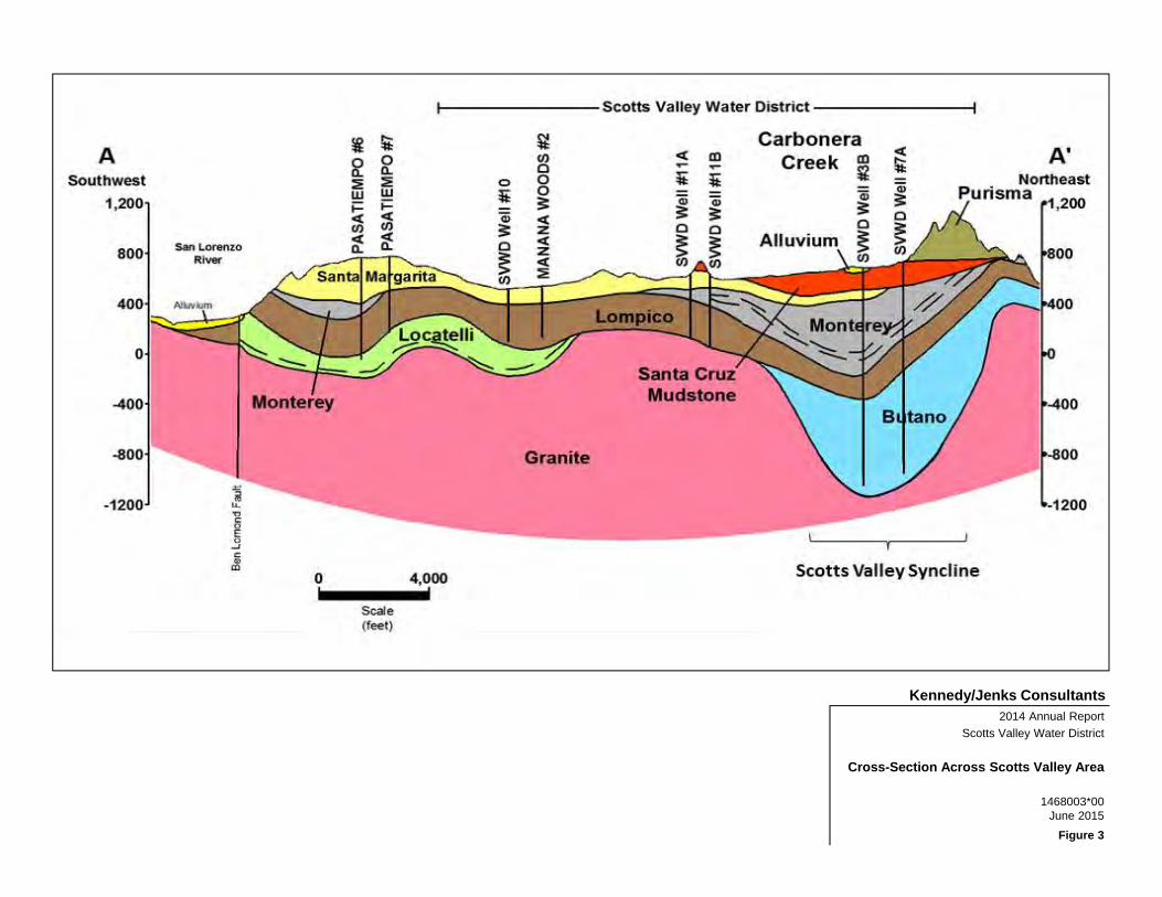
Kennedy/Jenks Consultants2014 Annual Report
Scotts Valley Water District
1468003*00June 2015
Cross-Section Across Scotts Valley Area
Figure 3

Mountain View Rd
N. R
odeo
Gul
ch D
r
ScottsValley
¬«17
¬«17
Bean
Cre
ek R
oad
Lock
hart
Gul
ch R
oad
Vine Hill R
d
Scot
ts V
alle
y D
rive
Zaya
nte
Creek
Roa
d
Lom
pico
Roa
d
Mt. Hermon Rd
Graham
Hill R
d
Gle
n C
anyo
n R
d
Granite C
reek Rd
Bran
cifo
rte D
r
Gle
nwoo
d D
r
Zayant
e CrLo
mpico
Cr
Bean C
r
Carbo
nera C
rBean Cr
Gran
ite C
r
Branci
forte
Cr
BoulderCreek
BenLomond
FeltonMount
Hermon
Zayante Fault
Ben Lomond Fault
¬«9
¬«9
Santa MargaritaGroundwater Basin
LochLomond
Groundwater Basin Boundary
San Lorenzo River
SANTA CRUZ PURISIMA FORMATION GROUNDWATER BASINDWR# 3-21FELTON AREA GROUNDWATER BASIN
DWR# 3-50
SCOTTS VALLEY GROUNDWATER BASINDWR# 3-27
³ 2014 Annual ReportScotts Valley Water District
DWR Groundwater Basins
K/J 1468003*00June 2015
Figure 4
Kennedy/Jenks Consultants
Path: Z:\Projects\Scotts_Valley_Water_District\Events\20150601_2014ReportFigures\Fig_04_SantaMargaritaGWBasin_Subareas.mxd
0 4,000 8,000
Scale: Feet
LegendSanta Margarita Groundwater Basin
Felton Area Growndwater Basin (DWR Basin 3-50)
Santa Cruz Purisima Formation Growndwater Basin (DWR Basin 3-21)
Scotts Valley Growndwater Basin (DWR Basin 3-27)
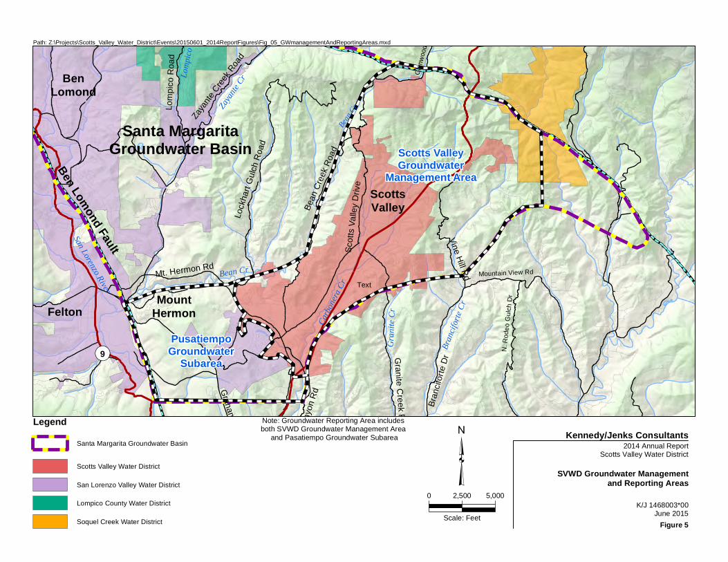
Mountain View Rd
N. R
odeo
Gul
ch D
r
ScottsValleyBe
an C
reek
Roa
d
Lock
hart
Gul
ch R
oad
Vine Hill R
d
Scot
ts V
alle
y D
rive
Zaya
nte
Creek
Roa
d
Lom
pico
Roa
d
Mt. Hermon Rd
Graham
Hill R
d
Gle
n C
anyo
n R
d
Granite C
reek Rd
Bran
cifo
rte D
r
Gle
nwoo
d D
r
Zayant
e CrLo
mpico
Cr
Bean C
r
Carbo
nera C
rBean Cr
Gran
ite Cr
Branci
forte C
r
BenLomond
FeltonMount
Hermon
Ben Lomond Fault
¬«9
Santa MargaritaGroundwater Basin
San Lorenzo River
PusatiempoGroundwater
Subarea
Scotts ValleyGroundwater
Management Area
³ 2014 Annual ReportScotts Valley Water District
SVWD Groundwater Managementand Reporting Areas
K/J 1468003*00June 2015
Figure 5
Kennedy/Jenks Consultants
Path: Z:\Projects\Scotts_Valley_Water_District\Events\20150601_2014ReportFigures\Fig_05_GWmanagementAndReportingAreas.mxd
0 2,500 5,000
Scale: Feet
LegendSanta Margarita Groundwater Basin
Scotts Valley Water District
San Lorenzo Valley Water District
Lompico County Water District
Soquel Creek Water District
Text
Note: Groundwater Reporting Area includes both SVWD Groundwater Management Area
and Pasatiempo Groundwater Subarea

Kennedy/Jenks Consultants2014 Annual Report
Scotts Valley Water District
1468003*00June 2015
Annual Precipitation for Scotts Valley by Water Year
Figure 6

Kennedy/Jenks Consultants2014 Annual Report
Scotts Valley Water District
1468003*00June 2015
Annual SVWD Groundwater Production
Figure 7

Kennedy/Jenks Consultants2014 Annual Report
Scotts Valley Water District
1468003*00June 2015
Annual and Cumulative Recycled Water Usage
Figure 8

Kennedy/Jenks Consultants2014 Annual Report
Scotts Valley Water District
1468003*00June 2015
SVWD Monthly Groundwater Production Comparison
Figure 9

Kennedy/Jenks Consultants2014 Annual Report
Scotts Valley Water District
1468003*00June 2015
Regional Groundwater Production in GWRA by User Type
Figure 10

@A
@A@A
@A
@A
@A
@A
@A
@A
@A@A@A
@A
")
")")")
")
")
")
")
")
")
Graham
Hill R
d
Santa Margarita Groundwater Basin
SLVWD Pasatiempo #7
SLVWD Pasatiempo 6
SLVWD Olympia #3
SVWD Well #3B
Granite C
reek Rd
Bean
Cre
ek R
oad
Lock
hart
Gul
ch R
oad
Scott
s Vall
ey D
r.
Mt. Hermon Rd
Carbo
nera C
r
Bean Cr
Gran
ite Cr
HansonQuarry
GeyerQuarry
OlympiaQuarry
ScottsValley
¬«17
Mt. H
ermon R
d
Gle
nwoo
d D
rive
Scott
s Vall
ey W
ater
Distric
t Bou
ndary
Scotts ValleyDry Cleaners
Camp Evers MTBE - BPCamp Evers MTBE - Chevron
Camp Evers MTBE - ShellCamp Evers MTBE - Tosco
Scotts Valley DriveDichlorobenzene Plume
HaciendaShell
")Watkins-JohnsonSuperfund
SVWD Well #11A
SVWD Well #11B
Manana Woods #2
SVWD Well #9
SVWD Well #10SVWD Well #10A
Kings Dry Cleaners
Former Frank'sAuto Dismantlers
³ 2014 Annual ReportScotts Valley Water District
Locations of EnvironmentalCompliance Sites
K/J 1468003*00June 2015Figure 11
Kennedy/Jenks Consultants
Pat
h: Z
:\Pro
ject
s\S
cotts
_Val
ley_
Wat
er_D
istri
ct\E
vent
s\20
1506
01_2
014R
epor
tFig
ures
\Fig
_11_
Loca
tions
OfE
nviro
nmen
talC
ompl
ianc
eSite
s.m
xd
0 1,000 2,000
Scale: Feet
Legend") Environmental Compliance Sites
@A Well Location
Scotts Valley Water District

@A
@A
@A
@A
@A
@A@A
@A
!2
!2
!2!?
!?
!H
!H
!H
!H!H!H
!H
!H!H!H
!H
!H
!H
#*
#*#*
#*
#*
#*#*
#*
#*
#*
!U!U!U
!.
!.
EagleCreek
SL-1SL-2
01149
SW-1
0710607109
07142
SW-2
SW-3
WWTPPrecipitationGauge
El Pueblo YardPrecipitationGauge Blair
RanchGaugeCarbonera
CreekStream Gauge
Bean CreekStreamGauge
SVWDWell#7A
SVWDWell #3B
SVWDWell #11B
SVWD Well #11A
SVWDWell #9
SVWDWell #10SVWD Well #10A
SLVWDPasatiempo
#5A
Canham Well
Stonewood Well
SVPLAZA-MW1SVPLAZA-MW2SVPLAZA-MW3
#15 MONITOR
#9 Monitoring Well
SVWD AB303 MW-1
SVWD AB303 MW-2SVWD AB303 MW-3A
SVWD AB303 MW-3B
SV1-MW
SV3-MW A
SV3-MW BSV3-MW C
SV4-MW
TH-18
TH-19
³0 2,500
Scale: Feet
Doc
umen
t Pat
h: Z
:\Pro
ject
s\S
cotts
_Val
ley_
Wat
er_D
istri
ct\E
vent
s\20
1506
01_2
014R
epor
tFig
ures
\Fig
_12_
GW
MP
_RW
MP.
mxd
Legend!U RWMP Shallow Groundwater Well Location
#* RWMP Surface Water Location
!H GWMP Groundwater Well Location
!2 GWMP Precipitation Gauge
!? GWMP Stream Gauge
@A SVWD Production Well Location
State Highways
Major Roads
Streets
Streams
Scotts Valley Water District
Quarry Location
Note:GWMP - Groundwater Monitoring ProgramRWMP - Recycled Water Monitoring Program
2014 Annual ReportScotts Valley Water District
Groundwater Management andRecycled Water Monitoring
Program Sampling LocationsK/J 1468003*00
June 2015
Kennedy/Jenks Consultants
Figure 12
HansonQuarry
GeyerQuarry
OlympiaQuarry

Kennedy/Jenks Consultants
K/J 1468003*00June 2015
Groundwater Elevation Hydrographs for Santa Margarita Aquifer
2014 Groundwater Management Annual ReportScotts Valley Groundwater Model
Figure 13

§ § §
§§§
§§§§
@A
@A
@A@A
@A@A
@A@A
@A
@A
@A
@A
@A
@A
@A
@A@A@A@A
HansonQuarry
GeyerQuarry
OlympiaQuarry
ScottsValley
¬«17
Scott
s Vall
ey W
ater
Distric
t Bou
ndary
Graham
Hill R
d
Granite C
reek Rd
Bean
Cre
ek R
oad
Lock
hart
Gul
ch R
oad
Scot
ts V
alley
Dr.
Mt. Hermon Rd
Carbo
nera C
rBean Cr
Gran
ite Cr
Mt. H
ermon R
d
Gle
nwoo
d D
rive
]]
]]
]
]
]Ferndale Spring
Redwood Spring
Eagle CreekSprings
349351394
387
483
484
485
483
342
500
477
396
476
403
472
349
349348349
500
600550350
500
400450 ³
0 2,500
Scale: Feet
2014 Annual ReportScotts Valley Water District
Santa Margarita GroundwaterElevation Contour Map
September 2014K/J 1468003*00
June 2015
Figure 14
Kennedy/Jenks Consultants
Doc
umen
t Pat
h: Z
:\Pro
ject
s\S
cotts
_Val
ley_
Wat
er_D
istri
ct\E
vent
s\20
1506
01_2
014R
epor
tFig
ures
\Fig
_14_
GW
_Ele
vatio
ns_S
anta
Mar
garit
a201
4 8.
5 x
11.m
xd (340)
§
LegendGroundwater Monitoring Well Location
Santa Margarita GroundwaterElevation ContourGroundwater Depression Contour
Location of Direct Contact between theSanta Margarita Sandstone and theLompico Sandstone
Scotts Valley Water District
@A
] Groundwater Flow Direction
Measured Groundwater Elevation infeet above mean sea level
Groundwater Basin Boundary
Inferred Unsaturated Area
Spring

Kennedy/Jenks Consultants
K/J 1468003*00June 2015
Groundwater Elevation Hydrographs for Monterey Aquifer
2014 Groundwater Management Annual ReportScotts Valley Groundwater Model
Figure 15
No Continuous Data Monitoring in Monterey During WY2014

Kennedy/Jenks Consultants
K/J 1468003*00June 2015
Groundwater Elevation Hydrographs for Lompico Aquifer
2014 Groundwater Management Annual ReportScotts Valley Groundwater Model
Figure 16

@A
@A@A@A
@A
@A
@A
@A
@A
@A
@A
@A
@A@A
@A
@A
@A@A
@A
@A
HansonQuarry
GeyerQuarry
OlympiaQuarry
ScottsValley
¬«17
Scott
s Vall
ey W
ater
Distric
t Bou
ndary
Graham
Hill R
d
Granite C
reek Rd
Bean
Cre
ek R
oad
Lock
hart
Gul
ch R
oad
Mt. Hermon Rd
Bean Cr
Gran
ite Cr
Mt. H
ermon R
dG
lenw
ood
Driv
e]
]]
LompicoAbsent
349344
341295
380
334
271
332
283330
427
289
296172
386351
327
223
350
300300
250
250
300
300
300350
³0 2,500
Scale: Feet
2014 Annual ReportScotts Valley Water District
Lompico GroundwaterElevation Contour Map
September 2014K/J 1460003*00
June 2015
Figure 17
Kennedy/Jenks Consultants
Doc
umen
t Pat
h: Z
:\Pro
ject
s\S
cotts
_Val
ley_
Wat
er_D
istri
ct\E
vent
s\20
1506
01_2
014R
epor
tFig
ures
\Fig
_17_
GW
_Ele
vatio
ns_L
ompi
co20
14 8
.5 x
11.
mxd
(340)
§
LegendGroundwater Monitoring Well Location
Lompico Groundwater Elevation Contour
Groundwater Depression Contour
Location of Direct Contact between theSanta Margarita Sandstone and theLompico Sandstone
Scotts Valley Water District
@A
] Groundwater Flow Direction
Measured Groundwater Elevation infeet above mean sea level
Groundwater Basin Boundary
Inferred Unsaturated Area
Spring
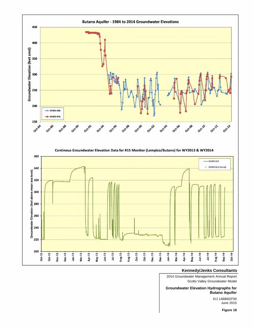
Kennedy/Jenks Consultants
K/J 1468003*00June 2015
Groundwater Elevation Hydrographs for Butano Aquifer
2014 Groundwater Management Annual ReportScotts Valley Groundwater Model
Figure 18

@A
@A
@A
@A
#*
#*
Mountain View Rd
ScottsValleyBe
an C
reek
Roa
d
Vine Hill R
d
Scot
ts V
alle
y D
rive
Gle
nwoo
d D
r
Bean C
r
Carbo
nera C
r Granite
Cr
800
600
400
2000
Carbone
ra Cr
Blackbur
n Gulch
Canham Well
Stonewood Well841
445
SVWD Well #3B
SVWD Well #7A
SVWD Well #11ASVWD Well #11B
251
-50
³ 2014 Annual ReportScotts Valley Water District
Butano Groundwater Elevation MapSeptember 2014
K/J 1468003*00June 2015Figure 19
Kennedy/Jenks Consultants
Pat
h: Z
:\Pro
ject
s\S
cotts
_Val
ley_
Wat
er_D
istri
ct\E
vent
s\20
1506
01_2
014R
epor
tFig
ures
\Fig
_19_
But
anoG
roun
dwat
erE
lev.
mxd
0 2,000 4,000
Scale: Feet
Legend#* New Butano Monitoring Wells@A Production Wells
Scotts Valley Water DistrictGroundwater ContoursState HighwayZayante Fault
Note: SVWD Well #7Apumping at about 340 GPM

Kennedy/Jenks Consultants2014 Annual Report
Scotts Valley Water District
1468003*00June 2015
Model-Simulated Change in Groundwater Storage by Aquifer for GWRA
Figure 20