Embed Size (px)
Citation preview

Jil. 20, No.3 (Vol. 20, No.3) May-Jun 1994
KANDUNGAN (Contents) .. ... ....... ....... ... ...... ... ......... ................ .......... ... ........ ............ ....... ........... . ....... ...... :.: ................. ::::::.::::.:.:.:::.:.: .. ::::.:::::: .:.:: :: :':':. {;~:rr~ :;:;:::;:~:~r: :::::\~{: .. :.:::. ~::: :·~:f:::;;:···::: : :::: :::::::::::
•. :.S.·: ..• • ... : ..••. ~ ..••. ·.:.;r .... A ..•. ; .• · .• ·.r ..•. ~ ..••..• · ... N .••. · ..• · ..• : .• · .. S.·.· ... : ..... E.·: ..••. Q .•.. :.··.:t.· .... tD .. :.:.:.·.·.G ..• • .. :· ..• · ..• ·.' ..••. :.( ..••. G .••..•.••..•. ·$ ..• : ..• : ..• ·.P.:.: .• ·.I.9a .•• · ..• : ..•. • •. : .• :.I ... P ..••. · ••. P.: ... :.· . .l .••..••. N ..••..• · ..• ·.¢ ..••. ·: ... f ..••. Q .•• : ..• :.$ .• · ..••. '.··.: ..• : ..• : .• ~.: •• q::::~:......~.:.~.~::: : ... .... :..::.}\ ................................................................................................................................................................................................ : ..... : ..... :.: ... :.:.: ... :.:.;.:-:.:.;.:.;.:.;.:.:.:.:.
H.D. Tjia: Faulted gravel terrace : active tectonics a t Deer Cave, Mulu region, Sarawak J.K. Raj and Ahmad Nazmi Mohd. Ali: Point load strength of a coarse grained, porphyritic,
biotite-hornblende granite from the Pergau area, Kelantan Darul Naim
173 177
.~ . ........................ . .... .
m§BJgNtQ:mNR~R~l\!QmN ·(MggtiOg.~.·Qfth~ ·~98!§ty~:::!:::~:::::::.. . :::::::::.. .. : Annual Geological Conference '94 - Laporan (Report) 183
Speech by the Organising Chairman, Dr. Ahmad Tajuddin Ibrahim 184 Welcoming Address by GSM President, En . Fateh Ch and 185 Opening Address by YAB Dato' Seri Amar Di Raja, Tan Sri Haji Wan Mokhtar Ahmad 187 Programme 190 Pre-Conference Fi eldtrip I - Gold Mineralization - Laporan (Report) 198 Pre-Conference Fi eldtrip II - Stratigraphy-Sedim entology - Laporan (Report) 200 Post-Conference Fieldtrip - Pul au Redang - Laporan (Report) 202 Abstracts of Papers 204
................... . ......... :.:.:.:.:. .......... . .. .. .. ....................... :.:.:-:.;.:.:. ............................................ . ..................................................................... :::::::::::::::::::::- :.:.:.:.:.:-:::::::::::::.: :.:.:.:.:.:.:-:-:.:.:-:.' ............... :.:-:.:.:.:.:::::.::
::::.:.:~~RJ·IlS8~:~B'=Tm :egR~~i~N(N~§(~Qf.·~Hg ·~9g!gl)· .. ::: :: : ... ::..::...::. ;:.... .• ~..~~:.:.~~...~<::::: ...... ,::,,: Keahlian (Membership) 248 Pertukaran Alamat (Change of Address) 248 Pertambahan Baru Perpustakaan (New Library Addi tions) 249 Bulletin 29 - Pembetulan (Correction) 249 Society Souvenirs 250
Theses titles Session 1992/93 UKM & UM 251 Senarai Pertukaran Pegawai Kajibumi Jabatan Penyiasatan Kajibumi Malaysia 253 South East Asian Symposium on Tunelling and Underground Space Development (SEASTUD) 254 lAG-SEA Conference on Geomorphology 256 Tectonic and Metallogeny of EarlylMid Precambrian Orogenic Belts 258 XVIII Pacific Science Congress 260 30th International Geological Congress 263 Kalendar (Calendar) 269

Majlis (Council) 1994/95
Presiden (President) Naib Presiden (Vice-President) Setiausaha (Secretary) Penolong Setiausaha (Asst. Secretary) Bendahari (Treasurer) Pengarang (Editor)
Ibrahim Komoo Ahmad Tajuddin Ibrahim Nik Ramli Nik Hassan Lee Chai Peng Teh GuanHoe
Presiden Yang Dahulu (Immediate Past President) : Ahmad Said LawJackFoo Juruodit Kehormat (Honorary Auditor)
1994-96 Abd. Ghani Mond Rafek Abdul Raliim Samsudin Effendy Cheng Abdullah Tan Boon Kong
1994-95 Ali Mohd. Sharif Choo Mun Keong Idris Mohamad Jimmy Khoo Khay Khean
Jawatankuasa Kecil Pengarang (Editorial Subcommittee)
Teh Guan Hoe (PengerusilChairman) Dorsihah Mohamad Jais Lili Sulastri Fan Ah Kwai Ng Tham Fatt J.J. Pereira Noor Ilmi Abu Bakar
Lembaga Penasihat Pengarang (Editorial Advisory Board)
AwPeckChin Azhar Hj. Hussin K.R. Chakraborty Choo Mun Keong Chu Leng Heng
Denis N.K. Tan FooWahYang C.A. Foss N.S. Haile C.S. Hutchison Lee Chai Peng
Leong Lap Sau Mazlan Madon Ian Metcalfe John Kuna Raj Senathi Rajah Shu Yeoh Khoon
P .H. Stauffer Tan Boon Kong Tan Teong Hing H.D. Tjia Yeap Cheng Hock
The Society was founded in 1967 with the aim of promoting the advancement of earth sciences particularly in Malaysia and the Southeast Asian region.
The Society has a membership of about 600 earth scientists interested in Malaysia and other Southeast Asian regions. The membership is worldwide in distribution.
Published by the Geological SoCiety of Malaysia. Department of Geology. University of Malaya. 59100 Kuala Lumpur. Tel: 603-757 7036 Fax: 603-756 3900
Printed by Art Printing" Works Sdn. Bhd .. 29 Jolon Rlong. 59100 Kuolo Lumpur.
Faulted gravel terrace: active tectonics at Deer Cave, Mulu region, Sarawak
H.D. TJIA
Petronas Research & Scientific Services Lot 1026, PKNS Industrial Estate, 54200 Hulu Kelang
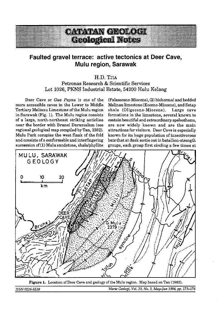
Deer Cave or Gua Payau is one of the (Palaeocene-Miocene), (2) biohermal and bedded more accessible caves in the Lower to Middle Melinau limestone (Eocene-Miocene), and Setap Tertiary Melinau Limestone of the Mulu region shale (Oligocene-Miocene). Large cave in Sarawak (Fig. 1). The Mulu region consists formations in the limestone, several known to of a large, north-northeast striking anticline contain beautiful and extraordinary speleothems, near the border with Brunei Darussalam (see are now widely known and are the main regional geological map compiled by Tan, 1982). attractions for visitors. Deer Cave is especially Mulu Park occupies the west flank of the fold known for its huge population of insectivorous and consists of a conformable and interfingering bats that at dusk sortie out in batallion-strength succession of(l) Mulu sandstone, shale/phyllite groups, each group first circling a few times at
MU LU I SARAWAK G EO LOGY
o 10 20 I
km
Figure 1. Location of Deer Cave and geology of the Mulu region. Map based on Tan (1982).
ISSN 0126-5539 Warta Geologi, Vol. 20, No.3, May-fun 1994, pp.173-176
174 H.D. TJIA the high western entrance of the cave before corkscrewing in a line away from the cave usually in westward direction. .'
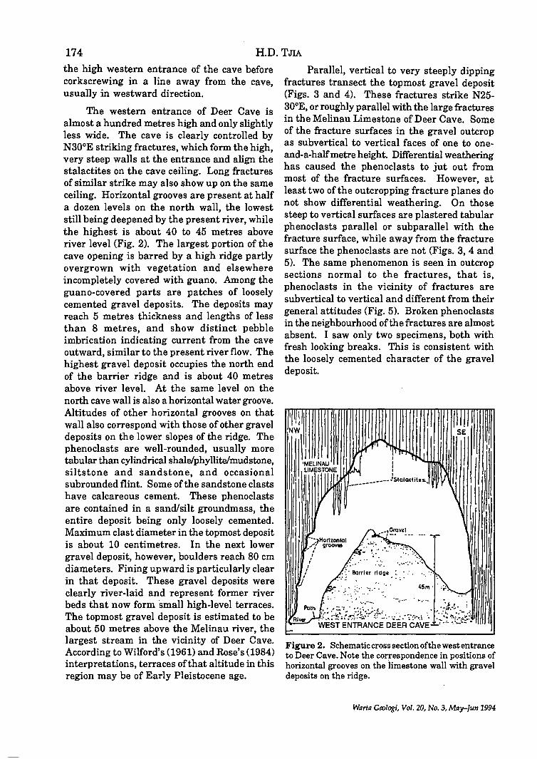
The western entrance of Deer Cave is almost a hundred metres high and only slightly less wide. The cave is clearly controlled by N300E striking fractures, which form the high, very steep walls at the entrance and align the stalactites on the cave ceiling. Long fractures of similar strike may also show up on the same ceiling. Horizontal grooves are present at half a dozen levels on the north wall, the lowest still being deepened by the present river, while the highest is about 40 to 45 metres above river level (Fig. 2). The largest portion of the cave opening is barred by a high ridge partly overgrown with vegetation and elsewhere incompletely covered with guano. Among the guano-covered parts are patches of loosely cemented gravel deposits. The deposits may reach 5 metres thickness and lengths of less than 8 metres, and show distinct pebble imbrication indicating current from the cave outward, similar to the present river flow. The highest gravel deposit occupies the north end of the barrier ridge and is about 40 metres above river level. At the same level on the north cave wall is also a horizontal water groove. Altitudes of other horizontal grooves on that wall also correspond with those of other gravel deposits on the lower slopes of the ridge. The phenoclasts are well-rounded, usually more tabular than cylindrical shale/phyllite/mudstone siltstone and sandstone, and occasionai subrounded flint. Some of the sandstone clasts have calcareous cement. These phenoclasts are contained in a sand/silt groundmass, the entire deposit being only loosely cemented. Maximum clast diameter in the topmost deposit is about 10 centimetres. In the next lower gravel deposit, however, boulders reach 80 cm diameters. Fining upward is particularly clear in that deposit. These gravel deposits were clearly river-laid and represent former river beds that now form small high-level terraces. The topmost gravel deposit is estimated to be about 50 metres above the Melinau river, the largest stream in the vicinity of Deer Cave. According to Wilford's (1961) and Rose's (1984) interpretations, terraces of that altitude in this region may be of Early Pleistocene age.
Parallel, vertical to very steeply dipping fractures transect the topmost gravel deposit (Figs. 3 and 4). These fractures strike N25-30oE, or roughly parallel with the large fractures in the Melinau Limestone of Deer Cave. Some of the fracture surfaces in the gravel outcrop as subvertical to vertical faces of one to oneand-a-halfmetreheight. Differential weathering has caused the phenoclasts to jut out from most of the fracture surfaces. However, at least two of the outcropping fracture planes do not show differential weathering. On those steep to vertical surfaces are plastered tabular phenoclasts parallel or subparallel with the fracture surface, while away from the fracture surface the phenoclasts are not (Figs. 3, 4 and 5). The same phenomenon is seen in outcrop sections normal to the fractures that is , , phenoclasts in the vicinity of fractures are subvertical to vertical and different from their general attitudes (Fig. 5). Broken phenoclasts in the neighbourhood of the fractures are almost absent. I saw only two specimens, both with fresh looking breaks. This is consistent with the loosely cemented character of the gravel deposit.
NW
\ I I 'MEUNAU I UMESlONEI
I
I I I
__ ----------JSlalaclitas..
Figure 2. Schematic cross section of the west entrance to ~eer Cave. Note the cor.respondence in positions of honzontal grooves on the limestone wall with gravel deposits on the ridge.
Warta Geologi, Vol. 20, No.3, MRy-Jun 1994

FAULTED GRAVEL: ACTIVE TECTONICS AT DEER CAVE, MULU REGION, SARAWAK 175
Figure 4. Surface of a N300E strikingfractw'e in the topmost gravel terrace of Deer Cave. Note the phenoclasts (small open circles) aligned with the fracture surface. Compare with Figure 3. Scale on exposed metal tape is 50 cm long.
Warta Geologi, Vol. 20, No. 3, May-Jun 1994
Figure 3. Vertical to very steep fractures transectingthe loosely cemented gravel deposi t. Fracture strike N25-30°E. The deposit is the topmost gravel terrace, approximately 40-45 metres above the present river flowing through Deer Cave. Note the position of phenoclasts with respect to the fractures and compare with Figure 4. Scale on exposed metal tape is 50 cm long.
SE
TOPMOST GRAVEL TERRACE N30' E FRACTURES ±4S m ABOVE RIVER
'V
DEER CAVE. WEST ENTRANCE
A
J FRACTURE SURFACE • . , DIFERREI"ITIALLY
WEATHERED
±4.Sm
Figure 5. Sketch of phenoclasts' positions near the N300E fractures and at distance from these fractures. Topmost gravel terrace, Deer Cave. The next lower gravel terrace at ±39 m above river level is also faulted.

176 H.D. TJIA
I interpret the dislocations ofphenoclasts in the vicinity of fractures to indicate that normal faulting had been the cause. Throws reach at least 1.5 m on some of the faults. It appears that the parallel fractures comprise step faults downthrowing towards southeast, or towards the axis of Deer Cave. No horizontal component offault movement is apparent. The parallelism of the N30oE-striking vertical fractures in the gravel deposit with those in the Melinau Limestone and their widespread occurrence suggest that the fractures are of tectonic origin. The large Mulu anticline also strikes N30oE. Therefore, the fractures in the Melinau limestone and in the gravel terrace of Deer Cave are tensional on which, in most cases, normal fault displacement takes place. Tectonic activity in the Mulu region has persisted
until after the deposition of the topmost gravel terrace, which may be of Early Pleistocene age. It seems highly probable that cavern enlargement of Deer Cave was facilitated by such young tectonic movements.
REFERENCES
RoSE, J., 1984. Alluvial terraces of an equatorial river, Melinau drainage basin, Sarawak. Zeitschrift fUr Geomorphologie 28 (2), 155-177.
TAN, D.N.K. compiler, 1982. Geological Map of Sarawak. Geological Survey of Malaysia, First edition, scale 1:500,000 (2 sheets).
WILFORD, G.E., 1961. Geology and Mineral Resources ofBruneiandAdjacentPartsofSarawak. Geological Survey Department, British Territories in Borneo, Memoir 10, 181p .
.. .. .. Manuscript received 24 February 1994
Wllrta Geologi, Vol. 20, No. 3,May-lun 1994

Point load strength of a coarse grained, porphyritic, biotitehornblende granite from the Pergau area, Kelantan Darul Nairn
, J.K. RAJ AND AHMAD NAZMI MOHD. ALI J abatan Geologi
Universiti Malaya 59100 ,Kuala Lumpur
Abstract: Point load tests on air, and oven, dried blocks of a coarse grained, porphyritic, biotite-hornblende granite from the Pergau area yield corrected strength indices [Is(60)l of 8.2 MPa, and 8.4 MPa, respectively. These indices were interpolated from the log-log plots of the loads at failure (P) versus the squares of the equivalent core diameters (De2) of several, tetrahedral blocks of different sizes that were tested. The corrected point load strength indices are related to the uniaxial compressive strength by a mUltiplication factor of about 18.
INTRODUCTION
The Point Load Strength, as described by Broch and Franklin (1972), has gained widespread acceptance as an index test for the strength classificatioIi of rock material and as a means for estimating other strength parameters as the uniaxial compressive strength (ISRM, 1985; Brook, 1985). Little or no specimen preparation is needed for this test which involves the splitting of rock specimens by application of a concentrated load through a pair of spherically truncated, conical platens; the specimens being in the form of cores, cut blocks or irregular lumps. The most widely known version of the test involves the diametral splitting of rock cores and determination of the point load strength index which is related to a reference core diameter of 50 mm. Where cores with other diameters are tested, a size correction factor needs to be introduced (ISRM, 1985).
Where specimens with shapes other than cores are tested, both shape and size correction factors need to be introduced. The shape correction factor is based on the minimum crosssectional area of the tested specimen and involves calculation of an "equivalent core diameter" (Brook, 1985). The size correction factor, however, is best determined from the log-log
ISSN 0126-5539
plots of the loads at failure (P) versus the squares of the equivalent core diameters (De2) of a range of specimen sizes as this allows interpolation (or extrapolation) of the load corresponding to an equivalent core diameter of 50 mm (ISRM, 1985).
In this paper are presented the results of point load tests that have been carried out on air and oven dried blocks of a coarse grained, porphyritic, biotite-hornblende granite from the Pergau area of Kelantan Darul Naim. Correlation of the point load strength index [Is(50)] with the uniaxial compressive strength is also discussed.
SAMPLING SITE - GEOLOGICAL SETTING
Between kilometre posts 97 and 107, the East-West Highway from Grik to Jeli cuts across a hilly terrain of moderate to steep slopes with deep valleys and follows in part the upper course of the Sungai Pergau (Fig. 1). Along this stretch, slope cuts expose completely to partly weathered, and unweathered, granitic rocks that are characteristically pink coloured and porphyritic with megacrysts of mainly pink, and lesser white, feldspars set in a medium to coarse grained, groundmass (Wong, 1974; Raj, 1987;
Warta Geologi, Vol. 20, No.3, May-Jun 1994, pp.177-182

178 J.K. RAJ AND AHMAD NAZMI MOHD. ALI Ahmad Nazmi, 1993). These rocks have been mapped as the Belimbing facies of the N oring Pluton which is a north-south trending, oval shaped body with an area of some 30 km x 20 km outcropping in the western part of Kelantan DarulNaim(CobbingandMallick,1987). Biotite K:Ar, and Rb:Sr, ages of 70 ± 2 Ma, and 69 ± 1 Ma, respectively, determined for a Sr-rich biotitehornblende granite from the Sg. Pergau near Batu Melintang, have been considered to represent a Late Cretaceous thermal resetting event (Bignell and Snelling, 1977), while Derbyshire (1988) suggests a Cretaceous age of intrusion (90 ± 30 Ma from 87Srj86Sr ratios) for at least part of the Noring Granite.
Along the said stretch of Highway, several faults are present and are marked by narrow zones (of usually 1 to 2 m wide) of chloritized and sheared bedrock. These faults are of variable orientations, though two prominent, steeply dipping to vertical, sets can be distinguished; one striking northwest-southeast, and the other,
N
~ o 10 ~
km
-- [-W Highway
-- Metalled Road
--- Track
~River
• 560 Spot Height
Quarry
."..:, Sampling Site
Figure 1. Location of sampling site.
westsouthwest-eastnortheast. Several joints of variable orientations, extents and spacings are also found in these granitic rocks, which are cut by several quartz veins (of up to 0.1 m thick).
METHOD OF STUDY
In connection with a study on the geotechnical properties of the granitic bedrock, point load tests were carried out as they offer a simple and rapid means of obtaining a strength classification. Several large, fresh granite blocks of some 0.1 to 0.2 mS in size were collected at a quarry near the Upper Pergau Bridge (Fig. 1) and then sawn into smaller tetrahedral blocks of various sizes. The visible, textural and structural features of each individual block were then described before a few of them were oven dried at 105°C for 12 hours, whilst others were air dried for a week, before being tested with an ELE Point Load Test Apparatus.
Thin-sections and rock slabs were also prepared from the large blocks in order to classify the rock material, whilst the densities, unit weights and porosities of selected samples were determined according to the suggested method ofISRM (1979) using saturation and buoyancy techniques (Table 1).
PETROGRAPHY OF INVESTIGATED ROCK MATERIAL
In hand specimens, the holocrystalline rock material is characteristically pink coloured with large, mainly pink, and lesser white, feldspar phenocrysts set in a medium to coarse grained, groundmass of feldspars, quartz, biotite and hornblende. The phenocrysts are mostly of tabular shapes and up to about 30 mm x 40 mm in size, whilst the groundmass crystals range in size from some 0.5 mm to 10 mm. The pink alkali feldspar phenocrysts are also sometimes mantled by :white plagioclase to give a rapakivi texture. The selective staining of feldspars (according to the method of Bailey and Stevens, 1960), and the determination of the mineral components at some 1,000 points, on several rock slabs furthermore, shows that the rock material is best classified as an adamellite (Table 2).
Warta Geologi, Vol. 20, No.3, May-Jun 1994
POINT LOAD STRENGTH OF A COARSE GRAINED, PORPHYRITIC, BIOTITE-HORNBLENDE GRANITE 179
Table 1: Physical properties of the coarse grained, porphyritic, biotite-hornblende adamellite.
Sample Dry Dry Unit Saturated Saturated
Density Weight Porosity Density Unit Weight Number kg/cu.m. kN/cu.m. % kg/cu.m. kN/cu.m.
UP 24 2,610 25.595 0.420 2,614 25.636 UP 38 2,606 25.559 0.329 2,610 25.592 UP 41 2,627 25.759 0.343 2,630 25.792 UP 44 2,615 25.645 0.381 2,619 25.683
Mean 2,615 25.640 0.368 2,618 25.676
Table 2: Modal compositions of the coarse grained, porphyritic, biotite-hornblended adamellite.
Sample Quartz Alkali Plagioclase Mafics
Number % Feldspar Feldspar
% % %
UP1 37.6 26.3 31.9 4.2 UP2 38.4 24.9 31.2 5.5 UP3 37.8 27.6 30.2 4.4
In thin sections, the rock material shows a porphyritic, hypidiomorphic-granular texture with large alkali feldspars set in a medium to coarse grained, groundmass of plagioclase, alkali feldspar, quartz, biotite and hornblende. Accessory minerals present are mainly sphene and apatite, whilst the secondary minerals include sericite and chlorite.
The anhedral to subhedral, alkali feldspar phenocrysts are usually of tabular shapes and contain inclusions of quartz, plagioclase, biotite and hornblende. They are predominantly of orthoclase and often show microperthitic intergrowths as well as Carlsbad twinning and alteration to sericite. The anhedral to subhedral, alkali feldspar of the groundmass are some 2 to 10 mm in size and are also of orthoclase.
The plagioclase feldspars are mainly found in the groundmass as small, subhedral to euhedral crystals of 2 to 10 mm in size, though they sometimes form small phenocrysts that show zoning as well as Carlsbad and Pericline twins. The plagioclases, which are mainly of labradorite, are also often sericitized.
The anhedral, quartz crystals of 2 to 10 mm size, show undulatory extinction with
Warta Geologi, Vol. 20, No. 3, May-Jun 1994
irregular boundaries and are mainly found in the groundmass, though they sometimes form small phenocrysts.
The biotites mostly occur as individual, euhedral, tabular crystals of some 0.5 to 3 mm in size, but sometimes cluster together to form aggregates, often with the hornblendes. These biotites are usually free of inclusions, except for apatite and are often bent and sometimes chloritized. The hornblendes usually occur as individual, euhedral, prismatic crystals of 1 to 6 mm in size and sometimes cluster together with biotites. The hornblendes also sometimes form small phenocrysts and then show cleavage and zoning.
On the basis of the textural features and mineralogical composition, the rock material is best classified as a porphyritic, coarse grained, biotite-hornblende adamellite.
RESULTS AND DISCUSSION
Results of point load tests on air dried blocks are shown in Table 3, whilst results of tests on oven dried blocks are shown in Table 4. At a first glance, it can be seen that blocks
180 J.K. RAJ AND AHMAD NAZMI MOHD. ALI
Table 3: Results of point load tests on air dried blocks.
Square of Load at Load at Uncorrected
Sample Equivalent Point Load Number Core Diameter Failure Failure Strength
sq.mm. lbf kN MPa
UP1 1,036 2,000 9.00 8.687 UP2 806 1,600 7.00 8.685 UP3 969 1,900 8.50 8.772 UP4 792 1,800 8.00 10.101 UP6 1,575 2,900 13.00 8.254 UP7 867 1,700 7.50 8.651 UP 8* 810 1,100 5.00 6.173 UP 9* 917 1,300 6.00 6.543 UP 10 1,383 2,700 12.00 8.677 UP 11 1,357 2,800 12.50 9.211 UP 12 1,095 2,250 10.00 9.132 UP 13* 1,143 1,800 8.00 6.999 UP 15 735 1,400 6.50 8.844 UP 16 809 1,900 8.50 10.507 UP 17 1,138 1,800 8.00· 7.030 UP 18 1,116 2,600 11.50 10.305 UP 19* 1,022 1,700 7.50 7.339 UP 20 1,298 2,500 11.00 8.475 UP21 1,107 2,300 10.50 9.485
* Block with very large phenocrysts.
Table 4: Results of point load tests on oven dried blocks.
Square of Load at Load at
Uncorrected Sample Equivalent
Failure Failure Point Load
Number Core Diameter lbf kN
Strength sq.mm. MPa
UP 23* 779 1,300 5.70 7.317 UP 24 795 1,800 8.00 10.063 UP 27* 922 1,700 7.30 7.918 UP 28 963 2,100 9.50 9.865 UP 29 1,033 2,250 10.00 9.681 UP 30 1,505 2,600 11.50 7.641 UP 31* 1,048 1,600 7.00 6.679 UP 33* 872 1,300 5.50 6.307 UP 34 870 2,000 9.00 10.345 UP 36* 925 2,050 9.50 10.270 UP 37 1,295 2,800 12.50 9.653 UP 39* 703 1,700 7.70 10.953 UP 42 827 2,000 9.00 10.883 UP 43 838 1,800 8.00 9.547
* Block with very large phenocrysts.
Warta Geologi, Vol. 20, No.3, May-Jun 1994

POINT LOAD STRENGTH OF A COARSE GRAINED, PORPHYRITIC, BIOTITE-HORNBLENDE GRANITE 181
with very large feldspar phenocrysts show lower values of the loads at failure in comparison with blocks of similar size but with smaller « 20 x 20 mm2) phenocrysts. This difference is in a sense to be expected for clo$e examination of the blocks with very large phenocrysts shows them to split along irregular, smooth to rough, fracture surfaces that mainly extend along the cleavage planes offeldspar phenocrysts, whereas the other blocks split along irregular, rough to very rough fracture surfaces that mainly extend along crystal boundaries.
Calculated values of the uncorrected point load strengths in Tables 3 and 4 are furthermore, variable, though when the loads at failure (P) are plotted in a log-log graph versus the squares of their equivalent core diameters (De2), as suggested by ISRM (1985), approximately linear relationships are shown, apart from the blocks with very large phenocrysts (Fig. 2). The bestfit lines (drawn visually and confirmed by regression analyses) through the points for the air, and oven, dried blocks then yield gradients of 0.885, and 0.810, respectively (i.e. tan 41.5° and 39.0°) (Fig. 2).
From the log-log plots (Fig. 2), the loads at failure corresponding to an equivalent core
Z .!:=::
0.. '-"
[::l P:: :=> ...:I -< r:.. ~ < Q
< 0 ...:I
50
10-
5
1
Gradient 41.5 0
P 2500 = 20.5 kN Is (50) = 8.2 MPa
+ +
I AIR DRIED BLOCKS I + Blocks with very large
phenocrysts
200 500 1,000 5,000 mm2
EQUIVALENT CORE DIAMETER (SQUARED) (De2 )
diameter of 50 mm for the air, and oven, dried blocks are 20.5 kN, and 20.9 kN, yielding corrected point load strength indices of 8.2 MPa, and 8.4 MPa, respectively. There is therefore, no really significant difference, though the slightly higher strength of the oven dried blocks may be due to their complete absence of moisture as pointed out by other workers as Broch (1974). In terms of a point load strength classification, as proposed by Bieniawski (1975) and Brook (1985), the adamellite rock material would be classified as being of very high strength.
The determined strength indices of 8.2 MPa, and 8.4 MPa, are comparable with some published data, as Brook (1985) who quotes a strength index of 7.2 MPa for point load tests on chisel cut lumps of granite; there being a gradient of 0.839 for the log-log plots of the loads at failure (P) versus the squares of the equivalent core diameters (De2).
Compression tests carried out on block samples of the porphyritic adamellite furthermore, yield a uniaxial compressive ,strength of 148.80 MPa (Raj and Ahmad Nazmi, in prep.). The point load strength indices [!s(50)] would thus need to be multiplied by a factor of about 18 to be equivalent to the uniaxial
-c.. '-"
50~-----------------------'
Gradient 39 0
P2500 = 20.9 kN IS(50} = 8.4 MPa
++
10VEN DRIED BLOCK]]
+ Blocks with very large phenocrysts
1+-~--~~~~----~--~~ 200 500 1,000 5,000
mm2
EQUIVALENT CORE DIAMETER (SQUARED) (Oe2 )
Figure 2. Log-log ofload at failure (P) in kN versus squares of equivalent core diameters (Dell) in mmll.
Warta Geologi, Vol. 20, No.3, MRy-Jun 1994

182 J.K. RAJ AND AHMAD NAZMI MOHD. ALI compressive strength. This multiplication factor is similar to the factors reported by other workers as Broch and Franklin (1972), Bieniawski (1975) and BrOOK (1985) who quote multiplication factors of between 18 and 24 for a wide variety of rock materials.
CONCLUSION
Arising from the above discussion it is concluded that the porphyritic, coarse grained, biotite-hornblende adamellite shows point load strength indices [IS(50)] of 8.2 MPa, and 8.4 MPa, for air, and oven, dried samples, respectively. These values of the point load strength index are related to the uniaxial compressive strength by multiplication factors of about 18.
ACKNOWLEDGEMENTS
En. Roshdy is thanked for drafting the figures. This study forms part of an on-going research project supported by IRPA Grant 04-07-04-172 from the Malaysian Government. Laboratory equipment used in the tests was purchased with a grant provided by Projek Lebuhraya Utara-Selatan Sdn. Bhd. (PLUS).
REFEBENCES
.AHMAD NAZMI MOHO. Au, 1993. Geologi am dan geomorfologi kawasan Pergau dengan penekanan terhadap kestabilan cerun potongan dijalanFelcra Bechah Pulai, Pergau,· Kelantan. (Unpubl) B.Sc. (Hons) Proj. Rept., Dept. Geology, Univ. Malaya, 131p.
BAILEY, E.H. and STEVENS, R.E., 1960. Selective staining ofK-feldspar and plagioclase on rock slabs and thin sections. Am. Mineral, No. 45, 1020-1025.
BIENIAWSKI, Z.T., 1975. The point-load test in geotechnical practice. Engng. Geoz., No.9, I-II.
BIGNELL, J.D. an~ SNELIJNG, N.J., 1977. Geochronology
of Malaysian Granites. Nat. Envir. Res. Council, Inst. Geol. Sciences, No. 47, 72p.
BROCH, E., 1974. The influence of water on some rock properties. Advances In Rock Mechanics, Reports of Current Research, V. ll-A, Denver, 1974,33-38.
BROCH, E. and FRANKLIN, J.A., 1972. The point load strength test. Int. J. Rock Meek. Min. Sci. & Geomeck. Abstr., 6, 669-697.
BROCH, E., 1974. The influence of water on some rock properties. Advances In Rock Mechanics, Reports Of Current Research, V. ll-A, Denver, 1974,33-38.
BROOK, N., 1985. The equivalent core diameter method of size and shape correction in point load testing. Int. J. Rock Meek. Min. Sci. & Geomeck. Abstr., 22(2), 61-70.
COBBING, E.J. and MALLICK, D.I.J., 1987. South east Asia granite project. Field report for Peninsular Malaysia. Nat. Envir. Res. Council, Brit. Geol, Survey, Overseas Directorate Div., Rept. No. MPI 87/191R,129p.
DERBYSHIRE, D.P.F., 1988. South East Asia granite project. Geochronology of Malaysian granites. Nat. Envir. Res. Council, Isotope Geoz. Centre, Rept. No. 88/3.
ISRM, 1979. Suggested methods for determining water content, porosity, density, absorption and related properties and swelling and slake-durability index properties. Int. J. Rock Mech. Min. Sci. & Geomech. Abstr., 16, 141-156.
ISRM, 1985. Suggested method for determining point load strength. Int. J. Rock Meek. Min. Sci. & Geomech. Abstr., 22, 51-60 •
RAJ, J.K.. 1987. Geology of the East-West Highway from Grik, Perak, to J eli, Kelantan, Peninsular Malaysia. (Unpubl.) Rept., 76p. .
RAJ,J.K.andAHMADNAZMI,MoHD.Au,inprep. Physical and mechanical properties of a porphyritic, coarse grained, biotite-hornblende adamellite fromPergau, Kelantan.
WONG, L.C., 1974. Geology of the Kampong Batu Melintang area, Northwest Kelantan, West Malaysia. (Unpubl.) B.Sc. (Hons) Thesis, Dept. Geology, Univ. Malaya, 88p .
.. -.. Manuscript received and revised 29 July, 1994
Warta Geologi, Vol. 20, No.·3, May-Tun 1994
183
Annual Geological Conference '94 Laporan (Report)
The Annual Geological Conference 1994, the ninth in the series, was held on the 11th & 12th June 1994, at the Primula Resort, Kuala Terengganu. It was declared open by YAB Dato' Seri Amar Di Raja, Tan Sri Haji Wan Mokhtar Ahmad, Mentri Besar of Terengganu.
The Conference attracted over 172 participants. Many members took the opportunity to , bring 'along their families for a holiday to sample the various tourists' attractions in Kuala Terengganu, its neighbouring towns and islands.
As in previous years, there was overwhelming support in terms of papers. For the first time, the first day's programme had to have parallel sessions to accommodate a new record of 41 papers. The papers touched on various aspects of geology by geoscientists from the Geological Survey Malaysia, Petronas Research &' Scientific Services, the local Universities and the private sector.
There were two Pre-Conference Fieldtrips, the first on Gold Mineralization on 9th June 1994 and the second on Sedimentology and Stratigraphy on 10th June 1994, and a PostConference Fieldtrip to Pulau Redang on the 13th & 14th June 1994 (Please refer to the individual Fieldtrip Reports).
The spouses' programme to Pusat Kraftangan and Muzeum Terengganu had to be scrapped since the 11th June 1994 happened to be a Public Holiday in the State. However, the Pulau Kapas Picnic the next day (12th June) turned out to be very popular, attracting 23 participants.
Once again we have to thank the many staunch supporters and donors for contributing to the success of the Annual Geological Conference, in particular YAB Menteri Besar Terengganu for hosting the dinner on 13th June at his residence, Malaysia Mining Corporation for again hosting the Conference Dinner, Mamut Copper Mine and others who have contributed towards the success of this 9th Annual Geological Conference of the Geological Society of Malaysia.
G.H. Teh
Warta Geologi, Vol. 20, No.3, May-fun 1994
184
'7
Ucapan Pengerusi Penganjur Persidangan Tahunan Geologi '94, Dr. Ahmad Tajuddin Ibrahim di Majlis
Perasmian
Tuan pengerusi majlis,
Yang saya hormati YAB Dato' Seri Amar Di Raja, Tan Sri Haji Wan Mokhtar Ahmad, Menteri Besar Terengganu,
En. Fateh Chand, Presiden Persatuan Geologi Malaysia,
Dato'-Dato', para jemputan, tuan-tuan dan puan-puan sekelian.
Saya bagi pihak jawatan kuasa penganjur Persidangan merakamkan setinggi penghargaan kepada YAB Tan Sri Menteri Besar diatas kesudian beliau menghadiri majlis perasmian yang tidak seberapa ini dan seterusnya merasmikan persidangan ini.
Saya sebenarnya, di Jabatan Geologi Universiti Malaya digelar 'Ketua Mafia Terengganu' kerana selalu sangat membuat kerjaluar di Terengganu. Saya kira Persidangan ini boleh dianggap sebagai kemuncak kegiatan kumpulan Mafia ini. Ianya tidak lain tidak bukan, hanya bertujuan untuk menimbulkan minat yang lebih tinggi untuk kegiatan penyelidikan terhadap permasaalahan geologi di Terengganu dan seterusnya membantu perkembangan ekonominya.
Tuan-tuan dan puan-puan sekelian, disini saya ingin mengucapkan ribuan terima kasih terutamanya sekali lagi kepada YAB Tan Sri kerana sudi mengadakan jamuan malam dikediaman beliau malam ini, juga kepada Perbadanan Memajukan Iktisad Negeri Terengganu terutamanya Dato' Hamzah serta PERMINT Minerals diatas kerjasama menjayakan kerjalapangan Pre-Conference. Terima kasih juga saya ucapkan kepada semua penderma-penderma terutamanya Malaysia Mining Corporation dan Mamut Copper Mine.
Seterusnya saya terhutang budi kepada semua AJK saya yang telah bertungkus lumus bersama-sama menjayakan Persidangan ini.
Akhir sekali terima kasih saya juga kepada semua yang telah terlibat secara langsung atau tidak langsung menganjurkan Persidangan ini.
Warla Geologi, Vol. 20, No. 3,May-Jun 1994
Ucapan PresideD Persatuan Geologi Malaysia. En. Fateh Chand di Persidangan Tahunan Geologi '94
Tuan Pengerusi MajIis;
185
Yang Amat Berhormat Dato' Sri Amar Di Raja Tan Sri Haji Wan Mokhtar Bin Ahmad, Menteri Besar Negeri Terengganu Darul Iman;
Ahli-Ahli Persatilan Geologi Malaysia yang saya hormati;
Tuan-Tuan dan Puan-Puan.
Selamat pagi. Terlebih dahulu saya ingin mengambil kesempatan ini untuk mengucapkan selamat datang dan terima kasih kepada Yang Amat Berhormat Dato' Sri Amar Di Raja Tan Sri Haji Wan Mokhtar Bin Ahmad, Menteri Besar Negeri Terengganu Darul Iman, kerana sudi merasmikan Persidangan Tahunan Persatuan Geologi Malaysia Kesembilan. Sempena dengan Persidangan ini, lawatan geologi ke Lubuk Mandi, Marang, Batu Rakit, Bukit Keluang, Pulau Redang, Pulau Kapas, Muzeum Terengganu serta temp at-temp at indah yang lain juga akan diadakan.
Yang Amat Berhormat Dato' Sri,
The Annual Conference of the Society is an occasion for its members to present their views on various aspects of Malaysian geoscience. It provides an avenue for our members to also participate in discussions to further realise the objectives of the Society. In holding the Conference, the Society decided on Terengganu as its venue and some 50 papers will be presented. Terengganu has been chosen as it is richly-endowed with natural resources and beauty. With regards to its mineral resources, the Geological Survey of Malaysia in its report on Terengganu state reported that the state has about 126.79 million tonnes of ball clay, in excess of 30 million tonnes of silica sand deposits, kaolin, granite dimension stone, barite, ilmenite, gold and iron ore other than petroleum and gas in the offshore areas.
Yang Amat Berhormat Dato' Sri,
At the recent Annual General Meeting of the Society, in the President's report which covered last year's activities, I had touched on the highlights of the Society's activities. They were:
(i) The 8th Annual Geological Conference held in Langkawi; (ii) The 17th Petroleum Geology Seminar held in Kuala Lumpur; (iii) Roving Workshops on Environmental Impact Assessment held in Kota Kinabalu,
Kuching and Kuala Lumpur which were conducted jointly with the University of Plymouth, U.K; and
(iv) 15 Technical Talks, 3 Forums and 5 Field Trips held during the past year.
Warta Geologi, Vol. 20, No.3, May-Jun 1994

186
For the new Council session of 1994/95 The Society will organise or co-sponsor the following:
(i) Aforum on "Geology and hillside development" to be held in July 1994 at the University of Malaya. This Forum is organised together with the Geological Survey Department and the Institute of Geology Malaysia. The Society is taking the initiative to hold this Forum as we feel that geological inputs are not being made use of effectively or are even not considered at times in some engineering projects. The construction industry tends to consult the geologists when they run into trouble which by then becomes a "reactive" role rather than a "preventive" role. Many problems resulting in cost-overruns and high maintenance costs can be avoided if proper geological inputs are considered. Today one has to use a multi-disciplinary approach with inputs from remote sensing specialists, engineering geologists, hydrogeologists and other besides those of architects, civil and geotechnical engineers right from the planning to the implementation stage. At this Forum, we will be inviting civil engineers, housing developers, planners, architects and other involved in the construction industry. The Society, which has an engineering geology working group, will come up with some guidelines which will be tabled to the Ministry of Housing and Local Government at the end of the Forum.
(ii) During August 21-24, 1994, The Society will co-host the American- Association of Petroleum Geologists' (AAPG) International Conference and Exhibition to be held at the PWTC, Kuala Lumpur. An expected 1,500 delegates from around the world together with their spouses are expected to attend. The Conference theme "Southeast Asian Basins: Oil and gas for the 21st Century" will generate exciting discussions and some 200 technical papers will be presented orally or in Poster Sessions.
Yang Amat Berhormat Dato' Sri,
On behalf of all present here I once again wish to thank you for your presence here today and we certainly look forward to your address.
Thank you.
Warla Geologi, Vol. 20, No.3, May-Tun 1994

Ucapan Menteri Besar Terengganu, YAB Dato' Seri Amar Di Raja, Tan Sri Haji Wan Mokhtar Ahmad di MajUs Perasmian Persidangan Tahunan Geologi '94
Yang Berusaha Tuan Pengerusi Majlis,
Yang Berusaha Encik Fateh Chand, Ketua Pengarah Penyiasatan Kajibumi Merangkap, Presiden Persatuan Geologi Malaysia,
Yang Berusaha Dr. Ahmad Tajuddin Ibrahim, Pengerusi Pengelola Persidangan,
Dato'-Dato', Tuan-Tuan dan Puan-Puan yang dihormati s~kelian.
187
Terlebih dahulu saya ingin mengJ1capkan terima kasih di atas undangan yang diberi kepada saya untuk hadir dan berucap sempena Persidangan Tahunan Geologi '94 pada hari ini. Terima kasih yang setingginyajuga diucapkan kerana memilih Terengganu untuk persidangan kali ini. Selamat datang ke Negeri Terengganu Darul Iman saya ucapkan kepada tuan-tuan dan puan-puan semua.
Saya berasa sungguh gembira kerana dapat bersama tuan-tuan di petang ini, yang merupakan kumpulan profesional penting yang secara terus terlibat di dalam mencarigali sumber kekayaan bumi negara seperti petroleum, airtanah dan berbagai jenis bijih dan bahan batuan, serta membantu di dalam pembinaan empangan-empangan, terowong, jalan dan lebuhraya, dan juga bangunan.
N egeri Terengganu sendiri juga telah dan sedang merasai nikmat usaha tuan-tuan. Umpamanya Bukit Besi pada satu masa dahulu menjadi sumber ekonomi yang penting bagi N egeri Terengganu di zaman kegemilangan bijih besinya. Begitu jugu selepas itu tiada diduga kawasan selatan Terengganu, dari Paka ke sempadan dengan Pahang yang dahulunya hanya boleh dilihat pokok-pokok kelapa, sekarang digantikan dengan berbagaijenis kilang terutamanya yang berkaitan dengan industri berasaskan petroleum. Dengan pemilihan Terengganu sebagai tempat persidangan tuan-tuan kali ini sudah tentu akan membolehkan tuan-tuan melihat sendiri pesatnya pembangunan di sekitar kawasan ini, yang merupakan hasil kajian dan penemuan pakar-pakar geologis sekalian. Tuan-tuan sekalian sudah tentulah berbangga dengan khidmat dan jasa tuan-tuan, bersama-sama memberi sumbangan yang besar terhadap pembangunan ekonomi dan peningkatan teknologi bukan saja di Negeri Terengganu bahkan di seluruh negara.
Kegiatan perlombongan besi dan timah sekarang tiqak begitu memberangsangkan. Walaubagaimanapun masih banyak sumber bumi lain yang boleh diusahakan. Selain dari emas kita mempunyai rezab Iempung bebola (ball clay) dan pasir silika yang besar. Pembangunan industri berkaitan dengan bahan bumi ini sedang dibuat oleh Kerajaan N egeri dalam usahanya untuk mempelbagaikan sumber ekonominya. Sebagaimana sudah di dalam pengetahuan tuan-tuan bahawa Terengganu juga terdapat batuan igneus atau nama komersialnya 'granit' yang berbagai jenis. Ia juga sudah mula diusahakan untuk batu dimensa tetapi saya percaya, batuan ini dengan kajian lebih
Warta Geologi, Vol. 20, No.3, May-Jun 1994

188
terperinci, sesuai untuk kepingan dinding atau lantai. Semua usaha ini jika beIjaya akan menambahkan hasil kerajaan dan mengurangkan pergantungan terhadap keperluan mengimpot bahan-bahan berkenaan.
Kerajaan Negeri telah J;D.emberi mandat kepada Perbadanan Memajukan Iktisad Negeri Terengganu PMINT untuk menjalankan kajian eksplorasi bagi membangunkan sektor perlombongan di Terengganu. Oleh itu, adalah diharapkan tuan-tuan para geologis dapat membantu agensi ini dalam menjayakan bidang ini. Pada tahun 1987 PMINT telah mula menerokai bidang carigali bijih emas primer di kawasan Sungai Pelong, Setiu dengan keIjasama MMC. Walau bagaimanapun projek ini tidak menemui sebarang deposit bersaiz ekonomik, sehinggalah PMINT akhimya memilih membuka lombong ilmenite di Ajil, Hulu Terengganu.
Pada tahun 1989, pihak PMINT mula terlibat dalam eksplorasi bijih emas di Rusila Marang secara persendirian dengan dikettiai oleh Ahli Geologi Kanan dan Tempatan. Dengan penemuan bijih emas ini, kita telah melengkapkan berbagai keperluan asas kajian seperti pembinaan makinal kimia, kelengkapan alat komputer pemerosesan data, diamond drilling, bahkan. turut menghantar pegawai-pegawai berkursus dalam bidang perlombongan ini di luar negara. Kawasan Lubok Mandi di Rusila telah diberi tumpuan utama bagi dibangunkan lombong emas pertama di Terengganu. Kini Kerajaan N egeri melalui PMINT telah bei'jaya membuka lombong emas pertama menggunakan teknologi CIP-CIL. Diharapkan dengan kerjasama ahli profesional masa depan industri perlombongan galian, termasuk emas akan lebih cerah. Walau bagaimanapun selain us aha memastikan potensi galian, keIja-kerja dan kajian perlombongan juga bertujuan membebaskan kawasan yang tidak berpotensi untuk aktiviti pembangunan selain perlombongan. Dalam hal ini kita amat memerlukan bantuan ahli-ahli profesional geologi agar dapat membuat keputusan y~g tepat dalam hal ini supaya rancangan pembangunan tidak sampai terbantut dengan sebab kepastian yang tidak menentu tentang potensi galian di sesuatu temp at untuk dimajukan. Kita tentulah tidak mahu pembangunan di sesuatu temp at tidak dapat dijalankan hanya kerana dikatakan mempunyai potensi galian tetapi tidak dibuat secara maklumat yang tepat dan memberi tempoh masa yang tertentu dan terperinci.
Tuan-tuan dan puan-puan sekalian,
Di dalam keghairahan kita mengejar kemajuan, kita mesti beringat supaya segala bentuk pembangunan yang dibuat adalah satu pembangunan berterusan dan bermanfaat. Kesan pembangunan terhadap alam sekitar tidak boleh diketepikan kerana ia mungkin akan membawa akibat negatif terhadap generasi akan datang. Saya percaya tragedi kondominium runtuh di Hulu Kelang masih lagi segar diingatan kita untuk dijadikan pengajaran. Pengekalan alam semulajadi adalah penting. Pad a masa yang sama keperluan meningkatkan taraf hidup rakyat melalui pembangunan juga tidak kurang pentingnya. Keseimbangan perlu dicari di antara kedua-duanya. Masalah pencemaran oleh sesetengah industri mesti sama-sama difikirkan dan dicarijalan untuk mengatasinya. Dalam hal ini saya percaya tuan-tuan boleh memainkan peranan yang aktifterutamanya di dalam merumuskan prosedur-prosedur atau undang-undang yang lebih ketat berkaitan dengan keperluan mengambil kira faktor geologi di dalam pembinaan empangan,lebuhraya, bangunan tinggi dan projek-projek infrastruktur yang lain. Faktor geologi mesti dipastikan diambil kira di dalam pembinaan tiap-tiap struktur kejuruteraan bermula dari peringkat pemilihan kesesuaiannya lagi. Bagi memastikan ketepatan maklumat geologi yang didapati, tentulah penyiasatan geologi ini perlu dilakukan oleh ahli geosains yang
Wllrtll GeDlogi, Vol. 20, No.3, MIIy-Jun 1994

189
berkelayakan dan bertauliah.
Untuk tujuan ini, saya gembira mendapat tahu bahawa Institut Geologi Malaysia sudahpun ditubuhkan untuk bertindak sebagai badan induk kepakaran geosains yang akhirnya akan bertanggungjawab mendaftar, memonitor dan mengawasi kepakaran dan tindaklaku ahlinya. Saya juga difahamkan bahawa usaha sedang dibuat untuk mengenengahkan satu akta profesional geologi di mana sekarang ini di dalam peringkat perbincangan dengan Kementerian Perusahaan Utama untuk mengawal profesyen ini. Saya percaya, adalah satu langkah yang bijak untuk menjaga bukan sahaja kepelltingan ahli geosains sendiri tetapi juga masyarakat umum dari penyelewengan kepakaran geologi.
Di sini juga saya ingin menyarankan supaya ahli-ahli geosains mempergiatkan lagi kajian dan penyelidikan di dalam bidang kepakaran masing-masing. Dalam hal ini marilah sama-sama kita hayati dan menganalisa akan Firma Allah yang berbunyi:
Maksudnya: "Dan tidakkah orang-orang kafir itu memikirkan dan mempercayai bahawa sesungguhnya langit dan bumi itu pada asal mulanya bercantum (sebagai benda yang satu), lalu Kami pisahkan antara kedua? Dan Kamijadikan dari air tiaptiap benda yang hidup? Maka mengapa mereka tidak mahu beriman?"
Surat Al-Anbiyaa' ayat 30
Ayat ini tentunya mempunyai maklumat yang penting untuk kita mencari dan memperolehinya bagi faedah pengetahuan dan keperrtingan kita bersama.
Tuan-tuan dan puan-puan sekalian,
Di dalam kemalapan industri perlombongan bijih terutamanya timah sekarang ini, usaha yang gigih mesti diteruskan bagi mengenalpasti kehadiran bahan bumi lain yang berguna untuk apa saja jenis industri yang boleh difikirkan. Dengan kepakaran dan pengetahuan yang ada pada tuan-tuan saya percaya tuan-tuan mampu bersama-sama kerajaan membangunkan Malaysia sebagai sebuah negara industri yang maju di rantau ini menjelang tahun 2020.
Saya difahamkan sempena persidangan ini juga dianjurkan beberapa aktiviti kerja luar untuk melihat geologi di sekitar Terengganu. Saya berharap persidangan dan kerja luar ini akan menimbulkan minat yang lebih mendalam di kalangan tuan-tuan untuk membuat kajian geologi yang lebih mendalam di Terengganu ini. Setelah bertungkuslumus berfikir dan berbincang, saya berharap tuan-tuan tidak akan ketinggalan menikmati alam semulajadi dan suasana hidup masyarakat Terengganu ini.
Akhirkata, saya mengucapkan Selamat Bersidang kepada tuan-tuan dan puanpuan semua, semoga idea-idea yang bernas akan terhasil dari persidangan ini. Dengan menyebut Bismillahirrahmanirrahim, saya merasmikan Persidangan Tahunan Geologi '94 ini.
Sekian, terima kasih.
Wassalam.
Warta Geologi, Vol. 20, No.3, May-fun 1994

190
08.00 08.20
08.50
09.10
09.30
09.50
10.10
08.50
09.10
09.30
09.50
10.10
10.45
11.05
11.25
11.45
12.05
12.25
Annual Geological Conference '94
Late Registration
Keynote Paper I
Programme
CHARLES S. HUTCHISON: The unique Baram Delta.
SESSION IA G.H . TEH & ISMAIL MOKHTAR: Mineralization and mining at southeast Tekka, Perak and associated granitoids.
E.B. YEAP: The aggregate resource to supply the new Kuala Lu mpur International Airport, Sepang and its surrounding area.
ABDUL HADI ABDUL RAHMAN & NURAITENG TEE ABDuLLAH: Himpunan fosil-fosil foraminifera dan alga yang terdapat di dalam singkapan-singkapan batu kapur di kawasan sekitar Sungai Kenong, Pahang.
MAJEED M. FAISAL, SHARIFF A.K OMANG & SANUDIN HJ . TAHIR: Geology of Kota Kinabalu and its implications to groundwater potential.
B.K TAN: Physico-chemical properties of basalt soils from Kuantan, Pahang.
SESSION IB SAMSUDIN HJ TAIB & ZUHAR ZAliIR TUAN HARITH: Interpretation ofthe magnetic anomalies in Parit Sulong-Batu Pahat area, Johor.
MUHAMAD MD. TAN & BABA MUSTA: Perlakuan luluhawa batuan ultrabes di Telupid, Sabah: tafsiran dari segi geokimia.
L.S. LEONG & T.S. NG: Seismic applications usingfeedforward neural network technology: a review.
SAFARUDIN MAT TAHIR & JUHARI MAT AKHIR: Penggunaan data LANDSAT Thematic Mapper (TM) dalam pentafsiran geologi kawasan Kuala Gris, Kelantan Darul Nairn.
COFFEE
SESSION II MOHD. RAZALI CHE KOB & BASIR JASIN: Distribution of modern nannofossils across the Sabah Margin and its application in environmental interpretation ofa Late Quaternary section.
ABDuL RAHIM SAMSUDlN: Application of resistivity method for archaeological site investigation.
KAMAL ROSLAN MOHAMED & IBRAHIM ABDULLAH: Sedimentologi dan lithostratigrafi batuan di Bukit Keluang, Besut, Terengganu.
DMAR HAMZAH, ABDUL RAHIM SAMSUDI N, ABDUL GHANI RAFEK & NORAI NI SURlP: Reflection seismic case studies in Quaternary deposits of east coast Peninsular Malaysia.
AHMAD TAJUDDI N IBRAHIM & RUZMAN ISMAIL: Lapisan Karbon Bawah di Kampong Minda - Seri Bangun, DIu Dungun, Terengganu.
ROBERT B. TATE: The Balingian shear zone and West Baram Line, Sarawak and their importance in the early Cenozoic evolution ofNW Borneo.
Warta Ge%gi, Vol. 20, No.3, May-Jun 1994
191 12.45 LUNCH 02.05 OPENING CEREMONY BY YAB MENTERI BESAR TERENGGANU 02.30 COFFEE 02.45 : Keynote Paper II
IBRAHIM KoMOO: Pendekatan bersepadu dalam penyiasatan geologi dan geoteknik untuk analisis kestabilan cerun.
SESSION IlIA 03.15 SHAMSUDIN JIRIN & R.J. MORLEY: Lower Cretaceous palynomorphs from the Termus and
Mangking Formations (Tembeling Group), Peninsular Malaysia: their stratigraphic and climatic significance.
03.35 ZAITON HARUN: Zon sesar Alur Lebey. 03.55 IBRAHIM ABDULLAH & KAMAL RoSLAN MOHAMED: Struktur batuan Jura-Kapur di Bukit
Keluang, Bukit Bubus dan Bukit Dendong, Besut, Terengganu. 04.15 SHARIFF AK OMANG & SANUDIN HJ. TAHIR: Cretaceous and Neogene volcanic lavas of
Sabah - origin and tectonic significance. 04.35 : T.T.KJ:IOo&C.P.LEE: Dynamic metamorphism of margin align eo us complex of the Main
Range granite in the Belum area, Upper Perak. 04.55 KR. CHAKRABORTY: How wide and oceanic was Palaeotethys? : evidence from Peninsular
Malaysia. 05.15 SANUDIN HJ TAHIR & AHMAD JANTAN: Stratigraphy of the Middle Miocene volcanic facies,
Dent Peninsula, Sabah.
SESSION 11m 03.15 MAJEED M. FAISAL, SHARIFF AK OMANG & SANUDIN R1. TAHIR: Effect of Marik ina Faults
on groundwater. 03.35 MICHAEL !.Au, E.B. YEAP & J.J. PEREIRA: The stratiform volcanogenic exhalative barite
deposit of Jenderak, Jerantut, Pahang Darul Makmur. 03.55 B.K TAN: Survey of slope failures for a rural road in Sarawak. 04.15 : T.H. TAN: Hydrochemistry of groundwater at Sahabat Region, Sabah. 04..35 : Uyop SAID & AHMAD JANTAN: Kajian palinologi batuan sedimen dari Jalan Keratong-
Paloh Hinai, Pahang Darul Makmur. 04.55 : J.J. PEREIRA: Geology, mining and tailing characteristics of selected gold mines in
Pahang.
SESSION IV 08.15 : Keynote Paper III
J.K RAJ: Seismicity of Peninsular Malaysia. 08.45 : MUSTAFFA KAMAL SHUIB: Structures within the Bentong suture zone along the Cameron
Highlands - Gua Musang road. 09.05 KAMALUDIN HAsSAN: Palynological study of the Late Pleistocene deposits at Pantai Remis,
Perak. 09.25 LIEW KIT KONG: Structural patterns within the Tertiary basement of the Strait of
Malacca.
Warta Grologi, Vol. 20, No.3, May-Jun 1994

192 09.45 HABIBAH JAMIL, AHMAD JANTAN & CHE AzIZ ALI: Sedimentology of a cyclic sequence ofthe
Bongaya Formation ·around Pitas, Sabah. 10.05 RoSNAN YAAKOB, M.L. HUSSEIN & AHMAD TAJUDDIN IBRAHIM: Longshore variation of beach
sand in relation to littoral drift direction along the Terengganu coast. 10.25 COFFEE
SESSION V 10.40 AsKURY ABD. KADIR: Tinjauan awal kewujudan jasad serpentinit di Sg. Tempang,
Temengor, Perak. 11.00 AHMAD MUNIF KORAINI, AzMI MOHD YAKZAN & UYOP SAID: Palynological study of outcrop
samples from Layang-Layang Formation, Bandar Tenggara, Johor. 11.20 BASIR JASIN & Uyop SAID: Late Permian radiolaria from Central Pahang, Malaysia. 11.40 MOHAMAD BARZANI GASIM: Canggaan bertindan dalam Formasi Crocker di kawasan
Tamparuli, Sabah. 12.00 AzHAR H.J HUSSIN: Redeposited limestone and paleokarst in the Ordovician-Silurian in
North Perak. 12.20 JUHARI MAT AIrnIR: Data LANDSAT MSS sebagai sumber maklumat geologi alternatif:
satu kajian kes di kawasan sekitar Grik, Perak Darul Ridwan. 12.40 HANIZAZAKRI & AHMAD JANTAN: Lithostratigraphy of the Chenor Formation at Chenor
Kg. Awah area, Pahang: a suggestion and proposal. 01.00 LUNCH
02.00
02.30
02.50
03.10
03.30
03.50
04.05
04.25 04.45
05.05
05.25
SESSION VI Keynote Paper IV KR. CHAKRABORTY: Recent advances and emergent problems in the tectonomagmatic evolution of the granitoids of the Main Range Province, Peninsular Malaysia. HAMZAH MOHAMAD & ROHAYU CHE OMAR: Metamorfisme batuan Paleozoik di sekitar Lebuhraya Timur-Barat, Semenanjung Malaysia. SHARIFF AK OMANG: Petrology and geochemistry of the mantle-sequence peridotite of the Darvel Bay Ophiolite, Sabah, Malaysia. LIM KOK KEONG & NURAITENG TEE ABDULLAH: Development of Permian volcaniclastics -limestone succession at Gua Bama, Pahang Darul Makmur. G.H. TEH & AzHAR HJ HUSSIN: Field relationships of rock units along the Malaysia -Thai border, Nenering, Hulu Perak. COFFEE
SESSION VII CHEAzIZALI, AHMADJANTAN, IBRAHIM ABDULLAH & JUHARI MATAKHIR: Kehadiranpaleosol di dalamjujukan sedimen kebenuaan di Nenering serta implikasi iklim kuno. MOHD. SHAFEEA LEMAN: Some Permian ammonoids from Kuala Betis area, Kelantan. G.H. TEH & RUSHDAN ABDUL LATIF: Occurrence of Tertiary deposit in the Lenggong area, Perak - its implications. M.Z. F ARSHORI, KAMAL ROSLAN MOHAMED & MOHD SHAFEEA LEMAN: Stratigraphy, sedimentology and palaeogeography of the Machinchang Group (Cambrian), Pulau Langkawi, Malaysia. CLOSING ADDRESS
POSTER PRESENTATIONS 1. WOO CHAW HONG: The palaeoenvironment of the Ganduman Formation, Eastern Dent
Peninsula, Sabah.
Warta Geologi, Vol. 20, No.3, Mily-Jun 1994

Annual Geological Conference '94
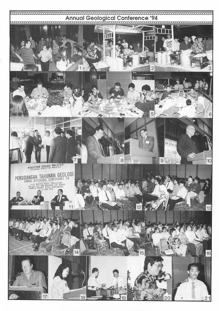
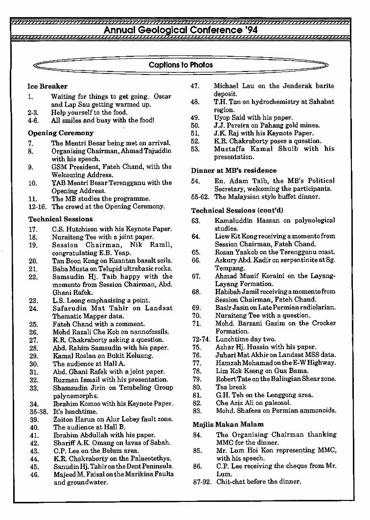
~===~===============c=a;p=tio~n~s=to~Ph~o~to~S==================~~ IceBreaker 1. Waiting for things to get going. Oscar
and Lap Sau getting warmed up. 2-3. Help yourself to the food. 4-6. All smiles and busy with the food!
Opening Ceremony 7. The Mentri Besar being met on arrival. 8. Organising Chairman, Ahmad Tajuddin
with his speech. 9. GSM President, Fateh Chand, with the
Welcoming Address. 10. YAB Mentri Besar Terengganu with the
Opening Address. 11. The MB studies the programme. 12-16. The crowd at the Opening Ceremony.
Technical Sessions 17. C.S. Hutchison with his Keynote Paper. 18. Nuraiteng Tee with a joint paper. 19. Session Chairman, Nik Ramli,
20. 21. 22.
23. 24.
25. 26. 27. 28. 29. 30. 31. 32. 33.
34. 35-38. 39. 40. 41. 42. 43. 44. 45. 46.
congratulating E.B. Yeap. Tan Boon Kong on Kuantan basalt soils. Baba Musta on Telupid ultrabasic rocks. Samsudin Hj. Taib happy with the momento from Session Chairman, Abd. Ghani Rafek. L.S. Leong emphasising a point. Safarudin Mat Tahir on Landsat Thematic Mapper data. Fateh Chand with a comment. Mohd Razali Che Kob on nannofossils. KR. Chakraborty asking a question. Abd. Rahim Samsudin with his paper. Kamal Roslan on Bukit Keluang. The audience at Hall A Abd. Ghani Rafek with a joint paper. Ruzman Ismail with his presentation. Sharnsudin Jirin on Tembeling Group palynomorphs. Ibrahim Komoo with his Keynote Paper. It's lunchtime. Zaiton Harun on Alur Lebey fault zone. The audience at Hall B. Ibrahim Abdullah with his paper. Shariff AK Omang on lavas of Sabah. C.P. Lee on the Belum area. KR. Chakraborty on the Palaeotethys. SanudinHj. Tahir on the Dent Peninsula. Majeed M. Faisal on the Marikina Faults and groundwater.
47. Michael Lau on the Jenderak barite deposit.
48. T.H. Tan on hydrochemistry at Sahabat region.
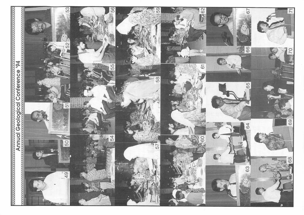
49. Uyop Said with his paper. 50. J.J. Pereira on Pahang gold mines. 51. J.K Raj with his Keynote Paper. 52. KR. Chakraborty poses a question. 53. Mustaffa Kamal Shuib with his
presentation.
Dinner at MB's residence 54. En. Adam Taib, the MB's Political
Secretary, welcoming the participants. 55-62. The Malaysian style buffet dinner.
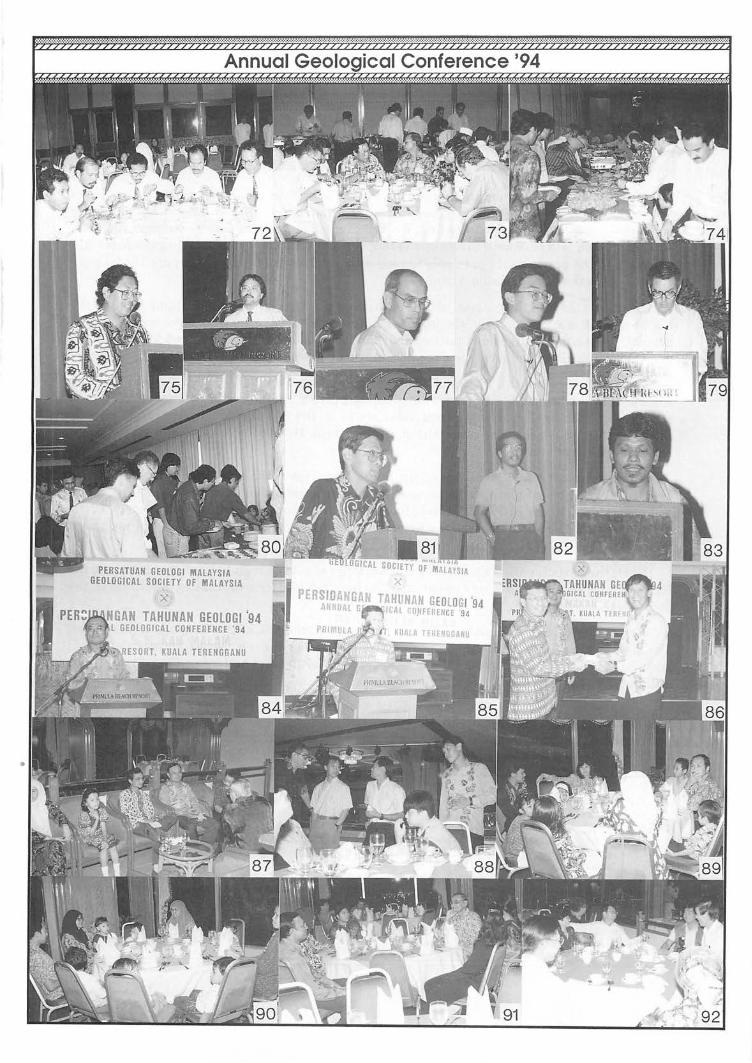
Technical Sessions (cont'd) 63. Kamaluddin Hassan on palynological
studies. 64.
65. 66.
67.
68.
69. 70. 71.
72-74. 75. 76. 77. 78. 79. 80. 81. 82. 83.
Liew Kit Kong receiving a momentofrom Session Chairman, Fateh Chand. Rosan Yaakob on the Terengganu coast. Askury Abd. Kadir on serpentinite at Sg. Tempang. Ahmad Munif Koraini on the LayangLayang Formation. HabibahJamil receiving a momento from Session Chairman, Fateh Chand. Basir J asin on Late Permian radiolarian. Nuraiteng Tee with a question. Mohd. Barzani Gasim on the Crocker Formation. Lunchtime day two. Azhar Hj. Hussin with his paper. Juhari Mat Akhir on Landsat MSS data. Hamzah Mohamad on theE-W Highway. Lim Kok Keong on Gua Barna. Robert Tate on the Balingian Shear zone. Tea break G.H. Teh on the Lenggong area. Che Aziz Ali on paleosol. Mohd. Shafeea on Permian ammonoids.
Majlis Makan Malam 84. The Organising Chairman thanking
MMC for the dinner. 85. Mr. Lum Hoi Kon representing MMC,
with his speech. 86. C.P. Lee receiving the cheque from Mr.
Lum. 87-92. Chit-chat before the dinner.
PERSATUAN GEOLOGI MALAYSIA GEOLOGICAL SOCIETY OF MALAYSIA
X
GAN TAHUNAN GEOLOGI '94 GEOLOGICAL CONFERENCE '94

198
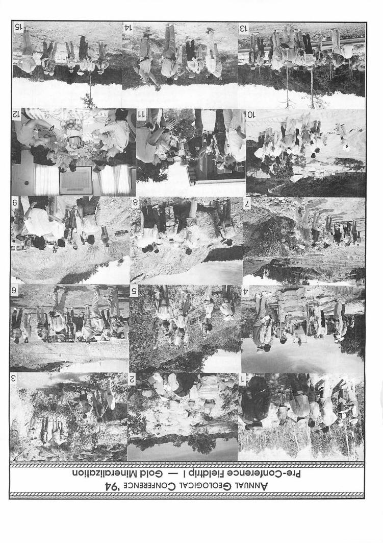
Annual Geological Conference '94 Pre-Conference Fieldtrip - Gold Mineralization, on 9 June, 1994
Mter a pleasant early morning drive, the three 4WD vehicles carrying the 15 participants arrived at Stop 1, one of the alluvial gold rush sites situated near to the confluence of Sg. Kerak and Sg. Marang. Mter a short briefing, Dr. E.B. Yeap, led the participants through the area, which has been laid bare extensively by the illegal miners. There were some illegal miners still present and the participants were able to see for themselves the technique of panning for gold, and the operation of a portable palong.
The next stop was the outcrop of the southernmost extent of the Lubok Mandi Lode at the Ru Rendang Road. Apparently, the lode do not appear to end there as the structural geologist present, Mustaffa Kamal Shuib, noticed that the lode has been highly sheared at the outcrop and there is sufficient evidence to suggest a sinistral offset.
The next stop was the PERMINT Gold Mine at Lubok MandL The manager, Hj. Wan Annuar Ibrahim was at hand to meet the group and give a briefing of the mining operations at the open cut. The gold bearing quartz veins strike in the 355 to 3600 direction and vary in thickness from 0.2-5 m. The mineralized zone is about 10 m wide, inclusive of the adjacent mineralized shear zones.
N ext the participants were driven up Bukit Tiga Tiga to have a panoramic view of the opencut, the treatment plant, the mine area and the adjacent Lubok Mandi area. Packed lunch was then served in the PERMINT Gold Mine Office. After lunch, a short stop was made at the entrance to PERMINT to observe the illegal miners busy working on both sides of the guard house.
Next, the participants visited the former workings of gold on high level alluvium around the Kampung Kijing area. This area apparently has been left idle for sometime as evidenced by the abundance of vegetation.
By popular request, an additional stop was made at the site of the Rusila gold rush area. The visit brought back memories and tales by some participants on the madness of those gold rush days. Here again one sees the familiar potholes left behind and a few illegal miners are still doing their business as usual.
G.H. Teh
Pre-Conference Fieldtrip I - Gold Mineralization Captions to Photos
1. E.B. Yeap briefing participants near the confluence of 8. A bonanza gold block in the mineralized zone. Sg. Kerak and Sg. Marang. 9. Up Bkt. Tiga Tiga, Hj. Wan Anuar describes the layout
of the mine. 2. 3. 4.
Participants viewing the dug out area. E.B. Yeap demonstrating the technique of panning for gold. The portable palong catches the interest of the participants.
5. Mustaffa indicating the Lubok Mandi Lode is offset to the left.
6-13. At the PERMINT Gold Mine. 6. Hj. Wan Anuar Ibrahim briefing the pruiicipants on
arrival. 7. Participants studying the mineralized zone.
10. A view of the treatment plant. 11. Click, click; the attractive gold ore display outside the
site office. 12. Packed lunch courtesy of PERM INT. 13. A look at the illegal mining operations at the entrance to
PERMINT. 14. E.B. Yeap indicates the trend of the fOlmer high level
alluvial gold working at Kg. Kijing. 15. A nostalgic stop at the site of the Rusila gold rush area.
Warta Ge%gi, Vol. 20, No.3, May-fun 1994
UOl40Zll0J9UlI(\J PIO~ al:l 9:>U9J9jUO:>-9Jd v6, 3:>N3~3~NO:> lV:>190103~ lvnNN\f
.... -:.: '.'::"-:'. :.:.:.;.:.;.:.: ..

200
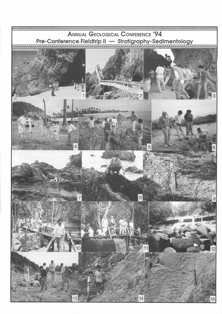
Annual Geological Conference '94 Pre-Conference Fieldtrlp - Stratigraphy & Sedimentology, on 10 June, 1994
V/////////////////////////////-i
The first stop of this Pre-Conference Fieldtrip was at Bukit Cenering along the coast south of Kuala Terengganu to look at the multiply deformed rocks described by Prof. Tjia in 1978 (Geol. Soc. Mal. Bull. 10, pp. 15-24). The highly tectonized interfoliated series of dark coloured metaclastics display cross-stratification, scour-fills, graded-bedding which sometimes indicate overturning of beds. Tectonic structures observed include contorted foliations, crenulation lineation, mullions, quartz injections and mylonite zones. In addition to the dark coloured highly contorted sequence of slate, quartzite, phyllite and schist, later lighter coloured conglomeratic fissure fillings were seen cutting the earlier sequence.
N ext we drove to Bukit Bucu, Batu Rakit, along the coast north of Kuala Terengganu, to examine a spectacular steeply dipping bed of Upper Carboniferous mudstone packed full of fossil brachiopods with minor presence of bryozoa, crinoids and bivalves. Some of the fossils in the sequence had been described by Idris and Zaki in 1986 (Warta Geologi 12, pp. 215-219) but we also found others like corals and even plant remains at the outcrops which they did not describe. The question raised was why should there be such a great difference in terms of tectonic deformation and metamorphic grade between these rocks at Bukit Bucu and the highly disturbed beds of supposedly the same age from the first stop?
We next made a brief stop at the popular picnic spot at the Gunung Tebu Waterfall to look at the granites there. The water gushing out of the near horizontal joints in the granite was most impressive.
The party stopped for lunch at Besut before meeting up with Dr. Kamal Roslan, our guide, and proceeding to Bukit Keluang at the mouth of the Sg. Keluang to examine the coarse, thickbedded conglomerates there. The hill has been developed into a popular picnic spot and one could easily walk up to the outcrop using the concrete walkways built beside it. Some spectacular caves have been carved out by the sea along the faults cutting the conglomerates. It began to rain and the tide was in so most of us missed seeing the angular unconformity at the base of the conglomeratic sequence.
We then drove on to Bukit Bubus, just south of Bukit Keluang, to try to look at a higher section of the same sequence but were turned back by the army who were conducting an exercise in the vicinity of the hill. Our attempt to look at the uppermost section of the sequence at Bukit Dendong was also thwarted because the bridge leading to the outcrop had collapsed! We decided to call it a day and drove back to Kuala Terengganu.
C.P. Lee
Pre-Conference Fieldtrip" - Stratigraphy-Sedimentology Captions to Photos
Bukit Keluang 1. At the clastic sediments outcrop at Bukit Keluang. 2. The walkway made study ofthe outcrops easy. 3. Lap Sau pointing out an interesting feature. Cenering 4. Mustaft"a briefing the participants at Ceneling. 5. Studying the complex structure at Cenering. 6. Mustaffa elaborating on the complex structure. 7. Participants discussing the structure at Bukit Ceneling. 8. Tham Fatt indicating the fissure filling Oight) in older
rocks (dark).
9. Aclose-up of the fissure filling and highly-folded host rocks. G.Tebu 10. Walking to the waterfall at Lata Belatan, G. Tebu. 11. Time for a break and to admire the waterfall. 12. GunungTebu waterfall, flowing over horizontaljoints in
granite. Bukit Bucu, Batu Rakit 13. The hunt for fossils at Bukit Bucu, Batu Rakit. 14. Budding geologists indicating the very fossiliferous
mudstone bed. 15. A close-up of the very fossiliferous bed.
ANNUAL GEOLOGICAL CONFERENCE '94 II - Strat" ra
202
~ Annual Geological Conference '94 Post-Conference Fieldtrip
to Pulau Redang, 13-14 June, 1994 - Report
Thirty-one eager participants boarded two boats at the jetty near the Kuala Terengganu market on the morning of 13th June for the four-hour journey to Pulau Redang. The weather was ime and the sea was not too rough. We arrived at the Marine Park headquarters on the northern tip of Pulau Pinang at lunch time. After checking into the chalets and a quick lunch, the non-geologists went swimming while the geologists proceeded to Tg. Batu Berak to study the marginal granitic rocks there. They then boarded a boat to cross over to Pulau Redang and landed at Pasir Macam Ayam using a small fibre-glass boat to study the metaconglomerates and quartzites belonging to the Redang beds. There was unanimous agreement that the conglomerates were similar to those at Bukit Keluang on the mainland.
The attempt to land at Pasir Kecil to look for plant fossils was aborted as the sky turned dark and the wind had risen making the sea too choppy and dangerous for the small boat. The group decided instead to proceed to the fishing village for tea. After a short tea-break we hired a local van to ferry us to the Redang Golf Resort, which is under construction, to look at the interesting faulted beds of alternating light and dark coloured Redang beds. The structural geologist on the trip, En. Mustaffa Kamal, was most excited to discover that what we at first thought to be high angle reverse faults producing the chequered pattern were actually strikeslip as evidenced by the low-angled slickenslides and relative displacements of the beds. Another interesting discovery was made by Dr. Nuraiteng Tee Abdullah that the sequence was cut by a number of igneous dykes with distinct chilled margins. We stopped briefly to collect some granite samples near the jetty before calling it a day. The weather had cleared by then and we could squeeze in some snorkelling before sunset and dinner.
The next morning after breakfast was spent examining the tonalite, dolerite dyke and Pinang beds near to the Marine Park jetty on Pulau Pinang. Some went for a last swim near the jetty before we packed up and headed back for Kuala Terengganu. The weather was fine but the wind was up and this made the journey back rougher than the journey to Pulau Redang. We reached Kuala Terengganu at about 2.30 pm.
C.P. Lee
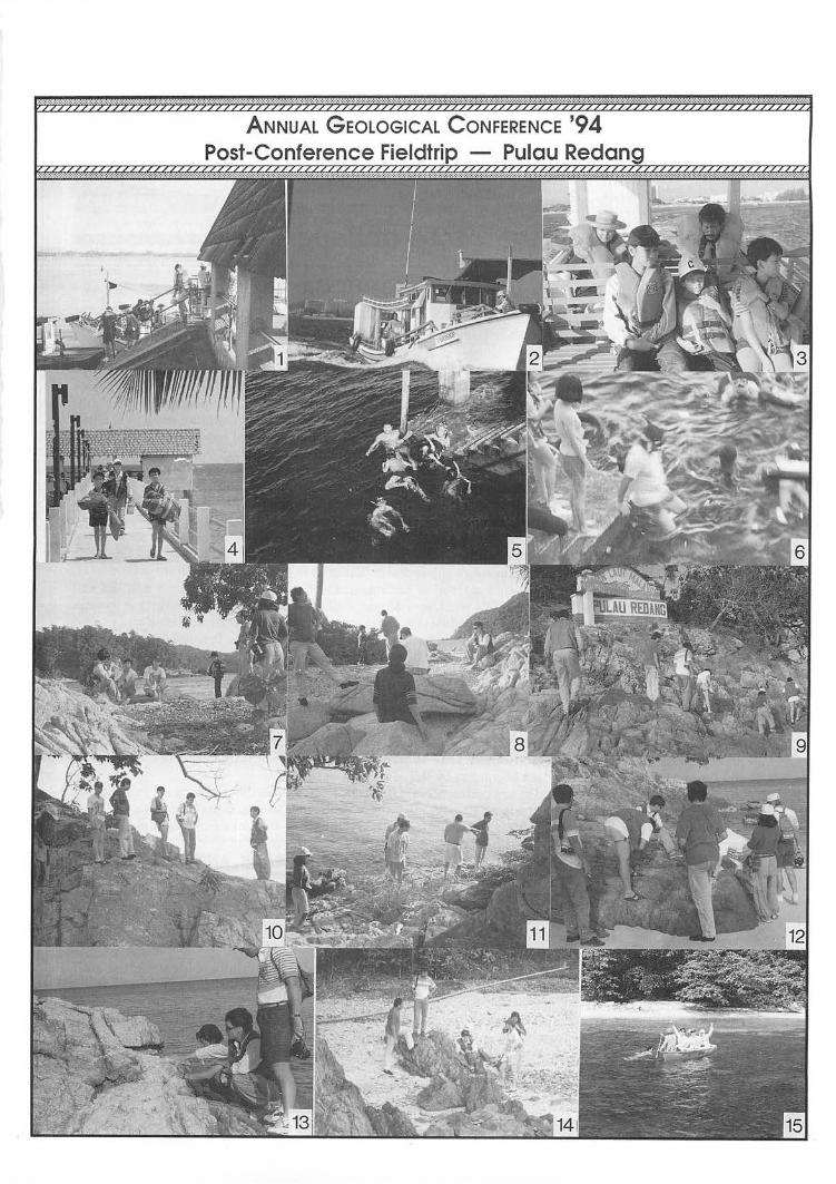
Post-Conference Fieldtrip - Pulau Redang Captions to Photos
1. All on board. We're leaving soon! 2. We're on the way! 3. It's a bit chilly though. 4. Arrival at the Marine Park jetty, Pulau Pinang. 5. Time for a dip in the clear water at Marine Park
jetty, Pulau Pinang. 6. Guess who's going snorkeling? 7-8. Discussing the quartz porphyry and porphyritic
microgranite at Tg. Batu Berak.
9-12. Examining the tonalite outcrops at Marine Park, Tg. Batu Manjing.
13. A closer look at microgranite dikes cutting the tonalite.
14. Dark coloured metasediments of the Pinang beds at Tg. Batu Manjing.
15. Ahoy there! Visiting the Redang beds at Pasir Macam Ayam, P. Redang.
Warta Geologi, Vol. 20, No. 3, May-Jun 1994
... , .. .; ...... '.
ANNUAL GEOLOGICAL CONFERENCE '94 Post-Conference Fieldtrip - Pulou Redan
204
PERSIDANGAN TAHUNAN GEOWGI '94 Annual Geological Conference '94
Abstracts of Papers
THE UNIQUE BARAM DELTA CHARLES S. HUTCHISON
Earth Sciences & Resources Institute, University of South Carolina, Columbia S.C. USA 29208
The Baram Delta is a unique triangular-shaped oil province, second in importance in Southeast Asia to the Central Sumatr.a Basin. Its ocean-ward toe is formed by the NE-trending NW Borneo Trough, its land-ward margins by the NNW-trending West Baram Line and the curved N to NE-trendingMorris Fault.
The West Baram Line is commonly shown on maps as a fault, perhaps because of its parallelism to the onland Tinjar Fault. However this is a misrepresentation of its actual geological nature and significance. From the Late Oligocene to the Late Miocene, it was in fact the continental slope of the Balingian-Luconia Province (micro-continent), and land lay to the WSW in the Penian High and east Natuna area.
Likewise, the Morris Fault, and its landward continuation the Jerudong Line, is shown on maps as a major left-lateral fault. This obscures its real identity, and in the Middle to Late Miocene it also was a major continental slope, lying close to the coastline, sloping steeply Wand NW to bathyal depths exceeding 1 km. The landmass extending only as far Wand NW as the Morris Fault-Jerudong Line was constructed of the Crocker Formation fold-thrust belt.
The proto Baram Delta site was therefore a deep water (bathyal) re-entrant into the Borneo landmass. It was sedimented by Setap Shale and starved of sand until the Crocker Formation was uplifted and exposed to rapid erosion during the Middle and Upper Miocene (Shallow Regional Unconformity of Sabah). Only then did abundant sands find their way fluvially across the narrow coastal plain and shelf and poured down over the steep slope to begin filling up the bathyal Proto-Baram Delta site. Probably its beginnings were turbiditic, but with filling up of the bathyal site, shallower water conditions prevailed offshore as the continental slope was draped over, and the delta began prograding ocean-wards, eventually as far as the NW Borneo Trough. As the delta grew, it draped over both the West Baram Line the Morris Fault scarp.
The bathyal Lower to Middle Miocene pro delta muds (Setap Shale) must have been of good source rock characteristics, and the dumping of abundant sands, off the continental slope, into the initially bathyal area caused a fortuitous juxtaposition of reservoir sands and source rocks, an ideal situation for an oilprolific delta. Of course the sand dominant Late Miocene formations also contained source material, but the Baram Delta had an excellent beginning by initially being bathyal.
Because the landward margins are both continental slopes, and because the geothermal gradients are low, it may be inferred that the Baram Delta, between the West Baram Line and the Morris Fault, is not underlain by normal thickness continental crust, and may even be a re-entrant floored by oceanic crust.
MINERALIZATION AND MINING AT SOUTHEAST TEKKA, PERAK, AND ASSOCIATED GRANITOIDS
G.R. TEH & ISMAIL MOKHTAR Department of Geology, University of Malaya, 59100 Kuala Lumpur
The Tekka area is located about 23 km south of Ipoh town and is essentially made up of the Main Range granitoid to the east, the Kinta Limestone and schist in the middle and the Kampar Riv·er drained alluvial plain to the west.
The metasedimentary rocks formed as a result of low grade regional metamorphism and further recrystallized as a result of contact metamorphism during the granitoid intrusion resulting in north to northwest striking bedding-parallel schistosity. The Kinta Limestone has been altered to marble and
Warla Ge%gi, Vol. 20, No.3, May-fun 1994

205 display karst topography resulting from intense chemical weathering and erosion. The granitoids between Tekka and Sg. Siput (south) have been dated as late Triassic by Bignell and Snelling (1977) and can be divided into 3 different units based on texture and mineralogy, namely the coarse porphyritic biotite adamellite (Unit 1), less porphyritic biotite-muscovite adamellite (Unit 2) and fine-grained non-porphyritic granite (Unit 3). Petrological and geochemical studies suggest that these granite units were differentiated from the same parental magma, with a narrow increase in the degree of differentiation from Unit 1 to 3.
The mesozonal granitoids show the familiar modifications such as microgranites, aplites and pegmatites as well as the effects of pneumatolytic processes like silicification, tourmalinization and greisenization. The infilling of joints, faults and shear zones by late-phase hydrothermal solutions have generated abundant quartz and tourmaline veins.
All the 3 granitoid units show peraluminous characteristics (with the presence of minerals like biotite, primary muscovite, tourmaline and topaz) and invariably can be classified as S-type granitoids, suggesting that magma generation was due to the melting of a sialic crust. Xenoliths present are cogeneric.
The tin mineralization at Tekka is the result of hydrothermal fluids infilling the cracks of the granitic cupola giving rise to quartz-tourmaline-cassiterite- wolframite-sulphide veins of preferred orientations and accompanying wallrock alterations. The xenothermal character of the mineralization is characterised by cassiterite, wolframite, arsenopyrite and pyrite in association with stannite, sphalerite, chalcopyrite, galena and stibnite. Generally the mineralized veins strike 290-300° with steep dips to the NE.
A unique feature of the mining operations at SE Tekka now is the dry mining method being carried out on the highly weathered in-situ hydrothermally altered granite.
THE AGGREGATE RESOURCE TO SUPPLY THE NEW KUALA LUMPUR INTERNATIONAL AIRPORT, SEPANG AND ITS SURROUNDING AREA
E.B. YEAP Department of Geology, University of Malaya, 59100 Kuala Lumpur
Introduction The construction of the new Kuala Lumpur International Airport in Sepang, Selangor is generating
a tremendous amount of synergetic development in the areas leading from the Klang Valley to Sepang and beyond, up to Seremban and Port Dickson. A master plan has been developed for this broad area south of the Klang Valley which has been called the South Corridor. Besides the construction of the new Kuala Lumpur International Airport, its auxiliary facilities and a township, other major infrastructure development planned along this corridor include a new 48 kilometre 6-lane connecting expressway, a new expressway linking Shah Alam to Kuala Lumpur and another linking Port Klang to Bangi to join up with the expressways to Sepang, a rail linkup with the present Subang International Airport (which is to be converted into a domestic airport) as well as several townships along the way. Many existing roads connecting Sepang to the surrounding areas will be upgraded in stages (some of this have already started). All such development require a tremendous amount of construction material which include aggregate, sand and borrow material. Aggregate Requirements
The overall development of the Klang Valley South Corridor from now till the scheduled completion of the new Kuala Lumpur International Airport which is to be ready for the 1998 Commonwealth Games, is estimated to require no less then 20 million tonnes of all types of aggregates, out of which 12 million tonnes are rock aggregates valued at no less then RM200 million. There is still a tremendous growth potential for the aggregate market beyond the airport construction and its infra-structure development period, especially, so when the areas surrounding this new airport have never been touched by urban development. This has created a great interest to contractors and quarry operators to be the first to be able to supply aggregate to tender for projects which are being awarded now. Types of Aggregates
The types of aggregates which are required for the construction industry is dependent 6n the nature ofthe structures which are to be constructed. For highways and expressways generally the aggregate used to form the sub-grade (layer above the platform level) is generally specified to be soil, laterite or sand which must show a soaked California Bearing Ratio (CBR) of about or greater then 5%. Sand with a soaked CBR>30% is specified for the sub-base, while the base is usually wet macadam composed of a "graded" <50 mm, crusher-run with a soaked CBR>80%. The top layer of the expressways would be either composed of
Warta Geologi, Vol. 20, No.3, May-Jun 1994

206 cement-based concrete or asphaltic concrete. If cement-based concrete is used then 25 mm to 20 mm aggregates and sand are required. If asphaltic concrete is used, then the base course will be composed of two 75 mm thick layers of <38 mm graded aggregate asphaltic concrete (AC) followed upwards by one 50 mm thick layer of binder course using <25 mm graded aggregate AC and then finally one 38 mm thick layer of wearing-course with 20 mm graded aggregate AC. In the case of runways, the sub-grade layer above the platform level is soil, sand or laterite with a soaked CBR>5%. This is followed upwards by four 75 mm thick layers of <50 mm graded aggregate AC. The binder course is of two 73 mm thick layers of <25 mm graded aggregate AC. The wearing course is generally of 2 layers of 38 mm thickness with <20 mm graded aggregate AC. Generally the amount of aggregate required for the construction of 1 km of 6-lane expressway including the drains, bridges, shoulders etc is from 70,000 tonnes to 100,000 tonnes depending on the ground conditions and the specifications. The one runway which is to be initially constructed in the new Kuala Lumpur Airport is estimated to require about 1,200,000 tonnes of aggregate. For the construction of buildings and houses, the main type of aggregate which is required is the 20 mm type, needed for the cement based concrete.
Overall, the aggregate requirements for the construction of the new Kuala Lumpur International Airport and the development of the South Corridor consist of all types of aggregates (from blocks to quarry dust), sand, earth and laterite. -
Geology and Mineral Resources of the South Corridor The geology within 30 kilometre radius of the new Kuala Lumpur International Airport is significant
in terms of aggregate resources for the development of the South Corridor. The oldest rock found in the eastern part of the South Corridor consists of a sequence of quartz-mica schist overlain conformably by graphitic schist. These have been correlated with the Dinding and Hawthornden Schists of the Kuala Lumpur area. Overlying unconformably these older schists is a sequence of phyllites and meta-quartzite. Part of these have been correlated with ·the Kenny Hill formation. Locally, lenses of marble are found in this upper sequence. The two sequences of rocks are observed to be folded and subsequently intruded by granites during the Late Triassic. The main granite mass which is part of the Main Range Granite is found on the eastern part of the South Corridor. The most important granite mass is the Bukit Galla granite which is located between Labu, Pajam and Nilai in Negeri Sembilan. Petrographically, the granite is composed mainly of porphyritic biotite adamellite, with minor intrusives of porphyritic microadamellite and non-porphyritic microadamelite. Some aplite veins and minor pegmatites are seen in the field. The granite mass which continues southwards from Bukit Galla forms the low hills of Bukit Ebang (about 293 m) in Labu and the Bukit Tajam-South Hammock (225 m to 255 m) ridge of Jimah. These two low hills are composed of porphyritic to non-porphyritic biotite adamellite with minor aplite and pegmatite. In the Selangor side of the South Corridor, no suitable granite quarry sites are found which are close to the new Kuala Lumpur International Airport. The nearest granite area is in the Jugra Hill where a quarry once operated. Recently, a new quarry licence has been granted on another part of the hill. Development work on this quarry site has just started.
Numerous quartz veins and reefs are found to cut the folded metasediments and the granite masses. These resistant quartz veins and reefs often occupy hill tops or form well defined ridges striking largely from 2700 to 3000 • The region as a whole was uplifted after the orogeny and the intrusion of the granite. The weathering, erosion and deposition events of the Pleistocene time can still be clearly observed. The main effect seen here is the deposition of alluvial-marine Pleistocene sediments in a broad strip extending up to 20 km inland from the coast. Much of the area demarcated for the new Kuala Lumpur International Airport sits largely on this Pleistocene sediments which overlie the folded phyllites and meta-quartzite sequence. The soil over a large parts of the South Corridor especially, those overlying the graphitic schist and some phyllites as well are found to be strongly laterized. Laterized soil with pebble to cobble size Feoxide concretions may be up to several meters thick.
The most important resource in the area exploited in the past is the alluvial tin ore. Tin mining has been active in the Sendayan-Lukut, Dengkil, Kuala Langat, Pajam and Labu areas and also along the alluvial plains of Sungei Semenyih, Sungei Labu and Sungei Langat. In terms of aggregate resource such former tin mining areas would be the best source for the supply of construction sand. The sand resource in most of the these former mining areas has been exploited extensively with the exception of those in Dengkil and Kuala Langat.
The weathering of the phyllites and the graphitic schists often gives rise to thick residual clayey soil. Pleistocene sediments which have their provenance derived from phyllites and graphitic schists are also clay rich. The location of many brick factories in the South Corridor is without doubt due to the presence of very good clay resource in this region.
Warta Geologi, VoL 20, No.3, May-Jun 1994
207 The Aggregate Resource in the South Corridor
The most valuable aggregate reSource required for the development of the South Corridor is the quarry rock aggregate. Granite rock aggregate is the preferred choice for use in the wearing course and as well as for concreting. Though, limestone and aggregate of other rock types do pass the specifications for many construction uses, they are generally not the first choice material.
The choice of quarry sites in the South Corridor would be largely confined to the granite areas. It is very fortunate that, the foothills surrounding Bukit Galla, which reaches to a height of about 613 m are suitable for many new quarry sites. Large areas of bare rock exposures can be seen between the 50 m to the 230 m level of the western foothills. The northern and eastern foothills however, seldom show bedrock exposures though large core boulders are very common. Drilling over such sites indicate soil overburden thickness ranging from 10 m to over 25 m The amount of weathered granite rocks is minimum. Two quarries have been operating at the foothill of Bukit Galla for some time. A third quarry site is located in the Bukit area in Labu where the JKR had previously operated a granite quarry. Another abandoned quarry which formerly worked on quartzite which is invaded by quartz veins is located on a hill near Kg. Jenderam in Selangor. The Geological Survey of Malaysia, based on a field study, had recommended 8 potential quarry sites around Bukit Galla. The state government ofNegeri Sembilan has so far approved no less then 15 quarry leases around Bukit Galla. Some of the earlier approved leases specified the exact locations of the site but however, many of these are found to be not suitable due to unsuitable rock types (quartz-mica schist), lack of access and inadequate rock reserve. Later quarry leases approved generally allow the leasee to choose a site of 30 acres to 40 acres from a larger area of a few hundred acres. The main problems of these newly approved quarry sites are the lack of or inadequate access to and from the approved site to the main road, suitable quarry plant sites and thick overburden.
Another 3 sites of 30 acres each have been approved for the state land part of the Bukit Tajam area recently. Small microgranite outcrops in deeply dissected stream courses are exposed in this area. Core boulders of biotite adamellite are seen in many places and where drilling has been carried out bedrock had not been reached at 30 m below the surface. This area also has problems of access and suitable crushing plant site.
For competitive supply of crushed rock aggregate, road distance is a very important factor. All the quarry sites around Bukit Galla and the Bukit Tajam area are within 30 kilometres to the new Kuala Lumpur International Airport site. However, development projects north and south of this site can be competitively supplied by quarries located in Puchong, Ulu Langat, Semenyih and Seremban. There are no less then 10 quarries in these areas.
The most important sand resource for the South Corridor is in Dengkil and Kuala Langat, specifically from the tin mining areas (both dredging and gravel pump mining). For use in the construction industry, the sand has to be reprocessed and sized according to the requirements. Conclusions
There is enough aggregate resource for use in the construction and development of the new Kuala Lumpur International Airport and the synergetic development of the South Corridor. Granite quarry rock aggregates are best supplied by the many new and old quarries located in the foothills of Bukit Galla. There is adequate sand resource in the mining areas of Dengkil, Kuala Langat and also along the Sungei Langat, Sungei Labu and Sungei Semenyih. Laterite earth developed over phyllites and graphitic schists is in abundant supply in the nearby areas for most development projects. Good clay deposits in and around the South Corridor have supported many brick factories. Laterite, especially those with iron concretions which is a good material for the sub-grade, can be used for the sub-base and base for roads and expressways if their soaked CBR values reached the specifications.
HIMPUNAN FOSILaFOSIL FORAMINIFERA DAN ALGA YANG TEROAPAT 01 OALAM SINGKAPAN-SINGKAPAN BATU KAPUR 01 KAWASAAN SEKITAR SUNGAI KENONG,
PAHANG ABDUL HADI ABDUL RAHMAN & NURAITENG TEE ABDULLAH
Jabatan Geologi, Universiti Malaya, 59100 Kuala Lumpur
Kawasan kajian kami terletak di kawasan sekitar Sungai Kenong, Pahang Darul Makmur. Kajian dijalankan ke atas dua singkapan batu kapur yang terdapat di sini iaitu Gua Batu Tinggi dan Gua Kesong yang mengandungi banyak mikrofosil.
Warta Geologi, Vol. 20, No.3, May-fun 1994
208 Batu kapur di sini mengandungi banyak fosH-fosH foraminifera dan alga berkalka yang berumur
Permian Lewat. Di antara foraminifera-foraminifera yang terdapat di sini adalah seperti Globivalvulina sp. Paraglobivalvulina sp., Sphaerulina sp., Cribrogenerina sp., Colaniella sp., Palaeofusulina sp. dan lain-lain sementara alga-alga yang terdapat adalah terdiri daripada kumpulan Gymnocodium dan Dasycladacean.
Foraminifera bentos dan alga berkalka yang terdapat di sini mempunyai persamaan taksonomi dengan yang dijumpai dalam jujukan Permian Lewat kawasan Tethy terutama di bahagian timur Tethy.
Kehadiran Palaeofosulina sp. di Gua Kesong dan Gua Batu Tinggi boleh dikorelasikan dengan palaeofusulinid daripada Selatan Kelantan (Aw et al., 1977), Utara Thailand (Sakagami & Hatta, 1982; Ueno & Sakagami, 1991) dan Selatan China (Rui, 1979). Fosil ini merupakan fosil indeks bagi beberapa zon yang telah dicadangkan oleh beberapa pengkaji seperti zon Palaeofusulina-Reichelina (Toriyama, 1973), zon Palaeofusulina sinensis (Kanmera & Wakazawa, 1973), zon Palaeofusulina sinensis-Colaniella parva (Ishii et aI., 1976) dan subzon Palaeofusulina sinensis (Rui, 1979).
Daripada kajian foraminifera dan alga-alga yang terdapat, batuan karbonat berumur Permian Lewat di kawasan Sungai Kenong ini diinterpretasikan terenap sebagai tebing lumpur di kawasan cetek air suam pentas benua.
GEOLOGY OF KOTA KINABALU AND ITS IMPLICATIONS TO GROUNDWATER POTENTIAL
MAJEED FAISAL, SHARIFF AK OMANG & SANUDIN HJ. TAHIR Department of Earth Sciences, Universiti Kebangsaan Malaysia Sabah Campus, 88996 Kota Kinabalu, Sabah
The increasing population in Kota Kinabalu results in an increase in the demand for water supply. Groundwater is of primary concern because it is the most economical source of water supply. The main objectives of this paper are 1) to evaluate the groundwater resources in the study area and 2) to study effect of geology on groundwater. Kota Kinabalu is underlain by the Middle Oligocene-Lower Miocene Crocker Formation which is composed of sandstone, shale and an interlayered sandstone and shale, and Quaternary alluvium. The study area is controlled by heavy structural lineaments mainly representing major folds, thrust faults, normal faults, wrench faults, sheared zones and landslides. A common characteristic of these structures is that they are closely associated with each other. Movement along these structures strongly influenced the geomorphology and groundwater of the study area. The rock formation within the fault zone and its vicinities are highly deformed, sheared and controlled by heavy joints and fractures resulting from thrusting. Geological study ofthe area indicates that only the sandstone unit of the Middle-Oligocene-Low Miocene Crocker Formation and the Quaternary alluvium can be considered as important groundwater reservoirs. The aquifers within the study area can be divided into three major groups based on the host rock and structural parameters as following: 1) aquifers of Quaternary alluvium, 2) aquifers within the fault zone and 3) aquifers of the sandstone unit of the Crocker Formation. Chemical and physical analysis of groundwater indicate that the groundwater in this study area is of meteoric origin and is alkaline in nature.
Both the stratigraphic and structural settings facilitates favorable movement and circulation of groundwater within the Crocker Formation and Quaternary alluvium. It affects the continuity of the aquifers, enhances secondary permeability, as well as increases the storage capacity of the formation. Such settings also create confined and unconfined aquifer systems.
By and large, the Crocker Formation and Quaternary alluvium has a good potential for resource and development of groundwater in Kota Kinabalu. .
PHYSICO-CHEMICAL PROPERTIES OF BASALT SOILS FROM KUANTAN, PAHANG TAN BOON KONG
Department of Geology, Universiti Kebangsaan Malaysia, 43600 Bangi, Selangor
Some 20 basalt soil samples from the Kuantan area were analysed for their physico-chemical properties. The physical properties of the soils analysed are: relative den!lity, water content, the Atterberg Limits, grain size distribution, and compaction properties. The chemical properties analysed involved the pore fluids chemistry, whereby the pore fluids of the soils were first extracted using the "Saturation Extract" method and then subsequently analysed for pH, conductivity, cation (Na+, K+, Ca2+, Mg2+) concentrations,
Warla Geologi, Vol. 20, No. 3, May-]un 1994

209 and anion (S042-, Cl-, COS2-, HCOS-) concentrations_ The results of the analyses are summarised in Table 1-
The results show the following characteristics for the basalt soils: relative density is high with most values> 2_7; water content is generally high with wo>30% indicating high adsorption of water; liquid limits can attain high values in excess of 50%; grain size comprises the whole range from G (gravel) to C (clay) but is predominantly fine-grained (MlC), ; the fines fraction of the soils are classified under ML-MH soils, i_e silts with low-high plasticity. Surprisingly the compacted maximum dry densities show rather low values ranging from 1-22-1-60 g/cms in spite of the fact that basalt soils generally make good embankment fill materials. The low g dmax values could be attributed to the rather high optimum moisture contents of the soils (wopt=29.0-47.5%).
Results for the pore fluids chemistry indicate the following: pH is on the acidic side « 7); conductivity is low, reflecting the low cations contents of the pore fluids; cations Na+, K+, Ca2+, Mg2+ are generally low in concentrations, with K+, Ca2+, and Mg2+ having values of < 5 ppm. Interestingly enough, there appears to be a distinct predominance ofNa+ concentrations. As such, the ratios of monovalent cations (Na+ + K+) versus divalent cations (Ca2+ + Mg2+) show high values ranging from 3-17, with a few values being in excess of 100, thus indicating the high dispersivity of the basalt soils. Anions Cl-, COs2-, and HCOS- were not detected, while SOl- shows considerable values of 35-122 NTU.
Although in the field the soil profile shows 3 distinct layers or horizonations having colours ranging from (top to bottom) dark brown, red, to purple, it would appear from the test results obtained that the physico-chemical properties of the soil samples taken from these 3 horizons do no~ show any significant differences or variations from one another, contrary to expectations. Moreover, some of the physicochemical properties of the basalt soils taken from the same layerlhorizon also appear to plot in 2 distinct clusters - the reasons for this are not entirely clear.
INTERPRETATION OF THE MAGNETIC ANOMALIES IN PARIT SULONG·BATU PAHAT AREA
SAMSUDIN HJ TAIB & ZUHAR ZAHIR TUAN HARITH Department of Geology, University of Malaya, 59100 Kuala Lumpur
The aeromagnetic map by Agoc (1958) over the Parit Sulong - Batu Pahat area shows a number of distinct local magnetic anomalies in a long wavelength regional anomaly. The regional anomaly generally decreases northwards. Ground magnetic survey conducted over these anomalies indicates the presence of shorter wavelength anomalies within the local anomaly. These superposition of anomalies having different wavelengths are common in the magnetic anomalies as observed in the study area. The main objective of this work is to determine the cause of these different wavelength magnetic anomalies and their relation to the geological and structural setting of the area.
The geology of the area comprises two main rock types that is sedimentary and igneous rocks. Rock outcrops are sparse with the outcrops only found at prominent topographic highs within a relatively flat region. The granites outcrop in the hills south and east of the Batu Pahat town while the sedimentary rocks mainly outcrop at the hills and ridges east of Parit Sulong. The flat areas (less than 5 m above datum) comprises alluvium with abundant recent fossils.
The sedimentary rocks are essentially the Cretaceous to Jurassic clastic sediments of the Paloh Formation; mainly the conglomeratic sandstone unit. An older shally sandstone layer probably of Triassic age is also present along one of the conglomeratic ridges. The igneous rocks are made up of mainly the Lower Jurassic to Upper Triassic Batu Pahat granite, some weathered basic rocks probably of Lower Triassic and the volcanic rocks mainly within the Paloh Formation. The granite is probably a composite body essentially having the same mineralogy but may be divided into two based on the susceptibility. To the east ofBatu Pahat the granite has high susceptibility, while to the south ofBatu Pahat the susceptibility is low.
The sedimentary structures observed include bedding, graded bedding, cross bedding and laminations. No obvious large scale geologic structure can be observed in the field. The sedimentary structures, topographic expression, and lineament study from aerial photography, however, indicate that the structural setting is quite complicated. They show the presence of a number of folds and faulting. A notable feature is the continuous ridge of Bukit Bindu - Central Ridge where the bedding is easterly dipping in the north (Central ridge) but westerly dipping in the southern part (Bukit Bindu ridge). A fault is inferred to cut across the ridge though not observed in the field.
Wllrtll Geologi, Vol. 20, No.3, MIly-Jun ~994
210 Three prominent local magnetic anomalies can be observed from the Argoc aeromagnetic map for the
region. Comparison of the aeromagnetic map to the geologic map indicates that these three prominent magnetic anomalies are located over different geologic settings. The almost circular anomaly near Batu Pahat town having distinct highs and lows, may be modelled as due to the granite body with high susceptibility. To the east of Parit Sulong the anomalies have two distinctly different patterns; an elongated anomaly to the south and an almost circular anomaly to the north. Part of the anomalies lie over the weathered basic rock and is probably its source. To the south of this area, another elongated anomaly occurs over the sedimentary (Paloh Formation) ridge. Its probable source is the volcanics within the Paloh Formation. These two elongated anomalies, though separated, may also be due to the same type of source. The structural implication from the magnetic anomalies appear to support some of the geological evidences such as the presence of a fault separating the Bukit Bindu-Central ridge. Other structures occur over areas without rock outcrops.
PERLAKUAN LULUHAWA BATUAN ULTRABES DI TELUPID SABAH: TAFSIRAN DARI SEGI GEOKIMIA
MUHAMAD MD. TAN & BABAMUSTA Jabatan Geologi, Universiti Kebangsaan Malaysia, 43600 Bangi, Selangor
Batuan ultrabes tersingkap dengan banyaknya di sepanjang lebuhraya Sandakan-Telupid. Batuan ultrabes di kawasan ini merupakan jujukan ofiolit. Cerapan pada profil batuan telah dijalankan di sepanjang potonganjalan 2.5 km hingga 11.0 km dari pekan Telupid menuju ke bandar Sandakan. Profil batuan dipiIih dari batuan segar hingga tanih yang tebalnya berjulat dari 7.0 m hingga 10.0 m.
Perlakuan luluhawa batuan dikaji pada sampel batuan segar dan tanih. Kaedah analisis melibatkan cerapan keratan nipis, XRD (pembelauan sinar-X), XRF (pendaran sinar-X), dan kimia basah. Sampel air yang muncul sebagai air bawah tanah dianalisis untuk menentukan kualitinya.
Perubahan mineral primer (mineral pembentuk batuan) ke mineral sekunder berlaku semasa luluhawa. Mineral primer seperti olivin, piroksen dan feldspar boleh dikenalpasti dari cerapan petrografi pada keratan nipis. Mineral sekunder seperti geotit, gibsit, anatas dan moghemit boleh dicerap dari analisis XRD.
Komposisi unsur major ditentukan dengan kaedah XRF. Unsur major yang ditentukan komposisinya ialah Si02, Ti02, Al20 S' Fe20 S' MnO, MgO, CaO, ~O, Na20 dan P20 S• Bagi FeO kepekatannya ditentukan dengan kaedah analisis kimia basah.L.O.I ditentukan dengan memanaskan sampel pada suhu 1200°C. Perlakuan semasa luluhawa batuan ditunjukkan dengan corak perubahan komposisi unsur melawan kedalaman. Korelasi antara unsur major juga memperlihatkan perlakuan semasa luluhawa.
Teknik XRF juga digunakan untuk menentukan komposisi unsur surih. Unsur surih zink (Zn), kuprum (Cu), nikel (NO, kobalt (Co), kromium (Cr), niodimium (Nd), barium (Ba), stanum (Sn), niobium (Nb), thorium (Th), zirkonium (Zr), strontinum (Sr), rubidium (Rb), plumbum (Pb) dan galium (Ga) telah dipilih untuk ditentukan komposisinya. Graf kedalaman melawan kepekatan unsur surih dan korelasi antara unsur major dan surih diharapkan dapat menggambarkan corak perlakuan batuan ultrabes yang terluluhawa.
Analisis air dibuat untuk menentukan kualiti air yang berpunca dari bawah tanah.
SEISMIC APPLICATION USING FEEDFORWARD NEURAL NETWORK TECHNOLOGY: A REVIEW
LEONG LAP SAlP & NG TONG SAW lGeophysics Program, School of Physics, Universiti Sains Malaysia, 11800 USM Penang
2PETRONAS Carigali Sdn Bhd, Wisma Peladang, Jalan Bukit Bintang, 50776 Kuala Lumpur
Many simple tasks present themselves in the oil and gas industry that appear trival but give results that are dependent on the experience, and to a certain degree, subjective judgement of the geophysicist concerned. A case in point are labour intensive decisions like editing noisy traces, first-break picks and velocity analysis. At another level is the integration of petrophysical parameters with multiple seismic attributes. Here the interpreter is confronted with such a vast array of input variables that it becomes difficult to recognize and weigh the most pertinent combination of influencing factors. Lateral reservoir prediction poses a similar dilemma and so is lithologic identification from well-log values.
War:a Geologi, Vol. 20, No.3, MRy-Jun 1994

211 A new approach to modern day data analysis which requires a subjective decision is computation by
neural network technology. Neural networks are a form of automated pattern recognition in which a set of input pattern is related to an output by a transformation encoded in the network weights. Whereas conventional processing algorithms are deterministic and inevitably sequential, neural networks are instead particularly appropriate for applications where the physics producing an output is not well understood and an exact algorithm cannot be formulated. The network is first 'trained' or calibrated to a certain preset group of patterns or features and when a predefined level of competence has been achieved it is then ready to 'decide' whether a new input sequence is congruent with its memory weights. The purpose of this paper is to review some seismic applications from feedforward neural networks using the backpropagation algorithm. Multi-layered feedforward network and the backpropagation learning algorithm are explained. Seismic applications and input attributes used by various authors are tabulated and discussed.
Neural networks are simple computer models that attempt to simulate the operations of neurons in the brain. The biological aspects of it involves neurophysiological and cognitive processes in the human brain. In neural computing, the computation and approximation power of neural architecture, learning algorithms and applications draws inspiration from physical models of the human brain instead. A very large class of network algorithms satisfying different paradigms and goals exist in neural computing.
Feedforward neural network as discussed here can be represented as a mapping function which is defined by a set of weights and connection parameters. The weights and parameters are determined by minimizing the error function with respect to the known input and output vector pairs. The backpropagation algorithm is the most widely used learning algorithm for feedforward neural networks. Figure 1 (a and b) illustrates the structure of an elemental computational unit with N inputs and one output, and a neural network architecture with two hidden units respectively. Input to the network is weighted, summed and squashed through a nonlinear transfer function (usually a sigmoidal function defined by its) = 1/(1 + e-8». Comparing with neurons in the human brain, the input corresponds to the dendrites, the weights correspond to the synapses, the summation and transfer functions correspond to the cell body while the output corresponds to axons fanning out to other neurons. The sigmoidal function is the mathematical approximation to the firing tate in the neuron: Supervised training is accomplished by error minimization (usually a form of gradient descent optimization) in the following steps: (1) Initialize weights and thresholds to small random numbers. (2) Present input and desired output. (3) Compute output, i.e. forward propagate the input. (4) Adapt the weights, i.e. compute error for network output and update new weights to minimize the error. (5) Use resulting output as new input, repeat steps 2 through 5 until error is sufficiently small. Repeat entire
process for each input in the training set. ' Knowledge in the feedforward neural network is now contained in the interconnecting weights. Summaries some applications using the backpropagation learning algorithm. Relevant sources can be
identified from the references for furthur reading. The paper concludes with a discussion of some strengths and weaknesses of neural networks.
PENGGUNAAN DATA LANDSAT "THEMATIC MAPPER" (TM) DALAM PENTAFSIRAN GEOLOGI KAWASAN KUALA GRIS, KELANTAN DARUL NAIM
SAFARUDIN MAT TAHIR & JUHARI MAT AKHIR Jabatan Geologi, Universiti Kebangsaan Malaysia, 43600 8angi, Selangor
Pentafsiran geologi terhadap imej Landsat TM telah dilakukan sebagai salah satu kaedah untuk mendapatkan maklumat ten tang geologi (litologi dan struktur) kawasan Kuala Gris Kelantan Darul Nairn. Kawasan kajian yang meliputi keluasan hampir 250 km persegi mempunyai beberapa jenis morfologi seperti kawasan tanah rendah dan aluvium, kawasan perbukitan rendah beralun, kawasan perbukitan sederhana tinggi dan kawasan perbukitan tinggi. Litologi utamanya terdiri daripada batuan metamorf (Syis Taku), batuan sedimen (Formasi Gua Musang) dan juga batuan igneus yang terdapat di beberapa kawasan kecil.
Data Landsat TM diproses untuk menghasilkan imej-imej yang sesuai untuk ditafsirkan. Antara teknik pemprosesan yang terlibat termasuklah pembetulan geometri, pembetulan atmosfera, peningkatan kontras, paparan warna, an ali sa komponen utama dan penapisan. Pemerhatian yang terperinci terhadap cirian imej seperti ton (rona), warna, tekstur, ketahanan terhadap hakisan, sifat perlapisan, lineamen
Warla Geologi, Vol. 20, No.3, May-Jun 1994
212 ~re~akan), bahan tutupan (tumbuhan dan pertanian) telah membantu dalam membuat pentafsiran tentang Jems batuan serta persempadanannya. Maklumat tentang struktur geologi (terutamanya sesar atau retakan utama) juga ditafsirkan.
Imej Landsat TM jalur 7 (2.08 2.35 urn) adalah antara jalur tunggal yang baik untuk penafsiran litologi. Antara banyak komposit warna yang dihasilkan didapati komposit wama gabungan jalur 457 merupakan antara komposit warna yang paling baik untuk tujuan pentafsiran geologi kawasan ini. Di samping itu, komposit warna imej komponen utama 214 juga memaparkan beberapa cirian menarik yang boleh digunakan dalam mentafsirkan maklumat litologi bagi kawasan kajian. Imej jalur 4 (0.76-0.90 urn) didapati sesuai untuk digunakan bagi mendapatkan maklurnat lineamen secara urnurn. Walau bagaimanapun, imej yang dihasilkan melalui teknik penapisan (sama ada tapis an berarah atau tanpa arah) memaparkan maklumat struktur geologi (line amen) lebih jelas dan sangat membantu dalam memetakan line amen (sesar atau retakan utama) di kawasan ini.
Berdasarkan cirian imej, sebanyak tujuh unit imej telah dicam dan dibezakan. Walau bagaimanapun, didapat tujuh unit ini boleh dikaitkan dengan empat jenis batuan utama yang terdapat di kawasan ini. Peta geologi hasil tafsiran imej Landsat TM ini memperlihatkan persekaitan yang baik dengan peta geologi terdahulu bagi kawasan menggambarkan bahawa, walaupun kawasan ini dipenuhi hutan serta bahan tutupan yang tebal, namun dengan penghasilan imej yang sesuai data satelit (dalam hal ini Landsat TM) serta pemerhatian yang teliti terhadapnya, data satelit mampu untuk memberikan maklumat geologi (litologi) kawasan ini. Maklumat struktur (lineamen utama) disurih dan dipetakan. Beberapa lineamen utama telahpun dipetakan dan berdasarkan saiznya maka kebanyakan lineamen ini ditafsirkan mewakili sesar yang belurn dipetakan setakat ini. Hasil pemetaan terperinci terhadap lineamen menggunakan imej satelit boleh digunakan dalam meramalkan kawasan-kawasan yang berpotensi daripada segi pemineralan bijih primer berdasarkan asosiasi antara sesar/retakan utama dengan zon pemineralan.
DISTRIBUTION OF MODERN NANNOFOSSILS ACROSS THE SABAH MARGIN AND ITS APPLICATION IN ENVIRONMENTAL INTERPRETATION OF A LATE QUATERNARY
SECTION MOHD RAZALI CHE KOBI & BASIR JASIW
IPETRONAS Research & Scientific Services, Lot 1026, PKNS Industrial Area, 54200 Hulu Klang 2Department of Geology, Universiti Kebangsaan Malaysia, 43600 8angi, Selangor
Calcareous nannofossils were analysed from 22 surface sediments across the Sabah continental " margin and 28 samples from core KL 139 of Late Quaternary section. The analyses were done quantitatively
by using light microscope. The nannofacies were determined analytically by using the triangular coordinate diagram of dominant coccolith component.
The modem nannofossil assemblage is dominated by two coccolith species: Emiliania huxleyi and Gephyrocapsa oceanica and one non-coccolith species: Florisphaera profunda. E. huxleyi and F. profunda are pelagic species, increasing in their abundance in proportion to water depth, whereas G. oceanica exhibits its preference for neritic environment shown by reducing abundance with depth.
Three nannofossil assemblages or nannofacies have been identified from surface sediment; E. huxleyi (EH), G. oceanica (GO) and E. huxleyi - G. oceanica (EH-GO). Each nannofacies snows different proportion of species and were dominated, in respective order by E. huxleyi, G. oceanica and the combination of both species. These nannofacies belts are distributed parallel to the mainland of Sabah. Nannofacies GO occupied the shelf and the proximal area of the continental slope. This is followed by nannofacies EH-GO at the distal part of the continental slope and nannofacies EH in the abyssal environment.
The same technique has been applied to a Late Quaternary section, core KL 139 which was retrieved from the Sabah trough. The length of the core is 1300 cm and composed mainly of Upper Pleistocene to Recent sediments. The zonation scheme of Gartner (1977) has been adopted in the bichronology of the core. Two nannofossil zones were identified; E. huxleyi and E. huxleyi Acme zones. These zones are equivalent to NN 21 zone of Martini (1971).
The core section can be subdivided into five nannofacies intervals assigned as nannofacies I-V. Nannofacies I (0-150 cm) is the interval for nannofacies EH-GO, nannofacies II (150-500 cm) composed of interlaminated, EH-GO and GO facies, nannofacies III (500-800 cm) is characterised by nannofacies EH, nannofacies IV (800-1250 cm) is the interval for nannofacies EH and nannofacies V (1250-1300 cm) is characterised by nannofacies GO.
Warta Geologi, Vol. 20, No.3, May-fun 1994
213 Using modern nannofacies distribution in the offshore Sabah margin as an analogue, the nannofossils
record from the core indicates changes of paleowater depth and paleotemperature. These changes are believed to be related to the global climatic changes during the Late Quaternary. The nannofacies V is representative of a glacial period, nannofacies IV is a record of the last interglacial period, nannofacies III and II are the record for the last glacial period and nannofacies I is a record of post-glacial period.
The present findings are in agreement with the previous palynological data from the same section, core KL 139 (Shamsudin, 1993).
APPLICATION OF RESISTIVITY METHOD FOR ARCHAEOLOGICAL SITE INVESTIGATION ABDUL RAHIM SAMSunIN
Department of Geology, Universiti Kebangsaan Malaysia, 43600 Bangi, Selangor
A geophysical survey using geoelectrical profiling technique was conducted at Kg. Sg. Mas which has been gazetted by Muzeum Negara as one of the important prehistoric sites in Kota Kuala Muda district of Kedah. An earlier excavation work in this area uncovered many bricks and rocks of archaeological significance. The resistivity survey was carried out by the Department of Geology, Universiti Kebangsaan Malaysia to help the excavation programme in locating areal distribution and depth of the archaeological objects in the area.
The resistivity profiling method employing dipole-dipole array was performed using the ABEM SAS300 terrameter. An electrode spacing of 1 m was used with transmitter-receiver separation (N) ranging from 1 to 6 m. The measurements were made along ten parallel lines located 10-15m apart and covered an area with dimensions of approximately 100 x 100m. Each measured value was plotted at the intersection of two 45-degree lines through centres of the dipoles. The measurements resulted in the preparation often resistivity pseudosections and six isoresistivity maps. The·maps show lateral distribution of the archaeological features where the depth below surface can be interpreted from the corresponding plotted pseudosections.
The isoresistivity maps for N=l, 2, 3 and 4 suggest that there are at least four anomalies of high resistivity or four probable locations of buried artifacts in the study area. The depths of the artifacts range from 1 to 2.5 m. Two or possibly five more anomalies are observed in the isoresistivity maps for N=5 and 6. These anomalies are possibly related to artifacts at depth of more than 3. m. Most of the resistivity anomalies coincide well with the locations of the previously excavated artifacts. These results demonstrate that the resistivity measurements can be successfully applied to locate archaeological artifacts in the study area.
SEDIMENTOLOGI DAN L1TOSTRATIGRAFI BATUAN 01 BUKIT KELUANG, BESUT, TERENGGANU
KAMAL ROSLAN MOHAMED & IBRAInM ABDULLAH Jabatan Geologi, Universiti Kebangsaan Malaysia, 43600 8angi, Selangor
Geologi di Bukit Keluang telah dikaji dengan terperinci, dan beberapa peneJp.uan yang menarik telah didapati. Secara umumnya, batuan yang membentuk bukit-bukit yang ada di sini terdiri daripada batuan sedimen klastik, iaitu terdiri daripada konglomerat, batu pasir, batu lodak dan juga syal atau batu lumpur, dan kesemua litologi yang ada ini boleh ditemui berselang lapis antara satu sama lain. Jujukan yang terdapat di sini telah dipetakan sebagai batuan berusia Karbon (Peta Geologi Semenanjung Malaysia, 1985). Secara umumnya, perlapisan yang ada ini membentuk permatang jurus yang mengarah hampir _ baratlaut-tenggara, dan miring ke arah baratdaya. Walau bagaimanapun, di Bukit Bubus dan Bukit Dendong, jurus perla pis an hampir mengarah timur-barat dan miring ke selatan.
Satu penemuan yang penting dan menarik di Bukit Keluang ialah terdapatnya satu satah ketakselarasan bersudut. Bahagian bawah ketakselarasan ini terdapat unit batu pasir yang mempunyai kemiringan hampir tegak, dan mempunyai struktur laminasi selari, dan unit nendatan yang nipis. Dalam unit pasir ini terdapat telerang kuarza yang selari dengan laminasillapisan. Lapisan pasir ini telah dipotong oleh satah ketakselarasan, dan di atas satah ketakselarasan ini pula terdapat unit konglomerat, yang mempunyai kedudukan jurus dan kemirigan 150°/40°. Jujukan yang terdapat di atas satah ketakselarasan terdiri daripada konglomerat masif, mencapai 50 m tebal. Klas yang ada berbagai saiz, dan secara umumnya lebih kasar daripada unit konglomerat bahagian yang lebih atas. Saiz klas yang paling besar ialah 0.5 m.
Warta Geologi, Vol. 20, No.3, May-Jun 1994

214 Semua kIas berbentuk bulat, dan mempunyai kesferaan sederhana hingga tinggi. Seeara umum, kIas dalam konglomerat tertabur secara rawak. Konglomerat yang sangat masifini diikuti oleh beberapa unit konglomerat yang lebih nipis (setebal beberapa meter hingga 20 m teban, dan diselangi oleh kekanta unit pasir. Secara umum, lebih ke atas, konglomeratnya lebih menunjukkan adanya pengaturan kIas yang selari dengan lapisan. Unit pasir yang ada mempunyai ketebalan beberapa puluhan em, dan unit pasir ini merupakan kekanta dalam unit konglomerat. Dalam unit pasir terdapat laminasi selari dan juga kekanta konglomerat nipis.
Di utara Bukit Bubus, iaitu berhampiran dengan kuala sungai, batuan yang tersingkap di sini terdiri daripada selang lapis konglomerat dengan batu pasir. Di bahagian bawah jujukan yang ada di sini, unit konglomeratnya lebih tebal daripada batu pasir. Walau bagaimanapun, apabila Makin ke atas, jujukan yang ada terdiri daripada batu pasir yang dominan, dan konglomerat Makin berkurangan. Makin °ke atas, unit syal dan lodak mula muneul, berlapis dengan batu pasir. Di Bukit Bubus ini terdapat batuan syal nipis yang merupakan jujukan paling atas untuk batuan di kawasan ini.
Bukit Dendong merupakan bukit yang paling ke selatan di antara tiga bukit yang ada di sini. Bukit ini berbentuk permatang yang menganjur hampir timur-barat, dan jurus perlapisan yang selari dengan permatang ini. Batu pasir merupakan unit yang paling dominan terdapat di Bukit Dendong ini. Seeara umumnya, unit konglomerat sangat sedikit, dan merupakan kekanta di dalam unit pasir. Struktur laminasi selari dan juga lapisan silang banyak terdapat di jujukan yang ada di Bukit Dendong ini. Terdapat beberapa struktur tektonik seperti sesar dan juga lipatan di Bukit Dendong ini. Sesar yang ada kebanyakannya sesar normal, berarah hampir utara-selatan.
Kajian sedimentologi seeara terperinei telah dilakukan terhadap semua singkapan yang ada di Bukir Keluang, Bukit Bubus dan juga Bukit Dendong. Setelah diteliti keseluruhan unit batuan yang ada di sini, enam fasies batuan telah dikenal pasti. Fasies tersebut ialah; Fasies konglomerat, Fasies konglomerat dominan berlapis dengan batu pasir, Fasies batu pasir dominan dengan kekanta konglomerat, Fasies batu pasir, Fasies selang lapis batuopasir dengan lodak, dan Fasies lodakllumpur. Beberapa log sedimen yang diukur di lapangan ada ditunjukkan dalam rajah yang disediakan.
Fasies sedimen yang terdapat di kawasan Bukit Keluang ini mempunyai pola taburan yang tertentu. Seeara umum kita boleh lihat ada penyusunan fasies yang ada, iaitu fasies konglomerat terdapat di bahagian utara Bukit Keluang, dan makin ke selatan, fasiesnya berubah kepada fasies konglomerat dominan berselang lapis dengan batu pasir, diikuti oleh fasies batu pasir dominan berselang lapis dengan konglomerat dan akhirnya fasies batu pasir di selatan Bukit Keluang. Keadaan yang sama juga berlaku untuk Bukit Bubus. Di Bukit Dendong, kebanyakan fasies yang ada adalah jenis fasies batu pasir berselang lapis dengan batu lodak. Melalui anaIisa log sedimen yang diukur di lapangan, dan juga dibantu oleh kajian struktur geologi, jujukan seeara menegak yang diperolehi ialah jujukan menghalus ke atas. Unit yang paling bawah merupakan fasies konglomerat masif, diikuti oleh fasies konglomerat dominan berselang lapis dengan batu pasir, fasies batu pasir dominan berselag lapis dengan konglomerat, fasies batu pasir berselang lapis dengan lodak dan akhir sekali fasies syalllodak.
Setelah membuat kajian analisis fasies, dan daripada taburan serta jujukan fasies seeara mendatar dan juga jujukan fasies seeara menegak, jujukan yang dikaji ini merupakan sedimen endapan daratan. Jujukan menghalus dan menipis ke atas merupakan satu eiri yang penting untuk endapan dalam alur. Batu pasir yang mempunyai lapisan silang semuanya menunjukkan arah arus yang searah. Sekitaran daratan yang paling sesuai untuk jujukan sedimen yang menghalus keatas, besar kemungkinannya di sekitaran sungai berburai hingga sungai berliku. Biasanya fasies konglomerat terletak di bahagian yang paling proksimal sekitaran sungai berburai, dan makin ke arah distal, unit konglomeratnya mula berkurangan dan unit batu pasir pula yang Makin bertambah, apabila sungai berIiku terbentuk. Fasies syalllodak yang ada mungkin terbentuk di sekitaran lampau tebing, seperti dataran banjir atau tasik di sekeliling sungai. Daripada analisis arus kuno yang terhad datanya, punea sedimen dijangkakan berasal daripada sebelah barat iaitu batuan yang berusia Karbon.
Kajian ini jelas menunjukkan unit batuan yang terdapat di Bukit Keluang, Bukit Bubus dan Bukit Dendong sangat berbeza dengan unit batuan yang terdapat di sekeliIingnya (berusia Karbon). Walaupun bukti palaeontologi tidak ditemui, ]ujukan ini dijangkakan berusia Jura-Kapur, berdasarkan sedimen daratan lain semuanya terbentuk pada mas a ini.
Memandangkan jujukan yang ada ini belum dikaji dengan terperinei dan jujukan yang ada ini tidak boleh disamakan dengan unit stratigrafi yang sedia ada untuk kawasan ini, dan kawasan lain di Semenanjung Malaysia, maka dieadangkan jujukan yang ada di sini diberi taraf unit stratigrafinya sendiri yang baru. Unit ini patut dikenali sebagai Formasi Bukit Keluang. Nama formasi diambil daripada nama bukit yang menjadi kawasan perkelahan, dan bukit ini juga merupakan lokaIiti tip untuk
Warta Geologi, Vol. 20, No.3, MRy-Jun 1994
215 formasi batu ini, iaitu Bukit Keluang. Formasi ini mungkin boleh diletakkan dalam Kumpulan Gagau yang diperkenalkan oleh Rishworth (1974).
REFLECTION SEISMIC CASE STUDIES IN QUATERNARY DEPOSITS OF THE EAST COAST OF PENINSULAR MALAYSIA
Kajian kes seismos pantulan dalam endapan Kuaterner pantai timur Semenanjung Malaysia
UMAR HAMZAH, ABDUL RAHIM SAMSUDIN, ABDUL GHANI RAFEK & NORAINI SURIP Department of Geology, Universiti Kebangsaan Malaysia, 43600 Bangi, Selangor
Summary A high frequency response seismograph together with a sledge hammer source was used to obtain
reflection seismic·data in Quaternary deposits from the east coast of Peninsular Malaysia. The thickness of individual subsurface layers were determined together with the depth to granite bedrock based (In reflection seismic data. Correlation with borehole data supported the validity of the interpretation conducted. Rumusan
Seismograf rangsangan frekuensi tinggi bersama dengan tukul sebagai punca digunakan untuk memperolehi data seismos pantulan dalam endapan Kuaterner daripada pantai timur Semenanjung Malaysia. Ketebaian setiap lapisan bawah tanah dapat ditentukan bersama dengan kedalaman batuan dasar granit berdasarkan data seismos pantulan. Korelasi dengan data lubang gerudi menyokong penafsiran yang dilakukan.
Introduction Recent modifications to the seismic reflection technique (Hunter et al., 1984; Knapp & Steeples, 1986;
Pullan & MacAulay, 1987; Ali & Hill, 1991) have contributed to the successful application of this technique for exploration at shallow depth. The main aim is to generate high resolution seismic data and reduce noise to a minimum, especially low-frequency high amplitude ground roll. The application of this technique in delineating the int.ernal structure of Quaternary deposits and determination of the granite bedrock is presented here. The study area in Pekan, Pahang consists of Quaternary alluvium of Pleistocene to Holocene age (SatTen Baharudin, 1992) with thickness ranging from 18m to 107 m overlying granite bedrock. Lithologically, interlayers of clay/silt and sand/gravel is found in a number of boreholes. Method of investigation
An ABEM 24 channel seismograph and an EG&G Geometrics 12 channel seismograph coupled with a data logging microcomputer were employed in the investigation, together with an approximately 5 kg sledgehammer as a seismic energy source. 14 Hz Mark geophones were used to receive the signals which were subsequently SUbjected to 100 Hz analogue low-cut filtering to enhance the high frequency content of the signal. Six fold common mid-point, eMP, coverage was used for data acquisition, as outlined by Umar Hamzah and Kina (1988). Data processing included gain recovery, velocity analysis, normal move out correction and common mid point stacking. Stacking velocities were used for normal move out correction of the data. Static correction was not applied as the survey area was flat. Interpretation Case 1: Pekan, PI
The stacked seismic section for Profile PI together with its geological interpretation is presented. Two distinct continuous and nlightly undulating reflections are recognised together with two continuous to discontinuous reflections at a greater time, which are generally parallel to the earlier two reflections. Depth conversion was carried out by using the stacking velocity obtained from the velocity analysis with a value of 1000 ms-l for the conversion and production of stacked sections. Boreholes 7 and 13, respectively to the north and south of the profile were used for geological control. The 25m thick layer above the first reflection correlates with a silty clay layer. Below this layer, a sand and gravel layer of variable thickness from 25 m to 75m is interpreted, with thin clay and silt layers within it. Granite bedrock at a depth of 55 m to 60 m at the centre of the profile and deepening towards the north and south is marked by a zone of poor reflection alignment.
Warta Geologi, Vol. 20, No.3, May-Jun 1994

216 Case 2: Pekan, P2
A dominant reflector, RI, at a depth of 28 m marks the interface between a silty clay layer (above it) and a sand and gravel layer. The reflector R2 is believed to be the top of a silty clay layer within the sand layer. Granite bedrock is interpreted at a depth of approximately 60 m as a poorly defined reflector below the R2layer. Conclusion
This study demonstrates the usefulness of the seismic reflection technique in obtaining shallow depth 0
subsurface information with considerable resolution and accuracy especially when correlated with borehole data. Acknowledgements
The authors record their appreciation to the Malaysian Government for tpe IRPA 4-07-03-03 research grant, JKR (IKRAM) for data processing software, as well as the field crew, drafting and general office of the Department of Geology, Universiti Kebangsaan Malaysia for the assistance rendered.
LAPISAN KARBON BAWAH 01 KAMPONG MINOA·SERI BANGUN, ULU OUNGUN, TERENGGANU
AHMAD TAJUDDIN IBRAHIM & RUZMAN ISMAIL Jabatan Geologi, Universiti Malaya, 59100 Kuala Lumpur
Kawasan Minda-Seri Bangun terletak kira-kira tiga kilometer ke barat bandar Bukit Besi, Ulu Dungun, Trengganu. Ianya terletak didalam Jaluran Timur Semenanjung Malaysia.
Litologi di kawasan ini terdiri dari batuan igneus kebanyakkannya adamelit biotit; batuan metamorf rantau dan sentuh iaitu sabak, sabak berkarbon, marmar, kuarzit dan skarn dan batuan metamorf dinamik iaitu kataklasit dan milonit.
Batuan metasedimen merupakan sebahagian dari Perlapisan Sungei PerIis (Chand, 1978). Mereka telah mengalami metamorfisme rantau pada Permian Lewat (Khoo & Tan, 1983). Sementara perejahan granit semasa Permian Akhir-Trias (Bignell & Snelling, 1977) telah menyebabkan metamorfisme sentuhan tertindih keatasnya. 0
Batuan adamelit biotit pula kebanyakkannya bersaiz butiran sederhana dan mempamerkan teksturtekstur mimerkit, konsertal, mortal dan poikilitik. Kajian geokimia menunjukkan adamelit biotit ini adalah berjenis S. Granit di bahagian timur kawasan kajian ini merupakan sambungan dari GranitO Jengai (Chung, 1962). Terdapat juga daik dolerit dipercayai berumur Jurasik (Bignell & Snelling, 1978) merejah kedalam batuan metasedimen dan adamelit biotit. Dolerit ini berkomposisi tholeiite.
Secara amnya batuan metasedimen menjurus utara-selatan dan bermiring ke timur dan barat membentuk lipatan-lipatan terbuka yang besar. Dua fasa canggaan dicadangkan oleh kehadiran tekstur tekanan bayangan dan ira kerdutan dalam batuan sabak.
Fosil yang dijumpai dikawasan ini terdiri dari brakiopoda, sefalopoda dan tangkai krinoid. Semua fosil filum brakiopoda yang dijumpai mempunyai pengkelasan yang sam a dari filumnya hingga ke suborder iaitu berkelas artikulata, order strophomedina dan suborder productidina. Dua fosil utama filum brakiopoda yang mempamerkan ciri-ciri yang jelas ialah Buxtonia sp. dan Dictyoclostidae. Umur keduadua fosil ini dicadangkan Karbon Bawah. Buxtonia sp.
Fosil Buxtonia sp. adalah dari super famHi productacea, famHi Buxtoniidae dan subfamili Buxtoniinae. Cirian Buxtonia sp. ialah bersaiz sederhana, berbentuk cengkerang cembung cengkung, terdapat ruga dan kosta dimana kosta berkurangan dengan lebar yang digantikan oleh duri. Kehadiran duri adalah banyak dan berada didalam bentuk barisan. Kebanyakkan duri bersudut 75°_90° berdeakatan dengan engselnya. Dictyoclostinae
Fosil Dictyoclostinae ini dari superfamili Productacea, famili Dictyoclostidae dan subfamili Dictyoclostinae. Cirian fosil ini ialah cengkerangnya sederhana besar, dengan bentuk cengkerang cembung-cengkung dan duri tepacak adalah kecil.
Fosil-fosil lain yang dijumpai ialah ammonite dan tangkai krinoid. Kehadiran tangkai krinoid, brakiopoda dan sefalopoda mencadangkan lingkungan pengenapan bagi batuan sedimen adalah laut cetek, suam berkemasinan rendah dan mempunyai arus kitaran air yang baik untuk membekalkan makanan terampai bagi organisma tersebut dan mempunyai bekalan oksigen yang tinggi.
Warla Geologi, Vol. 20, No. 3, May-Jun 1994
217
THE BALINGIAN SHEAR ZONE AND WEST BARAM LINE, SARAWAK AND THEIR IMPORTANCE IN THE EARLY CENOZOIC EVOLUTION OF NW BORNEO
ROBERT B. TATE Department of Geology, University of Malaya, 59100 Kuala Lumpur
Intense shearing of the rocks at the Sibu-Bintulu road bridge site on the Sg. Balingian was recognised first in 1976 and the shaaring then attributed to a NE-trending tectonic feature related to the Mulu Shear Zone (McManus & Tate, 1976). New roadside exposures in the middle-upper Eocene Belaga Formation in the neighbourhood of Sg. Balingian between Sibu and Bintulu now reveal a major zone of deformation which seems to trend approximately WNW. The zone appears to continue offshore where it is aligned with a positive gravity anomaly trending WNW (Hutchison,1991) indicating a major discontinuity at depth. The gravity anomaly coincides with the SW margin of the Balingian oil Province which has been described by Swinburn (1993) as the West Balingian Line.
The Balingian Shear zone is characterised by intensely folded turbidites belonging to the upper part of the Belaga Formation. Cleavage, quartz-filled jointing and ptygmatic folds, boudinage and small-scale thrusting are common within a belt about 5 km wide. Structural measurements obtained from the Balingian exposures indicate a general N -S compressional direction but more data are needed from a wider area before either the structural interpretation or lateral extent and direction of the shear zone, including whether there is any horizontal component, can be established satisfactorily. The timing of the deformation cannot be verified except that it is post upper Eocene. It is proposed to call this shear zone the Balingian Shear Zone and the main Sibu-Bintulu road crossing the Sg. Balingian designated as the type locality.
The Balingian Province sedimentary basins are bounded to the NE and SW by the West Balingian Line and the West Baram Line respectively (Swinburn,1993). The Lines are clearly of major tectonic importance in separating the oil-prone Baram DeltalBalingian and gas-prone Central Luconia Provinces and the barren areas of offshore SW Sarawak.
In a series of palinspastic maps, Agnostinelli et al. (1990) and Johnson et al. (1989), have shown conclusively that the Oligocene coastline trended approximately perpendicular to the present coast and that the Penian High formed the source of prograding deltas trending NE. In the Lower Miocene, shelf carbonates began to accumulate offshore on the SW side of the West Baram Line beyond the deltas. In Kalimantan, the extensive upper Oligocene-Lower Miocene Bayangkara Limestone is up to 800m total thickness (Lef~vre et al., 1982) and formed in a similar position on the southeastward extension of the West Baram Line. In the present offshore area, Oligocene deposition to the NE of the West Baram Line was probably devoid of clastics except perhaps thin turbidites which may occur beneath the Baram delta. Onshore, the predominantly silty Setap Shale Formation accumulated in the Baram valley basin to the NE whereas the Oligocene deltas of the Nyalau Formation are terminated on the SW side of the West Baram Line. It seems likely therefore that the West Baram Line may extend across Borneo in a SE direction.
Both the West Baram Line and West Balingian Line seem to be of fundamental tectonic importance in the evolution of the early Cenozoic history ofNW Sarawak. There is a marked change in heat flow across the West Baram Line (Rutherford & Qureshi,1981) indicating a fundamental fracture. Corroborative evidence includes tin-bearing Middle Miocene intrusives at Long Lai in central Kalimantan (Lef~vre et al.,1982) located on a parallel fracture close to the SE projection of the West Baram Line. The Tinjar fault is also parallel and close to the West Baram Line and has Middle Miocene basalts intruded along its length (R.Mani, Pers. Comm.). The Kinabalu-type intrusion (?Middle Miocene) at Bukit Kalulong is probably also related.
The heat flow patterns suggest hotter crust beneath Luconia; the tin-bearing granodiorites at Long Lai point towards a continental source at depth and minor tin occurrences are known also in NW Kalimantan. Both heat flow and tin mineralisation suggest there is continental crust at depth beneath central and western Borneo.
The Arip Volcanics, Piring Granophyre and Bukit Mersing pillow basalts are s~ciently close to the Balingian Shear Zone to indicate that they are probably inter-related and they may perhaps represent igneous activity connected with upper Eocene-early Oligocene rifting. The igneous rocks are stratigraphically within the same upper Eocene-?early Oligocene range as the presumed age of the West Balingian Line and Balingian Shear Zone. .
Oligocene limestones near the base of the Nyalau Formation at Bukit Lumut 80 km E of Balingian suggest they formed along the West Balingian Line in a similar fashion to the development of Miocene limestones to the SW of the West Baram Line. The West Baram Line appears to have been a major paleo-
Warta Geologi, Vol. 20, No.3, May-Jun 1994
218 geomorphological shelf-edge feature in the Lower Miocene and the West Balingian Line also may have been so although the muddy nature of the limestones suggest that land was closer.
Questions arise concerning the nature of the two WNW -trending "lines" and the change in geology across them as well as the implications for the interpretation of another. more famous "Line". the Lupar Line. Do the Lines represent successive Cretaceous and Oligocene rifted margins of the eastern edge of continental Sundaland?
PENDEKATAN BERSEPADU DALAM PENYIASATAN GEOLOGI DAN GEOTEKNIK UNTUK ANALISIS KESTABILAN CERUN
Integrated approach to geological and geotechnical investigation for slope stability analysis
IBRAHIM KOMOO Jabatan Geologi. Universiti Kebangsaan Malaysia. 43600 8angi. Selangor
Kegiatan penyiasatan tapak kini. terutama untuk penyediaan rekabentuk cerun. banyak melibatkan penilaian khusus sifat-sifat geoteknik bahan bumi. Dengan membuat ramalan jenis kegagalan yang mungkin. sifat geoteknik bahan bumi yang dianggap mewakili dijadikan asas menganalisis kestabHan cerun. Oleh kerana pendekatan ini ternyata bejaya dalam beberapa kes. terutamanya yang melibatkan bahan bumi homogen. kaedah analisis diteruskan untuk kebanyakkan rekabentuk cerun. Kejadian kegagalan cerun yang amat lazim. terutama di sepanjang lebuhraya dan kawasan pembangunan pertempatan. telah memaksa satu penilaian semula kaedah analisis kestabilan cerun yang boleh dipertanggungjawabkan. Jelasnya. bahan bumi tidak selalunya homogen. ia tidak sahaja ditentukan oleh sifat bahan. tetapi turut dipengaruhi oleh kehadiran ketakselanjaran dan perubahan oleh proses eksogen. Oleh itu. kebanyakan kes kegagalan cerun di negara ini mempunyai kaitan dengan kelemahan dalam memahami sifat sebenar bahan bumi pembentuk cerun.
Pendekatan geoteknik dalam mengkelas bahan bumi kepada dua kumpulan; tanah dan batuan masih mempunyai banyak kelemahan. Sebaliknya pengelasan bahan bumi mengikut kaedah geologi kurang membantu menyelesai persoalan geoteknik. Satu pendekatan berdasarkan kefahaman geologi dan cirian asas yang sama boleh diperkenalkan. Dalam kes analisis kestabilan cerun. bahan bumi boleh dibahagikan kepada lima kelompok berikut: tanah sedimen. tanah terluluhawa. batuan lemah (termasuk batuan terluluhawa>. batuan kompleks. dan batuan keras. Lima kumpulan batuan ini. masing-masing mempunyai banyak persamaan cirian geoteknik. sehingga setiap kumpulan boleh dikembangkan kaedah analisis kestabilannya secara yang lebih berkesan.
Satu kajian mengenai kegagalan cerun yang berlaku pada 1986-1987 di sepanjang lebuhraya TimurBarat telah menunjukkan beberapa hasil yang menarik. Daripada 87 kes kegagalan cerun yang dikaji. 33% melibatkan gelinciran cerun tanah. 13% masing-masing kegagalan baji dan jatuhan cerun batuan. 10% hakisan tanah. dan selebihnya melibatkan gelonsoran dan aliran tanah. kegagalan lingkaran dan satah pada cerun batuan. Suatu yang menarik ialah 28% melibatkan tanah terluluhawa. 26% melibatkan bahan tambak terdiri daripada bahan bumi terluluhawa, 36% melibatkan batuan lemah (batuan terluluhawa>. dan hanya 8% berkaitan dengan batuan kompleks dan batuan keras. Dapatan ini jelas menunjukkan tanah terluluhawa dan batuan terluluhawa merupakan dua kelompok bahan bumi yang sensitifterhadap kegagalan cerun. Oleh itu. kajian dan pemahaman sifat geotekniknya merupakan asas dalam menyelesaikan kebanyakan kes kegagalan cerun di negara ini.
Satu penyelesaian jangkapanjang perlu diusahakan untuk mengatasi masalah kegagalan cerun. Jelasnya. pendekatan geoteknik sahaja masih kurang memuaskan. Ahli geologi mempunyai peranan yang besar untuk membantu jurutera geoteknik untuk meningkatkan keyakinan analisis kestabilan cerun. Hal ini boleh dicapai dengan mengwujudkan satu pendekatan bersepadu dalam penyiasatan geologi dan geoteknik untuk analisis kestabilan dan penyediaan rekabentuk. Setiap tahap penyiasatan tapak; mulai pengkonsepan projek. penyiasatan awal. penyiasatan utama. dan semasa pembinaan perlu mefibatkan ahli geologi dan jurutera geoteknik secara berasingan dan berkerjasama. untuk mengwujudkan model bahan bumi yang mewakili keadaan cerun sebenar.
Warla Geologi, Vol. 20, No.3, MIly-Jun 1994

219
LOWER CRETACEOUS PALYNOMORPHS FROM THE TERMUS AND MANGKING FORMATIONS (TEMBELING GROUP), PENINSULAR MALAYSIA: THEIR STRATIGRAPHIC
AND CLIMATIC SIGNIFICANCE SHAMSUDIN JIRINI & R.J. MORLEYl
1Petronas Research & Scientific Services Sdn. Bhd., 54200 Hulu Klang, Selangor 2PALYNOVA, 14 Old Forge Way, Sawaton Cambridge CB2 4BO, United Kingdom
Palynological study of sediments from the Thermus and underlying Mangking Formations reveals well preserved palynomorphs. The main palynomorphs recovered are gymnosperms Classopollis, E:msipollenites, Ephedripites, and Cycadopites; pteridophytes Cicatricosisporites and other trilete veruceae and smooth forms. Very rare monosulcate gymnosperm Eucommiidites, monosulcate pollen with fine-pattern reticulum, and angiosperm ClalJatipollenites are also recovered. Presence ofClalJatipollenites in Cretaceous sequences in Southeast Asia is not known to have been reported before.
The predominance of gymnosperm: Classopollis, Exesipollenites, and Ephedripites confirm that the age of the formations are Early Cretaceous, which was thought previously to be Late Jurassic -Early Cretaceous (Khoo, 1983). Furthermore, the presence of the earliest recorded angiosperm ClalJatipollenites in the Termus Formation further suggests that the formation is Barremian in age, and its absence in the Mangking Formation suggest that the formation is pre-Barremian (see also Doyle, 1977).
The overwhelming dominance of Classopollis, and relative abundance of Exesipollenites and Ephedripites, all of which are remarkably adapted to xerophytic conditions, together with the absence of any bisaccate conifers, suggest a hot and dry condition (Doyle, 1982) existed during Late Cretaceous in this region. However, the relative abundance of pteridophytes which prefer wetter condition is indicative of semi-arid climate.
The findings from this study provide a useful new Cretaceous palynological data-base for this region. In addition to the evolutionary interest, the angiosperm pollen types and their associates in the Lower Cretaceous sequences of Peninsular Malaysia have important practical significance as stratigraphic markers for correlation of Cretaceous sequences. Similarly, this would improve the relationship between the lateral equivalent of the Jurassic-Cretaceous sequences mapped in the Central Belt with the offshore basement rock of the Malay and Penyu basins.
ZON SESAR ALUR LEBEY The Alur Lebey fault zone
ZAITON HARUN Jabatan Geologi, Universiti Kebangsaan Malaysia, 43600 Bangi, Selangor
Zon sesar Alur Lebey yang selari dengan sebahagian daripada Sungai Lebey, tersingkap di km 22.5 Kota Bharu Lebuhraya Timur-Barat. Panjang singkapan keratan di timur jalan di sekitar 155 m, manakala di barat jalan pula 105 m. Morfologi sesar ditunjukkan oleh barisan susuh bukit berfaset di sepanjang lembah. Di lapangan dan di peta geologi, sesar ini ditafsir sebagai sempadan di antara metavolkano di baratnya dan metaklas di timurnya. Lanjutannya ke utara ditafsirkan bahawa sesar tersebut memotong sepanjang sempadan di antara pelit bersilika di barat dan rijang serta pelit bersilika di timur. Tjia menafsirkan zon sesar tersebut sebagai zon sesar sinistral. Sungguhpun gerakan mendatar ke kiri terpamer dalam milonit, namun pergerakan mendatar ke kanan boleh dicerap dalam zon tersebut. Dalam arca Landsat 3 bertarikh 10 Januari 1979 lineamen berjurus 3550 yang mewakili zon sesar Alur Lebey dapat dikes an sepanjang 55 km.
Singkapan sesar tersebut terdiri daripada milonit terluluhawa yang mengandungi kekanta kuarza dan tuf. Selain berbentuk kekanta asimetri, kuarza juga berbentuk koma dan ramping ampul. Klas yang berbentuk tersebut digunakan untuk menentukan hala pergerakan dalam zon sesar.
Umumnya milonit menjurus ke utara dengan kemiringan curam hingga tegak. Satah-satah sesar mendatar memotong foliasi milonit pada sudut tirus atauJdan ada pula yang selari dengannya. Selain sesar mendatar terdapat pula sesar songsang yang kemiringannya landai hingga sederhana ke barat. Gerakan umumnya menyongsang ke timur tenggara.
Foliasi milonit yang menjurus ke utara mengandungi tanda-tanda pergerakan ke kiri dan ke kanan, manakala foliasi yang menjurus ke baratlaut hanya pergerakan mendatar ke kiri. Sebilangan lipatan
Warta Geologi, Vol. 20, No.3, May-fun 1994

220 yang berkait-rapat dengan sesar menunjam ke utara baratIaut, selatan baratdaya dan ke arah timur di cerap di dalam zon sesar tersebut.
Gabungan cerapan lapangan dan analisis struktur akhirnya sampai kepada penafsiran sejarah canggaan yang berlaku di dalam zon sesar tersebut.
The Alur Lebey fault zone, which is parallel to part of Sungai Lebey, is exposed along the East-West Highway at km 221.5 to Kota Bahru. The outcrop is about 155 m wide on the east and 105 m wide on the west side of the road. Fault morphology can be recognised from the faceted hill spurs along the valley. The fault zone has been interpreted as a geologic contact between metavolcanic in the west and metaclastic in the east. The northern extension of the fault was interpreted as the contact between siliceous pelite in the west and chert-siliceous pelite in the east. Tjia interpreted the fault movement as sinistral. On the landsat 3 imagery, a lineament in the direction of 3350 representing the Alur Lebey fault zone could be traced for some 55 km from the east-west highway to the middle of east Khlong Pattani. Even though left lateral motion is exhibited within the zone, evidences of right lateral motion were observed in the fault zone.
The outcrop at the east-west highway comprises medium indurated mylonite containing lenses of quartz and tuff. Other than asymmetric lenses, quartz are also in the form of a comma, and pinch-andswell structures. These forms of clasts are used to determine the sense of movements along the fault.
In general, steeply to vertically dipping foliation strikes towards the north. Fault planes with horizontal senses cut the foliation at an acute angle. Some of these fault planes are parallel to the foliation. There are also reverse fault planes with medium to gentle dips to the west. General motions of the fault were toward the east southeast.
The mylonite foliation which strikes toward the north contains evidences of both left and right lateral motions, whereas the northwest striking foliation exhibits a left lateral motion. Several fault-associated folds plunging towards the north northwest, south southwest and east were observed in the fault zone.
The combination of field observations and structural analysis are used to arrive at the interpretation on the history of the fault zone.
STRUKTUR BATUAN JURA-KAPUR DI BUKIT KELUANG, BUKIT BUBUS DAN BUKIT DENDONG, BESUT, TERENGGANU
IBRAHIM ABDULLAH & KAMAL ROSLAN MOHAMED Jabatan Geologi, Universiti Kebangsaan Malaysia, 43600 Bangi, Selangor
Batuan di Bukit Keluang, Bukut Bubus dan Bukit Dendong Besut, Terengganu terdiri daripada terutamanya konglomerat di bahagian bawah berubah kepada batu pasir dan syal di bahagian atas jujukan. Konglomerat di bahagian bawah jujukan batuan yang terdapat di sini menindih batuan karbon secara tak selaras. Seterusnya batuan di sini yang dipercayai berusia Jura-Kapur dikorelasi dengan batuan Kumpulan Gagau yang dipetakan banyak terdapat di Jalur Timur Semenanjung Malaysia.
Kajian yang telah dilakukan pada batuan berusia Jura-Kapur di sekitar Gunung Gagau mendapati struktur batuan di sana agak mudah dan tidak menunjukkan tanda-tanda mengalami canggaan yang kuat. Tiada lipatan dirakamkan, umumnya berjurus ke arah utara-baratlaut dan miring ke arah timurtimurlaut. Walau bagaimanapun dirakamkan juga beberapa perubahan jurus dan kemiringan secara tempatan.
Di kawasan Bukit Keluang dan bukit-bukit berhampiran, kedudukan umum perlapisan batuan adalah berlawanan dengan yang terdapat di kawasan Gunung Gagau. Di Bukit Keluang, jurus perlapisan ialah sekitar 1400 -1500 dengan kemiringan sekitar 30°-40°. Walau bagaimanapun di Bukit Bubus dan Bukit Dendong, jurus lapisan berubah ke arah 095°-110° dengan kern iring an hampir menegak.
Di bahagian selatan Bukit Keluang, struktur batuan didapati agak rencam. Batuan terlipat dengan arah paksi sekitar 280°/25°, sebahagiannya menunjukkan sifat perlipatan yang agak ketat. Di sini juga dicerap sesar mendatar yang berjurus 110° dengan anjakan ke kiri. Ira retakan yang berkedudukan 092°/ 130 dilihat dengan jelas terbentuk, merupakan ira satah paksi terhadap lipatan tersebut. Di bahagian tengah Bukit Dendong, lipatan yang berkedudukan serupa dengan yang terdapat di selatan Bukit Keluang juga dapat dicerap pada satu tebing. Jelas di sini lipatan begini berkaitan dengan sistem sesar songsang yang berkedudukan 105°/32°. Ira retakan 092°/15° didapat di sini . Pada lapisan konglomerat ira retakan begini memotong pebel, dan menunjukkan anjakan songsang, sebahagiannya mencapai jarak 5 cm. Seterusnya pada lapisan yang curam yang berjurus hampir timur barat pebel dalam batu pasir menunjukkan pemipihan dengan paksi memanjang selari dengan arah perlapisan. Sesar-sesar normal yang berkedudukan utara-baratIaut banyak dicerap di kawasan ini.
Warta Ceologi, Vol. 20, No.3, May-fun 1994

221 Daripada cerapan di atas jelaslah bahawa perubahan jurus batuan daripada hampir baratlaut
tenggara di bahagian utara kawasan ke arah hampir timur-barat di bahagian selatan tidak sesuai untuk ditafsirkan sebagai akibat daripada perubahan di sepanjang lipatan. Pada satu lipatan kita mengharapkan lapisan menjadi lebih landai bila menghampiri bahagian hi dung lipatan. Di sini ternyata keadaan lapisan menjadi semakin curam. Oleh itu perubahan jurus/kemiringan lapisan di sini lebih sesuai ditafsirkan sebagai akibat daripada putaran blok yang disempadan oleh sistem sesar. Ditafsirkan sesar mendatar kekanan memainkan peranan yang penting bagi mencorakkan keadaan struktur di kawasan ini. Tafsirkan ini disokong oleh taburan fasies batuan yang terdapat di kawasan ini. Penyesaran mendatar tersebut menyebabkan batuan di dalam zon sesar tercangga dengan lebih hebat dan seterusnya menerbitkan sistem sesar order yang lebih tinggi dan juga perlipatan.
CRETACEOUS AND NEOGENE VOLCANIC LAVAS OF SABAH - ORIGIN AND TECTONIC SIGNIFICANCE
SHARIFF AK OMANG & SANUDIN HJ. TAHIR Jabatan Sains Bumi, Fakulti Sains dan Sumber Alam, Universiti Kebangsaan Malaysia Kampus Sabah
88996 Kota Kinabalu, Sabah
A combination of field and geochemical investigation of the Cretaceous and Neogene volcanic lavas of Sabah (CNVLS) allow some control on the relative timing of events in its tectono-magmatic history. The presence oflow-K tholeiitic lava (Telupid basalt of Cretaceous age) or so-called 'boninitic suite', interpreted as a product of partial melting of hydrated oceanic lithosphere in the mantle wedge, suggests that this is the first magma to form in response to intra-oceanic subduction. As subduction proceeds, the magma composition changes to calc-alkaline suite (high-K calc-alkaline'lavas of Neogene Tungku and Tanjung Batu andesites), probably because the hydrated asthenosphere of the m~mtle wedge and confirmed an oceanic, supra-subduction zone origin for these volcanic ar~ assemblage. I
An evolutionary sequence can be envisaged for the CNVLSwhich begins with the establishment of an oceanic island arc where supra-subduction zone extension led to the genesis of tholeiitic lava and/or boninitic (Telupic basalt) and followed by formation of the volcanic arc (Tungku andesite). Next, followed by Tungku arc-splitting, as extension continued, a marginal basin (Sulu Sea) developed. Later, incomplete closing of the Sulu Sea caused the southwards subduction beneath the older arc and the formation of the Tanjung Batu andesite.
DYNAMIC METAMORPHISM OF MARGINAL IGNEOUS COMPLEX OF THE MAIN RANGE GRANITE IN THE BELUM AREA, UPPER PERAK
T.T. KHOO & C.P. LEE Department of Geology, University of Malaya, 59100 Kuala Lumpur
Two aspects of the geology of the area drained by the Halong, Bekek and Sara rivers in the Malaysian Nature Society's Belum Expedition area in Upper Perak are of special interest. Marginal igneous complex
The area is located at the margin of the Main Range granite from published maps. Within the catchment area of the Sara, tourmaline-bearing plutonic rocks and gravels of tourmalinized biotitecordierite-sillimanite schists occur.
In the rivers are exposed a suite of plutonic rocks ranging from hornblende quartz monzonite, biotite quartz monzonite, tonalite, granodiorite and adamellite forming an igneous complex at the margin of the Main Range granite. Tonalite and adamellite are predominant. Field relations of the tonalite and adamellite indicate that the two rocks are synplutonic. The relation between these two rocks with the others mentioned is at present not known. The quartz monzonites and granodiorite occur in close proximity in Halong and in Bekek granophyric adamellite and granophyric granodiorite occur in the same outcrop but the nature of the contact cannot be determined. The general impression is that all the rock types are coeval with the adamellite being the latest phase.
It is speculated here that this suite of rocks may be formed by an early emplacement of liquid magma at a high level which differentiated to develop the quartz monzonite, tonalite, granodiorite and possibly some adamellite, the bulk of which ascended slightly later immersing and invading the earlier formed
Warta Geologi, Vol. 20, No.3, May-fun 1994
1993 meru pakan lahun penuh bermakn a bagi
Syarikal-syarikal Esso di Mal ays ia, kerana pada lahun
lerse bul us ia kam i di ne ga ra ini 'genap 100 tahun.
Dalam abad ya ng lalu, kami telah melabur dalam berbagai
bidang ke arah me mbanlu memajukan kekayaa n sumber
as li Ma lays ia, iai lu minvak dan gas.
la nll111 , ka mi juga lelah membual pclaburan dalam salu
lagi sumber asli le'l)enling Malaysia: generasi akan dalang.
Melabur dalam sumber asli terpenting Malaysia.
Komilmen kami ke arah membina masa depan yang cerah
jelas lerbukli - hari ini lerdapal 13 buah pe'lJllslakaan bergerak -
scmbilan buah di Terengga nu dan empal buah di Negti Sembilan
- unluk membantu menggalakkan labial membaca di kalangan
rakya t Malaysia. Dan sebuah lagi akan dilancarkan di Negri
Sembilan lidak lama lagi. Sumbangan juga lelah dibelikan unluk
mcmbanlu sekolah-sekolah membeli buku unluk perpuslakaan
mereka; Esso juga menaja Anugerah Sukan Sekolah Peringkal
Negeri ; dan program Usahall'an Muda Esso memban lu
membenluk usahawan-usahawan yal)g beljaya di masa depan.
Matlamal kami adalah un luk mcmbanlu menjadikan
Malays ia sebuah negara maju menjelang lahun 2020.
B ERGA NDING T ANGA N B ERSAMA M ALAYSIA

Fullbore Micro Imager*
Formation imaging using microelectrical arrays has benefited the oil industry since its introduction in the mid-80s. The FMI*, Fullbore Formation Micro lmager tool , is the latest-generation electrical imaging device. It belongs to the family of imaging services provided by the MAXIS 500* system with its digital telemetry capability.
The FMllog , in conductive muds, provides electrical images almost insensitive to borehole conditions and offers quantitative information , in particular for analysis of fractures.
The FMI tool combines high-resolution measurements with almost fullbore coverage in standard diameter boreholes, thus assuring that virtually no features are missed along the borehole wall. Fully processed images and dip data are provided in real time on the MAXIS 500 imaging system.
The tool 's multiple logging modes allow wellsite customization of results to satisfy client needs without compromising efficiency.
3D-VIEW
"Bullseye " structure
Fault without associated drag
224 rocks before they have cooled down. The intrusion contact metamorphosed the adjacent Lower Palaeozoic low grade pelitic phyllites to the cordierite-sillimanite schist.
While this situation is similar to the occurrences oftonalitic margins of granitic plutons in the Eastern Belt where contact metamorphism is also well developed, we have as yet no knowledge that such type of margin has ever been mapped for the Main Range granite especially on the western side. We believe the absence of such margin is real for the areas already mapped and published. This may indicate that in the Belum area, the source rocks of the granite melt may have components different from those of the Main Range granite further south. Dynamic metamorphism
The whole sector traversed occurs in a crush zone. Every piece of specimen (2b) collected from the outcrops shows evidence of dynamic deformation ranging from imperceptible to extreme pulverization producing ultracataclasite. At several places the ultracataclasite occurs as bands ranging from 2 cm to 50 cm, parallel to adjacent bands of less pulverized cataclasite and protocataclasite of a similar range of thickness. The major trend of the crushed rocks is 315°-335° with a minor trend of 175°-200°. The NWflowing Bekek River, evidently oriented parallel to the strike of the major faulting, has several 50-70 m wide exposures of cataclasite with prominent quartz porphyroclasts. Here, the width of the cataclasite bands may well be several to tens of metres.
The NW-trending faults in the area appear to belong to a wider family of numerous NW-trending faults cutting the Main Range granite occurring between the Belum and the Sungai Nenggiri area to the south as shown in published maps. To the west of the Belum area is the post-granite NW -trending Bok Bak fault. The sector between Belum and Cameron Highlands and thence NW to central and west Kedah may be regarded as a zone of prominent NW -trending faults. These faults may have developed due to reactivation of the basement, which is suggested here to have prominent NW-trending structures, during post granite times. Coincidentally, the terrane of the Patani Metamorphics, which occurs in this zone, is also trending NW; another reflection of the trend of the basement structures.
HOW WIDE AND OCEANIC WAS PALAEOTETHYS?: EVIDENCE FROM PENINSULAR MALAYSIA
KR. CHAKRABORTY Department of Geology, University of Malaya, 59100 Kuala Lumpur
Upper Palaeozoic-Mesozoic tectonic evolution of mainland Southeast Asia is complex and problematic. Speculative models which gained popularity in recent years advocate Mesozoic suturing of Gondwanaderived blocks with Laurasia/Cathaysia through progressive demise of the Permo-Triassic Palaeotethys. Such tectonic schemes regard the N-S trending Bentong-Raub Line in Peninsular Malaysia as the site along which the Palaeotethys was closed resulting in collisional suturing ofthe western and eastern blocks (of Gondwanan and Cathaysian ancestry respectively). The nature of the Palaeotethys that became extinct in Southeast Asia remains controversial. Tectonic models centred on subduction- collision theme either implicitly or explicitly assume a vast Palaeotethys floored by oceanic crust; related palaeogeographic reconstructions also depict a vast ocean. A minority group, on the other hand, views the Palaeotethys as nothing more than a narrow Red Sea type seaway or as an essentially ensialic sea.
The evidence from Peninsular Malaysia called upon to support or refute the assumption of a vast oceanic Palaeotethys mainly comes from (i) palaeomagnetic and palaeontological data, (ii) stratigraphic and sedimentological records, (iii) occurrence of serpentinites, and (iv) Permo-Triassic magmatism. This paper discusses these aspects to throw some light on this issue.
Available palaeomagnetic data are of uncertain value, and, as it appears, they have been interpreted according to one's own personal bias. Differing palaeontological affinity of the two blocks of Peninsular Malaysia has been emphasized in favour of a wide Palaeotethys and its subsequent extinction. Palaeontological arguments, however, are not unequivocal, and evidence against the Upper Palaeozoic Gondwanan provenance of the western block exists. It should also be realized that palaeontological contrast, by itself, is not an evidence for a wide ocean. It merely suggests the allochthonous nature of the blocks.
The geological history as recorded in the Palaeozoic-Mesozoic rocks in the Bentong-Raub suture zone are enlightening. If a vast Permo-Triassic oceanic Palaeotethys existed between the western and eastern blocks, then its disappearance has left astonishingly little trace of it in this zone. The presence of pelagic sediments has been used as an evidence for deep ocean. However, bathyal or abyssal depths do not
Warta Geologi, Vol. 20, No.3, May-fun 1994

225 necessarily imply oceanic crust, particularly in view of the fact that radiolarian cherts are not associated with spilites. The sedimentary/metasedimentary formations in the Bentong-Raub suture zone have a general easterly dip, and they are progressively younger eastward. If they represent an accretionary complex formed by scraped-off oceanic deposits, as believed by many, then such a spatial disposition is rather incongruous with easterly subduction. Of particular significance is the complete absence of PermoTriassic deep oceanic sediments. Triassic volcaniclastic sediments are dominated by acidic tuffs suggesting strongly that Triassic basins did not develop over oceanic crust.
The single most important evidence in favour of the probable existence of a former oceanic crust comes from the occurrence of several isolated lenses of serpentinite along the Bentong-Raub suture zone. In fact the suggestion of an oceanic subduction primarily rests on this piece of evidence. Despite the presence of serpentinites, the Bentong-Raub Line does not, however, qualify to be regarded as an ophiolitic suture zone as major lithologies of an ophiolite suite (e.g. spilite/pillow basalt, cumulate basic rocks) are virtually missing. Even if it is considered as a highly dismembered ophiolitic suite, it is still difficult to explain the absence of other members, especially spilite/pillow basalt. Although amphibole schists are occasionally associated with the serpentinites, they are mostly of sedimentary parentage. Even more significant, perhaps, is the fact that serpentinite bodies are confined essentially within the OrdovicianSilurian pelitic schists. Permo-Triassic sediments are nowhere associated with ophiolitic materials in either a synsedimentary or a tectonic relationship. Evidently, the serpentinites can in no way be related to a Permo-Triassic oceanic crust. It is thus difficult to envisage a wide expanse of Permo-Triassic oceanic crust being subducted along the Bentong-Raub suture zone.
Permo-Triassic granitoid batholiths of the eastern block of Peninsular Malaysia are distinctly bimodal and are dominated by acidic rocks. They do not show any space-time-composition relationships, and Triassic potassic basic rocks occur nearer to the postulated trench site. The batholiths clearly lack characteristic features of subduction-controlled magmatism. The closure of a vast expanse of PermoTriassic oceanic crust through easterly subduction thus seems very unlikely. The absence of typical subduction related calcalkaline magmatism in the western block of Peninsular Malaysia also precludes the possibility of westerly subduction of a Permo-Triassic oceanic crust. It is thus apparent that subducting oceanic crust was not significantly involved in the Permo-Triassic magmatism in Peninsular Malaysia.
The absence of convincing ophiolitic materials, deep oceanic sediments and subduction-type calcalkaline magamatism together clearly demonstrate that the eastern and western blocks of Peninsular Malaysia were not separated by a vast oceanic Palaeotethys. The Permo-Triassic Palaeotethys in Peninsular Malaysia was in all probability a shallow continental sea. If, however, vestiges of an oceanic crust can be seen in the serpentinites of the Bentong-Raub suture zone, then the linearity and persistent narrowness (less than 15 km in most places) of this zone point to no more than a very narrow seaway.
STRATIGRAPHY OF THE MIDDLE MIOCENE VOLCANIC FACIES, DENT PENINSULA, SABAH
SANUDIN HJ. TAHIRl & AHMAD JANTAN2 'Department of Earth Sciences, Universiti Kebangsaan Malaysia Kampus Sabah, 88996 Koto Kinabalu, Sabah
2Department of Geology, Universiti Kebangsaan Malaysia, 43600 8angi, Selangor
The volcanic facies of the Dent Peninsula area is interpreted as part of the Middle Miocene volcanic deposits of Sabah. Stratigraphic, sedimentology and petrographic data collected from the outcrops are used here to construct the stratigraphy of the Neogene sequence. This establishes a new lithostratigraphic unit for the area, the Silabukan Formation. The Silabukan Formation is developed in order to simplify the formerly established stratigraphic units of the volcanic facies, viz. the Bagahak Volcanic Breccia, the Libong Tuffite Formation, the Tungku Formation and the undifferentiated volcaniclastic rocks of the area. Sections of the Silabukan Formation suggest that the volcanic rocks define a stratosubmarine volcanoes that probably originated as part of an island arc of this region during the Middle Miocene. The formation can be divided into three members, namely: the Bagahak Member (formerly the Bagahak Volcanic Breccia), the Libong Member (formerly the Libong Tuffite Formation) and the Tungku Member (formerly the Tungku Formation). The formation consists mainly of dark to light grey, low-angle to highly disturbed beds, massive to thinly bedded volcanic breccia, tuff, tuffite, tuffaceous clastic rocks, agglomerate and conglomerate of entirely submarine deposits. Structural data suggest that Early Middle Miocene tectonic has extensively effected the basin with the oceanic crustal basement to form a chaotic formation which acts as the receptacle of the volcanic apron.
Warla Geologi, Vol. 20, No.3, May-Jun 1994
226 Introduction
A comprehensive account of the stratigraphy in the Dent Peninsula area was given by Sanudin (1989). The first stratigraphical observations on the Dent Peninsula were thooe of Haile and Wong (1965), who incorporated a succession of andesite and basaltic tuffs, volcanic breccia, agglomerate, conglomerate and undifterentiated sequence (tuff, tuffite with argillaceous sediments) into the Segama Group. The undifferentiated sequence is a series equivalent in characteristics with those of the formal rock units, namely; the Libong Tuffite Formation, Tungku Formation and the Tabanak Formation.
Subsequent field investigations for the past few years showed that the Dent Peninsula volcanics of Haile and Wong (1965) is to be reorganised into more comprehensive stratigraphic positions. A more refined lithostratigraphical scheme is to be presented to establish correlations of the Middle Miocene volcanic facies in the study area. Thus, developed a new lithostratigraphic unit, the Silabukan Formation. The formation is developed in order to simplify the formerly established stratigraphy, viz., the Bagahak Volcanic Breccia, the Libong Tuffite Formation, The Tungku Formation and the undifferentiated volcanic and epiclastic facies of the area. Regional Setting
The Cenozoic geological history of the Dent Peninsula region is dominated by the southerly subduction of the Sulu Sea lithosphere beneath the present eastern part of Sa bah (Rangin et ol., 1990). The magmatic arc associated with this subduction is represented by a predominantly calc-alkaline batholiths, together with a thick extrusive volcanic sequence which rests unconformably on older accretionary complex rocks (Crocker sequence and its equivalent). A major phase of uplift was coincident with the early pulse of volcanic activity in the early Middle Miocene (beginning of N10). The Dent Peninsula volcanic sequence is interPreted as a volcanic arc setting. Subduction evidences, largely or wholly of Middl~ Miocene age occur in the area. This arc of eastern Sabah extend north eastward to the Sulu Arc basin forming the mountainous backbone of the Dent Peninsula.
Sedimentary basins of Late Neogene age rest unconformably on the above mentioned arc basin of the subduction complex. The strata occur in a belt superimposed on the central and southeastern part of the late Early to early Middle Miocene melange of Sabah.
The Dent Peninsula consists of thick sequences of volcanic and post volcanic arc deposits resting on top of m~lange. In the eastern part, the strata are superimposed on the Late Paleogene turbidites, the Labang Formation. The disconformable Late .Miocene to Pliocene post volcanic rocks consist of thick argillaceous sequence followed by thick sandstone facies. FormaiHthostratigraphy of the volcanic facies, the Silabukan Formation
Re-investigation of the volcanic facies in the Dent Peninsula are has indicated a new lithostratigraphic unit, the Silabukan formation to represent the Middle Miocene sequence of the area. The lithostratigraphic units introduced by former workers, viz, the Bagahak Volcanic Breccia, the Libong Tuffite Formation, the Tungku Formation and the undifferentiated volcaniclastic of the are have lithological homogeneity and age to be accorded a single formation, the Silabukan Formation. The name Silabukan is adopted from the Silabukan River which incised the volcanic and epiclastic facies in the Dent Peninsula area. This revision has concentrated wholly marine pyroclastic strata interbedded with volcaniclastic, epiclastic, mudstone and mixed members of the Middle Miocene time. Wherever possible, stratigraphical procedures have been carried out in accordance with the recommendations of Whittaker et ol. (1991) and Fisher and Schiminke (1984).
The Silabukan Formation is exposed along the central and eastern part of the Peninsula. It is unconformably rests ~n top of the Dent Melange (Sanudin, 1989) in the east and interfingers with the Tabanak Formation (epiclastic facies of Sanudin, 1989) in the west. The formation assigned to be divided into three members, namely the Bagahak Member, the Libong Member and the Tungku Member with an average thickness exceeding 2,000 m and can be simplified as below:
Conclusions
Bagahak Member > 75% Pyroclastic
(vol. breccia) < 25% epiclastic
Silabukan Formation
Libong Member > 75% Pyroclastic
(tum < 25% epiclastic
Tungku Member < 25% Pyroclastic
(tuff + v. brec.) > 75% epiclastic
The results of this work, together with the synthesis of previous observations, are presented here as a basis for formal revision of the Middle Miocene volcanic facies of the Dent Peninsula area. The
Warta Geologi, Vol. 20, No.3, May-Jun 1994

227 correlations effected in this study will enhance our understanding of the sedimentary evolution of the Dent Peninsula during the Neogene time.
The Middle Miocene volcanic deposits of the Dent Peninsula. a calc-alkaline type. is now lithostratigraphically redefined as the Silabukan Formation. The major component of the Silabukan Formation is of submarine pyroclastic rock types produced by a series of volcanic eruptions governed by the water depths at which the explosions take place. composition of magma and the dynamics of the intersection of lava and water.
The volcanic breccia. tuff and tuffaceous sandstone occupy most of the Dent Peninsula; the present part of the Silabukan Formation are parts of the volcaniclastic that in part filled the major basins during the Middle to Late Miocene. Sections of the Silabukan Formation suggest that the volcanic rocks define a strato-submarine volcanoes that probably originated as part of an island arc in this region during the Middle Miocene. The whole pyroclastic deposits together with the epiclastic deposits and other volcaniclastic facies of equivalent age are grouped together as one lithostratigraphic unit. the Silabukan Formation. The formation can be divided into three members. namely: the Bagahak Member. the Libong Member and the Tungku Member.
EFFECT OF MARIKINA FAULTS ON GROUNDWATER MAJEED M. FAISAL. SHARIFF AK OMANG & SANUDIN HJ. TAHIR
Department of Earth Sciences, Universiti Kebangsaan Malaysia Sabah Campus, 88996 Kota Kinabalu, Sabah
Metro Manila faces a major water shortage problem that will necessitate the development of all possible sources. Structural geological study is an effective tool for maximizing the exploration of water resources. The Marikina Faults. a permeable zone which could facilitate the movement and occurrence of groundwater should be fully evaluated for such purpose.
The main objectives of this paper are: 1) to study the effects of geology particularly the Marikina Faults on groundwater. 2) to evaluate the groundwater resources of the Marikina Valley area. and 3) to assist urban planners in the identification and assessment of the above mentioned problem.
The Marikina Fault zone is composed of several geologic structures in the Marikina Valley at the eastern edge of the Greater Manila Area (GMA). Geological studies indicate that the study area is controlled by two fault systems: the East and the West Marikina Valley Faults. Movements along these structures strongly influenced the morphology and groundwater conditions of the study area.
Hydrogeologic studies show that the groundwater is confined to the Pleistocene Guadalupe Formation. Quaternary Alluvium and along the fault zone itself.
Geochemical studies indicates that there are two types of groundwater (calcium bicarbonate and sodium rich waters) within the Guadalupe Formation. west of the West Marikina Valley Faults and three types of groudwater (calcium bicarbonate. sodium rich and sodium-chloride rich waters) within the Marikina Valley.
By and large. the Marikina Faults are not barriers. but rather facilitate the movement and circulation of groundwater. However. this has adverse effects on the groundwater quality as seepage of contaminated groundwater is enhanced.
THE STRATIFORM VOLCANOGENIC EXHALATIVE BARITE DEPOSIT OF JENDERAK, JERANTUT, PAHANG DARUL MAKMUR
Introduction
MICHAEL LAlP. E.B. YEAP2 & J.J. PEREIRA3 lSetia Barite Sdn Bhd
2Department of Geology, University of Malaya, 59100 Kuala Lumpur 3lnstitute of Advanced Studies, University of Malaya, 59100 Kuala Lumpur
Setia Barite Sdn Bhd had from 1989 to 1993 mined a stratiform barite ore body in Kampung Pasu. Jenderak in Pahang. It is accessible via a 15 km road which turns west from Kuala Krau. A total of about 10.000 tonnes of barite had been extracted from the open pit which measures 150 m long by 72 m wide when opened to the maximum. The open pit had been worked to a depth 35 m. The lens-shaped ore body dips at an angle of 50° to 60° towards the northeast and though this ore body is expected to continue down depth. the open pit had reached its economic limit at that depth.
W"rt" Geologi, Vol. 20, No.3, Mtly-]un 1994
~28
Geology of the Mine The mine pit of the Setia Barite Mine exposed a sequence of weakly metamorphosed carbonaceous
argillites and tuffaceous arenites which is believed to be part of the Kerdau Formation of probable Triassic age. This sequence of rock strikes in a general direction of320 to 340° and they dip from 40° to 60° towards the northeast. The high hills to the north and east of the mine site is composed of mainly volcanics while south of it, the clastic parts of the Kerdau Formation are exposed.
In the mine site three litho-stratigraphic units of rocks can be identified. The lower unit is composed of an almost monotonous sequence of thin to medium-sized beds of carbonaceous argillites with an observed minimum thickness of 50 m. The upper. unit is composed of an inter-bedded sequence of carbonaceous argillites and tuffaceous arenites.
Many of the tuffaceous arenites beds are pyrite bearing. Separating these two units is a 30 m thick unit consisting of a lower intra-depositional dacite porphyry intrusive which was emplaced inside a slumped and deformed sequence of carbonaceous argillites, a middle 15 m thick extrusive unit of amygdaloidal dacite followed by the 5 m thick lens~shaped bed of barite exhalite. This lens-shaped barite bed sits conformably on the amygdaloidal dacite intrusive and is conformably overlain by the unit of interbedded carbonaceous argillites and tuffaceous arenites.
Two sets offaults appeared to have cut these three units ofrocks. One set strikes 080 while the other 025°. The Ore Body
The ore body is lensoid in shape and strikes 3200 to 3300 and dips from 500 to 600 towards the northeast. Its total strike length is about 80 m. The thickest part of the ore body is at the northwest where it is measured to be about 5 meters thick. This thick part of the ore body continued along strike towards the southeast for a distance of approximately 60 m where it is terminated by a 080° late fault. When traced southeastwards, its continuation across the fault takes the form of three thin beds of fine-grained laminated barite-pyrite inter-bedded with thin beds of argillites and some arenites.
The thicker north-western part of the lens abutted upon an early 0250 fault which is believed to have been formed prior to the precipitation and deposition of the barite exhalites. Field evidence indicated that this early 0250 fault was formed as a normal fault in which the southeast block had moved downwards for . a number of meters. Tlie amygdaloidal dacite was extruded over the down-faulted southeastern block and had abutted·onto the still soft carbonaceous argillites on the upfaulted northwestern block. The extrusion of the hot dacitic magma into the sea water appeared to have caused some explosive brecciation of the top part of this. extrusive. The extruded amygdaloidal dacite which had abutted on the soft carbonaceous sediments of the northwestern block had disturbed and caused the breaking up of the latter. Some of the broken fragments of the top part of the amygdaloidal dacite intrusive which had exploded in contact with the sea water appeared to have been thrown and deposited over the top part of the soft sediments sitting on the upfaulted northwestern block.
Some of the coarse to fine-grained barite ore is found to infilled, veined and replaced the brecciated top part of the dacite extrusive. The thicker northwestern part of the ore body is regarded as the proximal part of the ore body that is the centre of deposition. In thin section, it is observed that siderite was also deposited together with the barite at this part of the ore body.
At the south-eastern end of the lens, the three thin laminated barite-pyrite beds are observed to have enclosed between them at least 30 thin beds of black and grey argillites and some arenites. This indicated that the precipitation and deposition of the barite lens had spanned a time frame represented by the time taken for the deposition of these thin argillite and arenite beds enclosed between the three thin laminated barite-pyrite beds. Nature of the Barite Ore
The extreme northwestern part of the barite ore body appeared to abut on to the 025 fault .. No continuation of the 5 m thick barite lens can be traced across the northwestern block of this fault.
The thicker (about 5 m) northwestern part of the lens-shaped barite bed is composed of massive coarse to fine-grained barite with minor siderite. The SG of this coarse-grained massive ore body has been determined to be 4.4 which is slightly lower than 4.5 for pure barite. This part of the ore body sits on an explosive-brecciated top of a 15 m thick amygdaloidal dacite submarine extrusive. The barite at the lower part of the ore body had in part infilled, veined and replaced the brecciated top of the dacitic extrusive.
A thin discontinuous layer of pyrite and minor amounts of other sulphides is found to cover the top of the barite lens.
Towards the southeast away from the massive part of the ore body, the barite ore is fine-grained structurally it may be massive to fine-laminated. The semi-translucent finely laminated ore looks very
Warla Geologi, Vol. 20, No.3, May-Jun 1994
229 much like chalcedony. Towards the southeastern end, the barite lens thinned out very fast. Here it is replaced by three thin beds of laminated barite-pyrite.
Conclusions Based on petrographic and detailed field evidences gathered throughout the time of the mining, it is
concluded that the barite ore body in the Setia Barite Mine in Kampung Pasu in Jenderak, Pahang was deposited as a submarine exhalite which was precipitated from hydrothermal solution which issued out into the sea water following the extrusion of the amygdaloidal dacite. The 025 fault at the northwestern part of the mine pit, represents an early fault which was formed in the still soft sediment prior to the igneous activities.
This intra-depositional fault (or perhaps there could be several of them) is believed to have controlled and guided the magma for the dacite porphyry intrusive and the lava for the amygdaloidal dacite extrusive and had also acted as the channel ways for the hydrothermal solution from below which gave rise to the precipitation of the barite.
This site of deposition of the barite is interpreted to represent a minor intrusive and extrusive centre of a much larger volcanic field which is found towards the north and south of the Setia Barite Mine.
The precipitation and deposition of the barite must have taken place spanning a time frame represented by the time taken for the deposition of the thin argillite and arenite beds which are enclosed between the three thin laminated barite-pyrite beds found at the southeastern part of the mine pit. It is interpreted that during this time span of deposition of the barite, a very weak residual current flow is active from the westerly to easterly. At times when this current become stronger, it had brought in and deposited many beds of argillites and also helped to distribute the fine precipitates of the barite towards the southwesterly direction away from the proximal depositional centre.
SURVEY OF SLOPE FAILURES FOR A RURAL ROAD IN SARAWAK TAN BOON KONG
Department of Geology, Universiti Kebangsaan Malaysia, 43600 8angi, Selangor
During the construction of a rural roadway from the KJD/SarikeilBintangor Junction to the Julau Junction in Sarawak, a series of cut-slope failures have occurred. A survey of the slope failures was thus undertaken to better understand the problems, and to seek possible remedial measures. Some 20 cutslopes were investigated and they were categorised into three classes A, B, and C depending on the severity of the problems. Factors considered relevant to the stability of the slopes and incorporated in the study include lithology, grade of weathering and structures.
The roadway traverses rocks of the Belaga Formation (Lower Tertiary) which comprises argillite, slate, rare phyllite, graywacke and graywacke conglomerate. For the roadway surveyed, the predominant rock type is shale, with some sandstone being encountered in only a few of the cut-slopes. The beds are mainly steeply dipping (> 70°) and highly folded. The breakdown in slope categories is as follows: 2 category A slopes (severe slope failures), 12 category B slopes (minor soil slips or localised bench failures only), and 6 category C slopes (stable). Stereoplots of the bedding planes and faults indicate that the failures are controlled by unfavourable bedding plane orientations relative to the cut-slope surface. Intersection by faults further aggravates the problem. Possible remedial measures proposed include: cutting back to flatter slopes; providing retaining structures such as gabion wall; and allowing for a wider berm at the base of the slope.
HYDROCHEMISTRY OF GROUNDWATER AT SAHABAT REGION, SABAH TAN TEONG HING
Department of Geology, Universiti Kebangsaan Malaysia, 43600 8angi, Selangor
The rolling land of the Sahabat region is currently developed by FELDA agency into one of the major palm oil estates in Sabah. The estimated total water demand for both domestic and palm oil industry is about 5.90 MId. From hydrologic evaluation of surface and ground water, the latter appears to be the main water resource available in this region.
Analyses of groundwater obtained from exploratory wells during pumping tests show that the groundwater, after proper treatment, is suitable for domestic and agricultural usage. Chemical analyses of groundwat~r
Warta Geologi, Vol. 20, No.3, May-Jun 1994

230 samples show that there is a definite chemical contrast between groundwater from the western and eastern part of the 8ahabat region. The groundwater at the western part of the region, represented by Kampong F, has proportionally higher concentrations of (Na+K) and (80,+C1), with proportionally lower concentrations of (Ca+Mg) compared to the groundwater present in the east, represented by Kampongs G, Hand J. The groundwater at the western side is probably derived from the Ganduman sandstone aquifer, whilst that at the eastern side is probably a mixture of groundwater from the Ganduman sandstone aquifer and groundwater from the overlying alluvium.
KAJIAN PALINOLOGI BATUAN SEDIMEN DARI JALAN KERATONG·PALOH HINAI, PAHANG D.M.
Palynological study of sedimentary rocks from Keratong ·Paloh Hinai Road, Pahang, D.M. UYOP SAID & AHMAD JANTAN
Jabatan Geologi, Universiti Kebangsaan Malaysia, 43600 Bangi Selangor
Batuan sedimen berusia Jura-Kapur yang kebanyakannya terdiri daripada batu pasir dan batu lodak telah dipetakan di sekitar Felda Keratong 8 dan Simpang Felda Paloh Hinai. Sebelum ini, penentuan usia batuan Jura-Kapur yang tersebar luas di bahagian tengah Semenanjung Malaysia adalah berdasarkan kajian perbandingan sama adalitologi, struktur sedimen atau kandungan fosil tumbuhan yang pernah dilaporkan. Beberapa contoh dari singkapan di sekitar Keratong dan Paloh Hinai dibuat kajian palinologi. Himpunan spora dan debunga yang terawet agak baik boleh dikenalpasti daripada tiga lokaliti yang dikaji. Walau bagaimanapun, serpihan tumbuhan dan spora fungus juga di temui dalam contoh-contoh yang lain.
Palinomorf yang utama dalam himpunan spora dan debunga yang dikenalpasti terdiri daripada Aequitriradites sp.,Araucariacites sp., Classopollis sp. dan Ephedripites sp. Batuan yang dikaji dicadangkan berusia akhir Kapur Awal (Barremian-Albian) berdasarkan kepada him pun an spora dan debunga yang juga disokong oleh kehadiran "miospora penunjuk" seperti Ephedripites sp. dan Classopollis sp. yang sering ditemui dalam batuan berusia Aptian-Albian. Batuan sedimen di kawasan ini ditafsirkan telah diendapkan di sekitaran daratan kerana ketiadaan palinomorf samudera dan disokong oleh struktur sedimen lazim sekitaran fluvial.
Jurassic-Cretaceous sedimentary rocks consisting mainly of sandstone and siltstone were mapped in the vicinity of Felda Keratong 8 and Felda Paloh Hinai, Pahang. Previously, the age determination of the widely distributed Jurassic-Cretaceous rocks in the central part of the Malay Peninsular was based on comparative study either on its lithology, sedimentary structures or plant fossils content. Several outcrop samples from the Keratong and Paloh Hinai areas were analysed for their palynomorphs content. A fairly well-preserved spore and pollen assemblage was identified from three localities. However, some palynodebris and fungal spores were also found in the remaining samples.
The dominant constituents of thE! spore and pollen assemblage identified are Aequitriradites sp., Araucariacites sp., Classopollis sp. and Ephedripites sp. The age of the rocks is suggested to be late Early Cretaceous (Barremian Albian) based on the observed spore and pollen assemblage and is further supported by the presence of the "index miospore" Ephedripites sp. and Classopollis sp. which are commonly recorded in the Aptian-Albian strata. The sedimentary rocks from the study area is interpreted to have been deposited in a terrestrial environment because of the absence of marine palynomorphs and this is supported by the typically fluvial sedimentary structures.
GEOLOGY, MINING AND TAILING CHARACTERISTICS OF SELECTED GOLD MINES IN PAHANG
J.J. PEREIRA Institute of Advanced Studies, University of Malaya, 59100 Kuala Lumpur
The characteristics of gold mine tailings are generally dependent upon the geology and mining practices within the mine as well as the duration of the operation. In order to illustrate this, the geology and mining operations in two hardrock gold mines are briefly described, and their controls on some of the tailings characteristics discussed. In addition, the mining operations and tailings from these two hardrock gold mines are compared to that from an alluvial gold mine operation.
Warla Geologi, Vol. 20, No.3, MRy-Jun 1994

231 The gold mines involved in this study are the Selinsing gold mine, located about 50 km north of Raub;
the Bukit Koman gold mine in Raub; and an alluvial gold mine located in Tersang. The Selinsing and Bukit Koman gold mines are actually old underground operations with similar histories: having pre-independence cyanided tailings and a series of openings and closures prior to the present operation. The alluvial operation in Tersang has moved gradually downstream for about 3 to 4 km along Sungai Chenua over the past six years.
The main rock type at the Selinsing gold mine are weathered calcareous phyllite, generally striking between 3400 and 3500 , and dipping between 650 and 81° to the east. Limestones predominate at the base of the hill where the mine is located, and outcrops at the eastern part of the mine, away from the working area. The gold bearing quartz veins are hosted by the calcareous phyllite, and conform to the bedding planes. The Bukit Koman gold mine is composed of interbedded limestones, schists and mudstones, generally striking between 3500 and 3600 , with varying dip directions. The gold and sulphide bearing quartz veins are hosted within these rock types.
The gold bearing veins and adjacent bedrock at Selinsing and Bukit Koman are extracted using hydraulic excavators and hauled to the stockpile, near the processing plant, by dump trucks. The alluvial mining operation in Tersang first involves clearing the working area of vegetation, mostly consisting of logged primary forest. Ditches are excavated for drainage purposes before the overburden is stripped. Then, the gold bearing material is excavated and sent to the processing plant. When this material is exhausted, the whole process is repeated downstream. In contrast to the mining of weathered rock which proceeds downwards, leaving a large hole a fewhundred meters in length at Bukit Koman and a denuded hill at Selinsing, the alluvial mining in Tersang extends laterally, leaving shallow mined out pits less than tens of meters in radius.
At Selinsing and Bukit Koman, the ore is pushed on to the hopper by a tractor and then fed into the ball mill with the aid of water. The discharge from the ball mill passes through the trommel, where the oversized are separated and sent back to the crusher. The undersized material flows on to the palong (sluice box) in the form of a slurry. The gold and other heavy metals are trapped at the wooden riffles while the lighter minerals flow down the inclinedpalong, which are elevated on trestles. Upon retrieval from the palong, the concentrates are separated on the shaking table. Further dressing involves panning and treatment with concentrated acids to eliminate the sulphides and other impurities.
At the gold mine in Tersang, the alluvium is dumped directly onto the hopper by dump trucks where they are well washed and puddled against the flow of water. All the large pebbles are discarded when clean and manually placed onto the dumpsite located nearby. The current of the water carries the fine sands along the palong to the point of discharge where they are discarded as tailings while the heavy minerals, sand and the gold are caught behind the riffles. The concentrates collected from the palong in Tersang are sent elsewhere for further dressing.
Apart from gold bearing material, the mining operations at Selinsing, Bukit Koman and Tersang have produced waste removed during the development phases, and tailings found in the settlement ponds. The term tailings refers exclusively to the solids that settles out from the water in the settlement ponds. Three . tailing samples were collected from three different settlement ponds in Selinsing, and two samples each were collected from Bukit Koman and Tersang. Samples were collected using a clean plastic spade, up to an average depth of about 10-15 cm. Depending on the size of the area, each sample is a composite of no less than 10 sampling points. The tailings were analyzed for their solid content, mineralogy, particle size distribution and heavy metal content.
The solid content values show that the tailings furthest away from the point of discharge and closest to the edge of the water is more saturated, and has a relatively lower solid content. The tailings in the hardrock mines have a maximum size of 2 mm, while that from the alluvial mine contain particles up to 5 cm across. The particle size distribution bar charts show that the tailings closer to the point of discharge have relatively higher amounts of coarse and very coarse sand (in the case of hardrock mines) as well as pebbles and granules (in the case of alluvial mines). A bimodal distribution is obtained for tailings from older settlement ponds.
The composition of tailings from Selinsing and Bukit Koman are generally similar, having angular grains; the majority being vein quartz fragments, with subordinate amounts of rock fragments and small amounts of calcite and illite. The tailings from the alluvial mine have sub-angular grains; a large proportion of quartz and rock fragments of various origins, as well as small amounts of mica, kaolinite, illite and montmorillonite. The 500-62.5 urn fraction and the -62.5 urn fraction of the tailing samples were digested and analyzed for its Fe, Cu, Mn and Zn contents, amongst others. The results indicate that the highest concentration of metals are not necessarily restricted to the finer fractions (-62.5 um) of the gold mine tailings.
Warla Geologi, Vol. 20, No.3, May-Tun 1994

232
SEISMICITY OF PENINSULAR MALAYSIA J.KRAJ
Department of Geology, University of Malaya, 59100 Kuala Lumpur
A detailed study of the historical and instrumental seismicity record for the general area located between latitudes lOoN and 100S, and longitudes 95°E and nODE, shows that the distribution of earthquake epicentres is consistent with the present-day plate tectonic setting; the majority of epicentres defining a broad, curvilinear zone that parallels the trends of Sumatra and Java. Within this zone, earthquakes with body wave magnitudes of up to 7 are found and show foci of variable depths that demarcate a dipping Benioff zone marking subduction of the Indo-Australian lithosphere plate beneath the Eurasian plate. Some of the earthquakes in the Andaman Sea area are also associated with this subduction, though others are associated with minor divergent tectonic plate boundaries as well as displacements along major faults. Within the island of Sumatra furthermore, several earthquakes with low body wave magnitudes and shallow foci are considered to be associated with displacements along several major faults, particularly the Sumatran fault zone. Within Peninsular Malaysia furthermore, earthquake epicentres are only found centred around the Kenyir Dam in Trengganu State. These earthquakes, with low body wave magnitudes and shallow foci, have occurred during the period 1983 to 1988, and are considered to reflect induced seismicity associated with infilling of the Kenyir Dam. It is concluded that, although Peninsular Malaysia appears to be a seismically stable area, it is important that the design oflarge engineering structures takes into consideration seismic waves generated by earthquakes with epicentres located in Sumatra or in the Andaman Sea, as well as induced earthquakes associated with major dam projects within the country.
STRUCTURES WITHIN THE BENTONG SUTURE ZONE ALONG THE CAMERON HIGHLANDS·GUA MUSANG ROAD
MUSTAFFA KAMAL SHUIB Department of Geology, University of Malaya, 59100 Kuala Lumpur
A 20 km wide zone of variably and complexly deformed rocks, believed to be part of the Bentong suture zone passes through the newly constructed unsurfaced road that links Kg. Raja (Cameron Highlands) to Pulai (near Gua Musang).
Rocks within the suture are schists, phyllite-schists, olistostromes, bedded cherts, chert-argillite interbeds, sandstones and a serpentinite lens. These rocks are bounded to the west by an igneous injection complex and to the east by a zone of bedded cherts with low angle bedding paralled thrusts. The simple structures exhibited by these cherts suggest that they may be relatively younger cherts compared to the cherts found in the internal part of the zone which shows more complex structures.
The rocks are generally striking NW-SE. Dips are generally moderately steep to sub-vertical and eastward. Numerous anastomising faults cut across these rocks. The great number offaults that pervade the area make up a complex pattern. Faults trend in various directions. However most of these faults are trending NNW, parallel-sub-parallel to the suture zone trend. Most faults appear in conjugate sets. Dip displacements are much in evidence, especially the low angle faults that evidently show the typical low angle fold-thrust geometry. These are the older faults and most of them dip to the NE.
Some low angle faults and most high angle faults do not exhibit the typical fold-thrust geometry. They often exhibit positive flower structures with drags along the faults ranging from moderate to steep and sub-vertical. Vertical displacements seen along the faults are variable and may change in sease and magnitude along an individual fault. All these features suggest a significant strike-slip motion is involved in the development of these faults.
The rocks within the suture appear to occur as several tectonic units. The tectonic units may range in width from a few meters to kilometes. The great number of high angle faults which exhibit significant strike-slip motion may suggest that the tectonic units may be bounded by strike-slip faults. Therefore the juxtaposition of different stratigraphic units within the suture zone can be explained by strike-slip movements. These juxtaposition can equally well be explained by imbrications and nappe tectonics. However, no systematic repetition of lithologies that can be made out due to imbrication are found. Moreover, nappes have never been described within the suture zone and the straight course and vertical dip of the zone is in contrast with such an assumption.
Warta Goologi, Vol. 20, No. 3, May-Jun 1994

233 Although lateral orogen-normal compression exerts a major control on the tectonics of the region, the
structures described above, suggest that considerable strike-slip motion could occur within the same time span. As the structures of the sture zone evidently absorbs an orogen-parallel transcurrent component of deformation, deformation as a whole can be described as transpressive. The sense of shear cannot yet be determined from the available structural data. However, based on paleogeographic reconstructions, the sense of shear may be dextral.
PALYNOLOGICAL STUDY OF LATE PLEISTOCENE DEPOSITS AT PANTAI REMIS, PERAK
KAMALUDIN BIN HASSAN Geological Survey of Malaysia, Ipoh, Perak
Palynological analyses were carried out on 15 peat and clayey samples from a coastal tin mine exposure at Pantai Remis in the west coast of Perak. 131 palynomorphs were differentiated. The pollen and spore assemblages indicate two distinct vegetation development in the profile. An earlier development is distinguished by three palynological zonations while in the later phase two successive vegetation change is shown.
The profile starts on a predominantly Pandanus swamp forest which shows a rather abrupt change to a mixed swamp community, mainly colonised by Campnosperma and lesser Calophyllum, and subsequently to a limited open swamp condition with increased fern spore representation. Proximity to the coast is indicated throughout the vegetation development. The sequence is interpreted to have developed during the period of high sea level, at least at 13.5 m below present MSL. The corresponding dates indicate that the deposits had accumulated earlier than 65000 years BP. The overlying palynomorph barren horizon, mainly made up of gravelly sand layers, is interpreted as terrestrially deposited by fluvial processes during period of low sea level, earlier than 55800 years BP. The top-most clayey peat layer discloses mangrove initiated vegetation characterised by abundant Rhizophora pollen which was consequently replaced by coastal forest with predominance of Casuarina equisetifolia. The sequence indicate accumulation after marine transgression, during periods of high sea stand. The sea level maxima lasted about 2000 years from 55810±1140 to 53870±1450 years BP and is measured at 4.3 m below present MSL. Further low sea stand, correspondingly deposited the overlying deposits dated at 37700±1800 and 28900±3000 years BP. Finally, a disconformity separates the lower truncated and eroded horizon from the overlying very recent deposits.
The high sea levels recorded in the area form the equivalents of the early WisconsinlWeichselianl Devensian interstadials of the northern hemisphere. An interstadial of about 2000 years is denoted by the younger peat layer while a longer duration is reflected from the underlying older and thicker sequence.
STRUCTURAL PATTERNS WITHIN THE TERTIARY BASEMENT OF THE STRAIT OF MALACCA
LIEW KIT KONG PETRONAS Research & Scientific Services, Lot 1026 PKNS Industrial Estate, 54200 Hulu Kelang
The Tertiary basement of the Strait of Malacca (Malaysian waters) slopes gently towards southwest. Northerly trending grabens have been mapped within the basement at discrete locations. These grabens, from south to north, are the Kukup Graben, Johor Graben, Port Klang Graben, Angsa Graben, Sabak Graben, Southern Graben, Central Graben, Eastern Graben, East Penang Graben, West Penang Graben, North Penang Graben, MSS-XA Graben, Northern Graben, Thai Border East Graben and Thai Border West Graben. These grabens/depressions may represent regional fracture zones.
All grabens are elongated in the northerly direction. A majority of the grabens have major bounding faults on the western margin of the graben. The maximum depth of the grabens range from 2700 ft to 13000 ft. Central graben is the deepest graben. Tertiary basement topography of some grabens have been altered by later structural modification during ?Late Miocene. Negative flower structures, folded younger sedimentary sequences and tilting of younger sedimentary sequences are evidences of this later structural overprint.
These grabens can be grouped into (1) Bengkalis Trough related grabens, (2) Pematang-Balam Trough related grabens, (3) Asahan Arch-Kepulauan Aruah Nose related grabens and (4) Tamiang-Yang Besar High related grabens. These graben groupings are also elongated in the northerly direction.
W"rt" Geologi, Vol. 20, No.3, May-Tun 1994
234
The Bengkalis Trough related grabens include the Johor Graben and the Kukup Graben. These grabens are situated about 60 km east of the N-S trending Bengkalis Trough. Both grabens are aligned in NNE direction. Tjia (1988, 1989) suggested that in late Cretaceous-early Tertiary time, the Bengkalis segment of the Bentong-Bengkalis suture experienced normal faulting that created the depression. Lateral faulting occurred in the Oligocene (?) and the Miocene. Pleistocene NW striking reverse faults have superimposed upon earlier trends. Wong (1990) believed that the Johor Graben is genetically related to the Bengkalis Trough in Central Sumatra. This graben could have developed as a side graben of Bengkalis Depression (see Moulds, 1989).
The Pematang-Balam Trough related grabens are the Port Klang Graben, Angsa Graben and Sabak Graben. These grabens are situated north of the N -S trending Balam Trough and Pematang Trough and could be the northern ?extension of the troughs. The Kepulauan Aruah Nose is situated west of these grabens. These grabens are aligned in a NNW direction. The Port Klang Graben and Sabak Graben are northerly elongated grabens whilst the Angsa Graben which is situated between these two grabens is oval in shape.
Grabens located between the Asahan Arch and the Kepulauan Aruah Nose are Central Grabens, Southern Graben, Eastern Graben, West Penang Graben, North Penang Graben and East Penang Graben. Collectively, these grabens are aligned in the NNE direction. Major bounding faults for these grabens are situated on the western margin of these grabens (except Central Graben).
Grabens that are situated north of the N-S Tamiang and Yang Besar High are the Northern Graben, MSS-XA Graben, Thai Border East and Thai Border West. The Northern and MSS-XA Graben which are situated on the southern part of this graben grouping are aligned in a NNE direction. Thai Border West and Thai Border East are aligned in a N-S direction. There is no preferred sloping direction of these grabens.
These graben groupings resemble regional left-stepping en echelon fractures with an average horizontal separation of 150 km. They are situated between regional highs and could have been initiated during ?Lower Oligocene by ?right lateral wrenching in a NW-SE direction.
Pre-Tertiary structures exerted strong influence on the development of Tertiary basins. Pre-Tertiary lineament patterns of the Strait of Malacca (Malaysian waters) trend northerly whilst those offshore of the east coast Peninsular Malaysia trend NW-SE (see Liew, 1993). Therefore, the structural development of Tertiary basins/depressions in the Malay Basin and the Strait of Malacca are subjected to different kinematics ..
Tertiary depressions/grabens in the Strait of Malacca are formed along ?pre-Tertiary ?reactivated zones of weaknesses. The Strait of Malacca region could be a structural buffer zone between Peninsular Malaysia and S1,lmatra. It is postulated that the scattered Tertiary basins on the west coast of the Peninsular Malaysia were produced by late Tertiary structural adjustments mainly involving faulting. These basins are ?aligned with the major faults (Gobbett, 1973; Stauffer, 1973). If formation of the depressions in these two areas are geologically related, then the maximum size of the Tertiary basins onshore (before subsequent erosion) would not have been bigger than that of Central Graben or Port Klang Graben. Furthermore, it can be inferred that some of the major lineaments in Peninsular Malaysia have experienced movement during Tertiary.
SEDIMENTOLOGY OF A CYCLIC SEQUENCE OF THE BONGAYA FORMATION AROUND PITAS, SABAH
HABIBAH JAMIL, AHMAD JANTAN & CHE AZIZ ALI Department of Geology, Universiti Kebangsaan Malaysia, 43600 Bangi, Selangor
The rocks of the Bongaya Formation, which is late Miocene to early Pliocene in age, underlie the southern portion of P. Banggi, the western side of the Bengkoka Peninsula, the whole of P. Jambongan, lower Paitan Valley and the southern side of Sugut Valley in north Sabah, and consist of mudstone, bioturbated mudstone and siltstone, heterolithic mudstone/sandstone, flat and cross bedded sandstone facies with occasional carbonaceous to coaly beds and limestone lenses. Alternation and cyclic occurrence of the various lithofacies are typical. Truncated blocks, appearing like 'unconformities', but representing slide blocks of synsedimentary faulting, probably of growth fault genesis, are common.
The present paper concentrates on the cyclic aspect of part of the Bongaya Formation rocks as exposed at a cleared-up area next to Sekolah Menengah Pitas, near Pitas town. The formation at this locality consist of truncated sequences of thick alternations (2 to 12 m) of sandstones and mudstone lithofacies. The
Warta Geologi, Vol. 20, No.3, May-Jun 1994

235 sandstone facies can be subdivided into two subfacies, i.e. cross-bedded sandstone subfacies and laminated sandstone subfacies. The cross-bedded sandstone subfacies is made up of clean sandstone, and is medium-scaled cross bedded (0.3 to 0.5m). Mud clasts are commonly found on the forset of the cross beds. The laminated sandstone subfacies is made up of very fine to fine sandstone, is thin (1.0 to 20 cm) and is ripple bedded.
The first subfacies is interpreted to represent off-shore bar morphology whilst the second subfacies is interpreted to represent bar edge, and both were subjected to the forces of waves and tidal influence.
The mudstone facies is similarly divided into two subfacies; i.e. white mudstone subfacies and sandy mudstone subfacies. The white mudstone subfacies consists of clean, white mudstone, 0.5 to 20 cm thick, and appears not to have any internal structures. It is found to be associated with laminated sandstone subfacies and occurs as mud drapes. The sandy mudstone subfacies consists of interbanded grey mudstone, and lenticular to flaser to wavy banded sandstone of variable thicknesses. Burrows are common and bioturbation are occasionally intense to the extent that the original sedimentary structures are totally destroyed. At some places, carbonaceous matter content is high, rendering the mudstone black. From the combination of sedimentary structures, burrows and bioturbation, the mudstone facies is interpreted as representing deposits in the interbar and littoral areas.
The alternation or cyclic occurrence of the two lithofacies, i.e. the sandstone facies and the interbarl littoral mudstone facies is interpreted to be the result of recurring transgression and deposition, probably as a consequence of active Neogene tectonics in the area.
LONGSHORE VARIATION OF BEACH SAND IN RELATION TO LITTORAL DRIFT DIRECTION ALONG THE KUALA TERENGGANU COAST
ROSNAN YAAKOB\ M.L. HUSSEINl AND A. TAJUDDIW 'Rsheries and Marine Science Center, Universiti Pertanian Malaysia,
Mengabang Telipot, 21030 Kuala Terengganu 2Department of Geology, University of Malaya, 59100 Kuala Lumpur.
A knowledge of variations in littoral drift directions and beach sediments is important for making decisions in coastal zone management and coastal engineering, especially in the construction of ports and breakwaters. This paper discusses a systematic analysis of variations in the grain sizes of beach sediments along the north-western coast of Terengganu.
The study area is located close to the town of Kuala Terengganu and extends from the beach at Tanjung Gelang to Kuala Ibai. For the study, 8 sampling stations were chosen; stations 1, 2 and 3 located on the south-east side of the Terengganu river mouth, and stations 4, 5, 6, 7 and 8 located on the other side. Beach profiles were measured 3 days a month, using the level and staff method, while the beach sands were sampled with plastic corers. Some 50 to 100 gm of each sample was used for textural analysis according to the wet sieving and pipette method described by Buchanan (1971). The coarse fraction comprising particles with a diameter of greater than 4 phi were analysed using dry sieving techniques.
From the results, several statistical parameters were calculated according to the formulae of Folk and Ward (1957). Waves and longshore currents were observed using the Littoral Environmental Observation Method. The beach sediments of the study area are exclusively sandy with median diameters between fine and medium grained sand. The mean sand grain size, as well as sorting and skewness values show a spatial and temporal variation throughout the entire study area. The mean grain size generally decreases along the direction of the littoral drift with increasing distance from the sediment source. The beach morphology varies throughout the area, with coarser beach sediments causing a more gentle fore-shore due to less erosion.
Warta Geologi, Vol. 20, No.3, May-Jun 1994

236
TINJAUAN AWAL KEWUJUOAN JASAO SERPENTINIT 01 SG. TEMPANG, TEMENGOR, PERAK
Preliminary observations of the occurrence of a serpentinite body at Sg. Tempang Temengor, Perak
ASKURY ABD. KADIR Jabatan Penyiasatan Kajibumi, Peti Surat 1015, 30820 lpoh
Pendahuluan Jasad serpentinit di jumpai semasa kerja-kerja pemetaan dan eksplorasi geokimia rutin bagi syit 32
(Temengor), Hulu Perak yang dijalankan oleh Jabatan Penyiasatan Kajibumi Malaysia pada April 1993. Ia tersingkap di sepanjang Sg. Tempang terletak di garis lintang 50 21.8' N dan garis bujur 1010 24.7' E. Semasa pemerhatian lapangan, singkapan tidak menunjukkan ciri-ciri jasad serpentinit malahan ianya seolah-olah seperti korok lamprofir. Ianya amat berbeza jika dibandingkan dengan jasad serpentinit lain yang telah dikenalpasti seperti di Kuala Pilah, Raub atau Bukit Rokan. Ringkasan
Singkapan keciljasad serpentinit yang menganjur ke arah timur laut dengan garispusat kira-kira 200 m di jumpai sepanjang Sg. Tempang di dalam jujukan batuan metasedimen-piroklas yang berusia Ordovisi-Silur. Kedudukannya adalah hampir selari dengan foliasi syis kuarza-mika, tetapi saiz sebenar jasad serpentinit belum dapat ditentukan secara terperinci sehingga kajian susulan dijalankan. Ia mungkin berbentuk daik, sil atau stok kecil rejahan. Walau bagaimanapun, penafsiran fotogeologi menunjukkan badan berbentuk bulat dengan tekstur tumbuhan yang hal us, teratur dan seragam jika dibandingkan dengan kawasan metatuf dan syis kuarza-mika.
Serpentinit berwarna hijau tua sama ada bersifat masif atau breksia dan bertekstur holohabluran bergranul. Mineral utama adalah antigorit (95%) wujud dalam bentuk memanjang (columnar), agregat berserabut (fibrous) serta berjejari (radiated) dan pengaturan mendatar (planar). Kalsit, dolomit dan magnesit merupakan mineral sampingan berbentuk rombohedron yang jelas wujud sama ada sebagai detritus atau telerang mikro. Kawasan ricihan jasad ini membentuk batu sabun (soapstone) bersifat lembut dengan permukaan yang licin serta berlilin (waxy). Komposisi utamanya terdiri daripada lebih 90% talkum (talc) berbutiran sangat halus sebagai agregat berserabut (fibrous aggregate) terhasil dari ubahan hidroterma oleh pengembangan antigorit.
Besar kemungkinanjasad serpentinit ini ada persamaannya dengan singkapan di Sg. Lebey berhampiran Bersia sebagaimana dilaporkan oleh Jones (1970). Penemuan ini mungkin boleh membuktikan sambungan Sutur Bentong-Raub di utara yang merentangi bahagian tengah semenanjung Malaysia tetapi mengalami anjakan ke baratlaut. Kesimpulan
Jasad serpentinit Sg. Tempang perlu dikaji dengan terperinci bagi mengenalpasti bentuk, sifat geokimia, potensi mineral serta mekanisme rejahan dan perkaitan secara genetik dengan Sutur BentongRaub.
PALYNOLOGICAL STUDY OF OUTCROP SAMPLES FROM LAYANG·LAYANG FORMATION, BANOAR TENGGARA, JOHOR
AHMAD MUNIF KORAINIl, AZMI MOHD YAKZAN1 & UYOP SAlD2 lPETRONAS Research and Scientific Services Sdn. Bhd., Ulu Klang, 54200 Kuala Lumpur
2Department of Geology, Universiti Kebangsaan Malaysia, 43600 Bangi, Selang'or
There are a number of small Tertiary sedimentary outcrops in Peninsular Malaysia but, very little is known or published about their fossil assemblages. This paper presents the results of the palynological study of the Layang-Layang Formation, Bandar Tenggara, Johor. The location map and the geological map of the area are presented.
Palynological analysis were performed on five outcrop samples from the Layang-Layang Formation near Bandar Tenggara, Johor. The samples were processed according to a standard palynological preparation method after Faegri and Iversen (1975) where samples were treated with hydrofluoric and hydrochloric acids to remove the mineral matrix. Organic residues were recovered after the treatment and mounted onto
Warta Geologi, Vol. 20, No.3, May-Jun 1994
237 slides for analyses. The slides were then analysed under a transmitted light microscope. Counting and identification of palynomorphs were done at magnification of 400x and 1000x. Identifications were made mainly by comparison to in-house reference specimens or by consultation with published reference material.
The samples which consists mainly of greyish mudstone, contains abundant well preserved palynomorphs. The results are presented in Table 1. The palynomorphs assemblage is dominated by Discoidites borneensis, Pandanidites sp., Striatricolpites catatumbus, Striatricolporites minor, Clavapalmaeidites hamerzii, Marginipollis concinuus and Heterocalporites spp. pollen which could have been sourced from the freshwater swamp plant community. Fresh water algae; Botryococcus sp., Pediastrum sp. and acritachs were also present in abundance. These assemblages suggest that the mudstone of the Layang-Layang Formation could had been deposited in a freshwater lacustrine environment.
The tentative age for the Layang-Layang Formation could be Miocene as indicated by the presence of a few index fossil such as Lanagiopollis nanggulanensis, ?Lanagiopollis emerginatus, Calophyllum tp, Garcinia tp, Pometia tp, and fungal spores; Dendromyceliates spp. The palynomorphs assemblage is also characterized by a high diversity of miospores that can be related to the extant tropical plants. This assemblage supports the suggested Miocene age for the formation.
LATE PERMIAN RADIOLARIA FROM CENTRAL PAHANG, MALAYSIA BASIR JASIN & UYOP SAID
Department of Geology. Universiti Kebangsaan Malaysia, 43600 Bangi, Selangor
Sedimentary rocks in central Pahang were mapped as the Triassic Seman tan Formation, except at Jengka Pass where an isolated Late Permian limestone is exposed. Recently, an isolated bedded chert was exposed near Genting Serampang, Jengka, Pahang. The total thickness of the chert is approximately 0.5 m. The chert is interbedded with highly weathered mudstone.
Chert is a sedimentary rock consisting dominantly of microcrystalline or cryptocrystalline quartz crystals. The primary silica source in the chert is generally considered to be the biogenic silica produced by radiolarian tests.
Several chert samples were collected from the outcrop. The samples were treated with hydrofluoric acid to retrieve the radiolaria. Only one sample yielded very well preserved radiolaria. Several species of radiolaria were identified. The most common species are Pseudoalbaellella cf. I Ishiga and Imoto, FollicucuUus monacanthus Ishiga and Imoto, FollicucuUus scholasricus Ormiston and Babcock, Copicyntra akikawaensis Shashida and Tonishi, and Enfactinia itsukaichiensis Shashida and Tonishi. The rare species are Hagleria mamilla (Sheng and Wang), Helioenracrinia nazarovi Shashida and Tonishi, and Copiellintra sp. The. occurrence of index form and zonal marker Follicucullus monacanthus indicates that the assemblage belongs to the Follicucullus monacanthus Zone, Guadalupian (Lower Capitanian) Late Permian.
The discovery of the Late Permian radiolaria in the chert differentiates the rock from the Triassic Semantan Formation. Radiolaria is very important group of microfossils which can be used to date the siliceous sedimentary rocks. A detailed study should be carried out to define the boundary between the Semantan Formation and the chert. It is also possible that the age of the Semantan Formation extends downwards to the Late Permian.
The chert was deposited in a deep marine environment very far away from the sources ofterrigenolls material. Since there is no trace of calcite in the chert, it is considered that the depositional environment of the radiolarian chert was near or below the calcite compensation depth. In the vicinity of the area at Jengka Pass, there is.an outcrop of Late Permian shallow marine limestone. This limestone was probably deposited on a topographic high (horst) which was surrounded by deep marine. The interbedded chert and mudstone indicates that the depositional environment was near or within range of the continental margin.
CANGGAAN BERTINDAN DALAM FORMASI CROCKER DI KAWASAN TAMPARULI, SA BAH
MOHAMAD BARZANI GASIM Jabatan Sains Bumi, Fakulti Sains dan Sumber A1am. Universiti Kembangsaan Malaysia Kampus Sabah
88996 Kota Kinabalu. Sabah
Formasi Croker yang berusia Eosen Lewat-Awal Miosen (Basir Jasin et al., 1991) pada amnya terdiri daripada fasies arenit yang berselang seli dengan fasies argilit pada nisbah yang berbagai. Terdapat 3
WRrtR Geologi, Vol. 20, No.3, MRy-Jun 1994

238
unit batu pasir dalam fasies arenit, iaitu unit batu pasir masif, unit batu pasir tebal dan syal nipis dan unit batu pasir dan syal seragam.
Fasies argilit kebanyakannya terdiri dari unit syal yang membentuk perlapisan batu lumpur yang tebal samaada berlamina ataupun masif. Kebanyakan jujukan unit ini berwarna merah dan biasanya mengandungi selang seli nipis batu pasir dan lodak berwarna kelabu.
Di kebanyakan singkapanjujukan batuan lebih banyak yang menunjukkan perubahan yang mengkasar ke atas daripada yang sebaliknya. Unit syal telah di kenal pasti sebagai mewakili jalur-jalur lemah, dim ana pergerakan sesar telah menyebabkan percampuran warna merah dan kelabu dalam satu unit yang sama, disamping juga sebagai sempadan yang tajam diantara selang seli nipis dengan selang seli tebal batu pasir dan syal.
Terdapat dua rentasan yang telah digunakan selama kerja-kerja penyelidikan ini dijalankan di kawasan kajian, iaitu:
(i) rentasan di sepanjang arah Baratlaut-Tenggara (310°-130°) (ii) rentasan di sepanjang arah Timurlaut-Baratdaya (045°-225°) Di sepanjang rentasan pertama (i) kita akan dapati taburan. struktur yang agak rencam, seperti
beberapa jenis lipatan terbuka sehingga rebah, sesar naik, sesar turun dan taburan kekar yang tumpat. Kedudukan jurus perlapisan adalah berkisar diantara U215°-175°T yang berpasangan dengan jurus
perlapisan Ulloo-125°T, kemiringan lapisan adalah berbagai, dan sepenuhnya dipengaruhi oleh bentuk struktur yang wujud, bermula dari 20° dan sangat jarang yang melebihi 80°.
Kedudukan satah paksi dari setiap perlipatan yang wujud di sini ialah TI-Bd, dimana kedudukan ini sama dengan satah-satah sesar naik yang mempunyai jurus sam ada ke arah T1 ataupun ke Bd dan kemiringan. sesar ialah diantara 12°-45°. Meskipun pembentukan sesar turun tidak mempunyai perkaitan secara langsung dengan struktur tektonik di atas, tetapi kebanyakan satah sesar turun di sini mempunyai kedudukan Tl-Bd (U2000-2500T) dan kemiringannya adalah sekitar 50°.
Cangaan ke atas perlapisan adalah lebih kuat dimana pengaruh sesaran naik jika dibandingkan dengan pengaruh sesar turun, seperti yang dapat diperhatikan di hujung tenggara singkapan, dimana gerakan sesar telah menyebabkan perlapisan terpipih dan terpecah menerusi satah belahan akibat daripada suatu mampatan yang telah berlaku dari arah Tenggara.
Di sepanjang rentasan kedua (ii) hanya didapati taburan struktur yang sifatnya sederhana, seperti lipatan terbuka, sesar turun dan perla pis an yang amnya mempunyai kedudukan jurus U1000-1100T dan pasangannya adalah U2900-285°T, kemiringan lapisan adalah dari landai « 30°) sehingga 50°.
Singkapan sepanjang ± 50 m pada arah TI-Bd ini dibentuk oleh selang lapis batu pasir tebal dan serpih nipis yang mengapit serpih merah setebal 20m, mempunyai perlapisan yang agak kacau, dim ana ~empadan serpih dengan batu pasir adalah secara tidak selaras, kerana dibatasi oleh sesar turun U1000TI 62°, sesar ini juga telah menyebabkan kemiringan serpih agak tinggi (46°-62°), jika dibandingkan dengan kemiringan batu pasir yang lebih rendah, iaitu 15°-30°.
Lebih kurang 2 m ke arah barat daya dari sempadan batuan dijumpai sesar naik U295°T/13° yang melibatkan perlapisan batu pasir. Sempadan serpih dengan batu pasir di sebelah timurlaut tidak begitu jelas kerana tertutup oleh tumbuhan.
Daya utama yang bertindak kawasan ini, berdasarkan kepada data sesar dan lipatan ialah dari arah timurlaut, arah daya yang sama dapat juga dikesan di dalam singkapan sesar naik dalam kumpulan yang pertama (i) di atas, yang telah menyebabkan adanya pergerakan sesar mendatar U42°TI7 4 yang mempunyai anjakan sebesar 30 cm ke kiri.
REDEPOSITED LIMESTONE AND PALEOKARST IN THE ORDOVICIAN-SILURIAN IN NORTH PERAK
AZHAR HAJJ HUSSIN Department of Geology, University of Malaya, 59100 Kuala Lumpur
A large part of north Perak between Grik and Pengkalan Hulu is shown to be underlain by the Ordovician-Silurian (GSM, 1985). Development projects and road constructions provided new and better exposures of these rocks. Redeposited limestone and paleokarst have recently been observed in these rocks. To the author's knowledge, these features have not been been reported before. Redeposited limestone
A large road cut 2 km northwest of Kampong Lallang on the newly realigned road linking Grik to Pengkalan Hulu exposes a sequence of chert, phyllitic shale and limestone. Phyllitic shale forms the
Warta Ceologi, Vol. 20, No.3, May-Jun 1994
239 dominant lithology. The sequence is folded into a broad open anticline. The limestone which forms two horizons of several meters thick each, have been broken into several boudins.
The limestone is predominantly composed of well-bedded micrites with shale interbeds. Two beds, which are composed of exclusively coarser limestones clasts of various shapes and sizes, show crude grading and poor sorting. Their thicknesses are laterally impersistent. The limestone clasts are of several varieties: dark algal biomicrite, dismicrite intraclasts, biosparite with large fossil fragments, dark micrites and crinoid stems.
The sequence of chert, shale and micrite is interpreted to have been deposited in a low energy, deeper water marine environments. However, the beds with the coarser limestone clasts suggest that the limestone clasts were derived from other limestone depositional environments and redeposited into the deeper part of the basin. Paleokarst
Approximately 3km northeast of Kampong Lallang on the road to Felda Nenering, the road cuts through a thick, well-bedded micritic limestone sequence which is punctuated by a 5m thick shale with minor, thin sandstone interbeds. The limestone and clastic beds are concordant. The upper part of the limestone below the contact with the shale is distinctly lighter coloured throughout the outcrop. The top surface of this limestone is scalloped with some depression and cavity up to 1 m deep. Crusts cover part of this surface and are in turn overlain by the clastics. This undulating surface is interpreted to be a paleokarstic surface and the relationship of the limestone and the overlying shale is a dis conformity. Discussion
If the interpretation that the undulating limestone surface is a paleokarstic feature is accepted, then it would imply that this part of the Ordovician-Silurian basin was exposed between the times of the deposition of the limestone and the clastics. This begs the question on what was the cause(s) for the relative change in sea-level: vertical tectonics, fluctuation of sea level or a combination of both? In addition, one might ask if there is a relationship between the relative fall in sea level which led to the formation of the paleokarstic surface and the redeposition of limestone clasts in the deeper marine environment?
Answers to these questions are very vague now as no precise age determination have yet been made to these redeposited limestone and the limestone and clastic sequence below and above the paleokarstic surface. Precise dating and more field and laboratory studies are still needed before any satisfactory conclusions be made.
DATA LANDSAT MSS SEBAGAI SUMBER MAKLUMAT GEOLOGI ALTERNATIF: SATU KAJIAN KES DI KAWASAN SEKITAR GRIK, PERAK DARUL RIDWAN
JUHARI MAT AKHIR Jabatan Geologi, Universiti Kebangsaan Malaysia, 43600 Bangi, Selangor
Semenjak tahun 1972 (terlancarnya LANDSAT-I), ramai orang telah mangambil kesempatan daripada kelebihan dan keistimewaan data satelit dan menggunakannya dalam pelbagai bidang. Sehingga kini, masyarakat penderiia jauh telah dibekalkan dengan pelbagai jenis data satelit yang masing-masing mempunyai kelebihan dan juga kekurangan. Antara data satelit yang lazim termasuknya data LANDSAT (MSS dan TM) dan SPOT. Selain itu, dalam kes-kes tertentu kita bolehjuga menggunakan data IRS, ERS-1, RESOURCE F, JERS dan RADARSAT.
Secara umum, data Landsat MSS agak rendah peleraiannya (resolution) berbanding dengan data satelit lain. Oleh itu dengan kehadiran data satelit yang berpeleraian lebih tinggi (seperti LANDSAT TM atau SPOT) maka data LANDSAT MSS mula ditinggalkan dan kurang digunakan akhir-akhir ini. N amun begitu, dalam kes-kes tertentu, sebagai contoh suatu kawasan itu tidak diliputi oleh data satelit lain ataupun datanya berkualiti kurang baik maka data LANDSAT MSS, jika ada dan baik mutunya boleh menjadi alternatif terbaik untuk digunakan.
Bagi kawasan sekitar Grik, walaupun kawasan ini diliputi oleh data LANDSAT TM dan juga SPOT tetapi kualitinya tidak baik (berawan). Walau bagaimanapun, data LANDSAT MSS (path/row 137/56) yang direkodkan pada 10 Januari 1979 mempunyai kualiti yang baik dan hampir keseluruhannya bebas daripada ditutupi awan. Oleh itu, kajian ini dilakukan untuk menunjukkan bahawa data LANDSAT MSS berpotensi untuk menjadi sumber maklumat geologi alternatif suatu kawasan sekiranya data satelit lain tidak ada atau berkualiti kurang baik.
Data satelit diproses menggunakan sistem pemprosesan imej untuk menghasilkan imej yang baik
Warta Geologi, Vol. 20, No.3, May-Jim 1994

240 untuk ditafsirkan. Beberapa pembetulan perlu dilakukan terhadap radiometri dan geometri data sebelum dilakukan pemprosesan seterusnya. Melalui pemprosesan secara digit (memperbetulkan kontras dan kombinasi warna) telah menghasilkan beberapa imej yang memaparkan maklumat geologi dengan baik dan seterusnya mudah ditafsirkan.
Penilaian yang teliti terhadap cirian imej (ton, warna, tekstur, cirian lineamen, ketahanan terhadap hakisan serta bahan tutupan) membolehkan enam unit imej dicam, ditafsir dan dipetakan. Maklumat ini kemudiannya dibandingkan dengan peta geologi yang telah diterbitkan oleh Jabatan Penyiasatan Kajibumi tahun 1985. Didapati sebahagian besar unit-unit ini memperlihatkan persekaitan yang baik dengan maklumat yang litologi yang telahpun dipetakan. Ini menandakan bahawa imej LANDSAT MSS, walaupun berpeleraian rendah, mampu memaparkan cirian tertentu yang boleh digunakan dalam pentafsiran geologi kawasan ini.
Maklumat struktur geologi (lineamen) kawasan ini juga ditafsirkan. Lebih 300 lineamen dengan jumlah panjang melebihi 1600 km telah disurih. Hasil analisa menggunakan gambarajah mawar didapati kebanyakan lineamen yang dipetakan sangat sesuai dengan maklumat struktur (sesar) yang telahpun dipetakan. Di samping itu beberapa lineamen utama yang ditafsirkan mewakili zon sesar yang belum dipetakan sehingga kini juga turut dipetakarr. Keputusan ini sekali lagi membuktikan bahawa data LANDSAT MSS sesuai dan mampu menjadi alternatif kepada data satelit lain, dalam kes-kes tertentu, dalam kerja pemetaan maklumat struktur geologi kawasan ini. Maklumat struktur yang baru yang dipaparkan oleh imej ini membolehkan maklumat geologi struktur kawasan ini dikemaskinikan lagi.
LITHOSTRATIGRAPHY OF THE CHENOR FORMATION AT CHENOR-KG. AWAH AREA, PAHANG: A SUGGESTION AND PROPOSAL
HANIZA ZAKRI & AHMAD JANTAN Department of Geology, Universiti Kebangsaan Malaysia, 43600 bangi, Selangor
The limestone and andesite rocks at the old but still operating JKR quarry at Kg. Awah, along the Temerloh-Maran trunk road in Pahang, was previously studied by many geologists. The limestone is fossiliferous and has been dated as middle to late Permian in age. The limestone occurrence is localised; the andesite however is more widespread but has been extensively weathered into reddish brown clay soil. An age-equivalent limestone also occurs at Jengka pass but its stratigraphic correlation is masked by complex faulting and tectonics. As far as it is known, no lithostratigraphic classification and nomenclature has been suggested for this Permian andesite and limestone.
The purpose of this paper is to suggest a lithostratigraphic classification and nomenclature of the Permian andesite together with the limestone inclusion. This was part of the first author's dissertation work on the Geology of Chen or area in Pahang for her Honours Bachelor's degree in 1993.
From the observations that the andesite is fairly widespread within Jengka Triangle area, as well as to the south up to Teriang and Bera; is readily recognisable by the reddish-brown soil derived from it, is dominantly flow-type in character and has not been subjected to intense metamorphism and intense tectonism; it qualifies to be classified as a lithostratigraphic unit, a formation, in accordance to the requirements for classifying rock units into lithostratigraphic units. Since the andesite is fairly well exposed in the Mukim of Chenor it is named as the Chenor Formation. Kampung Awah quarry can be considered as its type area. The localised limestone 'mount' at Kampung Awah can be considered as a member of the formation. Since the limestone is well exposed at Kampung Awah, it is named the Awah Limestone Member.
A proper and full write-up on the proposal to name the andesite rock, is in progress.
RECENT ADVANCES AND EMERGENT PROBLEMS IN THE TECTONOMAGMATIC EVOLUTION OF THE GRANITOIDS OF THE MAIN RANGE PROVINCE, PENINSULAR
MALAYSIA. KR. CHAKRABORTY
Department of Geology, University of Malaya, 59100 Kuala Lumpur
The N-S trending belt of Triassic granitoid batholiths of the Main Range Province is a most important and striking geologic feature in the western part of Peninsular Malaysia. Acquisition and accumulation
Warta Geologi, Vol. 20, No.3, May-Jun 1994
241 of petrographic, geochemical and geochronological data over the last two decades have significantly advanced our understanding of these batholiths, but at the same time new questions and conflicting ideas have also emerged. This paper aims to address some of the new ideas and emergent problems, particularly with reference to generation, emplacement and evolution of the magmas as well as their probable tectonic environment.
Granites of the Main Range Province are mainly peraluminous, although mildly metaluminous rocks are also present. They are alumino-cafemic to aluminous. They possess features of typical S-type granite and are undoubtedly products of crustal anatexis, the source probably being a 1500-1700 Ma old Precambrian crust as evidenced by the presence of inherited zircon.
There are some differences in opinion regarding the processes responsible for the chemical evolution of the magmas of this Province. An analysis of all available geochemical data reveals distinct chemical suites which seem to have evolved along broadly parallel paths through mainly crystallization- differentiation, the extent of which varies from suite to suite. Parental magmas of different suites represent differing degrees of crustal partial melts. Mixing of magmas at different stages of evolution has probably occurred to some extent. Coherent inter-element relationships of relatively immobile and high field strength elements and their regular variation patterns testify against assimilation playing any significant role. If "anomalously old Rb-Sr isochron" is an acceptable evidence in favour of appreciable assimilation, then it must have occurred at deeper levels since the plutons do not bear any distinctive chemical signatures reflecting the types of country rocks into which they have intruded. Restite-controlled differentiation can be discounted due to the lack of xenoliths with appropriate petrographic features or compositions. An important point that emerges from the chemical patterns is that compositionally similar suites occur in geographically separated areas. There is also no significant systematic chemical differences in the granitic suites across or along the Main Range Province. Evidently compositionally similar rocks were involved in magma genesis.
The early crystallizing phases in the granites are plagioclase-quartz-biotite or plagioclase-biotitequartz. K-feldspar, despite its frequent occurrence as megacrysts, is a late crystallizing phase. Such a paragenetic sequence suggests a melt water content less than 4%, and hence crystallization probably occurred at pressures not exceeding 3 kb. Otherwise, plagioclase could not have crystallized before quartz and biotite. Such a low pressure of crystallization does not conflict with the presence of texturally inferred primary muscovite in some evolved granites. The intersection point of wet solidus and muscovite (+quartz) stability curve would shift towards lower pressure in presence of boron and other volatiles. Also, various lines of evidence such as emplacement in lower green schist facies environment, roof pendants of similarly low metamorphic grades, occurrence ofmiarolitic cavities, indicate rather a shallow level emplacement of the magmas consistent with the inferred pressure of crystallization.
Late saturation of K-feldspar would imply that source rocks for granite magmas were relatively poor in ~O, and hence typical metapelites are unlikely to be the source rocks. If orthopyroxene bearing peraluminous granodiorite porphyry of Genting Sempah is genetically related to the granites, which seems very likely, then orthopyroxene can be assumed to be a liquidus phase leading to the suggestion that source rocks were orthopyroxene bearing. If this is correct, then quartz-plagioclase-biotite-orthopyroxene-garnet granulites or similar rocks appear to be likely candidates. This aspect of granite magmatism in the Main Range Province warrants more serious and in-depth studies.
Main Range granites display a variety of textures. Complex textural development is due to an interplay of a number offactors including fluctuations in physical conditions, fluid relocation, deformation of crystal-melt system, subsolidus alteration and recrystallization, and post-crystallization deformation. A composite porphyry-type texture or a variety sometimes referred to as "two phase granite" are quite common in many plutons. Influx of water into relatively dry rocks at solidus would cause partial fusion and remobilization. Subsequent crystallization of this remobilized mass could give rise to such textures. Invasion of early crystallized rocks by residual magmas may also produce similar textures.
The question of tectonic environment under which such voluminous S-type granites have formed remains an elusive problem, considerable attention notwithstanding. A collisional environment has been popularly invoked. In view of the fact that the subduction-collision models that have been proposed to explain the tectonic evolution of the Malay Peninsula find little support from available geological, geochemical and geophysical evidence, the idea of crustal anatexis due to collisional thickening cannot be entertained. The apparent absence oflarge thrust structures west of the Bentong-Raub Line (compare, for example, Himalayan collision zone) also does not support thrust-controlled crustal thickening in the western block; neither does available gravity data. On the other hand, the assumption that the thickening was effected by the thrusting of eastern block over the western block has to be rejected. Otherwise it would
Warta Geologi, Vol. 20, No.3, May-fun 1994

242
imply that the Main Range Province is an integral part of the eastern block inasmuch as the generation and emplacement of magmas would have to be confined to the overthrusted crust; and there is compelling evidence against it. Alternative tectonic models for the Malay Peninsula which are consistent with many geological evidence envisage a tensional regime during Permo-Triassic time. It is quite likely that Main Range granite magmatism occurred under intraplate tensional environment.
METAMORFISME BATUAN PALEOZOIK 01 SEKITAR LEBUHRAYA TIMUR-BARAT, SEMENANJUNG MALAYSIA
Metamorphism of Paleozoic rocks in the vicinity of the East-West Highway, Peninsular Malaysia
HAMZAH MOHAMAD & ROHAYU CHE OMAR Jabatan Geologi, Universiti Kebangsaan Malaysia, 43600 Bangi, Selangor
Kawasan yang dikaji, berkeluasan lebih kurang 1,300 km2, merangkumi jarak 5 hingga 10 kilometer di sebelah menyebelah jalanraya antara Gerik, Perak di hujung barat dan Jeli, Kelantan di hujung timur kawasan kajian. Batuan yang tersingkap ialah metasedimen bergred rendah hingga sederhana tinggi asalan batuan-batuan Kumpulan Baling (Cambria Atas-Silur Bawah) di bahagian barat, Kumpulan Bentong (Cambria Atas - Devon Bawah) di bahagian tengah, dan Formasi Gua Musang (Perm Atas Trias Tengah) di bahagian timur (Rajah 1). Metamorfisme rantau akibat perlanggaran mandala barat (beratiniti Gondwana) dan mandala timur (beratiniti Cathaysia) dipercayai berlaku sekitar Perm dan memetamorikan batuan Kumpulan Baling dan Kumpulan Bentong, dengan Kumpulan Bentong mengalami gred metamorf lebih tinggi. Sebuah lagi episod canggaan dan perejahan granit dipercayai berlaku sekitar Trias lewat, yang dipercayai memetamorfkan semula batuan-batuan Paleozoik ini serta memetamorfkan batuan Formasi Gua Musang di bahagian timur. Kesan haba rejahan granit ini dipercayai membantu mencapai keadaan pembentukan silimanit di dalam batuan Kumpulan Bentong.
Batuan metamorf yang ditemui kini ialah sabak, tilit (filit cert-grafit, muskovit-diopsid, kloritmuskovit-diopsid, muskovit-gratit-kalsit, kuarza-gratit dan filit kuarza), syis (syis kuarza, kuarza-mika, gamet-grafit-mika, gamet-mika, hornblend-albit-mika, staurolit-garnet-ortoklas-mika, epidot-trimolit, diopsid-wolastonit dan syis andalusit-biotit), and gneis silimanit-biotit-ortoklas-plagioklas-kalsit). Tiada kianit ditemui. Kehadiran himpunan berandalusit dan bersilimanit dan ketakhadiran kianit mencadangkan metamorfisme berlaku pada keadaan Siri Fasies Abukuma tekanan sederhana (mengikut pengelasan Miyashiro 1961). Himpunan-himpunan mineral di dalam batuan metapelit, metabasit serta batuan sedimen berkapur mencadangkan fasies metamorf berjulat daripada syis hijau hingga amtibolit.
Berdasarkan tempat kemunculan kali pertama mineral-mineral indeks di dalam batuan kepelitan, iaitu asalan sedimen klastik lempungan dan pasiran, taburan zon-zon metamorf rantau klorit, biotit, gamet, staurolit dan silimanit telah berjaya dipetakan. Peta zon metamorf ini jelas menunjukkan keamatan metamorfisme bertambah dari arah barat ke timur, mencapai kemuncaknya di dalam batuan Kumpulan Bentong (zon silimanit) kemudian mengurang semula ke arah timur, di dalam batuan Formasi Gua Musang. Taburan ini mencadangkan paksi haba metamorfisme berada di dalam Zon Tengah (Kumpulan Bentong).
Pekali taburan Fe-Mg antara biotit dan garnet almandin yang wujud berdampingan di dalam enam sampel batuan kepelitan telah dihitung, menggunakan data kimia masing-masingyang diperolehi daripada analisis Mikroskop Elektron Imbasan (SEM). Unjuran data ini ke dalam rajah InK lwn 10,000fl' (K) yang dicadangkan oleh Ferry dan Spear (1978) mencadangkan suhu metamortisme berjulat antara 250-800°C (+50°C). Kajian geobarometri pula menunjukkan metamorfisme melibatkan tekanan 2-7 kbar. Dapatan ini menyokong hasil kajian himpunan mineral yang menganggarkan fasies metamorf berjulat syishijauamtibolit.
Warla Geologi, Vol. 20, No.3, May-Jun 1994
243
PETROLOGY AND GEOCHEMISTRY OF THE MANTLE-SEQUENCE PERIDOTITE OF THE DARVEL BAY OPHIOLITE, SA BAH, MALAYSIA
SHARIFF, AK OMANG Jabatan Sains Bumi, Fakulti Sains dan Sumber Alam" Universiti Kembangsaan Malaysia Kampus Sabah
88996 Kota Kinabalu, Sabah
The mantle-sequence peridotites of the Darvel Bay Ophiolite are represented predominantly by depleted harzburgites. These rocks are characterised by mineral chemistry of spinel XCr = 39, XMg = 61; olivine Fo = 90 and orthopyroxene (Opx) En = 88-90, Al20 a = 3.4 wt.%, CaO = 1.8 wt%, suggesting a mantle residue which has undergone a moderate to high degree of a previously depleted source (oceanic upper mantle). Composition of spinel XCr' Opx (Al20 S) and bulk-chemistry indicate -20% partial melting of this source. The Darvel Bay harzburgites are less depleted (refractory) mantle than the harzburgites of Oman, Papuan and Halmahera Ophiolites. The Darvel Bay harzburgites represent a supra-subduction zone (SSZ)- ophiolite type, supported by bulk-rock chemistry of Ti02 contents. The tectonic evolution model of the Darvel Bay Ophiolite is much easier to explain using a model of supra-subduction zone (SSZ) I)phiolite accreting new material in a forearc region.
DEVELOPMENT OF PERMIAN VOLCANICLASTICS-LIMESTONE SUCCESSION AT GUA BAMA, PAHANG DARUL MAKMUR
LIM KOK KEONG & NURAITENG TEE ABDULLAH Department of Geology, University of Malaya, 59100 Kuala Lumpur
Late Permian volcanic and volcaniclastic facies interfingering with minor limestone were reported to be ubiquitous from the Padang Tengku to the Terengan catchment areas (Mohd. Shafeea Leman, 1993). Within this region, Gua Bama represents the largest existing carbonate outcrop. This hill is composed of poorly bedded to massive limestone. Fossils found within the limestones near Gua Sai and in Gua Bama were reported to be of probable Carboniferous age (Procter, 1972). Our investigation shows that the limestone sequence at Gua Bama is underlain by stratified volcaniclastics. The latter is characterized by crystal tuffs which become more calcareous towards the base of the limestone. The presence of radiolarian tests and crinoid plates in the volcaniclastics indicate that these strata were accumulated in marine waters. Volcanic activity in the region is believed to have been relatively quiescent during the accumulation of the limestone judging from the lack of tuffaceous materials within the limestone beds.
The Gua Bama limestone is marked by the development of a massive calcareous breccia at its base. Overlying it are mudstones and wackestones generally containing crinoid plates and calcareous algal remains. The common algal constituents are dasycladaceans and Tubiphytes. Two levels of organic encrustations are also observed. The skeletal remains of the encrustations are especially prone to silicification and the identity of the organisms could not be determined. The algal components of the encrustations are mainly Tubiphytes and thin laminites. Traces of other skeletal remains were observed but generally the majority of them could not be identified due to varying degrees of obliteration by neomorphism and dolomitization. Colaniellids (foraminifers) were among the better preserved microfossils observed. Their occurrences indicate that the age of the Gua Bama limestone is Late Permian.
Depositional environment of the Gua Bama limestone can be inferred from the biotic components present, in particular, the calcareous algae. Present-day distribution of dasycladaceans indicate that these taxa inhabit tropical to subtropical, shallow marine environments such as sheiflagoons or mudbanks. By analogy, Upper Paleozoic dasycladaceans were inferred to have occupied similar niches (Wilson, 1915; Flugel, 1977). Tubiphytes is another algae reported to be a common and important constituent of Upper Paleozoic organic buildups on shelfs (Wilson, 1975; Flugel, 1977). Therefore, based on the algal components, the Gua Bama limestone can be inferred to have been deposited on a shallow tropical shelf during Late Permian. The presence of mudstone and wackestone facies in the limestone further indicates that the environment was relatively protected. The relative thinness of the organic encrustations shows that no sizeable organic buildups were developed in the section studied. Thus, it seems highly likely that the Gua Bama limestone developed as a mudbank. The underlying volcaniclastics must have acted as a shelf shoal that allows the accumulation of the carbonates.
Warta Geologi, Vol. 20, No.3, May-fun 1994

244
Upper Permian limestones are now known to be more widespread and they appear to be concentrated within the northern part of the Central Belt (i.e. North Pahang and South KelantEm). The spatial distribution of these limestone bodies with volcanics/volcaniclastics may imply a genetic relationship between the two facies. Our findings at Gua Barna indicate clearly that an appropriate thickness of volcaniclastics was the preferred substrate for the accumulation of carbonate sediments. It is thus conceivable that similar volcaniclastics-carbonate successions may have been formed and it remains to be seen whether a more detailed study of the carbonate bodies outcropping within the region may yield more examples.
FIELD RELATIONSHIPS OF ROCK UNITS ALONG THE MALAYSIA-THAI BORDER, NENERING, HULU PERAK
G.H. TEH & AZHAR HJ. HUSSIN Department of Geology, University of Malaya, 59100 Kuala Lumpur
The spectacular outcrops along the 20-km border road of the Malaysia-Thai border at Hulu Perak show rocks with a vast span of geologic time from those of Early Ordovician-Early Devonian age through rocks of Upper Palaeozoic to those of Tertiary age.
Outcrops of two angular unconformities are clearly exposed, the first between the rocks of Early Ordovician-Early Devonian age (Kroh Formation) and that of Upper Palaeozoic (the Kati Formation) occurs in the SE portion of the road while the second occurs between the Kroh Formation and those of the Tertiary sediments (Nenering Tertiary deposit) at the NW portion of the road.
In the SE portion of the area, the Kroh Formation (which is part of the Baling Group), is made up of sandstone, shale, argillites and chert. The chert of the Kroh Formation just below the older angular unconformity here is highly folded. Above this unconformity is the sequence of rocks of the broadly folded Kati Formation starting with bedded chert, followed by chert conglomerate, and a metre thick zone of brecciated chert due to thrusting of the thick overlying fine sandstone beds (of up to 2 m thick with interbedded bands of thin argillites).
Towards the NW portion of the area, the Nenering Tertiary deposit which is made up of indurated gently dipping sandstones, mudstones and conglomerates with a basal conglomerate (with clasts as big as 1 foot) above the younger unconformity overlying the highly contorted phyllite, argillites and limestone of the Kroh Formation. The Tertiary deposit here is clearly an extension of the Betong Tertiary deposit of south Thailand.
A series offaults in the area have affected the Pre-Tertiary sequences which were subsequently eroded before the deposition of the Tertiary sediments. A consequence of this is the absence of the Kati Formation to the NW portion of the border road where the Tertiary sediments rest directly on the Kroh Formation. Along the 19 and 20 ms the chert is repeated twice by a series of NW directed thrusts.
- KEHADIRAN PALEOSOL DI DALAM JUJUKAN SEDIMEN KEBENUAN DI NENERING SERTA IMPLIKASIIKLlM KUNO
CHE AZIZ ALI, AHMAD JANTAN, IBRAHIM ABDULLAH & JUHARI MAT AKHm Jabatan Geologi, Universiti Kebangsaan Malaysia, 43600 8angi, Selangor
Lapisan Nenering merupakan batuan sedimen termuda yang tersingkap di kawasan Pengkalan Hulu, Grik. Sebaran sedimen dan sedimentologi jelas menujukkan sedimennya telah dienapkan oleh sistem aluvium di dalam lembangan bendungan sesar yang berarah utara selatan. Sedimennya telah diterbitkan dari batuan sekitar yang lebih tua (Kumpulan Baling) dan diangkut ke dalam lembangan menuruni tebing-tebing sesar. Sebaran fasies secara menyisi jelas menunjukkan kehadiran sedimen konglomerat di bahagian pinggir lembangan dan fasies berubah secara beransur kepada batu pasir dan lodak ke bahagian paksi lembangan. Organisasi fasies menegak jelas menunjukkan bahawa aliran sedimen tercair dan sungai-sungai efemeral merupakan mekanisma pengangkut yang utama.
Kewujudan aliran yang tidak malar di dalam sistem aluvium tersebut telah mendorong pembentukan beberapa ufuk tanah. Disebabkan usianya yang secara relatif muda membolehkan kesemua fitur dan profil tersebut terawet dengan baik dan telah dikenalpasti. Kajian terhadap sampel-sampel paleosol menunjukkan hubungan petrografi dan geokimia yang baik. Empat zon utama di dalam profil paleosol telah dikenalpasti dengan menggunakan kaedah pencirian petrografi dan geokimia tersebut.
Warta Geologi, Vol. 20, No.3, May-Jun 1994

245
Kehadiran kalkret pedogenik di dalam paleosol tersebut dikaitkan dengan fasa iklim lebih kering berbanding dengan masa sekarang.
SOME PERMIAN AMMONOIDS FROM KUALA BETIS AREA, KELANTAN MOHDSHAFEEALEMAN
Department of Geology, Universiti Kebangsaan Malaysia, 43600 Bangi, Selangor
Permian ammonoids were first recorded in Malaysia by Jones et al. (1966) in Kampar, Perak. These ammonoids which include Stacheoceras sp., Crimites sp. andAdrianites sp. suggested Middle Permian age to the H. S. Lee Beds. Suntharalingam (1968) added (and figured) Agathiceras sp. to the list of ammonoid genera found from the same bed. Detailed study conducted by Lee (1978) on these cephalopods suggested that these fauna might belong to the late Artinskian age. Lee (1978) also described some Middle Permian (early Murghabian) cephalopod fauna from Sungai Cheroh, Pahang. The Sungai Cheroh fauna is the only known Permian cephalopod fauna from the Central Belt of Peninsular Malaysia, prior to the present study. The age of the Kampar and Sungai Cheroh fauna were later converted into the threefold Permian subdivision by Fontaine (1986).
Recently, Permian cephalopods from two localities within the vicinity of Kuala Betis, Kelantan were studied. The Sungai Peralong cephalopod fauna were found in thin to moderately bedded tuffaceous siltstones and mudstones. The fauna consists of Agathiceras cf A. suessi Gemellaro, Adrianites elegans Gemellaro, Propanoceras sp., Propinacoceras sp. and some uncertain ammonoids with goniatitic suture. Some rare productidinid and athyridinid brachiopods were also discovered from this fossiliferous locality. The cephalopod assemblage is very similar to that of the Sungai Cheroh fauna and thus suggests an early Murghabian age to the Sungai Peralong fauna.
The Sungai Berok cephalopods were confined to thin tuffaceous interbeds between thin to moderately bedded cherty mudstones. Some recrystallized Permian radiolarians and some spherulitic quartz were also seen in the mudstones. This locality yields some Agathiceras cf A. suessi Gemellaro, Adrianites elegans Gemellaro, Propanoceras sp., Propinacoceras sp. and Metalegoceras sp. The fauna also shows close resemblance to the early Murghabian Sungai Cheroh fauna.
The Sungai Peralong, Sungai Berok and Sungai Cheroh faunas are all located immediately east of the Bentung-Raub line and these cephalopods belong to relatively deep water faunas. However, at Sungai Berok the cherty mudstones were thrusted over some older shallow water sediments, possibly of Lower Permian age. Similarities between these fauna and the Italian Socio fauna and the Basleo fauna of Timor (Lee, 1978) indicates that the link between these faunas must have been developed as early as Lower Permian.
OCCURRENCE OF TERTIARY DEPOSIT IN THE LENGGONG AREA, PERAK - ITS IMPLICATIONS
G.H. TEH & RUSHDAN ABDUL LATIF Department of Geology, University of Malaya, 59100 Kuala Lumpur
The Lenggong area is situated in the district of Hulu Perak, Perak. The geology of the area is made up of rocks of the Baling Group, Tertiary sediments and granite of the Bintang Range to the west and the Main Range to the east.
The Baling Group rocks make up half of the study area and comprises two formations, namely the Grik Tuff and Kroh Formation. The Grik Tuff was first studied by Jones (1970) and later dated Late Cambrian to Early Ordovician by Burton (1986). The Grik Tuff is believed to have been deposited in a shallow marine environment. It can be found interbedded with minor argillaceous and calcareous facies.
The Kroh Formation (Early Ordovician to Early Devonian) consists of argillaceous and calcareous facies. The argillaceous facies is made up of black to grey slate while the calcareous facies is made up of crystalline limestone and associated calc-silicate hornfels resulting from contact metamorphism with the granite.
The granite forms the mountainous portions of the area. The Bintang Range granite and the Main Range granite fuse together just north of Lenggong town. The granite is essentially a porphyritic biotite granite with phenocrysts ofK-feldspar while biotite is the only mafic mineral. The granite has been dated Late Triassic to Early Jurassic by Bignell & Snelling (1977).
Warta Geologi, Vol. 20, No.3, May-fun 1994
246 There is a complex of aplite veins in the granite. There appear to·be three main sets of aplite veins
(or dykes) in the area. There is also the presence of gneissic granite especially in the vicinity ofKampung Kuala Kenering to Kampung Ayer Jada along Sungai Kenering. There is significant alignment of the Kfeldspars and biotite in this gneissic textured rock.
The Tertiary sediments at Lenggong are exposed along the new Lenggong-Selama road where it overlies the Kroh Formation along an angular unconformity. This is the first reported occurrence of Tertiary sediments in the Lenggong area. Nearby, at Lawin, the Tertiary sediments are separated by an angular unconformity from the underlying Grik Tuff which interfingers with the Kroh Formation. The semi-consolidated Tertiary sediments are in places highly indurated and contain clasts ofPapulut Quartzite, Grik Tuff and Kroh Formation. The formation of the Tertiary basins at Lawin and Lenggong are related to extensive faulting in the region.
STRATIGRAPHY, SEDIMENTOLOGY AND PALEOGEOGRAPHY OF THE MACHINCHANG GROUP (CAMBRIAN), PULAU LANGKAWI, MALAYSIA
M.Z. FASHORI, KAMAL ROSLAN MOHAMED & MOHD SHAFEEA LEMAN Department of Geology, Universiti Kebangsaan Malaysia, 43600 8angi, Selangor
The Machinchang Group (Cambrian) comprises several units deposited in association with a broad, shallow standing body of water in northern Pulau Langkawi. The standing body of water, a large lake with limited connections to the sea, developed in response to marine transgression. The Machinchang Group is subdivided informally on lithologic and sedimentologic grounds into four distinct formations (Fig. 1). In ascending order, they are: 4. Jemuruk Formation 3. Tanjung Buta Sandstone 2. Anak Datai Sandstone 1. Tanjung Hulur Formation Tanjung Hulur Formation
The entire formation is dominantly argillaceous and shows soft sediment deformation, microfaults, convolute bedding, wave ripples and parallel laminations. There is also a gradual increase in energy, as indicated by the presence of parallel laminations grading upwards into cross bedded rippled sandstone. The sediments of this formation are interpreted to have been deposited in a very low energy, lacustrine environment.
Three major lithological successions are identified in the Tanjung Hulur Formation in the study area. These are Member "A", a weakly cemented light green to light grey mudstone/shale interbedded siltstone and fine sandstone. Member liB", a cyclic pattern of sedimentation of shale, siltstone and fine sandstone, is apparent throughout the member. Each cycle consists of argillaceous dark greylblack shale at the base and grades upward into finely laminated siltstone overlain by fine to medium grained argillaceous sandstone. Coarsening upward cycles reflect progressive shallowing of the basin. Member "C", light green medium to coarse grained, well sorted sheet sandstone representing shoreline deposits. The lowering of sea levels resul ted in the seaward progradation of the coastline and the development of deep incised river valleys.
Anak Datai Sandstone Anak Datai Sandstone is a predominantly light-grey, coarse-grained to conglomeratic, poor to moderately
sorted, crossbedded litharenite. The sandstone contains fining upward sequences and reveals a distinct fluvial sandbody geometry. A paleovalley 2-3 km wide was formed in the northern Langkawi area by the Anak Datai channel system.
The sheet character ofits regional distribution, the presence of numerous erosional surfaces associated with mudclasts, the dominance of trough and horizontal bedding and the small amount of over bank facies all suggest that the system was braided.
The regressing shorelines of the Cambrian sea at the end of Tanjung Hulur Formation caused the Anak Datai fluvial channels to migrate basinward, incising down into the underlying sediments. Tanjung Buta Sandstone
Immediately after regression, the Cambrian sea transgressed into the Anak Datai paleovalley. With continued sea level rise the paleovalley was transformed into an estuary with quartzose sand filling the paleovalley. A mesotidal estuarine setting was interpreted for Tanjung Buta lithofacies, based on the
Warla Geologi, Vol. 20, No.3, May-Jun 1994
247 presence of tidal couplets, mud drapes, reactivation surfaces, flaser and herringbone beds. This formation displays numerous tidal features analogous to the Holocene depositional setting of Oosterschelde, in the Netherlands.
This sandstone is white to light grey, fine to medium grained, very well sorted quartzarenite, with a slightly fining upward successions. Cross beds show a regular alteration of thick to thin sandy foresets separated by thin mud drapes. Jemuruk Formation
The Jemuruk Formation comprises a coarsening upward marine sequence, which coarsens upward from bioturbated black shale to well sorted, medium grained cross bedded and massive light grey sandstones, deposited on the upper shoreface of a prograding wave dominated shoreline.
Major fluctuations in relative sea level are generally interpreted as the result of eustatic sea level fluctuations. However, the provenance of the sediments, and the geometry of the basin changed dramatically during deposition of each of the four successions in the Machinchang Group. These observations are cited as evidence that tectonic uplift and/or subsidence was at least partly responsible for initiating base-level fluctuations in the basin.
Warta Geologi, Vol. 20, No.3, May-Jun 1994

248
The following applications for membership were approved:
Full Members
1. Kenny Goh Kiat Tze 155 J alan Terasik Dua, Bangsar Baru, 59100 Kuala Lumpur.
2. Amran Bin Mohamad Jurutera Konsultant(SEA) Sdn. Bhd., 435, Jalan Ipoh, 51200 Kuala Lumpur.
3. Lam Sia Keng Jabatan Penyiasatan Kajibumi Malaysia, Tingkat 19-21, Bangunan Tabung Haji, Jalan Tun Razak, Kuala Lumpur.
4. Mohd. Razali Che Kob 44 Jalan AU4I2,Taman Sri Keramat, 54200 Kuala Lumpur.
5. Wan Abdul Manan Wan Abdullah 1526AJalanlbrahim, 21100 KualaTrengganu
6. Frances Christine Patricia Spiller P.O. Box 135, Armidale, New South Wales, 2350 Australia.
7. Joe Wilkins Jr. 5450N.Kermebec, Tucson, Arizona, USA85704.
8. Sanudin Hj. Tahir Lot 20, Taman Resvoir, J alan Bundusan, 88300 Kota Kinabalu.
9. Christopher Stuart Kenyon Ingle Lodge, Bridle Lane, Loudwater, Rickmansworth, Herts, England WD3 4JB.
10. Lee Ju Shen 2ALorongCintaAlam 'F', Country Heights, 43000 Kajang.
Student Members
1. Rushdi Mohd. Yusoft' J abatan Geologi, Universiti Malaya, 59100 Kuala Lumpur.
Associate Member
1. Tan Boon Teck No. 6 Jalan Midah HC, 56000 Kuala Lumpur.
.. ., ..
The following members have informed the Society of their new addresses:
1. Keith Chan Foo Khee Mamut Copper Mining Sdn. Bhd., No.1, Jalan Lasam, Greentown, 30450 Ipoh.
2. Mark E.A Alex-Sanders 2, Byron Road, Hutton, Brentwood, Essex CM13 2RU, United Kingdom.
3. Engku Nasir B. Syed Mohamad Halliburton Energy, Admin Building, Kemaman Supply Base, 24007 Kemaman, Terengganu
4. Wolfgang S. Fischer 3 Stewart Place, Paddington, New South Wales, Australia 2021 . .... ..
Warta Geologi, Vol. 20, No.3, MRy-Jun 1994
249
The Society has received the following publications:
1. Scripta Geologica, no. 102 (1992), 103 & special issue no. 2 (1993).
2. Earthquakes & volcanoes, vol. 24, no. 1 & 2, 1993.
3. Science Reports of the Institute of Geoscience, UniversityofTsukuba, vol. 15, 1994.
4. Oklahoma Geology Notes: vol. 53, no. 4, 5, 6,1993.
5. AAPG Bulletin vol. 78/4, 1994.
6. AAPG Explorer May, June, July 1994.
7. IMM Bulletin no. 1017, 1018,1994. 8. Geoscience, vol. 8, no. 1, 1994.
9. Annual Report: Chinese Academy of Geological Sciences, 1992.
10. Bulletin of the Chinese Academy of Geological Sciences, nos. 27, 28, 1993.
11. Journal of Hebei College of Geology, vol. 16, nos. 3,4, 1993.
12. IMMSectionASept-Dec 1993 & Jan-Apr 1994.
13. SOPAC News, vol. 10, no. 4, 1993.
14. Mineral resources economics and the environment by Stephen E. Kesler.
15. Geologie, vol. 101, 1993.
16. Minerals Yearbook, vol. 1: metals & minerals, 1991.
17. USGS Circular 1993: 1120-B, 1086, 1110, 1094, 1105, 1120-A
18. Bourke Metallogenic Map 1:250,000.
19. Nymagee Metallogenic Map 1:250,000.
20. Berliner Geowissenschaftliche Abhandlungen, Band 137, 135, 132, 139 (1991); 138, 144, 141 (1992).
21. Explanotory text of the Geologic Map of Taiwan. Sheet 22: Nanao, 1993.
22. Commonwealth Science Council, Newsletter, no. 6, 1993.
23. USGS Bulletin 1993: 1909, 1976, 1996, 2014, 1917-Q, 1988-G, 2002, 1787-HH, 1988-E, 2061-A, 1898-E, 1839-I,J, 1988-F, 2024, 2021-C, 1904-Q, 1904-S, 2005, 2052, 1988-D,2039.
24. USGS Professional Paper: 1993: 1410-G.
-----------. ... -~-..~.-----------
Article "Significance of Monodiexodina (Fusulinacea) in geology of Peninsular Malaysia" by Basir Jasin, Bulletin 29 page 173,
Figs. 6-11. Monodiexodina shiptoni should read
Figs.6-11. Monodiexodina sutchanica
We apologise for the error.
.. ~ .. Editor
Warta Grologi, Vol. 20, No.3, Mily-Jun 1994
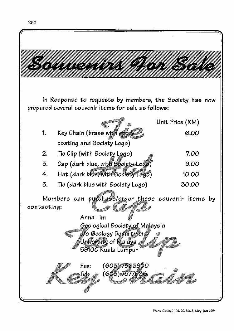
250
In Response to requests by members, the Society has now prepared several souvenir items for sale as follows:
1.
2.
3.
4.
5.
#~f$; Key Chain (brass wk;· ;:'J;¢t~
,@If ~_
coating and Society Logo)
Tie Clip (with Socie1(~ ~,geO) li~:::f s»~·:t -:~§i. i:fl
Cap (dark blue, wi ,.'~·:~::·:::::'cJ.,~yy~~:Lo.::/ ~M' x':':;';'
Hat (dark b· I t :::~ 06'1"" ."
Tie (dark blue with Society Logo)
Members contacting:
Fax:
Unit Price (RM)
6.00
7.00
9.00
10.00
30.00
souvenir Items by
Warta Geologi, Vol. 20, No.3, May-fun 1994

251
Senarai Tesis SmSn Semester II Sesi 1992/93 Jabatan Geologi, Universiti Kebangsaan Malaysia, Bangi
Abd. Rahim Harun Geologi am kawasan Marang-Kuala Terengganu.
Azlikamil Bin Hj. Napiah Geologiam kawasanPengkalan UluPerak, PerakD.R.
Haniza Bt. Zakaria Geologi am dan stratigrafi kawasan Chenor, Pahang D.M.
Jee Roslaily D. Awang Geologi am kawasan Rawang-Ulu Yam, Selangor D. Ehsan
Lim Chee Kheong Geologi am, geokimia dan survei geokimia kawasan Ulu Langat. Selangor D.E.
Mohd. Fauzi B. Rajiman Geologi am kawasan Seremban-Port Dickson, Negeri Sembilan D.K
Nor Asmah Bt. Abd. Aziz Geologi am dan stratigrafi kawasan Jerantut, Pahang.
Nor Iada Binti Zakaria Geologi am dan stratigra{i kawasan Utara Kuala Kerau, Pahang D. Makmur.
Rosmah Bt. Abd. Rahman Geologi am kawasan selatan segitiga Jengka, Pahang.
Senarai Tesis Sesi 1992/93 Jabatan Geologi, Universiti Malaya, Kuala Lumpur
Aniza Abdul Rahman Contact metamorphism of Machinchang Formation, Telaga Tujuh-Burau area, Langkawi, Kedah. 66 pp.
Warla Geologi, Vol. 20, No.3, May-Jun 1994
Azman Abdullah Stratigraphy, sedimentology and structure of Maran-Sg. Luit area, Pahang Darul Makmur. 76 pp.
Ferdaus Ahmad GeologikawasanFelda Chiku GuaMusang, Kelantan. 103 pp.
Mohd Hussin Mohamad Geologi kawasan Jeli, Kelantan dengan penekanan ke atas petrologi dan geokimia batuan granit. 129 pp.

252
Nizarulikram B. Abdul Rahim Geologi kawasan Kelian Intan-Keroh dengan penekanan kepada aspek pemineralan primer di Lombong Rahim Hidraulic Tin Bhd., Kelian Intan, Perak Darul Ridzuan. 60 pp.
Noorazhar Ngatimin Geologi kawasan Gunung Semalayang Kota Tinggi, Johor. 76 pp.
Nor Zaini Karim Petrologi & geokimia bagi granitoid kawasanLumut Segari-PantaiRemis. 144 pp.
Rabuan Abdul Rahman GeologiBukitKepayang, Temerloh, Pahang Darul Makmur. 38 pp.
Wan Izhan Wan Ibrahim Geologi kawasan Bukit Batu-Kulai, Kulai, Johor Darnl Takzim. 106 pp.
ZahipYahya Geologi kawasan Kg. Ayer Panas, Kg. Lalang, Kroh, Perak. 95 pp.
Zaidi Daud Kajian sedimentologi dan stratigrafi kawasan Bukit Keluang-Pulau Redang, Terengganu. 89 pp.
Zuraihan Bte. Ngah Geological studies of the Chuping Limestone in north-eastern ofPulau Ladang Bunting, Langkawi, Kedah. 31 pp.
Abd. Holed Ishak Geologi kawasan Sungai Buloh, Selangor Darul Ehsan, kajian terhadap batuan metasedimen, granit & daik kuarza. 48 pp.
Abdullah B. Sulaiman Geologi kawasan Ulu Cheku Pahang dengan penekanan kepada petrologi dan geokimia batuan igneus. 145 pp.
Adli Yaacob Geologi kawasan barat Jerantut, Pahang. 124pp.
Mandi B. Muda Geologi kawasan Bukit Batu Kutir-Bukit Kandang Goa-Bukit Chapor (Kg. Buluh Nipis-Kuala Jeneris), Hulu Terengganu, Terengganu Darul Imak (Penekanan terhadap petrologiigneus &geokimia). 140 pp.
Ahmad Nazmi Mohamed Ali Geologiam &geomorfologikawasanPergau dengan penekanan terhadap kestabilan cerun potongan di Jalan Felcra Bechah Pulai Pergau, Kelantan. 131 pp.
Ahmad Ridzuan Mohd Tahir Geologi kawasan barat Genting Highlands persekitaranJalanraya BaruBatang KaliGenting Highlands (Kilometer 6.8-15.4). 77pp.
Bujang Sabah Ak. Brunei The geology of Bentong Skarang Valley area, Second Division West Sarawak. 106 pp.
Edy Tonnizam Mohamad Geologi kawasan BukitKiara, Damansara, K.L.58pp.
Firdaus Othman The roof pendant of Gunong Raya, Langkawi, Kedah Darul Aman. 44 pp.
Hamdan Ariffin Geologi kawasan Kg. Kenuai-Klian Intan, Grik, Perak. 70 pp.
Mad Salleh B. Hj. abd. Malik Geologi am sebahagian kawasan Kota Belud Sabah. 53 pp.
Mazlan Abdullah Geologiam dan kajiangeomagnet terperinci bagi menentukan sempadan dan geoemtri Jasad gabbro di antara kawasan AjilWakafTapai, Terengganu. 98 pp.
Mohd Yazid Osman Cheroh, Pahang. 74 pp.
Muhamad Sade Muhamad Amin The general geology north of Bengkoka Peninsula Sabah, East Malaysia. 144 pp.
Morul Ashikin Haji Ab Karim Geologi kawasan Jongok, Batu-Felda Sg. Semmaring, UluDungun, Terengganu. 90 pp.
Sanisah Binti Ahmad Stratigraphy & sedimentologi kawasan Yong Peng-ayer Hitam, Johor. 123 pp.
Shakrizad Ismail Petrologi dan geokimia granitoid kawasan utara Pulau Pinang. 135 pp.
Warta Geologi, Vol. 20, No.3, May-Jun 1994
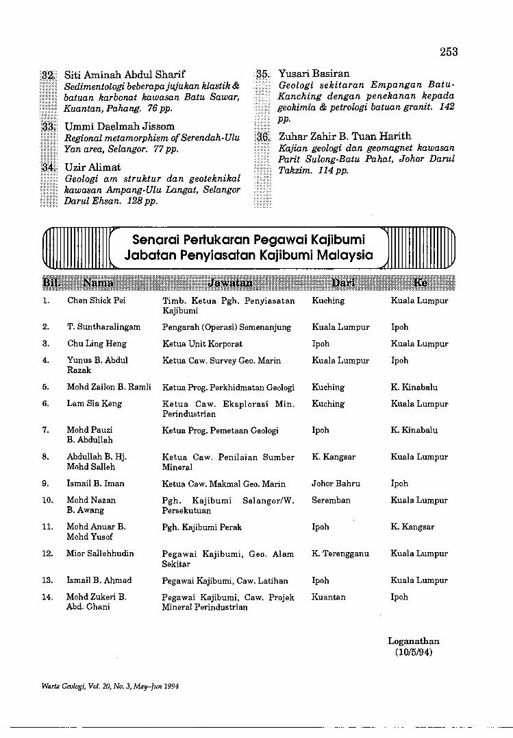
1.
2.
3.
4.
5.
6.
7.
8.
9.
10.
11.
12.
13.
14.
253
Yusari Basiran Siti Aminah Abdul Sharif Sedimentologi beberapajujukan klastik & batuan karbonat kawasan Batu Sawar, Kuantan, Pahang. 76 pp.
Ummi Daelmah Jissom
Geologi sekitaran Empangan BatuKanching dengan penekanan kepada geokimia & petrologi batuan granit. 142 pp.
Regional metamorphism of Serendah-Ulu Yan area, Selangor. 77 pp.
Zuhar Zahir B. Tuan Harith
UzirAlimat Geologi am struktur dan geoteknikal kawasan Ampang-Ulu Langat, Selangor Darul Ehsan. 128 pp.
Kajian geologi dan geomagnet kawasan Parit Sulong-Batu Pahat, Johor Darul Takzim. 114 pp.
v ~ Senarai Pertukaran Pegawai Kajibumi
Jabatan Penyiasatan Kajibumi Malaysia ~ ~
Chen Shick Pei Timb. Ketua Pgh. Penyiasatan Kuching Kuala Lumpur Kajibumi
T. Suntharalingam Pengarah (Operasi) Semenanjung Kuala Lumpur Ipoh
Chu Ling Heng Ketua Unit Korporat Ipoh Kuala Lumpur
Yunus B. Abdul Ketua Caw. Survey Geo. Marin Kuala Lumpur Ipoh Razak
Mohd Zailon B. Ramli Ketua Prog. Perkhidmatan Geologi Kuching K. Kinabalu
Lam SiaKeng Ketua Caw. Eksplorasi Min. Kuching Kuala Lumpur Perindustrian
MohdPauzi Ketua Prog. Pemetaan Geologi Ipoh K. Kinabalu B.Abdullah
Abdullah B. Hj. Ketua Caw. Penilaian Sumber K. Kangsar Kuala Lumpur Mohd Salleh Mineral
Ismail B. Iman Ketua Caw. Makmal Geo. Marin Johor Bahru Ipoh
MohdNazan Pgh. Kajibumi Selangor/W. Seremban Kuala Lumpur B.Awang Persekutuan
Mohd Anuar B. Pgh. Kajibumi Perak Ipoh K. Kangsar Mohd Yusof
Mior Sallehhudin Pegawai Kajibumi, Geo. Alam K. Terengganu Kuala Lumpur Sekitar
Ismail B. Ahmad Pegawai Kajibumi, Caw. Latihan Ipoh Kuala Lumpur
Mohd Zukeri B. Pegawai Kajibumi, Caw. Projek Kuantan Ipoh Abd. Ghani Mineral Perindustrian
Loganathan (10/5/94)
Warta Geologi, Vol. 20, No.3, May-fun 1994

256
INTERNATIONAL ASSOCIATION OF GEOMORPHOLOGISTS SOUTHEAST ASIA
CONFERENCE ON GEOMORPHOLOGY
===~ First Circular ~==~
The conference will be organisedjointly by Nanyang Technological University and National University of Singapore under the auspices of the International Association of Geomorphologists.
- Provisional Programme ~ The conference will start on the afternoon
of Sunday, 18 June (reception and registration) and continue until Friday, 23 June. It will include paper and poster sessions, symposia, local excursion, and social events. Both pre- and post-conference fieldtrips are being planned.
==~ Papers and Posters ==~
Papers on any topic in Geomorphology may be presented. However, papers on environmental themes and those based on low latitude regions will be especially welcome.
Prospective contributors will be required to submit abstracts with the Second Circular which will include details for abstract
preparation. Details on registration procedures, accommodation, costs, andfield trips will also be included in the Second Circular.
Organization ~~~~
Further inquiries should be sent to GOB Kim Chuan, Chair, lAG-SEA Conference on Geomorphology, Division of Geography! NIE, NanyangTechnological University, 469 Bukit Timah Road, Singapore 1025. Fax: 65-469-8433. E-mail: GOHKC @
am.nie.ac.sg
For details about papers and symposia please write toA vijit GUPTA, Department of Geography, National University of Singapore, Singapore 0511. Fax: 65-777-3091.
If you would like to propose and organise a special symposium, please write to Avijit Gupta as soon as possible.
The language of the conference will be English. We regret that no simultaneous translation will be available.
Warla Geologi, Vol. 20, No.3, May-Jun 1994
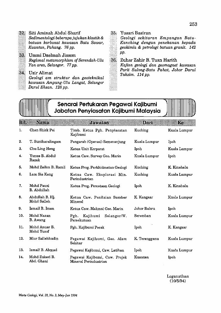
I.
2.
3.
4.
5.
6.
7.
8.
9.
10.
II.
12.
13.
14.
253
Yusari Basiran Siti Aminah Abdul Sharif Sedimentologi beberapajujukan klastik & batuan karbonat kawasan Batu Sawar, Kuantan, Pahang. 76 pp.
Ummi Daelmah Jissom
Geologi sekitaran Empangan BatuKanching dengan penekanan kepada geokimia & petrologi batuan granit. 142 pp.
Regional metamorphism of Serendah-Ulu Yan area, Selangor. 77 pp.
Zuhar Zahir B. Tuan Harith
UzirAlimat Geologi am struktur dan geoteknikal kawasan Ampang-Ulu Langat, Selangor Darul Ehsan. 128 pp.
Kajian geologi dan geomagnet kawasan Parit Sulong-Batu Pahat, Johor Darul Takzim. 114 pp.
v Senarai Pertukaran Pegawai Kajibumi
Jabatan Penyiasatan Kajibumi Malaysia ~ ~
Chen Shick Pei Timb. Ketua Pgh. Penyiasatan Kuching Kuala Lumpur Kajibumi
T. Suntharalingam Pengarah (Operasi) Semenanjung Kuala Lumpur Ipoh
Chu Ling Heng Ketua Unit Korporat Ipoh Kuala Lumpur
Yunus B. Abdul Ketua Caw. Survey Geo. Marin Kuala Lumpur Ipoh Razak
Mohd Zailon B. Ramli Ketua Prog. Perkhidmatan Geologi Kuching K. Kinabalu
Lam SiaKeng Ketua Caw. Eksplorasi Min. Kuching Kuala Lumpur Perindustrian
MohdPauzi Ketua Prog. Pemetaan Geologi Ipoh K. Kinabalu B.Abdullah
Abdullah B. Hj. Ketua Caw. Penilaian Sumber K. Kangsar Kuala Lumpur MohdSalleh Mineral
Ismail B. Iman Ketua Caw. Makmal Geo. Marin JohorBahru Ipoh
MohdNazan Pgh. Kajibumi Selangor/W. Seremban Kuala Lumpur B.Awang Persekutuan
Mohd Anuar B. Pgh. Kajibumi Perak Ipoh K. Kangsar Mohd Yusof
Mior Sallehhurun Pegawai Kajibumi, Geo. Alam K. Terengganu Kuala Lumpur Sekitar
Ismail B. Ahmad Pegawai Kajibumi, Caw. Latihan Ipoh Kuala Lumpur
Mohd Zukeri B. Pegawai Kajibumi, Caw. Projek Kuantan Ipoh Abd. Ghani Mineral Perindustrian
Loganathan (10/5/94)
Warta Geologi, Vol. 20, No.3, May-Jun 1994
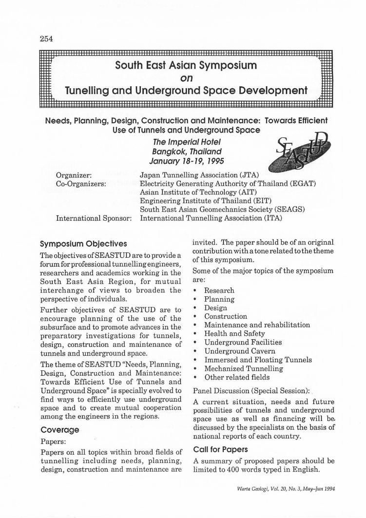
254
South East Asian Symposium on
.~
Tunelling and Underground Space Development .f
Needs, Planning, Design, Construction and Maintenance: Towards Efficient Use of Tunnels and Underground Space
The Imperial Hotel Bangkok, Thailand
January 78-79, 7995
Organizer: Japan Tunnelling Association (JTA) Co-Organizers: Electricity Generating Authority of Thailand (EGAT)
Asian Institute of Technology (AIT) Engineering Institute of Thailand (EIT)
International Sponsor: South East Asian Geomechanics Society (SEAGS) International Tunnelling Association (ITA)
Symposium Objectives The objectives of SEA STUD are to provide a forum for professional tunnelling engineers, researchers and academics working in the South East Asia Region, for mutual interchange of views to broaden the perspective of individuals.
Further objectives of SEASTUD are to encourage planning of the use of the subsurface and to promote advances in the preparatory investigations for tunnels, design, construction and maintenance of tunnels and underground space.
The theme of SEASTUD "Needs, Planning, Design, Construction and Maintenance: Towards Efficient Use of Tunnels and Underground Space" is specially evolved to find ways to efficiently use underground space and to create mutual cooperation among the engineers in the regions.
Coverage Papers:
Papers on all topics within broad fields of tunnelling including needs, planning, design, construction and maintenance are
invited. The paper should be of an original contribution with a tone related tothe theme of this symposium.
Some of the major topics of the symposium are:
• Research • Planning • Design • Construction • Maintenance and rehabilitation • Health and Safety • Underground Facilities • Underground Cavern • Immersed and Floating Tunnels • Mechanized Tunnelling • Other related fields
Panel Discussion (Special Session): .
A current situation, needs and future possibilities of tunnels and underground space use as well as financing will be. discussed by the specialists on the basis of national reports of each country.
Call for Papers A summary of proposed papers should be limited to 400 words typed in English.
Wa rfa Ge%gi, Vol. 20, No.3 , May-fun 1994

Full text of the accepted papers must be submitted to SEASTUD Secretariat in Thailand no later than September 30, 1994. The guidelines for the full paper preparation will be sent to each author whose summary is accepted. The symposium proceedings will be distributed to all the symposium registrants at the registration desk.
Registration Those interested in participating in the symposium are requested to contact the SEASTUD Secretariat in Thailand at your earliest convenience.
Fee Low price registration fee (before November 30, 1994) for the participants will be US$150, which will cover Symposium Proceedings, entrance to technical sessions, daily lunches and a social party. After November 30, 1994, the fee will be US$180.
Registration Fee for accompanying persons is US$100, which will cover daily lunches and a social party.
Accommodation The symposium organizers plan to negotiate with The Imperial Hotel for special discount
Warta Geologi, Vol. 20, No.3, May-fun 1994
255
for the participants. Detailed information will be noticed in the Second Announcement.
Technical Information Corner Companies, organizations and constructors interested in participating in the Technical Information Corner of their products, technologies and materials related to the symposium theme are invited. The Technical Information Corner is available to be used to serve brochures in the limited space next to the registration desk.
Social Party There will be an interesting social party for the participants and accompanying persons on the fIrst night of the Symposium in the Symposium hotel.
Further Information: SEASTUD Secretarial in Thailand
c/o M. Sugimoto (Dr.) Division of Geotechnical and Transportation Engineering
Asian Institute of Technology G.P.O. Box 2754, Bangkok 10501
Thailand Tel: +66-2-5245517 Fax: +66-2-5245509
Telex: 84276TH

256
INTERNATIONAL ASSOCIATION OF GEOMORPHOLOGISTS SOUTHEAST ASIA
CONFERENCE ON GEOMORPHOLOGY
~~~~ First Circular ~~~~
The conference will be organisedjointly by Nanyang Technological University and National University of Singapore under the auspices of the International Association of Geomorphologists.
- Provisional Programme ~ The conference will start on the afternoon
of Sunday, 18 June (reception and registration) and continue until Friday, 23 June. It will include paper and poster sessions, symposia, local excursion, and social events. Both pre- and post-conference fieldtrips are being planned.
~~~ Papers and Posters ~~~
Papers on any topic in Geomorphology may be presented. However, papers on environmental themes and those based on low latitude regions will be especially welcome.
Prospective contributors will be required to submit abstracts with the Second Circular which will include details for abstract
preparation. Details on registration procedures, accommodation, costs, and field trips will also be included in the Second Circular.
Organization ~~~~
Further inquiries should be sent to GOB Kim Chuan, Chair, lAG-SEA Conference on Geomorphology, Division of Geography I NIE, NanyangTechnological University, 469 Bukit Timah Road, Singapore 1025. Fax: 65-469-8433. E-mail: GOHKC @
am.nie.ac.sg
For details about papers and symposia please write to Avijit GUPTA, Department of Geography, National University of Singapore, Singapore 0511. Fax: 65-777-3091.
If you would like to propose and organise a special symposium, please write to Avijit Gupta as soon as possible.
The language of the conference will be English. We regret that no simultaneous translation will be available.
Warta Geologi, Vol. 20, No.3, May-Jun 1994

lAG-SEA CONFERENCE 18 - 23 June 1995
Singapore
Pre-Registration Form (non-binding)
Name:
Address: ___________ _
Fax: ____________ __
Phone: E-Mail:
257
I am interested in field trips with the following themes:
• Neotectonics 0 • Volcanic Landforms 0 • Tropical Karsts 0 • Tropical Coasts 0 • Rainforest 0 • Urban Geomorphology 0 • Fluvial Processes 0 • Others 0
I would like to present a I I pap e r (please specify) and/or I I poster (please check). ---------------
Tentative title or theme _____ _
Please indicate your preference
I am interested in field trips to these areas:
• Malay Peninsula
• SabahlSarawakIBrunei
• Sumatra
• Java/Bali
• Thailand
• Philippines
Warta Grologi, Vol. 20, No. 3, May-Jun 1994
o o o o o o
Photocopies are fine. The Second Circular will be sent on receipt of the preliminary form.
This form should be sent to:
Dr. GOB Kim Chuan Division of GeographylNIE
Nanyang Technological University 469 Bukit Timah Road
Singapore 1025 FAX: 65 469 8433

258
111111111111111111111111111111111111111111 First C i rc u I a r 111111111111111111111111111111111111111111
Tectonic and Metallogeny of Early/Mid Precambrian Orogenic Belts: An International
Conference, Montreal, Canada August 28 to September 1, 1995
Precambrian rocks ofthe Canadian Shield have inspired major advances in the understanding of ancient tectonic and metallogenetic processes, as well as offering windows into the lower crust. Through its rich array of Precambrian terranes, highlighted by modern mapping, geochronology, geophysical coverage, and multidisciplinary LITHOPROBE experiments, the Shield presents may further challenges and opportunities as a source of information on early Archean to middle Proterozoic plate interaction and associated mineralization. The Canadian Shield will provide the thematic backdrop for this international meeting, designed to explore current global issues in Precambrian geology from an interdisciplinary perspective, in the context of an increased understanding of modern processes. Montreal, the modern, multicultural centre hosting the meeting, is within easy striking distance of many classic Precambrian pre- and post-meeting field trip locali ties, now boasting state-ofthe-art geoscientific databases.
Conference Themes
I. Mountain Building in Early/Mid Precambrian orogens
orogenic components: greenstone belts, gneiss terranes; sedimentary belts crustal architecture and geophysical signature terrane analysis and tectonic interpretation Precambrian oceanic crust and plumes geochronological-geological correlations metamorphism and thermal models
Warta Geologi, Vol. 20, No.3, May-Tun 1994

IT. Metamorphism and Magmatism in the deep Precambrian Crust
magmatic underplating and high-grade metamorphism metamorphism, anatexis and granite magmatism granulites and charnockites role of anorthosites
ITI. Cratons and Their Roots
probes of lithospheric structure diamonds and other xenoliths; origin and geochronology dyke swarms; intercratonic correlations crustal growth in the EarlylMid Precambrian
IV. Models of Ore Deposit Genesis in Early/Mid Precambrian terranes
metallogeny, tectonics, base metals and gold new types of targets giant deposits deposit and exploration in high-grade Precambrian terranes resource-oriented geophysical exploration
V. Geology and Metallogeny of the North American Precambrian Shield
overviews of major Shield components topical and thematic studies
Field Trip Program (tied to conference themes)
1. Western Superior Province Transect (-$1,500)* 2. Kapuskasing- Wawa- Abitibi Transect (-$1,200) 3. Abitibi- Opatica Orogen (-$1,200) 4. Metallogentic Overview of the Abitibi belt (-$1,200) 5. Southern Slave Province (-$2,500) 6. Grenville Province Tectonics ( < $500) 7. Trans-Hudson Orogen (-$1,500) 8. Ungava Orogen (?) (>$2,500) 9. Western Torngat Orogen (-$1,800) 10. Nain and eastern Torngat Orogen (Northern Labrador; Aug. 14-20; -$3,000)
* Field trip costs are order-of-magnitude estimates ($Cdn = -D.9$U.S.J
Further Informations
J.A Percival J.N. Ludden
259
Geological Survey of Canada 601 Booth St.
Dept. de Geologie, Universire de Montreal, CP 6128, Succ. A
Ottawa, Ontario Mont.real, Quebec Canada, KlA OE8 Canada, H3C 317 Ph: (613) 995-4723; Ph: (514) 343-7389; Fax: (613) 995-9273; Fax: (514) 343-5782; e-mail: [email protected] e-mail: [email protected]
WRrtR Geologi, Vol. 20, No.3, MRy-Jun 1994

260
XVIII PACIFIC SCIENCE CONGRESS
Population, Resources and Environment: Prospects and Initiatives
Beijing, China June 5-12, 1995
GENERAL INFORMATION Host China National Committee for Pacific Science Association
Venue Beijing International Convention Center, Beijing, China
Dates June 5-12, 1995
Meeting Program The meeting program will mainly consists of General Symposia related to the Central Theme of the Congress as well as a series of Scientific Sessions covering all the Scientific Activities of Pacific Science Association. It is planned to organize a number of Scientific Tours in relation to the natural ecosystems, resources and environment protection, coastal zone development and so on to appreciate the participants who are interested in visiting these areas. A cultural program is also being planned to display the ancient and modern Chinese Cultural in order to enhance mutual understanding between scientists in China and those over all the world.
Language English
Registration and Housing A registration form and housing form will be in the Third Circular and sent to you between July-August, 1994.
Sponsors Congress will be sponsored jointly by
• China Association for Science and Technology • Chinese Academy of Sciences • National Natural Science Foundation of China • Chinese Academy of Social Science • Chinese Academy of Agricultural Sciences • Chinese Academy of Medical Sciences
CONGRESS SECRETARIAT Laboratory of Climate Research Institute of Atmospheric Physics Chinese Academy of Sciences P.O. Box 2718, Beijing 100080, China Tel: (+86-1) 2575034 Fax: (+86-1) 2562458 E-mail: fucb%[email protected] Prof. FU Congbin, Secretary General
SCIENTIFIC PROGRAM CENTRAL THEME
Population, Resources and Environment: Prospects and Initiatives
Warta Gcologi, Vol. 20, No.3, May-fun 1994
GENERAL SYMPOSIA Symposium I: Global Climate and Environment Change (Gl) Main Topics:
261
1. The relative roles of the oceans and the terresting biosphere in regulating the global climate and environmental change;
2. Environmental change in history in pacific regions; 3. Forcing factors of global change (trace-gas composition change, land uselland cover change); 4. Modeling and simulation of global climate change; 5. Impact of global change on terrestrial ecosystems and coastal zones (emphasizing Pacific-regions)
Symposium IT: Resources: exploration, utilization and protection (G2) Main Topics: 1. Energy and environment 3. Land management 5. Renewable resources
Symposium m: Biodiversity (G3) Main Topics:
2. 4.
1. Ecosystem functioning of biological diversity;
Water resources Mineral resources
2. The effects of natural and human-induced changes on the patterns of biodiversity at gene, species, ecosystem and landscape levels;
3. The ecological determinants and consequences of diversity; 4. The in situ and ex situ conservation of rare and endangered species; 5. The inventory and monitoring techniques and methods of biodiversity; 6. Biodiversity conservation and regional economic development; 7. The loss and extinction of biodiversity, and the restoration of biodiversity in degraded ecosystem; 8. New uses from wild species; 9. Laws, regulations and other legal measure adopted to protect biodiversity; 10. The effects of exotic species on local biodiversity.
Symposium IV: Population, education and culture (G4) Main Topics: Population, education and culture in relation to the main theme of the Congress. Population, resources
and environment and their interrelationships will be discussed in this symposium.
The impacts of population size, density, growth, distribution as well as migration and urbanization on resources and environment, and the adverse consequences of inadequate exploitation of natural resources and the degradation of environment on human reproduction, human health and human settlement will be focussed in the discussion. Resources and environment could be dealt with either as an integrated part or as a whole, such as natural resources, ecological environment or as an individual element such as land, fresh water, soil erosion, forest, rangeland wildlife, energy, ocean, coast atmosphere or air pollution etc.
Education could remold people's perception of childbearing, awareness of population, the sense ofscarcity of natural resources and the comprehensions of adverse effect of deterioration of environment. Any successful education programmes on population, resources and environment are invited to disseminate their experiences to the general public of the world.
Different culture holds diverse views and behaviors on population resources and environment with its own merits and demerits. It is suggested that the authors of the invited papers could bring with them the merits and demerits oftheir culture regarding development of population and protection of environment to enlighten the world and to share the experiences and lessons with other cultures.
Symposium V: South-North cooperation and sustainable development (G5) Main Topics: 1. Present status, characters and perspectives of the North-South relations in the Pan-Pacific region. 2. What should countries of both North and South do to deal with problems of environment and human
resources in economic development. 3. What can North countries do to promote the industrial restructuring and upgrading of the Southern
countries by way of capital supply and technology transfer. 4. For the Northern countries, what can they do to reduce trade protectionism and improve the terms of trade
in order to help the South countries in their development. 5. We should further promote dialogues between the North and South, coordinate development strategy and
policy, to ensure the sustained development of the world economy.
Warta Geologi, Vol. 20, No.3, May-lUll 1994

262
Symposium VI: Natural disaster mitigation (G6) Main Topics: 1. National advances of IDNDR (International 3.
Decade Nature Disaster Reduction) and general 4. countermeasures; 5.
Floods, droughts and countermeasures; Typhoon, other storms and warning systems; Volcanoes and prevention engineering;
2. Earthquake and earthquake resistant 6. engineering;
Land slides, mud flow and prevention engineering.
EXCURSIONS Scientific Tours
The Organizing Committee is planning to arrange some Scientific Tour Program which are related to the subjects of the Congress. Following is a list of proposed tours for your selection. Final program will be included in Third Circular depending on the number of person who wish to participate.
1. Beijing-Changbaishan Mt.-Qiqihaer-Mudanjiang (Tl) (9 Days, US$638/person) 2. Beijing-Dunhuang-Urmuqi (Exit) (T2) (11 Days US$803/person) 3. Beijing-Chengdu-Lhasa-Zhangmu (Exit) (TS) (12 Days, US$1020/person) 4. Beijing-Kunming-Guangzhou-Haikou-Guangzhou (T4) (11 Days, US$1078/person) 5. Beijing-Hangzhou-Fuzhou-Xiamen-Guangzhou (T5) 13 Days, US$11311person)
General Tours 1. Beijing-Xi'an-Giulin-Guangzhou-(Exit) (T6) (6.5 Days)
(5.5 Days) 2. Beijing-Xi'an-Shanghai -(Exit) (T7)
LOCAL TOURS 1. An Excursion to Marco Polo Bridge and the Museum of the Ruins of Peking ape-man (Zhou Koudian). 2. Visit the Forbidden City and the Temple of Heaven 3. A Tour to the Great Wall and Ming Tombs 4. See Beijinger's Daily Life: visit a neighbourhood committee (community service center), kindergarten,
school and resident house. 5. Visit to Beijing's Traditional Factories: cloisonne enamel, hand made carpet etc.
SOCIAL ACTIVITIES 1. Chinese painting and calligraphy performance 2. Oriental dancing, acrobatics and music performance
EXHIBITIONS 1. Scientific book exhibition 2. Scientific instrumentation exhibition
As the concurrent event of the congress, a comprehensive exhibition of technologies, instruments and books related to all aspects of the central theme of the congress will be held at the congress site. For further information please contact:
Mr. XIAO Jianzhang Dept. Exhibition China International Conference Center for Science and Technology No. 44 Kexueyuan Nanlu Rd., Shuangyushu, Haidian District Beijing 100086, China Tel: (+86)-1-2575672 Fax: (+86)-1-2575691/2546498
ABSTRACT SUBMISSION Contributed papers on topics related to any subjects of Symposia and Sessions are encouraged. An abstract in a format as described (see Abstract Instruction) will be required from all participants who
wish to give a talk or present a poster at the Congress. Please send two copies of abstract to the Program Committee and one copy to each of the Chairman of
Symposium or Convener of Session. The abstract deadline has been set for October 31,1994.
Warta Geologi, Vol. 20, No.3, May-Jun 1994

Place and Date
30TH INTERNATIONAL
GEOLOGICAL CONGRESS
BEIJING, CHINA
4-14 AUGUST 1996
First Circular
GENERAL INFORMATION
263
The Organizing Committee of the 30th International Geological Congress (lGe), representing the Geological Society of China, the Ministry of Geology and Mineral Resources of China, and the relevant Chinese governmental agencies, scientific institutions and industrial organizations, in collaboration with the under the sponsorship of the International Union of Geological Sciences (lUGS), has the honour of inviting you to participate in the
30th Session olthe International Geological Congress In the Great Hall of the People, Beijing
From 4 to 14 August 1996
The Great Hall of the People is situated in central Beijing, on the western side of the Tian'anmen Square, close to the Palace Museum (the Forbidden City).
Organizing Committee President: Zhu Xun (Ministry of Geology and Mineral Resources) Secretary General: Zhang Hongren Deputy Secretary General: Zhao Xun Treasurers: Chen Zhouqi, Shou Jiahua
Secretariat Bureau Director: Executive Secretaries:
Committee Chairmen Scientific Programme:
Field Trips: Exhibitions:
Social Programme:
ZhaoXun Wang Yanjun, Zhou Qi
Chen Yuchuan Sun Shu Li Tingdong WangZejiu Yan Dunshi Xu Baowen ZhuZupu
Chinese Academy of Geological Sciences National Natural Science Foundation of China Ministry of Geology and Mineral Resources Chinese Academy of Geological Sciences China National Oil and Gas Corporation Ministry of Geology and Mineral Resources Beijing Municipal Government
Conditions for Membership in the Congress According to the Statutes of the Congress, no professional qualifications are required in order to register
for the Congress. In filling the quotas for the geological excursions organized by the Congress, however, priority will be given to persons engaged in geological studies or in the practice of the branch of geology.
Registration Fees
Participating Members Accompanying Members Students in 1996 Non-attending Members
Pre-Registration
US$300 150 100 175
On-site Registration
US$350 175 120
The prices quoted are subject to revision in the event of changes in the world economic conditions; however, it is the intent of the Organizing Committee to maintain the registration fees at those quoted above.
Warta Geologi, Vol. 20, No.3, May-Jun 1994

264·
The fees include the rights to attend scientific events associated with the Congress, to receive Congress publications and to take part in some of the social events especially organized for the Congress.
First Circular Response Pleasereplyby31 October 1994. Earlyresponses
are important to the Organizing Committee because they aid in setting the Scientific Programme, Field Trips, and Workshops and Short Courses.
Respondents to the First Circular will receive . the Second Circular.
Geohost Geohostis a programme to help defray expenses
for individual attendees in need of assistance, principally those from developing countries. The programme may include subsidizing registration fees and (or) field trips fees or accommodation fees during the period of the meeting. The funds are expected to come from various international, governmental and private donors. Persons interested in contributing to this programme are requested to write directly to:
Prof. Zhao Xun Deputy Secretary General 30thIGC P.O. Box 823 Beijing 100037, P.R. China
Travel and Visa Registrants who are not entitled to visa
exemption by agreement between China and the country concerned should hold valid passports and contact their travel agent or the Chinese Embassy, Consulate or other representative agency in their country or region regarding the need for visas to enter the People's Republic of China.
Accommodation in Beijing Hotels in Beijing, ranging in size and rates, are
ready to offer good service to visitors. A wide choice of hotels will be provided in the Second Circular. Most hotels will be within walking distance, whereas others are a short ride on public transportation (bus or underground) or an inexpensive taxi ride from the convention site. The hotel room rates will range between US$40 and US$180.
Hotel room rates cannot be quoted firmly until the Third Circular.
SCIENTIFIC PROGRAMME Explanation of Scientific Programme
Accordingtothe suggestions made at the Council Meetings ofboth the 28th and the 29th Sessions of the IGC and those by the lUGS, the 30th IGC will focus on continental geology with emphasis on the continentrelated tectonics and structures, energy and mineral resources, environmental protection, and geological hazards reduction as well as their interrelationship
)
with human survival and sustainable development. The Scientific Programme Committee paid special attention to enhancing comprehensive and multidisciplinary discussions on the important problems faced by the geological sciences, and strove to choose topics for the ·scientific sessions that reflect the interdisciplinary nature of to day's science and emphasize the importance of geological sciences to the civilization of human society. The Programme is planned to highlight the themes of the Congress, the frontier subjects and hot spots of international geoscientific research, in association with the unique geological conditions of China and the progress made by Chinese geoscientists.
The Scientific Programme of the 30th IGC consists of Colloquia, Special Symposia, Symposia, Poster Sessions, Short Courses and Workshops. Colloquia papers will be invited by the Organizing Committee. Special Symposia, which include 11 subjects, will deal with the origin and history of the Earth; geosciences and human survival, environment, and natural hazards; global changes and future environment; structure of the lithosphere and deep processes; contemporary lithospheric motion; global tectonic zones; orogenic belts; basin analysis; energy and mineral resources for the 21st century; new technology for geosciences; progress of international geoscience projects. Symposia, which include 22 fields, will embrace the research projects and contents of various aspects of earth sciences that have been of common concern in recent years.
Colloquia (Congress-wide) Colloquia will focus on new advances in
continental geology, changes and protection of global environment, energy and mineral resources for the 21st century, and the interrelationship between geological sciences and human survival and sustainable development.
Special Symposia A. Origin and History of the Earth B. Geosciences and Human Survival,
Environment, and Natural Hazards C. Global Changes and Future Environment D. Structure of the Lithosphere and Deep Processes E. Contemporary Lithospheric Motion F. Global Tectonic Zones G. Orogenic Belts H. . Basin Analysis I. Energy and Mineral Resources for the 21st
Century J. New Technology for Geosciences K. Progress of International Geoscience Projects
Symposia 1. Stratigraphy 2. Palaeontology and Historical Geology 3. Sedimentology 4. Marine Geology and Palaeoceanography
Warta Geologi, Vol. 20, No.3, MRy-Jun 1994
5. Structural Geology and Geomechanics 6. Igneous Petrology 7. Mineralogy 8. Precambrian Geology and Metamorphic
Petrology 9. Geology of Mineral Deposits 10. Geology of Fossil Fuels 11. Mineral Economics 12. Geochemistry 13. Geophysics 14. Seismogeology 15. Quaternary Geology 16. Hydrogeology 17. Engineering Geology 18. Environmental Geology 19. Mathematical Geology and Geoinformatics 20. Comparative Planetology 21. Geological Education 22. History of Geosciences
Poster Sessions A part of the Congress papers and maps will be
presented in Poster Sessions. Detailed information will be announced in the Second Circular.
Timetable during Congress Scientific sessions will be conducted from 8:30
a.m. to 12:00 noon and 1:30 p.m. to 5.00 p.m. No scientific sessions will be held on Saturday, 10 August and Sunday, 11 August.
Abstracts All abstracts must reach the Organizing
Committee by 1 November 1995. They must be typewritten in English in accordance with the format to be attached to the Second Circular. Only registrants to the Congress may submit abstracts. Contributors may submit up to two abstracts on which they appear as first authors. If two abstracts are submitted, the abstracts must be listed in order of priority, which will facilitate the Programme setting.
The Organizing Committee reserves the right to accept or refuse contributions on the basis of the submitted abstracts.
Submission and Presentation of Papers
Colloquia will consist solely of papers invited by the Organizing Committee. Special Symposia and Symposia will consist of oral and/or poster sessions (Topics to be presented only in poster sessions are listed in the First Circular). Except for Colloquia, contributors are invited to submit their papers to any of the sessions they wish. Papers on topics not listed in the Programme will also be considered, and additional symposia will be added if the need arises. The author may choose either the oral or the poster form of presentation for each paper. The Scientific Programme Committee will take the author's preference for oral or poster session into full
Warla Geologi, Vol. 20, No.3, May-Jun 1994
265
consideration, but the final decision will be made by the Committee. Oral and poster sessions will carry equal weight regarding the quality of contributions.
English will be the working language during the Congress. No facilities for simultaneous translation will be available except for Colloquia. Each oral presentation will be 15 minutes in length with 5 minutes for discussion.
Publications All abstracts will be compiled and published in
a series of Abstract Volumes; participants may receive the Volumes upon check-in at the Congress. Complete papers will not be published by the Congress. However, symposia convenors are encouraged to make arrangements for publication of proceedings of their symposia by a scientific book publisher or as a special issue of a scientific journal.
Short Courses and Workshops In Short Courses, specialists summarize the
state of knowledge in areas of scientific or technological interest in an instructional format. Short Courses commonly are attended by those who either find the specialized information useful in their own work or
- wish to broaden their general knowledge.
In Workshop sessions, knowledge of new research will be shared among participants who will generally be specialists in the subject area. Workshops commonly are attended by those who have research results to share.
The Scientific Programme Committee will provide organizational support for Short Courses and Workshops, but will not necessarily be able to provide financial support. Convenors wishing to hold Workshops and/or Short Courses should send their proposals (including topic, contents, duration, fee per person) to the Scientific Programme Committee no later than 31 October 1994. The Scientific Programme Committee reserves the right to accept or reject any proposals submitted. The lists of Short Courses and Workshops will be given in the Second Circular.
Field Trips A programme offield trips has been planned for
the 30th International Geological Congress to show the characteristic features of continental geology in China. It highlights the major orogenic belts, largescale sedimentary basins, metallogenic belts, and'a great variety of geological attractions. The trips will cover most of the provinces (regions) of China.
Pre-Congress Trips T101 Volcanic landforms in Wudalianchi,
Heilongjiang, and Changbaishan, Jilin
TI02 Precambrian geology and mineral deposits of eastern Liaoning
T103 The Bayan Obo Nb-REE-Fe deposit in Nei Monggol
266
T104
T105
T106
T107
T108
T109
TllO
Tll1
TU2
Tll3
Holocene shoreline changes and traces of the Tangshan earthquake on the west coast of the Bohai Bay
Precambrian continental crust profile from eastern Hebei to Jixian, Tianjin
Geology of the Yangtze Gorges area
W-Sn-Pb-Zn polymetallic ore deposits in southern Hunan and karst landscape in Guilin, Guangxi
Geomorphic landscape of sandstone peak forest and karst in Wulingyuan, western Hunan
Geology of mineral resources, volcanoes, wavecut landforms and meteorite impact craters(?) on Hainan Island
Structural geology across the Qinling orogen, Shaanxi
Rare metals- and gem mineral-bearing pegmatite in Koktokay of Altay, Xinjiang
Geology along the Kuqa River and Kalpin sections of the Tarim Basin ....
Structural geology and stratigraphy along the Sino-Pakistan highway in the West Kunlun Mountains
Tll4 Karst geology and geohazards in the Huanglong-Jiuzhaigou region, western Sichuan
Tll5 Jurassic dinosaurs of Sichuan and their taphonomic conditions
TU6 Geology and tectonics of the KangdingBatang-Linzhi region in the northern sector of the Hengduan Mountains
Tll7 Karst geology of the Yunnan-Guizhou Plateau
Tll8 The Sinian-Cambrian boundary section and the Meishucun and Chengjiang faunas in Yunnan
Tl19 Structural geology of the central sector of the Hengduan Mountains
T120 Geology of plateau lakes in Yunnan
T121 Geology of the Yarlung Zangbo suture zone in Xizang
T122 Hydrocarbon resources in the Junggar Basin, Xinjiang
T123 Geology of the Nanjing-Zhenjing Mountains
T124 Qian'an iron deposit of Hebei Province and the multi-purpose utilization of mine tailings
During-Congress Trips T201 Proterozoic sedimentary facies and their
depositional environments in the MingTombs district, Beijing
T202 Sequence stratigraphy of Cambro-Ordovician carbonates in the Western Hills, Beijing
T203 Quaternary speleo-stratigraphy and palaeoanthropological relics in Zhoukoudian, Beijing
T204 Quaternary glacial vestiges in the Western Hills of Beijing
T205 Proterozoic anorogenicrapakivi granites, and related plutonic and potassic alkaline volcanic rocks in eastern Beijing
T206 Karst landform and caves around the Western Hills of Beijing
T207 Magmatic thermodynamic structure of the Zhoukoudiangranodiorite intrusive, western Beijing
T208 Regional and thermodynamic metamorphism in the Western Hills of Beijing
T209 The Huairou ductile shear zone, Beijing
T210 Extensional tectonics and metamorphic core complex of the Western Hills, Beijing
T2U Deformation zone of the 1679 Sanhe-Pinggu M = 8.0 earthquake and buried active fault
T212 Active faults in the Yanqing-Huailai basinrange structure and palaeoseismology
T213 Comprehensive utilization of geothermal resources in Beijing
T214 Tectonic and petrological characteristics of the Neo-Archaean in the Beijing area
T215 Cretaceous nonmarine sequences in the Western Hills, Beijing
T216 Anorthosite and vanadic-titano-magnetite deposits of Damiao, Hebei Province
T217 Mesozoic stratigraphy and fauna in the Luanping-Chengde region, Hebei Province
T218 Structural features and stratigraphy of the Ming Tombs-Great Wall area (Badaling), Beijing
T219 Geology of the Dagang oilfield
T220 Exploitation and comprehensive utilization of geothermal resources in Tianjin
T221 Urban groundwater supply in Beijing
T222 Exploitation and utilization of the Quyang marble deposit, Hebei Province
T223 Geology of the Jinchangyu gold deposit in Qianxi, Hebei Province
Post-Congress Trips Ta01 Volcanic landforms in Wudalianchi,
Heilongjiang and Changbaishan, Jilin
T302 Petroleum geology of the Daqing Oilfield
T303 Precambrian geology and mineral deposits of eastern Liaoning
Warta Geologi, Vol. 20, No.3, May-Jun 1994
T304 Structural and sedimentological features of the intraplate orogen in southern Liaoning
T305 Diamondiferouskimberlites in Liaoning and Shandong Provinces
T306 Geology of the Jungar-Dongsheng coal basin, N ei Monggol and the Shenfu coal basin, Shaanxi
T307 Precambrian geology and mineral deposits of the Daqing-Wula Mountains in Nei Monggol
T308 The Bayan Obo Nb-REE-Fe deposit in Nei Monggol
T309 Precambrian geology and mineral deposits in eastern Hebei Province
T310 Crustal movement and tectonic evolution of the Yanshan orogen
T311 Holocene shoreline changes and traces ofthe Tangshan earthquake on the west coast of the Bohai Bay
T312 Precambrian continental crust profile from eastern Hebei to Jixian, Tianjin
T313 Deposuite-sequence evolution of formation sequences of North China-type carbonate platform
T314 Neotectonics, ground fissures and palaeoseismology of the Fen-Wei rift system in Shanxi and Shaanxi Provinces
T315 Early Precambrian geology of the WutaiHengshan Mountains in Shanxi
T316 Tectonic features of the middle part of the Tan-Lu fracture zone
T317 Industrial minerals and rocks in the Shandong Peninsula
T318 Geology of Shengli oilfield of Shandong Province
T319 Geology of gold deposits in ShandongProvince
T320 Mesozoic and Cenozoic biota of Shandong Province
T321 Geology of the Fuxin and Fushun Mesozoic and Cenozoic coal basins
T322 Archaean geology of western Shandong
T323 Karst hydrogeology of mines in North China
T324 Volcanic geology and ore deposits in Jiangsu and Zhejiang Provinces
T325 Nonmetallic deposits around the Taihu Lake
T326 Stratigraphy and palaeontology of the Nanjing Hills and its adjacent areas
T327 Environmental geology along the Yangtze delta
T328 Structural geology and ultra-high pressure metamorphic belt ofthe Dabie Mountains in Anhui Province
Warta Geologi, Vol. 20, No. 3, May-JUlt 1994
T329
T330
T331
T332
T333
T334
T335
T336
T337
T338
T339
T340
T341
T342
T343
T344
T345
T346
T347
T348
T349
T350
267
Geology and landscape of granites of the Jiuhua-Huangshan Mountains, Anhui Province
Non-metallic mineral resources of the circumPacific continental-margin volcanic belt in Zhejiang Province
Geology of the Dexing and Yongping copper deposits in Jiangxi Province
Quaternary glaciations in the Lushan Mountain area and Quaternary stratigraphy of the Poyang Lake
Geology of U, Au, Ag ore deposits related with Mesozoic volcanic rocks in Jiangxi Province
Tectono-metamorphic belt along the southeast coast of Fujian Province
Precambrian tectonic evolution of the Songshan Mountain area, Henan
Structural characteristics of the TongbaiDabie orogen and large gold and silver deposits
Groundwater experiment, exploitation and utilization in the North China Plain
Iron-copper ore deposits in the middle-lower reaches of the Yangtze River
Structural geology and high-ultrahigh pressure metamorphism in Tongbai-Dabie Mesozoic orogenic belt
Geology of the Yangtze Gorges areas
Middle-Late Proterozoic geology of the Shennongjia area in western Hubei
W-Sn-Pb-Zn polymetallic ore deposits in southern Hunan and karst landscape in Guilin, Guangxi
The Xikuangshan antimony ore deposit and Woxi gold-tungsten-antimony ore deposit, Hunan Province
Geomorphic landscape of sandstone peak forest and karst in Wulingyuan, western Hunan
Lead-zinc ore deposits and Danxia red-bed landforms in northern Guangdong
Quaternary geology and tropical landscape in Guangzhou and its adjacent coastal region'
Karst and geomorphological landscape in the Guilin area
Devonian and Carboniferous stratigraphy, sedimentary facies and palaeontology of Guangxi
Karst hydrogeology in Guangxi
Geology of tin-lead-zinc ore deposits in Guangxi

268
T351 Geology of mineral resources, volcanoes, wavecut landfonns and meteorite impact craters(?) on Hainan Island
T352 Structural geology across the Qinling orogen, Shaanxi
T353 Comparison of Quaternary fluvio-Iacustrine and loess deposits in North China
T354 Quaternary geology and palaeoenvironment of desert and loess plateau in northern China
T355 Holocene active faults and M 8.6 earthquake vestiges in Ningxia
T356 Seismic and Quaternary geology along the northern margin of the Qinghai-Xizang
T357 Meso-Cenozoic continental deposits of the western Jiuquan Basin, Gansu Province
T358 Cu-Ni and Pb-Zn sulfide deposits in Gansu Province
T359 Geology of saline lakes of the Qaidam Basin
T360 Meso-Cenozoic geology and modem glaciers near Urumqi, Xinjiang
T361 Rare metals- and gem minerals-bearing pegmatites in Koktokay of Altay, Xinjiang
T362 Geology along the Kuqa River and Kalpin sections of the Tarim Basin
T363 Structural geology and stratigraphy along the Sino-Pakistan highway in the West Kunlun Mountains
T364 Structural characteristics of the Middle Tianshan Mountains
T365 Hydrocarbonresources in the Junggar Basin, Xinjiang
T366 Transect across the thrust-nappe belt of the Longmen Mountains, Sichuan
T367 Karst geology and geohazards in the Huanglong-Jiuzhaigou region, western Sichuan
T368 Triassic sequence stratigraphy and sea-level changes in the Mount Emei area
T369 Environmental and engineering geology of the Yangtze Gorges area
T370 Geologic features and vanadic-titanomagnetite deposits of the Panxi rift
T371 Late Cenozoic geology of the Sichuan-Yunnan structural belt in southwest China
T372 Glacial and Quaternary geology of the Gongga Mountain, Sichuan
T373 Jurassic dinosaurs in Sichuan and their taphonomic conditions
T374 Tectonic framework of the Songpan-Garz~ orogenic belt
T375 Geological hazards along the ChengduKunming railway
T376 Geology and tectonics of the KangdingBatang-Linzhi region in the northern sector of the Hengduan Mountains
T377 Petroleum geology of the Sichuan Basin
T378 Geology of the Late Pennian and Tertiary coal basins in Guizhou andYunnanProvinces
T379 Karst geology of the Yunnan-Guizhou Plateau
T380 Geology of phosphorite and bauxite deposits in central Guizhou
T381 The Sinian-Cambrian boundary section and the Meishucun and Chengjiq faunas in Yunnan ,-,
T382 Volcanoes and geothermal geology of the Tengcbong area, Yunnan,
T383 Geology of the Gejiu tin deposit area, Yunnan
T384 Geology of plateau lakes in Yunnan
T385 Tectonics and mineral resources in the southern section of the Hengduan Mountains
T386 Super-large Tertiary Pb-Zn deposits in the Lanping area, Yunnan
T387 Geology of the Himalayas, Xizang -
T388 Geothennal geology of Xizang
T389 Observation and study of the great EarlyPleistocene ice sheet and active structures of the Qinghai-Xizang plateau
T390 A geologic-geophysical excursion from Golmud to Lhasa, Xizang
T391 Tectonics, metamorphism, and magmatism of the Yunkai Mountains, western Guangdong
T392 Metamorphic geology ofblueschists, eclogites, and ophiolites in the North QilianMountains
T393 Saline lakes and epithermal deposits in Xizang
T394 Permian and Triassic sequences of continental facies in the Dalongkou area, Jimsar and the Turpan Basin of Xinjiang
T395 Palaeoecological environment of nested dinosaur eggs in 'Xixia, Henan Province
Warta Geologi, Vol. 20, No.3, May-Jun 1994

HYDROMETALLURGY, int'l mtg., Cambridge, England, by Society of Chemical Industry, and Institution of Mining and Metallurgy. (SCI, 141 15 Belgrave Square, London SW1X8PS. Phone: 0712353681. Fax: 0718231698) [December '92]
REGION, int'l mtg., Sydney, Australia by International Commission on the History of the Geological Sciences. (INHIGEO, c/o Earth Resources Foundation, Dept. of Geology and Geophysics, University of Sydney, New South Wales, Australia 2006. Phone: (02) 552 6136. Fax: (02) 552 6058)
Berkeley, California, USA. (FORAMS '94, Museum of Paleontology, University of California, Berkeley, CA 94720, USA. Phone: (510) 642-1821; telefax: (510) 642-1822)
DEPOSITS OF THE TRANSGRESSNE SYSTEM TRACT, mtg., Long Beach, Wash., by Society for Sedimentary Geology. (SEPM, c/o Ed Clifton, Conoco, Box 2197, Houston, 77252. Phone: 713/293-2839)
Warta Geologi, Vol. 20, No.3, May-Jun 1994
269
(International Meeting), Edmonton, Alberta, Canada. (D.C. Sego, First International Congress on Environmental Geotechnics, Dept. of Civil Engineering, University of Alberta, Edmonton, Alberta T6G 2G7, Canada. Phone: (403) 492-7228; telefax: (403) 492-8198)
. International Meeting), Potsdam, Germany. (Prof. Dr. Onno Oncken, GeoForschung-Zentrum. Telegrafenberg, D-0-1561 Potsdam, Germany. Phone: 331-310306; telefax: 331-310601)
-+-+-+ August 1994+-+-+-
9TH IUM THE INTERNATIONAL ASSOCIATION ON THE GENESIS OF ORE DEPOSITS (IAGOD 1994), Beijing, China. (Dr. Wang Zejiu, 9th IAGOD Symposium, Chinese Academy of Geological Sciences, 26 Baiwanzhuang Road, Beijing 100037, China)
MANTLE (International Symposium), Paulo, Brazil. (Professor Wilson Teixeira, Instituto de Geociencias. Universidade de Sao Paulo, P.O. Box 20899, 01498-970 Sao Paulo, Brazil. Phone: 55-11-8138777 ext. 3987;telefax: 55-11-2104958; E-mail: BRENHA @IAG.USP.BR)
AMER;d!J/AsSOCIATIONOFPETROLEUM GEOLOGISTS (International Conference and Exhibition), Kuala Lumpur, Malaysia. (AAPG Convention Department, P.O. Box 979, Tulsa, OK 74101, USA. Phone: (918) 584-2555)
270
STRATIGRAPHY, ENVIRONMENTS AND RESOURCES (lst International Symposium), Guiyang, Guizhou, China. (Dr. Wang Xiang-dong, Secretariat of Organizing Committee for ISP-1994, Laboratory of Palaeobiology & Stratigraphy, Nanjing Institute of Geology & Palaeontology, Chi-MingSsu, Nanjing, 21008 China. Phone: 86-25-714443; telefax: 86-25-712207)
METALLOGENICEVOLUTION(International Conference), Windhoek, Namibia. (Dr. G.I.C. Schneider, Geological Society of Namibia, P.O. Box 699, Windhoek, Namibia. Phone: 264-61-37240; telefax: 264-61-228324)
-+-+-+ September 1994+-+-+-
MINERALOGICAL ASSOCIATION (16th General Meeting),Pisa, Italy. (Professor Stefano Merlino, Dipartimento di Scienze della Terra, Via S. Maria 53, 56100 Pisa, Italy. Telefax: 395040976: E-MAIL: [email protected]
ENGINEERING GEOLOGY (7th Congress), Lisbon, Portugal. (Organizing Committee, 7th IAEG Congress, c/o LNEC, Av. do Brasil, 101, 1799 Lisboa Codex, Portugal. Phone: 351-1-8473822; telefax: 351-1-8497660; telex: 16760 LNECP)
INTERNATIONAL· VOLCANOLOGICAL CONGRESS (International Congress). Ankara, Turkey. Sponsored by the International Association of Volcanology and Chemistry of the Earth's Interior. (Dr. Ayla Tankut, Organizing Secretary, Int. Volcanological Congress, Dept. Geological Engineering, Middle
East Technical University, 06531 Ankara, Turkey. Phone: 90-4-210-1000, ext. 2682 or 2679; telefax: 90-4-210-1263.
PALYNOLOGICALCONGRESS(4th),Heerlen, The Netherlands. (Dr. G.F.W. Herngreen, General-Secretary, c/o Geological Survey, P.O. Box 157,2000 AD, Haarlem)
Lisbon Portugal. (Associacao EUROCOASTPORTUGAL, alc do Instituto de Hidraulica e Recursos Hidricos, Faculdade de Engenharia, Universidade do Porto, Rua dos Bragas, 4099 Porto Codex Portugal. Telefax: 351-2-310870, 351-2-318787, 351-2-319280)
-+-+-+ October 1994+-+-+-
EUROPE-ENDOGENOUS AND EXOGENOUS ASPECTS (Annual Meeting of German Geological Society), Heidelberg, Germany. (Professor Th. Bechstadt and Professor R.O. Greiling, GeologischPalaeontologisches Institut, Ruprecht-KarlsUniversitat, 1m N euenheimer Feld 234, D-6900 Hidelberg, Germany. Phone: (06221) 562831; telefax: (06221) 565503; telex: 461515 unihd)
~m!! Ii
(Annual Meeting), Seattle, Washington, USA (Jean Kinney, GSA Headquarters, P.O. Box 9140,3300 Penrose Place, Boulder, CO 80301, USA Phone: (303) 447-2020)
WRrtR Geologi, Vol. 20, No.3, MRy-Jun 1994

m ., Townsville, Queensland, Australia. (Russ~ll Myers, 171GES, National Key Centre In
Economic Geology, James Cook University, Townsville, 04814. Phone: 077-814486. Fax: 61-77-815522)
EXPLORATION GEOPHYSICISTS (57th Annual Meeting and Exhibition), Glasgow, UK (Evert van der Gaag, European Association of Exploration Geophysicists, Utrechtseweg 62, NL-3704 HE Zeist, The Netherlands. Phone: (03404) 56997; telefax: (03404) 62640; telex: 33480)
CIETY, ann. mtg., Atlantic City, N.J. (ANS, 555 N. Kensington Ave., La Grange Park, III. 60525. Phone: 312/ 352-6611)
Wllrtll Geologi, Vol. 20, No.3, Mlly-Jun 1994
271
":':':'RAPID ~;8~VA , mtg., San Francisco. (Society for Mining, Metallurgy, and Engineering, Box 625002, Littleton, Colo. 80162-5002. Phone: 303/973-9550. Fax: 303/979-3461)
::i:iii:i~~~RNAT;bNAL UNION OF GEODESY AND GEOPHYSICS, mtg., Boulder, Colo. (IUGG General Assembly, c/o American Geophysical Union, 2000 Florida Ave. N.W., Washington, D.C. 20009)
PALEOCEANOC/fw,HY, in~~Ii. mtg., Halifax, Nova Scotia. (Larry Mayer, Ocean Mapping Group, Dept. of Surveying and Engineering, Box 4400, Fredericton, New Brunswick, Canada E3B 5A3)
"';'::::':"
GEOLOGICAL SOdiETY OF AMERICA, ann. mtg., Denver. (Vanessa George, 3300 Penrose Place, Boulder. Colo, 80301. Phone: 303/447-2020. Fax: 303/447-1133)

Bulletin 1 (1968). 79 p. Studies in Malaysian Geology. Edited by P.H. Stauffer. A collection of papers presented at a meeting of the Geological Society on 31st January 1967. Price: RM3.00. Out of Stock.
Bulletin 2 (1968). 152 p. Bibliography and Index of the Geology of West Malaysia and Singapore by D.J. Gobbett. Price: RM10.00 -Softcover, M$15.00.
Bulletin 3 (1970). 146 p. Papers in Geomorphology and Stratigraphy (with Bibliography supplement). Edited by P .H. Stauffer. Price: RM 1 0.00.
Bulletin 4 (1971). 100 p. Papers in Petrology, Structure and Economic Geology. Edited by P.H. Stauffer. Price: RM10.00.
Bulletin 5 (1973). 70 p. The Search for Tungsten Deposits by K.F.G. Hosking. Price: RM10.00.
Bulletin 6 (1973). 334 p. Proceedings, Regional Conference on the Geology of Southeast Asia. A collection of papers, Kuala Lumpur, March,1972. EditedbyBK Tan. Price: RM22.00- hardcover only.
Bulletin 7 (1974). 138 p. A collection of papers on geology. Edited by B.K. Tan. Price: RM12.00.
Bulletin 8 (1977). 158 p. A collection of papers on geology. Edited by T.T. Khoo. Price: RM12.00.
Bulletin 9 (1977). 277 p. The relations between granitoids and associated ore deposits of the Circum-Pacific region. A collection of papers presented at the IGCP Circum-Pacific Plutonism Project Fifth Meeting. 12-13 November 1975, Kuala Lumpur, Edited byJ.A. Roddick & T.T. Khoo. Price: RM25.00. Out of stock.
Bulletin 10 (1978). 95 p. A collection of papers on the geology of Southeast Asia. Edited by C.H. Yeap. Price: RM10.00.
Bulletin 11 (1979). 393 p. Geology of Tin Deposits. A collection of papers presented at the International Symposium of 'Geology ofTin Depos~s', 23-25 March 1978, Kuala Lumpur. Edited by C.H. Yeap. Price: RM50.00.
Bulletin 12 (1980). 86 p. A collection of papers on geology. Edited by GH. Teh. Price: RM20.00.
Bulletin 13 (1980). 111 p. A collection of papers on geology of Malaysia and Thailand. Edited by G.H. Teh. Price: RM20.00.
Bulletin 14 (1981). 151 p. A collection of papers on geology of Southeast Asia. Edited by G.H. Teh. Price: RM30.00.
Bulletin 15 (1982). 151 p. A collection of papers on geology. EditedbyG.H. Teh. Price: RM30.00.
Bulletin 16 (1983). 239 p. A collection of papers on geology. Edited by G.H. Teh. Price: RM30.00.
Bulletin 17 (1984). 371 p. A collection of papers on geology. Edited by G.H. Teh. Price: RM35.00.
Bulletin 18 (1985). 209 p. Special Issue on Petroleum Geology. Edited by G.H. Teh & S. Paramananthan. Price: RM30.00.
Bulletin 19 & 20 (1986). GEOSEA V Proceedings Vols.1 & II, Fifth Regional Congress on Geology, Mineral and Energy Resources of Southeast Asia, Kuala Lumpur, 9-13 April 1984. Edited by G.H. Teh & S. Paramananthan. Price for both Bulletins 19 & 20: Members -RM50.00, Non-Members - RM125.00.
Bulletin 21 (1987). 271 p. Special Issue on Petroleum Geology Vol. II. Edited by G.H. Teh. Price: RM40.00.
Bulletin 22 (1988). 272 p. Special Issue on Petroleum Geology Vol. III. Edited by G.H. Teh. Price: RM40.00.
Bulletin 23 (1989). 215 p. A collection of papers on the geology of Malaysia, Thailand and Burma. Edited by G.H. Teh. Price: RM35.00.
Bulletin 24 (1989). 199 p. A collection of papers presented at ~SM Annual Geological Conference 1987 and 1988. Edited by G.H. Teh. Price: RM35.00.
Bulletin 25 (1989). 161 p. Special Issue on Petroleum Geology Vol. IV. Edited by G.H. Teh. Price: RM40.00.
Bulletin 26 (1990). 223 p. A collection of papers presented at GSM Annual Geological Conference 1989 and others. Edited by G.H. Teh. Price: RM40.00.
Bulletin 27 (1990). 292 p. Special Issue on Petroleum Geology Vol. V. Edited by G.H. Teh. Price: RM40.00.
Bulletin 28 (1991). 292 p. Special Issue on Petroleum Geology Vol. VI. Edited by G.H. Teh. Price: RM40.00.
Bulletin 29 (1991). 255 p. A collection of papers presented at GSM Annual Geological Conference 1990 and others. Ed~ed by G.H. Teh. Price: RM40.00. .
Bulletin 30 (1992). 90 p. Annotated bibliography of the geology of the South China Sea and adjacent parts of Borneo by N.S. Haile. Edited by G.H. Teh .. Price RM20.00
Bulletin 31 (1992). 176 p. A collection of papers presented at GSM Annual Geological Conference 1991 and others. Ed~ed by G.H. Teh. Price: RM35.00.
Bulletin 32 (1992). 283 p. Special Issue on Petroleum Geology Vol. VII. Edited by G.H. Teh. Price RM50.00
Field Guide 1 (1973). A 7-day one thousand mile, geological excursion in Central and South Malaya (West Malaysia and Singapore). 40 p. by C.S. Hutchison. Price: RM5.00.
Abstracts of papers (1972). Regional Conference on the Geology of Southeast Asia, Kuala Lumpur, 1972. 64 p. 8 figs, 3 tables, many extended abstracts. Edited by N.S. Haile. Price: RM6.00.
Proceedings of the Workshop on Stratigraphic Correlation ofThaiiand and Malaysia Vol. 1. (1983). Technical Papers. 383 p. Plice: RM25.00 (Members: RM12.00).
WARTA GEOLOGI (Newsletter of the Geological Society of Malaysi<;t). Price: RM5.00 per bimonthly issue from July 1966.
PACKAGE DEAL 1: Bulletin nos. 2-8, 10 + Field Guide 1 Student Members : RM10.00 Members : RM20.00 Non-Members : RM40.00
PAC KAGE DEAL 2: Bulletin nos. 11-14 Student Members : RM30.00 Members : RM40.00 Non-Members : RM60.00
PACKAGE DEAL 3: Bulletin nos. 15-18 and 21 Student Members : RM60.00 Members : RM80.00 Non-Members : RM100.00
PACKAGE DEAL 4: Combination of Package Deals 1-3 Student Members : RM100.00 Members : RM140.00 Non-Members : RM200.00
PACKAGE DEAL 5: Bulletin nos. 19 & 20 + Proceedings of Workshop on Stratigraphic Correlation of Thailand & Malaysia Vol. 1. Student Members : RM30.00 Members : RM50.00 Non-Members : RM125.00
Please note that the Package Deal offers is limited to ONE order per member only. There is to limit on the number of orders for non-members. Prices may be changed without notice.
Individual copies of Bulletin nos. 1-10 and Walta Geologi are available to members at half price. All prices quoted are inclusive of postage and packing by surface mail; for airmail, please wr~e in for inquiries. Allow 8-10 weeks for delivery. Cheques, money orders or bank drafts must accompany all orders.
Orders should be addressed to: The Hon. Assistant Secretary, Geological Society of Malaysia c/o Dept. of Geology, University of Malaya 59100 Kuala Lumpur, MALAYSIA TEL: 603-7577036, FAX: 603-7563900
For oversea orders, please write to the Society and you will be invoiced.

The Society publishes the Buletin Geologi Malaysia (Bulletin of the Geological Society of Malaysia) and the bimonthly Warta Geologi (Newsletter ofthe Geological Society of Malaysia).
Papers of general interest or on the geology of the Southeast Asian region (South China, Burma, Thailand, Indochina, Malaysia, Singapore, Indonesia , Brunei and the Philippines) and also marine areas within the region are welcome for publication in the Buletin. Short notes , progress reports and general items of information are best submitted to the Warta Geologi.
Papers should be as concise as possible. However there is no flxed limit, as to the length and number of illustrations. Therefore, papers of monograph length are also welcome. Normally, the whole paper should not exceed 30 printed pages and it is advisable that authors of papers longer than 30 printed pages should obtain the consent of the Editor before submission of the papers.
The flnal decision of any paper submitted for publication rests with the Editor who is aided by an Editorial Advisory Board. The Editor may send any paper submitted for review by one or more reviewers. Scripts of papers found to be unsuitable for publication may not be returned to the authors but reasons for the rejection will be given. The authors of papers found to be unsuitable for publication may appeal only to the Editor for reconsideration if they do not agree with the reasons for rejection. The Editor will consider the appeal together with the Editorial Advisory Board.
Unless with the consent of the Editor, papers which have been published before should not be submitted for consideration.
Authors must agree not to publish elsewhere a paper submitted to and accepted by the Society.
Authors alone are responsible for the facts and opinions given in their papers and for the correctness of references etc.
Twenty-flve reprints of each paper are free-of-charge. Contributors should notify the Editor of extra reprints (which are of non-profit costs) required.
All papers should be submitted to the:
Editor, Geological Society of Malaysia, c/o Department of Geology, University of Malaya, 59100 Kuala Lumpur, MALAYSIA.
FoT"11UJt Warta Geologi & Buletin (20x28 cm) Scripts must be written in Bahasa Malaysia (Malay)
or English. Two copies of the text and illustrations must be
submitted. The scripts must be typewritten doublespaced on papers not exceeding 21 x 30 cm. One side of the page must only be typed on.
Figure captions must be typed on a separate sheet of paper. The captions must not be drafted on the flgures.
Original maps and illustrations or as glossy prints should ideally be submitted with sufficiently bold and large lettering to permit reduction to 15 x 22 cm: fold-outs and large maps will be considered only under special circumstances.
Photographs should be of good quality, sharp and with contrast. For each photograph, submit two glossy prints, at least 8 x 12 cm and preferably larger. Use of metric system of measurements (lSU) is strongly urged wherever possible.
Reference cited in the text should be listed at the end of the paper and arranged in alphabetical order and typed double-spaced. The references should be quoted in the following manner: Suntharalingam, T., 1968. Upper Palaeozoic stratigraphy
of the area west of Kampar, Perak. Geol. Soc. Malaysia Bull., 1, 1 - 15.
Hosking, K.F.G., 1973. Primary mineral deposits. In Gobbett, D.J. and Hutchison, C.8. (Eds), "Geology of the Malay Peninsula (Wes t Malays ia and Singapore)". Wiley-Interscience, New York, 335-390.
Goh Yok Leng, 1975. Bedrock geology and mineralization of the Seng Mines, Sungei Way, Selangor. Unpublished University of Malaya B.Sc. (Hons.) thesis, 62 p.
Hutchison, C.8., 1989. Geological Evolution of South-east Asia. Oxford Monographs on Geology and Geophysics, 13, Oxford University Press, England, 368p.
The name of the book or pUblication must be underlined and will be later printed in italics.
A concise and informative abstract in English is required for each paper written in Bahasa Malaysia or English.
A paper written in Bahasa Malaysia must have an abstract in Bahasa Malaysia as well.
For format, kinds of subheadings and general style, use this and the previous Bulletins as a guide.
The final decision regarding the size of the illustrations, sections of the text to be in small type and other matter relating to printing rests with the Editor.
If authors have trouble over the script requirements, please write in to the Editor.

o
N.
. 0 P. Langkawl 0
,.-; \J\~ Alor Sta ~ < .... ~..,.,>. 3
o,~
~~ ... "'-t-
C'C' .., ~
i IJu - t'
~ °Singkep
N
f 200km
LAUT CHINA SELATAN (South China Sea)
() Natuna
NEGERI-NEGERI MALAYSIA <STATES OF MALAYSIA)
1. PERLIS 8 . PlAHANG 2. KEDAH 9. NEGERI SEMBILAN 3. PULAU PI NANG 10. MELAKA 4. PERAK 11 . JOHOR 5. KELANTAN 12. SABAH 6. TERENGGANU 13. SARAWAK 7. SELANGOR
#IP P. Banggi
./ ./
!;;\ . I
KALIMANTAN
CYH/10/89
I J