Embed Size (px)
Citation preview

i
GLASSHOUSE PROJECT
GEORGINA BASIN, NORTHERN TERRITORY
ANNUAL AND FINAL TECHNICAL REPORT
FOR
GR123/09 “Glasshouse”
(inclusive of EXPLORATION LICENCES
ELs 26310, 26311, 26312 AND 26701)
For the period 8th April 2008 to 24th October 2013
This document and its content are the copyright of Australis Exploration Limited. The document has been
written by Australis Exploration Limited for submission to the Northern Territory Department of Mines and
Energy as part of the tenement reporting requirements of the Mineral Titles Act. The owned information
acquired by Australis Exploration Limited includes all information under the previous work by Australis
Exploration Limited and work during reporting year sections. The rest of the information has been sourced from
open reports and data through the Department of Resources – Minerals and Energy. The Minister has authority
to publish the copyrighted information accordingly.

ii
ABSTRACT
Project Name: Glasshouse Project
Tenement Number: ELs 26310, 26311, 26312 and 26701
Group Reporting Number: GR123/09
Tenement Operator: Australis Exploration Limited
Tenement Holder: Australis Exploration Limited
Report Type: Annual and Final Technical Report
Report Title: GR123/09 Annual and Final Technical Report
Report Period 8th April 2008 to 24th October 2013
Author: A Chai
Date of Report: 30 October 2013
1: 250 000 map sheet: Ranken SE5316, Mt Drummond SE5312, Alroy SE5315
1: 100 000 map sheet: Alexandria 6259, Mittiebah 6260, Boxer 6261, Alroy 6159
Target Commodity: Phosphate, Uranium, Base Metals
Keywords: Evaluation of data, Prospectivity assessment and valuation
Prospects Drilled: -
List of Assays: -
ABSTRACT:
Location: The Glasshouse Project is located in the Barkly Tableland region
within the Tennant Creek Mineral Field of the Northern Territory.
Geology: The project is located within the Georgina Basin which is prospective for uranium and phosphate rock mineralisation within Middle Cambrian shallow marine sediments.
Work done: Geophysical data review and evaluation, field reconnaissance & soil sampling.
Conclusion: Phosphate, Base Metals and Uranium prospectivity is limited in the Glasshouse Project and hence all four tenements were surrendered in October 2013.

iii
SUMMARY
This final report details exploration and project activities completed during the tenure period on the
Glasshouse Project Exploration Licenses ELs 26310, 26311, 26312 and 26701 since the tenements
were first granted to Australis Exploration Limited in April 2008.
The Glasshouse Project is located in the Barkly Tableland region within the Tennant Creek Mineral
Field of the Northern Territory.
In 2008 Australis was a wholly owned subsidiary of Mineral Securities Ltd (Minsec) which in turn was
owned by CopperCo Ltd (CopperCo). CopperCo fell into receivership in November 2008 and its assets
were finally sold to Cape Lambert Iron Ore (now Cape Lambert Resources Limited) in June 2009.
Australis Exploration Limited is now a wholly owned subsidiary of Cape Lambert Resources Limited
(Cape Lambert).
Since obtaining the tenements from Copper Co, Australis Exploration Limited has undertaken the
following work in the tenement.
Historical Literature Review and Compilation
Geophysical interpretation by Consultant Resource Potentials
Prospectivity and Valuation by Consultant Geologists Ravensgate
A site visit in October 2011, where a series of scintillometer readings were collected across
the Glasshouse project anomalies
A follow up soil & auger sampling program in 2012
Geological data collection and interpretation
As a result of the site visit and results from the soil sampling program, a decision has been made to
relinquish the Glasshouse Project tenements in full.

iv
CONTENTS
ABSTRACT ................................................................................................................ II
SUMMARY .............................................................................................................. III
CONTENTS .............................................................................................................. IV
LIST OF FIGURES ...................................................................................................... V
LIST OF TABLES ........................................................................................................ V
1.0 INTRODUCTION ................................................................................................ 6
1.1 TENURE ....................................................................................................................................... 7
1.2 TENEMENT STATUS ........................................................................................................................ 8
2.0 EXPLORATION RATIONALE .............................................................................. 13
3.0 REGIONAL GEOLOGY ...................................................................................... 14
3.1 REGIONAL PHOSPHATE PROSPECTIVITY ........................................................................ 17
3.2 LOCAL GEOLOGY .................................................................................................................... 18
4.0 HISTORICAL PHOSPHATE EXPLORATION.......................................................... 20
5.0 EXPLORATION BY AUSTRALIS EXPLORATION LIMITED ..................................... 22
5.1 GEOPHYSICAL INTERPRETATION ..................................................................................................... 22
5.2 PROSPECTIVITY ASSESSMENTS & VALUATION ................................................................................ 22
5.1 SITE VISIT & SOIL SAMPLING .......................................................................................................... 22
6.0 RECOMMENDATIONS ..................................................................................... 27
7.0 REFERENCES ................................................................................................... 27
APPENDIX 1 ........................................................................................................... 28
RESOURCE POTENTIAL-M COOPER, MAY 2010 NT AREA-GEOPHYSICAL DATA COMPILATION, PROCESSING
AND TARGET GENERATION (EXTRACT ONLY) ......................................................................................... 28
APPENDIX 2 ........................................................................................................... 29
RAVENSGATE-PROSPECTIVITY ASSESSMENT AND VALUATION- JUNE 2010 (EXTRACT ONLY) .............. 29
APPENDIX 3 ........................................................................................................... 30
SOIL ASSAY RESULTS ...................................................................................................................... 30
v
LIST OF FIGURES
Figure 1: Location of the Georgina Basin ................................................................................................................. 6
Figure 2: Photographs of the Barkly Tableland terrain and vegetation ................................................................... 7
Figure 3: EL26310 Sub Blocks ................................................................................................................................. 10
Figure 4: EL26311 Sub Blocks ................................................................................................................................. 10
Figure 5: EL26312 Sub Blocks ................................................................................................................................. 11
Figure 6: EL26701 Sub Blocks ................................................................................................................................. 11
Figure 7: Glasshouse Project Tenements Location ................................................................................................. 12
Figure 8: Simplified geology of the Georgina, Wiso and Daly basins showing the distribution of phosphorite
facies depocentres and major phosphate deposits. Source: Khan, M, Ferenczi, PA, Ahmad, M and Kruse, PD
(2007). .................................................................................................................................................................... 15
Figure 9: Stratigraphy of the Georgina and Wiso basins in the Northern Territory, showing the stratigraphic
location of phosphate occurrences in Lower to Middle Cambrian sediments (Source: Khan, M, Ferenczi, PA,
Ahmad, M and Kruse, PD (2007). ........................................................................................................................... 16
Figure 10: Project Geology ..................................................................................................................................... 19
Figure 11: 2011 Ntion XRF Surveying Results ......................................................................................................... 23
Figure 12: EL26310 XRF Follow Up Soil Sample Results ......................................................................................... 24
Figure 13: EL26310 Soil Sampling Thematic Map .................................................................................................. 25
Figure 14: Minimum Curvature Plot of P2O5% for the EL26310 soil/auger sampling grid .................................... 26
LIST OF TABLES
Table 1: Tenure Schedule ......................................................................................................................................... 8
Table 2: Tenure Sub Blocks ....................................................................................................................................... 9
Table 3: Previous Exploration on Glasshouse Tenements ...................................................................................... 20

6
1.0 INTRODUCTION
ELs 26310, 26311, 26312 and 26701 form the Glasshouse Project which is a package of tenements that
Australis Exploration Limited (“Australis”) holds in Queensland and the Northern Territory. Australis was a
wholly owned subsidiary of Mineral Securities Operations Limited (Minsec) A. C. N. 077 507 521, which
merged with CopperCo Limited (“CUO”) in 2008. CUO subsequently entered administration and
receivership in November 2008. Cape Lambert Resources purchased the project in June 2009.
The Glasshouse Project tenements are located in the Barkly Tableland region within the Tennant Creek
Mineral Field of the Northern Territory. The tenures were acquired for their potential to host phosphate
mineralisation.
Figure 1: Location of the Georgina Basin

7
1.1 TENURE
The tenures are located on freehold land in the Barkley tablelands in the Northern Territory. The tenements
can be accessed by the bitumen Barkley Highway from Camooweal (in Queensland) or Tennant Creek (in
Northern Territory), which crosses the tenement group. Within the tenements, there is a network of
unsealed roads and station tracks. Some of the tracks traverse black soil plains that can be impassable in
wet weather. The tenements are located in the Barkley Tableland region that has low topographic relief.
They cover the headwaters and a section of the watershed of the southwards flowing Georgina River. With
the low relief and seasonal high rainfall, the drainages form broad braided channels that flow in a general
southwards direction. Locally, the southern part of this region is referred as ‘channel country’.
Vegetation in the Tableland region is dominated by open savannah woodland and grassland (Figure 2).
Taller and more abundant trees are restricted to the banks of the major drainage systems which only flow
for short periods after storms.
Figure 2: Photographs of the Barkly Tableland terrain and vegetation

8
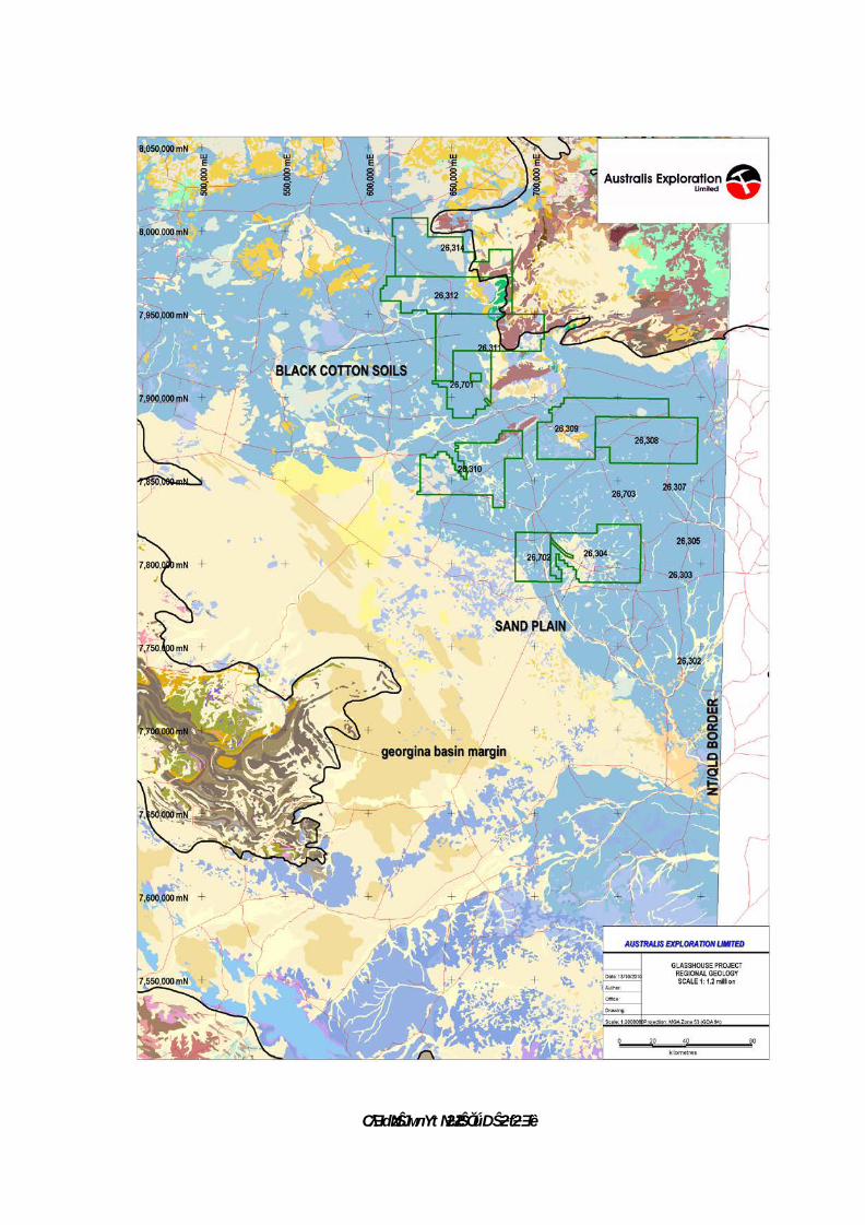
1.2 TENEMENT STATUS
ELs 26310, 26311, 26312 and 26701 form Australis Exploration Limited’s Glasshouse Project in the Northern
Territory.
The tenements covered a series of north-west trending magnetic linear that parallel the structural trend
passing through the McArthur River, Century and Mount Isa base metal deposits and also covered
extensive areas of the Georgina Basin cover sequence sediments prospective for phosphate and uranium.
The Glasshouse Project encompasses a total of four exploration licences covering 1138.44 km2.
Table 1 shows the tenure schedule and Table 2 shows all the sub blocks for all four licences.
Figures 3, 4, 5 and 6 show the final tenement sub blocks and Figure 7 shows the location of the Glasshouse Project tenements.
ELs 26310, 26311 and 26312 were granted on the 8th April 2008 and EL 26701 was granted on the 8th
January 2009.
Australis found that phosphate, base metals and uranium prospectivity is limited in the Glasshouse Project
and hence all four tenements were surrendered outright on the 24th October 2013.
Table 1: Tenure Schedule
Tenure ID Holder Tenement
Name Date
Granted Date
Surrendered Area Km2
Area Sub-
Blocks
EL 26310 Australis Exploration
Limited Glasshouse
8 8/04/2008 24/10/2013 77.84 24
EL 26311 Australis Exploration
Limited Glasshouse
9 8/04/2008 24/10/2013 406.8 125
EL 26312 Australis Exploration
Limited Glasshouse
10 8/04/2008 24/10/2013 407.3 125
EL 26701 Australis Exploration
Limited Glasshouse
12 8/01/2009 24/10/2013 246.5 76

9
Table 2: Tenure Sub Blocks
Tenement BIM BLOCK SUB-BLOCKS
EL26310 SE53 2793 DE HJK NOP RST VWX
EL26310 SE53 2794 ABCDEFGH JK
TOTAL SUB BLOCKS 24
EL26311 SE53 2216 OP TU YZ
EL26311 SE53 2217 LM QR VWX
EL26311 SE53 2219 YZ
EL26311 SE53 2220 VW
EL26311 SE53 2288 DE JK
EL26311 SE53 2289 ABC FGHJ LMNOP RSTU WXYZ
EL26311 SE53 2290 P TU YZ
EL26311 SE53 2291 BCDE FGHJK LMNOP QRSTU VWXYZ
EL26311 SE53 2292 AB FG LM QR VW
EL26311 SE53 2361 BCDE GHJK MNOP RSTU
EL26311 SE53 2362 ABCDE FGHJK LMNOP QRSTU
EL26311 SE53 2363 A F LMN QRST
TOTAL SUB BLOCKS 125
EL26312 SE53 2071 CDE HJK NOP TU YZ
EL26312 SE53 2072 ABCDE FGHJK LMNOP QRSTU VWXYZ
EL26312 SE53 2073 ABCD FGHJ LMNO QRST VWXY
EL26312 SE53 2143 E K P U Z
EL26312 SE53 2144 ABCDE FGHJK LMNOP QRSTU VWXYZ
EL26312 SE53 2145 ABCD FGHJ LMNO QRST VWX
EL26312 SE53 2215 E K
EL26312 SE53 2216 ABCDE FGHJK
EL26312 SE53 2217 ABC FGH
TOTAL SUB BLOCKS 125
EL26701 SE53 2575 OP STU VWXYZ
EL26701 SE53 2576 G LM QR VW
EL26701 SE53 2645 K P
EL26701 SE53 2646 CDE FGHJK LMNOP RSTU WXYZ
EL26701 SE53 2647 ABCDE FGHJK LMNOP QRST VWXY
EL26701 SE53 2648 AB FG LM
EL26701 SE53 2718 BCDE
EL26701 SE53 2719 ABC
TOTAL SUB BLOCKS 76

10
Figure 3: EL26310 Sub Blocks
Figure 4: EL26311 Sub Blocks

11
Figure 5: EL26312 Sub Blocks
Figure 6: EL26701 Sub Blocks

Australis Exploration: Combined Annual Technical Report 2010
Annual_NT_Australis_2010 4
Figure 7: Glasshouse Project Tenements Location

13
2.0 EXPLORATION RATIONALE
Based on initial review of the recently released geological and geophysical data, Australis applied for 57
exploration licenses covering some 41,742 km2 to the west and south of Mount Isa, and extending to the
north-west into the Northern Territory. In this area, outcrop is dominated by Paleozoic, Mesozoic and
recent sediments of the Georgina Basin and Eromanga Basin. The geophysical data suggests that there are
parts of the tenement area where the prospective Proterozoic-age basement extends beneath the region at
relatively shallow depths. Historically, this region has received little attention for mineral exploration due to
the Mesozoic and Paleozoic cover. However, the new compilation of geophysical data for the region
provides a useful guide to focus exploration on targets with the potential to host large-scale base metal and
uranium ore-deposits. In addition, the geophysical and historical database compilation has highlighted
opportunities to explore for uranium and phosphate deposits in the younger overlying sediments.
In summary, the Australis tenements cover an area with extensive aeromagnetic, radiometric and gravity
anomalies, where historical company reports and current exploration activities by other companies indicate
potential for:
Copper
Zinc-Lead-Silver
Uranium
Phosphate
Proterozoic-age rocks of the Mount Isa Block in north western Queensland host one of the major Copper-
Zinc-Lead-Silver and Uranium provinces of the world, including:
Mt Isa Cu and Pb-Zn-Ag and George Fisher Pb-Zn-Ag mines
Century Zn-Pb mine
Ernest Henry Cu-Au mine
Cannington Ag-Pb mine
Valhalla and Westmoreland U deposits
Duchess Phosphate mine
The company’s primary focus has been on identifying phosphate mineralisation in Cambrian sedimentary
cover sequences. The potential still exists to explore the extensive tenement package for large mineralized
systems of copper, lead, zinc and their associated metals (i.e. gold and silver) within the Proterozoic
basement rocks beneath the superficial and Phanerozoic units, and the overlying superficial and
Phanerozoic sediments for roll-front type and calcrete type uranium mineralisation, phosphate deposits
and possible MVT base metals mineralisation.

14
3.0 REGIONAL GEOLOGY
The Georgina Basin, together with the Wiso, Daly, Amadeus and Ngalia basins, form remnants of the
stratigraphically continuous Centralian Superbasin that extended over most of central Australia from the
Neoproterozoic to Paleozoic. Structural dismemberment of the Superbasin during Paleozoic intra-plate
orogenic events (400–300 Ma Alice Springs Orogeny) has resulted in the exposure of Palaeoproterozoic to
Mesoproterozoic basement between basin fragments in their current configuration (Khan, Ferenczi, Ahmad
and Kruse, 2007), see Figure 8.
The Georgina Basin is the largest of the intracratonic Neoproterozoic to Palaeozoic basins. It covers a large
part of eastern Northern Territory and extending into northwest Queensland, for a total area of about
325,000 km2, of which 185,000 km2 lies within the Northern Territory. Down faulted blocks and half-
grabens typically contain up to 1.5 km of Neoproterozoic sedimentary rocks. Up to 2.2 km of overlying
Palaeozoic succession is preserved in depocentres and synclines. Cambrian platform carbonate rocks
dominate the basin fill. Accompanying sandstone and shale were deposited during relative uplift and
subsidence, respectively. The Cambrian–Ordovician succession is most complete in the southern portion of
the basin. In contrast, the central region contains only a relatively thin Middle Cambrian succession (Khan,
Ferenczi, Ahmad and Kruse, 2007).
Basement rocks consist of Mesoproterozoic and minor Neoproterozoic sediments, characterised by shallow
marine epicontinental successions of carbonate and marine clastic rocks, evaporite, and fluvial and
lacustrine continental sandstone, glaciogenic sediments, shale and siltstone. These sediments were
succeeded by marine carbonate and clastic deposits, which accumulated in Cambrian and Ordovician times.
Younger, non-marine Silurian to Early Carboniferous successions is restricted in areal extent. In addition,
extensive sub-aerial flood basalt (Peaker Piker Volcanics and Antrim Plateau Volcanics) of Early Cambrian
age (540 Ma) floor these basins in much of the northern part of the Northern Territory. The volcanics are
amygdaloidal and porphyritic tholeiitic basalts and have associated dolerites (McCrow, 2008; Gifford, 2006;
Khan, Ferenczi, Ahmad and Kruse, 2007).
The Georgina Basin is bounded by the South Nicholson and McArthur Basins to the north, Tennant Inlier to
the west and Arunta Province to the south, and continues eastward into western Queensland to abut the
Mt Isa Block. It has been subdivided into several sub-basins that primarily reflect the thickness of Cambrian
deposition (Khan, Ferenczi, Ahmad and Kruse, 2007).
In the northern part of the project area, the central Georgina Basin contains a relatively thin stratigraphic
succession, up to 450m thick, deposited on a tectonically quiescent platform. Deposition commenced with
a marine transgression in the early Middle Cambrian and may have extended into the Late Cambrian
(McCrow, 2008). This central platform has been subdivided into an eastern Undilla Sub-basin and a western
Barkly Sub-basin, separated by a NNE – SSW striking structural ridge known as the Alexandria-Wonarah
Basement High (McCrow, 2008, Gifford, 2006). In the northern tenements, this structural ridge outcrops as
two north-east trending Precambrian basement highs within Georgina Basin sediments, with the Buchanan-
Alroy-Alexandria phosphate occurrences occurring nearby. The Mittiebah Range forms the northern Pre-
Cambrian inlier, the western end extending into EL26701, while the southern Pre-Cambrian inlier, south of
Alexandria homestead and phosphate occurrence, outcrops in the north-east part of EL26310.
By the Middle Cambrian, marine conditions prevailed in the basin and phosphogenesis was widespread
(McCrow, 2008). The Middle Cambrian succession has been subdivided into two depositional sequences
with three discrete phosphogenic episodes. Sequence 1 (early Middle Cambrian) comprises terrigenous

15
siliclastic rocks, peritidal and shelf carbonate rocks, carbonaceous shale and phosphatic carbonate rocks;
sequence 2 (remainder of Middle Cambrian) comprises siliclastic and carbonate rocks, phosphorite and
phosphatic limestone, and carbonaceous shale. Major phosphate deposits are apparently in sequence 2,
including the Wonarah, Alexandria and Alroy deposits in the Northern Territory. All three appear to be
hosted in the Wonarah Formation, although others have assigned the Wonarah deposit to the Gum Ridge
Formation (sequence 1) (Khan, Ferenczi, Ahmad and Kruse, 2007). There have been efforts to correlate
sedimentary horizons from one area to another but this has been difficult to achieve, other than in the
broadest terms, due to rapid lateral facies changes, see Figure 9.
Figure 8: Simplified geology of the Georgina, Wiso and Daly basins showing the distribution of phosphorite facies
depocentres and major phosphate deposits. Source: Khan, M, Ferenczi, PA, Ahmad, M and Kruse, PD (2007).

16
Figure 9: Stratigraphy of the Georgina and Wiso basins in the Northern Territory, showing the stratigraphic location
of phosphate occurrences in Lower to Middle Cambrian sediments (Source: Khan, M, Ferenczi, PA, Ahmad, M and
Kruse, PD (2007).

17
3.1 REGIONAL PHOSPHATE PROSPECTIVITY
Australia’s largest phosphate deposits (phosphorites) are the shallow marine siliclastic and carbonate
sediments of the Lower to Middle Cambrian Georgina Basin sequence in north-west Queensland and
Northern Territory. These sedimentary phosphorite deposits occur where the phosphorus has been
chemically and biologically precipitated as apatite group minerals (McCrow, 2008). An up-welling process
of phosphogenesis of cold phosphate enriched water onto warm shallow marine shelves and embayments
is the mechanism favoring precipitation.
Exploration and phosphate resource development has largely focused on the well-endowed Georgina
Basin, which contains significant deposits in the Northern Territory (Wonarah, Highland Plains, Alexandria,
Alroy and Buchanan Dam) and Queensland (Duchess, Lady Annie, D Tree, Lady Jane, Galah, Sherrin Creek
and others) (McCrow, 2008). Previous studies have also outlined the presence of phosphorite in the Wiso
and Daly basins (Khan, Ferenczi and Ahmad, 2005a).
Economic phosphate deposits in Middle Cambrian Georgina Basin sediments are being mined at Duchess
(Phosphate Hill) in Queensland. These phosphatic sediments were deposited in a restricted embayment
that was bounded by land on its northern, western, and southern sides, and whose eastern connection with
the Burke River Outlier, an appendage of the Georgina Basin, was restricted by shallow banks (McCrow,
2008). Incitec’s (ex WMC) Phosphate Hill, Duchess Mine and DAP plant produces 648,000 t of di-
ammonium phosphate and 236,000t of mono-ammonium phosphate (from 2 Mt of phosphate rock)
annually from a deposit containing a total resource of 131 Mt @ 23.5% P2O5 (McCrow, 2008; Ferenczi,
Khan and Ahmad, 2005b). That facility commenced production in December 1999 (Gifford, 2006).
The host rocks for these deposits are typically recessive and often covered with surficial sediments.
Previous exploration and discovery of known deposits involved shallow reconnaissance drilling programs
(and phosphate testing of drill cuttings) in favorable stratigraphy in close proximity to palaeo-highs
(Ferenczi, Khan and Ahmad, 2005b). Future targeting of phosphorite deposits would involve a structural
interpretation which would include identifying possible embayments and structural palaeo-highs (McCrow,
2008).
Howard (1990) examined the distribution of phosphatic facies in the Georgina, Wiso and Daly River Basins.
He used lithological logs and analyses of cuttings from water bores and Bureau of Mineral Resources
stratigraphic holes, together with aeromagnetic, gravity and elevation data, to define a carbonate-siltstone-
chert phosphatic lithofacies of Middle Cambrian age within the basins. The deposition of these phosphatic
lithofacies is related to the basement configuration and its depth. They occur as belts, peripheral to and
within the basins, with an average width of 32 km, a thickness of 10 to 190 metres, and have been traced
over a distance of 2,100 km. Some phosphorite deposits (such as the Lady Judith in the Wiso Basin) rest on
volcanic rocks and interdigitate with carbonates of the Montejinni Limestone, while others, such as the
Ammaroo phosphatic belt in the southwestern portion of the Georgina Basin, are contained within a
depression bounded by limestones of the Arthur Creek Formation. The phosphatic sediments are believed
to have been deposited primarily as an Ordian Middle Cambrian event in the west with a ‘younging’
transition through Ordian and/or Early Templetonian to Late Templetonian in the southeast. The basins are
extensional, exhibiting a series of broad downwarps crossed by peripheral aulacogens, grabens, half
grabens formed in the Late Proterozoic and modified subsequently by the development of plateau, narrow
horst blocks and adjacent deeps during the Middle Cambrian along basin-dividing arches. The basement to
the shallow-water phosphatic lithofacies consists of Proterozoic sediment or Early Cambrian volcanic

18
plateau or peripheral sloping platforms which in the Brunette Sub-basin have present elevations of 0-300
metres ASL (Howard, 1990).
3.2 LOCAL GEOLOGY
Alexandria-Alroy-Buchanan Dam Geology
In the Alexandria Region, the early Middle Cambrian sediments include the Wonarah Beds, Burton Beds
and Anthony Lagoon Beds. They all consist predominantly of siltstone, sandstone, chert, limestone and
dolomite. IMC reported that sequences of Middle Cambrian siltstone/sandstone deposition in close
proximity to mapped Precambrian basement highs almost invariably overlie Peaker Piker volcanics of Lower
Middle Cambrian age (northern Alexandria) or Precambrian Mittiebah Sandstone/ Mullera Formation (most
of Alexandria) (McCrow, 2008).
In 1976 ICI reported no Pre-Cainozoic outcrops in the Alroy area which is totally covered by pedo-calcic
black/grey soils, with alluvium in the seasonal swamps associated with the Playford and Buchanan Rivers.
The under lying rocks were siltstone, shale, chert, limestone and dolomite. These are probably the Lower
Middle Cambrian Burton Beds, considered to be the stratigraphic equivalent of the Wonarah Beds to the
south and the Beetle Creek Formation in Queensland, both of which are phosphatic in parts. No
information is available about rocks below the Middle Cambrian (McCrow, 2008).
Wonarah Deposit Geology
The Wonarah deposits occur along the flanks of the Alexandria – Wonarah High. On lapping dolomitic
members equivalent to the Middle Cambrian Thorntonia Limestone are present on the lower flanks of this
structural ridge and, when present, the phosphorus-bearing sediments (Upper Gum Ridge Formation) occur
on the limestone and extend in thicker beds, lying directly on the Peaker Piker Volcanics, on the upper
flanks of the ridge. This succession is then overlain by the Convolute Mudstone followed by the Hanging
Wall Mudstone. Two basal sedimentary units that are not always present are the Transitional Sediments
and the Potassium Marker Horizon. The transitional sediments consist of mixed mudstone, siltstone,
sandstone, and a possible palaeo soil. The overlying Potassium Marker Horizon is a clay rich mudstone
(Gifford, 2006).
There are two mineralised rock types at Wonarah – Mudstone Phosphorite and the Chert Breccia
Phosphorite (Gifford, 2006). The Mudstone Phosphorite contains most of the mineralisation, forming
friable and fine grained beds 2 metres to 10 metres thick with grades up to 40% P2O5 but typically between
20% and 30% P2O5. The Chert Breccia Phosphorite occurs beneath the Mudstone Phosphorite with a
gradational boundary and contains discrete clasts of chert breccia in a phosphorite matrix. The grade
ranges from 5% to 20% P2O5 but is typically between 10% and 15% P2O5 (Gifford, 2006).
CƛƎdzNJŜ млΥ tNJƻƧŜŎǘ DŜƻƭƻƎȅ

20
4.0 HISTORICAL PHOSPHATE EXPLORATION
The Glasshouse Project area has been explored by numerous previous workers. The details of this and the
work that was completed are presented in Table 3.
Table 3: Previous Exploration on Glasshouse Tenements
Year Company Exploration
1968-1971
IMC Development IMC Development completed an extensive phosphate exploration program covering the majority of the project area. Work completed included air photo interpretation, geological mapping, and interpretation of radiometric and magnetic geophysics surveys. They completed and extensive drilling program which led to the discovery of the Wonarah and Alexandria phosphate deposits (outside of project area to the south). They note that phosphate mineralisation occurs within clastic sediments on the margins of Precambrian basement highs and these sediments (the Wonarah Beds, Burton Beds and Anthony Lagoon Beds) are likely to be Mid-Cambrian correlates of the Beetle Creek-Inca Creek Formations in Queensland that host the D-Tree phosphate deposit. They also note that the most favorable environment appears to be have been in silt-chert facies in the shallows of the Middle Cambrian phosphogenic sea. A total of 12 widely spaced drill holes were completed within the project area (426 metres). Drill cuttings were tested with ammonium molybdate to assess whether phosphate was present and select intervals for assaying. Two holes intercepted narrow widths of phosphatic beds returning 1.5m at 2% P2O5 and 0.8m at 2.2% P2O5. The tenements were relinquished as they were not thought prospective for phosphate mineralisation and to focus on the neighbouring Wonarah and Alexandria deposits.
1981-1982
BHP Minerals Pegged tenement in central part of project area targeting Mississippi Valley lead-zinc type deposits. Completed literature review and photo-geological studies and decided to relinquish tenement.
1984-1985
CRA Exploration Completed diamond exploration program over the eastern two thirds of the project area. Completed a helicopter supported drainage sampling program with several micro-diamonds recovered that were believed to have been recycled from a secondary detrital source. Orientation aeromagnetic surveying was completed, indicating the area was amenable to detailed magnetic for detecting magnetic diatremes.
1985-1986
Australian Diamond Exploration/ Design and Construction
Completed a sampling program over the north-eastern part of the project area. Collected 24 samples, of which five contained microdiamonds. No kimberlite indicator minerals were identified. Thematic mapping was carried out over the area. No targets were identified and the tenement was relinquished.
1983-1989
AOG Mines / Ashton / Aberfoyle / Australian Diamond Exploration JV‟s
Completed extensive diamond exploration programs throughout the project area. Work completed included aeromagnetic and ground magnetic surveys, stream sediment sampling for kimberlite indicator minerals, and bulk sampling of alluvial material by costean sampling and shallow RAB drilling. Several microdiamonds were found in bulk samples, but it was concluded that potential for diamondiferous kimberlite pipes in the area was remote.
1984-1990
CRA Exploration Completed an extensive diamond exploration program over the much of the project area. Several micro diamonds were recovered and orientation magnetic surveys were completed. It was noted that detailed aeromagnetics would be useful for detecting magnetic diatremes.
1989-1990
CRA Exploration Completed an extensive diamond exploration program over the eastern part of the project area. Helicopter and ground magnetic was carried out identifying many magnetic targets, of which 15 were drill tested. One microdiamond was recovered

21
from the sampling program and no further work was completed. The MVT potential of the areas was also reviewed but was not considered prospective for this style of mineralisation due to the lack of indicator minerals in loam samples and the low fluorine levels in groundwater.
1985-1991
Ashton / Design and Construction JV
Completed diamond exploration programs throughout the central part project area. Work completed included thematic mapping and stream and bulk sampling of alluvial material. Several microdiamonds were found in bulk samples, but it was concluded that potential for diamondiferous kimberlite pipes in the area was remote and the tenement was relinquished.
1991-1992
BHP Minerals Based on aeromagnetic interpretation, a tenement was pegged that covered a small portion of the south east of the project area targeting SEDEX deposits within the interpreted shallow Proterozoic basement. Shallow ground magnetic soundings revealed Proterozoic basement was at depths greater than 300m. The tenement was relinquished.
1993-1997
Aberfoyle / Ashton Mining
Completed diamond exploration programs in the north east of the project area. Work completed included stream sediment sampling and loam sampling. One microdiamond was recovered but no other diamond indicator minerals were identified.
1995-1997
BHP Minerals Completed reconnaissance geological programs targeting SEDEX style base metal deposits within outcropping and below cover basement Proterozoic rocks. Geophysical and geological interpretations concluded that prospective host rocks of the Proterozoic Fickling Group may lie below cover south of the interpreted extension of the Fish River Fault. Several PROTEM readings were taken indicating that the cover sequence was not conductive and would not present problems for planned airborne EM. An airborne GEOTEM survey was completed, covering part of the northern most part of the project area. A number of low order GEOTEM anomalies were defined, but were not deemed worthy of further follow up and no more work was completed on the tenements.
2002-2004
De Beers Australia Reconnaissance diamond exploration was carried out over an area that onlaps the southeast part of the project area. 37 Streams sediments were collected and analysed for the presence of diamond indicator minerals. No kimberlite indicator minerals were found and no priority magnetic anomalies were defined and the ground was relinquished.
2003-2004
Anglo American Exploration
Completed an exploration program targeting SEDEX style Pb-Zn mineralisation over a tenement that overlaps the north east part of the project area (the work was targeted Proterozoic rocks outside of the current project area). Work included a review of previous exploration and 40.2 km of TEM surveying (outside of project area). Evaluation of the data and target review downgraded the prospectivity of the lease and it was surrendered.

22
5.0 EXPLORATION BY AUSTRALIS EXPLORATION LIMITED
Exploration by Australis Exploration Limited within the Glasshouse Project tenements includes:
Geophysical Interpretation
Prospectivity assessments & valuation
Site visit and soil sampling
5.1 GEOPHYSICAL INTERPRETATION
Consultant Resource Potentials was contracted to carry out processing of all available geophysical data sets and provide targets for future exploration. An extract of the report detailing this work is in Appendix 1.
The report concluded that the tenements have little potential for phosphate development.
5.2 PROSPECTIVITY ASSESSMENTS & VALUATION
Consultant Ravensgate were contracted to carry out a prospectivity analysis and valuation on the Australis Glasshouse Project. An extract copy of the report is in Appendix 2.
The report by Ravensgate concluded in the Desert Creek project (which EL 26310 is located) and Mittiebah project (which ELs 26311, 26312 and 26701 are located) that there were a number of prospective target zones for phosphate mineralisation throughout the project area and were defined based on geology, geophysics and past exploration.
Potential for base metals deposits and near surface uranium is considered to be low prospectivity.
5.1 SITE VISIT & SOIL SAMPLING
In October 2011 a site visit to the Glasshouse Project tenements were undertaken by personnel from
Australis Exploration Limited. The aim of the visit was to assess the anomalies targets from the Ravensgate
report.
Soil readings were taken using a Niton Rad-eye scintillometer. A collection of scintillometer total count data
at the anomaly sites of the Glasshouse project were taken and results of this survey is detailed in Figure 11
below. Niton XRF readings for these soil samples taken the four tenements are detailed in Appendix 3 of
this report.
The 2011 XRF reconnaissance program resulted in identifying anomalous sites which were targeted in a
follow up soil sampling program in 2012.

23
Figure 11: 2011 Ntion XRF Surveying Results

24
The follow up program was conducted in two separate trips in July/August and September 2012. All
anomalous sites identified using handheld XRF were soil sampled using an 180µm/-80mesh sieve, 100g
samples collected and placed into a calico bag. A basic grid was completed over each site with a single
sample on the XRF anomaly location and at least four other samples taken 100m apart at cardinal points (N,
E, S, W). All samples were submitted to ALS Laboratories in Mt Isa for analysis using ME-ICP61 and ME-
XRF24 which specifically target low level phosphate. The assay results for all the soil sampling have been
included in Appendix 3 of the report.
The program has determined that many of these areas have only background levels of phosphate and
require no further work. Site A4 within EL 26310 returned anomalous phosphate in several soil samples
averaging 0.145% P2O5 (Figure 12).
Figure 12: EL26310 XRF Follow Up Soil Sample Results

25
Follow up soil sampling of 2011 XRF results has discovered anomalous phosphate in soils on EL 26310, as a
result a 36 sample grid was implemented. The grid consisted of collection of 180µm/-80mesh sieved
samples on a 400m x 400m grid (Figure 13).
Figure 13: EL26310 Soil Sampling Thematic Map
During October 2012, a secondary program to extend the soil sampling grid conducted on EL 26310 was
completed with 98 soil and 8 auger samples collected over an area of 19 km2. A basic 400m x 400m grid
was used to cover the northern portion of EL 26310, extending the previously defined anomaly and also
testing a nearby radiometric anomaly which may be associated with surficial phosphate mineralisation. All
soil samples were collected 10-20cm below surface in order to avoid sampling transported and/or
contaminated material. Auger samples were collected 30-40cm below surface using a hand held auger. All
samples were sieved using an 180µm/-80mesh sieve, >100g sampled and stored in Kraft geochemical
sampling bags.
The 98 soil samples assayed averaged 401 ppm P or 0.092% P2O5 while the 8 auger holes averaged 721ppm
P or 0.165% P2O5, 79% more than the soils. It must be noted than when compared to the soil samples
directly around the auger holes the soil samples averaged 537ppm P or 0.123% P2O5 which is still 34% less.
56 of the 98 soil samples were >0.1% P2O5 which has been selected as anomalous as it is approximately 3
times background levels (based on field observations). A very rough area calculation for the anomaly
within EL26310 is ~11.3 km2 which is significant in size.

26
Auger samples collected along the phosphate anomaly show a distinct elevation in phosphate levels when
compared to soil samples collected within the same area. This indicates that the phosphate anomalism is
not just a surficial anomaly from outside factors such as bush fires and that drilling may be warranted in
order to fully test for a potential source. Of the 8 auger samples collected, 7 were highly elevated (>0.1%
P2O5), compared to background levels.
Results from the secondary soil sampling program within EL26310 have been encouraging with an
extension of the previously defined phosphate anomalism along the margins of the Mittiebah Sandstone.
Auger sampling has also been successful with elevated phosphate grades obtained from subsurface
sampling compared to previous surficial samples. The auger sampling has also helped reduce the likelihood
that the anomalism is due to surficial contamination or other unforeseen factors.
The results from the soil and auger program have highlighted the possibility of concealed phosphate
mineralisation along the southern margin of the Mittiebah Sandstone (Figure 14). Soil & auger location and
assays taken at EL26310 are detailed in Appendix 3 of this report.
Figure 14: Minimum Curvature Plot of P2O5% for the EL26310 soil/auger sampling grid

27
6.0 RECOMMENDATIONS
Observation of the radiometric anomalism on the investigated Glasshouse tenements shows levels that are not significant enough to be an effective exploration tool in this part of the Georgina Basin and as such it’s weighting as an exploration vector has been downgraded. Radeye scintillometer readings put total counts per second radiometric background levels for the Glasshouse project area at an average of 10 -15cps, while the observed readings at anomalous area are in the range of 20-25cps resulting in an anomalism of barely double background levels. The expected radiometric response for Cambrian phosphatic sediments of the Georgina Basin can be in the order of 100ppm Uranium. This should result in scintillometer readings of well over 100cps with readings around 200cps being entirely feasible. The lack of signal could be due to the lack of outcrop exposure as 1m of cover could completely attenuate any radiometric signals. In light of the results from the follow up soil sampling and the reports from various consultants indicated that there is limited prospectivity for phosphate, base metals and uranium, a decision has been made to relinquish the four tenements.
7.0 REFERENCES
Gifford, AC
2006
Independent Consulting Geologist’s Report. Minemakers Limited Prospectus.
Howard, PF
1990 The distribution of phosphatic facies in the Georgina, Wiso and Daly River Basins, Northern Australia. GEOLOGICAL SOCIETY OF LONDON, SPECIAL PUBLICATIONS; 1990; v. 52; p. 261-272.
Khan, M, Ferenczi, PA, Ahmad, M
2005a Regional Phosphate Prospectivity. Annual Geoscience Exploration Seminar (AGES) 2005. Record of Abstracts. Geological Survey Record 2005-001. Northern Territory Department of Business, Industry and Resource Development.
Khan, M, Ferenczi, PA, Ahmad, M
2005b Phosphorite in water bores from the Georgina, Wiso and Daly basins, Northern Territory. http://conferences.minerals.nt.gov.au/cabs/pdfs/ abstracts/A01_Ferenczi_phosphorite.pdf
Khan, M, Ferenczi, PA, Ahmad, M and Kruse, PD
2007 Phosphate testing of waterbores and diamond drillcore in the Georgina, Wiso and Daly basins, Northern Territory. Geological Survey Record 2007-003. Northern Territory Department of Primary Industry, Fisheries and Mines.
McCrow, B 2008 Independent Geologists Report. Phosphate Australia Limited Prospectus.
NTGS Various Open File Reports

28
APPENDIX 1
RESOURCE POTENTIAL-M COOPER, MAY 2010 NT AREA-GEOPHYSICAL DATA
COMPILATION, PROCESSING AND TARGET GENERATION (EXTRACT ONLY)

29
APPENDIX 2
RAVENSGATE-PROSPECTIVITY ASSESSMENT AND VALUATION- JUNE 2010 (EXTRACT
ONLY)

30
APPENDIX 3
SOIL ASSAY RESULTS
GR123_09_2013_AS_02_SurfaceGeochem.txt
GR123_09_2013_AS_03_SurfaceGeochem.txt