Embed Size (px)
Citation preview

Annexure F- Relevant Council Recommendation and Plans for RM150169 - Makarora Variable Message Sign

Queenstown Lakes District Council - Private Bag 50072 - Queenstown 9348 - Tel 03 441 0499 - www.qldc.govt.nz
RECOMMENDATION OF THE QUEENSTOWN LAKES DISTRICT COUNCIL
RECOMMENDATION UNDER s181
ALTERATION TO A DESIGNATION
RESOURCE MANAGEMENT ACT 1991
Applicant/Requiring Authority: New Zealand Transport Agency
RM reference: RM150169
Application: Notice of Requirement (NoR) under Section 181(3) of the
Resource Management Act 1991 (RMA) for an alteration of a
designation for ‘State Highway Purposes’ to allow the
instillation of a Variable Message Sign (VMS).
Location: State Highway 6, Makarora
Legal Description: Adjacent to Lot 2 DP 25911 contained in Computer Freehold
Register 18A/74
Zoning: Rural Lifestyle
Designation: Ref. No. 84 State Highway Purposes
Recommendation Date 16 April 2015
SUMMARY OF RECOMMENDATIONS
1. Pursuant to Section 181(3) of the RMA, the NoR for an alteration of Designation Ref. No. 84 is
ACCEPTED. To reach the recommendation the application was considered (including the full
and complete records available in Council’s electronic file and responses to any queries) by
Anita Vanstone, Senior Planner, as delegate for the Council.
1

V1_08/08/14 RM150169
1. PROPOSAL AND SITE DESCRIPTION A NoR has been received from the New Zealand Transport Agency (NZTA) to alter Designation Ref. No. 84 for ‘State Highway Purposes’ to allow for a Variable Message Sign (VMS) to be installed. The applicant has provided a detailed description of the proposal, the site and locality and the relevant site history in Sections 1-4 of the report entitled ‘Proposed New Variable Message Sign on SH6 at Makarora- Notice of requirement for alteration to Designation, March 2015’, prepared by Kate Randell of Opus International Consultants on behalf of NZTA, and submitted as part of the application (hereon referred to as the applicant’s AEE and attached as Appendix 1). This description is considered accurate and is adopted for the purpose of this report. It is noted that the application also details the extent of the proposed works to occur within the altered designation in relation to the VMS. Therefore in accordance with s176A(2) the requiring authority does not subsequently require an outline plan approval for these works. 2. NATIONAL ENVIRONMENTAL STANDARD FOR ASSESSING AND MANAGING
CONTAMINANTS IN SOIL TO PROTECT HUMAN HEALTH (NES) This application does not involve subdivision (excluding production land), change of use where it is reasonably likely to harm human health or removal of (part of) a fuel storage system. Any earthworks will meet section 8(3) of the NES (including volume not exceeding 25m³ per 500m2). Therefore the NES does not apply.
3. SECTION 181 OF THE RMA A territorial authority may at any time alter a designation in its district plan if the alteration;
involves no more than a minor change to the effects on the environment associated with the use of land or any water concerned (s181(3)(a)(i));
or the alteration involves only minor changes or adjustments to the boundary of the designation or requirement (s181(3)(a)(ii)); and
written notice of the proposed alteration has been given to every owner or occupier of the land directly affected and those owners or occupiers agree with the alteration (s181(3)(b)); and
both the territorial authority and the requiring authority agree with the alteration (s181(3)(c)) - and sections 168 to 179 shall not apply to any such change.
An assessment in this respect follows. 4. ASSESSMENT OF EFFECTS ON THE ENVIRONMENT (s181(3)(a)(i)) 4.1 ASSESSMENT: EFFECTS ON THE ENVIRONMENT The following assessment determines whether the alteration to the designation involves no more than a minor change to the effects on the environment associated with the use or proposed use of the land. The Assessment of Effects provided at section 7 of the applicant’s AEE, is comprehensive and is considered accurate. It is therefore adopted for the purposes of this report. In summary the actual or potential effects are in terms of construction, landscape and visual amenity and road safety. In addition to the applicant’s assessment on landscape and visual amenity it is considered appropriate that the supporting poles for the sign are finished in a suitable recessive grey colour to mitigate any potential adverse visual effects of the sign. Any actual or potential effects of the proposal are considered to be less than minor. 4.2 DECISION: EFFECTS ON THE ENVIRONMENT
2

V1_08/08/14 RM150169
Overall the proposed alteration of Designation Ref. No. 84 will involve no more than a minor change to the effects on the environment associated with the use or proposed use of land. 5. WRITTEN NOTICE (s181(3)(b)) Written notice of the proposed alteration of Designation Ref. No. 84 has been given to every owner or occupier of the land directly affected and those owners or occupiers agree with the alteration. These persons are outlined below:
Land owner Land Parcel Land Required Approval Provided
RP Copper and AD Copper, Farry and Co Trustees Ltd
Lot 2 Deposited Plan 25911 held in Computer Freehold Title OT 18A/74
130m²
Yes
The proposal will result in only minor changes to the boundaries of the existing designation. No other persons are directly affected by the alteration with no other land required to accommodate the alteration. 6. OVERALL RECOMMENDATION Given the decisions made above in sections 4.2 and 5, the Queenstown Lakes District Council agrees with the alteration. In addition, the Requiring Authority as applicant agrees with the alteration. 6.1 RECOMMENDATION ON NOR PURSUANT TO SECTION 181 (3) OF THE RMA Pursuant to section 181(3) of the RMA the alteration to Designation Ref. No. 84 is ACCEPTED such that: 1. The proposed designation is extended in accordance with the plan titled ‘SH 6 region 13 RS
828 variable Message Sign, Haast Pass- Makarora Road- Land Designation Plan’ by OPUS and stamped as approved on X April 2015.
2. The poles that support the sign shall be a dark grey colour of low light reflectance value (less
than 15%) to ensure the sign structure is recessive within the broader landscape. 7. ADMINISTRATIVE MATTERS The costs of processing the NoR are currently being assessed and you will be advised under separate cover whether further costs have been incurred. This NoR is not a consent to build under the Building Act 2004. A consent under this Act must be obtained before construction can begin. If you have any enquiries please contact Sarah Picard on phone (03) 441 0499 or email [email protected]. Report prepared by Decision made by
Sarah Picard Anita Vanstone PLANNER SENIOR PLANNER
3

V1_08/08/14 RM150169
APPENDIX 1 – Applicant’s AEE
4

5

6

7

8

9
10

11

12

13

14

15

16

17

18
19

20

21
22
23

24
25

26

27

28

29

30

31

Annexure G- Relevant Decision, Council Recommendation and Plans for RM090645 - Boyd Road


File Ref: SH/13/6/8/607
22 February 2010
Lakes Environmental
Private Bag 50077
QUEENSTOWN 9348
Attention: Wendy Rolls
Dear Wendy
Decision on Recommendation for Notice of Requirement (RM090645) – Boyd Road – SH 6 –
Queensotwn
The NZ Transport Agency (the requiring authority) has received the Queenstown Lakes District
Council’s (Council) recommendation in terms of Section 171 of the Resource Management Act 1991
(the Act) on the Requirement to Alter the Designation (RM090645) for the State highway at Boyd Road
on State Highway 6 near Queenstown.
The Council’s recommendation was received on 9 February 2010.
Under section 172 of the Act, the requiring authority is now able to respond to the Council on whether
or not its recommendation is accepted, or rejected, in whole or in part.
I therefore advise, pursuant to section 172 of the Act, that the Council’s recommendation to confirm
the Notice of Requirement to amend the designation for State highway purposes at Boyd Road on State
Highway 6 subject to conditions is accepted in whole.
Please do not hesitate to contact me if you have any further queries on this matter.
Yours sincerely
Ian McCabe
Integrated Planning Manager – Otago/Southland
cc Opus International Consultants, Private Bag 1913, Dunedin 9054

Annexure H- Relevant Council Recommendation and Plans for RM081075 Peninsula Road
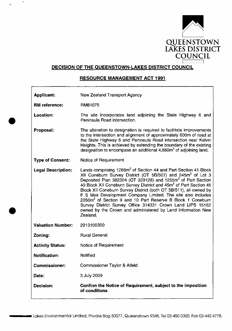
QUEENSTOWN LAKES DISTRICT
COUNCIL DECISION OF THE QUEENSTOWN-LAKES DISTRICT COUNCIL
RESOURCE MANAGEMENT ACT 1991
Applicant:
RM reference:
Location:
Proposal:
Type of Consent:
Legal Description:
Valuation Number:
Zoning:
Activity Status:
Notification:
Commissioner:
Date:
Decision:
New Zealand Transport Agency
RMS 1075
The site incorporates land adjoining the State Highway 6 and Peninsula Road intersection.
The alteration to designation is required to facilitate improvements to the intersection and alignment of approximately 600m of road at the State Highway 6 and Peninsula Road intersection near Kelvin Heights. This is achieved by extending the boundary of the existing designation to encompass an additional 4,880m2 of adjoining land.
Notice of Requirement
Lands comprising 1285m2 of Section 44 and Part Section 41 Block XII Coneburn Survey District (OT 5B/507) and 245m2 of Lot 3 Deposited Plan 382304 (OT 329128) and 1255m2 of Part Section 40 Block XII Coneburn Survey District and 45m2 of Part Section 45 Block XII Coneburn Survey District (both OT 5B/511), all owned by F S Mee Development Company Limited. The site also includes 2050m2 of Section 9 and 10 Part Reserve B Block 1 Coneburn Survey District Survey Office 314331 Crown Land LIPS 15162 owned by the Crown and administered by Land Information New Zealand.
2913100300
Rural General
Notice of Requirement
Notified
Commissioner Taylor & Alfeld
3 July 2009
Confirm the Notice of Requirement, subject to the imposition of conditions
Lakes Environmental Limited, Private Bag 50077, Queenstown 9348, Tel 03-450 0300, Fax 03-442 4778.

UNDER THE RESOURCE MANAGEMENT ACT 1991
IN THE MATTER OF a Notice of Requirement by New Zealand Transport Agency, a Requiring Authority under section 167 of the Resource Management Act 1991, to alter the State Highway 6 and Peninsula Road intersection.
Date of hearing: 12 June 2009
Counsel for the Applicant: Ms C J Hewitt
Council File: RM 081075
RECOMMENDATION BY QUEENSTOWN LAKES DISTRICT COUNCIL UNDER S 171(2) OF THE RESOURCE MANAGEMENT ACT 1991
BY INDEPENDENT HEARINGS COMMISSIONERS JANE TAYLOR AND LOU ALFELD
1. The Proposal
On 3 July 2008, Transit New Zealand (Transit) issued a Notice of Requirement
("NOR") for an alteration to a designation pursuant to Section 181(3) of the
Resource Management Act of 1991 ("the Act") required to facilitate improvements to
the intersection and alignment of approximately 600m of road at the State Highway
6 and Peninsula Road intersection near Kelvin Heights, Queenstown.
The Applicant is a Crown entity created by the Land Transport Management
Amendment Act 2008 ("LTMAA") on 1 August 2008. The LTMAA dissolved Transit
and Land Transport New Zealand ("LTNZ') and established the New Zealand
Transport Agency ("NZTA") to succeed both Transit and LTNZ. Accordingly, this
Notice of Requirement (NOR) proceeds under the authority of NZTA ("the
Applicant"), which replaces Transit as a requiring authority under the relevant Order
in Council, notice or other instrument in effect immediately before 1 August 2008.

The NOR seeks to extend the boundary of the existing designation to encompass
an additional 4,880m2 of adjoining land. Specifically, the land comprises 1285m2 of
Section 44 and Part Section 41 BLK XII Coneburn SD (OT 5B/507) and 245m2 of
Lot 3 DP 382304 (OT 329128) and 1255m2 of Part Section 40 BLK XII Coneburn
SD and 45m2 of Part Section 45 BLK XII Coneburn SD (both in OT 5B/511) and all
owned by F S Mee Development Company Limited, and 2050m2 of Section 9 and
10 Part Reserve B BLK I Coneburn SDSO 314331 Crown Land LIPS 15162 owned
by the Crown and administered by Land Information New Zealand.
2. Process under the Resource Management Act 1991
At the time NZTA lodged the NOR it was anticipated that an agreement to the
alteration of the designation would be reached with the owners of the neighbouring
affected land, F S Mee Development Company Limited ("Mee Development"). Such
agreement would have enabled the designation to be altered on a relatively informal
basis as provided by section 181 (3).
However, Mee Development has not agreed to the NOR. As a result, the proposal
fails to meet s 181(3)(b) and the process for a new designation applies to the
alteration in accordance with s 181(2).
As Mee Development has further alleged that the Territorial Authority does not have
jurisdiction to consider this matter on the grounds that no agreement in relation to
the land owned by the submitter has been reached with NZTA, we have set out the
process applicable to our determination of this matter as required by the Act.
Section 169 provides that a Territorial Authority, in this case the Queenstown Lakes
District Council ("QLDC"), must notify the NOR in accordance with s 93(2) (as has
been done), following which QLDC must make a recommendation under s 171,
which states:
171. Recommendation by Territorial Authority
(1) When considering a requirement and any submissions received, a Territorial Authority must, subject to Part 2, consider the effects on the environment of allowing the requirement, having particular regard to:
(a) Any relevant provisions of: -

(i) A national policy statement;
(ii) A New Zealand coastal policy statement;
(iii) A regional policy statement or proposed regional policy statement;
(iv) A plan or proposed plan; and
(b) Whether adequate consideration has been given to alternative sites, routs or methods of undertaking the work if: -
(i) The Requiring Authority does not have an interest in the land sufficient for undertaking the work; or
(ii) It is likely that the work will have a significant adverse effect on the environment; and
(c) Whether the work and designation are reasonably necessary for achieving the objectives of the Requiring Authority for which the designation is sought; and
(d) Any other matter the Territorial Authority considers reasonably necessary in order to make a recommendation on the requirement.
(2) The Territorial Authority may recommend to the Requiring Authority that it: -
(a) Confirm the requirement; (b) Modify the requirement; (c) Impose conditions; (d) Withdraw the requirement.
(3) The Territorial Authority must give reasons for its recommendation under subsection (2).
Once QLDC has made its recommendation under s 171(2), which is the purpose of
this hearing, the Requiring Authority (NZTA) must advise QLDC within 30 working
days whether it accepts or rejects the recommendation in whole or part (s 172).
Section 172(2) provides that a Requiring Authority may modify a requirement if, and
only if that modification is recommended by the Territorial Authority or is not
inconsistent with the requirement as notified. Section 172(3) provides that where a
Requiring Authority rejects the recommendation in whole or in part, or modifies the
requirement, the Authority shall give reasons for its decision.
Following the decision by the Requiring Authority under s 172, the Territorial
Authority and any person who made a submission on the requirement may appeal
the whole or any part of a decision of the Requiring Authority under s 174.
Accordingly, pursuant to s 171(1) this Commission must, subject to Part 2, consider
the effects on the environment of allowing the requirement, having particular regard
to the matters contained in that section (s 171(i)(a) to (d)). The Commission may
recommend to the Applicant that it confirm the requirement, modify the requirement,
impose conditions or withdraw the requirement in accordance with s 171(2).
Outline Plans
Section 176A of the Act sets out the provisions in respect of outline plans. Subject
to subsection (2), an outline plan of the public work, project or work to be
constructed on designated land must be submitted by a Requiring Authority to the
Territorial Authority to allow the Territorial Authority to request changes before
construction is commenced. However, subsection (2) provides that an outline plan
need not be submitted if, inter alia:
(i) The proposed public work, project or work has been otherwise approved
under this Act; or
(ii) The details of the proposed public work, project or work are incorporated into
the designation.
In this respect, we note that full details of the proposed work has been provided in
respect of the intersection realignment and roadway upgrade, which is incorporated
into the NOR: accordingly, the NOR meets the requirements of s 176A(2).
3. The Hearing
Prior to the hearing, we had the benefit of a comprehensive s 42A report from Lakes
Environmental planner, Mr Aaron Burt (planner). Mr. Burt recommended in his
report that pursuant to s 171 (2)(a) of the Act, the NOR be confirmed.
Five submissions were received prior to the hearing as follows:
(i) A submission in opposition to the application was received from F S Mee
Development Company Ltd. alleging the lack of the Commission's jurisdiction
over the NOR on the grounds that no agreement has been reached as

between the registered proprietor of the property to be designated (Mee
Development) and NZTA. However, as previously discussed, the Act
anticipates that landowners subject to an alteration to a designation may not
agree with the alteration. In the absence of landowner approval, s 181(2)
requires that ss 168 to 179 apply to the NOR, which has the effect of treating
the application as a requirement for a new designation. Section 185 of the
Act empowers the Environment Court to make an order allowing the
requiring authority to obtain the land under the Public Works Act 1981 ("the
PWA"). Therefore the issue raised by Mee Development is a PWA issue and
is not therefore relevant to these proceedings under the Act.
(ii) Mr Bill and Mrs Kirsty Sharpe lodged a submission in support of the NOR.
Ms Sharpe spoke at the hearing and requested consideration be given to
providing a roundabout in place of the proposed "T" intersection. She also
requested that the Kawarau Falls Station temporary access road be allowed
to remain open; that an additional lane for slow traffic be added; that a place
for car parking near the intersection remain, and that native landscaping be
retained to enhance the entrance to Kelvin Heights.
(iii) Mr Ross Lawrence lodged a submission in support.
(iv) The Kelvin Peninsula Community Association lodged a submission in
support, requesting that a landscape plan be made available for comment by
the KPCA and that details of the proposed design be made available.
(v) Peninsula Road Limited lodged a late submission in support, which, following
consideration of the relevant criteria, was accepted by the Commission
pursuant to s 37A of the Act.
The Applicant was represented at the hearing by its legal counsel, Ms C J Hewitt,
who called expert evidence from:
Mr Nicolas Grant Rodger, an NZTA Project Manager and civil engineer. Mr
Rodger's evidence described the need for the intersection upgrade and
provided plans for the proposed works, detailing the necessity for the
acquisition of the additional land beyond the current designation. He

discussed alternatives to the proposal and the reasons for rejecting them,
the consultation process to date, and addressed issues raised by submitters.
• Ms Jane Clark Loten, a planner with Opus International Consultants Ltd. Ms
Loten prepared the NOR, assessed environmental effects and undertook
consultations with potentially affected parties. She also provided a proposed
landscape plan.
The Commission was assisted at the hearing by Committee Secretary, Ms Ryan.
Prior to the hearing the Commission undertook a site visit to the property.
4. The Notice of Requirement
The NOR seeks to alter the existing designation to include an additional 4,880m2 of
land required to facilitate improvements to the intersection and alignment of
approximately 600m of road at the State Highway 6 and Peninsula Road
intersection near Kelvin Heights.
Ms Hewitt submitted that the intersection upgrade is necessary to provide for the
safe operation of the roadway as traffic volumes increase. Mr Rodger gave
evidence that the objectives of the NOR are to:
• Provide a safer driving environment for road users by increasing the sight
distances along SH6 at the Peninsula Road intersection, decreasing the
gradient of the road through this intersection and replacing the U-bend
approach with a single radius curve leading to a standard 90 degree "tee"
junction;
• Prevent the projected increase in the number of crashes at the Peninsula
Road intersection due to the projected increase in traffic from both the
adjacent Kawarau Falls Station development, and ongoing smaller-scale
residential development on the peninsula;
• Contribute to the ongoing upgrading of SH6;

Improve the safety and efficiency of the highway in this area.
5. Assessment under s171(i)
(a) Section 171(i)(a): Effects on the Environment and Relevant Provisions of Planning
Documents
Ms Loten provided detailed evidence regarding the environmental effects of allowing
the requirement, and concluded that not only will any adverse effects of the
proposed realignment of the intersection be minor, but that substantial positive
effects will result. She also recommended conditions be imposed on the NOR
regarding the implementation of the Landscape Plan and the excavation of
archaeological or koiwi remains to mitigate construction and landscape effects. We
summarise her evidence briefly as follows:
Positive effects
Referring to Mr Rodger's evidence, the works will enable traffic to safely and
efficiently use the intersection due to improved sight distances and road
realignment.
Construction effects
NZTA standard conditions for construction ensure that all environmental effects will
be safeguarded. A copy of the project specification and the standard environmental
plan were tabled at the end of the hearing.
Effects on water resources
The distance from the Kawarau River (approximately 16m) and the presence of
existing culverts for storm water discharge and the addition of no new discharges
comply with the Otago Regional Council Regional Plan: Water (Rule 12.4.1.2).
Contractor measures will prevent any sediment runoff and will replant bare soil.
Effects on vegetation
Some native plantings by the KPCA that adorn the entranceway will be removed.
New native vegetation will be replanted in accordance with the Landscape Plan

provided by Ms Loten at the hearing. Further consultation with KPCA will ensure
that the overall result is both appropriate and attractive.
Effects on landscape values
The Partially Operative District Plan classifies the land in the vicinity of the NOR to
be an area of Outstanding Natural Landscape ("ONL"). However, the proposed
works will barely encroach along the edge of the ONL, while the result of the works,
including the extensive re-vegetation, will add to the amenity of the landscape.
Visual and amenity effects
Although the work will involve new cut and fill batters and the position of the
intersection will change, the overall result will not substantially alter the existing
topography. New landscape plantings will enhance the entry to Kelvin Heights.
Cultural significance
No archaeological sites are known in the vicinity. However, following consultation
with KTKO Limited, Ms Loten recommended a condition be imposed on the NOR in
the event that any archaeological or koiwi remains are uncovered during the
construction process.
Local road, access and traffic effects
Due to the nature of the work, traffic movements will be affected throughout the
duration of the upgrade. At times traffic may be reduced to a single lane. Access,
however, will remain open at all times. Traffic management will comply with NZTA's
Interim Code of Practice for Temporary Traffic Management to minimize disruption.
Once work is complete, traffic safety and access will be greatly improved.
Statutory Planning Provisions
Ms Loten discussed the relevant provisions of the Otago Regional Policy Statement;
the Partially Operative District Plan, together with other relevant planning
documents; and Part 2 of the Act. We accept with her analysis and conclusion that
confirmation of the NOR is consistent with the provisions of the relevant documents
and that the NOR will achieve the purpose of the Act in terms of the Part 2
considerations.

10
Having assessed the evidence presented at the hearing, together with the evidence
contained in Mr Burt's report, we are of the view that any adverse effects on the
environment will be minor and that, on the contrary, there are substantial positive
effects resulting from the increased safety of the intersection. In our view the NOR
is consistent with the provisions of the relevant planning documents, subject to Part
2 of the Act (discussed further below). We have considered and accept the
recommended conditions proposed by Ms Loten to mitigate construction and
landscape effects.
(b) Section 171(i)(b): Consideration of alternative sites
Mr Rodger gave detailed evidence in relation to alternative engineering solutions,
none of which were considered by NZTA to be either practical or economical. We
accept Ms Hewitt's submission that the Commission must satisfy itself in relation to
the process undertaken by NZTA to consideration of alternative sites; it is not the
function of the Commission to determine which alternative design might be the most
desirable (the substantive decision). The evidence presented at the hearing by Mr
Rodger has satisfied us in relation the requirements of s 171(b)(i), noting that
section 171 (b)(ii) is not relevant as we have determined that the work will not have a
significant adverse effect on the environment.
(c) Section 171(i)(c): Whether the work and designation are reasonably necessary for achieving the objectives of the Reguiring Authority for which the designation is sought
Both Mr Rodger and Ms Loten gave evidence as to the necessity of the proposed
upgrade. Projected growth of traffic along State Highway 6 and to and from Kelvin
Heights raises heightened risks of accident and injury. Although traffic accident data
does not currently show this intersection as an overly dangerous location, it is clear
that vehicles must take extra care when exiting Peninsula Road onto the State
Highway, especially when travelling south. Large vehicles, such as buses and long
trucks, are frequently obliged to cross into the oncoming lane when making the
right-hand turn.
We are satisfied that, on the evidence presented, the existing intersection is
operating at close to maximum capacity and will not be able to service the forecast

11
growth. In addition, the peak evening traffic during the ski season already poses a
considerable hazard at this location on the roadway.
Having heard the evidence, we are satisfied that the Applicant has demonstrated
that the work is reasonably necessary, if not essential, for achieving the objectives
of the Requiring Authority in this area. The Applicant is taking a responsible
approach to its obligation to ensure that safe and efficient traffic flows will
accommodate future growth in this area.
(d) Section 171(i)(d): Any other matters that are considered reasonably necessary in
order to make a recommendation on the requirement
There are no other matters which the Commission consider to be reasonably
necessary to make a recommendation on the NOR.
6. Part 2 of the Act
Both Ms Loten and Ms Hewitt have addressed the relevant Part 2 matters,
acknowledging that consideration of the designation is subject to Part 2 of the Act in
accordance with s 171. Ms Hewitt submitted that the designation does not offend
any of the three "environmental bottom lines" contained in s 5, while it will enable
the Applicant to achieve its statutory duties to protect and maintain the physical
resource that is the State Highway.
Section 6 of the Act requires that Outstanding Natural Landscapes are protected
from inappropriate use and development. The evidence of Ms Loten concluded that
the proposed work is appropriate for the purposes of 6(a) because the natural
character of the Kawarau River and its margins will be preserved; and for the
purposes of 6(b) because the road already exists and the works are very small scale
in the context of the adjoining ONL.
Section 7 requires consideration of amenity values and the quality of the
environment. Again, we are satisfied that appropriate conditions that address the
amenity values and the quality of the environment are both necessary and
potentially effective.

12
In his report, Mr Burt considers that confirming the NOR would: "... provide for the
continued management, use, development, and protection of the state highway
resource, enabling the community to provide for its social, economic and cultural
wellbeing, health and safety, within limited environmental consequences".
Accordingly, we consider the proposed designation is consistent with Part 2 of the
Act in that it will promote sustainable management of natural and physical
resources.
7. Summary
In summary, having regard to the provisions of s 171 and the evidence presented at
the hearing, we have reached a conclusion in accordance with s 171(2) that for the
reasons explained above the NOR will promote sustainable management and
should be confirmed subject to the imposition of the recommended conditions.
Accordingly, we CONFIRM the Notice of Requirement, subject to the imposition of
the following conditions:
• That the activity be carried out in accordance with the application and plans
submitted, with the exception of the amendments required by the following
conditions of consent.
• NZTA shall implement the Landscape Plan attached as Appendix One to this
decision (supplied by Ms Loten and contained as appendix 1 to her
evidence).
• If koiwi (human skeletal remains), waahi taoka (resource or object of
importance), waahi tapu (place or feature of special significance) or other
artefact materials are discovered, work shall stop, allowing for a site
inspection by the appropriate Runaka and their advisors. These people will
determine if the discovery is likely to be extensive and whether a thorough
site investigation will be required. Materials discovered should be handled
and removed by takata whenua who possess knowledge of tikanga
(protocol) appropriate to their removal or preservation.

13
Dated^KQueenstown this 3rd day of July 2009
JanATaylor and Lou Alfeld
Hearintis Commissioners

QUEENSTOWN LAKES DISTRICT COUNCIL
8-
9-
I -
Date
ILHwrttobtoMtt
TOTAI.:! an T ' f "
1"
■ AREAD (25) Sm (75) Pie (50) Ca (25) Nc (25) Ph (75) Cp (75)Cnj (75) Ma (75) PI
DETAIL TO SHOW PLANTING OF AREA A AND AREA G BESIDE THE GRASS VERGE
I. M l OLIUMW
fe3v U w y j ^ w l * (ywiTOW i l M «r * f f f l » ** t t fc i
Dunedin Office m i REGION 13 SH 6 RS 196
HP JS«/iJO - R? P86 i . (0 PEHMSUU ROAD IHTERSECIION lUPROVEMEHTS
LANDSCAPE PLAN
FINAL
I SO 0 At 1:500 0 J 22/01/09 faiwtBfmia
7/50/54 tn \Tnia\ l . l lM.01 WT* * * * * * M Ouiroto.nVM
ovr 5705
. o,.', axm stn m u luo-ml
mum Rl

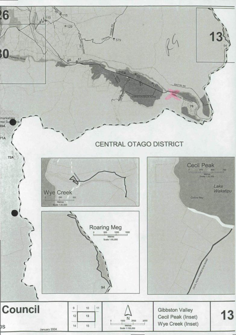
Annexure I- Relevant Council Recommendation and Plans for RM040909 and RM090555- Nevis Bluff

QUEENSTOWN LAKES DISTRICT
COUNCIL File: RM040909 ' ' " ^
4 November 2004
Transit New Zealand CI- Opus International Private Bag 1913 DUNEDIN
Attn: David Campbell
Dear David
DECISION OF THE QUEENSTOWN LAKES DISTRICT COUNCIL
FOR ALTERATION TO A DESIGNATION
PURSUANT TO SECTION 181 OF THE
RESOURCE MANAGEMENT ACT 1991 - RM040909
I refer to your notice of requirement for an alteration to an existing designation under Section 181 of the Resource Management Act 1991. The request was considered under delegated authority pursuant to Section 34 of the Resource Management Act 1991 on 4 November 2004. This decision was made and its issue authorised by Jane Sinclair, Independent Commissioner, as delegate for the Council.
The Proposal ■i . . .
Transit New Zealand require an extension to the boundaries of the existing Designation 84 for State Highway 6 located at Nevis Bluff, Kawarau Gorge under the Partially Operative District Plan. The alteration to the existing designation is necessary for Transit New Zealand in that it incorporates land in which work is required to stabilise the Nevis Bluff to ensure safe and efficient operation of the State Highway. Similar work is currently being carried out within the existing designation.
The stabilisation works will involve the removal of rock from the bluff face by means of blasting and sluicing. Resource Consent approval is currently been sought to dispose ofthe debris material on land at Wentworth Station, located approximately 2 km from the Nevis Bluff, (refer to RM040908).
No references remain outstanding on Designation 84, and as such the provisions of the Partially Operative District Plan can be afforded full weight in considering this proposal.
Site Description
The land area proposed for the designation alteration immediately adjoins the State Highway designation 84 located at the Nevis Bluff, Kawarau Gorge. The land area to be designated is described as Sec 1 SO 328697 being that portion of Part Section 4 SO 24743 (CT OT2528). The subject site is 5.073 hectares in area.
CivicCorp, Private Bag 50077, Queenstown, Tel 03-442 4777, Fax 03-442 477^M040909

A section of State Highway 6 runs through a narrow stretch of the Kawarau Gorge, above which is situated the Nevis Bluff which incorporates the subject site proposed for the designation alteration.
Nevis Bluff is approximately 120m high and rises at an angle of 70° immediately above State Highway 6. The face is a highly fractured rocky outcrop which has a history of material collapsing onto the State Highway below.
Nature of Proposed Work
The proposed stabilisation works will involve the removal of any unstable rock features from the bluff face that potentially threaten the safe and efficient operation of State Highway 6 below.
Rock will be removed from the Nevis Bluff through various techniques including:
Scaling and trimming of smaller loose rocks from the rock face;
Blasting of rock from the face by placing explosives into predrilled cavities;
Sluicing of the rock face following blasting to wash off any loose material. This is usually achieved by releasing water from a monsoon bucket suspended beneath a helicopter.
Stabilisation works also involve methods to retain rock on the face of the bluff, these include:
Drilling of drain holes and general drainage works to reduce the amount of water on the face and to lower groundwater levels;
Application of Shotcrete in conjunction with mesh reinforcement, bolts and plates. This will assist in preserving rock structure.
Attaching bolts and anchors to hold rock in place.
Draping of mesh and cable nets to prevent small rock falls bouncing out on to the State Highway.
Benching of the slope in order to catch and retain small rockfalls. Benching will require an application to be made for an outline plan approval;
Construct of fences and walls to retain smaller rock falls. Future structures will require an application to be made for an outline plan approval.
Work on the Nevis Bluff is likely to require helicopter assistance. Helicopters are to be used for inspections of the bluff, the placement of explosives, sluicing and to provide necessary access. Helicopter operational hours have been proposed on an intermittent basis between the hours of 7:00am and 6:00pm.
Vehicle access is provided to the top of the bluff via an existing track.
Statutory Requirements
Section 181 ofthe Resource Management Act 1991 enables a requiring authority that is responsible for a designation to alter an existing designation. Section 181(3) sets out the manner in which an alteration to a designation may be considered, as follows:
(3) A territorial authority may at any time alter a designation in its district plan or a requirement in
its proposed district plan il
ia) the alteration -
(i) involves no more than a minor change to the effects on the environment associated with the use or proposed use of land or any water concerned; or
RM040909
(ii) involves only minor changes or adjustments to the boundaries of the designation or requirement; and
(b) written notice of the proposed alteration has been given to every owner or occupier of the land directly affected and those owners or occupiers agree with the alteration; and
(c) both the territorial authority and the requiring authority agree with the alteration - and sections 168to179 shall not apply to any such alteration.
State Highway 6 is designated under the Proposed District Plan for 'State Highway purposes' (Ref: Designation number 84). The authority responsible for the designation is Transit New Zealand. The designation is not subject to any specific conditions.
It is agreed under section 181 (3)(a)(i) that the proposal involves only minor changes to the effects on environment which are outlined in the following section 'Change to Effects on the Environment'.
As per requirement of section 181(3) (a) (ii) the proposal constitutes a more than minor change to the existing designation boundary as the alteration is to incorporate an additional 5.073 hectares to the existing State Highway designation.
Transit New Zealand is the only directly affected party of the land proposed to be altered under the designation. Transit New Zealand agree to the alteration of the designation, which constitutes the requirement under section 181(3)(b).
It is accepted by the Queenstown Lakes District Council (territorial authority) that the proposed alterations fall within the purpose of the designation and are being undertaken by the requiring authority responsible for this designation.
Change to Effects on the Environment
An Assessment of Environmental Effects (AEE) prepared by Opus International Consultants submitted with the application identifies a number of potential effects on the environment as follows:
1) Landscape and visual effects; 2) Effects on amenity, 3) Traffic effects, 4) Cultural effects, 5) Effects on people and communities.
Landscape and Visual effects
The proposed stabilisation works will potentially have a minor effect on the natural character and natural features of the Nevis Bluff.
The bluff is visible from the State Highway where the majority of people view it from. The bluff is also visible from the Gibbston Back Road and Coal Pit Road to the west.
The AEE addresses the potential effects on the landscape and visual amenity that will occur when stabilisation works are carried out. The operation of machinery required for stabilisation will be short in duration and temporary in nature. Any effect caused by the removal of rock will be little different than what may occur naturally. The bluff has been highly modified since the construction of the highway from both natural rock fall and stabilisation works. Stabilisation works requiring the placement of materials such as Shotcrete, anchors, bolts and mesh will alter the visual appearance of the bluff. These materials will not be visible from a distance.
Any further proposed stabilisation works such as the construction of fences, walls and benching will impact more significantly on the visual amenity of the bluff. And an outline plan approval will be required.
RM040909

Effects on Amenity
The AEE addresses the adverse amenity effects that may be experienced in terms of noise, vibration and dust. These effects would result from the operation of earth moving machinery, drilling and helicopter take-offs and landings. Proposed mitigation measures submitted with the application include that noise and vibration outputs will comply with the New Zealand Standards NZS 4403:1976 (vibration) and NZS 6803:1999 (Acoustics - Construction Noise) for the operation of earthmoving machinery and blasting activity. The proposal states that when blasting work is required there will only be one blast per day. A siren will warn locals in the vicinity before each blast. Noise and vibration works being carried out will be short term in duration and temporary.
Dust nuisance may result from blasting and removal of debris. Material blasted from the site is to be transported to a debris disposal area. The debris is comprised of mainly rock which will result in minimal dust content.
Any potential adverse effects of noise, vibration or dust are considered to be less than minor.
Traffic effects
Stabilisation works will require the temporary closer of the state highway for periods of blasting and debris removal. Localised traffic control will be required and will comply with Transit New Zealand's "Interim Code of Practice for Temporary Traffic Management". Observance of this code of practice will mitigate any potential adverse effects on road safety.
Cultural effects
Kai Tahu ki Otago was consulted on this proposal when Transit New Zealand was seeking resource consent from the Otago Regional Council during previous works. Kai Tahu ki Otago are not considered a directly affected party to the designation alteration. Pursuant to section 181(3) (b) of the RMA written approval for the proposed designation alteration is not required from Kai Tahu ki Otago.
Effects on people and communities
Public notice will be provided and local landowners and occupiers in the area will be advised of road closures. A warning blast will be given to warn the locals in the area of blasting activity. A sentry guard/spotter will identify river users in the immediate vicinity. Blasting will be delayed if river users are identified.
State Highway 6 is the main road link into and out of Queenstown. The economic, social and cultural wellbeing of Queenstown depends on the safe and efficient operation of the State Highway. The proposed stabilisation works will provide reassurance to the local community.
Change to boundaries
The extent of the alteration and changes being proposed to the State Highway designation is shown on the land plan submitted with the application. The area of land to be designated is described as Sec 1 SO 328697. In total the proposed alteration requires 5.073 hectares of additional land which immediately adjoins the existing State Highway designation.
The size and scale of the proposed boundary adjustment to State Highway 6 at the Nevis Bluff will result in a more than minor change to designation boundary. Section 181(3)(a)(ii) of the RMA is therefore not met. However, it is only necessary to met one limb of section 181(3)(a) (i) or (ii).
Written Approval
In April 2004 the land area to be designated was transferred from the Department of Conservation to Transit New Zealand. The agreement for the transfer of land was submitted with the application. Pursuant to section 181(3) (b) of the RMA, no other land owners or occupiers are considered directly affected by the designation alteration.
RM040909

Agreement of Territorial Authority
In order for an alteration to an existing designation to be processed without the formal notification procedure set out under Sections 168 to 179, the Territorial Authority (Queenstown Lakes District Council) must first consider whether it agrees to the proposed alteration.
There are guidelines under the Resource Management Act on what matters are relevant for the territorial authority to base this decision. This is interpreted to mean that the Territorial Authority is satisfied that the proposal can pass each of the above requirements relating to effects on the environment and the acquisition of approvals. Section 181 (3) (a) (ii) of the RMA has not been met in relation to boundary adjustments, however it is deemed only necessary for the requiring authority to meet one limb of this section.
The effects of the boundary adjustment to Designation 84, State Highway 6 located at the Nevis Bluff, are considered to be more than minor due to the size and scale of the area proposed for the designation. Alteration of the designation boundaries will allow Transit New Zealand to undertake necessary maintenance work to ensure the safe and efficient operation of State Highway 6. The proposed work falls within the designation provisions and the effects are considered minor. There are no parties considered directly affected in terms of requiring written approval.
Accordingly the Queenstown Lakes District Council accepts the alteration to the designation as outlined in the application.
Decision
It is considered that the proposed alteration of the State Highway 6 designation including all of that work described within the Notice of Requirement prepared by Opus International Consultants (dated September 2004) as well as the subsequent letter (dated 28 October 2004) meets the prescribed tests of section 181(3), and accordingly the provisions of sections 168-179 of the Resource Management Act 1991 do not apply. It is accepted that the designation can be amended accordingly.
Other Matters
The consent holder is advised that if the construction of fences, walls and the benching of slopes is necessary, an application will be required for outline plan approval.
The costs of processing the request are currently being assessed and you will be advised under separate cover whether further money is required or whether a refund is owing to you.
This approval is not a consent to build under the Building Act 1991. A consent under this Act must be obtained before construction can begin.
If you have any enquiries please contact Karen Hanson on (03) 442 4969.
Prepared by Reviewed and Approved by CIVICCORP CIVICCORP
Karen Hanson Andrew Henderson PLANNER PRINCIPAL: RESOURCE MANAGEMENT
RM040909

Karen Hanson
From: David Campbell [[email protected]] Sent: Thursday, 28 October 2004 11:55 To: Karen Hanson Subject: RM040909 - TNZ designation - Nevis Bluff
Hi Karen,
I apologise for the cross referencing not relating, so here is what the relevant sentences should read:
• page 6, Section 7 Consultation: Section 1.5 should read Section 1.2 • page 10, Section 10.4.2 Noise and vibration, third paragraph: Section 4.2.2 should read Section 2.2. • page 11, Section 10.6 Cultural Values, third paragraph: Section 4.2.2.3 shoudl read Sections 1.2 and 7.
I hope this clarifies matters for you.
regards David Campbell Senior Resource Management Planner Opus International Consultants Limited
kPhilip Laing House r144 Rattray Street
Private Bag 1913 DUNEDIN www.opus.co.nz
DDI: (03) 474 8965 Fax: (03)474 8995 Cell: 027 450 9606 Email: [email protected]

Resource Management & Regulatory Services
CivicCorp
In rep ly p l e a s e q u o t e F i le Ref : R M 0 4 0 9 0 9
CMc Corporation Umited Privale Bag 50077, CivicCorp House, 74 Shotover Street Queenstown, New Zealand Tel 64-3-4424777 Fax. 64-3-442 4778
e-mail: [email protected] site: http://www.civlccorp.co.nz
5 October 2004
Transit New Zealand CI- Opus International Consultants Private Bag 1913 DUNEDIN
Dear Sir or Madam
RESOURCE CONSENT APPLICATION
DESIGNATION ALTERATION LOCATED ON STATE HIGHWAY 6. GIBBSTON HIGWAY. GIBBSTON
I acknowledge receipt of your application for resource consent under Section 88 of the Resource Management Act 1991.
The application has been allocated the number RM040909 and it is requested that you use this number as a reference when corresponding on this matter. This application has been allocated to:
Karen Hanson DDI: 442 4969 Email: [email protected]
This Planner will be in contact with you in due course.
The amount charged for proaessing this application is a deposit fee only. You may be charged further than the deposit depending on.'the costs incurred by CivicCorp in processing this application. Monthly invoices will be issued throughout the consent process.
Please also be aware that your proposal may result in a requirement for development contribution payments to Council where further demand on Council infrastructure is identified. For further information on development contributions, please contact the planner processing your application.
We will ensure at all times that your application is processed as quickly as possible.
Yours faithfully CIVICCORP
Katherine Ashton CONSENTS OFFICER

CivicCorp PLANNING CIRCULATluN
Resource ccuisuii number: RM
Descnplion of activity:
Location:
NO CIRCULATION REQUIRED
CJJRCULATION )\\li VU1RED
Externa) Letters
n n □ n □ D
MAC Property Services Imtech LCS Robertson Valuations DLR MSA
Planner Only
□ □ D
Jnternal Memos
Engineering Policy Landscape Architects Environmental Health
Js Ihe site/aclivity within or adjacent lo an area of Si ai vtory Acknowledgment/Nohoanga or Topuni
Does ihe sile/ activity involve waterway issues Has a report been commissioned from the Maritime Safety Authority (Section 395) (refer above)
Does the propeny front a State Highway ? Is there a potential impact on the Slate Highway Has Transit NZ approval been sought by applicant?
Arrowtovw Residenli;::!/Commercia] Heriiagc zones Adjacent/ in close proximity to zone AiTOWlo -̂rj Planning Group conlacicd/meeting aiTfin^c'd
□ Y
Has Ngai Tahu/Kai Tahu been consulted by applicant D Y
□ Y ny ny □y ny
□N
□N DN DN
DN □N □N
DN □N

. Rct'.ir.t'.-i'-ciHPTorregisterfdOl.i.K" D y Dig iiej-ri/pj-c-'cinct/zone Adjacent/in close proximiiy to item D y Djsj Has Hisloric Phu cs Trust consent been soug]it/r:l.--!;-.irjccl by applicant? Wcikrnipu Advisory Group conifici/rriteting arranged O y D N
Does the activity iijvc.jve: D y DN D Large scale earthworks; D Ground uiyiurbance of Areas devcJopL-d pre 1900 D ArchoeoJogical sites 0 IJju-egistered sites or buildings of heritage interest 0 Historic Place Trust consent sought/obtained
Other
D Council Consent as Landowner CH DOC □ Harbourmaster LU Circulate geotech repon ;o □ Fish & Game Council
NOTES

Site Visit Checklist, of Potential Effects: *
Site Address:
Planner: Date:
EFFECT YES/NO COMMENTS
Land, Flora and Fauna Trees Vegetation Fauna Landform W e erbodies
tage (trees / volcanic cones) Groundwater
Infrastructure Run-off Capacity Flooding Pollution
People and Built Form Shadowing Privacy Dominance Character Amenity Views Streetscape Heritage " ' t t j f ' i n - l oumnal Values Socio-economic Smeli Noise Dust Air dicharges Vibration Soil Stability
Traffic Generation & Vehicle Movements On-Street Parking Driver Safety Pedestrian Safety Traffic Generation Roading Capacity Noise Vehicle Movements
gAconsentsMand use manual\site visit F'sibft 1 v-.f *>

''MEASURES OF "EFFECT"
In assessing ihe extent or scale; of effects - (minor, > minor, nil), consider (lie following :
• Any positive or negative effects.
«■ Any past, present, or future effects.
• Duration of effects (short-term/ temporaiy (e.g during construction); medium-term (e.g prior to landscaping becoming fully established); and long-term/permanent.)
• Frequency of effects (e.g "one-off', intermittent/sporadic, continuous.)
» Degree of Probability (including any potential effect of high probability; and any potential effect of low probability which has a high potential impact.)
t Cuiriulative effect (arising over time or in combination with other effects.)
Further Comments on Potential Adverse Effects:
Adversely Affected Persons:
ronse'i-itsMEind use maiuial\ei!e visit

n QUEENSTOWN LAKES DISTRICT
COUNCIL
N PROPERTY INQUIRY
^ Occupier: DEPARTMENT OF CONSERVATION: P O BOX 27 ALEXANDRA
l Property Location: GIBBSTON HIGHWAY, GIBBSTON
Queenstown Area Assessment Number: 2907203201 Date Prepared: 4/10/04 M MwZMianfs OgHal Cadastral OatobaH (DCOfii CROWN

CENTRAL OTAGO DISTRICT
^
Wye Creek 250 500 I ' 1
Metres Scale 120,000
i \
<
v^.
1
Roaring Meg \ 0 500 1000 1500
Cecil Peak 0 250 500 750 1 . 1 . = I
MeUes Scale 1:25.000
Lake Wakatipu
Collins Bay
Council )S January 2004
9
12
14
10
13
15
11 A N
1000 2000 I 1 Motfoc
Scale 1:100,000
3000
I I
Gibbston Valley Cecil Peak (Inset) Wye Creek (Inset)
13

\\l/- * ! -"\1 Ufa -J d
RESERVE I . P. (T t . . Pl.nling) ^ ' " J J ;
1
ERVE ^nic •arry UNDERLYINff ZONNG FOR 'DESIGNATIONS=RU^AL
aB'
COMMERCIAL I
COMMERCIAL 2
COMMERCIAL 3
LcL
INDUSTRIAL
INDUSTRIAL [mri r^T]
COMMERCIA
COMMERCIA
COMMERCE
TOURIST DEVELOPME
DESIGNATIONS RESERVES
NATIONAL PARKS
PUBLIC WORKS
STATE HIGHWAYS
E.i.lins I w t s I
Exi.ting I^PK) Exiting I * I
E«i>tin« UMITED ACCESS ROADS Existing b
ROAO TO K STOPPED
ROAD TO BE WIDENED
NOTATIONS DISTRICT (County) BOUNDARY. BOROUGH BOUNDARY-
ZONE BOUNDARY.
DESIGNATION BOUNDARY.
COMMUNITY USES NOTABLE OBJECT OR PLACE.
NOTABLE BUILDING
NOTABLE TREE
CZ) CZ3
AREAS KN FOR DEVEl IN R4 ZONI
VERANDAh FRONTAGE R£QUIREO.
SUGGESTE ALKNMEN BUILDING I RESTRICTI RESERVE( DIVISION.
.■ IO: : ; ^ i t-
Scale 1 : 300 000 £
Location Diagram i
Map reproduced by permission of the Dept. of
SHOTOVER oreunH atMt

+ . O l a ̂ X^lr^Vy-^JV . CivicCorp
PLANNING CHECKLIST
Resource consent
Site
Certificate of Compliance
address: ^ k . r . .,
^ \ ^ . 4 . k $ Date....J£.][.lff/.Q-.^
Checking Planner'^rP.... .V^..CI>^r.U.crr^r?«s Oktoreceipt B/
Zone: k^vA Further Info required Time taken
□ n
Yes No N/A Form details completed and signed (Form 5 or equivalent)
0" □ Application Fee n Certificate of Title (current) L^ □ (Check for Covenants or Encumbrances -copy to be provided with application) n
W Assessment of Effects □ (required by the 4 Schedule) commensurate in detail with the application Description of Proposal IZI ^ u) Explaining the application and specifying the exact matter(s) for which consent is sought and quantifying of degree of non-compliance Plans (2x scale copies plus 1x A4) "W □ Scale (Standard scales being 1:50 or 1:100 or 1:200)
"a □ Site Plan Boundaries/easements H
Building outlines LJ Contours/floor levels CH Vehicle access/carparking CD Trees/vegetation □ Site coverage C Outdoor living space LJ Show a clear north point ^
n □ n n n n n n
n EI El H IS
□ Earthworks Volume (in m3
) Area (in m2
) Height of cuts/fill (in m) Site management plan
□ □ □ n
□ □ □ □
m El
(proposed sediment control measures) Water supply (if not connecting to main water lines)
□ n s Effluent Disposal (If not connecting to Sewage lines) n n m
Elevations n □ E Certificate by a registered architect/surveyor stating That ground levels shown are those at 10 October I—I 1995 (if issue relates to height and it is within 0.5m or above)
n ra
Floor Plan □ D Landscape Plan □ H Photographs (secondhand dwellings/relocatables) D n a Affected persons Approval □ I—I Form filled out/Plans signed (Clear signatures on the plans, with printed name)


QUEENSTOWN LAKES DISTRICT
COUNCIL File: RM040909 ' ' " ^
4 November 2004
Transit New Zealand CI- Opus International Private Bag 1913 DUNEDIN
Attn: David Campbell
Dear David
DECISION OF THE QUEENSTOWN LAKES DISTRICT COUNCIL
FOR ALTERATION TO A DESIGNATION
PURSUANT TO SECTION 181 OF THE
RESOURCE MANAGEMENT ACT 1991 - RM040909
I refer to your notice of requirement for an alteration to an existing designation under Section 181 of the Resource Management Act 1991. The request was considered under delegated authority pursuant to Section 34 of the Resource Management Act 1991 on 4 November 2004. This decision was made and its issue authorised by Jane Sinclair, Independent Commissioner, as delegate for the Council.
The Proposal ■i . . .
Transit New Zealand require an extension to the boundaries of the existing Designation 84 for State Highway 6 located at Nevis Bluff, Kawarau Gorge under the Partially Operative District Plan. The alteration to the existing designation is necessary for Transit New Zealand in that it incorporates land in which work is required to stabilise the Nevis Bluff to ensure safe and efficient operation of the State Highway. Similar work is currently being carried out within the existing designation.
The stabilisation works will involve the removal of rock from the bluff face by means of blasting and sluicing. Resource Consent approval is currently been sought to dispose ofthe debris material on land at Wentworth Station, located approximately 2 km from the Nevis Bluff, (refer to RM040908).
No references remain outstanding on Designation 84, and as such the provisions of the Partially Operative District Plan can be afforded full weight in considering this proposal.
Site Description
The land area proposed for the designation alteration immediately adjoins the State Highway designation 84 located at the Nevis Bluff, Kawarau Gorge. The land area to be designated is described as Sec 1 SO 328697 being that portion of Part Section 4 SO 24743 (CT OT2528). The subject site is 5.073 hectares in area.
CivicCorp, Private Bag 50077, Queenstown, Tel 03-442 4777, Fax 03-442 477^M040909

A section of State Highway 6 runs through a narrow stretch of the Kawarau Gorge, above which is situated the Nevis Bluff which incorporates the subject site proposed for the designation alteration.
Nevis Bluff is approximately 120m high and rises at an angle of 70° immediately above State Highway 6. The face is a highly fractured rocky outcrop which has a history of material collapsing onto the State Highway below.
Nature of Proposed Work
The proposed stabilisation works will involve the removal of any unstable rock features from the bluff face that potentially threaten the safe and efficient operation of State Highway 6 below.
Rock will be removed from the Nevis Bluff through various techniques including:
Scaling and trimming of smaller loose rocks from the rock face;
Blasting of rock from the face by placing explosives into predrilled cavities;
Sluicing of the rock face following blasting to wash off any loose material. This is usually achieved by releasing water from a monsoon bucket suspended beneath a helicopter.
Stabilisation works also involve methods to retain rock on the face of the bluff, these include:
Drilling of drain holes and general drainage works to reduce the amount of water on the face and to lower groundwater levels;
Application of Shotcrete in conjunction with mesh reinforcement, bolts and plates. This will assist in preserving rock structure.
Attaching bolts and anchors to hold rock in place.
Draping of mesh and cable nets to prevent small rock falls bouncing out on to the State Highway.
Benching of the slope in order to catch and retain small rockfalls. Benching will require an application to be made for an outline plan approval;
Construct of fences and walls to retain smaller rock falls. Future structures will require an application to be made for an outline plan approval.
Work on the Nevis Bluff is likely to require helicopter assistance. Helicopters are to be used for inspections of the bluff, the placement of explosives, sluicing and to provide necessary access. Helicopter operational hours have been proposed on an intermittent basis between the hours of 7:00am and 6:00pm.
Vehicle access is provided to the top of the bluff via an existing track.
Statutory Requirements
Section 181 ofthe Resource Management Act 1991 enables a requiring authority that is responsible for a designation to alter an existing designation. Section 181(3) sets out the manner in which an alteration to a designation may be considered, as follows:
(3) A territorial authority may at any time alter a designation in its district plan or a requirement in
its proposed district plan il
ia) the alteration -
(i) involves no more than a minor change to the effects on the environment associated with the use or proposed use of land or any water concerned; or
RM040909

(ii) involves only minor changes or adjustments to the boundaries of the designation or requirement; and
(b) written notice of the proposed alteration has been given to every owner or occupier of the land directly affected and those owners or occupiers agree with the alteration; and
(c) both the territorial authority and the requiring authority agree with the alteration - and sections 168to179 shall not apply to any such alteration.
State Highway 6 is designated under the Proposed District Plan for 'State Highway purposes' (Ref: Designation number 84). The authority responsible for the designation is Transit New Zealand. The designation is not subject to any specific conditions.
It is agreed under section 181 (3)(a)(i) that the proposal involves only minor changes to the effects on environment which are outlined in the following section 'Change to Effects on the Environment'.
As per requirement of section 181(3) (a) (ii) the proposal constitutes a more than minor change to the existing designation boundary as the alteration is to incorporate an additional 5.073 hectares to the existing State Highway designation.
Transit New Zealand is the only directly affected party of the land proposed to be altered under the designation. Transit New Zealand agree to the alteration of the designation, which constitutes the requirement under section 181(3)(b).
It is accepted by the Queenstown Lakes District Council (territorial authority) that the proposed alterations fall within the purpose of the designation and are being undertaken by the requiring authority responsible for this designation.
Change to Effects on the Environment
An Assessment of Environmental Effects (AEE) prepared by Opus International Consultants submitted with the application identifies a number of potential effects on the environment as follows:
1) Landscape and visual effects; 2) Effects on amenity, 3) Traffic effects, 4) Cultural effects, 5) Effects on people and communities.
Landscape and Visual effects
The proposed stabilisation works will potentially have a minor effect on the natural character and natural features of the Nevis Bluff.
The bluff is visible from the State Highway where the majority of people view it from. The bluff is also visible from the Gibbston Back Road and Coal Pit Road to the west.
The AEE addresses the potential effects on the landscape and visual amenity that will occur when stabilisation works are carried out. The operation of machinery required for stabilisation will be short in duration and temporary in nature. Any effect caused by the removal of rock will be little different than what may occur naturally. The bluff has been highly modified since the construction of the highway from both natural rock fall and stabilisation works. Stabilisation works requiring the placement of materials such as Shotcrete, anchors, bolts and mesh will alter the visual appearance of the bluff. These materials will not be visible from a distance.
Any further proposed stabilisation works such as the construction of fences, walls and benching will impact more significantly on the visual amenity of the bluff. And an outline plan approval will be required.
RM040909

Effects on Amenity
The AEE addresses the adverse amenity effects that may be experienced in terms of noise, vibration and dust. These effects would result from the operation of earth moving machinery, drilling and helicopter take-offs and landings. Proposed mitigation measures submitted with the application include that noise and vibration outputs will comply with the New Zealand Standards NZS 4403:1976 (vibration) and NZS 6803:1999 (Acoustics - Construction Noise) for the operation of earthmoving machinery and blasting activity. The proposal states that when blasting work is required there will only be one blast per day. A siren will warn locals in the vicinity before each blast. Noise and vibration works being carried out will be short term in duration and temporary.
Dust nuisance may result from blasting and removal of debris. Material blasted from the site is to be transported to a debris disposal area. The debris is comprised of mainly rock which will result in minimal dust content.
Any potential adverse effects of noise, vibration or dust are considered to be less than minor.
Traffic effects
Stabilisation works will require the temporary closer of the state highway for periods of blasting and debris removal. Localised traffic control will be required and will comply with Transit New Zealand's "Interim Code of Practice for Temporary Traffic Management". Observance of this code of practice will mitigate any potential adverse effects on road safety.
Cultural effects
Kai Tahu ki Otago was consulted on this proposal when Transit New Zealand was seeking resource consent from the Otago Regional Council during previous works. Kai Tahu ki Otago are not considered a directly affected party to the designation alteration. Pursuant to section 181(3) (b) of the RMA written approval for the proposed designation alteration is not required from Kai Tahu ki Otago.
Effects on people and communities
Public notice will be provided and local landowners and occupiers in the area will be advised of road closures. A warning blast will be given to warn the locals in the area of blasting activity. A sentry guard/spotter will identify river users in the immediate vicinity. Blasting will be delayed if river users are identified.
State Highway 6 is the main road link into and out of Queenstown. The economic, social and cultural wellbeing of Queenstown depends on the safe and efficient operation of the State Highway. The proposed stabilisation works will provide reassurance to the local community.
Change to boundaries
The extent of the alteration and changes being proposed to the State Highway designation is shown on the land plan submitted with the application. The area of land to be designated is described as Sec 1 SO 328697. In total the proposed alteration requires 5.073 hectares of additional land which immediately adjoins the existing State Highway designation.
The size and scale of the proposed boundary adjustment to State Highway 6 at the Nevis Bluff will result in a more than minor change to designation boundary. Section 181(3)(a)(ii) of the RMA is therefore not met. However, it is only necessary to met one limb of section 181(3)(a) (i) or (ii).
Written Approval
In April 2004 the land area to be designated was transferred from the Department of Conservation to Transit New Zealand. The agreement for the transfer of land was submitted with the application. Pursuant to section 181(3) (b) of the RMA, no other land owners or occupiers are considered directly affected by the designation alteration.
RM040909

Agreement of Territorial Authority
In order for an alteration to an existing designation to be processed without the formal notification procedure set out under Sections 168 to 179, the Territorial Authority (Queenstown Lakes District Council) must first consider whether it agrees to the proposed alteration.
There are guidelines under the Resource Management Act on what matters are relevant for the territorial authority to base this decision. This is interpreted to mean that the Territorial Authority is satisfied that the proposal can pass each of the above requirements relating to effects on the environment and the acquisition of approvals. Section 181 (3) (a) (ii) of the RMA has not been met in relation to boundary adjustments, however it is deemed only necessary for the requiring authority to meet one limb of this section.
The effects of the boundary adjustment to Designation 84, State Highway 6 located at the Nevis Bluff, are considered to be more than minor due to the size and scale of the area proposed for the designation. Alteration of the designation boundaries will allow Transit New Zealand to undertake necessary maintenance work to ensure the safe and efficient operation of State Highway 6. The proposed work falls within the designation provisions and the effects are considered minor. There are no parties considered directly affected in terms of requiring written approval.
Accordingly the Queenstown Lakes District Council accepts the alteration to the designation as outlined in the application.
Decision
It is considered that the proposed alteration of the State Highway 6 designation including all of that work described within the Notice of Requirement prepared by Opus International Consultants (dated September 2004) as well as the subsequent letter (dated 28 October 2004) meets the prescribed tests of section 181(3), and accordingly the provisions of sections 168-179 of the Resource Management Act 1991 do not apply. It is accepted that the designation can be amended accordingly.
Other Matters
The consent holder is advised that if the construction of fences, walls and the benching of slopes is necessary, an application will be required for outline plan approval.
The costs of processing the request are currently being assessed and you will be advised under separate cover whether further money is required or whether a refund is owing to you.
This approval is not a consent to build under the Building Act 1991. A consent under this Act must be obtained before construction can begin.
If you have any enquiries please contact Karen Hanson on (03) 442 4969.
Prepared by Reviewed and Approved by CIVICCORP CIVICCORP
Karen Hanson Andrew Henderson PLANNER PRINCIPAL: RESOURCE MANAGEMENT
RM040909

Karen Hanson
From: David Campbell [[email protected]] Sent: Thursday, 28 October 2004 11:55 To: Karen Hanson Subject: RM040909 - TNZ designation - Nevis Bluff
Hi Karen,
I apologise for the cross referencing not relating, so here is what the relevant sentences should read:
• page 6, Section 7 Consultation: Section 1.5 should read Section 1.2 • page 10, Section 10.4.2 Noise and vibration, third paragraph: Section 4.2.2 should read Section 2.2. • page 11, Section 10.6 Cultural Values, third paragraph: Section 4.2.2.3 shoudl read Sections 1.2 and 7.
I hope this clarifies matters for you.
regards David Campbell Senior Resource Management Planner Opus International Consultants Limited
kPhilip Laing House r144 Rattray Street
Private Bag 1913 DUNEDIN www.opus.co.nz
DDI: (03) 474 8965 Fax: (03)474 8995 Cell: 027 450 9606 Email: [email protected]
Resource Management & Regulatory Services
CivicCorp
In rep ly p l e a s e q u o t e F i le Ref : R M 0 4 0 9 0 9
CMc Corporation Umited Privale Bag 50077, CivicCorp House, 74 Shotover Street Queenstown, New Zealand Tel 64-3-4424777 Fax. 64-3-442 4778
e-mail: [email protected] site: http://www.civlccorp.co.nz
5 October 2004
Transit New Zealand CI- Opus International Consultants Private Bag 1913 DUNEDIN
Dear Sir or Madam
RESOURCE CONSENT APPLICATION
DESIGNATION ALTERATION LOCATED ON STATE HIGHWAY 6. GIBBSTON HIGWAY. GIBBSTON
I acknowledge receipt of your application for resource consent under Section 88 of the Resource Management Act 1991.
The application has been allocated the number RM040909 and it is requested that you use this number as a reference when corresponding on this matter. This application has been allocated to:
Karen Hanson DDI: 442 4969 Email: [email protected]
This Planner will be in contact with you in due course.
The amount charged for proaessing this application is a deposit fee only. You may be charged further than the deposit depending on.'the costs incurred by CivicCorp in processing this application. Monthly invoices will be issued throughout the consent process.
Please also be aware that your proposal may result in a requirement for development contribution payments to Council where further demand on Council infrastructure is identified. For further information on development contributions, please contact the planner processing your application.
We will ensure at all times that your application is processed as quickly as possible.
Yours faithfully CIVICCORP
Katherine Ashton CONSENTS OFFICER

CivicCorp PLANNING CIRCULATluN
Resource ccuisuii number: RM
Descnplion of activity:
Location:
NO CIRCULATION REQUIRED
CJJRCULATION )\\li VU1RED
Externa) Letters
n n □ n □ D
MAC Property Services Imtech LCS Robertson Valuations DLR MSA
Planner Only
□ □ D
Jnternal Memos
Engineering Policy Landscape Architects Environmental Health
Js Ihe site/aclivity within or adjacent lo an area of Si ai vtory Acknowledgment/Nohoanga or Topuni
Does ihe sile/ activity involve waterway issues Has a report been commissioned from the Maritime Safety Authority (Section 395) (refer above)
Does the propeny front a State Highway ? Is there a potential impact on the Slate Highway Has Transit NZ approval been sought by applicant?
Arrowtovw Residenli;::!/Commercia] Heriiagc zones Adjacent/ in close proximity to zone AiTOWlo -̂rj Planning Group conlacicd/meeting aiTfin^c'd
□ Y
Has Ngai Tahu/Kai Tahu been consulted by applicant D Y
□ Y ny ny □y ny
□N
□N DN DN
DN □N □N
DN □N

. Rct'.ir.t'.-i'-ciHPTorregisterfdOl.i.K" D y Dig iiej-ri/pj-c-'cinct/zone Adjacent/in close proximiiy to item D y Djsj Has Hisloric Phu cs Trust consent been soug]it/r:l.--!;-.irjccl by applicant? Wcikrnipu Advisory Group conifici/rriteting arranged O y D N
Does the activity iijvc.jve: D y DN D Large scale earthworks; D Ground uiyiurbance of Areas devcJopL-d pre 1900 D ArchoeoJogical sites 0 IJju-egistered sites or buildings of heritage interest 0 Historic Place Trust consent sought/obtained
Other
D Council Consent as Landowner CH DOC □ Harbourmaster LU Circulate geotech repon ;o □ Fish & Game Council
NOTES

Site Visit Checklist, of Potential Effects: *
Site Address:
Planner: Date:
EFFECT YES/NO COMMENTS
Land, Flora and Fauna Trees Vegetation Fauna Landform W e erbodies
tage (trees / volcanic cones) Groundwater
Infrastructure Run-off Capacity Flooding Pollution
People and Built Form Shadowing Privacy Dominance Character Amenity Views Streetscape Heritage " ' t t j f ' i n - l oumnal Values Socio-economic Smeli Noise Dust Air dicharges Vibration Soil Stability
Traffic Generation & Vehicle Movements On-Street Parking Driver Safety Pedestrian Safety Traffic Generation Roading Capacity Noise Vehicle Movements
gAconsentsMand use manual\site visit F'sibft 1 v-.f *>
''MEASURES OF "EFFECT"
In assessing ihe extent or scale; of effects - (minor, > minor, nil), consider (lie following :
• Any positive or negative effects.
«■ Any past, present, or future effects.
• Duration of effects (short-term/ temporaiy (e.g during construction); medium-term (e.g prior to landscaping becoming fully established); and long-term/permanent.)
• Frequency of effects (e.g "one-off', intermittent/sporadic, continuous.)
» Degree of Probability (including any potential effect of high probability; and any potential effect of low probability which has a high potential impact.)
t Cuiriulative effect (arising over time or in combination with other effects.)
Further Comments on Potential Adverse Effects:
Adversely Affected Persons:
ronse'i-itsMEind use maiuial\ei!e visit

n QUEENSTOWN LAKES DISTRICT
COUNCIL
N PROPERTY INQUIRY
^ Occupier: DEPARTMENT OF CONSERVATION: P O BOX 27 ALEXANDRA
l Property Location: GIBBSTON HIGHWAY, GIBBSTON
Queenstown Area Assessment Number: 2907203201 Date Prepared: 4/10/04 M MwZMianfs OgHal Cadastral OatobaH (DCOfii CROWN
CENTRAL OTAGO DISTRICT
^
Wye Creek 250 500 I ' 1
Metres Scale 120,000
i \
<
v^.
1
Roaring Meg \ 0 500 1000 1500
Cecil Peak 0 250 500 750 1 . 1 . = I
MeUes Scale 1:25.000
Lake Wakatipu
Collins Bay
Council )S January 2004
9
12
14
10
13
15
11 A N
1000 2000 I 1 Motfoc
Scale 1:100,000
3000
I I
Gibbston Valley Cecil Peak (Inset) Wye Creek (Inset)
13

\\l/- * ! -"\1 Ufa -J d
RESERVE I . P. (T t . . Pl.nling) ^ ' " J J ;
1
ERVE ^nic •arry UNDERLYINff ZONNG FOR 'DESIGNATIONS=RU^AL
aB'
COMMERCIAL I
COMMERCIAL 2
COMMERCIAL 3
LcL
INDUSTRIAL
INDUSTRIAL [mri r^T]
COMMERCIA
COMMERCIA
COMMERCE
TOURIST DEVELOPME
DESIGNATIONS RESERVES
NATIONAL PARKS
PUBLIC WORKS
STATE HIGHWAYS
E.i.lins I w t s I
Exi.ting I^PK) Exiting I * I
E«i>tin« UMITED ACCESS ROADS Existing b
ROAO TO K STOPPED
ROAD TO BE WIDENED
NOTATIONS DISTRICT (County) BOUNDARY. BOROUGH BOUNDARY-
ZONE BOUNDARY.
DESIGNATION BOUNDARY.
COMMUNITY USES NOTABLE OBJECT OR PLACE.
NOTABLE BUILDING
NOTABLE TREE
CZ) CZ3
AREAS KN FOR DEVEl IN R4 ZONI
VERANDAh FRONTAGE R£QUIREO.
SUGGESTE ALKNMEN BUILDING I RESTRICTI RESERVE( DIVISION.
.■ IO: : ; ^ i t-
Scale 1 : 300 000 £
Location Diagram i
Map reproduced by permission of the Dept. of
SHOTOVER oreunH atMt

+ . O l a ̂ X^lr^Vy-^JV . CivicCorp
PLANNING CHECKLIST
Resource consent
Site
Certificate of Compliance
address: ^ k . r . .,
^ \ ^ . 4 . k $ Date....J£.][.lff/.Q-.^
Checking Planner'^rP.... .V^..CI>^r.U.crr^r?«s Oktoreceipt B/
Zone: k^vA Further Info required Time taken
□ n
Yes No N/A Form details completed and signed (Form 5 or equivalent)
0" □ Application Fee n Certificate of Title (current) L^ □ (Check for Covenants or Encumbrances -copy to be provided with application) n
W Assessment of Effects □ (required by the 4 Schedule) commensurate in detail with the application Description of Proposal IZI ^ u) Explaining the application and specifying the exact matter(s) for which consent is sought and quantifying of degree of non-compliance Plans (2x scale copies plus 1x A4) "W □ Scale (Standard scales being 1:50 or 1:100 or 1:200)
"a □ Site Plan Boundaries/easements H
Building outlines LJ Contours/floor levels CH Vehicle access/carparking CD Trees/vegetation □ Site coverage C Outdoor living space LJ Show a clear north point ^
n □ n n n n n n
n EI El H IS
□ Earthworks Volume (in m3
) Area (in m2
) Height of cuts/fill (in m) Site management plan
□ □ □ n
□ □ □ □
m El
(proposed sediment control measures) Water supply (if not connecting to main water lines)
□ n s Effluent Disposal (If not connecting to Sewage lines) n n m
Elevations n □ E Certificate by a registered architect/surveyor stating That ground levels shown are those at 10 October I—I 1995 (if issue relates to height and it is within 0.5m or above)
n ra
Floor Plan □ D Landscape Plan □ H Photographs (secondhand dwellings/relocatables) D n a Affected persons Approval □ I—I Form filled out/Plans signed (Clear signatures on the plans, with printed name)

QUEENSTOWN LAKES DISTRICT
COUNCIL
DECISION OF THE QUEENSTOWN-LAKES DISTRICT COUNCIL
RESOURCE MANAGEMENT ACT 1991
Applicant:
RM reference:
Location:
Proposal:
Type of Consent:
Legal Description:
Valuation Number:
Zoning:
Activity Status:
Notification:
Commissioner:
Date:
Decision:
NZ Transport Agency
RM090555
Foot of Mount Mason on the south side of State Highway 6 in the Gibbston Valley
To alter Designation 84 to include 6.45 hectares for Nevis Bluff control works, which includes access and as a future deposition area for cleanfill.
Alteration to Designation
Section 1, SO 400378
N/A
Rural General Zone
N/A
Non-notified
Commissioner Sinclair
9 September 2009
Granted
Lakes Environmental Limited, Private Bag 50077, Queenstown 9348, Tel 03-450 0300, Fax 03-442 4778

I refer to your requirement under section 181 of the Resource Management Act 1991 to alter Designation 84 to increase the amount of land included within the Designation, by approximately 6 hectares, at the foot of Mount Mason on the south side of State Highway 6 in the Gibbston Valley. The application was considered under delegated authority pursuant to section 34 of the Resource Management Act 1991 on 8 September 2009. This decision was made and its issue authorised by Jane Sinclair, Independent Commissioner, as delegate for the Council.
The subject site is situated at the foot of Mount Mason, in the Gibbston Valley and is legally described as Section 1, SO 400378.
Under the Partially Operative District Plan the site subject to Designation 84 is designated for State Highway Purposes. The authority responsible for the designation is the NZ Transport Agency (previously Transit New Zealand). The subject site is currently zoned Rural General and is part of a landscape that has been identified as an Outstanding Natural Landscape on the District Planning Maps.
Section 181 of the Resource Management Act 1991 establishes the procedure for altering a designation. Section 181 (3) of the Act states:
"A territorial authority may at any time alter a designation in its district plan if-
(a) The alteration -
(i) Involves no more than a minor change to the effects on the environment associated with the use of land or any water concerned; or
(ii) Involves only minor changes or adjustments to the boundary of the designation; and
(b) Written notice of the proposed alteration has been given to every owner or occupier of the land directly affected and those owners or occupiers who agree with the alteration and
(c) Both the territorial authority and the requiring authority agree with the alteration -
And sections 168 to 179 shall not apply to any such change."
Proposal
The NZ Transport Agency (NZTA) has acquired the land subject to this Alteration through Section 20(1) of the Public Works Act 1981. The purpose of the acquisition was to ensure surety of access to the Nevis Bluff for control works. The NZTA now wishes to alter the boundaries of the Designation, by a minor amount for the purposes of roading, to allow it to more efficiently carry out protection works in order to maintain the safe and efficient operation of the State Highway in the vicinity of Nevis Bluff. The proposed use of the site is to provide access to the Nevis Bluff and as a future deposition area for cleanfill. When it is intended to use the site for cleanfill purposes an Outline Plan will be submitted for approval. At this time conditions may be recommended in relation to the cleanfill. Currently, monitoring and control works are carried out on the Nevis Bluff on both a scheduled basis and occasionally due to emergency dislodgements. The ability to quickly and efficiently organise works from a nearby site and deposit material is necessary for the NZTA to fulfil its statutory obligations. This alteration to the designation will enable a site for the future deposition of cleanfill close to the Nevis Bluff.

The current designation is subject to the conditions listed under A 'Roads,' on pages A1-15 and A1-16 of the Partially Operative District Plan. No changes to the conditions in this part of the District Plan are required as a result of this Alteration.
Recommendation
Pursuant to section 181(3) of the Resource Management Act 1991 the alterations to Designation 84 as outlined below are ACCEPTED.
1. The size of Designation 84 is increased by approximately 6.4510 ha as shown on Site Plan A, stamped as approved on 9 September 2009.
2. The site legal description for Designation 84 in Appendix 1 of the Partially Operative District Plan is amended to include:
Section 1, SO 400378.
Reasons for Recommendation
Landscape Amenity
The site is triangular in shape and consists of 6.45 ha in area. It is currently covered in scrubby bush with sporadic rock outcrops. Access to the site is obtained from the State Highway and a farm track which is used for the Nevis Bluff control works zigzags up the north face of Mount Mason. This is the only permanent and visible man made feature on the subject site at the moment. No other permanent works are currently proposed. An application for outline plan approval will be applied for prior to the use of the site for a cleanfill. At the moment the likely size of the cleanfill operation is not known. An assessment of effects and conditions relating to landscaping and the operation of the cleanfill can be imposed at the time of outline plan approval.
Ecological Values
Ecologist Neil Simpson has identified that the subject site contains no vegetation of significance.
Heritage Values
The applicant has undertaken a review of the NZ Historic Places Trust database, which has no identified archaeological sites within the subject site. The NZ Archaeological Association has also been contacted who have also advised that there are no known sites in the immediate vicinity. The applicant is aware of their obligations under the Historic Places Act if material is found during works on the site.
Traffic
The applicant has advised that control works for Nevis Bluff usually occur only twice a year, and as such access will remain low volume. Any vehicle movements associated with emergency dislodgments will be minimal. No upgrade is required to the existing access at this stage and if an upgrade is required in the future, it will be subject to the outline plan process. The site is some 120m from Nevis Bluff which will reduce the travel times for heavy vehicles, thus reducing demands on the Highway. As such, it is considered that there will be no adverse effects in terms of traffic movements.
Affected Parties
The two adjoining landowners (DOC and Antimony Investments Limited) have provided written consent to the proposal. No other parties are considered to be affected by the alteration to the designation.

Conclusion
Overall, the adverse effects on the environment of the activity for which consent is sought will be de minimus.
Other Matters
The costs of processing the application are currently being assessed and you will be advised under separate cover whether further costs have been incurred.
Please contact the Council when the conditions have been met or if you have any queries with regard to the monitoring of your consent.
If you have any enquiries please contact Charlene Kowalski on phone (03) 450 0367 or email charlene.kowalski(5)lakesenv.co.nz.
Prepared by Reviewed and Approved by LAKES ENVIRONMENTAL LAKES ENVIRONMENTAL
Charlene Kowalski Paula Costello PLANNER PLANNER

Annexure J- Recommended Amendments to the Proposed Plan

Recommended Amendments to the Proposed Plan
The Transport Agency seeks the following amendments to the Proposed Plan (further to those changes that are included in the the revised chapter at Appendix 1 of the Officer’s Report).
1. Amend “37.2 Schedule of Designations” to read:
No. Map No. Authority Responsible Purpose Site/Legal Description and Conditions
84 2, 3, 5, 8, 11, 13, 15, 16, 17, 18, 21, 24, 30, 31, 31a 32, 33, 34, 35, 36, 37, 38
New Zealand Transport Agency
State Highway Purposes
As Shown on District Plan Maps. For conditions refer to A below.
2. Amend “A.3 Limited Access Roads” to read:
Those sections of State Highway which are declared limited access are:(i) SH No 6 from the junction with SH No 6A to the eastern abutment of the Hayes Creek
Bridge. (ii) SH No 6 835m south of Kent Street to 300m north of Kent Street, Kingston. (iii) SH No 6A from the junction with State Highway 6 to Cecil Street (unformed - 500m east
of Suburb Street). (iv) SH No 84 from its junction with State Highway No. 6 to its intersection with Ardmore Drive
and Brownston Street, Wanaka. (v) Brady Creek Bridge to Wharf Creek Bridge (vi) The Neck to Lake Hawea (control dam) (vii) Hawea to Mount Iron (viii) Mt Iron to SH8A Intersection (ix) Intersection SH8A, Luggate to Gravelly Gully (x) Cemetery Road to Goldfields Mining Centre (xi) Gentle Annie Bridge (Kawarau Gorge) to Nevis Bluff (xii) Nevis Bluff to Kawarau River (xiii) Kawarau River to Lake Hayes (xiv) Lake Hayes to Shotover River (xv) Shotover River to Frankton (xvi) SH 6 Intersection to Wye Creek Bridge (xvii) Kingston Section (xviii) Frankton to Queenstown (east) (xix) Frankton to Queenstown (west) (xx) SH6 to Wanaka (xxi) Those sections of the State Highway which are proposed limited access are as follows: (xxii) SH 6 from Hayes Creek to Swift Burn.
3. Amend “A Roads” to include:

2
A.6 Conditions for Designation #84- Kawarau Falls Bridge
General
1. Except as modified by the conditions below, and subject to final design, the Project shall be
undertaken in general accordance with the information provided by the requiring authority in
the notice of requirement dated 20 July 2012 and supporting documents, being:
i) Assessment of Environmental Effects report, dated 3 April 2012 (and re-submitted on
20 September 2012);
ii) Geotechnical Assessment SH6 Kawarau Falls Bridge Specimen Design (prepared by
Ross Roberts-, SKM, dated August 2012); and
iii) SH6 Kawarau Falls Bridge – Design Statement in relation to Road Bridges Urban
Design Principles (prepared by Vivian + Espie, dated 27 August 2012).
2. As soon as practicable following completion of construction of the Project, the requiring
authority shall:
a. Review the width of the area designated for the Project;
b. Identify any areas of designated land that are no longer necessary for the ongoing
operation, or maintenance of the Project or for ongoing mitigation measures (provided
that the final designation width is no less than 16 metres); and
c. Give notice to the Council in accordance with Section 182 of the RMA for the removal
of those parts of the designation identified in 2(b) above.
3. The requiring authority may request amendments to the management plans required by these
conditions by submitting the amendments in writing to QLDC for certification by the Chief
Executive Officer or their delegate, prior to any changes taking effect.
4. At the completion of the Project, the requiring authority shall ensure that all plant, equipment,
chemicals, fencing, signage, debris, rubbish and other material brought on site is removed
from the site. The site shall be tidied to a degree at least equivalent to that prior to the Project
commencing.
Advice Note: These conditions apply to construction of the Kawarau Falls Bridge, and will be satisfied
once construction is complete. These conditions do not apply to operation or maintenance of the
Bridge or adjacent sections of State highway.
Notification
5. The requiring authority shall notify the QLDC and all immediately adjoining landowners in
writing at least five working days prior to the commencement of the Project, and at the
completion of the Project.
Communications Plan
6. 25 working days prior to the commencement of the Project, the requiring authority shall
submit a Communication Plan to QLDC for certification by the Chief Executive Officer or their
delegate. The Communications Plan shall be based on the draft plan submitted with the
notice of requirement application.
7. The requiring authority shall carry out the Project in accordance with the certified
Communications Plan.
Construction Environmental Management Plan
8. Twenty-five (25) working days prior to the Project commencing, the requiring authority shall
submit a Construction Environmental Management Plan (CEMP) to the QLDC for certification
by the Chief Executive Officer or their delegate. The CEMP shall be based on the draft CEMP
provided with the NOR, and include the following:
• Accidental Discovery Protocol

3
• Procedures to ensure that any refuelling of machinery within 50 metres of any
ephemeral or permanent watercourse is carried out in such a manner so as to prevent
the discharge of contaminants
• The following plans, required by conditions 6, 11, 14, and 21 shall form appendices to
the CEMP and be held together with it:
• Construction Noise and Vibration Management Plan
• Temporary Traffic Management Plan
• Urban and Landscape Design Master Plan
• Communications Plan.
9. The requiring authority shall carry out the Project in accordance with the certified CEMP.
10. All significant earthworks, pile boring and retaining construction shall be supervised by a
suitably qualified geotechnical engineer
Advice Note: The NZTA shall ensure that if the CEMP is changed or updated that the most up to date
version is provided to the QLDC. The Erosion Sediment and Dust Control Plan and River Users
Management Plan may be held together with the CEMP, but will be certified by the Otago Regional
Council.
Construction Noise and Vibration Plan
11. Twenty-five (25) working days prior to commencing the Project, the requiring authority shall
submit a Construction Noise and Vibration Management Plan (CNVMP) to the QLDC for
certification by the Chief Executive Officer or their delegate. The CNVMP shall:
a. be prepared by a suitably qualified and experienced acoustic consultant;
b. contain methods to ensure that construction noise and vibration generally comply with
the requirements of NZS6803:1999 and DIN 4150-3:1999;
c. contain methods which represent the best practicable option; and
d. include requirements for monitoring construction noise and vibration.
12. The requiring authority shall engage a suitably qualified engineer to conduct a detailed pre-
construction building condition survey of the existing Kawarau Falls Bridge before
construction. This survey shall be repeated within 25 working days of construction being
complete. The requiring authority shall provide copies of the survey reports to the QLDC
within one week of receipt.
13. The requiring authority shall carry out the Project in accordance with the certified CNVMP.
Temporary Traffic Management Plan
14. Twenty-five (25) working days prior to commencing the Project, the requiring authority shall
submit a temporary traffic management plan (TTMP) to the QLDC for certification by the Chief
Executive Officer or their delegate. The TTMP shall include:
a. Details of traffic management systems for vehicles entering and exiting the site;
b. Suitable site warning signage to be in place on the road in both directions from the site
entrance;
c. Frequency and number of construction traffic movements estimated to and from the site;
d. Truck loading/unloading areas and procedures;
e. Road remediation once works are complete;
f. Management of pedestrian and cycling routes during construction.
15. The requiring authority shall carry out the Project in accordance with the certified TTMP.
Dust
16. The requiring authority shall control the discharge of dust created by earthworks,
transportation and construction activities in order to minimise dust hazard or nuisance.
Control of Hazardous Substances
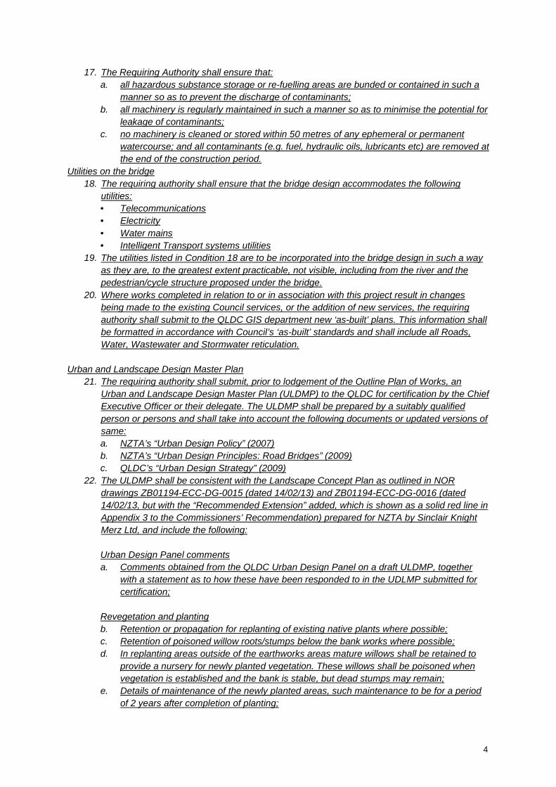
4
17. The Requiring Authority shall ensure that:
a. all hazardous substance storage or re-fuelling areas are bunded or contained in such a
manner so as to prevent the discharge of contaminants;
b. all machinery is regularly maintained in such a manner so as to minimise the potential for
leakage of contaminants;
c. no machinery is cleaned or stored within 50 metres of any ephemeral or permanent
watercourse; and all contaminants (e.g. fuel, hydraulic oils, lubricants etc) are removed at
the end of the construction period.
Utilities on the bridge
18. The requiring authority shall ensure that the bridge design accommodates the following
utilities:
• Telecommunications
• Electricity
• Water mains
• Intelligent Transport systems utilities
19. The utilities listed in Condition 18 are to be incorporated into the bridge design in such a way
as they are, to the greatest extent practicable, not visible, including from the river and the
pedestrian/cycle structure proposed under the bridge.
20. Where works completed in relation to or in association with this project result in changes
being made to the existing Council services, or the addition of new services, the requiring
authority shall submit to the QLDC GIS department new ‘as-built’ plans. This information shall
be formatted in accordance with Council’s ‘as-built’ standards and shall include all Roads,
Water, Wastewater and Stormwater reticulation.
Urban and Landscape Design Master Plan
21. The requiring authority shall submit, prior to lodgement of the Outline Plan of Works, an
Urban and Landscape Design Master Plan (ULDMP) to the QLDC for certification by the Chief
Executive Officer or their delegate. The ULDMP shall be prepared by a suitably qualified
person or persons and shall take into account the following documents or updated versions of
same:
a. NZTA’s “Urban Design Policy” (2007)
b. NZTA’s “Urban Design Principles: Road Bridges” (2009)
c. QLDC’s “Urban Design Strategy” (2009)
22. The ULDMP shall be consistent with the Landscape Concept Plan as outlined in NOR
drawings ZB01194-ECC-DG-0015 (dated 14/02/13) and ZB01194-ECC-DG-0016 (dated
14/02/13, but with the “Recommended Extension” added, which is shown as a solid red line in
Appendix 3 to the Commissioners’ Recommendation) prepared for NZTA by Sinclair Knight
Merz Ltd, and include the following:
Urban Design Panel comments
a. Comments obtained from the QLDC Urban Design Panel on a draft ULDMP, together
with a statement as to how these have been responded to in the UDLMP submitted for
certification;
Revegetation and planting
b. Retention or propagation for replanting of existing native plants where possible;
c. Retention of poisoned willow roots/stumps below the bank works where possible;
d. In replanting areas outside of the earthworks areas mature willows shall be retained to
provide a nursery for newly planted vegetation. These willows shall be poisoned when
vegetation is established and the bank is stable, but dead stumps may remain;
e. Details of maintenance of the newly planted areas, such maintenance to be for a period
of 2 years after completion of planting;

5
f. Selection of plant varieties for newly planted areas consistent with the Department of
Conservation’s “Wakatipu Project Gold” objectives and specifications;
g. A detailed planting plan identifying the location, density, grade, botanical names, and
quantity of all planting;
Pedestrian and cycle tracks
h. The final design and location of pedestrian and cycle tracks shall include step
connections indicated on the Landscape Concept Plan as “link via steps” and otherwise
meet the intent of the Landscape Concept Plan, including:
• Earthworks, showing areas of cut and fill, depths of cut and fill and cut batters;
• Any subsoil drainage system;
• Ease and convenience of use;
• Providing a complementary amenity experience to what is provided on nearby
sections of track;
• Adherence, to the extent that is practical, to the following design criteria:
- The provision of pathways that meet district wide design standards of minimum
width (2.5m) and maximum gradient (10%); and
- Pedestrian and cycling routes that provide direct and safe routes.
i. The requiring authority shall make reasonable efforts to consult with Queenstown Trails Trust
and the QLDC regarding conformity with the Trust’s and the QLDC’s pedestrian and cycle
track standards, and consult with the Otago Regional Council on provision for pedestrians
and cyclists both on and in the vicinity of the new bridge, and if this offer is accepted, describe
the consultation which occurred, and its outcomes in the ULDMP submitted for certification;
Heritage Matters
j. A detailed landscape design of the area where the new and existing bridges converge on the
true left bank of the River. This design shall be prepared in consultation with a heritage
consultant approved by the NZHPT, and shall ensure that the connection between the
existing bridge and the north bank remains visible;
k. A detailed design of the pedestrian and cycle structure below the existing bridge and the new
bridge. The design of this structure shall be prepared in consultation with a heritage
consultant approved by the NZHPT and shall ensure a minimum of impact on the fabric of the
existing bridge. Any alteration to the fabric of the bridge is to be undertaken in accordance
with recognised heritage principles such as the ICOMOS New Zealand Charter;
l. Removal of modern traffic facilities from the existing bridge where possible;
m. Prior to removal of the designation from the existing bridge, the requiring authority is to make
such modifications as are necessary to enable the carriageway to be used as a pedestrian
and cycle track (suitable for use by both recreational and commuting cyclists). Where this
involves modifications to the fabric of the bridge, such work is to be undertaken in accordance
with recognised heritage principles such as the ICOMOS New Zealand Charter.
n. Provision of information panels on the history of the existing bridge and Kawarau Falls area;
o. Carparking for visitors to the existing bridge, where possible;
Bridge Design
p. Bridge safety barriers which allow views out to the river, river margins and the existing bridge
for State highway users, while balancing safety considerations;
q. Final bridge design (including embankments and retaining walls) using external materials,
finishes and colours that assist it to accord with both the natural setting and its relationship
with the existing bridge, including giving effect to Condition 19;
r. Final bridge design which, to the extent practicable, gives effect to Goals 1, 2 and 4 of the
Queenstown Lakes District Council Urban Design Strategy;

6
s. Details of lighting to be installed on the bridge and its approaches, if any. Any proposed
lighting –
• should be an integral design component of the bridge;
• shall minimise light spill onto the river, onto adjacent land and into the night sky; and
• must comply with the Queenstown Southern Lights Strategy.
Emergency access
t. Details of how, at the completion of construction, the requiring authority shall ensure that
emergency access for vehicles onto the historic bridge is to be made possible.
23. The requiring authority shall carry out the Project in general accordance with ULDMP. The
ULDMP shall be fully implemented within 12 months of the opening of the new State highway
bridge.
Archaeology
24. During construction, the requiring authority shall:
a. Identify the extent of the stacked stone wall to the east of the Northern abutment of the
existing bridge before earthworks begin.
b. Clear vegetation in the location of proposed earthworks in a way that minimises damage
to ground.
c. Ensure earthworks areas are examined and recorded by an archaeologist prior to
earthworks commencing (with recordings submitted to the NZHPT and NZAA).
Advice Note: If any archaeological sites are to be affected by earthworks an Authority from the
NZHPT will be required.
Lapse date
25. The designation shall lapse if not given effect to within 10 years from the date on which it is
included in the District Plan under Section 175 of the RMA.
4. Alter the Proposed Planning maps to show the altered designations as follows:
Show the full designation footprints, including as altered by the designation alterations in Annexures
C-H:
a. With red and black markings on the smaller scale maps; and
b. With light blue markings and filled in with dots on the larger scale maps.
5. The Proposed Plan Maps- “Legend and User Information” is amended to include “State Highways (Designation 84)” as follows:
6. Definition for “State Highway 6 Roundabout Works” is deleted
State Highway (Designation 84)