Embed Size (px)
Citation preview
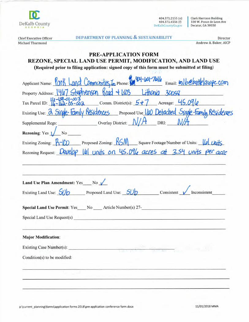
Parkland Communities, Inc. and Battle Law, P.C.
Parkland Communities, Inc. and Battle Law P .C.
We take this opportunity to encourage
you to come out and participate.
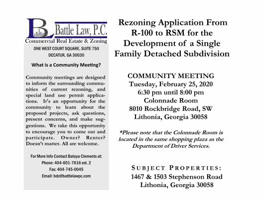
COMMUNITY MEETING Tuesday, February 25, 2020
6:30 pm until 8:00 pm Colonnade Room
8010 Rockbridge Road, SW Lithonia, Georgia 30058
*Please note that the Colonnade Room is located in the same shopping plaza as the
Department of Driver Services.
S U B J E C T P R O P E R T I E S :
1467 & 1503 Stephenson Road Lithonia, Georgia 30058
Rezoning Application From R-100 to RSM for the
Development of a Single Family Detached Subdivision
For More Info Contact Batoya Clements at:
Phone: 404-601-7616 ext. 2
Fax: 404-745-0045
Email: [email protected]
ONE WEST COURT SQUARE, SUITE 750
DECATUR, GA 30030
What is a Community Meeting?
Community meetings are designed to inform the surrounding commu-nities of current rezoning, and special land use permit applica-tions. It's an opportunity for the community to learn about the proposed projects, ask questions, present concerns, and make sug-
gestions. We take this opportunity
to encourage you to come out and participate. Owner? Renter? Doesn’t matter. All are welcome.

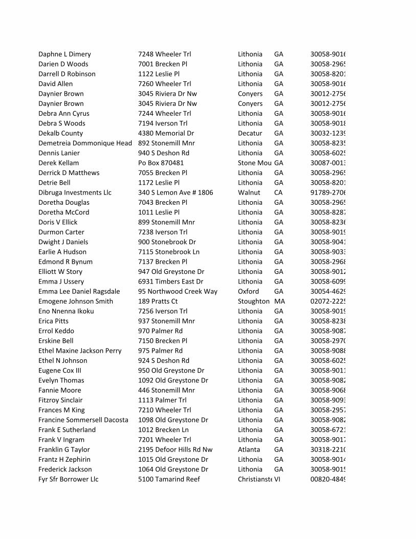
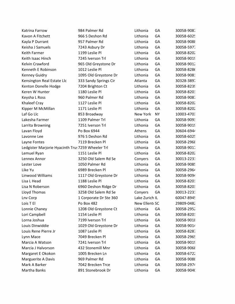
Name Address City State Zip2015 3 IH2 Borrower Lp 1717 Main St Dallas TX 75201-4612884 South Deshon Road Llc 884 S Deshon Rd Lithonia GA 30058-3008Aaron J Williams 311 Fernhill Ct Jonesboro GA 30236-4227Adan Family Trust Adan Victor Po Box 5006 Buena VistaCO 81211-5006Addi Matthews 6990 Brecken Trce Lithonia GA 30058-6724Adrainne P Butts 1011 Brecken Ln Lithonia GA 30058-6722Africa N Williams 6978 Brecken Pl Lithonia GA 30058-3238Akua James 7028 Brecken Pl Lithonia GA 30058-2969Alana D Ogle 1100 Palmer Rd Lithonia GA 30058-2945Alesha Puckett 7036 Brecken Pl Lithonia GA 30058-2969Alexis C Populus 7017 Brecken Pl Lithonia GA 30058-2965Alfred Anderson 902 Mountain Creek Vw Lithonia GA 30058-2914Allen Gathers 1040 S Deshon Rd Lithonia GA 30058-6027Allen Scott 1105 Old Greystone Dr Lithonia GA 30058-9094Andre Boozer 6997 Brecken Cir Lithonia GA 30058-2972Andre J 15 Montgomery 882 Stonebrook Dr Lithonia GA 30058-9041Andrea M Plater 966 Old Greystone Dr Lithonia GA 30058-9011Andrea Mitchell 1090 Palmer Rd Lithonia GA 30058-9086Angela Bryan 5727 Walter Trl Stone MounGA 30087-5911Angella C Gordon 1073 Leslie Pl Lithonia GA 30058-8287Angie Vidal 7124 Brecken Pl Lithonia GA 30058-2970Anita Williams 7246 Wheeler Ct Lithonia GA 30058-9043Anna Rosa Jackson 1138 Leslie Pl Lithonia GA 30058-8201Annette Hurst 996 Palmer Rd Lithonia GA 30058-9087Anthony Marshall 7003 Brecken Trce Lithonia GA 30058-2975Anthony Sylvester 944 Stonemill Mnr Lithonia GA 30058-8237Antoinette D Harper 6998 Deshon Ridge Dr Lithonia GA 30058-8203Antuane D King 3543 W 72nd Pl Chicago IL 60629-4303April Ammons 3541 Fannin Dr Lithonia GA 30038-2821Aretha Fuqua 213 S 42nd St Louisville KY 40212-2513Arnold J Teasley 1420 Stephenson Rd Lithonia GA 30058-5935Arthur D Drayton 7247 Wheeler Trl Lithonia GA 30058-9017Asdb Services Llc 510 Persimmon Pt Fayetteville GA 30214-7825Astiee Jackson Khan 1080 Palmer Rd Lithonia GA 30058-9086Atl 2 Sf Llc 445 Bush St San FranciscCA 94108-3707Azza S Malik 1321 Eli Ln Lawrencevi GA 30045-8216Bacilla Perry Mary 1117 Palmer Trl Lithonia GA 30058-9093Barbara Sydney Romeo 6994 Brecken Pl Lithonia GA 30058-3238Barry Anthony Wright 7232 Asbury Dr Lithonia GA 30058-5901Bart Williams 6992 Deshon Ridge Dr Lithonia GA 30058-8203Bayou Peach Realty Llc 3269 Meadowview Ln Sw Marietta GA 30008-5916Beckey N Smith 954 Palmer Rd Lithonia GA 30058-9087Belinda Ellington 6986 Brecken Cir Lithonia GA 30058-2971

Bernarda Castillo 1589 Stephenson Rd Lithonia GA 30058-6024Beth Harper Rodriguez 993 Palmer Rd Lithonia GA 30058-9088Betty Bey 7257 Wheeler Trl Lithonia GA 30058-9017Betty McCullough 7217 Iverson Trl Lithonia GA 30058-9019Billy R David 7119 Stonebrook Ln Lithonia GA 30058-9033Bobbie Triplett 6934 Timbers East Dr Lithonia GA 30058-6072Breckenridge Estates Homerown Po Box 922149 Norcross GA 30010-2149Breken Place Trust 3225 McLeod Dr Ste 777 Las Vegas NV 89121-2257Brian Gibson 329 Jerome St Brooklyn NY 11207-3807Byron C Middleton 1063 Old Greystone Dr Lithonia GA 30058-9014Carl S Hope 1111 Old Greystone Dr Lithonia GA 30058-9094Carl Washington Jr 6968 Deshon Ridge Dr Lithonia GA 30058-8203Carmen Peoples Nelson 7231 Iverson Trl Lithonia GA 30058-9019Carol Mattox 1017 Brecken Ln Lithonia GA 30058-6722Carol Williams 908 Stonebrook Dr Lithonia GA 30058-9041Caroline Cusack Po Box 68 Stone MounGA 30086-0068Carolyn P Richards Po Box 870022 Stone MounGA 30087-0001Carolyn Scott 1029 Brecken Ln Lithonia GA 30058-6722Cecil C Pryor 984 S Deshon Rd Lithonia GA 30058-6025Cerberus Sfr Holdings Lp 875 3rd Ave New York NY 10022-6225Charles Osborne 7000 Brecken Pl Lithonia GA 30058-2969Charlotte R Ross 7094 Brecken Pl Lithonia GA 30058-2969Chavez Ma Martha Gamez 959 Old Greystone Dr Lithonia GA 30058-9012Cheryl A McKay 7235 Wheeler Ct Lithonia GA 30058-9043Cheryl Parker 6995 Brecken Trce Lithonia GA 30058-6745Chinoel Gregg Kendrich 6519 Cheval Ct Stone MounGA 30087-6077Chiron Lashay Rutledge 1017 Palmer Rd Lithonia GA 30058-9083Cindy Gordon 1040 Palmer Rd Lithonia GA 30058-9085Clift Pettway 7041 Brecken Trce Lithonia GA 30058-2975Constella L Hughes 923 Stonemill Mnr Lithonia GA 30058-8238Courtney Kahlil Jones 7250 Wheeler Ct Lithonia GA 30058-9043Courtney Sanders 1079 Old Greystone Dr Lithonia GA 30058-9081Cross Of Calvary Baptist Churc 1451 Stephenson Rd Lithonia GA 30058-5934Curtis Kinsel 7211 Wheeler Trl Lithonia GA 30058-9017Curtis Sharon 894 Stonebrook Dr Lithonia GA 30058-9041Cyntelia Abrams 7213 Iverson Trl Lithonia GA 30058-9019Cynthia M Jones 899 Stonebrook Dr Lithonia GA 30058-9040Cynthia Walton M Morris 982 Old Greystone Dr Lithonia GA 30058-9011Daen Alexandre 948 S Deshon Rd Lithonia GA 30058-6025Daisy D Jones 929 Stonemill Mnr Lithonia GA 30058-8238Daisy Vershia Walker 1020 Leslie Pl Lithonia GA 30058-8286Daniel J Pierre 1109 Palmer Rd Lithonia GA 30058-2947Daniel Mahoney 7225 Wheeler Trl Lithonia GA 30058-9017Daphne Alice Smith 7030 Brecken Trce Lithonia GA 30058-2974
Daphne L Dimery 7248 Wheeler Trl Lithonia GA 30058-9016Darien D Woods 7001 Brecken Pl Lithonia GA 30058-2965Darrell D Robinson 1122 Leslie Pl Lithonia GA 30058-8201David Allen 7260 Wheeler Trl Lithonia GA 30058-9016Daynier Brown 3045 Riviera Dr Nw Conyers GA 30012-2756Daynier Brown 3045 Riviera Dr Nw Conyers GA 30012-2756Debra Ann Cyrus 7244 Wheeler Trl Lithonia GA 30058-9016Debra S Woods 7194 Iverson Trl Lithonia GA 30058-9018Dekalb County 4380 Memorial Dr Decatur GA 30032-1239Demetreia Dommonique Head 892 Stonemill Mnr Lithonia GA 30058-8235Dennis Lanier 940 S Deshon Rd Lithonia GA 30058-6025Derek Kellam Po Box 870481 Stone MounGA 30087-0013Derrick D Matthews 7055 Brecken Pl Lithonia GA 30058-2965Detrie Bell 1172 Leslie Pl Lithonia GA 30058-8201Dibruga Investments Llc 340 S Lemon Ave # 1806 Walnut CA 91789-2706Doretha Douglas 7043 Brecken Pl Lithonia GA 30058-2965Doretha McCord 1011 Leslie Pl Lithonia GA 30058-8287Doris V Ellick 899 Stonemill Mnr Lithonia GA 30058-8236Durmon Carter 7238 Iverson Trl Lithonia GA 30058-9019Dwight J Daniels 900 Stonebrook Dr Lithonia GA 30058-9041Earlie A Hudson 7115 Stonebrook Ln Lithonia GA 30058-9033Edmond R Bynum 7137 Brecken Pl Lithonia GA 30058-2968Elliott W Story 947 Old Greystone Dr Lithonia GA 30058-9012Emma J Ussery 6931 Timbers East Dr Lithonia GA 30058-6099Emma Lee Daniel Ragsdale 95 Northwood Creek Way Oxford GA 30054-4629Emogene Johnson Smith 189 Pratts Ct Stoughton MA 02072-2225Eno Nnenna Ikoku 7256 Iverson Trl Lithonia GA 30058-9019Erica Pitts 937 Stonemill Mnr Lithonia GA 30058-8238Errol Keddo 970 Palmer Rd Lithonia GA 30058-9087Erskine Bell 7150 Brecken Pl Lithonia GA 30058-2970Ethel Maxine Jackson Perry 975 Palmer Rd Lithonia GA 30058-9088Ethel N Johnson 924 S Deshon Rd Lithonia GA 30058-6025Eugene Cox III 950 Old Greystone Dr Lithonia GA 30058-9011Evelyn Thomas 1092 Old Greystone Dr Lithonia GA 30058-9082Fannie Moore 446 Stonemill Mnr Lithonia GA 30058-9068Fitzroy Sinclair 1113 Palmer Trl Lithonia GA 30058-9093Frances M King 7210 Wheeler Trl Lithonia GA 30058-2957Francine Sommersell Dacosta 1098 Old Greystone Dr Lithonia GA 30058-9082Frank E Sutherland 1012 Brecken Ln Lithonia GA 30058-6721Frank V Ingram 7201 Wheeler Trl Lithonia GA 30058-9017Franklin G Taylor 2195 Defoor Hills Rd Nw Atlanta GA 30318-2210Frantz H Zephirin 1015 Old Greystone Dr Lithonia GA 30058-9014Frederick Jackson 1064 Old Greystone Dr Lithonia GA 30058-9015Fyr Sfr Borrower Llc 5100 Tamarind Reef ChristiansteVI 00820-4849

Gabriel I Adams 7005 Brecken Cir Lithonia GA 30058-2976Garry C Baker 960 Old Greystone Dr Lithonia GA 30058-9011George E Clarke 904 S Deshon Rd Lithonia GA 30058-6025Geraldine Hawkins Robinson 1056 Palmer Rd Lithonia GA 30058-9085Gloria A Ortiz 976 Palmer Rd Lithonia GA 30058-9087Gloria Minta 1046 Palmer Rd Lithonia GA 30058-9085Gordon Persons 1141 Leslie Pl Lithonia GA 30058-8202Grace C Rodriques 27 Dearborn St Springfield MA 01109-2703Greystone Community 2555 Westside Pkwy Alpharetta GA 30004-4187Gwendolyn L Nicolls 980 Palmer Rd Lithonia GA 30058-9087H Benedict Telesford 7245 Wheeler Ct Lithonia GA 30058-9043Harlene Moise 983 Old Greystone Dr Lithonia GA 30058-9012Harvey L Jones 990 Palmer Rd Lithonia GA 30058-9087Hillsworth E Charles 7236 Wheeler Ct Lithonia GA 30058-9043Holly Semple 1115 Leslie Pl Lithonia GA 30058-8202Home Sfr Borrower Llc 8300 N Mopac Expy Austin TX 78759-8330Horace McClarin III 1023 Brecken Ln Lithonia GA 30058-6722Hubert Karl Thomas 971 Old Greystone Dr Lithonia GA 30058-9012Ibitola O Alalade Po Box 52553 Atlanta GA 30355-0553Ingrid R Williams 1156 Leslie Pl Lithonia GA 30058-8201Itamar Zamor 898 Stonemill Mnr Lithonia GA 30058-8235Jacin Q Thompson 911 Stonemill Mnr Lithonia GA 30058-8238Jackie Wilborn 7002 Brecken Trce Lithonia GA 30058-6719James A Williams 7195 Iverson Trl Lithonia GA 30058-9018James E Jones 956 S Deshon Rd Lithonia GA 30058-6025James H Ward 1045 Leslie Pl Lithonia GA 30058-8287James N Carmichael 885 Stonebrook Dr Lithonia GA 30058-9040James Tyler Pattman 7252 Iverson Trl Lithonia GA 30058-9019Jameson Jervier 994 Brecken Ln Lithonia GA 30058-6720Janaun J Ivy 1035 Leslie Pl Lithonia GA 30058-8287Janee A Dixon 1082 Old Greystone Dr Lithonia GA 30058-9082Janie Asante 2308 Lochinver Ln Sw Conyers GA 30094-6851Jason Whitfield 7125 Brecken Pl Lithonia GA 30058-2968Jerry McMillan 5033 Doby Ln Austell GA 30106-2836Joann Harris 7256 Wheeler Trl Lithonia GA 30058-9016Joann W Benford 1085 Leslie Pl Lithonia GA 30058-8287John H Cowart 1370 Center Dr Atlanta GA 30338-4132John H Herriott 944 Old Greystone Dr Lithonia GA 30058-9011John Z Clemons Jr 1110 Palmer Trl Lithonia GA 30058-9092Johnny Billings 999 Palmer Rd Lithonia GA 30058-9088Jonathan Brewer 7129 Stonebrook Ln Lithonia GA 30058-9033Joseph G Locurto 6982 Kimberland Gardens Ln Lithonia GA 30058-6019Justin Myers 5245 Mainstreet Park Dr Stone MounGA 30088-2407Kathy E Boozer King 1411 Stephenson Rd Lithonia GA 30058-5934
Katrina Farrow 984 Palmer Rd Lithonia GA 30058-9087Kavon A Fitchett 966 S Deshon Rd Lithonia GA 30058-6025Kayla P Durrant 957 Palmer Rd Lithonia GA 30058-9088Keisha J Samuels 7243 Asbury Dr Lithonia GA 30058-5977Keith Farmer 1199 Leslie Pl Lithonia GA 30058-8202Keith Isaac Hinch 7245 Iverson Trl Lithonia GA 30058-9019Kelvin Crawford 965 Old Greystone Dr Lithonia GA 30058-9012Kenneth E Robinson 1012 Leslie Pl Lithonia GA 30058-8286Kenney Guidry 1095 Old Greystone Dr Lithonia GA 30058-9081Kensington Real Estate Llc 333 Sandy Springs Cir Atlanta GA 30328-3897Kenton Donelle Hodge 7204 Brighton Ct Lithonia GA 30058-8239Keren W Hunter 1180 Leslie Pl Lithonia GA 30058-8201Keysha L Ross 960 Palmer Rd Lithonia GA 30058-9087Khaleef Cray 1127 Leslie Pl Lithonia GA 30058-8202Kipper M McMillan 1171 Leslie Pl Lithonia GA 30058-8202Laf Go Llc 853 Broadway New York NY 10003-4703Lakesha Farmer 1109 Palmer Trl Lithonia GA 30058-9093Larrita Browning 7251 Iverson Trl Lithonia GA 30058-9019Lavan Floyd Po Box 6944 Athens GA 30604-6944Lavonne Lee 976 S Deshon Rd Lithonia GA 30058-6025Layne Fontes 7119 Brecken Pl Lithonia GA 30058-2968Ledgister Marjorie Hyacinth Trus 7259 Wheeler Trl Lithonia GA 30058-9017Lemuel Ryan 1151 Leslie Pl Lithonia GA 30058-8202Lennex Annor 3250 Old Salem Rd Se Conyers GA 30013-2231Lester Love 1050 Palmer Rd Lithonia GA 30058-9085Like Yu 6989 Brecken Pl Lithonia GA 30058-2964Linwood Williams 1117 Old Greystone Dr Lithonia GA 30058-9094Lisa L Head 1188 Leslie Pl Lithonia GA 30058-8201Lisa N Roberson 6960 Deshon Ridge Dr Lithonia GA 30058-8203Lloyd Thomas 3258 Old Salem Rd Se Conyers GA 30013-2231Lnv Corp 1 Corporate Dr Ste 360 Lake Zurich IL 60047-8945Lois T El Po Box 482 New EllentoSC 29809-0482Lonnie Chaney 1208 Old Greystone Ct Lithonia GA 30058-2952Lori Campbell 1154 Leslie Pl Lithonia GA 30058-8201Lorna Joshua 7199 Iverson Trl Lithonia GA 30058-9018Louis Dinwiddie 1029 Old Greystone Dr Lithonia GA 30058-9014Louis Rene Pierre Jr 1087 Leslie Pl Lithonia GA 30058-8287Lynn Mace 7049 Brecken Pl Lithonia GA 30058-2965Marcia A Watson 7241 Iverson Trl Lithonia GA 30058-9019Marcia J Halvorson 432 Stonemill Mnr Lithonia GA 30058-9068Margaret E Okokon 1005 Brecken Ln Lithonia GA 30058-6722Marguerite A Davis 969 Palmer Rd Lithonia GA 30058-9088Mark A Barker 7042 Brecken Trce Lithonia GA 30058-2974Martha Banks 891 Stonebrook Dr Lithonia GA 30058-9040

Martha Glover 988 Brecken Ln Lithonia GA 30058-6720Marva Reid 1089 Leslie Pl Lithonia GA 30058-8287Mary J Stevenson 7202 Wheeler Trl Lithonia GA 30058-9070Mary Jones 978 Old Greystone Dr Lithonia GA 30058-9011Mary McRae 6991 Brecken Trce Lithonia GA 30058-6745Matthew O Lindsay 1146 Leslie Pl Lithonia GA 30058-8201Maurice Heron 3306 Waterford Way Conyers GA 30012-8110Maurice N Coleman 1085 Palmer Rd Lithonia GA 30058-9084Maxwell Donna Williams 1093 Palmer Rd Lithonia GA 30058-9084Melaf Ga Llc 853 Broadway Fl 5 New York NY 10003-4724Melissa Bolden 1037 Palmer Rd Lithonia GA 30058-9083Melvyn Dean Underwood 1427 Stephenson Rd Lithonia GA 30058-5934Messa Sewa 7100 Brecken Pl Lithonia GA 30058-2970Michael D Anderson II 1091 Old Greystone Dr Lithonia GA 30058-9081Michael H Macon 1119 Leslie Pl Lithonia GA 30058-8202Michael J Stephens 7050 Brecken Pl Lithonia GA 30058-2969Michelle Tulloch 8420 Austin St Kew GardenNY 11415-2235Mills Valencia N Strickland 1117 Palmer Rd Lithonia GA 30058-2947Monica Nwogu 7231 Wheeler Trl Lithonia GA 30058-9017Monica S Carthen 982 Brecken Ln Lithonia GA 30058-6720Mort Com Everhome 8100 Nations Way JacksonvilleFL 32256-4405Mr Paul W King 1467 Stephenson Rd Lithonia GA 30058-5934Mupr 3 Assets Llc 5001 Plaza On The Lk Ste 200 Austin TX 78746-1053Myreon Tyree Miller 1116 Palmer Rd Lithonia GA 30058-2945Myrtle A Richards 7101 Brecken Pl Lithonia GA 30058-2968Nakeeta Dozier 1202 Old Greystone Ct Lithonia GA 30058-2952Nancy M Thomas 7235 Iverson Trl Lithonia GA 30058-9019Netsanet Zeleke 7007 Brecken Pl Lithonia GA 30058-2965Nicole Hilliard 7248 Iverson Trl Lithonia GA 30058-9019Novelette Dacres 7011 Brecken Pl Lithonia GA 30058-2965Obadiah T Yusuf 1105 Palmer Rd Lithonia GA 30058-2947Pamela L Ross 6952 Deshon Ridge Dr Lithonia GA 30058-8203Pamela W Price 1025 Leslie Pl Lithonia GA 30058-8287Patricia A Cooper 7196 Iverson Trl Lithonia GA 30058-9018Patricia Ann Byrd 972 Old Greystone Dr Lithonia GA 30058-9011Patricia McShane-Cody 1086 Leslie Pl Lithonia GA 30058-8286Patricia Walker 7080 Brecken Pl Lithonia GA 30058-2969Paulette E Wiltshire 1164 Leslie Pl Lithonia GA 30058-8201Pfin Ii F Llc 6300 Powers Ferry Rd Ste 600 Atlanta GA 30339-2961Philip Nash 1098 Palmer Trl Lithonia GA 30058-2941Predency Moore 7235 Wheeler Trl Lithonia GA 30058-9017Quantrell Devon Fortune 1031 Palmer Rd Lithonia GA 30058-9083Quentin Stephen Starnes 1030 Palmer Rd Lithonia GA 30058-9085Rachel Casey 7113 Brecken Pl Lithonia GA 30058-2968
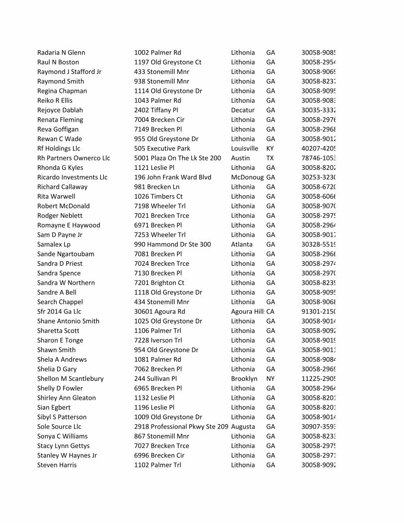
Radaria N Glenn 1002 Palmer Rd Lithonia GA 30058-9085Raul N Boston 1197 Old Greystone Ct Lithonia GA 30058-2954Raymond J Stafford Jr 433 Stonemill Mnr Lithonia GA 30058-9069Raymond Smith 938 Stonemill Mnr Lithonia GA 30058-8237Regina Chapman 1114 Old Greystone Dr Lithonia GA 30058-9095Reiko R Ellis 1043 Palmer Rd Lithonia GA 30058-9083Rejoyce Dablah 2402 Tiffany Pl Decatur GA 30035-3332Renata Fleming 7004 Brecken Cir Lithonia GA 30058-2976Reva Goffigan 7149 Brecken Pl Lithonia GA 30058-2968Rewan C Wade 955 Old Greystone Dr Lithonia GA 30058-9012Rf Holdings Llc 505 Executive Park Louisville KY 40207-4205Rh Partners Ownerco Llc 5001 Plaza On The Lk Ste 200 Austin TX 78746-1053Rhonda G Kyles 1121 Leslie Pl Lithonia GA 30058-8202Ricardo Investments Llc 196 John Frank Ward Blvd McDonoughGA 30253-3230Richard Callaway 981 Brecken Ln Lithonia GA 30058-6720Rita Warwell 1026 Timbers Ct Lithonia GA 30058-6066Robert McDonald 7198 Wheeler Trl Lithonia GA 30058-9070Rodger Neblett 7021 Brecken Trce Lithonia GA 30058-2975Romayne E Haywood 6971 Brecken Pl Lithonia GA 30058-2964Sam D Payne Jr 7253 Wheeler Trl Lithonia GA 30058-9017Samalex Lp 990 Hammond Dr Ste 300 Atlanta GA 30328-5519Sande Ngartoubam 7081 Brecken Pl Lithonia GA 30058-2966Sandra D Priest 7024 Brecken Trce Lithonia GA 30058-2974Sandra Spence 7130 Brecken Pl Lithonia GA 30058-2970Sandra W Northern 7201 Brighton Ct Lithonia GA 30058-8239Sandre A Bell 1118 Old Greystone Dr Lithonia GA 30058-9095Search Chappel 434 Stonemill Mnr Lithonia GA 30058-9068Sfr 2014 Ga Llc 30601 Agoura Rd Agoura HillsCA 91301-2150Shane Antonio Smith 1025 Old Greystone Dr Lithonia GA 30058-9014Sharetta Scott 1106 Palmer Trl Lithonia GA 30058-9092Sharon E Tonge 7228 Iverson Trl Lithonia GA 30058-9019Shawn Smith 954 Old Greystone Dr Lithonia GA 30058-9011Shela A Andrews 1081 Palmer Rd Lithonia GA 30058-9084Shelia D Gary 7062 Brecken Pl Lithonia GA 30058-2969Shellon M Scantlebury 244 Sullivan Pl Brooklyn NY 11225-2905Shelly D Fowler 6965 Brecken Pl Lithonia GA 30058-2964Shirley Ann Gleaton 1132 Leslie Pl Lithonia GA 30058-8201Sian Egbert 1196 Leslie Pl Lithonia GA 30058-8201Sibyl S Patterson 1009 Old Greystone Dr Lithonia GA 30058-9014Sole Source Llc 2918 Professional Pkwy Ste 209 Augusta GA 30907-3593Sonya C Williams 867 Stonemill Mnr Lithonia GA 30058-8233Stacy Lynn Gettys 7027 Brecken Trce Lithonia GA 30058-2975Stanley W Haynes Jr 6996 Brecken Cir Lithonia GA 30058-2971Steven Harris 1102 Palmer Trl Lithonia GA 30058-9092

Steven Spivey 1068 Leslie Pl Lithonia GA 30058-8286Stevie Jackson 1204 Leslie Pl Lithonia GA 30058-9066Stuart H Dorfman 989 S Deshon Rd Lithonia GA 30058-6008Suleiman Mahamed Hassan 966 Palmer Rd Lithonia GA 30058-9087Sylvia Samuel 7044 Brecken Pl Lithonia GA 30058-2969Tah 2018 1 Borrower Llc 1508 Brookhollow Dr Santa Ana CA 92705-5433Tah Ms Borrower Llc 1508 Brookhollow Dr Santa Ana CA 92705-5433Takawira P Sanganza 1104 Leslie Pl Lithonia GA 30058-8201Takiya M Nelson 6988 Brecken Pl Lithonia GA 30058-3238Tangula L Wright 7223 Iverson Trl Lithonia GA 30058-9019Tanya Louise Lynn Smith 1401 Stephenson Rd Lithonia GA 30058-5995Teesha Thomas 1110 Palmer Rd Lithonia GA 30058-2945Teresa Gail Teasley Vickery 1470 Stephenson Rd Lithonia GA 30058-5935Terri Lawson-Adams 1899 Chedworth Ct Stone MounGA 30087-2130Theresa A Brown 6992 Brecken Cir Lithonia GA 30058-2971Theresa Anntionette Carter 7068 Brecken Pl Lithonia GA 30058-2969Thomas J Marshall 7133 Stonebrook Ln Lithonia GA 30058-9033Tiawanna T Thompson 7193 Iverson Trl Lithonia GA 30058-9018Tiffany Butler 2319 Cherokee Valley Cir Lithonia GA 30058-5383Timothy H Finney 445 Stonemill Mnr Lithonia GA 30058-9069Timothy Lee King 1006 Palmer Rd Lithonia GA 30058-9085Timothy R Paul 4988 Fairhaven Way Ne Roswell GA 30075-6111Todd P Tyler 7036 Brecken Trce Lithonia GA 30058-2974Toni P Walker 1061 Leslie Pl Lithonia GA 30058-8287Tracy D Adams 1108 Old Greystone Dr Lithonia GA 30058-9095Trina N Stroupe 7035 Brecken Pl Lithonia GA 30058-2965Troy M Lewis 1106 Palmer Rd Lithonia GA 30058-2945Troy Strohman 7106 Brecken Pl Lithonia GA 30058-2970Tyler Penny 1094 Palmer Rd Lithonia GA 30058-9086Tyrone Rogers 1212 Old Greystone Ct Lithonia GA 30058-2952Ucall L Gooden 7090 Brecken Pl Lithonia GA 30058-2969Union Jack Properties Llc Po Box 8503 Atlanta GA 31106-0503Valerie Campbell 7033 Brecken Trce Lithonia GA 30058-2975Vanessa Goodridge 932 S Deshon Rd Lithonia GA 30058-6025Vanessa Luke 7202 Brighton Ct Lithonia GA 30058-8239Vanessa Peterson 983 Palmer Rd Lithonia GA 30058-9088Vanessa R Byams 990 Old Greystone Dr Lithonia GA 30058-9011Vickie S McGhee 10460 Saint Simonds Ct Johns CreekGA 30022-6026Voice Of Praise New Testament 1368 Stephenson Rd Lithonia GA 30058-5933Voice Of Praise New Testament 1368 Stephenson Rd Lithonia GA 30058-5933W H J Properties Llc 4173 Bent Willow Dr Sw Lilburn GA 30047-3366Wade Wimberly 438 Stonemill Mnr Lithonia GA 30058-9068Wentworth E Rennalls 1034 Brecken Ln Lithonia GA 30058-6721Wesley Murdock 7191 Iverson Trl Lithonia GA 30058-9018

William Cunnigham 6983 Brecken Pl Lithonia GA 30058-2964William Hobbs 1201 Old Greystone Ct Lithonia GA 30058-2950William Michael Graham Jr 1099 Old Greystone Dr Lithonia GA 30058-9081Willie Frink 1000 Brecken Ln Lithonia GA 30058-6721Willie Lockhart 931 Timberclair Way Lithonia GA 30058-6063Winifred Ibe 907 Stonemill Mnr Lithonia GA 30058-8238Winston L Hill Sr 4540 Sunlight Ct Lilburn GA 30047-4585Wonder Athill 1014 Palmer Rd Lithonia GA 30058-9085Yanan Wang 90 S Shore Dr South AmboNJ 08879-3431Ynz Properties Llc 2620 Spring Harbor Dr Cumming GA 30041-9338Yvette H Johnson 1099 Leslie Pl Lithonia GA 30058-8287Yvonne D Jamieson 439 Stonemill Mnr Lithonia GA 30058-9069Zandra M Turner 987 Brecken Ln Lithonia GA 30058-6720Zezar M Holder 7226 Wheeler Trl Lithonia GA 30058-2957


C:\Users\store\Downloads\14-Revised _ Client Campaign Disclosure 121819.docx
Campaign Contribution Disclosure Statements
CAMPAIGN CONTRIBUTIONS DISCLOSURE STATEMENT Pursuant to the provisions of 36 O.C.G.A. 67(A), please find below a list of those contributions made by Michèle L Battle or Battle Law, P.C. in the past two years, aggregating $250.00 or more, to local government officials who will consider this application.
NAME OF GOV’T OFFICIAL
OFFICIAL POSITION
AMOUNT OF CONTRIBUTION
Kathie Gannon Commissioner $350 Mereda Davis Johnson Commissioner $500
Larry Johnson Commissioner $700 Lorraine Cochran-Johnson Commissioner $250
By: Printed Name:
2/24/2020 GSCCCA.org - Image Index
https://search.gsccca.org/Imaging/HTML5Viewer.aspx?id=73045016&key1=27354&key2=182&county=44&countyname=DEKALB&userid=251358&ap… 1/8

2/24/2020 GSCCCA.org - Image Index
https://search.gsccca.org/Imaging/HTML5Viewer.aspx?id=73045016&key1=27354&key2=182&county=44&countyname=DEKALB&userid=251358&ap… 3/8
2/24/2020 GSCCCA.org - Image Index
https://search.gsccca.org/Imaging/HTML5Viewer.aspx?id=73045016&key1=27354&key2=182&county=44&countyname=DEKALB&userid=251358&ap… 5/8

2/24/2020 GSCCCA.org - Image Index
https://search.gsccca.org/Imaging/HTML5Viewer.aspx?id=73045016&key1=27354&key2=182&county=44&countyname=DEKALB&userid=251358&ap… 7/8

PARKLAND COMMUNITIES, INC.
REZONING APPLICATION
LIST OF OWNERS AND PROPERTY INFORMATION
Owner:
Address:
Tax Parcel: Address: Zoned:
Owner: Owner Address:
Tax Parcel: Address: Zoned:
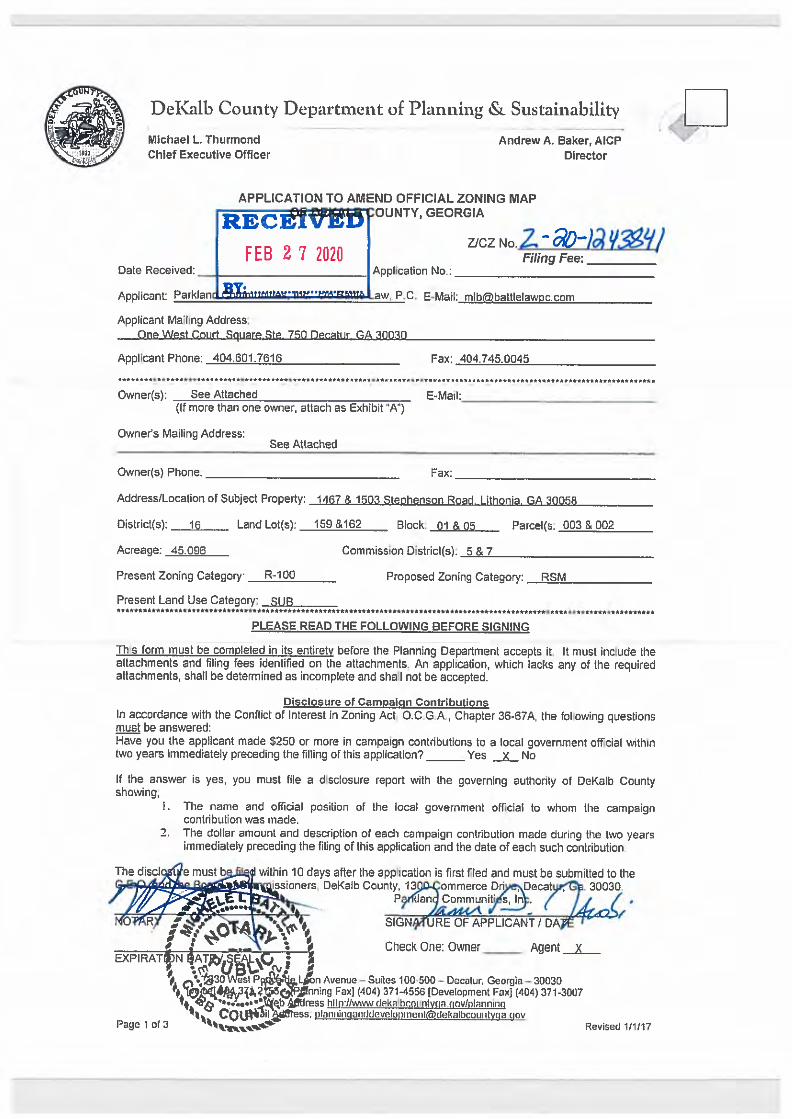
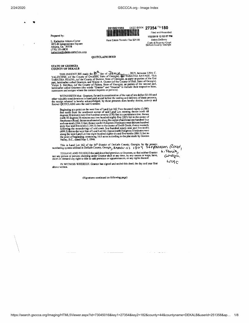
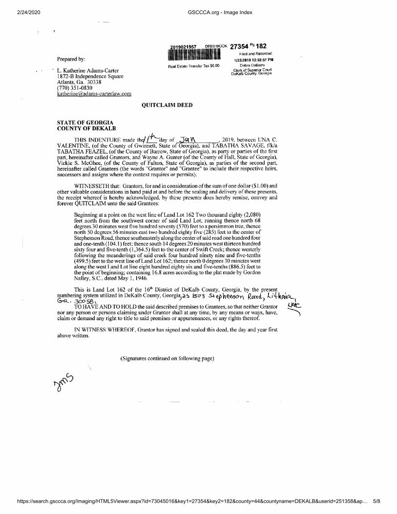
Judith King Estes and Paulinda King HallExecutors of the Estate of Paul King 1467 Stephenson Road Lithonia, GA 30058 16 159 01 003 1467 Stephenson Road R-100
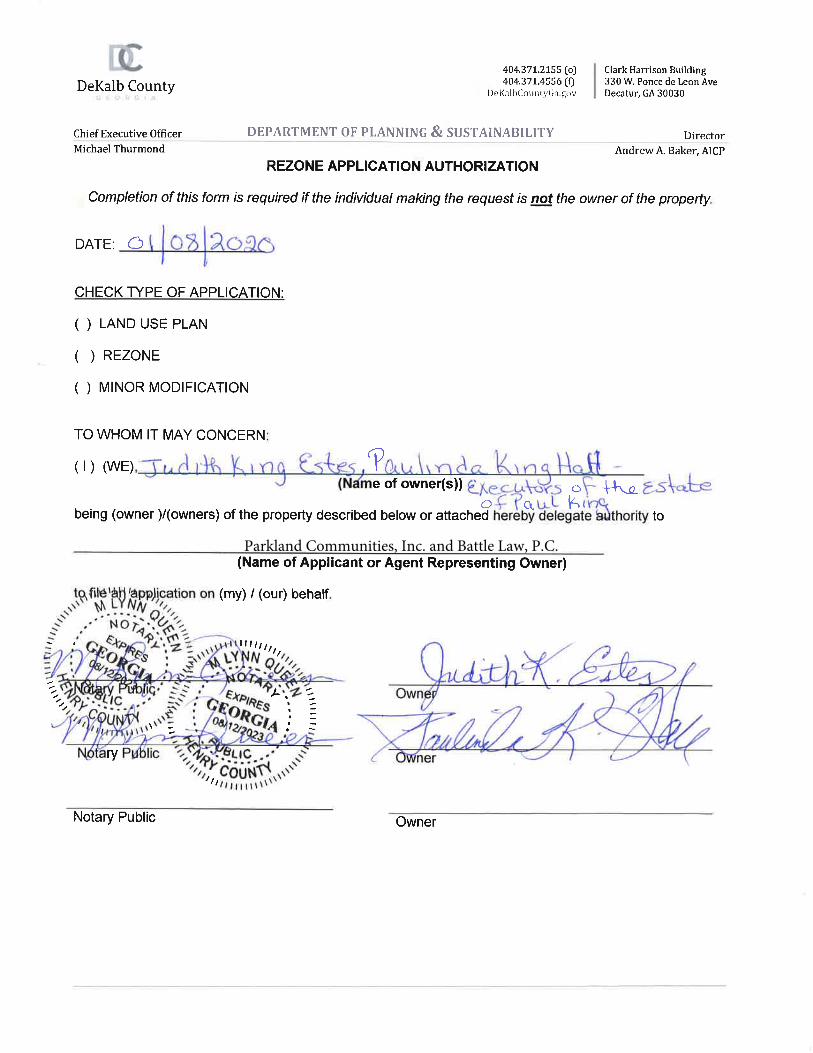
Vickie S. McGhee Wayne A. Gunter 1503 Stephenson Road Lithonia, GA 30058 16 162 05 002 1503 Stephenson Road R-100
Multiple Tax Parcels/Address: 16 159 01 003 1467 Stephenson Road Zoned: R-100
16 162 05 002 1503 Stephenson Road Zoned: R-100

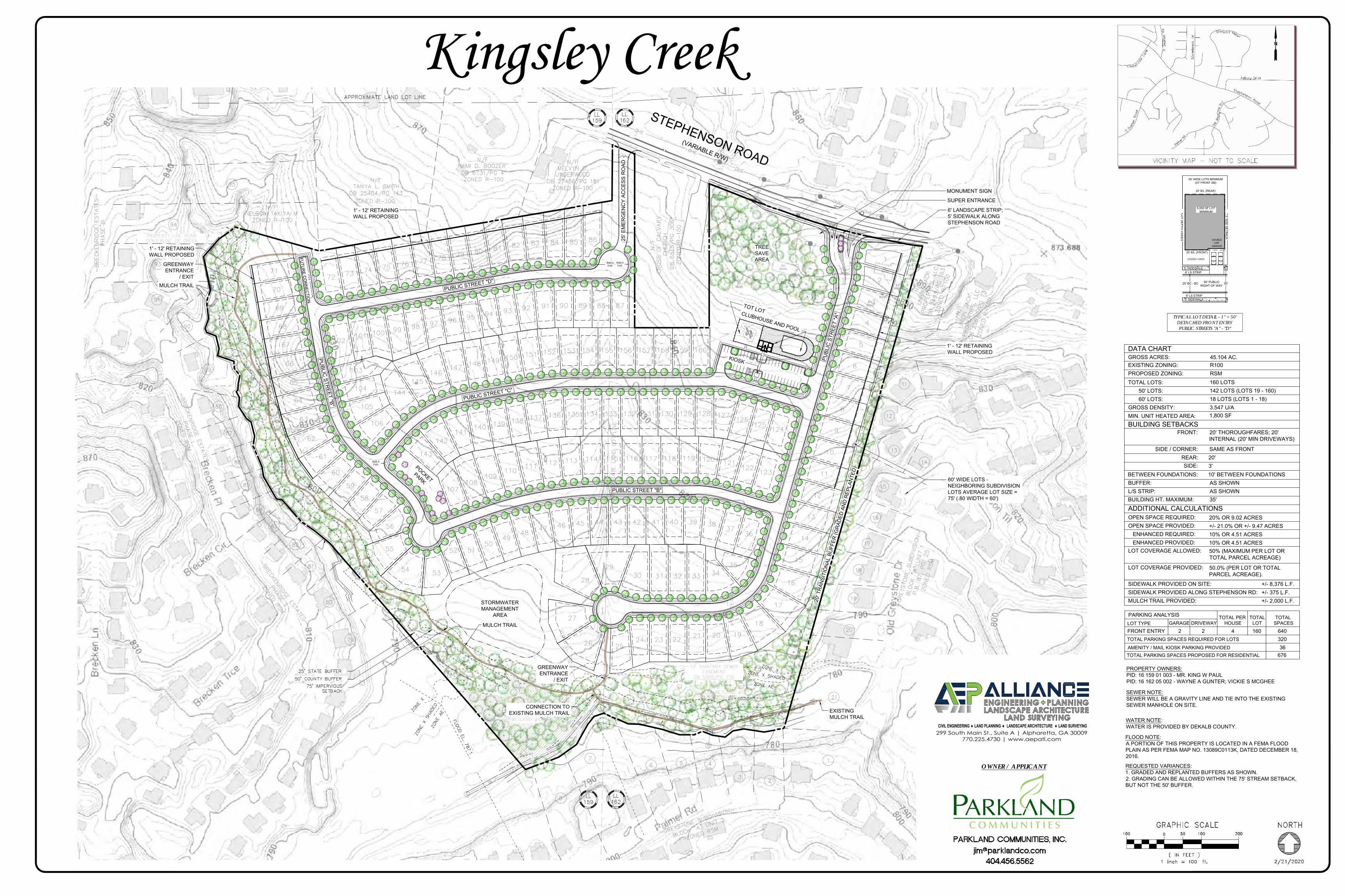
STEPHENSON ROAD(VARIABLE R/W)
STORM SEWER MANHOLE
SIGN
WATER METERFIRE HYDRANT
WATER VALVE
GRATE INLET
UTILITY POLEGUY WIRE
SPECIMEN TREE
IRON PIN FOUND
SANITARY SEWER MANHOLE
GAS VALVE
MAILBOX
MEASURED DISTANCE
CALCULATED DISTANCE
RECORD DISTANCE
SANITARY SEWERWATER LINEGAS LINEOVERHEAD ELECTRIC
STORM SEWER LINE
PROPERTY LINEADJACENT PROPERTY LINEFENCE
GAS METER CALCULATED POINT
R/W MARKER
LAND LOT
File
Loc
atio
n:c:
\use
rs\d
avid
ande
rson
\dro
pbox
(aep
)\04-
surv
ey p
roje
cts\
03-p
roje
cts\
1906
2 - s
teph
enso
n ro
ad\d
wg\
1906
2-st
ephe
nson
rd
Drafted byChecked byProject #
ALTA
/NSP
S LA
ND
TIT
LE S
UR
VEY
Plot
Dat
e: T
uesd
ay, J
anua
ry 2
8, 2
020
5:50
:57
PM A B Q
1
2
5
6
7
8
9
10
11
12
M.C.B.
D.L.A.
19062
01/2
4/20
D E F G H I J K L M N O P
3
4
C
Rev
. (3)
:
Issu
e:R
ev. (
1):
Rev
. (2)
:
Rev
. (4)
:R
ev. (
5):
Rev
. (6)
:R
ev. (
7):
Dat
e:Is
sue:
Des
crip
tion:
6095
ATL
AN
TA H
IGH
WA
Y S
UIT
E 10
0FL
OW
ERY
BR
AN
CH
, GA
. 305
4267
8.82
8.94
24 |
ww
w.a
ep
atl.
co
m
1 OF 1SHEET NO:
16TH
DIS
TRIC
TD
EKAL
B C
OU
NTY
, GEO
RG
IA
LOC
ATED
INLA
ND
LO
TS 1
59 A
ND
162
L.S.
F. 1
322
Know what's below. Call before you dig.
IRON PIN SET

File
Loc
atio
n:c:
\use
rs\d
avid
ande
rson
\dro
pbox
(aep
)\04-
surv
ey p
roje
cts\
03-p
roje
cts\
1906
2 - s
teph
enso
n ro
ad\d
wg\
1906
2-st
ephe
nson
rd
Drafted byChecked byProject #
ALTA
/NSP
S LA
ND
TIT
LE S
UR
VEY
Plot
Dat
e: T
uesd
ay, J
anua
ry 2
8, 2
020
5:53
:24
PM A B Q
1
2
5
6
7
8
9
10
11
12
M.C.B.
D.L.A.
19062
01/2
4/20
D E F G H I J K L M N O P
3
4
C
Rev
. (3)
:
Issu
e:R
ev. (
1):
Rev
. (2)
:
Rev
. (4)
:R
ev. (
5):
Rev
. (6)
:R
ev. (
7):
Dat
e:Is
sue:
Des
crip
tion:
6095
ATL
AN
TA H
IGH
WA
Y S
UIT
E 10
0FL
OW
ERY
BR
AN
CH
, GA
. 305
4267
8.82
8.94
24 |
ww
w.a
ep
atl.
co
m
1 OF 1SHEET NO:
16TH
DIS
TRIC
TD
EKAL
B C
OU
NTY
, GEO
RG
IA
LOC
ATED
INLA
ND
LO
TS 1
59 A
ND
162
L.S.
F. 1
322
Know what's below. Call before you dig.

EX.BLDG.
EX.BLDG.
EX.BLDG.
EX.BLDG.
EX.BLDG.
EX.BLDG.
EX.BLDG.
EX.BLDG.
STEPHENSON ROAD(VARIABLE R/W)
R50.0TYP.
R40.0TYP.
R25.0TYP.
SUPER ENTRANCE
60' WIDE LOTS -NEIGHBORING SUBDIVISIONLOTS AVERAGE LOT SIZE =75' (.80 WIDTH = 60')
1' - 12' RETAININGWALL PROPOSED
1' - 12' RETAININGWALL PROPOSED
1' - 12' RETAININGWALL PROPOSED
POCKETPARK
25' E
MER
GEN
CY
ACC
ESS
RO
AD
STORMWATERMANAGEMENT
AREA
MULCH TRAIL
CLUBHOUSE AND POOL
GREENWAYENTRANCE
/ EXIT
GREENWAYENTRANCE
/ EXITMULCH TRAIL
FUTU
RE C
ON
NEC
TION
TOT LOT
PUBLIC STREET "D"
PUBL
IC S
TREE
T "A
"
PUBLIC STREET "B"
PUBLIC STREET "C"
6' LANDSCAPE STRIP;5' SIDEWALK ALONGSTEPHENSON ROAD
MONUMENT SIGN
20' T
RAN
SITI
ON
AL B
UFF
ER (G
RAD
ED A
ND
REP
LAN
TED
)
113.0
KIOSK
TREESAVEAREA
PUBLIC
STREET "B"
EXISTINGMULCH TRAIL
CONNECTION TOEXISTING MULCH TRAIL
25' BC - BC
SODDED YARDS
20' B/L (FRONT)
GARAGECAR
TYPICAL LOT DETAIL - 1" = 50'DETACHED FRONT ENTRYPUBLIC STREETS "A" - "D"
50'
20' B/L (REAR)
50' WIDE LOTS MINIMUM(AT FRONT SB)
5,000 SF LOTMINIMUM
3' SIDE SETBAC
K
6' LS STRIP5' SIDEWALK
50' PUBLICRIGHT OF WAY
6' LS STRIP5' SIDEWALK
LOT D
EPTH VAR
IES DOUBLE
GROSS ACRES:EXISTING ZONING: R100
BUILDING HT. MAXIMUM:
BUILDING SETBACKS
BUFFER:
TOTAL LOTS:
SEWER NOTE:SEWER WILL BE A GRAVITY LINE AND TIE INTO THE EXISTINGSEWER MANHOLE ON SITE.
WATER NOTE:WATER IS PROVIDED BY DEKALB COUNTY.
PROPOSED ZONING: RSM
GROSS DENSITY:
FRONT:
SIDE:BETWEEN FOUNDATIONS:
3.547 U/A
OPEN SPACE REQUIRED:
REAR:
160 LOTS
L/S STRIP:
10' BETWEEN FOUNDATIONS
20'3'
35'
20% OR 9.02 ACRES
AS SHOWNAS SHOWN
PROPERTY OWNERS:PID: 16 159 01 003 - MR. KING W PAULPID: 16 162 05 002 - WAYNE A GUNTER; VICKIE S MCGHEE
PARKING ANALYSIS
FRONT ENTRYLOT TYPE
2GARAGE DRIVEWAY
2 4HOUSE
160
TOTAL PER LOT
TOTAL SPACESTOTAL
640
AMENITY / MAIL KIOSK PARKING PROVIDED 36676TOTAL PARKING SPACES PROPOSED FOR RESIDENTIAL
TOTAL PARKING SPACES REQUIRED FOR LOTS 320
MIN. UNIT HEATED AREA: 1,800 SF
LOT COVERAGE ALLOWED:
45.104 AC.
OPEN SPACE PROVIDED: +/- 21.0% OR +/- 9.47 ACRES
LOT COVERAGE PROVIDED:
FLOOD NOTE:A PORTION OF THIS PROPERTY IS LOCATED IN A FEMA FLOODPLAIN AS PER FEMA MAP NO. 13089C0113K, DATED DECEMBER 18,2016.
SIDE / CORNER: SAME AS FRONT
ENHANCED REQUIRED: 10% OR 4.51 ACRESENHANCED PROVIDED: 10% OR 4.51 ACRES
20' THOROUGHFARES; 20'INTERNAL (20' MIN DRIVEWAYS)
50% (MAXIMUM PER LOT ORTOTAL PARCEL ACREAGE)
50.0% (PER LOT OR TOTALPARCEL ACREAGE).
50' LOTS:60' LOTS:
142 LOTS (LOTS 19 - 160)18 LOTS (LOTS 1 - 18)
ADDITIONAL CALCULATIONS
SIDEWALK PROVIDED ON SITE: +/- 8,376 L.F.SIDEWALK PROVIDED ALONG STEPHENSON RD: +/- 375 L.F.MULCH TRAIL PROVIDED: +/- 2,000 L.F.
DATA CHART
299 South Main St., Suite A | Alpharetta, GA 30009770.225.4730 | www.aepatl.com
CIVIL ENGINEERING ̈ LAND PLANNING ̈ LANDSCAPE ARCHITECTURE ̈LAND SURVEYING
OWNER / APPLICANT
Kingsley Creek
REQUESTED VARIANCES:1. GRADED AND REPLANTED BUFFERS AS SHOWN.2. GRADING CAN BE ALLOWED WITHIN THE 75' STREAM SETBACK,BUT NOT THE 50' BUFFER.

0’ 200’100’
N
400’
KINGSLEY CREEK
MASTER AMENITY
AREA
CONNECTION WITH EXISTING MULCH TRAIL
60’ WIDE LOTS (LOTS 1 - 18)
50’ WIDE LOTS (LOTS 19 - 160)
GREENWAY ENTRANCE
GREENWAY ENTRANCE
CREEK
MULCH TRAILSTORMWATER MANAGEMENT
AREA
POCKET PARK
STEPHENSON ROAD
KINGSLEY CREEK
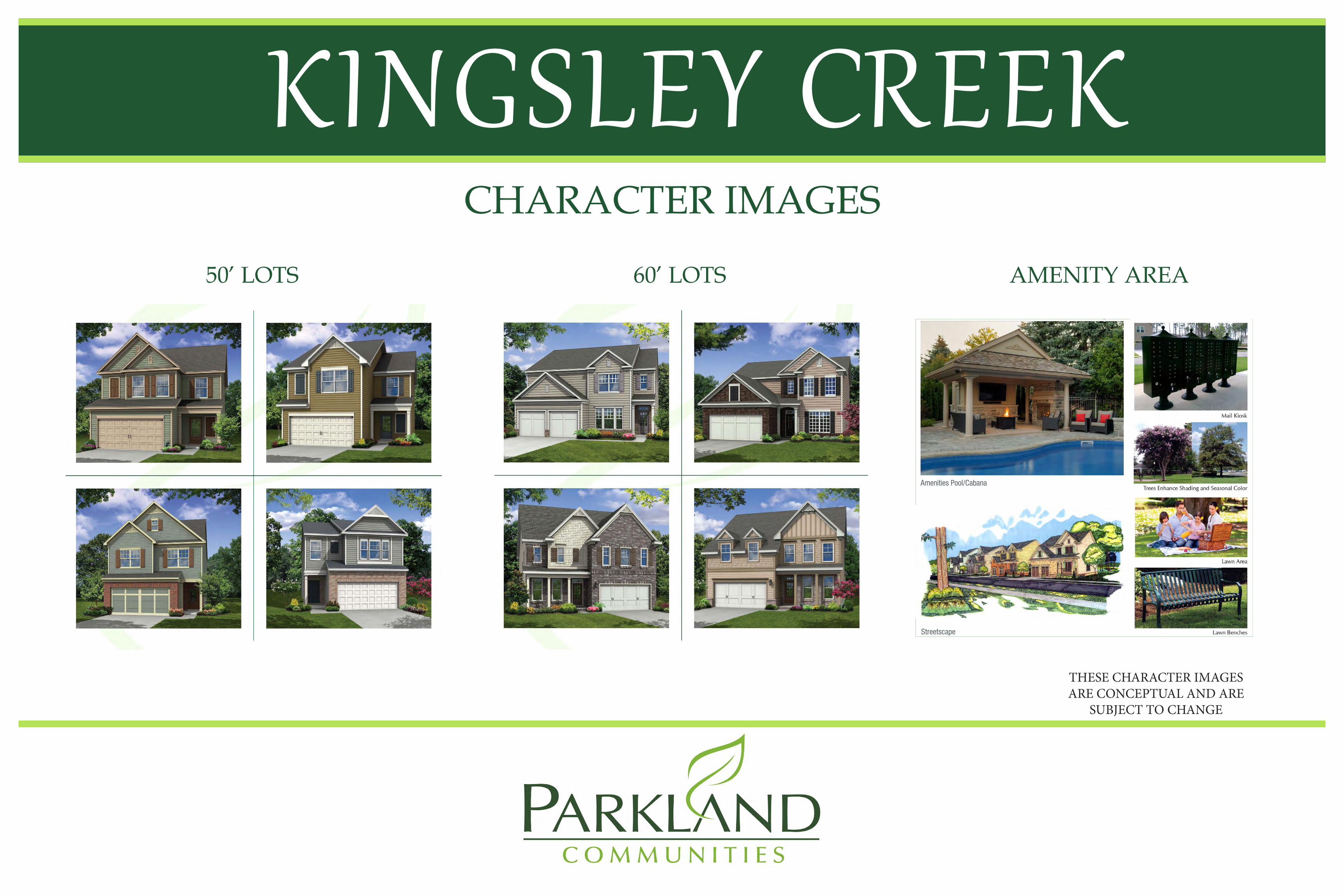
Amenities Pool/Cabana
6845 Shiloh Rd East | Suite D-2 | Alpharetta, GA 30005 | parklandco.com
Streetscape
Character Images
KINGSLEY CREEK
Amenities Pool/Cabana
6845 Shiloh Rd East | Suite D-2 | Alpharetta, GA 30005 | parklandco.com
Streetscape
Character Images
50’ LOTS 60’ LOTS
CHARACTER IMAGES
AMENITY AREA
THESE CHARACTER IMAGES ARE CONCEPTUAL AND ARE
SUBJECT TO CHANGE

STATEMENT OF INTENT AND IMPACT ANALYSIS
and
Other Material Required by
DeKalb County Zoning Ordinance for the
Application for Rezoning
of
Parkland Communities, Inc. c/o Battle Law, P.C.
for
45.096± acres of land located at 1467 and 1503 Stephenson Road
Submitted for Applicant by:
Michèle L. Battle, Esq. Battle Law, P.C. One West Court Square, Suite 750 Decatur, Georgia 30030 Phone: (404) 601-7616 Fax: (404) 745-0045 Email: [email protected]

2
I. STATEMENT OF INTENT
The Applicant, Parkland Communities, Inc., is seeking to rezone the properties located at
1467 and 1503 Stephenson Road, Lithonia, Unincorporated DeKalb County, GA having an
aggregate acreage of 45.096 acres (the “Subject Property”) from R-100 to RSM for the
development of a 160 unit single family detached subdivision at a density of 3.54 units per acre.
The Subject Property has a land use designation of Suburban.
This document is submitted both as a Statement of Intent regarding this Application, a
preservation of the Applicant’s constitutional rights, and the Impact Analysis of this Application
as required by the DeKalb County Zoning Ordinance. A surveyed plat and conceptual site plan of
the Subject Property controlled by the Applicant has been filed contemporaneously with the
Application, along with other required materials.
II. IMPACT ANALYSIS
(a) Suitability of use: The proposed rezoning will allow for the development of residential
lots at a density that is suitable for the area considering the existing uses and zoning
classifications in the area. The Subject Property is located on Stephenson Road, and all
ingress and egress to the Subject Property will be through Stephenson Road. The Subject
Property wraps around the Cross of Calvary Baptist Church located at 1451 Stephenson
Road, which is zoned R-100. Abutting the Subject Property are three residential
subdivisions which are zoned RSM, being Breckenridge Estates, and Units 1 and 2 of the
Greystone Subdivision. Additionally, the Stonebrook and Stonemill Manor Subdivisions,
which are also zoned RSM, are across the street on the North side of Stephenson Road. It
is the Applicant’s intent to develop the Subject Property to allow for the building of two

3
story homes which have a minimum square footage of 1,800 sq. ft., with an anticipated
minimum sales price of $225,000, without any interior upgrades. .
(b) Effect on adjacent property: The proposed development will have a positive impact on
the surrounding community, as it will support the continued recovery of the area from the
2007 economic downturn which devastated South DeKalb. The proposed homes will be
sold at a price point which will be in excess of many of the surrounding values.
Furthermore, the community will have sidewalks, pedestrian scale lighting, greenspace
areas around the perimeter of the subdivision, as well as trees plated throughout the
community, a mulched walking trail, an amenity area, a pocket park and a mandatory
homeowners association, all of which enhance the viability and marketability of the
community
(c) Effect on public facilities: The Subject Property is in an area with public utility
availability. The proposed rezoning will not cause excessive use of streets, transportation
facilities, or utilities in the area. The Applicant will be installing sidewalks along
Stephenson Road, which will support the continued improvement of the Stephenson Road
right of way.
(d) Economic use of current zoning: The Subject Property has minimal use as currently zoned
R-100. The development of large lot single family homes is not currently marketable in
the area as the sales prices of the homes and lots would be significantly higher than current
market rates due to building and infrastructure costs. Additionally, smaller residential lots
reduce the impact of continue urban sprawl and allows for homes to be built which support
working families.
4
(e) Effect on historic building, sites, etc. The approval of this Application will not have any
adverse impact on any historic buildings, sites, districts or archaeological resources in the
area.
(f) Compatibility with Comprehensive Land Use Plan. The Subject Property has a land use
designation of Suburban which supports the RSM zoning district.
IV. CONCLUSION
For the foregoing reasons, the Applicant respectfully requests that the Land use
Amendment Application at issue be approved. Please note that the Applicant’s Notice of
Constitutional Allegations and Preservation of Constitutional Rights have been submitted with this
Application and are attached hereto and by this reference incorporated herein.
This 26th day of February, 2020.
Respectfully submitted,
__________________________ Michèle L. Battle, Esq. Attorney For Applicant

5
NOTICE OF CONSTITUTIONAL ALLEGATIONS AND PRESERVATION OF
CONSTUTIONAL RIGHTS
The portions of the DeKalb County Zoning Ordinance, facially and as applied to the Subject Property, which restrict or classify or may restrict or classify the Subject Property so as to prohibit its development as proposed by the Applicant are or would be unconstitutional in that they would destroy the Applicant’s property rights without first paying fair, adequate and just compensation for such rights, in violation of the Fifth Amendment and Fourteenth Amendment of the Constitution of the United States and Article I, Section I, Paragraph I of the Constitution of the State of Georgia of 1983, Article I, Section III, Paragraph I of the Constitution of the State of Georgia of 1983, and would be in violation of the Commerce Clause, Article I, Section 8, Clause 3 of the Constitution of the United States.
The application of the DeKalb County Zoning Ordinance to the Subject Property which
restricts its use to any classification other than that proposed by the Applicant is unconstitutional, illegal, null and void, constituting a taking of Applicant’s Property in violation of the Just Compensation Clause of the Fifth Amendment to the Constitution of the United States, Article I, Section I, Paragraph I, and Article I, Section III, Paragraph I of the Constitution of the State of Georgia of 1983, and the Equal Protection and Due Process Clauses of the Fourteenth Amendment to the Constitution of the United States denying the Applicant an economically viable use of its land while not substantially advancing legitimate state interests.
A denial of this Application would constitute an arbitrary irrational abuse of discretion and
unreasonable use of the zoning power because they bear no substantial relationship to the public health, safety, morality or general welfare of the public and substantially harm the Applicant in violation of the due process and equal protection rights guaranteed by the Fifth Amendment and Fourteenth Amendment of the Constitution of the United States, and Article I, Section I, Paragraph I and Article I, Section III, Paragraph 1 of the Constitution of the State of Georgia.
A refusal by the DeKalb County Board of Commissioners to rezone the Subject Property
to the classification as requested by the Applicant would be unconstitutional and discriminate in an arbitrary, capricious and unreasonable manner between the Applicant and owners of similarly situated property in violation of Article I, Section I, Paragraph II of the Constitution of the State of Georgia of 1983 and the Equal Protection Clause of the Fourteenth Amendment to the Constitution of the United States. Any rezoning of the Property subject to conditions which are different from the conditions requested by the Applicant, to the extent such different conditions would have the effect of further restricting Applicant’s utilization of the property, would also constitute an arbitrary, capricious and discriminatory act in zoning the Subject Property to an unconstitutional classification and would likewise violate each of the provisions of the State and Federal Constitutions set forth hereinabove.
A refusal to allow the rezoning in questions would be unjustified from a fact-based
standpoint and instead would result only from constituent opposition, which would be an unlawful delegation of authority in violation of Article IX, Section II, Paragraph IV of the Georgia Constitution.

6
A refusal to allow the rezoning in question would be invalid inasmuch as it would be denied
pursuant to an ordinance which is not in compliance with the Zoning Procedures Law, O.C.G.A Section 36-66/1 et seq., due to the manner in which the Ordinance as a whole and its map(s) have been adopted.
The existing zoning classification on the Subject Property is unconstitutional as it applies
to the Subject Property. This notice is being given to comply with the provisions of O.C.G.A. Section 36-11-1 to afford the County an opportunity to revise the Property to a constitutional classification. If action is not taken by the County to rectify this unconstitutional zoning classification within a reasonable time, the Applicant is hereby placing the County on notice that it may elect to file a claim in the Superior Court of DeKalb County demanding just and adequate compensation under Georgia law for the taking of the Subject Property, diminution of value of the Subject Property, attorney’s fees and other damages arising out of the unlawful deprivation of the Applicant’s property rights.

kimley-horn.com 11720 Amber Park Drive, Suite 600, Alpharetta, GA 30009 770 619 4280
MEMORANDUMTo: Jim Jacobi, Parkland Communities, Inc.
From: John D. Walker, P.E., PTOEJin Seo, P.E.
Date: February 24, 2020
RE: Stephenson Road Tract – DeKalb County – Trip Generation Memo
Kimley-Horn is pleased to provide this memorandum regarding the project trip generation for theproposed Stephenson Road Tract development in DeKalb County, Georgia.
PROJECT OVERVIEW
The Stephenson Road Tract development (located at 1467 and 1503 Stephenson Road) is a proposedresidential development bordered by Stephenson Road to the north in DeKalb County, Georgia. Theproposed development consists of approximately 160 single-family lots.
TRIP GENERATION
Project traffic, for the purposes of this evaluation, is defined as the vehicle trips expected to begenerated by the proposed development. Anticipated trip generation for the Stephenson Roaddevelopment was calculated using rates and equations contained in the Institute of TransportationEngineers’ (ITE) Trip Generation Manual, 10th Edition, 2017. This analysis generated the project tripsusing the following land use: Single-Family Detached Housing (ITE Code 210).
The proposed density and the anticipated project trip generation are summarized in Table 1.

Jim Jacobi, February 24, 2020
K:\ALP_TPTO\019380008_Stephenson Road Trip Gen Memo - February 2020\Memo\2020-02-24-Stephenson Road_Memo.docx
kimley-horn.com 11720 Amber Park Drive, Suite 600, Alpharetta, GA 30009 770 619 4280
Table 1: Trip Generation
Land Use Density ITECode
Daily Traffic AM Peak Hour PM Peak Hour
Total Enter Exit Total Enter Exit Total Enter Exit
Single-FamilyDetachedHousing
160units 210 1,602 801 801 118 30 88 160 101 59
Total 1,602 801 801 118 30 88 160 101 59Note: No reductions for alternative transportation modes (walking, cycling, transit, carpooling, etc.), mixed-use, or pass-by were taken.
As shown in Table 1, the proposed development is projected to generate 1,602 total daily trips (801 in;801 out), 118 total AM peak hour trips, and 160 total PM peak hour trips.
We hope this information is helpful. If you have any questions concerning this letter or need additionalinformation, please do not hesitate to contact me.
Sincerely,
KIMLEY-HORN AND ASSOCIATES, INC.
John D. Walker, P.E., PTOE Jin Seo, P.E.Senior Vice President/Senior Associate Project Engineer
Attachments:l Trip Generation Analysisl Proposed Site Plan

Land Use Daily AM Peak Hour PM Peak HourTrips Total In Out Total In Out
Proposed Site Traffic210 Single-Family Detached Housing 160 d.u. 1,602 118 30 88 160 101 59
Gross Trips 1,602 118 30 88 160 101 59Residential Trips 1,602 118 30 88 160 101 59
Mixed-Use Reductions 0 0 0 0 0 0 0Alternative Mode Reductions 0 0 0 0 0 0 0Adjusted Residential Trips 1,602 118 30 88 160 101 59
Mixed-Use Reductions - TOTAL 0 0 0 0 0 0 0Alternative Mode Reductions - TOTAL 0 0 0 0 0 0 0Pass-By Reductions - TOTAL 0 0 0 0 0 0 0New Trips 1,602 118 30 88 160 101 59Driveway Volumes 1,602 118 30 88 160 101 59
k:\alp_tpto\019380008_stephenson road trip gen memo - february 2020\analysis\[2020-02-24-stephenson-road.xlsm]trip generation
Trip Generation Analysis (10th Ed. with 2nd Edition Handbook Daily IC & 3rd Edition AM/PM IC)
Intensity
Stephenson Road Tract DevelopmentDeKalb County, GA