Embed Size (px)
Citation preview
ANC Timber Ltd. - FMA Operating Ground Rules
i
ANC Timber Ltd. FMA Timber Harvest Planning and Operating Ground
Rules
ANC Timber Ltd. - FMA Operating Ground Rules
ii
2016
ANC TIMBER LTD.
FMA OPERATING GROUND RULES
ANC Timber Ltd.
ALBERTA AGRICULTURE and FORESTRY
ENDORSEMENTS
The ANC Timber Ltd. FMA Operating Ground Rules, having been prepared in accordance with Section 16(2) of FMA O.C. 8900026, and hereby endorsed this 28th day of September, 2016. The Executive Director of Forest Management Branch has determined that these ground rules will apply to all operations within FMA 8900026. ANC Timber Ltd. HER MAJESTY THE QUEEN in right of Alberta as
represented by the Minister of Agriculture and Forestry
Per: __________________________________________
Per: __________________________________________:
__________________________________________
(print name)
__________________________________________
(print name) __________________________________________
(title) __________________________________________
(title)
Original Signed Original Signed
ANC Timber Ltd. - FMA Operating Ground Rules
iii
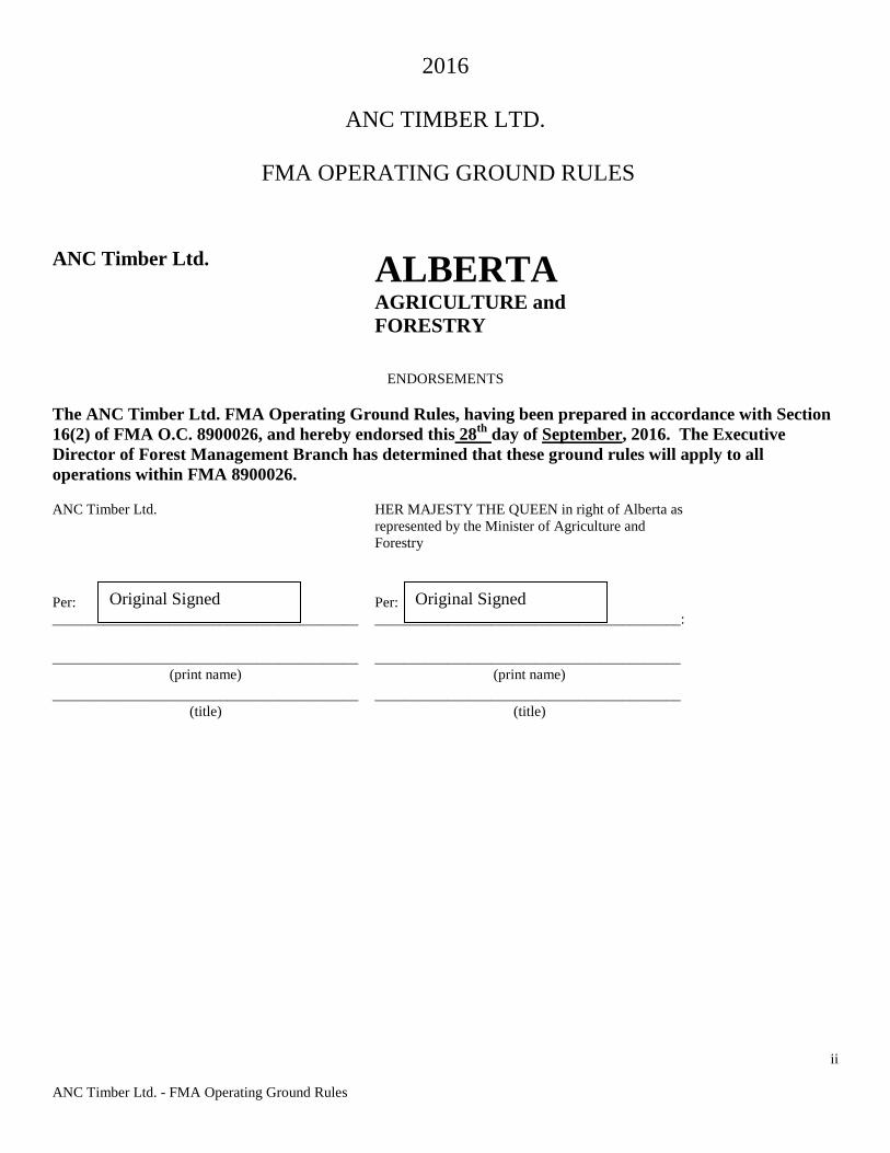
ANC Timber Ltd. Operating Ground Rules Revisions from 2015 to 2016
(Effective Date: September 1, 2016)
2016 Revisions Ground Rule
Number 2015 Version of the Ground Rule 2016 Version of the Ground Rule
General
Some edits were made outside of the joint review that included deletion of word(s), correction of spelling & grammar, changes to bolded text, etc., which did not change the intent, meaning or requirements of the OGRs, but rather to provide clarification. These changes are not documented in this table.
3.5 Annual Operating Plan Purpose
To annually authorize all road, harvest and forest management activities for the operator.
To annually authorize all road, harvest and forest management activities for the operator as previously approved in a Forest Harvest Plan (FHP).
3.5.4 c) III. Declaration of outstanding operational items, or an agreement with Alberta on reporting of outstanding operational items.
Declaration of outstanding operational items as per12.03 or alternative agreement with Alberta on reporting format.
Table 2. Standards and Guidelines for Operating Beside Watercourses
Roads, Landings, Decking and Bared Areas Roads, Landings, and Bared Areas
11.4.3.7 a) Decompacting and returning them to an acceptable landform;
Decompacting (if required) and returning them to an acceptable landform;
12.0.4
The company shall submit an as built plan to Alberta at an agreed upon time or by September 1 each year that includes digital shape files or other approved digital format of harvest boundaries, road location, and added watercourse crossings from the previous year’s harvest.
The company shall submit an as built plan to Alberta at an agreed upon time or by November 1 each year that includes digital shape files or other approved digital format of harvest boundaries, road location, and added watercourse crossings from the previous year’s harvest.
ANC Timber Ltd. - FMA Operating Ground Rules
iv
TABLE OF CONTENTS 1.0 GROUND RULE SCOPE……………………………………………………………..1
1.1 REGULAR REVIEWS…………………………………………………………………………..1 2.0 THE TOPICS…………………………………………………………………………..1 3.0 OPERATIONAL PLANNING………………………………………………………..2
3.1 PLANNING PROCESS………………………………………………………………………….2 3.2 COMPARTMENT ASSESSMENT……………………………………………………………..3 3.3 GENERAL DEVELOPMENT PLAN…………………………………………………………...3 3.4 FOREST HARVEST PLAN…………………………………………………………………….5 3.5 ANNUAL OPERATING PLAN………………………………………………………………...8 3.6 SALVAGE PLANNING………………………………………………………………………..10
4.0 UTILIZATION………………………………………………………………………..11
4.1 STAND UTILIZATION………………………………………………………………………...11 4.2 TREE UTILIZATION……………………………………………………………………….….13
5.0 INTEGRATION WITH OTHER USERS…………………………………………..15
5.1 DECIDUOUS/CONIFEROUS INTEGRATION……………………………………………….15 5.2 FOREST RECREATION AND TOURISM……………………………………………………15 5.3 TRAPPING……………………………………………………………………………………..16 5.4 RANGE MANAGEMENT……………………………………………………………………..16 5.5 FOREST AESTHETICS………………………………………………………………………..17 5.6 HISTORICAL RESOURCES…………………………………………………………………..18
6.0 WATERSHED PROTECTION……………………………………………………...19
TABLE 1. WATERCOURSE CLASSIFICATION……………………………………………………………… … 21 TABLE 2. STANDARDS AND GUIDELINES FOR OPERATING BESIDE WATERCOURSES…………… … … … … … … … … … … … … … … … ….23
7.0 HABITAT MANAGEMENT………………………………………………………...26
7.1 LANDSCAPE PLANNING ……………………………………………………………………26 7.2 DEBRIS MANAGEMENT………………………………………………………………… ….27 7.3 STRUCTURE RETENTION………………………………………………………………..…..28 7.4 UNDERSTOREY PROTECTION………………………………………………………… …..30 7.5 FISHERIES AND THE AQUATIC ENVIRONMENT………………………………………...30 7.6 SPECIES OF SPECIAL CONCERN…………………………………………………………...32
8.0 SILVICULTURE……………………………………………………………………..39
8.1 PLANNING…………………………………………………………………………………….39 8.2 REFORESTATION PROGRAM………………………………………………………………40 8.3 SILVICULTURE OPERATIONS……………………………………………………………...41
ANC Timber Ltd. - FMA Operating Ground Rules
v
9.0 SOILS………………………………………………………………………………….43 10.0 FOREST HEALTH/PROTECTION………………………………………………..46
10.1 INSECT AND DISEASE………………………………………………………………………46 10.2 WEED MANAGEMENT………………………………………………………………………47
11.0 ROADS………………………………………………………………………………..48 11.1 ROAD CLASSIFICATION……………………………………………………………………48 TABLE 3. ROAD CLASSIFICATION AND DESIGN………………………………………………………..49 TABLE 3A – ROAD CLASSIFICATION FOR THE CARIBOU AREA……………………………………51
11.2 ROAD PLANNING AND DESIGN…………………………………………………………...52 11.3 ROAD CONSTRUCTION, MAINTENANCE AND RECLAMATION……………………,..53 11.4 WATERCOURSE CROSSINGS……………………………………………………………....57
TABLE 4 – ACCEPTABLE CROSSING STRUCTURES……………………………………………………57 11.5 ACCESS CONTROL…………………………………………………………………………..61 11.6 CAMPS AND FACILITIES…………………………………………………………………...62
12.0 REPORTING…………………………………………………………………………63 FIGURE 1 PLANNING FLOWCHART……………………………………………………1 FIGURE 2 SOIL COMPACTION AND RUTTING RISK DIAGRAM………………….45 APPENDIX 1 RFP ROLE OF REGULATED FORESTRY PROFESSIONALS (RFP) IN FOREST MANAGEMENT………………………………………………………………….64 APPENDIX 2 DEBRIS MANAGEMENT STANDARDS FOR TIMBER HARVESTING OPERATIONS………………………………………………………………………………..66 APPENDIX 3 DIRECTIVE FOR WEED MANAGEMENT……………………………...69 APPENDIX 4 GLOSSARY………………………………………………………………….74 APPENDIX 5 FHP/AOP CHECKLISTS…………………………………………………...85
ANC Timber Ltd. - FMA Operating Ground Rules
1
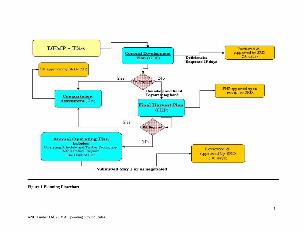
Figure 1 Planning Flowchart

ANC Timber Ltd. - FMA Operating Ground Rules
1
ANC Timber Ltd. - FMA Operating Ground Rules 1.0 GROUND RULE SCOPE
The following ground rules apply to the FMA holder and all other timber disposition holders authorized under the Forests Act and Timber Management Regulation operating within the FMA area. Ground rules are the practices used in planning and conducting forest management operations which constitute the methods used to implement decisions made in the FMP and other higher level plans such as Plans under the Land Use Framework and Integrated Resource Plans (IRP). In the event that these strategic plans do not exist, the ground rules shall establish practices that minimize the chance of negative impacts from forest management operations. Authorizations by Alberta do not imply authorization under federal legislation and requirements, notably the federal Fisheries Act and Migratory Birds Convention Act. The proponent must seek advice and approvals of the federal agencies (Department of Fisheries and Oceans, Environment Canada) regarding federal legislation requirements.
1.1 REGULAR REVIEWS
The intent is to have an annual review of ground rules if requested by either forest disposition holders or Alberta. This is not meant to be a complete redevelopment but rather an opportunity to fine-tune the ground rules. It is expected that regular reviews will allow participants to plan revisions more systematically and to correct any inconsistencies or problems. It will also create the ability to regularly consider modifications that reflect the best and most current knowledge and tools available. Changes made to the ground rules during the review will require the updated document to be signed by Alberta and the company.
2.0 THE TOPICS
Each topic includes a purpose, discussion, and ground rule heading. PURPOSE
A statement of what the topic is designed to accomplish. DISCUSSION
Include background information, research knowledge, and reasons for the concern. The discussion shall focus on why a ground rule is needed. Alternative actions or solutions could also be discussed here.
GROUND RULES
These are definitive statements of the desired results to be achieved and a clear indication of what is expected. The ground rules shall be relevant, measurable, understandable and achievable. A summary of the ground rules constitutes a checklist necessary for RFP validation.
ANC Timber Ltd. - FMA Operating Ground Rules
2
3.0 OPERATIONAL PLANNING 3.1 PLANNING PROCESS PURPOSE
The operational planning process is designed to expedite the implementation of the DFMP. Where management direction has not been established through an approved DFMP, then required decisions shall be made during this operational planning process.
DISCUSSION
The planning process includes five main components: 1. Approved Detailed Forest Management Plan (DFMP)
Spatial Harvest Sequence (SHS) for first two 10-year periods
2. Compartment Assessment (CA) – A CA shall be required when information or major issues are identified that in Alberta’s opinion, have not been addressed in the DFMP. In the event that the SHS is deemed by Alberta to be inappropriate due to a significant change in circumstances since the approval of the FMP, a compartment assessment describing current issues shall be required. (see section 3.2)
3. General Development Plan (GDP) The GDP gives a comprehensive description of a
forest operator's proposed harvest strategy, road building plans, and reclamation operations for a five-year period, and includes all licences and permits. The GDP is used to guide integration of activities. (See section 3.3)
4. Forest Harvest Plan (FHP) – The FHP is a map and associated report describing the laid
out harvest plan. (See section 3.4) 5. Annual Operating Plan (AOP) – The AOP describes operations in detail through a
series of components that shall be submitted together at the same time, or as individual submissions on a schedule approved by Alberta: a) Operating Schedule and Timber Production b) Applicable Forest Harvest Plans c) General Development Plan d) Compartment Assessments as required e) Reforestation Program f) Fire Control Plan g) Road Plan (See section 3.5)
ANC Timber Ltd. - FMA Operating Ground Rules
3
3.2 COMPARTMENT ASSESSMENT (CA) PURPOSE
To address significant issues that has arisen since the approval of the FMP.
DISCUSSION
It is recognized that circumstances change over time and it is possible that the SHS approved in the FMP may prove to be inappropriate. Where Alberta deems it necessary, a CA shall be completed to adjust the operational plan for the area. CAs are necessary when major new issues or information that have been identified since FMP approval make the SHS inappropriate. (E.g., Forest fire, insect or disease, species of special management concern, a major change in land use direction or an unacceptable variance of >20% of the SHS/compartment/ decade as determined by the Delegated Authorities at the Region (or Area) and FMB) The CA shall describe how the new issues will be incorporated into the FHP. In completing the CA, operators must consult in a meaningful way with stakeholders and strive to reach general agreement on issues. The CA provides an opportunity to reconsider management strategies at the time of operational planning if warranted.
GROUND RULES
3.2.1 Alberta shall decide on the boundaries of the area on which a CA is required after consultation with the forest disposition holder.
3.2.2 If a CA is required, the operator must receive Alberta’s approval for the CA prior
to the submission of a FHP. Compartment assessments will normally be approved within 30 days.
3.2.3 A CA is considered current if it has been approved by Alberta and the FHP is
submitted to Alberta within three years of approval. The approval of the CA will include a timeline that the CA will remain valid.
3.2.4 The CA shall include any maps, analyses, and reports deemed necessary by Alberta
to adequately address the issues. Ie. Watershed flow analysis.
3.3 GENERAL DEVELOPMENT PLAN (GDP)
PURPOSE
To provide a projection of activities for the next five years to: • Guide the integration of activities • Schedule timber disposition administration activities; • Predict cut control status; • Co-ordinate the development and reclamation of roads.
DISCUSSION
The primary components of the GDP include a forecast of the areas scheduled for harvest for a five-year period or long-term road plans outlined in the FMP. The GDP must also include the current status and forecast of the respective AACs and cut control period for each of the operators
ANC Timber Ltd. - FMA Operating Ground Rules
4
within the planning area. This could be either a joint submission by all operators or separate submissions containing consistent information between operators. In addition to outlining the projected wood supply forecast, the GDP shall also include details regarding road requirements, and fish and wildlife issues within the planning area. The company will follow Alberta’s First Nations Consultation Guidelines on Land Management and Resource Development. Alberta will provide a list of relevant first nations to the company by Dec 15th of each year or where possible earlier. It is expected that there will be substantial discussion on significant issues with Alberta before the FHP is submitted. i.e. timing constraints
GROUND RULES
3.3.1 The GDP submission date is on or before May 1 of each year unless otherwise approved by Alberta. Alberta shall respond within 15 days identifying any deficiencies in the GDP. The GDP shall be approved subject to an appraisal by Alberta. Approval will be within 30 days if the plan is complete and accurate. One digital copy (eg. .pdf) shall be submitted per Area office.
3.3.2 Prior to approval other forest operators affected by the GDP must agree or provide concerns in writing or by email to the upcoming year’s production described in the GDP. Where agreement can’t be reached see section 5.1.1. Proposed over-cuts shall not be approved outside of that allowed by the tenure document.
3.3.3 The GDP consists of the following:
1. Schedules with the following information:
a) the volumes of conifer and deciduous to be harvested each year by compartments for the next five-year period;
b) quadrant/cut control period production summary table for all of the company’s dispositions (by year); utilization standards in effect for each year. Includes volume retained for structure retention (as per section 7.4);
c) Developments showing planning and consistency with the road corridor plan;
d) all roads noted that are to be monitored, and all outstanding and anticipated reclamation work related to DLO road and stream crossings; (see 11.2.1.1)
e) a brief description of potential issues arising from the proposed harvest activities that have been identified through discussions with Alberta or other known resource users;
f) companies may seek “approval to layout” for areas outside the SHS prior to submitting a FHP;
g) where a significant change to the approved GDP is proposed, an amendment is necessary. Significant will be considered to be a change affecting another operator or an increase above the QAC.
2. A map (of appropriate scale) that shows the following: a) compartments and timber dispositions to be operated; b) other important known forest resource areas or facilities ie. Trumpeter
Swan lakes, provincial parks etc. that could be directly affected by harvesting.
ANC Timber Ltd. - FMA Operating Ground Rules
5
3.4 FOREST HARVEST PLAN PURPOSE: To describe the laid out harvest and road design DISCUSSION
The primary components of a Forest Harvest Plan (FHP) are a map and report that clearly show and document the harvest area boundaries, roads and water crossings for the harvesting area. The design shall be valid for five years from the time of approval, unless issues deemed significant by Alberta arise during this period.
GROUND RULES
3.4.1 A FHP shall be approved by acceptance if: a) validated by a RFP; b) variance less than 20% of the area sequenced in the SHS, by compartment
per decade; c) the harvest area (ha) does not exceed 100% of the total area in the SHS or
strata description table by compartment per decade as tracked in the GDP; and
d) it adheres to all ground rules as per the FHP checklist, see Appendix 5. Any deviations from the ground rules shall be listed and justification provided for Alberta review. The review will be focused on the variances with approval required by Alberta. Where the FHP does not meet standards a, b, or c, the FHP shall undergo a full review by Alberta. Variances from the SHS shall be reported annually in the FHP in a format acceptable to Alberta. (See section 4.1.1)
3.4.2 Companies have reported block and road specific ground rule deviations. 3.4.3 If a CA was completed, the FHP shall undergo a full Alberta referral and review to
ensure the direction in the CA has been implemented. 3.4.4 All FHPs submitted by operators who harvest more than 30,000 m3 each year from
Crown land, must be validated by a RFP. Validation means that, the OGRs were followed, the SHS was followed or variances identified, and all affected operators have agreed to the design. (See section 5.1.1)
3.4.5 Maps shall accurately show the following information at an appropriate scale: a) The approved forest inventory; b) Laid-out harvest areas overlying the original SHS polygons and the
proposed variance to the SHS, and where possible harvest areas of other operators;
c) Compartment boundary including all SHS polygons; d) All existing roads used to access forest operations; e) All applicable laid out Class 1 – 3 roads and corresponding watercourse
crossings and structures; f) All class 4 inter harvest area roads and proposed associated watercourse
crossings shall be laid out and shown, (crossings on ephemeral watercourses don’t need to be shown);
ANC Timber Ltd. - FMA Operating Ground Rules
6
g) Locations of access control measures where required (existing and proposed);
h) Current dispositions and reserves, e.g., Registered Trapline boundaries, permanent sample plot locations;
i) Watercourses, their classifications and where a variance from Table 2- Watercourse Protection is requested, the protective buffer;
j) Springs, water source and seepage areas within or adjacent to harvest area, k) Current information on previously harvested areas, existing trails, seismic
lines, power lines, pipelines, and l) Sensitive wildlife sites within or adjacent to harvest area as per section
7.7.6.2
3.4.6 In addition to the FHP map, the following information is required: a) Area (ha), and coniferous and deciduous volume for each proposed harvest
area; b) Summary table of variances from the SHS by compartment for each FHP
submitted (see section 4.1.1); c) Reforestation strata designation for each harvest area; d) Information required in 3.4.5 (h) may be shown in tabular format instead of
on the map, Description of how the CA is addressed in the FHP, if applicable;
e) Where applicable, access control methods employed, and f) Description of integration with other affected forest operators (see section
5.1.1). Affected means forest companies with overlapping timber dispositions operating within an FMU. Where agreement can’t be reached see section 5.1.1.
3.4.7 Shrubs and advanced growth adjacent to permanent all weather roads shall be
protected to limit the line-of-sight across the harvest area. The number of entry points into the harvest area shall be minimized.
3.4.8 Alberta permanent sample plots and protective notations as enabled by the Public
Lands Act shall not be disturbed or harvested unless such action is approved by Alberta. PSP’s shall be protected by retention of the painted buffer.
3.4.9 Detailed harvest area plans (DHAP) are required when there is higher than average
potential for environmental damage if operations are not carefully planned. Circumstances that merit DHAPs are: a) Areas of steep topography requiring specific road location and construction
or specialized harvesting equipment on slopes >45%. b) Unstable slopes are generally to be avoided but if this is not possible it is
necessary to plan operations carefully to minimize impacts. c) Harvest areas with numerous water source areas, seepages, or drainages. d) Harvest areas utilizing understorey protection using planned protection
techniques. e) Harvest areas located near high-value recreation areas or identified as
highly sensitive in the FMP e.g. Provincial Park, campground. f) Partial harvests, excluding commercial thinning (CT) and pre-commercial
thinning (PCT). g) Layout bordering or encompassing riparian management zones when
different than the standards in section 6.0. h) Important wildlife sites as defined in section 7.7.6.2 where mitigation is
different than the ground rules (this information shall be made available for resource planning purposes only through Fish and Wildlife).

ANC Timber Ltd. - FMA Operating Ground Rules
7
3.4.10 The DHAP shall include a map of appropriate scale to the issue(s) and describe how the concern will be addressed in operations. DHAPs are submitted to Alberta but do not require approval. The company may discuss the need for a DHAP with Alberta if they deem it isn’t necessary to mitigate risk.
ANC Timber Ltd. - FMA Operating Ground Rules
8
3.5 ANNUAL OPERATING PLAN PURPOSE
To annually authorize all road, harvest and forest management activities for the operator as previously approved in a Forest Harvest Plan (FHP).
DISCUSSION
The AOP articulates in detail the activities proposed for the current year and must be approved by Alberta before timber operations shall commence. The AOP components include:
a) Operating Schedule and Timber Production b) Applicable Forest Harvest Plans c) Compartment Assessments (if applicable) d) Reforestation Program e) Fire Control Plan f) Road Plan g) General Development Plan
Refer to Appendix 1 for RFP validation requirements For timber permit operators and small quota holders who harvest less than 30,000 m3 annually, Alberta has alternate AOP submission requirements.
GROUND RULES
3.5.1 The AOP submission date is May 1 of each year unless otherwise approved by Alberta. Alberta shall respond within 15 days identifying any deficiencies in the AOP. The AOP shall be approved subject to an appraisal by Alberta.
3.5.2 The Operating Schedule and Timber Production, Reforestation Program, Fire
Control Plan, and Road Plan, are submitted as in 3.5.1 above, unless otherwise agreed to by Alberta. The schedule for submitting any necessary CA, GDP and FHPs may be different.
3.5.3 Only harvest areas and roads with FHP approval shall be scheduled for operations
in the AOP submission. The AOP is a schedule of harvest areas and roads approved for operations. Changes to roads can be shown as an FHP or AOP amendment but don’t need to be shown on both.
3.5.4 The Annual Operating Plan shall contain the following components:
a) Shape files or other approved digital formats, of approved FHP harvest areas boundaries, interblock roads and crossings if not previously submitted with the FHP.
b) Administrative and Timber Production Information: I. Name of disposition holder(s) II. Number of the disposition(s) III. Date of submission and effective period IV. Location of mill where timber will be manufactured or processed,
or other reporting options. V. Where all volumes (deciduous and coniferous) will be charged
(Quota, deciduous timber allocation, Deciduous Timber Permit, FMA, Commercial Timber Permit) Community timber permit program.
VI. Proposed volume to be harvested by timber disposition.
ANC Timber Ltd. - FMA Operating Ground Rules
9
VII. Community Timber Program Operators shall include all road use agreements
VIII. Scaling methodology, e.g., weigh scale, other arrangements, (not necessary if otherwise submitted)
IX. Utilization standards X. Declaration or list of key stakeholder notifications (See Sec 5.0)
c) Operating Schedule – a table which outlines: I. List of harvest areas proposed for harvest (including area and
volume by species or species group, with totals) II. Lists of roads proposed for construction, maintenance and
reclamation for non-DLO roads, except in-harvest area roads. It includes watercourse crossings to be built or installed or removed/maintained.
III. Declaration of outstanding operational items as per12.03 or alternative agreement with Alberta on reporting format.
IV. Annual Reforestation Program (see section 8.2) d) Fire Control Plan which covers suppression equipment (see section 7.2 Fire
Management), and debris disposal, e) GDP and if applicable CA.
3.5.5 All amendments to harvest plans must be justified and submitted to Alberta in writing. RFP validation of all amendments is required. Any changes must be incorporated into the as-built plan.
3.5.5.1 Changes meeting the following criteria are considered ‘Minor
Amendments’, and require only company RFP validation and notification to Alberta. Minor Amendments don’t require Alberta’s approval, provided all appropriate background checks (eg. LSAS) have been made and rationale for the change has been provided (changes can be implemented prior to notification but must be reported on the next monthly operations summary after implementation). Changes shall not adversely affect buffers established for the protection of riparian areas, wildlife sites, historical resources, or aesthetic values. A company supervisor shall approve all minor amendments prior to the change being carried out:
a) Additions to the approved AOP harvest area boundary where the final area does not vary from the area in the approved FHP by more than five percent for blocks greater than 10ha, or more than .5 ha for blocks less than or equal to 10 ha. Any additions to block areas must be approved by a Company supervisor prior to the change being carried out. Any resulting variances from the approved SHS must be categorized and reported as per 4.1.1. This ground rule does not apply to CTP’s and DTP’s for which additions to a harvest area must be within the company’s disposition and landbase and be approved by Alberta.
b) Any deletions to block areas must be approved by a Company supervisor prior to the change being carried out and cannot exceed the variance tolerance in 3.4.1. Any resulting variances from the approved SHS must be categorized and reported as per 4.1.1. This ground rule does not apply to CTP’s and DTP’s and all deletions to a harvest area must be approved by Alberta.
c) Exterior block roads moved to existing access or conventional seismic lines where re-growth is less than 3m and within 150 m of the approved AOP access.
d) Exterior block roads requiring the development of new Right-of-Way clearing (not detailed above) that are moved up to 150m.
ANC Timber Ltd. - FMA Operating Ground Rules
10
e) The interior block roads may be moved as required, provided that no additional watercourse crossings are required outside of that allowed in (f).
f) Crossings on ephemeral or intermittent watercourses may be added and reported on the first operations report after installation.
g) Any change to the approved AOP not listed in 3.5.5.1 shall be treated as an AOP amendment and requires the approval of Alberta prior to implementation. Changes affecting previously submitted digital data require submission of a new shape file with the amendment request. Alberta will provide the company feedback and/or approval of the AOP amendment within 10 working days of the submission.
3.6 SALVAGE PLANNING PURPOSE Salvage planning shall be implemented when necessary to reduce the potential for loss of fibre. DISCUSSION
Under certain circumstances, planning shall be expedited to reduce the loss of fibre from fire, disease or insect infestation, blowdown or other such unforeseen disturbances. Salvage planning shall not be used when:
a) The disturbance regime is slow moving and can be accommodated under conventional planning timeframes and protocols.
b) The regime is not an imminent threat to green fibre. c) Fibre loss is deemed to be within an acceptable range.
Salvage planning does not confer rights to the planner to ignore other values, or the inherent value of a natural disturbance. It does allow for consideration of all values and for prompt, qualified, professional opinion to drive the process.
GROUND RULES
3.6.1 Salvage planning is initiated on the natural disturbance when deemed appropriate by Alberta through discussions with the company.
3.6.2 A FHP for the salvage area must be developed, and shall form part of the AOP.
Modified timelines and content for the FHP shall be considered by Alberta. Detailed requirements may be published from time to time by Alberta. It is expected that there will be substantial discussion to resolve significant issues with Alberta before the FHP is submitted.
ANC Timber Ltd. - FMA Operating Ground Rules
11
4.0 UTILIZATION
4.1 STAND UTILIZATION PURPOSE
Track variance from the approved FMP SHS as well as total area harvested in order to: • ensure a sustainable harvest level and future forest objectives are maintained
through operations adhering to the FMP; • improve information for the next FMP (e.g., landbase, yields); • make decisions around FHP acceptance.
DISCUSSION
The Alberta Forest Management Planning Standard, Annex 1, Section 6.0 Harvest Planning Standards indicates scheduling of stands through the FMP - SHS is dependent upon the timber merchantability criteria allocated in the disposition holder’s tenure document (e.g., FMA, quota certificate) and the management assumptions used in the timber supply analysis (TSA). Pertinent assumptions are comprised of deletions from the net landbase (e.g., subjective deletions, stream buffers, protected areas) and parameters that determine a stand’s eligibility for harvest (e.g., earliest age of harvest). The SHS results from the analysis of these TSA inputs coupled with basic field reconnaissance. The SHS identifies spatially (location) and temporally (period) the queue of stands that will produce the sustainable timber harvest level (AAC) and desired future forest condition. Adhering to the SHS is imperative to achieving the timber supply forecasts and the forest conditions expected. Variance from the SHS will not allow the FMP to realize its objectives and forecasted outcomes. Operational variance is unavoidable but must be effectively managed. Variance shall be monitored and reported where: 1) Merchantable Stands scheduled in the first decade of the SHS are not harvested in that
decade; and 2) Special Features not identified in the FMP net landbase are encountered during layout or
harvesting and are deleted from the SHS.
Timber Harvest Planning and Operating Ground Rules require timber operators to protect special features through detailed harvest planning and careful operations. (e.g., riparian buffers, steep slopes, sensitive sites, cultural/heritage sites, areas with high aesthetic value shall be removed from the SHS.)
Adhering to the SHS is imperative to achieving the timber supply forecasts and the forest conditions expected. Variance from the SHS will not allow the FMP to realize its objectives and forecasted outcomes. Operational variance is unavoidable but must be effectively managed. Definitions: Deletion – SHS area removed from the active landbase for at least one rotation. Only deletions of 1 ha and greater will be classified as variance and reported in the FHP. Examples of deletions include watercourse buffers, protected areas, inoperable ground, unmerchantable stand, land use deletion, and other. Deferred – SHS area deferred from harvest until after the 10 year SHS timeframe. These stands can still be harvested in the future and can only be treated as a deferral if there are other similar
ANC Timber Ltd. - FMA Operating Ground Rules
12
stands in the area to return to harvest during the next planning cycle. Only deferrals of 1 ha and greater will be classified as variance and reported in the FHP. Variance – Is any deletion or deferral from the SHS to the laid out harvest design as shown in the FHP (area is not harvested yet). Where the area tracked as variance as submitted in the FHP has changed by more than 5% after harvesting is complete, an update to variance shall be provided in the next submission of Variance Table 2 (see 4.1.3 below). Total SHS Area – Is defined as the total SHS area within the FHP. Area Harvested – Is the most up to date harvested area within the SHS. Additions – Area not part of the 10 year SHS that is added to the FHP harvest area. Area can only be added to the SHS polygon during layout when an equal or greater amount has been deleted or deferred. The sum of total area to be harvested and total area already harvested cannot exceed 100 % of the SHS compartment/area without moving to appraisal of the FHP. Only additions of 1 ha or greater will be reported. Where the block area has increased by more than five percent an update to additions shall be provided in the AOP amendment. Stratum – Is the yield stratum used in the FMP timber supply analysis. Compartment – Operational units of a forest management unit (FMU).
GROUND RULES
4.1.1 Companies shall report the following items in the FHP: • SHS area and SHS harvested area by decade, by stratum • Area of deletions, area of deferrals, area of additions by total and
variance expressed as a percent 4.1.2 Variance tracking will be completed on a compartment basis or other area as
agreed to by Alberta. 4.1.3 Companies shall submit a map to show the comparison of the SHS to the laid out
FHP highlighting all variance and additions >1 ha.
4.1.4 Variance from the SHS shall be monitored and reported by compartment. Cumulative variance shall be reported in the FHP. Alberta will appraise any plan exceeding 20% Variance to determine the need for a CA per section 3.2.
4.1.5 A summary shall be provided in the FHP for all deferred or deleted stands as to the
reason for deferral or deletion.
ANC Timber Ltd. - FMA Operating Ground Rules
13
4.2 TREE UTILIZATION PURPOSE
To utilize all merchantable trees and pieces in a merchantable stand as defined by the timber disposition and the FMP.
DISCUSSION
Tree utilization assumptions in the FMP must be followed so that sustainability is not affected. The allowable harvest levels in the FMP are determined on standing timber volumes using the forest inventory and yield estimates. Cull and defect have been deducted from the total volume prior to the company determining its annual allowable cut (AAC). The average amount of cull and defect scaled out by the mills approved scaling practices is what is used for this deduction.
Since cull and defect are not part of the cut, they are not required to be utilized by the company even though the fibre may be suitable for use in products using woodchips or even burning to produce energy. The company’s are responsible for utilizing the portion of the tree that has been used in determining their AAC. They may choose to utilize this additional fibre but are not required to do so by these ground rules.
GROUND RULES
4.2.1 The tree/piece utilization standards are:
Coniferous Utilization Standards 15/10 Utilization
• Merchantable Tree: one that has a minimum diameter of 15 cm outside bark at stump height (30 cm) and a usable length of 4.88 m to a 10 cm diameter (inside bark) where rot content or form does not render it unusable for the manufacture of lumber as defined by the Alberta Scaling Manual.
• Merchantable Piece: one that is 2.44 m (plus 5 cm trim allowance) or longer, with a 10 cm (inside bark) small end, where rot content or form does not render it unusable for the manufacture of lumber as defined by the Alberta Scaling Manual.
Deciduous Utilization Standards 15/10 Utilization
• Merchantable Tree: one that has a minimum stump diameter of 15 cm outside bark and a merchantable length of 4.88 m or greater to a 10 cm top diameter (inside bark), or to the point where the stem is unusable or there is no central stem due to heavy branching.
• Merchantable Piece: one that is 2.44 m or longer to a 10 cm (inside bark) small end, where rot content or form does not render it unusable.
Salvage Operations 19/13 Utilization
• This standard may be adopted by Alberta to encourage recovery of timber damaged by fire or insects and diseases in coniferous and deciduous stands.
• Merchantable Tree: one with a minimum diameter of 19 cm outside bark at stump height (30 cm) and a merchantable length of 5.0 m or greater to a
ANC Timber Ltd. - FMA Operating Ground Rules
14
13 cm top diameter (inside bark) where rot content or form does not render it unusable for the manufacture of lumber as defined by the Alberta Scaling Manual.
• Merchantable Piece: one that is 2.44 m (plus 5 cm trim allowance) or longer, to a 13 cm (inside bark) small end, where rot content or form does not render it unusable for the manufacture of lumber as defined by the Alberta Scaling Manual .
4.2.2 Company processing practices cannot make an unmerchantable piece from a merchantable tree.
4.2.3 Coniferous and deciduous log butts or large ends exhibiting advanced decay greater
than 50% in area of the cut surface (basal area) may be bucked at 0.61 m intervals until 50% (basal area) sound wood. Bucking in larger intervals is acceptable provided that the company notifies Alberta in an acceptable format (i.e. includes rationale in the required reporting as per Directive 2006-04).
4.2.4 Coniferous trees or logs (large ends) of 19 cm diameter or less, containing soft rot,
may be bucked at 0.61 m intervals to 100% clear face on both the butt and the top. For butts (large ends) greater than 19 cm in size, the normal bucking rules shall apply.
4.2.5 Maximum stump height when measured from ground level shall be no more than 30
cm or that used in the timber supply analysis for the FMP (e.g., 15 cm.). Where stumps are left to delineate areas (e.g., harvest areas, pipelines, create rub posts for understorey protection, or to delineate watercourses) they shall be approximately 30 m apart on linear boundaries (may be closer on small patches or in understorey protection) and approximately 2 m high.
4.2.6 As per the Debris Management and Structure Retention ground rules, forest operators are permitted to leave merchantable volume in harvest areas if the approved FMP identifies specific stand structure retention strategies. In the absence of FMP guidance, the standards in section 7.4 apply.
4.2.7 All trees/pieces used in the construction of crossing structures may be scattered or
piled along the right-of-way or in the harvest area, but they shall not be left piled in riparian areas. It is acceptable to use these pieces for erosion control on the road bed.
ANC Timber Ltd. - FMA Operating Ground Rules
15
5.0 INTEGRATION WITH OTHER USERS 5.1 DECIDUOUS/CONIFEROUS INTEGRATION PURPOSE
To ensure that planning, harvesting and reforestation in overlapping dispositions are carried out efficiently and with a minimum of environmental impact.
DISCUSSION
Due to overlapping tenures, integration of activities between the various operators is essential. Alberta monitors the integration of roads and harvesting, but the responsibility for co-ordinating plans and operations lies with the operators. Integration of activities is necessary to:
a) Reduce the amount of time roads are open b) Reduce disturbance of wildlife c) Enable prompt reforestation
GROUND RULES
5.1.1 All operators with timber dispositions potentially affected by a FHP or GDP must
agree to the FHP and GDP before approval is granted. If agreement cannot be reached after all meaningful consultation has taken place, the following dispute resolution process can be implemented. Areas of disagreement will be documented and forwarded to the ESRD Senior Forester for review with the reviewing forester. Depending on the exact nature of the disagreement, ESRD will either: 1) facilitate a dispute resolution process, or 2) direct the operators on areas of disagreement through conditions of approval.
5.1.2 All roading, harvesting and silviculture operations shall be completed at a time and
in a manner that enables effective reforestation and minimizes road access. 5.2 FOREST RECREATION AND TOURISM PURPOSE
To manage the implications of forest management activities on forest recreation.
DISCUSSION
Forest management activities can impact recreational opportunities. Potential exists for increased public awareness and for increased recreational opportunities through co-ordination with forest management practices. The FMP may have addressed recreational issues through a variety of tactics.
GROUND RULES
5.2.1 Operational tactics to mitigate impacts on recreation and tourism shall be described in the GDP, FHP, or CA where required.
ANC Timber Ltd. - FMA Operating Ground Rules
16
5.2.2 The forest operator shall work with stakeholders that have raised concerns with the operator or have been identified by Alberta.
5.2.3 Roads should be planned to avoid recreation sites. Roads shall be designed to
minimize their impact on the recreation values of the area.
5.2.4 FHPs affected by recreational sites should provide opportunities for the enhancement of existing recreational trail and road systems whenever possible.
5.3 TRAPPING PURPOSE
To avoid damage to the infrastructure associated with Registered Fur Management Areas (RFMA) and to reduce the impact on trapping opportunities.
DISCUSSION
Communication with the owner and/or operator of a trapline is a key element in minimizing the impact of timber operations. Discussions held early in the planning process allow both the trapper and the forest operator to work co-operatively, with the least amount of disruption to their individual operations. Upon request the local Fish and Wildlife office shall provide the relevant list of trappers to the forest operators.
GROUND RULES
5.3.1 A representative of the forest operator shall personally contact, or send a registered
letter or equivalent notification to the senior partners of a RFMA during the preparation of the FHP. Information provided by the trapper such as cabin locations, trails and other improvements, or concerns shall be noted at this stage. During the development of the FHP information and concerns shall be addressed. The forest operator shall provide the trapper with a harvest design map to appropriate scale.
5.3.2 At least ten days prior to commencing operations, the forest operator shall notify
the trapper, preferably by personal contact that timber operations are beginning in the RFMA.
5.4 RANGE MANAGEMENT PURPOSE
To integrate forest and range management operations. DISCUSSION
The goal is to develop a co-operative, long-term relationship between grazing disposition holders and forest operators to sustain fibre and forage resources. At the GDP, FHP and AOP stages of planning, the emphasis is to integrate harvesting, silviculture, and grazing schedules to ensure the sustainability of timber, forage, wildlife and watershed values (i.e., wildlife habitat, watershed protection). Specific harvesting and reforestation operations and grazing systems would be identified within components of the AOP.
ANC Timber Ltd. - FMA Operating Ground Rules
17
Effective communication between the timber and grazing operators is necessary. Discussions held early in the planning process are intended to enable the grazing disposition holder and the forest operator to work co-operatively minimizing the disruption to their individual operations. Discussions from the beef/timber report are ongoing at the provincial level and results from the provincial beef/timber integration committee will be implemented upon their approval.
GROUND RULES
5.4.1 The forest operator shall follow the requirements of Directive 2006-1.
5.5 FOREST AESTHETICS PURPOSE
To manage the visual impact of timber operations on the forest landscape. DISCUSSION
The objective is to mitigate the impact of timber operations on the visual quality of the forest landscape by:
• Identifying the location of forest landscapes and other areas of high visual and scenic
value, and setting objectives for their management; • Addressing visual quality issues in the FMP. Areas considered highly sensitive are those:
a) Within, adjacent to or viewed from recreational sites and tourist developments; b) Seen from elevated viewpoints; c) Adjacent to or viewed from major travel corridors (roads, lakes and rivers);
rural/urban forest interface and site-specific areas identified during the referral and public review process; or
d) Adjacent to primary and secondary highways in Alberta. Tactics to reduce the impacts of timber harvest and reforestation on visual quality may include: retention of forest structure and lesser vegetation at strategic vantage points in the harvest area, modification of harvest area design, low impact scarification techniques, vegetative buffers, and utilizing natural topography.
GROUND RULE
5.5.1 Highly sensitive areas shall be assessed and tactics shall be identified in the FHP to mitigate the impacts of harvesting and reforestation on visual quality.
5.5.2 Where the approved FMP identified highly sensitive areas and tactics, these areas will be identified in the FHP and a description of the mitigating tactics provided.

ANC Timber Ltd. - FMA Operating Ground Rules
18
5.6 HISTORICAL RESOURCES PURPOSE
To ensure that forest operators identify and protect historical and cultural resources. DISCUSSION
There are many historical resources (as defined by the Historical Resources Act), located on Alberta’s Crown land. In keeping with the requirements of Alberta Community Development, forest operators shall develop and implement a process for identifying and protecting resources that are regulated by the Historical Resources Act.
GROUND RULES
5.6.1 Historical resource records are confidential and shall not to be shared with the public.
5.6.2 If a previously unknown historical resource is discovered during road building,
harvesting, or silviculture operations, the operations that may directly affect the historical resource shall cease and Alberta Culture shall be notified.
ANC Timber Ltd. - FMA Operating Ground Rules
19
6.0 WATERSHED PROTECTION PURPOSE To manage the implications of timber operations on water quality, quantity, and flow regime by:
• minimizing the potential for sedimentation in watercourses, • preventing soil, logging debris and deleterious substances from entering watercourses, • maintaining aquatic and terrestrial habitat, and • complying with the Water Act.
DISCUSSION
The FMP shall address watershed water quantity and flow issues. Ground rules define operating practices to protect water quality and riparian values. Riparian areas adjacent to watercourses and water source areas perform a number of ecological functions. Riparian areas help to regulate stream flows (storage and release of surface and groundwater), reduce sheet, rill and gully erosion, and moderate stream temperature. Functional riparian areas provide bank stability, debris for creating aquatic habitats and provide a source of food and nutrients for aquatic organisms. Riparian areas also provide habitats supporting a high diversity of wildlife species and other terrestrial biota, and provide corridors that can link different landscape and habitat features. Authorizations by Alberta do not imply authorization under federal legislation and requirements, notably the federal Fisheries Act. The proponent must seek advice and approvals of the federal agencies (Department of Fisheries and Oceans) regarding federal legislation requirements.
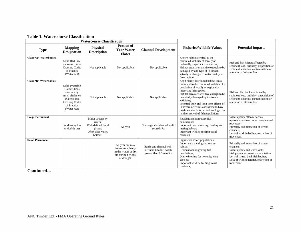
GROUND RULES
6.1 Watercourses shall be classified according to Table 1, Watercourse/Waterbody Classification. In the event the channel classification is not distinctly evident, the width shall be determined by the average of measurements taken at 50 m intervals at representative points of undisturbed stream channel over the length of the watercourse bordering the block. • A minimum of four measurements are required with the measurement
location flagged for audit purposes. • The channel width is measured from where the bank begins to slope down
towards the channel bottom across to the same point on the opposite bank. • Where the distance bordering the block is not enough for four
measurements reduce the measurement interval as required. 6.2 Measures shall be implemented, including temporary and permanent erosion
control measures, to minimize erosion and prevent sedimentation from entering a watercourse or waterbody as a result of the company’s operations.
6.3 Riparian protection areas shall be established as in Table 2, Standards and
Guidelines for Operating beside Watercourses. Where uncertainty exists on the classification of the watercourse, the watercourse protection area shall be that required by the higher class of watercourse.
6.4 All watercourses shall be given the appropriate protection as described in Table 2.

ANC Timber Ltd. - FMA Operating Ground Rules
20
6.5 Variances from the standards in Table 2 must demonstrate that aquatic and terrestrial objectives are met. Any such proposals shall undergo a full review by Alberta prior to being considered for approval.
6.6 Sediment, logging debris or deleterious materials (e.g., fuels, oils, greases, industrial
or household chemicals or refuse) shall not be deposited into the water or onto the ice of any watercourse or water body during road construction, maintenance, harvesting, reclamation or silviculture operations.
6.7 Only crossings meeting the requirements of section 11.4 shall be used by equipment
to cross watercourses. 6.8 Logs shall not be decked in watercourses, riparian areas, or seepage areas. 6.9 Authorized in-stream activities in fish-bearing watercourses shall be scheduled to
avoid disturbing migration, spawning and incubation of fish species, and carried out in such a manner as to avoid stream sedimentation.
6.10 Beaver ponds shall have the same classification as the watercourse flowing out of the
pond as measured at the smallest width within 50m of the dam.
ANC Timber Ltd. - FMA Operating Ground Rules
21
Table 1. Watercourse Classification Watercourse Classification
Fisheries/Wildlife Values Potential Impacts Type Mapping Designation
Physical Description
Portion of Year Water
Flows Channel Development
Class “A” Waterbodies Solid Red Line on Watercourse Crossing Codes
of Practice (Water Act)
Not applicable Not applicable Not applicable
Known habitats critical to the continued viability of locally or regionally important fish species; Habitat areas are sensitive enough to be damaged by any type of in-stream activity or changes to water quality or flow regime
Fish and fish habitat affected by sediment load, turbidity, disposition of sediment, chemical contamination or alteration of stream flow
Class “B” Waterbodies
Solid (Variable Colour) lines overlain by
small circles on Watercourse
Crossing Codes of Practice (Water Act)
Not applicable Not applicable Not applicable
Key broadly distributed habitat areas important to the continued viability of a population of locally or regionally important fish species; Habitat areas are sensitive enough to be potentially damaged by in-stream activities; Potential short and long-term effects of in-stream activities considered to have detrimental effects on, and are high risk to, the survival of fish populations
Fish and fish habitat affected by sediment load, turbidity, disposition of sediment, chemical contamination or alteration of stream flow
Large Permanent
Solid heavy line or double line
Major streams or rivers;
Well-defined flood plains;
Often wide valley bottoms
All year Non-vegetated channel width exceeds 5m
Resident and migratory fish populations; Important over wintering, feeding and rearing habitat; Important wildlife feeding/travel corridors
Water quality often reflects all upstream land use impacts and natural processes; Primarily sedimentation of stream channels; Loss of wildlife habitat, restriction of movement
Small Permanent
All year but may freeze completely
in the winter or dry up during periods
of drought.
Banks and channel well-defined. Channel width greater than 0.5m to 5m
Significant insect populations; Important spawning and rearing habitat; Resident and migratory fish populations; Over wintering for non-migratory species; Important wildlife feeding/travel corridors;
Primarily sedimentation of stream channels; Water quality and water yield; Fish population sensitive to siltation; Loss of stream bank fish habitat; Loss of wildlife habitat, restriction of movement
Continued…
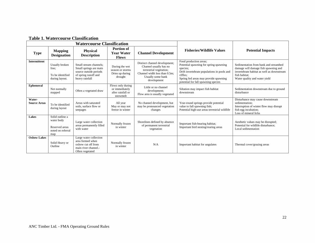
ANC Timber Ltd. - FMA Operating Ground Rules
22
Table 1. Watercourse Classification Watercourse Classification
Fisheries/Wildlife Values Potential Impacts Type Mapping
Designation Physical
Description
Portion of Year Water
Flows Channel Development
Intermittent Usually broken line; To be identified during layout.
Small stream channels; Small springs are main source outside periods of spring runoff and heavy rainfall
During the wet season or storms Dries up during
drought
Distinct channel development; Channel usually has no terrestrial vegetation;
Channel width less than 0.5m; Usually some bank
development
Food production areas; Potential spawning for spring spawning species; Drift invertebrate populations in pools and riffles; Spring fed areas may provide spawning potential for fall spawning species
Sedimentation from bank and streambed damage will damage fish spawning and invertebrate habitat as well as downstream fish habitat; Water quality and water yield
Ephemeral Not normally mapped Often a vegetated draw
Flows only during or immediately after rainfall or
snowmelt
Little or no channel development;
Flow area is usually vegetated
Siltation may impact fish habitat downstream
Sedimentation downstream due to ground disturbance
Water-Source Areas To be identified
during layout
Areas with saturated soils, surface flow or seepages
All year May or may not freeze in winter
No channel development, but may be pronounced vegetation
changes
Year-round springs provide potential value to fall spawning fish; Potential high-use areas terrestrial wildlife
Disturbance may cause downstream sedimentation; Interruption of winter flow may disrupt fish egg incubation; Loss of mineral licks
Lakes Solid outline a water body Reserved areas noted on referral map
Large water collection areas permanently filled with water
Normally frozen in winter
Shorelines defined by absence of permanent terrestrial
vegetation
Important fish-bearing habitat; Important bird nesting/rearing areas
Aesthetic values may be disrupted; Potential for wildlife disturbance; Local sedimentation
Oxbow Lakes
Solid Heavy or Outline
Large water collection area formed when oxbow cut off from main river channel.-Often vegetated
Normally frozen in winter N/A Important habitat for ungulates Thermal cover/grazing areas

ANC Timber Ltd. - FMA Operating Ground Rules
23
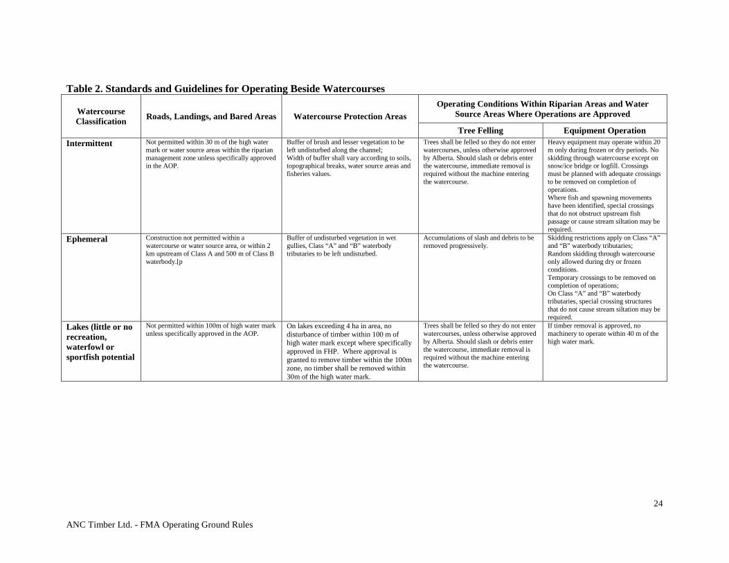
Table 2. Standards and Guidelines for Operating Beside Watercourses
Watercourse Classification Roads, Landings, and Bared Areas Watercourse Protection Areas
Operating Conditions Within Riparian Areas and Water Source Areas Where Operations are Approved
Tree Felling Equipment Operation
Class “A” Waterbodies
Not permitted within 100m of high water mark. Any existing roads may be maintained at present classification standards. Any proposed watercourse crossings within 2 km upstream must be specifically approved in the AOP and be type 1 temporary crossings as defined by the COP.
No disturbance or removal of timber within 100m of the high water mark on the main stem of the class A; No duff disturbance of intermittent (min 10m vegetated buffer) or ephemeral drainages (minimum 5m vegetated buffer) within 2 km upstream of Class A waterbody.
Not permitted without specific Alberta approval
Not allowed without specific Alberta approval.
Class “B” Waterbodies
Not permitted within 60m of high water mark. Any existing roads may be maintained at present classification standards. Any watercourse crossings within 500m upstream must be specifically approved in the AOP and be a type 1 crossing temporary crossing as defined in the COP.
No disturbance or removal of timber within the appropriate riparian area specified by stream type unless specifically approved in the AOP; No duff disturbance of intermittent (minimum 10m vegetated buffer) or ephemeral drainages (minimum 5m vegetated buffer) within 500m upstream of Class B waterbody.
Trees shall be felled so that they do not enter watercourse. Should slash or debris enter the watercourse immediate removal is required without a machine entering the watercourse.
Where removal of timber within 60m is approved, no machinery is permitted within 30m of the high water mark.
Large Permanent Not permitted within 100m of the high water mark or water source areas within the riparian management zone unless specifically approved in the AOP.
No disturbance or removal of timber within 60m of high water mark unless specifically approved in the AOP. No removal of timber shall be approved within 10 m of the high water mark.
Trees shall be felled so that they do not enter watercourse. Should slash or debris enter the watercourse immediate removal is required without a machine entering the watercourse.
Where removal of timber within 60m is approved, no machinery is permitted within 20m of the high water mark;
Small Permanent Not permitted within 30m of the high water mark or water source areas within the riparian management zone unless specifically approved in the AOP.
No disturbance or removal of timber within 30m of high water mark unless specifically approved in the AOP. No removal of timber shall be approved within 10 m of the high water mark.
Trees shall be felled so that they do not enter watercourse. Should slash or debris enter the watercourse immediate removal is required without a machine entering the watercourse.
Where removal of timber within 30m is approved, no machinery is permitted within 20m of the high water mark;
Continued…
ANC Timber Ltd. - FMA Operating Ground Rules
24
Table 2. Standards and Guidelines for Operating Beside Watercourses
Watercourse Classification Roads, Landings, and Bared Areas Watercourse Protection Areas
Operating Conditions Within Riparian Areas and Water Source Areas Where Operations are Approved
Tree Felling Equipment Operation Intermittent Not permitted within 30 m of the high water
mark or water source areas within the riparian management zone unless specifically approved in the AOP.
Buffer of brush and lesser vegetation to be left undisturbed along the channel; Width of buffer shall vary according to soils, topographical breaks, water source areas and fisheries values.
Trees shall be felled so they do not enter watercourses, unless otherwise approved by Alberta. Should slash or debris enter the watercourse, immediate removal is required without the machine entering the watercourse.
Heavy equipment may operate within 20 m only during frozen or dry periods. No skidding through watercourse except on snow/ice bridge or logfill. Crossings must be planned with adequate crossings to be removed on completion of operations. Where fish and spawning movements have been identified, special crossings that do not obstruct upstream fish passage or cause stream siltation may be required.
Ephemeral Construction not permitted within a watercourse or water source area, or within 2 km upstream of Class A and 500 m of Class B waterbody.[p
Buffer of undisturbed vegetation in wet gullies, Class “A” and “B” waterbody tributaries to be left undisturbed.
Accumulations of slash and debris to be removed progressively.
Skidding restrictions apply on Class “A” and “B” waterbody tributaries; Random skidding through watercourse only allowed during dry or frozen conditions. Temporary crossings to be removed on completion of operations; On Class “A” and “B” waterbody tributaries, special crossing structures that do not cause stream siltation may be required.
Lakes (little or no recreation, waterfowl or sportfish potential
Not permitted within 100m of high water mark unless specifically approved in the AOP.
On lakes exceeding 4 ha in area, no disturbance of timber within 100 m of high water mark except where specifically approved in FHP. Where approval is granted to remove timber within the 100m zone, no timber shall be removed within 30m of the high water mark.
Trees shall be felled so they do not enter watercourses, unless otherwise approved by Alberta. Should slash or debris enter the watercourse, immediate removal is required without the machine entering the watercourse.
If timber removal is approved, no machinery to operate within 40 m of the high water mark.

ANC Timber Ltd. - FMA Operating Ground Rules
25
Table 2. Standards and Guidelines for Operating Beside Watercourses
Watercourse Classification Roads, Landings, and Bared Areas Watercourse Protection Areas
Operating Conditions Within Riparian Areas and Water Source Areas Where Operations are Approved
Tree Felling Equipment Operation Lakes (with recreational, waterfowl or sport fish potential)
For shorelines not located within reserved areas, no disturbances shall be permitted within 200 m of the high water mark unless specifically approved in the AOP.
On lakes exceeding 4 ha in area, no disturbance or removal of timber within 100 m of the high-water mark. Alberta in the FHP may require additional protection. On lakes less than 4 ha, removal of timber prohibited within 30 m of the high-water mark and any removal within 100 m requires Alberta’s approval.
Trees shall be felled so they do not enter the waterbody, unless otherwise approved; Should slash or debris enter the watercourse, immediate removal is required without the machine entering the watercourse.
Consideration must be given to aesthetics when harvesting adjacent to lakes with recreational potential.
Water source Areas, Natural Springs and Areas Subject to Normal Seasonal Flooding
Construction not permitted unless approved in the AOP; No log decks permitted; The number of stream crossings must be minimized; No disturbance of organic duff layers or removal of lesser vegetation.
Treed riparian management zone of at least 20 m on all water source areas; No harvest of merchantable trees or disturbances of lesser vegetation unless specifically approved in the AOP; Buffer width may be altered according to its potential to produce surface water, provided it is approved in the AOP.
Heavy machinery not permitted with in water source areas during unfrozen soil conditions; Minimal disturbance or removal of duff or lesser vegetation; Timber may be harvested if stream sedimentation is the only resource concern, provided there is no disturbance of the organic soils and lesser vegetation when harvesting the trees; On unstable areas subject to blowdown, merchantable trees shall be carefully harvested from water source areas to minimize root disturbances of duff layers and watercourse damming.
Road construction, timber harvest, reforestation and reclamation shall be done with equipment capable of operating without causing excessive disturbance to the soil layers; Heavy equipment is not permitted during moist or wet soil conditions, but bay be operated during frozen periods; No soil caps or depositing of soil permitted on roads in water source areas, unless a separation layer is incorporated or the road is designed to provide adequate surface and sub-surface drainage away from the road bed; Where a separation layer is used, the soil cap shall be removed as operations are completed.
Oxbow Lake Construction not permitted within 100m of oxbow lake unless specifically approved in the FHP.
Operational buffer of brush and lesser vegetation to be left undisturbed along the channel.
Heavy equipment not permitted around oxbow lakes during unfrozen conditions. Trees shall be felled so they do not enter the waterbody, unless otherwise approved; Should slash or debris enter the watercourse, immediate removal is required without the machine entering the watercourse.
Approved activities shall be done with equipment capable of operating without causing excessive disturbance.
See Water Act for definitions of class A and B waterbodies.
ANC Timber Ltd. - FMA Operating Ground Rules
26
7.0 HABITAT MANAGEMENT 7.1 LANDSCAPE PLANNING PURPOSE
To implement timber operations in a manner that ensures landscapes maintain biodiversity and ecosystem function.
DISCUSSION
Forest operators are expected to manage the forest cover in a manner that maintains biodiversity and ecological integrity. The SHS approved in the FMP is the mechanism by which the forest cover is managed. Within landscapes managed for timber production, landscape patterns, cover types and seral stages can be managed to produce a desired future forest. The coarse filter approach to maintaining biodiversity in managed landscapes involves managing for suitable amounts and patterns of all forest cover types and all seral stages, along with managing for inherent natural spatial and temporal variability. The variability of natural disturbances shall be considered when planning harvest area size and shape. This variability will help to provide habitat for species that are dependent on natural disturbance regimes. The use of Alberta Vegetation (AVI) polygon boundaries will help to plan this variability. Use of natural features as harvest area boundaries is consistent with natural disturbance and shall be used whenever possible. Landscape planning requires that targets be set that are measurable. Targets describe the amount of each landscape element that will be created, maintained, or managed, as well as the spatial and temporal variability (expressed as a range) of each. Creating variability in natural landscapes is important because element amounts vary between landscapes, and the requirements of biota also vary. Targets will be refined over time using analysis based on natural disturbances, natural succession processes, current and historical conditions within the region, sub-region and ecodistrict or ecoregion. Wildlife species of special management concern are major considerations in the selection of the SHS in the FMP. Wildlife movement corridors are required to ensure that animals with large home ranges find passage between and within managed landscapes. When planning for wildlife habitat and movement corridors, the following factors shall be considered: watercourse classification/ profile/ pattern and associated valley definition, timber types and proximity to watercourses, travel corridor width, harvesting method, harvest area shape, continuity of forest cover or adjacency/size of forest patches. ANC Timber Ltd. has an approved SHS as of May 1, 2011
ANC Timber Ltd. - FMA Operating Ground Rules
27
7.2 DEBRIS MANAGEMENT AND WILDFIRE PROTECTION
PURPOSE
To manage the amount and distribution of woody debris left in harvest areas to: • minimize wildfire risk, particularly near communities • optimize ecological benefits • minimize the loss of productive landbase • to minimize the risk of wildfires, and to improve fire suppression capability.
DISCUSSION
Debris or slash accumulation resulting from timber harvest operations must, as a priority, be redistributed or disposed of to minimize the risk of wildfire ignition and spread. However, it is recognized that some retention of debris is valuable from an ecological perspective, and that a reasonable amount of debris retention shall occur to emulate natural forest floor accumulations. Ecological benefits include microtine habitat, furbearer habitat (when piled), and soil nutrient inputs. When debris is maintained, it must be in such a distribution and amount to: 1) minimize wildfire risk as a priority, 2) minimize the amount of productive landbase loss by limiting lost area available for deciduous species suckering, or tree planting, and 3) provide ecological benefit (coarse filter vs. fine filter). Landscape-level issues regarding the risk of large fires are addressed in the development of the SHS. The FMP shall develop objectives, strategies and tactics that consider the risk of occurrence and spread of fire at the stand and landscape levels. Opportunities may exist to implement fuel reduction, isolation and conversion on the landscape while accounting for other values. Where applicable, forest operators shall follow the guidelines in the FireSmart Protecting Your Community from Wildfire manual. Acceptable methods of reducing slash hazards are defined in FPD policy Debris Disposal Requirement for Logging Operations (see Appendix2).
GROUND RULES
7.2.1 Slash accumulations resulting from timber harvesting, road, and campsite construction shall be disposed of as per the Forest and Prairie Protection Regulation Part II.
7.2.2 Slash fuel accumulation is not permitted within 5 metres of the perimeter of the
harvest area. The bordering undisturbed forest floor shall be used as a benchmark to determine what constitutes a significant accumulation. Unacceptable accumulations include piles of trees or non-merchantable timber, and tops or branches deposited during logging that could create fuel ladders for fire bordering the stand (refer to 9.3 for further requirements).
7.2.3 Burning operations shall:
a) not be conducted during the fire season, unless otherwise approved in the
Fire Control Plan; and b) require a post burning survey to ensure all holdover fires are extinguished.
ANC Timber Ltd. - FMA Operating Ground Rules
28
7.2.4 The FHP shall comply with direction provided in Community Firesmart Plans where applicable.
7.2.5 An approved fire control plan is required prior to approving the AOP. 7.2.6 For ecological benefits within the constraints of the Debris Disposal Policy and
safety requirements, debris should be retained as follows:
a) Large logs presently on the ground or unmerchantable trees knocked down during harvest could be spread or left in place.
b) Where debris is piled, piles chosen for retention, as a priority should contain larger logs as opposed to fines and branches and shall be a minimum of 30m from the block edge.
7.3 STRUCTURE RETENTION PURPOSE
To create temporary refuges for forest biota to re-colonize harvest areas. To maintain snags and live residual trees in harvested areas for biota that depend on these structures following natural disturbances. To provide wildlife thermal and hiding cover within harvest areas throughout the rotation. To provide wildlife travel corridors within large harvest areas and compartments.
DISCUSSION
Although many types of natural disturbance (fire, floods, wind events, pest events) occur within Alberta's forests, fire is the most common. Historically all trees are killed within intense fires but, following low and moderate-intensity fires, many scattered live trees are present post disturbance. In addition, within all fire types, fire skips result in residual patches of live trees remaining within burned areas. MPB has emerged as a threat to the forests of Alberta and as a result accelerated harvest levels have been approved. The concern about retention of pine trees creating refuges for MPB and exacerbating the spread of MPB has led to increased emphasis on the retention of non-pine species to compensate for the removal of pine. D. Andison (March, 2001) suggests that fires in the boreal forest are commonly referred to as "events". They tend to be memorable, occur over a very short period of time, and leave behind a mosaic of burnt and un-burnt patches. The relationship between events and their constituent patches is vital to ANC Timber's approach to residual structure retention. An area relationship between patches and fire events exists. Since most events are composed of a number of disturbance patches, we expect large events to be even more prominent on the landscape. For instance, disturbance patches greater than 2,000 hectares occupy 71% of the Upper Foothills landscape, while disturbance events greater than 2,000 hectares occupy 90% of the Upper Foothills landscape (Andison, March 2001). It is not possible to create compartments with as high a density of large snags as are found after fire. However, retaining some large snags and large downed logs within cutblock and compartments creates habitat for some of the biota associated with disturbed habitat. Additional large snags may be created by retaining large live trees, as some of these trees will die throughout the rotation. Current residual structure in the FMA area indicates that considerable opportunity exists for retaining residual structure post-harvest. Refer to Table 2-10 in the FMP for a summary of the categories of tree types that can be retained post-harvest in order to ensure appropriate levels of structure remain after logging. The current plan indicates that at least 39% of the landbase within the DFA will not be scheduled for harvest within the 200 year planning horizon.
ANC Timber Ltd. - FMA Operating Ground Rules
29
GROUND RULES
7.3.1 Retention target of 1% of merchantable timber by volume (within harvest areas)
across the FMA and shall be representative of the species composition and timber profile of the original stand. The 1% target will be applied to each forest operator on an annual basis per FMU.
7.3.2 A variety of tree sizes may be left for retention as single trees, in clumps, or as
patches within a harvest area.
a) Trees that are crooked and heavily branched will be preferably left; b) Clumps of trees will preferentially be left in areas that have a steep slope,
excessive moisture, or natural openings. 7.3.3 Where possible, snags will be left in groups of 2 or more and may be incorporated as
part of a retention patch. Snag retention will be prioritized as follows:
a) existing snags where worker safety is not compromised; b) trees with evidence of an existing cavity; and c) snags or live trees that exhibit windfirm characteristics.
7.3.4 Other considerations in determining when and where structure should be left in
block include wildlife zones, proximity to large watercourses or lakes, harvest area size, line of sight issues, distance to hiding cover and probability of remaining standing over time.
7.3.5 All structure retention, including snags that are left during active harvest operations
shall also be avoided and/or protected throughout all phases of silviculture treatments while considering worker safety.
7.3.6 Merchantable trees used for residual structure retention are considered as
Allowable Cut Drain. The method used to determine amount of volume retained must be defensible and auditable.
a) Amount of merchantable volume retained will be reported by the individual
Forest Operators on an annual basis using a TM7 Form; b) Quota holders must also report retention volumes to ANC Timber Ltd. for
Stewardship Report requirements
7.3.7 Retention target (1% as per 7.4.1.) will be compared with the actual volume retained summaries of structure retention accomplishments in the required Stewardship Report.
ANC Timber Ltd. - FMA Operating Ground Rules
30
7.4 UNDERSTOREY PROTECTION PURPOSE
To protect coniferous understorey during timber harvesting and reforestation operations. DISCUSSION
The main objective of this ground rule is to protect coniferous understories (understorey) that will contribute to future forest values. Avoidance protection is carried out where understorey is of lower value for timber objectives and has not been used in the TSA to contribute to future yield. Wind buffering tactics and pre-planning are not specifically required for avoidance protection. Pine stands containing >600 stems per ha of understorey suitable for retention will be left standing to contribute towards future growing stock.
GROUND RULES
7.4.1. Understorey discovered in the field but not previously identified shall be avoided,
unless otherwise approved by Alberta. 7.4.2. Avoidance techniques are used for stands with highly aggregated (clumped) and/or
low-density understorey distribution. Wind buffering not specifically pre-planned.
7.5 FISHERIES AND THE AQUATIC ENVIRONMENT PURPOSE
To conduct timber operations in a manner that shall minimally affect: • The health, diversity and natural distribution of aquatic biota; • The quantity and productive capacity of the aquatic environment, including fish habitat,
and; • Fisheries management objectives identified in the FMP.
DISCUSSION
Current provincial and federal legislation require that the aquatic environment and fisheries resources in Alberta must be protected. Timber operations can directly affect the aquatic environment and fish habitat in a number of ways. Tree removal in riparian areas and along stream banks can alter light intensity, nutrient supply, sediment inputs, water temperatures, stream bank stability and recruitment of large woody debris to the watercourse. Watercourse crossings, if not properly designed, can create physical barriers to the movement of fish and other aquatic biota along watercourses. Roads and ditches can intercept and transport sediments from the upland source to crossing sites where they are deposited in the watercourse. Upland timber harvesting can also affect watershed water yield and flow regimes. These effects can lead to changes in aquatic primary productivity, food-web pathways, aquatic species abundance and distribution, and channel morphology.
ANC Timber Ltd. - FMA Operating Ground Rules
31
The primary strategy for maintenance and protection of the aquatic environment and fish habitat values is to maintain treed buffers along watercourses and water bodies and adopt rigorous watercourse crossing and erosion control measures. Alternate management proposals for riparian areas would be considered to support aquatic environment and fisheries management objectives in the area, where acceptable to Alberta. Authorizations by Alberta do not imply authorization under federal legislation and requirements, notably the federal Fisheries Act. The proponent must seek advice and approvals of the federal agencies (Department of Fisheries and Oceans) regarding federal legislation requirements. Additional ground rules for any work carried out in and around watercourses are found in section 11.4 – Watercourse Crossings.
GROUND RULES
7.5.1. All waterbodies and watercourses are presumed to be fish bearing or support fish-bearing habitat. However, the company may confirm the distribution of fish and fish habitat within the planning areas by:
a) Checking the Fisheries Management Information System (FMIS), Water
Act Codes of Practice and fisheries inventory data, or b) Conducting new inventories, or c) Consulting with the appropriate Area Fisheries Management Biologist.
7.5.2. For any activity that disturbs or alters the bed and banks of a fish-bearing
waterbody, an assessment of the potential effects on fish and fish habitat has been conducted by an individual with expertise in fisheries and aquatic assessment methods and habitat mitigation measures. For assessment requirements and methods, refer to Schedule 4 of the Code of Practice for Watercourse Crossings.
ANC Timber Ltd. - FMA Operating Ground Rules
32
7.6 SPECIES OF SPECIAL MANAGEMENT CONCERN PURPOSE
To conduct planning and timber operations in a manner that shall: • Conserve and plan for an agreed upon level of effective habitat for species of special
management concern including woodland caribou, grizzly bear, trumpeter swan and others as determined by Alberta from time to time.
• Maintain the effective habitats for ungulates in river valley environments. Ground Rules
7.6.1 Access Management in Wildlife Zones (Woodland Caribou, Grizzly Bear, and Key Wildlife and Biodiversity Zone (KWBZ).
7.6.1.1 To the extent possible, all new access roads must follow existing
disturbances, unless doing so will compromise options for subsequent access management or wildlife objectives (i.e., “traditional access” issues).
7.6.1.2 Preference shall be given to development and use of winter (frozen ground)
or temporary summer roads since this reduces negative impacts on wildlife permits minimization of long-term infrastructure, and facilities reclamation.
7.6.1.3 For KWBZ completing operations in ungulate habitat areas early in the
winter season remains a management objective. It is recognized that in some cases work will occur in winter to take advantage of frozen ground access.
7.6.1.4 As an alternative to winter (frozen ground) roads, summer roads may be
developed and used, subject to the following:
a) Road width and grade shall be minimized. Preferentially, summer roads shall be temporary “dry weather” routes, with use suspended when ground conditions are unfavourable.
b) Summer harvesting areas shall preferentially be located outside of Caribou and Grizzly range, or as an alternative, in proximity to previously existing all-weather access roads to assist in reducing the need for new summer access routes. As an alternative, summer harvesting in more remote areas shall have hauling deferred to take advantage of frozen ground conditions.
7.6.1.5 Except where identified and agreed upon within the FHP, only temporary
access roads shall be used. 7.6.1.6 Roads shall be built no sooner than one year prior to harvesting operations.
Temporary roads shall be re-contoured and reclaimed (and potentially reforested) within 18 months of completion of harvesting and hauling operations, unless otherwise agreed to in the operating schedule.
7.6.1.7 As agreed to between the company and Alberta, effective forms of public
access control for highway vehicles shall be maintained. Control of highway vehicle use of any open temporary or permanent access route may be required. All “non-traditional” (define in glossary) access routes that are open must have measures in place to prevent highway vehicle traffic.
ANC Timber Ltd. - FMA Operating Ground Rules
33
Options for access management on “traditional” routes must be considered during the CA or FHP. The need for options to manage off highway vehicle traffic must be considered in the CA or FHP. See section 11.5 for more detail on Access Management.
7.6.1.8 Reclamation techniques used on access routes must strive to prevent
highway vehicle use and attempt to limit off-highway vehicle use. Woodland Caribou DISCUSSION
The FMP strategies and SHS shall describe the harvesting program that will create the desired future forest, taking into consideration the full range of values including habitat for species of special management concern. Woodland caribou are classified as a “Threatened” species under both the Alberta Wildlife Act and the National COSEWIC/RENEW system. The Federal Species at Risk Act (SARA) shall apply to woodland caribou in Alberta. The “1996/97 Operating Guidelines for Industrial Activity in Caribou Ranges in West Central Alberta” and the “2001 Boreal Caribou Committee Strategic Plan and Industrial Guidelines for Boreal Caribou Ranges in Northern Alberta” provide background, intent, and specific direction for managing industrial work on caribou range. Both national and provincial woodland caribou recovery processes have been initiated which may have implications for timber harvesting in Alberta. Timber operations and management in caribou range can affect caribou populations and habitat directly or indirectly and in four main ways: 1) creating and maintaining public access routes, 2) altering natural and human-caused mortality rates on caribou populations (both through access route development and habitat changes), 3) altering the amount, quality, and effectiveness of caribou habitat, and 4) displacing and causing undue sensory disturbance to individual caribou. All of the four factors are consequential for caribou conservation; however, predation rates and habitat changes are of primary concern. A sufficient amount of habitat (considering both habitat quality and effectiveness) must be maintained at all times within the caribou ranges. The FMP has provided direction for the amount, configuration and location/adjacency of harvest areas and older seral stage retention areas, and on rate of harvest. Harvest area boundaries should be based upon natural stand edges breaks in topography, and other natural features. The negative effects of creating and maintaining access routes (public travel, predation, reduced habitat effectiveness, disturbance and displacement) shall be managed by planning the amount, tenure and class of new access routes (roads), and by reviewing and acting upon management options (i.e., access management, abandonment, reclamation) for existing routes. The FMP describes management direction for harvesting in Caribou habitat. Where conflict exists between the FMP and the ground rules the FMP direction will take precedent.
ANC Timber Ltd. - FMA Operating Ground Rules
34
GROUND RULES 7.6.2 Woodland Caribou
Planning
7.6.2.1 Silvicultural prescriptions shall strive to limit non-coniferous shrub and
tree regeneration in habitats dominated by coniferous species prior to harvest, and where regeneration to coniferous-dominant stands is planned. Silvicultural prescriptions shall strive to protect existing terrestrial lichens, and facilitate terrestrial lichen regeneration.
7.6.2.2 Unless approved in the SHS, new harvest areas in caribou ranges shall be
no larger than 1000 hectares. 7.6.2.3 Retention patches shall be used in large harvest areas to protect areas of
concentrated terrestrial lichen growth, and reduce, watershed, aesthetic, and wildlife related concerns.
7.6.2.4 Areas of concentrated terrestrial lichen growth (where terrestrial lichens
are the predominant ground cover) within proposed harvest areas should be delineated in the FHP. DHAPs which identify protection measures must be provided to the operator for these areas. Some strategies such as structure retention in harvest areas within the Caribou range should focus on these lichen areas.
7.6.2.5 Winter operations are preferred to protect existing terrestrial lichen
growth within harvest areas, and to retain lichen propagules. 7.6.2.6 While maintaining safety, Class roads within caribou zones shall have
narrower and more temporary road surfaces than those built to road standards outlined in Table 3. Table 3A provides guidance towards achieving these objectives. The goal is for development frozen ground access to minimize grade development.
7.6.2.7 Summer harvesting areas shall preferentially be located outside of caribou
range or if within caribou range, be located in proximity to previously existing all-weather access roads to assist in reducing the need for new summer access routes. As an alternative, summer harvesting in more remote areas shall have hauling deferred to take advantage of frozen ground conditions.
Grizzly Bear
DISCUSSION
The SHS and FMP shall address the harvesting program that will create the desired future forest, taking into consideration the full range of values including habitat for species of special management concern. Grizzly bears are classified as a threatened species under the Alberta Wildlife Act and as a species of “Special Concern” under the national COSEWIC system. The Federal Species at Risk Act
ANC Timber Ltd. - FMA Operating Ground Rules
35
(SARA) shall apply to grizzly bears in Alberta. A provincial grizzly bear recovery process has been initiated which may have implications for timber harvest in Alberta. Timber operations in grizzly bear range can affect grizzly bear populations directly or indirectly in three main ways: 1) altering natural and human caused bear mortality rates through the creation and maintenance of access routes 2) altering the amount, quality, and effectiveness of grizzly bear habitat, and 3) displacing and causing undue sensory disturbance to individual grizzly bears. Landscape level planning is necessary to ensure the availability of effective habitat and managing mortality risk for grizzly bears. The indicators of suitable landscape conditions for grizzly bears are habitat effectiveness, security areas, road density and habitat connectivity. Specific strategies for landscape planning for grizzly bear shall be agreed upon in the FMP and at the (FHP) level. It has been determined that access routes in key grizzly habitat have negative effects on grizzly bear populations through increased mortality rates, disturbance and displacement. These negative effects shall be managed by minimizing the amount, tenure and class of new access roads, and by reviewing and acting upon management options (i.e., access management, reclamation strategies for existing routes, avoiding or minimizing access development in key grizzly bear habitat and by using grizzly bear habitat maps, as provided by the Department in planning new access). Harvest area boundaries shall be based upon natural stand edges, breaks in topography, and other natural features.
GROUND RULES
7.6.3 Grizzly Bear The following ground rules are to be implemented in core grizzly bear habitat.
Planning
7.6.3.1 Companies shall minimize the amount, class, and tenure of roads in identified key grizzly bear habitat.
7.6.3.2 Where possible, summer roads and crossings should attempt to avoid riparian corridors. Those routes that lie within riparian corridors shall minimize the ROW width and reduce vehicle speeds through construction standards and company operating procedures.
7.6.3.3 Roads, skid trails, landings and campsites shall be located where they avoid natural
meadows and den locations.
7.6.3.4 Structure retention patches should be left to assist as movement corridors through the harvest area and along the riparian areas.
7.6.3.5 Structure retention areas shall be used in harvest areas to protect areas of known concentrated berry growth, and provide hiding cover and connectivity to forest patches.
Trumpeter Swan
DISCUSSION
The FHP shall describe the harvesting program that is agreed will create the desired future forest, taking into consideration the full range of values including habitat for species of special management concern.
ANC Timber Ltd. - FMA Operating Ground Rules
36
Trumpeter swans are classified as a “Species of Special Concern” under the Alberta Wildlife Act. The Recommended Land Use Guidelines for Trumpeter Swan Habitat in Alberta” located at http://www3.gov.ab.ca/srd/fw/landuse/index.html provides background, intent, and specific direction for managing industrial work near trumpeter swan breeding wetlands. Locations of breeding wetlands are found on provincial land use referral maps. A provincial trumpeter swan recovery process has been initiated which may have implications for timber harvest in Alberta. Trumpeter swans are sensitive to human disturbance, and human activity in breeding areas may decrease survival of eggs or cygnets. Trumpeter swans that are disturbed may not nest or may abandon an existing nest. Therefore, the breeding population continues to be dependent on current management practices and habitat protection. Timber harvest planning and operating ground rules must reflect the sensitive nature of this species. These operating rules serve three primary purposes: a) protection of the long-term integrity and productivity of trumpeter swan breeding habitat; b) avoidance of industrial disturbance to trumpeter swans during nesting and rearing of
cygnets; and c) minimize the access created near swan lakes to reduce the potential for secondary
disturbance of trumpeter swans from recreational use. During the period from April 1 to Sept. 30, low-level (<2000 feet) aircraft flights may disturb trumpeter swans. Low-level aircraft flights are discouraged over identified trumpeter swan lakes or water bodies.
GROUND RULES
7.6.4 Trumpeter Swan
7.6.4.1 A 200m-treed buffer adjacent to the lake shall be left on identified Trumpeter Swan lakes or water bodies.
7.6.4.2 Prior to submission of the FHP, a Trumpeter Swan protection plan shall be developed between the company and Fish and Wildlife to determine site-specific measures for each specific lake. The plan shall contain the following: Additional protection has been provided for Trumpeter Swan lakes for areas approximately 300m out from the 200 m treed buffer,
a) Reclamation that reduces the potential for future vehicular access, b) Conditions regarding the application of herbicides, c) Attempts to limit maximum line of sight to 100m, d) Unless otherwise approved by Alberta, attempts to retain sufficient
structure to contribute to a “forested” habitat in this zone are encouraged. Techniques that limit line of sight and contribute to the treed buffer of the wetland are encouraged.
7.6.4.3 Harvesting, hauling, road building or scarification activity within 800 m of
the edge of the woody vegetation adjacent to identified trumpeter swan lakes or water bodies should not be conducted from April 1 to Sept. 30.
ANC Timber Ltd. - FMA Operating Ground Rules
37
7.6.4.4 Unless otherwise agreed to by Alberta, long-term infrastructure (roads and camps) shall not be developed within 500 m of the edge of the woody vegetation adjacent to the identified trumpeter swan water bodies. Only temporary winter roads shall be permitted within the 500m buffer.
Key Wildlife and Biodiversity Zone
DISCUSSION
For deer, elk and moose in Alberta, key winter range is often found, in river valleys. These landforms contain the topographic variation and site productivity conditions that provide winter foraging conditions in proximity to forest and topographic cover. Also, south-facing valley slopes have relatively lower snow accumulations and warmer bedding sites. The valley landform itself provides protection from high wind chills. Traditional, high use and high quality winter ranges have been identified and mapped (provincial land use referral maps) on the basis of several decades of winter aerial population surveys, supplemented by habitat assessments using aerial photo interpretation and ground surveys. Key ungulate winter ranges play a disproportionately large role, given their localized size and distribution, in maintaining the overall productivity of regional ungulate populations. These ranges ensure that a significant proportion of the breeding population survives to the next year. Females not only have to survive, they have to be in good enough shape in the spring to provide a healthy new crop of young. Habitat effectiveness, including maintenance of thermal cover, foraging areas and escape cover is important for ungulates. Timber operations within and adjacent to key wintering areas adds stress and increases energy drain for animals. They may be forced to move about unnecessarily and even relocate too less favourable habitat. This becomes an increasingly significant factor as winter progresses. Activities associated with timber harvest may also create temporary and permanent access that exposes animals to additional non-industrial disturbances, increased levels of harvest from licensed and non-licensed hunting, and to increased predator efficiency. The FMP and SHS has provided direction on the location/adjacency of harvest areas and retention areas, and on rate of harvest. In the interest of maintaining productive ungulate populations, operating ground rules must reflect an understanding of the biology of these animals and the importance of their key winter ranges. These must serve two primary purposes: a. protection of the long term integrity and productivity of key ungulate winter ranges, and: b. avoidance of direct and indirect disturbance to animals that are using these winter ranges
during the mid-to late-winter period.
Ground Rules 7.6.5 Ungulate Habitat in Major River Valleys
7.6.5.1 The amount, tenure and class of new access roads shall be minimized and
consistent with the land use objectives in regionally defined key wildlife zones (Landscape Analysis Tool, LAT). Access development will strive to minimize new human infrastructure.
7.6.5.2 Where possible all access roads shall avoid known key habitat features.
ANC Timber Ltd. - FMA Operating Ground Rules
38
7.6.5.3 Unless otherwise agreed to by Alberta, timber operations should be conducted outside of the period Jan. 15 to April 30. Where temporary access is being used, variance to the timing restriction will be approved through the AOP.
7.6.5.4 Known willow areas shall be maintained in harvest areas during timber
operations. 7.6.5.5 Stand tending activities shall only remove competing deciduous vegetative
growth that interferes with approved regeneration standards. The intent is to maintain browse availability.
Other Species
DISCUSSION
Additional habitats of selected wildlife species require maintenance of undisturbed habitats, e.g., breeding or denning locations. These species require specific sites in order to complete all or part of their life cycles. 7.6.6 Other Species
7.6.6.1 Sensitive sites listed below shall be protected by retention of an
undisturbed, forested buffer (or other management technique) from the edge of the opening associated with these sites, or from the centre of sites without openings. Both Alberta and the forest operator shall make a reasonable effort to identify sensitive sites in the FHP. Sites discovered in the field shall receive the same buffer as those sites previously identified in planning. Buffer widths and duration shall be agreed to in the FHP.
7.6.6.2 In the event that site-specific buffers or other management techniques are
not agreed to in the FMP and FHP, the following buffer widths shall apply:
Sensitive Site Width of Forested Buffer
Breeding Sites and Hibernacula of Salamanders, Amphibians and Reptiles listed as threatened under the Wildlife Act 100 m Bat Hibernacula 100 m Colonial Bird Nesting Area 100 m Sandhill Crane Nesting Area 100 m Wolverine Den 100 m Mineral Licks 100 m Raptor Nest Tree 100 m Grizzly Bear Den 100 m. Active Beaver Ponds with no outflow channel 20 m-vegetated
ANC Timber Ltd. - FMA Operating Ground Rules
39
8.0 SILVICULTURE PURPOSE
To plan and implement silvicultural practices that result in reforested stands that meet approved regeneration standards.
DISCUSSION
A reforestation program is required by Alberta under TMR 143.1. The reforestation program is a component of the Annual Operating Plan and contains reforestation prescriptions by stratum, and a schedule of treatments for the upcoming year. The proposed reforestation program provides a link between reforestation operations and the FMP. The reforestation program must be based on the most current knowledge of treatments (by stratum) which lead to reforestation success in terms of reforestation standards. Reforestation prescriptions are a critical point in the sustainable forest management planning system where growth and yield stratum targets from the FMP are delivered through well-planned silviculture treatments. Knowledge of how sites respond to different treatments result in better treatments, and greater probability of success in meeting growth and yield stratum targets, for height, stocking, density and ultimately, stratum volumes. An acceptable silvicultural process includes:
• Site assessment (pre or post harvest); • A prescription table or ‘matrix’ of silviculture treatments or tactics for specific strata; • Regeneration standards based on yield curve stratum targets; • An annual treatment schedule of activities; and • An assessment/survey system, and feedback mechanisms to ensure regeneration data is
used to refine the prescription matrix and, in conjunction with all data sources (including permanent sample plot information), the regeneration standards and post harvest growth and yield assumptions.
GROUND RULES 8.1 PLANNING
8.1.1 The conditions outlined by Alberta must be met prior to planning reforestation of
balsam fir or alpine fir as an acceptable species. See Directive 2001-01 or successors.
8.1.2 Harvest layouts bordering previously harvested areas shall avoid damaging
regeneration.
8.1.3 Reforestation timelines prescribed by Alberta shall begin at the start of the timber year following the end of the timber year when the harvest area has received skid clearance from Alberta, or from a company representative pursuant to a self-inspection agreement between the company and Alberta.
8.1.4 The Alberta Forest Genetics Resource Management Standards (FGRM) shall be adhered to in all silviculture planning and operations. The standards specify rules for seed and vegetative material collection, registration, storage, handling, and testing for improved stock.
ANC Timber Ltd. - FMA Operating Ground Rules
40
8.2 REFORESTATION PROGRAM
8.2.1 The reforestation program, which is part of the AOP, shall be submitted before May 1 of each year unless otherwise approved by Alberta.
8.2.2 Harvest areas (openings) shall be clearly identified. E.g. maps, spatial files, or
delineation on the ground through visual markings.
8.2.3 The reforestation program shall include the following components and information: a) Opening number and Silviculture Prescription, b) Proposed Silviculture Treatment Schedule, c) Maps as requested by Alberta, and d) Proposed blocks for declaration in lieu of survey and re-treatment.
a) Opening number and Silviculture Prescription
The Forest Management Plan contains a Silviculture Strategy table for prescriptions specific to different forest stratum. Changes to the approved strategy in the FMP are outlined in the AOP. Proposals for herbicide application shall be submitted for approval in accordance with approved vegetation management strategies and Alberta requirements. (see Herbicide Reference Manual). Herbicide proposals are a component of the reforestation program in the AOP, but may be submitted separately from the AOP.
Commercial thinning proposals shall be submitted for approval as part of the AOP unless otherwise agreed by Alberta, in accordance with Alberta’s requirements.
b) Proposed Silviculture Treatment Schedule
The Silviculture Treatment Schedule shall contain the following information:
• Opening number • A list of harvest areas and the estimated area (ha) to be treated, • The reforestation stratum standard for each harvest area (see below for more
detail) • Season or date of activity – summer vs. winter
The following proposed reforestation activities for each harvest area (or stand) shall be listed:
I. Site Preparation – mechanical or chemical treatment II. Planting – primary species, density range, and notification if outside approved
seed zone III. Seeding – species and notification if outside approved seed zone IV. Leave for Natural – species V. Manual Tending – Type (cleaning vs spacing or combination) VI. Fertilization – type of fertilizer VII. Herbicide/Insecticide application – type of chemical and method (ground vs.
aerial) and target species for insecticide VIII. Commercial Thinning IX. Regeneration surveys – establishment and performance X. Cone/cuttings collection – (if unknown, Alberta shall be notified regarding
collections as per the FGRM standards)
ANC Timber Ltd. - FMA Operating Ground Rules
41
XI. Let it grow as a retreatment strategy
Should the proposed reforestation activities for a harvest area change after AOP approval, the following items require an amendment to the AOP:
o Changing to a treatment not approved in the silviculture strategy table
for the specific stratum. o Additional harvest areas to be treated by any means of treatment
The remaining changes require notification to Alberta through ARIS reporting. If a harvest area is declared sensitive, the forest operator shall provide additional information beyond the strategic and tactical levels (see section 3.4 Detailed Harvest Area Plans). This information shall include the actual techniques (e.g., type of site preparation machine) and their expected impact on the harvest area attribute(s) that make it a sensitive site (e.g., providing frequent furrow trenching breaks on down hill run to reduce erosion). Note that proposals to deploy seed or vegetative material outside the seed zone or breeding region require prior approval of the Provincial Seed Officer at the Alberta Tree Improvement and Seed Centre. Sample Silviculture Treatment Schedule
Opening Number (ARIS)
Harvest Area (ha)
Preliminary Strata Declaration
Activity Activity Area (ha)
Season Comment
HARN004-001
10 C Mounding 4 Winter
c) Map
As part of the reforestation program, a map may be requested (At Alberta’s discretion, the FHP map may be used) that identifies: I. All harvest areas to be treated, II. And all roads and stream crossings to be constructed or used.
d) A listing of harvest areas where a declaration is proposed in lieu of a survey for areas not likely to meet regeneration standards (per TM Reg 141.61(1)) and harvest areas where re-treatment is proposed (per TM Reg 141.6(2)) I. Blocks where ‘let it grow’ is the retreatment strategy will require survey
information supporting re-treatment rationale. II. May be submitted for review and approval at any time throughout the year for
approval to ensure timeliness of treatments.
See Section 12.0 REPORTING for reforestation activity reporting requirements.
ANC Timber Ltd. - FMA Operating Ground Rules
42
8.3 SILVICULTURE OPERATIONS
8.3.1 Site preparation and other silviculture activities must follow the same AOP conditions and ground rule standards that apply to timber operations (i.e., stream crossing requirements, watercourse buffers, tree/understorey retention, and Forest Soils Conservation Guidelines).
8.3.2 Site preparation creating linear disturbance patterns, shall be oriented to minimize
channelling of water downslope.
8.3.3 Herbicide, pesticide and fungicide use shall be performed in accordance with
Alberta requirements.
8.3.4 Site preparation equipment shall be cleaned and free of restricted and noxious weed seed or plant parts before entry into the working area or before mobilizing between projects according to Alberta requirements.
8.3.5 Planting boxes shall be disposed of within 24 months of logging (skid clearance) and
shall be removed to an appropriate disposal facility if ground access exists or the block does not contain any debris piles. If ground access does not exist, boxes may be securely placed within existing debris piles for disposal by burning. All plastic shall be removed from boxes and disposed of at an approved waste disposal site prior to burning. Based on past operator compliance to this rule, Alberta may place a condition in the AOP for removal of all planting boxes.
ANC Timber Ltd. - FMA Operating Ground Rules
43
9.0 SOILS PURPOSE
To conduct timber harvest, road construction, reforestation and reclamation operations in a way that shall: • Minimize the potential for soil erosion, • Prevent soil, logging debris and deleterious substances from entering watercourses,
and • Ensure that the capability of the site to support healthy forest tree growth is
maintained. DISCUSSION
Minimizing soil displacement, compaction and rutting/puddling during road construction, harvesting, and silvicultural operations is a primary concern. Soils are most at risk of compaction and rutting/puddling when the soil is moist or wet, with the more poorly drained soils remaining wetter longer. The soils are equally at risk in the winter months if they are wet and the soil has not frozen, which is a common occurrence. Rehabilitation of compacted soil in harvest areas (off –road) is seldom an option because they are generally wet and additional machine traffic will often cause more soil damage. Therefore, protection of soil is best achieved in choice of equipment, staff training and advanced planning of operations. In terms of advanced planning, it is recommended that a pre-harvest site assessment include the evaluation of soil drainage class across the harvest area delineating sensitive areas with imperfectly and poorly drained soils. Management of field operations shall involve operating on soils when they are as dry as possible. The weather and percentage of sensitive areas in the harvest area shall be taken into account when scheduling areas for harvesting. Following a long dry period in summer, the sensitive sites shall be scheduled accordingly.
GROUND RULES
Harvest planning
9.1 Areas susceptible to rutting, puddling or compaction shall be avoided when planning temporary roads, decks, landings and skidding patterns.
9.2 Areas susceptible to rutting, puddling or compaction shall be harvested during dry
or frozen conditions (e.g., harvest areas with predominantly imperfectly-poorly drained soils).
9.3 Where an approved silvicultural strategy does not exist for reforestation of
disturbed soil, the total area covered by temporary roads, bared landing or camp areas, and displaced soil created by timber harvesting operations shall not exceed five percent of each harvest area without prior approval of Alberta. Disturbance is measured using length x average width.
Harvesting
9.4 Operations shall not occur when soil conditions are above field capacity (saturated). 9.5 Minimize machine traffic on sensitive areas, depending on soil susceptibility to
disturbance according to the results of a hand test. (see figure 2).
ANC Timber Ltd. - FMA Operating Ground Rules
44
9.6 Operations shall cease when instances of multiple ruts in a limited area are created.
9.7 Timber harvesting shall not occur on any area where the likelihood of soil water table increases following harvesting is high, and the risk that the reforested area will not achieve the regeneration standard is also high.
9.8 During road construction, erosion and soil disturbance shall be limited. Effort shall
be made to retain organic matter and soil nutrients for reclamation.
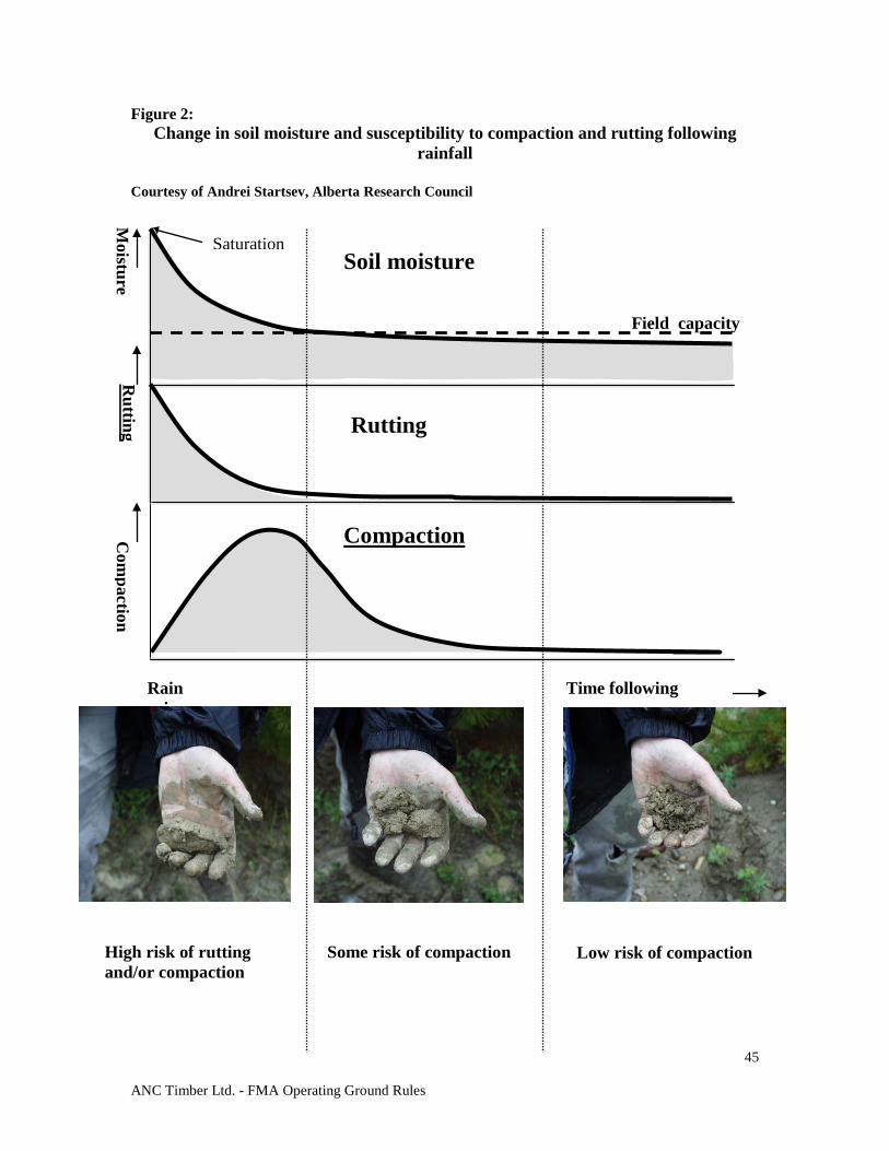
ANC Timber Ltd. - FMA Operating Ground Rules
45
Figure 2: Change in soil moisture and susceptibility to compaction and rutting following
rainfall
Courtesy of Andrei Startsev, Alberta Research Council
High risk of rutting and/or compaction
Low risk of compaction Some risk of compaction
Moisture
Field capacity
Saturation Soil moisture
Com
paction
Compaction
Rutting Rutting
Rain Time following i
ANC Timber Ltd. - FMA Operating Ground Rules
46
10.0 FOREST HEALTH/ PROTECTION 10.1 INSECT AND DISEASE PURPOSE
To minimize the risk of occurrence, and spread of insects and disease, which have the potential to impact forest management objectives. To prioritize the salvage of timber damaged by insects and disease.
DISCUSSION
The impact of certain insects and diseases shall be addressed when planning harvesting, silviculture operations, and surveys. Several biotic and abiotic forest health agents affect the growth and survival of trees. Each agent poses a threat to the forest. Priority for management shall be given to those agents that have the greatest impact or could potentially cause the most damage by: a) Increasing the wildfire hazard b) Reduction or loss of merchantable volume c) Detracting from landscape aesthetics
GROUND RULES
10.1.1 Harvest plans and operations shall be prioritized in stands with insect and disease issues. Variance from the SHS to address insect or disease issues may be acceptable if approved by Alberta. Infected and infested stands shall be ranked based on the type and intensity of insect and disease present, or the presence of dead trees. Stands or trees shall be ranked for treatment or harvest as follows:
Rank 1: Stands or trees with the presence of mountain pine beetles or spruce beetles. Rank 2: Stands with a significant number of dead or dying trees resulting from fire, insects or disease, and windthrow. Rank 3: Stands infected with mistletoe, spruce budworm, forest tent caterpillar, root disease (Tomentosis, Armillaria) or jack pine budworm. Rank 4: Stands infected with needle cast, Western gall rust, and root collar weevils, Atropellis or other miscellaneous forest health agents.
10.1.2 Management tactics are based on the Forest Protection Ranking as follows:
Rank 1 stands or trees: To be effective, control Measures must be undertaken before adult beetles take flight, either through harvest or single tree treatment. Alberta and forest operators shall work co-operatively to prevent spread through aggressive action. Rank 2 stands: Shall be addressed through salvage planning process (see section 3.6, Salvage Planning). Highly unpredictable spread therefore, salvage planning is initiated. Rank 3 stands: To manage dwarf mistletoe operators shall: - Create a 20 m wide mistletoe-free zone adjacent to the harvest area, or - Create a 20 m wide non-host buffer beside the harvest area perimeter, or - Reforest the harvest area to a non-host species.
ANC Timber Ltd. - FMA Operating Ground Rules
47
Any wildlife tree patches shall consist of non-pine species where possible. For other pests, contact Alberta. Rank 4 stands: Regenerated stands requiring treatment due to infestation from Western gall rust or root collar weevils shall contact Alberta.
10.1.3 Insect and disease assessment information shall be utilized in the CA. Where a CA
is not required, the assessment information will be used to develop the GDP. Where new infestations are found, or for known infestations already sequenced through the SHS, they shall be addressed in the FHP.
10.1.4 Any infestation of Rank 1 agents and all data must be reported to Alberta .
10.1.5 Where dues relief is requested, mistletoe infected stands must be surveyed using an
acceptable rating system (e.g., Hawksworth system). 10.2 WEED MANAGEMENT PURPOSE
To minimize the impact of noxious and prohibited noxious weeds. DISCUSSION
The invasion of noxious and prohibited noxious weeds in the forested area of Alberta negatively affects the integrity of the ecosystem. Weeds may alter natural processes and displace plant species that naturally occur in the area. Under Alberta legislation, the occupant (or owner if there is no occupant) must control all noxious weeds and destroy all prohibited noxious weeds.
GROUND RULES
10.2.1 Forest operators shall follow Alberta’s requirements (Directive 2001-06) for weed management in forestry operations. (see Appendix 3)
10.2.2 All equipment used for timber operations shall be cleaned and free of noxious or
prohibited noxious weed seed or plant parts before entry into the working area or before mobilizing between projects (where risk of spread is high).
ANC Timber Ltd. - FMA Operating Ground Rules
48
11.0 ROADS 11.1 ROAD CLASSIFICATION PURPOSE
To define a road classification system that provides guidelines to all forest operators and potentially all resource users in the Ground Rule Zones.
DISCUSSION
As roads are one of the most significant components of forest harvesting operations, forest operators along with Alberta shall co-ordinate and integrate road planning and construction plans with other resource operators. This classification system will provide consistent working guidelines to be used in planning and operations to facilitate integration. It is important to identify not only construction schedules but closure and reclamation timelines as well. Long term planning of access roads is a significant tactic to address landscape access issues.
GROUND RULES
11.1.1 The operator shall utilize the classification system described in Table 3 during planning and operations.
11.1.2 All roads, regardless of class, with a lifespan of greater than three years shall be
built under the authority of a DLO.
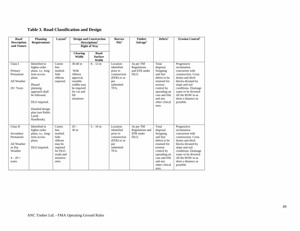
ANC Timber Ltd. - FMA Operating Ground Rules
49
Table 3. Road Classification and Design
Road Description and Tenure
Planning Requirements
Layout1 Design and Construction Descriptions1
Borrow Pits1
Timber Salvage1
Debris1
Erosion Control1
Right of Way
Clearing Width
Road Surface Width
Class I Primary Permanent All Weather 20+ Years
Identified in higher-order plans, i.e., long term access plans. Phased planning approach shall be followed. DLO required. Detailed design plan (see Public Lands Handbook).
Centre line marked. Side ribbons required.
30-40 m With Alberta approval, variable widths may be required for cut and fill situations
8 – 12 m Location identified prior to construction (EFR) or as per submitted TFA.
As per TM Regulations and EFR under DLO.
Total disposal. Stripping and fine debris to be retained for erosion control by spreading on cuts and fills and any other critical area.
Progressive reclamation concurrent with construction. Cross drains and ditch blocks dictated by slope and soil conditions. Drainage water to be diverted off the ROW in as short a distance as possible.
Class II Secondary Permanent All Weather or Dry Weather 4 – 20 + years
Identified in higher-order plans, i.e., long-term access plans. DLO required.
Centre line marked. Side ribbons may be required for DLO roads and sensitive sites.
20 – 30 m
5 – 10 m Location identified prior to construction (EFR) or as per submitted TFA.
As per TM Regulations and EFR under DLO.
Total disposal. Stripping and fine debris to be retained for erosion control by spreading on cuts and fills and any other critical area.
Progressive reclamation concurrent with construction. Cross drains and ditch blocks dictated by slope and soil conditions. Drainage water to be diverted off the ROW in as short a distance as possible.
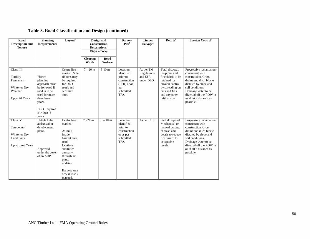
ANC Timber Ltd. - FMA Operating Ground Rules
50
Table 3. Road Classification and Design (continued)
Road Description and
Tenure
Planning Requirements
Layout1 Design and Construction Descriptions1
Borrow Pits1
Timber Salvage1
Debris1
Erosion Control1
Right of Way
Clearing Width
Road Surface
Class III Tertiary Permanent Winter or Dry Weather Up to 20 Years
Phased planning approach must be followed if road is to be used for more than three years. DLO Required if > than 3 years.
Centre line marked. Side ribbons may be required for DLO roads and sensitive sites.
7 – 20 m
5-10 m
Location identified prior to construction (EFR) or as per submitted TFA.
As per TM Regulations and EFR under DLO.
Total disposal. Stripping and fine debris to be retained for erosion control by spreading on cuts and fills and any other critical area.
Progressive reclamation concurrent with construction. Cross drains and ditch blocks dictated by slope and soil conditions. Drainage water to be diverted off the ROW in as short a distance as possible.
Class IV Temporary Winter or Dry Conditions Up to three Years
Details to be addressed in development plans. Approved under the cover of an AOP.
Centre line marked. As-built inside harvest area road locations submitted annually through air photo updates Harvest area access roads mapped.
7 - 20 m
5 – 10 m Location identified prior to construction or as per submitted TFA.
As per FHP. Partial disposal. Mechanical or manual cutting of slash and debris to reduce fire hazard to acceptable levels.
Progressive reclamation concurrent with construction. Cross drains and ditch blocks dictated by slope and soil conditions. Drainage water to be diverted off the ROW in as short a distance as possible.
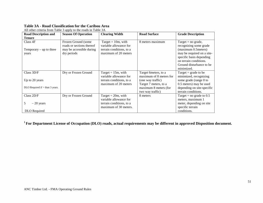
ANC Timber Ltd. - FMA Operating Ground Rules
51
Table 3A - Road Classification for the Caribou Area All other criteria from Table 3 apply to the roads in Table 3A Road Description and Tenure
Season Of Operation Clearing Width Road Surface Grade Description
Class 4F Temporary – up to three years
Frozen Ground (some roads or sections thereof may be accessible during dry periods
Target = 10m, with variable allowance for terrain conditions, to a maximum of 20 meters
8 meters maximum Target = no grade, recognizing some grade (maximum 0.5meters) may be required on a site-specific basis depending on terrain conditions. Ground disturbance to be minimized.
Class 3D/F Up to 20 years DLO Required if > than 3 years.
Dry or Frozen Ground Target = 15m, with variable allowance for terrain conditions, to a maximum of 20 meters
Target 6meters, to a maximum of 8 meters for (one way traffic) Target 7 meters, to a maximum 8 meters (for two way traffic)
Target = grade to be minimized, recognizing some grade (range 0 to 0.5 meters) may be used depending on site-specific terrain conditions.
Class 2D/F 5 – 20 years DLO Required
Dry or Frozen Ground Target = 20m, with variable allowance for terrain conditions, to a maximum of 30 meters.
8 meters Target = no grade to 0.5 meters, maximum 1 meter, depending on site specific terrain conditions.
1 For Department License of Occupation (DLO) roads, actual requirements may be different in approved Disposition document.
ANC Timber Ltd. - FMA Operating Ground Rules
52
11.2 ROAD PLANNING AND DESIGN PURPOSE
To plan the construction, maintenance, and reclamation of roads. DISCUSSION
The impacts of permanent roads on the values associated with the forested landscape shall be recognized as long-term. It is therefore important that the initial placement of roads be carefully examined. Resource values shall be assessed during the process in order to best mitigate impacts or enhance benefits associated with those values. Long term road network plans shall be developed in the FMP. All road construction, maintenance and reclamation shall be directed by strategies outlined in the FMP.
The submission of road plans will assist Alberta to facilitate the integration of access management among all resource users (e.g., oil and gas industry). Road plans shall forecast corridor development linking all compartments and other industrial developments. Safety needs to be addressed throughout the road planning process.
GROUND RULES 11.2.1 Long-Term Roads (Class I, II, III) Road Planning
11.2.1.1 Forest operators shall annually submit a road corridor plan and construction schedule in the GDP. Proposed variances from the FMP long-term corridor plan require Alberta’s approval. The minimum scope of the road construction schedule shall be a five-year forecast with the content requirements being: Map showing: • Existing forest operator roads by class including un-reclaimed non-
DLO roads; • Other existing roads if the digital information is available; • Proposed forest operator corridors, including corridors approved in
the FHP; and • Access control points – See section 11.5 Access Control.
11.2.2 Phased Planning Process
Phase 1: Corridor Planning
11.2.2.1 Forest operators with overlapping tenures shall consult each other to
ensure consistency in their corridor planning. 11.2.2.2 Forest operators shall advise other known industrial operators of their road
plans and strive to integrate road access with those operators.
ANC Timber Ltd. - FMA Operating Ground Rules
53
11.2.2.3 Upon request by Alberta, the road centre-line, as built, in a format acceptable to Alberta, shall be submitted to Alberta by the forest operator within 90 days of construction.
11.2.3 Temporary Roads: Class IV (with lifespans up to three years from start of
construction). 11.2.3.1 These roads shall be built as per the approved AOP. Only roads with FHP
approvals shall be included in the AOP submission. 11.2.3.2 The forest company shall submit a table or report tracking the status of all
their unreclaimed non DLO roads over two years old. These roads shall be reclaimed as soon as timber operations are complete or within three years of construction. This may be submitted as part of the Road Plan in the AOP or GDP by map or in a table.
11.3 ROAD CONSTRUCTION, MAINTENANCE AND RECLAMATION PURPOSE
The roads shall be constructed, maintained and reclaimed in a timely manner to minimize environmental impacts.
GROUND RULES
11.3.1 General
11.3.1.1 Existing access (e.g., seismic lines, trails, existing roads) shall be used as a priority wherever practical and feasible.
11.3.1.2 Road ROWs shall be cleared according to standards established in Table 3,
road comments, and any additional conditions approved in the FHP. 11.3.1.3 Roads and landings shall be constructed to avoid:
a) Unstable soils, water source areas, springs and seepage areas. b) Creating disturbed, compacted or bared soils that exceed the
amount specified in section 9.3 – Soils.
11.3.1.4 Temporary road construction activities that are required outside an approved ROW can be considered incidental to construction and will be approved as part of the AOP with respect to temporary road construction provided the following is met:
a) Be immediately adjacent to AOP approved disposition (temporary road and associated ROW only);
b) Be reclaimed or reforested in the same fashion as the adjacent AOP approved disposition (if applicable);
c) Be without conflict of existing dispositions and/or adjacent land uses; AND
d) Be an activity type and within the parameters as described below:
• Log Decks or Decking Areas: i. ≤ 0.18 hectares in size;
ii. Located on average ≥400 metres apart
ANC Timber Ltd. - FMA Operating Ground Rules
54
• Bank Stabilization:
i. Related to hill cuts impacted during construction;
• Push Outs: i. ≤0.04 hectares in size;
ii. Located on average ≥800 metres apart.
11.3.2 Construction
11.3.2.1 Roads, skid trails and landings shall be placed in locations and constructed
so that soil erosion, damage to streambeds and sedimentation of watercourses are minimized.
11.3.2.2 On those parts of the ROW not used for grade construction, disturbance to
the duff and organic soil shall be minimized to reduce damage to the roots of bordering trees and to provide a protective soil cover.
11.3.2.3 With Alberta’s approval, trees with root systems seriously damaged by
road construction activities shall be removed from the edge of a road cut. 11.3.2.4 The fill required for road construction shall be taken from the ROW when
feasible. 11.3.2.5 All borrow pits required off the ROW must be authorized by Alberta
through appropriate land use disposition. 11.3.2.6 All sand and gravel pits off the ROW must be authorized under an
appropriate disposition. 11.3.2.7 Removal of sand and gravel from within the channel or floodplain of any
watercourse is prohibited. 11.3.2.8 Active long-term roads shall be properly maintained to reduce wheel or
track ruts, and to minimize watercourse sedimentation from erosion and traffic during adverse weather.
11.3.3 Erosion Control/Prevention
11.3.3.1 Erosion control shall be implemented as per Table 3. 11.3.3.2 Initial erosion control measures shall be concurrent with grade
construction. Preferably, no more than a two kilometre length of bared surface shall be developed between the time the sub-grade is constructed and the completion of erosion control activities.
11.3.3.3 Constructed roads require erosion control and stabilization of disturbed
soils. 11.3.3.4 Ditches shall be constructed to the same gradient as the road and shall be
deep enough to drain the sub-grade, unless limited by topography. Ditch backslopes shall have a regular profile from the top of the cut to the bottom with no hanging banks or vertical cuts.

ANC Timber Ltd. - FMA Operating Ground Rules
55
11.3.3.5 Water from roads, ditches and bared soil surfaces shall not be permitted to drain directly into watercourses. Where vegetated buffers alone do not retard water and sediment movement effectively, appropriate obstructions (e.g., logs, rocks, mounds) or sediment control structures shall be installed to dissipate the flow of water and capture sediment prior to entering the watercourse.
11.3.3.6 Cross-drainage culverts and other drainage devices shall be installed as
road sub-grade construction progresses. Cross-drainage structures shall:
a) Reduce water movement along ditches. b) Divert water from the ROW into the surrounding vegetation
directly as possible. c) Provide cross movement for water from seeps and springs. d) Be installed with adequate spillways or downspouts where they
drain onto unstable or bare soil.
11.3.3.7 Re-vegetation shall be completed concurrent with operations or as soon as soil conditions permit during the following growing period. Existing ditch vegetation shall be protected during road maintenance wherever possible and re-established where necessary.
11.3.3.8 A portion of the debris from clearing, and strippings from road and landing
construction shall be retained and used for re-vegetation and erosion control on disturbed areas.
11.3.4 Reclamation
11.3.4.1 Roads not under DLO that are no longer required shall be reclaimed, have
crossings removed, and their condition monitored until they are considered satisfactorily stabilized.
11.3.4.2 Certified weed free seed shall be used when seeding is used for reclamation. 11.3.4.4 All borrow and gravel pits no longer required must be reclaimed (re-
contoured to stable slopes and re-vegetated) unless approval has been given to allow water to fill the pit for wildlife or wildfire purposes.
Seasonal Reclamation
11.3.4.5 Certain roads that are not used continuously throughout the year may
require intermediate erosion control measures such as:
a) Shallow surface cross ditches based on slope and soil type b) Re-established drainage c) Slope Stabilization d) Rut-free driving surface establishment e) Access control measures
Partial Reclamation
11.3.4.6 Roads that are not immediately required but necessary for future
operations (≤ 3 years) shall be reclaimed to the following standards unless otherwise approved in the AOP.
ANC Timber Ltd. - FMA Operating Ground Rules
56
a) Watercourse crossing and drainage structures that have a high risk of erosion or failure are removed, and stream banks and approaches reclaimed.
b) All potentially erodible slopes are stabilized through rollback, seeded to approved vegetation species, and cross-ditched to disperse runoff and suspended sediment into undisturbed areas.
c) Access closure structures are installed where required.
Total Reclamation
11.3.4.7 Roads and associated bared areas that are no longer required, shall be permanently reclaimed by completing all of the following:
a) Decompacting (if required) and returning them to an acceptable
landform; b) Removing all watercourse crossing and drainage structures and
reclaiming stream banks and approaches; c) Cross-ditching, rolling back topsoil (including slash and logging
debris) and re-vegetating erodible bared surface areas; d) Reforesting disturbed areas inside harvest areas and where
mutually agreed to, outside of the harvest area. e) Establishing access closures where required. f) Where agreed to by Alberta, the company may leave ATV access
for Silviculture purposes. Rollback shall be done on approaches to all watercourses.
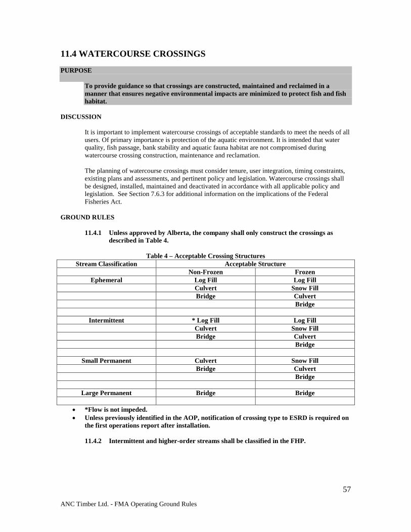
ANC Timber Ltd. - FMA Operating Ground Rules
57
11.4 WATERCOURSE CROSSINGS PURPOSE
To provide guidance so that crossings are constructed, maintained and reclaimed in a manner that ensures negative environmental impacts are minimized to protect fish and fish habitat.
DISCUSSION
It is important to implement watercourse crossings of acceptable standards to meet the needs of all users. Of primary importance is protection of the aquatic environment. It is intended that water quality, fish passage, bank stability and aquatic fauna habitat are not compromised during watercourse crossing construction, maintenance and reclamation.
The planning of watercourse crossings must consider tenure, user integration, timing constraints, existing plans and assessments, and pertinent policy and legislation. Watercourse crossings shall be designed, installed, maintained and deactivated in accordance with all applicable policy and legislation. See Section 7.6.3 for additional information on the implications of the Federal Fisheries Act.
GROUND RULES
11.4.1 Unless approved by Alberta, the company shall only construct the crossings as
described in Table 4.
Table 4 – Acceptable Crossing Structures Stream Classification Acceptable Structure
Non-Frozen Frozen Ephemeral Log Fill Log Fill
Culvert Snow Fill Bridge Culvert Bridge
Intermittent * Log Fill Log Fill Culvert Snow Fill Bridge Culvert Bridge
Small Permanent Culvert Snow Fill Bridge Culvert Bridge
Large Permanent Bridge Bridge
• *Flow is not impeded. • Unless previously identified in the AOP, notification of crossing type to ESRD is required on
the first operations report after installation.
11.4.2 Intermittent and higher-order streams shall be classified in the FHP.
ANC Timber Ltd. - FMA Operating Ground Rules
58
11.4.3 Unless otherwise approved, watercourse crossings shall:
a) Minimize erosion and sedimentation; b) Have stable approaches; c) Be at right angles to the watercourse; d) Be at locations where the channels are well defined, unobstructed and
straight; e) Be at a narrow point along the watercourse; f) Allow room for direct gentle approaches; g) Have no direct ditch drainage; h) Shall have erosion control structures during construction.
11.4.4 Watercourse crossings shall accommodate peak stream flows at the following levels as measured using a method acceptable to Alberta:
a) Long-term roads (Class I – III) – shall be designed for a minimum of 1:50
year flood levels; and b) Temporary roads (Class IV) – shall be constructed such that the crossing is
at or above the high water mark, will allow water flow and meet the minimum requirements of an adequately designed crossing as per section 11.4.
11.4.5 On approaches to watercourse crossings, the organic soil layer and lesser vegetation shall not be stripped from portions of the ROW not needed for the road grade.
11.4.6 Any in-stream activities shall be scheduled to avoid migration, spawning and
incubation periods of migratory or resident fish species (restricted activity periods). Mitigative measures approved by Alberta may allow for deviations from the in-stream timing constraints.
11.4.7 Upstream fish passage for migratory or resident species must be maintained at all
watercourse crossings on fish-bearing waterbodies. 11.4.8 The flow of the watercourse must be maintained at all times when carrying out in-
stream activities, unless otherwise approved under the Water Act. 11.4.9 Measures must be implemented to minimize the duration and amount of
disturbance of the bed and banks of the watercourse or waterbody. Where damage to the bed and banks of a watercourse occur, appropriate measures to restore the bed and banks must be undertaken.
11.4.10 During timber operations measures must be implemented to prevent the deposition
of soil, logging debris or other deleterious substances and materials that are toxic, or an immediate threat to fish and other aquatic organisms into any watercourse. Any such substances or materials unavoidably deposited in a watercourse must be removed immediately and reported to Alberta.
11.4.11 Measures must be implemented to prevent the transfer of biota that are not
indigenous to the environment at the watercourse-crossing site. 11.4.12 Stream crossings shall be kept free of accumulated debris. Culverts plugged with ice
shall be reopened to prevent flooding during spring thaw. 11.4.13 Interim erosion control measures (e.g., silt fences, matting, gravel check dams) must
be implemented and maintained until permanent vegetation and erosion control measures are established where necessary.
ANC Timber Ltd. - FMA Operating Ground Rules
59
11.4.14 Stream crossings that fail shall be reclaimed or replaced (if necessary) with more appropriate crossing structures as soon as possible.
11.4.15 Bridge abutments shall not constrict the normal stream channel. Where stream
banks must be built up to construct a bridge abutment, soil shall be brought in and deposited from the end of the grade – no equipment shall enter the stream channel. Bridge spans must extend beyond stream banks and abutment walls.
11.4.16 The use of bridges is preferred on fish-bearing streams; however, steel culverts may
be permitted where they will not restrict upstream passage of fish. 11.4.17 Culverts for all classes of streams must be designed properly sized and installed to
prevent erosion at both the inflow and outflow ends of the structure. Culverts shall be of sufficient length beyond the fill with the overburden properly backsloped and stabilized to prevent sediment from entering the watercourse, and the ends of the culvert open at all times. Any culvert that becomes a hanging culvert must be correctly re-installed as soon as possible. (see table 4)
11.4.18 Properly constructed logfills (see 11.4.21 below) on temporary roads may be used as per table 4. As soon as the temporary road is abandoned, logfills shall be removed so that no soil is allowed into the water channel. A bottom layer of logs may be left in place when removing the logfill to provide for summer crossing of ephemeral watercourses.
11.4.19 A properly constructed logfill has all of the following:
a) Enough logs to adequately fill an ephemeral draw or watercourse channel
so that when the logs are removed there is little or no damage to the banks or channel bottom;
b) At least 1.5 m longer than the grade fill at each end and all limbs removed with removal of the crossing;
c) Logs covered by a layer of suitable material that separates the soil from the logs, which shall permit total removal of the soil cap;
d) Provisions have been made to allow for easy removal, that does not disturb the banks or watercourse.
11.4.20 In fish-bearing watercourses, any negative impacts on the stability and fish habitat
values of stream banks must be minimized. Any damage to streambanks and the corrective measures taken by the company shall be reported to Alberta within 7 days of the occurrence.
11.4.21 A native timber bridge may be used on watercourses as per table 4 provided that all
of these requirements are met:
a) Bridge abutments do not restrict stream channel; b) A brow log is installed on both sides of the bridge deck to prevent soil from
entering the stream; c) No equipment enters the stream channel; d) Timber of suitable size and strength is available for construction; e) The span extends beyond stream bank and abutment walls; f) A separation layer is used between soil cap and timber; g) The soil cap and separation layer is removed as soon as harvest, hauling
and initial silviculture is complete; h) The remainder of the structure is removed as soon as final silviculture
operations are completed unless a proposal to leave crossing structures in place after hauling is approved by Alberta and an acceptable monitoring program is in place.
ANC Timber Ltd. - FMA Operating Ground Rules
60
11.4.22 Snow-fills may be used on watercourses as per table 4 during frozen conditions
provided that all of the following requirements are met:
a) Sufficient snow exists to fill creek channel; b) Any soil cap installed over the snow is removed prior to break-up; c) Measures are in place to prevent soil or other debris from entering stream
channel or ice surface; d) Suitable measures are taken during deactivation to ensure flow is not
impeded.
11.4.23 Ice bridges may be used during frozen conditions as per table 4 provided that all of the following requirements are met:
a) No capping material is used on the bridge; b) Winter stream flows are not impeded; c) Approaches of snow and ice constructed of sufficient thickness to protect
the stream bank; d) Appropriate ice thickness exists to bear necessary load requirements; e) No alterations to streambed or bank are required; f) They are not on that portion of the Athabasca River between the East
boundary of Twp 60-Rge 17-W5 and the North boundary of Twp 64-Rge 3-W5.
11.4.24 Each operator shall establish a monitoring program acceptable to Alberta, for their
watercourse crossings. Documentation as to current condition, repair requirements, or removal dates of the crossing structures must be maintained and made available to Alberta upon request.
11.4.25 Watercourse crossings that are no longer required shall be reclaimed and inspected
following reclamation to verify that the crossing has been satisfactorily stabilized and suitable measures to minimize the risk of erosion have been implemented. Suitable measures include: a) Removing all watercourse crossing and drainage structures and reclaiming
stream banks and approaches; and b) Where necessary, cross-ditching approaches, rolling back topsoil (including
slash and logging debris) and within one year re-vegetating erodible bared surface areas with vegetation capable of maintaining bank stability, eg. this may include the use of sedges and willow cuttings.
ANC Timber Ltd. - FMA Operating Ground Rules
61
11.5 ACCESS CONTROL PURPOSE
To manage existing and proposed surface access recognizing key resource values. DISCUSSION
The impacts of roads on resource values may require mitigation through access control measures. Wildlife, sensitive areas (i.e., historical sites, soils), protection of road quality and safety are reasons for implementing access control. A number of strategies and tactics are available for controlling or restricting access. Access control measures for long-term roads shall be identified through the submission and review of the phased planning process. For temporary roads, the CA or GDP, and FHP shall be the mechanisms used in identifying access control requirements. The following list of access control methods identifies a number of options that may be implemented: • Physical Barriers (e.g., gates; barricades, pilings) • Road Condition (e.g., berms, ditches, road standard, roll-back, no snow removal) • Regulatory (e.g., sanctuaries, timing restrictions, signage)
GROUND RULES
11.5.1 Where access control has been identified as an objective in strategic land use plans, Alberta shall consult with the forest operator to determine an access control strategy. In the event that a strategic land use plan has not been developed, the FHP shall describe specific access control measures identified in the GDP or FMP (see section 3.4).
11.5.2 In designated areas, Alberta may direct forest operators to restrict road access
during specified periods, implemented in accordance with Alberta policy. Restricted access issues shall be dealt with differently depending on whether the road is new access or is existing access. All closures of existing access must be submitted to the Minister or his authorized delegate for approval whereas new access shall have the terms defined in the approval of the disposition.
ANC Timber Ltd. - FMA Operating Ground Rules
62
11.6 CAMPS AND FACILITIES PURPOSE
To give guidance to forest operators so that the planning, construction, maintenance and reclamation of camps and miscellaneous facilities is done in a manner that minimizes negative impacts on the forest environment.
DISCUSSION
Camps and other facilities are often a necessary part of operations in remote areas. Forest operators require that such facilities operate in an efficient and cost-effective manner and are implemented without compromising the integrity of the environment.
Some of the best practices for camps and facilities include: • Place sites out of visual and auditory range from mineral licks and key wildlife areas or
use a default of one kilometre; • Safe camp locations are a priority. Therefore, an evaluation of all potential risks shall be
conducted prior to selecting a final camp location; • Camps and fuel storage sites shall be identified in the annual fire control plan when
proposed locations are known; • Camps shall be kept clean. Proper mechanisms for the disposal of hazardous and non-
hazardous waste shall be implemented. • Camp food and garbage storage shall minimize the potential for problems with wildlife.
Recommend following the Bear Smart guidelines for specific mitigation relating to bears. Problems with wildlife shall be dealt with in consultation with Alberta.
GROUND RULES
11.6.1 Any facility or camp that shall be in place for more than twelve consecutive months requires an appropriate disposition under the Public Lands Act. Temporary field authorities (TFAs) are required for camps to be in place less than twelve consecutive months.
11.6.2 Any facility or camp must adhere to all provincial regulations related to the camp
(ie. Public Health Act – Work Camp Regulation.). 11.6.3 Where feasible, forest operators shall establish temporary camps and/or other
facilities within either new harvest areas or existing clearings (ie. Gravel and borrow pits).
11.6.4 Temporary fuel storage sites shall not be located within 100 m of any flowing
watercourse.
ANC Timber Ltd. - FMA Operating Ground Rules
63
12.0 REPORTING PURPOSE
To ensure that timber operation activities are reported to Alberta in order to maintain an accurate and current database across the Province.
DISCUSSION
Silviculture and harvest operations reporting and monitoring is necessary to ensure legislated requirements are met in all treatment areas. Ground rules governing operations reporting are required to ensure consistency among forest operators. The intent of activity reporting is to communicate that a given activity has occurred, where it occurred and when it occurred. This information shall also be used for annual and stewardship reports and shall be RFP validated as per Appendix 1.
GROUND RULES SILVICULTURE AND HARVEST ACTIVITY REPORTING
12.0.1 Forest operators who conduct silviculture work on their disposition shall report the details of all work completed in the previous year annually into ARIS no later than May 15. The required information is outlined in the ARIS Industry Operations Manual. Information shall be submitted in accordance with all requirements of the manual and associated policy directives.
12.0.2 Alberta may require additional reporting for forest management activities such as
thinning, herbicide, pesticide spraying, or fertilization. Alberta shall consult with the company on the appropriate format of such reports. Reporting of herbicide projects are as per Alberta requirements.
12.0.3 Reports based on the 2006-04 directive shall be submitted to Alberta once per
month or at agreed to intervals.
12.0.4 The company shall submit an as built plan to Alberta at an agreed upon time or by November 1 each year that includes digital shape files or other approved digital format of harvest boundaries, road location, and added watercourse crossings from the previous year’s harvest. The as built shall include opening number, block number, block area, skid clearance date and any amendments made as per section 3.5.5.
12.0.5 Quota Holders are to provide, annually, the FMA holder with as built block shapes
as well as deleted and deferred polygons either directly or through Alberta.
ANC Timber Ltd. - FMA Operating Ground Rules
64
Appendix 1 - Role of Regulated Forestry Professionals (RFP) in Forest Management The Alberta Government is committed to sustainable management of forests on public land to provide benefits and opportunities for Albertans. Alberta relies on the professional integrity of RFPs to enhance the effectiveness of forest resource management planning, implementation and harvest activity, while recognizing the interdisciplinary nature of forest management planning.
Alberta requires a RFP to submit the components of forest management plans; annual operating plans and harvest activity reporting, as identified in this appendix, for approval. 1.0 Validation by a RFP
RFPs shall validate their submitted work by one of the following methods: i. Signing a plan using their professional title and registration number. ii. Stamping and signing plans using the seal provided by a College. iii. Using other mechanisms approved by Alberta.
1.1 Significance of RFP Validation
RFP validation provides assurance to Alberta that work is accurate and has been prepared with due diligence. Government RFPs shall review validated work by conducting a reasonable assessment for accuracy and shall take appropriate corrective actions where validated work is not accurate. The documentation required to demonstrate due diligence is viewed as a significant source for validating accuracy. Alberta will not accept inadequate documentation and may refer such occurrences to the Complaints Director of the appropriate College.
1.2 Approval of Validated Work
Alberta’s approval does not transfer the accountability for the plan or its implementation from the Organization or the submitting RFP to Alberta or its staff. Approval of validated work shall be addressed as described below.
1.2.1 Appraisal
Work with far-reaching and significant potential effect if inaccurate (such as but not limited to timber supply analysis, GDP). Validation of this type of work demonstrates confidence the work is accurate; however, due to its potential significance, it is both necessary and important to examine the work carefully. Approval shall be granted after the work has been reviewed by appropriate RFPs to assess accuracy. The timeline for this shall be established by Alberta and will vary depending on the nature of the validated work. Those preparing work for appraisal are advised to communicate with the reviewing government RFPs regularly and effectively to minimize confusion over the standards expected of the work.
1.2.2 Acceptance
Work with a more limited potential effect (such as, but not limited to silviculture reports, operations inspections). The work is considered approved on the date Alberta acknowledges receipt of the work. Alberta shall notify the organization by acknowledging receipt within five working days of submission. The notification date will be documented by Alberta as the start date for FHP approval. Alberta shall periodically check the work and supporting documentation to verify its accuracy.
2.0 Work Validated by a RFP
All entities that conduct timber harvesting or silvicultural activities on public land, except those harvesting less than 30,000 m3 annually from public land, must validate the items described below (the list of work to be validated may be amended from time to time by Alberta to adapt to change).
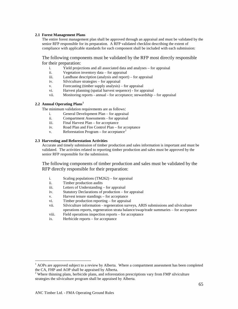
ANC Timber Ltd. - FMA Operating Ground Rules
65
2.1 Forest Management Plans
The entire forest management plan shall be approved through an appraisal and must be validated by the senior RFP responsible for its preparation. A RFP validated checklist describing the extent of compliance with applicable standards for each component shall be included with each submission:
The following components must be validated by the RFP most directly responsible for their preparation:
i. Yield projections and all associated data and analyses – for appraisal ii. Vegetation inventory data – for appraisal iii. Landbase description (analysis and report) – for appraisal iv. Silviculture strategies – for appraisal v. Forecasting (timber supply analysis) – for appraisal vi. Harvest planning (spatial harvest sequence) - for appraisal vii. Monitoring reports - annual - for acceptance; stewardship – for appraisal
2.2 Annual Operating Plans1
The minimum validation requirements are as follows: i. General Development Plan – for appraisal ii. Compartment Assessments - for appraisal iii. Final Harvest Plan – for acceptance iv. Road Plan and Fire Control Plan – for acceptance v. Reforestation Program – for acceptance2
2.3 Harvesting and Reforestation Activities
Accurate and timely submission of timber production and sales information is important and must be validated. The activities related to reporting timber production and sales must be approved by the senior RFP responsible for the submission.
The following components of timber production and sales must be validated by the RFP directly responsible for their preparation:
i. Scaling populations (TM262) – for appraisal ii. Timber production audits iii. Letters of Understanding – for appraisal iv. Statutory Declarations of production – for appraisal v. Harvest tenure standings – for acceptance vi. Timber production reporting – for appraisal vii. Silviculture information - regeneration surveys, ARIS submissions and silviculture
operations reports, regeneration strata balance/swap/trade summaries – for acceptance viii. Field operations inspection reports – for acceptance ix. Herbicide reports – for acceptance
1 AOPs are approved subject to a review by Alberta. Where a compartment assessment has been completed the CA, FHP and AOP shall be appraised by Alberta. 2 Where thinning plans, herbicide plans, and reforestation prescriptions vary from FMP silviculture strategies the silviculture program shall be appraised by Alberta.
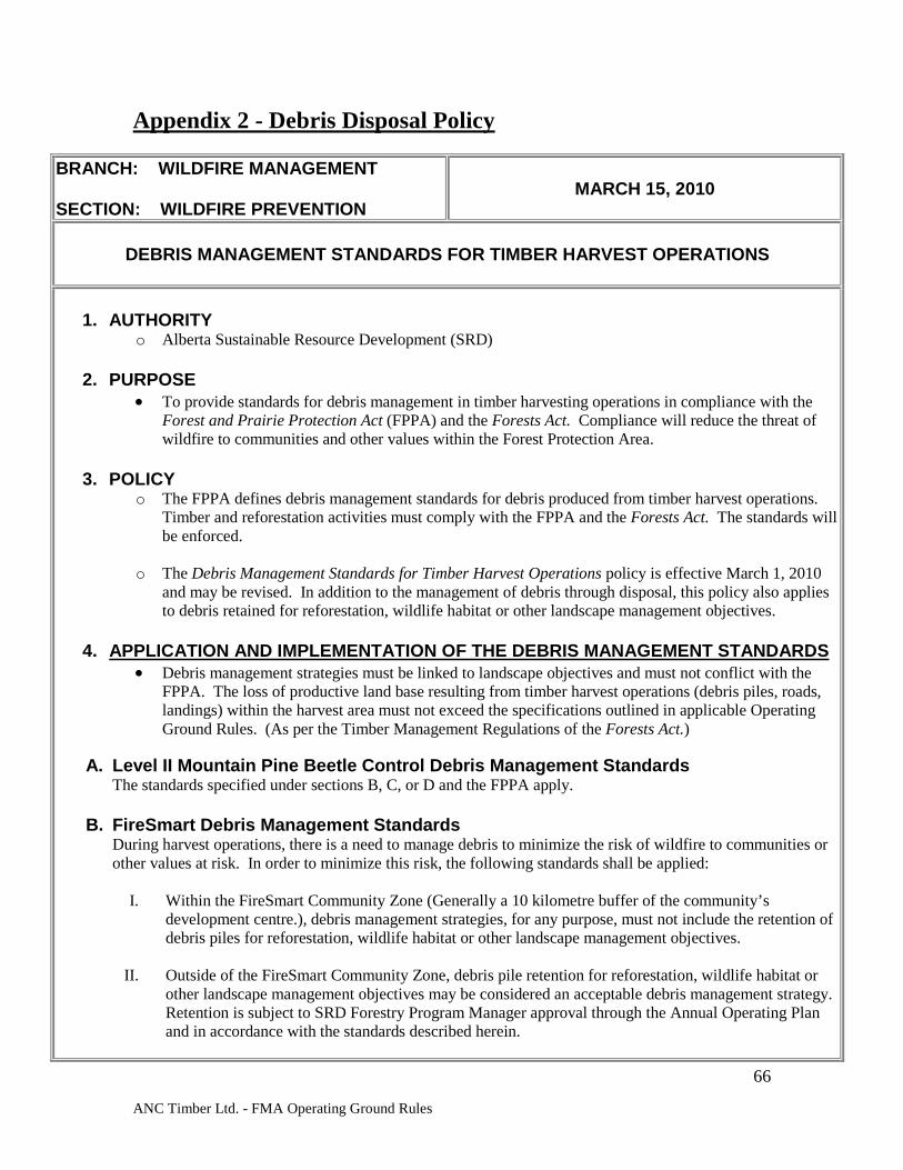
ANC Timber Ltd. - FMA Operating Ground Rules
66
Appendix 2 - Debris Disposal Policy
BRANCH: WILDFIRE MANAGEMENT SECTION: WILDFIRE PREVENTION
MARCH 15, 2010
DEBRIS MANAGEMENT STANDARDS FOR TIMBER HARVEST OPERATIONS
1. AUTHORITY
o Alberta Sustainable Resource Development (SRD)
2. PURPOSE • To provide standards for debris management in timber harvesting operations in compliance with the
Forest and Prairie Protection Act (FPPA) and the Forests Act. Compliance will reduce the threat of wildfire to communities and other values within the Forest Protection Area.
3. POLICY
o The FPPA defines debris management standards for debris produced from timber harvest operations. Timber and reforestation activities must comply with the FPPA and the Forests Act. The standards will be enforced.
o The Debris Management Standards for Timber Harvest Operations policy is effective March 1, 2010
and may be revised. In addition to the management of debris through disposal, this policy also applies to debris retained for reforestation, wildlife habitat or other landscape management objectives.
4. APPLICATION AND IMPLEMENTATION OF THE DEBRIS MANAGEMENT STANDARDS
• Debris management strategies must be linked to landscape objectives and must not conflict with the FPPA. The loss of productive land base resulting from timber harvest operations (debris piles, roads, landings) within the harvest area must not exceed the specifications outlined in applicable Operating Ground Rules. (As per the Timber Management Regulations of the Forests Act.)
A. Level II Mountain Pine Beetle Control Debris Management Standards
The standards specified under sections B, C, or D and the FPPA apply. B. FireSmart Debris Management Standards
During harvest operations, there is a need to manage debris to minimize the risk of wildfire to communities or other values at risk. In order to minimize this risk, the following standards shall be applied:
I. Within the FireSmart Community Zone (Generally a 10 kilometre buffer of the community’s development centre.), debris management strategies, for any purpose, must not include the retention of debris piles for reforestation, wildlife habitat or other landscape management objectives.
II. Outside of the FireSmart Community Zone, debris pile retention for reforestation, wildlife habitat or
other landscape management objectives may be considered an acceptable debris management strategy. Retention is subject to SRD Forestry Program Manager approval through the Annual Operating Plan and in accordance with the standards described herein.
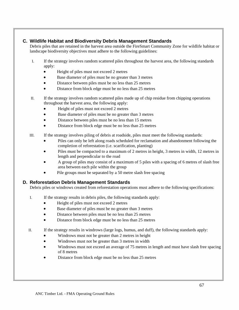
ANC Timber Ltd. - FMA Operating Ground Rules
67
C. Wildlife Habitat and Biodiversity Debris Management Standards Debris piles that are retained in the harvest area outside the FireSmart Community Zone for wildlife habitat or landscape biodiversity objectives must adhere to the following guidelines:
I. If the strategy involves random scattered piles throughout the harvest area, the following standards
apply: • Height of piles must not exceed 2 metres • Base diameter of piles must be no greater than 3 metres • Distance between piles must be no less than 25 metres • Distance from block edge must be no less than 25 metres
II. If the strategy involves random scattered piles made up of chip residue from chipping operations
throughout the harvest area, the following apply: • Height of piles must not exceed 2 metres • Base diameter of piles must be no greater than 3 metres • Distance between piles must be no less than 15 metres • Distance from block edge must be no less than 25 metres
III. If the strategy involves piling of debris at roadside, piles must meet the following standards:
• Piles can only be left along roads scheduled for reclamation and abandonment following the completion of reforestation (i.e. scarification, planting)
• Piles must be compacted to a maximum of 2 metres in height, 3 metres in width, 12 metres in length and perpendicular to the road
• A group of piles may consist of a maximum of 5 piles with a spacing of 6 metres of slash free area between each pile within the group
• Pile groups must be separated by a 50 metre slash free spacing
D. Reforestation Debris Management Standards Debris piles or windrows created from reforestation operations must adhere to the following specifications: I. If the strategy results in debris piles, the following standards apply:
• Height of piles must not exceed 2 metres • Base diameter of piles must be no greater than 3 metres • Distance between piles must be no less than 25 metres • Distance from block edge must be no less than 25 metres
II. If the strategy results in windrows (large logs, humus, and duff), the following standards apply: • Windrows must not be greater than 2 metres in height • Windrows must not be greater than 3 metres in width • Windrows must not exceed an average of 75 metres in length and must have slash free spacing
of 8 metres • Distance from block edge must be no less than 25 metres
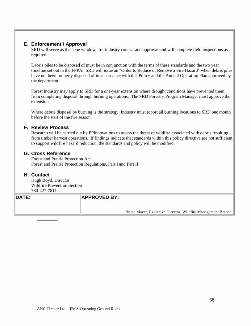
ANC Timber Ltd. - FMA Operating Ground Rules
68
E. Enforcement / Approval SRD will serve as the "one window" for industry contact and approval and will complete field inspections as required. Debris piles to be disposed of must be in conjunction with the terms of these standards and the two year timeline set out in the FPPA. SRD will issue an "Order to Reduce or Remove a Fire Hazard" when debris piles have not been properly disposed of in accordance with this Policy and the Annual Operating Plan approved by the department. Forest Industry may apply to SRD for a one-year extension where drought conditions have prevented them from completing disposal through burning operations. The SRD Forestry Program Manager must approve the extension. Where debris disposal by burning is the strategy, Industry must report all burning locations to SRD one month before the start of the fire season.
F. Review Process
Research will be carried out by FPInnovations to assess the threat of wildfire associated with debris resulting from timber harvest operations. If findings indicate that standards within this policy directive are not sufficient to support wildfIre hazard reduction, the standards and policy will be modified.
G. Cross Reference
Forest and Prairie Protection Act Forest and Prairie Protection Regulations, Part I and Part II
H. Contact Hugh Boyd, Director Wildfire Prevention Section 780-427-7811
DATE:
APPROVED BY: ___________________________________________________
Bruce Mayer, Executive Director, Wildfire Management Branch
ANC Timber Ltd. - FMA Operating Ground Rules
69
Appendix 3 - Directive for Weed Management.
Directive No. 2001-06
Subject Weed Management in Forestry Operations
Purpose To implement effective weed management programs administered by holders of Forests Act dispositions engaged in forestry operations. This policy applies only to Forests Act dispositions.
Policy Section 60 of the Public Lands Act sets out a disposition holder’s responsibility with respect to noxious and restricted weeds on dispositions issued under that Act. Similarly, Section 31 of the Weed Control Act requires that the occupant (or if the land is unoccupied, the owner) of land destroy all restricted weeds, control all noxious weeds and prevent the spread or scattering of nuisance weeds. The weed control duties on holders of dispositions issued pursuant to the Public Lands Act are reasonably clear and would apply to such dispositions that are issued in relation to forestry operations (e.g. camps, roads, processing sites and other associated land uses). It is, however, not entirely certain as to how the courts would interpret and apply the definition of “occupant” under the Weed Control Act in respect of timber dispositions issued under the Forests Act. In terms of forestry operations, the vast majority of weed management situations should fall under either the Public Lands Act or the Weed Control Act. This Directive attempts to address weed management, in a forest operations context, where neither of these two Acts apply. The Crown’s goal is to address weed management issues on a landscape level, as opposed to on a disposition-by-disposition level. To accomplish this, a two-step approach will be taken. Firstly, the disposition document and annual operating plans (AOP) will be used to describe the disposition holder’s obligations with respect to weed management activities. Secondly, the Land and Forest Service (LFS) (and ideally, municipalities) will establish landscape level, co-operative weed management groups, with a mandate to developing a single management plan for all stakeholders involved. Invasive weeds can alter the ecosystem’s natural processes and displace native, threatened, and endangered vegetation and habitat. For these reasons, forest companies are expected to assist in managing weeds in the forested area of Alberta.
ANC Timber Ltd. - FMA Operating Ground Rules
70
Procedure
Amendment of Annual Operating Plans and Dispositions In order to address situations that fall outside the requirements of either the Public Lands Act or the Weed Control Act all AOPs prepared and submitted for timber dispositions are to include the following condition. Additionally, this statement is to be incorporated into the disposition itself upon issuance or renewal.
“{Disposition holder} shall, with respect to the land contained in this timber disposition, prevent the establishment of and control all noxious and restricted weeds to which the Weed Control Act applies, in a manner acceptable to the Minister.”
The Minister will consider the “Recommended Standards of Good Practice for Prevention”, described in the Guidelines section to be the minimum level of performance for all disposition holders. Where a disposition holder or weed management group (as described below) prepares a plan outlining weed management, the commitments in that plan will become the standards to which the disposition holder or parties to the group will be expected to meet. The Regional Director will approve this plan, where appropriate. Co-operative Weed Management Groups The LFS will establish co-operative weed management groups where willing participants are identified. The specific purpose of the groups will depend on the level of current involvement the individual participants have in weed management. Where participants are currently managing weeds, the purpose of the group may be to review individual existing weed management plans to identify opportunities for co-operative management. Where participants are not currently involved in weed management the purpose of the group may be to develop a single weed management plan for all group participants, or to assist individuals in the development of individual plans if desired. The role and degree of involvement of LFS staff on these groups will depend on the make-up and desires of each individual group. Typically, the LFS will convene and co-ordinate weed management group meetings, in addition to other roles defined by the group. Forest Management Division staff will work with Forest Area staff to develop provincially consistent Terms of Reference for each group, and provide technical expertise and support where possible. Each group will select its own chairperson and define the roles for each member. Weed management plans should address inventory, control, education, and prevention. Once a co-operative or individual weed management plan is agreed to, that plan will be implemented through the individual’s AOP. The results of this implementation will be used as the benchmark to which the Minister’s satisfaction for weed control and prevention is measured (i.e. vis-à-vis the AOP clause described above).
Guidelines To assist in determining whether a disposition holder’s weed management activities are acceptable to the Minister, the following guidelines describe the four essential aspects of weed management: goals, prevention, inventory and control. All of these should be considered when developing weed management activities and plans.
ANC Timber Ltd. - FMA Operating Ground Rules
71
A. Goals
The goals should be specific to noxious and restricted weed prevention, inventory and control. They can be short-term and long-term, as is the nature of weed management.
B. Recommended Good Standards of Practice for Prevention 1. Limit Soil Disturbances To limit the establishment of weed infestations, prevent unnecessary soil disturbances wherever possible. 2. Clean Equipment Practice due diligence by ensuring that all equipment and vehicles are free of weed seeds and plant parts before arriving on a job site. All agricultural implements or any equipment knowingly exposed to weeds are to be pressure washed prior to use in forested areas. 3. The Use of Straw Bales for Erosion Control The use of straw bales for erosion control is discouraged in the Green Area. Unlike hay, it is very difficult to determine if the straw bales are free of weed seeds. Therefore, certified “weed free” hay bales acquired from producers with a “Certificate of Inspection” should be used for erosion control. 4. Use Certified “Weed Free” Seed for Re-vegetation of Disturbed Sites Canada #1 Seed, approved under the Canada Seed Act, may not be weed free. To ensure a seed mix is virtually weed free, a purchaser can request a “Certificate of Seed Analysis.” To get a more detailed “Certificate of Seed Analysis”, the purchaser can request a larger seed sample analyzed, rather than the typical 25g sample to improve the confidence of the analysis. Alternatively, one can start with pure seed and then prepare the seed mix manually. 5. Rapid Response to Weed Infestations Because a single plant and small infestations are easier to control than large infestations, it is important to manage weeds proactively. To do this effectively, industry and LFS field staff should be trained in the identification of restricted and noxious weeds, and the importance of destroying individual weed plants and reporting new infestations. C. Inventory
A weed management program is most effective with an accurate account of existing weed infestations. Inventorying is most effective during the months of June through September, when most plants are in bloom and are the most easily recognized. “Noxious” and “Restricted” weed species to be surveyed are listed in the Weed Designation Regulation (138/80). Additionally, the Weed Control Act provides municipalities with the authority to designate other species of local concern as
ANC Timber Ltd. - FMA Operating Ground Rules
72
restricted or noxious. For this reason weed surveyors should obtain a list of restricted and noxious weeds from the municipal district(s) within which they are surveying.
D. Prioritizing Areas for Control Measures As some areas within which weeds are managed consist of a large land base, control throughout the entire area is not feasible. Specific areas should be targeted each year, based on priorities. When prioritizing areas for control treatments, many factors must be considered to deliver the most effective and efficient control program. The following example criteria are not ranked in order of importance, with exception of Restricted and Noxious: 1. Restricted vs. Noxious Target restricted weed infestations over noxious weed infestations. Control of restricted weeds should be implemented immediately following their discovery. 2. Location of Infestation Target infestations in highly traveled areas over those in isolated areas, thereby limiting the threat of seeds or plant parts being Tran located. 3. Size of Infestation Target small infestations before large ones, as it is easier to gain control of small infestations. This also applies to outlying pockets of larger infestations, which should be controlled prior to tackling the larger infestation. When dealing with a large infestation, a “contain and control” strategy (targeting outlying pockets, and/or the perimeter of the infestations) is an excellent option when resources are not available to control an entire infestation. 4. Weed Species To prevent their establishment, target weed species that are less abundant on a regional basis. When controlling infestations, target the weed species with the greatest ecological impacts. In many situations this may be difficult to quantify, although generally speaking it can be done. For instance, a weed infestation encroaching on a habitat of an endangered plant species would have a higher priority than an infestation among common or non-native vegetation. 5. Co-operative Control Opportunities Co-operative control is the most effective and efficient method to control weed infestations that span multiple dispositions or border of responsibility. Unless one is adopting a “contain and control” strategy, generally it is not a good idea to control only part of an infestation. E. Control Options When selecting a control method, it is important to note that different species respond differently to each method. The most efficient programs will have an integrated control plan that includes both prevention and one or more of the

ANC Timber Ltd. - FMA Operating Ground Rules
73
following control methods: ♦ Mowing / Cutting - Effective for perennial weeds. Careful monitoring and
proper timing are necessary for this to be a viable option. If a site is mowed over several years, well-developed root systems can eventually be depleted. Weeds should not be mowed once seed set has occurred, as this will aid in spreading seed.
♦ Hand Pulling - Effective for annual or biennial weeds, especially when dealing with small infestations or individual plants. Hand pulling may have to be done annually (before seed set) for several years, as dormant seeds in the soil may continue to germinate. If any weeds are pulled when in flower, they must be bagged and burned, as they will set seed if they are left on the ground.
♦ Herbicide Application - Very effective but will not guarantee 100% control. Sites may have to be revisited again the next year for follow-up treatments. Several herbicides are effective for each weed species. Chemical selection should be determined by site, weed species, existing desirable vegetation, and whether or not a residual effect is wanted. Assistance with selecting a herbicide and application rate can be obtained through a Municipal District, County Agricultural Fieldman, or Certified Pesticide Applicator.
♦ Biological Control - This method of control is the introduction of insects or diseases that attack or infect a specific weed species. Biological control agents can be difficult to obtain, and in some cases they are in the testing phase to determine effectiveness. Information regarding the biological control of weeds can be obtained through the Alberta Research Council in Vegreville, Alberta.
Authorities Weed Control Act - provincial legislation describing weed control and
management requirements. Weed Designation Regulation - lists weed species designated as restricted, noxious and nuisance in Alberta. Forests Act - describes the requirements with respect to forest allocation.
Cross - Reference
♦ FPD Policy 16.0 - Restricted and Noxious Weed Management Jurisdiction
♦ Land and Forest Service “Forest Management Herbicide Reference Manual”
Contacts Doug Sklar 422-4590 Hideji Ono 422-8801
Approved
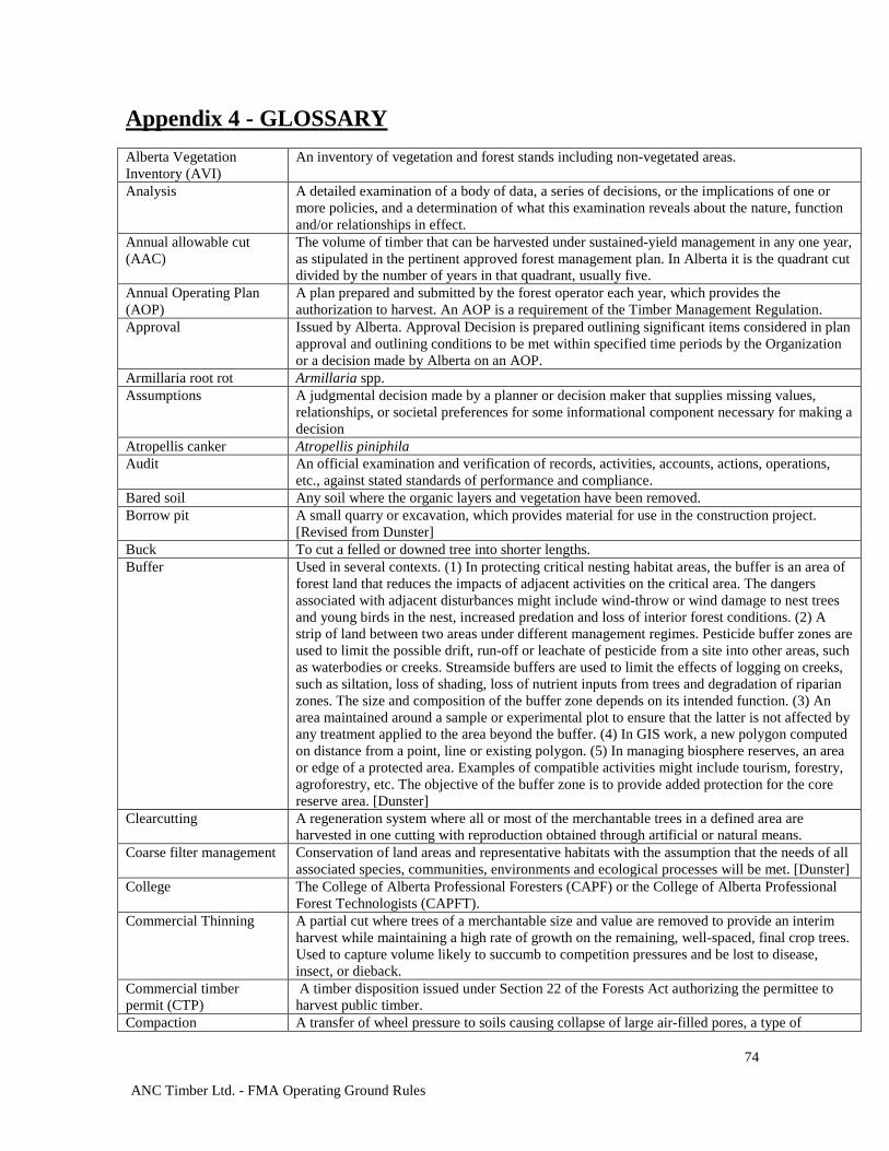
ANC Timber Ltd. - FMA Operating Ground Rules
74
Appendix 4 - GLOSSARY Alberta Vegetation Inventory (AVI)
An inventory of vegetation and forest stands including non-vegetated areas.
Analysis A detailed examination of a body of data, a series of decisions, or the implications of one or more policies, and a determination of what this examination reveals about the nature, function and/or relationships in effect.
Annual allowable cut (AAC)
The volume of timber that can be harvested under sustained-yield management in any one year, as stipulated in the pertinent approved forest management plan. In Alberta it is the quadrant cut divided by the number of years in that quadrant, usually five.
Annual Operating Plan (AOP)
A plan prepared and submitted by the forest operator each year, which provides the authorization to harvest. An AOP is a requirement of the Timber Management Regulation.
Approval Issued by Alberta. Approval Decision is prepared outlining significant items considered in plan approval and outlining conditions to be met within specified time periods by the Organization or a decision made by Alberta on an AOP.
Armillaria root rot Armillaria spp. Assumptions A judgmental decision made by a planner or decision maker that supplies missing values,
relationships, or societal preferences for some informational component necessary for making a decision
Atropellis canker Atropellis piniphila Audit An official examination and verification of records, activities, accounts, actions, operations,
etc., against stated standards of performance and compliance. Bared soil Any soil where the organic layers and vegetation have been removed. Borrow pit A small quarry or excavation, which provides material for use in the construction project.
[Revised from Dunster] Buck To cut a felled or downed tree into shorter lengths. Buffer Used in several contexts. (1) In protecting critical nesting habitat areas, the buffer is an area of
forest land that reduces the impacts of adjacent activities on the critical area. The dangers associated with adjacent disturbances might include wind-throw or wind damage to nest trees and young birds in the nest, increased predation and loss of interior forest conditions. (2) A strip of land between two areas under different management regimes. Pesticide buffer zones are used to limit the possible drift, run-off or leachate of pesticide from a site into other areas, such as waterbodies or creeks. Streamside buffers are used to limit the effects of logging on creeks, such as siltation, loss of shading, loss of nutrient inputs from trees and degradation of riparian zones. The size and composition of the buffer zone depends on its intended function. (3) An area maintained around a sample or experimental plot to ensure that the latter is not affected by any treatment applied to the area beyond the buffer. (4) In GIS work, a new polygon computed on distance from a point, line or existing polygon. (5) In managing biosphere reserves, an area or edge of a protected area. Examples of compatible activities might include tourism, forestry, agroforestry, etc. The objective of the buffer zone is to provide added protection for the core reserve area. [Dunster]
Clearcutting A regeneration system where all or most of the merchantable trees in a defined area are harvested in one cutting with reproduction obtained through artificial or natural means.
Coarse filter management Conservation of land areas and representative habitats with the assumption that the needs of all associated species, communities, environments and ecological processes will be met. [Dunster]
College The College of Alberta Professional Foresters (CAPF) or the College of Alberta Professional Forest Technologists (CAPFT).
Commercial Thinning A partial cut where trees of a merchantable size and value are removed to provide an interim harvest while maintaining a high rate of growth on the remaining, well-spaced, final crop trees. Used to capture volume likely to succumb to competition pressures and be lost to disease, insect, or dieback.
Commercial timber permit (CTP)
A timber disposition issued under Section 22 of the Forests Act authorizing the permittee to harvest public timber.
Compaction A transfer of wheel pressure to soils causing collapse of large air-filled pores, a type of
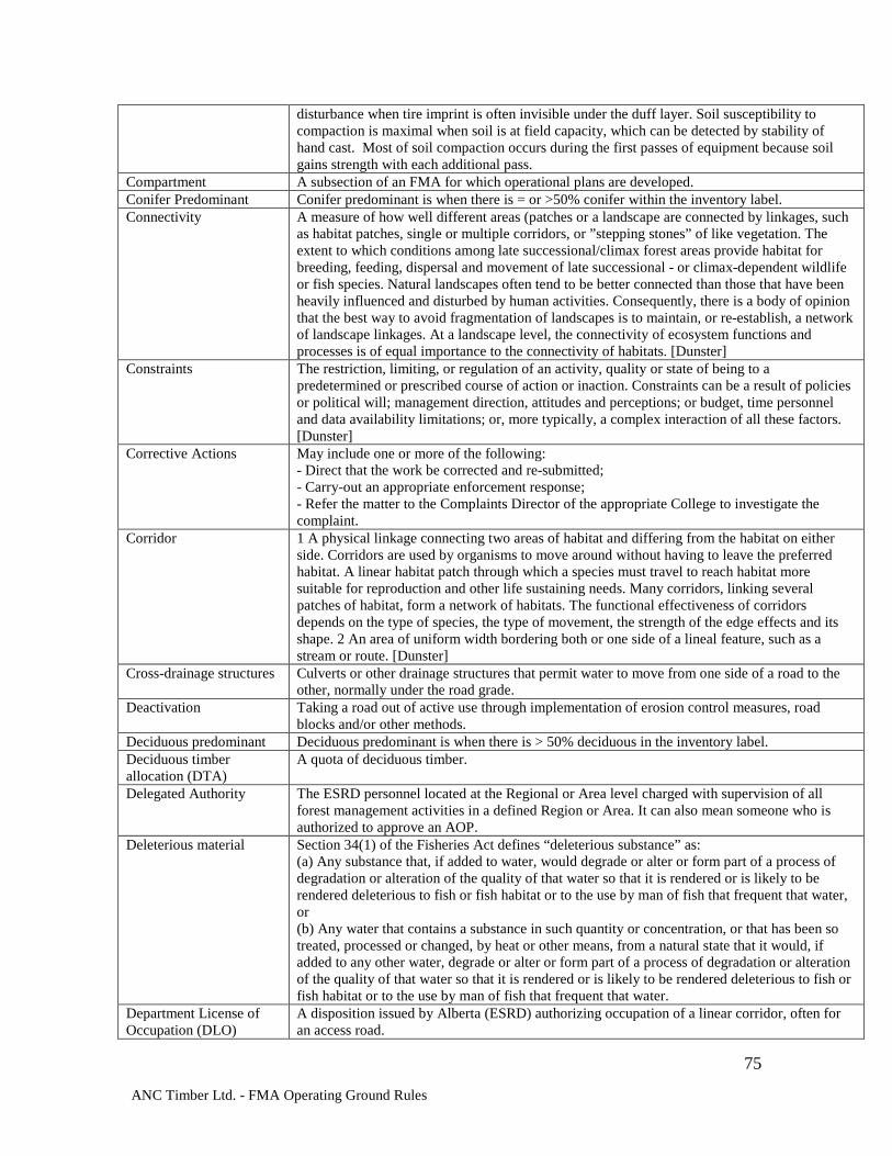
ANC Timber Ltd. - FMA Operating Ground Rules
75
disturbance when tire imprint is often invisible under the duff layer. Soil susceptibility to compaction is maximal when soil is at field capacity, which can be detected by stability of hand cast. Most of soil compaction occurs during the first passes of equipment because soil gains strength with each additional pass.
Compartment A subsection of an FMA for which operational plans are developed. Conifer Predominant Conifer predominant is when there is = or >50% conifer within the inventory label. Connectivity A measure of how well different areas (patches or a landscape are connected by linkages, such
as habitat patches, single or multiple corridors, or ”stepping stones” of like vegetation. The extent to which conditions among late successional/climax forest areas provide habitat for breeding, feeding, dispersal and movement of late successional - or climax-dependent wildlife or fish species. Natural landscapes often tend to be better connected than those that have been heavily influenced and disturbed by human activities. Consequently, there is a body of opinion that the best way to avoid fragmentation of landscapes is to maintain, or re-establish, a network of landscape linkages. At a landscape level, the connectivity of ecosystem functions and processes is of equal importance to the connectivity of habitats. [Dunster]
Constraints The restriction, limiting, or regulation of an activity, quality or state of being to a predetermined or prescribed course of action or inaction. Constraints can be a result of policies or political will; management direction, attitudes and perceptions; or budget, time personnel and data availability limitations; or, more typically, a complex interaction of all these factors. [Dunster]
Corrective Actions May include one or more of the following: - Direct that the work be corrected and re-submitted; - Carry-out an appropriate enforcement response; - Refer the matter to the Complaints Director of the appropriate College to investigate the complaint.
Corridor 1 A physical linkage connecting two areas of habitat and differing from the habitat on either side. Corridors are used by organisms to move around without having to leave the preferred habitat. A linear habitat patch through which a species must travel to reach habitat more suitable for reproduction and other life sustaining needs. Many corridors, linking several patches of habitat, form a network of habitats. The functional effectiveness of corridors depends on the type of species, the type of movement, the strength of the edge effects and its shape. 2 An area of uniform width bordering both or one side of a lineal feature, such as a stream or route. [Dunster]
Cross-drainage structures Culverts or other drainage structures that permit water to move from one side of a road to the other, normally under the road grade.
Deactivation Taking a road out of active use through implementation of erosion control measures, road blocks and/or other methods.
Deciduous predominant Deciduous predominant is when there is > 50% deciduous in the inventory label. Deciduous timber allocation (DTA)
A quota of deciduous timber.
Delegated Authority The ESRD personnel located at the Regional or Area level charged with supervision of all forest management activities in a defined Region or Area. It can also mean someone who is authorized to approve an AOP.
Deleterious material Section 34(1) of the Fisheries Act defines “deleterious substance” as: (a) Any substance that, if added to water, would degrade or alter or form part of a process of degradation or alteration of the quality of that water so that it is rendered or is likely to be rendered deleterious to fish or fish habitat or to the use by man of fish that frequent that water, or (b) Any water that contains a substance in such quantity or concentration, or that has been so treated, processed or changed, by heat or other means, from a natural state that it would, if added to any other water, degrade or alter or form part of a process of degradation or alteration of the quality of that water so that it is rendered or is likely to be rendered deleterious to fish or fish habitat or to the use by man of fish that frequent that water.
Department License of Occupation (DLO)
A disposition issued by Alberta (ESRD) authorizing occupation of a linear corridor, often for an access road.
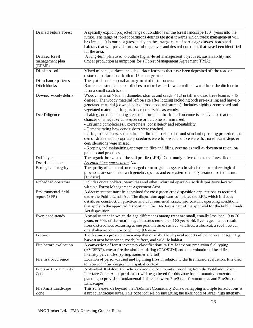
ANC Timber Ltd. - FMA Operating Ground Rules
76
Desired Future Forest A spatially explicit projected range of conditions of the forest landscape 100+ years into the future. The range of forest conditions defines the goal towards which forest management will be directed. It is our best guess today on the arrangement of forest age classes, roads and habitats that will provide for a set of objectives and desired outcomes that have been identified for the area.
Detailed forest management plan (DFMP)
A long-term plan used to outline higher-level management objectives, sustainability and timber production assumptions for a Forest Management Agreement (FMA).
Displaced soil Mixed mineral, surface and sub-surface horizons that have been deposited off the road or disturbed surface to a depth of 15 cm or greater.
Disturbance patterns The spatial and temporal arrangement of disturbances. Ditch blocks Barriers constructed across ditches to retard water flow, to redirect water from the ditch or to
form a small catch basin. Downed woody debris Woody material >1cm in diameter, stumps and snags < 1.3 m tall and dead trees leaning >45
degrees. The woody material left on site after logging including both pre-existing and harvest-generated material (downed boles, limbs, tops and stumps). Includes highly decomposed and vegetated material as long as it is recognizable as woody.
Due Diligence - Taking and documenting steps to ensure that the desired outcome is achieved or that the chances of a negative consequence or outcome is minimized. - Ensuring completeness, correctness, consistency and repeatability. - Demonstrating how conclusions were reached. - Using mechanisms, such as but not limited to checklists and standard operating procedures, to demonstrate that appropriate procedures were followed and to ensure that no relevant steps or considerations were missed. - Keeping and maintaining appropriate files and filing systems as well as document retention policies and practices.
Duff layer The organic horizons of the soil profile (LFH). Commonly referred to as the forest floor. Dwarf mistletoe Arceuthobium americanum Nutt. Ecological integrity The quality of a natural, unmanaged or managed ecosystem in which the natural ecological
processes are sustained, with genetic, species and ecosystem diversity assured for the future. [Dunster]
Embedded operators Includes quota holders, permittees and other industrial operators with dispositions located within a Forest Management Agreement Area.
Environmental field report (EFR)
A document that must be submitted for most green area disposition applications as required under the Public Lands Act. The disposition applicant completes the EFR, which includes details on construction practices and environmental issues, and contains operating conditions that apply to the approved disposition. The EFR forms part of the approval for the Public Lands Act disposition.
Even-aged stands A stand of trees in which the age differences among trees are small, usually less than 10 to 20 years, or 30% of the rotation age in stands more than 100 years old. Even-aged stands result from disturbances occurring at one point in time, such as wildfires, a clearcut, a seed tree cut, or a shelterwood cut or coppicing. [Dunster]
Features The features represented on a map that describe the physical aspects of the harvest design. E.g. harvest area boundaries, roads, buffers, and wildlife habitat.
Fire hazard evaluation A conversion of forest inventory classifications to fire behaviour prediction fuel typing (AVI2FBP), crown fire threshold modeling (CROSUM) and determination of head fire intensity percentiles (spring, summer and fall).
Fire risk occurrence Location of person-caused and lightning fires in relation to the fire hazard evaluation. It is used to represent “fire danger” in a spatial context.
FireSmart Community Zone
A standard 10-kilometre radius around the community extending from the Wildland Urban Interface Zone. A unique data set will be gathered for this zone for community protection planning to provide a fundamental linkage between FireSmart Communities and FireSmart Landscapes
FireSmart Landscape Zone
This zone extends beyond the FireSmart Community Zone overlapping multiple jurisdictions at a broad landscape level. This zone focuses on mitigating the likelihood of large, high intensity,
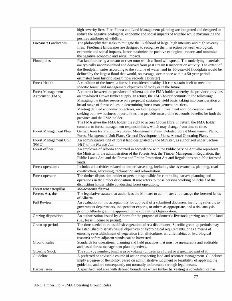
ANC Timber Ltd. - FMA Operating Ground Rules
77
high severity fires. Fire, Forest and Land Management planning are integrated and designed to reduce the negative ecological, economic and social impacts of wildfire while maximizing the positive attributes of wildfire.
FireSmart Landscapes The philosophy that seeks to mitigate the likelihood of large, high intensity and high severity fires. FireSmart landscapes are designed to recognize the interaction between ecological, economic and social impacts, hence maximize the positive ecological impacts and minimize the negative economic and social impacts.
Floodplains Flat land bordering a stream or river onto which a flood will spread. The underlying materials are typically unconsolidated and derived from past stream transportation activity. The extent of the floodplain varies according to the volume of water, and its 50-year-old floodplain would be defined by the largest flood that would, on average, occur once within a 50-year-period, estimated from historic stream flow records. [Dunster]
Forest Health A condition of the forest; a forest is considered healthy if it can sustain itself to meet the specific forest land management objectives of today or in the future.
Forest Management Agreement (FMA)
A contract between the province of Alberta and the FMA holder whereby the province provides an area-based Crown timber supply. In return, the FMA holder commits to the following: Managing the timber resource on a perpetual sustained yield basis, taking into consideration a broad range of forest values in determining forest management practices. Meeting defined economic objectives, including capital investment and job creation, and seeking out new business opportunities that provide measurable economic benefits for both the province and the FMA holder. The FMA gives the FMA holder the right to access Crown fibre. In return, the FMA holder commits to forest management responsibilities, which may change from time to time.
Forest Management Plan Generic term for Preliminary Forest Management Plans, Detailed Forest Management Plans, Forest Management Unit Plans, General Development Plans, Annual Operating Plans.
Forest Management Unit (FMU)
An administrative unit of forest land designated by the Minister, as authorized under Section 14(1) of the Forests Act.
Forest officer An employee of Alberta appointed in accordance with the Public Service Act who represents the Minister in the administration of the Forests Act, the Timber Management Regulation, the Public Lands Act, and the Forest and Prairie Protection Act and Regulations on public forested lands.
Forest operations Includes all activities related to timber harvesting, including site assessments, planning, road construction, harvesting, reclamation and reforestation.
Forest operator The timber disposition holder or person responsible for controlling harvest planning and operations in the timber disposition. It also refers to those persons working on behalf of the disposition holder while conducting forest operations.
Forest tent caterpillar Malacosoma disstria Forests Act, the The legislative statute that authorizes the Minister to administer and manage the forested lands
of Alberta. Full Review An evaluation of the acceptability for approval of a submitted document involving referrals to
government departments, independent experts, or others as appropriate, and a risk analysis prior to Alberta granting approval to the submitting Organization.
Grazing disposition An authorization issued by Alberta for the purpose of domestic livestock grazing on public land (i.e., lease, license or permit).
Green-up period The time needed to re-establish vegetation after a disturbance. Specific green-up periods may be established to satisfy visual objectives or hydrological requirements, or as a means of ensuring re-establishment of vegetation (for silviculture, wildlife habitat or hydrological reasons) before adjacent stands can be harvested.
Ground Rules Standards for operational planning and field practices that must be measurable and auditable and based forest management plan objectives.
Growing Stock The sum (by number, basal area or volume) of trees in a forest or a specified part of it. Guideline A preferred or advisable course of action respecting land and resource management. Guidelines
imply a degree of flexibility, based on administrative judgment or feasibility of applying the guideline, and are consequently not normally enforceable through legal means.
Harvest area A specified land area with defined boundaries where timber harvesting is scheduled, or has
ANC Timber Ltd. - FMA Operating Ground Rules
78
occurred. (commonly referred to as a cut block) Harvest area form A map and harvest area comments for each laid-out harvest area. Hiding cover See “sight distance.” High-water mark Stream course water levels corresponding to the top of the unvegetated channel or lakeshore. Historical resource Any work of nature or man that is primarily of value for its palaeontological, archaeological,
prehistoric, historic, cultural, natural, scientific or aesthetic interest, including, but not limited to, the structure or object and its surrounding site.
Incidental Activity Activities incidental to temporary road construction that when approved, are considered part of the adjacent disposition.
Interpretive Bulletin Document issued from time to time by Alberta describing protocols, standards, methods or other applicable to forest management planning.
Harvest area aesthetics Overall quality of operations in respect to the real or imagined effect on visual quality and/or the environment within a particular harvest area.
Harvest Level A volume or area of timber determined through timber supply analysis available for harvest on an annual sustainable basis within a DFA. A harvest level is not an AAC unless approved by the Minister.
Inoperable Classification of a forest site based on the potential to harvest timber on that site, as affected by physiographic characteristics, moisture regime and harvesting equipment/technology.
Insects and Diseases Biological, physiological, and environmental agents that have an adverse effect on the health of the forest. These agents include insects; nematodes; micro-organisms (viruses, bacteria, fungi); parasitic plants; mammals; birds; and non-infectious disorders caused by climate, soil, applied chemicals, air pollutants and other physiographic conditions.
Integrated resource management (IRM)
IRM is an interdisciplinary and comprehensive approach to decision making for the management of natural resources. IRM integrates decisions, legislation, policies, programs and activities across sectors to gain the best overall long-term benefits for society and to minimize conflicts. This approach recognizes that the use of a resource for one purpose can affect both the use of a resource for other purposes and the management and use of other resources. IRM is based on: Co-operation, communication, co-ordination and the comprehensive consideration of all resource values. This philosophy is centered on the belief that efforts to manage natural resources will be more successful if they are co-ordinated at all levels within government; and Appropriate consultation before action. Those who are significantly affected by a decision should have the opportunity to participate in the decision making process.
Integrated resource plan A regional plan developed by provincial government agencies in consultation with the public and local government bodies. It provides strategic policy direction for the use of public land and its resources within the prescribed planning area. It is used as a guide for resource planners, industry and publics with responsibilities or interests in the area.
Interests The wants, needs, concerns and desires of each party that provide motivation to be concerned about an issue or topic.
Interior forest conditions The environmental conditions typical of the central or interior part of a habitat patch. They are usually relatively stable and are not influenced by the changing climatic conditions and other variables (noise, wind, sunlight, temperature, moisture) associated with edge conditions. [Dunster]
Issue The topic to be discussed. The problem to be solved. The theme of the discussion. Jack pine budworm Choristoneura pinus Landing Any area where logs are gathered for processing or further transport to a mill site. Landscape A landscape (or LMU) is a heterogeneous area in which the pattern of the mosaic of local
ecosystems or land uses is repeated in similar form throughout kilometres wide area (after Forman 1986). Landscapes may coincide with a climatic, physiographic or ecological boundary. However, landscapes are not strictly ecologically based and include human use and modification of the area.
Landscape fire assessment Information on the effects of fire which may be used to influence forest management strategies and tactics over a landscape. The wildfire threat component of the landscape fire assessment handles the negative aspects of fire, and fire regime analysis handles the positive attributes. Both "wildfire threat" and "fire regime" need to be considered in order to provide a balanced
ANC Timber Ltd. - FMA Operating Ground Rules
79
"landscape fire assessment." [Stegehuis] Large patch of residual trees
A 0.2 to 2 ha patch of undisturbed canopy forest surrounded by harvested area. At least half of the trees in the patch should be large residual trees.
Large residual tree A residual tree with a diameter measured at breast height (DBH) greater than the approximate average merchantable tree DBH of the harvest area.
Letter(s) of Understanding
An agreement(s) signed between the Organization and the Crown outlining commitments and timelines for each party on future timber production audits as referenced in the “Timber Audit Framework.”
License of Occupation(LOC)
A formal disposition issued under the Public Lands Administration Regulation by Alberta (AER) authorizing occupation of a linear corridor, often for an access road.
Logfill Stream crossings constructed with logs placed in a streambed parallel to the flow of the water. Logging slash The unusable trees, shrubs or portions thereof that result after tree felling, skidding and
processing at the harvest site. Machine-free zone The area protected from machinery which would cause soil damage. Mass-wasting Movement of large masses of land, soil or regolith (i.e., slumping, landslides, rock slides and
massive undercut erosion). Mature stands Stands that have reached rotation age or have a decreasing growth rate. Mean Annual Increment The average annual increase in volume of individual trees or stands up to the specified point in
time. The MAI changes with different growth phases in a tree's life, being highest in the middle years and then slowly decreasing with age. The point at which the MAI peaks is commonly used to identify the biological maturity of the stand and its readiness for harvesting.
Maximum Mean Annual Increment
The volume available at the culmination of mean annual increment. The volume/ha described by the point on a volume/ha: age graph where the curve of mean annual increment crosses the curve of the current annual increment (CAI).
Mixedwood forest A forest type in which the softwood component is between 20% and 80% by crown closure. Model An idealized representation of reality developed to describe, analyse or understand the
behaviour of some aspect of this reality. A mathematical representation of relationships under study. The quest to find a subset of variables and a function between them that predicts one or more dependent variables.
Mountain pine beetle Dendroctonus ponderosae Noxious Weed A plant designated under the Weed Regulation (AR 171/2001) of the Weed Control Act. Organization The proponent charged with developing the FMP. This may be a corporation, cooperative, or a
public agency. Partial cutting A treatment where significantly less than 100% of the trees are harvested from a stand or area.
It includes commercial thinning, even when the intention is leading to a final clearcut. Pattern The arrangement of forest stands or harvest units. Permanent reserve An area permanently excluded from harvesting in the DFMP. Permanent roads Roads that will be in use for more than three years. Permanent sample plots (PSP)
A fixed or variable area plot established for (forest) sampling and measurement purposes, and designed for remeasurement.
Planning Horizon The length of time over which a series of defined management actions occur. For the purposes of modeling, usually equivalent to two full rotations.
Precautionary AAC A level of harvest set that minimizes the risk of negatively impacting forest resources from an inadequately justified management assumption or in the absence of a comprehensive DFMP for the DFA.
Pre-commercial Thinning A silvicultural treatment to reduce tree density in young stands, carried out before the stems reach merchantable size. The intent is to concentrate the site’s growth potential on fewer trees thereby accelerating stand development and reducing the time to final harvest, retaining more live crown, creating opportunities for future commercial thinning activities and improving stand operability.
Preliminary Forest Management Plan
A plan submitted by FMA holders within 12 months of signing a new agreement (includes a major revision to an existing agreement). It establishes an interim harvest level and cut sequence complete with justifications. This plan is the basis for harvest authorization until replaced by the Detailed Forest Management Plan.
Prescribed burn The planned use of carefully controlled fire to accomplish predetermined management goals
ANC Timber Ltd. - FMA Operating Ground Rules
80
(e.g., site preparation for planting, reduction of fire hazards or pest problems, improvement of the ease with which the site can be traversed, and creation of better quality browse for wildlife). [Dunster]
Prohibited debris Any flammable debris or waste material that, when burned, may result in the release of dense smoke, offensive odours or toxic air contaminants. It includes: (a) Garbage or refuse from commercial or industrial operations (b) Rubber or plastic, or anything containing or coated with rubber or plastic or similar substances (c) Used oil from internal combustion engines, hydraulic oil and lubricants (d) Motor vehicle tires.
Quota The timber quota is a share of the allowable cut of coniferous timber within a forest management unit.
Reclamation of roads Permanent removal of watercourse crossings; re-contouring of road crown and ditches; reseeding or planting of the former right-of-way.
Recreationalist A person who participates in outdoor activities in the forest, such as horseback riding, ATV riding, snowmobiling, hiking, cross-country skiing, wilderness area experience, hunting, fishing, berry-picking, wildlife viewing, photography, camping, canoeing, etc.
Recreation Site Includes areas designated by Alberta as Ecological Reserves, Wilderness Areas, Wildland Parks, Provincial Parks, Heritage Rangelands, Natural Areas, and Recreation areas.
Regeneration The renewal of a tree crop by natural or artificial means. It may also refer to the young crop itself.
Regulated Forestry Professional
A Registered Professional Forester (RPF) on the Registered Professional Forester Register of the College of Alberta Professional Foresters (CAPF) or a Registered Professional Forest Technologist (RFPT) on the Registered Professional Forest Technologist Register of the College of Alberta Professional Forest Technologists (CAPFT).
Reserve In its strictest sense, an area of land designated as being off-limits to any exploitive activities that might change the nature of the area. Not all reserves are so tightly controlled. [Dunster]
Residual structure Standing structure that is taller than 2 m, within a harvested area. Areas buffered for sensitive ecological or wildlife habitat may be included for residuals. Required buffers for lakes and small and large permanent streams are not included. This includes non-merchantable trees and shrubs, live merchantable trees, snags and stubs.
Residual tree A live canopy tree that is spatially within a harvested area. Areas buffered for sensitive ecological or wildlife habitat may be included for residuals. Required buffers for lakes, small and large permanent streams are not included.
Resources Physical and intrinsic features of the land, including but not limited to timber, wildlife, water and soil.
Restricted Weed A plant designated under the Weed Regulation (AR 171/2001) of the Weed Control Act. Review Acceptance or appraisal conducted by Alberta Review Team A group of senior Alberta officials and the Forest Management Planning Forester formed to
review detailed forest management plans. Right-of-way (ROW) A cleared area, usually linear, containing a road and its associated features such as shoulders,
ditches, cut and fill slopes, or the area cleared for the passage of utility corridors containing power lines or over- or under-ground pipelines. Typically, the right-of-way is a specially designated area of land having very specific rights of usage attached. Someone else may own rights-of-way. [Dunster]
Riparian area or management zone
(1) The band of land that has a significant influence on a stream ecosystem or is significantly affected by the stream. It often has specialized plant and animal communities associated with it. [Anon] (2)Terrestrial areas where the vegetation complex and microclimate conditions are products of the combined presence and influence of perennial and/or intermittent water, associated high water tables and soils that exhibit some wetness characteristics. Normally used to refer to the zone within which plants grow rooted in the water table of these rivers, streams, lakes, ponds, reservoirs, springs, marshes, seeps, bogs and wet meadows. The riparian zone is influenced by, and exerts an influence on, the associated aquatic ecosystem. [Dunster]
Root collar weevils Hylobius spp.
ANC Timber Ltd. - FMA Operating Ground Rules
81
Rotation The period of years required to establish and grow even-aged timber crops to a specified condition of maturity.
Ruts Machine depressions in the soil which are determined by depth and length: where the depth of the organic dark humus material is greater than 30 cm, a rut is a depression that shears the organic layer of soil (a sheared organic will expose a vertical face greater than 20 cm of the organic layer). Where the depth of the organic material is less than 30 cm, a rut is a depression exceeding 10 cm into the mineral soil. Length: An impacted area meeting the rut depth criteria that is greater than 4 m long. A continuous track with a rut less than 4 m because of stumps, logs or rocks lifting the vehicle will still count as a rut if the total length of the smaller holes is greater than 4 m.
Rutting/ puddling A paste-like behaviour of wet soil when most of the soil pores are filled with water and soil literally flows from underneath the wheel to the sides and upward forming visible tire imprint into the mineral soil. Intensity/depth of rutting is directly related to the number of equipment passes. Soil is considered susceptible to rutting when it forms a stable hand cast.
Selection Harvesting A silvicultural system used to create or maintain uneven aged stands. Usually accomplished through the periodic removal of groups of trees or individual trees, while full residual stand growth rates are maintained and natural regeneration from overstory trees is encouraged. Not to be confused with selective harvesting, or high-grading, where trees are selected and removed periodically based solely on economic criteria. Selective harvest is not designed to improve the growing conditions of the remaining crop trees as Selection harvest is.
Sensitive or Complex sites
Sites that have soil, water, slope, aesthetic, vegetation or wildlife characteristics that require special protection beyond the normal precautions described in the ground rules. They may be complex if many values or issues are involved.
Sensitive soil site Any site that may be prone to soil movement, soil erosion, mass wasting or siltation due to steep slopes, wet ground, seepage areas, springs, fine textured soils or soils prone to mass wasting.
Seral stages A stage in succession. A series of plant community conditions that develop during ecological succession from a major disturbance to the climax stage. Most common characteristics/classifications include tree species and age.
Sight distance The distance at which 90% or more of an adult big game animal is hidden from the view of a human. This distance may vary from one stand to another.
Silt fence Permeable fabric barriers installed along the contour to filter surface water runoff and trap sediment from sheet or overland flow and prevent it from entering streams.
Silvicultural systems Systems that follow accepted silvicultural principles, whereby the tree crops are tended, harvested and replaced to produce a crop of a desired form. This includes even-aged (i.e., clearcutting, shelterwood or seed tree cutting) or uneven-aged (i.e., selection cutting) systems. A planned program of silviculture treatments over the life of a stand, it includes the harvesting and the follow-up tending to the next rotation. [Smith, 1996]
Silviculture The theory and practice of controlling the establishment, composition, health, structure and growth of forests in order to achieve specified management objectives.
Site preparation Any action taken in conjunction with a reforestation effort (natural or artificial) to create an environment favourable for survival of suitable trees during the first growing season. Altering the ground cover, soil or microsite conditions can create this environment; using biological, mechanical or manual clearing; prescribed burns; herbicides or a combination of methods. [Dunster]
Skid trail An unimproved temporary forest trail suitable for use by equipment such as bulldozers and skidders in bringing trees or logs to a landing or road.
Small patch of residual trees
A patch of less than 0.2 ha of undisturbed canopy forest surrounded by harvested area. The patch must be composed of at least four canopy trees. At least two of the trees in the patch should be large residual trees.
Snag A dead tree that is taller than 2 m. Soil Displacement A loss of nutrient-rich organic layers, and top mineral soil as a result of harvesting activities.
Bare mineral soil is susceptible to raindrop impact causing soil crusting, increased surface runoff, and erosion.
ANC Timber Ltd. - FMA Operating Ground Rules
82
Soil disturbance In the context of the 5% maximum allowable area within a harvest area, includes bared landing areas, temporary roads, displaced soils or ruts.
Soil productivity The capacity of a soil to provide for growth. Spatial Of, or existing in, space. [Webster’s] Species at risk Any species known to be ”at risk” after formal detailed status assessment and designation as
“Endangered” or “Threatened” in Alberta. The list of species is maintained by Alberta. Species of management concern
Species within the forest management planning area that have an identified value (social, economic, ecological) and are managed to ensure their continued protection and/or use. This includes species that are hunted or trapped, as well as those that are endangered or threatened.
Spruce beetle Dendroctonus rufipennis Stakeholder Anybody who feels that his/her interests will be affected by the outcome of a decision making
process. Stand A community of trees sufficiently uniform in species, age, arrangement or condition as to be
distinguishable as a group in the forest or other growth in the area. A stand may also be that polygon as defined in the AVI or Phase III inventory.
Stand Density Management Diagram (SDMD)
A stand model based on data from the –3/2 power law for self-thinning. Illustrates the relationships between diameter and height with stand density over time.
Strippings Layers of humus-bearing topsoil and fine woody material above mineral soil that have been stripped off during road or landing construction.
Stub A large residual tree that has been “topped off” at approximately 6 m to create an artificial snag.
Subgrade The road base. Subsequent pass Any harvest occurring after the first harvest pass. Suppression capability The effectiveness of traditional fire suppression tactics. It is an objective evaluation of initial
attack response time, access for ground support resources, water availability and terrain which might adversely impact movement of resources.
Sustainable forest management (SMF)
Management to maintain and enhance the long-term health of forest ecosystems, while providing ecological, economic, social and cultural opportunities for the benefit of present and future generations.
Temporal Of, or limited by, time. [Webster’s] Temporary field authority (TFA)
An authority issued under Section 19 of the Public Lands Act by an Alberta officer to grant short-term land use activities on public land in the White or Green Areas. The TFA may or may not be related to an existing disposition that has also been issued under the Public Lands Act. The concept is to provide field-level service to an applicant, with access to public land for a specific purpose/use/activity, for a term of less than or equal to one year.
Temporary road Roads that are part of a harvest area or that connect harvest areas, and are built, used and reclaimed before expiry of the Annual Operating Plan (AOP) or reclaimed within three years of construction.
Terrestrial vegetation Look Up in Dunster – hydrophytic vegetation ends Thermal cover Generally, an area of at least 10 ha having a coniferous canopy at least 10 m in height, with at
least 70% crown closure and a minimum width of 200 m. This cover is used by animals to assist in their temperature regulation during extreme weather conditions.
Three-pass harvest A harvest pattern in which all the available merchantable timber in an area is harvested in three separate passes. Normally it is done over approximately equal areas and in equal volumes.
Timber disposition Licenses and permits that allow forest operators to harvest from Crown lands. Timber Management Regulation
The legislative statute that describes the mechanism and regulations by which the forested lands of Alberta are managed. The Regulation is associated with the Forests Act.
Timber Operations Includes all activities related to timber harvesting including site assessments, planning, road construction, harvesting, reclamation and reforestation.
Timber supply analysis (TSA)
Calculations/computer models with built-in assumptions regarding forest growth patterns, used to determine the annual allowable cut (AAC).
Timing constraints A restriction or limitation on when an activity may be carried out. Tolerance Limits Acceptable degree of change that can be allowed before corrective action is taken. Trapper Holder of a trapping license.
ANC Timber Ltd. - FMA Operating Ground Rules
83
Two-pass harvest A harvest pattern in which all the merchantable timber in an area is harvested in two harvest passes. Normally, the harvest is done over approximately equal areas and in equal volumes.
Understorey The trees and other woody species growing under the canopies of larger adjacent trees and other woody growth. [Dunster]
Uneven-aged stand Stands in which the trees differ markedly in age, usually with a span greater than 20 years. Unstable slope Slopes of loose or poorly consolidated materials beyond the angle of repose, geological
features having a high probability of failure, or soils that will not support loads. Utilization The portion of the stand or individual tree used for manufacture of wood products, defined in
terms of piece length and diameter at each end. Minimum standards for utilization are defined in the timber disposition.
Validated work (Validation)
Work that has been prepared by, or reviewed and approved by an RFP. These professionals are subject to an enforceable code of ethics and standards of practice and are expected to complete their work with due diligence to ensure such work is accurate. The RFPs who validate the work may have done the work themselves, contracted the work to be done, or supervised those who did the work, but in any case, the validating RFPs are accountable for the work being prepared with due diligence and being accurate. If more than one RFP is involved in preparing the work, the RFP that is most directly involved in the work is to validate the work.
Values at risk A listing of values which may be at risk of being reduced by wildfire. In order to complete a spatial “priority” evaluation, information regarding values is required.
Variance Any change from a planned activity or result as compared to the actual activity or result. Variance refers to the actual total change not net change. (i.e., cumulative not compensatory, Two individual variances of (+5) and (-5) = a total variance of 10, not zero)
Viable understorey Trees of desirable merchantable species that are windfirm and of sufficient vigour that they will continue to grow after harvest.
Visual impact analysis (VIA)
Estimates visual impact potential, determines acceptable design and layout, and guides measures to be taken during and upon completion of operations to reduce visual contrast.
Visual quality objectives (VQO)
Broad objectives for visual resource management that set limits considered acceptable to the average viewer, as to the form and scale of visible alteration.
Visual resource assessment (VRA)
A relatively intensive reconnaissance of a landscape or parts of a landscape. A forest management planning framework for assessing Alberta’s visual resource base in a consistent and systematic manner. Consists of four planning phases: visual resource inventory, visual quality objectives, visual impact analysis and total resource design.
Visual resource inventory (VRI)
A quick and simple process of recording the expanses of viewable area, noting key features, their prominence and sensitivity in order to better direct proposed harvesting operations in scenic or visually important areas.
Visual Resource Management
A standardized process of identifying and assessing visual values to ensure that proposed industrial developments in visually sensitive areas of Alberta, are planned and developed in a consistent manner. The process used is called a Visual Resource Assessment.
Water availability Availability of water which can be utilized for fire suppression. Water regime Timing of water flow. Water source area That portion of a watershed where soils are water-saturated and/or surface flow occurs and
contributes directly to streamflow. The area of saturated interflow associated with a stream. Watercourse The bed, bank or shore of a river, stream, creek or lake or other natural body of water, whether
it contains or conveys water continuously or intermittently. Watershed An area of land, which may or may not be under forest cover, that drains water, organic matter,
dissolved nutrients and sediments into a lake or stream. The topographic boundary, usually a height of land, that marks the dividing line from which surface streams flow in two different directions. [Dunster]
Western gall rust Endocronartium harknesii Wildland Urban Interface Zone
The area where various structures and other human developments meet or are intermingled with the forest and other vegetative fuel types.
Wildlife Any species of amphibian, bird, fish, mammal and reptile found in the wild, living unrestrained or free roaming and not domesticated. Some definitions include plants, fungi, algae and bacteria. [Dunster]
Wildlife corridor A strip of forest with a minimum width of 100m that connects two forested areas.
ANC Timber Ltd. - FMA Operating Ground Rules
84
Wildlife zone As defined on Fish and Wildlife Referral Maps. Windfirm boundaries Harvest area boundaries established at locations that are stable and that minimize the potential
for timber losses from wind. Yield Curve Graphical representation of a yield table. Yield Table A summary table showing, for stands (usually even aged) of one or more species on different
sites, characteristics at different ages of the stand. List of Initialisms AAC Annual Allowable Cut AOP Annual Operating Plan CAPF College of Alberta Professional Foresters CAPFT College of Alberta Professional Forest Technologists CCFM Canadian Council of Forest Ministers CT Commercial Thinning COP Codes of Practice (Watercourse Crossings Codes of Practice, Water Act). CSA Canadian Standards Association C&I Criteria and Indicators DHAP Detailed Harvest Area Plan DFMP Detailed Forest Management Plan FMA Forest Management Agreement FMP See definitions - Forest Management Plans (generic) FMU Forest Management Unit G&Y Growth and Yield GDP General Development Plan IRM Integrated Resource Management IRP Integrated Resource Management Plan PCT Pre-commercial Thinning RFP Regulated Forestry Professional RPF Registered Professional Forester RPFT Registered Professional Forest Technologist ToR Terms of Reference TMR Timber Management Regulation made under the Forests Act VOIT Values, Objectives, Indicators and Targets
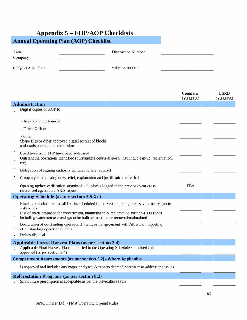
ANC Timber Ltd. - FMA Operating Ground Rules
85
Appendix 5 – FHP/AOP Checklists Annual Operating Plan (AOP) Checklist Area Disposition Number Company CTQ/DTA Number Submission Date
Company ESRD (Y,N,N/A) (Y,N,N/A) Administration
∙ Digital copies of AOP to
- Area Planning Forester
- Forest Officer
- other
Shape files or other approved digital format of blocks and roads included in submission
∙ Conditions from FHP have been addressed
∙ Outstanding operations identified (outstanding debris disposal, hauling, clean-up, reclamation, etc)
∙ Delegation of signing authority included where required
∙ Company is requesting dues relief, explanation and justification provided
∙ Opening update verification submitted - all blocks logged in the previous year cross referenced against the ARIS report
N/A Operating Schedule (as per section 3.5.4 c)
∙ Block table submitted for all blocks scheduled for harvest including area & volume by species with totals
∙ List of roads proposed for construction, maintenance & reclamation for non-DLO roads including watercourse crossings to be built or installed or removed/maintained
∙ Declaration of outstanding operational items, or an agreement with Alberta on reporting of outstanding operational items
∙ Debris disposal Applicable Forest Harvest Plans (as per section 3.4)
∙ Applicable Final Harvest Plans identified in the Operating Schedule submitted and approved (as per section 3.4)
Compartment Assessments (as per section 3.2) - Where Applicable
∙ Is approved and includes any maps, analyses, & reports deemed necessary to address the issues
Reforestation Program (as per section 8.2) ∙ Silviculture prescription is acceptable as per the Silviculture table
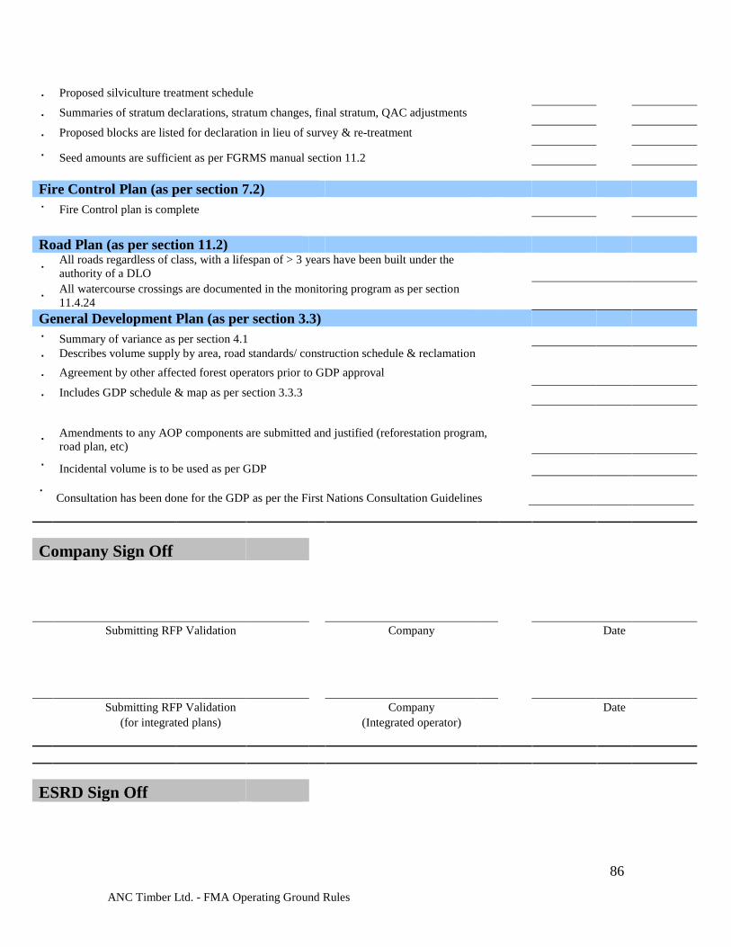
ANC Timber Ltd. - FMA Operating Ground Rules
86
∙ Proposed silviculture treatment schedule ∙ Summaries of stratum declarations, stratum changes, final stratum, QAC adjustments ∙ Proposed blocks are listed for declaration in lieu of survey & re-treatment ∙ Seed amounts are sufficient as per FGRMS manual section 11.2 Fire Control Plan (as per section 7.2) ∙ Fire Control plan is complete
Road Plan (as per section 11.2)
∙ All roads regardless of class, with a lifespan of > 3 years have been built under the authority of a DLO
∙ All watercourse crossings are documented in the monitoring program as per section 11.4.24
General Development Plan (as per section 3.3) ∙ Summary of variance as per section 4.1 ∙ Describes volume supply by area, road standards/ construction schedule & reclamation ∙ Agreement by other affected forest operators prior to GDP approval ∙ Includes GDP schedule & map as per section 3.3.3
∙ Amendments to any AOP components are submitted and justified (reforestation program, road plan, etc)
∙ Incidental volume is to be used as per GDP
∙ Consultation has been done for the GDP as per the First Nations Consultation Guidelines
Company Sign Off
Submitting RFP Validation Company Date
Submitting RFP Validation Company Date (for integrated plans) (Integrated operator)
ESRD Sign Off

ANC Timber Ltd. - FMA Operating Ground Rules
87
Reviewing RFP Validation Date
Note: This Checklist should reflect regional or FMA Operating Ground Rules - this is a template
Note: The AOP shall be appraised by Alberta in accordance to the AOP checklist, with approval subject to the outcome of the appraisal.
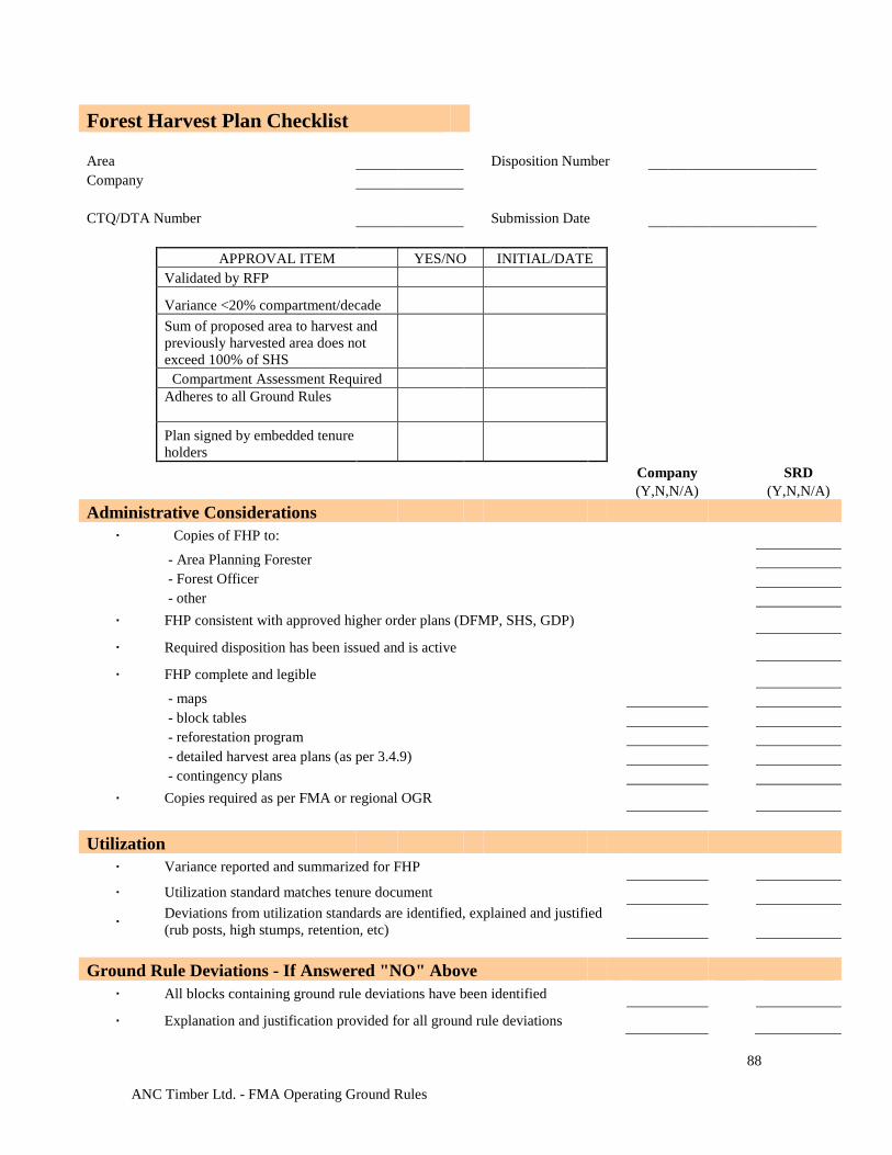
ANC Timber Ltd. - FMA Operating Ground Rules
88
Forest Harvest Plan Checklist Area Disposition Number Company CTQ/DTA Number Submission Date APPROVAL ITEM YES/NO INITIAL/DATE Validated by RFP
Variance <20% compartment/decade
Sum of proposed area to harvest and previously harvested area does not exceed 100% of SHS
Compartment Assessment Required
Adheres to all Ground Rules
Plan signed by embedded tenure holders
Company SRD (Y,N,N/A) (Y,N,N/A) Administrative Considerations
∙ Copies of FHP to: - Area Planning Forester - Forest Officer - other
∙ FHP consistent with approved higher order plans (DFMP, SHS, GDP)
∙ Required disposition has been issued and is active
∙ FHP complete and legible - maps - block tables - reforestation program - detailed harvest area plans (as per 3.4.9) - contingency plans
∙ Copies required as per FMA or regional OGR Utilization
∙ Variance reported and summarized for FHP ∙ Utilization standard matches tenure document
∙ Deviations from utilization standards are identified, explained and justified (rub posts, high stumps, retention, etc)
Ground Rule Deviations - If Answered "NO" Above
∙ All blocks containing ground rule deviations have been identified
∙ Explanation and justification provided for all ground rule deviations
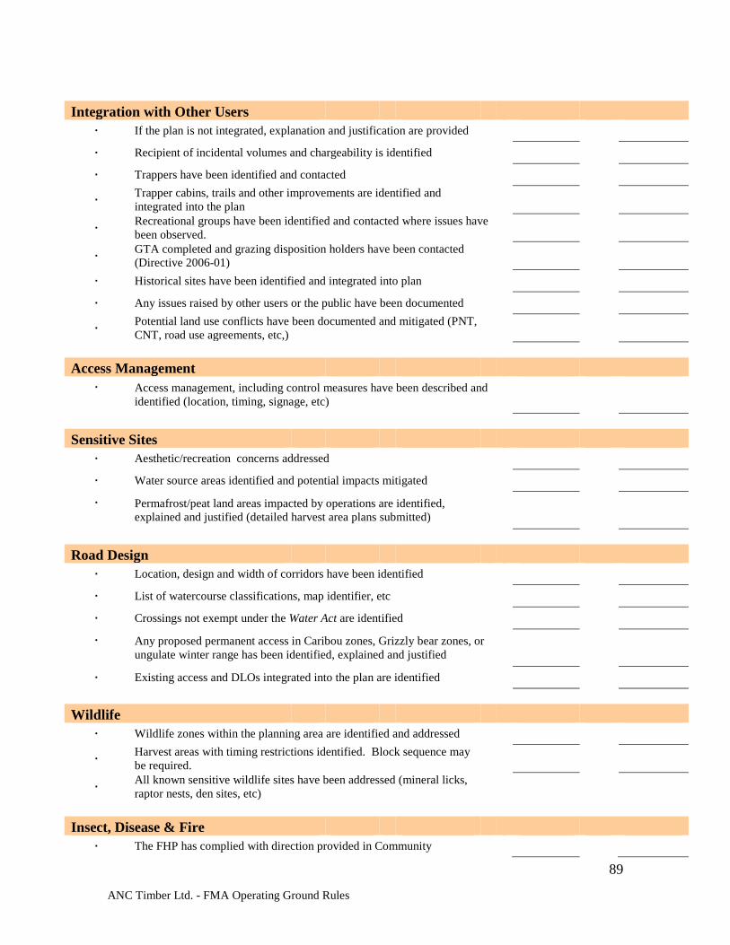
ANC Timber Ltd. - FMA Operating Ground Rules
89
Integration with Other Users
∙ If the plan is not integrated, explanation and justification are provided
∙ Recipient of incidental volumes and chargeability is identified
∙ Trappers have been identified and contacted
∙ Trapper cabins, trails and other improvements are identified and integrated into the plan
∙ Recreational groups have been identified and contacted where issues have been observed.
∙ GTA completed and grazing disposition holders have been contacted (Directive 2006-01)
∙ Historical sites have been identified and integrated into plan
∙ Any issues raised by other users or the public have been documented
∙ Potential land use conflicts have been documented and mitigated (PNT, CNT, road use agreements, etc,)
Access Management
∙ Access management, including control measures have been described and identified (location, timing, signage, etc)
Sensitive Sites
∙ Aesthetic/recreation concerns addressed
∙ Water source areas identified and potential impacts mitigated
∙ Permafrost/peat land areas impacted by operations are identified, explained and justified (detailed harvest area plans submitted)
Road Design
∙ Location, design and width of corridors have been identified
∙ List of watercourse classifications, map identifier, etc
∙ Crossings not exempt under the Water Act are identified
∙ Any proposed permanent access in Caribou zones, Grizzly bear zones, or ungulate winter range has been identified, explained and justified
∙ Existing access and DLOs integrated into the plan are identified Wildlife
∙ Wildlife zones within the planning area are identified and addressed
∙ Harvest areas with timing restrictions identified. Block sequence may be required.
∙ All known sensitive wildlife sites have been addressed (mineral licks, raptor nests, den sites, etc)
Insect, Disease & Fire
∙ The FHP has complied with direction provided in Community
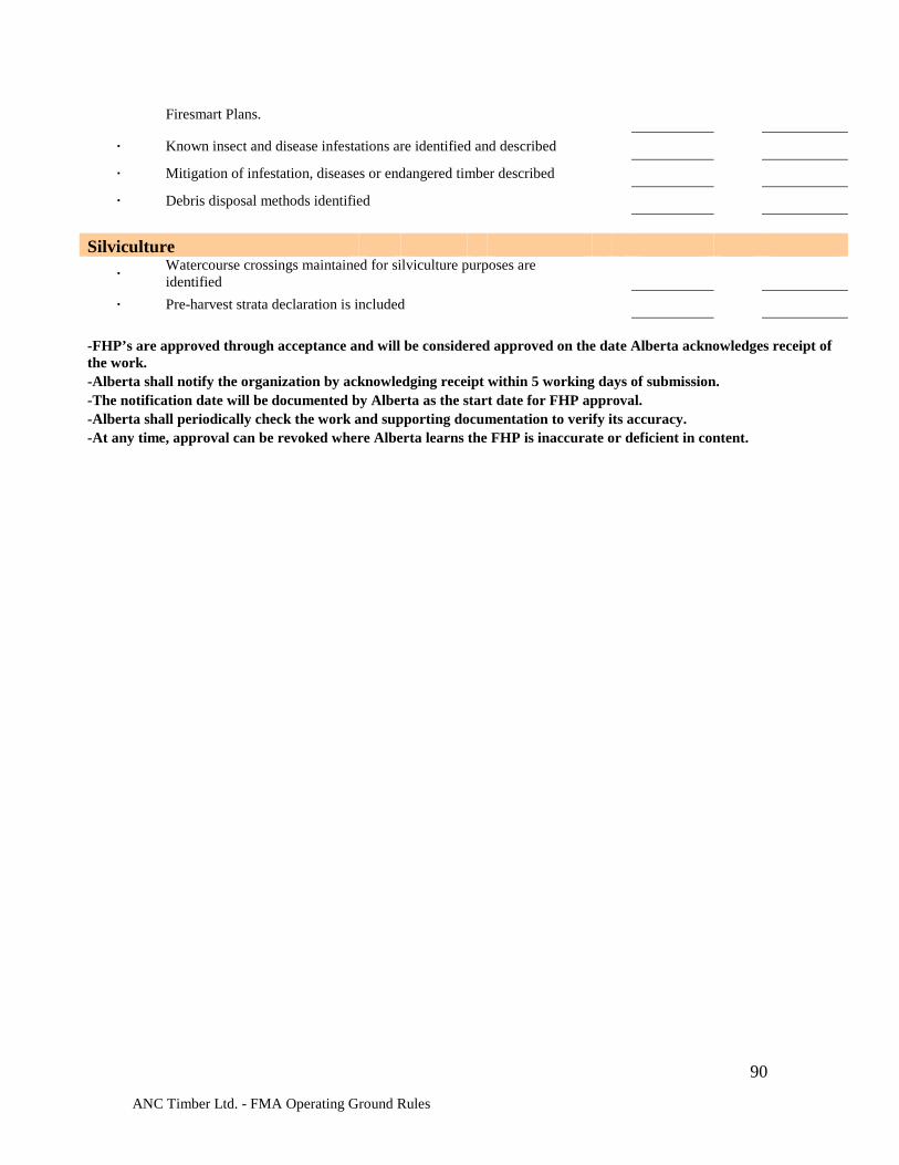
ANC Timber Ltd. - FMA Operating Ground Rules
90
Firesmart Plans.
∙ Known insect and disease infestations are identified and described
∙ Mitigation of infestation, diseases or endangered timber described
∙ Debris disposal methods identified Silviculture
∙ Watercourse crossings maintained for silviculture purposes are identified
∙ Pre-harvest strata declaration is included -FHP’s are approved through acceptance and will be considered approved on the date Alberta acknowledges receipt of the work. -Alberta shall notify the organization by acknowledging receipt within 5 working days of submission. -The notification date will be documented by Alberta as the start date for FHP approval. -Alberta shall periodically check the work and supporting documentation to verify its accuracy. -At any time, approval can be revoked where Alberta learns the FHP is inaccurate or deficient in content.
ANC Timber Ltd. - FMA Operating Ground Rules
91
Company Sign Off
Submitting RFP Validation Company Date
Submitting RFP Validation Company Date
(for integrated plans) (Integrated operator)
ESRD Sign Off
Reviewing RFP Validation Date Note: This Checklist should reflect regional or FMA Operating Ground Rules - this is a template. Note: Appraisal of the FHP is required if "No" has been indicated on any of the above Approval Items.