Embed Size (px)
Citation preview
SVR Comment Analysis 1 GEDA/Stanley Consultants 12/11/15
Analysis of Comments Received on San Vitores Road Flood Mitigation Project
Public Law 30-228 appropriated proceeds from the Hot Bond “for resolution of the San Vitores flooding caused by storm water runoff along San Vitores Road north of the Fujita Pump Station by collecting and removing storm runoff via transmission to the Fujita Pump Station to be discharged at a suitable location.” After evaluation of alternatives to satisfy the Law’s requirements, the Bay Outlet option was selected for design and construction and taken through the completed public/agency comment phase. Some members of the public and government agencies have expressed concerns with the proposed Bay Outlet solution. The objective of this communication is to provide a summary of project issues and options so a viable solution can be developed. A description of the project tasks and agencies contacted is attached as Exhibit A. FLOODING
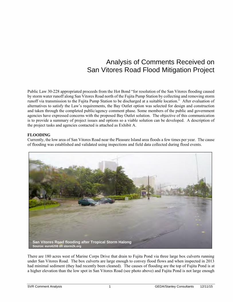
Currently, the low area of San Vitores Road near the Pleasure Island area floods a few times per year. The cause of flooding was established and validated using inspections and field data collected during flood events.
There are 180 acres west of Marine Corps Drive that drain to Fujita Pond via three large box culverts running under San Vitores Road. The box culverts are large enough to convey flood flows and when inspected in 2013 had minimal sediment (they had recently been cleaned). The causes of flooding are the top of Fujita Pond is at a higher elevation than the low spot in San Vitores Road (see photo above) and Fujita Pond is not large enough
San Vitores Road flooding after Tropical Storm Halong Source: euro6208 on storm2k.org
SVR Comment Analysis 2 GEDA/Stanley Consultants 12/11/15
to contain heavy rainfall events. During heavy rains the pond fills up, overflows, and causes flooding on San Vitores Road and Fujita Road. The following provides a summary of the sequence of events from rainfall to flooding:
No Flooding - typical rains (less than 3 inches of rain in one day) o Developed and undeveloped areas in the drainage basin infiltrate most of the rainfall. o The storm sewer system captures remaining stormwater. o Storm water flows into Fujita Pond through existing box culverts. o Fujita Pond comes up a few inches. o Rainfall stops, stormwater infiltrates into Fujita Pond, and the water level goes back down.
Flooding - heavy rains (more than 3 inches of rain in one day) o Developed and undeveloped area infiltration does not keep up with rainfall and stormwater
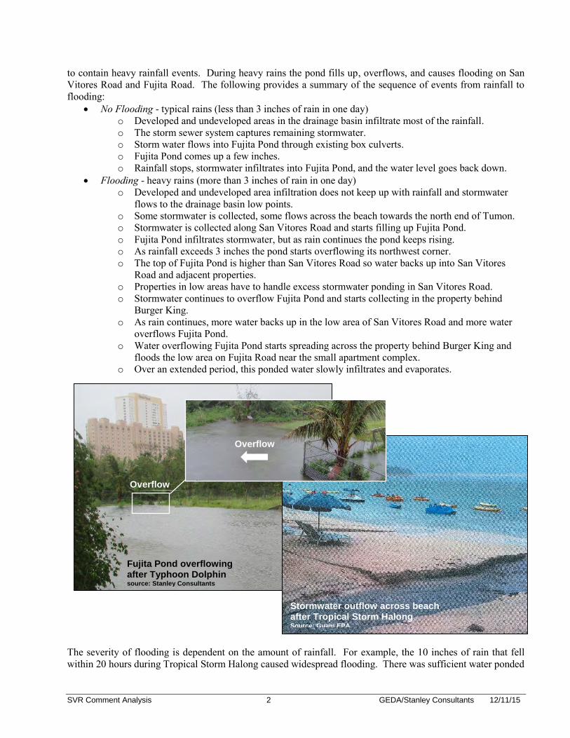
flows to the drainage basin low points. o Some stormwater is collected, some flows across the beach towards the north end of Tumon. o Stormwater is collected along San Vitores Road and starts filling up Fujita Pond. o Fujita Pond infiltrates stormwater, but as rain continues the pond keeps rising. o As rainfall exceeds 3 inches the pond starts overflowing its northwest corner. o The top of Fujita Pond is higher than San Vitores Road so water backs up into San Vitores
Road and adjacent properties. o Properties in low areas have to handle excess stormwater ponding in San Vitores Road. o Stormwater continues to overflow Fujita Pond and starts collecting in the property behind
Burger King. o As rain continues, more water backs up in the low area of San Vitores Road and more water
overflows Fujita Pond. o Water overflowing Fujita Pond starts spreading across the property behind Burger King and
floods the low area on Fujita Road near the small apartment complex. o Over an extended period, this ponded water slowly infiltrates and evaporates.
The severity of flooding is dependent on the amount of rainfall. For example, the 10 inches of rain that fell within 20 hours during Tropical Storm Halong caused widespread flooding. There was sufficient water ponded
Overflow
Fujita Pond overflowing after Typhoon Dolphin source: Stanley Consultants
Stormwater outflow across beach after Tropical Storm Halong Source: Guam EPA
Overflow
SVR Comment Analysis 3 GEDA/Stanley Consultants 12/11/15
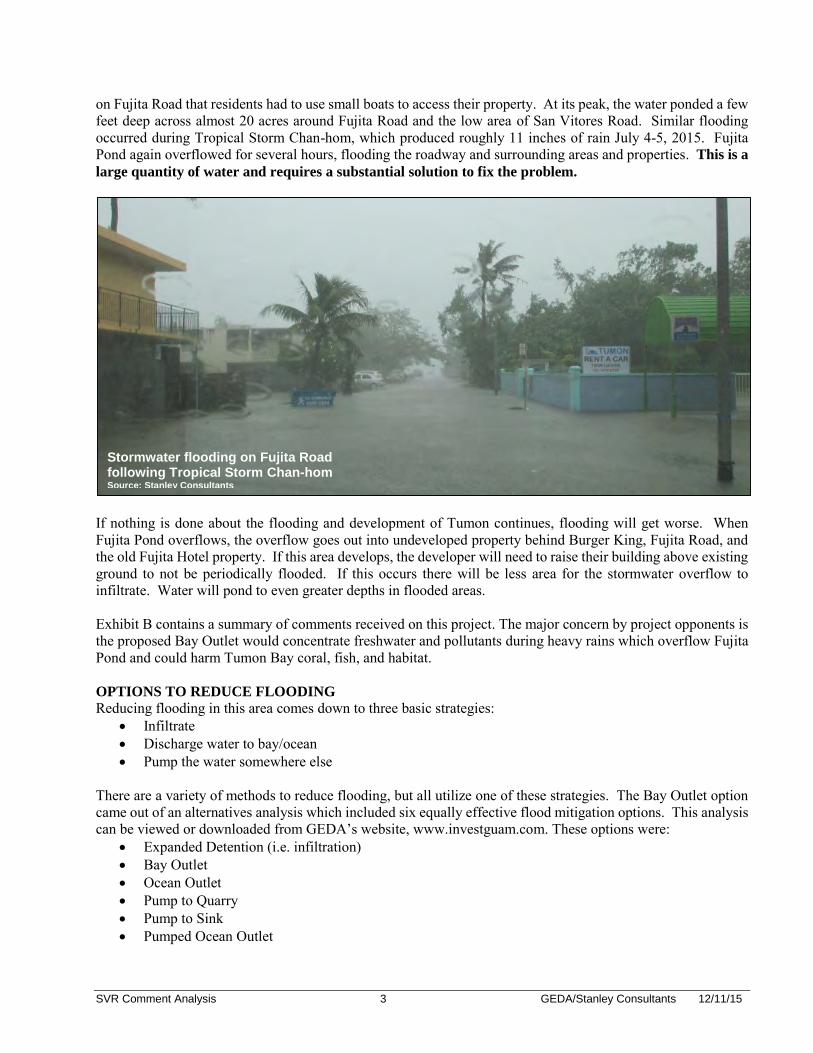
on Fujita Road that residents had to use small boats to access their property. At its peak, the water ponded a few feet deep across almost 20 acres around Fujita Road and the low area of San Vitores Road. Similar flooding occurred during Tropical Storm Chan-hom, which produced roughly 11 inches of rain July 4-5, 2015. Fujita Pond again overflowed for several hours, flooding the roadway and surrounding areas and properties. This is a
large quantity of water and requires a substantial solution to fix the problem.
If nothing is done about the flooding and development of Tumon continues, flooding will get worse. When Fujita Pond overflows, the overflow goes out into undeveloped property behind Burger King, Fujita Road, and the old Fujita Hotel property. If this area develops, the developer will need to raise their building above existing ground to not be periodically flooded. If this occurs there will be less area for the stormwater overflow to infiltrate. Water will pond to even greater depths in flooded areas. Exhibit B contains a summary of comments received on this project. The major concern by project opponents is the proposed Bay Outlet would concentrate freshwater and pollutants during heavy rains which overflow Fujita Pond and could harm Tumon Bay coral, fish, and habitat. OPTIONS TO REDUCE FLOODING
Reducing flooding in this area comes down to three basic strategies: Infiltrate Discharge water to bay/ocean Pump the water somewhere else
There are a variety of methods to reduce flooding, but all utilize one of these strategies. The Bay Outlet option came out of an alternatives analysis which included six equally effective flood mitigation options. This analysis can be viewed or downloaded from GEDA’s website, www.investguam.com. These options were:
Expanded Detention (i.e. infiltration) Bay Outlet Ocean Outlet Pump to Quarry Pump to Sink Pumped Ocean Outlet
Stormwater flooding on Fujita Road following Tropical Storm Chan-hom Source: Stanley Consultants

SVR Comment Analysis 4 GEDA/Stanley Consultants 12/11/15
Over the course of this project several options for reducing flooding have been considered. Although Expanded Detention was initially the preferred option; seven acres of infiltration area was required to effectively reduce flooding so this option was not pursued because the land costs in the area well exceeded the project budget. There is no public land available for detention in the project area. The project area is in one of the most densely developed, high value land areas in Guam and land acquisition could include multiple parcels and drag out for several years. The Bay Outlet was the preferred option that met budgetary constraints as well as providing a simple, effective solution. It could be constructed on GovGuam owned property and discharge to Tumon Bay would occur infrequently, coinciding with heavy rainfall events when there was already a significant quantity of freshwater entering Tumon Bay. BAY OUTLET OPTION
The Bay Outlet includes a concrete weir (a zig-zagging concrete wall) in Fujita Pond that overflows to concrete box culverts under Fujita Road. The culverts discharge through an outlet structure at the end of Fujita Road and into Tumon Bay. The top of weir in Fujita Pond is three feet above the normal pond water level which
allows the pond to rise and fall during typical rain events without discharge to Tumon Bay. During heavy rains, the pond level rises three feet and overflows the weir. The top of weir is set below the low elevation of San Vitores Road. The weir overflow maintains the water level in Fujita Pond near the top of weir and minimizes flooding on San Vitores Road. There is metal grating between weir and culvert which prevents trash and debris from flowing out of Fujita Pond. The box culverts convey overflow out to Tumon Bay instead of flooding lands adjacent to Fujita Pond, so it also reduces Fujita Road flooding. The following graphic shows a rendering of the Fujita Pond weir overflow structure.
It is understood that the Guam EPA (GEPA) has been working to remove direct point source discharges of stormwater from private properties into Tumon Bay. This system is not a step back from this objective. This project will involve installing additional inlets along all of San Vitores Road to improve capture of stormwater throughout the drainage area, which will reduce the frequency of outflow to Tumon Bay during smaller rain events. Stormwater that previously flowed directly into Tumon Bay will be captured and brought to Fujita Pond, reducing discharge at this point. Fujita Pond will be expanded to provide 135,000 cubic feet of
Fujita Pond Overflow Weir source: Stanley Consultants
SVR Comment Analysis 5 GEDA/Stanley Consultants 12/11/15
storage/infiltration to allow some settlement of stormwater. This storage volume meets the Guam Stormwater Management Manual storage requirement for the untreated, developed area within the drainage area. During heavy rain events, the proposed Bay Outlet provides a defined overflow into Tumon Bay to mitigate flooding on Fujita and San Vitores Road and reduce recurring issues caused by flooding such as property damage, traffic issues, safety concerns, seepage into the sanitary sewer system, and tourist activity interruptions. Overflow from Fujita Pond will be conveyed to Tumon Bay via concrete box culverts that will be installed under Fujita Road. An outlet structure will be constructed at the end of Fujita Road. The location of the structure was set slightly back from the beach to maintain the existing stretch of open beach during the 360 plus days a year there is no overflow. During discharge events, the overflow will flow out across the beach and into Tumon Bay. Beach raking at the discharge point will be required following overflow events. A maintenance program will be established for this project prior to installation. Beach access via Fujita Road will be maintained. More information on the proposed system and project development can be found in project reference documents which are posted on the GEDA website, www.investguam.com. As described in Exhibit A, the Bay Outlet option was taken from conceptual to preliminary design and a draft Environmental Impact Assessment was developed. These draft design documents were submitted for agency and stakeholder review in February 2015. FEEDBACK
Stanley Consultants and GEDA have held meetings with the majority of agencies that received the Bay Outlet draft design submittal and a public meeting was held on March 25, 2015. Comments on the project have now been received via the public meeting or review of project documents. Significant concerns were expressed over the Bay Outlet’s maintenance and potential impacts to Tumon Bay. Comments included:
The Bay Outlet, “Would Adversely Affect Essential Fish Habitat”. “The impact of fresh water inflow to coral reef must be investigated and addressed….”. “Is this the cure that is worse than the disease?”
ADDITIONAL OPTIONS CONSIDERED
Over the course of this project several options for reducing flooding have been considered. Expanded detention required acquiring over seven acres of land in lower Tumon which well exceeded the project budget. Other options considered in the alternatives analysis, such as pumping stormwater (Pump to Quarry/Sink) or outletting past the reef (Ocean Outlets) were over $20M and had significantly greater operational and maintenance risks. Solving flooding through pumping requires large pumps, mechanical/electrical equipment, significant and reliable power supply, and dedicated maintenance. Due to the high cost, ongoing maintenance requirement, and higher risk of failure involved with a system that only operates a few times a year, the pumping options were eliminated. Constructing an outlet past the reef was also high cost and presented unacceptable impacts. The size of pipe needed was too large to bore under the floor of Tumon Bay, so would be constructed via open cut. This would involve significant impacts to coral/habitat in Tumon Bay and the outlet would be located even closer to the coral than the Bay Outlet. More information can be found in the San Vitores Road Flood Mitigation Report which is part of the references documents posted on the GEDA website (http://www.investguam.com/). There is a substantial amount of water causing flooding at San Vitores Road. Solving the flooding will require a substantial solution. During heavy rains Fujita Pond backs up water into San Vitores Road and overflows into several acres of low area surrounding Fujita Road. Solving flooding requires finding somewhere else for this substantial amount of water to go. The public involvement process has generated several comments pointing to additional options to solve flooding. Several of these options are smaller features that could help the problem and need to be included as part of a comprehensive flood mitigation plan to reduce the burden on the larger system. However, these options alone will not solve flooding.
SVR Comment Analysis 6 GEDA/Stanley Consultants 12/11/15
An evaluation of additional options was completed. Considerations included effectiveness, suitability to location, regulations, cost, safety, and operation and maintenance requirements. As a point of comparison, their potential to reduce flooding was analyzed for Tropical Storm Halong which dropped approximately 10 inches of rain on July 30, 2014. The following provides a summary of the additional options considered, listed in order of effectiveness: Expand Fujita Pond What is it? Fujita Pond is a small (0.5 acre) detention and infiltration basin that receives all storm water collected by the San Vitores Road storm sewer system. To effectively reduce flooding over a wide range of rain events it would need to be 14 times larger (7 acres) than its current size. Any expansion will help though so the pond should be expanded from its current size and “maxed out” within the surrounding GovGuam property (under ownership or easement). This expansion will help improve infiltration, detention, and settling of stormwater. Will it help? Yes, but the impact is relative to the area of land available for stormwater detention and there is limited land available for expansion. There are currently underground infiltration basins (0.3 acres or 100 feet by 150 feet) adjacent to Fujita Pond which already provide some infiltration. This property is privately owned but GovGuam has an easement allowing stormwater infiltration on this property. Removing these basins and expanding the pond will provide more infiltration and detention capacity. The parcel that includes Fujita Pond, the GWA pump station, and Police Station is the only GovGuam owned parcel in lower Tumon in the drainage area. The 0.3 acre expansion pushes the pond boundary to the edge of the parcel boundaries. Additional expansion into adjacent police parking by providing underground infiltration (i.e. parking can continue) was reviewed. Only 0.05 acres could be gained by installing infiltration under the Police Station parking so there would be limited flood benefit to the expanding Fujita Pond further. The currently proposed 0.3 acre pond expansion provides an additional 45,000 cubic feet of flood storage and it also provides infiltration. This expansion would have offset the total rainfall volume during Tropical Storm Halong by 2%. Rain Gardens What is it? Rain gardens are the size of a planting bed, are less than 1 foot deep, and have an overflow for spilling heavy rains. They have pervious soil and plants that help filter stormwater and improve water quality. Will it help? Yes, but only as part of the solution. Rain gardens are very effective at improving water quality and reducing runoff for small rain events but not for handling larger rain events. They fill up quickly during a significant rain event and are not deep enough to provide sufficient storage to offset flooding. Guam generally has high infiltration rates, so these vegetated areas would provide continuous infiltration during a rain event. 1.4 acres of rain gardens could be installed if every vegetated area along San Vitores Road (median and adjacent sidewalk areas) was converted to rain garden. These rain gardens would have infiltrated 2% of the total rainfall volume of Tropical Storm Halong. This 1.4 acres represents all of the vegetated GovGuam property north of Fujita Road. Realistically, there is less than 0.2 acres of area suitable for rain garden development within San Vitores Road right of way. However, pervious pavers is another infiltration option which is being reviewed for inclusion in the proposed project. Additional rain gardens would require development on private land so would involve land acquisition or an incentive program to encourage rain gardens on private land. Rain gardens also require maintenance. Any infiltration helps though, so these are being included in project development. More Enforcement for Infiltration Systems What is it? Developments are required to collect and infiltrate stormwater. If property owners are required to better maintain their systems this will reduce flooding. Will it help? Yes, but only as part of the solution. Currently there is no government inspection or enforcement on maintenance of private development infiltration systems. When a development is designed, a system to collect and infiltrate all of the site’s stormwater is required. During the alternatives analysis many of these
SVR Comment Analysis 7 GEDA/Stanley Consultants 12/11/15
systems were inspected. Analysis based on field measurements during rainfall events show that these properties infiltrate rainfall similar to an undeveloped area. There is minimal flow out of the property for light rains, but during heavy rains the infiltration systems cannot keep up and excess stormwater flows out to San Vitores Road. Unless a property is walled in, there will always be some portion of stormwater that runs off the property. During Tropical Storm Halong these properties infiltrated approximately 19% of the total rainfall. With improved maintenance and capture this percentage could be bumped up by a few percentage points, but not enough to solve the issue. It could make a difference though should be pursued if regulatory programs can be initiated to manage. Injection Wells What is it? An Injection well is a vertical pipe that extends far below the ground surface and discharges stormwater into the pervious soil layers below ground through perforations in the pipe. Will it help? Yes, but only in the upper watershed for individual developments. The water table is roughly 5-7 feet below the ground elevation in lower Tumon. Injection wells typically require roughly 100 feet between ground surface and water table to provide sufficient infiltration length. So, injection wells are not feasible in lower Tumon. Below the steep ridge off Marine Corps drive, the ground elevation is roughly 90 feet above the water table. Injection wells could be feasible in this location. Injection wells require pretreatment which involves providing 24-48 hours of storage at the surface level to reduce pollutants/siltation. This means additional land; and GEPA also needs justification that other systems such as infiltration basins will not work. Relative to Tropical Storm Halong, a single injection well has the capacity to infiltrate 0.1% of the total rainfall volume. Twenty injection wells installed in upper Tumon could infiltrate 2% of the total rainfall volume of Tropical Storm Halong. Outside of private developments, there are no stormwater collection systems in upper Tumon. The land slopes steeply toward Tumon Bay. In addition to the wells, an injection well system that provides infiltration for upper Tumon would require a collection system to capture the drainage which would involve grading, piping, and ditch systems as well as a pretreatment storage basin cut into a steeply sloped area to allow stormwater settling. On a large scale this is not a cost efficient option for reducing flooding. On a development scale injection wells could be an option to reduce runoff from an individual property. Stop Flow from Marine Corps Drive What is it? Install curb barriers or additional inlets to keep Marine Corps Drive stormwater on Marine Corps Drive and stop it from flowing down to San Vitores Road. Will it help? Marginally. Some flow does come off Marine Corps Drive and flows down to San Vitores Road. Relative to Tropical Storm Halong, it is 1% of the total rainfall volume. Marine Corps Drive has its own storm sewer system and it also has a median, so the stormwater flowing to San Vitores Road is from half the roadway width that is not picked up by the Marine Corps Drive system. This flow is concentrated in the gutter so looks like a significant amount of flow. Relative to all the stormwater flow from the 180 acre drainage area, it is not the cause of flooding but any reduction helps. Trench drains across the San Vitores Road intersection with Marine Corps Drive are being added to the proposed design to improve capture into the Marine Corps Drive storm sewer. Connect to Unused Sewer Pipe What is it? Connect the Fujita Pond system to the unused sewer pipe under San Vitores Road. Will it help? This unused 15 to 24-inch sanitary sewer pipe could be part of a solution but would need to connect to a large detention area to be effective. The pipe itself is 3650 feet long has 8650 cubic feet of storage or 0.1% of the rainfall volume of Tropical Storm Halong. This volume would have minimal impact on flooding so the pipe needs to flow to a detention/infiltration area to provide effective reduction in flood volume. Given the density of development and land values of properties along San Vitores Road, it is unlikely that a detention area
SVR Comment Analysis 8 GEDA/Stanley Consultants 12/11/15
could be located adjacent to San Vitores Road, but if this pipe was extended from a location near Fujita Pond to another detention area, it could potentially be utilized to connect these two areas. Connect to Matapang Infiltration Basins What is it? The Matapang underground infiltration basins are located beneath Matapang Park. Connect the Fujita Pond system to Matapang to increase infiltration and reduce flooding Will it help? Not feasible. The Matapang underground infiltration basins are located beneath the Matapang Park located approximately 1600 feet south of Fujita Pond along San Vitores Road. The system was installed during the 2000 San Vitores Road reconstruction to infiltrate drainage from 120 acres south of Fujita Pond. The basin area is 250 feet by 250 feet extending under the parking lot and boat storage area. The system was designed for the 120 acre drainage area and without capacity for additional stormwater. There is usually standing water in the parking lot over several stormwater inlets draining to the system indicating the infiltration basins are not fully draining. During heavy rainfall events the parking lot floods, water backs up on San Vitores Road north of the Holiday Resort, and stormwater flows across the beach indicating the basins are not able to keep up with the current volume of stormwater draining to them. This system is already overtaxed so connecting to the Matapang system is not a viable option. Provide Chemical or Biological Treatment What is it? Build a treatment system at Fujita Pond to treat stormwater by mixing with chemical or biological substances that improve water quality prior to discharging into Tumon Bay Will it help? Not for flood events. Chemical and/or biological treatment of stormwater can be effective at reducing nutrient and pollutant levels but they are typically used to treat normal, not high rainfall events. Systems are set up to treat a specific inflow capacity, normally between 5-20 cubic feet per second (cfs). As a point of reference the Hagatna wastewater treatment plant has a maximum capacity of 15 cfs. A stormwater treatment plant has sensors that read the flow, ph, and other water attributes and mixes chemical or biological substances to the inflow based on this reading. The flow then enters the pond and pollutants and nutrients settle out. When rainfall events cause greater flows, 5-20 cfs still enters the system and is treated, but the excess stormwater flows through a bypass. Fujita Pond only discharges during high rainfall events and it is this event that would require treatment. Overflows at Fujita Pond can range from 5 cfs to 300 cfs depending on the rain event. Given the size of Fujita Pond, it would not be feasible to scale up a treatment system to handle overflow events. Fujita Pond is not big enough to allow settling of all flocculants during high overflow events and building a treatment plant to handle over 100 cfs would cost millions of dollars. There would also be concerns over dosage given the wide range of flows, if the inflow receives too much treatment the water could be toxic so it may create more issues than it solves. Also, treatment plants require continued operation and maintenance. Treatment could be a viable option with an expanded detention area, but even at a $1.5m/acre it would be more cost effective to expand detention and provide infiltration (an effective treatment) than build a treatment plant. Raise Low Area of San Vitores Road What is it? Raise San Vitores Road two feet above the typical flooding depths. Will it help? Not feasible. To provide an effective reduction in flooding the raise would need to be two feet and extend from the Hyatt to Outrigger. The raise would involve reconstruction of the roadway, building entrances, utilities, driveways, walkways. This would be more than $20M and disruptive. The solution would also be temporary because flooding would get worse.
SVR Comment Analysis 9 GEDA/Stanley Consultants 12/11/15
FINDINGS ON ADDITIONAL OPTIONS
The following “additional options” are feasible for managing a portion of the stormwater flowing to Fujita Pond, listed in order of effectiveness:
Rain gardens Infiltration system enforcement Injection wells Marine Corps Drive capture
For flood mitigation, the purpose of these additional options is to reduce the stormwater flowing to Fujita Pond. Even during a heavy rainfall event, only a portion of the total rainfall runs off and makes its way down to Fujita Pond. When the rain starts falling some is infiltrated into the ground by pervious areas (i.e. vegetated areas) or developed area infiltration systems (i.e. offline areas). Only rain falling on impervious areas and rainfall that is in excess of what can be infiltrated by vegetated and offline areas runs off as stormwater and down to Fujita Pond. The additional options would provide more methods to infiltrate/detain stormwater and reduce the overall volume of stormwater that needs to be handled by the San Vitores Road storm sewer system and Fujita Pond. To analyze the effectiveness of these additional options relative to solving flooding, three rainfall scenarios were analyzed:
1. Major Flooding Rainfall – 10 inch rainfall during Tropical Storm Halong 2. Minor Flooding Rainfall – 3.8 inch rainfall on October 10, 2013 3. Typical Rainfall – ½ inch rainfall
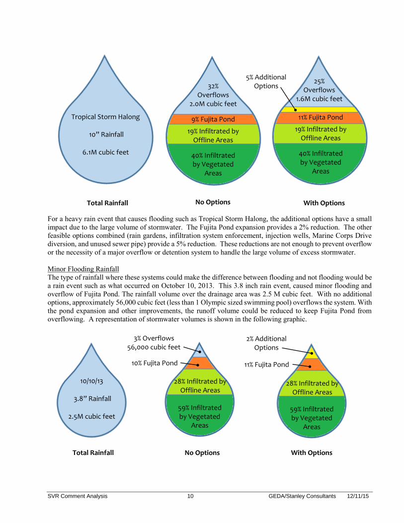
For every rainfall a total volume of water over the drainage area can be determined. The area draining to Fujita Pond is 180 acres and each rainfall event has a total depth. For example, 10 inches of rain over the 180 acre area is 6.1 million (M) cubic feet of rainfall. Out of this total rainfall volume, a portion is infiltrated by vegetated areas, a portion by the infiltration systems of offline areas, and a portion is infiltrated by Fujita Pond. If it is a heavy rain (exceeding 3 inches) Fujita Pond cannot keep up with all the stormwater flowing into it and starts overflowing and backing water up into the low areas of San Vitores Road. This is the overflow volume. With the Bay Outlet, this volume would be conveyed out to Tumon Bay instead of flooding areas surrounding Fujita Pond and San Vitores Road. The effectiveness of the additional options was evaluated by computing the percentage of the total rainfall volume that could be handled by the additional options. A series of graphics were created to illustrate how the total rainfall volume within the area draining to Fujita Pond is distributed between infiltration and overflow. The total rainfall volume is represented by a single raindrop sized by the amount of rainfall. This raindrop is divided proportionally based on where this rainwater ends up within the drainage system. This was analyzed for a condition without the additional options (No Options) and a condition with the additional options (With Options) to demonstrate how effective these options are at reducing flooding for the three different rainfall scenarios. Major Flooding Rainfall During Tropical Storm Halong roughly 10 inches of rain fell over 20 hours on July 30, 2014 causing extensive flooding on San Vitores and Fujita Road. The magnitude of the Tropical Storm Halong rainfall is similar to the three rain events this summer (2015) that caused flooding. The rains that fell during these storms are a very large volume of water and are enough to overwhelm infiltration and overflow Fujita Pond. The volume of the Tropical Storm Halong rainfall over the 180 acre drainage area was 6.1 M cubic feet. Roughly 2M cubic feet of that rainfall overflowed the drainage system and Fujita Pond which is enough to flood all of Micronesia Mall, 5 feet deep. The following graphic illustrates how this rainfall is distributed within the drainage system.
SVR Comment Analysis 10 GEDA/Stanley Consultants 12/11/15
For a heavy rain event that causes flooding such as Tropical Storm Halong, the additional options have a small impact due to the large volume of stormwater. The Fujita Pond expansion provides a 2% reduction. The other feasible options combined (rain gardens, infiltration system enforcement, injection wells, Marine Corps Drive diversion, and unused sewer pipe) provide a 5% reduction. These reductions are not enough to prevent overflow or the necessity of a major overflow or detention system to handle the large volume of excess stormwater. Minor Flooding Rainfall The type of rainfall where these systems could make the difference between flooding and not flooding would be a rain event such as what occurred on October 10, 2013. This 3.8 inch rain event, caused minor flooding and overflow of Fujita Pond. The rainfall volume over the drainage area was 2.5 M cubic feet. With no additional options, approximately 56,000 cubic feet (less than 1 Olympic sized swimming pool) overflows the system. With the pond expansion and other improvements, the runoff volume could be reduced to keep Fujita Pond from overflowing. A representation of stormwater volumes is shown in the following graphic.
Total Rainfall
32% Overflows
2.0M cubic feet
Tropical Storm Halong
10” Rainfall
6.1M cubic feet
9% Fujita Pond
25% Overflows
1.6M cubic feet
11% Fujita Pond
19% Infiltrated by Offline Areas
5% Additional Options
19% Infiltrated by Offline Areas
40% Infiltrated by Vegetated
Areas
40% Infiltrated by Vegetated
Areas
No Options With Options
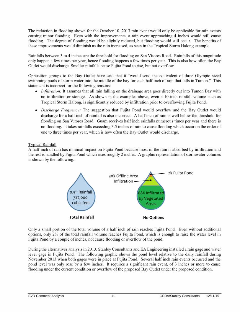
10/10/13
3.8” Rainfall
2.5M cubic feet
10% Fujita Pond
28% Infiltrated by Offline Areas
3% Overflows 56,000 cubic feet
59% Infiltrated by Vegetated
Areas
11% Fujita Pond
28% Infiltrated by Offline Areas
2% Additional Options
59% Infiltrated by Vegetated
Areas
Total Rainfall No Options With Options
SVR Comment Analysis 11 GEDA/Stanley Consultants 12/11/15
The reduction in flooding shown for the October 10, 2013 rain event would only be applicable for rain events causing minor flooding. Even with the improvements, a rain event approaching 4 inches would still cause flooding. The degree of flooding would be slightly reduced, but flooding would still occur. The benefits of these improvements would diminish as the rain increased, as seen in the Tropical Storm Halong example. Rainfalls between 3 to 4 inches are the threshold for flooding on San Vitores Road. Rainfalls of this magnitude only happen a few times per year, hence flooding happens a few times per year. This is also how often the Bay Outlet would discharge. Smaller rainfalls cause Fujita Pond to rise, but not overflow. Opposition groups to the Bay Outlet have said that it “would send the equivalent of three Olympic sized swimming pools of storm water into the middle of the bay for each half inch of rain that falls in Tumon.” This statement is incorrect for the following reasons:
Infiltration: It assumes that all rain falling on the drainage area goes directly out into Tumon Bay with no infiltration or storage. As shown in the examples above, even a 10-inch rainfall volume such as Tropical Storm Halong, is significantly reduced by infiltration prior to overflowing Fujita Pond.
Discharge Frequency: The suggestion that Fujita Pond would overflow and the Bay Outlet would discharge for a half inch of rainfall is also incorrect. A half inch of rain is well below the threshold for flooding on San Vitores Road. Guam receives half inch rainfalls numerous times per year and there is no flooding. It takes rainfalls exceeding 3.5 inches of rain to cause flooding which occur on the order of one to three times per year, which is how often the Bay Outlet would discharge.
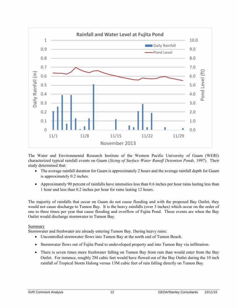
Typical Rainfall A half inch of rain has minimal impact on Fujita Pond because most of the rain is absorbed by infiltration and the rest is handled by Fujita Pond which rises roughly 2 inches. A graphic representation of stormwater volumes is shown by the following. Only a small portion of the total volume of a half inch of rain reaches Fujita Pond. Even without additional options, only 2% of the total rainfall volume reaches Fujita Pond, which is enough to raise the water level in Fujita Pond by a couple of inches, not cause flooding or overflow of the pond. During the alternatives analysis in 2013, Stanley Consultants and EA Engineering installed a rain gage and water level gage in Fujita Pond. The following graphic shows the pond level relative to the daily rainfall during November 2013 when both gages were in place at Fujita Pond. Several half inch rain events occurred and the pond level was only rose by a few inches. It requires a significant rain event, of 3 inches or more to cause flooding under the current condition or overflow of the proposed Bay Outlet under the proposed condition.
0.5” Rainfall
327,000 cubic feet
Total Rainfall
30% Offline Area Infiltration
2% Fujita Pond
68% Infiltrated by Vegetated
Areas
No Options
SVR Comment Analysis 12 GEDA/Stanley Consultants 12/11/15
The Water and Environmental Research Institute of the Western Pacific University of Guam (WERI) characterized typical rainfall events on Guam (Sizing of Surface Water Runoff Detention Ponds, 1997). Their study determined that:
The average rainfall duration for Guam is approximately 2 hours and the average rainfall depth for Guam is approximately 0.2 inches.
Approximately 90 percent of rainfalls have intensities less than 0.6 inches per hour rains lasting less than 1 hour and less than 0.2 inches per hour for rains lasting 12 hours.
The majority of rainfalls that occur on Guam do not cause flooding and with the proposed Bay Outlet, they would not cause discharge to Tumon Bay. It is the heavy rainfalls (over 3 inches) which occur on the order of one to three times per year that cause flooding and overflow of Fujita Pond. These events are when the Bay Outlet would discharge stormwater to Tumon Bay. Summary Stormwater and freshwater are already entering Tumon Bay. During heavy rains:
Uncontrolled stormwater flows into Tumon Bay at the north end of Tumon Beach.
Stormwater flows out of Fujita Pond to undeveloped property and into Tumon Bay via infiltration.
There is seven times more freshwater falling on Tumon Bay from rain than would enter from the Bay Outlet. For instance, roughly 2M cubic feet would have flowed out of the Bay Outlet during the 10 inch rainfall of Tropical Storm Halong versus 13M cubic feet of rain falling directly on Tumon Bay.
0.0
1.0
2.0
3.0
4.0
5.0
6.0
7.0
8.0
9.0
10.0
0
0.1
0.2
0.3
0.4
0.5
0.6
0.7
0.8
0.9
1
11/1 11/8 11/15 11/22 11/29
Pon
d L
evel
(ft
)
Dai
ly R
ain
fall
(in
)
November 2013
Rainfall and Water Level at Fujita Pond
Daily Rainfall
Pond Level

SVR Comment Analysis 13 GEDA/Stanley Consultants 12/11/15
The Bay Outlet is an overflow, not a direct outlet, so stormwater would flow to Tumon Bay about as often as significant flooding currently occurs. For example, this year there have been three major rain/flood events that overflowed Fujita Pond. The following graph shows the rain events at the Dededo rain gage which is the nearest gage that compiles daily rainfall amounts in graphic format. During 2015, the Bay Outlet would have discharged three times, on May 15, July 5, and August 15.
Stormwater is already entering Tumon Bay, but the proposed Bay Outlet changes how stormwater enters the bay. It provides better collection but it concentrates the discharge at a location that may provide limited circulation during non-windy conditions. Fujita Pond will provide settling relative to the direct stormwater discharge that currently occurs across the beach. The amount of settlement will depend on the intensity of the rainfall but given its size Fujita Pond will not fully filter out the silt, nutrients, and other elements that stormwater picks for the full range of overflow events. The metal grating over the weir will filter out floating trash and debris but does not act as a full filter for small particles. Improved collection will limit overflow discharge events to heavy rain events so they are infrequent and of short duration.
SVR Comment Analysis 14 GEDA/Stanley Consultants 12/11/15
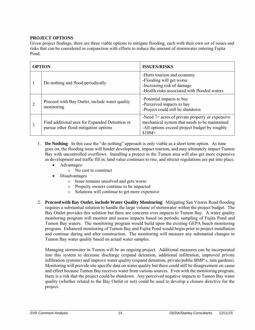
PROJECT OPTIONS
Given project findings, there are three viable options to mitigate flooding, each with their own set of issues and risks that can be considered in conjunction with efforts to reduce the amount of stormwater entering Fujita Pond.
OPTION ISSUES/RISKS
1 Do nothing and flood periodically
-Hurts tourism and economy -Flooding will get worse -Increasing risk of damage -Health risks associated with flooded waters
2 Proceed with Bay Outlet, include water quality monitoring
-Potential impacts to bay -Perceived impacts to bay -Project could still be shutdown
3 Find additional area for Expanded Detention or pursue other flood mitigation options
-Need 7+ acres of private property or expensive mechanical system that needs to be maintained -All options exceed project budget by roughly $10M+
1. Do Nothing: In this case the “do nothing” approach is only viable as a short term option. As time
goes on, the flooding issue will hinder development, impact tourism, and may ultimately impact Tumon Bay with uncontrolled overflows. Installing a project in the Tumon area will also get more expensive as development and traffic fill in, land value continues to rise, and stricter regulations are put into place.
Advantages: o No cost to construct
Disadvantages o Issue remains unsolved and gets worse o Property owners continue to be impacted o Solutions will continue to get more expensive
2. Proceed with Bay Outlet, include Water Quality Monitoring: Mitigating San Vitores Road flooding
requires a substantial solution to handle the large volume of stormwater within the project budget. The Bay Outlet provides this solution but there are concerns over impacts to Tumon Bay. A water quality monitoring program will monitor and assess impacts based on periodic sampling of Fujita Pond and Tumon Bay waters. The monitoring program would build upon the existing GEPA beach monitoring program. Enhanced monitoring of Tumon Bay and Fujita Pond would begin prior to project installation and continue during and after construction. The monitoring will measure any substantial changes in Tumon Bay water quality based on actual water samples. Managing stormwater in Tumon will be an ongoing project. Additional measures can be incorporated into this system to decrease discharge (expand detention, additional infiltration, improved private infiltration systems) and improve water quality (expand detention, private/public BMP’s, rain gardens). Monitoring will provide site specific data on water quality but there could still be disagreement on cause and effect because Tumon Bay receives water from various sources. Even with the monitoring program, there is a risk that the project could be shutdown. Any perceived negative impacts to Tumon Bay water quality (whether related to the Bay Outlet or not) could be used to develop a closure directive for the project.
SVR Comment Analysis 15 GEDA/Stanley Consultants 12/11/15
Advantages: o Solves the flooding problem within available funding o Constructed within GovGuam right of way. o Impacts assessed on site/event specific data
Disadvantages o Risk of impact to the Bay o Potential continued opposition and shutdown
3. Reconsider Expanded Detention or Other Flood Mitigation Options: Expanded detention is the preferred alternative for this project because it keeps most Fujita Pond flood events from overflowing to the Bay, but the likely reality is it would be difficult to complete. The cost to acquire private property exceeds the allotted project budget by over seven million dollars. There is no public land available within the project area for detention. Given the high land value and potential development opportunities, private landowners may be hesitant to sell and it could take years to acquire the necessary property. Land swaps and mixed-use opportunities have been discussed as alternative methods to expand detention, but the large area limits feasibility. Other non-bay/ocean discharge flood mitigation options require pumps. These would be large mechanical systems costing several million dollars that depend on a constant power supply and continued maintenance to operate as required during a flood event. There are more risks of potential failure with these types of systems especially during a severe storm or typhoon magnitude event.
Advantages o Will satisfy all perspectives, less opposition o Meets project objective and minimizes discharge to Tumon Bay o Less permitting o Mixed-use opportunities (parks, beach access, restoration, etc.) for expanded detention
Disadvantages o Requires acquisition of privately owned land o Securing land could be complicated and take time o Significant maintenance to function as required and risk of failure o Additional cost
RESOLUTION The summer of 2015 included three major rain events (6+ inches) which caused widespread flooding in the Tumon Area. During this time several meetings have been held between the Governor’s Office, Department of Public Works, GEPA, GVB, GEDA, and Stanley Consultants to discuss a path forward to mitigating the recurring flooding on San Vitores Road and Fujita Road. Based on public comments, enhancements were added to the project which include:
Additional Inlets: Additional trench drains will be installed across San Vitores Road to improve capture of stormwater and reduce the quantity of stormwater that runs out to Tumon beach and down to the low area of San Vitores Road.
Rain Gardens/Pervious Pavers: Installing rain gardens or pervious pavers along San Vitores Road to infiltrate a portion of the roadway’s stormwater runoff.
Marine Corps Drive: Improvements to help capture (inlets, trench drain, or other) Marine Corps Drive stormwater to keep it within the Marine Corps Drive system and off San Vitores Road.
Fujita Pond Improvements: Improvements will include cleaning Fujita Pond and expanding the pond area by removal of the underground infiltration chambers. Cleaning will maintain the infiltration rate
SVR Comment Analysis 16 GEDA/Stanley Consultants 12/11/15
and expanding the pond will provide a roughly 50% increase in detention volume from the existing condition.
Culvert Cleaning: Improvements will include finishing the culvert cleaning project started in 2013 to remove sediment from the culverts under San Vitores Road between Outrigger and Fujita Pond.
Inspect Offline Systems: A program inspecting offline, private stormwater systems in the project area will be initiated. Inspections will determine if any offline systems are not functioning as designed and contributing too much stormwater to the San Vitores Road drainage system.
Due to the controversy surrounding the Bay Outlet option, the decision was made to implement the above recommendations (now known as Phase 2) immediately, in order to:
Reduce stormwater escaping the system during heavy rain events which reduces current outflows to Tumon Bay north of Fujita Road.
Improve stormwater capture along San Vitores Road which is needed for any of the flood reduction options.
Expand stormwater storage volume of Fujita Pond by 50% which improves water quality.
Increase stormwater infiltration in the drainage basin.
The above improvements would be implemented regardless of the final option selected for disposal of storm water (Phase 3). Construction of Phase 2 improvements will take approximately one year, during which time additional options can be assessed and additional funding can be sought for Phase 3.
A-1
EXHIBIT A
SAN VITORES ROAD FLOOD MITIGATION PROJECT TASKS
The project began in July of 2013. The first task was to define the magnitude and cause of flooding north of Fujita Pond. This task included the following:
2-week site visit with four engineers Inspect storm sewer network draining to Fujita Pond Inspect adjacent storm sewer networks to establish extents of Fujita Pond system Inspect tributary drainage area and developed area infiltration systems Create GIS database of storm sewer network with location, size, condition, and material
information Meet with regulatory and utility agencies to gather information Review property boundaries for potential Government of Guam (GovGuam) properties in the area Meet with property owners to gather information Review prior studies and construction drawings of drainage infrastructure Review applicable BMP’s for project area Install rain gages near Fujita Pond and DFS shopping center Install water level logger at Fujita Pond Complete topographic survey of San Vitores Road and Fujita Pond Develop XP-SWMM model of Fujita Pond tributary drainage areas and storm sewer network Review applicable stormwater design parameters, standards, and regulations Run and calibrate the XP-SWMM model using water level logger and rain gage data
The inspections and stormwater modeling established the cause of flooding as
Insufficient stormwater inlets along San Vitores Road Fujita Pond being undersized and overflowing at an elevation above San Vitores Road.
With this determination, the project moved on to developing solutions to mitigate the flooding. Develop Potential Mitigation Solutions (Task 1) A number of mitigation solutions were reviewed for the project area. San Vitores Road flooding is caused by a large quantity of stormwater and requires a substantial solution. Six technically feasible alternatives that equally solved the flooding issue were established:
Expanded Detention Bay Outlet Ocean Outlet Pump to Quarry Pump to Sink Pumped Ocean Outlet
A conceptual design was developed for each alternative which was scaled to solve flooding for 2-year design storm up to the 25-year design storm. The following were analyzed for each alternative:
Land requirements Permitting and regulatory requirements Size of system required Construction equipment, materials, and staging Construction cost estimates Operation and maintenance requirements
A-2
Environmental impacts Schedule
A draft report and summary presentation was prepared on the six flood mitigation alternatives. Stanley Engineers were on island for one week in December 2013. A presentation of the six flood mitigation alternatives was given to:
GEDA Department of Public Works (DPW) Guam Environmental Protection Agency (GEPA) Bureau of Statistics and Plans (BSP) Coastal Management Program (CMP) Guam Visitors Bureau (GVB)
In addition, the project was coordinated with:
U.S. Army Corps of Engineers (USACE) State Historical Preservation Office (SHPO) Water and Environmental Research Institute (WERI) Parsons (the Department of Public Works engineering consultant for the NPDES process) Environmental Protection Agency (USEPA) Guam Waterworks Authority (GWA)
Major concerns voiced during the coordination process were maintenance plans for the proposed systems and that Fujita Pond was contaminated with sanitary sewage, therefore, sanitary sewer discharges would damage Tumon Bay. No agencies indicated that any of the alternatives would be unpermittable at these meetings. Following the December 2013 discussions, two months of water quality testing was completed on Fujita Pond and showed no contamination of sanitary sewage. Flood mitigation alternatives were evaluated on the following criteria:
Reduce Flooding Cost Effective Operation and Maintenance Schedule Constructability Impact to Environment Permitting Requirements Public Perception
All mitigation alternatives were equally effective at reducing flooding but had specific advantages and disadvantages. Due to its simplicity and with no discharge to Tumon Bay, Expanded Detention was established as the highest scoring alternative. Because there was no undeveloped GovGuam property in the area, the cost of Expanded Detention was estimated at almost double the allotted project funding due to land acquisition. The Bay Outlet was the second highest scoring alternative and was the only option within project funding. Potential permitting issues were acknowledged but the Bay Outlet provided a simple, effective solution, and could be constructed on GovGuam owned property. Discharge to Tumon Bay would occur infrequently and coincide with heavy rainfall events when there was already a significant quantity of freshwater entering Tumon Bay. Other options, such as pumping stormwater or outletting past the reef were over $20M and had
A-3
significantly greater operational and maintenance risks. As the second highest scoring alternative that resolved the flooding issue, and the only option within the project budget, the decision was made to proceed with the Bay Outlet. Advancing Bay Outlet (Task 2) In Task 1, the Bay Outlet was presented with several variations, as a culvert, as a vegetated channel, and with a lagoon at the downstream end. Concept drawings were developed for each option. An evaluation of the three options was performed considering the same criteria as used in the Task 1 alternatives evaluation. The Culvert Option was the highest scoring option. A report summarizing the three options, Culvert, Vegetated Channel, and Vegetated Channel Lagoon was submitted to GEDA in October 2014. Stanley Consultants were on-island and met with the following agencies in November of 2014 to discuss the Bay Outlet options:
GEDA DPW GEPA Bureau of Statistics and Plans (BSP) Coastal Management Program (CMP) Department of Agriculture, Division of Aquatic & Wildlife Resources (DAWR) GVB SHPO USACE U.S. Fish and Wildlife (USFWS) National Oceanic and Atmospheric Administration Fisheries Service – Pacific Islands Regional
Office (NOAA)
Each agency was provided with a summary of Bay Outlet options. In general, it was agreed by agencies that the Culvert Option would have the least impact to terrestrial species and historical remains. Concerns were beach erosion, maintenance responsibility, Fujita Road flooding, volume and rate of discharge into Tumon Bay, and Fujita Pond water quality. No regulatory barriers had been raised during the November meetings so it was decided to advance with the Culvert Option With feedback from agencies, preliminary design and a draft Environmental Impact Assessment (EIA) of the Culvert Bay Outlet option proceeded. Agency concerns were incorporated into the development of the EIA. Between November 2014 and February 2015, Stanley Consultants advanced design of the Bay Outlet and additional stormwater inlets on San Vitores Road to allow detailed discussion with all regulatory agencies and impacted utilities. Relative to the existing condition, the draft EIA concluded that with proper maintenance, impacts of the proposed bay outlet would be short-term, indirect, and negligible due to the infrequency of discharge. Preliminary drawings and the draft EIA were submitted in February 2015 to the following agencies and stakeholders for review:
GEDA DPW GEPA Bureau of Statistics and Plans (BSP) Coastal Management Program (CMP) DAWR GVB SHPO USACE (declined to receive copy)

A-4
U.S. Fish and Wildlife NOAA Guam Land Use Commission Department of Land Management Tamuning Mayor’s Office GWA Guam Power Authority (GPA) Docomo Pacific Guam Telephone Authority (GTA) IT&E iConnect Guam Police Department (GPD) Guam Fire Deparment (GFD)
Stanley Consultants met with the majority of these agencies and presented at a public meeting hosted by the Tamuning Mayor’s office and GEDA in late March 2015. Coordination with agencies continued following the visit in April 2015 to solicit missing comments or provide additional information. In these comments and at the public meeting stronger concerns were expressed on volume of freshwater, nutrient input, and pollutants going to the bay, and impacts to coral, fish, and habitat. In May 2015, following review of the comments, GEDA made the decision to pause work on the Gravity Bay Outlet option to allow policy, agency, and technical consultations to occur on the approach to take moving forward. The summer of 2015 included three major rain events (6+ inches) which caused widespread flooding in the Tumon Area. During this time several meetings have been held between the Governor’s Office, Department of Public Works, GEPA, GVB, GEDA, and Stanley Consultants to discuss a path forward to mitigating the recurring flooding on San Vitores Road and Fujita Road. Based on public comments, enhancements were added to the project such as rain gardens, pervious pavers, and additional trench drains. However, due to the controversy surrounding the Bay Outlet, the decision was made to separate project improvements into phases and proceed immediately with project improvements at Fujita Pond and on San Vitores Road which include the enhancements listed above, additional curb inlets and cleaning out and expanding Fujita Pond. These improvements would be implemented regardless of the final option selected for disposal of storm water. Construction of Phase 2 improvements will take approximately one year, during which time additional options can be assessed for flood reduction and additional funding can be sought. Agency and public comments and meeting minutes are contained in Exhibit B.
EXHIBIT B
SAN VITORES ROAD FLOOD MITIGATION PROJECT COMMENTS AND MEETING
NOTES
This exhibit contains documentation of all comments and meetings, from November 2014 to the present. All 219 comments received from meetings, letters, and comment forms have been collected in the comment log which is the first set of documents. Comments are listed in order of date received. Then meeting notes and comment letters are provided, in order of date held/received.
NAME OF PROJECT: San Vitores Road Flood Mitigation Project
DESIGN PACKAGE: Draft Design Submittal/EIA
DATE: 9/3/2015
DESIGNER: Stanley Consultants
Comment
NumberDocument Date Received
Date
ReviewedReviewer Organization
Reference
Sheet NumberReview Comment
Concur, Nonconcur, For
Information Only (FIO)Response
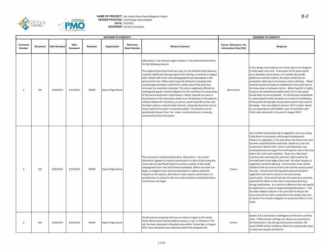
1 EIA 2/26/2015 3/13/2015 DAWR Dept of Agriculture
Alternative 2, the Channel Lagoon Option, is the preferred alternative,
for the following reasons:
The original Fujita Road Pond was used by the federally listed Mariana
moorhen (Gal/inula chloropus guami) for nesting, as recently as August
2012. Adults with chicks were photographed and videotaped in the
pond at that time. When water hyacinth (Eichornia crassipes) that
covered approximately 113rd of the surface area of the pond was
removed, the moorhens relocated. This action negatively affected an
endangered species. Partial mitigation for this could be the construction
of the pond mentioned in Alternative 2. Water hyacinth can serve a
dual purpose in this alternative; both as an introduction to the pond to
enhance habitat for moorhens, as well as, water hyacinth can be, and
has been used as a natural water cleanser, removing chemicals such as
heavy metals from water in treatment plants. The hyacinth can be
periodically thinned from the newly constructed pond, removing
contaminants from the system.
Non-Concur
In this design, pond adjacent to Tumon Bay is not designed
to hold water over time. Draw down of the pond would
occur between storm events, so it would not provide
additional moorhen habitat, the water would also be
somewhat saline due to its location close to the Bay.. Water
hyacinth would not likely be established in the pond due to
the draw down in between storms. Water hyacinth is highly
invasive and intentional establishment of it in the ponds
would likely not be acceptable. If it did become established,
it could spread to other locations as a result of overflowing
of the ponds during high volume storm events that result in
discharge. Text was added to Section 3.8.2 to state: Based
on correspondence with DAWR, a pair of moorhens with
chicks were observed in the pond in August 2012.
2 EIA 2/26/2015 3/16/2015 DAWR Dept of Agriculture
The contractor's preferred alternative, Alternative I , the culvert
alternative, appears to require construction in a plot of land along the
north side of Fujita Road known to contain a colony of the locally
endangered Guam Tree Snail (Partula radiolata). Before any work can
begin, a mitigation plan must be developed to address potential
impacts on this species. Alternative 2 does require construction in a
wooded area. A survey for the tree snails should be conducted before
construction can begin.
Concur
Very limited impacts/clearing of vegetation will occur along
Fujita Road in association with project development.
Impacts to vegetation in the area where the Guam tree snail
has been reported will be restricted. Based on a site visit
conducted in March 2014, there is one flametree, one
monkeypod and one pago that overhang the road in the area
where the snails were reported. There are a few lower
branches that overhang the road that might need to be
trimmed back to the edge of the road. No other impacts to
vegetation would be allowed. Constructioin crews will be
notified of the occurrence of the snail and the need to avoid
the area. Construction fencing will be placed to protect
vegetation and restrict access to the area during
construction. Dust control will also be required to minimize
potential for effects to the snail in associated with dust
during construction. As a result no effects to the snail would
be expected as a result of implementing Alternative 1. Text
has been added to Section 3.8.2 and 3.8.4 to discuss the
occurrence of the snail in proximity to the project area and
to Section 5 to include mitigation to avoid any effects to the
snails.
3 EIA 2/26/2015 3/16/2015 DAWR Dept of Agriculture
All alternatives proposed will have an indirect impact to the locally
listed, Micronesian starling (Aplonis opaca), or sali, in Chamorro. The
sali, has been observed in forested areas within Tumon Bay. In August
2012, two individuals were observed within the proposed site.
Concur
Section 3.8.4 and Section 5 (Mitigation) of the EIA currently
state: If Micronesian starlings are observe in proximity to
the Alternative 1 site during construction activities, the
Guam DAWR will be notified to determine appropriate steps
to avoid any impacts to the bird.
DESIGNER TO COMPLETEREVIEWER TO COMPLETE
1 of 26
B-2
NAME OF PROJECT: San Vitores Road Flood Mitigation Project
DESIGN PACKAGE: Draft Design Submittal/EIA
DATE: 9/3/2015
DESIGNER: Stanley Consultants
Comment
NumberDocument Date Received
Date
ReviewedReviewer Organization
Reference
Sheet NumberReview Comment
Concur, Nonconcur, For
Information Only (FIO)Response
DESIGNER TO COMPLETEREVIEWER TO COMPLETE
4 EIA 2/26/2015 3/16/2015 DAWR Dept of Agriculture
Migratory birds occur during the wintering months and use the existing
Fujita Road Pond. Migratory birds are protected under the Migratory
Bird Treaty Act of 1917. These birds should not be harmed.
Concur
Section 5 of the EIA includes a construction BMP that states:
If active bird nests are found in close proximity to the project
site during construction, actions will be taken to avoid
adverse effects to the nest in compliance with the MBTA.
5 EIA 2/26/2015 3/16/2015 DAWR Dept of Agriculture
The pond should act as a settling area, allowing solids and larger
particulate matter to fall from the water column, instead of being
carried on to the Tumon Bay Marine Preserved Area (MPA) reef flat.
This pond should also allow for some percolation of runoff water into
underlying limestone before entering the Tumon Bay MPA. These two
actions will help increase the quality of water being discharged in to this
sensitive environmental area. The alternative also has the benefit of
being a more natural appearing alternative than the concrete exit point
of alternative I.
Concur
Fujita Pond will act strictly as a settling/infiltration basin for
the majority of storm events with no discharge to Tumon
Bay. Overflow events will occur following large rainfalls but
the pond will still provide some settling and infiltration. Task
1 included installation of a pond level logger. The
storage/infiltration parameters of Fujita Pond are discussed
in pages 4-18 to 4-21 of the Task 1 Report (included as
appendix of EIA)
6 EIA 2/26/2015 3/16/2015 DAWR Dept of Agriculture
The EIA fails to discuss in detail the expected output (discharge) of each
proposed Alternatives. Of great concern, is erosion of the output into
Tumon MPA. All alternatives construction ends at the Mean Higher High
Water (MHHW). It is not define as to what the true value of the MHHW
in the EIA.
Concur
All alternatives would have the same discharge rate, there is
no reduction in the channel/lagoon option due to the small
amount of storage provided. The EIA will be updated with a
discharge table and definition of MHHW (2.8 feet elevation
on project datum provided. Will add text on erosion
potential.
7 EIA 2/26/2015 3/16/2015 DAWR Dept of Agriculture
All vegetation cleared from the site will need to be replaced with native
tree species.
Consult with Department of Agriculture's Forestry Soil Resources
Division to obtain a list
of native tree species for the project.
Concur
There will be limited vegetation and tree removal under
Alternative 1 (Fujita Road option). Any trees specificed will
be native
8 EIA 2/26/2015 3/16/2015 DAWR Dept of Agriculture
The concrete planters should consist of additional smaller planters to
help reduce discharge
velocity at the outlet slab.
Non-Concur
Incorporation of vegetated groundcover is being reviewed
for the outlet design to provide greater roughness and
reduction in velocity. The use of planters would be to
obscure the outlet and spread out discharge. The planters
must be tall enough that they are not overtopped by the
discharge, if they are too small there will not be enough soil
material within the planter to support growth.
9 EIA 2/26/2015 3/16/2015 DAWR Dept of Agriculture
All of the alternatives mention the need for periodic maintenance to
maintain peak functionality
of the drainage system. It is not clear which party is responsible for the
maintenance of these
systems; DPW, GWA, or GVB, a private contractor? It should be noted
that some of the flooding
in Tumon could be averted if hotels and businesses performed regular
maintenance on existing
drainage features. A visit to a site flooded during heavy rains last
November revealed every
drainage grate in the parking area of a hotel are completely clogged
with trash, soil, and sand.
Concur
DPW is responsible for maintaining stormwater utilites
located within the public right of way (i.e. San Vitores Road,
Fujita Pond, Fujita Road). Maintenance of
infiltration/drainage systems on private property are the
responsibility of the property owner.
GEDA is currently reviewing maintenance responsibility of
the proposed system which will be defined during detailed
design.
2 of 26
B-3
NAME OF PROJECT: San Vitores Road Flood Mitigation Project
DESIGN PACKAGE: Draft Design Submittal/EIA
DATE: 9/3/2015
DESIGNER: Stanley Consultants
Comment
NumberDocument Date Received
Date
ReviewedReviewer Organization
Reference
Sheet NumberReview Comment
Concur, Nonconcur, For
Information Only (FIO)Response
DESIGNER TO COMPLETEREVIEWER TO COMPLETE
10 EIA 2/26/2015 3/16/2015 DAWR Dept of Agriculture
Increased focused freshwater input to Tumon has the potential for a
variety of problems, both
human health and aesthetic. Enteromorpha algae grows in Tumon
where freshwater enters at the
beach. Heavy growth of Enteromorpha is unsightly, and large amounts
of dead algae emits an
unpleasant odor. Removal of Enteromorpha can be costly and
continuous. It is likely this
freshwater input will lead to increased Enteromorpha growth in the
vicinity of the outflow.
Freshwater input can also lead to increased growth of dynoflagellates,
the "San
Vitores Blood" blooms in Tumon Bay. Dynoflagellates can be unsightly,
and also cause human health concerns. Large amounts of
dynoflagellates in the water can cause skin irritation, and as in red tide
events in the U .S. mainland, cause seafood to be unsafe for human
consumption.
Non-Concur
Untreated/uncontrolled stormwater is already entering
Tumon Bay near Outrigger. This project improves collection
and provides additional settling time in Fujita Pond. Both
WERI (WERI Tech Report No. 110, 2005) and Dr. Matson
articles evaluating blooms in Tumon Bay attribute the
combination of factors causing algae blooms to nutrients
within freshwater (additional phosphorous), not specifically
freshwater. Dr. Matson's 1991 article on the "Blood of San
Vitores" indicates, "Blooms largely occur at salinities greater
than 25%".
Record of these blooms being toxic is not provided in any
reports that were reviewed on Tumon Bay.
11 EIA 2/26/2015 3/16/2015 DAWR Dept of Agriculture
A focused stream of freshwater discharged in to Tumon Bay will effect
corals, other marine organisms, and fish habitat in the region of
discharge. This can lead to changes in fish populations, coral and
invertebrate distribution, and increased algal growth.
Non-Concur
Dishcarge only occurs during heavy rain events which are
infrequent. During rain events significant enough for Bay
Outlet discharge, the Bay outlet will account for less than
15% of the overall freshwater entering Tumon Bay. The coral
and fish habitat are several hundred feet out from the outlet
point, which will allow some mixing of the freshwater
outflow.
12 EIA 2/26/2015 3/16/2015 DAWR Dept of Agriculture
Increased freshwater input to Tumon will affect the quality of a
snorkeling experience. Freshwater is less dense than saltwater, and
floats on the surface. The resulting halocline causes blurry vision when
looking through the water. The freshwater entering Tumon bay is also
colder than the salt water in the bay. A focused discharge of freshwater
will create a large area of cooler water, affecting the comfort of
snorkelers in the area, and affecting the health of cool intolerant marine
organisms in the area.
Non-Concur
Overflow events associated with Fujita Pond are expected to
occur approximately 2 - 3 times per year in association with
high volume storm events. During these storm events, large
volumes of freshwater would also be entering the bay in
association with the rainfall event which by itself would
effect visibility for snorklers during and for a short period
following the rainfall event. the Fujita Pond water quality
samples taken during rain events showed water temps
between 25-27C. Typical Guam sea surface temperatures
are 27-30 C, so the stormwater would not be significantly
cooler. The source of the coolest water would be the rainfall
that occurs over the bay so discomfort to snorklers during
the short period following the discharge event would be
expected to be minimal.
13 EIA 2/26/2015 3/12/2015Ray Blas and
Lynda Aguon
Dept of Parks and
Recreation
Additional Storm Water Inlets: It is unclear how the waters expected
from the 25 inlet structures will affect capacity.FIO
The additional inlets capture the stormwater runoff more
effectively, the bay outlet provides an overflow for heavy
rainfall events so Fujita Pond does not flood and create
ponding on San Vitores Road
14 EIA 2/26/2015 3/12/2015Ray Blas and
Lynda Aguon
Dept of Parks and
RecreationPage 3-21
Given the maximum depth to the water table of 10 feet and the plan to
have the channel and the lagoon above this, there should be no adverse
impacts to the bedrock.
Concur
3 of 26
B-4

NAME OF PROJECT: San Vitores Road Flood Mitigation Project
DESIGN PACKAGE: Draft Design Submittal/EIA
DATE: 9/3/2015
DESIGNER: Stanley Consultants
Comment
NumberDocument Date Received
Date
ReviewedReviewer Organization
Reference
Sheet NumberReview Comment
Concur, Nonconcur, For
Information Only (FIO)Response
DESIGNER TO COMPLETEREVIEWER TO COMPLETE
15 EIA 2/26/2015 3/12/2015Ray Blas and
Lynda Aguon
Dept of Parks and
RecreationPage 3-30
"…overflow from Fujita Pond reaches Tumon Bay during high volume
storm events" is not supported in the document.Concur
Some pond overflow collects in the low spot onf Fujita Road,
this infiltrates and flows into the Bay. If the rainfall event is
large enough the low area of Fujita Road overtops and water
spills into the Bay. Will provide additional discussion in EIA.
16 EIA 2/26/2015 3/12/2015Ray Blas and
Lynda Aguon
Dept of Parks and
Recreation
All options would have an area of potential effect (APE) greater than
the dimensions statedNon-Concur
No specific dimensions are stated for the APE, however the
construction area for the preferred Fujita Road option would
be within Fujita Road Right-of-Way which is 40-45 feet and
there would be no visual effects to historical resources
occuring from this option.
17 EIA 2/26/2015 3/12/2015Ray Blas and
Lynda Aguon
Dept of Parks and
Recreation
A review of these archived materials indicates that there are intact
deposits below and along the road. The potential for the culvert option
to impact these deposits remains high, especially considering the extent
of the excavations needed to accommodate the culverts.
Concur
An archaelogical monitoring plan will be developed for the
construction phase. The soil boring monitoring will provide
some additional insight into probability of historical deposits
18 Design 2/26/2015 3/12/2015Ray Blas and
Lynda Aguon
Dept of Parks and
Recreation
A 1993 archaeological project investigated the property the Fujita
Ponding Basin currently occupies as well as a corridor extending
seaward from it approximately 185 meters long that was parallel to and
east of Fujita Road. The corridor appears to have tested the area slated
for the channel. However, as with so many of the maps included with
PHRI reports they float in space and it is difficult to precisely locate the
project on either a topographic map or air photo. See the project map.
The proposed channel options will undoubtedly adversely impact intact
prehistoric cultural deposits along their length.
Concur
An archaelogical monitoring plan will be developed for the
construction phase. The soil boring monitoring will provide
some additional insight into probability of historical deposits.
The majority of construction area for the Culvert option has
already been excavated. While this does not eliminate the
potential for discovery of historic remains, it does
significantly reduce the potential for excavating undisturbed
items.
19 Overall 2/26/2015 3/12/2015Ray Blas and
Lynda Aguon
Dept of Parks and
Recreation
The project as it is described in the EIA will have adverse impacts on
cultural historical properties in the Fujita Road area. Both the culvert
and channel designs will encounter known sites as described above. Of
the three design options, the culvert option potentially will have the
least impact because of disturbance from previous utilities sub-Fujita
Road.
Concur
20 Overall 2/26/2015 3/12/2015Ray Blas and
Lynda Aguon
Dept of Parks and
Recreation
Based upon the existing site information and the description of the
project an archaeological data recovery plan may be indicated. It is
definitely needed for the channel options and possibly also for the
culvert option.
ConcurWill discuss with Dept Parks and Rec following completion of
the soil boring monitoring report.
21 EIA 2/26/2015 3/18/2015
M. Borja, F.
Taitano & C.
Cruz
Dept of Land
Management
Section 3.2.2,
Page 3-2, Lines
31-33
"...the bordering properties are zoned as Commercial." Being that the
entire Tumon area is zoned "H" (Hotel-Resort) recommend change to
read that the bordering properties are of commercial uses.
Concur
Text revised based on the comment to state: The areas
adjacent to Fujita Road and the area encompassing San
Vitores Road in proximity to the proposed project area are
zoned as Hotel/Resort (Guam.Gov 2015).
22 EIA 2/26/2015 3/18/2015
M. Borja, F.
Taitano & C.
Cruz
Dept of Land
Management
Section 3.2.3,
Page 3-4, Line 1
"The Guam Seashore Reserve is public property on Guam." Considering
that the Guam Territorial Seashore Protection Act of 1974 (Chapter 63,
Title 21 GCA) defines the Seashore Reserve as both public and private
lands. We feel that this statement could be misleading and recommend
that the reference to the ownership of the Seashore Reserve is
referenced to the project site (Fujita Road), which is a public owned
property.
ConcurThe text was revised to state: The Guam Seashore Reserve
adjacent to Fujita Road is public property.
4 of 26
B-5
NAME OF PROJECT: San Vitores Road Flood Mitigation Project
DESIGN PACKAGE: Draft Design Submittal/EIA
DATE: 9/3/2015
DESIGNER: Stanley Consultants
Comment
NumberDocument Date Received
Date
ReviewedReviewer Organization
Reference
Sheet NumberReview Comment
Concur, Nonconcur, For
Information Only (FIO)Response
DESIGNER TO COMPLETEREVIEWER TO COMPLETE
23 2/26/2015 3/18/2015
M. Borja, F.
Taitano & C.
Cruz
Dept of Land
Management
It is our position that the proposed project as an infrastructure
improvement project and its design, to be outside the Seashore
Reserve. The proposed San Vitores Road Flooding Mitigation Project
will not be subjected to the Guam Land Use Commission or the Guam
Seashore Protection Commission application process.
Concur
Text was added to Section 3.2.4 to state: "Based on input
from the Guam Department of Land Management, the
proposed project is an infrastructure improvement project
and is designed to be outside the Seashore Reserve. As a
result, the proposed project under Alternative 1 will not be
subject to the Guam Land Use Commission or the Guam
Seashore Protection Commission application process for
devlopment within the Seashore Reserve. No effects to the
Guam Seashore reserve would occur.
24 2/26/2015 3/18/2015
M. Borja, F.
Taitano & C.
Cruz
Dept of Land
Management
It is also our position that, in line with Section 3.11 of the EIA (Coastal
Zone) the Department of Land Management supports the issuance of a
positive Federal Consistency Certification for the proposed project.
Concur
It has been determined by the Guam Bureau of Statistics
and Plans that the project has no federal nexus so a
Consistency Determination under the Guam CZMP is not
required. However, the Bureau of Statistics and Plans has
reviewed the EIA and has stated that the project will be
beneficial as a result of the mitigation of flooding in and
adjacent to the project area. They recommend that best
management practices and ongoing and long term
maintenance be implemented.
25 2/26/2015 3/18/2015
M. Borja, F.
Taitano & C.
Cruz
Dept of Land
Management
In addition the Department of Land Management, in line with the
general provision of the island's Land Use Laws, supports the inclusion
of Best Management Practices (BMPs), Section 5.0 of the EIA
(Mitigation Measures), to promote the protection of the public's health,
safety and general welfare.
Concur
26 Design 2/26/2015 3/24/2015F. Benavente &
P. Slagel
Dept of Public
Works
DPW requested that the roadway ponding spread width criteria used in
design of the additional inlets be included in the project drawing notes. Concur Will include in drawing notes
27 Design 2/26/2015 3/24/2015F. Benavente &
P. Slagel
Dept of Public
Works
Cover over the culvert was discussed. DPW does not have concerns as
long as a 2’ minimum cover is maintained.Concur
28 Design 2/26/2015 3/24/2015F. Benavente &
P. Slagel
Dept of Public
Works
DPW requested that the pond design be modified to include an access
path, including 12 foot concrete ramp at 4h:1v max. to access the pond
for dredging.
Concur Pond design will be revised to include.
29 Design 2/26/2015 3/24/2015F. Benavente &
P. Slagel
Dept of Public
Works
DPW requested that the project use the DPW standard pavement
section, 1” surface course, on 2” base course, on 8” aggregate, on 12”
of subbase. DPW indicated that aggregate grade A is difficult/expensive
to obtain so to use grade C for all base aggregate. DPW to provide
design standard.
Concur Road section will be revised
30 Design 2/26/2015 3/24/2015F. Benavente &
P. Slagel
Dept of Public
Works
DPW requested that any street lights removed on the project be
salvaged to DPWConcur Note will be added to drawings
31 Design 2/26/2015 3/24/2015F. Benavente &
P. Slagel
Dept of Public
Works
DPW requested any exposed metal grating or attachment hardware be
reviewed for corrosion resistance. Potentially use stainless steel or
resin composite.
ConcurCorrosion potential will be reviewed and corrosion resistant
materials utilized on project
32 Design 2/26/2015 3/24/2015F. Benavente &
P. Slagel
Dept of Public
Works
DPW requested the size of concrete apron around new inlets be
reduced and a maximum depression of ¾” be used to provide better
bicycle pathway on roadside.
Concur Inlet details will be revised
5 of 26
B-6
NAME OF PROJECT: San Vitores Road Flood Mitigation Project
DESIGN PACKAGE: Draft Design Submittal/EIA
DATE: 9/3/2015
DESIGNER: Stanley Consultants
Comment
NumberDocument Date Received
Date
ReviewedReviewer Organization
Reference
Sheet NumberReview Comment
Concur, Nonconcur, For
Information Only (FIO)Response
DESIGNER TO COMPLETEREVIEWER TO COMPLETE
33 Design 2/26/2015 3/24/2015F. Benavente &
P. Slagel
Dept of Public
Works
Maintenance of the proposed system was discussed. DPW requested a
summary of recommended maintenance tasks and frequency be
included with the project documentation.
Concur Maintenance tasks/frequency will be provided
34 Design 2/26/2015 3/24/2015F. Benavente &
P. Slagel
Dept of Public
Works
Maintenance of the proposed system was discussed. DPW indicated
capacity/equipment to maintain pond and culvert but not the beach.
Timing of maintenance may vary with availability of staff/equipment
Concur
GEDA is currently reviewing maintenance responsibility of
the proposed system which will be defined during detailed
design.
35 Design 2/26/2015 3/24/2015F. Benavente &
P. Slagel
Dept of Public
Works
Maintenance of the proposed system was discussed. DPW indicated pond maintenance will be included in the DPW maintenance schedule but, given current limitations, it may not get maintained as often as it should be.
Concur
GEDA is currently reviewing maintenance responsibility of
the proposed system which will be defined during detailed
design.
36 Design 2/26/2015 3/24/2015F. Benavente &
P. Slagel
Dept of Public
Works
Maintenance of the proposed system was discussed. DPW would have no objections to having GVB consider the option of having maintenance crews from the businesses that will benefit from the pond maintain it and that GVB be given a copy of the pond maintenance requirements.
Concur
GEDA is currently reviewing maintenance responsibility of
the proposed system which will be defined during detailed
design.
37 Design 2/26/2015 3/24/2015F. Benavente &
P. Slagel
Dept of Public
Works
Maintenance of the proposed system was discussed. DPW
recommended beach maintenance be discussed with GVB and
Department of Parks and Recreation.
Concur
GEDA is currently reviewing maintenance responsibility of
the proposed system which will be defined during detailed
design.
38 Design 2/26/2015 3/24/2015F. Benavente &
P. Slagel
Dept of Public
Works
It was agreed that Stanley will stay in communication with DPW on
design and modifications.Concur
39 Design 2/26/2015 3/17/2015 Capt. Castro
Guam Fire Dept.
Fire Prevention
Bureau
Shall maintain emergency apparatus access for duration. Concur Will require in project documents
40 Meeting 2/26/2015 3/17/2015 Capt. Castro
Guam Fire Dept.
Fire Prevention
Bureau
Improvements made to water line/fire hydrants will need to be
reviewed.Concur Drawings will be provided for review
41 Meeting 2/26/2015 3/17/2015 Capt. Castro
Guam Fire Dept.
Fire Prevention
Bureau
An Emergency Plan from the contractor is needed for the duration of
construction to address emergency access and access to the fire
hydrants/fire suppression water
Concur Will require in project specs
42 Meeting 2/26/2015 3/17/2015 Capt. Castro
Guam Fire Dept.
Fire Prevention
Bureau
Maintain clear access to hydrants during construction. Concur Will require in project documents
43 Meeting 2/26/2015 3/17/2015 Capt. Castro
Guam Fire Dept.
Fire Prevention
Bureau
Coordination with the GFD Fire Marshall and GWA (Heidi Ballendorf)
needed if construction will temporarily affect water to the hydrants.Concur Will require in project documents
44 Meeting 2/26/2015 3/17/2015 Capt. Castro
Guam Fire Dept.
Fire Prevention
Bureau
Maintain water pressure to the hydrants or provide fire suppression
water tank.Concur Will require in project documents
45 Meeting 2/26/2015 3/17/2015 Capt. Castro
Guam Fire Dept.
Fire Prevention
Bureau
Contractor needs to maintain one lane of access along Fujita Road at all
timesConcur Is required in project documents
46 Meeting 2/26/2015 3/17/2015 Capt. Castro
Guam Fire Dept.
Fire Prevention
Bureau
12’ foot ingress/egress corridor from Fujita Road to the beach is
acceptable. No parking/fire line signs should be posted above the
corridor.
Concur Will provide signage in project documents
47 Meeting 3/19/2015 Board GEDAConcerned about stakeholder concerns, especially rain/fresh water into
Tumon Bay.Concur Will provide additional discussion in EIA
48 Meeting 3/19/2015 Board GEDA Erosion at the outfall point. Concur
Key to this issue will be maintenance. GEDA is currently
reviewing maintenance responsibility of the proposed
system which will be defined during detailed design.
6 of 26
B-7
NAME OF PROJECT: San Vitores Road Flood Mitigation Project
DESIGN PACKAGE: Draft Design Submittal/EIA
DATE: 9/3/2015
DESIGNER: Stanley Consultants
Comment
NumberDocument Date Received
Date
ReviewedReviewer Organization
Reference
Sheet NumberReview Comment
Concur, Nonconcur, For
Information Only (FIO)Response
DESIGNER TO COMPLETEREVIEWER TO COMPLETE
49 Meeting 3/19/2015 Board GEDA Signs to keep away skaters/loiterers. ConcurSignage and other elements to maintain intended use of
public amenity features will be incorporated.
50 Meeting 3/19/2015 Board GEDA Landscaping around the pond. Concur Will incorporate
51 Meeting 3/19/2015 Board GEDA Artwork at the outfall. Ask about budget. GVB branding. ConcurWill get GVB input/involvement as design moves out of
regulatory phase
52 Meeting 3/19/2015 E. Calvo, Board GEDA Considerations needed to consider increased pedestrian traffic. Concur
Sidewalk along Fujita Road has been discussed, but this will
reduce parking. Will need to be decided amongst
DPW/GVB/GEDA/Stakeholders
53 Meeting 3/19/2015 E. Calvo, Board GEDA Who will manage the space when construction is completed? Concur
GEDA is currently reviewing maintenance responsibility of
the proposed system which will be defined during detailed
design.
54Construction
Schedule2/16/2015 2/16/2015 GBT CHA General
Include at least 1 month for permitting at the beginning and 1 month
for closeout at the end.Concur Schedule has been adjusted
55Construction
Schedule2/16/2015 2/16/2015 GBT CHA General
Durations for completion seem optimistic based on historical data here
in Guam; consider increasing the total duration from 30 weeks at least
52.
Concur
Schedule has been adjusted to 10 months, will consider
increasing time from NTP to mobilization. Need to try to
keep/incentivize contractor to limit duration of road
disturbance
56Construction
Schedule2/16/2015 2/16/2015 GBT CHA General
Identify long lead items in procurement task 5 such as precast items,
box culvert, transformer, sheet piling, fiber optic, rip rap, etc.Concur
Schedule has been adjusted to 10 months, will consider
increasing time from NTP to mobilization for additional
procurement time. Construction items on this project are
fairly standard so not anticipating normal procurement time.
Will identify long lead time items as bid documents are put
together.
57Construction
Schedule2/16/2015 2/16/2015 GBT CHA General
Underground clearances take a long time to obtain in GU and they are
processed like another permit. Include at least 1 month for
underground clearances prior to any excavation tasks such as utility
relocations task summary 10.
Concur
Schedule has been adjusted to 10 months, will consider
increasing time from NTP to mobilization for additional
underground clearance times.
58Specification
List2/16/2015 2/16/2015 GBT CHA General Include a section for temporary traffic control. Concur Will incorporate
59Specification
List2/16/2015 2/16/2015 GBT CHA General
In future submittals, under section 014529 and 014100, identify if the
owner needs to procure separately any 3rd party structural/soils/DOT
testing and 3rd party inspection services.
ConcurWill discuss with GEDA/GEDA PMO as bid documents are
developed.
60 Estimate 2/16/2015 2/16/2015 GBT CHA General
Identify any necessary 3rd party inspection services for structural
elements and/or paving & utilities, if the owner should procure them
separately and include in the estimate.
ConcurWill discuss with GEDA/GEDA PMO as bid documents are
developed.
61 Drawings 2/16/2015 2/16/2015 GBT CHA GeneralInclude a lsit of required inspections per DOT and Guam Building Dept.
regulations. This list may be provided to DPW for concurrence.Concur
Will discuss with DPW/GEDA PMO as bid documents are
developed.
62 Drawings 2/16/2015 2/16/2015 GBT CHA General Include a table in the plans for all required inspections and testing. Non-Concur Will provide submittal table as part of specifications
63 Drawings 2/16/2015 2/16/2015 GBT CHA GeneralInclude traffic control plans and construction sequencing. Use
DPW/DOT approved Maintenance of Traffic details.Concur
Will provide details and general requirements, there are
several methods of staging the contractor can use
64 Drawings 2/16/2015 2/16/2015 GBT CHA General Include general notes and symbols. Concur Will incorporate
65 Drawings 2/16/2015 2/16/2015 GBT CHA General Include inlets and structures tables. Concur Will incorporate
66 Drawings 2/16/2015 2/16/2015 GBT CHA General Include key plan with sections and corresponding plan references. Concur Key plan is provided in current drawing set
67 Drawings 2/16/2015 2/16/2015 GBT CHA General
Include a general note to obtain all underground clearances prior to
excavation, and to coordinate with the CM and program archaeologist
and approved monitoring plan per SHPO.
Concur Will incorporate
7 of 26
B-8
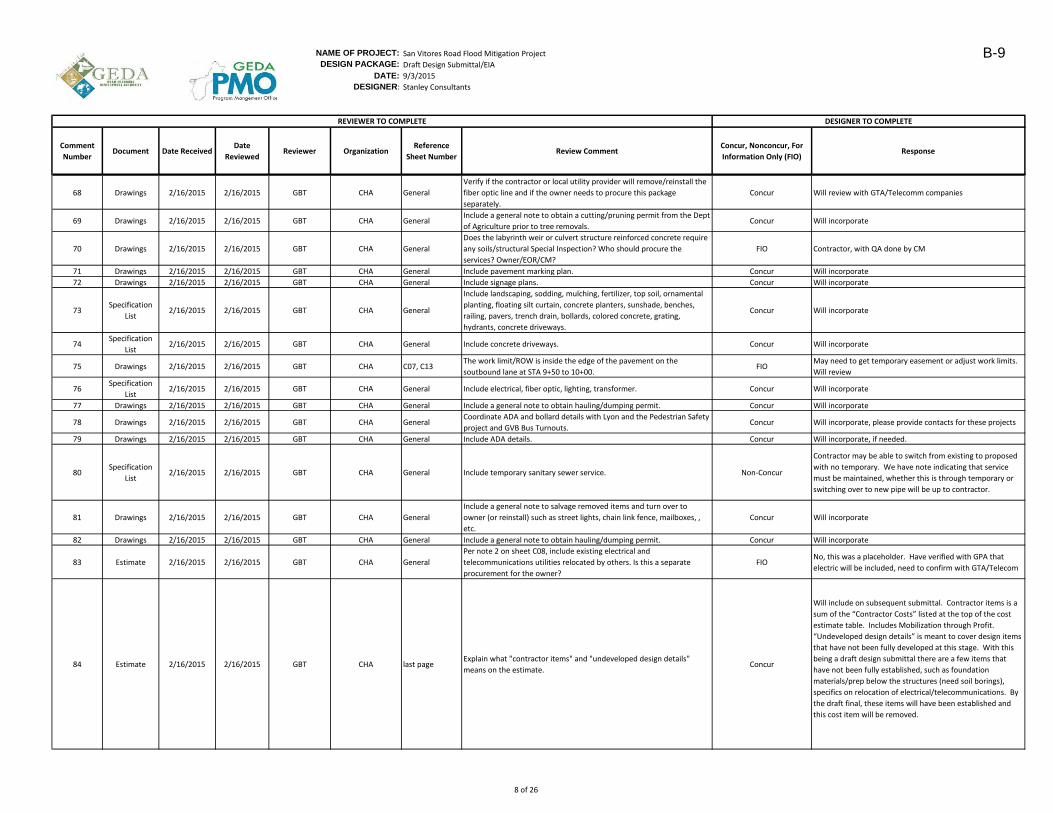
NAME OF PROJECT: San Vitores Road Flood Mitigation Project
DESIGN PACKAGE: Draft Design Submittal/EIA
DATE: 9/3/2015
DESIGNER: Stanley Consultants
Comment
NumberDocument Date Received
Date
ReviewedReviewer Organization
Reference
Sheet NumberReview Comment
Concur, Nonconcur, For
Information Only (FIO)Response
DESIGNER TO COMPLETEREVIEWER TO COMPLETE
68 Drawings 2/16/2015 2/16/2015 GBT CHA General
Verify if the contractor or local utility provider will remove/reinstall the
fiber optic line and if the owner needs to procure this package
separately.
Concur Will review with GTA/Telecomm companies
69 Drawings 2/16/2015 2/16/2015 GBT CHA GeneralInclude a general note to obtain a cutting/pruning permit from the Dept
of Agriculture prior to tree removals.Concur Will incorporate
70 Drawings 2/16/2015 2/16/2015 GBT CHA General
Does the labyrinth weir or culvert structure reinforced concrete require
any soils/structural Special Inspection? Who should procure the
services? Owner/EOR/CM?
FIO Contractor, with QA done by CM
71 Drawings 2/16/2015 2/16/2015 GBT CHA General Include pavement marking plan. Concur Will incorporate
72 Drawings 2/16/2015 2/16/2015 GBT CHA General Include signage plans. Concur Will incorporate
73Specification
List2/16/2015 2/16/2015 GBT CHA General
Include landscaping, sodding, mulching, fertilizer, top soil, ornamental
planting, floating silt curtain, concrete planters, sunshade, benches,
railing, pavers, trench drain, bollards, colored concrete, grating,
hydrants, concrete driveways.
Concur Will incorporate
74Specification
List2/16/2015 2/16/2015 GBT CHA General Include concrete driveways. Concur Will incorporate
75 Drawings 2/16/2015 2/16/2015 GBT CHA C07, C13The work limit/ROW is inside the edge of the pavement on the
soutbound lane at STA 9+50 to 10+00.FIO
May need to get temporary easement or adjust work limits.
Will review
76Specification
List2/16/2015 2/16/2015 GBT CHA General Include electrical, fiber optic, lighting, transformer. Concur Will incorporate
77 Drawings 2/16/2015 2/16/2015 GBT CHA General Include a general note to obtain hauling/dumping permit. Concur Will incorporate
78 Drawings 2/16/2015 2/16/2015 GBT CHA GeneralCoordinate ADA and bollard details with Lyon and the Pedestrian Safety
project and GVB Bus Turnouts.Concur Will incorporate, please provide contacts for these projects
79 Drawings 2/16/2015 2/16/2015 GBT CHA General Include ADA details. Concur Will incorporate, if needed.
80Specification
List2/16/2015 2/16/2015 GBT CHA General Include temporary sanitary sewer service. Non-Concur
Contractor may be able to switch from existing to proposed
with no temporary. We have note indicating that service
must be maintained, whether this is through temporary or
switching over to new pipe will be up to contractor.
81 Drawings 2/16/2015 2/16/2015 GBT CHA General
Include a general note to salvage removed items and turn over to
owner (or reinstall) such as street lights, chain link fence, mailboxes, ,
etc.
Concur Will incorporate
82 Drawings 2/16/2015 2/16/2015 GBT CHA General Include a general note to obtain hauling/dumping permit. Concur Will incorporate
83 Estimate 2/16/2015 2/16/2015 GBT CHA General
Per note 2 on sheet C08, include existing electrical and
telecommunications utilities relocated by others. Is this a separate
procurement for the owner?
FIONo, this was a placeholder. Have verified with GPA that
electric will be included, need to confirm with GTA/Telecom
84 Estimate 2/16/2015 2/16/2015 GBT CHA last pageExplain what "contractor items" and "undeveloped design details"
means on the estimate.Concur
Will include on subsequent submittal. Contractor items is a
sum of the “Contractor Costs” listed at the top of the cost
estimate table. Includes Mobilization through Profit.
“Undeveloped design details” is meant to cover design items
that have not been fully developed at this stage. With this
being a draft design submittal there are a few items that
have not been fully established, such as foundation
materials/prep below the structures (need soil borings),
specifics on relocation of electrical/telecommunications. By
the draft final, these items will have been established and
this cost item will be removed.
8 of 26
B-9
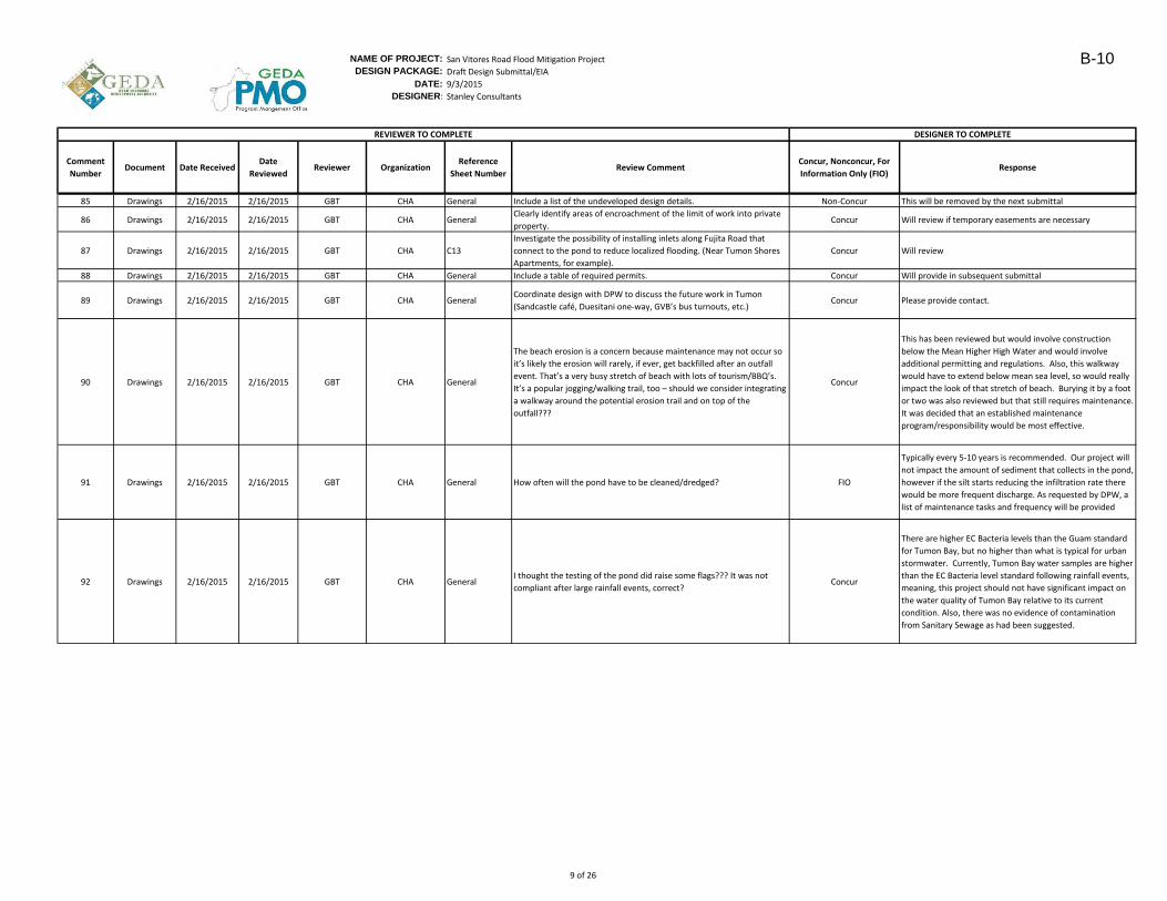
NAME OF PROJECT: San Vitores Road Flood Mitigation Project
DESIGN PACKAGE: Draft Design Submittal/EIA
DATE: 9/3/2015
DESIGNER: Stanley Consultants
Comment
NumberDocument Date Received
Date
ReviewedReviewer Organization
Reference
Sheet NumberReview Comment
Concur, Nonconcur, For
Information Only (FIO)Response
DESIGNER TO COMPLETEREVIEWER TO COMPLETE
85 Drawings 2/16/2015 2/16/2015 GBT CHA General Include a list of the undeveloped design details. Non-Concur This will be removed by the next submittal
86 Drawings 2/16/2015 2/16/2015 GBT CHA GeneralClearly identify areas of encroachment of the limit of work into private
property.Concur Will review if temporary easements are necessary
87 Drawings 2/16/2015 2/16/2015 GBT CHA C13
Investigate the possibility of installing inlets along Fujita Road that
connect to the pond to reduce localized flooding. (Near Tumon Shores
Apartments, for example).
Concur Will review
88 Drawings 2/16/2015 2/16/2015 GBT CHA General Include a table of required permits. Concur Will provide in subsequent submittal
89 Drawings 2/16/2015 2/16/2015 GBT CHA GeneralCoordinate design with DPW to discuss the future work in Tumon
(Sandcastle café, Duesitani one-way, GVB’s bus turnouts, etc.)Concur Please provide contact.
90 Drawings 2/16/2015 2/16/2015 GBT CHA General
The beach erosion is a concern because maintenance may not occur so
it’s likely the erosion will rarely, if ever, get backfilled after an outfall
event. That’s a very busy stretch of beach with lots of tourism/BBQ’s.
It’s a popular jogging/walking trail, too – should we consider integrating
a walkway around the potential erosion trail and on top of the
outfall???
Concur
This has been reviewed but would involve construction
below the Mean Higher High Water and would involve
additional permitting and regulations. Also, this walkway
would have to extend below mean sea level, so would really
impact the look of that stretch of beach. Burying it by a foot
or two was also reviewed but that still requires maintenance.
It was decided that an established maintenance
program/responsibility would be most effective.
91 Drawings 2/16/2015 2/16/2015 GBT CHA General How often will the pond have to be cleaned/dredged? FIO
Typically every 5-10 years is recommended. Our project will
not impact the amount of sediment that collects in the pond,
however if the silt starts reducing the infiltration rate there
would be more frequent discharge. As requested by DPW, a
list of maintenance tasks and frequency will be provided
92 Drawings 2/16/2015 2/16/2015 GBT CHA GeneralI thought the testing of the pond did raise some flags??? It was not
compliant after large rainfall events, correct?Concur
There are higher EC Bacteria levels than the Guam standard
for Tumon Bay, but no higher than what is typical for urban
stormwater. Currently, Tumon Bay water samples are higher
than the EC Bacteria level standard following rainfall events,
meaning, this project should not have significant impact on
the water quality of Tumon Bay relative to its current
condition. Also, there was no evidence of contamination
from Sanitary Sewage as had been suggested.
9 of 26
B-10
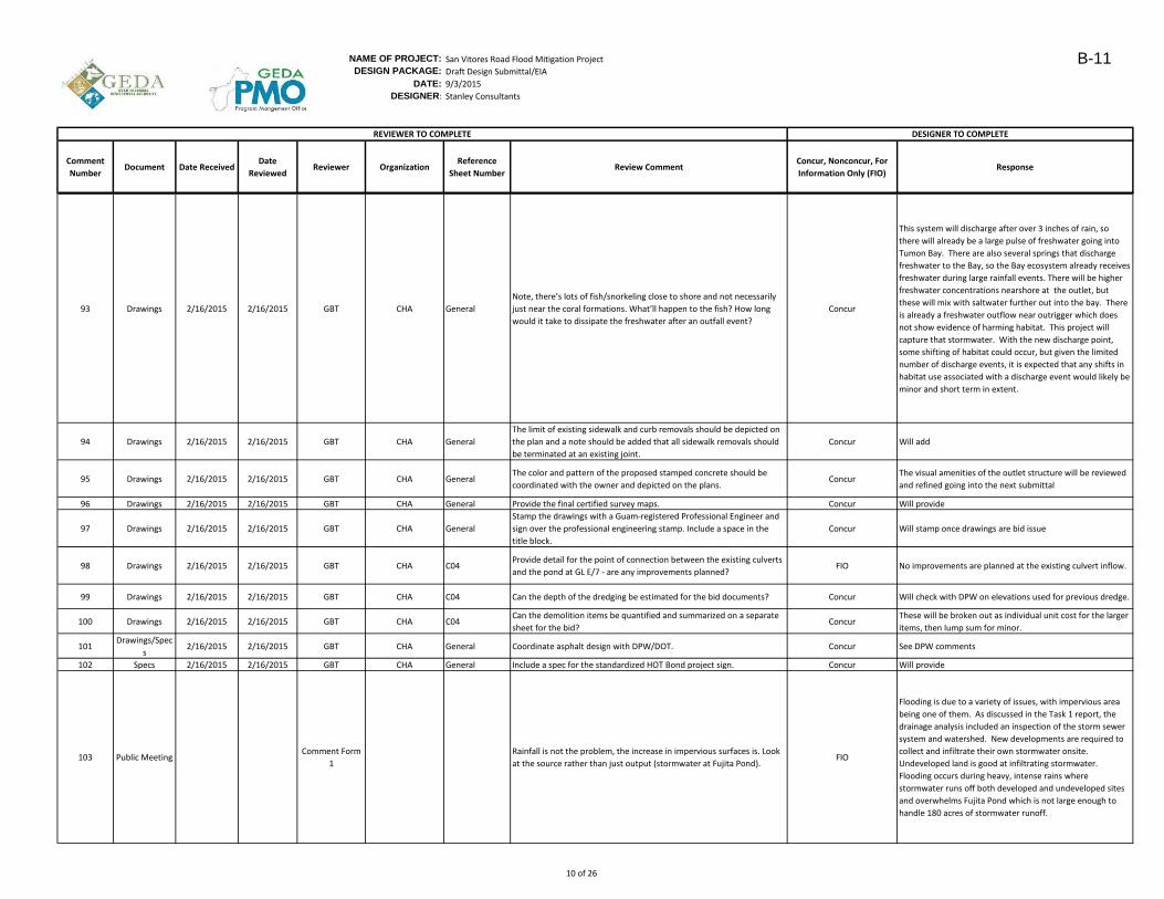
NAME OF PROJECT: San Vitores Road Flood Mitigation Project
DESIGN PACKAGE: Draft Design Submittal/EIA
DATE: 9/3/2015
DESIGNER: Stanley Consultants
Comment
NumberDocument Date Received
Date
ReviewedReviewer Organization
Reference
Sheet NumberReview Comment
Concur, Nonconcur, For
Information Only (FIO)Response
DESIGNER TO COMPLETEREVIEWER TO COMPLETE
93 Drawings 2/16/2015 2/16/2015 GBT CHA General
Note, there’s lots of fish/snorkeling close to shore and not necessarily
just near the coral formations. What’ll happen to the fish? How long
would it take to dissipate the freshwater after an outfall event?
Concur
This system will discharge after over 3 inches of rain, so
there will already be a large pulse of freshwater going into
Tumon Bay. There are also several springs that discharge
freshwater to the Bay, so the Bay ecosystem already receives
freshwater during large rainfall events. There will be higher
freshwater concentrations nearshore at the outlet, but
these will mix with saltwater further out into the bay. There
is already a freshwater outflow near outrigger which does
not show evidence of harming habitat. This project will
capture that stormwater. With the new discharge point,
some shifting of habitat could occur, but given the limited
number of discharge events, it is expected that any shifts in
habitat use associated with a discharge event would likely be
minor and short term in extent.
94 Drawings 2/16/2015 2/16/2015 GBT CHA General
The limit of existing sidewalk and curb removals should be depicted on
the plan and a note should be added that all sidewalk removals should
be terminated at an existing joint.
Concur Will add
95 Drawings 2/16/2015 2/16/2015 GBT CHA GeneralThe color and pattern of the proposed stamped concrete should be
coordinated with the owner and depicted on the plans.Concur
The visual amenities of the outlet structure will be reviewed
and refined going into the next submittal
96 Drawings 2/16/2015 2/16/2015 GBT CHA General Provide the final certified survey maps. Concur Will provide
97 Drawings 2/16/2015 2/16/2015 GBT CHA General
Stamp the drawings with a Guam-registered Professional Engineer and
sign over the professional engineering stamp. Include a space in the
title block.
Concur Will stamp once drawings are bid issue
98 Drawings 2/16/2015 2/16/2015 GBT CHA C04Provide detail for the point of connection between the existing culverts
and the pond at GL E/7 - are any improvements planned?FIO No improvements are planned at the existing culvert inflow.
99 Drawings 2/16/2015 2/16/2015 GBT CHA C04 Can the depth of the dredging be estimated for the bid documents? Concur Will check with DPW on elevations used for previous dredge.
100 Drawings 2/16/2015 2/16/2015 GBT CHA C04Can the demolition items be quantified and summarized on a separate
sheet for the bid?Concur
These will be broken out as individual unit cost for the larger
items, then lump sum for minor.
101Drawings/Spec
s2/16/2015 2/16/2015 GBT CHA General Coordinate asphalt design with DPW/DOT. Concur See DPW comments
102 Specs 2/16/2015 2/16/2015 GBT CHA General Include a spec for the standardized HOT Bond project sign. Concur Will provide
103 Public MeetingComment Form
1
Rainfall is not the problem, the increase in impervious surfaces is. Look
at the source rather than just output (stormwater at Fujita Pond).FIO
Flooding is due to a variety of issues, with impervious area
being one of them. As discussed in the Task 1 report, the
drainage analysis included an inspection of the storm sewer
system and watershed. New developments are required to
collect and infiltrate their own stormwater onsite.
Undeveloped land is good at infiltrating stormwater.
Flooding occurs during heavy, intense rains where
stormwater runs off both developed and undeveloped sites
and overwhelms Fujita Pond which is not large enough to
handle 180 acres of stormwater runoff.
10 of 26
B-11
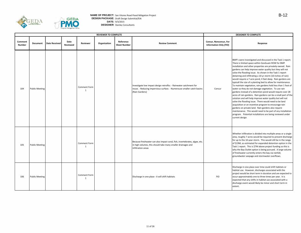
NAME OF PROJECT: San Vitores Road Flood Mitigation Project
DESIGN PACKAGE: Draft Design Submittal/EIA
DATE: 9/3/2015
DESIGNER: Stanley Consultants
Comment
NumberDocument Date Received
Date
ReviewedReviewer Organization
Reference
Sheet NumberReview Comment
Concur, Nonconcur, For
Information Only (FIO)Response
DESIGNER TO COMPLETEREVIEWER TO COMPLETE
104 Public MeetingComment Form
1
Investigate low impact design retrofits: - Rainwater catchment for
reuse. - Reducing impervious surface. - Numerouse smaller catch basins
(Rain Gardens)
Concur
BMP's were investigated and discussed in the Task 1 report.
There is limited space within GovGuam ROW for BMP
installation and other properties are privately owned. Rain
gardens can help improve water quality but they will not
solve the flooding issue. As shown in the Task 1 report
detaining and infiltrating a 10-yr storm (10 inches of rain)
would require a 7 acre pond, 4 feet deep. Rain gardens are
typicall the size of a planting bed to allow for maintenance.
To maintain vegetation, rain gardens hold less than 1 foot of
water so they do not damage vegetation. To use rain
gardens instead of a detention pond would require over 28
acres of rain gardens. Rain gardens can be a small part of the
solution and will help improve water quality but will not
solve the flooding issue. There would need to be land
acquisition or an incentive program to encourage rain
gardens on private land. Rain gardens also require
maintenance. This would need to be part of any installation
program. Potential installations are being reviewed under
current design.
105 Public MeetingComment Form
1
Because freshwater can also impact coral, fish, invertebrates, algae, etc.
in high volumes, this should take many smaller drainages and
infiltration areas
Whether infiltration is divided into multiple areas or a single
area, roughly 7 acres would be required to prevent discharge
for up to the 10-year storm. This would still be in the range
of $19M, as estimated for expanded detention option in the
Task 1 report. This is $7M above project funding so this is
why the Bay Outlet option is being pursued. A large volume
of freshwater currently enters the bay via rainfall,
groundwater seepage and stormwater overflows.
106 Public MeetingComment Form
1Discharge in one place - it will shift habitats FIO
Discharge in one place over time could shift habitats or
habitat use. However, discharges associated with the
project would be short term in duration and are expected to
occur approximately one to three times per year. It is
expected that any shifts in habitat use associated with a
discharge event would likely be minor and short term in
extent.
11 of 26
B-12
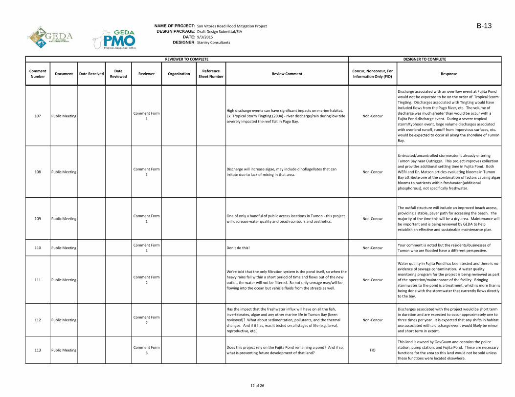
NAME OF PROJECT: San Vitores Road Flood Mitigation Project
DESIGN PACKAGE: Draft Design Submittal/EIA
DATE: 9/3/2015
DESIGNER: Stanley Consultants
Comment
NumberDocument Date Received
Date
ReviewedReviewer Organization
Reference
Sheet NumberReview Comment
Concur, Nonconcur, For
Information Only (FIO)Response
DESIGNER TO COMPLETEREVIEWER TO COMPLETE
107 Public MeetingComment Form
1
High discharge events can have significant impacts on marine habitat.
Ex. Tropical Storm Tingting (2004) - river discharge/rain during low tide
severely impacted the reef flat in Pago Bay.
Non-Concur
Discharge associated with an overflow event at Fujita Pond
would not be expected to be on the order of Tropical Storm
Tingting. Discharges associated with Tingting would have
included flows from the Pago River, etc. The volume of
discharge was much greater than would be occur with a
Fujita Pond discharge event. During a severe tropical
storm/typhoon event, large volume discharges associated
with overland runoff, runoff from impervious surfaces, etc.
would be expected to occur all along the shoreline of Tumon
Bay.
108 Public MeetingComment Form
1
Discharge will increase algae, may include dinoflagellates that can
irritate due to lack of mixing in that area.Non-Concur
Untreated/uncontrolled stormwater is already entering
Tumon Bay near Outrigger. This project improves collection
and provides additional settling time in Fujita Pond. Both
WERI and Dr. Matson articles evaluating blooms in Tumon
Bay attribute one of the combination of factors causing algae
blooms to nutrients within freshwater (additional
phosphorous), not specifically freshwater.
109 Public MeetingComment Form
1
One of only a handful of public access locations in Tumon - this project
will decrease water quality and beach contours and aesthetics.Non-Concur
The outfall structure will include an improved beach access,
providing a stable, paver path for accessing the beach. The
majority of the time this will be a dry area. Maintenance will
be important and is being reviewed by GEDA to help
establish an effective and sustainable maintenance plan.
110 Public MeetingComment Form
1Don't do this! Non-Concur
Your comment is noted but the residents/businesses of
Tumon who are flooded have a different perspective.
111 Public MeetingComment Form
2
We're told that the only filtration system is the pond itself, so when the
heavy rains fall within a short period of time and flows out of the new
outlet, the water will not be filtered. So not only sewage may/will be
flowing into the ocean but vehicle fluids from the streets as well.
Non-Concur
Water quality in Fujita Pond has been tested and there is no
evidence of sewage contamination. A water quality
monitoring program for the project is being reviewed as part
of the operation/maintenance of the facility. Bringing
stormwater to the pond is a treatment, which is more than is
being done with the stormwater that currently flows directly
to the bay.
112 Public MeetingComment Form
2
Has the impact that the freshwater influx will have on all the fish,
invertebrates, algae and any other marine life in Tumon Bay (been
reviewed)? What about sedimentation, pollutants, and the thermal
changes. And if it has, was it tested on all stages of life (e.g. larval,
reproductive, etc.)
Non-Concur
Discharges associated with the project would be short term
in duration and are expected to occur approximately one to
three times per year. It is expected that any shifts in habitat
use associated with a discharge event would likely be minor
and short term in extent.
113 Public MeetingComment Form
3
Does this project rely on the Fujita Pond remaining a pond? And if so,
what is preventing future development of that land?FIO
This land is owned by GovGuam and contains the police
station, pump station, and Fujita Pond. These are necessary
functions for the area so this land would not be sold unless
these functions were located elsewhere.
12 of 26
B-13
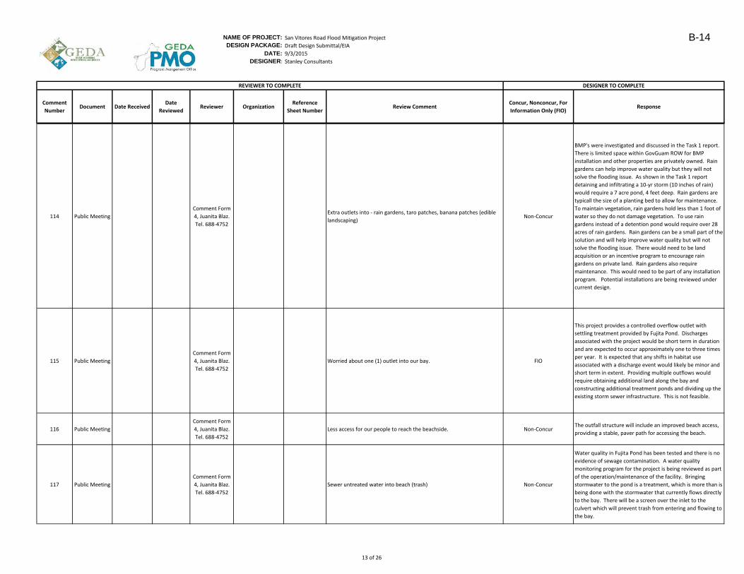
NAME OF PROJECT: San Vitores Road Flood Mitigation Project
DESIGN PACKAGE: Draft Design Submittal/EIA
DATE: 9/3/2015
DESIGNER: Stanley Consultants
Comment
NumberDocument Date Received
Date
ReviewedReviewer Organization
Reference
Sheet NumberReview Comment
Concur, Nonconcur, For
Information Only (FIO)Response
DESIGNER TO COMPLETEREVIEWER TO COMPLETE
114 Public Meeting
Comment Form
4, Juanita Blaz.
Tel. 688-4752
Extra outlets into - rain gardens, taro patches, banana patches (edible
landscaping)Non-Concur
BMP's were investigated and discussed in the Task 1 report.
There is limited space within GovGuam ROW for BMP
installation and other properties are privately owned. Rain
gardens can help improve water quality but they will not
solve the flooding issue. As shown in the Task 1 report
detaining and infiltrating a 10-yr storm (10 inches of rain)
would require a 7 acre pond, 4 feet deep. Rain gardens are
typicall the size of a planting bed to allow for maintenance.
To maintain vegetation, rain gardens hold less than 1 foot of
water so they do not damage vegetation. To use rain
gardens instead of a detention pond would require over 28
acres of rain gardens. Rain gardens can be a small part of the
solution and will help improve water quality but will not
solve the flooding issue. There would need to be land
acquisition or an incentive program to encourage rain
gardens on private land. Rain gardens also require
maintenance. This would need to be part of any installation
program. Potential installations are being reviewed under
current design.
115 Public Meeting
Comment Form
4, Juanita Blaz.
Tel. 688-4752
Worried about one (1) outlet into our bay. FIO
This project provides a controlled overflow outlet with
settling treatment provided by Fujita Pond. Discharges
associated with the project would be short term in duration
and are expected to occur approximately one to three times
per year. It is expected that any shifts in habitat use
associated with a discharge event would likely be minor and
short term in extent. Providing multiple outflows would
require obtaining additional land along the bay and
constructing additional treatment ponds and dividing up the
existing storm sewer infrastructure. This is not feasible.
116 Public Meeting
Comment Form
4, Juanita Blaz.
Tel. 688-4752
Less access for our people to reach the beachside. Non-ConcurThe outfall structure will include an improved beach access,
providing a stable, paver path for accessing the beach.
117 Public Meeting
Comment Form
4, Juanita Blaz.
Tel. 688-4752
Sewer untreated water into beach (trash) Non-Concur
Water quality in Fujita Pond has been tested and there is no
evidence of sewage contamination. A water quality
monitoring program for the project is being reviewed as part
of the operation/maintenance of the facility. Bringing
stormwater to the pond is a treatment, which is more than is
being done with the stormwater that currently flows directly
to the bay. There will be a screen over the inlet to the
culvert which will prevent trash from entering and flowing to
the bay.
13 of 26
B-14
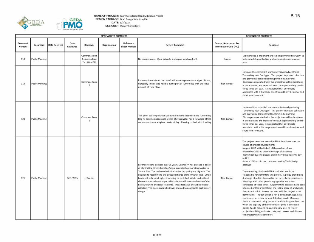
NAME OF PROJECT: San Vitores Road Flood Mitigation Project
DESIGN PACKAGE: Draft Design Submittal/EIA
DATE: 9/3/2015
DESIGNER: Stanley Consultants
Comment
NumberDocument Date Received
Date
ReviewedReviewer Organization
Reference
Sheet NumberReview Comment
Concur, Nonconcur, For
Information Only (FIO)Response
DESIGNER TO COMPLETEREVIEWER TO COMPLETE
118 Public Meeting
Comment Form
4, Juanita Blaz.
Tel. 688-4752
No maintenance. Clear culverts and repair sand wash off. Concur
Maintenance is important and is being reviewed by GEDA to
help establish an effective and sustainable maintenance
plan.
119 Public MeetingComment Form
5
Excess nutrients from the runoff will encourage nuisance algae blooms,
especially since Fujita Road is at the part of Tumon Bay with the least
amount of Tidal Flow.
Non-Concur
Untreated/uncontrolled stormwater is already entering
Tumon Bay near Outrigger. This project improves collection
and provides additional settling time in Fujita Pond.
Discharges associated with the project would be short term
in duration and are expected to occur approximately one to
three times per year. It is expected that any impcts
associated with a discharge event would likely be minor and
short term in extent.
120 Public MeetingComment Form
5
This point source pollution will cause blooms that will make Tumon Bay
lose its pristine appearance weeks of gross water has a far worse effect
on tourism than a single occassional day of having to deal with flooding.
Non-Concur
Untreated/uncontrolled stormwater is already entering
Tumon Bay near Outrigger. This project improves collection
and provides additional settling time in Fujita Pond.
Discharges associated with the project would be short term
in duration and are expected to occur approximately one to
three times per year. It is expected that any impcts
associated with a discharge event would likely be minor and
short term in extent.
121 Public Meeting 3/31/2015 J. Duenas
For many years, perhaps over 35 years, Guam EPA has pursued a policy
of eliminating direct shoreline/shore area discharge of stormwater to
Tumon Bay. The preferred solution defies this policy in a big way. The
decision to recommend the direct discharge of stormwater into Tumon
bay is not only short sighted focusing on cost, but fails to understand
the enormous adverse impact this solution will have on the use of the
bay by tourists and local residents. This alternative should be wholly
rejected. The question is why it was allowed to proceed to preliminary
design.
Non-Concur
The project team has met with GEPA four times over the
course of project development:
-August 2013 at the kickoff of the analysis phase
-December 2013 to present concept alternatives
-November 2014 to discuss preliminary design gravity bay
outlet
-March 2015 to discuss comments on EIA/Draft Design
package
These meetings included GEPA staff who would be
responsible for permitting this project. A policy prohibiting
discharge of public stormwater has never been mentioned.
Meetings with other permitting agencies were also
conducted at these times. All permitting agencies have been
informed of this project from the initital stage of analysis to
the current point. No one has ever said this project is not
permittable. The bay outlet is not a direct discharge, it is a
stormwater overflow for an infiltration pond. Meaning,
there is treatment being provided and discharge only occurs
when the capacity of the stormwater pond is exceeded.
Design has to proceed to a preliminary level to review
project feasibility, estimate costs, and present and discuss
the project with stakeholders.
14 of 26
B-15
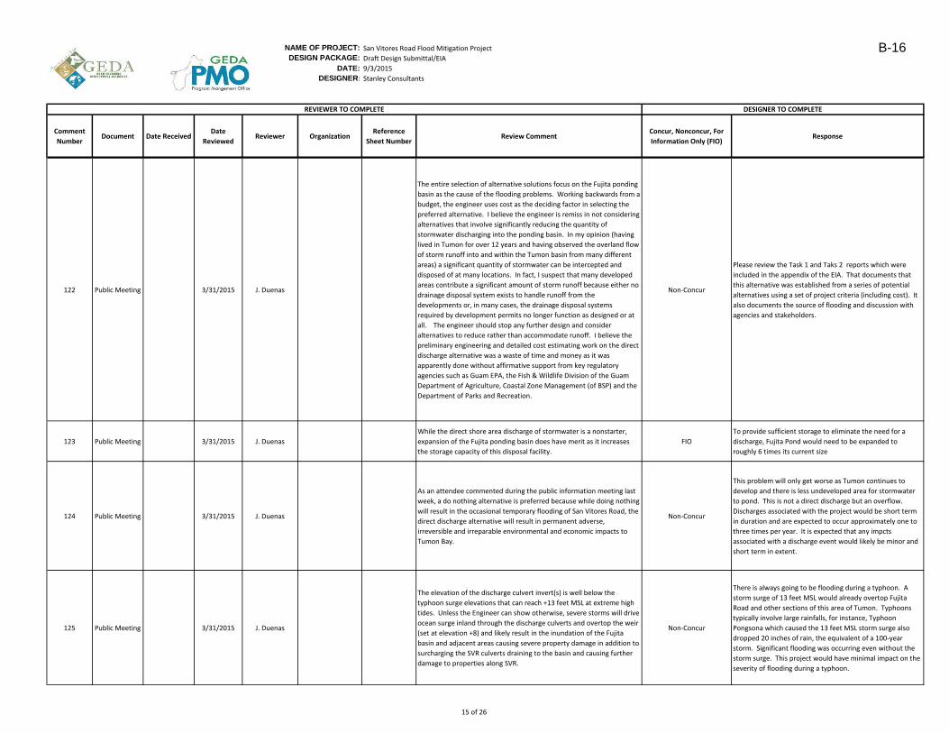
NAME OF PROJECT: San Vitores Road Flood Mitigation Project
DESIGN PACKAGE: Draft Design Submittal/EIA
DATE: 9/3/2015
DESIGNER: Stanley Consultants
Comment
NumberDocument Date Received
Date
ReviewedReviewer Organization
Reference
Sheet NumberReview Comment
Concur, Nonconcur, For
Information Only (FIO)Response
DESIGNER TO COMPLETEREVIEWER TO COMPLETE
122 Public Meeting 3/31/2015 J. Duenas
The entire selection of alternative solutions focus on the Fujita ponding
basin as the cause of the flooding problems. Working backwards from a
budget, the engineer uses cost as the deciding factor in selecting the
preferred alternative. I believe the engineer is remiss in not considering
alternatives that involve significantly reducing the quantity of
stormwater discharging into the ponding basin. In my opinion (having
lived in Tumon for over 12 years and having observed the overland flow
of storm runoff into and within the Tumon basin from many different
areas) a significant quantity of stormwater can be intercepted and
disposed of at many locations. In fact, I suspect that many developed
areas contribute a significant amount of storm runoff because either no
drainage disposal system exists to handle runoff from the
developments or, in many cases, the drainage disposal systems
required by development permits no longer function as designed or at
all. The engineer should stop any further design and consider
alternatives to reduce rather than accommodate runoff. I believe the
preliminary engineering and detailed cost estimating work on the direct
discharge alternative was a waste of time and money as it was
apparently done without affirmative support from key regulatory
agencies such as Guam EPA, the Fish & Wildlife Division of the Guam
Department of Agriculture, Coastal Zone Management (of BSP) and the
Department of Parks and Recreation.
Non-Concur
Please review the Task 1 and Taks 2 reports which were
included in the appendix of the EIA. That documents that
this alternative was established from a series of potential
alternatives using a set of project criteria (including cost). It
also documents the source of flooding and discussion with
agencies and stakeholders.
123 Public Meeting 3/31/2015 J. Duenas
While the direct shore area discharge of stormwater is a nonstarter,
expansion of the Fujita ponding basin does have merit as it increases
the storage capacity of this disposal facility.
FIO
To provide sufficient storage to eliminate the need for a
discharge, Fujita Pond would need to be expanded to
roughly 6 times its current size
124 Public Meeting 3/31/2015 J. Duenas
As an attendee commented during the public information meeting last
week, a do nothing alternative is preferred because while doing nothing
will result in the occasional temporary flooding of San Vitores Road, the
direct discharge alternative will result in permanent adverse,
irreversible and irreparable environmental and economic impacts to
Tumon Bay.
Non-Concur
This problem will only get worse as Tumon continues to
develop and there is less undeveloped area for stormwater
to pond. This is not a direct discharge but an overflow.
Discharges associated with the project would be short term
in duration and are expected to occur approximately one to
three times per year. It is expected that any impcts
associated with a discharge event would likely be minor and
short term in extent.
125 Public Meeting 3/31/2015 J. Duenas
The elevation of the discharge culvert invert(s) is well below the
typhoon surge elevations that can reach +13 feet MSL at extreme high
tides. Unless the Engineer can show otherwise, severe storms will drive
ocean surge inland through the discharge culverts and overtop the weir
(set at elevation +8) and likely result in the inundation of the Fujita
basin and adjacent areas causing severe property damage in addition to
surcharging the SVR culverts draining to the basin and causing further
damage to properties along SVR.
Non-Concur
There is always going to be flooding during a typhoon. A
storm surge of 13 feet MSL would already overtop Fujita
Road and other sections of this area of Tumon. Typhoons
typically involve large rainfalls, for instance, Typhoon
Pongsona which caused the 13 feet MSL storm surge also
dropped 20 inches of rain, the equivalent of a 100-year
storm. Significant flooding was occurring even without the
storm surge. This project would have minimal impact on the
severity of flooding during a typhoon.
15 of 26
B-16
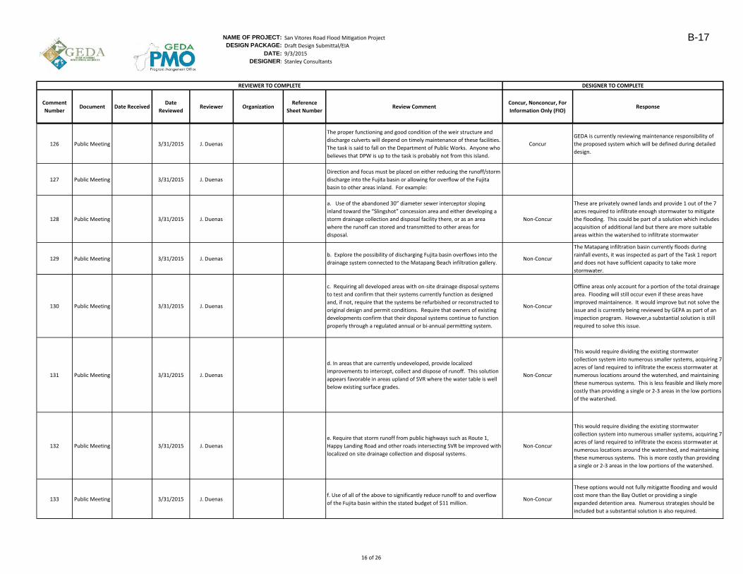
NAME OF PROJECT: San Vitores Road Flood Mitigation Project
DESIGN PACKAGE: Draft Design Submittal/EIA
DATE: 9/3/2015
DESIGNER: Stanley Consultants
Comment
NumberDocument Date Received
Date
ReviewedReviewer Organization
Reference
Sheet NumberReview Comment
Concur, Nonconcur, For
Information Only (FIO)Response
DESIGNER TO COMPLETEREVIEWER TO COMPLETE
126 Public Meeting 3/31/2015 J. Duenas
The proper functioning and good condition of the weir structure and
discharge culverts will depend on timely maintenance of these facilities.
The task is said to fall on the Department of Public Works. Anyone who
believes that DPW is up to the task is probably not from this island.
Concur
GEDA is currently reviewing maintenance responsibility of
the proposed system which will be defined during detailed
design.
127 Public Meeting 3/31/2015 J. Duenas
Direction and focus must be placed on either reducing the runoff/storm
discharge into the Fujita basin or allowing for overflow of the Fujita
basin to other areas inland. For example:
128 Public Meeting 3/31/2015 J. Duenas
a. Use of the abandoned 30” diameter sewer interceptor sloping
inland toward the “Slingshot” concession area and either developing a
storm drainage collection and disposal facility there, or as an area
where the runoff can stored and transmitted to other areas for
disposal.
Non-Concur
These are privately owned lands and provide 1 out of the 7
acres required to infiltrate enough stormwater to mitigate
the flooding. This could be part of a solution which includes
acquisition of additional land but there are more suitable
areas within the watershed to infiltrate stormwater
129 Public Meeting 3/31/2015 J. Duenasb. Explore the possibility of discharging Fujita basin overflows into the
drainage system connected to the Matapang Beach infiltration gallery.Non-Concur
The Matapang infiltration basin currently floods during
rainfall events, it was inspected as part of the Task 1 report
and does not have sufficient capacity to take more
stormwater.
130 Public Meeting 3/31/2015 J. Duenas
c. Requiring all developed areas with on-site drainage disposal systems
to test and confirm that their systems currently function as designed
and, if not, require that the systems be refurbished or reconstructed to
original design and permit conditions. Require that owners of existing
developments confirm that their disposal systems continue to function
properly through a regulated annual or bi-annual permitting system.
Non-Concur
Offline areas only account for a portion of the total drainage
area. Flooding will still occur even if these areas have
improved maintainence. It would improve but not solve the
issue and is currently being reviewed by GEPA as part of an
inspection program. However,a substantial solution is still
required to solve this issue.
131 Public Meeting 3/31/2015 J. Duenas
d. In areas that are currently undeveloped, provide localized
improvements to intercept, collect and dispose of runoff. This solution
appears favorable in areas upland of SVR where the water table is well
below existing surface grades.
Non-Concur
This would require dividing the existing stormwater
collection system into numerous smaller systems, acquiring 7
acres of land required to infiltrate the excess stormwater at
numerous locations around the watershed, and maintaining
these numerous systems. This is less feasible and likely more
costly than providing a single or 2-3 areas in the low portions
of the watershed.
132 Public Meeting 3/31/2015 J. Duenas
e. Require that storm runoff from public highways such as Route 1,
Happy Landing Road and other roads intersecting SVR be improved with
localized on site drainage collection and disposal systems.
Non-Concur
This would require dividing the existing stormwater
collection system into numerous smaller systems, acquiring 7
acres of land required to infiltrate the excess stormwater at
numerous locations around the watershed, and maintaining
these numerous systems. This is more costly than providing
a single or 2-3 areas in the low portions of the watershed.
133 Public Meeting 3/31/2015 J. Duenasf. Use of all of the above to significantly reduce runoff to and overflow
of the Fujita basin within the stated budget of $11 million.Non-Concur
These options would not fully mitigatte flooding and would
cost more than the Bay Outlet or providing a single
expanded detention area. Numerous strategies should be
included but a substantial solution is also required.
16 of 26
B-17
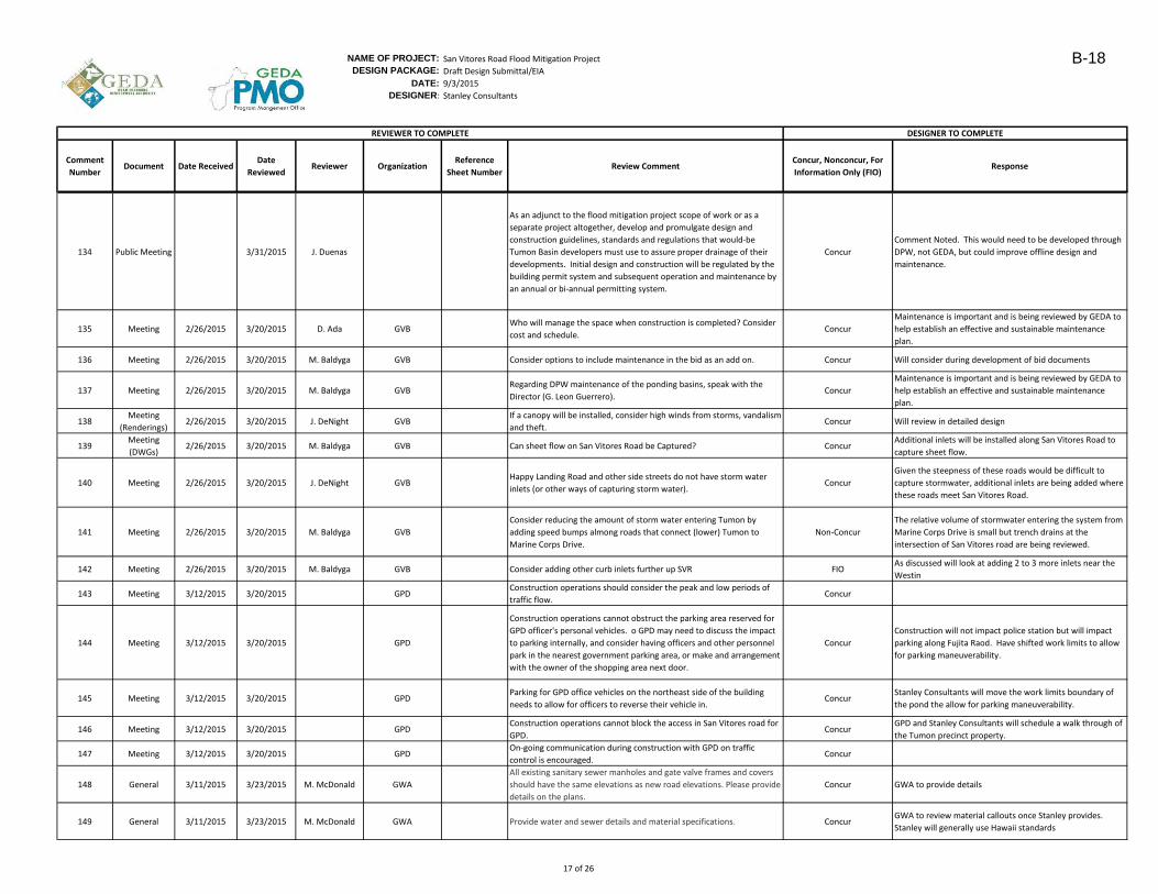
NAME OF PROJECT: San Vitores Road Flood Mitigation Project
DESIGN PACKAGE: Draft Design Submittal/EIA
DATE: 9/3/2015
DESIGNER: Stanley Consultants
Comment
NumberDocument Date Received
Date
ReviewedReviewer Organization
Reference
Sheet NumberReview Comment
Concur, Nonconcur, For
Information Only (FIO)Response
DESIGNER TO COMPLETEREVIEWER TO COMPLETE
134 Public Meeting 3/31/2015 J. Duenas
As an adjunct to the flood mitigation project scope of work or as a
separate project altogether, develop and promulgate design and
construction guidelines, standards and regulations that would-be
Tumon Basin developers must use to assure proper drainage of their
developments. Initial design and construction will be regulated by the
building permit system and subsequent operation and maintenance by
an annual or bi-annual permitting system.
Concur
Comment Noted. This would need to be developed through
DPW, not GEDA, but could improve offline design and
maintenance.
135 Meeting 2/26/2015 3/20/2015 D. Ada GVBWho will manage the space when construction is completed? Consider
cost and schedule.Concur
Maintenance is important and is being reviewed by GEDA to
help establish an effective and sustainable maintenance
plan.
136 Meeting 2/26/2015 3/20/2015 M. Baldyga GVB Consider options to include maintenance in the bid as an add on. Concur Will consider during development of bid documents
137 Meeting 2/26/2015 3/20/2015 M. Baldyga GVBRegarding DPW maintenance of the ponding basins, speak with the
Director (G. Leon Guerrero).Concur
Maintenance is important and is being reviewed by GEDA to
help establish an effective and sustainable maintenance
plan.
138Meeting
(Renderings)2/26/2015 3/20/2015 J. DeNight GVB
If a canopy will be installed, consider high winds from storms, vandalism
and theft.Concur Will review in detailed design
139Meeting
(DWGs)2/26/2015 3/20/2015 M. Baldyga GVB Can sheet flow on San Vitores Road be Captured? Concur
Additional inlets will be installed along San Vitores Road to
capture sheet flow.
140 Meeting 2/26/2015 3/20/2015 J. DeNight GVBHappy Landing Road and other side streets do not have storm water
inlets (or other ways of capturing storm water).Concur
Given the steepness of these roads would be difficult to
capture stormwater, additional inlets are being added where
these roads meet San Vitores Road.
141 Meeting 2/26/2015 3/20/2015 M. Baldyga GVB
Consider reducing the amount of storm water entering Tumon by
adding speed bumps almong roads that connect (lower) Tumon to
Marine Corps Drive.
Non-Concur
The relative volume of stormwater entering the system from
Marine Corps Drive is small but trench drains at the
intersection of San Vitores road are being reviewed.
142 Meeting 2/26/2015 3/20/2015 M. Baldyga GVB Consider adding other curb inlets further up SVR FIOAs discussed will look at adding 2 to 3 more inlets near the
Westin
143 Meeting 3/12/2015 3/20/2015 GPDConstruction operations should consider the peak and low periods of
traffic flow.Concur
144 Meeting 3/12/2015 3/20/2015 GPD
Construction operations cannot obstruct the parking area reserved for
GPD officer's personal vehicles. o GPD may need to discuss the impact
to parking internally, and consider having officers and other personnel
park in the nearest government parking area, or make and arrangement
with the owner of the shopping area next door.
Concur
Construction will not impact police station but will impact
parking along Fujita Raod. Have shifted work limits to allow
for parking maneuverability.
145 Meeting 3/12/2015 3/20/2015 GPDParking for GPD office vehicles on the northeast side of the building
needs to allow for officers to reverse their vehicle in. Concur
Stanley Consultants will move the work limits boundary of
the pond the allow for parking maneuverability.
146 Meeting 3/12/2015 3/20/2015 GPDConstruction operations cannot block the access in San Vitores road for
GPD.Concur
GPD and Stanley Consultants will schedule a walk through of
the Tumon precinct property.
147 Meeting 3/12/2015 3/20/2015 GPDOn-going communication during construction with GPD on traffic
control is encouraged.Concur
148 General 3/11/2015 3/23/2015 M. McDonald GWA
All existing sanitary sewer manholes and gate valve frames and covers
should have the same elevations as new road elevations. Please provide
details on the plans.
Concur GWA to provide details
149 General 3/11/2015 3/23/2015 M. McDonald GWA Provide water and sewer details and material specifications. ConcurGWA to review material callouts once Stanley provides.
Stanley will generally use Hawaii standards
17 of 26
B-18
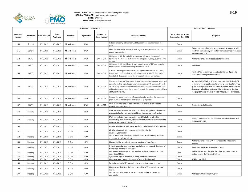
NAME OF PROJECT: San Vitores Road Flood Mitigation Project
DESIGN PACKAGE: Draft Design Submittal/EIA
DATE: 9/3/2015
DESIGNER: Stanley Consultants
Comment
NumberDocument Date Received
Date
ReviewedReviewer Organization
Reference
Sheet NumberReview Comment
Concur, Nonconcur, For
Information Only (FIO)Response
DESIGNER TO COMPLETEREVIEWER TO COMPLETE
150 General 3/11/2015 3/23/2015 M. McDonald GWAIndicate property lot numbers/utility easement boundaries on the
plans.Concur
151 General 3/11/2015 3/23/2015 M. McDonald GWADescribe how utility service to existing structures will be maintained
during construction. Concur
Contractor is required to provide temporary service or will
construct new sanitary and water, transfer service over, then
remove old service.
152 DWG 3/11/2015 3/23/2015 M. McDonald GWA C08 to C10At Station 1+80, the end of the proposed 12"water line should
terminate in a manner that allows for adequate flushing, such as a fire
hydrant.
Concur Will review and provide adequate termination
153 DWG 3/11/2015 3/23/2015 M. McDonald GWA C08 to C10 At Station 2+20, provide an 8" gate valve instead of 12"gate valve for
the water line connection along Chamorrita Drive.Concur Will revise
154 DWG 3/11/2015 3/23/2015 M. McDonald GWA C08 to C10A private developer is responsible for a project to retrofit the Fujita
Pump Station influent line from Station 11+00 to 13+00. This project
has stalled. Discussion about the project's timing is warranted.
ConcurStanley/GWA to continue coordination to see if projects
have similar timing of construction
155 DWG 3/11/2015 3/23/2015 M. McDonald GWA C08 to C10
The plans shows a 6' horizontal distance separation between water and
sewer lines. The typical separation distances are 1O' horizontally and
18"vertically. Confirm the minimum horizontal distance between the
utility pipes throughout the proiect 's extent. Considerations to address
utility conflicts may
FIO
Discussed with GWA at 3/24 and resolved that design is OK
as shown. The 6 foot horizontal is being used due to limited
space within project area, but there is several feet of vertical
clearance. All utility crossings will be reviewed as detailed
design progresses. Details of crossings provided as needed.
156 DWG 3/11/2015 3/23/2015 M. McDonald GWA C08 to C10Provide the length and type of materials to be used on the plans and
profiles. Also, identify pipes and "new"or "proposed".Concur
157 DWG 3/11/2015 3/23/2015 M. McDonald GWA C21 to C27GWA utility lines should be field verified in construction areas to
identify potential conflicts.Concur Contractor to field verify
158 Meeting 3/11/2015 3/23/2015 GWAGWA requested Contractor submit a utility staging plan to show their
proposed plan for maintaining utility services during construction.Concur
159 Meeting 3/11/2015 3/23/2015 GWA
GWA requested notes on drawings for GWA to be involved in
coordinating any water and/or sanitary utility conflicts encountered by
the contractor during construction.
ConcurStanley Consultants to continue coordination with GWA as design progresses.
160 3/11/2015 3/23/2015 E. Cruz GPA Provide a relocation plan for GPA utilities you are Intending to remove Concur
161 3/11/2015 3/23/2015 E. Cruz GPAAll relocation work shall be done and paid for by the
developer/contractor.Concur
162 Meeting 3/11/2015 3/23/2015 E. Cruz GPAGPA is flexible with location of mainline but wants to keep mainline
separated from branch linesConcur
163 Meeting 3/11/2015 3/23/2015 E. Cruz GPA GPA would like to maintain current location of transformers ConcurWill review and notify GPA of any potenital relocations
required
164 Meeting 3/11/2015 3/23/2015 E. Cruz GPAIf line is located within roadway, manholes area required, if outside of
traffic area, handholes allowable.Concur Will adjust proposed access per location
165 Meeting 3/11/2015 3/23/2015 E. Cruz GPAGPA suggests constructing new line first, transferring service, then
removing old line.FIO
Will be contractor's decision, but they will be required to
sustain service during construction
166 Meeting 3/11/2015 3/23/2015 E. Cruz GPA Typical line is (2) 6” conduits, 3’ deep, encased in concrete Concur
167 Meeting 3/11/2015 3/23/2015 E. Cruz GPA GPA to provide construction details/standards, via email Concur GPA has provided
168 Meeting 3/11/2015 3/23/2015 E. Cruz GPA Typically maintain 12” separation between electric and telecom Concur
169 Meeting 3/11/2015 3/23/2015 E. Cruz GPAGPA advised that streetlights are owned by DPW, maintain existing
meter.Concur
170 Meeting 3/11/2015 3/23/2015 E. Cruz GPAGPA should be included in inspections and review of contractor
submittalsConcur Will keep GPA informed/involved
18 of 26
B-19
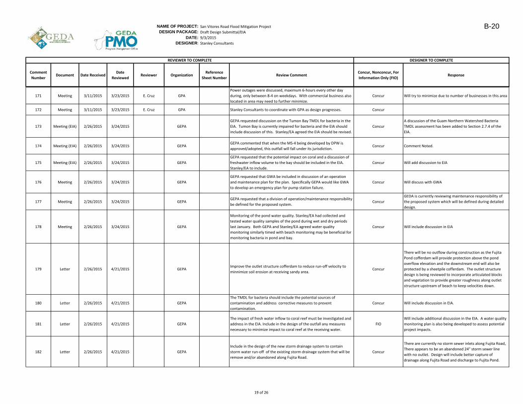
NAME OF PROJECT: San Vitores Road Flood Mitigation Project
DESIGN PACKAGE: Draft Design Submittal/EIA
DATE: 9/3/2015
DESIGNER: Stanley Consultants
Comment
NumberDocument Date Received
Date
ReviewedReviewer Organization
Reference
Sheet NumberReview Comment
Concur, Nonconcur, For
Information Only (FIO)Response
DESIGNER TO COMPLETEREVIEWER TO COMPLETE
171 Meeting 3/11/2015 3/23/2015 E. Cruz GPA
Power outages were discussed, maximum 6-hours every other day
during, only between 8-4 on weekdays. With commercial business also
located in area may need to further minimize.
Concur Will try to minimize due to number of businesses in this area
172 Meeting 3/11/2015 3/23/2015 E. Cruz GPA Stanley Consultants to coordinate with GPA as design progresses. Concur
173 Meeting (EIA) 2/26/2015 3/24/2015 GEPA
GEPA requested discussion on the Tumon Bay TMDL for bacteria in the
EIA. Tumon Bay is currently impaired for bacteria and the EIA should
include discussion of this. Stanley/EA agreed the EIA should be revised.
Concur
A discussion of the Guam Northern Watershed Bacteria
TMDL assessment has been added to Section 2.7.4 of the
EIA.
174 Meeting (EIA) 2/26/2015 3/24/2015 GEPAGEPA commented that when the MS-4 being developed by DPW is
approved/adopted, this outfall will fall under its jurisdiction.Concur Comment Noted.
175 Meeting (EIA) 2/26/2015 3/24/2015 GEPA
GEPA requested that the potential impact on coral and a discussion of
freshwater inflow volume to the bay should be included in the EIA.
Stanley/EA to include.
Concur Will add discussion to EIA
176 Meeting 2/26/2015 3/24/2015 GEPA
GEPA requested that GWA be included in discussion of an operation
and maintenance plan for the plan. Specifically GEPA would like GWA
to develop an emergency plan for pump station failure.
Concur Will discuss with GWA
177 Meeting 2/26/2015 3/24/2015 GEPAGEPA requested that a division of operation/maintenance responsibility
be defined for the proposed system. Concur
GEDA is currently reviewing maintenance responsibility of
the proposed system which will be defined during detailed
design.
178 Meeting 2/26/2015 3/24/2015 GEPA
Monitoring of the pond water quality. Stanley/EA had collected and
tested water quality samples of the pond during wet and dry periods
last January. Both GEPA and Stanley/EA agreed water quality
monitoring similarly timed with beach monitoring may be beneficial for
monitoring bacteria in pond and bay.
Concur Will include discussion in EIA
179 Letter 2/26/2015 4/21/2015 GEPAImprove the outlet structure cofferdam to reduce run-off velocity to
minnimize soil erosion at receiving sandy area.Concur
There will be no outflow during construction as the Fujita
Pond cofferdam will provide protection above the pond
overflow elevation and the downstream end will also be
protected by a sheetpile cofferdam. The outlet structure
design is being reviewed to incorporate articulated blocks
and vegetation to provide greater roughness along outlet
structure upstream of beach to keep velocities down.
180 Letter 2/26/2015 4/21/2015 GEPA
The TMDL for bacteria should include the potential sources of
contamination and address corrective measures to prevent
contamination.
Concur Will include discussion in EIA.
181 Letter 2/26/2015 4/21/2015 GEPA
The impact of fresh water inflow to coral reef must be investigated and
address in the EIA. Include in the design of the outfall any measures
necessary to minimize impact to coral reef at the receiving water.
FIO
Will include additional discussion in the EIA. A water quality
monitoring plan is also being developed to assess potential
project impacts.
182 Letter 2/26/2015 4/21/2015 GEPA
Include in the design of the new storm drainage system to contain
storm water run-off of the existing storm drainage system that will be
remove and/or abandoned along Fujita Road.
Concur
There are currently no storm sewer inlets along Fujita Road,
There appears to be an abandoned 24" storm sewer line
with no outlet. Design will include better capture of
drainage along Fujita Road and discharge to Fujita Pond.
19 of 26
B-20

NAME OF PROJECT: San Vitores Road Flood Mitigation Project
DESIGN PACKAGE: Draft Design Submittal/EIA
DATE: 9/3/2015
DESIGNER: Stanley Consultants
Comment
NumberDocument Date Received
Date
ReviewedReviewer Organization
Reference
Sheet NumberReview Comment
Concur, Nonconcur, For
Information Only (FIO)Response
DESIGNER TO COMPLETEREVIEWER TO COMPLETE
183 Letter 2/26/2015 4/21/2015 GEPA
All existing sewer laterals that are affected by removal of sewer lines
along Fujita road must be verified to insure laterals are within invert
elevation of the new sewer line.
Concur
Have approximate locations of laterals noted on drawings
which will be connected following replacement of sanitary
sewer line. New sanitary sewer line will be installed at same
profile as existing and the culvert for most of Fujita Road is
above this line. This is being coordinated with GWA
184 Letter 2/26/2015 4/21/2015 GEPAAll existing water service lines and meters that are affected by the
removal of waterlines along Fujita road must be verified.Concur This is being coordinated with GWA
185 Letter 2/26/2015 4/21/2015 GEPA
All existing water lines, sewer lines and appurtenances to be
remove/abandoned must be identified to insure that proper removal is
applied. If Asbestos Pipes are encountered, an abetment plan must be
submitted to Guam EPA for approval prior to removal. This requirement
must be incorporated in the technical specification.
Concur Will incorporate in technical specifications
186 Letter 2/26/2015 4/21/2015 GEPA
A certified Wastewater Collection Level II operator is required to
surpervise the removal of the existing pipes and during the tapping of
the existing to the new sewer lines.
Concur Will require in project docments
187 Letter 2/26/2015 4/21/2015 GEPA
A certified Water Distribution Level II operator is required to
supervised the disinfection and swabbing during the tapping of the new
water system and appurtenances to the existing water main.
Concur Will require in project docments
188 Letter 2/26/2015 4/21/2015 GEPA
Include in your specs the requirements of disinfection method and
procedure for the new water lines and method of cleaning and removal
of the existing sewer and water lines
Concur Will coordinate with GWA and require in project documents.
189 Letter 2/26/2015 4/21/2015 GEPASubmit the Basis of Design and Hydraulic Calculation for review and
comment.Concur
Task 1 report , section 2, which is included as an appendix to
the EIA provides basis of design and Section 4 provides a
summary of hydraulic calculations for computing capacity of
system and inlets. Will include computations in permit
submittal
190 Letter 2/26/2015 4/21/2015 GEPA Submit the Hydraulic Design Criteria. Concur
Task 1 report , section 2, which is included as an appendix to
the EIA provides basis of design and Section 4 provides a
summary of hydraulic calculations for computing capacity of
system and inlets. Will include computations in permit
submittal
191 Letter 2/26/2015 4/21/2015 GEPA
Submit copy of water quality analysis taken a t the existing Fujita Pond.
Historical data of the water quality of the pond must be use for
reference when evaluating the water quality.
ConcurThis is included in the Task 1 report, but additional
discussion will be brought into the EIA.
192 Letter 2/26/2015 4/21/2015 GEPASubmit a technical specification during the design phase for review by
this Agency.Concur Will submit
20 of 26
B-21
NAME OF PROJECT: San Vitores Road Flood Mitigation Project
DESIGN PACKAGE: Draft Design Submittal/EIA
DATE: 9/3/2015
DESIGNER: Stanley Consultants
Comment
NumberDocument Date Received
Date
ReviewedReviewer Organization
Reference
Sheet NumberReview Comment
Concur, Nonconcur, For
Information Only (FIO)Response
DESIGNER TO COMPLETEREVIEWER TO COMPLETE
193 Letter 2/26/2015 4/22/2015 NOAA
Freshwater input alone from the proposed outfall could have significant
impacts on corals, resulting in bleaching or mortality from reduced
salinity, particularly if the discharge occurs during low tide.
Non-Concur
This system would overflow following rainfall events greater
than roughly 3 inches. Under the existing condition
freshwater is already entering the bay, a large freshwater
input via rainfall, groundwater seepage, and
untreated/uncontrolled stormwater near Outrigger,
Matapang Park and other locations. Discharges associated
with this project would be short term in duration and are
expected to occur approximately one to three times per
year. It is expected that any shifts in habitat use associated
with a discharge event would likely be minor and short term
in extent.
194 Letter 2/26/2015 4/22/2015 NOAA
Freshwater and pollutants associated with stormwater may also
decrease these species' growth rates, reproduction, and resistance to
disease and bleaching. This in tum can cause shifts in coral cover and
community structure
Non-Concur
This system would overflow following rainfall events greater
than roughly 3 inches. Under the existing condition
freshwater is already entering the bay, a large freshwater
input via rainfall, groundwater seepage, and
untreated/uncontrolled stormwater near Outrigger,
Matapang Park and other locations. Discharges associated
with this project would be short term in duration and are
expected to occur approximately one to three times per
year. It is expected that any shifts in habitat use associated
with a discharge event would likely be minor and short term
in extent.
195 Letter 2/26/2015 4/22/2015 NOAA
The nutrients, bacteria, sediment, and other pollutants contained in
stormwater will have additional impacts on the coral reef ecosystem,
exacerbating algal blooms and coral disease outbreaks, as well as
impacting the health of human users of the bay. The "pre-treatment"
provided by the settling pond will not reduce EC levels, pollutants,
nutrients, or fine sediment in the stormwater.
FIO
This project is an overflow, the initial inflow with the
greatest concentrations will have time to settle, but
settlement times will be reduced as the pond fills up to its
overflow elevation. The project will include a water quality
monitoring program to assess potential impacts.
196 Letter 2/26/2015 4/22/2015 NOAAThe impacts from a point discharge of stormwater into the bay will
threaten these important economic benefits provided by the Bay.FIO
Flooding is also impacting economics. This project is an
overflow, so discharge is infrequent and of short duration. A
water quality monitoring plan is being included in this
project to assess potential impacts.
21 of 26
B-22

NAME OF PROJECT: San Vitores Road Flood Mitigation Project
DESIGN PACKAGE: Draft Design Submittal/EIA
DATE: 9/3/2015
DESIGNER: Stanley Consultants
Comment
NumberDocument Date Received
Date
ReviewedReviewer Organization
Reference
Sheet NumberReview Comment
Concur, Nonconcur, For
Information Only (FIO)Response
DESIGNER TO COMPLETEREVIEWER TO COMPLETE
197 Letter 2/26/2015 4/22/2015 NOAA
The project will cause erosion on the beach between the outfall
structure and the water. The level of erosion may be significant, and
according to Stanley Consuhants staff, will require repair after each
major overflow event. The DEIA does not identify the extent of this
beach erosion or how it will be repaired. This would likely require heavy
equipment on the beach, and possibly movement of sand in both the
nearshore and intertidal areas. This would likely lead to additional
impacts on EFH in Tumon Bay
Non-Concur
Scour potential is discussed on page 3-5 of the Task 2 report
included as an appendix to the EIA. Less than 18 inches for
most storm events that cause overflow. Up to 2-3 feet for
storms exceeding the 10-year storm (i.e. 10 inches).
Repairing the beach for most overflow events would not
require heavy equipment, a small crew with rakes could
repair. Sand will fall out within 20-30 feet of shore as seen
near the outrigger, so the potential impact area from erosion
is relatively small. Maintenance will be required only a few
times per year, following heavy rainfall events.
22 of 26
B-23
NAME OF PROJECT: San Vitores Road Flood Mitigation Project
DESIGN PACKAGE: Draft Design Submittal/EIA
DATE: 9/3/2015
DESIGNER: Stanley Consultants
Comment
NumberDocument Date Received
Date
ReviewedReviewer Organization
Reference
Sheet NumberReview Comment
Concur, Nonconcur, For
Information Only (FIO)Response
DESIGNER TO COMPLETEREVIEWER TO COMPLETE
198 Letter 2/26/2015 4/22/2015 NOAA
The cumulative impacts analysis in the DEIA does not fully evaluate the
potential impacts of private construction such as the Dusit Thani hotel
and other potential projects within the catchment. It also fails to assess
the potential impacts of projected increases in rainfall associated with
global climate change that could exacerbate the impacts of the
proposed outfall, and the projected increases in sea level that may
impact the outfall's ability to function as designed. Further, the analysis
did not consider the impacts of ocean acidification, including recent
research that found corals exposed to high nutrients and acidic
conditions experience significantly higher rates of macrobioerosion
Non-Concur
This project is an overflow. Discharge events are infrequent,
short duration, and accompany larger rainfall events. It's
outflow is at elevation 4 feet, 1.8 feet above the Mean
Higher High Water. The system has capacity to discharge a
10-year storm with a tide level above 5 feet so 3 feet higher
than the Mean Higher High Water. The system has sufficient
capacity to accomodate increases in sea level. It also will
function and provide reduction in flooding for increased
rainfall. Private construction areas are required to infiltrate
their own stormwater so have runoff rates similar to
undeveloped area. Within the scientific community, climate
change is a well-established trend. However, at this point
predicting the specific magnitude of impacts, such as
changes to precipitation, sea temperature, etc. cannot be
done with accuracy. The range and timing of potential
climate change and development scenarios is too wide to
provide quantitative discussion in the EIA. Impacts are
discussed relative to the current condition which is a known
scenario.
199 Letter 2/26/2015 4/22/2015 NOAA
Discharge of stormwater into Tumon Bay Marine Preserve should be
avoided to the fullest extent practicable. GEDA should re-evaluate
other options to include, but not limited to:
FIO
The project was discussed at GovGuam agency meetings in
July/August 2015. The decision was made to proceed with
the project but include a water quality monitoring plan to
assess impacts and some additional enhancements to
improve water quality.
200 Letter 2/26/2015 4/22/2015 NOAA
a. Seek additional funding to expand the Fujita Pond to a sufficient
size to handle the stormwater. Initial report from Stanley Consultants
suggested that this was a practical alternative, but slightly outside of
the allotted budget.
FIOThis was the preferred option but was $19M relative to the
$11.5M allotted for the project.
201 Letter 2/26/2015 4/22/2015 NOAA
b. Fund Low Impact Design retrofits to existing developments
throughout the Fujita Pond catchment area to reduce the amount of
stormwater reaching the Fujita Pond. This could include installing rain
gardens, water catchment systems for irrigation, small infiltration
chambers or settling ponds on private properties.
Concur
This will help, but not solve the flooding issue. Solving
flooding requires a substantial solution. GEDA is reviewing
potential smaller strategies, but there will still need to be an
outlet or large infiltration area to handle the large volume of
stormwater. .Rain gardens are very effective at improving
water quality and reducing runoff for normal rain events but
not for handling extreme rain events. For example, over 28
acres of rain gardens (38 miles of roadway median) would be
required to infiltrate 10 inches of rain in the project area.
Any infiltration helps though, so these could be part of a
solution and are being reviewed for inclusion in project
construction.
23 of 26
B-24
NAME OF PROJECT: San Vitores Road Flood Mitigation Project
DESIGN PACKAGE: Draft Design Submittal/EIA
DATE: 9/3/2015
DESIGNER: Stanley Consultants
Comment
NumberDocument Date Received
Date
ReviewedReviewer Organization
Reference
Sheet NumberReview Comment
Concur, Nonconcur, For
Information Only (FIO)Response
DESIGNER TO COMPLETEREVIEWER TO COMPLETE
202 Letter 2/26/2015 4/22/2015 NOAAc. Provide assistance to landowners with existing stormwater
systems that are not being properly maintained.Concur
This will help, but not solve the flooding issue. Solving
flooding requires a substantial solution. GEDA is reviewing
potential smaller strategies, but there will still need to be an
outlet or large infiltration area to handle the large volume of
stormwater. Stanley Consultants analyzed the impact if
every developed property had “perfect capture” of all rainfall
“Perfect capture” would reduce the discharge rate during an
overflow event by roughly 30% but there is still enough
stormwater volume to cause flooding for even 4 inches of
rain. Keeping more water onsite will only help the flooding
issue so improved maintenance should be part of a solution
and a monitoring/inpsection program is being discussed with
GEPA.
203 Letter 2/26/2015 4/22/2015 NOAA
GEDA should analyze the long term maintenance requirements for this
project and potential environmental impacts associated with
maintenance. At a minimum , GEDA should develop a maintenance
plan that outlines the maintenance required including the cost of
maintenance and the permits necessary to repair damage to the beach
in the intertidal zone. Please note that these activities are likely to
trigger a number of local and federal environmental permits as they will
take place within the intertidal zone and the boundary of the Marine
Preserve. The plan should clearly identify the agency or organization
responsible for maintenance of the system and ensure that there is
sufficient funding to maintain it over its expected lifespan.
Concur
GEDA is currently reviewing maintenance responsibility of
the proposed system which will be defined during detailed
design, prior to final permitting.
204 Letter 2/26/2015 4/22/2015 NOAA
If the preferred alternative is implemented, include additional features
in the final design to slow the velocity of water exiting the culverts onto
the beach to avoid and minimize beach erosion. The planters may serve
to increase velocity by channelizing the flow rather than slowing it.
Vegetation such as beach morning glory (Ipomoea) or other plants, may
provide a buffer between the outflow and the bay
Concur
The proposed planters help spread flow, which reduces
depth, but do not necessarily slow velocity. Incorporation of
vegetated groundcover without planters is being reviewed
for the outlet design to provide greater roughness and
reduction in velocity.
205 Letter 2/26/2015 4/22/2015 NOAA
If GEDA moves forward with the preferred alternative, GEDA should
ensure that the contractors implement measures to avoid potential
impacts associated with construction activities:
Concur
A SWPPP will be defined for the project during detailed
design. As shown in the draft drawings, the plan to minimize
erosion/sedimentation is to construct sheetpile cofferdams
at the upstream and downstream end which will isolate the
major construction area from Fujita Pond and the Bay. The
Contractor will be required to pump all stormwater back into
Fujita Pond, so no construction stormwater will enter marine
waters. The top of cofferdam will be set above the overflow
elevation of Fujita Pond.
24 of 26
B-25

NAME OF PROJECT: San Vitores Road Flood Mitigation Project
DESIGN PACKAGE: Draft Design Submittal/EIA
DATE: 9/3/2015
DESIGNER: Stanley Consultants
Comment
NumberDocument Date Received
Date
ReviewedReviewer Organization
Reference
Sheet NumberReview Comment
Concur, Nonconcur, For
Information Only (FIO)Response
DESIGNER TO COMPLETEREVIEWER TO COMPLETE
206 Letter 2/26/2015 4/22/2015 NOAA
a. Implement appropriate sediment control BMPs during shoreside
work to ensure that sedimentation is avoided and the debris are not
allowed to fall in the water. Water displaced by the construction of the
outflow should not be directly discharged into marine waters.
Concur
A SWPPP will be defined for the project during detailed
design. As shown in the draft drawings, the plan to minimize
erosion/sedimentation is to construct sheetpile cofferdams
at the upstream and downstream end which will isolate the
major construction area from Fujita Pond and the Bay. The
Contractor will be required to pump all stormwater back into
Fujita Pond, so no construction stormwater will enter marine
waters. The top of cofferdam will be set above the overflow
elevation of Fujita Pond.
207 Letter 2/26/2015 4/22/2015 NOAA
b. Cease any activities that may result in sediment/pollutant
discharges during the primary hard coral spawning events each year.
The applicant may contact NMFS PIRO HCD Guam Field Office for more
information including spawning dates.
Non-Concur
With adequate erosion control measures which will be
required as part of construction, construction can occur
without discharging sediments into the Bay.
208 Letter 2/26/2015 4/22/2015 NOAA
c. Develop and implement a stormwater management plan to avoid
all freshwater discharges and potential sediment and pollutant
transport into the warers of the Tumon Bay during construction.
Concur
A SWPPP will be defined for the project during detailed
design. As shown in the draft drawings, the plan to minimize
erosion/sedimentation is to construct sheetpile cofferdams
at the upstream and downstream end which will isolate the
major construction area from Fujita Pond and the Bay. The
Contractor will be required to pump all stormwater back into
Fujita Pond, so no construction stormwater will enter marine
waters. The top of cofferdam will be set above the overflow
elevation of Fujita Pond.
209 Letter 2/26/2015 4/22/2015 NOAA
Due lo the unavoidable impacts to EFH associated with the construction
and implementation phases of this project, GEDA should fund projects
to mitigate the loss of this ecological function. Should GEDA decide to
pursue the preferred alternative described in the DEIA, NMFS can
provide guidance on assessing impacts and scaling potential mitigation
options to offset this loss.
FIO
This project is an overflow. Discharges associated with the
project would be short term in duration and are expected to
occur approximately one to three times per year. It is
expected that any shifts in habitat use associated with a
discharge event would likely be minor and short term in
extent. GEDA will keep NOAA in the discussion as the project
moves forward.
210 Letter 2/26/2015 4/22/2015 NOAA
NMFS determines that adverse affect to EFH will occur as a result of this
project. We strongly encourage GEDA to consider other options to
address the stormwater impacts discussed in the DEIA. We have offered
conservation recommendations that may minimize the effects of the
proposed project, but they will not preven t impacts to EFH and other
marine resources. The information provided in the DEIA suggests that
there will be significant impacts to marine resources, particularly EFH,
associated with this action as currently described .
FIO
Additional options has been reviewed and it has been
determined that this is the most feasible option. A
substantial solution is required to solve this problem. This
project is an overflow. Discharges associated with the
project would be short term in duration and are expected to
occur approximately one to three times per year. It is
expected that any shifts in habitat use associated with a
discharge event would likely be minor and short term in
extent. GEDA will keep NOAA in the discussion as the project
moves forward.
211 Letter 2/26/2015 6/9/2015 USFWSA qualified biologist should survey the project site daily, prior to
conducting work to determine if ESA listed species are in the area.FIO
Steps to manage ESA will be developed during detailed
design to avoid or minimize impacts leading up to and during
construction. Will coordinate with USFWS and DAWR.
25 of 26
B-26
NAME OF PROJECT: San Vitores Road Flood Mitigation Project
DESIGN PACKAGE: Draft Design Submittal/EIA
DATE: 9/3/2015
DESIGNER: Stanley Consultants
Comment
NumberDocument Date Received
Date
ReviewedReviewer Organization
Reference
Sheet NumberReview Comment
Concur, Nonconcur, For
Information Only (FIO)Response
DESIGNER TO COMPLETEREVIEWER TO COMPLETE
212 Letter 2/26/2015 6/9/2015 USFWS
Work should be postponed or halted if ESA-listed species are observed
within the project area and will only resume after the animal has
voluntarily departed the area.
Concur
Steps to manage ESA will be developed during detailed
design to avoid or minimize impacts leading up to and during
construction. Will coordinate with USFWS and DAWR.
213 Letter 2/26/2015 6/9/2015 USFWS
All on-site personnel should receive instruction regarding ESA-listed
species and what to do when listed species are present within the
project area.
Concur
Steps to manage ESA will be developed during detailed
design to avoid or minimize impacts leading up to and during
construction. Will coordinate with USFWS and DAWR. This
will include communication with contractor.
214 Letter 2/26/2015 6/9/2015 USFWS
A litter control program should be implemented at the project site. All
equipment, materials, debris, and vegetation clippings should be
removed upon completion of work.
ConcurA SWPPP is being developed for this project which includes
steps for debris/trash management and disposal.
215 Letter 2/26/2015 6/9/2015 USFWS
Margins of the ponding basin should be regularly maintained by
removing vegetation when morrhens are not present to prevent
recolonization of the area by moorhens
Concur
DPW maintains on a periodic basis, more frequent mowing is
being considered leading up to construction, after site is
reviewed for moorhens, to discourage recolonization.
216 Letter 2/26/2015 6/9/2015 USFWS
Margins of the ponding basin should be regularly maintained by
removing vegetation when morrhens are not present to prevent
recolonization of the area by moorhens
Concur
GEDA is currently reviewing maintenance responsibility of
the proposed system which will be defined during detailed
design. More frequent maintenance of vegetation would be
beneficial and will be considered.
217 Letter 2/26/2015 6/9/2015 USFWS
The Service recommneds ensuring migratory birds are not within the
project area during consturction and maintenance and that measures
are taken to avoid any impacts to migratory birds, especially if nesting is
detected.
ConcurAs stated in the EIA, actions will be taken to avoid adverse
effects to the nest in compliance with the MBTA.
218 Letter 2/26/2015 6/9/2015 USFWSThe Service recommends investigating alternatives that would minimize
impacts to the protected marine communities in Tumon BayFIO
GEDA is planning to discuss with GEPA/NOAA and other
regulatory agencies
219 Letter 2/26/2015 6/9/2015 USFWSThe Service recommends consulting with DAWR and GEPA on the
project's potential impacts to the marine communityFIO
GEDA is planning to discuss with GEPA/NOAA and other
regulatory agencies
26 of 26
B-27

SAN VITORES ROAD FLOOD MITIGATION PROJECT
REGULATORY AGENCY MEETING NOTES
Summary of meetings conducted by Stanley Consultants Inc. and EA Engineering, Science
and Technology, Inc. (EA) with Regulatory Agencies during the week of 10 November 2014
for the Guam Economic Development Authority (GEDA) San Vitores Road Flood
Mitigation Project.
Purpose: Discuss project and upcoming regulatory process for permitting of San Vitores
Road flood mitigation project.
Notes by
ShannonCauley EA Engineering, Inc. [email protected] 671-646-5231 Ext 509
Andrew Judd Stanley Consultants, Inc. [email protected] 952-738-4378
Aja Reyes Stanley Consultants, Inc. [email protected] 671-646-3466
Monday 11/10/14 at 9:00 am
Meeting with the State Historic Preservation Office (SHPO) at the Department of Parks and Recreation in Agana Heights.
Agency Role in the Project:
Compliance with the National Historic Preservation Act and Guam historic preservation requirements associated with the project.
Meeting Attendees:
Richard Olmo (Guam Archaeologist), Alfred Masga (Guam Archaeological Technician II), Andrew Judd (Stanley Consultants, Inc.), Craig Johnson (Stanley Consultants, Inc.), Aja Reyes (Stanley Consultants, Inc.) and Shannon Cauley (EA Engineering Science and Technology, Inc. [EA])
Summary:
A. Judd provided a summary of the project and considered alternatives.
R. Olmo concurred that the two channel alternatives would have a much greater potential for discovery or impacts to cultural resources.
R. Olmo requested to see a Monitoring Plan for the proposed disturbance activities. His main concern for the Fujita Road alignment is the expansion of the existing pond and potential excavation of any areas that have not been previously disturbed. He wants testing to be done on the east side of the pond where the expansion would occur to determine if the area has been previously disturbed. A. Judd said that there are buried stormwater vaults where the expansion would occur. R. Olmo said he would like to see testing done in areas adjacent to the vaults that would need to be disturbed to access the vaults for removal.
R. Olmo wants archaeological monitoring to occur during the drilling of the Geotech borings. A. Judd said this will occur. R. Olmo said the boring should be monitored until undisturbed ground is reached in
B-28
2
SVR Flood Mitigation Project Regulatory Agency Meeting Notes
the borings. He said that the caliche horizon is an indicator of the bottom limit of artifacts or other cultural resources found at sites on Guam.
R. Olmo said that any area adjacent to a beach has a high potential for the occurrence of cultural resources. He said several old estates occurred in the Fujita area and that some burial locations had been found. He feels that the proposed test borings are too far apart (200 foot spacing) to adequately evaluate whether there are undisturbed areas along the proposed Fujita Road alignment. He would like to see closer spacing of excavations for archaeological reconnaissance along the project alignment. He said that SHPO typically recommend the use of a backhoe to place trenches for reconnaissance.
S. Cauley asked if borings could be used to determine if the area was previously disturbed due to the amount of disturbance that trenching would cause along Fujita Road. R. Olmo said borings (split spoon) could be used to determine previous disturbance, but he would like to see them placed closer than 200 feet apart. He said they should be a couple of meters deep and to an approximate depth of two meters. A. Judd said they will review the archaeological and soil boring scope and potentially add more borings.
The meeting ended approximately 9:45 am.
Action Items:
Stanley Consultants will provide a Monitoring Plan to the State Historic Preservation Office prior to initiating land disturbance (Geotech borings and borings to determine previous disturbance).
Monday 11/10/14 at 2:00 pm
Meeting with the U.S. Army Corps of Engineers (USACE) at the Fujita Pond in Tumon.
Agency Role in the Project:
The USACE is responsible for Clean Water Act (CWA) Section 404 permitting requirements that could apply to the project.
Meeting Attendees:
Ryan Winn (USACE), Andrew Judd, Craig Johnson, Aja Reyes and Shannon Cauley
Summary:
A. Judd provided R. Winn with a summary of the project.
S. Cauley asked R. Winn if he felt that the pond would be regulated under Section 404 of the Clean Water Act. R. Winn said that if it was strictly a stormwater pond that was constructed for that purpose, and if it was not associated with any natural drainage features (i.e. stream), then it would not be jurisdictional under Section 404. He asked if there were any natural drainages directing flow to the pond. R. Winn said that he would review data back at his office regarding drainage to help determine the status of the pond. A. Judd said that a drainage study had been done and he could provide the data to R. Winn.
R. Winn said that it might be more efficient if we agreed to a determination of Preliminary Jurisdiction for the pond. He said that dredging and widening the pond would not require a permit, but a permit would be required if fill is placed into the pond. The placement of the footing of the weir within the
B-29
3
SVR Flood Mitigation Project Regulatory Agency Meeting Notes
boundary of the pond would constitute placement of fill. He said the permit would be straight forward with minimal, if any, requirements for mitigation. He said the action might fall under Nationwide Permit 35, but he would review the action to see what permit would be most applicable. He said he would provide us with the appropriate permit application.
The meeting team looked at the outfall location at the end of Fujita Road. R. Winn said that as long as the disturbance associated with the outfall structure was above the mean higher high water line (MHHW) that a Section 404 permit would not be required for the outfall. A. Judd asked R. Winn what datum should be used for the outfall location since the closest tidal gage is in Apra Harbor. R. Winn said that we should make a determination on what data to use for the MHHW and he would review.
S. Cauley asked R. Winn if he had concerns from a permitting perspective regarding beach maintenance following a discharge event. He said it shouldn’t be a problem as long as heavy equipment was not used.
R. Winn said he would review information on the project area and would provide us with his input on the best way to move forward with respect to the Section 404 status of the pond and related permit requirements.
The meeting ended at 3:00 pm.
Action Items:
Stanley Consultants will provide R. Winn with drainage area information. R. Winn will provide Stanley Consultants with options for moving forward regarding the existing
pond and associated permitting options. R. Winn will provide Stanley Consultants the appropriate permit application form.
Wednesday 11/12/14 at 9:00 am
Meeting with the Guam Department of Agriculture, Division of Aquatic & Wildlife Resources (DAWR) in Mangilao.
Agency Role in the Project:
DAWR is the equivalent of a State Fish and Game Agency. They provide input regarding territory and federally listed species that might be affected by the project and recommend actions that could be implemented to reduce the potential for impacts. The DAWR is also responsible for Guam wetland permitting requirements associated with a project. The Guam wetland permitting requirements are consistent with the USACE Section 404 permitting requirements.
Meeting Attendees:
Tino Aguon (Chief of the Division of Aquatic and Wildlife Resources), Jeff Quitugua (Wildlife Biologist), Andrew Judd, Craig Johnson, Aja Reyes and Shannon Cauley
Summary:
A. Judd provided a summary of the project and considered alternatives.
B-30
4
SVR Flood Mitigation Project Regulatory Agency Meeting Notes
J. Quitugua said there should be a study of the sources of water for Fujita Pond and that adding catch basins along San Vitores Road should be considered. A. Judd said that a study regarding the sources of water had been conducted as a part of the initial project assessment.
T. Aguon said that it would be good to get Brent Tibbatts (DAWR Biologist) from his office involved regarding the Marine Protected Area in Tumon Bay. Brent was not able to attend the meeting. T. Aguon said he would get Brent in the loop.
S. Cauley asked for input on concerns regarding the Mariana common moorhen (Gallinula chloropus guami). T. Aguon said if you have ponded water, you will have moorhens at some point. T. Aguon said that his office cannot authorize take. He said it would have to come from the U.S. Fish and Wildlife Service (USFWS). S. Cauley asked if conducting a pre-construction survey to see if moorhens are using the pond would be sufficient. If moorhens are in the pond then activities would be postponed until the moorhen(s) leaves. T. Aguon said that if nesting was occurring, then activities would need to be postponed until the chicks had fledged the nest and left. It is possible that a take permit could be obtained from USFWS. J. Quitugua said that the breeding season is typically from August to March and then it takes 28 to 60 days for chicks to fledge. T. Aguon said that the area of the pond that was considered most suitable for moorhens in the past is the area where the weir would be placed. This is because of the occurrence of emergent vegetation in the area in the past.
T. Aguon also agreed that the Fujita Road culvert alternative would have the least impact to flora and fauna. He said that the Guam tree snail (Partula radiolata), which is a candidate species for listing under the Endangered Species Act (ESA), has been found in the forest in the area of the two channel alternatives.
S. Cauley asked if there were concerns regarding the Guam Endangered Micronesian starling (Aplonis opaca guami). T. Aguon said he did not think there would be any issues.
T. Aguon said that his office would review the project summary handout and provide a letter with their input on the project. S. Cauley told T. Aguon to let him know if his office needed any additional input on the project for their review.
The meeting ended at 10:15am.
Action Items:
T. Aguon will inform Brent Tibbatts of the project and get his input regarding the Marine Protected Area in Tumon Bay.
T. Aguon will provide Stanley Consultants with a letter presenting their input and recommendations on the project.
Wednesday 11/12/14 at 10:30 am
Meeting with the Guam Department of Environmental Protection (GEPA).
Agency Role in the Project:
B-31
5
SVR Flood Mitigation Project Regulatory Agency Meeting Notes
GEPA is responsible for permitting associated with CWA Section 401 Water Quality Certification requirements and Section 402 National Pollutant Discharge Elimination System (NPDES) permitting requirements. A Section 401 Water Quality Certification would be required for any Section 404 permit associated with the project. A Water Quality Certification is also required for operation of facilities which might result in a discharge into Waters of the United States. A construction General Permit under Section 402 would also be required for the project. GEPA also requires preparation of an Environmental Impact Assessment (EIA), or EIA Short Form to evaluate potential impacts of the project on resource areas including noise, land use, air quality, safety, geological resources, water resources, biological resources, socioeconomic resources and environmental justice, infrastructure, and hazardous materials and wastes.
Meeting Attendees:
Eric Palacios (GEPA Administrator), Angel Marquez (GEPA Safe Drinking Water Program Engineering Supervisor), Edgardo Ibay (EHS GEPA), Ray Calvo (Water Division Planner GEPA), Jesse Cruz (Environmental Monitoring and Surveillance [EMAS] Administrator GEPA), Andrew Judd, Craig Johnson, Aja Reyes and Shannon Cauley
Summary:
C. Johnson provided GEPA with a summary of the project and alternatives.
A. Marquez said he had concerns regarding total suspended solids (TSS) and sediments associated with discharges from the pond. He said there needs to be design to minimize transport of sediments from the pond. A. Marquez said the project design should follow the guidelines in the 2006 CNMI/Guam Stormwater Management Manual. He said there needs to be a sediment analysis and turbidity needs to be measured during a storm event. A. Judd said that a water quality analysis of the pond had been conducted.
R. Calvo asked if sand erosion was expected during discharge events. C. Johnson said that there would be erosion of the beach during high flow events. R. Calvo said he did not have concerns if there was only one outfall, but did if there would be several outfall locations along Tumon Bay.
A. Judd said that the project will include placement of additional inlet structures in the Fujita Pond drainage area to better collect and direct flows to the pond. J.Cruz requested a copy of the inlet structure design for review and to consider in their separate monitoring studies.
R. Calvo mentioned the stormwater runoff channeling down the road adjacent to the Outrigger and there is subsequent channel erosion and discharge into the bay at that location. A. Judd said that the placement of additional inlet structures would help to minimize the uncontrolled runoff at that location and others in the drainage area.
J. Cruz said that the project should help to address Total Maximum Daily Load (TMDL) concerns by abating nonpoint source runoff in the drainage area which could result in water quality improvements. The project should also reduce inflow into the sanitary system.
E. Palacios thanked the team for providing the informational meeting on the project.
B-32

6
SVR Flood Mitigation Project Regulatory Agency Meeting Notes
S. Cauley asked R. Calvo if he felt there would be a NPDES permit requirement for the outfall discharge. EPA Region 9 has said that there is no permit for the stormwater discharge. R. Calvo said that he did not know of a NPDES permit for the discharge, but would inquire with GEPA’s NPDES advisor.
The meeting ended at approximately 11:30 am.
Action Items:
R. Calvo will follow up with S. Cauley regarding the NPDES permitting question.
Wednesday 11/12/14 at 2:00 pm
Meeting with Guam Bureau of Statistics and Plans regarding the Guam Coastal Management Program and Federal Consistency.
Agency Role in the Project:
The Guam Bureau of Statistics and Plans is responsible for implementing the Guam Coastal Management Program under the Coastal Zone Management Act. Projects are evaluated to determine if they are consistent with the policies and procedures of Guam’s Coastal Management Program.
Meeting Attendees:
Edwin Reyes (Guam Coastal Program Administrator), Brenda Atalig (Planner I), Esther Taitague (Planner), Christine Fejeren (Watershed Coordinator) Andrew Judd , Craig Johnson, Aja Reyes and Shannon Cauley
A. Judd and S. Cauley provided a summary of the project and alternatives.
E. Reyes asked what the Federal compliance nexus would be for the project given that the project is not federally funded. S. Cauley said that there would be a nexus if the project requires a Section 404 permit for placement of the weir in the pond. S. Cauley said that the purpose of the meeting was to inform the GCMP group of the project and to get their input or any concerns. The Coastal Zone Management Program Consistency Determination would be submitted if determined to be necessary.
E. Reyes said that he had just moved into his position and that he was still getting up to speed. He appreciated our meeting with his office to discuss the project.
The meeting ended at approximately 2:30 pm.
Wednesday 11/12/14 at 4:00 pm
Meeting with the National Oceanic and Atmospheric Administration (NOAA) National Marine Fisheries Service (NMFS) in Hagatna.
Agency Role in the Project:
The NMFS is responsible for implementing requirements of Section 7 and Section 10 of the Endangered Species Act for marine species. Consultation with the NMFS is required if the project has potential to result in impacts to marine species that are listed under the Endangered Species Act.
B-33
7
SVR Flood Mitigation Project Regulatory Agency Meeting Notes
Meeting Attendees:
Valerie Brown (Fishery Biologist NOAA), Andrew Judd, Craig Johnson, Aja Reyes and Shannon Cauley
Summary:
A. Judd provided V. Brown with a summary of the project.
V. Brown asked about flow volumes associated with overflow events. C. Johnson said that there would be erosion associated with large storm flow events.
V. Brown said that there are four coral species (Acropora globiceps, A. retusa, Pavona diffluens, and Seriatopora aculeata) recently listed as threatened under the ESA that are known to occur on Guam threatened for Guam. One species could occur in association with the outer reef of Tumon Bay. She said that discharges associated with the project would probably not result in direct impacts to the coral, but they are a concern.
V. Brown said she had concerns regarding potential impacts to fish associated with salinity and nutrient inputs during overflow discharge events. A. Judd said that freshwater input to the bay also occurs as a result of rainfall and spring discharge during discharge events. He said that the input could be calculated on average. V. Brown said that stormwater outfalls have resulted in the relocation of fish habitat in the past. She asked if there would be any stormwater treatment. A. Judd said that the pond would provide a degree of stormwater treatment during discharge events. A. Reyes said that Dr. Matson at the University of Guam has conducted studies on nutrients and associated eutrophication in Guam coastal waters.
V. Brown said her concerns are energy dissipation, the amount of freshwater input associated with a discharge, and effects on sensitive habitats in the bay. She said that the potential for impacts to federally threatened scalloped hammerheads (Sphyrna lewini) in Tumon Bay is low. V. Brown said she would contact Donald Hubner with NOAA in Honolulu regarding potential impacts to listed corals in Tumon Bay. She said that impacts to the federally threatened green sea turtles (Chelonia mydas) should not be an issue.
V. Brown asked if she could get an electronic version of the project summary handout to send to Donald Hubner. A. Judd said he would send a copy to her.
V. Brown will check into potential Essential Fish Habitat (EFH) concerns associated with the outfall. She will check into whether the Fish and Wildlife Coordination Act applies to the project and determine if there are triggers that will require surveys or additional consultation with NOAA.
The meeting ended at approximately 5:15 pm.
Action Items:
An electronic copy of the project summary handout was provided to V. Brown. V. Brown will contact Donald Hubner at NOAA in Honolulu regarding potential impacts to ESA
listed corals in Tumon Bay. V. Brown will check into potential EFH concerns regarding outfall discharges to Tumon Bay.
B-34

8
SVR Flood Mitigation Project Regulatory Agency Meeting Notes
V. Brown will check into whether the Fish and Wildlife Coordination Act applies to the project and determine if there are triggers that will require surveys or additional consultation with NOAA.
Wednesday 11/26/14 at 9:00 am
Meeting with United States Fish and Wildlife Service (USFWS).
Agency Role in the Project:
The USFWS is responsible for implementing requirements of Section 7 and Section 10 of the Endangered Species Act for terrestrial species. Consultation with the USFWS is required if the project has potential to result in impacts to terrestrial species that are listed under the Endangered Species Act.
Meeting Attendees:
Ann Marie Gawel (USFWS), Lelani Takano (USFWS), Aja Reyes and Shannon Cauley
Summary:
S. Cauley and A. Reyes provided a summary of the project.
L. Takano said that USFWS’s main concern for the project is potential impacts to the Mariana common moorhen (moorhen). She said that there is a pair of moorhens that visit the pond a few times a year. She said that the moorhens are year round breeders and their patterns of movement between the wet and dry season are not well known. L. Takano said she has not conducted surveys at Fugita Pond and does not know the pattern of moorhen use at the pond. S. Cauley said that he goes by the pond a couple times a week and has not observed moorhens.
L. Takano said that proactive maintenance of the pond should be conducted to limit attractiveness to moorhens. She said that well established vegetation in the pond, or on its banks, is attractive to the birds because it provides refuge and nesting habitat. S. Cauley said that the vegetation on the banks of the pond had been recently mowed and that there is short (<4 inch) emergent vegetation in the pond.
L. Takano said that pond design should also take into consideration attractiveness to moorhens. She said that she has examples of best management practices that can be used to reduce attractiveness. She will provide what she has.
L.Takano said that formal consultation under the ESA would be required if construction or maintenance of the pond were to occur while moorhens were present. S. Cauley asked if formal consultation could be avoided if construction and maintenance activities were scheduled, or phased, to avoid times when moorhens are using the pond. L. Takano said that informal consultation would be sufficient if construction and maintenance were scheduled for times when the moorhens were not at the pond.
L. Takano said that a Section 404 USACE permit for the pond would trigger consultation between USFWS and USACE under Section 7 of the ESA. If there is no Section 404 permit, and impacts to moorhens cannot be avoided (i.e. construction and maintenance are conducted when moorhens are using the pond), then consultation under Section 10 of the ESA would be required. Preparation of a Habitat Conservation Plan would be required for impacts associated with a non-Federal activity.
B-35
9
SVR Flood Mitigation Project Regulatory Agency Meeting Notes
S. Cauley asked if there were concerns regarding green sea turtles. A. Gawel said that turtle nesting on the beach is not likely and that any in water impacts would be a NMFS concern.
A. Gawel asked if future development in the area would increase flows to the pond. A. Reyes said yes, but that new development would be required to address associated increased impervious surfaces.
L. Takano asked who is responsible for maintaining the pond. A. Reyes said it is the Department of Public Works (DPW). L. Takano said that she thinks that DPW probably coordinates with DAWR regarding avoidance of impacts to moorhens during maintenance activities.
L. Takano offered to review the pond design and make recommendation to minimize attractiveness to moorhens.
The meeting ended at 10:00 am.
Action Items:
L. Takano will provide examples of best management practices to reduce attractiveness of ponds to moorhens.
B-36
1
1001 Army Drive, Suite 103 Barrigada, Guam 96913 Telephone: 671-646-5231 Fax: 671-646-5230 www.eaest.com EA Engineering, Science, and Technology, Inc. PBC
January 13, 2015
Subject: Summary of meeting to discuss NPDES requirements and any additional Guam EPA permitting requirements.
Attendees: Shannon Cauley (EA), Bob Shambach (EA), Angel Marquez (Guam EPA Safe Drinking Water Program Engineering Supervisor), Edgardo Ibay (Guam EPA)
Date and Time: January 8, 2014 at 10:30 AM
Meeting Summary: B. Shambach briefly reviewed past meetings with Guam EPA where NPDES and other permitting requirements were discussed in association with the San Vitores Road Flood Mitigation Project. He said there had been some questions raised regarding NPDES permitting associated with discharges from the outfall structure. B. Shambach said that it was our understanding that the only NPDES for stormwater outfalls was tied to the MS4 permit and since there was no MS4 in place there was no NPDES permit requirement. The Fujita Pond outfall would be covered under the MS4 once it was in place. B. Shambach turned the discussion over to S. Cauley. S. Cauley said that the purpose for meeting with Guam EPA was to clarify if there were any Guam EPA NPDES requirements and to identify any other permits that would be required.
A. Marquez said that there is no Guam EPA NPDES permit requirement associated with the Fujita Pond stormwater discharge. He said that a USEPA NPDES permit requirement would apply to the MS4 permit when it is completed. That would be during operation and would be Guam DPWs responsibility. At this point with no MS4, there is no NPDES that would apply to the outfall. He said that the NPDES for the MS4 would be for the entire MS4, not just the Fujita Pond outfall.
A. Marquez said there might be a requirement for additional stormwater treatment if it was determined during operation that discharges from the outfall were resulting in a reduction in water quality in Tumon Bay to below Guam EPA’s baseline values.
A. Marquez said there is no Section 401 permit associated with the stormwater discharge at the outfall unless there is a Section 404 permit. He said there would be a Section 401 permit associated with Fujita Pond, if there is a Section 404 permit, but it would just be a formality (no issues). He indicated the pond is designed with a stormwater treatment function, so the 401 Water Quality Certification would not be an issue.
S. Cauley asked if there were any other Guam EPA permit requirements associated with the project. A. Marquez said just the Environmental Protection Plan and an Erosion Control Plan associated with construction activities.
B-37

2
S. Cauley asked if the Environmental Impact Assessment was the only thing that we needed to present to Guam EPA at this point. A. Marquez indicated that this is the case. A. Marquez said he would also like to look at more detailed design for the project (30 – 60%) when it is available for review and discussion.
The meeting ended at 11:00 AM.
B-38
B-39

B-40
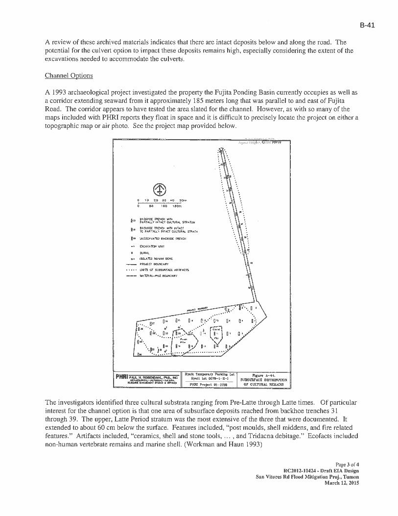
B-41
B-42
SC 5018 R2 0613 Page 1 of 1
MEETING NOTES
Date: 03/18/15
Place: Department of Public Works Permit Department
Project/Purpose: San Vitores Road Flood Mitigation Project
Attendees: Captain Castro - GFD Andrew Judd - Stanley Aja Reyes - Stanley
Notes By: Aja Reyes
The following meeting notes set forth our understanding of the discussions and decisions made at this meeting. If no objections, questions, additions, or comments are received within 5 working days from issuance of the meeting notes, we will assume that our understandings are correct. We are proceeding based on the contents of these meeting notes.
The draft design drawings for the San Vitores Road Flood Mitigation Project were discussed with the Guam Fire Department. The following provides a summary of discussion points:
Maintain clear access to hydrants during construction. Stanley to include in construction documents.
Maintain water pressure to the hydrants or provide fire suppression water tank. Stanley to include in construction documents.
Coordination with the GFD Fire Marshall and GWA (Heidi Ballendorf) needed if construction will temporarily affect water to the hydrants. Stanley to include in construction documents.
Contractor needs to maintain one lane of access along Fujita Road at all times. Already required in construction documents
12’ foot ingress/egress corridor from Fujita Road to the beach is acceptable. No parking/fire line signs should be posted above the corridor. Will include signage
Distribution: Attendees, GEDA
B-43
SC 5018 R2 0613 Page 1 of 1
MEETING NOTES
Date: 03/19/15
Place: Guam Police Department
Project/Purpose: San Vitores Road Flood Mitigation Project
Attendees: Chief Bordallo – GPD Lt. Carbullido - GPD Andrew Judd - Stanley Aja Reyes - Stanley
Notes By: Aja Reyes
The following meeting notes set forth our understanding of the discussions and decisions made at this meeting. If no objections, questions, additions, or comments are received within 5 working days from issuance of the meeting notes, we will assume that our understandings are correct. We are proceeding based on the contents of these meeting notes.
The draft design drawings for the San Vitores Road Flood Mitigation Project were discussed with the Guam Police Department. The following provides a summary of discussion points:
Construction operations should consider the peak and low periods of traffic flow. Construction operations cannot obstruct the parking area reserved for GPD officer's personal vehicles.
o GPD may need to discuss the impact to parking internally, and consider having officers and other personnel park in the nearest government parking area, or make and arrangement with the owner of the shopping area next door.
Parking for GPD office vehicles on the northeast side of the building needs to allow for officers to reverse their vehicle in.
o Stanley Consultants will move the work limits boundary of the pond the allow for parking maneuverability.
Construction operations cannot block the access in San Vitores road for GPD. GPD and Stanley Consultants will schedule a walk through of the Tumon precinct property. On-going communication during construction with GPD on traffic control is encouraged.
Distribution: Attendees, GEDA
B-44

B-45
B-46
B-47
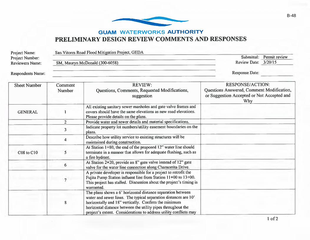
B-48

B-49
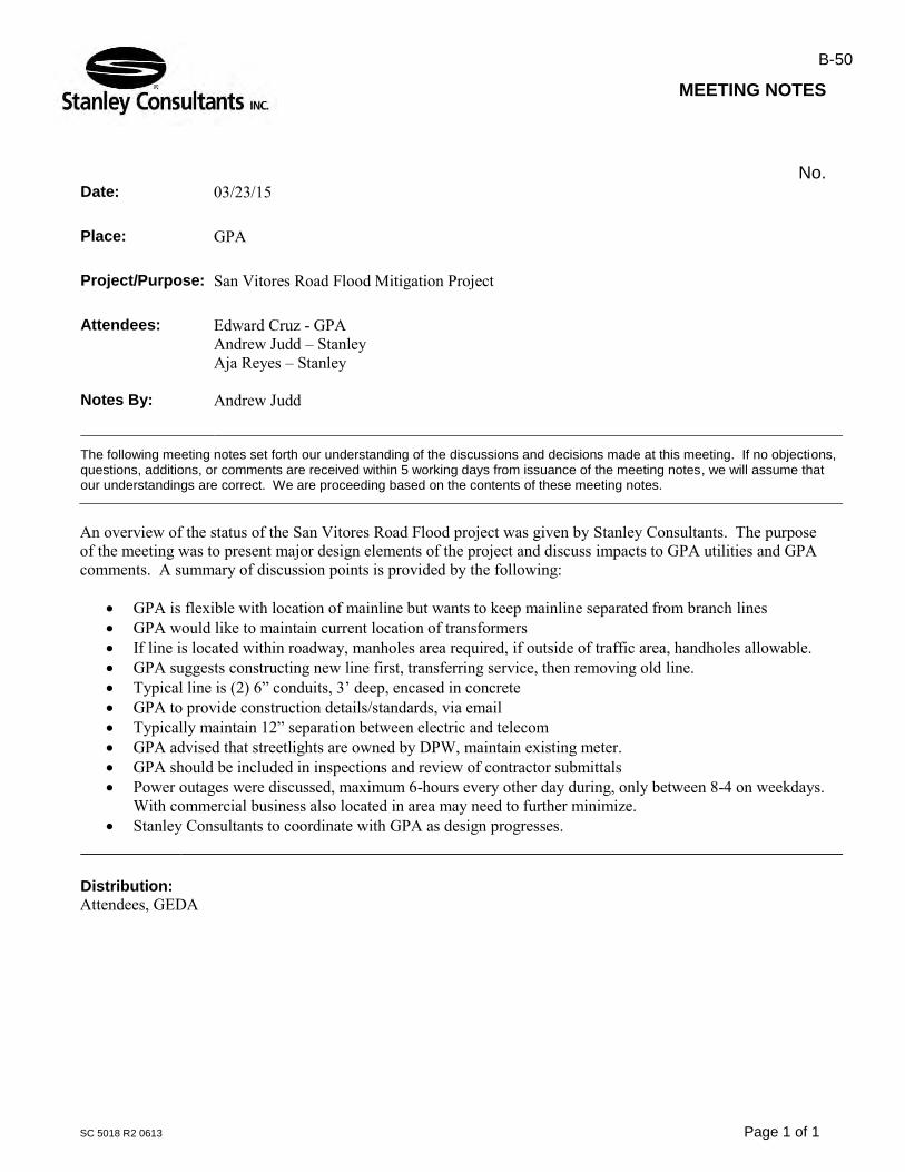
SC 5018 R2 0613 Page 1 of 1
MEETING NOTES
No. Date: 03/23/15
Place: GPA
Project/Purpose: San Vitores Road Flood Mitigation Project
Attendees: Edward Cruz - GPA Andrew Judd – Stanley Aja Reyes – Stanley
Notes By: Andrew Judd
The following meeting notes set forth our understanding of the discussions and decisions made at this meeting. If no objections, questions, additions, or comments are received within 5 working days from issuance of the meeting notes, we will assume that our understandings are correct. We are proceeding based on the contents of these meeting notes.
An overview of the status of the San Vitores Road Flood project was given by Stanley Consultants. The purpose of the meeting was to present major design elements of the project and discuss impacts to GPA utilities and GPA comments. A summary of discussion points is provided by the following:
GPA is flexible with location of mainline but wants to keep mainline separated from branch lines GPA would like to maintain current location of transformers If line is located within roadway, manholes area required, if outside of traffic area, handholes allowable. GPA suggests constructing new line first, transferring service, then removing old line. Typical line is (2) 6” conduits, 3’ deep, encased in concrete GPA to provide construction details/standards, via email Typically maintain 12” separation between electric and telecom GPA advised that streetlights are owned by DPW, maintain existing meter. GPA should be included in inspections and review of contractor submittals Power outages were discussed, maximum 6-hours every other day during, only between 8-4 on weekdays.
With commercial business also located in area may need to further minimize. Stanley Consultants to coordinate with GPA as design progresses.
Distribution: Attendees, GEDA
B-50

SC 5018 R2 0613 Page 1 of 1
MEETING NOTES
No. Date: 03/23/15
Place: GWA
Project/Purpose: San Vitores Road Flood Mitigation Project
Attendees: Tom Cruz - GWA Mauryn McDonald - GWA Andrew Judd – Stanley Aja Reyes – Stanley
Notes By: Andrew Judd
The following meeting notes set forth our understanding of the discussions and decisions made at this meeting. If no objections, questions, additions, or comments are received within 5 working days from issuance of the meeting notes, we will assume that our understandings are correct. We are proceeding based on the contents of these meeting notes.
An overview of the status of the San Vitores Road Flood project was given by Stanley Consultants. The purpose of the meeting was to present major design elements of the project and discuss impacts to GWA utilities and GWA comments. A summary of discussion points is provided by the following:
GWA provided a comment sheet summarizing their comments which was discussed. Comment sheet with responses (as discussed) is attached to this email.
GWA requested Contractor submit a utility staging plan to show their proposed plan for maintaining utility services during construction.
GWA requested note on drawings for GWA to be involved in coordinating any water and/or sanitary utility conflicts encountered by the contractor during construction.
Stanley Consultants to continue coordination with GWA as design progresses.
Distribution: Attendees, GEDA
B-51
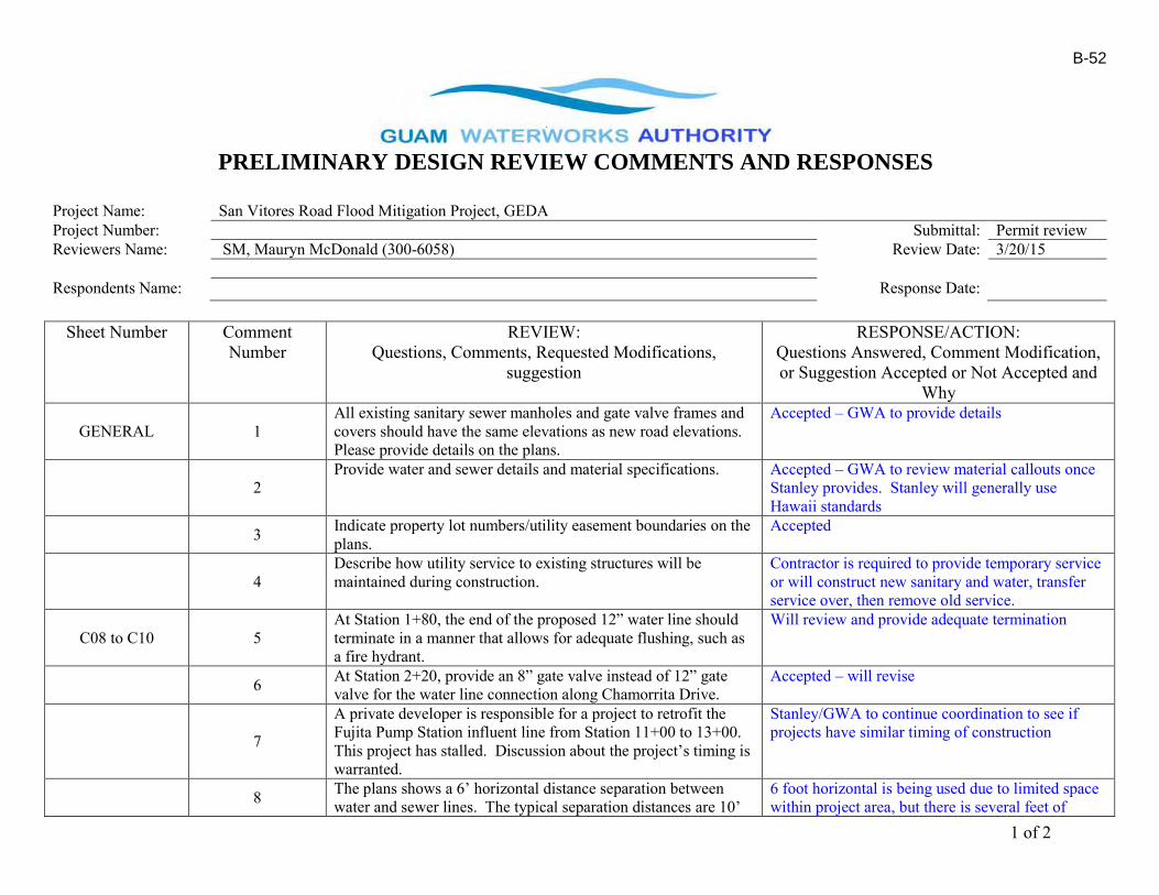
1 of 2
PRELIMINARY DESIGN REVIEW COMMENTS AND RESPONSES
Project Name: San Vitores Road Flood Mitigation Project, GEDA Project Number: Submittal: Permit review Reviewers Name: SM, Mauryn McDonald (300-6058) Review Date: 3/20/15 Respondents Name: Response Date:
Sheet Number Comment Number
REVIEW: Questions, Comments, Requested Modifications,
suggestion
RESPONSE/ACTION: Questions Answered, Comment Modification, or Suggestion Accepted or Not Accepted and
Why
GENERAL 1 All existing sanitary sewer manholes and gate valve frames and covers should have the same elevations as new road elevations. Please provide details on the plans.
Accepted – GWA to provide details
2 Provide water and sewer details and material specifications. Accepted – GWA to review material callouts once
Stanley provides. Stanley will generally use Hawaii standards
3 Indicate property lot numbers/utility easement boundaries on the plans.
Accepted
4 Describe how utility service to existing structures will be maintained during construction.
Contractor is required to provide temporary service or will construct new sanitary and water, transfer service over, then remove old service.
C08 to C10 5 At Station 1+80, the end of the proposed 12” water line should terminate in a manner that allows for adequate flushing, such as a fire hydrant.
Will review and provide adequate termination
6 At Station 2+20, provide an 8” gate valve instead of 12” gate valve for the water line connection along Chamorrita Drive.
Accepted – will revise
7
A private developer is responsible for a project to retrofit the Fujita Pump Station influent line from Station 11+00 to 13+00. This project has stalled. Discussion about the project’s timing is warranted.
Stanley/GWA to continue coordination to see if projects have similar timing of construction
8 The plans shows a 6’ horizontal distance separation between water and sewer lines. The typical separation distances are 10’
6 foot horizontal is being used due to limited space within project area, but there is several feet of
B-52
2 of 2
horizontally and 18” vertically. Confirm the minimum horizontal distance between the utility pipes throughout the project’s extent. Considerations to address utility conflicts may be required, particularly at utility crossings.
vertical clearance. All utility crossings will be reviewed as detailed design progresses.
9 Provide the length and type of materials to be used on the plans and profiles. Also, identify pipes and “new” or “proposed”.
Accepted
C21 to C27 10 GWA utility lines should be field-verified in construction areas to identify potential conflicts.
Contractor to filed verify.
Approved as submitted X Re-submit with corrections Reviewers Initials: Approved as noted – Do not resubmit
ACKNOWLEDGEMENT OF RECEIPT OF GWA COMMENTS:
I hereby acknowledge receipt of the GWA comments for the above stated construction project generated as part of the permit process for the building permit. I understand the comments will require a response from the design engineer of record and/or revised design documents to be resubmitted to GWA. Failure to provided GWA with a response and/or revise design documents will result in delays in obtaining the permit from GWA. (Provide additional pages for response if required) ___________________________________ _________________________ ______________________ _________ Permit Applicant (Print Name) Signature Date ___________________________________ _________________________ ______________________ _________ Design Engineer of Record (Firm) (Print Name) Signature Date
B-53
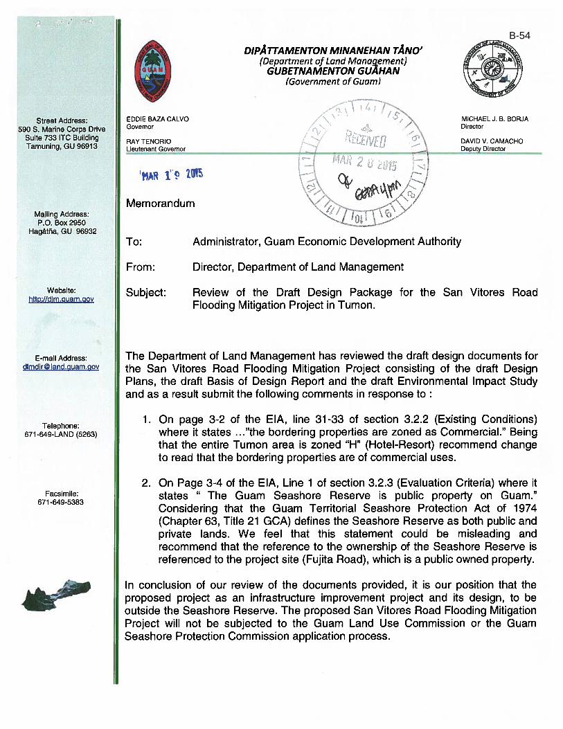
B-54
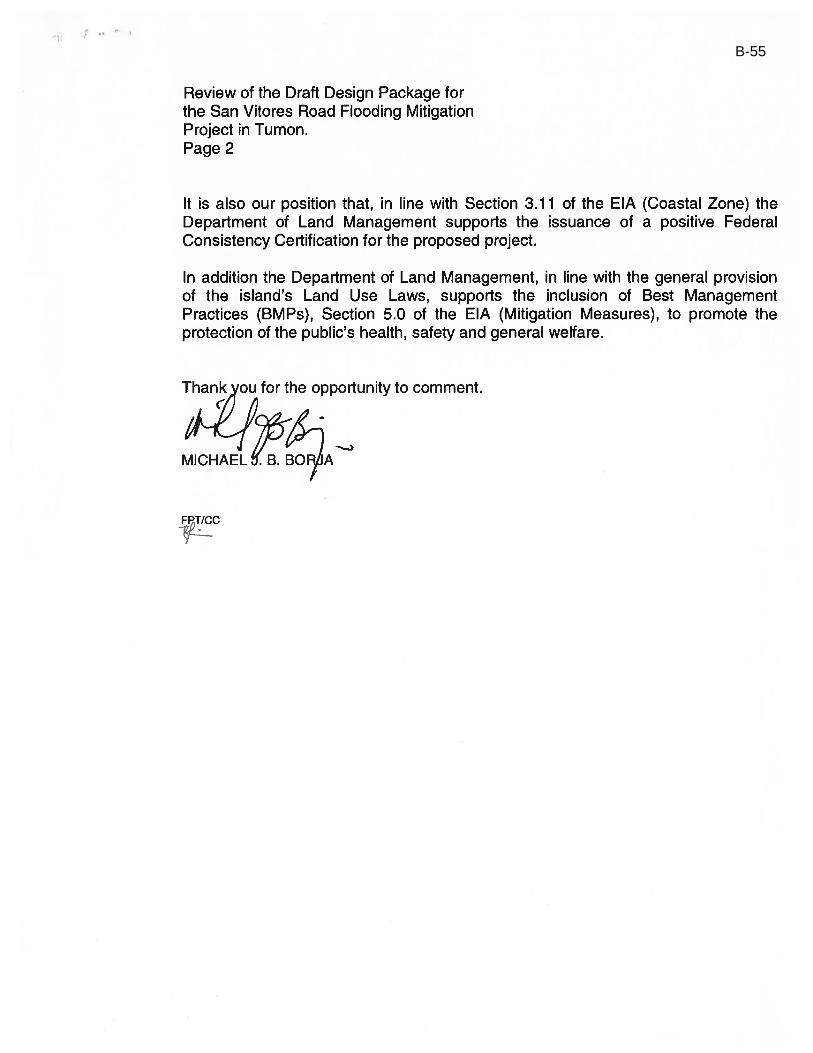
B-55

B-56
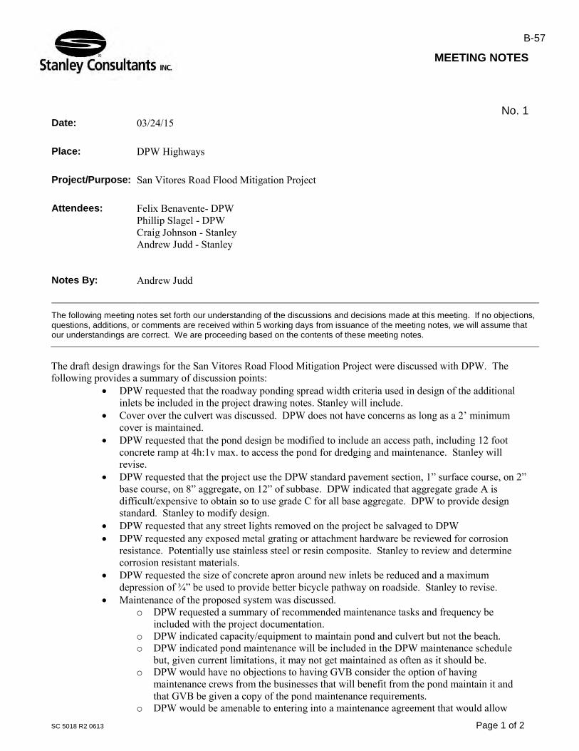
SC 5018 R2 0613 Page 1 of 2
MEETING NOTES
No. 1 Date: 03/24/15
Place: DPW Highways
Project/Purpose: San Vitores Road Flood Mitigation Project
Attendees: Felix Benavente- DPW Phillip Slagel - DPW Craig Johnson - Stanley Andrew Judd - Stanley
Notes By: Andrew Judd
The following meeting notes set forth our understanding of the discussions and decisions made at this meeting. If no objections, questions, additions, or comments are received within 5 working days from issuance of the meeting notes, we will assume that our understandings are correct. We are proceeding based on the contents of these meeting notes.
The draft design drawings for the San Vitores Road Flood Mitigation Project were discussed with DPW. The following provides a summary of discussion points:
DPW requested that the roadway ponding spread width criteria used in design of the additional inlets be included in the project drawing notes. Stanley will include.
Cover over the culvert was discussed. DPW does not have concerns as long as a 2’ minimum cover is maintained.
DPW requested that the pond design be modified to include an access path, including 12 foot concrete ramp at 4h:1v max. to access the pond for dredging and maintenance. Stanley will revise.
DPW requested that the project use the DPW standard pavement section, 1” surface course, on 2” base course, on 8” aggregate, on 12” of subbase. DPW indicated that aggregate grade A is difficult/expensive to obtain so to use grade C for all base aggregate. DPW to provide design standard. Stanley to modify design.
DPW requested that any street lights removed on the project be salvaged to DPW DPW requested any exposed metal grating or attachment hardware be reviewed for corrosion
resistance. Potentially use stainless steel or resin composite. Stanley to review and determine corrosion resistant materials.
DPW requested the size of concrete apron around new inlets be reduced and a maximum depression of ¾” be used to provide better bicycle pathway on roadside. Stanley to revise.
Maintenance of the proposed system was discussed. o DPW requested a summary of recommended maintenance tasks and frequency be
included with the project documentation. o DPW indicated capacity/equipment to maintain pond and culvert but not the beach. o DPW indicated pond maintenance will be included in the DPW maintenance schedule
but, given current limitations, it may not get maintained as often as it should be. o DPW would have no objections to having GVB consider the option of having
maintenance crews from the businesses that will benefit from the pond maintain it and that GVB be given a copy of the pond maintenance requirements.
o DPW would be amenable to entering into a maintenance agreement that would allow
B-57

SC 5018 R2 0613 Page 2 of 2
GVB to have third parties maintain the pond. o DPW recommended beach maintenance be discussed with GVB and Department of Parks
and Recreation. It was agreed that Stanley will stay in communication with DPW on design and modifications.
Distribution: Attendees, GEDA
B-58
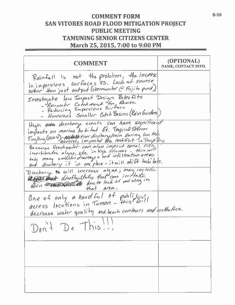
B-59
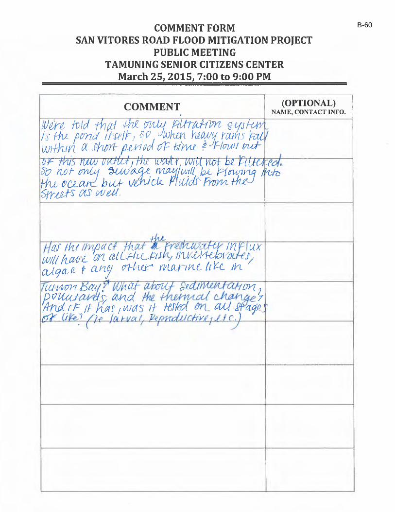
B-60
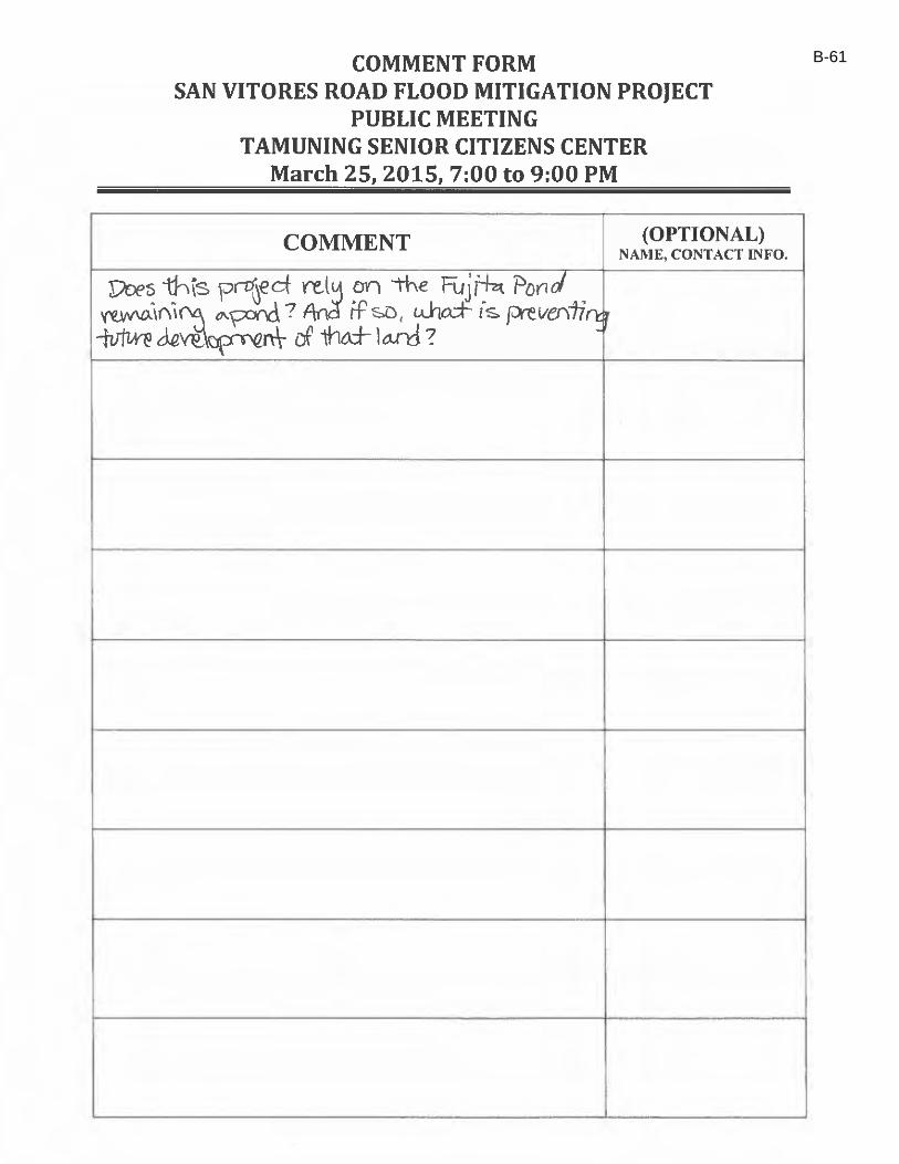
B-61
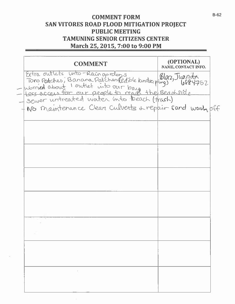
B-62
B-63
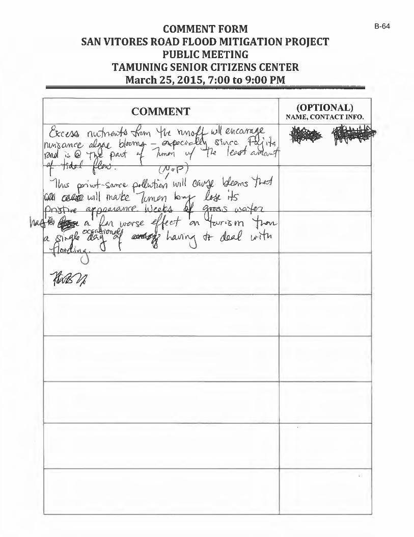
B-64
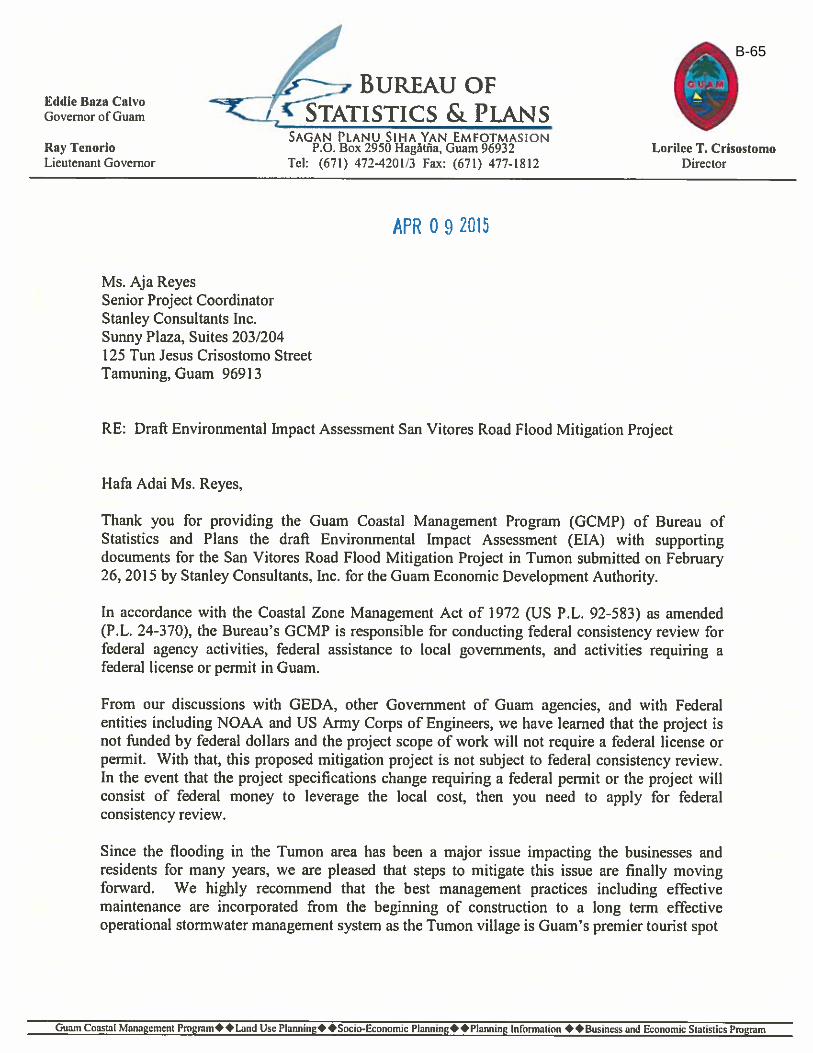
B-65
B-66
B-67
B-68
B-69
B-70

B-71
B-72
B-73
B-74
B-75

B-76

B-77
B-78
B-79