Embed Size (px)
Citation preview
Analysis and forecast of a weather situation
Severe precipitations and thunderstormson the 7th of October 2009
J. Neméghaire RMIB – BelgiumNovember 2009
Table of contents
1.Introduction
2.Observations : short description of the weather event
3.Analysis : a global model analysis to diagnose the weather situation (identification of the perturbations, scales, ....)+summary of comments
4.Forecasts : global and regional (LAM) deterministic models are exploitedby forecasters to elaborate a 4D short range weather scenario +summary of comments
5.Conclusions and recommendations for forecasters
NB: regional Satreps analysis are documented for discussion
1. Introduction
Motivations-----------------heavy precipitations including a large thundery activity have been observed over a large part of Belgium but also in surrounding areas (North of France – Netherlands – Germany)
synotic and meso (even convective) scales are involved
-precipitations more severe than expected by forecasters altough significant precipitation forecasts are given by NWP but not exactly in the same areas
How could forecasters have improved their short range forecasts (+12 to +30h): -interpreting deterministic models (using other models, other NWP data,...) ? -improving their physical knowledge on the weather mechanisms (conceptual models) ? NB: up to now ensemble forecasts are not exploited for our short range forecasts
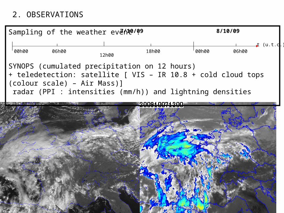
2. OBSERVATIONS
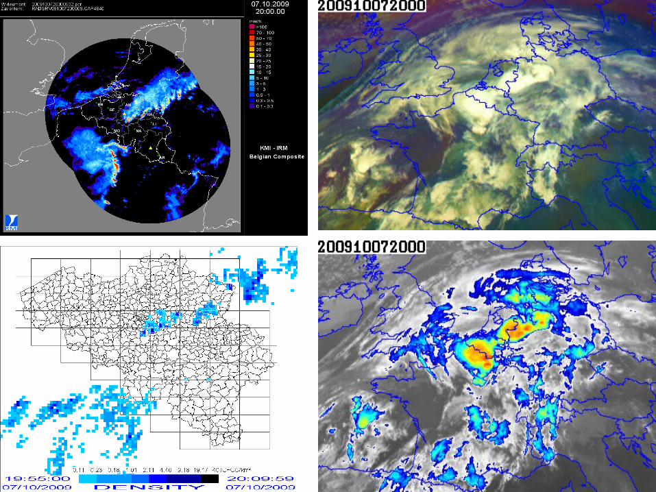
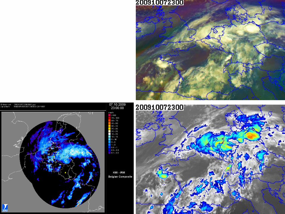
Sampling of the weather event :
SYNOPS (cumulated precipitation on 12 hours) + teledetection: satellite [ VIS – IR 10.8 + cold cloud tops (colour scale) – Air Mass)] radar (PPI : intensities (mm/h)) and lightning densities
t (u.t.c.)
00h00 06h0012h00
18h00 00h00 06h00
7/10/09 8/10/09


Cumul of precipitation on 24h (mm) estimated by the radar of Wideumontfrom 7/10/09 at 6h00 u.t.c. to 8/10/09 at 6h00 u.t.c.
Cumul of precipitations on 12h (mm) at synoptic stations :7/10/09 between 06h00 and 18h00 u.t.c. (above)7>8/10/09 between 18h00 and 06h00 u.t.c. (below)

3. ANALYSIS
ECMWF model analysis : run date 7/10/2009 at 00h00 u.t.c.Area = Western Europe (centred over Belgium)
A selection of diagnosis model fields to characterize the synoptic situation is proposed :-MSLP+surface wind-MSLP+Z500+Wind speed 300 hPa-Z500+Wind 500+Relative VORTicity 500 hPa-Z+T+Wind 850 hPa-Z+Relative Humidity+Wind 850 hPa-Z+Theta’w 850 hPa-Z+Thetae 850 hPa-Z+Wind 925 and Thickness 1000-850 hPa
OBJECTIVE : forecasters are building a 3D “mental image” of the atmosphere at synoptic scale at the starting point of their forecasts (analysis date). To elaborate this “mental image” they can proceed as follows:-extraction of the main elements (fields, CMs,...) which characterize the analysis -confrontation with observations (teledetection (mainly satellites), synops)
These elements (fields, CMs,...) will be identified and used in the forecast to facilitate the elaboration ofa deterministic scenario.A conceptual models approach will be useful to estimate the impact on the surface parameters.
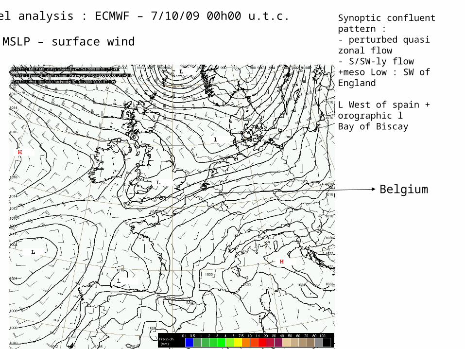
Model analysis : ECMWF – 7/10/09 00h00 u.t.c.
MSLP – surface wind
Belgium
Synoptic confluent pattern :- perturbed quasi zonal flow- S/SW-ly flow +meso Low : SW of England
L West of spain + orographic lBay of Biscay

Belgium
Model analysis: ECMWF – 7/10/09 00h00 u.t.c.
MSLP (- - -) Z500 Wind speed 300
2 main confluent upper-air streams + jet streams+ short wave upper trough (southwest of England)
L+troughs west of Spain +jet stream
In-between (France-Italy): flat ridge
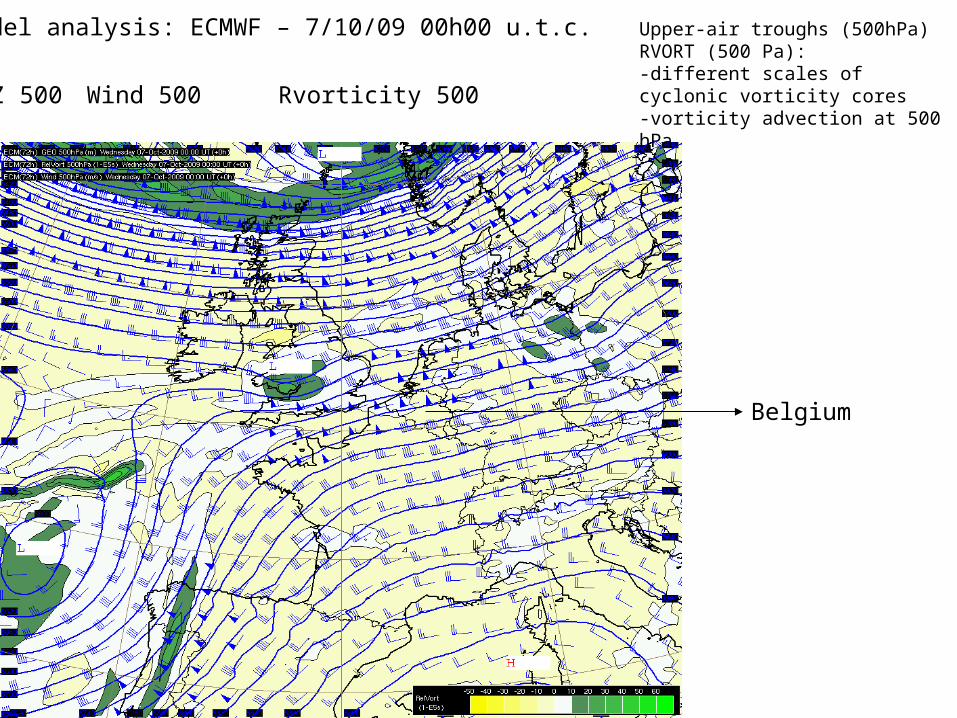
Model analysis: ECMWF – 7/10/09 00h00 u.t.c.
Z 500 Wind 500 Rvorticity 500
Belgium
Upper-air troughs (500hPa)RVORT (500 Pa):-different scales of cyclonic vorticity cores -vorticity advection at 500 hPa

Model analysis: ECMWF – 7/10/09 00h00 u.t.c.
Belgium
Z 850 T 850 Wind 850
Temperature at low levels (850 hPa)-waving cold front (Sweden - UK)-frontal system (NW spain) ?-strong thermal advection at 850 hPa

Model analysis: ECMWF – 7/10/09 00h00 u.t.c.
Belgium
Z 850 RH 850 Wind 850
Relative Humidity at low levels (850 hPa) - advection over SE of UK, NW of Spain - waving cold front (Sweden-UK) and dry air behind cold front
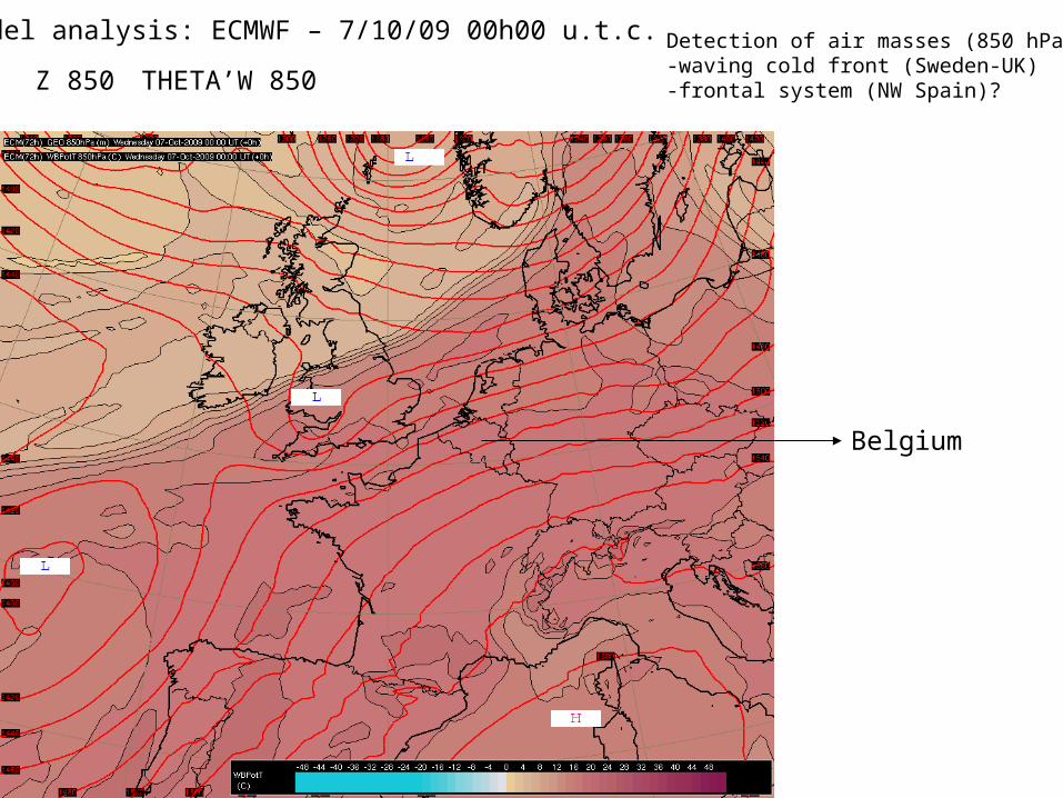
Model analysis: ECMWF – 7/10/09 00h00 u.t.c.
Belgium
Z 850 THETA’W 850
Detection of air masses (850 hPa):-waving cold front (Sweden-UK)-frontal system (NW Spain)?
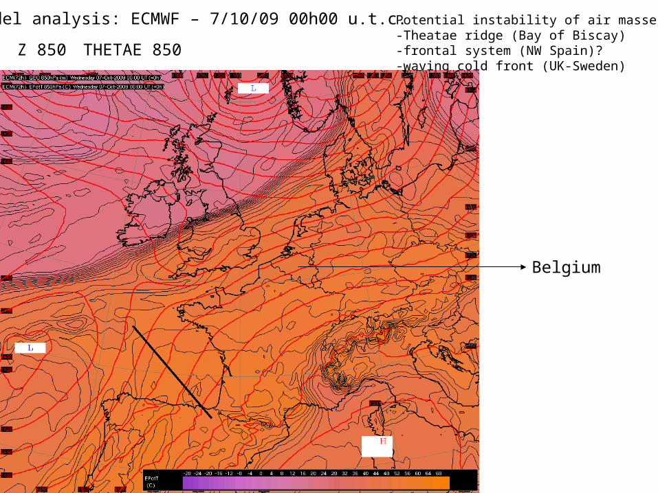
Model analysis: ECMWF – 7/10/09 00h00 u.t.c.
Belgium
Z 850 THETAE 850
Potential instability of air masses:-Theatae ridge (Bay of Biscay)-frontal system (NW Spain)?-waving cold front (UK-Sweden)
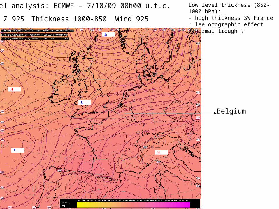
Model analysis: ECMWF – 7/10/09 00h00 u.t.c.
Belgium
Z 925 Thickness 1000-850 Wind 925
Low level thickness (850-1000 hPa):- high thickness SW France : lee orographic effect /thermal trough ?
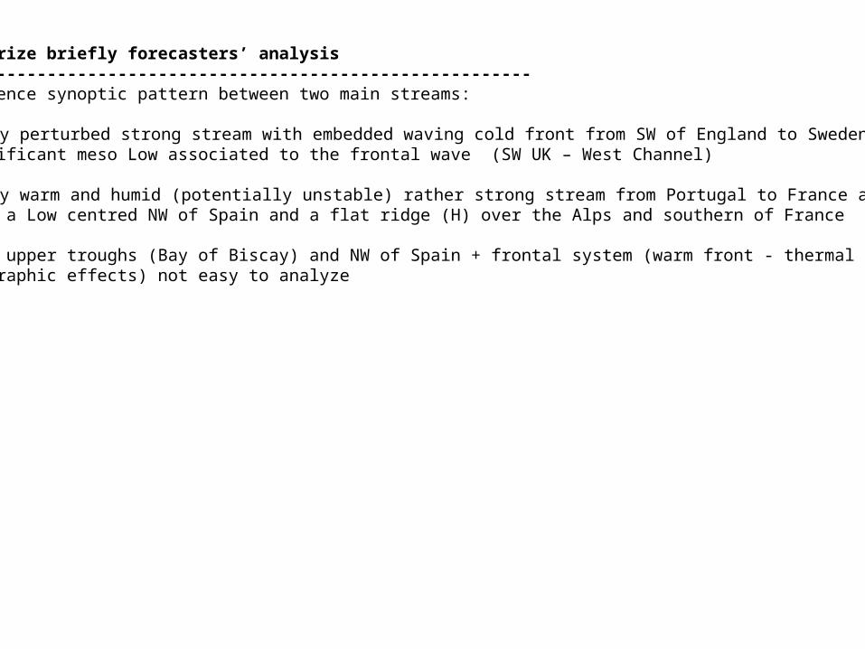
To summarize briefly forecasters’ analysis -------------------------------------------------------------A confluence synoptic pattern between two main streams:
W/SW-ly perturbed strong stream with embedded waving cold front from SW of England to Swedenand significant meso Low associated to the frontal wave (SW UK – West Channel)
S/SW-ly warm and humid (potentially unstable) rather strong stream from Portugal to France and Germany between a Low centred NW of Spain and a flat ridge (H) over the Alps and southern of France
Embedded upper troughs (Bay of Biscay) and NW of Spain + frontal system (warm front - thermal trough orlee orographic effects) not easy to analyze

4. FORECASTS
A- ECMWF model forecast: run date 7/10/2009 at 00h00 u.t.c.Area = Western Europe (centred over Belgium)
Exploitation of the deterministic model for short range forecasts:a selection of model fields to forecast the evolution of the weather situation at synoptic scale is proposed :-MSLP+3h cumulated precip.+surface wind-MSLP+Z500+Wind speed 300 hPa-Z500+Wind 500+Relative VORTicity 500 hPa-Z+T+Wind 850 hPa-Z+Thetae 850 hPa-Z500+Omega 700 hPa
OBJECTIVE : forecasters are building a 4D “mental image” of the atmosphere at synoptic scale starting at the analysis date. To elaborate this “mental image” (deterministic short term scenario) : -they try to use the main elements (or CMs) already identified in the analysis -they try to estimate their evolution and their impact on the surface parameters (main mechanisms responsible for the severity of the sensible weather)
t (u.t.c.)00h00 06h00 12h00 18h00 00h00 06h00
7/10/2009 8/10/2009
F+12 F+18 F+24 F+30ANA

7/10/09 12h00 u.t.c. (F+12) : MSLP+3hR+W10 7/10/09 18h00 u.t.c. (F+18)
8/10/09 00h00 u.t.c. (F+24) 8/10/09 06h00 u.t.c. (F+30)
ECMWF forecasts : run date 7/10/09 at 00h00 u.t.c.
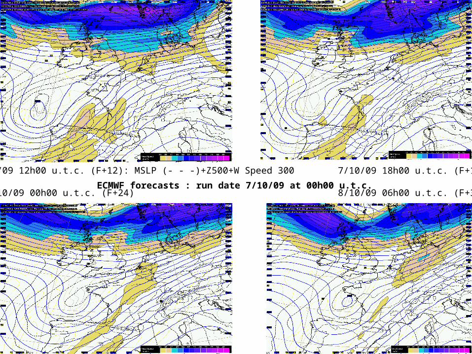
7/10/09 12h00 u.t.c. (F+12): MSLP (- - -)+Z500+W Speed 300 7/10/09 18h00 u.t.c. (F+18)
8/10/09 00h00 u.t.c. (F+24) 8/10/09 06h00 u.t.c. (F+30)ECMWF forecasts : run date 7/10/09 at 00h00 u.t.c.

7/10/09 12h00 u.t.c. (F+12) : Z500+RVORT500+W500 7/10/09 18h00 u.t.c. (F+18)
8/10/09 00h00 u.t.c. (F+24) 8/10/09 06h00 u.t.c. (F+30)
ECMWF forecasts : run date 7/10/09 at 00h00 u.t.c.
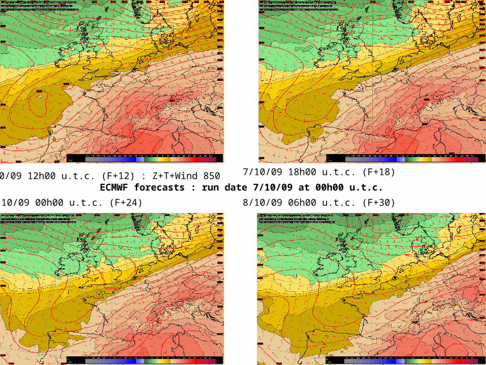
7/10/09 12h00 u.t.c. (F+12) : Z+T+Wind 850 7/10/09 18h00 u.t.c. (F+18)
8/10/09 00h00 u.t.c. (F+24) 8/10/09 06h00 u.t.c. (F+30)
ECMWF forecasts : run date 7/10/09 at 00h00 u.t.c.

7/10/09 12h00 u.t.c. (+12h) : Z+THETAE 850 7/10/09 18h00 u.t.c. (+18h)
8/10/09 00h00 u.t.c. (+24h) 8/10/09 06h00 u.t.c. (+30h)ECMWF forecasts : run date 7/10/09 at 00h00 u.t.c.
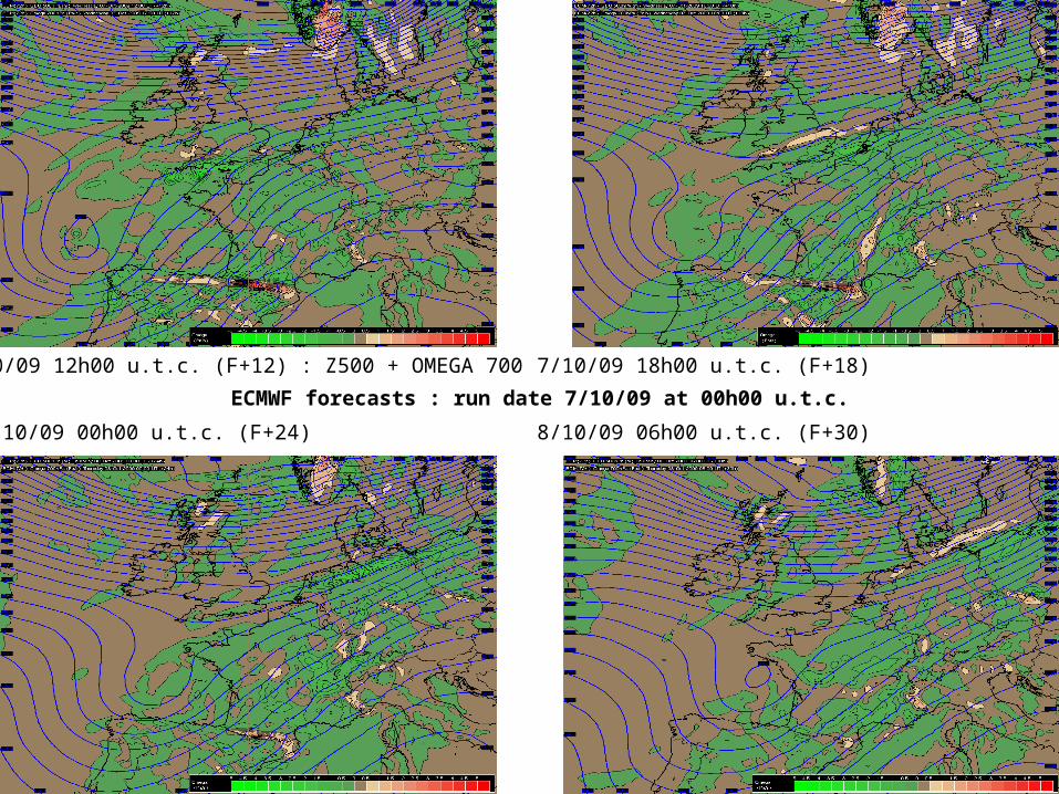
7/10/09 12h00 u.t.c. (F+12) : Z500 + OMEGA 700 7/10/09 18h00 u.t.c. (F+18)
8/10/09 00h00 u.t.c. (F+24) 8/10/09 06h00 u.t.c. (F+30)
ECMWF forecasts : run date 7/10/09 at 00h00 u.t.c.
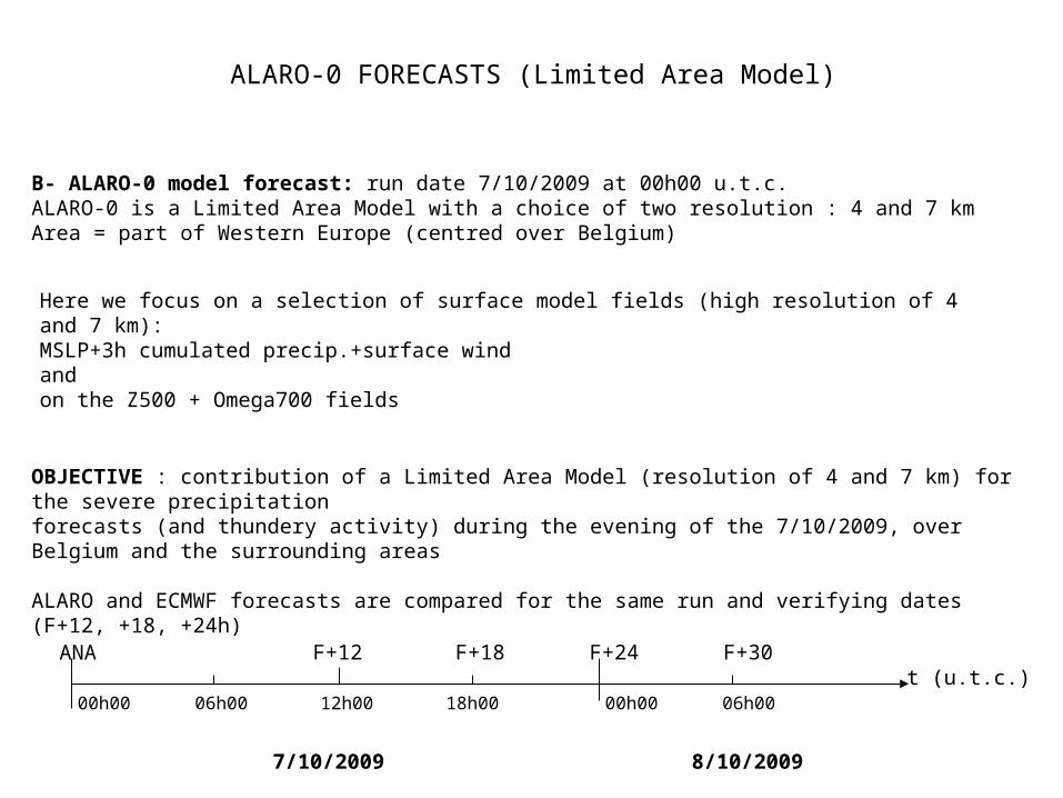
ALARO-0 FORECASTS (Limited Area Model)
B- ALARO-0 model forecast: run date 7/10/2009 at 00h00 u.t.c. ALARO-0 is a Limited Area Model with a choice of two resolution : 4 and 7 kmArea = part of Western Europe (centred over Belgium)
Here we focus on a selection of surface model fields (high resolution of 4 and 7 km):MSLP+3h cumulated precip.+surface windand on the Z500 + Omega700 fields
OBJECTIVE : contribution of a Limited Area Model (resolution of 4 and 7 km) for the severe precipitation forecasts (and thundery activity) during the evening of the 7/10/2009, over Belgium and the surrounding areas
ALARO and ECMWF forecasts are compared for the same run and verifying dates (F+12, +18, +24h)
t (u.t.c.)00h00 06h00 12h00 18h00 00h00 06h00
7/10/2009 8/10/2009
F+12 F+18 F+24 F+30ANA
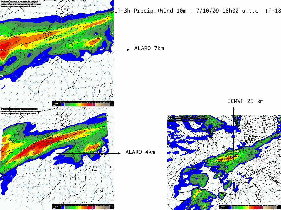
MSLP+3h-Precip.+Wind 10m : 7/10/09 18h00 u.t.c. (F+18h)
ALARO 7km
ALARO 4km
ECMWF 25 km

MSLP+3h-Precip.+Wind 10m : 7/10/09 21h00 u.t.c. (F+21h)
ALARO 7 km
ALARO 4 km
ECMWF 25 km
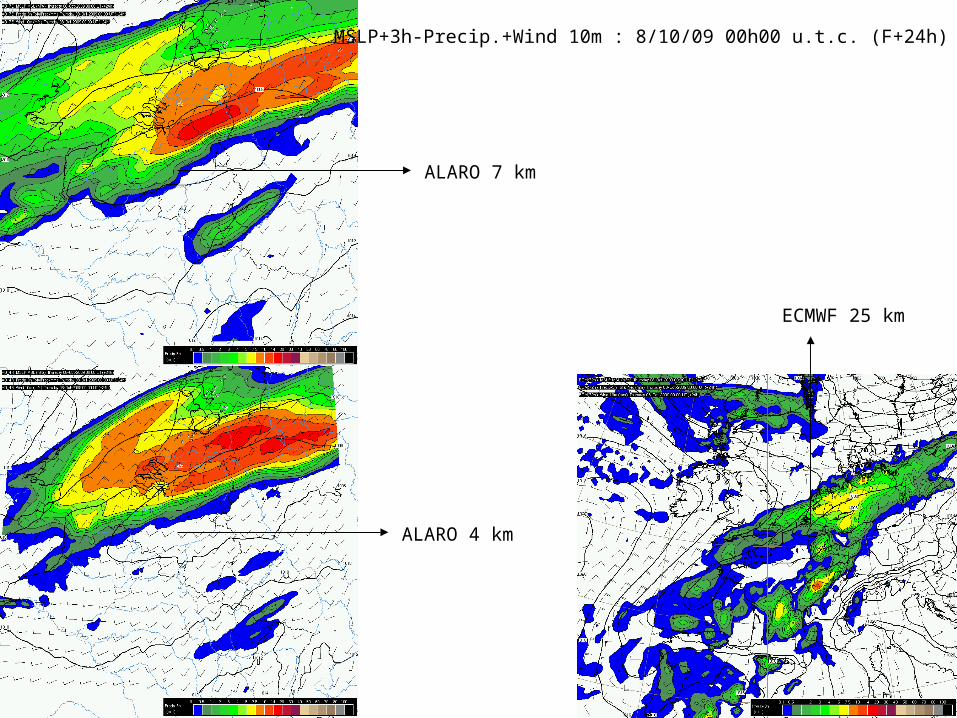
MSLP+3h-Precip.+Wind 10m : 8/10/09 00h00 u.t.c. (F+24h)
ALARO 7 km
ALARO 4 km
ECMWF 25 km
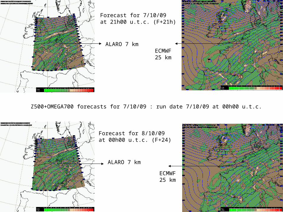
Z500+OMEGA700 forecasts for 7/10/09 : run date 7/10/09 at 00h00 u.t.c.
Forecast for 7/10/09at 21h00 u.t.c. (F+21h)
Forecast for 8/10/09at 00h00 u.t.c. (F+24)
ALARO 7 km
ALARO 7 km
ECMWF25 km
ECMWF25 km

To summarize briefly forecasters’ interpretation of NWP data (4D “mental” image)---------------------------------------------------------------------------------------------------------------------
Short term forecast scenario - derived from selected analysis and forecasts (deterministic) fields
-significant precipitation area moving E/NE in a low level convergence area (surface trough) just south of a quasi stationary cold front waving from the Channel to North Germany and Sweden.
-possible but rather limited development of convective precipitation in the unstable (warm and humid) air stream advected from France.A conjonction of a short wave upper trough and a thetae ridge could have triggered enhanced convective systems and (thundery) precipitations, in the evening of the 7 th over the belgian areas LAM and ECMWF models are consistent
-similar MSLP, surface wind and precipitation fields over the northern part of Belgium (a little bit more precipitations are forecasted with ALARO 4 km)-similar upper-air geopotential and vertical motion patterns

5. CONCLUSIONS and RECOMMENDATIONS
The severe precipitations and thundery event has been underestimated and not rightly positioned byforecastersso what could be recommended to forecasters ?
Global and LAM models helpful enough to elaborate a realistic weather scenario ?
Are there missing relevant model fields in the forecasters’ scenario (wind shear, instability indices, helicity, ...)?
Real time NWP verification with observations useful
Use of Regional SATREPS analyses (using a NWP background) ? (documented on the next slide)
Which benefits from a more physical approach (mechanisms, conceptual models) ?
Which benefits from a short range EPS forecast for these situations ?

Regional Satreps charts (KNMI)-------------------------------------------7/10/2009 respectively at at 9h00 – 14h45 and 21h00 u.t.c.
CMs and surface weather are documented onIR satellite pictures
9h00 u.t.c.
14h45 u.t.c. 21h00 u.t.c.