Embed Size (px)
Citation preview
An Overview of Mobile GIS Apps for Field Data Collection
Matt Alexander
Anatum Field Solutions, LLC

• 2010
• iOS GIS Apps
• No accurate GPS/GNSS (TestedniPhone 6 and iPad Air = 6.5m [95% CI])

New Tech Opens New Doors
2012-ish
• BlueTooth External 2.5-meter GPS
• Bad Elf Pro GPS
• (Tested 2.2m at 95% CI)
• Garmin Glo
• Dual XGPS150

Submeter GNSS Finally Arrives!
• iSXBlue II GNSS (2013)
• Accuracy ≤ 0.60 meter
• Arrow 100 GNSS (2014)
• Accuracy ≤ 0.60 meter
• Trimble R1 (2015)
• Accuracy < 1.0 meter

RTK Market Grows
• SXBlue III GNSS (2014)
• Accuracy 1 cm
• Arrow 200 GNSS (2014)
• Accuracy 1 cm
• CHC X91+ GNSS (2015)
• Accuracy 1 cm

Full Hardware Solution
iPad (or equivalent tablet)
• Waterproof case
• Strap system
• Apps Aplenty!
• Mobile GIS
• Plant Guides
• Compass/Camera
• PDF Reader
• External battery
• Cellular service (optional)
• Real-time access to GIS server
• Internet access
GNSS
• 2.5 meter GPS
• Submeter GNSS
• RTK

Workflow
• Tablet paired to GNSS
• Monitor GNSS “health”
• Mobile GIS App for data collection and export
• Cloud server
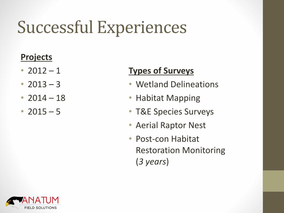
Successful Experiences
Projects
• 2012 – 1
• 2013 – 3
• 2014 – 18
• 2015 – 5
Types of Surveys
• Wetland Delineations
• Habitat Mapping
• T&E Species Surveys
• Aerial Raptor Nest
• Post-con Habitat Restoration Monitoring (3 years)

iPad Benefits
TIME AND MONEY SAVINGS
1. Better Navigation
2. Helpful Aerial Imagery
3. Quicker Data Entry
4. Direct Photo Integration
5. Real Time Data Access (Cloud)
6. Long-term Asset Monitoring
7. Better Security (Passcode Lock)

iPad Benefits
• Numbers based on general environmental field surveys in remote areas
iPad and Bluetooth GPS
startup times save 6% of
your work day lost to
other GPS technology
glitches
iPad provides easier field
navigation that saves teams
5% of their work day
Recording photos and
corresponding GPS points
is 37% faster than other
methods
Nightly data upload to the
cloud database is 30 times
faster than other methods
5100
510
0
505
0
5050
5000
5000
5000
4950
4950

The Difficult PartSoftware• Multitude of Mobile GIS Apps
• iGeoTrak
• Collector
• Fulcrum
• GIS Pro
• Wolf GIS
• iCMTGIS
• Theodolite
• GeoJot+
• TerraGo
• Mapistry
• Geospago
• Avenza PDF Maps

Theodolite HD

GeoJot+Good Photolog Software
• Photos automatically linked to GPS point and compass bearing
• Eliminates manual photo loading
• Saves on expensive office data entry time

GeoJot+
Multiple formatting options
• Word
Export KMZ with photos and attribute data attached

Fulcrum
Simple back end (HTML)
Multiple export options
• Shapefile
• CSV
• KMZ
• GeoJSON

Fulcrum
Default report PDF export
Export reports customizable

Mapistry
• Web browser based system for data collection
• Customizable legend and title box for simple map creation

TerraGo Edge
• Custom offline maps
• Create “Task Orders”
• WMS feeds
• Record audio

Avenza PDF Maps
• Buy GeoPDF’s of USGS, USFS, and aerial maps
• Create simple attribute collection forms
• Pay for business

iGeoTrak
• Best mapping system: zoom ANYWHERE & offline image caching
• Direct integration of aerial imagery at all times
• Can upload additional imagery layers
• NAIP satellite
• UAV imagery
• SSURGO soils data
• USGS National Hydrography Data
• Points, Lines, Polygons
• Data syncs only DELTA
• SQL based system for robust database

iGeoTrak

iGeoTrak
Customizable data collection forms (simple or complex)
• Multiple photo capture
• Draw on photos
• Sketchpad
• Save map screenshot to point
• Dropdown picklists (5,000 species)
• Linked data fields
• Auto calculations
• Data history

Post-con Habitat Monitoring Yr1Old Field Data Management iPad Field Data Management
Activity Time Activity Time
Photos: Trimble + Camera 24 Photos: iPad 14
Nightly download to laptop 2.5 Nightly synch to cloud database
0.2
Download new project files to Trimble
0.5 Synch new files to iPad 0.2
Weekly upload to FTP 1 Synch with cloud database 0.2
GIS data compilation 3 Data automatically compiled 0
Manual photo upload 4 Photos automatically linked to GIS features
0
Total hours per week 31 Total hours per week 14.6
Cost $2x Cost $x
Time estimated per team per week for photo centric field work

Habitat Monitoring Yr 2: All In
6 Field Teams
• All teams switched to iPads paired with external GPS and electronic data sheet collection and photos (no paper)
• Each team completed scheduled tasks 20 – 30% faster than estimated thanks to:
• Field iPad
• External GPS
• iGeoTrak utilizing cloud interface
• Cellular data plan when service was available (mostly offline; very remote areas)

Additional Informationwww.anatumfieldsolutions.com
Visit Field Talk Blog
• Discussions of Mobile GIS best practices
• Links to our Mobile GIS publications
• Interviews with:
• iGeoTrak
• Fulcrum
• Mapistry
• Avenza PDF Maps
• Geospago

Publications
• Increasing the Efficiency of Aerial Surveys By Using Tablets for Project Siting, March 2015
• Using the Tablet in the Field: Pipeline Post-Construction Restoration Monitoring Case Study, March 2015


Handheld GPS vs. Mobile GIS
• Handheld GNSS
• ArcPad/Terrasync
• GPS Correct (needed for post-processing)
• Internal GNSS
• System can use Real-Time Differential GPS and/or Post-Processing
• Mobile GIS: Tablet and External GNSS
• GNSS
• Manufacturer specific SDK
• GIS App
• System relies on Real-Time Differential GPS