Embed Size (px)
Citation preview

AN ORGANISATION FOR A NATIONAL EARTH SCIENCE INFRASTRUCTURE PROGRAM
Making your data accessible on the network using standards
Bruce Simons

2
Standards
“Standards are like toothbrushes – everybody wants to use one but nobody wants to share it”
Francois Robida, BRGM
3
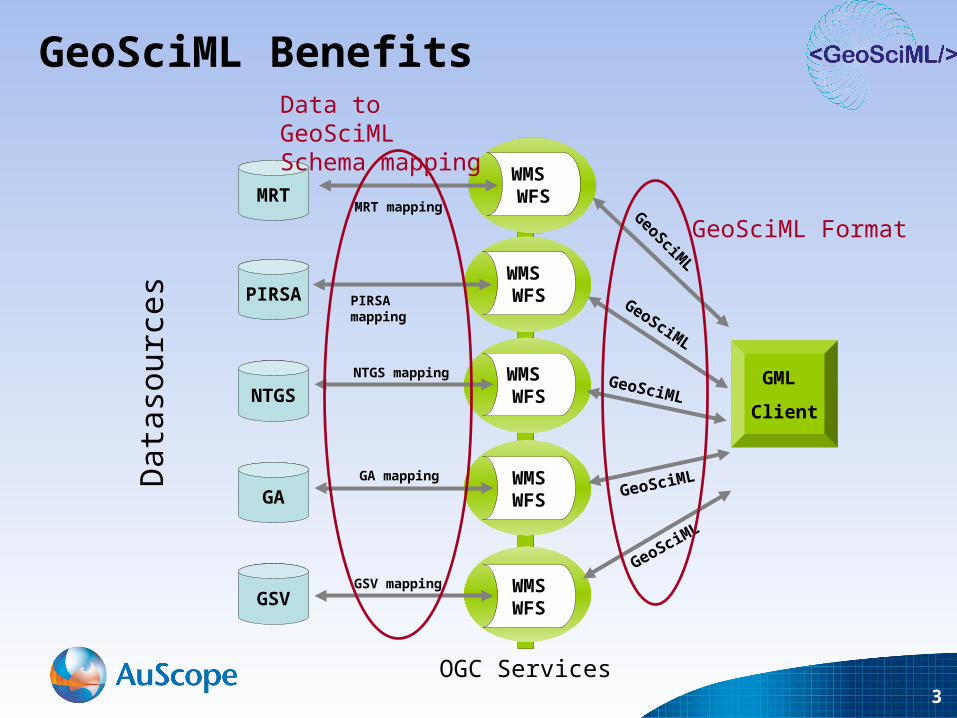
GML
Client
WMS WFS
WMSWFS
WMSWFS
WMS WFS
GeoSciML
GeoSciML
GeoSciML
GeoSciML
WMS WFS
GeoSciML
GSV
GA
NTGS
PIRSA
MRTMRT mapping
GeoSciML Benefits
GeoSciML Format
PIRSA mapping
NTGS mapping
GA mapping
GSV mapping
Data to GeoSciML Schema mapping
OGC Services
Dat
asou
rces
4
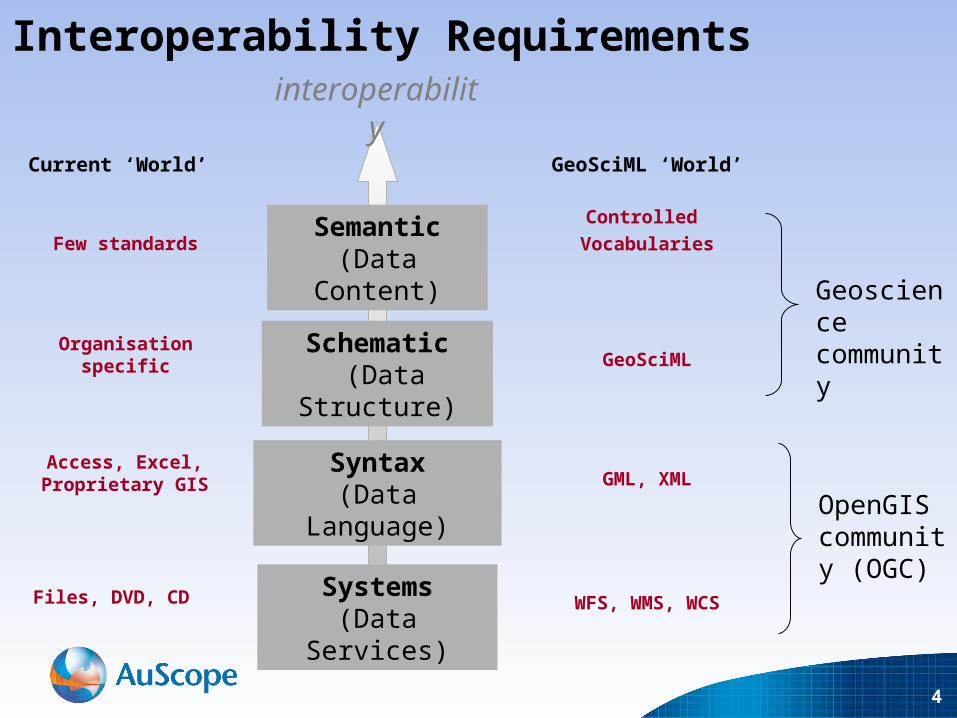
Systems(Data Services)
Syntax(Data Language)
Schematic (Data Structure)
Semantic(Data Content)
interoperability
Current ‘World’
Organisation specific
Few standards
Access, Excel,Proprietary GIS
Files, DVD, CD
GeoSciML
Controlled
Vocabularies
GML, XML
WFS, WMS, WCS
GeoSciML ‘World’
Interoperability Requirements
Geoscience community
OpenGIS community (OGC)

5
Systems and Syntax standards
• WFS 1.0, WFS 1.1, WFS 2.0• GML 2.0, GML 3.1, GML 3.2• Compliance levels (SF-0, SF-1, SF-2)• Community defined application schema
• WFS 1.0, WFS 1.1, WFS 2.0• GML 2.0, GML 3.1, GML 3.2• Compliance levels (SF-0, SF-1, SF-2)• Community defined application schema
– GeoSciML extends 3.1.1
– GeoSciML conforms to SF-1
• Make sure you are compliant with your community specified standard

6
‘Simple features’ vs ‘Complex features’
Level SF-0 Level SF-1
Restricted set of non-spatial property types Y Y
Restricted set of spatial property types Y Y
User-defined property types N Y
Property cardinality 0 - 1 0 - *
Property = temperature,
Value = ’15-20 C’
Property = temperature, TValue[1] = 15 Unit = C Instrument = thermometer TValue[2] = 17 Unit = C Instrument = thermometer TValue[3] = 20 Unit = C Instrument = thermometer
OR
Property = temperature, TRange = MinValue = 15 Unit = C
MaxValue = 20 Unit = C
SF-0 SF-1
7
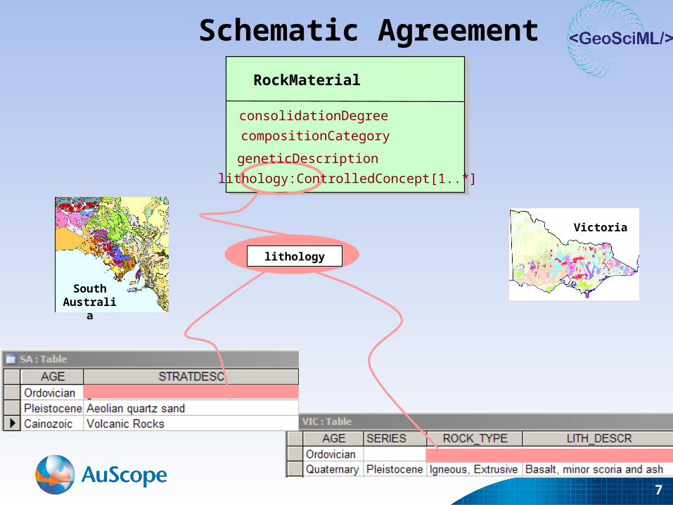
Schematic Agreement
Victoria
South Australia
lithology
RockMaterial
consolidationDegree
compositionCategory
geneticDescription
lithology:ControlledConcept[1..*]

8
RockMaterial
consolidationDegree
compositionCategory
geneticDescription
Lithology: ControlledConcept [1..*]
GeologicUnit+ bodyMorphology: [0..*]+ compositionCategory: [0..1]+ exposureColor: [0..*]+ outcropCharacter: [0..*]+ rank: [0..1]
CompositionPart
+ lithology: ControlledConcept [1..*]+ material: RockMaterial [0..1]+ proportion:+ role:
+composition0..*Lithology
Schematic Agreement

9
Cainozoic?
Palaeozoic?
Archaean?
Bolindian?Eastonian?Gisbornian?
Late?Early?
Semantic Agreement Semantic Agreement • Select geologic features where age = “xxx”

10
• Geological data is largely text-based and interpretive. Simple
numerical data is rare.
• Compliance to many controlled vocabularies is not a trivial exercise
• Compliance to vocabularies is crucial to be able to construct
standardised requests on distributed data
• Establish language independent identifiers (URNs) that local terms
and languages can be mapped to
• GGIC Controlled Vocabularies Working Group and CGI
Geoscience Concepts Task Group
Semantic Agreement Semantic Agreement
11
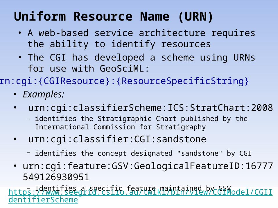
Uniform Resource Name (URN)
• Examples:• urn:cgi:classifierScheme:ICS:StratChart:2008
– identifies the Stratigraphic Chart published by the International Commission for Stratigraphy
• urn:cgi:classifier:CGI:sandstone – identifies the concept designated "sandstone" by CGI
• urn:cgi:feature:GSV:GeologicalFeatureID:16777549126930951– Identifies a specific feature maintained by GSV
• A web-based service architecture requires the ability to identify resources
• The CGI has developed a scheme using URNs for use with GeoSciML:
urn:cgi:{CGIResource}:{ResourceSpecificString}
https://www.seegrid.csiro.au/twiki/bin/view/CGIModel/CGIIdentifierScheme

12
Example• <MappedFeature>
… <observationMethod> <CGI_TermValue>
• <value codeSpace="http://urn.opengis.net">urn:ogc:def:nil:OGC::missing</value> • </CGI_TermValue></observationMethod>
<positionalAccuracy> <CGI_NumericValue>• <principalValue uom="urn:ogc:def:uom:UCUM:m">50</principalValue>• </CGI_NumericValue> </positionalAccuracy>• <samplingFrame
xlink:href="urn:cgi:feature:CGI:EarthNaturalSurface"/>• <specification>
<GeologicUnit > <gml:description>Undifferentiated: sandstone, siltstone, black shale; sparsely fossiliferous</gml:description>
• <gml:name codeSpace="urn:cgi:party:CGI:GSV">Castlemaine Group</gml:name> • <gml:name codeSpace="urn:cgi:classifierScheme:GSV:StratigraphicLexicon:Map_symbol“
>Oc</gml:name> <gml:name codeSpace="urn:ietf:rfc:2141">urn:cgi:feature:GA:Stratno:36202</gml:name>
• <observationMethod> <CGI_TermValue>• <value codeSpace=“http://urn.opengis.net">ogc:def:nil:OGC::missing</value>• </CGI_TermValue> </observationMethod>
<purpose>typicalNorm</purpose> <preferredAge> <GeologicEvent>
<eventAge> <CGI_TermValue>• <value codeSpace="urn:cgi:classifierScheme:ICS:StratChart:2004“
>urn:cgi:classifier:ICS:StratChart:2004:Ordovician</value>• </CGI_TermValue> </eventAge>
<eventProcess> <CGI_TermValue>• <value codeSpace="urn:cgi:classifierScheme:GSV:Process">turbidity current</value>• </CGI_TermValue> </eventProcess>
</GeologicEvent> </preferredAge> • …
Most property values refer to registered conceptsCommon values interoperability

13
• Can define your own or use those provided by CGI or GGIC – which you do will depend on use case
• CGI vocabularies will generally have lower semantic resolution than data provider’s – but will be more interoperable
Vocabularies

14
• MappedFeature View:• Provides Geometries (eg polygons)
– GeologicFeature may be in-line or byReference
– In response to a question like ‘find all GeologicUnits in this area’
• GeologicFeature View:• Provides GeologicFeatures (eg GeologicUnit)
– geometry data (MappedFeature) in-line or byReference
– In response to a question like ‘find all units of Devonian age’
MappedFeature vs GeologicFeature Views

15Tony Cragg, Subcommittee, 1991
Governance
IWG
16
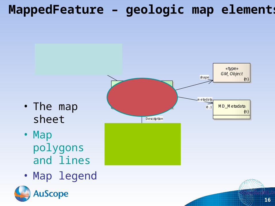
«FeatureType»MappedFeature
+ observationMethod [1..*]+ positionalAccuracy
«type»GM_Object
{n}
SamplingFeature
«FeatureType»SpatiallyExtensiveSamplingFeature
«FeatureType»GeologicFeature
+ observationMethod [1..*]+ purpose = instance
MD_Metadata{n}
shape
samplingFrame
specification1
Description
occurrence 0..*
metadata
0..1
Name:Package:Version:Author:
Overview diagram: MappedFeature«Leaf» GeologicFeature1.0Simon Cox
MappedFeature – geologic map elements
• The map sheet• Map polygons
and lines• Map legend

17
«FeatureType»MappedFeature
+ observationMethod [1..*]+ positionalAccuracy
«type»GM_Object
{n}
SamplingFeature
«FeatureType»SpatiallyExtensiveSamplingFeature
«FeatureType»GeologicFeature
+ observationMethod [1..*]+ purpose = instance
MD_Metadata{n}
shape
samplingFrame
specification1
Description
occurrence 0..*
metadata
0..1
Name:Package:Version:Author:
Overview diagram: MappedFeature«Leaf» GeologicFeature1.0Simon Cox
MappedFeature – use of standards
• ISO 19109 Feature Model
• ISO 19107 Geometry
• ISO 19115 Metadata
• OGC 07-002 Sampling Model
18
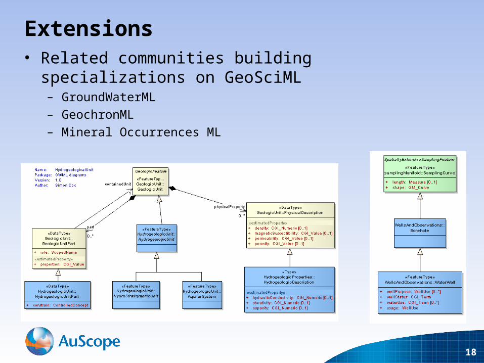
Extensions• Related communities building specializations on
GeoSciML– GroundWaterML
– GeochronML
– Mineral Occurrences ML

AN ORGANISATION FOR A NATIONAL EARTH SCIENCE INFRASTRUCTURE PROGRAM
AuScope 2007-2011

20
RockMaterial
consolidationDegree
compositionCategory
geneticDescription
Lithology: ControlledConcept [1..*]
GeologicUnit+ bodyMorphology: [0..*]+ compositionCategory: [0..1]+ exposureColor: [0..*]+ outcropCharacter: [0..*]+ rank: [0..1]
CompositionPart
+ lithology: ControlledConcept [1..*]+ material: RockMaterial [0..1]+ proportion:+ role:
+composition0..*Lithology
Schematic Agreement
Cardinality
21
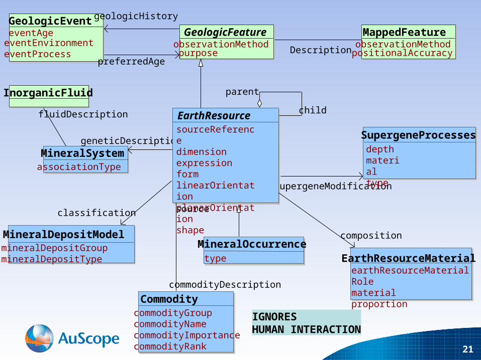
MineralSystemassociationType
geneticDescription
InorganicFluid
fluidDescription
classification
MineralDepositModelmineralDepositGroupmineralDepositType
commodityDescription
CommoditycommodityGroupcommodityNamecommodityImportancecommodityRank
MineralOccurrencetype
supergeneModification
composition
source
SupergeneProcessesdepthmaterialtype
EarthResourceMaterialearthResourceMaterialRolematerialproportion
EarthResourcesourceReferencedimensionexpressionformlinearOrientationplanarOrientationshape
parent
child
GeologicFeatureobservationMethodpurpose
MappedFeatureobservationMethodpositionalAccuracy
GeologicEventeventAgeeventEnvironmenteventProcess
geologicHistory
preferredAgeDescription
IGNORESHUMAN INTERACTION

22
commodityDescription
CommoditycommodityGroupcommodityNamecommodityImportancecommodityRank
MineralOccurrencetype
source
EarthResourcesourceReferencedimensionexpressionformlinearOrientationplanarOrientationshape
parent
childEndowmentincludesReservesincludesResources
OreMeasurecalculationMethoddatedimensionproposedExtractionMethodsourceReferenceestimatedProperty:ore
CommodityMeasurecommodityAmountcutOffGradegrade
ResourcecategoryincludesReserves
Reservecategory
oreAmount
measureDetails
commodityOfInterest

23
commodityDescription
CommoditycommodityGroupcommodityNamecommodityImportancecommodityRank
MineralOccurrencetype
source
EarthResourcesourceReferencedimensionexpressionformlinearOrientationplanarOrientationshape
parent
child
ProductproductNamesourceReferencegradeproductionrecovery
sourceCommodity
deposit
composition
relatedMineassociatedMine
relatedActivity
MiningActivityactivityDurationactivityTypeoreProcessed
MineendDatemineNamesourceReferencestartDatestatus
RawMaterialmaterialproportionrawMaterialRole
producedMaterial
resourceExtraction
MiningFeatureOccurrenceobservationMethodpositionalAccuracy
specification
specification
occurrence