Embed Size (px)
Citation preview

An investigation on the consequential features of Southwest Monsoon-2007 Onset and Super cyclone 'Gonu' using Satellite,
Model and Ground-based dataR. Harikumar1*, Hamza Varikoden2, C. A. Babu3, R. Vishnu4, and G. Mohan Kumar5
1ESSO-Indian National Centre for Ocean Information Services, MoES, Govt. of India, Hyderabad-902Indian Institute of Tropical Meteorology, MoES, Government of India, Pashan, Pune-08
3Department of Atmospheric Sciences, Cochin University of Science and Technology, Cochin-164PG Dept. of Physics, Sree Krishan College, Guruvayur
5Centre for Earth Science Studies, Akkulam, Thiruvananthapuram-31*Corresponding author E-mail: [email protected]
ABSTRACTOnset features of the Summer monsoon-2007 were analyzed using data from five different sources, namely, the Tropical Rainfall Measuring Mission (TRMM) 3-hourly rainfall, National Centers for Environmental Prediction/National Center for Atmospheric Research (NCEP/NCAR) wind reanalysis data set, NOAA Outgoing Longwave Radiation (OLR), cloud imageries from the meteosat satellite,cloud base height and cloud occurrence frequency from a ground-based Vaisala Laser Ceilometer at Thiruvananthapuram. On the day of onset, 33 mm of rainfall was registered by TRMM satellite over south Kerala region with 80% cloud frequency and an averaged cloud base height of 2 km. On the next day, the formation of ‘Gonu’ super cyclone as a consequence of the convergence of monsoon onset surge in the Arabian Sea has caused the dissipation of cloud bands in the Arabian Sea and in the Bay of Bengal, except over the region of the system. This caused a lull situation for about ten days after the India Meteorological Department (IMD) declared monsoon onset. In fact, the remarkable characteristics of onset, such as deepening of westerlies and strengthening of low level jet streams were observed only after two weeks of IMD declared monsoon onset. Another unique behavior of 2007 monsoon onset was that the Arabian Sea branch of monsoon onset surge has advanced faster than the Bay of Bengal branch in the early stage.
INTRODUCTION
The onset of Indian summer monsoon triggers the rainy season, which lasts about four months from June through September (JJAS). The organized zonally oriented convective heat source brings large quantity of rainfall, and such an arrival of the first splash is termed as Indian summer monsoon onset. The first touch of the monsoon surge takes place over Kerala at the end of May or in the beginning of June. The onset of southwest monsoon over Kerala triggers the rainy season in India during which the country receives a major portion of its annual rainfall. The study and the prediction of monsoon onset are important and highly relevant to the Indian community as it depends highly on agriculture. The monsoon takes about 45 days to cover the entire country after the date of onset over Kerala (Rao, 1976). The monsoon onset was defined subjectively by Ananthakrishnan et. al. (1967) and subsequently redefined by Joseph et. al. (2005) in an objective manner. The increase in rainfall during the monsoon onset is also characterised by the changes in circulation pattern and the vertical moisture distribution over the atmosphere. Various aspects of monsoon onset features over Kerala were studied by Ananthakrishnan and Soman (1991), Joseph et. al. (1994), Joseph and Sijikumar (2004) and Pai and Rajeevan
(2007). Identification and studies of monsoon onset with cloud imageries are easier (Rameshkumar, 2004; Simon et. al., 2006) because of very advanced development in the field of satellite meteorology in the last decade. The onset and withdrawal of the southwest monsoon modulates the atmospheric and oceanic circulation in the Indo-Pacific domain (Rao, 1976; Murakami and Nkazawa, 1985; Lau et. al., 1998; Wu and Zhang 1998; Hsu et. al., 1999). Summer monsoon onset is characterised by a rapid and sustained increase in the rainfall over a large area (Ananthakrishnan and Soman, 1988; Soman and Kumar, 1993). An improved definition of the monsoon onset and withdrawal was put forward on the basis of vertically integrated moisture transport over the Arabian Sea by Fasullo and Webster (2003).
Studies were made on the synoptic features of the onset phase of the summer monsoon by Ananthakrishnan et. al. (1968) and Rao (1976). The diagnostic and prognostic features of the monsoon onset were studied from the First Global GARP (Global Atmospheric Research Program) Experiment (FGGE) data set and Monsoon–79 data set (Krishnamurty et. al., 1981; Krishnamurti and Ramanathan, 1982; Pearce and Mohanty, 1984; Slingo et. al., 1988). The main inferences from the above experiments are, 1. the formation and northward movement of a vortex
J. Ind. Geophys. Union ( July 2014 )v.18, no.3, pp:319-329
R. Harikumar et al.
320
in the south Arabian Sea is seen in many years, 2. the intensification and deepening of the low level westerlies are found along with the monsoon onset, 3. the subtropical westerly jet tends to weaken and shift northward during the monsoon onset period and 4. a persistent heavy cloudiness is seen over the south Arabian Sea associated with the onset of monsoon. Soman and Kumar (1993) found that the average date of monsoon onset over south Kerala is 31st May with a standard deviation of 8.5 days. The earliest onset was on 7th May 1918 and the most delayed onset was on 22nd June 1972.
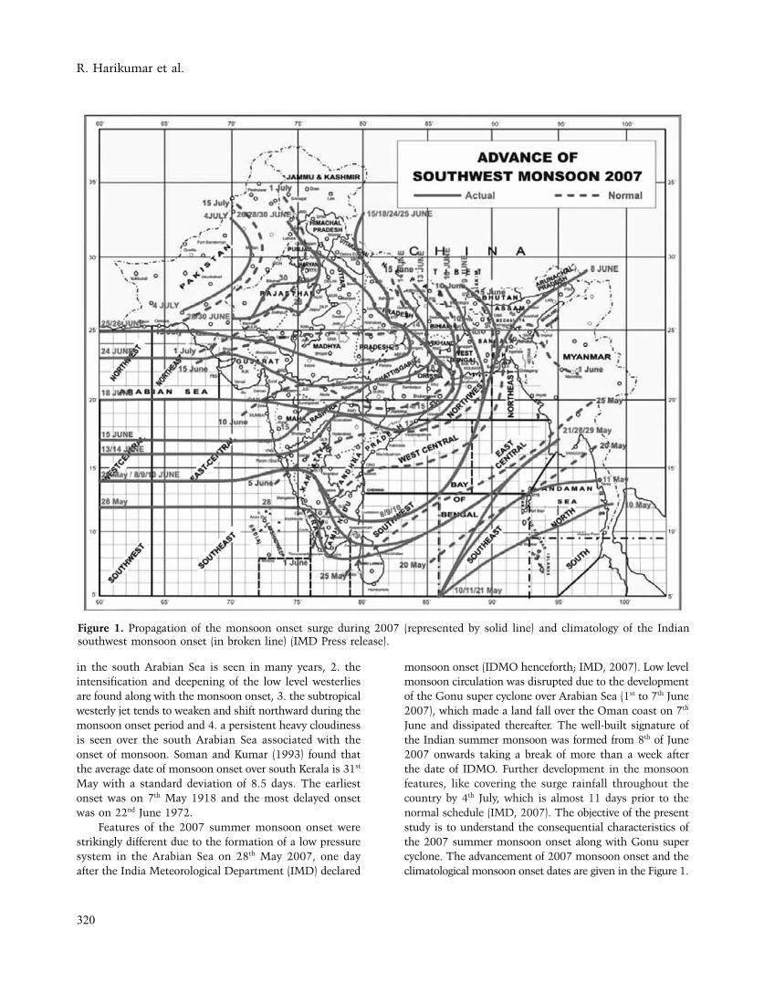
Features of the 2007 summer monsoon onset were strikingly different due to the formation of a low pressure system in the Arabian Sea on 28th May 2007, one day after the India Meteorological Department (IMD) declared
monsoon onset (IDMO henceforth; IMD, 2007). Low level monsoon circulation was disrupted due to the development of the Gonu super cyclone over Arabian Sea (1st to 7th June 2007), which made a land fall over the Oman coast on 7th June and dissipated thereafter. The well-built signature of the Indian summer monsoon was formed from 8th of June 2007 onwards taking a break of more than a week after the date of IDMO. Further development in the monsoon features, like covering the surge rainfall throughout the country by 4th July, which is almost 11 days prior to the normal schedule (IMD, 2007). The objective of the present study is to understand the consequential characteristics of the 2007 summer monsoon onset along with Gonu super cyclone. The advancement of 2007 monsoon onset and the climatological monsoon onset dates are given in the Figure 1.
Figure 1. Propagation of the monsoon onset surge during 2007 (represented by solid line) and climatology of the Indian southwest monsoon onset (in broken line) (IMD Press release).

An Investigation on the consequential features of Southwest Monsoon-2007 Onset and Super cyclone 'Gonu' using Satellite, Model and Ground-based data
321
DATA AND METHODOLOGY
Zonal and meridional wind characteristics were analysed using NCEP/NCAR reanalysis data set. This data set has a spatial resolution of 2.5º X 2.5º latitude-longitude grid and temporal resolution of 6-hourly with 17 vertical levels (Kalnay et. al., 1996). Daily NOAA OLR with the same spatial resolution was also used to identify the organized convective cloud bands in the southwest monsoon domain (Liebmann and Smith, 1996). Further, we have utilised the Tropical Rainfall Measuring Mission (TRMM) rain rate data set (3B42-V6; TRMM satellite-based merged high quality/Infra red precipitation estimates) with a spatial resolution of 0.25º X 0.25º latitude-longitude grid and a temporal resolution of 3-hourly cycles (Kummerow et. al., 1998). Cloud base height and cloud occurrence frequency were analysed from a ground-based Vaisala Laser Ceilometer, CL31 (Varikodan et. al., 2009), which is installed at a coastal station, Thiruvananthapuram (8.52ºN, 76.91ºE) as part of the cloud physics studies.
Time series of daily area averaged rainfall derived from TRMM from 20th May to 30th June, 2007 over the area covered by (75º E-77.5º E & 7.5º N-10º N) was analysed to identify the rainfall pattern before, during and after the onset of southwest monsoon. Infra Red cloud imageries at 00 UTC from the meteosat satellite (courtesy: Dundee satellite observatory) for the period from 28th May to 8th June 2007 were used to describe the evolution of the convective clouds during the monsoon onset and the movement of cloud bands associated with the low pressure system. Daily rainfall at Thiruvananthapuram station derived from TRMM 3-hourly rainfall and also at selected boxes in the Arabain Sea and in the Bay of Bengal, daily OLR pattern for the Indian region, vertical-time section of zonal wind and 3-day composite of TRMM and winds at 850 hPa in the Indian monsoon domain were used for studying the characteristics of summer monsoon during 2007.
RESULTS AND DISCUSSIONS
Figure 2 describes the Infra Red cloud imageries at 00 UTC from the meteosat satellite during and after the monsoon onset during 2007. On 28th May, the organized convective cloud bands appeared over the equatorial region with an extension to the Arabian Sea, and further to the South China Sea through the Bay of Bengal. This feature can be considered as a good signal for the southwest monsoon onset. However, from 30th May, this convective cloud band was started to converge to a small area in the east Arabian Sea. The onset cloud band persisted over the Kerala region for three days and later it has become the part of a well marked low pressure system on 31st May near Goa coast. This system intensified into a tropical cyclone on 2nd
June, and further intensified into a super cyclone on 4th June. This low pressure system started to move towards the Persian Gulf region and made a land fall on 6th/7th June. The Bay of Bengal branch of the convective cloud band was confined to Indonesia and West Bengal region. That means, the cloud band over the entire Bay of Bengal region was fully dissipated due to the low pressure system in the Arabian Sea. After the development of this super cyclone, rainfall receded from the Kerala coast, until its dissipation. From 1st June to 5th June, virtually, there were no clouds over the Kerala region and the entire clouds were in fact concentrated over the cyclonic storm region. While the cyclone entered the land near Oman, the monsoon was found to be reviving in Kerala region, along with the dissipation of the cyclonic system. By 8th of June, the entire southern peninsula was covered with the monsoon clouds and the monsoon surge started its northward migration.
Rainfall from TRMM and in situ measurements of cloud occurrence and average cloud base height are given in Figure 3. This gives an idea about the monsoon onset and its development after a long break/lull. On the day of the IDMO (28th May), the Kerala region (75º E-77.5º E & 7.5º N-10º N) received a rainfall of 33 mm (Figure 3) and the westerlies also deepened up to 500 hPa (Figure 4). This sudden increase in rainfall, speed and depth of wind are sufficient to ‘declare’ this date as the monsoon onset. However, the main condition of the monsoon onset, the maintenance of rainfall for the next few days and keeping the strength and depth of the wind up to 600 hPa, as reported by Ananthakrishnan et. al. (1967) is not satisfied after the formation of the super cyclone Gonu. So, this condition can lead to a confusion about the date of the onset. Kerala region has received a rainfall of less than only 5 mm for two days after the IDMO. The ground-based measurements of cloud occurrence frequency showed that the day of onset was 80% cloudy. After the onset date, the sky over Thiruvananthapuram was 50% clear for the next two days and the cloud cover was less than 25%, thereafter. Since the low pressure system, Gonu was dissipated by 7th June, the monsoon condition was found to be revived and the atmosphere was again cloudy from 8th June onwards (more than 80%). Cloud base height on the day of IDMO was 2 km; but it became 5.3 km by 29th May. It indicates the absence of southwest monsoon clouds, which is generally as low as around 2 km, during this period. The monsoon clouds (with a mean cloud base height of ~ 2 km) started to appear once again from 5th June onwards, even though the revival of the monsoon condition, as a weak current, was on 8th June.
From the analysis of the vertical section of the zonal wind from NCEP/NCAR, the characteristics of the deepening and strengthening of westerlies are evident; however, the depth of the westerlies did not reach up to 600 hPa (Figure 4). The existence of westerlies up to 600 hPa

R. Harikumar et al.
322
and the intensification of Low Level Jetstream (LLJ; 12 ms-1 or more) at the initial phase of the IDMO were absent.Such a development is in contrast to the monsoon onset feature as reported by Joseph et. al. (2006). The strength and the depth of the winds decreased from 31st May onwards, just after the formation of the cyclonic storm, but picked up again from 8th June onwards. During the period of Gonu super cyclone, the lower level wind over the southern
peninsular India and adjoining Arabian Sea was feeble and the westerlies prevailed in a shallow layer (easterly at 750 hPa). This feature resembles closely to the wind pattern during a break monsoon situation. The westerly wind restored its strength and depth after the dissipation of the Gonu super cyclone in the Persian Gulf region. Even though the LLJ was developed in the western Arabian Sea (including Somali coast) on 20th May, the westerly wind
Figure 2. Cloud imageries in the Infra Red band at 00 UTC during 28th May to 8th June, 2007 from Meteosat (courtesy: Dundee satellite observatory)

An Investigation on the consequential features of Southwest Monsoon-2007 Onset and Super cyclone 'Gonu' using Satellite, Model and Ground-based data
323
did not develop into a LLJ over the Kerala coast, although Kerala region received rainfall. The LLJ developed first over Kerala region on 18th June and intensified further into 16 ms-1 on 25th June. The period from 18th to 25th June can be treated as an active monsoon period over Kerala region in association with the development of strong depression in the Bay of Bengal (IMD, 2007). The features can also be seen in the Figure 3.
Hovmoller diagram for Outgoing Longwave Radiation (OLR) averaged over the longitude belt 60º E - 95º E during 20th May to 10th July, representing the northward propagation of the organized cloud bands, as the manifestation of the monsoon onset, is presented in Figure 5. Even though the organized convection similar to monsoon onset was formed over the equatorial region (3oS) on 26th May, it was not fully developed as a monsoon onset surge. The organized convection converged into a
low pressure system and the cloud bands outside the low pressure system were dissipated. The organized convection started to weaken while it moved towards north. Hence, the organized convection formed over the equatorial region gave an impression as monsoon onset surge on IDMO (28th May) in the southern tip of the Indian peninsula and converged in to a low pressure system, which developed further in to a super cyclone, Gonu, in the Arabian Sea. In the Figure 5, a small patch of organized convection can be seen, which existed during 25th May to 28th May in the region from 3o S to 6o N. Revival of the monsoon took place with the formation of a feeble organized convection in the equatorial region on 6th June, after the landfall of the Gonu super cyclone.
Variation of daily TRMM rainfall during 20th May to 30th June over the Arabian Sea (area averaged over 11o N - 12o N & 73o E - 74o EN and over the Bay of Bengal (11o N
Figure 3. Time series of rainfall from TRMM (mm) over the area 7.5º N-10º N & 75º E-77.5º E (top panel), cloud occurrence frequency in percentage (middle panel) and average cloud base height (m) using five-minute data from the ceilometer (bottom panel) over Thiruvananthapuram (8.52º N, 76.91º E) during 21st May-30 June 2007.

R. Harikumar et al.
324
- 12o N & 84o E - 85o E) is shown in Figure 6. The progress of the onset surge in these two domains in the presence of the low pressure system, Gonu is clearly observed. The
evolution of an organized convection during the monsoon onset surge has produced a good amount of rainfall in the Arabian Sea region in the second half of May. However, no
Figure 4. Vertical time section of zonal wind (in pressure level, hpa) averaged over the area 7.5 N -10ºN & 75ºE-80ºE. Arrows represent the wind directions at each level.
Figure 5. Hovmoller diagram for OLR (Wm-2) averaged over the longitude belt 60º E-95º E during 20th May to 10th July 2007, representing northward propagation of the organized convection as part of the monsoon onset.

An Investigation on the consequential features of Southwest Monsoon-2007 Onset and Super cyclone 'Gonu' using Satellite, Model and Ground-based data
325
rainfall occurred in the Bay of Bengal region. Generally, progress of monsoon cloud band is 10 days ahead in the Bay of Bengal compared to that in the Arabian Sea (refer Figure 1). During 2007, monsoon organized convection was not properly developed in the Bay of Bengal. Further, the organized convection evolved over the Arabian Sea on 28th May was converged into a low pressure system by 29th May. The cloud clusters over the Bay of Bengal, though they were not well organized, started to dissipate by the formation of the low pressure system. A good amount of rainfall occurred in the region of the low pressure system over the Arabian Sea, even though monsoon clouds were absent in other parts of the Arabian Sea after the evolution of the low pressure system. Monsoon clouds and rain revived as a weak organized convection, after the landfall of the Gonu system on 6th June. Both the Arabian Sea and the Bay of Bengal regions started to receive monsoon rainfall from 8th June and an intense rainfall during 16th to 25th June (Figure 6).
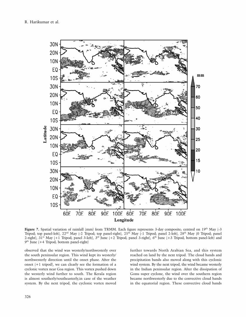
Spatial variation of daily rainfall during the onset phase of monsoon is presented in Figure 7 as three-day composites (3 tripods before, 1 tripod during the onset (28th May) and 4 tripods after the monsoon onset); centered on 19th May (-3 Tripod), 22nd May (-2 Tripod), 25th May (-1
Tripod), 28th May (0 Tripod), 31st May (+1 Tripod), 3rd June (+2 Tripod), 6th June (+3 Tripod) and 9th June (+4 Tripod). We observe that there was no rainfall in -3, -2, +1 and +2 tripods over the southern peninsular region. During IDMO phase, the rain bands were well organized and the onset band extended from the South Arabian Sea to the Bay of Bengal and then to the South China Sea. This can be considered as a typical monsoon onset feature. But after the onset, the rain bands moved to the Oman coast across the Arabian Sea along with Gonu super cyclone. During the cyclone period, the rain bands in the Bay of Bengal also disappeared, and the entire moisture might have diverted in feeding the cyclone. The rain bands started to appear again over the Kerala region only after the dissipation of the cyclone. In +3 and +4 tripods after the onset phase, the raining started in the southern region, and the monsoon features, such as organized rain bands and wind structure, were built up.
We have also analysed the wind characteristics at 850 hPa to know its influence on the onset and consequential development and movement of the Gonu cyclone to its designated region. Figure 8 shows the 3-day composite of the zonal wind at 850 hPa, where the LLJ maxima are found. From the 3 tripod before the onset, it is
Figure 6. Variation of daily TRMM rainfall (mm) from 20th May to 30th June, 2007 at (a) an area average (11o N - 12o N & 73o E - 74o E) over the Arabian Sea (top panel) and (b) over the Bay of Bengal (11o N - 12o N & 84o E - 85o E)
R. Harikumar et al.
326
observed that the wind was westerly/northwesterly over the south peninsular region. This wind kept its westerly/northwesterly direction until the onset phase. After the onset (+1 tripod), we can clearly see the formation of a cyclonic vortex near Goa region. This vortex pushed down the westerly wind further to south. The Kerala region is almost southerly/southeasterly,in case of the weather system. By the next tripod, the cyclonic vortex moved
further towards North Arabian Sea, and this system reached on land by the next tripod. The cloud bands and precipitation bands also moved along with this cyclonic wind system. By the next tripod, the wind became westerly in the Indian peninsular region. After the dissipation of Gonu super cyclone, the wind over the southern region became northwesterly due to the convective cloud bands in the equatorial region. These convective cloud bands
Figure 7. Spatial variation of rainfall (mm) from TRMM. Each figure represents 3-day composite; centred on 19th May (-3 Tripod; top panel-left), 22nd May (-2 Tripod; top panel-right), 25th May (-1 Tripod; panel 2-left), 28th May (0 Tripod; panel 2-right), 31st May (+1 Tripod; panel 3-left), 3rd June (+2 Tripod; panel 3-right), 6th June (+3 Tripod; bottom panel-left) and 9th June (+4 Tripod; bottom panel-right)

An Investigation on the consequential features of Southwest Monsoon-2007 Onset and Super cyclone 'Gonu' using Satellite, Model and Ground-based data
327
and associated westerlies moved further towards north/northeast as the monsoon surge.
CONCLUSION
The main feature of the onset of southwest monsoon during 2007 was the formation of a low pressure system in the Arabian Sea, by merging the organized convection associated with the monsoon onset. The organized convection produced a good amount of rainfall in the southwest peninsular India and adjoining Arabian Sea during the monsoon onset. The TRMM rainfall data showed a peak rainfall of 33 mm at Thiruvananthapuram on the day of the onset. Cloud base height and cloud frequency were properly analyzed in conjunction with the TRMM rainfall and found that the cloud frequency was high and cloud base height was lowered with heavy rainfall. But, before and after the IDMO, the rainfall amount was less than 5 mm. There was a break/lull period of more than a week just after the onset due to the presence of the Gonu super cyclone. The system produced continuous rainfall along its path in the Arabian Sea, until its landfall. The
average cloud base height during intense rainy days was less than 2km. Cloud frequency derived from the ceilometer was around 80%. In contrast to the past rain fall pattern ,the Arabian Sea branch of monsoon onset surge advanced faster than the Bay of Bengal counterpart, in the early stage. Wind characteristics associated with the onset and subsequent monsoon features were fully developed after the landfall of the system which happened after ten days of IDMO date. Important wind features associated with the monsoon onset, such as deepening of westerlies and intensification of low level westerlies were not noticed for two weeks after IDMO date. This break/lull period in the 2007 southwest monsoon was caused by the formation of Gonu super cyclone. After the onset, the organized convection became converted to a low pressure system and the rain bands moved towards the northwest Arabian Sea/Persian Gulf region along with the Gonu cyclone till 7th June. This movement was due to the formation and subsequent propagation of Gonu cyclone, which formed over Arabian Sea, just after the monsoon onset. The landfall of the cyclone occurred on 7th June and the monsoon got revived on 8th June, as a weak current. The monsoon clouds and
Figure 8. Similar to Figure 7, but for the wind (ms-1) at 850 hPa, 3 tripods before, 1 tripod during onset and 4 tripods after the onset tripod.

R. Harikumar et al.
328
rain were absent over the Bay of Bengal region until the revival of the monsoon after two weeks from IDMO date. Part of Arabian Sea and Bay of Bengal surrounding the Indian peninsula started to receive monsoon rainfall from the fresh monsoon organized convection formed over the equatorial region from 8th June onwards.
In nutshell, it can be concluded that the 2007 monsoon had unique consequential features such as formation of a low pressure system in the Arabian Sea just after the onset, a related break/lull period, and building up of extensive monsoonal features after two weeks. This study brought out the peculiarities of the 2007 monsoon onset features in an investigative manner. A detailed analysis for similar years may help in better understanding the reasons for such distinguished monsoonal phenomena.
ACKNOWLEDGMENTS
The authors are thankful to the providers of Meteosat Cloud imagery, NCEP/NCAR reanalysis data, NOAA OLR data and TRMM rainfall data through their websites. Centre for Earth Science Studies, Thiruvananthapuram is thanked for providing the ground-based cloud data. The support of the Director, Indian National Centre for Ocean Information Services is thankfully acknowledged. Hamza Varikoden acknowledges the Director, Indian Institute of Tropical Meteorology, Pune for the support. The support of the Director, CESS is also gratefully acknowledged. This is INCOIS contribution 189.
REFERENCES
Ananthakrishnan, R., and M. K. Soman, 1988. The onset of
southwest monsoon onset over Kerala: 1901-1980. J.
Climatol., v.8, pp:283-296.
Ananthakrishnan, R., U. R. Acharya, and A. R. Ramakrishnan,
1967. On the criteria for declaring the onset of the southwest
monsoon over Kerala. Forcasting manual, FMU, Rep. No. IV-
18.1, India Meteorological Department, Pune, India, pp:52.
Ananthakrishnan, R., Srinivasan. V., Ramakrishnan. A. R., and
Jambunathan R., 1968. Synoptic features associated with
onset of southwest monsoon over Kerala, Forecasting
Manual, Report No. IV-18.2, India Meteorological
Department, Pune, India.
Ananthakrishnan, R., and Soman. M.K., 1991. The Onset of
the southwest monsoon in 1990. Current Science, v. 61,
pp: 447–453.
Hsu, H. H., C. T. Terng, and C. T. Chen., 1999. Evolution of large
scale circulation and heating during the first transition of the
Asian summer monsoon. . J. Climate., v. 12, pp:793-810.
India Meteorological Department., 2007. Southwest monsoon
–2007, Mid season review-2007. Press release dated 6th
August, 2007, pp:7.
Joseph. P.V., 1990. Monsoon variability in relation to equatorial
trough activity over Indian and Western Pacific Oceans.
Mausam, v.41, no.2, pp: 291–296.
Joseph. P.V., Eishcheid, J.K. and Pyle. R.J., 1994. Inter-annual
variability of the onset of the Indian summer monsoon and
its association with atmospheric features, El Nino, and sea
surface temperature anomalies. J Climate, v.7, pp:81–105.
Joseph. P.V., and Sijikumar. S., 2004. Intraseasonal variability of
the low level Jet stream of the Asian Summer Monsoon, J
Climate, v.17, pp:1449–1458
Joseph, P. V., K. P. Sooraj., and C. K. Rajan., 2006. The summer
monsoon onset process over South Asia and an objective
method for the date of monsoon onset over Kerala. Int. J.
Climatol., v.26, pp:1871-1893.
Kalnay, E., Kanamitsu, M., Kirtler, R., Collins, W., Deaven, D.,
Gandin, L., Iredell, M., Saha, S., White, G., Woollen, J., Zhu,
Y., Chelliah, M., Ebisuzaki, W., Higgins, W., Janowiak, J.,
Mo, K. C., Ropelewski, C., Wang, J., Leetma, A., Reynolds,
R., Jenne, R. and Joseph, D., 1996. The NCEP/NCAR
40-year reanalysis project. Bull. Am. Meteorol. Soc., v.77,
pp:437-471.
Krishnamurti, T. N. and Y. Ramanathan., 1982. Sensitivity of the
monsoon onset on differential heating. J. Atmos. Sci., v.38,
pp:1290-1306.
Krishnamurti, T. N., P. Ardanuy, Y. Ramanathan, and R. Pasch.,
1981. On the onset vortex of summer monsoon. Mon. Wea.
Rev,. v.109, pp:344-363.
Kummerow, C., W. Barnes, T. Kozu, J. Shiue and J. Simpson.,
1998. The Tropical Rainfall Measuring Mission (TRMM)
Sensor Package, J. Atmos Ocean Tech, v. 15, pp:809-817.
Lau, K. -M., H. T. Wu and S. Yang., 1998. Hydrologic process
associated with the first transition of the Asian summer
monsoon: A pilot satellite study. Bull. Amer. Meteor. Soc.,
v.79, pp:1871-1882.
Liebmann, B. and C. A. Smith., 1996. Description of a complete
(Interpolated) Outgoing Longwave Radiation data set. Bull.
Amer. Meteor. Soc., v.77, pp:1275-1277.
Murakami, T., and T. Nakazawa., 1985. Transition from the
southern to northern hemisphere summer monsoon, Mon.
Wea. Rev., v.113, pp:1470-1486.
Pai, D.S. and M. Rajeevan., 2007. Indian Summer Monsoon Onset:
Variability and Prediction, National Climate Centre Research
Report No: 4/2007, India Meteorological Department, pp:24.
Pearce, R. P. and U. C. Mohanty., 1984. Onset of the Asian summer
monsoon 1979-82. J. Atmos. Sci., v. 41, pp:1620-1639.
Rameshkumar, M.R., 2004. Forecasting of Onset of southwest
Monsoon Over Kerala coast using satellite data, IEEE
Geosciences and Remote Sensing Letters, v.1, no.4, pp:265-
267.
Rao, Y. P., 1976. Southwest monsoon, Synoptic meteorology,
Meteor. Monogr., No. 1/1976, India Meteorological
Department, pp:367.
Simon B., Rahman S.H., and Joshi P.C., 2006. Conditions leading
to the onset of the Indian monsoon: a satellite perspective.
Meteorol Atmos Phys, v.93, pp: 201–210.

An Investigation on the consequential features of Southwest Monsoon-2007 Onset and Super cyclone 'Gonu' using Satellite, Model and Ground-based data
329
Slingo, J. M., U. C. Mohanty, M. Tiedke., and R. P. Pearce.,
1988. Prediction of 1979 summer monsoon onset with
modified parameterisation schemes. Mon. Wea. Rev., v.116,
pp:328-346.
Soman, M. K., and K. K. Kumar., 1993. Space time evolution of
meteorological features associated
with the onset of Indian summer monsoon. Mon. Wea. Rev.,
v.121, pp:1177-1194.
Varikoden, H., R. Harikumar, S. Murali Das, S. Sampath., and
G. Mohan Kumar., 2009. Properties of cloud base height
during southwest monsoon period over a tropical station,
Thiruvananthapuram, Current Science, v.96, no.4, pp:
562-568.
Wu, G. X, and Y. S. Zhang., 1998. Tibetan plateau forcing and the
timing of the monsoon onset over south Asia and the South
China Sea. Mon. Wea. Rev., v.126, pp:913-927.
Dr. R. Harikumar, is a Scientist and in-charge of Ocean State Forecast services at ESSO-Indian National Centre for Ocean Information Services (ESSO-INCOIS). He took his Ph.D. in Physics (Atmospheric Science) from Cochin University of Science and Technology in 2010. Currently, he works in the fields of operational oceanography and marine meteorology. He has research experience in Earth system science for more than 9 years. He has published 12 papers in the national/international peer-reviewed journals and 33 in conference/symposium proceedings. He has written a book on Tropical rain Drop Size Distribution and integral rain parameters.
Dr. Hamza Varikoden is a scientist at Indian Institute of Tropical Meteorology, Pune. Presently he is carrying out hydrological modelling and climate change studies. He received his Ph. D in Atmospheric Sciences from Cochin University of Science And Technology, Kochi in 2008. Before joining IITM, he worked at Centre for Earth Science Studies, Thiruvananthapuram and University of Malaya, Kuala Lumpur, Malaysia. He has published 23 peer reviewed publications.
Dr. C A Babu is a Professor at Cochin University of Science and Technology for the last 24 years. He has more than 30 peer reviewed publications, one book and one book chapter in addition to number of conference contributions. He is actively involved in research to unravel the various issues of monsoon system. He worked as PI of many research projects funded by various government organizations. Presently he is the head of Atmospheric Science Department and Director of School of Marine Sciences of Cochin University of Science and Technology.
Dr. R. Vishnu is working as Assistant Professor of Physics at the Guruvayur Devaswom Sreekrishna College, Guruvayur, Thrissur. He holds a Ph. D. in Science from the University of Kerala in Cloud Physics. He has been working in lightning studies and related instrumentation for the last eight years. He has about 25 publications to his credit. He is a recipient of Young Scientist award (2008) of the Kerala State Council for Science, Technology and Environment, Gov.of Kerala.
Dr. G. Mohan Kumar was a Scientist with the Atmospheric Sciences Division, Centre for Earth Science Studies, Thiruvananthapuram. He received Ph.D in Physics from the CUSAT. His present research interests include atmospheric trace gas measurements, solar UV-B and cloud physics.