Embed Size (px)
Citation preview
AN INVESTIGATION INTO THE LATE NEOLITHIC
AND EARLY BRONZE AGE ROUND BARROW MONUMENTS IN THE
WYLYE VALLEY, WILTSHIRE
by
SIMON MARK HOWARTH
A thesis submitted to The University of Birmingham
for the degree of MASTER OF PHILOSOPHY
University of Birmingham Research Archive
e-theses repository This unpublished thesis/dissertation is copyright of the author and/or third parties. The intellectual property rights of the author or third parties in respect of this work are as defined by The Copyright Designs and Patents Act 1988 or as modified by any successor legislation. Any use made of information contained in this thesis/dissertation must be in accordance with that legislation and must be properly acknowledged. Further distribution or reproduction in any format is prohibited without the permission of the copyright holder.
This thesis examines the significance of funerary practices and monuments dating to the Late Neolithic and Early Bronze Age in and around the Wylye Valley to the west of Stonehenge. This has been conducted through the re-evaluation of the work of Sir Richard Colt Hoare and the production of a database and Geographical Information System using the Wiltshire Sites and Monuments Record. The motivation behind why the monuments were positioned where they were has been attempted through spatial analysis within the GIS. The critical examination of the primary excavation data is based on modern interpretive frameworks and the interpretations which have been formed are re-examined to meet new thinking. The results of the thesis indicate the concentration of barrows towards the top of the valley on the northern escarpment and the clustering of barrows around older features in the landscape. This is similar to the spatial patterns observed nationally, supporting previous research and the interpretations drawn, though there appears to be a higher concentration of primary cremations and more nucleated cemeteries in the Wylye Valley area which may indicate local trends.

For all my family, whose love and support throughout the course of this thesis will never be forgotten

My extreme gratitude goes to my thesis supervisor, Mr. Paul Garwood for his expertise, consideration and patience.
Your enthusiasm for prehistory has been an inspiration and will help me motivate
others.

Table of Contents 1. Introduction
1.1 Aim of the thesis and selection of study area……………………………...1 1.2 Late Neolithic and Early Bronze Age Periods in Britain and Burial
Practices…………………………………………………………………...4 1.3 Archaeological and Historical Background of the Study Area…..………10 1.4 Geology and Topography of the Study Area………………………..……13 1.5 Research Objectives……………………………………………………...14 1.6 Methodology……………………………………………………………..16
2. Data Collection and Related Work 2.1 Data collection, methodology and initial reflections……………………..18 2.2 Global Information Systems……………………………………………...21 2.3 The spatial database and analytical methods …………………………….24 2.4 Related work in Britain…………………………………………………..29
3. Data and Analysis 3.1 Arrangement of barrow data………………………………………..…….32 3.2 Analysis of the barrow data in ST94SW…………………………………32
3.2.1.1 Middle Hill (MH) Group……………………..…...…...…33 3.2.1.2 Scratchbury Hill (SH) Group…………………………….37 3.2.1.3 Cotley Hill (CH) Group…………………………………..41 3.2.2.1 Norton Bavant (NB) Group…………………………..…..45 3.2.2.2 Sutton Veny (SV) Group…………………………………51 3.2.2.3 The Knoll (TK) Group…………………………………...52 3.2.2.4 Tytherington (T) Group…………………………………..58 3.2.2.5 Heytesbury (H) Group……………………………………59 3.2.3 Golden Barrow (GB) Group……………………………...59 3.2.4.1 West Hill (WH) Pair……………………………..……….62 3.2.4.2 Knook Village (KV) Barrow……………………..………63
3.3 Analysis of barrow data in ST94SE………………………………...…..64 3.3.1 Knook Barrow (KB) Group…………….………………...65 3.3.2 Upton Lovell (UL) Group……………………..…………69 3.3.3 Codford Down (CD) Group……………………...………76
3.4 Analysis of the barrow data in ST93NE………………………….……...82 3.4.1 Lamb Down (LD) Group…………………………………83 3.4.2.1 Stockton Earthworks (SE) Group……………………...…88 3.4.2.2 Queen's Barrow (QB) Plantation Pair…………………....89 3.4.3.1 Sherrington Plantation (SP) Group……………………....90 3.4.3.2 Boyton Down (BD) Group……………………………….90
3.5 Analysis of the barrow data in ST93NW…………………………...…..92 3.5.1 Eastern Barrows……………………………………...…..92 3.5.2 Western Barrows……………………….…………..…….93
3.6 Analysis of barrow data in SU03NW……………………………….….95 3.6.1.1 Field Barn Group……………………………...….………96 3.6.1.2 Yarnbury Grange Group……………………………….…96 3.6.1.3 Deptford Field Barn Group……………………………....97 3.6.1.4 Gilbert’s Plantation Pair……………………………...…..99 3.6.2.1 New Covert Pair……………………………………….…99 3.6.2.2 Manor Farm Feature…………………………………..….99 3.6.3.1 Bilbury Rings Barrow…………………………………..101

3.6.3.2 Wylye Village Barrow………………………..…………101 3.6.4.1 East Castle Group……………………………………….102 3.6.4.2 Langford Long Group…………………………………..103 3.6.4.3 Steeple Langford Group………………………………...103
3.7 Analysis of barrow data in SU03NE……………………………………104 3.7.1 Lawn Group……………………………...…...………....104 3.7.2.1 Druid’s Lodge Group……………………...……....……106 3.7.2.2 South Kite Group………………………………….……106 3.7.3 Hungerford Lodge Farm Group………………….……..107
3.8 Analysis of barrow data in SU03SE………………………….…………108 3.8.1 Wilton Park Barrow…………………………………….109 3.8.2 Hadden Hill Feature…………………………………….111
4. Interpretation 4.1 Spatial patterns in the siting of monuments…………………………….112 4.2 The contents of the round barrows of the Wylye Valley……………….117 4.3 Monumental architecture of the Late Neolithic and Early Bronze Age in
the Wylye Valley……………………………………..…………………122 4.4 The ‘meaning’ of the spatial distribution of the monumental architecture of
the Wylye Valley………………………………………………...……...124 5. Conclusion
5.1 Summary of results……………………………………………….……..127 5.2 Key outcomes of the study……………….……………………….…….129 5.3 Implications and further work………………..…………………………130
Appendix List of monuments described in data and analysis section……………………133 Description of the contents of the CD-R………………………………...……138
Bibliography 1.1 Cartographic Sources……………………...………………..…………..139 1.2 Sources…………………………………………………...……………..139 1.3 Figures…………………………………………………………………..144
List of Illustrations Figure 1: A map highlighting the Wylye Valley and the county of Wiltshire……...…2 Figure 2: Time chart for barrows and ceramics in Britain………………………….....5 Figure 3: Key forms of round barrow in the Wylye Valley…………………………...7 Figure 4: Classification of the ‘wealth’ of Wessex Series graves according to the number of objects present…………………………………………………………….10 Figure 5: River systems and settlements related to the Wylye Valley………….……14 Figure 6: Study area with OS grid references………………………………………..19 Figure 7: Relationship diagram for Access database………………………………...19 Figure 8: Four separate spatially referenced layers…………………………..………22 Figure 9: Monument information in GIS with spatial information……………..……23 Figure 10: The major elements of a GIS……………………………………………..25 Figure 11: Possible patterns of points on a map………………………………….…..25 Figure 12: Characteristics of vector and raster data………………………………….27 Figure 13: Testing for intervisibility using viewshed analysis………………...…….28 Figure 14: Distribution of barrows and ring ditches in central Southern England ….31 Figure 15: Descriptions of the different forms of spatial patterns………………...…33 Figure 16: The monuments of ST94SW……………………………………………..33 Figure 17: Middle Hill Group…………………………………………………..……34 Figure 18: MH01 seen from Scratchbury Hill……………………………………….35 Figure 19: Burial types present in Middle Hill group………………………………..35 Figure 20: Scratchbury Hill…………………………………………………………..36 Figure 21: Two bone finds from SH06………………………………………………38 Figure 22: Metal finds from SH05…………………………………………………...38 Figure 23: Finds from SH05………………………………………………………….39 Figure 24: Burial types present in Scratchbury Hill group…………………………..40 Figure 25: View towards Cotley Hill group from SH05……………………………..41 Figure 26: Cotley Hill group…………………………………………………………42 Figure 27: Cotley Hill OS First Edition Map…………………...……………………43 Figure 28: Barrow forms present in Cotley Hill group………………………………43 Figure 29: Norton Bavant Group…………………………………………………….45 Figure 30: NB01……………………………………………………………………...46 Figure 31: NB03……………………………………………………………………...47 Figure 32: NB06 Site plan with the excavated features from trenches A and C……..47 Figure 33: NB06 Primary inhumation in trench C…………………………………...49 Figure 34: NB06 Primary inhumation grave goods………………………………….50 Figure 35: Burial types present in Norton Bavant group…………………………….51 Figure 36: Sutton Veny Group……………………………………………………….52 Figure 37: The Knoll Group………………………………………………………….53 Figure 38: TK07 trial borings………………………………………………………...54 Figure 39: TK08 Site plan and central grave………………………………………...55 Figure 40: TK08 Miniature vessel and food vessel…………………………………..56 Figure 41: The Knoll Group Barrow Form and Burial Type………………………...57 Figure 42: Tytherington Group………………………………………………………58 Figure 43: Heytesbury Group………………………………………………………...59 Figure 44: Golden Barrow Group……………………………………………………60 Figure 45: GB04 Amber necklace, gold beads and gold plate……………………….61 Figure 46: GB04 Grave goods……………………………………………………….62 Figure 47: West Hill Pair…………………………………………………………….63

Figure 48: Knook Village Barrow……………………………………………………64 Figure 49: Monuments of ST94SE…………………………………………………...65 Figure 50: Knook Barrow Group…………………………………………………….66 Figure 51: KB07 Bronze knife dagger……………………………………………….67 Figure 52: Knook Barrow Group Burial Types……………………………………...68 Figure 53: Knook Barrow Group Barrow Forms…………………………………….69 Figure 54: Upton Lovell Group………………………………………………………70 Figure 55: UL01 Necklace…………………………………………………………...71 Figure 56: UL01 Upton Great Barrow……………………………………………….71 Figure 57: UL02 Bronze dagger……………………………………………………...72 Figure 58: UL03 Grave goods from two primary inhumations………………………72 Figure 59: UL03 polished circular stone ‘rubber’……………………………………74 Figure 60: Bone tweezers and miniature vessel……………………………………...76 Figure 61: Upton Lovell Group Barrow Forms……………………………………...77 Figure 62: Upton Lovell Group Burial Types………………………………………..77 Figure 63: Codford Down Group…………………………………………………….78 Figure 64: Codford Down Barrow Forms……………………………………………78 Figure 65: Codford Down Burial Types……………………………………………..79 Figure 66: Left CD10 Stone battle axe; Right CD13 Stone battle axe……………….81 Figure 67: The monuments of ST93NE……………………….……………………..82 Figure 68: Lamb Down Group……………………………………………………….84 Figure 69: Lamb Down Group excavation plan……………………………………...84 Figure 70: LD02 Site Plan……………………………………………………………85 Figure 71: LD03 Site Plan……………………………………………………………85 Figure 72: LD07 Site Plan……………………………………………………………87 Figure 73: Lamb Down Burial Types………………………………………………..88 Figure 74: Stockton Earthworks Group……………………………………………...89 Figure 75: Queen's Barrow Group…………………………………………………...89 Figure 76: Sherrington Plantation Group…………………………………………….91 Figure 77: Boyton Down Group……………………………………………………...91 Figure 78: Boyton Down Burial Types………………………………………………92 Figure 79: The monuments of ST93NW……………………………………………..93 Figure 80: Eastern Barrow Group……………………………………………………94 Figure 81: Western Barrow Group…………………………………………………...94 Figure 82: The monuments of SU03NW…………………………………………….95 Figure 83: Field Barn Group…………………………………………………………96 Figure 84: Yarnbury Grange Group………………………………………………….97 Figure 85: Deptford Field Barn Group……………………………………………….98 Figure 86: DF01 1. Miniature vessel 2. Beaker ware handle 3. Grooved ware……...98 Figure 87: Gilbert's Plantation Pair Group………………………………………….100 Figure 88: New Covert Pair Group…………………………………………………100 Figure 89: Manor Farm Feature Group……………………………………………..100 Figure 90: Bilbury Rings Barrow…………………………………………………...101 Figure 91: Wylye Village Barrow…………………………………………………..101 Figure 92: East Castle Group……………………………………………………….102 Figure 93: Langford Long Group…………………………………………………...103 Figure 94: Steeple Langford Group…………………………………………………104 Figure 95: The monuments of SU03NE…………………………………………….105 Figure 96: Lawn Group……………………………………………………………..105 Figure 97: Druid's Lodge Group……………………………………………………106

Figure 98: Druid's Lodge Group (1st Edition OS Map)……………………………..107 Figure 99: South Kite Group………………………………………………………..107 Figure 100: Hungerford Lodge Group……………………………………………...108 Figure 101: The monuments of SU03SE…………………………………………...109 Figure 102: Wilton Park Barrow……………………………………………………110 Figure 103: WP01 View north towards South Newton……………………………..110 Figure 104: Hadden Hill Feature……………………………………………………111 Figure 105: View of the Boyton Down barrow group from the valley floor……….114 Figure 106: Viewshed of WV01, GP01 and GP02…………………………………115 Figure 107: Breakdown of primary burial rites in known round barrows in the Wylye Valley……………………………………………………………………………….118 Figure 108: Barrow forms present in the Wylye Valley……………………………123 Figure 109: Distribution of barrows and ring ditches in central Southern England...125 Figure 110: Statistical quantification of the landscape location of the barrow cemeteries of the Wylye Valley…………………………………………………….126 Figure 111: Main screen of the database……………………………………………128 Figure 112: Main data entry form………………………………….……………….129
1 of 148
1. Introduction
1.1 Aim of the thesis and selection of study area
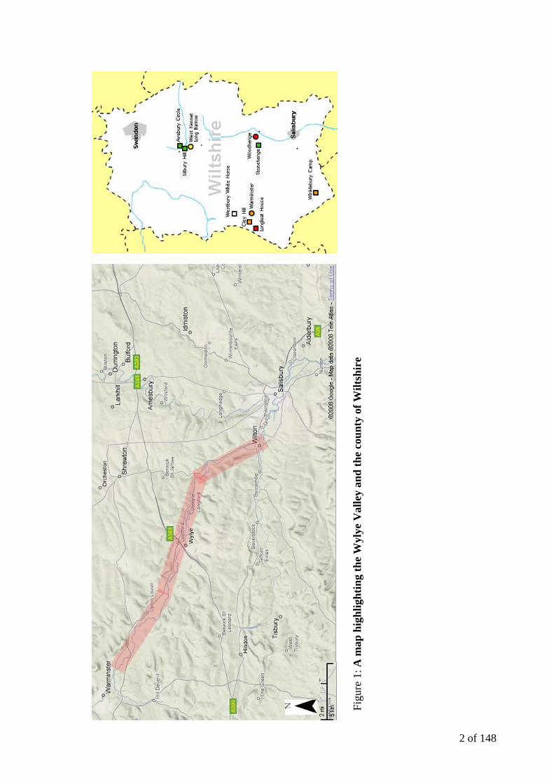
This thesis aims to analyse the significance of funerary practices and monuments in and
around the Wylye Valley to the west of Stonehenge, as shown on the next page (Figure 1).
The premise of the work is an exploration of the spatial relationships between the
monuments and the Wylye Valley landscape and discern the rationale behind the
positioning and development of the funeral monuments and funerary complexes. This work
will be conducted using a digital environment created in a geographical information system
with accompanying database. This focus on the funerary practices and monuments in the
study area is significant as the Wylye Valley has not been considered as a landscape unit by
any previous research, though it includes some of the richest Early Bronze Age burial
assemblages in Britain and is remarkably close to Stonehenge, which has benefited from
many detailed studies, notably in Stonehenge and its Environs (RCHME: 1979), The
Stonehenge Environs Project (Richards: 1990), Stonehenge in its Landscape (Cleal et al:
1995), Stonehenge Landscapes (Exon et al: 2000) and most recently Stonehenge: The
Biography of a Landscape (Darvill: 2006).
These studies of the Stonehenge landscape, to the northeast of the Wylye Valley, focus
specifically on the Stonehenge landscape and its archaeological context. The intention of
this thesis is to investigate the spatial organisation and chronological development of the
round barrow groups present in the Wylye Valley by examining both excavated funerary
monuments and probable unexcavated funerary monuments (in the form of crop marks) that
have been identified in the landscape. Antiquarians originally excavated a large proportion
of the round barrows present within the Wylye Valley and very few have been re-excavated
using modern archaeological methods.
2 of 148
Figu
re 1
: A m
ap h
ighl
ight
ing
the
Wyl
ye V
alle
y an
d th
e co
unty
of W
iltsh
ire
3 of 148
Perhaps the most famous and active of the antiquarians who excavated in and around
the Wylye Valley were William Cunnington and Sir Richard Colt Hoare who investigated
many of the ancient monuments at the beginning of the nineteenth century in an attempt to
compile a history of Wiltshire (Colt Hoare 1812:viii) that was eventually published in two
volumes titled The Ancient History of Wiltshire in 1812 and 1821.
The body of data generated by such antiquarians as Cunnington and Colt Hoare has
been a foundation for research into the Neolithic and Bronze Age in Wiltshire. Colt Hoare
opened his introduction to The Ancient History of Wiltshire with the words ‘We speak from
facts, not theory’ (Colt Hoare 1812:7) highlighting his attempt to provide a body of material
evidence relating to Britain’s prehistoric past. It is perhaps the lack of a theoretical
framework that limits the interpretations present in the accounts of the barrow excavations
Colt Hoare conducted. The emerging ‘Three Age System’ is not referred to in Colt Hoare’s
work, although Cunnington appears to have begun to consider the possibility in his own
notes (Colt Hoare 1812:xv). This in turn has resulted in many of Colt Hoare’s ideas
regarding the dating and meaning of what was excavated now being discounted by modern
archaeological thought.
The fact that much of the archaeological evidence relating to the Wylye Valley lacks
modern theoretical analysis may be remedied through a re-evaluation of Colt Hoare’s work
with the use of modern archaeological theory and interpretive frameworks. The inconsistent
nature of some of the older records relating to a number of the monuments may well mean
that a detailed analysis of the chronological development of the round barrow groups is
unachievable.
The placement of structures within the landscape is most often examined in relation to
enclosed spaces (Parker Pearson and Richards 1994:3) but this usage is not exclusive. The

4 of 148
visual setting may well have been an important element in the design of prehistoric
landscapes and the work of individuals such as Chris Tilley in A Phenomenology of
Landscape: places, paths and monuments (1994) suggests (using carefully chosen
examples) that the capacity to see earlier monuments and natural features was a significant
factor in the positioning of monuments.
Attempts have been made to envisage the funerary landscape of the Late Neolithic and
Early Bronze Age as being designed to follow set ‘rules’, for example Woodward and
Woodward (1996:275) suggested that cemetery layouts in Bronze Age Wessex reflected the
circular shape of the round barrows they contained. This idea of an unchanging structural
‘blueprint’ for an area is based upon an indistinct understanding of how barrow groups
developed over time and may therefore be enhanced through a better understanding of the
detailed chronologies of individual cemeteries.
This is what makes an investigation of the landscape placement of funerary monuments
in and around the Wylye Valley so important. To better understand the cultural significance
of round barrows and the role that they played in the Late Neolithic and early Bronze Age
landscape, a clearer understanding of the relationship between monuments and their
landscape is required at a regional (as opposed to national) level.
1.2 Late Neolithic and Early Bronze Age Periods in Britain and Burial Practices
The monumental architecture of the Late Neolithic and Early Bronze Age (2500-1500
BC) is typically visible in the modern landscape as circular mounds. These tumuli, or burial
mounds, are the most common prehistoric monuments in the British landscape (Ashbee
1998:6) and are separate from the wholly Neolithic funerary monuments known as long
barrows. When Thurnam published his survey of British barrows from 1869 to 1872, long

5 of 148
and the round barrows were separated not only by their shapes but also by the nature of the
funerary deposits that they contained (Barrett 1990:180). Long barrows were constructed as
earthen or drystone mounds with flanking ditches and acted as funerary monuments
between around 3800 and 3300 cal. BC (Whittle et al 2007:142). Long barrows often
produced the disarticulated remains of more than one individual in a single deposit with few
associated artefacts, whereas round barrows often covered primary graves containing single
graves, sometimes with associated grave goods (Barrett 1990:180).
Round barrows can be divided into distinctive sub-categories by their shape, diameter,
height and composition (Woodward 2000:16). There are two major classifications relating
to monument composition. The term barrow means a mound of earth, whilst monuments
constructed of stones are often referred to as cairns (Ashbee 1998:6). The material used was
often the most readily available (Burgess 1980:305) and in chalkland landscapes the most
common form of barrow is the bowl barrow (Woodward 2000:19). Often superficially
similar, round barrows can differ widely in size; a review of the published accounts of
twentieth-century excavations in the area around Stonehenge suggests that barrows range
from as small as 3 metres in diameter up to a size of 26 metres (Lawson 2007:205). Bowl
barrows exhibit regional variations both in form and in the diversity of burial practices and
their construction commonly dates from the Late Neolithic period to the Late Bronze Age,
Figure 2: Time chart for barrows and ceramics in Britain

6 of 148
with most examples belonging to the period between 2400 and 1500 BC.
The main categories of Early Bronze Age pottery associated with the Wylye Valley
round barrows begin with Beaker vessels. A speculative ceramic sequence places Beaker
pottery and Grooved Ware as the earliest grave goods in the monuments dating to the Late
Neolithic and Early Bronze Age. Grooved Ware began to be deposited in around 2800 BC
and ceased to be manufactured around 2000 BC (Gibson 2002:84), whereas Beaker vessels
began to appear in the archaeological record in Britain around 2400 BC (Gibson 2002: 92).
Collared Urns and Deverel Rimbury vessels signify later deposits within the chronological
framework for prehistoric ceramics (Pearson in Hunter 81:1999) as reproduced in Figure 2.
Round barrows occur either in isolation or grouped as cemeteries and often acted as a
focus for burials in later periods (in the form of inserted burials). These round barrow
cemeteries usually date to the Bronze Age (c.2500-700 BC). They developed over a
considerable period of time, often many centuries, and can be investigated for spatial
grouping of particular burial practices and funerary goods (Woodward 2000:73). They
exhibit considerable diversity of burial rite, plan and form, frequently including several
different types of round barrow and are occasionally associated with earlier monuments
(Lawson 2007:207). Barrow cemeteries are usually divided into nucleated or linear (with
barrows spaced less than 100 metres apart), dispersed (for barrows spaced out between 100
and 150 metres) or area cemeteries (for barrows spread over a distance of 200 to 400
metres) (Woodward 2000:73) but such classification can be considered subjective. Single
cemeteries can contain their own internal groupings; for example a nucleated cemetery may
display an internal linear element. The Wylye Valley contains a predominant number of
dispersed cemeteries at the heads and sides of the main valley and the joining smaller
valleys (Section 3).
7 of 148
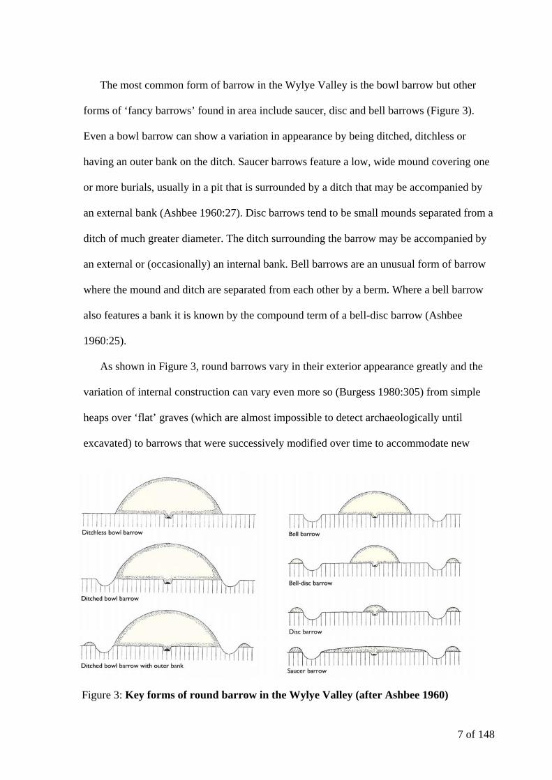
The most common form of barrow in the Wylye Valley is the bowl barrow but other
forms of ‘fancy barrows’ found in area include saucer, disc and bell barrows (Figure 3).
Even a bowl barrow can show a variation in appearance by being ditched, ditchless or
having an outer bank on the ditch. Saucer barrows feature a low, wide mound covering one
or more burials, usually in a pit that is surrounded by a ditch that may be accompanied by
an external bank (Ashbee 1960:27). Disc barrows tend to be small mounds separated from a
ditch of much greater diameter. The ditch surrounding the barrow may be accompanied by
an external or (occasionally) an internal bank. Bell barrows are an unusual form of barrow
where the mound and ditch are separated from each other by a berm. Where a bell barrow
also features a bank it is known by the compound term of a bell-disc barrow (Ashbee
1960:25).
As shown in Figure 3, round barrows vary in their exterior appearance greatly and the
variation of internal construction can vary even more so (Burgess 1980:305) from simple
heaps over ‘flat’ graves (which are almost impossible to detect archaeologically until
excavated) to barrows that were successively modified over time to accommodate new
Figure 3: Key forms of round barrow in the Wylye Valley (after Ashbee 1960)
8 of 148
burials or innovative ceremonies (Burgess 1980:310). Some barrows appear to have
undergone ‘open periods’ where grave pits were left unfilled after an interment was made,
whereas others appear to have had pits or even barrows ‘re-cut’ to insert further
contemporary or later burials. Cist graves are present within the Wylye Valley, which was a
popular form of burial in Ireland and northern Britain (Burgess 1980:312)
During the first half of the second millennium BC the richly furnished graves known as
Wessex Series burials begin to appear. Wessex Series was a phrase developed from Stuart
Piggott’s attempts to describe a small proportion of the graves dating to the Early Bronze
Age containing a higher frequency of valuable items (Burgess 1980:99). Today these grave
deposits are interpreted with reference to ‘processes of indigenous social change’ (Barrett
1990:180), rather than being perceived as an intrusive aristocratic minority being
represented by the wide range of burial goods represented. These Wessex graves are now
explained as almost an attempt to be eye-catching by the native elite who were concerned
with how their own individual status would be remembered (Barrett 1990:181). This form
of social display seems to have its roots in the rise of single grave traditions that are
characterised by Beaker graves in the Late Neolithic (Barrett 1990:181).
Using dagger typologies, it appears that there were two successive phases of Wessex
Series burials – Early Dagger Graves or Wessex I and Late Dagger Graves (known as
Wessex II) (Lawson 2007:219). Typically Wessex I graves may contain either cremations
or inhumations whereas Wessex II almost entirely contain cremation (Woodward
2000:103). Early Dagger Graves are typified by rich grave goods such as gold work and
pendants and a lack of large urns and are generally considered to date between 2000 and
1750 BC (Lawson 2007:220). The wealth of such early grave assemblages may have been
related to the arrangement of the funeral rites (Barrett 1990:184).

9 of 148
After 1750 BC Wessex II graves are dominated by cremations. Collared Urns, already
well established by this date (Figure 2) are used to collect the cremated remains in many
cases Lawson 2007:230). Cremation urns are rare in the Wessex II deposits (Barrett
1990:184), and daggers, bronze pins and beads rose in frequency along with the inclusion
of bone tweezers (Woodward 2000:103). In many cases the ashes of the individual appear
to have been deposited adjacent to the funeral pyre, and in some cases are buried beneath a
single barrow mound (Ashbee 1960: 20).
It is easy to imagine that every barrow in the region contained a wealth of grave goods
yet the majority of barrows that covered graves dating to the Wessex Series or Beaker rites
cover cremations placed in small pits (Lawson 2007:238). This means that, with regard to
this study it is important to define how ‘rich’ each grave is (in addition to its date where
possible). With regards to the ‘wealth’ of Wessex Series graves, Exon et al (2000) used a
simple but very effective system to classify each barrow that contained a Wessex grave
according to the number of objects that it contained (Exon et al 2000:80-81), as reproduced
in Figure 4. Each type of object associated with the interment is counted as one in terms of
material (i.e. if a single item is made of more than one material it would be counted more
than once) and the graves are grouped into three categories: one to two items is a ‘Standard’
Wessex grave, three to five items is a ‘Rich’ Wessex grave and a grave with six or more
items would be considered a ‘Wealthy’ Wessex grave (Exon et al: 2000:81). This
methodology has been utilised for Wessex Series graves encountered in the Wylye Valley
study area.

10 of 148
1.3 Archaeological and Historical Background of the Study Area
The Wylye Valley lies within the county of Wilshire in the south of England. Wiltshire
is well known for its prehistoric landscape dating from as far back as the Mesolithic. The
most complete and extensive survival of chalk downland archaeological remains in central
southern England occurs on Salisbury Plain to the north of the study area with a number of
the barrows included in the study being preserved on Ministry of Defence land. Salisbury
Plain has been used by the British Army for training purposes and some arable farming
since the land was first purchased for military training in 1897 and its primary use for
military purposes has allowed the area to be largely unaffected by man during the past 110
years (McOrmish, Field & Brown 2002:2).
With fascinating monuments such as Stonehenge and Avebury visible in the county it
is easy to understand why scholars in the eighteenth and nineteenth centuries sought to visit
and attempt to interpret the ancient remains of Wiltshire (Darvill 2006:41). This focus on
Figure 4: Classification of the ‘wealth’ of Wessex Series graves according to the number of objects present (after Exon et al 2000)
11 of 148
the history of the area around Stonehenge (including the Wylye Valley) led to the
excavation of the barrows that were visible in the vicinity by a number of antiquarians,
none more famous than William Cunnington and Sir Richard Colt Hoare.
Colt Hoare is perhaps the better known of the pair as he was a man of wealth whose
fortune was able to fund the publication of The Ancient History of Wiltshire whereas
Cunnington was a tradesman who helped to plan and collect material for the manuscript
(Cunnington 1975:1). In all Colt Hoare and Cunnington opened no less than 465 barrows in
Wiltshire (Colt Hoare 1975:xiv). It is unclear what first motivated William Cunnington
(1754-1810) to excavate barrows other than that his poor health demanded outdoor pursuits
(Annable and Simpson 1964:1). Cunnington’s methods of excavating the barrows he
investigated were, by modern standards, crude. In most cases a shaft was sunk from the
centre of the mound to the base, or a trench was cut from the perimeter to its centre (Colt
Hoare 1975:14). It is important to remember that standards of archaeological excavation are
still improving to this day and that Cunnington and Colt Hoare’s methods achieved the
results that they set out to achieve, which at first was little more than to satisfy
Cunnington’s curiosity (Cunnington 1975:xv).
Richard Colt Hoare (1758-1838) became involved in the excavation of barrows as a
patron to Cunnington, paying labourer’s expenses (Cunnington 1975:47). When it came to
writing the account of the excavations, Colt Hoare usually made it clear which barrows
Cunnington had opened before he became involved. From 1804 onwards Colt Hoare used
inclusive pronouns to describe the excavations yet often was not present and was merely
informed of the results via letter (Cunnington 1975:53)
Colt Hoare appears to have modelled The Ancient History of Wiltshire on the report
produced by Reverend Bryan Fausset and James Douglas on the barrow cemeteries of Kent

12 of 148
(Cunnington 1975:xiii) yet the work conducted by Colt Hoare Cunnington investigated far
older remains over a larger area, making it the earliest example of a regional archaeological
survey.
When attempting to interpret the finds that they discovered, both Cunnington and Colt
Hoare were held back by the problem of dating the monuments they excavated. Bound to
the biblical chronology of the day they were limited to the period between 500 and 100 BC
(Colt Hoare 1975:15). Although Colt Hoare’s workmen spent little time recording the
structural details of the barrows they excavated, he himself was aware of relative
chronology and made an effort to classify the barrows that he excavated. The work of Colt
Hoare and Cunnington inspired others to investigate Wiltshire and the Wylye Valley, for
example aerial photography (as a method of detecting monuments) initially focussed on the
area. Archaeologists such as Paul Ashbee and Faith Vatcher contributed to archaeology’s
understanding of chalkland landscapes such as the Wylye Valley. Many of the reports for
these investigations appeared in journals such as the Wiltshire Archaeological and Natural
History Magazine and have been consulted for this thesis.
The most comprehensive study of round barrows in Wylye Valley (and Wiltshire) was
undertaken by Leslie Grinsell (1907-95), an amateur archaeologist who helped to shape
field archaeology in Britain after the Second World War. In addition to his regional and
national overviews Grinsell recorded and classified more or less all of the barrows in
Southern England; during his career over 10,000 barrows were recorded (Woodward
2000:14). Grinsell produced the magisterial gazetteer volume of the Victoria County
History of Wiltshire that was used extensively for the research of this thesis. This collection
of monument information for the Victoria County History of Wiltshire identifies fourteen
13 of 148
different categories of barrow which serves to indicate the diversity of monuments in the
county (Grinsell 1957:136).
Following the Second World War, the expansion of cultivated land and alterations to
the road network led to the destruction of many earthworks in Wiltshire (primarily round
barrows) and in turn resulted in ‘rescue excavations’ to record what was being destroyed.
Once again, many of the interim reports for such sites have appeared in Wiltshire
Archaeological and Natural History Magazine.
1.4 Geology and Topography of the Study Area
The Wylye Valley is defined by its river, the Wylye, which is a tributary of the River
Avon rising southwest of Warminster. The river flows in an easterly direction and meets the
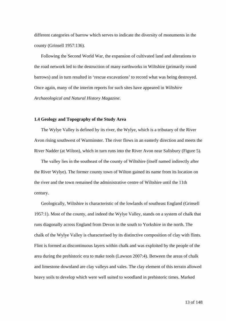
River Nadder (at Wilton), which in turn runs into the River Avon near Salisbury (Figure 5).
The valley lies in the southeast of the county of Wiltshire (itself named indirectly after
the River Wylye). The former county town of Wilton gained its name from its location on
the river and the town remained the administrative centre of Wiltshire until the 11th
century.
Geologically, Wiltshire is characteristic of the lowlands of southeast England (Grinsell
1957:1). Most of the county, and indeed the Wylye Valley, stands on a system of chalk that
runs diagonally across England from Devon in the south to Yorkshire in the north. The
chalk of the Wylye Valley is characterised by its distinctive composition of clay with flints.
Flint is formed as discontinuous layers within chalk and was exploited by the people of the
area during the prehistoric era to make tools (Lawson 2007:4). Between the areas of chalk
and limestone downland are clay valleys and vales. The clay element of this terrain allowed
heavy soils to develop which were well suited to woodland in prehistoric times. Marked
14 of 148
scarp slopes typify downland formations with one very steep slope on one side and a
shallower dip slope on the other.
1.5 Research Objectives
As stated in Section 1.1, the principal aim of this thesis is to analyse the significance of
funerary practices and monuments in the Wylye Valley and its surrounding area. The basic
aim of the thesis is to explore the spatial relationships between the monuments and the
Wylye Valley landscape in a digital environment with an aim to determine the reasoning
behind the placement of the barrows (and on a larger scale the funerary complexes they
form) over time. This will be undertaken with the following research objectives in mind:
1. Produce a dynamic dataset for relevant and accurate information associated
with the monuments of the study area by:
a) Assessing the potential for more detailed investigation on individual
monuments. The potential of further spatial analysis and additional investigation
Figure 5: River systems and settlements related to the Wylye Valley
15 of 148
into the chronological development of each burial will be considered initially to
make sure that the data will be detailed enough for the analytical and interpretive
work to be conducted for the study. This will involve checking the accuracy of the
SMR data in relation to excavation reports and the location of remains on the
ground.
b) Creating a visual database of the information collated for the funerary
monuments in the Wylye Valley. Information on each barrow within the study area
will be input into a database and linked to a Geographical Information System. The
design and implementation of both the database and GIS will be based on
consideration of related work that has been conducted previously and with the
research aims of the investigation in mind.
2. Use current interpretive frameworks to reanalyse the original explanations of
the findings of previous excavations. Due to the age of much of the primary
excavation data relating to the Wylye Valley (see Section 1.3) it is almost certain that
further analysis of the original findings of excavators such as Colt Hoare using modern
interpretative frameworks will allow further or more detailed interpretation of the data.
Using a variety of different techniques it is hoped that new interpretations can be drawn
and used to form a better understanding of the funerary practices of the Late Neolithic
and Early Bronze Age in the Wylye Valley, especially when compared to areas such as
Salisbury Plain and the Avon Valley.
3. Consider the chronological development of ‘cemeteries’ within the Wylye
Valley area internally and in relation to one another. Using up-to-date artefact
sequences and chronologies to reassess the antiquated barrow data for the Wylye Valley
it is hoped that it will be possible to comment on the development of the round barrow
16 of 148
groups during the Bronze Age. Where this is not achievable due to a lack of dateable
information, it may be possible to indicate where further work should be targeted to
increase the understanding of the sequence of construction of the funerary monuments
of the area.
4. Look for spatial patterns and attempt to interpret why funerary monuments
were built where they were within the landscape. A locational analysis of the
barrows and cemeteries within the study area will be conducted. The siting of
monuments will be analysed looking at the terrain and topography of the valley. This
will be carried out using the GIS and any patterns observed in the chronological
development of the study area. It is hoped that it will be possible to choose some key
examples with a clear chronology to study in depth.
5. Assess the meaning of the Wylye Valley in a larger geographical setting. Once
an interpretation of the data for the study area has been produced, its meaning within the
wider context of Wiltshire will be investigated. In particular, the location of the study
area to the west of Stonehenge will be considered. The current interpretation of the
Stonehenge landscape will be explored to examine whether it supports or contradicts the
interpretation of the Wylye Valley landscape.
1.6 Methodology
These research aims will be dealt with in four further sections within the thesis, with
accompanying appendices for the spatial and relational databases.
Section 2, (Data Collection and Related Work) will discuss the method of collection for
the data used and provide some opening thoughts and ideas for the direction of further
investigation. The form that the database will take to facilitate the collation and presentation
17 of 148
of the information will be expanded upon with reference to the rationale behind the
arrangement of the data and the construction of the database and geographical information
system. Examples of related and similar work will also be considered in relation to the
specific research questions that can be answered and the assumptions that can be made
about the evidence based on previous studies.
Section 3 (Data and Analysis) will examine each of the barrows within the study area in
turn for evidence of sequences and patterns by investigating previous archaeological work
and the research of other archaeologists. The inspection of the data and reports relating to
the barrows and the subsequent observations will draw on the analytical techniques
discussed in the previous section and the statistical modelling capabilities of the spatial and
relational databases.
The Interpretation (Section 4) aims to infer some meaning from the observed sequences
and patterns in relation to the specific research questions and the assumptions made about
the evidence based on previous studies. Here the influential ideas of authors such as John
Barrett, Joanna Brück, David Field, Koji Mizoguchi etc will be assessed critically in
relation to the sequences and patterns observed in the Wylye Valley. An explanation of the
significance of the funerary practices and monuments in the study area will then be created.
The final section is the Conclusion (Section 5). Here a summary of results will be
presented including the overall interpretation of the findings from Sections 3 and 4 with a
review of the key outcomes of the thesis with reference to the research objectives discussed
above. Along with a discussion of the problems encountered, suggestions for further work
will be made.
18 of 148
2. Data Collection and Related Work
2.1 Data collection, methodology and initial reflections
Due to the large amount of data to be examined, the information on each barrow has
been catalogued and input into a database and linked to a Geographic Information System
(GIS) for spatial analysis. The initial source for information on the round barrows in the
area was the Sites and Monuments Record (SMR) situated in the Archaeology Office,
Trowbridge. The SMR contains a summary of all the known sites and finds for the Wylye
Valley region. It includes references to the location of finds in local museums and other
sources held in the same department. This includes census-year vertical aerial photography
from 1971 to 2001 for the county and a large collection of oblique aerial photos of specific
archaeological sites. A SMR ‘data dump’ of all monuments classified as Circular Feature or
Round Barrow was acquired, comprising individual records for each site within 8 5km by
5km grid squares. Due to the restrictions of length and time on this study it was decided to
limit the study area to this area (Figure 6) though the Wylye Valley itself extends further to
the west.
Each SMR record also lists the sources used to compile it, such as excavation reports
and the volumes of Victoria County History of Wiltshire that were consulted (Grinsell
1957). The raw SMR data was input into a Microsoft Access relational database to aid an
initial examination of the dataset. Three tables were created to store information regarding
each of the barrows within the dataset – Data (relating to the barrows themselves), Finds
(containing information on grave goods) and Graves (holding information on the burials).
The shared field was the SMR Number, allowing the data in each of the tables to be linked
(Figure 7).

19 of 148
Preliminary reports were generated within Microsoft Access to gain an initial
impression of the quality of the information gathered, for example how many barrows
contained finds, etc. It was clear that the quantity and quality of information varied for each
barrow but spatial data relating to the monuments was present for all but two barrows (later
Figure 7: Relationship diagram for Access database
Figure 6: Study area with OS grid references

20 of 148
labelled UB01 and UB02 or Unknown Barrow). The archaeological record for any area is
known to be incomplete and this will always affect the results of any locational analysis of
the distribution of sites and artefacts within a study area.
With an initial summary of each barrow created, it was then essential to return to
primary sources such as Sir Richard Colt Hoare’s work, The Ancient History of Wiltshire,
aerial photography conducted in the area and more recent excavation reports to expand the
information for each monument.
The information entered into the Access database was completed then linked to a Global
Information System in ArcGIS (Version 9.2) via a series of queries, which were created in
the Microsoft Access relational database and exported as .dbf files. This data formed a large
part of the Data Entry for the GIS (see Figure 10) and was overlaid as points on a digital
map of the area.
The map used for the purpose of overlaying the barrow data was the Ordnance Survey
(or OS) 1:10,000 Scale Raster, a high resolution scanned image of the OS map downloaded
from Edina Digimap (EDINA 2007). This resolution was very satisfactory for displaying
the location of the monuments recorded. The topographical data used for producing the
three-dimensional models of the landscape was created using OS Land-Form PROFILE,
1:10,000 contours and digital terrain model (or DTM) data that was also downloaded from
Edina Digimap (EDINA 2007). The final version of the GIS can be found digitally on the
attached CD-R as an interactive complement to the text in addition to the static images
included in the Analysis and Interpretation sections that clarify the ideas and arguments put
forward.
After an initial assessment of the Wylye Valley dataset in the created database and GIS
it was clear that further investigation was likely to present a far clearer picture of the
21 of 148
‘meaning’ behind the monuments within the study area. The data on the excavated barrows
within the study area had the potential for further spatial analysis as the position of the
majority of the barrows was known and the SMR data appeared to be accurate.
Investigation into the chronological development of both the funerary monuments and
associated round barrow cemeteries also appeared to be possible with reinterpretation of
original site accounts.
2.2 Global Information Systems
A Global Information System (or GIS) is most often used in an archaeological context
as a data management tool or even as a methodology in itself (Chapman, 2006:9). Much of
the data recovered by archaeologists is spatial in nature and a GIS is essentially a spatial
database designed to allow the ‘acquisition, manipulation, visualisation, management and
display of spatially referenced (or geographic) data’ (Aldenderfer, 1996:4). This is
undoubtedly true of the Wylye Valley dataset as much of the data amassed from the SMR
and Victoria County History of Wiltshire is related to the position, size and composition of
the barrows themselves.
Separate layers of data can be viewed together in a GIS due to the fact that each element
within the spatial database shares a common coordinate system that is spatially referenced
(Chapman, 2006:67) (Figure 8). The Ordnance Survey system used by Wiltshire County
Council Archaeological Service required the alphabetical prefix used within the SMR
records for each site to be converted to produce a 12-figure grid reference (accurate to one
metre). For example ST93NE600 became 395150, 138490. The Projected Coordinate
System for the spatial database was then set to British_National_Grid (Esri 2007) to ensure
that all the data was overlaid using the correct coordinates (Wheatley and Gillings,
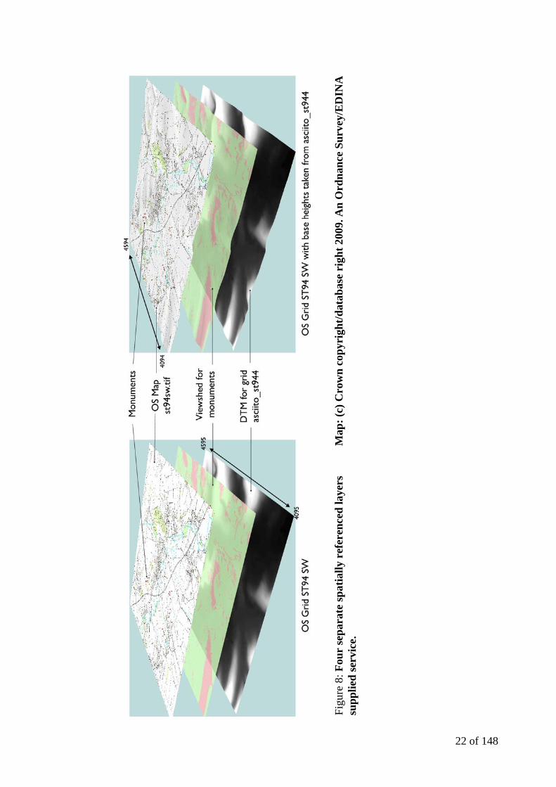
22 of 148
Figu
re 8
: Fou
r se
para
te sp
atia
lly r
efer
ence
d la
yers
M
ap: (
c) C
row
n co
pyri
ght/d
atab
ase
righ
t 200
9. A
n O
rdna
nce
Surv
ey/E
DIN
A
supp
lied
serv
ice.

23 of 148
2002:32). Once this was completed, queries were generated to look at different sets of
information within the relational database. These queries could be then be linked to the map
of the study area to use in ArcGIS to analyse the data spatially. This was possible as they
contained x (EASTING) and y (NORTHING) data that matched the National Grid
coordinated specified for the map (Figure 9).
Archaeologists have utilised the spatial element of the archaeological record as far back
as the eighteenth century in locating excavations and finds through the use of maps and
plans. One of the pioneers of careful mapping was General Pitt-Rivers and his work at the
Roman earthwork known as Bokerley Dyke (to the south of the Wylye Valley in Dorset) is
a notable early example of the plotting of artefacts and features in three-dimensions
(Wheatley and Gillings, 2002:3).
Pitt-Rivers’ technique (and others based on cartographic analysis) can now be easily
and quickly addressed using a GIS and further, more complex investigation can be
performed using the mathematical functions, which is particularly important in modern
archaeological research. It is important to go beyond an empirical approach of simply
identifying and describing features within the landscape (as Colt Hoare and Grinsell did
with their studies of Wiltshire) and explore the meaning behind the information presented
(Exon et al: 2000:10). It is no longer sufficient simply to identify patterns and alignments
Figure 9: Monument information in GIS with spatial information
24 of 148
within a landscape without explaining why such arrangements exist. The rationalization as
to why such a grouping exists is required to gain a fuller understanding of the past
(Wheatley and Gillings, 2002:6).
2.3 The spatial database and analytical methods
The GIS created with the dataset was first used to produce a distribution map of the
barrows within the study area, with separate layers relating to different information about
each monument being created for the initial analysis. The majority of spatial archaeological
data in the twentieth century was tabulated and plotted by hand and the formation of
interpretive frameworks from these was restricted to looking for trends visually (Wheatley
and Gillings, 2002:6). Distribution maps are no longer the sole piece of data upon which
interpretations are based. The use of technology such as GIS within archaeology has
enabled distribution maps to become the foundation upon which further analyses are based
(Wheatley and Gillings, 2002:7). The use of a GIS allows the distribution of finds and
burial types to be formed and analysed far more quickly and precisely.
Intervisibility and viewsheds have become commonplace outputs from GIS analysis but
such analysis has been criticised for their simplicity in ‘explaining’ the location of a feature
in terms of purely mathematical reasoning (Chapman, 2006:101). Conversely, the
phenomenological approach to the study of landscape has been questioned for its emphasis
on observations of social space without using statistical analysis (Exon et al: 2000:10). A
balance between archaeological information, social theory and spatial frameworks needs to
be found to provide the fullest possible interpretation of the practices and monuments in the
Bronze Age Wylye Valley funerary landscape. A well-designed GIS is a means of
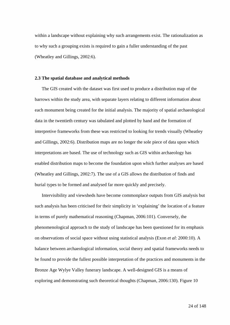
exploring and demonstrating such theoretical thoughts (Chapman, 2006:130). Figure 10
25 of 148
Figure 11: Possible patterns of points on a map (after Hodder and Orton 1976)
Figure 10: The major elements of a GIS (after Wheatley and Gillings 2002)
26 of 148
illustrates the flow of data with a GIS. The Wylye Valley GIS uses the same structure with
data entry taking the form of queries from the Access database and cartographic sources
from Digimap. The manipulation and analysis provides the stage where theoretical ideas
can be tested such as spatial patterns and visibility studies.
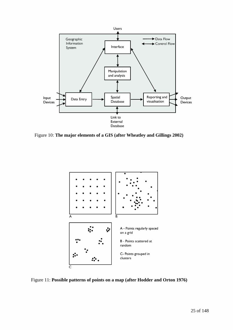
When considering the study of spatial patterns with regard to monuments, point pattern
analysis is an important analytical tool. The simpler methods of point pattern analysis
(regular spaced, scattered at random or grouped in clusters) seen in Figure 11 are of
particular use when studying the distribution of sites (Hodder and Orton 1976:32). It is an
important point that numerous factors affect site survival and that the patterning of site
distribution over large areas such as the Wylye Valley is likely to be the result of site
erosion and destruction as the result of past activities (Hodder and Orton 1976:237).
Three basic geometric forms can represent geographical data known as point, line and area.
Point is the simplest way of representing geographical features (Wheatley and Gillings,
2002:34) and the most effective for defining round barrows. The only limitation is that the
size of the point in the GIS that has been created is fixed. This will be discussed further in
Section 5.1. This form of data is vector data and provides a flexible link with the external
database (Figure 10). The maps on which the monument data is overlain are raster data. The
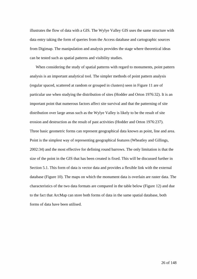
characteristics of the two data formats are compared in the table below (Figure 12) and due
to the fact that ArcMap can store both forms of data in the same spatial database, both
forms of data have been utilised.
27 of 148
Figure 12: Characteristics of vector and raster data (Ordnance Survey)
In addition to investigating spatial patterns based upon point patterns, visibility analysis
was also undertaken on the data. The level of visibility of single sites or the intervisibility of
groups of sites is an important element of landscape archaeology (Wheatley and Gillings,
2002:201). The perception and interpretation of space as a social construct and the
relationship of time and action have a direct influence over the analysis of visibility analysis
(Exon et al 2000:8). The balance between simplification (and abstraction) and descriptive
(and anecdotal) has shifted over the course of the last 30 years (Wheatley and Gillings,
2002:204) from the fixed points study of the ‘territories’ of Neolithic and Bronze Age
Wessex of Renfrew in 1979 (in Wheatley and Gillings, 2002:203) to the observational
study of the nature of space by Tilley in 1994 (Exon et al 2000:10). Neither method is
without its limitations yet both provide interesting and insightful interpretations of the
archaeological landscape.
Within the context of a GIS, visibility is analysed using a viewshed calculation. The
calculation requires a Digital Elevation Model (DEM) and a layer with the location (or
group of locations) you wish to establish the visibility from. In the Wylye Valley GIS these
Vector Raster
relatively low data volume relatively high data volume
faster display slower display
can also store attributes has no attribute information
less pleasing to the eye more pleasing to the eye
does not dictate how features should look
in a GIS
inherently stores how features should
look in a GIS
28 of 148
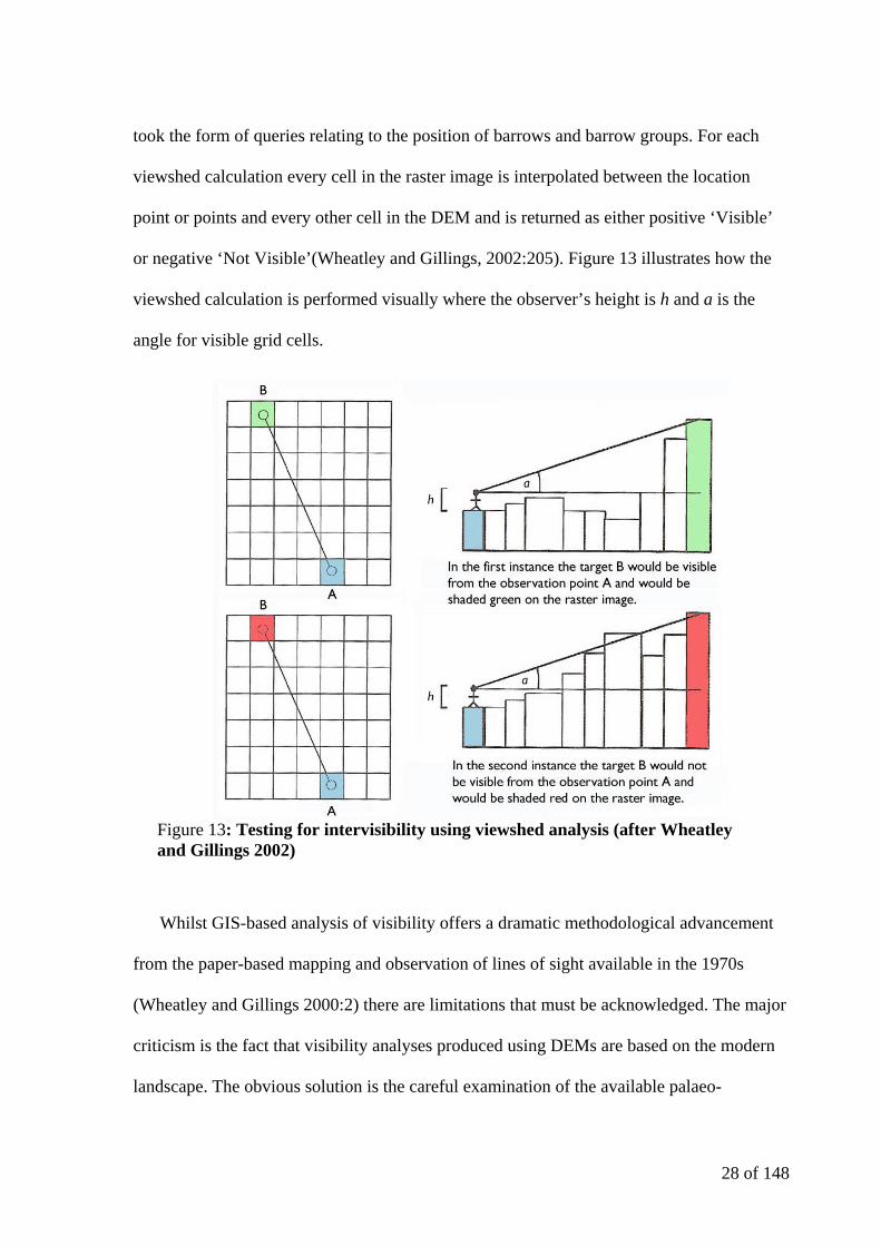
took the form of queries relating to the position of barrows and barrow groups. For each
viewshed calculation every cell in the raster image is interpolated between the location
point or points and every other cell in the DEM and is returned as either positive ‘Visible’
or negative ‘Not Visible’(Wheatley and Gillings, 2002:205). Figure 13 illustrates how the
viewshed calculation is performed visually where the observer’s height is h and a is the
angle for visible grid cells.
Whilst GIS-based analysis of visibility offers a dramatic methodological advancement
from the paper-based mapping and observation of lines of sight available in the 1970s
(Wheatley and Gillings 2000:2) there are limitations that must be acknowledged. The major
criticism is the fact that visibility analyses produced using DEMs are based on the modern
landscape. The obvious solution is the careful examination of the available palaeo-
Figure 13: Testing for intervisibility using viewshed analysis (after Wheatley and Gillings 2002)
29 of 148
environmental data for the study area. The ‘denuded’ DEM landscape can also be seen as a
benefit as this topography results in modern vegetation being removed from the landscape
in a way which physical observation cannot achieve in the field (Wheatley and Gillings
2000:6).
2.4 Related work in Britain
The aim of this study is to investigate the significance of funerary practices and
monuments in and around the Wylye Valley to the west of Stonehenge. Many descriptions
of the monuments across the chalkland of Wessex have been written, though not in recent
years. The most appropriate is the work of Leslie Grinsell titled The Archaeology of Wessex
(1958) that offered an excellent commentary on the monuments in chronological order but
now suffers from some inaccuracies (due to the actions of agriculture on the monuments in
the intervening fifty years) and monotony due to dealing with repetitive descriptions of
similar monuments. Many works of synthesis have been produced which deal with specific
areas of the chalkland, in a similar manner to this study of the Wylye Valley. For example
Landscape, Monuments and Society: The Prehistory of Cranborne Chase by Barrett and
Bradley (1991) whose study area of the chase covers the majority of the Wylye Valley and
The Field Archaeology of the Salisbury Plain Training Area by McOmish et al 2002 which
covers the area directly to the north of the study area. Where McOmish et al (2002) attempt
to cover a time period from the Neolithic through to the creation of the military ranges on
Salisbury Plain, Barrett and Bradley (1991) focus purely the time period from the end of the
Mesolithic through the Iron Age. Neither study focuses on the Wylye Valley as a landscape
unit and the lack of excavated data prevents detailed chronological understanding of the
development of the prehistoric monuments discussed in most cases.
30 of 148
The location of the study area is very close to Stonehenge (within 20 kilometres)
making the GIS work under taken by Exon et al. for Stonehenge Landscapes (2000) a
significant related work to discuss with regards to the actual format and methodology of the
thesis, if not the geographical content.
Stonehenge Landscapes was an archaeological project to analyse and interpret the
spatial patterns of the monuments present within the area of Stonehenge in relation to the
position of the major public monuments in the region using a GIS to explore the
relationships between monument distribution and topographic variation (Exon et al:
2000:3). Unlike the Wylye Valley, the Stonehenge landscape has been the subject of
various research projects in the past, many of which were interpretive (Darvill 1987,
Richards 1990, Cleal et al 1995 etc).
Stonehenge Landscapes (2000) investigated changes in the landscape over a far longer
period of time, ranging from the Mesolithic (c.8000 cal BC) through to the Early Bronze
Age (c.1600 cal BC) and therefore had a wider range of research objectives to meet than
this thesis that aims to investigate solely Late Neolithic and Early Bronze Age monuments.
The Stonehenge landscape also benefits from a good vegetation sequence allowing the use
of palaeo-environmental data to reconstruct the vegetation patterns for the area over time
(Exon et al: 2000:20).
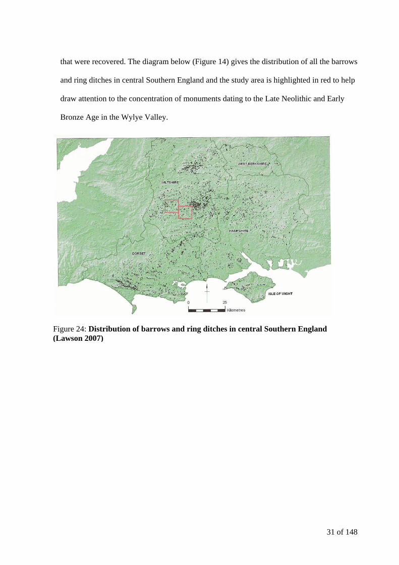
Figure 14 is taken from Lawson’s book Chalkland: an archaeology of Stonehenge and
its region (2007), an archaeological perspective on Stonehenge’s landscape and the wider
chalkland it forms a part of. Focusing mainly on the prehistory of the Stonehenge area,
Lawson aims to describe the archaeological evidence and provide a chronological
description of the region. Although the Wylye Valley is not discussed directly, key sites
such as Upton Lovell and Norton Bavant are discussed due to the importance of the finds
31 of 148
that were recovered. The diagram below (Figure 14) gives the distribution of all the barrows
and ring ditches in central Southern England and the study area is highlighted in red to help
draw attention to the concentration of monuments dating to the Late Neolithic and Early
Bronze Age in the Wylye Valley.
Figure 24: Distribution of barrows and ring ditches in central Southern England (Lawson 2007)

32 of 148
3. Data and Analysis
3.1 Arrangement of barrow data
In this analytical section the barrow data is predominantly discussed in terms of the
‘cemetery’ groups shown in Figure 15 (and discussed in more detail in Section 1.2). By
using a ‘cemetery’ group to investigate each barrow in detail before looking at the cemetery
groups in relation to the landscape (and other monuments) it is possible to avoid the
replication of information in many cases. The overall order of the potential cemeteries in
and surrounding the Wylye Valley was achieved subjectively through the systematic use of
the conventional alphanumeric Ordnance Survey grid references as used at the start of each
barrow’s SMR number (Figure 6). For example ST94SW refers to the upper valley and
contains 65 barrows, 4 clusters of barrow groups and 11 cemetery groups. The only
exceptions to this system are where it was observed that a barrow cluster or cemetery
appeared to overlap a modern grid square. In these cases the grid reference where the
majority of the barrow group rested was chosen, for example The Knook Barrow Group.
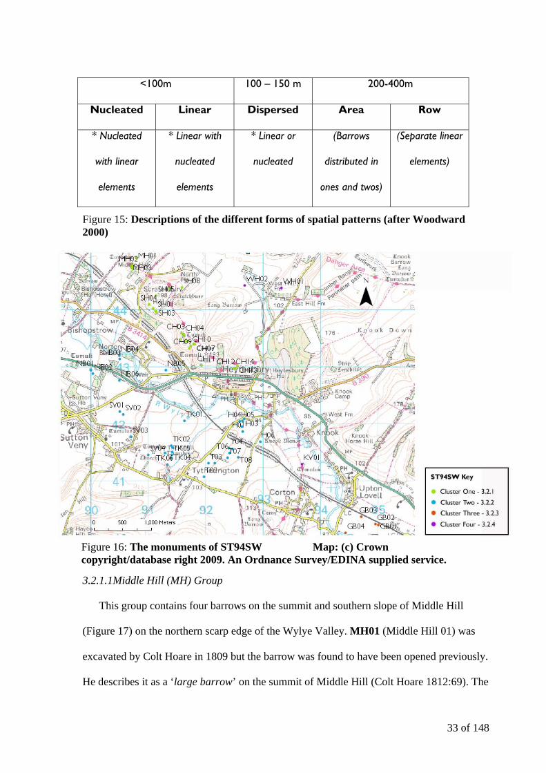
3.2 Analysis of the barrow data in ST94SW
This area is the most northwesterly OS grid in the study area (Figure 6) and contains
sixty-five of the possible barrows within the study area including thirty-two confirmed
round barrows (twenty of which are scheduled monuments). To discuss the monuments
situated in this part of the study area, the barrows (or potential barrows) have been split into
four distinct clusters, as shown in Figure 16. This quadrate contains the highest proportion
of barrows in the study area (37% of the overall total) and appears to include barrows both
on the valley floor and escarpments.
33 of 148
<100m 100 – 150 m 200-400m
Nucleated Linear Dispersed Area Row
* Nucleated
with linear
elements
* Linear with
nucleated
elements
* Linear or
nucleated
(Barrows
distributed in
ones and twos)
(Separate linear
elements)
Figure 15: Descriptions of the different forms of spatial patterns (after Woodward 2000)
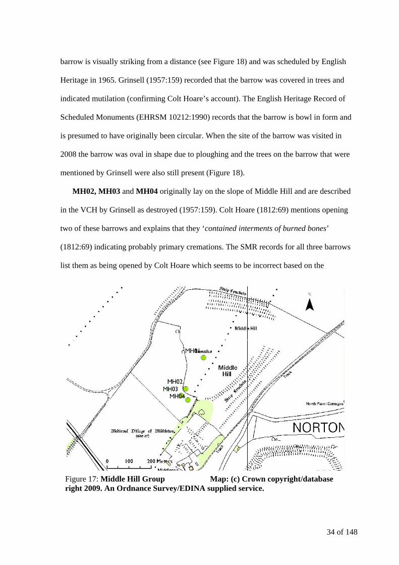
3.2.1.1Middle Hill (MH) Group
This group contains four barrows on the summit and southern slope of Middle Hill
(Figure 17) on the northern scarp edge of the Wylye Valley. MH01 (Middle Hill 01) was
excavated by Colt Hoare in 1809 but the barrow was found to have been opened previously.
He describes it as a ‘large barrow’ on the summit of Middle Hill (Colt Hoare 1812:69). The
Figure 16: The monuments of ST94SW Map: (c) Crown copyright/database right 2009. An Ordnance Survey/EDINA supplied service.
34 of 148
barrow is visually striking from a distance (see Figure 18) and was scheduled by English
Heritage in 1965. Grinsell (1957:159) recorded that the barrow was covered in trees and
indicated mutilation (confirming Colt Hoare’s account). The English Heritage Record of
Scheduled Monuments (EHRSM 10212:1990) records that the barrow is bowl in form and
is presumed to have originally been circular. When the site of the barrow was visited in
2008 the barrow was oval in shape due to ploughing and the trees on the barrow that were
mentioned by Grinsell were also still present (Figure 18).
MH02, MH03 and MH04 originally lay on the slope of Middle Hill and are described
in the VCH by Grinsell as destroyed (1957:159). Colt Hoare (1812:69) mentions opening
two of these barrows and explains that they ‘contained interments of burned bones’
(1812:69) indicating probably primary cremations. The SMR records for all three barrows
list them as being opened by Colt Hoare which seems to be incorrect based on the
Figure 17: Middle Hill Group Map: (c) Crown copyright/database right 2009. An Ordnance Survey/EDINA supplied service.

35 of 148
Figure 18: MH01 seen from Scratchbury Hill
Figure 19: Burial types present in Middle Hill group Map: (c) Crown copyright/database right 2009. An Ordnance Survey/EDINA supplied service.
36 of 148
information above. The three destroyed barrows (MH02, MH03 and MH04) were all
located by O.G.S. Crawford in his work Air survey and archaeology (1924) and this may
have contributed to the error. As a barrow group the monuments appear to form a small
linear cemetery (Figure 19). MH01 appears to have been larger than the other barrows in
the cemetery (based on Colt Hoare’s description) and lies on the summit of the hill and
MH01 – MH02 –MH03 are aligned whilst MH03 – MH04 follow the contour of the hill.
MH01 has inter-visibility with SH05 (see 3.2.1.2) but if intervisibility between the two
cemeteries was intended, MH02 to 04 would have been better positioned on the eastern
slope of Middle Hill. Only MH01 would have had a clear view of cemeteries to the east,
such as the West Hill Pair (WH01 and 02) and Knook Barrow Group (KB01 to 10).
Figure 20: Scratchbury Hill Group Map: (c) Crown copyright/database right 2009. An Ordnance Survey/EDINA supplied service.

37 of 148
Figure 19 also indicates that MH02 to 04 all appear to have contained primary cremations
and are situated less than 50 metres apart.
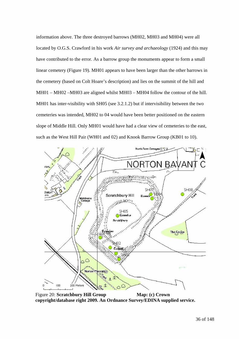
3.2.1.2 Scratchbury Hill (SH) Group
The Scratchbury Hill Group lies within Scratchbury Hillfort (Figure 20), which spreads
from the northern slope of the Wylye Valley to the scarp edge. Scratchbury is one of seven
hillforts that are recorded within the Salisbury Plain Training Area by English Heritage
(EHRSM 10213:1990) and dates to the Iron Age. SH01 was an unproductive bowl barrow
opened by Colt Hoare that survives at around 8 metres in diameter and 0.07 metres in
height, making it one of the smallest barrows in Wiltshire (1957:185) (1812:70). SH02 is an
undated bowl barrow with ‘a few burned bones at a considerable distance from the centre’
(Colt Hoare 1812:70) according to Colt Hoare. SH03 is a bowl barrow which appears to
have become buried on the edge of the of the Iron Age hillfort earthworks. Colt Hoare
described the barrow as unproductive (1812:70).
SH04 is a large bowl barrow that was described by Colt Hoare as ‘a very conspicuous
object from the turnpike road below’ (1812:70). This is certainly still the case on approach
from the B3414, situated as it is above the hillfort earthworks. Colt Hoare explains that
much effort went into excavating SH04 and although no interment was found the finds
associated with the barrow (wild boar’s teeth, charcoal and burned stones) suggested that a
cremation had been performed. SH05 was in all probability a ditched saucer barrow
originally located within Scratchbury Hillfort near its highest point. Partial excavation by
Colt Hoare revealed a primary cremation and many associated items (Goddard 1913:296).
SH06 is a bowl barrow (Grinsell 1957:185) that featured a pit dug into the chalk beneath
the mound that contained a cremation (Thomas 1954:313) and three bone objects. Figure 21
38 of 148
Figure 22: Metal finds from SH05 (Moore and Rowlands 1972)
shows one of the bone plates (one has been lost) and the bone pin. The bone pin was
probably worn in the hair whereas the plate appears to have been designed to attachment to
another material (Thomas 1954:314).
SH07 is a bowl barrow (Grinsell 1957:185) that was partially excavated by Colt Hoare
who found it to be ‘unproductive’ (1812:70). Slightly below the hillfort (to the north-east)
lies SH08. This round mound was plotted in 1995 by the Royal Commission on the
Historical Monuments of England (now English Heritage) (RCHME 1995) and without
further investigation appears to be another round barrow associated with the group.
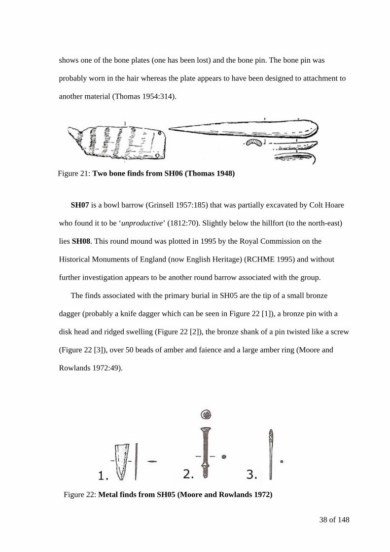
The finds associated with the primary burial in SH05 are the tip of a small bronze
dagger (probably a knife dagger which can be seen in Figure 22 [1]), a bronze pin with a
disk head and ridged swelling (Figure 22 [2]), the bronze shank of a pin twisted like a screw
(Figure 22 [3]), over 50 beads of amber and faience and a large amber ring (Moore and
Rowlands 1972:49).
Figure 21: Two bone finds from SH06 (Thomas 1948)

39 of 148
This range of materials and large number of items represent a ‘rich Wessex grave’
based upon the classification of Exon et al (see 1.2). Exon et al (2000) found that the
majority of Wessex graves in the Stonehenge survey area occurred most commonly in
larger bowl barrows (Exon et al 2000:79) but SH05 was almost certainly a saucer barrow. It
appears that the grave group was originally illustrated for Ancient Wiltshire but attempts to
locate the drawing (referred to by Thurnam) have been unsuccessful (Moore and Rowlands
1972:49). The ribbed pin (Figures 22 and 23) has an incised criss-cross decoration on top
and the ribbing appears to cease just before the break in the shank (Moore & Rowlands
1972: 50). The more fragmentary pin shank is of a similar date, showing parallels with
Tumulus Culture pins found in Central Europe (Moore & Rowlands 1972: 50).
The Scratchbury Hill cemetery contains a high proportion of primary cremations in
the barrows where remains were recovered (Figure 24). The occurrence of a non-central
primary cremation in SH02 makes it less likely that the barrow group is early in date
(Garwood 2007:40). A period of c.1800-1300 BC for the cemetery seems most likely. The
Figure 23: Finds from SH05

40 of 148
barrows SH01 to SH04 display a linear arrangement running gradually down the slope of
Scratchbury Hill. A more dispersed linear arrangement runs northeast - southwest between
SH08 and SH04. Looking from SH05 it is possible to see a large proportion of the barrows
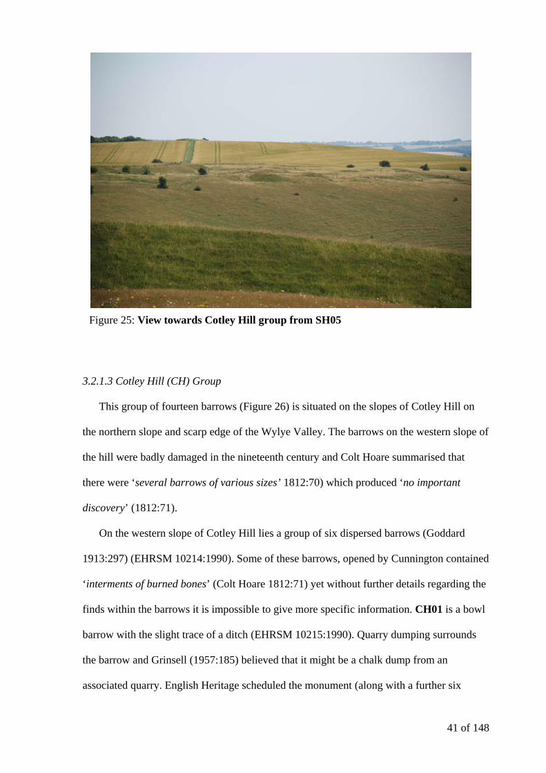
in the Cotley Hill group (Figure 25).
Figure 24: Burial types present in Scratchbury Hill group Map: (c) Crown copyright/database right 2009. An Ordnance Survey/EDINA supplied service.
41 of 148
3.2.1.3 Cotley Hill (CH) Group
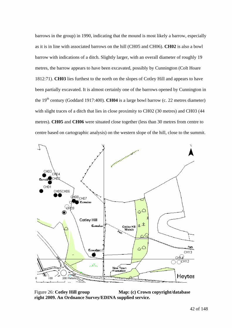
This group of fourteen barrows (Figure 26) is situated on the slopes of Cotley Hill on
the northern slope and scarp edge of the Wylye Valley. The barrows on the western slope of
the hill were badly damaged in the nineteenth century and Colt Hoare summarised that
there were ‘several barrows of various sizes’ 1812:70) which produced ‘no important
discovery’ (1812:71).
On the western slope of Cotley Hill lies a group of six dispersed barrows (Goddard
1913:297) (EHRSM 10214:1990). Some of these barrows, opened by Cunnington contained
‘interments of burned bones’ (Colt Hoare 1812:71) yet without further details regarding the
finds within the barrows it is impossible to give more specific information. CH01 is a bowl
barrow with the slight trace of a ditch (EHRSM 10215:1990). Quarry dumping surrounds
the barrow and Grinsell (1957:185) believed that it might be a chalk dump from an
associated quarry. English Heritage scheduled the monument (along with a further six
Figure 25: View towards Cotley Hill group from SH05
42 of 148
barrows in the group) in 1990, indicating that the mound is most likely a barrow, especially
as it is in line with associated barrows on the hill (CH05 and CH06). CH02 is also a bowl
barrow with indications of a ditch. Slightly larger, with an overall diameter of roughly 19
metres, the barrow appears to have been excavated, possibly by Cunnington (Colt Hoare
1812:71). CH03 lies furthest to the north on the slopes of Cotley Hill and appears to have
been partially excavated. It is almost certainly one of the barrows opened by Cunnington in
the 19th century (Goddard 1917:400). CH04 is a large bowl barrow (c. 22 metres diameter)
with slight traces of a ditch that lies in close proximity to CH02 (30 metres) and CH03 (44
metres). CH05 and CH06 were situated close together (less than 30 metres from centre to
centre based on cartographic analysis) on the western slope of the hill, close to the summit.
Figure 26: Cotley Hill group Map: (c) Crown copyright/database right 2009. An Ordnance Survey/EDINA supplied service.
43 of 148
Figure 28: Barrow forms present in Cotley Hill group Map: (c) Crown copyright/database right 2009. An Ordnance Survey/EDINA supplied service.
Figure 27: Cotley Hill OS First Edition Map Map: (c) Crown copyright/database right 2009. An Ordnance Survey/EDINA supplied service.
44 of 148
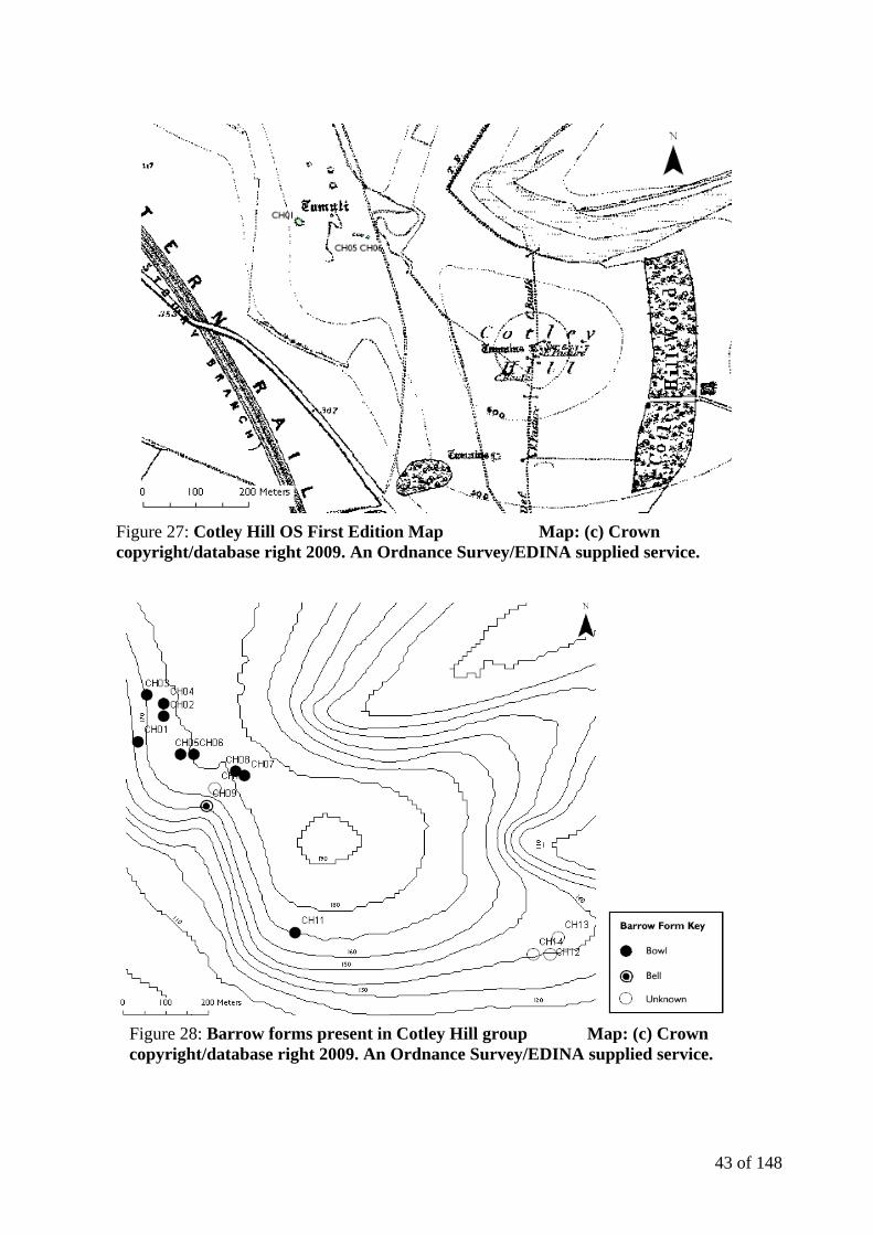
They have been totally destroyed yet are visible on the first edition of the Ordnance Survey
Map (Figure 27) in association with two further barrows not listed in the SMR (Grinsell
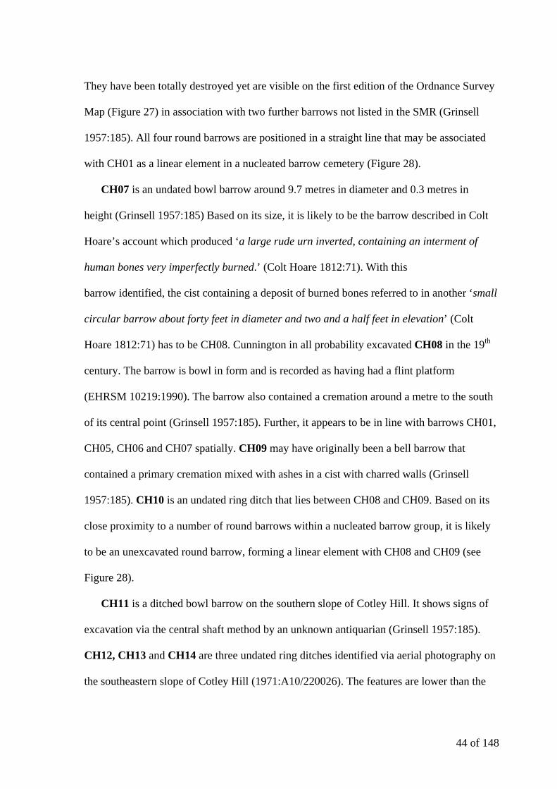
1957:185). All four round barrows are positioned in a straight line that may be associated
with CH01 as a linear element in a nucleated barrow cemetery (Figure 28).
CH07 is an undated bowl barrow around 9.7 metres in diameter and 0.3 metres in
height (Grinsell 1957:185) Based on its size, it is likely to be the barrow described in Colt
Hoare’s account which produced ‘a large rude urn inverted, containing an interment of
human bones very imperfectly burned.’ (Colt Hoare 1812:71). With this
barrow identified, the cist containing a deposit of burned bones referred to in another ‘small
circular barrow about forty feet in diameter and two and a half feet in elevation’ (Colt
Hoare 1812:71) has to be CH08. Cunnington in all probability excavated CH08 in the 19th
century. The barrow is bowl in form and is recorded as having had a flint platform
(EHRSM 10219:1990). The barrow also contained a cremation around a metre to the south
of its central point (Grinsell 1957:185). Further, it appears to be in line with barrows CH01,
CH05, CH06 and CH07 spatially. CH09 may have originally been a bell barrow that
contained a primary cremation mixed with ashes in a cist with charred walls (Grinsell
1957:185). CH10 is an undated ring ditch that lies between CH08 and CH09. Based on its
close proximity to a number of round barrows within a nucleated barrow group, it is likely
to be an unexcavated round barrow, forming a linear element with CH08 and CH09 (see
Figure 28).
CH11 is a ditched bowl barrow on the southern slope of Cotley Hill. It shows signs of
excavation via the central shaft method by an unknown antiquarian (Grinsell 1957:185).
CH12, CH13 and CH14 are three undated ring ditches identified via aerial photography on
the southeastern slope of Cotley Hill (1971:A10/220026). The features are lower than the
45 of 148
confirmed barrows in the area but have been included in the study, as their position on the
valley side seems to fit with the pattern of barrow positioning observed elsewhere in the
Wylye Valley.
There is a predominance of bowl barrows and cremation burials in the Cotley Hill
cemetery. Unfortunately there is little dating evidence for the cemetery other than a ‘large
inverted urn’ (Grinsell 1957:185) that is neither illustrated nor available for study today.
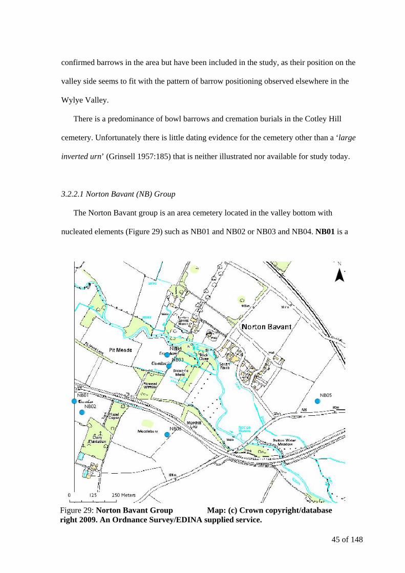
3.2.2.1 Norton Bavant (NB) Group
The Norton Bavant group is an area cemetery located in the valley bottom with
nucleated elements (Figure 29) such as NB01 and NB02 or NB03 and NB04. NB01 is a
Figure 29: Norton Bavant Group Map: (c) Crown copyright/database right 2009. An Ordnance Survey/EDINA supplied service.
46 of 148
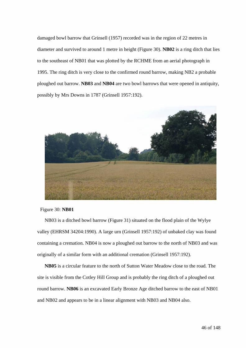
damaged bowl barrow that Grinsell (1957) recorded was in the region of 22 metres in
diameter and survived to around 1 metre in height (Figure 30). NB02 is a ring ditch that lies
to the southeast of NB01 that was plotted by the RCHME from an aerial photograph in
1995. The ring ditch is very close to the confirmed round barrow, making NB2 a probable
ploughed out barrow. NB03 and NB04 are two bowl barrows that were opened in antiquity,
possibly by Mrs Downs in 1787 (Grinsell 1957:192).
NB03 is a ditched bowl barrow (Figure 31) situated on the flood plain of the Wylye
valley (EHRSM 34204:1990). A large urn (Grinsell 1957:192) of unbaked clay was found
containing a cremation. NB04 is now a ploughed out barrow to the north of NB03 and was
originally of a similar form with an additional cremation (Grinsell 1957:192).
NB05 is a circular feature to the north of Sutton Water Meadow close to the road. The
site is visible from the Cotley Hill Group and is probably the ring ditch of a ploughed out
round barrow. NB06 is an excavated Early Bronze Age ditched barrow to the east of NB01
and NB02 and appears to be in a linear alignment with NB03 and NB04 also.
Figure 30: NB01
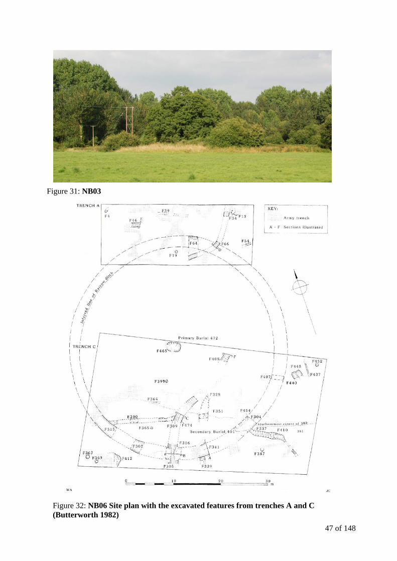
47 of 148
Figure 31: NB03
Figure 32: NB06 Site plan with the excavated features from trenches A and C (Butterworth 1982)
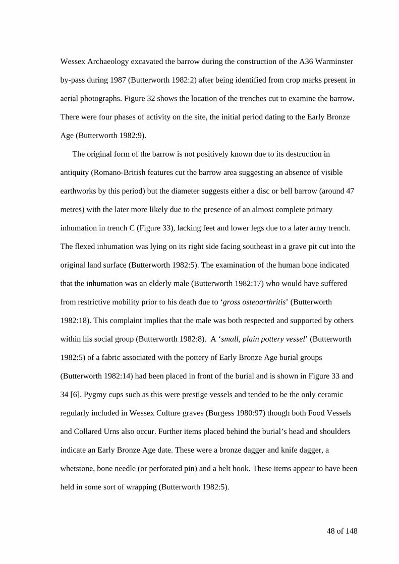
48 of 148
Wessex Archaeology excavated the barrow during the construction of the A36 Warminster
by-pass during 1987 (Butterworth 1982:2) after being identified from crop marks present in
aerial photographs. Figure 32 shows the location of the trenches cut to examine the barrow.
There were four phases of activity on the site, the initial period dating to the Early Bronze
Age (Butterworth 1982:9).
The original form of the barrow is not positively known due to its destruction in
antiquity (Romano-British features cut the barrow area suggesting an absence of visible
earthworks by this period) but the diameter suggests either a disc or bell barrow (around 47
metres) with the later more likely due to the presence of an almost complete primary
inhumation in trench C (Figure 33), lacking feet and lower legs due to a later army trench.
The flexed inhumation was lying on its right side facing southeast in a grave pit cut into the
original land surface (Butterworth 1982:5). The examination of the human bone indicated
that the inhumation was an elderly male (Butterworth 1982:17) who would have suffered
from restrictive mobility prior to his death due to ‘gross osteoarthritis’ (Butterworth
1982:18). This complaint implies that the male was both respected and supported by others
within his social group (Butterworth 1982:8). A ‘small, plain pottery vessel’ (Butterworth
1982:5) of a fabric associated with the pottery of Early Bronze Age burial groups
(Butterworth 1982:14) had been placed in front of the burial and is shown in Figure 33 and
34 [6]. Pygmy cups such as this were prestige vessels and tended to be the only ceramic
regularly included in Wessex Culture graves (Burgess 1980:97) though both Food Vessels
and Collared Urns also occur. Further items placed behind the burial’s head and shoulders
indicate an Early Bronze Age date. These were a bronze dagger and knife dagger, a
whetstone, bone needle (or perforated pin) and a belt hook. These items appear to have been
held in some sort of wrapping (Butterworth 1982:5).
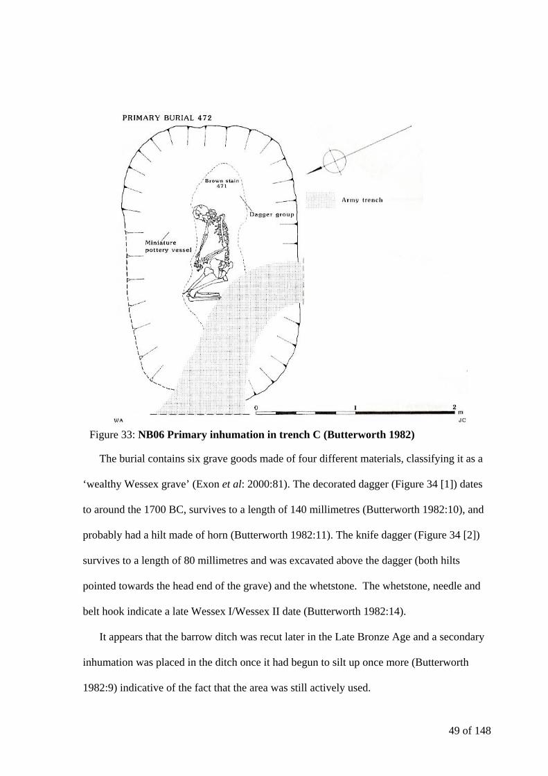
49 of 148
The burial contains six grave goods made of four different materials, classifying it as a
‘wealthy Wessex grave’ (Exon et al: 2000:81). The decorated dagger (Figure 34 [1]) dates
to around the 1700 BC, survives to a length of 140 millimetres (Butterworth 1982:10), and
probably had a hilt made of horn (Butterworth 1982:11). The knife dagger (Figure 34 [2])
survives to a length of 80 millimetres and was excavated above the dagger (both hilts
pointed towards the head end of the grave) and the whetstone. The whetstone, needle and
belt hook indicate a late Wessex I/Wessex II date (Butterworth 1982:14).
It appears that the barrow ditch was recut later in the Late Bronze Age and a secondary
inhumation was placed in the ditch once it had begun to silt up once more (Butterworth
1982:9) indicative of the fact that the area was still actively used.
Figure 33: NB06 Primary inhumation in trench C (Butterworth 1982)

50 of 148
The Norton Bavant group contains barrows with both primary cremations and
inhumations (Figure 35) and dates from at least 1700 BC based upon the dagger from NB06
and the predominance of cremation burials as the primary interment in the cemetery’s
barrows.
Figure 34: NB06 Primary inhumation grave goods (Butterworth 1982)
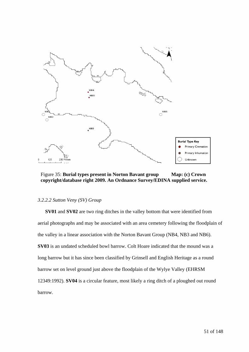
51 of 148
3.2.2.2 Sutton Veny (SV) Group
SV01 and SV02 are two ring ditches in the valley bottom that were identified from
aerial photographs and may be associated with an area cemetery following the floodplain of
the valley in a linear association with the Norton Bavant Group (NB4, NB3 and NB6).
SV03 is an undated scheduled bowl barrow. Colt Hoare indicated that the mound was a
long barrow but it has since been classified by Grinsell and English Heritage as a round
barrow set on level ground just above the floodplain of the Wylye Valley (EHRSM
12349:1992). SV04 is a circular feature, most likely a ring ditch of a ploughed out round
barrow.
Figure 35: Burial types present in Norton Bavant group Map: (c) Crown copyright/database right 2009. An Ordnance Survey/EDINA supplied service.
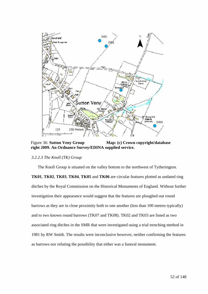
52 of 148
3.2.2.3 The Knoll (TK) Group
The Knoll Group is situated on the valley bottom to the northwest of Tytherington.
TK01, TK02, TK03, TK04, TK05 and TK06 are circular features plotted as undated ring
ditches by the Royal Commission on the Historical Monuments of England. Without further
investigation their appearance would suggest that the features are ploughed out round
barrows as they are in close proximity both to one another (less than 100 metres typically)
and to two known round barrows (TK07 and TK08). TK02 and TK03 are listed as two
associated ring ditches in the SMR that were investigated using a trial trenching method in
1981 by RW Smith. The results were inconclusive however, neither confirming the features
as barrows nor refuting the possibility that either was a funeral monument.
Figure 36: Sutton Veny Group Map: (c) Crown copyright/database right 2009. An Ordnance Survey/EDINA supplied service.
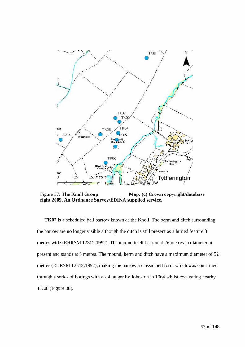
53 of 148
TK07 is a scheduled bell barrow known as the Knoll. The berm and ditch surrounding
the barrow are no longer visible although the ditch is still present as a buried feature 3
metres wide (EHRSM 12312:1992). The mound itself is around 26 metres in diameter at
present and stands at 3 metres. The mound, berm and ditch have a maximum diameter of 52
metres (EHRSM 12312:1992), making the barrow a classic bell form which was confirmed
through a series of borings with a soil auger by Johnston in 1964 whilst excavating nearby
TK08 (Figure 38).
Figure 37: The Knoll Group Map: (c) Crown copyright/database right 2009. An Ordnance Survey/EDINA supplied service.
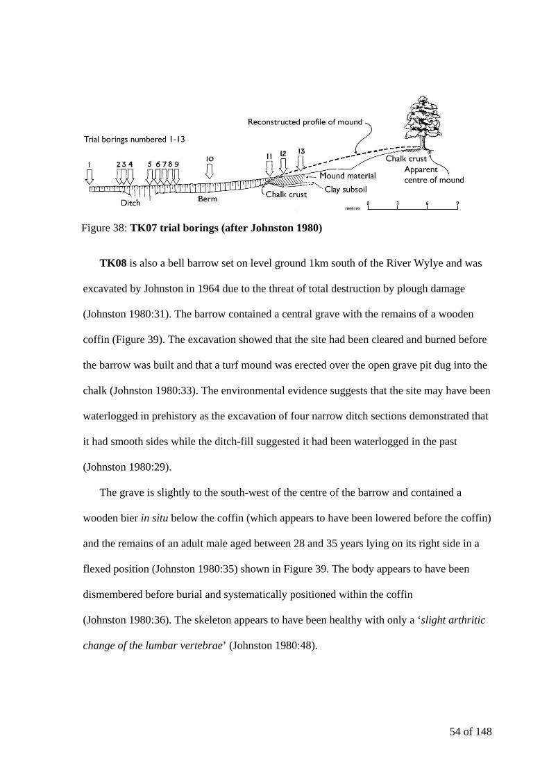
54 of 148
TK08 is also a bell barrow set on level ground 1km south of the River Wylye and was
excavated by Johnston in 1964 due to the threat of total destruction by plough damage
(Johnston 1980:31). The barrow contained a central grave with the remains of a wooden
coffin (Figure 39). The excavation showed that the site had been cleared and burned before
the barrow was built and that a turf mound was erected over the open grave pit dug into the
chalk (Johnston 1980:33). The environmental evidence suggests that the site may have been
waterlogged in prehistory as the excavation of four narrow ditch sections demonstrated that
it had smooth sides while the ditch-fill suggested it had been waterlogged in the past
(Johnston 1980:29).
The grave is slightly to the south-west of the centre of the barrow and contained a
wooden bier in situ below the coffin (which appears to have been lowered before the coffin)
and the remains of an adult male aged between 28 and 35 years lying on its right side in a
flexed position (Johnston 1980:35) shown in Figure 39. The body appears to have been
dismembered before burial and systematically positioned within the coffin
(Johnston 1980:36). The skeleton appears to have been healthy with only a ‘slight arthritic
change of the lumbar vertebrae’ (Johnston 1980:48).
Figure 38: TK07 trial borings (after Johnston 1980)

55 of 148
The grave goods associated with the burial were a miniature accessory vessel (placed
upright by the ankles), a large Food Vessel (placed on its side by the knees) and a bronze
dagger (Johnston 1980:33). The Food Vessel (Figure 40) is exceptionally well finished,
both in form and decoration, and the pattern is similar to the earlier ceramic tradition of Bell
Beakers (Burgess 1980:67). The pot is approaching the size of an enlarged Food Vessel
(often included with cremations) and the inclusion of the accessory vessel indicates a later
date in the Early Bronze Age for the burial. The bronze dagger carried traces of a wooden
hilt (Johnston 1980:41) and the point appears to have been ritually bent.
In the southeastern quadrant of the barrow there were the remains of a fragmentary
collared urn with an adult female cremation in situ that was probably a secondary burial
(Johnston 1980:38). A secondary inhumation with evidence of a head trauma appears to
have been inserted into the barrow in the Late Bronze Age (Johnston 1980:120).
Figure 39: TK08 Site plan and central grave (after Johnston 1980)

56 of 148
Despite partial excavation in 1964, the ditch and much of the old ground surface
beneath the TK08 remains intact. The barrow is almost certainly part of a cemetery
probably originating around the long barrow around 160 metres to the west of TK08 (and
140 metres northeast of SV04). The barrow is ovoid in plan, is around 50 metres long and
20 metres wide, and stands to a height of 1.5m. The Polebridge Farm barrow (as the long
barrow is known) has potential for the recovery of archaeological remains and
environmental evidence relating to the period in which the monument was constructed
(EHRSM 12348:1992).
As a cemetery group The Knoll group is nucleated with linear elements (Figure 41).
TK03, TK04, TK05 and TK07 are closely aligned and SV04, TK08 and TK04 are in a line
but are not close together. TK07 and TK08 are both bell barrows in form and are only 150
metres apart and re-excavation of TK07 may allow more comparisons to be made between
the two barrows.
Figure 40: TK08 Miniature vessel and food vessel (Johnston 1980)
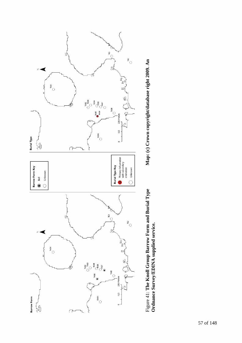
57 of 148
Figu
re 4
1: T
he K
noll
Gro
up B
arro
w F
orm
and
Bur
ial T
ype
Map
: (c)
Cro
wn
copy
righ
t/dat
abas
e ri
ght 2
009.
An
Ord
nanc
e Su
rvey
/ED
INA
supp
lied
serv
ice.
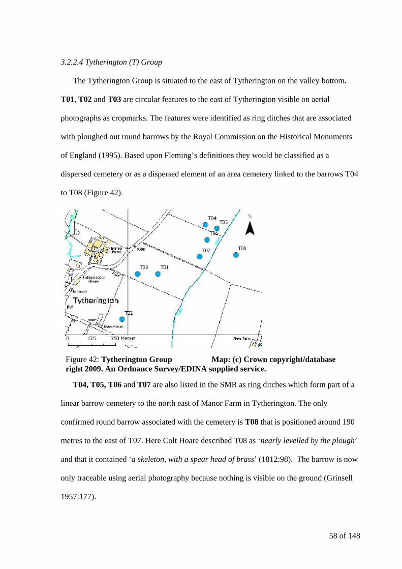
58 of 148
3.2.2.4 Tytherington (T) Group
The Tytherington Group is situated to the east of Tytherington on the valley bottom.
T01, T02 and T03 are circular features to the east of Tytherington visible on aerial
photographs as cropmarks. The features were identified as ring ditches that are associated
with ploughed out round barrows by the Royal Commission on the Historical Monuments
of England (1995). Based upon Fleming’s definitions they would be classified as a
dispersed cemetery or as a dispersed element of an area cemetery linked to the barrows T04
to T08 (Figure 42).
T04, T05, T06 and T07 are also listed in the SMR as ring ditches which form part of a
linear barrow cemetery to the north east of Manor Farm in Tytherington. The only
confirmed round barrow associated with the cemetery is T08 that is positioned around 190
metres to the east of T07. Here Colt Hoare described T08 as ‘nearly levelled by the plough’
and that it contained ‘a skeleton, with a spear head of brass’ (1812:98). The barrow is now
only traceable using aerial photography because nothing is visible on the ground (Grinsell
1957:177).
Figure 42: Tytherington Group Map: (c) Crown copyright/database right 2009. An Ordnance Survey/EDINA supplied service.
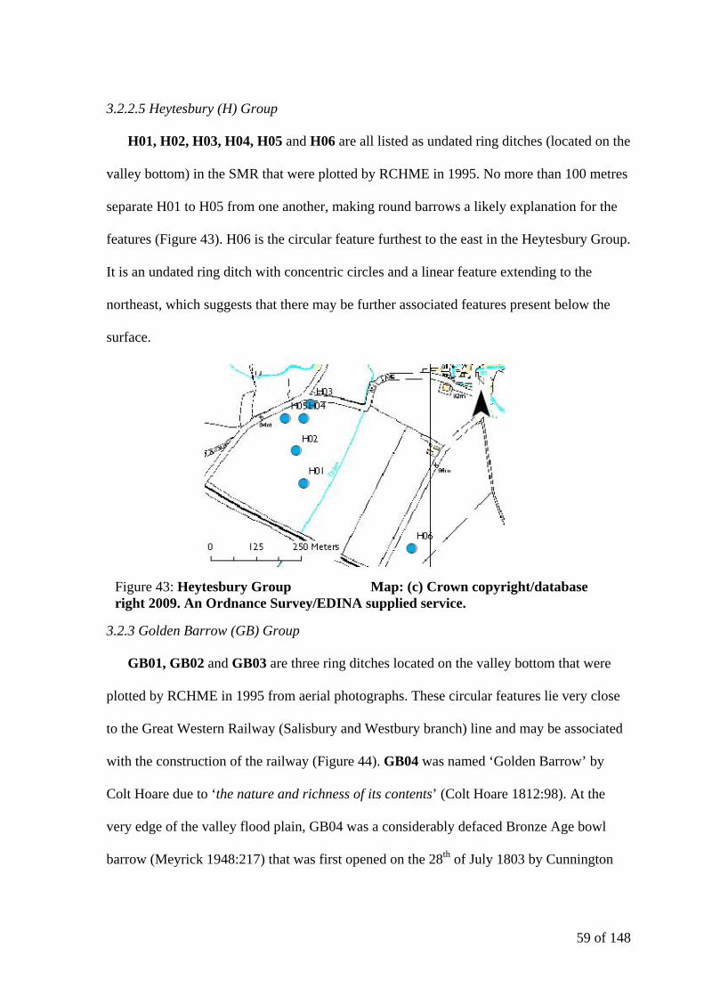
59 of 148
3.2.2.5 Heytesbury (H) Group
H01, H02, H03, H04, H05 and H06 are all listed as undated ring ditches (located on the
valley bottom) in the SMR that were plotted by RCHME in 1995. No more than 100 metres
separate H01 to H05 from one another, making round barrows a likely explanation for the
features (Figure 43). H06 is the circular feature furthest to the east in the Heytesbury Group.
It is an undated ring ditch with concentric circles and a linear feature extending to the
northeast, which suggests that there may be further associated features present below the
surface.
3.2.3 Golden Barrow (GB) Group
GB01, GB02 and GB03 are three ring ditches located on the valley bottom that were
plotted by RCHME in 1995 from aerial photographs. These circular features lie very close
to the Great Western Railway (Salisbury and Westbury branch) line and may be associated
with the construction of the railway (Figure 44). GB04 was named ‘Golden Barrow’ by
Colt Hoare due to ‘the nature and richness of its contents’ (Colt Hoare 1812:98). At the
very edge of the valley flood plain, GB04 was a considerably defaced Bronze Age bowl
barrow (Meyrick 1948:217) that was first opened on the 28th of July 1803 by Cunnington
Figure 43: Heytesbury Group Map: (c) Crown copyright/database right 2009. An Ordnance Survey/EDINA supplied service.

60 of 148
(Cunnington 1975:53) who discovered a primary cremation at a depth of around 0.6 metres
in a ‘shallow bason-like cist’ (Colt Hoare 1812:98).
A secondary cremation was discovered around 0.3 metres from the primary cremation
with a great many items including a bronze awl, 13 drum-shaped gold beads (with
unscrewable ends) that were perforated on the sides (probably for the purpose of stringing),
an amber space-plate necklace with complex borings, a grape cup with incisions on upper
part of body and rim bevel, a bronze dagger, a collared urn with stab marks on rim bevel,
two gold cones with grooved ornament, one of which has a small triangular perforation
through the side, a rectangular plate of sheet gold with grooved ornament and a shale button
with gold cover. Photographs of the necklace, gold beads and gold plate can be seen in
Figure 45 and an illustration of all the surviving items from the barrow can be seen in
Figure 46.
The grooved ornament on the gold cover is repeated on the shale core, the decoration
taking the form of ‘zigzags’. The finds recovered from the barrow certainly justify the title
Figure 44: Golden Barrow Group Map: (c) Crown copyright/database right 2009. An Ordnance Survey/EDINA supplied service.

61 of 148
‘Golden Barrow’ and the temptation to be a part of the excavation proved too much for Colt
Hoare as he includes himself in the description of an excavation that he was almost
certainly not present at. Since the excavation two of the 13 gold beads have been lost and
the remaining eleven are on loan at the British Museum. A second collared urn was not
preserved (Annable and Simpson 1964:49). The barrow certainly falls into the category of
Wealthy Wessex (with the presence of over five items of four different materials) and may
even have been a ‘fancy barrow’. The description provided by Colt Hoare is unclear but the
possibility of this barrow being a ‘cone’ barrow will be discussed further in Section Four.
Figure 45: GB04 Amber necklace, gold beads and gold plate
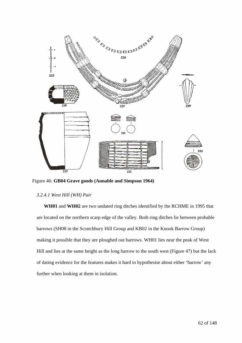
62 of 148
3.2.4.1 West Hill (WH) Pair
WH01 and WH02 are two undated ring ditches identified by the RCHME in 1995 that
are located on the northern scarp edge of the valley. Both ring ditches lie between probable
barrows (SH08 in the Scratchbury Hill Group and KB02 in the Knook Barrow Group)
making it possible that they are ploughed out barrows. WH01 lies near the peak of West
Hill and lies at the same height as the long barrow to the south west (Figure 47) but the lack
of dating evidence for the features makes it hard to hypothesise about either ‘barrow’ any
further when looking at them in isolation.
Figure 46: GB04 Grave goods (Annable and Simpson 1964)
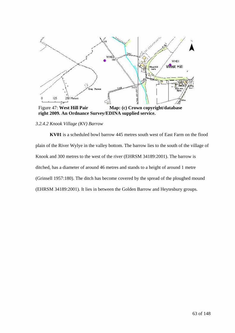
63 of 148
3.2.4.2 Knook Village (KV) Barrow
KV01 is a scheduled bowl barrow 445 metres south west of East Farm on the flood
plain of the River Wylye in the valley bottom. The barrow lies to the south of the village of
Knook and 300 metres to the west of the river (EHRSM 34189:2001). The barrow is
ditched, has a diameter of around 46 metres and stands to a height of around 1 metre
(Grinsell 1957:180). The ditch has become covered by the spread of the ploughed mound
(EHRSM 34189:2001). It lies in between the Golden Barrow and Heytesbury groups.
Figure 47: West Hill Pair Map: (c) Crown copyright/database right 2009. An Ordnance Survey/EDINA supplied service.

64 of 148
3.3 Analysis of barrow data in ST94SE
This area contains thirty-four of the possible barrows within the study area including
twenty-seven confirmed round barrows. Two of these barrows (UB01 and UB02) are
unlocated within the SMR but have been included in the study as their essential location is
known (i.e. Upton Lovell) and their contents are important to the analytical discussion.
The barrows (or potential barrows) have been split into three distinct clusters, as shown
in Figure 49. This quadrate contains some of the most closely spaced nucleated cemetery
groups in the study area, as well as some well known finds (such as those from UL03).
Figure 48: Knook Village Barrow Map: (c) Crown copyright/database right 2009. An Ordnance Survey/EDINA supplied service.
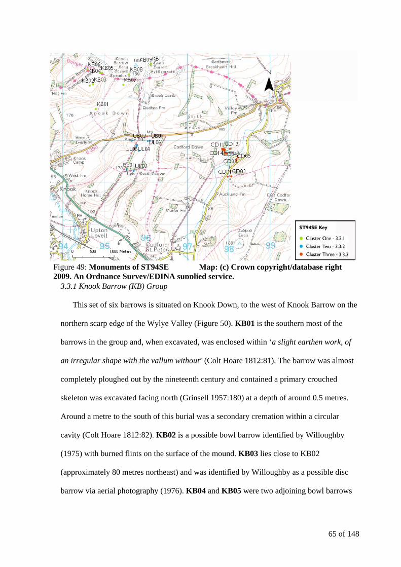
65 of 148
3.3.1 Knook Barrow (KB) Group
This set of six barrows is situated on Knook Down, to the west of Knook Barrow on the
northern scarp edge of the Wylye Valley (Figure 50). KB01 is the southern most of the
barrows in the group and, when excavated, was enclosed within ‘a slight earthen work, of
an irregular shape with the vallum without’ (Colt Hoare 1812:81). The barrow was almost
completely ploughed out by the nineteenth century and contained a primary crouched
skeleton was excavated facing north (Grinsell 1957:180) at a depth of around 0.5 metres.
Around a metre to the south of this burial was a secondary cremation within a circular
cavity (Colt Hoare 1812:82). KB02 is a possible bowl barrow identified by Willoughby
(1975) with burned flints on the surface of the mound. KB03 lies close to KB02
(approximately 80 metres northeast) and was identified by Willoughby as a possible disc
barrow via aerial photography (1976). KB04 and KB05 were two adjoining bowl barrows
Figure 49: Monuments of ST94SE Map: (c) Crown copyright/database right 2009. An Ordnance Survey/EDINA supplied service.

66 of 148
to the west of Knook Barrow. KB04 contained a crouched inhumation and ‘an ivory or
bone pin’ (Colt Hoare 1812:82) and KB05 contained a cremation within a cist (Colt Hoare
1812:82) at a depth of around 0.6 metres. A long brass pin or awl (Grinsell1957:177) was
associated with the cremated remains. KB06 is another probable bowl barrow identified by
Willoughby in 1976 to the west of the down.
A second nucleus of round barrows sited on Knook Down are focused around Knook
Barrow, a long barrow 33.5 metres north-east/south-west by 19.5 metres wide, with side
ditches 6 metres wide (EHRSM 10225:1990) which was found to contain the remains of
around 8 cremations on a pavement of flints with associated animal bones (Colt Hoare
1812:83). KB07 lies to the south of Knook Barrow and was the first barrow that William
Cunnington opened. The barrow contained a cremation ‘deposited within a rude sepulchral
Figure 50: Knook Barrow Group Map: (c) Crown copyright/database right 2009. An Ordnance Survey/EDINA supplied service.
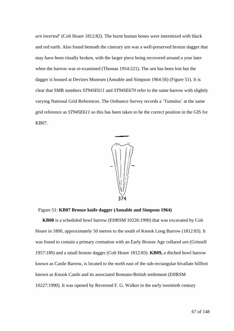
67 of 148
urn inverted’ (Colt Hoare 1812:82). The burnt human bones were intermixed with black
and red earth. Also found beneath the cinerary urn was a well-preserved bronze dagger that
may have been ritually broken, with the larger piece being recovered around a year later
when the barrow was re-examined (Thomas 1954:221). The urn has been lost but the
dagger is housed at Devizes Museum (Annable and Simpson 1964:56) (Figure 51). It is
clear that SMR numbers ST94SE611 and ST94SE670 refer to the same barrow with slightly
varying National Grid References. The Ordnance Survey records a ‘Tumulus’ at the same
grid reference as ST94SE611 so this has been taken to be the correct position in the GIS for
KB07.
KB08 is a scheduled bowl barrow (EHRSM 10226:1990) that was excavated by Colt
Hoare in 1800, approximately 50 metres to the south of Knook Long Barrow (1812:83). It
was found to contain a primary cremation with an Early Bronze Age collared urn (Grinsell
1957:180) and a small bronze dagger (Colt Hoare 1812:83). KB09, a ditched bowl barrow
known as Castle Barrow, is located to the north east of the sub-rectangular bivallate hillfort
known as Knook Castle and its associated Romano-British settlement (EHRSM
10227:1990). It was opened by Reverend F. G. Walker in the early twentieth century
Figure 51: KB07 Bronze knife dagger (Annable and Simpson 1964)

68 of 148
(Cunnington 1939:189) who discovered a central primary cremation of a child in a cist
around 1.2 metres below the mound. A badly crushed cinerary urn of coarse Bronze Age
form was associated with the remains (Grinsell 1957:193). KB10 is the site of an undated
round barrow visible as a ring ditch in aerial photographs close to KB09. A large ring ditch
(ST94SE634) has not been included as a possible round barrow as it seems more likely to be
a feature associated with the later settlement to the west.
The Knook Barrow group is an area cemetery with nucleated elements (such as KB04
and KB05 and KB09 and KB10) that is centred on a much older feature in the landscape.
There is a mix of interment rites present (Figure 52) and the ceramic and metallic evidence
recovered from the barrows would suggest a later date in the Early Bronze Age.
Figure 52: Knook Barrow Group Burial Types Map: (c) Crown copyright/database right 2009. An Ordnance Survey/EDINA supplied service.
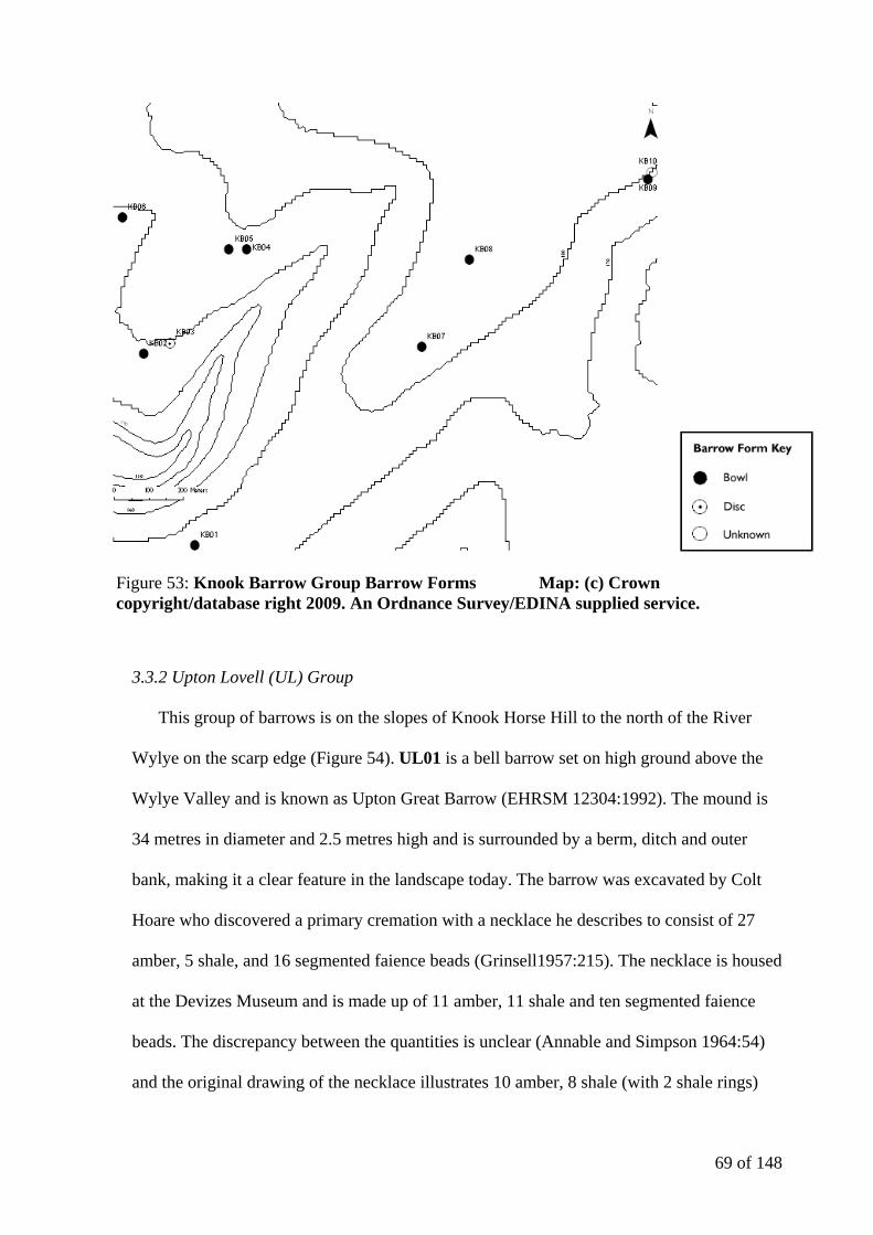
69 of 148
3.3.2 Upton Lovell (UL) Group
This group of barrows is on the slopes of Knook Horse Hill to the north of the River
Wylye on the scarp edge (Figure 54). UL01 is a bell barrow set on high ground above the
Wylye Valley and is known as Upton Great Barrow (EHRSM 12304:1992). The mound is
34 metres in diameter and 2.5 metres high and is surrounded by a berm, ditch and outer
bank, making it a clear feature in the landscape today. The barrow was excavated by Colt
Hoare who discovered a primary cremation with a necklace he describes to consist of 27
amber, 5 shale, and 16 segmented faience beads (Grinsell1957:215). The necklace is housed
at the Devizes Museum and is made up of 11 amber, 11 shale and ten segmented faience
beads. The discrepancy between the quantities is unclear (Annable and Simpson 1964:54)
and the original drawing of the necklace illustrates 10 amber, 8 shale (with 2 shale rings)
Figure 53: Knook Barrow Group Barrow Forms Map: (c) Crown copyright/database right 2009. An Ordnance Survey/EDINA supplied service.

70 of 148
and 10 faience beads (Figure 55). There were also ‘fragments of rude pottery, pieces of
stags’ horns, animal bones, and vast quantities of ashes and charred wood’ (Colt Hoare
1812:77) in the body of the mound. The barrow currently rests inside a pheasant run with a
metal water reservoir sunk into the centre of the barrow (Figure 56). It is unclear what
damage this will have caused and a disagreement between the farmer and English Heritage
seems to have delayed its removal indefinitely (Mr Nevill, personal communication 2008).
Figure 54: Upton Lovell Group Map: (c) Crown copyright/database right 2009. An Ordnance Survey/EDINA supplied service.
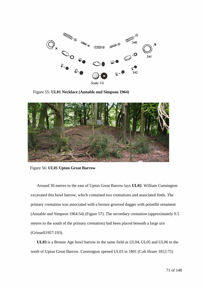
71 of 148
Around 30 metres to the east of Upton Great Barrow lays UL02. William Cunnington
excavated this bowl barrow, which contained two cremations and associated finds. The
primary cremation was associated with a bronze grooved dagger with pointillé ornament
(Annable and Simpson 1964:54) (Figure 57). The secondary cremation (approximately 0.5
metres to the south of the primary cremation) had been placed beneath a large urn
(Grinsell1957:193).
UL03 is a Bronze Age bowl barrow in the same field as UL04, UL05 and UL06 to the
north of Upton Great Barrow. Cunnington opened UL03 in 1801 (Colt Hoare 1812:75)
Figure 55: UL01 Necklace (Annable and Simpson 1964)
Figure 56: UL01 Upton Great Barrow
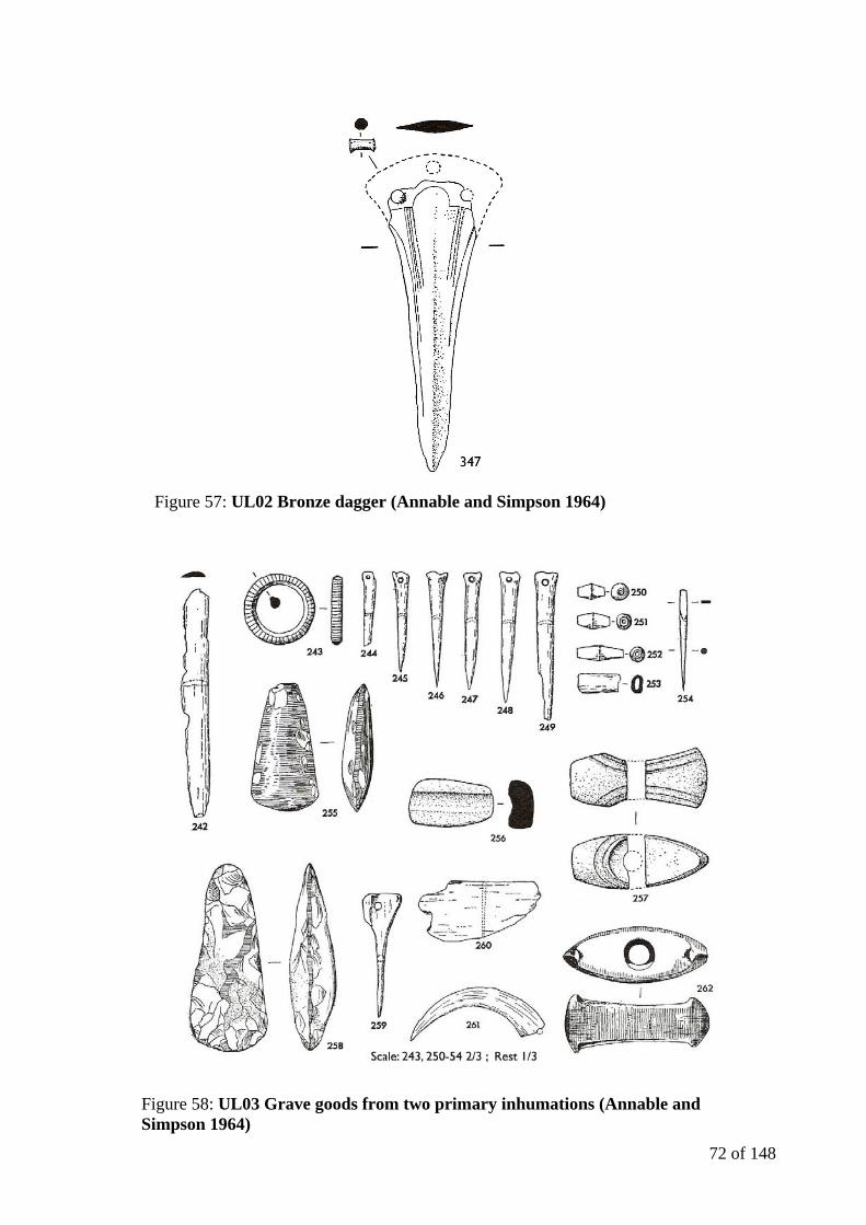
72 of 148
Figure 57: UL02 Bronze dagger (Annable and Simpson 1964)
Figure 58: UL03 Grave goods from two primary inhumations (Annable and Simpson 1964)
73 of 148
where primary inhumations were uncovered in an oval grave. The first, lying on its back
(north-south) appears to have been a stout male with many finds including bone perforated
points, perforated boars' teeth, stone and flint axes, a jet or lignite ring, biconical beads and
a bronze awl (Figure 58). The other burial appeared much smaller in stature and was in a
sitting posture. The material in the grave appears to represent a combination of items
associated with both genders (Annable and Simpson 1964:50) and it is possible that certain
items were specific to one of the two inhumations. Colt Hoare records that it was
impossible to separate the objects appropriate to each of the inhumations but the burial was
interpreted by Piggott (1962:94) to be that of a shaman dating to around 1500 BC. The bone
points number over sixty and in terms of quantity have no parallel in Britain. Six similar but
unperforated bone points were excavated at Aldro 113 in the Yorkshire Wolds by Sir J.R.
Mortimer and were associated with a female burial (Howarth 2005:44).
In 2000 Colin Shell developed Piggott’s suggestion that the stones from the grave in
UL03, notably the polished circular stone ‘rubber’ (Figure 59), formed ‘an early
metalworker’s toolkit’ (Shell 2000:271). Although it is very tempting to go on to link the
individual (or individuals) interred in UL03 with gold work in the area (particularly GB04
with its rectangular plate of sheet gold), a spatial correlation is not necessarily a correct
association. Whilst it is clear that metalwork such as that found in the area required a skilled
individual with a specific set of tools (which would have undoubtedly been of great
personal value) a stronger chronological framework for the burials of the two sites would be
required.
When the barrow was de-scheduled in 1994, it became possible to conduct resistivity
and magnetometry surveys to clarify the position and shape of the early 19th century
excavation of the grave pit and confirm the diameter of the ditch, as the barrow was no

74 of 148
longer clearly visible in the field (Shell 2002:290). This was conducted in 1999 (Robinson
2001:253) and the geophysical survey results led to an excavation (undertaken by Colin
Shell and Gill Swanton) to investigate magnetic anomalies and allowed the recovery of
skeletal material (left by Cunnington) from the grave pit. The robust bones uncovered
included the skull of what (from Colt Hoare’s description) is likely to be the primary burial
and may well be able to contribute to the discussion of a possible link between the
metalworker and GB04.
UL04 and UL05 are two adjacent saucer barrows situated just over 100 metres to the
northwest of UL03 (EHRSM 12303:1994) spaced around 5 metres apart on almost a north-
south alignment. UL05 is around 12 metres in diameter and 0.5 metres in height and UL04
is smaller at around 11 metres yet higher at about 0.7 metres. Shallow ditches surround both
barrows but only UL05 has been partially excavated. Cunnington excavated UL05 and
uncovered an inhumation with a ceramic beaker at the burial’s legs (not a cremation as
listed in the English Heritage’s Record of Scheduled Monuments (EHRSM 12303:1994))
Figure 59: UL03 polished circular stone ‘rubber’ (Wiltshire Heritage Museum)
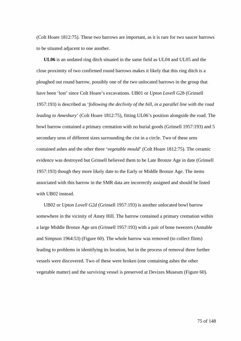
75 of 148
(Colt Hoare 1812:75). These two barrows are important, as it is rare for two saucer barrows
to be situated adjacent to one another.
UL06 is an undated ring ditch situated in the same field as UL04 and UL05 and the
close proximity of two confirmed round barrows makes it likely that this ring ditch is a
ploughed out round barrow, possibly one of the two unlocated barrows in the group that
have been ‘lost’ since Colt Hoare’s excavations. UB01 or Upton Lovell G2b (Grinsell
1957:193) is described as ‘following the declivity of the hill, in a parallel line with the road
leading to Amesbury’ (Colt Hoare 1812:75), fitting UL06’s position alongside the road. The
bowl barrow contained a primary cremation with no burial goods (Grinsell 1957:193) and 5
secondary urns of different sizes surrounding the cist in a circle. Two of these urns
contained ashes and the other three ‘vegetable mould’ (Colt Hoare 1812:75). The ceramic
evidence was destroyed but Grinsell believed them to be Late Bronze Age in date (Grinsell
1957:193) though they more likely date to the Early or Middle Bronze Age. The items
associated with this barrow in the SMR data are incorrectly assigned and should be listed
with UB02 instead.
UB02 or Upton Lovell G2d (Grinsell 1957:193) is another unlocated bowl barrow
somewhere in the vicinity of Ansty Hill. The barrow contained a primary cremation within
a large Middle Bronze Age urn (Grinsell 1957:193) with a pair of bone tweezers (Annable
and Simpson 1964:53) (Figure 60). The whole barrow was removed (to collect flints)
leading to problems in identifying its location, but in the process of removal three further
vessels were discovered. Two of these were broken (one containing ashes the other
vegetable matter) and the surviving vessel is preserved at Devizes Museum (Figure 60).

76 of 148
The Upton Lovell cemetery group is an area cemetery with nucleated elements (for
example UL01 and UL02 and UL04 and UL05). It is possible that if the two unlocated
barrows in the area could be positively confirmed, there would be a more defined spatial
pattern to the barrows. The proximity of the two saucer barrows is striking (Figure 61), as is
the variety of burial styles present in the cemetery (Figure 62).
3.3.3 Codford Down (CD) Group
CD01 and CD02 are two possible bowl barrows to the east of Chitterne Brook on the
northern slope of the Wylye Valley (Figure 63). CD01 is an undated circular mound and
CD02 is an undated ring ditch, both of which were identified through aerial photography.
Spatially both features are aligned with a variation in the valley wall (Figure 64). Three
further ring ditches (CD03, CD04, and CD05) are located to the north of CD02, on the
eastern side of the Chitterne Brook in the basin of the valley and are visible in aerial
photographs as cropmarks. All five of these unconfirmed features lie close to the eleven
recorded barrows in the Ashton Valley Group (CD06-16) indicating that they are possibly
part of a larger cemetery complex on the slopes of the Chitterne Brook valley leading down
to the river Wylye.
Figure 60: Bone tweezers and miniature vessel (Annable and Simpson 1964)
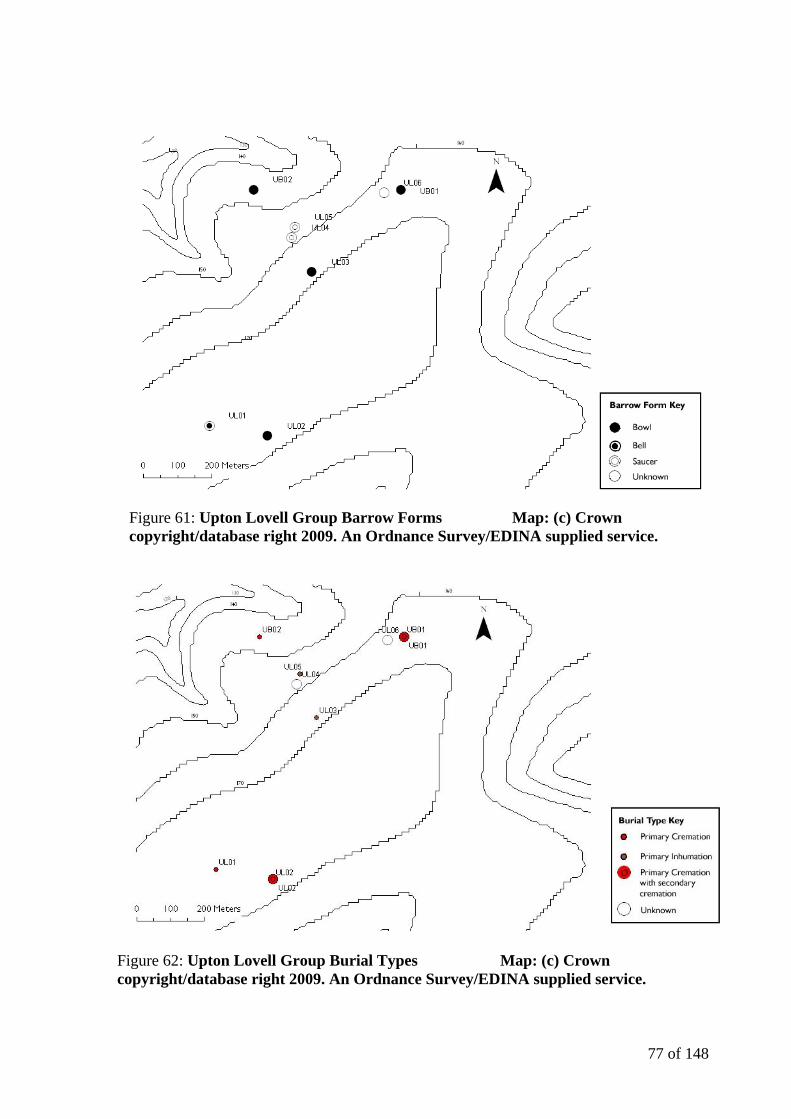
77 of 148
Figure 61: Upton Lovell Group Barrow Forms Map: (c) Crown copyright/database right 2009. An Ordnance Survey/EDINA supplied service.
Figure 62: Upton Lovell Group Burial Types Map: (c) Crown copyright/database right 2009. An Ordnance Survey/EDINA supplied service.
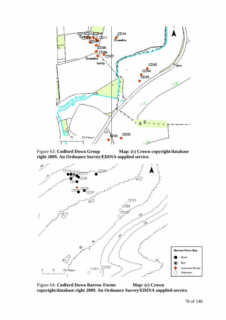
78 of 148
Figure 63: Codford Down Group Map: (c) Crown copyright/database right 2009. An Ordnance Survey/EDINA supplied service.
Figure 64: Codford Down Barrow Forms Map: (c) Crown copyright/database right 2009. An Ordnance Survey/EDINA supplied service.

79 of 148
The Ashton Valley Group is a round barrow cemetery that comprised one bell barrow
and ten bowl barrows located on the slopes of the valley. It is situated at the base of the
south facing edge of Codford Down on the west side of the valley of the Chitterne Brook
(EHRSM 31665:1999). The bell barrow and five of the bowl barrows are still visible, with
the remaining five bowl barrows now buried features. All eleven barrows were investigated
by William Cunnington and recorded and drawn by the antiquarian Sir Richard Colt Hoare
(1812:77). The cemetery area has been respected by the later Celtic field system that
encloses it on three sides (Annable 1960:8).
CD06 is the largest bowl barrow in the group (2.2 metres high and 23.5 metres in
diameter (EHRSM 31665:1999)); Cunnington excavated it in 1801 (and again in 1803 and
once more with Colt Hoare in 1808 (Colt Hoare 1812:77)). The primary cremation was
discovered in a cist with a large Middle Bronze Age urn (Grinsell 1957:166). To the south
Figure 65: Codford Down Burial Types Map: (c) Crown copyright/database right 2009. An Ordnance Survey/EDINA supplied service.
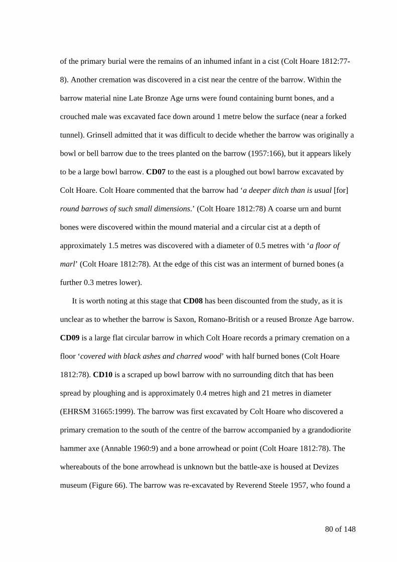
80 of 148
of the primary burial were the remains of an inhumed infant in a cist (Colt Hoare 1812:77-
8). Another cremation was discovered in a cist near the centre of the barrow. Within the
barrow material nine Late Bronze Age urns were found containing burnt bones, and a
crouched male was excavated face down around 1 metre below the surface (near a forked
tunnel). Grinsell admitted that it was difficult to decide whether the barrow was originally a
bowl or bell barrow due to the trees planted on the barrow (1957:166), but it appears likely
to be a large bowl barrow. CD07 to the east is a ploughed out bowl barrow excavated by
Colt Hoare. Colt Hoare commented that the barrow had ‘a deeper ditch than is usual [for]
round barrows of such small dimensions.’ (Colt Hoare 1812:78) A coarse urn and burnt
bones were discovered within the mound material and a circular cist at a depth of
approximately 1.5 metres was discovered with a diameter of 0.5 metres with ‘a floor of
marl’ (Colt Hoare 1812:78). At the edge of this cist was an interment of burned bones (a
further 0.3 metres lower).
It is worth noting at this stage that CD08 has been discounted from the study, as it is
unclear as to whether the barrow is Saxon, Romano-British or a reused Bronze Age barrow.
CD09 is a large flat circular barrow in which Colt Hoare records a primary cremation on a
floor ‘covered with black ashes and charred wood’ with half burned bones (Colt Hoare
1812:78). CD10 is a scraped up bowl barrow with no surrounding ditch that has been
spread by ploughing and is approximately 0.4 metres high and 21 metres in diameter
(EHRSM 31665:1999). The barrow was first excavated by Colt Hoare who discovered a
primary cremation to the south of the centre of the barrow accompanied by a grandodiorite
hammer axe (Annable 1960:9) and a bone arrowhead or point (Colt Hoare 1812:78). The
whereabouts of the bone arrowhead is unknown but the battle-axe is housed at Devizes
museum (Figure 66). The barrow was re-excavated by Reverend Steele 1957, who found a
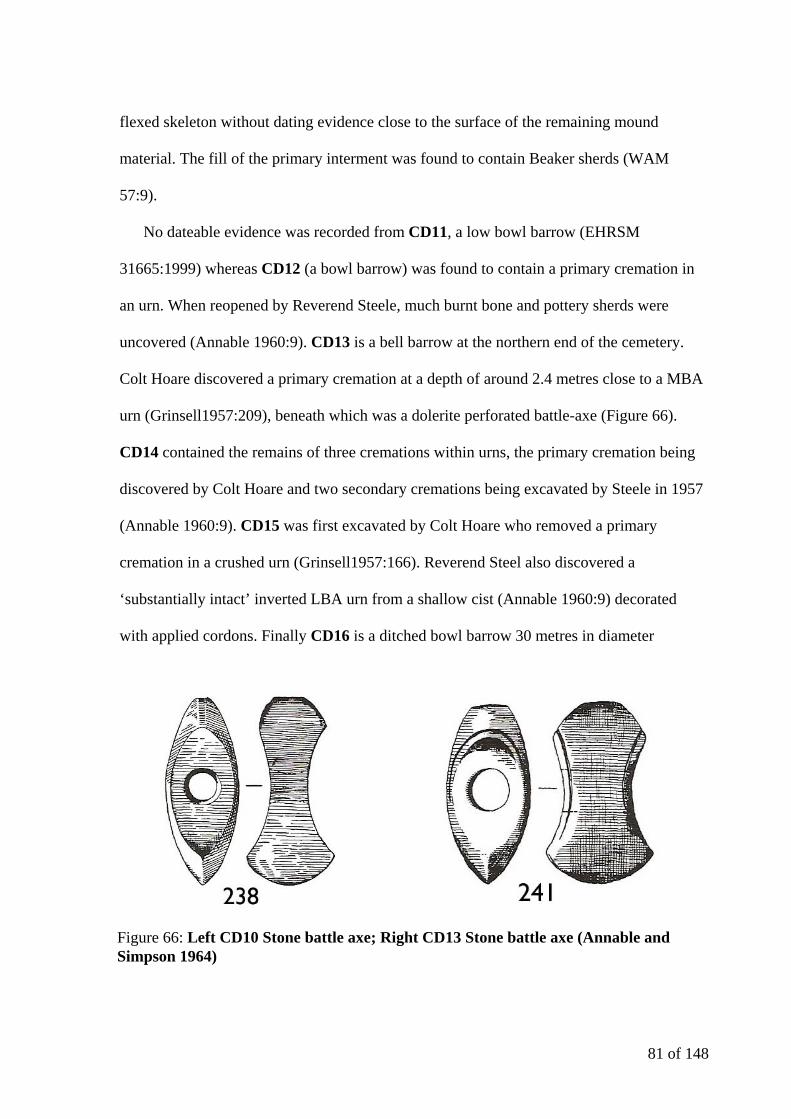
81 of 148
flexed skeleton without dating evidence close to the surface of the remaining mound
material. The fill of the primary interment was found to contain Beaker sherds (WAM
57:9).
No dateable evidence was recorded from CD11, a low bowl barrow (EHRSM
31665:1999) whereas CD12 (a bowl barrow) was found to contain a primary cremation in
an urn. When reopened by Reverend Steele, much burnt bone and pottery sherds were
uncovered (Annable 1960:9). CD13 is a bell barrow at the northern end of the cemetery.
Colt Hoare discovered a primary cremation at a depth of around 2.4 metres close to a MBA
urn (Grinsell1957:209), beneath which was a dolerite perforated battle-axe (Figure 66).
CD14 contained the remains of three cremations within urns, the primary cremation being
discovered by Colt Hoare and two secondary cremations being excavated by Steele in 1957
(Annable 1960:9). CD15 was first excavated by Colt Hoare who removed a primary
cremation in a crushed urn (Grinsell1957:166). Reverend Steel also discovered a
‘substantially intact’ inverted LBA urn from a shallow cist (Annable 1960:9) decorated
with applied cordons. Finally CD16 is a ditched bowl barrow 30 metres in diameter
Figure 66: Left CD10 Stone battle axe; Right CD13 Stone battle axe (Annable and Simpson 1964)
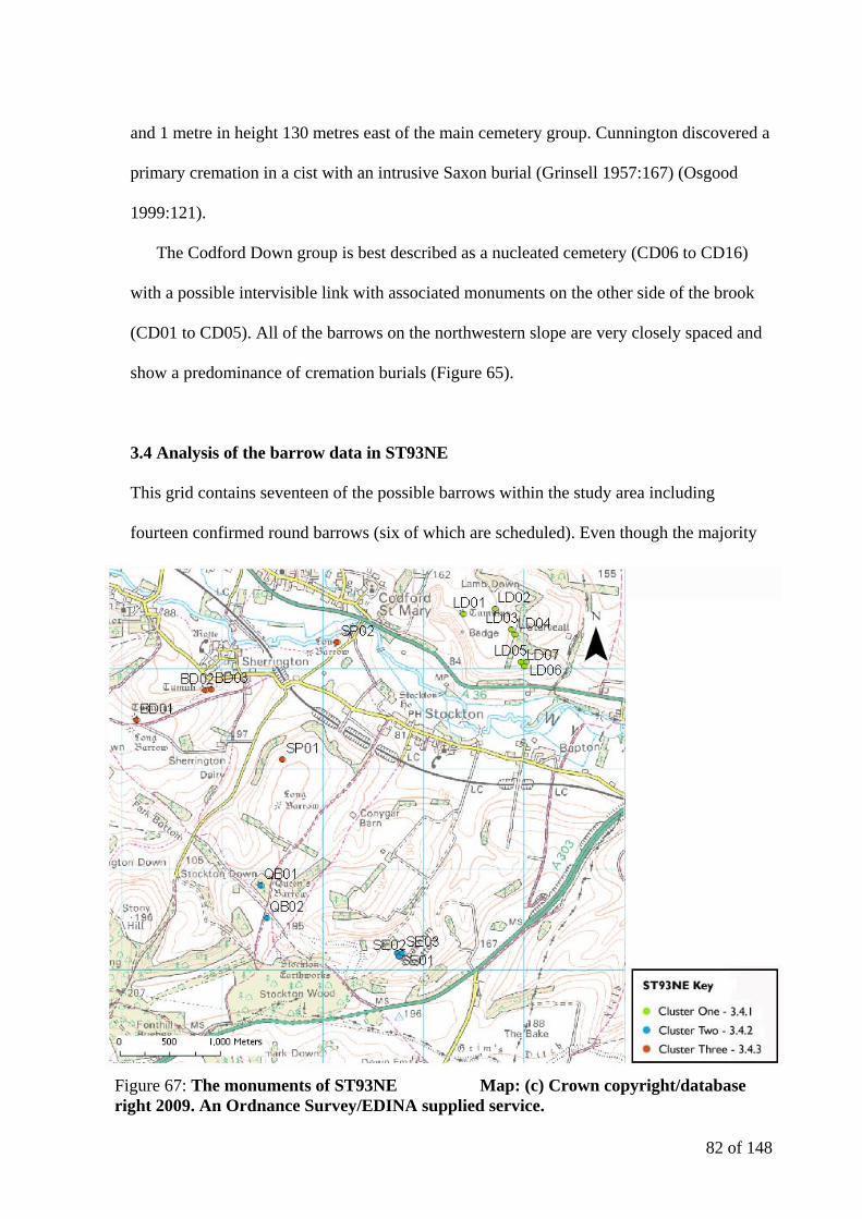
82 of 148
and 1 metre in height 130 metres east of the main cemetery group. Cunnington discovered a
primary cremation in a cist with an intrusive Saxon burial (Grinsell 1957:167) (Osgood
1999:121).
The Codford Down group is best described as a nucleated cemetery (CD06 to CD16)
with a possible intervisible link with associated monuments on the other side of the brook
(CD01 to CD05). All of the barrows on the northwestern slope are very closely spaced and
show a predominance of cremation burials (Figure 65).
3.4 Analysis of the barrow data in ST93NE
This grid contains seventeen of the possible barrows within the study area including
fourteen confirmed round barrows (six of which are scheduled). Even though the majority
Figure 67: The monuments of ST93NE Map: (c) Crown copyright/database right 2009. An Ordnance Survey/EDINA supplied service.

83 of 148
of this OS grid square lies on the southern valley slope, the focus of the recorded barrows in
the SMR are on the northern slope (focussed on Lamb Down).
3.4.1 Lamb Down (LD) Group
The group of seven barrows lies on a chalk hill known as Lamb Down on the southern edge
of Salisbury Plain on the northern scarp edge of the valley (Figure 68). LD01 is a bowl
barrow that commands ‘extensive views over the Wylye Valley to the south’ (EHRSM
31669:1999). Faith Vatcher investigated LD02 to LD07 in 1958 (Figure 69). LD02 is a
small Bronze Age ditched bowl barrow excavated by Vatcher (1962:417) that contained a
primary cremation of a child of around 9 years of age (Vatcher 1962:436) with 39
fragments of a collared urn with twisted cord impression (Vatcher 1962:425). The
cremation appeared to have taken place in situ due to red and black scorch marks (Figure
70). The urn appeared to have been ‘purposely scattered before the building of the mound’
(Vatcher 1962:425). The form is typical of many similar urns of the Wessex Culture
(Vatcher 1962:431) with horizontal cord impressions on the collar. In the north east
quadrant of the barrow there was a piece of another collared urn with diagonal fine cord
impressions possibly relating to a ploughed out secondary burial. There was also abraded
ceramic evidence indicating pre-barrow activity on the old land surface beneath the barrow.
There were 3 sherds of Windmill Hill pottery of a pinkish brown colour, a fragment of a
small cup and three Beaker sherds were recovered (two probable B Beakers and one a-C
Beaker) (Vatcher 1962:431-2). The barrow is small compared with an average Wessex
Culture barrow possibly indicating either a hasty burial or that of a less important individual
(Vatcher 1962:435).
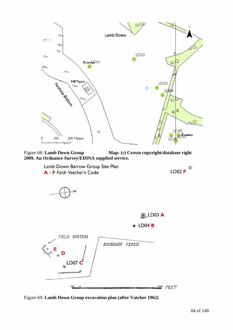
84 of 148
Figure 68: Lamb Down Group Map: (c) Crown copyright/database right 2009. An Ordnance Survey/EDINA supplied service.
Figure 69: Lamb Down Group excavation plan (after Vatcher 1962)

85 of 148
Figure 70: LD02 Site Plan (Vatcher 1962)
Figure 71: LD03 Site Plan (Vatcher 1962)
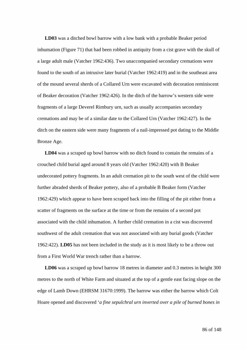
86 of 148
LD03 was a ditched bowl barrow with a low bank with a probable Beaker period
inhumation (Figure 71) that had been robbed in antiquity from a cist grave with the skull of
a large adult male (Vatcher 1962:436). Two unaccompanied secondary cremations were
found to the south of an intrusive later burial (Vatcher 1962:419) and in the southeast area
of the mound several sherds of a Collared Urn were excavated with decoration reminiscent
of Beaker decoration (Vatcher 1962:426). In the ditch of the barrow’s western side were
fragments of a large Deverel Rimbury urn, such as usually accompanies secondary
cremations and may be of a similar date to the Collared Urn (Vatcher 1962:427). In the
ditch on the eastern side were many fragments of a nail-impressed pot dating to the Middle
Bronze Age.
LD04 was a scraped up bowl barrow with no ditch found to contain the remains of a
crouched child burial aged around 8 years old (Vatcher 1962:420) with B Beaker
undecorated pottery fragments. In an adult cremation pit to the south west of the child were
further abraded sherds of Beaker pottery, also of a probable B Beaker form (Vatcher
1962:429) which appear to have been scraped back into the filling of the pit either from a
scatter of fragments on the surface at the time or from the remains of a second pot
associated with the child inhumation. A further child cremation in a cist was discovered
southwest of the adult cremation that was not associated with any burial goods (Vatcher
1962:422). LD05 has not been included in the study as it is most likely to be a throw out
from a First World War trench rather than a barrow.
LD06 was a scraped up bowl barrow 18 metres in diameter and 0.3 metres in height 300
metres to the north of White Farm and situated at the top of a gentle east facing slope on the
edge of Lamb Down (EHRSM 31670:1999). The barrow was either the barrow which Colt
Hoare opened and discovered ‘a fine sepulchral urn inverted over a pile of burned bones in
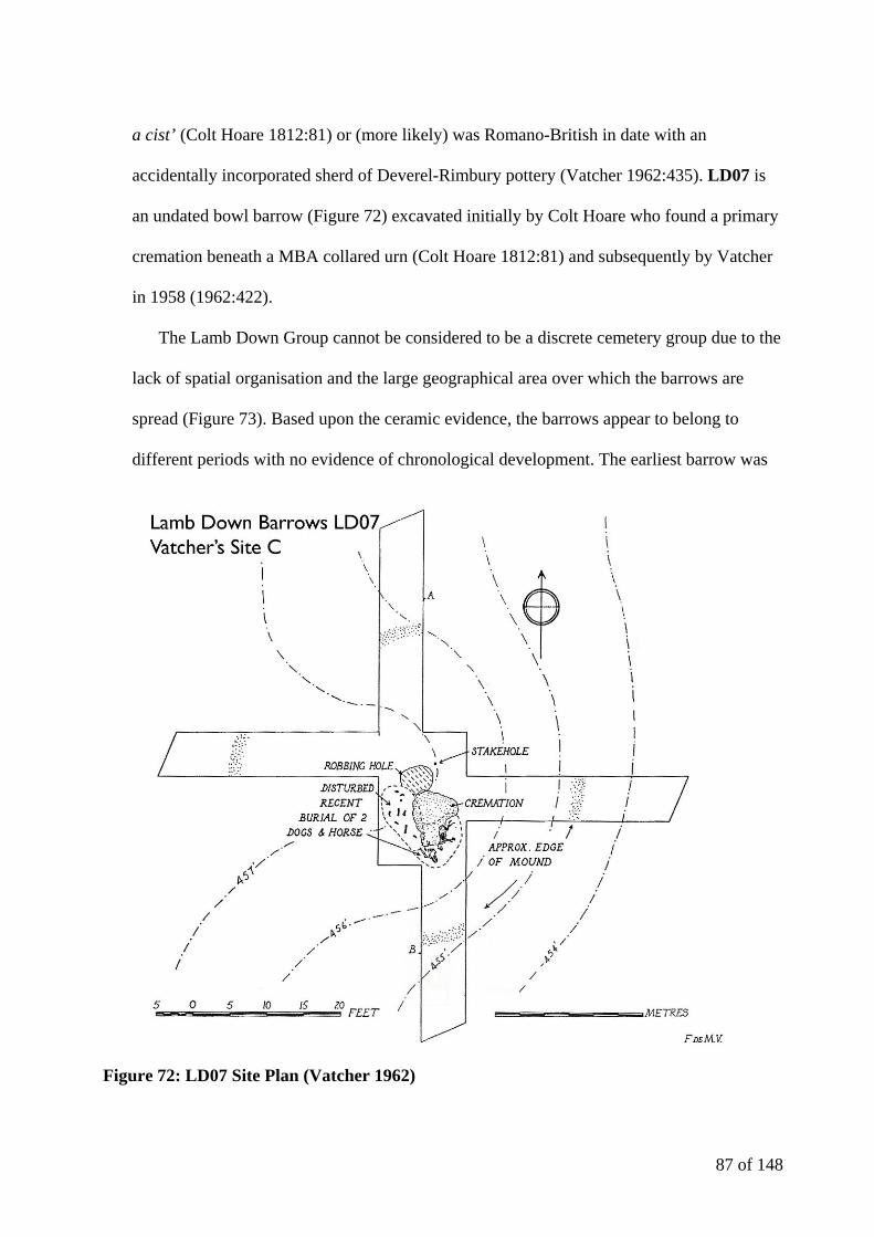
87 of 148
a cist’ (Colt Hoare 1812:81) or (more likely) was Romano-British in date with an
accidentally incorporated sherd of Deverel-Rimbury pottery (Vatcher 1962:435). LD07 is
an undated bowl barrow (Figure 72) excavated initially by Colt Hoare who found a primary
cremation beneath a MBA collared urn (Colt Hoare 1812:81) and subsequently by Vatcher
in 1958 (1962:422).
The Lamb Down Group cannot be considered to be a discrete cemetery group due to the
lack of spatial organisation and the large geographical area over which the barrows are
spread (Figure 73). Based upon the ceramic evidence, the barrows appear to belong to
different periods with no evidence of chronological development. The earliest barrow was
Figure 72: LD07 Site Plan (Vatcher 1962)
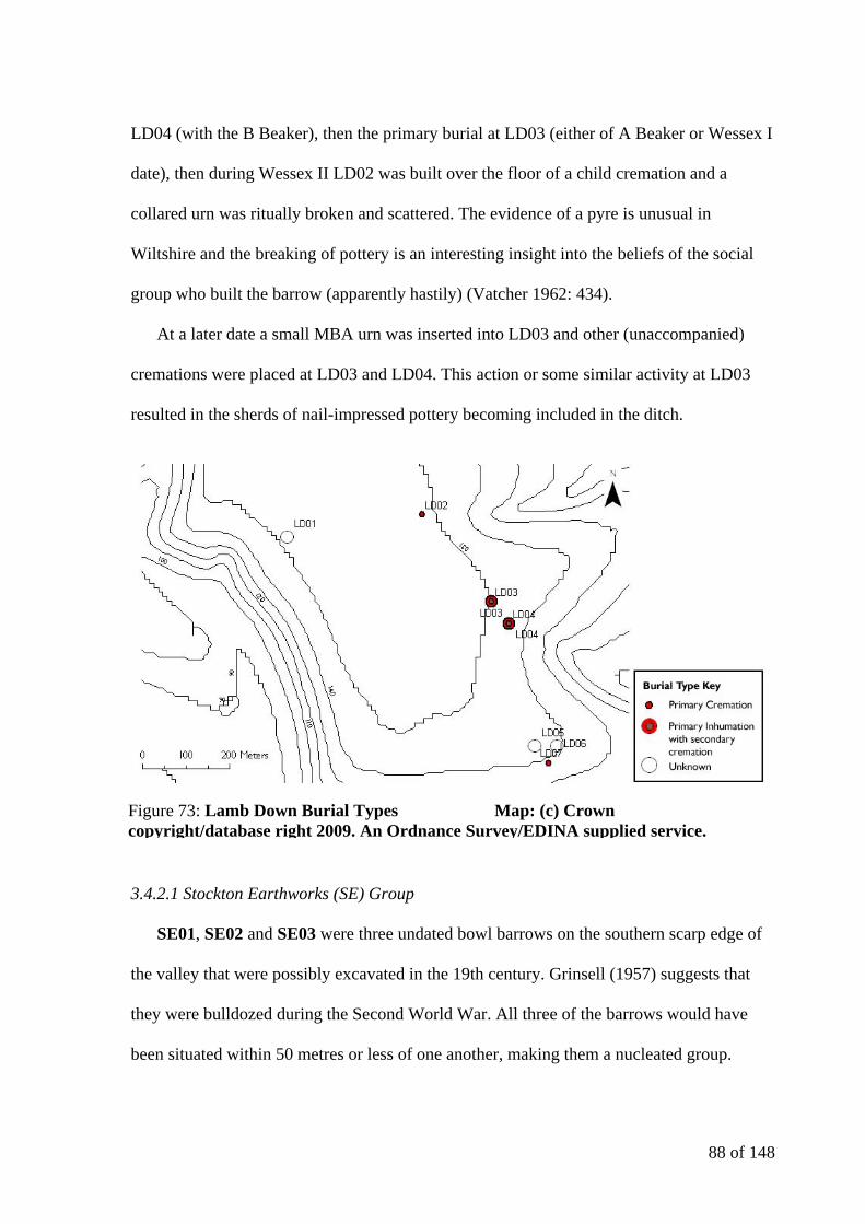
88 of 148
LD04 (with the B Beaker), then the primary burial at LD03 (either of A Beaker or Wessex I
date), then during Wessex II LD02 was built over the floor of a child cremation and a
collared urn was ritually broken and scattered. The evidence of a pyre is unusual in
Wiltshire and the breaking of pottery is an interesting insight into the beliefs of the social
group who built the barrow (apparently hastily) (Vatcher 1962: 434).
At a later date a small MBA urn was inserted into LD03 and other (unaccompanied)
cremations were placed at LD03 and LD04. This action or some similar activity at LD03
resulted in the sherds of nail-impressed pottery becoming included in the ditch.
3.4.2.1 Stockton Earthworks (SE) Group
SE01, SE02 and SE03 were three undated bowl barrows on the southern scarp edge of
the valley that were possibly excavated in the 19th century. Grinsell (1957) suggests that
they were bulldozed during the Second World War. All three of the barrows would have
been situated within 50 metres or less of one another, making them a nucleated group.
Figure 73: Lamb Down Burial Types Map: (c) Crown copyright/database right 2009. An Ordnance Survey/EDINA supplied service.
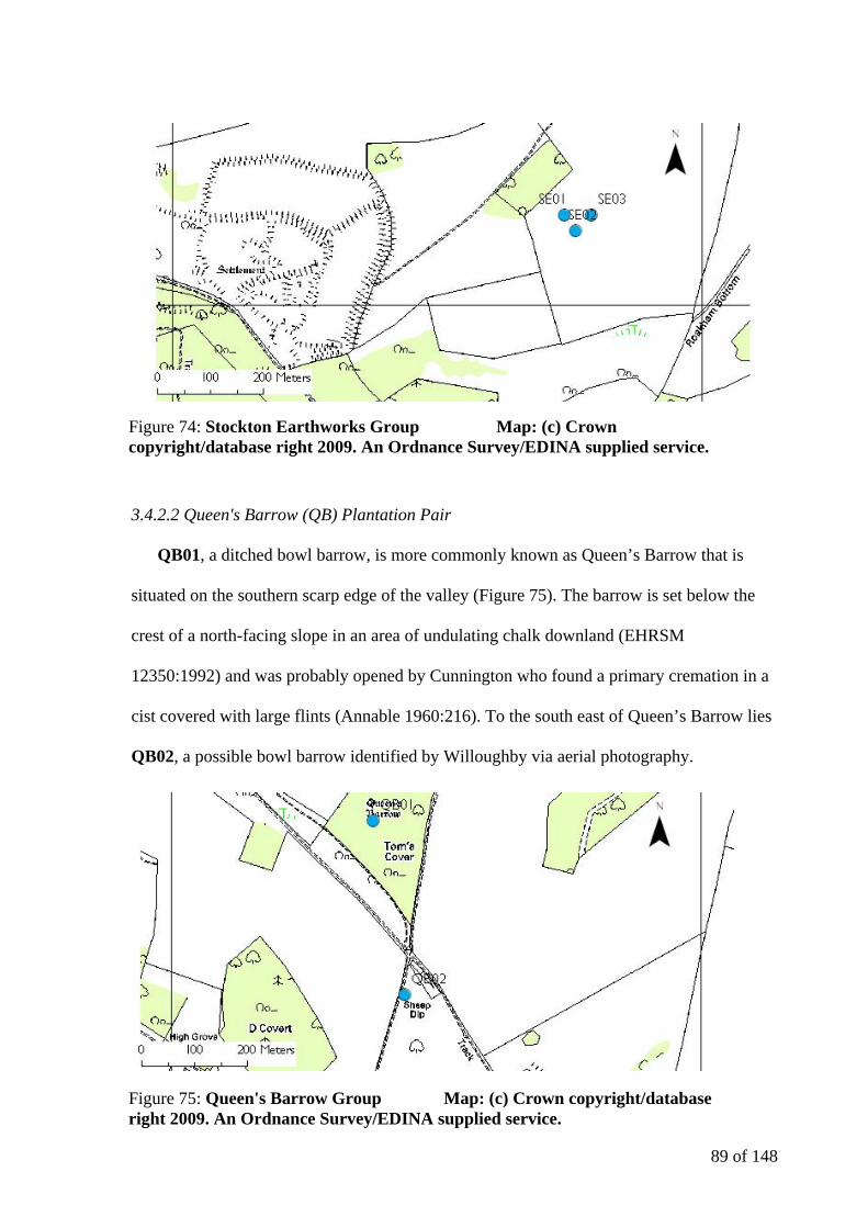
89 of 148
3.4.2.2 Queen's Barrow (QB) Plantation Pair
QB01, a ditched bowl barrow, is more commonly known as Queen’s Barrow that is
situated on the southern scarp edge of the valley (Figure 75). The barrow is set below the
crest of a north-facing slope in an area of undulating chalk downland (EHRSM
12350:1992) and was probably opened by Cunnington who found a primary cremation in a
cist covered with large flints (Annable 1960:216). To the south east of Queen’s Barrow lies
QB02, a possible bowl barrow identified by Willoughby via aerial photography.
Figure 74: Stockton Earthworks Group Map: (c) Crown copyright/database right 2009. An Ordnance Survey/EDINA supplied service.
Figure 75: Queen's Barrow Group Map: (c) Crown copyright/database right 2009. An Ordnance Survey/EDINA supplied service.
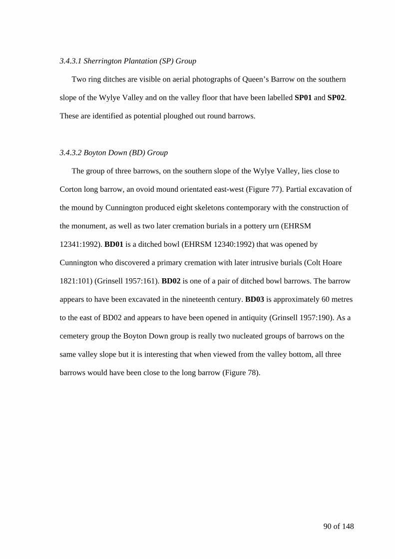
90 of 148
3.4.3.1 Sherrington Plantation (SP) Group
Two ring ditches are visible on aerial photographs of Queen’s Barrow on the southern
slope of the Wylye Valley and on the valley floor that have been labelled SP01 and SP02.
These are identified as potential ploughed out round barrows.
3.4.3.2 Boyton Down (BD) Group
The group of three barrows, on the southern slope of the Wylye Valley, lies close to
Corton long barrow, an ovoid mound orientated east-west (Figure 77). Partial excavation of
the mound by Cunnington produced eight skeletons contemporary with the construction of
the monument, as well as two later cremation burials in a pottery urn (EHRSM
12341:1992). BD01 is a ditched bowl (EHRSM 12340:1992) that was opened by
Cunnington who discovered a primary cremation with later intrusive burials (Colt Hoare
1821:101) (Grinsell 1957:161). BD02 is one of a pair of ditched bowl barrows. The barrow
appears to have been excavated in the nineteenth century. BD03 is approximately 60 metres
to the east of BD02 and appears to have been opened in antiquity (Grinsell 1957:190). As a
cemetery group the Boyton Down group is really two nucleated groups of barrows on the
same valley slope but it is interesting that when viewed from the valley bottom, all three
barrows would have been close to the long barrow (Figure 78).

91 of 148
Figure 76: Sherrington Plantation Group Map: (c) Crown copyright/database right 2009. An Ordnance Survey/EDINA supplied service.
Figure 77: Boyton Down Group Map: (c) Crown copyright/database right 2009. An Ordnance Survey/EDINA supplied service.
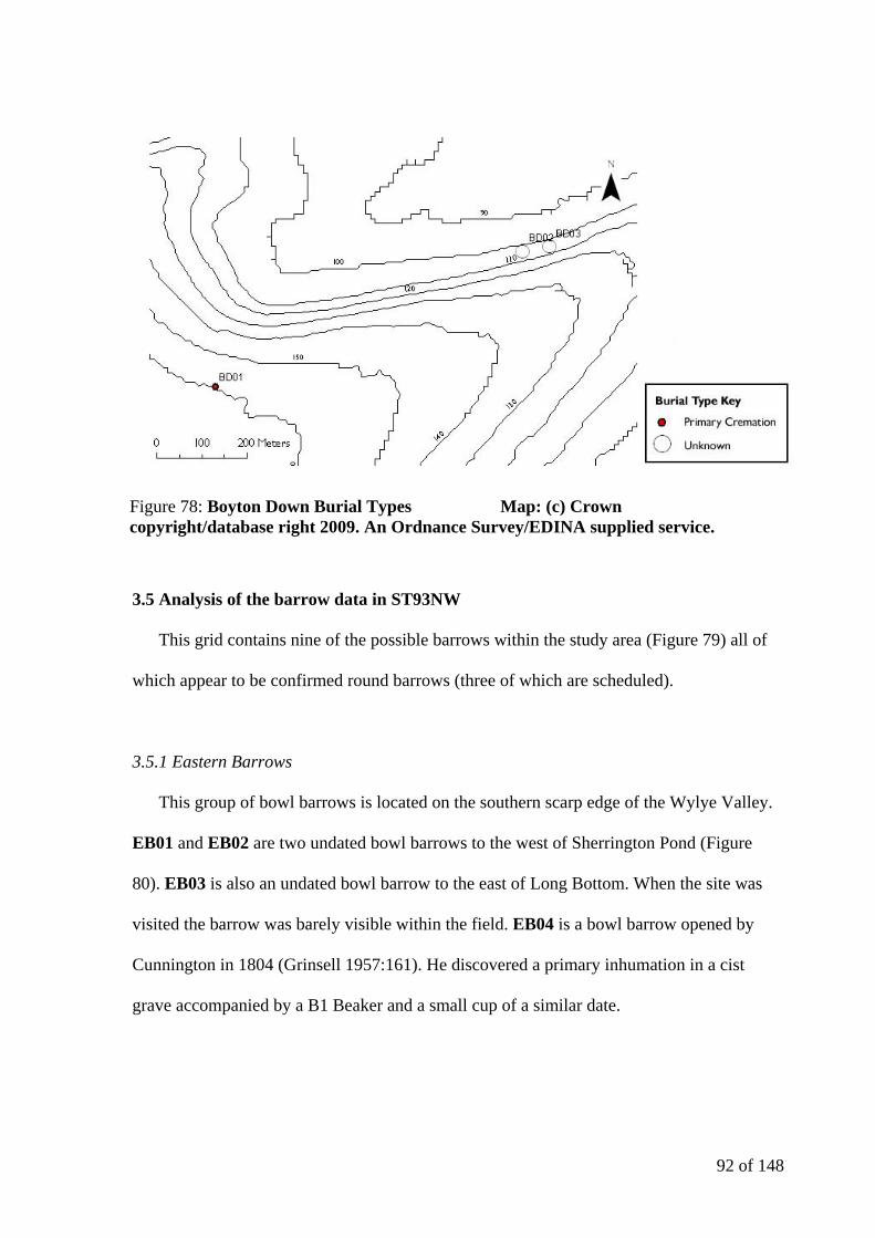
92 of 148
3.5 Analysis of the barrow data in ST93NW
This grid contains nine of the possible barrows within the study area (Figure 79) all of
which appear to be confirmed round barrows (three of which are scheduled).
3.5.1 Eastern Barrows
This group of bowl barrows is located on the southern scarp edge of the Wylye Valley.
EB01 and EB02 are two undated bowl barrows to the west of Sherrington Pond (Figure
80). EB03 is also an undated bowl barrow to the east of Long Bottom. When the site was
visited the barrow was barely visible within the field. EB04 is a bowl barrow opened by
Cunnington in 1804 (Grinsell 1957:161). He discovered a primary inhumation in a cist
grave accompanied by a B1 Beaker and a small cup of a similar date.
Figure 78: Boyton Down Burial Types Map: (c) Crown copyright/database right 2009. An Ordnance Survey/EDINA supplied service.
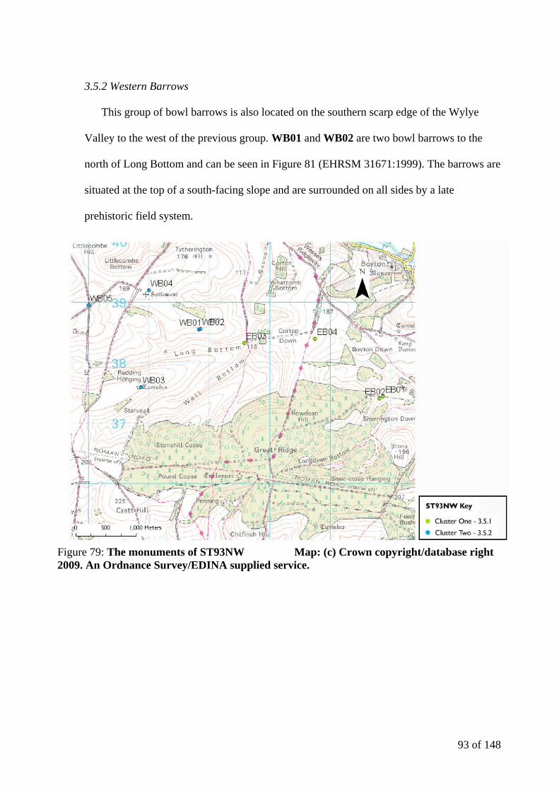
93 of 148
3.5.2 Western Barrows
This group of bowl barrows is also located on the southern scarp edge of the Wylye
Valley to the west of the previous group. WB01 and WB02 are two bowl barrows to the
north of Long Bottom and can be seen in Figure 81 (EHRSM 31671:1999). The barrows are
situated at the top of a south-facing slope and are surrounded on all sides by a late
prehistoric field system.
Figure 79: The monuments of ST93NW Map: (c) Crown copyright/database right 2009. An Ordnance Survey/EDINA supplied service.
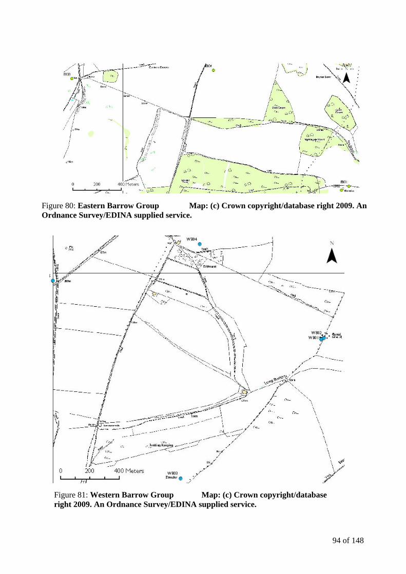
94 of 148
Figure 80: Eastern Barrow Group Map: (c) Crown copyright/database right 2009. An Ordnance Survey/EDINA supplied service.
Figure 81: Western Barrow Group Map: (c) Crown copyright/database right 2009. An Ordnance Survey/EDINA supplied service.
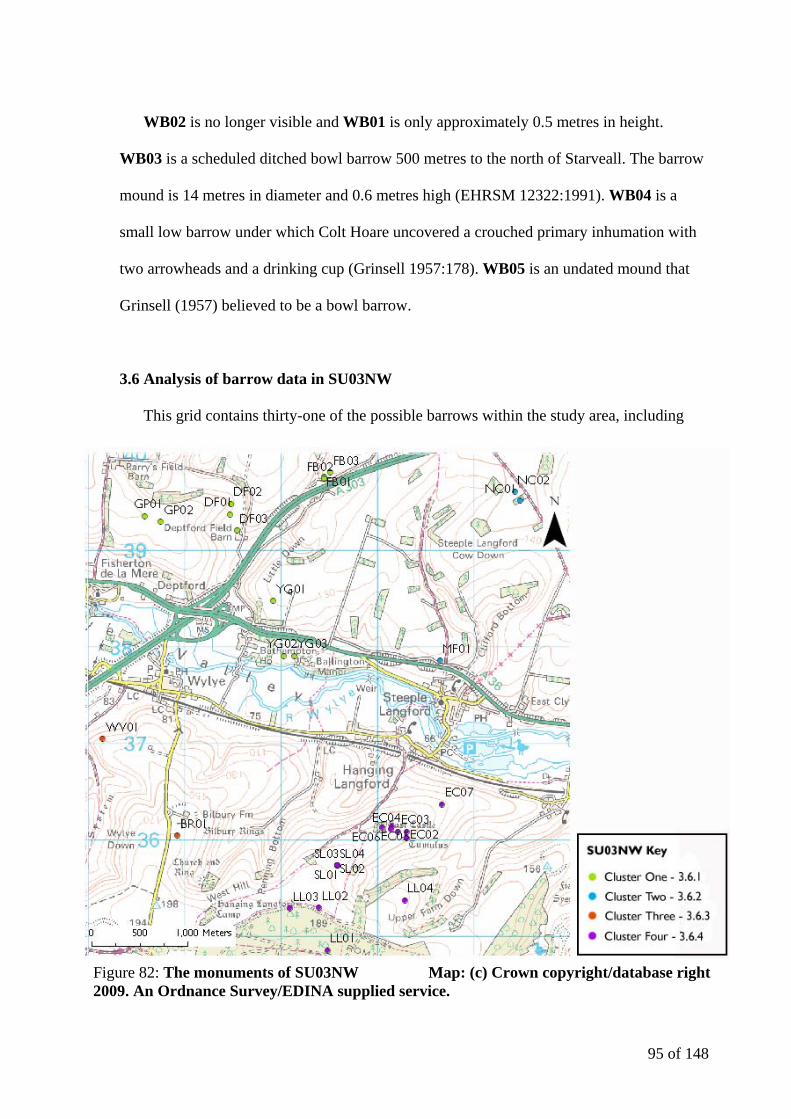
95 of 148
WB02 is no longer visible and WB01 is only approximately 0.5 metres in height.
WB03 is a scheduled ditched bowl barrow 500 metres to the north of Starveall. The barrow
mound is 14 metres in diameter and 0.6 metres high (EHRSM 12322:1991). WB04 is a
small low barrow under which Colt Hoare uncovered a crouched primary inhumation with
two arrowheads and a drinking cup (Grinsell 1957:178). WB05 is an undated mound that
Grinsell (1957) believed to be a bowl barrow.
3.6 Analysis of barrow data in SU03NW
This grid contains thirty-one of the possible barrows within the study area, including
Figure 82: The monuments of SU03NW Map: (c) Crown copyright/database right 2009. An Ordnance Survey/EDINA supplied service.

96 of 148
twenty-one confirmed round barrows (six of which are scheduled). The barrows (or
potential barrows) have been split into four distinct clusters, as shown in Figure 82) and
into eleven further groups within the four clusters.
3.6.1.1 Field Barn Group
FB01, FB02 and FB03 (Figure 83) are three undated bowl barrows on the northern
scarp edge of the Wylye Valley that appear to have been excavated in antiquity (Grinsell
1957:191). They form a nucleated group focussed on the southwestern spur of the down.
3.6.1.2 Yarnbury Grange Group
YG01 is an undated bowl barrow on the northern scarp edge of the valley which may be
the one excavated by Newall in 1956 (WCCSMR 2008). To the south of the barrow are two
ring ditches, located on the valley slope, which may be the ditches of round barrows (based
on aerial photography) and are labelled in Figure 84 as YG02 and YG03.
Figure 83: Field Barn Group Map: (c) Crown copyright/database right 2009. An Ordnance Survey/EDINA supplied service.

97 of 148
3.6.1.3 Deptford Field Barn Group
In a similar manner to the Yarnbury Grange group, the Deptford Field Barn group
contains one confirmed barrow and two ring ditches on the northern scarp edge of the
valley (Figure 85). DF01 is a bowl barrow that was opened by Lush in around 1908. He
found a primary cremation and a miniature vessel (Passmore 1942:118). The handle of a
beaker and two sherds of grooved ware were also found in the fill of the grave as shown in
Figure 86 (Passmore 1942:117).
DF02 and DF03 are two ring ditches that are visible on aerial photography. They are
between 100 and 200 metres from the confirmed bowl barrow and may form an area
cemetery.
Figure 84: Yarnbury Grange Group Map: (c) Crown copyright/database right 2009. An Ordnance Survey/EDINA supplied service.
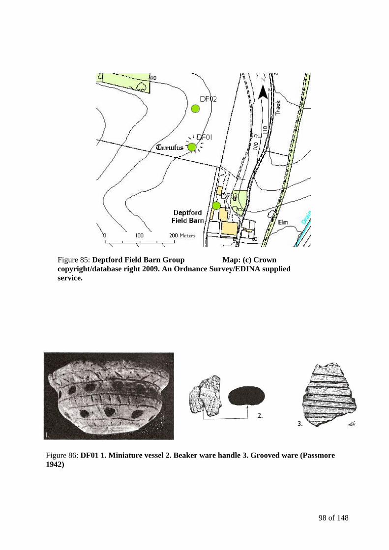
98 of 148
Figure 85: Deptford Field Barn Group Map: (c) Crown copyright/database right 2009. An Ordnance Survey/EDINA supplied service.
Figure 86: DF01 1. Miniature vessel 2. Beaker ware handle 3. Grooved ware (Passmore 1942)

99 of 148
3.6.1.4 Gilbert’s Plantation Pair
GP01 and GP02 are two ring ditches located on the northern scarp edge of the valley
that were identified via aerial photography by English Heritage (Figure 87). They are
separated from one another by around 180 metres and if they were to be confirmed as
ploughed out round barrows, they may be associated with the Deptford Field Barn group to
the east.
3.6.2.1 New Covert Pair
NC01 was an undated bowl barrow that Grinsell identified in 1950 (1957:191). When
the Ordnance Survey visited the site in 1956 the barrow was already found to have been
ploughed out, emphasising the speed at which barrows can be ultimately destroyed. NC02
is an undated ring ditch approximately 100 metres to the northwest of NC01 (Figure 88).
Both of the barrows are located on the far side of the northern scarp edge of the valley.
3.6.2.2 Manor Farm Feature
MF01 is an undated ring ditch situated on a false crest on the northern slope of the
Wylye Valley escarpment (Figure 89). Spatially it is similar to some of the barrows in the
Scratchbury Hill group.

100 of 148
Figure 87: Gilbert's Plantation Pair Map: (c) Crown copyright/database right 2009. An Ordnance Survey/EDINA supplied service.
Figure 88: New Covert Pair Map: (c) Crown copyright/database right 2009. An Ordnance Survey/EDINA supplied service.
Figure 89: Manor Farm Feature Map: (c) Crown copyright/database right 2009. An Ordnance Survey/EDINA supplied service.
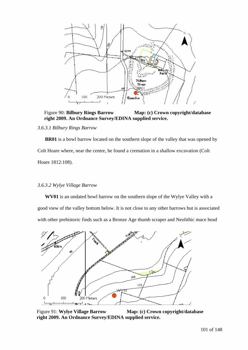
101 of 148
3.6.3.1 Bilbury Rings Barrow
BR01 is a bowl barrow located on the southern slope of the valley that was opened by
Colt Hoare where, near the centre, he found a cremation in a shallow excavation (Colt
Hoare 1812:108).
3.6.3.2 Wylye Village Barrow
WV01 is an undated bowl barrow on the southern slope of the Wylye Valley with a
good view of the valley bottom below. It is not close to any other barrows but is associated
with other prehistoric finds such as a Bronze Age thumb scraper and Neolithic mace head
Figure 90: Bilbury Rings Barrow Map: (c) Crown copyright/database right 2009. An Ordnance Survey/EDINA supplied service.
Figure 91: Wylye Village Barrow Map: (c) Crown copyright/database right 2009. An Ordnance Survey/EDINA supplied service.
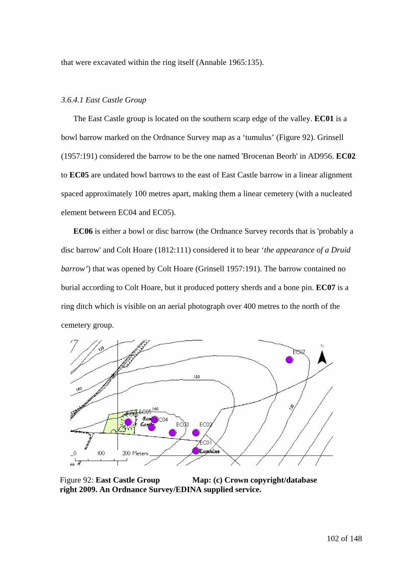
102 of 148
that were excavated within the ring itself (Annable 1965:135).
3.6.4.1 East Castle Group
The East Castle group is located on the southern scarp edge of the valley. EC01 is a
bowl barrow marked on the Ordnance Survey map as a ‘tumulus’ (Figure 92). Grinsell
(1957:191) considered the barrow to be the one named 'Brocenan Beorh' in AD956. EC02
to EC05 are undated bowl barrows to the east of East Castle barrow in a linear alignment
spaced approximately 100 metres apart, making them a linear cemetery (with a nucleated
element between EC04 and EC05).
EC06 is either a bowl or disc barrow (the Ordnance Survey records that is 'probably a
disc barrow' and Colt Hoare (1812:111) considered it to bear ‘the appearance of a Druid
barrow’) that was opened by Colt Hoare (Grinsell 1957:191). The barrow contained no
burial according to Colt Hoare, but it produced pottery sherds and a bone pin. EC07 is a
ring ditch which is visible on an aerial photograph over 400 metres to the north of the
cemetery group.
Figure 92: East Castle Group Map: (c) Crown copyright/database right 2009. An Ordnance Survey/EDINA supplied service.
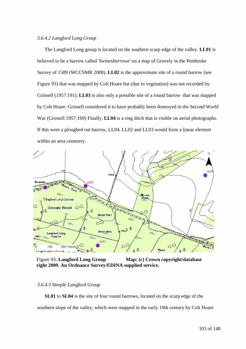
103 of 148
3.6.4.2 Langford Long Group
The Langford Long group is located on the southern scarp edge of the valley. LL01 is
believed to be a barrow called 'Swinesbarrowe' on a map of Grovely in the Pembroke
Survey of 1589 (WCCSMR 2008). LL02 is the approximate site of a round barrow (see
Figure 93) that was mapped by Colt Hoare but (due to vegetation) was not recorded by
Grinsell (1957:191). LL03 is also only a possible site of a round barrow that was mapped
by Colt Hoare. Grinsell considered it to have probably been destroyed in the Second World
War (Grinsell 1957:169) Finally, LL04 is a ring ditch that is visible on aerial photographs.
If this were a ploughed out barrow, LL04, LL02 and LL03 would form a linear element
within an area cemetery.
3.6.4.3 Steeple Langford Group
SL01 to SL04 is the site of four round barrows, located on the scarp edge of the
southern slope of the valley, which were mapped in the early 19th century by Colt Hoare
Figure 93: Langford Long Group Map: (c) Crown copyright/database right 2009. An Ordnance Survey/EDINA supplied service.
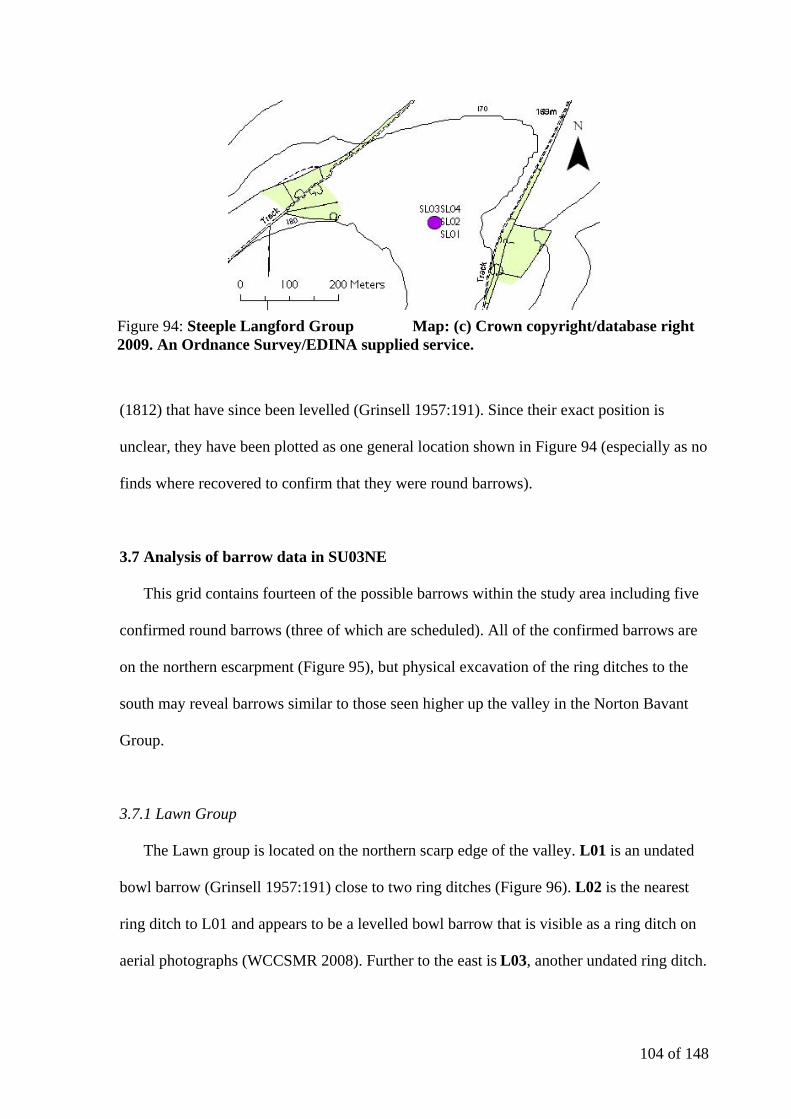
104 of 148
(1812) that have since been levelled (Grinsell 1957:191). Since their exact position is
unclear, they have been plotted as one general location shown in Figure 94 (especially as no
finds where recovered to confirm that they were round barrows).
3.7 Analysis of barrow data in SU03NE
This grid contains fourteen of the possible barrows within the study area including five
confirmed round barrows (three of which are scheduled). All of the confirmed barrows are
on the northern escarpment (Figure 95), but physical excavation of the ring ditches to the
south may reveal barrows similar to those seen higher up the valley in the Norton Bavant
Group.
3.7.1 Lawn Group
The Lawn group is located on the northern scarp edge of the valley. L01 is an undated
bowl barrow (Grinsell 1957:191) close to two ring ditches (Figure 96). L02 is the nearest
ring ditch to L01 and appears to be a levelled bowl barrow that is visible as a ring ditch on
aerial photographs (WCCSMR 2008). Further to the east is L03, another undated ring ditch.
Figure 94: Steeple Langford Group Map: (c) Crown copyright/database right 2009. An Ordnance Survey/EDINA supplied service.

105 of 148
Figure 96: Lawn Group Map: (c) Crown copyright/database right 2009. An Ordnance Survey/EDINA supplied service.
Figure 95: The monuments of SU03NE Map: (c) Crown copyright/database right 2009. An Ordnance Survey/EDINA supplied service.
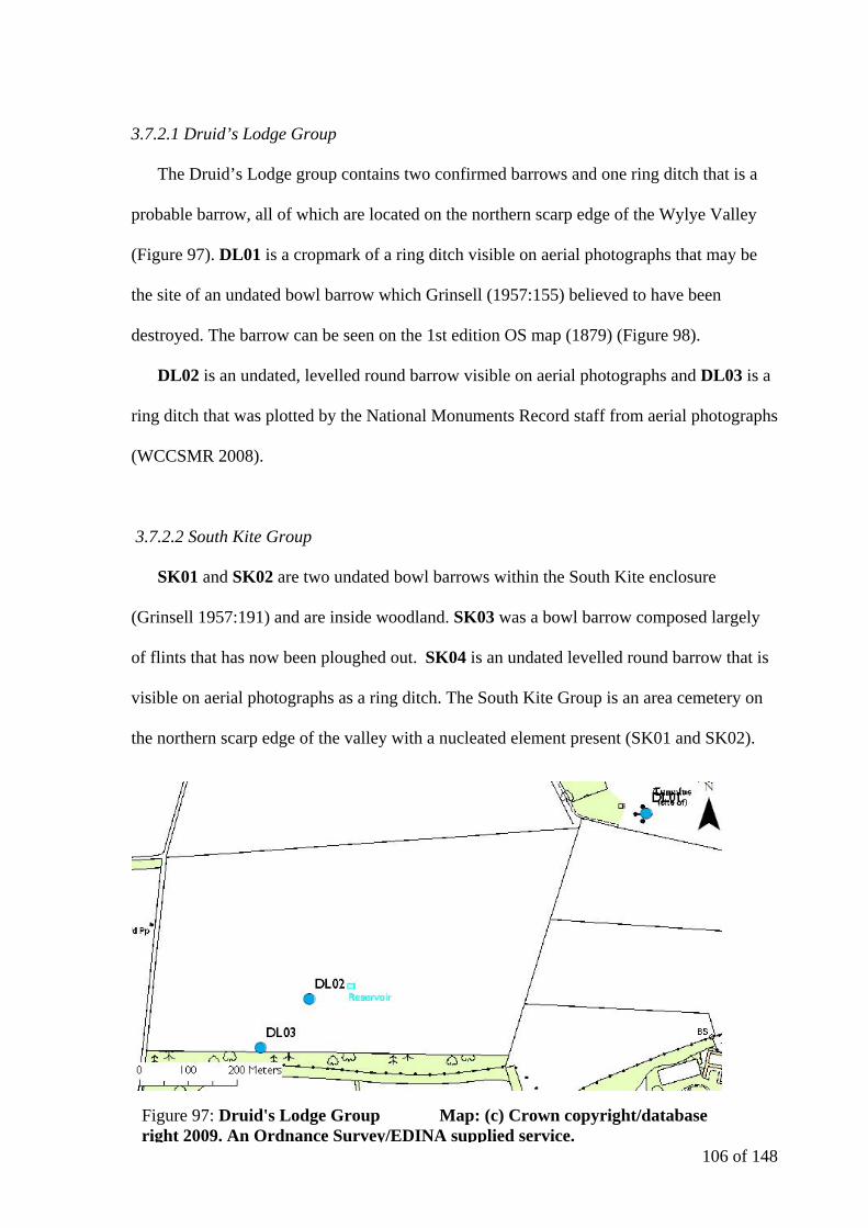
106 of 148
3.7.2.1 Druid’s Lodge Group
The Druid’s Lodge group contains two confirmed barrows and one ring ditch that is a
probable barrow, all of which are located on the northern scarp edge of the Wylye Valley
(Figure 97). DL01 is a cropmark of a ring ditch visible on aerial photographs that may be
the site of an undated bowl barrow which Grinsell (1957:155) believed to have been
destroyed. The barrow can be seen on the 1st edition OS map (1879) (Figure 98).
DL02 is an undated, levelled round barrow visible on aerial photographs and DL03 is a
ring ditch that was plotted by the National Monuments Record staff from aerial photographs
(WCCSMR 2008).
3.7.2.2 South Kite Group
SK01 and SK02 are two undated bowl barrows within the South Kite enclosure
(Grinsell 1957:191) and are inside woodland. SK03 was a bowl barrow composed largely
of flints that has now been ploughed out. SK04 is an undated levelled round barrow that is
visible on aerial photographs as a ring ditch. The South Kite Group is an area cemetery on
the northern scarp edge of the valley with a nucleated element present (SK01 and SK02).
Figure 97: Druid's Lodge Group Map: (c) Crown copyright/database right 2009. An Ordnance Survey/EDINA supplied service.
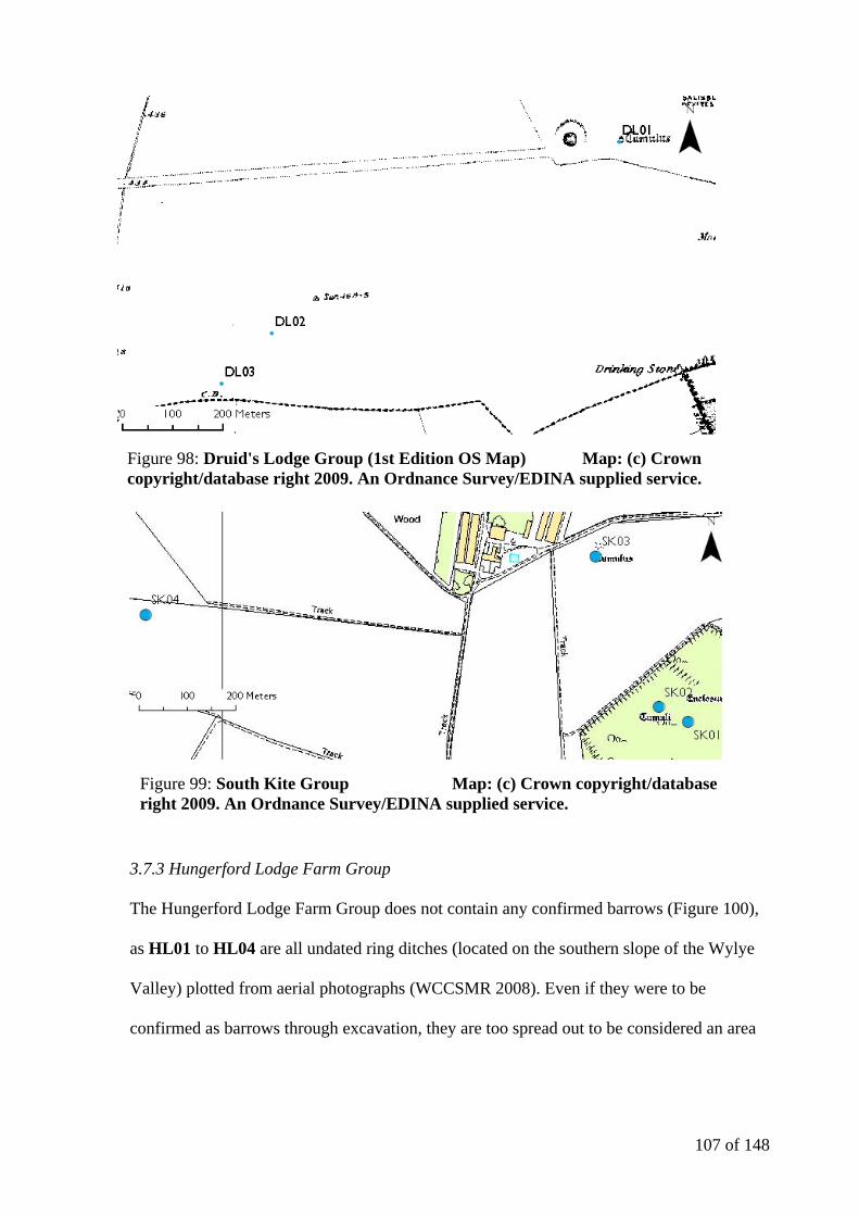
107 of 148
3.7.3 Hungerford Lodge Farm Group
The Hungerford Lodge Farm Group does not contain any confirmed barrows (Figure 100),
as HL01 to HL04 are all undated ring ditches (located on the southern slope of the Wylye
Valley) plotted from aerial photographs (WCCSMR 2008). Even if they were to be
confirmed as barrows through excavation, they are too spread out to be considered an area
Figure 98: Druid's Lodge Group (1st Edition OS Map) Map: (c) Crown copyright/database right 2009. An Ordnance Survey/EDINA supplied service.
Figure 99: South Kite Group Map: (c) Crown copyright/database right 2009. An Ordnance Survey/EDINA supplied service.
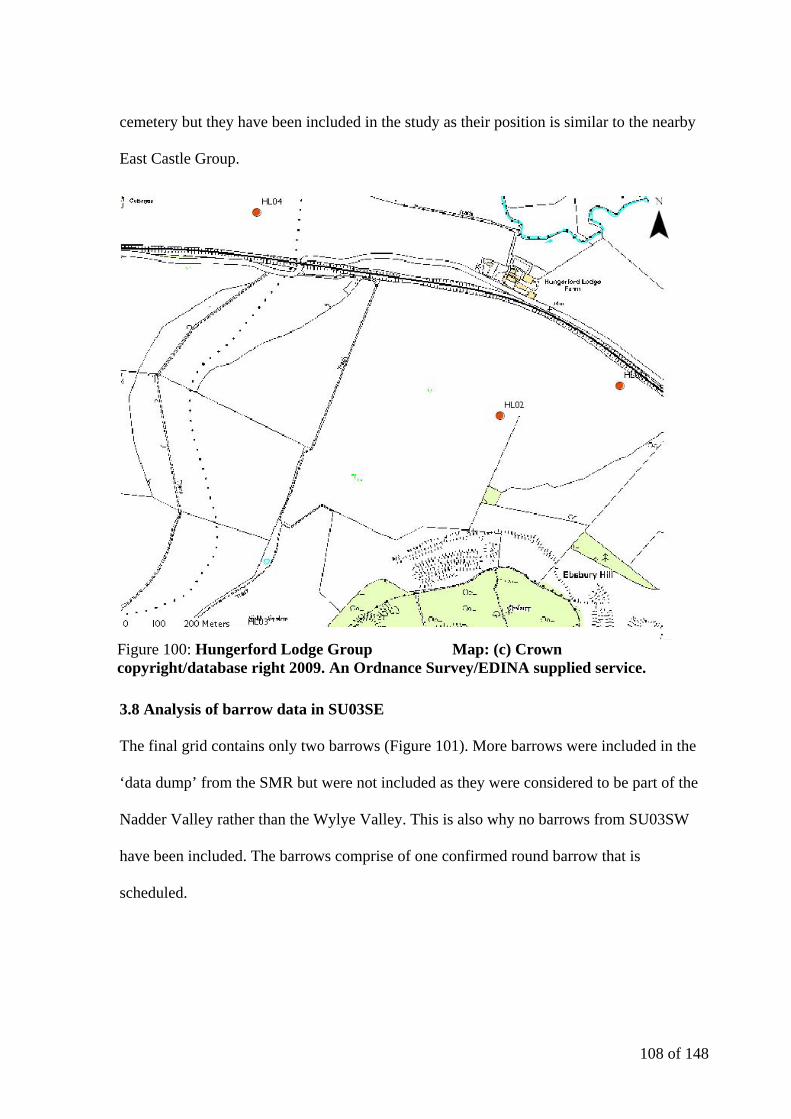
108 of 148
cemetery but they have been included in the study as their position is similar to the nearby
East Castle Group.
3.8 Analysis of barrow data in SU03SE
The final grid contains only two barrows (Figure 101). More barrows were included in the
‘data dump’ from the SMR but were not included as they were considered to be part of the
Nadder Valley rather than the Wylye Valley. This is also why no barrows from SU03SW
have been included. The barrows comprise of one confirmed round barrow that is
scheduled.
Figure 100: Hungerford Lodge Group Map: (c) Crown copyright/database right 2009. An Ordnance Survey/EDINA supplied service.

109 of 148
3.8.1 Wilton Park Barrow
WP01 is a scheduled bowl barrow surrounded by a ditch just inside the copse that forms the
eastern perimeter boundary for Wilton Park on the southern slope of the Wylye Valley
(Figure 102). From the barrow the view back up the Wylye valley is particularly striking
and pleasing (Figure 103).
Figure 101: The monuments of SU03SE Map: (c) Crown copyright/database right 2009. An Ordnance Survey/EDINA supplied service.
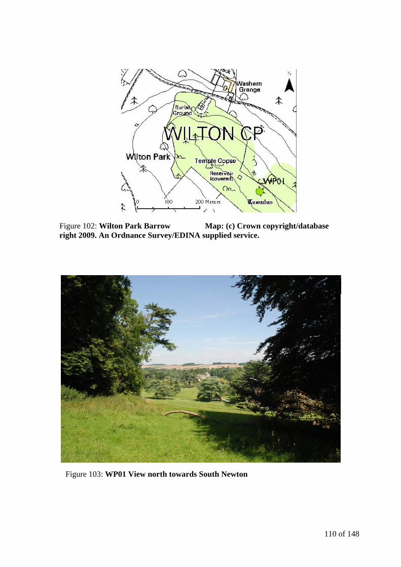
110 of 148
Figure 102: Wilton Park Barrow Map: (c) Crown copyright/database right 2009. An Ordnance Survey/EDINA supplied service.
Figure 103: WP01 View north towards South Newton
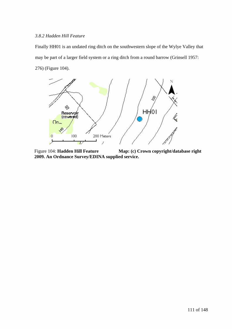
111 of 148
3.8.2 Hadden Hill Feature
Finally HH01 is an undated ring ditch on the southwestern slope of the Wylye Valley that
may be part of a larger field system or a ring ditch from a round barrow (Grinsell 1957:
276) (Figure 104).
Figure 104: Hadden Hill Feature Map: (c) Crown copyright/database right 2009. An Ordnance Survey/EDINA supplied service.
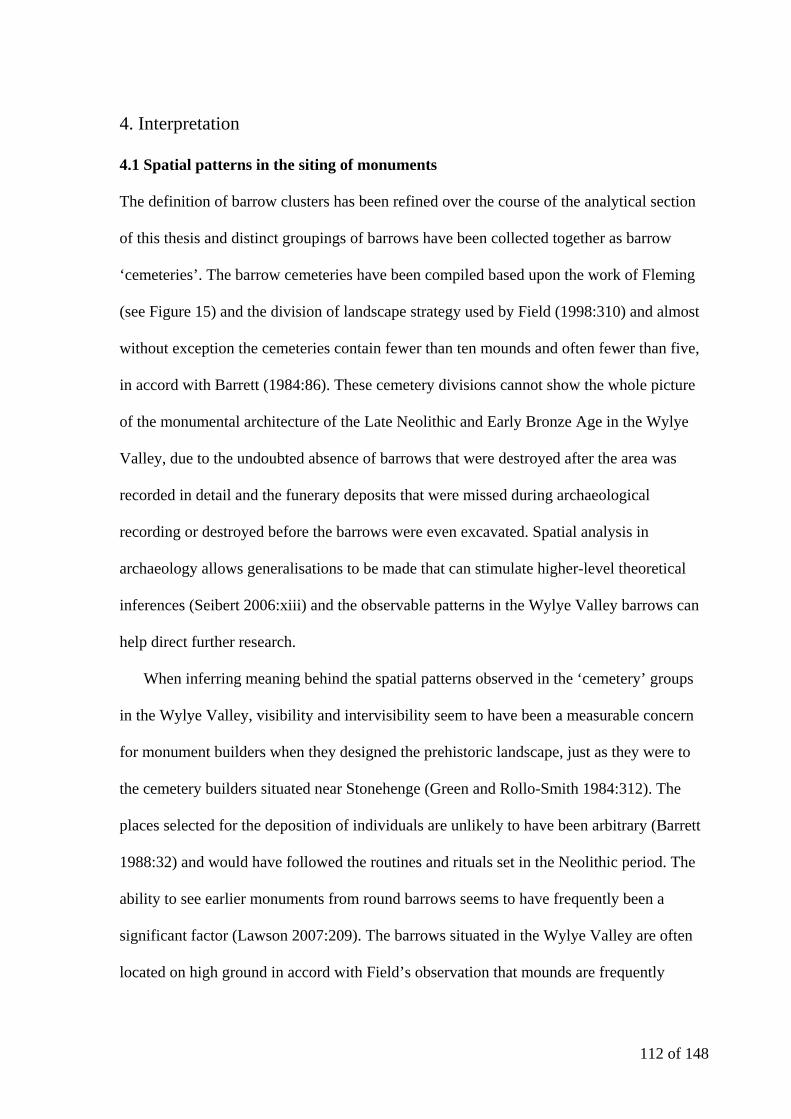
112 of 148
4. Interpretation
4.1 Spatial patterns in the siting of monuments
The definition of barrow clusters has been refined over the course of the analytical section
of this thesis and distinct groupings of barrows have been collected together as barrow
‘cemeteries’. The barrow cemeteries have been compiled based upon the work of Fleming
(see Figure 15) and the division of landscape strategy used by Field (1998:310) and almost
without exception the cemeteries contain fewer than ten mounds and often fewer than five,
in accord with Barrett (1984:86). These cemetery divisions cannot show the whole picture
of the monumental architecture of the Late Neolithic and Early Bronze Age in the Wylye
Valley, due to the undoubted absence of barrows that were destroyed after the area was
recorded in detail and the funerary deposits that were missed during archaeological
recording or destroyed before the barrows were even excavated. Spatial analysis in
archaeology allows generalisations to be made that can stimulate higher-level theoretical
inferences (Seibert 2006:xiii) and the observable patterns in the Wylye Valley barrows can
help direct further research.
When inferring meaning behind the spatial patterns observed in the ‘cemetery’ groups
in the Wylye Valley, visibility and intervisibility seem to have been a measurable concern
for monument builders when they designed the prehistoric landscape, just as they were to
the cemetery builders situated near Stonehenge (Green and Rollo-Smith 1984:312). The
places selected for the deposition of individuals are unlikely to have been arbitrary (Barrett
1988:32) and would have followed the routines and rituals set in the Neolithic period. The
ability to see earlier monuments from round barrows seems to have frequently been a
significant factor (Lawson 2007:209). The barrows situated in the Wylye Valley are often
located on high ground in accord with Field’s observation that mounds are frequently
113 of 148
observed to lie on elevated ridges to ensure each site is highly visible (1998:315) and are
often sited close to the edge of the area visible from the ancient focal point (Exon et al
2000:26-8).
It seems more likely that the view of the Wylye Valley from below the barrow groups
was of significance, as highlighted by the position of MH02, MH03 and MH04 in the
Middle Hill Group on the southern slope of the hill. Here the barrows are positioned to be
in clear view if the viewer was positioned on the valley floor whereas on the eastern slope
they would have benefited from increased intervisibility with the nearby barrows on
Scratchbury Hill. Where intervisibility between monuments is present, such as that between
the Scratchbury Hill and Cotley Hill groups, the presence of active funerary mounds in
close proximity may have been a method of expressing inter-group relationships through
the media of unchanging monumental architecture (Garwood 2007:47).
Barrows such as BD01 BD02 and BD03 appear to have been carefully sited along the
scarp edge to become visible from lower ground and make reference to the long barrow that
would have been present in the landscape (Figure 105). This may indicate the importance of
the position of the viewer as well as the significance of the spatial location of the barrow
itself to the people who constructed the barrows (Lawson 2007:210). It is clear that the
disposal of human remains in the Late Neolithic and Early Bronze Age did not require the
construction of a barrow, as simpler forms of burial (such as flat graves) are present
throughout the Neolithic. The construction of the barrow itself therefore may have held a
deeper meaning than purely funerary (Owoc 2006:8).
Round barrows do not always occur on high ground, as Heytesbury, Tytherington and
The Knoll groups attest. The development of aerial photography and contract-based
archaeological excavation such as that at NB06 indicates that the concentrations of barrows
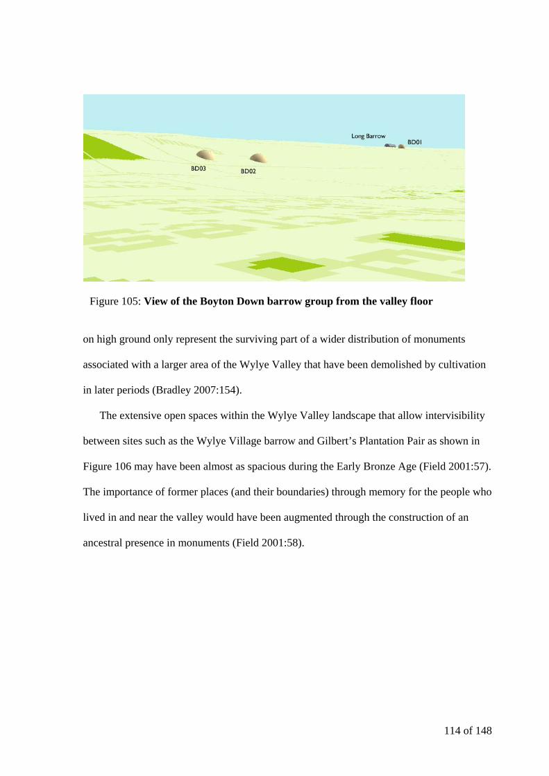
114 of 148
on high ground only represent the surviving part of a wider distribution of monuments
associated with a larger area of the Wylye Valley that have been demolished by cultivation
in later periods (Bradley 2007:154).
The extensive open spaces within the Wylye Valley landscape that allow intervisibility
between sites such as the Wylye Village barrow and Gilbert’s Plantation Pair as shown in
Figure 106 may have been almost as spacious during the Early Bronze Age (Field 2001:57).
The importance of former places (and their boundaries) through memory for the people who
lived in and near the valley would have been augmented through the construction of an
ancestral presence in monuments (Field 2001:58).
Figure 105: View of the Boyton Down barrow group from the valley floor
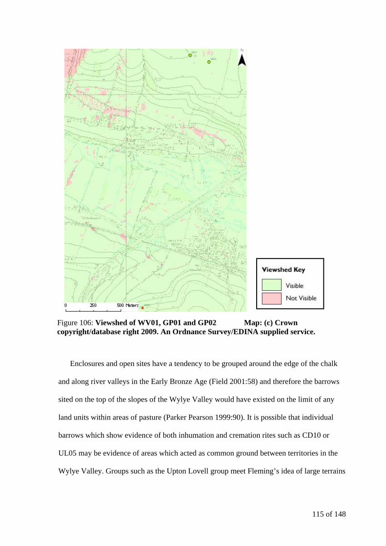
115 of 148
Enclosures and open sites have a tendency to be grouped around the edge of the chalk
and along river valleys in the Early Bronze Age (Field 2001:58) and therefore the barrows
sited on the top of the slopes of the Wylye Valley would have existed on the limit of any
land units within areas of pasture (Parker Pearson 1999:90). It is possible that individual
barrows which show evidence of both inhumation and cremation rites such as CD10 or
UL05 may be evidence of areas which acted as common ground between territories in the
Wylye Valley. Groups such as the Upton Lovell group meet Fleming’s idea of large terrains
Figure 106: Viewshed of WV01, GP01 and GP02 Map: (c) Crown copyright/database right 2009. An Ordnance Survey/EDINA supplied service.

116 of 148
(in Kitchen 2001:117) as it contains a variety of interment rites. There is an absence of
evidence to support Renfrew’s spatial boundaries for different regions in Wessex at this
period (Braithwaite 1984:96) but there is proof that the Wessex series burials in the Wylye
Valley show a predominance of cremation rites with more traditional burial assemblages of
ceramics and high status goods. This supports the idea of an older system of ‘prestige’
(Renfrew 2001:136) existing on this area of the chalkland upheld by an affluent society
who were attempting to maintain or re-establish authority during the transitionary period
(Braithwaite 1984:107) or may simply be evidence of a society deciding to bury obsolete
items in ancient ancestral monuments (Woodward 2000:121).
Nationally between 2150 and 1850 BC round barrows were constructed, elaborated and
redesigned on a large scale in relation to existing features in the landscape, often stressing
the importance of links with the past through the reopening of graves and the addition of
new deposits (Bradley 2007:165). Between 1850 and 1500 BC similar concerns with a
desire to link to the past are expressed yet they are met through a spatial relationship
between different monuments (Bradley 2007:166). Many of the largest or the ‘fancy’
barrows (such as saucer or bell) are on the summits of hills, for example barrows MH01,
CD06 and CD09 are large bowl barrows on the top of the Wylye Valley slope and KB03
are SH05 saucer and disc barrows respectively. A careful consideration of relative
chronology within barrows and cemeteries through ceramic and metallurgy chronologies
has been beyond the scope of this thesis but a re-evaluation of the monuments through
extensive geophysical survey and selective excavation as suggested by Woodward and
Woodward (1996:289) may allow a more in-depth analysis of the chronological
development of the cemeteries identified, as has been seen at Radley in Oxfordshire.

117 of 148
The construction of barrow cemeteries suggests that the monument builders of the Late
Neolithic and early Bronze Age were not solely interested in representing the ‘individual’
as suggested by Braithwaite (1984), as burials beneath barrows in the Wylye Valley can be
grouped together (via the monuments that cover them) into cemeteries. The spatial
relationship between round barrows in relation to preceding monuments suggests a
continuing importance of interpersonal relationships that link back to Neolithic systems of
identity (Brück 2004:310).
As expressed by Field (1998:315), straight lines are common when some form of spatial
arrangement is present in barrow cemeteries and the Wylye Valley is no exception. Many
barrows appear to have been placed to respect one another and form a linear alignment,
such as LD02-LD03-LD04 or DF02-DF01-DF03. The clustering of ‘cemeteries’ such as
CH01 to CH04 and CH07 to CH10 may emphasise that barrows were placed with a
purpose.
4.2 The contents of the round barrows of the Wylye Valley
One of the primary purposes of barrows in prehistory was burial (Woodward 2000:21)
yet there seems to be no relationship between the external shape of any individual mound
and the deposits found beneath it. For example, both CH09 and TK08 have been classified
as bell barrows and the example on Cotley Hill appears to have simply contained a primary
cremation mixed with ashes in a cist with charred walls whereas TK08 was a richly
furnished burial with a bronze dagger, a pigmy cup and a Food Vessel. It is wrongly
assumed that all Late Neolithic and Early Bronze Age monument types and the associated
burial traditions overlapped within the period 2500-1500 BC (Garwood 2007:31) and this
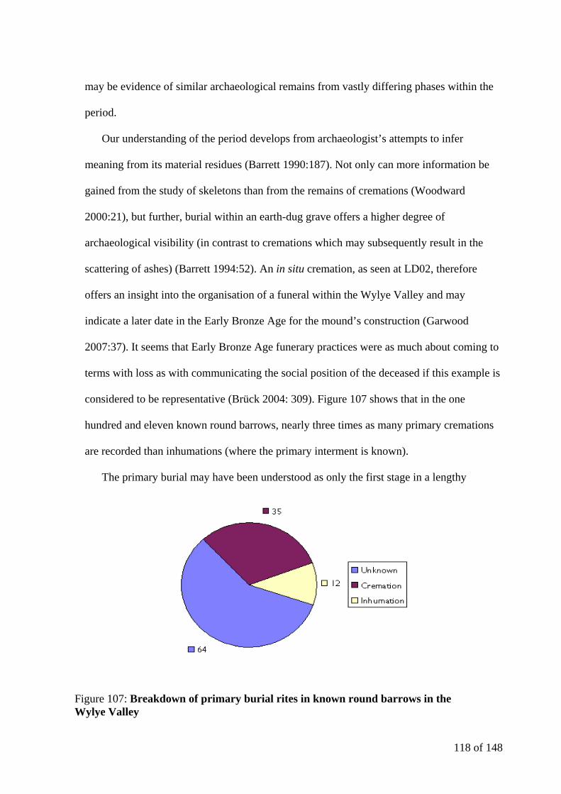
118 of 148
may be evidence of similar archaeological remains from vastly differing phases within the
period.
Our understanding of the period develops from archaeologist’s attempts to infer
meaning from its material residues (Barrett 1990:187). Not only can more information be
gained from the study of skeletons than from the remains of cremations (Woodward
2000:21), but further, burial within an earth-dug grave offers a higher degree of
archaeological visibility (in contrast to cremations which may subsequently result in the
scattering of ashes) (Barrett 1994:52). An in situ cremation, as seen at LD02, therefore
offers an insight into the organisation of a funeral within the Wylye Valley and may
indicate a later date in the Early Bronze Age for the mound’s construction (Garwood
2007:37). It seems that Early Bronze Age funerary practices were as much about coming to
terms with loss as with communicating the social position of the deceased if this example is
considered to be representative (Brück 2004: 309). Figure 107 shows that in the one
hundred and eleven known round barrows, nearly three times as many primary cremations
are recorded than inhumations (where the primary interment is known).
The primary burial may have been understood as only the first stage in a lengthy
Figure 107: Breakdown of primary burial rites in known round barrows in the Wylye Valley
119 of 148
ceremonial process in Early Bronze Age burial mounds (Mizoguchi 1993:233) and it is
possible that this suggests that many of the Wylye Valley barrows were constructed later in
the Late Neolithic and Early Bronze Age when cremations became gradually more common
than inhumations (Garwood 2007:37). A recall of ancestral deposits was observed when a
barrow was reopened, mirroring early Neolithic traditions, whereas the burial itself was of
most importance in a single event barrow construction. It has been suggested that a
cremation can be understood as the destruction of the ‘individual identity’ as opposed to the
continuity that is expressed through the preservation of the body in an inhumation grave
(Braithwaite 1984:104) and this may support the development of round barrow ‘cemeteries’
as an arena for identity to be generalised and displayed. The information contained within a
burial of the Late Neolithic and Early Bronze Age is a social narrative (Last 1998:53): it
aims to express meaning through how, where and when it was conducted, yet archaeologists
can not reliably conclude whether this was a personal or group narrative.
Inhumation involves three distinct phases: preparation of the body, transportation of the
body to the grave and the deposition of the body and filling of the grave pit. All three stages
can result in the inclusion of grave goods and the distinction between these periods can be
blurred to confuse the interpretation of any burial (Barrett 1994:116). Not only is it difficult
to understand at what stage goods were placed with a body based on the majority of the
Wylye Valley data, it is also often unclear whether the grave goods themselves refer to the
person who has been interred or say more of the individual who placed them (in terms of
the goods that they were able or prepared to part with) (Barrett 1994:117). The corpse could
not decide on how it was depicted in death and the archaeological record reflects the
relationship between the deceased and those who conducted the burial (Bradley 2007:159).
The question of interpreting mortuary practices is further complicated by the difficulty in

120 of 148
recognising the distinction between rank and status within a single burial based on the
objects it contained (Barrett 1988:30).
Nationally there appears to be a move from the more ‘group-orientated’ societies
(represented by burial practices) in the Neolithic (Barrett 1988:32) to the ‘individualising’
societies of the Early Bronze Age through the expression of single burial and the
accompaniment of rich grave goods (Renfrew 2001:136). The later contrast of cremation
rites that destroy the ‘individual identity’ of a person (and the continuity that is expressed
through the preservation of the individual via an inhumation burial) (Braithwaite 1984:104)
is strongly represented in the Wylye Valley and seems to indicate a desire to express a
group belief once more.
There is as much variation with the nature of primary cremation deposits as there is with
inhumations (Barrett 1994:52) yet some common themes are represented within the Wylye
Valley interments. Primary cremations often occur within numerous barrows within the
same cemetery (for example in the Middle Hill group three cremations occur less than 50
metres apart and there are three cremations on the summit of Scratchbury Hill within a 200
metre area). With regard to the associated finds, the only bone tweezers were recovered
from a cremation (UB02) and two of the three bronze awls discovered in the Wylye Valley
were associated with cremated remains (in GB04 and KB05 as opposed to one with an
inhumation in UL03). Barrett (1994:123) suggests that this may indicate that the items were
used to modify materials related to the body and may have been associated with the
alteration of the corpse.
Beaker burials mark the beginning of the single grave rite and a change from a ‘process
of transformation to an event of deposition’ (Thomas 1999:157). These graves were often
marked by a low covering mound, encircling ditch or fence and required each future

121 of 148
deposition within the cemetery to either reference or contrast what had gone before as the
grave had a physical presence in the landscape. Many Beaker burials were placed beneath
mounds in the Wylye Valley. The interments at UL05, LD03, LD04 and EB04 that were
accompanied by Beakers (or Beaker sherds were recovered from the grave fills) were
inhumations whereas CD10, LD02 and DF01 were cremated. The fact that LD03 and LD04
are so close together and contained similar burial rites supports the idea of ‘ordered
adjacency’ (Thomas 1999:158) and the idea of continuity (or at the least familiarity) with
the contents of spatially close mounds over a period of time. Only the primary inhumation
accompanied by a B1 Beaker and a small cup of a similar date recovered from EB04 lies on
the southern escarpment of the Wylye Valley, though this may be representative of the
concentration of excavation.
The Wessex Series grave excavated at GB04 is unusual as it was a secondary burial
which contained cremated remains. The finds from the grave, including items of gold,
amber and shale suggest a ‘highly inventive local school of craftsmanship’ (Case 2003:171)
and exhibit Beaker motifs such as the decoration on the gold foil plaque and the shale
conical V-buttons which are a well-known Beaker association (Case 2003:174). The
crescentic amber necklace is one of only three examples in southern England to include
enough beads, spacers and simple types for it to seen as a complete item (Woodward
2002:1043). It is however possible that the worn appearance of many of the beads is due to
the necklace being composite, emphasising the interpersonal relationships of the Late
Neolithic that were given material form through burial practices (Brück 2004:314). Burials
such as these may been deposited at times of social or political change, perhaps indicating
that ideas needed to be reinforced or introduced (Barrett 1984:95).

122 of 148
Of the confirmed round barrows in the Wylye Valley, sixty-four have no known
primary burial. This may be due to the excavation method undertaken or the fact that
barrows themselves should not be viewed simply as graves (Woodward 2000:50) but more
as monuments within the landscape of the Late Neolithic and early Bronze Age.
4.3 Monumental architecture of the Late Neolithic and Early Bronze Age in the Wylye
Valley
The Wylye Valley contains a reasonable variety in its range of barrow forms. The vast
majority (82%) are bowl barrows (Figure 108) yet everything that was recorded about these
barrows depends on the assumptions with which excavation was approached (Bradley
1984:74). The work of antiquarians in the Wylye Valley focused on the centre of
earthworks rather than on the monuments as a whole as this is where they believed the
richest material would be found (Bradley 2007:153). Indeed, Colt Hoare sought to preserve
the external appearance of the majority of barrows that he opened (whilst undoubtedly
being aware that it would also reduce the effort required to retrieve any grave goods) by
either cutting ‘directly through the mound’ or more often ‘sinking a shaft down the centre
from top to bottom’ (Colt Hoare 1812:3). Since excavators of this period did little to
investigate or record the structure of the mounds they investigated, the contents of a small
(and relatively prejudiced) sample of graves are available for detailed study in the Wylye
Valley (Bradley 2007:153). For example it is possible that GB04 was originally a cone
barrow yet Colt Hoare’s description is unclear (especially when it is considered that the
description which appears in The Ancient History of Wiltshire is compiled from two
separate excavations at the site in 1803 and 1807) (Cunnington 1954:233) and given that
the barrow has now been ploughed out of existence, the alternative possibilities will never

123 of 148
be resolved. It is true that Colt Hoare described many barrows as flat topped or cone in
form which have subsequently been reclassified simply as bowl barrows (Field 1998:323),
removing the possibility of examining the vertical importance of the mound.
When considering a large proportion of the excavation evidence for the barrows in the
Wylye Valley it is disappointing that Colt Hoare did not include all of Cunnington’s
evidence in The Ancient History of Wiltshire and there is confusion regarding both what
was found in a number of barrows and with the arrangement of grave goods and interments
within each barrow. The renewed excavation of barrows that were initially opened in
antiquity in other areas has revealed that original excavators have often ignored or missed
evidence of the reuse of barrows or the sequence of deposition within a single grave
(Bradley 2007:158). This is highly likely to have occurred with the earlier excavations of
Cunnington and with the ‘less impressive’ barrows discussed by Colt Hoare: for example
the opening of the barrows on the western slope of Cotley Hill are evaluated by containing
Figure 108: Barrow forms present in the Wylye Valley
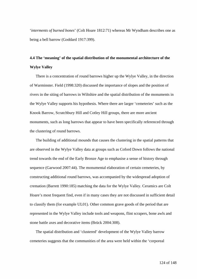
124 of 148
‘interments of burned bones’ (Colt Hoare 1812:71) whereas Mr Wyndham describes one as
being a bell barrow (Goddard 1917:399).
4.4 The ‘meaning’ of the spatial distribution of the monumental architecture of the
Wylye Valley
There is a concentration of round barrows higher up the Wylye Valley, in the direction
of Warminster. Field (1998:320) discussed the importance of slopes and the position of
rivers in the siting of barrows in Wiltshire and the spatial distribution of the monuments in
the Wylye Valley supports his hypothesis. Where there are larger ‘cemeteries’ such as the
Knook Barrow, Scratchbury Hill and Cotley Hill groups, there are more ancient
monuments, such as long barrows that appear to have been specifically referenced through
the clustering of round barrows.
The building of additional mounds that causes the clustering in the spatial patterns that
are observed in the Wylye Valley data at groups such as Coford Down follows the national
trend towards the end of the Early Bronze Age to emphasise a sense of history through
sequence (Garwood 2007:44). The monumental elaboration of certain cemeteries, by
constructing additional round barrows, was accompanied by the widespread adoption of
cremation (Barrett 1990:185) matching the data for the Wylye Valley. Ceramics are Colt
Hoare’s most frequent find, even if in many cases they are not discussed in sufficient detail
to classify them (for example UL01). Other common grave goods of the period that are
represented in the Wylye Valley include tools and weapons, flint scrapers, bone awls and
stone battle axes and decorative items (Brück 2004:308).
The spatial distribution and ‘clustered’ development of the Wylye Valley barrow
cemeteries suggests that the communities of the area were held within the ‘corporeal

125 of 148
narratives’ of hierarchical descent and political order which had been expressed in the
landscape through monuments for centuries, and either could not or felt no need to detach
themselves from it (Garwood 2007:45). Many of these barrows are large, perhaps
attempting to express an ‘instant’ presence within the developing hierarchical narrative of
the area where other monuments in the Stonehenge locality had been elevated as multi-
phase monuments (Garwood 2007:47).
Returning to Lawson’s distribution of barrows and ring ditches in central Southern
England, Figure 109 highlights the river Wylye (in blue) and the concentration of barrows
(in red) at the head of the valley. A closer inspection of the Wylye Valley data (Figure 110)
confirms Lawson’s suggestion that the spatial distribution of the barrows follows the
topography of the area with the highest concentrations of barrows in cemeteries occurring
on the crest of the chalk ridges, principally on the northern escarpment (Lawson 2007:209).
This trend may have occurred due to the more pronounced scarp edge of the northern side
Figure 109: Distribution of barrows and ring ditches in central Southern England

126 of 148
of the Wylye Valley, meaning a greater visual impact for barrows created there and would
certainly explain why all of the cemeteries which utilise both the scarp edge and valley
slope occur on the northern escarpment. When considering the higher frequency of
cemeteries on the northern valley side it is also possible that additional barrows were
located on the southern scarp edge but that forested areas such as Grovely Wood and Great
Ridge have masked their existence.
The Wylye Valley’s spatial distribution of round barrows follows the patterns observed
in the wider area of Wiltshire such as in the barrow cemeteries around Stonehenge
investigated by Exon et al (2000) with the visual setting being an important element of the
landscape. The chosen locations in the Stonehenge landscape would be more visible than if
they had been randomly positioned in the landscape (Exon et al 2000:28).
Although many questions remain unanswered regarding the ‘meaning’ of the spatial
distribution and indeed the chronological development of the monumental architecture of
the Wylye Valley, the creation of the detailed Access database and associated GIS will
allow further work to be undertaken more systematically and suggestions for such further
work will be discussed in the concluding section.
Topography Total number of cemetery
groups present
% of total
cemetery groups
% of cemetery groups on
northern valley side
% of cemetery groups on
southern valley side
Scarp edge 19 50 63 37
Scarp edge and valley slope 3 8 100 0
Valley slope 9 24 22.5 77.5
Valley bottom 7 18
Figure 110: Statistical quantification of the landscape location of the barrow cemeteries of the Wylye Valley
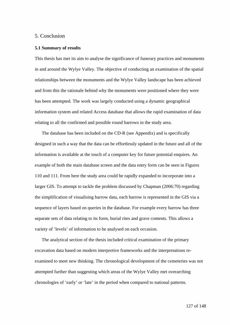
127 of 148
5. Conclusion
5.1 Summary of results
This thesis has met its aim to analyse the significance of funerary practices and monuments
in and around the Wylye Valley. The objective of conducting an examination of the spatial
relationships between the monuments and the Wylye Valley landscape has been achieved
and from this the rationale behind why the monuments were positioned where they were
has been attempted. The work was largely conducted using a dynamic geographical
information system and related Access database that allows the rapid examination of data
relating to all the confirmed and possible round barrows in the study area.
The database has been included on the CD-R (see Appendix) and is specifically
designed in such a way that the data can be effortlessly updated in the future and all of the
information is available at the touch of a computer key for future potential enquires. An
example of both the main database screen and the data entry form can be seen in Figures
110 and 111. From here the study area could be rapidly expanded to incorporate into a
larger GIS. To attempt to tackle the problem discussed by Chapman (2006:70) regarding
the simplification of visualising barrow data, each barrow is represented in the GIS via a
sequence of layers based on queries in the database. For example every barrow has three
separate sets of data relating to its form, burial rites and grave contents. This allows a
variety of ‘levels’ of information to be analysed on each occasion.
The analytical section of the thesis included critical examination of the primary
excavation data based on modern interpretive frameworks and the interpretations re-
examined to meet new thinking. The chronological development of the cemeteries was not
attempted further than suggesting which areas of the Wylye Valley met overarching
chronologies of ‘early’ or ‘late’ in the period when compared to national patterns.
128 of 148
Suggestions for how this could be improved are discussed in Section 5.3 below. The siting
of the monuments has been analysed and compared to similar examples studied elsewhere
to formulate an explanation as to why the barrows of the Wylye Valley were built where
they were. The concentration of barrows towards the top of the valley on the northern
escarpment has been observed, as has the clustering of barrows around older features in the
landscape. This is similar to the spatial patterns observed in the Stonehenge area, though
there appears to be a higher concentration of primary cremations and more nucleated
cemeteries.
Figure 111: Main screen of the database
129 of 148
5.2 Key outcomes of the study
This thesis has produced an analysis of the spatial distributions of the Late Neolithic
and early Bronze Age monuments in the Wylye Valley and has attempted to interpret the
significance of those distributions. The key results are:
There are distinct clusters of barrows that form cemeteries, which are defined in this
work as groups, throughout much of the Wylye Valley. There are more groups (that
contain larger cemeteries) at the top of the valley than there are towards where the
river Wylye meets the rivers Till and Nadder.
The groups of barrows are mostly dispersed cemeteries with either nucleated or
linear elements (based of the definitions of Fleming). Many of the more densely
Figure 112: Main data entry form
130 of 148
grouped cemeteries seem to make reference to earlier features in the landscape such
as long barrows.
A larger proportion of the primary interments are cremations (where the primary
interment is known) though modern excavations have found the correlation to be
more even.
The Wylye Valley ceramic evidence is limited due to the absence of physical
remains for many of the vessels described by Colt Hoare, yet where they survive in
museums they tend to be either Early or Middle Bronze Age in date.
The landscape of the Wylye seems to have played a role in the placement of barrows
with many following the scarp edge (particularly on the northern valley side) to
ensure that they are visible from lower ground and many barrows appear to have
been on the very limit of any land units on the top of the slopes.
There is evidence for a ‘highly inventive local school of craftsmanship’ (Case
2003:171) being present in the area, supported by the goods present in barrows such
as GB04; further the burial at UL03 may have been one of the metalworkers of the
area.
5.3 Implications and further work
One of the main limitations of this thesis is the lack of investigation into the
chronological development of the cemetery groups analysed. This is due to the paucity of
131 of 148
data relating to the ceramic evidence. Where studies have been undertaken on the metallic
evidence from graves, a date has been included for the burial in the analytical section but
the data set includes too few Wessex burials for any meaningful conclusions to be drawn.
A reassessment of the ceramic evidence which survives (which unfortunately would not
give a full coverage for the valley) would possibly allow a firmer dating of a proportion of
the barrows (and therefore give a better indication of the chronological development of the
cemeteries), but it would not resolve the issue of the form and development of the barrows
themselves. The production of accurate ‘biographies’ of the individual cemeteries, as
considered necessary by Woodward (1998:32), would require modern excavation to
supplement the antiquarian results.
As suggested by Field (1998:31), rescue work and the re-excavation of trenches cut by
Cunnington would provide enormous amounts of environmental and structural information
relating to barrow form and phasing. An investigation into the enclosure ditches at Middle
Hill and Scratchbury Hill may reveal Neolithic evidence as the ditch at Scratchbury has
only been partially excavated in the past (Field 1998:31).
The re-excavation of UL03 is significant, as the recovery of skeletal material (left by
Cunnington) from the grave pit indicates that skeletal investigation may be possible for
many barrows in the area opened for The Ancient History of Wiltshire and would give a
clearer understanding of the individuals interred in the monuments, including the attribution
of gender to items uncovered.
The excavations of Colt Hoare and Cunnington are the principle source of evidence for
the round barrows of the Wylye Valley. With this fact in mind it is suggested that it may be
of interest to compile a spatial database of all of the excavations described in The Ancient
History of Wiltshire with the aim of relocating some of the ‘lost’ barrows and recataloguing
132 of 148
some of the mismatched finds. This would not be difficult using the format of this thesis
(and associated databases) and may allow firmer descriptions to be made.
The final suggested development for the research of this thesis would be the extension
of the study area towards Warminster to include the very head of the Wylye Valley and to
investigate whether the closer clustering of barrows and cemeteries continues. An
examination of the Nadder Valley (to the south of the Wylye Valley) would also serve to
confirm if the higher percentage of cemetery groups on the northern valley side is due to the
geography of the survey area, the better survival of monuments within the boundary of the
Salisbury Plain Training Area or prehistoric building practices as suggested by Lawson
(2007:209).
The immediate influence that The Ancient History of Wiltshire and the excavations of
Cunnington and Colt Hoare had on British archaeology are difficult to assess due to
contemporary excavators such as Mortimer and Thurnam making little reference to what
influenced their own work. The importance of The Ancient History of Wiltshire and the
finds of the Wylye Valley cannot be questioned in relation to the work of later
archaeologists looking to interpret the physical remains of the Late Neolithic and Early
Bronze Age such as Piggott in 1938. A new investigation into the chronological evidence of
the barrows themselves now needs to be undertaken, perhaps starting with a reinvestigation
of Cunnington and Colt Hoare’s excavations before any remaining physical evidence at the
sites is destroyed along with the attendant loss of the vital opportunity to further develop the
valuable resource provided by The Ancient History of Wiltshire.
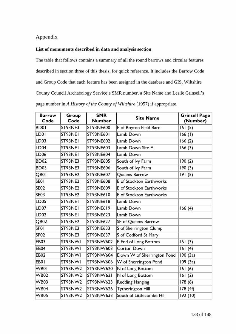
133 of 148
Appendix
List of monuments described in data and analysis section
The table that follows contains a summary of all the round barrows and circular features
described in section three of this thesis, for quick reference. It includes the Barrow Code
and Group Code that each feature has been assigned in the database and GIS, Wiltshire
County Council Archaeology Service’s SMR number, a Site Name and Leslie Grinsell’s
page number in A History of the County of Wiltshire (1957) if appropriate.
Barrow Code
Group Code
SMR Number Site Name Grinsell Page
(Number) BD01 ST93NE3 ST93NE600 E of Boyton Field Barn 161 (5) LD01 ST93NE1 ST93NE601 Lamb Down 166 (1) LD03 ST93NE1 ST93NE602 Lamb Down 166 (2) LD04 ST93NE1 ST93NE603 Lamb Down Site A 166 (3) LD06 ST93NE1 ST93NE604 Lamb Down BD02 ST93NE3 ST93NE605 South of Ivy Farm 190 (2) BD03 ST93NE3 ST93NE606 South of Ivy Farm 190 (3) QB01 ST93NE2 ST93NE607 Queens Barrow 191 (5) SE01 ST93NE2 ST93NE608 E of Stockton Earthworks SE02 ST93NE2 ST93NE609 E of Stockton Earthworks SE03 ST93NE2 ST93NE610 E of Stockton Earthworks LD05 ST93NE1 ST93NE618 Lamb Down LD07 ST93NE1 ST93NE619 Lamb Down 166 (4) LD02 ST93NE1 ST93NE623 Lamb Down QB02 ST93NE2 ST93NE627 SE of Queens Barrow SP01 ST93NE3 ST93NE633 S of Sherrington Clump SP02 ST93NE3 ST93NE637 S of Codford St Mary EB03 ST93NW1 ST93NW602 E End of Long Bottom 161 (3) EB04 ST93NW1 ST93NW603 Corton Down 161 (4) EB02 ST93NW1 ST93NW604 Down W of Sherrington Pond 190 (3a) EB01 ST93NW1 ST93NW606 W of Sherrington Pond 109 (3a) WB01 ST93NW2 ST93NW620 N of Long Bottom 161 (6) WB02 ST93NW2 ST93NW621 N of Long Bottom 161 (2) WB03 ST93NW2 ST93NW623 Redding Hanging 178 (6) WB04 ST93NW2 ST93NW626 Tytherington Hill 178 (4f) WB05 ST93NW2 ST93NW633 South of Littlecombe Hill 192 (10)
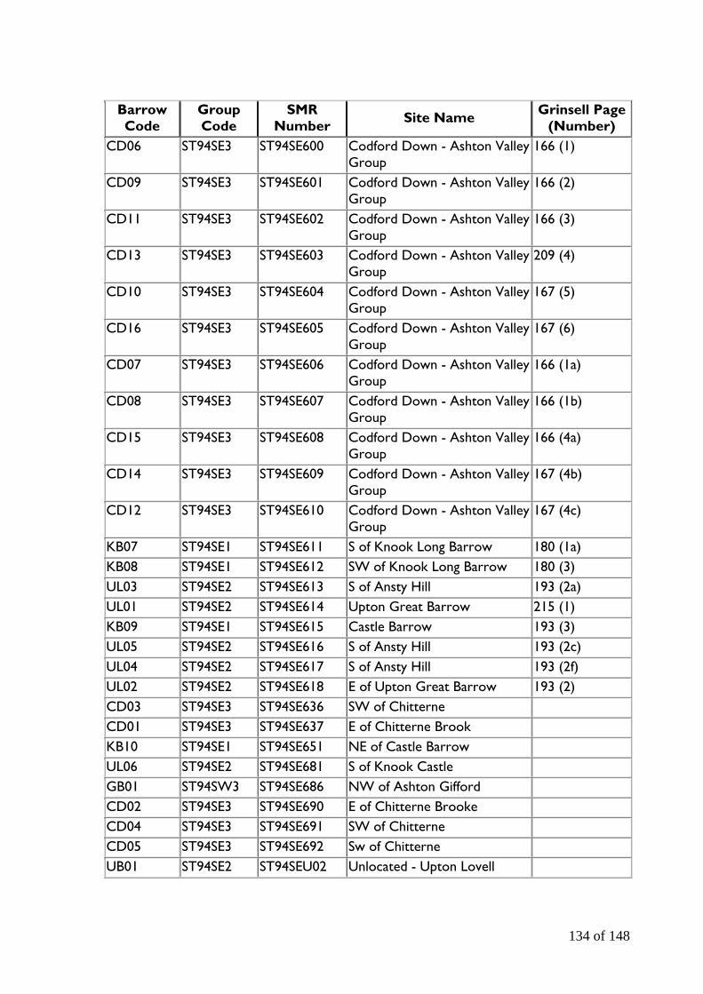
134 of 148
Barrow Code
Group Code
SMR Number Site Name Grinsell Page
(Number) CD06 ST94SE3 ST94SE600 Codford Down - Ashton Valley
Group 166 (1)
CD09 ST94SE3 ST94SE601 Codford Down - Ashton Valley Group
166 (2)
CD11 ST94SE3 ST94SE602 Codford Down - Ashton Valley Group
166 (3)
CD13 ST94SE3 ST94SE603 Codford Down - Ashton Valley Group
209 (4)
CD10 ST94SE3 ST94SE604 Codford Down - Ashton Valley Group
167 (5)
CD16 ST94SE3 ST94SE605 Codford Down - Ashton Valley Group
167 (6)
CD07 ST94SE3 ST94SE606 Codford Down - Ashton Valley Group
166 (1a)
CD08 ST94SE3 ST94SE607 Codford Down - Ashton Valley Group
166 (1b)
CD15 ST94SE3 ST94SE608 Codford Down - Ashton Valley Group
166 (4a)
CD14 ST94SE3 ST94SE609 Codford Down - Ashton Valley Group
167 (4b)
CD12 ST94SE3 ST94SE610 Codford Down - Ashton Valley Group
167 (4c)
KB07 ST94SE1 ST94SE611 S of Knook Long Barrow 180 (1a) KB08 ST94SE1 ST94SE612 SW of Knook Long Barrow 180 (3) UL03 ST94SE2 ST94SE613 S of Ansty Hill 193 (2a) UL01 ST94SE2 ST94SE614 Upton Great Barrow 215 (1) KB09 ST94SE1 ST94SE615 Castle Barrow 193 (3) UL05 ST94SE2 ST94SE616 S of Ansty Hill 193 (2c) UL04 ST94SE2 ST94SE617 S of Ansty Hill 193 (2f) UL02 ST94SE2 ST94SE618 E of Upton Great Barrow 193 (2) CD03 ST94SE3 ST94SE636 SW of Chitterne CD01 ST94SE3 ST94SE637 E of Chitterne Brook KB10 ST94SE1 ST94SE651 NE of Castle Barrow UL06 ST94SE2 ST94SE681 S of Knook Castle GB01 ST94SW3 ST94SE686 NW of Ashton Gifford CD02 ST94SE3 ST94SE690 E of Chitterne Brooke CD04 ST94SE3 ST94SE691 SW of Chitterne CD05 ST94SE3 ST94SE692 Sw of Chitterne UB01 ST94SE2 ST94SEU02 Unlocated - Upton Lovell
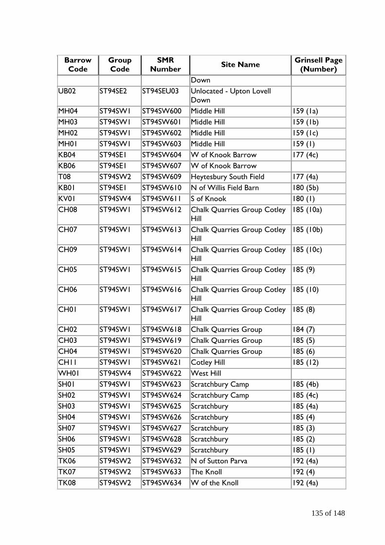
135 of 148
Barrow Code
Group Code
SMR Number Site Name Grinsell Page
(Number) Down
UB02 ST94SE2 ST94SEU03 Unlocated - Upton Lovell Down
MH04 ST94SW1 ST94SW600 Middle Hill 159 (1a) MH03 ST94SW1 ST94SW601 Middle Hill 159 (1b) MH02 ST94SW1 ST94SW602 Middle Hill 159 (1c) MH01 ST94SW1 ST94SW603 Middle Hill 159 (1) KB04 ST94SE1 ST94SW604 W of Knook Barrow 177 (4c) KB06 ST94SE1 ST94SW607 W of Knook Barrow T08 ST94SW2 ST94SW609 Heytesbury South Field 177 (4a) KB01 ST94SE1 ST94SW610 N of Willis Field Barn 180 (5b) KV01 ST94SW4 ST94SW611 S of Knook 180 (1) CH08 ST94SW1 ST94SW612 Chalk Quarries Group Cotley
Hill 185 (10a)
CH07 ST94SW1 ST94SW613 Chalk Quarries Group Cotley Hill
185 (10b)
CH09 ST94SW1 ST94SW614 Chalk Quarries Group Cotley Hill
185 (10c)
CH05 ST94SW1 ST94SW615 Chalk Quarries Group Cotley Hill
185 (9)
CH06 ST94SW1 ST94SW616 Chalk Quarries Group Cotley Hill
185 (10)
CH01 ST94SW1 ST94SW617 Chalk Quarries Group Cotley Hill
185 (8)
CH02 ST94SW1 ST94SW618 Chalk Quarries Group 184 (7) CH03 ST94SW1 ST94SW619 Chalk Quarries Group 185 (5) CH04 ST94SW1 ST94SW620 Chalk Quarries Group 185 (6) CH11 ST94SW1 ST94SW621 Cotley Hill 185 (12) WH01 ST94SW4 ST94SW622 West Hill SH01 ST94SW1 ST94SW623 Scratchbury Camp 185 (4b) SH02 ST94SW1 ST94SW624 Scratchbury Camp 185 (4c) SH03 ST94SW1 ST94SW625 Scratchbury 185 (4a) SH04 ST94SW1 ST94SW626 Scratchbury 185 (4) SH07 ST94SW1 ST94SW627 Scratchbury 185 (3) SH06 ST94SW1 ST94SW628 Scratchbury 185 (2) SH05 ST94SW1 ST94SW629 Scratchbury 185 (1) TK06 ST94SW2 ST94SW632 N of Sutton Parva 192 (4a) TK07 ST94SW2 ST94SW633 The Knoll 192 (4) TK08 ST94SW2 ST94SW634 W of the Knoll 192 (4a)
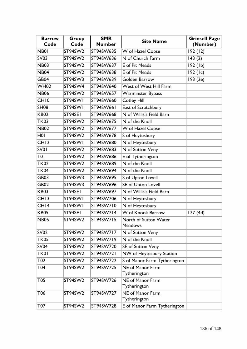
136 of 148
Barrow Code
Group Code
SMR Number Site Name Grinsell Page
(Number) NB01 ST94SW2 ST94SW635 W of Hazel Copse 192 (12) SV03 ST94SW2 ST94SW636 N of Church Farm 143 (2) NB03 ST94SW2 ST94SW637 E of Pit Meads 192 (1b) NB04 ST94SW2 ST94SW638 E of Pit Meads 192 (1c) GB04 ST94SW3 ST94SW639 Golden Barrow 193 (2e) WH02 ST94SW4 ST94SW640 West of West Hill Farm NB06 ST94SW2 ST94SW657 Warminster Bypass CH10 ST94SW1 ST94SW660 Cotley Hill SH08 ST94SW1 ST94SW661 East of Scratchbury KB02 ST94SE1 ST94SW668 N of Willis's Field Barn TK03 ST94SW2 ST94SW675 N of the Knoll NB02 ST94SW2 ST94SW677 W of Hazel Copse H01 ST94SW2 ST94SW678 S of Heytesbury CH12 ST94SW1 ST94SW680 N of Heytesbury SV01 ST94SW2 ST94SW683 N of Sutton Veny T01 ST94SW2 ST94SW686 E of Tytherington TK02 ST94SW2 ST94SW689 N of the Knoll TK04 ST94SW2 ST94SW694 N of the Knoll GB03 ST94SW3 ST94SW695 S of Upton Lovell GB02 ST94SW3 ST94SW696 SE of Upton Lovell KB03 ST94SE1 ST94SW697 N of Willis's Field Barn CH13 ST94SW1 ST94SW706 N of Heytesbury CH14 ST94SW1 ST94SW710 N of Heytesbury KB05 ST94SE1 ST94SW714 W of Knook Barrow 177 (4d) NB05 ST94SW2 ST94SW715 North of Sutton Water
Meadows
SV02 ST94SW2 ST94SW717 N of Sutton Veny TK05 ST94SW2 ST94SW719 N of the Knoll SV04 ST94SW2 ST94SW720 SE of Sutton Veny TK01 ST94SW2 ST94SW721 NW of Heytesbury Station T02 ST94SW2 ST94SW722 S of Manor Farm Tytherington T04 ST94SW2 ST94SW725 NE of Manor Farm
Tytherington
T05 ST94SW2 ST94SW726 NE of Manor Farm Tytherington
T06 ST94SW2 ST94SW727 NE of Manor Farm Tytherington
T07 ST94SW2 ST94SW728 E of Manor Farm Tytherington

137 of 148
Barrow Code
Group Code
SMR Number Site Name Grinsell Page
(Number) H02 ST94SW2 ST94SW730 S of Heytesbury H03 ST94SW2 ST94SW731 S of Heytesbury H04 ST94SW2 ST94SW732 S of Heytesbury H05 ST94SW2 ST94SW733 S of Heytesbury H06 ST94SW2 ST94SW735 W of Heytesbury T03 ST94SW2 ST94SW743 E of Tytherington ES01 SU03NE2 SU03NE613 E of Stoford SK01 SU03NE2 SU03NE615 'South Kite' Enclosure 191 (3) SK02 SU03NE2 SU03NE616 'South Kite' Enclosure 191 (2) SK03 SU03NE2 SU03NE617 E of Druids Head Farm 191 (5) DL01 SU03NE2 SU03NE618 NNW of Druids Lodge 155 (2) L01 SU03NE1 SU03NE620 SW of the Lawn 191 (4) SK04 SU03NE2 SU03NE622 SW of Druids Head Wood DL02 SU03NE2 SU03NE628 NW of Druids Lodge HL02 SU03NE3 SU03NE642 N of Ebsbury Copse HL01 SU03NE3 SU03NE643 NE of Ebsbury Copse L02 SU03NE1 SU03NE645 W of Stapleford L03 SU03NE1 SU03NE649 SW of Berwick St James DL03 SU03NE2 SU03NE661 North-west of Druid's Lodge HL03 SU03NE3 SU03NE667 West of Ebsbury Earthworks HL04 SU03NE3 SU03NE668 East of Little Langford DF01 SU03NW1 SU03NW600 N of Deptford Field Barn 204 (2) BR01 SU03NW3 SU03NW602 SW of Bilbury Rings 204 (1) WV01 SU03NW3 SU03NW603 SW of Wylye Village 204 (1b) SL01 SU03NW4 SU03NW604 SW of East Castle 191 (10b) SL02 SU03NW4 SU03NW606 SW of East Castle 191 (10a) NC01 SU03NW2 SU03NW607 SE of New Covert 191 (3) FB01 SU03NW1 SU03NW608 Field Barn N of A303 191 (5) FB02 SU03NW1 SU03NW609 Field Barn N of A303 191 (6) FB03 SU03NW1 SU03NW610 Field Barn N of A303 191 (7) EC01 SU03NW4 SU03NW611 ESE of East Castle 191 (9) EC06 SU03NW4 SU03NW612 Inside East Castle 191 (10) EC05 SU03NW4 SU03NW614 E of East Castle 191 (10e) EC02 SU03NW4 SU03NW615 E of East Castle 191 (10f) EC04 SU03NW4 SU03NW616 E of East Castle 191 (10g) EC03 SU03NW4 SU03NW617 E of East Castle 10(h) LL02 SU03NW4 SU03NW618 N of Grovely Grims 191 (11)

138 of 148
Barrow Code
Group Code
SMR Number Site Name Grinsell Page
(Number) YG01 SU03NW1 SU03NW619 Little Down 191 (12) LL03 SU03NW4 SU03NW628 Langford Long Coppice 161 (1) DF03 SU03NW1 SU03NW632 N of Deptford Field Barn MF01 SU03NW2 SU03NW633 N of Manor Farm YG02 SU03NW1 SU03NW634 W of Yarnbury Grange YG03 SU03NW1 SU03NW635 W of Yarnbury Grange DF02 SU03NW1 SU03NW656 E of Gilberts Plantation NC02 SU03NW2 SU03NW658 SE of New Covert SL03 SU03NW4 SU03NW661 SW of East Castle 191 (10c) SL04 SU03NW4 SU03NW664 SW of East Castle 191 (10d) LL04 SU03NW4 SU03NW671 NW of Upper Farm Down EC07 SU03NW4 SU03NW713 E of Holloway Hedge Barn GP01 SU03NW1 SU03NW717 N of Fisherton De La Mere GP02 SU03NW1 SU03NW718 N of Fisherton De La Mere WP01 SU03SE1 SU03SE612 Wilton Park 200 (2) HH01 SU03SE2 SU03SE619 Hadden Hill LL01 SU03NW4 SU03SW602 In or near Langford Long
Coppice
Description of the contents of the CD-R
The included CD-R contains a copy of the Microsoft Access database, named ‘Wylye DB’,
a copy of the ArcMap saved to be opened in ArcReader titled ‘Wylye Valley’ and two
versions of the Digital Elevation Model saved as VRML World files (one in high resolution
‘WV3DHi’ and another in low resolution ‘WV3Dlow’ for slower processors).
To ensure that the files are readily accessible, a zipped copy of ArcReader (to open the
ArcMap file) and OctagaPlayer (to open the VRML files) have been included on the disc in
the folder ‘Software’. Please install if necessary and follow the on screen instructions.
139 of 148
Bibliography 1.1 Cartographic Sources Ordnance Survey (or OS) 1:10,000 Scale Raster at Edina Digimap, available at: http://edina.ac.uk/digimap/ (2007) OS Land-Form PROFILE, 1:10,000 contours and DTM data at Edina Digimap, available at: http://edina.ac.uk/digimap/ (2007) OS 1:50,000 Scale Colour Raster at Edina Digimap, available at: http://edina.ac.uk/digimap/ (2007) 1849-1899 County Series 1st Edition OS map (1:2500) at Edina Digimap, available at: http://edina.ac.uk/digimap/ (2008) 1.2 Sources Aldenderfer, M. (1996) “Introduction.” In Aldenderfer, M. and Maschner, H.D.G. (eds.) Anthropology, space and geographic information systems. Oxford: Oxford University Press. pp 3-18 Annable, F.K. (1960) Excavation and Fieldwork in Wiltshire: 1957. Wiltshire Archaeological and Natural History Magazine, 57: 2-17 Annable, F.K. and Simpson, D.D.A. (1964) Guide Catalogue of the Neolithic and Bronze Age Collections in Devizes Museum. Devizes: Wiltshire Archaeological and Natural History Society Annable, F. K (1965) Excavation and Fieldwork in Wiltshire: 1964. Wiltshire Archaeological and Natural History Magazine, 60: 132-139 Ashbee, P. (1960) The Bronze Age Round Barrow in Britain. London, Phoenix House Ltd Ashbee, P. (1998) Barrows, cairns and a few impostors. British Archaeology, 32: 6-7 Barrett, J.C. Bradley, R. and Green, M. (1991) Landscape, Monuments and Society: The Prehistory of Cranborne Chase. Cambridge: Cambridge University Press Barrett, J.C. (1990) The Monumentality of Death: The Character of Early Bronze Age Mortuary Mounds in Southern Britain. World Archaeology, 22 (2): 179-189 Barrett, J.C. (1994) Fragments from Antiquity: An Archaeology of Social Life in Britain, 2900-1200 BC. Oxford, Blackwell Barrett, J.C. (1988) “The living, the dead and the ancestors: Neolithic and Early Bronze Age mortuary practices.” In Barrett, J.C. and Kinnes, I.A. (eds.) The Archaeology of Context in the Neolithic and Bronze Age: Recent Trends, University of Sheffield. pp 30-41

140 of 148
Bradley, R. (1984) The social foundations of prehistoric Britian: themes and variations in the archaeology of power. Harlow: Longman Group Bradley, R. (2007) The Prehistory of Britain and Ireland. Cambridge: Cambridge University Press Braithwaite, M. (1984) “Ritual and prestige in the prehistory of Wessex c. 200-1400 BC: a new dimension to the archaeological evidence.” In Miller, D. and Tilley, C. (eds.) Ideology, Power and Prehistory. Cambridge: University Press pp. 93-110 Brück, J. (2004) Material metaphors: the relational construction of identity in Bronze Age burials in Ireland and Britain. Journal of Social Archaeology, 4 (3): 307-333 Burgess, C. (1980) The Age of Stonehenge. London: Phoenix Press Butterworth, C.A. (1992) Excavations at Norton Bavant Borrow Pit, Wiltshire, 1987. Wiltshire Archaeological and Natural History Magazine, 85: 1-25 Case, H. (2003) Beaker Presence at Wilsford 7. Wiltshire Archaeological and Natural History Magazine, 96: 161-194 Chapman, H. (2006) Landscape Archaeology and GIS. Stroud: Tempus Publishing Ltd Cleal, R, Walker, K and Montague, R (1995) “Stonehenge And Its Landscape Twentieth Century Excavation.” In English Heritage Archaeological Report, 10. London: English Heritage Colt Hoare, Sir R. (1812) The Ancient History of South Wiltshire. London: William Miller (Republished 1975, Wakefield: EP Publishing Ltd.) Colt Hoare, Sir R. (1821) The Ancient History of Wiltshire Vol II. London: Lackington, Hughes, Harding, Maver and Lepard (Republished 1975, Wakefield: EP Publishing Ltd ) Crawford, O. G. S. (1924) Air survey and archaeology. 2nd ed. HMSO: Ordnance Survey Cunnington, M.E. (1939) On Walker Bequest to Museum. Wiltshire Archaeological and Natural History Magazine, 48: 185-190 Cunnington, H.R. (1954) The Cunningtons of Wiltshire. Wiltshire Archaeological and Natural History Magazine, 55: 211-236 Cunnington, R. (1975) From Antiquary to Archaeologist: A biography of William Cunnington 1754-1810. Aylesbury: Shire Publications Darvill, T. (1987) Prehistoric Britain. London: Routledge Darvill, T. (2006) Stonehenge: The Biography of a Landscape. Stroud: Tempus Publishing Ltd EHRSM (Accessed 2007) Extracts from English Heritage's record of scheduled monuments [online]. Available from: http://www.magic.gov.uk/rsm/ .pdf

141 of 148
Exon, S. Gaffney, V. Woodward, A. and Yorston, R. (2000) Stonehenge Landscapes Journeys through real-and-imagined worlds. Oxford: Archaeopress Field, D. (1998) Round barrows and the harmonious landscape: placing Early Bronze Age burial monuments in South-East England. Oxford Journal of Archaeology, 17 (3): 309-326 Field, D. (1998) “Neolithic and early Bronze Age communities on Salisbury Plain.” In Woodward, A and Gardiner, J. (eds) (1998) Wessex before Words: Some new research directions for prehistoric Wessex. Salisbury: Wessex Archaeology. pp 31 Field, D. (2001) “Place and memory in Bronze Age Wessex.” In Bruck, J. (ed.) Bronze Age Landscapes Tradition and Transformation. Oxford: Oxbow Books. pp 57-64 Garwood, P. (2007) “Before The Hills In Order Stood: chronology, time and history in the interpretation of Early Bronze Age round barrows.” In Last, J (ed.) Beyond the Grave: new perspectives on round barrows. Oxford: Oxbow Books pp 30-52 Gibson, A. (2002) Prehistoric Pottery in Britain and Ireland. Stroud: Tempus Publishing Ltd. Goddard, E.H. (1913) List of Prehistoric, Roman, and Pagan Saxon Antiquities. Wiltshire Archaeological and Natural History Magazine, 38: 153-378 Goddard, E.H. (1917) Notes. Wiltshire Archaeological and Natural History Magazine, 39: 377-404 Green, C. and Rollo-Smith, S. (1984) The Excavation of Eighteen Round Barrows near Shrewton, Wiltshire. Proceedings of the Prehistoric Society, 50: 255-318 Grinsell, L.V. (1957) A History of the County of Wiltshire: Volume 1. London: Oxford University Press Grinsell, L.V. (1958) The archaeology of Wessex. London: Methuen Grinsell, L.V. (1990) Barrows in England and Wales. Risborough: Shire Publications Hodder, I. and Orton, C. (1976) Spatial analysis in archaeology. Cambridge: Cambridge University Press Howarth, S. (2005) An assessment of the spatial organisation and chronological development of two late Neolithic and Early Bronze Age round barrow groups in the north-western Yorkshire Wolds. BA thesis, University of Birmingham Johnston, D. E. (1980) The Excavation of a Bell-Barrow at Sutton Veny, Wilts. Wiltshire Archaeological and Natural History Magazine, 72-3: 29-50 Kitchen, W. (2001) “Tenure and territoriality in the British Bronze Age: a question of varying social and geographic scales?” In Bruck, J. (ed.) Bronze Age Landscapes Tradition and Transformation. Oxford: Oxbow Books. pp 110-120
142 of 148
Last, J. (1998) Books of Life: Biography and memory in a Bronze Age barrow. Oxford Journal of Archaeology, 17 (1): 43-53 Lawson, A.J. (2007) Chalkland: an archaeology of Stonehenge and its region. Salisbury: The Hobnob Press Wheatley, D. and Gillings, M. (2000) “Vision, perception and GIS: developing approaches to the study of archaeological visibility.” In Lock. G. (ed) Beyond the Map: archaeology and Spatial Technologies. IOS Press, Amsterdam. pp 1-27 McOrmish, D. Field, D. and Brown, G. (2002) The Field Archaeology of the Salisbury Plain Training Area. Swindon: English Heritage Meyrick, O. (1948) Sir Richard Colt Hoare and William Cunnington. Wiltshire Archaeological and Natural History Magazine, 52: 213-218 Mizoguchi, K. (1993) Time in the Reproduction of Mortuary Practices. World Archaeology, 25 (2): 223-235 Moore, C.N. and Rowlands, M. (1972) Bronze Age Metalwork in Salisbury Museum. Salisbury: Tisbury Printing Works Nevill (2008) Interview with landowner. Wiltshire Osgood, R. (1999) The Unknown Warrior? The Re-Evaluation of a Skeleton from a Bell Barrow at Sutton Veny, Wiltshire. Wiltshire Archaeological and Natural History Magazine, 92: 120-32 Owoc, M.A. (2006) “Beyond Geoarchaeology: Pragmatist Explorations of Alternate Viewscapes in the British Bronze Age and Beyond.” In Robertson, E.C. Seibert, J.D. Fernandes, D.C. and Zender, M.U (eds.) Space and Spatial Analysis in Archaeology. Calgary: University of Calgary Press. pp 3-14 Parker Pearson, M. (1999) “The Earlier Bronze Age.” In Hunter, J. and Ralston, I. (eds.) The Archaeology of Britain: An introduction from the Upper Palaeolithic to the Industrial Revolution. London: Routledge. pp 77-94 Parker Pearson, M. and Richards, C. (1994) Architecture and Order: approaches to social space. Routledge: London Passmore, A.D. (1942) Notes. Wiltshire Archaeological and Natural History Magazine, 49: 117-119 Piggott, S. (1962) From Salisbury to South Siberia. Wiltshire Archaeological and Natural History Magazine, 58: 93-97 Renfrew, C. (2001) “Symbol before Concept: Material Engagement and the Early Development of Society.” In Hodder, I. (ed) Archaeological Theory Today. Cambridge: Polity Press. pp122-140 RCHME (1979) Stonehenge And Its Environs. London: RCHME
143 of 148
Richards, J (1990) “The Stonehenge Environs Project.” In English Heritage Archaeological Reports 16 Robinson, P. (2001) Excavation and Fieldwork in Wiltshire: 1999. Wiltshire Archaeological and Natural History Magazine, 94: 243-256 Seibert, J. (2006) “Introduction.” In Robertson, E.C. Seibert, J.D. Fernandes, D.C. and Zender, M.U (eds.) Space and Spatial Analysis in Archaeology. Calgary: University of Calgary Press. pp xiii-xxiv Shell, C. (2000). Metalworker or shaman: Early Bronze Age Upton Lovell G2a burial. Antiquity, 74: 271–272 Shell, C. (2002) Excavation and Fieldwork in Wiltshire: 2000. Wiltshire Archaeological and Natural History Magazine, 95: 279-291 Thomas, J. (1999) Understanding the Neolithic. London: Routledge Thomas, N. (1954) Notes on Some Early Bronze Age Grave Groups in Devizes Museum. Wiltshire Archaeological and Natural History Magazine, 55: 311-332 Tilley, C. (1994) A Phenomenology of Landscape: places, paths and monuments. Berg: Oxford Vatcher, F (1962) The Excavation of the Barrows on Lamb Down, Codford St. Mary. Wiltshire Archaeological and Natural History Magazine, 58: 417-441 Wheatley, D. and Gillings, M. (2002) Spatial Technology and Archaeology The Archaeological Applications of GIS. London: Taylor and Francis Whittle, A. Barclay, A. Bayliss, A. McFadyen, L. Schulting, R and Wysocki, M. (2007) Building for the Dead: Events, Processes and Changing Worldviews from the Thirty-eighth to the Thirty-fourth Centuries cal. BC in Southern Britain Proceedings of the Prehistoric Society, 62: 275-291 Cambridge Archaeological Journal 17 (supplement):123–47 Wiltshire County Council Archaeology Service (2007) Wiltshire County Council Sites and Monuments Record. Trowbridge: WCCAS Woodward, A. and Woodward, P. (1996) The Topography of some Barrow Cemeteries in Bronze Age Wessex Proceedings of the Prehistoric Society, 62: 275-291 Woodward, A. (1998) “Barrow cemeteries.” In Woodward, A and Gardiner, J. (eds) (1998) Wessex before Words: Some new research directions for prehistoric Wessex. Salisbury: Wessex Archaeology. pp 32 Woodward, A. (2000) British Barrows A Matter of Life and Death. Stroud: Tempus Publishing Ltd Woodward, A. (2002) Beads and beakers: heirlooms and relics in the British Early Bronze Age. Antiquity 76: 1040-1047
144 of 148
1.3 Figures Figure 1: A map highlighting the Wylye Valley and the county of Wiltshire (Google Earth and http://www.mysteriousbritain.co.uk/england/wiltshire.html) Figure 2: Time chart for barrows and ceramics in Britain (Personal image) Figure 3: Key forms of round barrow in the Wylye Valley (after Ashbee 1960) Figure 4: Classification of the ‘wealth’ of Wessex Series graves according to the number of objects present (after Exon et al 2000) Figure 5: River systems and settlements related to the Wylye Valley (after www.streamlife.org.uk) Figure 6: Study area with OS grid references (Personal image using Google Earth) Figure 7: Relationship diagram for Access database (Personal image) Figure 8: Four separate spatially referenced layers (Personal image) Figure 9: Monument information in GIS with spatial information (Personal image) Figure 10: The major elements of a GIS (after Wheatley and Gillings 2002) Figure 11: Possible patterns of points on a map (after Hodder and Orton 1976) Figure 12: Characteristics of vector and raster data (Ordnance Survey) Figure 13: Testing for intervisibility using viewshed analysis (after Wheatley and Gillings 2002) Figure 14: Distribution of barrows and ring ditches in central Southern England (Lawson 2007) Figure 15: Descriptions of the different forms of spatial patterns (after Woodward 2000) Figure 16: The monuments of ST94SW (OS 1:50,000 Scale Colour Raster) Figure 17: Middle Hill Group (OS 1:10,000 Scale Raster) Figure 18: MH01 seen from Scratchbury Hill (Personal Photograph) Figure 19: Burial types present in Middle Hill group (OS 1:10,000 Scale Raster) Figure 20: Scratchbury Hill (OS 1:10,000 Scale Raster) Figure 21: Two bone finds from SH06 (Thomas 1948)
145 of 148
Figure 22: Metal finds from SH05 (Moore and Rowlands 1972) Figure 23: Finds from SH05 (Personal Photograph) Figure 24: Burial types present in Scratchbury Hill group (OS 1:10,000 Scale Raster) Figure 25: View towards Cotley Hill group from SH05 (Personal Photograph) Figure 26: Cotley Hill group (OS 1:10,000 Scale Raster) Figure 27: Cotley Hill (1849-1899 County Series 1st Edition OS map) Figure 28: Barrow forms present in Cotley Hill group (OS 1:10,000 Scale Raster) Figure 29: Norton Bavant Group (OS 1:10,000 Scale Raster) Figure 30: NB01 (Personal Photograph) Figure 31: NB03 (Personal Photograph) Figure 32: NB06 Site plan with the excavated features from trenches A and C (Butterworth 1982) Figure 33: NB06 Primary inhumation in trench C (Butterworth 1982) Figure 34: NB06 Primary inhumation grave goods (Butterworth 1982) Figure 35: Burial types present in Norton Bavant group (OS 1:10,000 Scale Raster) Figure 36: Sutton Veny Group (OS 1:10,000 Scale Raster) Figure 37: The Knoll Group (OS 1:10,000 Scale Raster) Figure 38: TK07 trial borings (after Johnston 1980) Figure 39: TK08 Site plan and central grave (after Johnston 1980) Figure 40: TK08 Miniature vessel and food vessel (Johnston 1980) Figure 41: The Knoll Group Barrow Form and Burial Type (OS 1:10,000 Scale Raster) Figure 42: Tytherington Group (OS 1:10,000 Scale Raster) Figure 43: Heytesbury Group (OS 1:10,000 Scale Raster) Figure 44: Golden Barrow Group (OS 1:10,000 Scale Raster)

146 of 148
Figure 45: GB04 Amber necklace, gold beads and gold plate (Personal Photograph) Figure 46: GB04 Grave goods (Annable and Simpson 1964) Figure 47: West Hill Pair (OS 1:10,000 Scale Raster) Figure 48: Knook Village Barrow (OS 1:10,000 Scale Raster) Figure 49: Monuments of ST94SE (OS 1:50,000 Scale Colour Raster) Figure 50: Knook Barrow Group (OS 1:10,000 Scale Raster) Figure 51: KB07 Bronze knife dagger (Annable and Simpson 1964) Figure 52: Knook Barrow Group Burial Types (OS 1:10,000 Scale Raster) Figure 53: Knook Barrow Group Barrow Forms (OS 1:10,000 Scale Raster) Figure 54: Upton Lovell Group (OS 1:10,000 Scale Raster) Figure 55: UL01 Necklace (Annable and Simpson 1964) Figure 56: UL01 Upton Great Barrow (Personal Photograph) Figure 57: UL02 Bronze dagger (Annable and Simpson 1964) Figure 58: UL03 Grave goods from two primary inhumations (Annable and Simpson 1964) Figure 59: UL03 polished circular stone ‘rubber’ (Wiltshire Heritage Museum) Figure 60: Bone tweezers and miniature vessel (Annable and Simpson 1964) Figure 61: Upton Lovell Group Barrow Forms (OS 1:10,000 Scale Raster) Figure 62: Upton Lovell Group Burial Types (OS 1:10,000 Scale Raster) Figure 63: Codford Down Group (OS 1:10,000 Scale Raster) Figure 64: Codford Down Barrow Forms (OS 1:10,000 Scale Raster) Figure 65: Codford Down Burial Types (OS 1:10,000 Scale Raster) Figure 66: Left CD10 Stone battle axe; Right CD13 Stone battle axe (Annable and Simpson 1964) Figure 67: The monuments of ST939NE (OS 1:50,000 Scale Raster) Figure 68: Lamb Down Group (OS 1:10,000 Scale Raster)
147 of 148
Figure 69: Lamb Down Group excavation plan (after Vatcher 1962) Figure 70: LD02 Site Plan (Vatcher 1962) Figure 71: LD03 Site Plan (Vatcher 1962) Figure 72: LD07 Site Plan (Vatcher 1962) Figure 73: Lamb Down Burial Types (OS 1:10,000 Scale Raster) Figure 74: Stockton Earthworks Group (OS 1:10,000 Scale Raster) Figure 75: Queen's Barrow Group (OS 1:10,000 Scale Raster) Figure 76: Sherrington Plantation Group (OS 1:10,000 Scale Raster) Figure 77: Boyton Down Group (OS 1:10,000 Scale Raster) Figure 78: Boyton Down Burial Types (OS 1:10,000 Scale Raster) Figure 79: The monuments of ST93NW (OS 1:50,000 Scale Raster) Figure 80: Eastern Barrow Group (OS 1:10,000 Scale Raster) Figure 81: Western Barrow Group (OS 1:10,000 Scale Raster) Figure 82: The monuments of SU03NW (OS 1:50,000 Scale Raster) Figure 83: Field Barn Group (OS 1:10,000 Scale Raster) Figure 84: Yarnbury Grange Group (OS 1:10,000 Scale Raster) Figure 85: Deptford Field Barn Group (OS 1:10,000 Scale Raster) Figure 86: DF01 1. Miniature vessel 2. Beaker ware handle 3. Grooved ware (Passmore 1942) Figure 87: Gilbert's Plantation Pair Group (OS 1:10,000 Scale Raster) Figure 88: New Covert Pair Group (OS 1:10,000 Scale Raster) Figure 89: Manor Farm Feature Group (OS 1:10,000 Scale Raster) Figure 90: Bilbury Rings Barrow (OS 1:10,000 Scale Raster) Figure 91: Wylye Village Barrow (OS 1:10,000 Scale Raster) Figure 92: East Castle Group (OS 1:10,000 Scale Raster)
148 of 148
Figure 93: Langford Long Group (OS 1:10,000 Scale Raster) Figure 94: Steeple Langford Group (OS 1:10,000 Scale Raster) Figure 95: The monuments of SU03NE (OS 1:50,000 Scale Raster) Figure 96: Lawn Group (OS 1:10,000 Scale Raster) Figure 97: Druid's Lodge Group (OS 1:10,000 Scale Raster) Figure 98: Druid's Lodge Group (1849-1899 County Series 1st Edition OS map) Figure 99: South Kite Group (OS 1:10,000 Scale Raster) Figure 100: Hungerford Lodge Group (OS 1:10,000 Scale Raster) Figure 101: The monuments of SU03SE (OS 1:50,000 Scale Raster) Figure 102: Wilton Park Barrow (OS 1:10,000 Scale Raster) Figure 103: WP01 View north towards South Newton (Personal Photograph) Figure 104: Hadden Hill Feature (OS 1:10,000 Scale Raster) Figure 105: View of the Boyton Down barrow group from the valley floor (Personal Image) Figure 106: Viewshed of WV01, GP01 and GP02 (OS 1:10,000 Scale Raster) Figure 107: Breakdown of primary burial rites in known round barrows in the Wylye Valley (Personal Image) Figure 108: Barrow forms present in the Wylye Valley (Personal Image) Figure 109: Distribution of barrows and ring ditches in central Southern England (Lawson 2007) Figure 110: Statistical quantification of the landscape location of the barrow cemeteries of the Wylye Valley (Personal Image) Figure 111: Main screen of the database (Personal Image) Figure 112: Main data entry form (Personal Image)