Embed Size (px)
Citation preview

An Efficient and Robust Tsunami Model on Unstructured Grids. Part I:
Inundation Benchmarks
YINGLONG J. ZHANG1 and ANTONIO M. BAPTISTA
1
Abstract—A modern multi-purpose baroclinic circulation model (SELFE) has been recently extended to
include the ability to simulate tsunami propagation and inundation. The core model is based on the 3-D
nonlinear shallow-water wave (NSW) equations, which are solved on unstructured grids, using the finite-
element method. A semi-implicit method is used to solve all equations to enhance numerical stability, thus
bypassing the most stringent CFL restriction on the time step. Further aided algorithmically by an Eulerian-
Lagrangian solution of the advection terms in the momentum equation and by a simple yet effective inundation
algorithm, SELFE is very efficient and robust in both quasi-2-D (with two vertical layers) and 3-D modes.
A quasi-2-D version of the model is being used to update and expand the characterization of tsunami hazards
along the Oregon coast. As a part of a rigorous testing procedure that includes multiple types of coastal
problems, we present in this paper a quantitative assessment of performance of the quasi-2-D SELFE for two
challenging open benchmark problems proposed in the 3rd International Workshop on Long-wave Runup
Models. Satisfactory results are obtained for both problems.
Key words: Tsunami inundation, cross-scale modeling, finite elements, semi-implicit model, Eulerian-
Lagrangian Method.
1. Introduction
The Indian Ocean mega-tsunami of 2004 dramatically reinforced the importance of
tsunami hazard assessment and mitigation, and challenged all involved communities to
re-evaluate their strategies for a holistic analysis of risk.
In the United States, the State of Oregon has been pro-active in tsunami hazard
assessment and mitigation since the early 1990s, when, in the wake of the Nicaragua and
Okushiri tsunamis of 1992 and 1993, and prompted by newly found evidence of a
tsunamogenic Cascadia Subduction Zone, the Oregon Department of Geology and
Mineral Industries (DOGAMI) developed a state-wide tsunami hazard map (PRIEST,
1995). That work has been refined over the years through a series of local studies, leading
progressively to highly detailed community-specific inundation maps that help coastal
1 Science and Technology Center for Coastal Margin Observation and Prediction, Oregon Health &
Science University, 20000 NW Walker Road, Beaverton, OR 97006, U.S.A. E-mail: [email protected]
Pure appl. geophys. 165 (2008) 1–20 � Birkhauser Verlag, Basel, 2008
DOI 10.1007/s00024-008-0424-7 Pure and Applied Geophysics
Journal : 24 Dispatch : 14-11-2008 Pages : 20
Article No. : 0424 h LE h TYPESET
MS Code : 0424 h CP h DISK4 4

planners increase community preparedness, in part through education and raised
awareness supported by evacuation maps and well-marked evacuation routes. Also,
bridges have been upgraded based on perceived risk, and new critical infrastructure (such
as hospitals and schools) has been located so as to minimize risk.
Recent tsunami studies in Oregon have been conducted with a multi-disciplinary
approach that (a) attempts to characterize the underwater earthquake source based on
best-available geological and seismic evidence, including but not limited to analyses of
turbidite data (GOLDFINGER et al., 2003) and sand tsunami deposits contained in cored
samples (WITTER et al., 2003; Fig. 1a); and (b) embraces a probabilistic concept of risk
(Fig. 1b). A similar multi-disciplinary approach towards the probabilistic tsunami hazard
analysis was also conducted at Seaside, Oregon by the TSUNAMI PILOT STUDY WORKING
GROUP (2006). The combination of (a) and (b) entails hundreds of tsunami simulations,
which could not be realistically accomplished by the numerical hydrodynamic model
(ADCIRC; LUETTICH et al., 1991) that we have used over the past ten years to study the
propagation and coastal inundation of Cascadia Subduction Zone (CSZ) tsunamis.
This led us to evaluate the potential of two very efficient 3-D circulation models
(ELCIRC, ZHANG et al., 2004; and SELFE, ZHANG and BAPTISTA, 2008), developed in
recent years to sustain advanced modeling within ocean observatories (BAPTISTA, 2006), as
reference models for our tsunami studies. This is the first of a series of papers that report on
the extension of these models to tsunami simulations. Our focus in this article is on
inundation modeling, and in particular on benchmarking one of the models (SELFE)
Figure 1
(a) Paleo-tsunamis on Cannon Beach, Oregon. The four sand sheets were collected by Dr. Rob Witter of
DOGAMI and indicate the minimum extent of inundation due to past tsunami events. Sheets 1 and 2 are
attributed to small events, and sheets 3 and 4 to average to large events. Also shown are the maximum
inundation extent calculated using the model for typically small and average tsunami events on inferred paleo-
landscapes around Cannon Beach. (b) Quasi-probabilistic inundation map for Cannon Beach, based on the
results for 25 scenarios (8 cases each for average, large and largest events, plus 1 case for small events).
2 Y.J. Zhang and A.M. Baptista Pure appl. geophys.,
Journal : 24 Dispatch : 14-11-2008 Pages : 20
Article No. : 0424 h LE h TYPESET
MS Code : 0424 h CP h DISK4 4

against analytical and laboratory tests. We will report elsewhere on the results of the
validation of the models against field data in the well documented 1993 Hokkaido-Nansei-
Oki tsunami (MYERS and BAPTISTA, 1995; SHIMAMATO et al., 1995), and on applications to
Cascadia Subduction Zone tsunamis. As general cross-scale ocean models, SELFE and
ELCIRC have also been cross-applied to a range of coastal margin processes, including
characterization of 3-D estuarine and plume circulation, in which context they have been
extensively validated against field data (BAPTISTA et al., 2005; ZHANG and BAPTISTA, 2008).
The paper is organized as follows. After this introduction, we place the development
of SELFE in context of the state-of-the-art in hydrodynamic modeling of tsunamis
(Section 2). We then summarize the main SELFE physical and numerical formulations,
including the new inundation algorithm (Section 3). Results from benchmarking SELFE
with two challenging initial- and boundary-value problems are presented in Section 4.
Conclusions and road maps for future work are presented in Section 5.
2. SELFE in Context of the State-of-the-Art of Tsunami Modeling
Over the past two decades tremendous progress has been made in numerical modeling
of tsunamis, from its generation (source model) to propagation through the open ocean to
final inundation on dry land (propagation and inundation model). Uncertainties exist in all
stages of simulation, with arguably the largest occurring in the initial stage: The
characterization of the earthquake/landslide source of the tsunami (WANG and HE, 1999;
SYNOLAKIS and BERNARD, 2006). However, reducing errors in the propagation and
inundation of the tsunami wave remains an important challenge, not only because of the
need to improve the characterization/comparison of impacts for defined sources, but also
to improve the ability to characterize sources post-event via inversion of sea-level data
(arguably not a well posed problem without better propagation/inundation models; see
SYNOLAKIS and BERNARD, 2006; WEI et al., 2008).
Increasingly sophisticated methods have been proposed to tackle the high nonlinearity
and supercritical flow as found in the propagation and, in particular, inundation processes.
These models usually solve shallow-water wave equations (either linear (LSW) or
nonlinear (NSW), in which the wave dispersion is neglected), or Boussinesq or Euler
equations which incorporate dispersion effects, in 1-D, 2-D or 3-D. Smoothed Particle
Hydrodynamics (SPH) also showed promise recently (DIAS and DUTYKH, 2007). Most
popular models of the current generation are so-called ‘‘2 ? 1’’ models (i.e., depth-
averaged in space plus time evolution) based on the NSW equations. Among others,
TITOV and SYNOLAKIS (1995) demonstrated that except in the wave-breaking region, the
NSW formulation was able to accurately predict long wave runup. On the other hand, the
NSW formulation may not be appropriate for dispersive waves as found in trans-oceanic
and in many landslide-generated tsunamis (LIU et al., 2005), for which a Boussinesq or
Euler formulation may be necessary. BURWELL et al. (2007) presented an approach to use
numerical dispersion to mimic physical dispersion.
Vol. 165, 2008 Tsunami Model on Unstructured Grids 3
Journal : 24 Dispatch : 14-11-2008 Pages : 20
Article No. : 0424 h LE h TYPESET
MS Code : 0424 h CP h DISK4 4

With few exceptions, most current numerical tsunami models use the finite-difference
method on structured rectangular grids (TITOV and SYNOLAKIS, 1995; LYNETT et al., 2002;
YALCINER et al., 2002). A recent notable exception to finite differences was introduced by
GEORGE and LEVEQUE (2006) and LEVEQUE and GEORGE (2007), who used a Godunov-type
finite-volume method for enforcing conservation properties and obtained excellent results
for some benchmark problems. In addition, they also proposed an adaptive mesh
refinement strategy. However, the flux limiter used is one-dimensional in nature and its
extension to the transverse direction is still problematic.
More than the use of finite differences, the general preference for structured grids is
somewhat surprising. Indeed, the complex geometry and bathymetry/topography of
coastlines are often responsible for many intriguing localized inundation patterns (e.g.,
the large runup in a narrow valley in the Okushiri Island in the 1993 Hokkaido-Nansei-
Oki tsunami, see SHIMAMATO et al. (1995); Nicaragua tsunami, see BAPTISTA et al., 1993).
The natural ability of structured grids to accurately resolve these important features is
limited, and therefore various grid nesting or adapting approaches have been proposed to
address localized refinement (VENTURATO et al., 2007; GEORGE and LEVEQUE, 2006). The
proper imposition of boundary conditions at the interfaces between grids of various
resolutions remains a challenging issue (VENTURATO et al., 2007).
By contrast, unstructured grids have the inherent ability to resolve complex geometry
and bathymetry/topography. Yet, relatively few such models have been used on a
sustained basis for practical tsunami propagation and inundation studies. An exception is
ADCIRC (LUETTICH et al., 1991), a model that we adapted to tsunamis in the mid-1990s
(MYERS and BAPTISTA, 1995, 1997, 2001; MYERS, 1998; MYERS et al., 1999). Originally
written as a general circulation model, and based on the solution of the Generalized
Wave-continuity equation (GWCE; LYNCH and WERNER, 1991) by finite elements on
unstructured grids, ADCIRC has — in an interesting contrast between closely related
fields — been extensively used in inundation studies for storm surges and hurricanes
(WESTERINK et al., 2004).
Our experiences with ADCIRC as a tsunami propagation and inundation model were
mixed. While the model was transformative in extensively mapping tsunami inundation
in the Oregon coast (PRIEST, 1995; PRIEST et al., 1995, 1997a, 1997b, 1998, 1999a, 1999b,
2000, 2002, 2003; PRIEST and BAPTISTA 2000), some numerical limitations became
apparent. Issues related to volume/mass conservation and to parasitic oscillations, due to
the use of GWCE in lieu of the primitive momentum equations,1 were particularly of
concern. Also, numerical stability constraints forced very small time steps to be used,
resulting in computational inefficiency. Finally, the inundation algorithm could lead to
serious instabilities during the inundation in benchmark problems as described in the
review paper by SYNOLAKIS and BERNARD (2006).
1 Recently there has been some progress in incorporating the Discontinuous Galerkin Finite-Element method in
ADCIRC in order to use the primitive equations; see KUBATKO et al. (2006). However, the efficiency problem
remains an issue.
4 Y.J. Zhang and A.M. Baptista Pure appl. geophys.,
Journal : 24 Dispatch : 14-11-2008 Pages : 20
Article No. : 0424 h LE h TYPESET
MS Code : 0424 h CP h DISK4 4

The recent development of a new generation of very efficient 3-D unstructured grid
circulation models (such as UnTRIM, CASULLI and WALTERS, 2000; ELCIRC, ZHANG
et al., 2004; SELFE, ZHANG and BAPTISTA, 2008; and FVCOM, CHEN et al., 2003), whose
performance in realistic simulations of estuarine and coastal dynamics rivals or surpasses
ADCIRC, has created the opportunity to revisit options available for unstructured grid
modeling of tsunamis. The main goal of the present work is to introduce a tsunami
propagation and inundation version of SELFE. Based on the finite-element solution of the
primitive NSW equations, SELFE is hydrostatic, and hence is not currently suited for
problems in which wave dispersion effects are important. Yet, the physics of SELFE is
essentially the same as in MOST, a reference model used by NOAA in tsunami
simulations worldwide and originally developed by TITOV and SYNOLAKIS (1995).
SELFE uses semi-implicit time stepping and treats the advection with an Eulerian-
Lagrangian method (ELM; BAPTISTA, 1987), and therefore most stringent stability
conditions (e.g., CFL) are bypassed, resulting in greater efficiency. The matrices in
the model are all positive definite and symmetric, and very efficient solvers like the
Conjugate Gradient (CG) method can be used with fast convergence guaranteed. The
well-conditioning of the matrices and a simple yet effective inundation algorithm lead to
great robustness of the model; only minimal instabilities are encountered near the wetting
and drying interface, even without bottom friction and viscosity. Compared to ADCIRC,
the new model is considerably more efficient, conserves volume and mass well, and
suffers little from the parasitic oscillations. Therefore the model is well suited for realistic
applications, including forecasting.
Since the original model was 3-D, and incorporates baroclinicity as well as realistic
tidal and atmospheric forcings, the new tsunami model can simulate these effects in a
straightforward fashion.2 The importance of nonlinear interactions between tides and
tsunami waves has been demonstrated in MYERS (1998). Three-dimensional effects are
also important in landslide-generated tsunamis (LIU et al., 2005). However, better
physical formulations (e.g., dispersion effects, small-scale turbulence etc.) may be needed
in order to take full advantage of the 3-D model. These formulations will be considered in
the future model.
3. Physical and Numerical Formulation of SELFE
The equations SELFE solves are the 3-D nonlinear shallow-water wave (NSW)
equations, transport equations for salt and heat, and turbulence closure. Since only
the barotropic model is used in this paper, the transport and turbulence closure equations
are not included in this paper; however, we note that these are existing capabilities of the
model. The equations used in the tsunami model are then:
2 3D tsunami simulations are inevitably expensive, but with the judicious use of unstructured grid and a parallel
code that became available recently, the current model is able to do such simulations.
Vol. 165, 2008 Tsunami Model on Unstructured Grids 5
Journal : 24 Dispatch : 14-11-2008 Pages : 20
Article No. : 0424 h LE h TYPESET
MS Code : 0424 h CP h DISK4 4

r � uþ ow
oz¼ 0 ð1Þ
oðg� bÞot
þr �Zg
�h
udz ¼ 0 ð2Þ
Du
Dt¼ f � grgþ o
ozmou
oz
� �;
f ¼ �f k� uþ agrw� 1
q0
rpA �g
q0
Zg
z
rq dfþr � lruð Þ ð3Þ
where
(x,y) horizontal Cartesian coordinates, in [m]
z vertical coordinate, positive upward, in [m]
r oox ;
ooy
� �
t time [s]
g(x, y, t) free-surface elevation, in [m]
b(x,y,t) seabed displacement in [m] (positive for uplift)
h(x, y) bathymetric depth, in [m]
u(x, y, z, t) horizontal velocity, with Cartesian components (u,v), in [ms-1]
w vertical velocity, in [ms-1]
f Coriolis factor, in [s-1]
g acceleration of gravity, in [ms-2]
wð/; kÞ earth-tidal potential, in [m]
a effective earth-elasticity factor
q(x, t) water density; by default, reference value q0 is set as 1025 kgm-3
pA(x, y, t) atmospheric pressure at the free surface, in [Nm-2]
m vertical eddy viscosity, in [m2 s-1]
l horizontal eddy viscosity, in [m2 s-1]
Comparing these equation to those in ZHANG and BAPTISTA (2008), the only difference
is in Equation (2), where the bed deformation is included, and therefore the current model
is capable of simulating the initial seabed movement during the earthquake. This is
important because in real tsunamis the initial acceleration is very large despite the initial
velocities being small, and therefore strictly speaking, an elevation field that mirrors the
bed deformation with zero velocity everywhere is not the right initial condition (DUTYKH
et al., 2006; KANOGLU and SYNOLAKIS, 2006). All equations have appropriate initial and
boundary conditions.
Since a detailed description of the numerical formulation is given in ZHANG and BAPTISTA
(2008), only a brief summary is given here. The horizontal domain is discretized into a series
6 Y.J. Zhang and A.M. Baptista Pure appl. geophys.,
Journal : 24 Dispatch : 14-11-2008 Pages : 20
Article No. : 0424 h LE h TYPESET
MS Code : 0424 h CP h DISK4 4

of triangular elements (unstructured grid technique), and the vertical dimension is divided
into layers. A semi-implicit finite-element method is used to solve the coupled continuity
and momentum Equations (2) and (3); a key step is to decouple the two equations through
the bottom boundary layer. The advection in Equation (3) is treated with ELM, which is
explicit but unconditionally stable (BAPTISTA, 1987). A finite-volume method is used to
solve the continuity Equation (1). The resulting matrices are all symmetric and positive-
definite if a mild restriction is placed on the water depth (ZHANG and BAPTISTA, 2008), and
therefore the numerical scheme is very efficient and robust. If the horizontal viscosity is not
used, there is no stability constraint in the current model and large time steps could be used;
however, a smaller time step is necessary to ensure accuracy because of the relatively short
period for tsunami waves (WALTERS, 2005) and the highly nonlinear inundation process.
As regards the tsunami simulation, we found that one of the most critically important
issues is related to the inundation algorithm. The wetting and drying process can be
treated in a relatively straightforward fashion based on the water depths in SELFE
(ZHANG and BAPTISTA, 2008). The challenges of the inundation algorithm and the solution
thereof will be detailed in the following subsection.
3.1. Inundation Algorithm
The inundation process as found in typical tsunamis is a highly complex and
nonlinear moving-boundary problem, and some processes such as overland flow, scoured
sediments and wave breaking have not been fully understood. However, for practical
estimates of inundation extent and maximum wave runups, TITOV and SYNOLAKIS (1995)
showed that NSW formalism gives remarkably good results. From a numerical viewpoint,
while a moving/adaptive grid is conceptually more efficient in capturing the moving
shoreline (e.g., HUBBARD and DODD (2002) proposed a hierarchical Cartesian Adaptive
Mesh Refinement (AMR) algorithm that largely bypassed the need for tracking the
shoreline), it does pose some robustness issues as the flow is supercritical near the wetting
and drying interface (VENTURATO et al., 2007). Therefore we use fixed meshes, and in
doing so preclude partial wetting and drying in an element. This drawback is remedied by
using high resolution near the wetting and drying interfaces, which is made possible by
judicious use of an unstructured grid.
The inundation algorithm used in SELFE is intuitive and relatively straightforward.
At the beginning of each time step, the interfaces (or shorelines) between wet and dry
regions are computed. Then at the end of that time step, each node on the interfaces is
examined in turn to determine if the interface there needs to be advanced or retreated.
The interfaces are then updated and the process is repeated until new interfaces are found.
The procedure is summarized as follows:
1. Compute wet/dry interfaces (Cn) at time step n (Fig. 2a);
2. At the end of time step n ? 1, go through and examine all interfacial nodes on Cn.
If a node (say, A) is surrounded by wet elements (with all nodes being wet-based on
Vol. 165, 2008 Tsunami Model on Unstructured Grids 7
Journal : 24 Dispatch : 14-11-2008 Pages : 20
Article No. : 0424 h LE h TYPESET
MS Code : 0424 h CP h DISK4 4

newly computed elevations), the local interface line is advanced into the dry region,
and the velocity at the center of the dry side is calculated as the average of the
adjacent sides (Fig. 2b). If one or more elements surrounding a node (say, B) are dry
(based on newly computed elevations), the local interface line is retreated towards
the wet region;
3. Update interface lines based on the results from step 2, and iterate until the final
interface lines at the step n ? 1 (Cn?1) are found (Fig. 2c);
4. Go through all nodes on Cn?1, and do constant extrapolation of the elevations into the
dry region (e.g., elevation(A00) = elevation(A0)) if the total volume flux from the
adjacent sides on the interface is into the dry region (Fig. 2d).
Note that step 4 is similar to the extrapolation procedure in TITOV and SYNOLAKIS
(1995), and is an effective way to smooth numerical instabilities commonly found near
the interfaces; otherwise the large elevation gradients near the interfaces would lead to
unrealistically large velocity.
4. Benchmarks
As expounded in SYNOLAKIS and BERNARD (2006) and SYNOLAKIS et al. (2007),
inundation models need to be carefully benchmarked against three types of data:
analytical solutions, laboratory data, and field measurements. Due to the enormous
uncertainties in most real-case tsunamis, the comparisons with known analytical solutions
and laboratory data are critically important to gain confidence in the numerical model.
Therefore in this paper, we present the results for the first two benchmark tests published
by the 3rd International Workshop on Long-wave Runup Models (IWLRM, LIU et al.,
2008; http://www.cee.cornell.edu/longwave/index.cfm?page¼benchmark&problem¼1).
The evaluation of model performance in real tsunami applications (1993 Hokkaido-
Nansei-Oki, 1964 Alaska, and historical tsunamis caused by Cascadia Subduction Zone
earthquakes, etc.) is left to future publications.
4.1. Wave Runup on a Uniform Plane Beach
The first problem has a simple setup, with a uniformly sloping beach and no variation
in the lateral direction, and therefore is a 2-D problem in the vertical plane. The only
forcing is the initial displacement of the free surface that resembles a typical N-wave,
with a leading-depression wave followed by an elevation wave, as found in most
tsunamis (Fig. 3). The initial-value-problem (IVP) technique introduced by CARRIER et al.
(2003), and later improved by KANOGLU (2004), provides a nonlinear analytical solution,
which can be downloaded from the IWLRM website. IVPs are particularly challenging
for numerical models as the inherent numerical dissipation in a model will become quite
apparent due to the lack of continuous supply of energy into the domain as found in
8 Y.J. Zhang and A.M. Baptista Pure appl. geophys.,
Journal : 24 Dispatch : 14-11-2008 Pages : 20
Article No. : 0424 h LE h TYPESET
MS Code : 0424 h CP h DISK4 4

wet
dry
Γn
A
wet
dry
B
A’
wet
B’
dry
A’
Γ n+1
A’
wet B’
dry
A’’
(a)
(b)
(c)
(d)
Figure 2
The inundation algorithm in SELFE. (a) Initial wet/dry interface at step n; (b) evaluate wet/dry status for
interfacial nodes based on new elevations at step n ? 1; (c) update the wet/dry interface, and iterate between (b)
and (c); (d) final extrapolation of elevations along the final interface.
Vol. 165, 2008 Tsunami Model on Unstructured Grids 9
Journal : 24 Dispatch : 14-11-2008 Pages : 20
Article No. : 0424 h LE h TYPESET
MS Code : 0424 h CP h DISK4 4

boundary-value problems; in other words, the energy loss due to excessive numerical
dissipation would lead to poor results in IVPs.
The initial shoreline is at x ¼ 0 (Fig. 3), and the domain is about 80 km long, with the
region between x ¼ -300 m to x ¼ 0 being initially dry. The large domain was chosen
to minimize the reflection from the right boundary, where a radiation boundary condition
was imposed. Various grid resolutions, ranging from 40 m to 2.5 m, were tested, but only
uniform grids (by splitting each rectangle into 2 triangles) were used for simplicity and to
facilitate the convergence study (see below). In other words, we did not take full
advantage of using an efficient variable-resolution unstructured grid in this study. Two
vertical layers were used in the vertical direction, and therefore essentially a 2-D depth-
averaged model was used. The time step was fixed at 0.1 s. Although a much larger time
step can be used without comprising numerical stability, a small time step was chosen for
accurate simulation of the inundation process.3 The implicitness factor was set to be 1
(i.e., fully implicit). Bottom friction and viscosity were all neglected in order to be
consistent with the analytical solution. The run was carried out for a total of 600 sec, but
most comparisons were done for the first 300 sec. All runs shown in this paper were
carried out on an AMD Opteron 2.2 GHz processor. With Dx ¼ Dy ¼ 5 m and a grid
with 176011 nodes, the 600 sec-run took 16 hours CPU time.
The initial amplitude of the N-wave is about 12 m, which translates to a very large
extent of inundation (over 36 m in the vertical and 400 m in the horizontal excursion of
the shoreline; Fig. 4), and supercritical flow near the shoreline (Fig. 5). The comparison
of instantaneous surface elevations and velocity in the x direction at three time instances
(t ¼ 160, 175, and 220 sec) is presented in Figure 4. The 2nd and 3rd time instances
roughly correspond to maximum drawdown and runup. The model results for elevation
are excellent for all stages of the wave, with an error of 4.7% for the predicted maximum
runup, which is within the error limit proposed in SYNOLAKIS et al. (2007). Larger errors in
the velocity are observed, especially near the shoreline; probably due to numerical
dissipation, the model seems to have lost some energy in that region.
The comparison of shoreline position and velocity is shown in Figure 5. The average
and maximum errors in the predicted shoreline position are 10 m and 40 m, respectively.
MSLInitial N-wave
80km
γ =1/10
300m
xO
Figure 3
Definition sketch of the plane beach runup test. Depth in the domain is x/10.
3 For real applications, a variable time step approach is usually used; the model is run with a larger time step
(e.g., 5–10 s) until the first wave hits the coastline and then the time step is reduced to capture the inundation.
10 Y.J. Zhang and A.M. Baptista Pure appl. geophys.,
Journal : 24 Dispatch : 14-11-2008 Pages : 20
Article No. : 0424 h LE h TYPESET
MS Code : 0424 h CP h DISK4 4

Again, larger errors are observed in the shoreline velocity during both drawdown and
runup stages, although the general trend is captured. A small amount of numerical
instability can be seen near the shoreline (Fig. 5b), although it did not appear to affect the
solution elsewhere.
Because extrapolation is used in the model, the convergence property of the model
must be tested. We chose the error metrics to be the Root-Mean-Square (RMS) errors for
the shoreline position and velocity as presented in Figure 5, and studied them as the grid
resolution was varied. As indicated in ZHANG and BAPTISTA (2008), the Courant number is
increased as the grid size is decreased, and by virtue of ELM, convergence is expected.
This is indeed confirmed in Figure 6.
Volume and energy conservation is an important issue in tsunami applications
(MYERS, 1998), which has caused serious problems in our application of ADCIRC. The
total energy in the domain (at a particular time step) is:
EðtÞ ¼ Ep þ Ek; ð4Þ
Where the potential and kinetic energies are given by:
Ep ¼qg
4
Zg2 dA;
Ek ¼qg
2
Zðjuj2 þ w2Þ dV : ð5Þ
Assuming that the outgoing wave travels at a speed offfiffiffiffiffighp
; the energy flux across the
right-hand boundary per unit length in the y direction and during each time step is then
Figure 4
Comparison of instantaneous free surface (top panel) and velocity (bottom panel) along the plane beach at three
time instances. The thick black line in the top panel indicates the bottom position.
Vol. 165, 2008 Tsunami Model on Unstructured Grids 11
Journal : 24 Dispatch : 14-11-2008 Pages : 20
Article No. : 0424 h LE h TYPESET
MS Code : 0424 h CP h DISK4 4
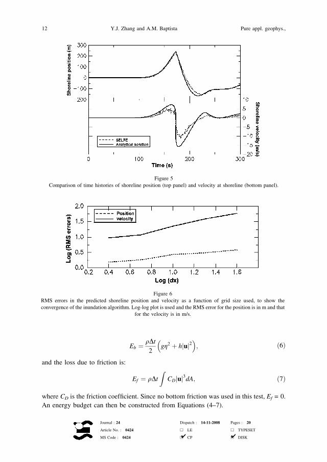
Eb ¼qDt
2gg2 þ hjuj2� �
; ð6Þ
and the loss due to friction is:
Ef ¼ qDt
ZCDjuj3dA; ð7Þ
where CD is the friction coefficient. Since no bottom friction was used in this test, Ef = 0.
An energy budget can then be constructed from Equations (4–7).
Figure 5
Comparison of time histories of shoreline position (top panel) and velocity at shoreline (bottom panel).
Figure 6
RMS errors in the predicted shoreline position and velocity as a function of grid size used, to show the
convergence of the inundation algorithm. Log-log plot is used and the RMS error for the position is in m and that
for the velocity is in m/s.
12 Y.J. Zhang and A.M. Baptista Pure appl. geophys.,
Journal : 24 Dispatch : 14-11-2008 Pages : 20
Article No. : 0424 h LE h TYPESET
MS Code : 0424 h CP h DISK4 4

Starting from the potential energy in the initial N-wave, the time history of
‘‘expected’’ total energy can be calculated from the budget presented above. This is then
compared with the actual amount of total energy in the model results in Figure 7. In
addition, Figure 7b also shows the errors in volume conservation (a volume budget can
be constructed by taking into account the water that leaves the domain during each time
step). The volume conservation errors remain very small (<0.01%) throughout the entire
simulation, which is in sharp contrast to the early ADCIRC results (unpublished). The
actual energy is always smaller than the ‘‘expected’’ value, indicating a net loss. The
temporary increase in energy during the runup stage (from t ¼ 180 to 210 sec) is most
likely due to the extrapolation used, which has added energy back to the system. The total
energy loss at the end of 10 min is about 12.5%, which is a considerably better result than
those from the ADCIRC runs (unpublished).
4.2. Wave Runup on a Complex 3-D Beach
The 1993 Hokkaido-Nansei-Oki tsunami serves as one of the best benchmark tests for
inundation models because of the detailed bathymetric surveys before and after the event,
and excellent field measurements. The earthquake occurred just west of Okushiri Island,
and caused extensive damage along the Hokkaido coastline, however, the largest runup
(up to 32 m) was observed at a narrow valley (Tsuji) within a small cove near Monai on
the west coast of Okushiri Island (SHIMAMATO et al., 1995).
Figure 7
Energy and volume conservation in the plane beach test. (a) Time history of expected (analytical) and numerical
total mechanical energies, accounting for the energy loss through the right open boundary. (b) Time history of
volume ratio between expected and predicted volumes (both account for volume loss through the open
boundary), and energy ratio between the energies shown in (a). The increase of the energy ratio around
t ¼ 200 s coincides with the inundation stage where extrapolation is used.
Vol. 165, 2008 Tsunami Model on Unstructured Grids 13
Journal : 24 Dispatch : 14-11-2008 Pages : 20
Article No. : 0424 h LE h TYPESET
MS Code : 0424 h CP h DISK4 4
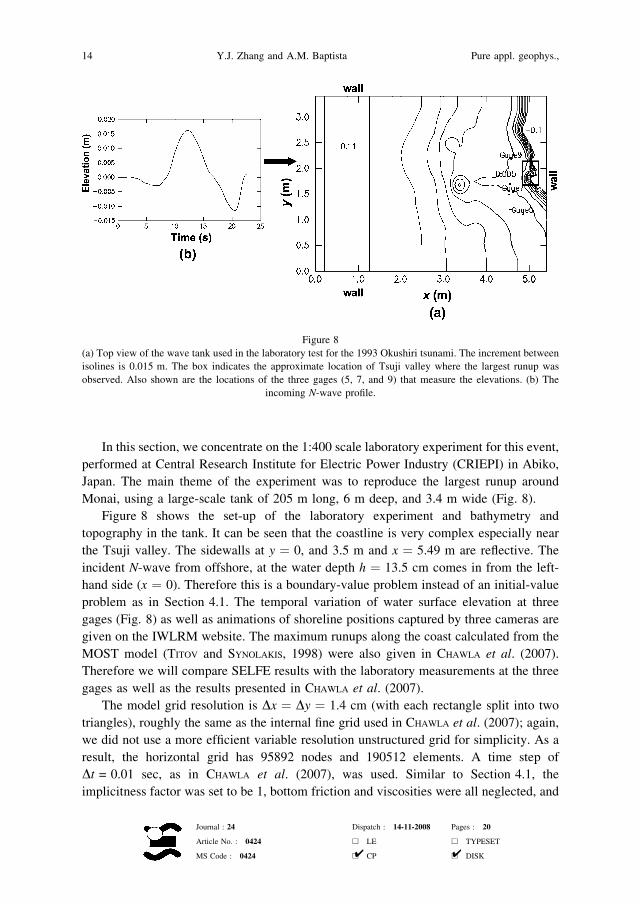
In this section, we concentrate on the 1:400 scale laboratory experiment for this event,
performed at Central Research Institute for Electric Power Industry (CRIEPI) in Abiko,
Japan. The main theme of the experiment was to reproduce the largest runup around
Monai, using a large-scale tank of 205 m long, 6 m deep, and 3.4 m wide (Fig. 8).
Figure 8 shows the set-up of the laboratory experiment and bathymetry and
topography in the tank. It can be seen that the coastline is very complex especially near
the Tsuji valley. The sidewalls at y ¼ 0, and 3.5 m and x ¼ 5.49 m are reflective. The
incident N-wave from offshore, at the water depth h ¼ 13.5 cm comes in from the left-
hand side (x ¼ 0). Therefore this is a boundary-value problem instead of an initial-value
problem as in Section 4.1. The temporal variation of water surface elevation at three
gages (Fig. 8) as well as animations of shoreline positions captured by three cameras are
given on the IWLRM website. The maximum runups along the coast calculated from the
MOST model (TITOV and SYNOLAKIS, 1998) were also given in CHAWLA et al. (2007).
Therefore we will compare SELFE results with the laboratory measurements at the three
gages as well as the results presented in CHAWLA et al. (2007).
The model grid resolution is Dx ¼ Dy ¼ 1.4 cm (with each rectangle split into two
triangles), roughly the same as the internal fine grid used in CHAWLA et al. (2007); again,
we did not use a more efficient variable resolution unstructured grid for simplicity. As a
result, the horizontal grid has 95892 nodes and 190512 elements. A time step of
Dt = 0.01 sec, as in CHAWLA et al. (2007), was used. Similar to Section 4.1, the
implicitness factor was set to be 1, bottom friction and viscosities were all neglected, and
Figure 8
(a) Top view of the wave tank used in the laboratory test for the 1993 Okushiri tsunami. The increment between
isolines is 0.015 m. The box indicates the approximate location of Tsuji valley where the largest runup was
observed. Also shown are the locations of the three gages (5, 7, and 9) that measure the elevations. (b) The
incoming N-wave profile.
14 Y.J. Zhang and A.M. Baptista Pure appl. geophys.,
Journal : 24 Dispatch : 14-11-2008 Pages : 20
Article No. : 0424 h LE h TYPESET
MS Code : 0424 h CP h DISK4 4

two vertical layers were used in the vertical direction. The total duration of the run was
22.5 sec, which took 3.75 hours CPU time on the same platform as in Section 4.1.
The comparison of elevations at the three gages between SELFE and lab
measurements is depicted in Figure 9; similar comparison can be found in Figure 4 of
CHAWLA et al. (2007). The results for the first 10 sec are discarded because the model is
still being ramped up. The overall agreement is satisfactory; the calculated maximum
elevations at the three gages are within 4.6%, 5.1%, 4.6% of measure values, and lag the
measured arrival times by 0.2, <0.001, and 0.1 sec, respectively; note the excellent match
of arrival time at Gage 7. The results are also comparable to those in CHAWLA et al.
(2007); the main difference occurs at Gage 9. While the simulated elevation at this gage
in CHAWLA et al. (2007) was such that the position of the tide gage was dry from t ¼ 13.5
to 15 sec, this gage is always submerged under water in our results, although the total
water depths are very thin (<0.1 mm) during this period (Fig. 9b). The measured
elevation at this gage is larger than those in either model (Fig. 9a).
Figure 9
(a) Comparison of surface elevations at the gages shown in Figure 8. (b) Zoom-in of SELFE results at gage 9,
where the depth is 5.98 mm (the bottom is indicated as the thick black line), from t = 13 to 15.5 s. Note that the
total depth is positive despite being very small (<0.1 mm) between t ¼ 13.5 s and 15 s.
Vol. 165, 2008 Tsunami Model on Unstructured Grids 15
Journal : 24 Dispatch : 14-11-2008 Pages : 20
Article No. : 0424 h LE h TYPESET
MS Code : 0424 h CP h DISK4 4

The calculated maximum wave runup around the Tsuji valley is shown in Figure 10,
and can be compared to Figure 5 of CHAWLA et al. (2007). Both models predicted a large
runup inside the cove, although the maxima there are different (10 cm for MOST vs.
7.5 cm for SELFE). If a linear scaling is assumed, the projected maximum runups in the
cove for the real event are 40 m for MOST and 30 m for SELFE, with the field estimate
being about 32 m. It should be emphasized that this simple scaling may not be
appropriate as the experiment cannot faithfully reproduce all nonlinear processes that
have occurred during the real event. Another peak in the runups north of the cove also
appeared in both models, although at slightly different locations. Without actual
measurements in this region, it is difficult to compare the two models there.
5. Concluding Remarks
A new tsunami model is proposed, and its ability to address stringent inundation
benchmarks demonstrated. SELFE is based on the solution of the NSW equations with a
semi-implicit finite-element method on unstructured grids, with Eulerian-Lagrangian
treatment of advective terms in the momentum equation. A simple and yet effective
inundation algorithm is incorporated in the model. Compared to a reference unstructured-
grid tsunami model (ADCIRC), SELFE is computationally efficient, robust, accurate, and
has improved volume and energy conservation properties. A parallel (MPI-based) version
of the model, which has become available recently, will add to its attractiveness as a
computationally efficient tool.
Figure 10
Maximum runup along the coastline. (a) Isobaths in the tank in the increment of 0.2 m; (b) maximum runup
along the y-axis.
16 Y.J. Zhang and A.M. Baptista Pure appl. geophys.,
Journal : 24 Dispatch : 14-11-2008 Pages : 20
Article No. : 0424 h LE h TYPESET
MS Code : 0424 h CP h DISK4 4
SELFE is in this paper benchmarked against two test problems: An initial-value
problem with an analytical solution, and a laboratory experiment inspired by the 1993
Hokkaido-Nansei-Oki tsunami. Satisfactory results are obtained in both cases. We have
also applied the SELFE to the 1993 Hokkaido-Nansei-Oki tsunami, with equally
satisfactory results, which we will report in Part II. Applications of SELFE to the1964
Alaska tsunami and to Cascadia Subduction Zone tsunamis are in progress; each
application involves both an element of field validation and a re-assessment of the
tsunami hazard for Oregon communities.
SELFE is a multi-purpose open source code, available at http://www.ccalmr.ogi.edu/
CORIE/modeling/selfe/. Other applications of SELFE include studies of 3-D circulation
in estuaries and plumes, reported elsewhere (ZHANG and BAPTISTA, 2008). The ability of
SELFE to address fully 3-D problems effectively opens the opportunity for studies of
sediment transport during tsunami events; a perspective that has strong potential value for
Cascadia Subduction Zone tsunamis, whose strongest field evidence of inundation resides
on sedimentary deposits.
Acknowledgements
The authors thank Dr. George Priest for his steadfast support, constant encouragement
and guidance over the years. The Oregon Department of Geology and Mineral Industries
and National Science Foundation (ACI-0121475; OCE-0424602) provided financial
support for this research. Any statements, opinions, findings, conclusions, or recom-
mendations expressed in this material are those of the authors and do not necessarily
reflect the views or policies of the federal sponsors, and no official endorsement should be
inferred.
REFERENCES
BAPTISTA, A.M. (1987), Solution of Advection-dominated Transport by Eulerian-Lagrangian Methods Using the
Backwards Methods of Characteristics, Ph.D. Thesis, Massachusetts Institute of Technology (260 pp), Civil
Engineering. Cambridge, Massachusetts.
BAPTISTA, A.M. (2006), CORIE: The first decade of a coastal margin collaborative observatory, Oceans’06
MTS/IEEE, Boston, MA.
BAPTISTA, A.M., PRIEST, G.R., and MURTY, T.S. (1993), Field Survey of the 1992 Nicaragua Tsunami, Marine
Geodesy 16(2), 169–203.
BAPTISTA, A.M., ZHANG, Y.L., CHAWLA, A., ZULAUF, M.A., SEATON, C., MYERS, E.P., KINDLE, J., WILKIN, M.,
BURLA, M., and TURNER, P.J. (2005), A cross-scale model for 3D baroclinic circulation in estuary-plume-shelf
systems: II. Application to the Columbia River, Continental Shelf Res. 25, 935–972.
BURWELL, D., TOLKOVA, E., and CHAWLA, A. (2007), Diffusion and dispersion characterization of a numerical
tsunami model, Ocean Modelling 19, 10–30.
CARRIER, G. F., WU, T. T., and YEH, H. (2003), Tsunami run-up and run-down on a plane beach, J. Fluid Mech.
475, 79–99.
CASULLI, V. and WALTERS, R. A. (2000), An unstructured grid, three-dimensional model based on the shallow
water equations, Int. J. Num. Meth. Fluids 32, 331–348.
Vol. 165, 2008 Tsunami Model on Unstructured Grids 17
Journal : 24 Dispatch : 14-11-2008 Pages : 20
Article No. : 0424 h LE h TYPESET
MS Code : 0424 h CP h DISK4 4

CHAWLA, A., BORRERO, J., and TITOV, V., Evaluating wave propagation and inundation characterstics of the
MOST tsunami model over a complex 3D beach. In Advanced Numerical Models for Simulationg Tsunami
Waves and Runup (eds. P. L.-F. Liu, H. Yeh, and C.E. Synolakis), vol. 10, Advances in Coastal and Ocean
Engineering (World Scientific, 2008).
CHEN, C., H. LIU, H., and BEARDSLEY, R.C. (2003), An Unstructured Grid, Finite-Volume, Three-Dimensional,
Primitive Equations Ocean Model: Application to Coastal Ocean and Estuaries, J. Atmos. Oceanic Tech. 20,
159–186.
DIAS, F. and DUTYKH, D., Dynamics of Tsunami Waves, (Springer, Netherlands 2007).
DUTYKH, D., DIAS, F., and KERVELLA, Y. (2006), Linear theory of wave generation by a moving bottom, C. R.
Acad. Sci. Paris, Ser. I, 343, 499–504.
GEORGE, D. L. and LEVEQUE, R. J. (2006), Finite volume methods and adaptive refinement for global tsunami
propagation and local inundation, Science of Tsunami Hazards 24, 319–328.
GOLDFINGER, C., NELSON, C.H., and JOHNSON, J.E. (2003), Holocene earthquake records from the Cascadia
subduction zone and Northern San Andreas fault based on precise dating of offshore turbidites, Ann. Rev.
Earth Planet. Sci. 31, 555–577.
HUBBARD, M.E. and DODD, N. (2002), A 2-D numerical model of wave runup and overtopping, Coastal Eng., 47,
1–26.
KANOGLU, U. (2004), Nonlinear evolution and runup–rundown of long waves over a sloping beach, J. Fluid
Mech. 513, 363–372.
KANOGLU, U. and SYNOLAKIS, C.E. (2006), Initial value problem solution of nonlinear shallow water-wave
equations, Phys. Rev. Lett. 97(14), 148501.
LEVEQUE, R.J. and GEORGE, D.L., High-resolution finite volume methods for the shallow water equations with
bathymetry and dry states. In Advanced Numerical Models for Simulationg Tsunami Waves and Runup (eds.
P. L.-F. Liu, H. Yeh and C.E. Synolakis), vol. 10, Advances in Coastal and Ocean Engineering (World
Scientific 2008).
LIU, L.-F., WU, T.R., RAICHLEN, F., SYNOLAKIS, C.E., and BORRERO, J.C. (2005), Runup and rundown generated by
three-dimensional sliding mass, J. Fluid Mech. 536, 107–144.
LIU, P. L.-F., YEH, H., and SYNOLAKIS, C.E. In Advanced Numerical Models for Simulating Tsunami Waves and
Runup (eds. P. L.-F. Liu, H. Yeh, and C. E. Synolakis), vol. 10, Advances in Coastal and Ocean Engineering
(World Scientific 2008).
LUETTICH, R.A., WESTERINK, J.J., and SCHEFFNER, N.W. (1991), ADCIRC: An advanced three-dimensional
circulation model for shelves, coasts and estuaries, Coastal Engin. Res. Ct., U.S. Army Engs. Wtrways.
Experiment Station, Vicksburg, MS.
LYNCH, D.R. and WERNER, F.E. (1991), Three-dimensional hydrodynamics on finite elements. Part II: Non-linear
time-stepping model, J. Num. Meth. in Fluids 12, 507–533.
LYNETT, P., WU, T.-R., and LIU, P.L.-F. (2002), Modeling wave runup with depth-integrated equations, Coastal
Engin. 46(2), 89–107.
MYERS, E.P., BAPTISTA, A. M., and PRIEST, G.R. (1999), Finite element modeling of potential Cascadia
subduction zone tsunamis, Science of Tsunami Hazards 17, 3–18.
MYERS, E.P. (1998), Physical and numerical analysis of long wave modeling for tsunamis and tides,
Environmental Science and Engineering, Beaverton, Oregon, Graduate Institute of Science and Technology,
273 pp.
MYERS, E.P. and BAPTISTA, A.M. (1995), Finite element modeling of the July 12, 1993 Hokkaido Nansei-Oki
tsunami, Pure Appl. Geophys. 144(3/4), 769–801.
MYERS, E.P. and BAPTISTA, A.M. (1997), Finite element solutions of the Hakkaido Nansei-Oki benchmark.
In Long-Wave Runup Models (eds. Yeh, H. et al.), pp. 272–280.
MYERS, E.P. and BAPTISTA, A.M. (2001), Analysis of factors influencing simulations of the 1993 Hokkaido
Nansei-Oki and 1964 Alaska tsunamis, Natural Hazards 23(1), 1–28.
PRIEST, G.R. (1995), Explanation of mapping methods and use of the tsunami hazard maps of the Oregon coast,
Oregon Department of Geology and Mineral Industries, Open-File Report O–95-67, 95 pp.
PRIEST, G.R., ALLAN, J. C., MYERS, E.P., BAPTISTA, A.M., and KAMPHAUS, R. (2002), Tsunami hazard map of the
Coos Bay Area, Coos County, Oregon, Oregon Department of Geology and Mineral Industries, Interpretive
Map Series IMS-21.
18 Y.J. Zhang and A.M. Baptista Pure appl. geophys.,
Journal : 24 Dispatch : 14-11-2008 Pages : 20
Article No. : 0424 h LE h TYPESET
MS Code : 0424 h CP h DISK4 4

PRIEST, G.R. and BAPTISTA, A.M. (2000), Digital reissue of tsunami hazard maps of coastal quadrangles
originally mandated by Senate Bill 379 (1995), Oregon Department of Geology and Mineral Industries,
Open-File Report O-00-05, maps in.pdf and GIS formats and text files for Open File Reports O-95-38 and
O-95-43 to O-95-67 [maps of the tsunami inundation zone (most probable Cascadia event) for the entire
Oregon coast].
PRIEST, G.R., CHAWLA, A., and ALLAN, J.C. (2003), Tsunami hazard map of the Alsea Bay (Waldport) area,
Lincoln County, Oregon, Oregon Department of Geology and Mineral Industries, Interpretive Map Series
IMS-23.
PRIEST, G.R., MYERS, E., BAPTISTA, A.M., ERDAKOS, G., and KAMPHAUS, R. (1999a), Tsunami hazard map of the
Astoria area, Clatsop County, Oregon, Oregon Department of Geology and Mineral Industries, Interpretive
Map Series map IMS-11, scale 1:24,000.
PRIEST, G.R., MYERS, E.P., BAPTISTA, A.M., and KAMPHAUS, R. (1999b), Tsunami hazard map of the Warrenton
area, Clatsop County, Oregon, Oregon Department of Geology and Mineral Industries, Interpretive Map
Series IMS-12, scale 1:24,000.
PRIEST, G.R., MYERS, E.P., BAPTISTA, A.M., and KAMPHAUS, R. (2000), Tsunami hazard map of the Gold Beach
area, Curry County, Oregon, Oregon Department of Geology and Mineral Industries, Interpretive Map Series
IMS-13, scale 1:12,000.
PRIEST, G.R., MYERS, E.P., BAPTISTA, A.M., KAMPHAUS, R., PETERSON, C.D., and DARIENZO. M.E. (1997a), Tsunami
hazard map of the Yaquina Bay area, Lincoln County, Oregon, Oregon Department of Geology and Mineral
Industries: Interpretive Map Series IMS-2, scale 1:12,000.
PRIEST, G. R., MYERS, E.P., BAPTISTA, A.M., KAMPHAUS, R., PETERSON, C.D., and DARIENZO. M.E. (1998), Tsunami
hazard map of the Seaside-Gearhart area, Clatsop County, Oregon, Oregon Department of Geology and
Mineral Industries: Interpretive Map Series IMS-3, scale 1:12,000.
PRIEST, G. R., MYERS, E.P., BAPTISTA, A.M., KAMPHAUS, R., PETERSON, C.D., and DARIENZO. M.E. (1997b),
Cascadia subduction zone tsunamis: hazard mapping at Yaquina Bay, Oregon, Oregon Department of
Geology and Mineral Industries: 144.
PRIEST, G.R., QI, M., BAPTISTA, A.M., KAMPHAUS, R., C.D., and DARIENZO, M.E. (1995), Tsunami hazard map of
the Siletz Bay area, Lincoln County, Oregon, Oregon Department of Geology and Mineral Industries: GMS-
99, scale 1:12,000.
SHIMAMATO, T., TSUTSUMI, A., KAWAMOTO, M., MIYAWAKI, M., and SATO, H. (1995), Field survey report on
tsunami disasters caused by the 1993 Southwest Hokkaido earthquake, Pure Appl. Geophy. 144(3/4),
665-692.
SYNOLAKIS, C.E. and BERNARD, E.N. (2006), Tsunami science before and beyond Boxing Day 2004, Phil. Trans.
R. Soc. A 364, 2231–2265.
SYNOLAKIS, C.E., BERNARD, E.N., TITOV, V.V., KANOGLU, U., and GONZALEZ, F. (2007), Standard, criteria, and
procedures for NOAA evaluation of tsunami numerical models, NOAA Technical Memorandum, OAR
PMEL–135.
TITOV, V.V. and SYNOLAKIS, C.E. (1995), Modeling of breaking and non-breaking long-wave evolution and
runup using VTCS-2, J. Waterway, Ports, Coastal and Ocean Engin. 121(6), 308–316.
TITOV, V.V. and SYNOLAKIS, C.E. (1998), Numerical modeling of tidal wave runup, J. Waterway, Ports, Coastal
and Ocean Engin. 124(4), 157–171.
TSUNAMI PILOT STUDY WORKING GROUP (2006), Seaside, Oregon Tsunami Pilot Study-Modernization of FEMA
flood hazard maps, NOAA OAR Special Report, Contribution No 2975, NOAA/OAR/PMEL, Seattle, WA, 83
pp. ?7 appendices.
VENTURATO, A.J., ARCAS, D., and KANOGLU, U. (2007), Modeling tsunami inundation from a Cascadia
Subduction Zone earthquake for Long Beach and Ocean Shores, Washington, NOAA Technical Memoran-
dum, OAR PMEL-137.
WALTERS, R.A. (2005), A semi-implicit finite-element model for non-hydrostatic (dispersive) surface waves,
Internat. J. Num. Meth. in Fluids 49, 721–737.
WANG, K. and HE, J. (1999), Mechanics of low-stress forearcs: Nankai and Cascadia, J. Geophys. Res. 104,
15191–205.
WEI, Y., BERNARD, E.N., TANG, L., WEISS, R., TITOV, V.V., MOORE, C., SPILLANE, M. HOPKINS, M., and KANOGLU,
U. (2008), Real-time experimental forecast of the Peruvian tsunami of August 2007 for U.S. coastlines,
Geophys. Res. Lett. 35, L04609.
Vol. 165, 2008 Tsunami Model on Unstructured Grids 19
Journal : 24 Dispatch : 14-11-2008 Pages : 20
Article No. : 0424 h LE h TYPESET
MS Code : 0424 h CP h DISK4 4

WESTERINK, J.J., FEYEN, J.C., ATKINSON, J.H., LUETTICH, R.A., DAWSON, C.N., POWELL, M.P., DUNION,
J.P., ROBERTS, H.J., KUBATKO, E.J., and POURTAHERI, H. (2004), A new generation hurricane storm surge
model for southern Louisiana, http://www.nd.edu/*adcirc/pubs/westerinketal_bams_ref1935b.pdf.
WITTER, R.C., KELSEY, H.M. and HEMPHILL-HALEY, E. (2003), Great Cascadia earthquakes and tsunamis of the
past 6700 years, Coquille River estuary, sourthern coastal Oregon, Geolog. Soc. Am. Bull. 115, 1289–1306.
YALCINER, A.C., ALPAR, B., ALTINOK, Y., OZBAY, I., and IMAMURA, F. (2002), Tsunami in the Sea of Marmara:
historical documents for the past, models for future, Marine Geology 190(1–2), 445–463.
ZHANG, Y.-L. and BAPTISTA, A. M. (2008), SELFE: A semi-implicit Eulerian-Lagrangian finite-element model for
cross-scale ocean circulation, Ocean Modeling 21(3–4), 71–96.
ZHANG, Y.-L., BAPTISTA, A.M., and MYERS, E.P. (2004), A cross-scale model for 3D baroclinic circulation in
estuary-plume-shelf systems: I. Formulation and skill assessment, Continental Shelf Res. 24, 2187–2214.
(Received January 1, 2008, revised June 25, 2008)
To access this journal online:
www.birkhauser.ch/pageoph
20 Y.J. Zhang and A.M. Baptista Pure appl. geophys.,
Journal : 24 Dispatch : 14-11-2008 Pages : 20
Article No. : 0424 h LE h TYPESET
MS Code : 0424 h CP h DISK4 4