Embed Size (px)
Citation preview

University of Rhode Island University of Rhode Island
DigitalCommons@URI DigitalCommons@URI
Open Access Master's Theses
2003
An Assessment of Regulatory and Planning Measures Affecting An Assessment of Regulatory and Planning Measures Affecting
Land Conservation and Resource Protection in Eight Rhode Island Land Conservation and Resource Protection in Eight Rhode Island
Towns: Charlestown, Coventry, Exeter, Hopkinton, Richmond, Towns: Charlestown, Coventry, Exeter, Hopkinton, Richmond,
South Kingstown, Westerly, and West Greenwich South Kingstown, Westerly, and West Greenwich
Patricia S. Hickey University of Rhode Island
Follow this and additional works at: https://digitalcommons.uri.edu/theses
Recommended Citation Recommended Citation Hickey, Patricia S., "An Assessment of Regulatory and Planning Measures Affecting Land Conservation and Resource Protection in Eight Rhode Island Towns: Charlestown, Coventry, Exeter, Hopkinton, Richmond, South Kingstown, Westerly, and West Greenwich" (2003). Open Access Master's Theses. Paper 750. https://digitalcommons.uri.edu/theses/750
This Thesis is brought to you for free and open access by DigitalCommons@URI. It has been accepted for inclusion in Open Access Master's Theses by an authorized administrator of DigitalCommons@URI. For more information, please contact [email protected].

An Assessment of Regulatory and Planning Measures
Affecting Land Conservation and Resource Protection
In Eight Rhode Island Towns:
Charlestown, Coventry, Exeter, Hopkinton, Richmond,
South Kingstown, Westerly, and West Greenwich
BY
PATRICIA S. HICKEY
A RESEARCH PROJECT SUBMITTED IN PARTIAL FULFILLMENT OF THE REQUIREMENTS
FOR THE DEGREE OF MASTER OF COMMUNITY PLANNING
UNIVERSITY OF RHODE ISLAND
2003

An Assessment of Regulatory and Planning Measures
Affecting Land Conservation and Resource Protection
In Eight Rhode Island Towns:
Charlestown, Coventry, Exeter, Hopkinton, Richmond,
South Kingstown, Westerly, and West Greenwich
Approved: Major Professor
Acknowledged: Director
Research Project
Of
Patricia S. Hickey

Acknowledgments:
Acknowledgments:
I would like to thank my Professional Project Committee:
Rob Thompson, PhD., JD. URI Community Planning & Landscape Architecture:
Major Professor
Sheila Brush, Program Director, Grow Smart Rhode Island: Reader
Howard Foster, PhD. URI Community Planning & Landscape Architecture: Reader
As well as:
Meg Kerr and Virginia Lee at the URI Coastal Resources Center; and
Sheila Brush, Scott Millar, Jim Lucht, Howard Foster, Kathy Crawley, Mike Deluca
and Richard Youngken for their assistance in the design of this study.
A special thanks to the Charlestown, Coventry, Exeter, Hopkinton, Richmond,
South Kingstown, Westerly, and West Greenwich Planning Departments for their
participation in this study.
iii

Table of Contents:
Section I. Introduction and Purpose . . . . . . . . . . . . . . . .. .. . . . . . . . . . . . . . . . . . .. . .. . . . . . . .. 1
Section II. Town Profiles ...... .... ... ... . ...... ...... ..... ..... .......... .... .. . ....... 5
Town of Charlestown Profile .. ...... ... .. ... .......... ....... .. ...... ........ .... ................. ..... 6
Town of Coventry Profile .... ... .. .. .. ........... ............. .......... ........ ... ... ..... .......... ... 26
Town of Exeter Profile ..... ....... .... ...... ..... .......................... .......... . ................. ... 47
Town of Hopkinton Profile ........ .... .... .. ... ... .... ...... .. .... ................ ...... ...... .......... 63
Town of Richmond Profile ....... .................. ..... .. .......................... .. .. ... ... .......... 79
Town of South Kingstown Profile ... .... .. .... .. .... ...... ... .............. .. ... ... ................... 93
Town of West Greenwich Profile .... ... .......... ........ ........... .. ..... ... .............. ...... ... 110
Town of Westerly Profile ... ... .... ..... ......... .. .... .. ..... ...... .. .. .... .. ... .... ... .. .... ... ... . .... 122
Section Ill. Town Regulatory Comparisons ... ... ...... .. .......... .. ......... ........ . 138
Charlestown, Coventry, Exeter, Hopkinton Matrix ..... ... .. ............... .. ......... ... . ..... 138
Richmond, South Kingstown, West Greenwich, Westerly Matrix .. ....... .. .. .............. 159
Appendix A List of Plans, Ordinances, and Land Development Regulations .. ... 172
Appendix B Municipal Planners ... ......... .. .......... .......... ........... ..... ....... ..... ... .. 173
iv

Section I. Introduction & Purpose
The purpose of this study was to assess planning capacity for land
conservation and natural resource protection in eight Rhode Island
municipalities based on factors such as community comprehensive planning
goals and objects, zoning and subdivision regulations, technical capacity and
staffing considerations. The main body of this report is comprised of detailed
matrices inventorying land conservation and resource protection efforts for
the individual towns. The last section of the report is comprised of two
matrices comparing zoning and land development regulations in each of the
eight towns. The matrices are organized by resource area and applicable
development regulations.
This assessment provides only a snapshot of the planning and regulatory
milieus in the eight towns during the period of June to December 2000. The
results of this study will be used to build planning capacity in the towns under
study through targeted educational and funding opportunities. The information
in this study is proprietary, and should not be used or cited without permission
of the author.
The criteria used to assess planning capacity were largely derived from an
inventory of comprehensive plan objectives and development regulations.
The study also included in-depth interviews with town planners on
implementation efforts. These interviews provided important information on
the technical and professional capacity within planning departments, as well
as insight into how well the towns are actually managing development. The
interviews were also beneficial in helping to gauge levels of awareness and
consensus among town decision-makers concerning the significance of land
conservation and natural resource protection to growth management efforts.
1

It became apparent throughout the interview process, that a town's planning
capacity is greatly influenced by the level of consensus among town decision
makers. Low technical and staffing capacity does not preclude high capacity
to manage development. For example, the Town of Richmond lacks a full
time planner and GIS capability. This rather low in-house capacity, given
current rates of growth, is offset by a high level of commitment to land
conservation and natural resource protection among town decision-makers.
The Town of Richmond's development regulations and practices reflect this
commitment. According to the town planner, Richmond's capacity to manage
development is high.
The adoption and implementation of strong development regulations can also
compensate for limited in-house professional and technical capacity. In towns
that lack full GIS capacity, and hence the ability to view environmental
characteristics on a parcel basis, developers can be required to provide
environmental impact statements as part of site review requirements in the
zoning ordinance. Towns can also require developers to provide a site
analysis demonstrating how environmental considerations will be
incorporated into the design of the site. Towns can also hire environmental
consultants to conduct impact assessments. For example, the Town of
Coventry contracts with a non-profit organization that is staffed by
environmental management professionals to assist the town in conducting in
depth environmental assessments for development proposals.
Towns with mandatory residential cluster development ordinances, such as
Charlestown and Richmond, have the greatest degree of flexibility and the
highest level of consistency in siting development away from environmentally
sensitive areas. For example, both towns use their mandatory cluster
ordinance to site development away from wetlands and water bodies, in effect,
creating extended vegetative buffer zones for these resources in town.
Mandatory cluster has also been used to plan and create linked greenspaces
2

in one of the towns. Coventry's cluster ordinance includes a 20 percent
density bonus for farmland preservation.
Subdivision and land development regulations specifying "land unsuitable for
development" is another important way for the towns to preserve open spaces
and protect fragile ecosystems during the development process. Land defined
as unsuitable for development is deducted from the buildable acreage of the
parcel. Charlestown's regulation is the most protective and far reaching, and
provides an excellent example of how towns can increase their capacity to
protect natural resources and fragile or important land. Exeter is the only town
in the study area that does not specify "land unsuitable for development".
The town profiles included in this report identify planning capacity limitations
on a town-by-town basis. The eight towns in the study vary widely in their
capacity to manage growth in an environmentally sensitive manner. A
surprising conclusion of this assessment is that low technical and staffing
capacity does not preclude high capacity to manage development.
Comprehensive development regulations requiring detailed environmental
assessments and site analysis can offsite a number of in-house capacity
limitations. The towns with the highest level of planning capacity, in this study,
also possessed the most experienced and proactive planning officials.
Broad-based consensus among town officials on the need to manage growth
through land conservation and natural resource protection efforts may be the
single most important variable in assessing a town's planning capacity for
purposes of this study. Based on these findings, efforts to build planning
capacity should focus on education and training programs for town officials,
particularly for planning board and commission members. The comparative
regulatory matrix created for this study indicates a high degree of cross-town
sharing of development regulations. Capacity building efforts should focus on
facilitating cross-town learning wherever possible.
3

This report concludes that the most important indicators of planning capacity
are: 1) consensus among town officials regarding the significance of land
conservation and natural resource protection, 2) an experienced and
proactive planning board or commission, and 3) comprehensive,
environmental development regulations.
4

Section II. Town Profiles
The town profiles include a narrative assessment of planning capacity along
with two matrices inventorying comprehensive planning objectives and
implementation efforts and regulatory measures and implementation efforts.
The matrices are organized by natural resource area and applicable
development regulations or plan objectives. In order to create each matrix,
community comprehensive plans, zoning ordinances, and subdivision and
land development regulations were reviewed for each town. Information was
then transcribed into the matrices. Although detailed citations are not
provided due to space limitations, headings are provided to indicate where
the information is located in municipal planning documents.
The narrative assessment in each town profile is organized into five principal
sections: an overall summary, information on planning staff and resources, an
assessment of comprehensive plan objectives, GIS capacity and site analysis
protocols, and lastly, land development regulations. The views or judgments
expressed in these assessments are solely those of the author, and should
not be read as authoritative statements of fact.
5

TOWN OF CHARLESTOWN PROFILE
Summary Based on the criteria used in this study, Charlestown has one the most
comprehensive approaches to natural resources protection and land
conservation in the study area. The majority of the Town's comprehensive
plan objectives for land conservation and natural resources protection, as set
forth in the 1992 plan, have all been implemented. The Town's zoning and
subdivision regulations further reflect a commitment to protecting natural
resources and open spaces. The Town's present planning capacity to
manage development is high.
The town is unique in that the planning commission is an elected body. The
commission has enacted some of the most progressive subdivision and land
development regulations in the study area. For example, Charlestown is one
of only two towns that mandate cluster development for all major subdivisions.
The Town's subdivision and land development regulation, which classifies
land that is "unsuitable for development," is also the most far-reaching.
Charlestown is one of only two towns in the study area that requires
developers to obtain a certified letter from the Rhode Department of
Environmental Management, Natural Heritage Program documenting the
presence or absence of rare or endangered species.
There is widespread consensus in the Town on the need to preserve open
space and to protect the water resources. The town is currently working with
the university and state agencies on a number of projects to increase water
quality management, including the establishment of a wastewater
management commission. The planning commission is presently working on
a new open space acquisition plan for the town.
6

Planning Department The Charlestown Planning Department, under the current town planner,
possesses a high level of both professional and technical capacity. The town
planner (now gone) has a strong background in, and commitment to, natural
resource protection. Charlestown is one of the few towns in the study area
with adequate GIS technical capacity. The Town's plat maps have been
digitized, and the planner has easy access to GIS coverages of critical
resource areas and 'environmental constraints' to development on both a
town-wide and parcel basis.
The town planner works almost exclusively with the planning commission. As
an elected body, the commission assumes responsibility for planning
decisions in town. Both the planning commission and the zoning board of
review have their own solicitors to prevent conflicts of interest in the
development process.
Planning capacity limitations are primarily due to a lack of resources for
planning functions. The town employs a single, full-time planner to handle all
day-to-day planning functions. Planning officials need more assistance
identifying "model ordinances" and other innovative techniques for guiding
development. There is also a need for institutionalized training program for all
new board and commission members as well as for town solicitors. It appears
that the town, particularly the planning commission, is open to strengthening
environmental protections and growth management provisions.
Comprehensive Plan Objectives The Town of Charlestown Comprehensive Plan was adopted by the town
council in January of 1992. The plan provides a focused agenda for natural
resource protection, with an emphasis on water resources. In regard to
broader land conservation objectives, the plan does not offer a town-wide
vision or greenspace concept plan. Land acquisition strategies mentioned in
7

the plan are mainly focused on the protection of specific resources such as
wetlands and water bodies. Suggested policies for land acquisition revolve
around the preservation of protective buffer zones for critical resource areas.
The Town's comprehensive plan objectives strongly encourage increased
municipal involvement with local and state environmental organizations. The
plan also strongly supports increasing public education and participation
around environmental issues, as well as increased public access to the
Town's natural resources and open spaces.
The plan consistently promotes changes in subdivision/land development
regulations and zoning to increase environmental protection measures. The
inclusion of such policy goals in the plan provides an important basis for
future regulatory actions. Charlestown has adopted or is pursuing the majority
of its comprehensive plan objectives. The plan appears to be an important
guidance document for land conservation and natural resources protection,
as reflected in regulatory changes since the adoption of the plan.
Site Analysis Charlestown's in-house GIS capacity greatly assists the town planner in
conducting early environmental assessments of proposed sites for
development. Easy access to detailed site maps allows the town planner to
address important site considerations with developers prior to the pre
application meeting and the drafting of conceptual plans. This saves
developers both time and resources, and provides town officials more
influence in the design of the site. The town planner would like to have this
process formally adopted into regulatory procedures by requiring developers
to initiate the review process with detailed two foot contour maps in-hand. In
this way, siting decisions would formally begin with a consideration of the
natural characteristics of the parcel.
8

Town-produced maps also assist the planner and the commission in
conducting onsite analysis. GIS mapping of parcel constraints direct attention
to specific areas of the site, such as wetlands or important habitat, it also
enables town officials to see the site in the context of adjoining properties
and/or nearby areas of environmental concern. Ultimately, in-house mapping
capacity greatly reduces the planning commission's dependence on
developers for complete and accurate site information. It also provides town
officials with a sound foundation on which to base concerns and conditions of
approval early in the development review process.
Zoning and Subdivision Regulations
Zoning Ordinances
• Farmland Zoning-none • Residential Cluster Development--Charlestown is one of two towns in the
study area that mandates residential cluster development for all major subdivisions. The cluster provisions require that 40 percent of the total land area must be protected as open space, 50 percent of which may be land "unsuitable for development." The planner felt that the cluster provisions could be made stronger, particularly through the adoption of better site analysis and site design standards.
• Overlay Districts-Charlestown's zoning ordinance includes two protection districts--the Flood Hazard Overlay District and the Groundwater Protection Overlay District. Nancy Hess considers the Town's Groundwater Protection Overlay District to be a model ordinance. The town is also in the process of implementing a wastewater management district.
• Site Plan Review-The town has adopted detailed environmental standards for all land developments under its Site Plan Review Ordinance.
• Performance Standards-The town has adopted its own septic system setback requirements from water bodies, fresh and coastal wetlands, and flood hazard areas. The planning commission has the authority to increase the criteria where necessary.
9

Subdivision and Land Development Regulations
By comparison to other towns in the study area, Charlestown's subdivision
and land development regulations provide the most comprehensive suite of
regulatory provisions designed to protect natural resources during the
development process.
• Land Unsuitable for Development--The Town's list of land unsuitable for development is the most detailed and far-reaching in comparison with other towns in the study area. Land unsuitable for development shall be deducted from the developable acreage of the parcel--resource areas subject to protective setback distance such as but not limited to, wetlands; areas subject to storm flow or flooding; hydric soils and inter-tidal salt marshes; land located in any V zones or floodways; any area of the track proposed to be developed equal to the area of any street and/or utility rights-of-way; any unique sites having historical, archeological values or protected species of flora or fauna; any other lands which if developed would cause a threat to public health, or result in irreparable public harm, or loss of irreplaceable resources; any area of ledge and/or rock outcrops at/or within four feet of the land surface, any area where slopes exceed fifteen percent)
• Environmental Analysis--An environmental analysis is required for all major subdivisions and land developments as well as for any development occurring in proximity to significant natural resources. The list of natural resources covered under this regulation extends to all of the natural resource areas addressed in this study.
• Erosion and Sediment Control--An erosion and sediment control plan is required for all major subdivisions and land developments and for all development occurring in close proximity to wetlands, water resources or on sites with steep slopes. According to the planner, the public works director and the building inspector strictly monitor and enforce erosion and sediment control plans.
• Site Design Standards--The Town's Physical Design and Public Improvement Standards are comprehensive and detailed. The Town's mandatory cluster provision provides the town with the flexibility it needs to implement basic design standards. Of particular note, the standards include a provision that states: "excess cutting, filling or stripping vegetation shall not be permitted." However, parcels of five acres or less do not require a clearing permit from the Rhode Island Department of Environmental Management. Oftentimes, owners of these parcels will strip the property of trees and vegetation prior to initiating the development review process.
10

Charlestown Comprehensive Plan Matrix
Issue Area Comprehensive Planning Implementation Objective
Farmland Preservation Open Space Zoning
• Rezone all conservation lands ~ Adopted held by public agencies to Open Space, Conservation and Recreation
Open Space Preservation
• Develop a land trust for ~ Began the South County Conservancy conservation purposes (which is now independent)
• Acquire additional open space ~ This was accomplished using DEM's land .. . with a focus on providing 1990 Open Space Grants. The town buffers and/ or limited access to currently has a grant proposal in with natural resources DE M for continued open space
acquisition. ~ The Planning Commission is currently
working on an Open Space Plan for the town.
• Rezone the 5-acre residential ~ Adopted zone to 3-acre residential
• Continue requiring exactions of ~ Pursued through open space provisions developers to preserve open in mandatory cluster, and in designation space, especially as undeveloped of land unsuitable for development. buffers to natural resources. Continue encouraging clustered developments with surrounding open space.
• Continue to cooperate with ~ Actively pursued agencies such as the Wood Pawcatuck Association and pond watcher groups in educational activities and preservation of undevelOJ:>_ed _E_arcels
11

Charlestown Comprehensive Plan Matrix
I ssue Area Comprehensive Planning Implementation Objective
Natural Resource Protection
• Promote access to and appreciation of many of the natural resources as appropriate through the continued development of shore access points, hiking paths, and other opportunities for outdoor activities.
• Identify areas for increased }> The town works with the South County protection through dedication or Conservancy, TNC etc ... to protect and acquisition of development acquire critical land rights or property. Promote acquisition of these sites by the town, land trust, or other conservation o~anization . . .
• Continue educational efforts and }> The town actively works with URI, state group activities that raise agencies and other organizations to awareness of environmental protect natural resources through protection, e.g., septic system increased public awareness and brochure, Conservation participation Commission sponsored clean- }> The town has a Wastewater Management ups, or activities for school Commission. children
• Manage growth and }> Adopted in subdivision and land development to reflect the development regulations natural characteristics (resources and constraints}_ of the land
• Explore alternative measures of }> Pursued resources protection as they become available or feasible, including alternative flexible zoning measures, and the use of alternative technologies to remove nutrients from wastewater.
12

Charlestown Comprehensive Plan Matrix
Issue Area Comprehensive Planning Implementation Objective
Wetlands
• Work with adjacent communities and the Tribe to define the appropriate character of key resources and to cooperate in p rotectin_g_ them
• D evelop a planner's database, );;> Yes. Parcel data is digitized and used
combining environmental/ along with GIS data layers created by the cultural resources and EDC. Mary H utchinson digitized the
constraints maps with lot parcel maps and created an Arc View information to be used as a "red Project for the town flag" in reviewil]i_ devel~ments
• Preserve vegetated buffers );;> Pursued through site design standards between land uses and roads, streams and wetlands
Watercourse/ Surface Waters
• Develop additional provisions );;> Stormwater Management Plans required
for water resource protection for all development through zoning and other land );;> Performance Standards adopted use management tools (such as );;> Wastewater Management District water quality performance adopted standards and enforcement of );;> Site design standards state vegetated setbacks from streams and wetlands
• Monitor water quality in the );;> Actively collaborates with Cooperative fresh water bodies and salt Extension, Water Quality Program and ponds through the volunteer state agencies to monitor and protect pond watchers groups' efforts water resources and other studies, identifying specific problems or improvements, and where necessary researching and implementing feasible improvements that remedy S£ecific _J_Jroblems identified
• Promote establishing protective );;> Pursued through site design standards undeveloped zones along water and mandatory cluster provisions resources and other habitats );;> Pursued through delimiting "land through the use of setbacks, unsuitable for development" design standards, exactions, open space dedication, and where necessary the purchase of develo_Q_ment ri_g_hts or _J_J!O_l)_e~
13

Charlestown Comprehensive Plan Matrix
Issue Area Comprehensive Planning Implementation Objective
Groundwater & Recharge Areas
• Adopt a Groundwater ~ Adopted Protection Overlay District
• Implement a "Wastewater ~ Adopted Management District"
• Develop and implement a soil ~ Adopted erosion and sediment control ordinance
• Develop additional provisions ~ Strict Performance Standards adopted for water resource protection ~ Stormwater Management Plans through zoning and other land ~ Site design standards use management tools ~ Site Plan Review
~ Erosion and Sediment Control Plan
Floodplains
Coastal • Define the seaward setbacks ~ Adopted
Features along the barrier beach communities to be the most severe erosional dune scarp (edge) i.e., the erosional scarp from the blizzard of 1978 or more severe erosion after 1978
• Promote access to and appreciation of many of the natural resources as appropriate through the continued development of shore access points, hiking paths, and other opportunities for outdoor activities.
• Monitor water quality in the ~ Actively collaborates with Cooperative fresh water bodies and salt Extension, Water Quality Program and ponds through the volunteer state agencies to monitor and protect pond watchers groups' efforts water resources and other studies, identifying specific problems or improvements, and where necessary researching and implementing feasible improvements that remedy specific problems identified
14

Charlestown Comprehensive Plan Matrix
Issue Area Comprehensive P lanning Implementation Objective
Topography • Develop and implement a soil ~ Adopted erosion and sediment control ordinance
Rare Species/ • Develop a planner's database, ~ GIS with EDC Critical Lands Coverage
Critical combining environmental/ including DEM's Natural Heritage Sites
Habitat cultural resources and constraints maps with lot information to be used as a "red flag" in reviewin__g_ develo_E_ments
• Promote establishing protective ~ Pursued through site design standards undeveloped zones along water and mandatory cluster provisions resources and other habitats ~ Pursued through delimiting "land through the use of setbacks, unsuitable for development" design standards, exactions, open space dedication, and where necessary the purchase of development ri__g_hts or _E!O_E_erty
Trees/ Woodlands
• See above (Rare Species/Critical Habitat)
Cultural and Historic Resources Village/Rural Character
• Eliminate 'spot' zones, which ~ Implemented may allow redevelopment that is inconsistent with surrounding land uses and natural resources
• Recommends Village District ~ Combined with Historic District Overlay
• Historic Districts ~ Combined with Village District
• Scenic Road D esignations ~ Reserved in Zoning Regulations
• Roadside Standards ~ Not successfully adopted
• Ensure that town staff and the ~ Implemented boards and commissions that review land development proposals have adequate mapping to make well considered land use decisions
15

Charlestown Comprehensive Plan Matrix
Issue Area Comprehensive Planning Implementation Objective
Village/Rural • Maintain the current general ~ D one through zo ning (i.e., zoning
Character patterns, scale, and densities of reflects traditional land use patterns)
(continued) development, with the most dense development occurring in villages and generally low density development occurring outside the village areas
• Preserve important views and visual ~ No access to the water. D esign standards along Routes 1 and 1A, Charlestown Beach Road, East Beach, West Beach Road, and at important viewing locations along the Pawcatuck should specify preservation of views, design of buildings to be screened by topography or vegetation where possible."
16

Charlestown Municipal Protections
I ssue Area Municipal Protection Measures Implementation
Land Conservation
Farmland Preservation
Zoning Regulations • Agricultural land may serve as open )> Has not promoted land space in cluster developments zo conservation.
• Protection of farmland is mentioned --------------------------------
as a public purpose of the Planned )> Has not promoted land
Development District zo conservation
Site Desjg_n Other • Farm, Forest and Open Space
Program
Open Space Zoning • Permitted uses "by right" include: most recreational uses, government administrative buildings, libraries and minor recreation centers, as well as commercial uses such as driving ranges and riding stables. zo
• Agricultural uses are allowed subject to _E_erformance standards. zo
Open Space Preservation
Residential Cluster • Mandatory cluster for all major )> The clusters are not too
Development subdivisions in R-3A, R-2A and R-40 bad. There is a need for Zoning Districts ( 40 % of the total better site analysis prior land area must be protected open to the lay out of lots. A space, 35 % of which must be suitable BMP would have the for active recreational purposes; no developers come in with more than 25% shall be made colored contour maps impervious; unbuildable land may prior to site drawings. account for a maximum of 50% of )> Planner uses a G IS protected open space) zo database for site analysis
for all developments )> Planner does a site visit
for all developments.
Residential Compounds • Residential Compounds allowed in the R-3A and R-2A zones zo
Large Lot Zoning • 3-Acre Zoning
17

Charlestown Municipal Protections
Issue Area Municipal Protection Measures Implementation
Land Preservation (continued)
Land Unsuitable for • Land Unsuitable for Development-- ~ Strictly adhered to
Development "Constraints to Development" ( shall ~ Developer required to
be deducted from the developable provide a certified letter
acreage of the parcel--resource areas from DEM's Natural
subject to protective setback distance Heritage Program
such as but not limited to, wetlands; ~ The Town has
areas subject to storm flow or "constraints maps"
flooding; hydric soils and inter-tidal salt marshes; land located in any V zones or floodways; any area of the track proposed to be developed equal to the area of any street and/ or utility rights-of-way; any unique sites having historical, archeological values or protected species of flora or fauna; any other lands which if developed would cause a threat to public health, or result in irreparable public harm, or loss of irreplaceable resources; any area of ledge and/ or rock outcrops at/ or within four feet of the land surface, any area where slopes exceed fifteen _JJ_ercent)
Dedication of Land for • Recreation Facilities and Open Space
Public PU'fposes Dedication Qand dedication, payment in lieu or both are required; amount of land to be dedicated is .Olacres/ person)
Site Design Other • South County Conservancy ~ The Planning
• The town has a grant proposal in to Commission is working
DEM for an Open Space Grant. on an Open Space Plan
18

Charlestown Municipal Protections
Issue Area Municipal Protection Measures Implementation
N atural R esource Protection
Wetlands Erosion and Sediment • Erosion and Sediment Control Plan );:- Strictly implemented and
Control Plan (required for all major applications as monitored well as all land development within );:- Major subdivision sites 200 feet of any waterbody, are monitored by the watercourse, wetland or coastal Public Works Director feature) );:- Commercial land
developments are monitored by the Building Inspector.
);:- The town has a small public works department that is highly invested in ensuring good erosion and sediment control.
Land Unsuitable for • Wetlands are defined as "land );:- Strictly adhered to
Development unsuitable for development"
Environmental • Environmental Analysis (for all major );:- Strictly adhered to
Ana!Jsis/ Impact applications as well as land );:- There is townwide
Statement development occurring on sites with support for water quality wetlands or high watertables) protection.
Site Design • Physical Design and Public );:- Strictly adhered to Improvement Standards (existing );:- Implemented through features such as . .. wetlands shall be mandatory cluster preserved in the design of the provisions for major subdivision)_ subdivisions
Site P Ian Review • Site Plan Review, Standards (sites to );:- Strictly adhered to be developed shall alter the natural );:- Identified through GIS, topography as minimally as possible site analysis and an EIS and shall avoid 'Constraints to DevelC?£_menD_
Performance Standards • Performance Standards, Water bodies );:- Zoning Board of Review
(No facility designed to leach liquid is unlikely to allow a wastes into the soil shall be located vanance. within 100 feet of a boundary of a freshwater or coastal wetlanc!)_ zo
Other • Wastewater Management D istrict );:- The town has a Wastewater Management Commission.
19

Charlestown Municipal Protections
Issue Area Municipal Protection Measures Implementation
Watercourses I Surface Waters
Erosion and Sediment • Erosion and Sediment Control Plan >- Strictly adhered to and
Control Plan (for all major applications as well as all monitored for all major land development within 200 feet of subdivisions and land any waterbody, watercourse, wetland developments. or coastal feature)
Protection District • Flood Hazard Areas (Development >- Strictly adhered to that alters water-carrying capacity is prohibited pursuant to the flood hazard overlay_ districQ zo
Environmental • Environmental Analysis (required >- Required for all major
Ana!Jsis /Impact where Planning Commission finds a subdivisions and land
Statement reasonable cause that the proposed developments development will have a negative environmental impact on the natural or manmade environment on the property or upon nearby properties or natural ~stem~
Site Design Site Plan Review • Site Plan Review, Standards--required >- Strictly adhered to
for all nonresidential activities >- Public Works Director (measures shall conform to the Monitors stormwater minimum standards of the 1993 State management provisions of RI Stormwater Manual) zo
Performance Standards • Performance Standards, Water bodies >- Strictly adhered to . (No facility designed to leach liquid wastes Planning Commission has into the soil shall be located in that area of authority to increase land a) within 100 feet of the edge of any criteria intermittent stream; b) within 200 feet of the edge of any flowing body of water having a width of 10 feet or more; c) within 100 feet of the edge of any flowing body of water having a width of 10 feet or less) except by the granting of a special use
...E_ermit ZO
Groundwater/ Recharge Areas
Protection Distn"ct • Groundwater Protection Overlay >- Strictly adhered to District (site plan review and an >- (It is a model ordinance) environmental impact statement are reguired) zo
Environmental • Environmental Analysis (required for >- Strictly adhered to
Ana!Jsis /Impact all land developments in areas
Statement designated by RIDEM as a groundwater reservoir, groundwater recharge area, or wellhead protection area)
20

Charlestown Municipal Protections
Iss ne Area Municipal Protection Measures Implementation
Groundwater/ Recharge Areas
J_Continued)_ Site Design • Site Design Standards (development };> Strictly adhered to
shall be laid out to avoid adversely affecting groundwater and aquifer rechar_g_e .. J_
Site P Ian Review • Site Plan Review, Standards, };> Strictly adhered to E nvironmental Constraints--required for all nonresidential development (sites to be developed shall avoid areas of high groundwater, seasonal or permanent) zo
Other • Wellhead Protection
• Wastewater Management District
Floodplains
Protection District • Flood Hazard Areas (Development };> Well implemented --the that alters water-carrying capacity is Building Inspector has a prohibited pursuant to the flood good background. hazard overlay district) zo
Land Unsuitable for • Areas subject to storm flow or };> Strictly adhered to
Development flooding defined as "land unsuitable for development"
Environmental • E nvironmental Analysis (required for };> Strictly adhered to
Ana!Jsis/ Impact all developments partially or wholly
Statement located in an area designated as a floodway, V zone or 100 year flooc!IJlairl)_
Site Design Site P Ian Review • Site Plan Review, Standards--required };> Adhered to
for all nonresidential developments (sites to be developed shall alter the natural topography as minimally as possible and shall avoid 'Constraints to Development')
Performance Standards • Performance Standards, Water bodies };> Adhered to (No facility designed to leach liquid wastes into the soil shall be located in that area of land defined as a 100 year flood hazard boundary Zone A on the official Flood Insurance Rate Maps) zo
Other • 1997 Hazard Mitigation Plan };> 1997 H azard Mitigation Plan has a Recovery Plan stipulation which compels private owners to rebuild away from flood zones
21

Charlestown Municipal Protections
Issue Area Municip al Protection Measures Implementation
Topography
Erosion and Sediment • Erosion and Sediment Control Plan >- Strictly implemented and
Control Plan (for all major subdivisions and land monitored development and for all development where slope exceeds 15 %)
Land Unsuitable for • Land Unsuitable for Development );> Adhered to
Development (any area of ledge and/ or rock outcrops at/ or within four feet of the land surface; any area where slopes exceed 15 %)
Environmental • Environmental Analysis (required for );> Adhered to
Ana!Jsis /Impact all major subdivisions and land
Statement developments and where slope exceeds 15 % on greater than 25 % of the development)
Site Design • Design Standards (Development shall );> Implemented through minimize adverse effects upon the mandatory cluster for natural or existing topography and major subdivisions soils conditions to minimize the );> Problem with sites under potential for erosion; grading and 5 acres not regulated by other site preparation shall be kept to DEM for clearing an absolute minimum; excess cutting, permits. Owners will strip filling or stripping vegetation shall not site prior to development be permitted) application.
Site P Ian Review • Site Plan Review, Standards, );> Adhered to Environmental Constraints--required for all nonresidential activities (development shall avoid areas of high groundwater, soils with excessively slow or fast percolation, ridgelines)
22

Charlestown Municipal Protections
I ssue Area M unicipal Protection Measures Implem entation
Rare Species/ Critical Habitat
Land Unsuitable for • Land Unsuitable for Development ~ Strictly implemented.
Development ~ Developer is required to obtain a certified letter from the Natural Heritage Program
Environmental • Environmental Analysis (required) ~ Strictly adhered to
Ana/ysis/ Impact Statement Site Design • Physical Design and Public ~ Implemented through
Improvement Standards (existing cluster design and site features such as woodlands, wetlands, analysis cemeteries, wildflower sites, archeological sites, areas of unique botanical interest and similar irreplaceable assets, shall be preserved in the design of the subdivision)
Site P Ian Review • Site Plan Review, Standards, Historic ~ Adhered to and Archaeological Areas--required for all nonresidential developments (There shall not be any adverse effect on the scenic or natural beauty of the areas. Historical sites, specimen vegetation and rare and irreplaceable natural areas shall not be disturbed)
Other • Land acquisition through South County Conservancy
23

Charlestown Municipal Protections
Issue Area Municipal Protection Measures Implementation
Coastal Features
Erosion and Sediment • Erosion and Sediment Control Plan ~ Strictly adhered to
Control Plan (for all major subdivisions and land developments as well as for all land development within 200 feet of any waterbody, watercourse, wetland or coastal feature)
Protection District • In Zones VI-V-30, the alteration of ~ She would like to see all sand dunes and/ or undeveloped development on barrier barrier beaches is prohibited for any beaches prohibited purpose zo ~ 1997 Hazard Mitigation
Plan has a Recovery Plan stipulation which compels private owners to rebuild aw~ from flood zones
Land Unsuitable far • Intertidal salt marshes considered ~ Strictly adhered to
Development "land unsuitable for development"
Setbacks • All new construction must be ~ Strictly adhered to landward of the reach of mean high tide zo
Environmental • Environmental Analysis (for all major ~ Strictly adhered to
Anafysis /Impact subdivisions and land developments as
Statement well as for land that is entirely or partially located in an area subject to review under the RI CRMC Special Area Marn1gement Plan}_
Site P Jan Review • Site Plan Review, Environmental ~ Strictly adhered to Considerations (sites to be developed shall avoid areas with "Constraints to Development") zo
Performance Standards • Performance Standards, Water bodies ~ Performance Standards (No facility designed to leach liquid strictly enforced wastes into the soil shall be located within 100 feet of a boundary of a freshwater or coastal wetland) zo
25

TOWN OF COVENTRY PROFILE
Summary The Town of Coventry is actively working to increase its capacity to protect
and preserve its natural resources and remaining open spaces. These issues
have become priority concerns under current suburban growth pressures.
The planning department has recently finished updating its 1992
comprehensive plan, and is presently working to adopt and implement a
number of the plan's objectives for land conservation and natural resource
protection. The town council and the town manager are strongly in support of
strengthening conservation measures, and both have recently championed
several natural resource protection initiatives.
Coventry's land conservation and natural resource protection efforts are
primarily focused on preserving active farmland, rural character, and water
resources. The Town is in the process of strengthening its subdivision and
zoning regulations to encourage more environmentally sensitive development.
The town council has requested the adoption of a watershed protection
district. The new ordinance will be fashioned after a "model ordinance" from
the Scituate Reservoir Protection Project. The town manager and the
planning department have just completed work on a new tree ordinance to
prohibit excessive clearing of land under development. The Town already
promotes flexibility in requirements for frontage setbacks, road widths and
public rights-of-way to help preserve rural character. New performance
standards and septic system setback requirements from water bodies are
also in the works.
26

Planning Department The Coventry Planning Department is comprised of two full-time
professionals--the new town planner (with a background in landscape
architecture and environmental consulting) and the building inspector. A half
time GIS technician is also on staff. To augment in-house planning capacity,
the department maintains a number of unique working relationships with
outside agency groups. For instance, the Town contracts with the Southern
Rhode Island Conservation District for assistance in evaluating and
monitoring erosion and sedimentation control plans. It also contracts with the
Rhode Island Resource Conservation and Development Council, Inc. and
Environmental Design, Inc. to prepare environmental analysis reports
(Environmental Review Team Reports) during the development review
process for all major subdivisions and land developments, as well as for any
development occurring in environmentally sensitive areas. Fees for both
services are charged to developers.
The town planner and the building inspector maintain a strong working
relationship. The town planner feels confident that there is broad consensus
among town officials on the need to increase the Town's capacity for land
conservation and natural resource protection. Aside from actively supporting
the adoption of new environmental regulations, the town council and town
manager also supported the purchase of deed based, digitized parcel maps
for the town. Although in-house GIS capacity is somewhat limited at present,
the Environmental Review Team Reports (ERT) provide a great deal of
information on the environmental constraints of parcels under review. The
planning commission seems to be very diligent in their use of this service.
According to both the town planner and the building inspector, the
department's principle capacity limitations are due to lack of staffing and
resources. Any assistance would be welcome. The town planner is already
overextended. In addition to his full-time job as town planner, he also works
27

with the conservation commission and the new land trust to provide them with
much needed technical support and expertise.
Comprehensive Plan Objectives The town planner is aggressively working to adopt and implement
comprehensive plan objectives. The natural resource element of the plan is
primarily focused on water quality protection and the preservation of rural
lands. The new land trust will take responsibility for furthering many of the
Town's land conservation objectives. New subdivision and zoning regulations
are incorporating important comprehensive plan objectives such as higher
standards for water resource protection. The new watershed protection
district was a principal objective of the plan.
Coventry is the largest municipality in the state. Its land area covers both an
old urban core and large tracts of agricultural and forested areas. There is a
clear division in land use/land cover between the eastern and the western
portions of town. Suburban growth pressures in the western portion of the
Town have prompted town officials to reassess subdivision regulations. The
Town is considering refining its regulations to better preserve the rural areas
of town. For example, the Town may amend its residential cluster
development ordinance to require a higher percentage of open space in the
western portion of town.
Coventry is the only town in the study area that directly links provisions in its
subdivision and land development regulations to the comprehensive plan.
The Town's subdivision and land development regulations require that an
Environmental Review Team Report be conducted if all or part of the property
is identified in the Natural and Cultural Resources Element of the
Comprehensive Plan.
28

Site Analysis The Town is in the process of increasing its in-house GIS capacity. At present,
it is not able to access parcel-based information. It appears that the planning
department and planning commission rely heavily on onsite analysis. The
EAT Report, required for most developments in town, are prepared by staff
from agencies such as Rhode Island Department of Environmental
Management and USDA Natural Resource Conservation Service. The report
provides not only detailed site information, but also evaluative commentary on
development plan submittals. For example, the EAT Report includes field
assessments of mapped data, such as wetlands boundaries and test holes for
groundwater submitted by developers.
The town planner, the conservation commission and the planning commission
are all involved in conducting onsite environmental analysis. In addition,
developers are required to submit a formal site analysis, a written or graphic
analysis describing the potential impact of the development on
environmentally sensitive areas such as wetlands, areas with steep slopes,
and agricultural lands. The planning commission promotes clustered
development wherever appropriate, which greatly enhances its ability to guide
development away from environmentally sensitive areas.
Zoning and Subdivision Regulations
Zoning Ordinances
• Farmland Zoning-none • Residential Cluster Development-Coventry is the only town in the study
area that provides a density bonus and other incentives in the cluster ordinance for the preservation of agricultural land. A density bonus of up to 20 percent is also provided for all cluster developments where 50 percent of the parcel is preserved as open space. Coventry has a unique provision in the cluster ordinance stating that: "land which has been environmentally damaged prior to final approval of the development. .. as a result of soil and earth removal operations, harvesting of trees or other natural features or refuse disposal or other causes shall not be accepted
29

as common open space unless and until the land is restored to a condition which the Planning Commission determines to be reasonable ... "
• Large Lot Residential Zoning--A large portion of Coventry's remaining open lands are zoned as either 5 acre, 3 acre or 2 acre lot sizes.
• Environmental Protection Overlay Districts- none • Site Plan Review-The Town's Site Plan Review Ordinance includes
specific provisions for the implementation of "best management practices" for erosion control, stormwater management and wastewater disposal and landscaping. The ordinance includes detailed environmental considerations and protection measures.
• Performance Standards-The Town zoning ordinance includes "Performance Standards for Sewage and Water-borne Wastes" and a "Hazardous Waste Management Facilities, Siting Restrictions" regulation.
Subdivision and Land Development Regulations
Coventry's subdivision regulations are both detailed and comprehensive in
comparison to other towns in the study area. Large-lot residential districts of 5
acre, 3 acre and 2 acre provide extra flexibility in ensuring environmentally
sensitive site design. Mandatory site analysis for all development in
environmentally sensitive areas also provides extra assurance of environmental
considerations in site design.
• Land Unsuitable for Development-Shall be subtracted from the total parcel in order to determine the maximum number of dwelling units-wetlands, including perimeter wetlands; land located within Zone A on a FEMA Map; street allowance; all existing public and private easements; land containing steep slopes in excess of 20% within any 10 feet interval on the contour drawing.
• Environmental Analysis--The Town's "Environmental Review Team Report" requirements provide a unique way to augment local planning capacity while at the same time assuring a high level of environmental analysis during the development process.
• Erosion and Sediment Control--The Town requires an "erosion and sediment control plan" for all development in town. The Town contracts with the Southern Rhode Island Conservation District for assistance in evaluating and monitoring plans. As a landscape architect, the town planner is committed to the use of "best management practices" and diligent monitoring of sites.
• Site Design Standards--Coventry's site design standards include a fairly comprehensive list of areas that should be preserved as open space in the design of the site. The site design regulations also include site analysis requirements-a written or graphic analysis describing the potential impact of the development on environmentally sensitive areas, further ensures environmental considerations in site design.
30

Coventry Comprehensive Plan IVJatrix
Issue Area Comprehensive Planning Implementation Objective
Land Conservation
Farmland Preservation
• "Formulate and adopt an >- Not implemented Agricultural Protection Overlay District (LU lm_.E!ementation, E.~"
• "Establish a local Farm >- Not implemented Advisory Board that includes farmers, farm property owners, agricultural-related businesspersons, the local county extension service agent and the local SCS agent (Natural & Cultural Resources Plan E lement, D.1~. "
Open Space Zonin_g_ Open Space Preservation
• "Methods of easements, >- Cluster provisions zoning, and subdivision >- Dedication of Land for Public Purposes controls will be used as alternatives for obtaining and preserving recreation, conservation and open space when out-right purchase is not feasible (Open Space and Recreation Policies, D.7-~."
• "Aggressively develop a >- New Land Trust prioritized inventory of open space parcels for eventual acquisition/ control as permanent open space (Natural & Cultural Resources Implementation, E.2Ql"
• "Establish a program to >- New Land Trust permanently acquire and/ or ensure the conservation of priority open space parcels"
31

Coventry Comprehensive Plan J\fatrix
Issue Area Comprehensive Planning Implementation Objective
N atural Resource Protection Wetlands
• "Adopt a town policy that ~ A dopted removes wetlands areas from rhe density calculations for residential subdivisions (Natural & Cultural Resources Implementation, E.19)"
• "Where possible, rhe town or ~ Not adopted non-profit conservancy groups should purchase wetlands for protection (Natural and Cultural Resources Plan Element, D.16)."
• "As a minimum, adhere to and ~ Not adopted enforce existing RIDEM wetlands setback regulations after appropriate study of a 150' natural buffer--to address existing regulatory deficiencies, and modify standards to protect environmental quality (Natural & Cultural Resources Implementation, E.19)."
32

Coventry Comprehensive Plan iVlatrix
Issue Area Comprehensive Planning Implementation O bjective
Watercourses/ Surface Waters
• "Prepare Water Quality ~ Uses Environmental Data Center Maps Protection Plan--to protect the ~ Wellhead Protection Zone town's groundwater and surface water (Community Services and Facilities Implementation, E. 17)."
• "Formulate and adopt a ~ Presently working on (using Scituate Watershed Protection Overlay Ordinance as a model) District--to establish specific watershed growth management controls to minimize impacts on water quality, and protect groundwater and wetlands resources (LU Implementation, E.3)."
• Masterplan the Riverfront Trail ~ The town is currently working with the System and related Pawtuxet River Authority to digitize parcel neighborhood facilities--to boundaries along the river ensure protection of and availability to the public of a notable natural community amenity, namely, approximately five miles of the riverfront of the south branch of the Pawtuxet River (Open Space & Recreation, E.2~"
• Adopt a Soil and ~ Adopted Sedimentation Ordinance to reduce degradation of water resources
• "Adopt a Stormwater ~ Did not adopt a stand-alone ordinance. Management Ordinance which Stormwater management plans are required would establish design and for all major subdivisions and land performance standards . .. and developments require new developments to use the Best Management Practices to reduce stormwater runoff and non-point source pollution (Natural & Cultural Resources Plan Element, D.13)."
• "Implement Wastewater ~ Not Adopted Management Districts (Community Services and Facilities Implementation, E.1 -1~"
33

Coventry Comprehensive Plan Matrix
Issue Area Comprehensive Planning Implementation Objective
Groundwater/ R ech arge Areas
• "Prepare Water Quality ~ Uses Environmental Data Center Maps
Protection Plan--to protect ~ Well Head Protection Zone
the town's groundwater and surface water (Community Services and Facilities lfl:!E!ementation, E. ill"
• "Conduct a town-wide ~ Would like to use GPS to catalogue all out-point and non-point source falls in the town. pollu tion study" (Natural & Cultural Resources Implementation, E.19)."
• "Formulate and adopt a Town ~ Not Adopted Environmental Policy Statement in regard to groundwater; wellhead protection and wetlands conservation protection--(Natural & Cultural Resources lm_..E!ementation, E. 1~"
• "Formulate and adopt a ~ Presently working on (using Scituate Watershed Protection Overlay Ordinance as a model) District--to establish specific watershed growth management controls to minimize impacts on water quality, and protect groundwater and wetlands resources (LU Implementation, E.3)."
Flood....E_la ins Coastal Features
T o_£_o_E!~1!Y_
34

Coventry Comprehensive Pbn i\fatrix
I ssue Area Comprehensive Planning Implementation Objective
Rare Species/ Critical Habitat
• "The town should require the };:> Adopted in Site A nalysis requirements mapping of vegetative features in site plan and subdivision review (Natural & Cultural Resources Plan Element, D.16). "
• "The use of innovative land };:> Adopted Cluster provisions planning techniques will increase the potential for wildlife protection in the town of Coventry by aJlowing flexibility in site design and conservation of natural resources (Natural & Cultural Resources Plan Element, D.18)."
• "The recommended strategies };:> Adopted to protect water resources, vegetation and other conservation strategies in the Natural and Cultural Resources Plan element will also protect wildlife through protection of habitat (Natural & Cultural Resources Plan Element, D.18)."
Trees/ Woodlands Cultural and Historic Resources
Village/Rural Character
• "Formulate and Enact Historic };:> Two new zoning districts were recently District Zoning for the South adopted--Village Main Street and Village Main Street Historic District, Rural--regulations include design standards and examine other potential candidate areas for designation within the town (Housing Implementation, E. 14)."
• "Work to identify and protect archeological sites through the development of site plan review requirements (Natural & Cultural Resources lm_..E!ementation, E.2!2.:"
35

Coventry Comprehensive Plan j\fatri x
Issue Area Comprehensive Planning Implementation Objective
Village/Rural Character
i!__ontinuec!)_ • "The town should create a ~ Planning Department
Design Review Board to review development proposals (Natural & Cultural Plan Element, D .19)."
• "Evaluate and nominate ~ Not A dopted potentially eligible structures to the National Registry by property owners-- (Natural & Cultural Resources Im__Qiementation, E.2!1"
• "Formulate, adopt and ~ The town has adopted a new Tree administer a town Landscape Ordinance Ordinance-- (Natural & Cultural Resources Implementation, E.21)."
• The town should adopt a 'View ~ Not Adopted Protection Overlay Ordinance' which will designate areas of the town where views from public places should be preserved (Natural & Cultural Plan Element, D.12}."
• "The town should adopt the ~ Not Adopted Scenic Highway System developed by the Rhode Island Sce.nic Highway Board to evaluate and designate scenic corridors in the town (Natural & Cultural Plan Element, D.19)."
• "The town of Coventry should ~ Adopted new zoning districts and design develop Historic Overlay standards for Village Main Street and Zoning to protect the resources Village Rural and integrity of its historic districts (Natural & Cultural Plan Element, D.1~"
• "The town should require archaeological surveys in the site plan review process (Natural & Cultural Plan Element, D.19)."
36

Coventry ,\funicipal Protections
Issue Area Municipa1 Protection Measures Implementation
Land Conservation Farmland Preservation
Zoning Regulations • Residential Cluster, General ~ Implemented Requirements (any parcel containing land that is classified as Prime Farmland or Farmland of Statewide Importance, and has been under cultivation at any time during the five years preceding subdivision application, shall be designed as a residential cluster development or residential compound in such a way as to preserve 50% of the farmland for agricultural uses, provided the characteristics of the parcel are such that the farmland is capable of being arranged in a lot of at least five contiguous acres; may be granted a 20% bonus in the number of lot~
Site Design • Site Design (preferred preservation of ~ Subdivision regulations "Agricultural Lands" as undeveloped allow for flexibility in open space or lot area; reducing road widths
and public-rights-of-way
• Site Design, Site Analysis (required for and frontage setbacks to
all major subdivisions and minor promote better design
subdivisions by request of the Planning options.
Commission, developer must include written and/ or graphic analysis of agricultural land~
Other • Farm, Forest and Open Space Program ~ Coventry's minimum parcel size is very low at 10 acres, the town has many participating properties
Open Space Zoning No ~ The Zoning Officer and
• "Open Lands" classified as the Planner do not think conservation lands, wildlife areas, and it is necessary (also, they nature preserves are allowed by right in don't understand the all zoning districts. Open lands principle of open space operated as commercial picnic groves zoning or how to
are allowed by special permit in RRS determine the zone) and RR2 districts and prohibited in all other districts
37

Coventry ~Iunicipal Protection:_;;
Issue Area Municipal Protection Measures Implementation
Open Space Preservation Residential Cluster • Residential Cluster Development permitted ~ The Town needs a better
in RR-5, RR-2 and R-20 Zoning Districts Cluster Ordinance (density bonuses up to 20% may be permitted if a minimum set aside of 50% percent of the land is open space) zo
• Special Requirements, Residential Cluster Development (40% of the gross area of the RCD must be open space; no more than 50% of the minimum open space shall be land unsuitable for development; land which has been environmentally damaged prior to final approval of the development . . . as a result of soil and earth removal operations, harvesting of trees or other natural features or refuse disposal or other causes shall not be accepted as common open space unless and until the land is res tored to a condition which the Planning Commission determines to be reasonable . . . )
Residential Compounds • Residential Compounds (s tated purpose is to preserve the rural character of the town .. . )
Large L.ot Zoning • RR-5 Zone--Residential 5 Acres (designed to preserve the rural character and to protect environmentally sensitive land) zo
Land Unsuitable for • Land Unsuitable for Development (shall ~ Land is deducted from
Development be subtracted from the total parcel in order buildable parcel size. to determine the maximum number of The E RT Report dwelling units--wetlands, including identifies what land perimeter wetlands; land located within Zone A on a FEMA Map; street allowance; all existing public and private casements; land containing steep slopes in excess of 20% within any 10 feet interval on the contour drawing)
Dedication of Land for • Dedication of Land for Public Purposes ~ Yes, although mostly for
Public Purposes Oand dedication, payment in lieu of or active recreational
both are required; amount of land to purposes such as
dedicated is .01 acres per person) playgrounds within subdivisions
38

Coventry l\Junicipal Protections
Issue Area M unicipal Protection Measures Implementation
Open Space Preservation (continued)
Site Design • Site Design (The following areas shall ~ The town has a new be preserved as undeveloped open Tree Ordinance that will space or lot area, to the extent help protect significant consistent with the reasonable trees or strands of trees. utilization of land-unique and/ or fragile ~ Vegetative species that areas, including freshwater wetlands; are rare to the area are significant trees or stands of trees, or not adequately protected other vegetative species that are rare to unless an ERT is the area or are of particular horticultural conducted. or landscape value; land in the flood plain; steep slopes in excess of 20% unless appropriate engineering measures are taken into consideration; habitat of endangered wildlife; historically significant structures and sites; agricultural lands)
Site P Ian Review • Development Plan Review, Criteria ~ Planned Unit (required for any residential project not Developments requiring subdivision approval that exceeds 6 dwellings, construction or expansion of all non-residential sites, applications requiring a special use permit, zoning map change or variance--Building sites shall, to the extent feasible: maximize open space retention . . . )
39

Coventry 1vfunicipal Protections
Issue Area Municipal Protection Measures Implementation
Natural Resource Protection Wetlands Erosion and Sediment • Erosion and Sediment Control Plan }> A fee and monitoring
Control Plan (required for all land developments and schedule are prepared.
subdivisions) zo }> The Planner or someone from the Southern RI Conservation District inspects sites.
}> Strictly monitored
Land Unsuitable for • Wetlands are considered "land }> Strictly adhered to
Develop_ment unsuitable for development"
Environmental • Environmental Review Team Report }> The ERT Report assists
Ana/ysis/ Impact (fhe Planning Commission may require the the town in identifying
Statement applicant to pay for an ERT prepared by the important constraints to RI Resource Conservation and development (however, Development Council, Inc.--if all or part of lacks sufficient the property is identified in the Natural and recommendations) Cultural Resources Element of the Comprehensive Plan; the Planning Commission finds that there is reasonable expectation . .. of negative environmental impact ... )
Site Design • Site Design (preferred preservation of }> Strictly adhered to
freshwater wetlands as undeveloped open space or lot area)
• Site Design, Site Analysis (required for all major subdivisions and minor subdivisions by request of the Planning Commission, developer must include written and/ or graphic analysis of wetlands and an assessment describing potential effects of the proposed devel<2.e_men.!2_
Site P Ian Review • Development Plan Review, Criteria }> Strictly adhered to
(required for any residential project not requiring subdivision approval that exceeds 6 dwellings, construction or expansion of all non-residential sites, applications requiring a special use permit, zoning map change or variance--Building sites shall, to the extent feasible: minimize use of wetlands .. _.}
Performance Standards • Hazardous Waste Management }> Strictly adhered to
Facilities, Siting Restrictions (shall be prohibited in environmentally sensitive area~
40

Coventry J\Junicipal Protections
Issue Area MunicipaJ Protection Measures Implementation
Watercourses/ Surface Waters Erosion and Sediment • Erosion and Sediment Control Plan ~ Well implemented
Control Plan (required for all land developments and ~ A fee and monitoring
subdivisions) zo schedule are prepared. ~ The Planner or someone
from the Southern RI Conservation District inspects sites
Protection District ~ The Town is currently working on a Watershed Protection District or overlay zone
Environmental • Environmental Review Team Report ~ The ERT Report assists
Ana!Jsis/ Impact (The Planning Commission. may require if the town in identifying
Statement all or part of the property is identified in the protection methods. Natural and Cultural Resources Element of the Comprehensive Plan; the Planning Commission finds that there is reasonable expectation . . . of negative environmental i~act .. J_
Site Design • Site Design, Site Analysis (required for ~ Adhered to
all major subdivisions and minor subdivisions by request of the Planning Commission, developer must include written and/ or graphic analysis of wetlands and an assessment describing potential effects of the proposed development)
Site P Ian Review • Development Plan Review, Criteria (the ~ The town mandates use development plan shall show adequate of the Department of measures to prevent pollution of surface or Transportation's list of groundwater, to minimize erosion and "BMPs" for stormwater sedimentation, and to prevent changes in management. groundwater levels, increased runoff and potential for flooding . . . ) zo
• Development Plan Review, Criteria (Building sites shall, to the extent feasible: prevent depletion or degradation of public drinking water supplies by employing best management practices for erosion control, storm water management, wastewater di~osal and landsc~llfil
Performance Standards • Performance Standards for Sewage and ~ Implemented
Water-borne Wastes( All industrial uses shall develop a Stormwater Management Plan which is approved by the Planning Commission prior to receiving a building
_E_ermit:} ZO
Other • Hazardous Waste Management ~ Implemented
Facilities, Siting Restrictions (shall be prohibited in environmentally sensitive area~ zo
41

Coventry l\funicipal Protections
Issue Area Municipal Protection Measures Implementation
Groundwater/ Recharge Areas
Protection District ~ The Town Council has requested a Watershed Protection District that establishes specific watershed growth management controls to minimize impacts on water quality, and protect groundwater and wetlands resources.
Environmental • Environmental Review Team Report ~ The ERT Report assists
Ana!Jsis /Impact (The Planning Commission. may require the the town in identifying
Statement applicant to pay for an ERT prepared by the protection methods. RI Resource Conservation and Development Council, Inc.--if all or part of the property is identified in the Natural and Cultural Resources Element of the Comprehensive Plan; the Planning Commission finds that there is reasonable expectation of negative environmental im....E_act . ·l
Site Design • Site Design Standards (development shall ~ (Probably to the extent be laid out to avoid adversely affecting that an E RT has helped ground water and aquifer recharge; to to identify appropriate reduce cut and fill; to avoid unnecessary site protection measures) impervious cover and to prevent ~ The Planning flooding ... )
Commission may reduce road width standards or approve a private, non-im...r_ervious road surface.
Site P Ian Review • Development P lan Review, Criteria (the ~ (Probably to the extent development plan shall show adequate that an E RT has helped measures to prevent pollution of surface or to identify appropriate groundwater, to minimize erosion and site protection measures) sedimentation, and to prevent changes in groundwater levels, increased runoff and
....E_otential for floodin_& · l zo
Other • Hazardous Waste Management ~ Strictly adhered to
Facilities, Siting Restrictions (shall be prohibited in environmentally sensitive areas}_
42

Coventry t-.Junici_pal Protections
Issue Area Municipal Protection Measures Implementation
Floodplains
Protection District Land Unsuitable for • Land Unsuitable for development ~ Strictly adhered to
Develop_ment Environmental • ERT (Environmental Review Team Report)
Ana/ysis/ Impact may be required by Planning Commission.
Statement Site Design • Site Design (preferred preservation of lands ~ Implemented through
in the floodplain as undeveloped open space cluster and site plan or lot area) . .
review provis10ns
• Site Design Standards (development shall be ~ The town encourages laid out to reduce cut and fill; to avoid
private, impervious unnecessary impervious cover; to prevent flooding ... ) surfaced roads in cluster
and residential com_e_ounds
Site Plan Review • Development Plan Review, Criteria ~ (Probably to the extent (Building sites shall, to the extent feasible: that an E RT has helped minimize use of floodplains . . . ) to identify appropriate
Development Plan Review, Criteria (the site protection measures)
• development plan shall show adequate measures to prevent changes in groundwater levels, increased runoff and potential for flooding ... ) zo
Peiformance Principles • Hazardous Waste Management Facilities, ~ Strictly adhered to Siting Restrictions (shall be prohibited in environmentally sensitive areas)
43

Coventry l\lunicipal Protections
Issue Area Municipal Protection Measures Implemen tation
Topography
Erosion and Sediment • Erosion and Sediment Control Plan )> Strictly adhered to
Control Plan (required for all land developments and subdivisions) zo
Land Unsuitable for • Land unsuitable for development (steep )> Strictly adhered to
Development slopes in excess of 20% within any 10 feet interval on the contour drawing)
Environmental • ERT (Environmental Review Team Report)
Ana!Jsis/ Impact may be required by Planning Commission.
Statement
Site Design • Site Design (preferred preservation of steep )> Implemented through slopes in excess of 20% as undeveloped cluster and site plan open space or lot area; site analysis require review provisions for all major subdivisions and minor subdivisions by request of the Planning Commission)
• Site Design, Site Analysis (required for all )> Adhered to
major subdivisions and minor subdivisions by request of the Planning Commission, developer must include written and / or graphic analysis of topography and an assessment describing potential effects of the proposed development)
Site P Ian Review • Development Plan Review, Criteria )> Strictly adhered to (Building sites shall, to the extent feasible: minimize use of steep slopes . . . minimize tree, vegetation and soil removal, grade changes and subsequent erosion)
44

Coventry l\fonicipal Protections
Issue Area Municipal Protection Measures Implementation
Rare Species/ Critical Habitat
Land Unsuitable for Develqp_ment Environmental • ERT (Environmental Review Team Report) );;>- The E RT identifies rare
Ana!Jsis/ Impact may be required by Planning Commission. species and critical
Statement habitat.
Site Design • Site Design (preferred preservation of );;>- The P lanner and Zoning habitats of endangered wildlife as Officer do not seem to undeveloped open space or lot area; site understand how to use analysis required for all major subdivisions the Natural Heritage and minor subdivisions by request of the Maps to identify critical Planning Commission)
site considerations • Site Design (preferred preservation of
);;>-significant trees or stands of trees, or other Need assistance from
vegetative species that are rare to the area or the State--need a system
are of particular horticultural or landscape or procedure to fo llow.
value as undeveloped open space or lot area; site analysis require for all major subdivisions and minor subdivisions by request of the Planning Commission)
• Site Design, Site Analysis (required for all major subdivisions and minor subdivisions by request of the Planning Commission, developer must include written and / or graphic analysis of wetlands, ecology and existing vegetation and an assessment describing potential effects of the proposed development)
Site P /an Review • Development Plan Review, Criteria );;>- Strictly implemented (Building sites shall, to the extent feasible: minimize tree, vegetation and soil removal;
__Ereserve uni__g_ue natural features . . . )
Other
45

Coventry JVfunicipal Protection~
Issue Area Municipal Protection Measures Implementation
Trees/Woodlands Erosion and Sediment • Erosion and Sediment Control Plan
Control Plan (required for all land developments and subdivision0_ zo
Environmental • ERT (Environmental Review Team
Ana!Jsis/ Report) may be required by Planning
Imp_act Statement Commission
Site Design • Site Design (preferred preservation of );> (The Planner and significant trees or stands of trees, or Zoning Officer do not other vegetative species that are rare to seem to understand how the area or area of particular to use the Natural horticultural or landscape value as Heritage Maps to undeveloped open space or lot area; site identify vegetative species analysis require for all major that are rare to the area or subdivisions and minor subdivisions by areas of particular
request of the Planning Commission) horticultural or landscape value)
• Site Design, Site Analysis (required for all major subdivisions and minor subdivisions by request of the Planning Commission, developer must include written and/ or graphic analysis of wetlands, ecology and existing vegetation and an assessment describing potential effects of the proposed devel~men2_
Site P /an Review • Development Plan Review, Criteria (required for any residential project not requiring subdivision approval that exceeds 6 dwellings, construction or expansion of all non-residential sites, applications requiring a special use permit, zoning map change or variance--Building sites shall, to the extent feasible : minimize tree, vegetation and soil removal; preserve unique natural features .· l
Landscape Plan • Landscaping, Landscape Standards and Specification (applies to all non-residential and multifamily residential projects--existing trees and woodlands shall be preserved to the greatest extent possible . . . )
Other • New Tree Ordinance
46

TOWN OF EXETER PROFILE
Summary Exeter is one of the only towns in the study area that is not experiencing
significant growth pressures. A notable portion of the Town's land area is
comprised of permanently protected state and federal lands. Much of the
Town's remaining developable land is zoned for very low density residential
(R-3 and R-4 districts). Given these conditions, there has been little perceived
need for large investments in town planning, and as a result the Town's
planning capacity is low. There is a growing awareness, however, among
local decision-makers of the need for stronger development regulations and
more comprehensive, long-term planning. The development proposal for the
Ladd Center has been a catalyst for new planning initiatives.
The Town will need significant revisions to both its comprehensive plan and
its development regulations to adequately manage an increased growth rate
in commercial and residential development. Based on the interview
conducted for this study, there does not appear to be broad-based political
support for a number of the policy objectives found in the 1990
comprehensive plan. Consequently, planning officials and residents cannot
easily refer to the document, as it was intended, as an authoritative guide to
regulatory changes. The Town's development regulations do not include a
residential cluster or residential compound development ordinance. Exeter is
the only town in the study area that does not identify "land unsuitable for
development," nor does it establish site design standards.
The Town's subdivision and land development regulations have been recently
updated to include a mandatory impact statement for all major subdivisions
and land developments. The regulation also gives the planning board
authority to require a more detailed environmental impact statement (EIS) for
any development if deemed necessary. The Town has also adopted a
47

development plan review ordinance with strict environmental performance
standards and mandatory "best management practices" for stormwater
management and erosion and sediment control. Exeter is in the process of
establishing a local land trust, strengthening its groundwater protection
ordinance, and finding new ways to promote farmland preservation. It is one
of the few towns in the study area that allows farming, raising of animals, and
forestry by right in most zoning districts.
Planning Department Exeter currently employs one half-time planner. The Town has very little
technical planning capacity, and no in-house GIS capabilities. The slow pace
of development historically did not necessitate full planning capacity. Exeter's
town planning officials are becoming increasingly aware of the technical
requirements needed to successfully implement a number of the Town's
development regulations (e.g., the groundwater protection ordinance).
Exeter's planning board is very knowledgeable and committed to increased
land conservation and natural resource protection. The town planner
maintains a strong working relationship with the board.
Planning capacity limitations in Exeter revolve around a need for updating the
Town's regulations and comprehensive plan, increased technical support and
research. Most importantly, the Town needs increased training and education
for town decision-makings to help build broader awareness and consensus
around land conservation and natural resource protection issues.
Comprehensive Plan Objectives Exeter's comprehensive plan objectives touch on many of the natural
resource and land conservation issues identified in this study. The Town has
adopted or is in the process of adopting many of the significant policy
objectives outlined in the plan. For example, the Town has hired Newport
Collaborative to assist in identifying innovative ways to preserve agricultural
land, an important objective in the plan. The Town is also working with Rhode
48

Island Department of Environmental Management to explore new ways to
maintain forestry operations. The Town adopted EIS regulations,
environmental performance standards in its development plan review, and a
groundwater protection district, all important comprehensive plan objectives.
The Town will need to establish a municipal land trust to further a number of
the objectives outlined in the plan.
Site Analysis The town planner interviewed for this study had not had an opportunity to
review a major subdivision proposal. Therefore, information on site analysis in
this profile is very limited. The Town appears to rely on its mandatory impact
statement for detailed information pertaining to environmental considerations
in site design. A full EIS is required if all or part of the land has been identified
by the planning board, conservation commission, the Rhode Island Natural
Heritage Program, the Rhode Island Historic Preservation and Heritage
Commission, The Nature Conservancy, RIDEM, the U.S. Geological Survey,
or the U.S. EPA, as unique natural areas or areas of critical and/or
environmental concern; or if the planning board feels it is necessary to
prevent negative environmental impacts.
The EIS requirement is an important tool for protecting environmentally
sensitive features on a site, particularly if the Town lacks in-house technical
capacity. Exeter lacks important site design standards, flexible cluster design
options, and a determination of "land unsuitable for development" to help
guide development away from environmentally sensitive areas. Without these
provisions in its regulations, it would be very difficult for the Town to institute
environmentally sensitive development practices.
49

Zoning and Subdivision Regulations
Zoning Ordinances
• Farmland Zoning-Raising of animals is allowed either by right or by special use permit in all zones except Business (B); farming and forestry are allowed by right or by special use permit in all zones except Light Industrial (LI)
• Residential Cluster Development-none • Large Lot Residential Zoning-The Town is zoned primarily for very low
residential development (RU-3, RU-4, and 5 acre Conservation/Recreation/Residential District)
• Overlay Districts-Groundwater Protection Overlay District • Site Plan Review-Development Plan Review, provides strict
environmental performance standards for water bodies and requires the use of "best management practices" for stormwater management and erosion and sediment control.
• Performance Standards--{see Development Plan Review)
Subdivision and Land Development Regulations
• Land Unsuitable for Development-none • Environmental Analysis-Regulations include a mandatory "Impact
Statement" for all major subdivisions and land developments and an EIS for any development at the request of the planning board.
• Erosion and Sediment Control-Exeter requires an "Erosion and Sediment Control Plan" for all developments. The Town strictly monitors the plan. It also works to establish "best management practices" for stormwater management and erosion and sediment control.
• Site Design Standards-none
50

Exeter Comprehensive Plan 1\fatrix
Issue Area Comprehensive Planning Implementation Objective
Land Conservation Farmland Preservation
• Institute regulations that };.>- Yes, see regulations to promote encourage the continued use of farmland preservation prime farmland for the preservation of open space, natural habitats and agricultural purposes
• Investigate additional means and };.>- Newport Collaborative Report methods for preserving addressing these issues agricultural land. These could };.>- The planning board is working to include establishment of an provide new opportunities for farmland Agricultural Land Trust and a preservation mechanism for the transfer of development rights
Open Space Zoning
• Zone open space areas such as };.>- Eventually, zoning changes are very state parks and lands held by the time consuming Audubon Society, private organizations and other lands under open space easements as Open Space, to prevent their reuse for some other ~ose
Open Space Preservation
• Strengthen the Town's efforts to };.>- Groundwater Protection Overlay acquire or otherwise protect all District water bodies, wet areas, streams and other natural resources
• Establish a progressive policy };.>- Town is supportive ofTNC and other toward open space as a positive acquisition strategies and proponents of element in improving the Town's open space economy
51

Exeter Comprehensive Plan f\fatrix
Iss ne Area Comprehensive Planning Implementation Objective
Open Space Preservation (continued)
• Pursue the purchase of easements to allow public access to lakes, ponds, and rivers for canoeing, hiking and fishing. These easements could also serve to keep development set back from sensitive Town waters
• The Town should encourage the );;>- The town is working towards the establishment of land trusts to establishment of a land trust
help preserve sensitive natural areas and open space
• Establish a sound and );;>- Not adopted continuous Capital Improvement Program to efficiently allocate funds for orderly acquisition and development of recreation facilities and open space resources according to the priority needs of the Town and in a manner to take advantage of Federal and State matching programs
• The Town should amend its );;>- Adopted--Dedication of Land for subdivision regulations to Public Purposes provide for the dedication of land for recreation or conservation~ devel~ers
52

E xeter Comprchcns.ivc Plan j\fatrix
Issue Area Comprehensive Planning Implementation Ob jective
Natwal Resource Protection
• It is recommended that )> Performance standards are part of Environmental Performance Development Plan Review Standards be incorporated into )> The planning board can require BMPs the Town's Zoning & through the EIS process Subdivision Regulations. The standards would institute a Best Management Practice (BMP) policy requirement
• Incorporate an Environmental )> Adopted Impact requirement for large residential, commercial and industrial proiects
• Require innovative land use )> In the process techniques to avoid or minimize development impacts to natural resources
Wetlands
• Require vegetative buffers for all )> Relies on DEM's standards surface water bodies and wetlands to protect water quality and wildlife habitat
• Strengthen the Town's efforts to )> In the process acquire or otherwise protect all water bodies, wet areas, streams and other natural resources
Watercourses/ Surface Waters
• Strengthen the Town's efforts to )> In the process acquire or otherwise protect all water bodies, wet areas, streams and other natural resources
53

Exeter Comprehensive Plan T:vfatrix
Issue Area Comprehensive Planning Implementation Ob jective
Groundwater/ Recharge Areas
• Adopt a groundwater protection ~ Adopted ordinance to limit or prohibit land uses with a potential to contaminate or pollute surface or groundwater and limit the removal of outwash materials in ~uifers
• The town should establish a ~ Not adopted
High Water Table Overlay District
• A program of acquisition of land ~ Not adopted and the purchase of conservation easements should be immediately implemented to insure the protection of the Queen's River aquifer as a ~otential water supp_!y_
Flood__p_lains Coastal Features T~o~a_E_~
• Establish regulations governing ~ Not adopted alteration of sites having grades in excess of 15% . T he regulations should specifically address methods for soil removal, stabilization and erosion control.
Rare Species/ Critical H abitat
• Require vegetative buffers from ~ Not adopted all surface water bodies and wetlands to protect water quality and wildlife habitat
Trees/ Woodlands
• The Town should designate the ~ (I think adoptedO Planning Board or Conservation Commission to be responsible to
disseminate information regarding state or federal government 'Forest Legac:y_ Pr~ams'
54

Exeter Comprehensive Plan f\.fatrix
I ssue Area Comprehensive Planning Implementation Ob jective
Cultural and Historic Resources Village/Rural Character
• Use the Town's Zoning Ordinance to effectively preserve and enhance historical and cultural locale by incorporating scenic, conservation and aesthetic conuols
• Establish a number of ;;... Adopted Planned Unit D evelopment planned disuicts, including ;;... Village Center District village center disuicts, ;;... Residential Planned Districts in the works indusuial and commercial planned development disuicts and special use disuicts, which would include the Ladd Center Disuict and the Dorset Mill Disuict.
• E ncourage small-scaled, ;;... See D evelopment Plan Review
clustered, architecturally sensitive, landscaped shopping areas consistent with the rural town character, with adequate off-street parking and loading areas included in overall site design
• Amend the subdivision ;;... Not adopted
regulations to include a variety o f new road standards that relate future design criteria and width to the ultimate function of the roadway as opposed to the current standard of one design for all new roads, irrespective of its function and ultimate use
• Update and make universally ;;... Adopted applicable the Site Plan Review Requirements that are currently embodied in the Subdivision Ordinance and adopt them as a separate Site Plan Review Ordinance.
55

Exeter l\'f unicipal Protections
Issue Area Municipal Protection Measure Implementation
L and Conservation Farmland Preservation Zoning Regulations • RU-3 and RU-4 (Rural Districts)--The
stated purpose of the RU-4 district is to protect land now used for forestry, farming, and related activities and the natural habitat and wildlife and to preserve the area's rural character. Zo
• Raising of animals is allowed either by right or by special use permit in all zones except Business (B) zo
• Farming and forestry are allowed by right or special use permit in all zones except Light Industrial (LI) zo
Site Design
Other • Farm, Forest and Open Space Program
Open Space Zoning • Residential Single-Family, raising of animals, farming, and roadside stands, municipal buildings are allowed by special use permit zo
Open Space Preservation Cluster Deveio_p__ment Residential Com~unds Large Lot Zoning • Rural Residential Zoning Districts; 5
acre Conservation/ Recreation District zo
Land Unsuitable for Deveiqp__ment Dedication of Land for • Dedication of Land for Public Purposes
Public Purposes (minimum amount is 3% of total gross acres of development parcel)
Site Design Other
56

Exeter 1fu.nicipal Protections
Issue Area Municipal Protection Measure Implementation
Natural Resource Protection
Wetlands Erosion and Sediment • Erosion and Sediment Control Plan )> Adhered to
Control Plan (required for all development)
Land Unsuitable for Development Environmental • General Requirements, Project )> Strictly adhered to
Ana/ysis/ Impact description and impact statement
Statement (Narrative description and impact report required for all major subdivisions and land developments; an EIS may be required for any development at the request of the Planning Board)
Site Design • Design Standards (freshwater wetlands )> Adhered to cannot be excavated, drained, filled nor shall any extraneous materials be placed into these wetlands)
Site P Ian Review • Development Plan Review, Stormwater )> Adhered to runoff and erosion control(Direct discharge of untreated stormwater runoff to a wetland or water course from impervious surfaces .. . shall not be allowed)zo
• Development Plan Review, Water bodies, (Whenever situated in the whole or in part, within 300 feet of any pond, lake, river or other freshwater wetland, the proposed project shall not adversely effect the quality of such body of water or unreasonably affect the shoreline of such body of water. There will be no disturbance of soil within 100 feet of the outer edge of a wetland (as defined J:>yD~zo
P~rmance Standards
57

Exeter J\.funicipal Protections
Issue Area Municipal Protection Measure Implementation
Watercourses/ Surface Waters
Erosion and Sediment • Erosion and Sediment Control ;.... Adhered to
Control Plan Performance Principles (Development plans shall preserve salient natural features, keep cut and fill operations to
a minimum and ensure conformity with topography so as to adequately handle the volume and velocity of surface water runoff, and create the least erosion_E_otentiall
Protection District Environmental • General Requirements, Project ;.... Adhered to
Anafysis/ Impact description and impact statement
Statement (Narrative description and impact report required for all major subdivisions and land developments; an EIS may be required for any development at the request of the Plannil!K Board
Site Desjg_n Site P Ian Review • Development Plan Review (required for ;.... Adhered to
all permitted uses other than one or two family dwellings or accessory buildings; adherence to the RI Stormwater Runoff and RI Erosion and Sediment Control Handbooks is required) zo
• Development Plan Review, Water bodies, (Whenever situated in the whole or in part, within 300 feet of any pond, lake, river or other freshwater wetland, the proposed project shall not adversely effect the quality of such body of water or unreasonably affect the shoreline of such body of water. There will be no disturbance of soil within 100 feet of the outer edge of a wetland (as defined ~DEM)) zo
P~rmance Standards Other
58

Exeter J\'funicipal Protections
Issue Area Municipal Protection Measure Implementation
Groundwater/ Recharge Areas
Protection District • Groundwater Protection Overlay )>- Needs to be District zo strengthened
Environmental • General Requirements, Project )>- Strictly adhered to
Ana!Jsis/ Impact description and impact statement
Statement (Narrative description and impact report required for all major subdivisions and land developments; an EIS may be required if land is identified as either unique natural area or area of environmental concern or at the request of the _E!annin__g_ boarc!2_
Site Desifiz Site P Ian Review • Development Plan Review (Ibe project )>- Adhered to
shall be designed to prevent the pollution of surface or ground water resources; the planning board may require specific site designs, best management practices, and/ or applicable management measures to protect surface and ground water quality) zo
Other
Floodplains
Protection District Land Unsuitable for Develqp_ment Environmental • General Requirements, Project
Ana!Jsis /Impact description and impact statement
Statement (Narrative description and impact report required for all major subdivisions and land developments; an EIS may be required for any development at the request of the Planning Board)
Site Desjg_n Site P Ian Review Performance Principles
59

Exeter 1\fu.nicipal Protections
Issue Area Municipal Protection Measure Implementation
Topography
Erosion and Sediment • Erosion and Sediment Control ~ Strictly adhered to
Control Plan Performance Principles (Development plans shall preserve salient natural features, keep cut and fill operations to
a minimum and ensure conformity with topography so as to adequately handle the volume and velocity of surface water runoff, and create the least erosion potential)
Land Unsuitable for Devefqp_ment Environmental • General Requirements, Project
Ana!Jsis/ Impact description and impact statement
Statement (Narrative description and impact report required for all major subdivisions and land developments; an EIS may be required for any development at the request of the Planning Board)
Site Design • Land development and subdivision design standards, specific, Lots (slopes over 12%, and bedrock areas may be a determining factor in effecting lot size due to the effect this has on onsite (proposed) sewage systems)
Site P fan Review • Development Plan Review (adherence to the RI Stormwater Runoff and RI Erosion and Sediment Control Handbooks is required) zo
• Development Plan Review , Landscaping (The landscape shall be preserved in its natural state insofar as practicable by minimizing tree removal, disturbance of the soil and retaining existing vegetation during and after construction; Existing trees and vegetation shall be preserved to the maximum extent possible) zo
60

E xeter lVfunicipal Protections
Issue Area Municipal Protection Measure Implementation
Rare Species I Critical Habitat Land Unsuitable for Develqp_ment Environmental • General Requirements, Project ~ Strictly adhered to
Ana!Jsis/ Impact description and impact statement
Statement (Narrative description and impact report required for all major subdivisions and land developments; an EIS may be required for any development at the request of the Planning Board or if site is identified by DEM's Natural Herit~e Pro~ml
Site Desjfzz Site Plan Review • Development Plan Review (states that
there must not be any undue adverse effect on the scenic or natural beauty of the project area, aesthetics, historic sites, or rare and irreplaceable natural areas) zo
Other • RU-4 (Rural District)--The stated purpose of the district is to protect land now used for forestry, farming, and related activities and the natural habitat and wildlife and to preserve the area's rural character zo
• Master Plan approval requires a ~ Strictly adhered to
verification letter from DEM's Natural Heritage Program zo
61

Exeter fonicipal Protections
Issue Area Municipal Protection Measure Implementation
Trees/ Woodlands
Erosion and Sediment • Erosion and Sediment Control );:;> Adhered to
Control Plan Performance Principles (Whenever feasible, natural vegetation shall be retained, protected, and supplemented)
Environmental • General Requirements, Project );:;> Adhered to
Ana!Jsis/ description and impact statement
Impact Statement (Narrative description and impact report required for all major subdivisions and land developments; an EIS may be required for any development at the request of the Planning Board or if site is identified as an area of critical or environmental concern)_
Site Des!fzi Site P /an Review • Development Plan Review Qandscape );:;> Strictly adhered to
plan requirements state that existing trees and vegetation shall be preserved to the maximum extent possible; the plan must include the approximate location of wooded areas, wetlands and coastal features}_ zo
Other • RU-4 (Rural District)--The stated purpose of the district is to protect land now used for forestry, farming, and related activities and the natural habitat and wildlife and to preserve the area's rural character. zo
62

TOWN OF HOPKINTON PROFILE
Summary The Town of Hopkinton is in the process of adjusting to unprecedented
suburban growth pressures and increasing local concern for land preservation
and natural resource protection. In comparison to other towns in the study,
Hopkinton's current planning capacity is low. The Town's 1991
comprehensive plan objectives for land conservation and natural resource
protection need to be revised. Plan objectives do not adequately reflect
present levels of environmental concern, particularly in the area of impacts
from development. The Town's existing subdivision and land development
regulations incorporate very few measures to promote environmentally
sensitive development. In addition, the Town lacks the technical capacity to
conduct its own site analysis, and is almost completely reliant on the
developer for site information. The absence of an environmental analysis
requirement in the subdivision and land development regulations further limits
the Town's access to critical parcel information.
Local concern for land conservation and natural resource protection is rising,
however. Town officials are openly concerned with preserving rural character
and protecting the Town's drinking water supplies. The town planner is in the
process of updating the Town's development regulations. The Town has
recently established the Hopkinton Land Trust to help manage land
acquisition and conservation efforts, and the town council is in the process of
adopting a new groundwater protection overlay district.
Planning Department The Hopkinton Planning Department has one full-time planner. The town
planner is concerned about land conservation and natural resource protection,
but does not have a background in environmental management. To
compensate for this lack of knowledge, she consults frequently with other
planners in the region. She works primarily with the Hopkinton Planning
63

Board, though she attends the monthly meetings of the town council and
other boards and commissions to educate decision-makers on the need for
better long-term planning. According to the town planner, the planning board
is experienced and does a good job, despite the Town's weak subdivision and
land development regulations.
Planning capacity limitations in the town range from understaffing and lack of
resources to limited technical and regulatory capacity to manage current
levels of growth. At present, the planning board often relies on informal
procedures to both assess and direct individual developments. For example,
the planning board uses the "abutters notice" to garner important information
on the proposed development site. In other words, abutting property owners
are relied upon for information concerning the suitability of the site for a
particular development proposal. The planning board also relies heavily on
"conditions of approval" to strike deals with developers concerning site design
standards. This rather arbitrary process would be unnecessary if the Town
required detailed environmental analysis and site analysis for major
subdivisions and land developments. If these provisions were adopted, the
developer would be required to provide in-depth information on the
environmental characteristics of the site, as well as a description of how
environmental impacts would be minimized.
Comprehensive Plan Objectives Many of the 1991 comprehensive plan objectives focus on the need to
establish guidelines and acquisitions strategies for land conservation. The
establishment of a land trust was an important step towards implementing a
number of the plan's objectives. The Town recently voted to grant $250,000
to the new land trust.
The new groundwater protection ordinance also fulfils an important objective
of the 1991 plan. However, the comprehensive plan should be updated to
64

include more detailed and informed policy objectives for protecting the Town's
water resources, wetlands, forests and critical habitat.
Site Analysis Hopkinton is very much in need of better site analysis procedures and
development regulations. The planning department's lack of in-house GIS
capacity, coupled with the absence of a mandatory regulation requiring a
detailed environmental analysis, makes it very difficult for the Town to institute
environmentally sensitive development practices. This is particularly the case
for larger sites, where it is not possible for the town planner or the planning
board to conducted extensive onsite environmental assessments. Instead, the
planning board may request an impact statement that asks for research and
documentation describing and assessing short and long term environmental
impacts. This provision is not mandatory, however.
Hopkinton's site design standards list environmentally sensitive areas that
should be preserved and protected in the development of the site. The design
standards do not include, however, a site analysis provision requiring
developers to demonstrate how they intend to minimize environmental
impacts. The planning board may request an impact statement and/or an
alternative residential cluster design, if deemed necessary, to better protect
environmental features on the site.
Zoning and Subdivision Regulations
Zoning Ordinances
• Residential Cluster Development-See Subdivision and Land Development Regulations (below)
• Large Lot Residential Zoning-Hopkinton's Rural Farming Residential (R-80) District allows farming operations by right. According to the town planner, this provision, coupled with the "Residential Compound" site design, has encouraged the preservation of farmland and open space in town.
65

• Overlay Districts-The Town's "Floodplain and Watercourse Protection District" provides extra oversight for the planning board. The ordinance does not exceed state standards.
• Site Plan Review-The Town's "Development Plan Review" ordinance incorporates limited provisions for the protection of environmentally sensitive areas. For example, the ordinance does not mandate a detailed environmental analysis of the site. Nor does the ordinance require a detailed "site analysis," demonstrating how the developer intends to protect sensitive natural features on the site. Such considerations need be made only to the extent "practicable" for the developer.
• Performance Standards-none
Subdivision and Land Development Regulations
• Residential Cluster Development-The Town's "Residential Cluster" and "Residential Compound" site design regulations are popular, though not mandatory. Residential cluster development regulations only require that 30 percent of the total area be preserved as open space. The regulation excludes any wetlands, ponds, marshes, protected natural areas, areas classified as unique, and slopes greater than 15 percent from the calculation. These exclusion may add considerable to the actually percent land preserved as open space in the site design.
• Land Unsuitable for Development- Shall be deducted from the minimum building acreage of the parcel--freshwater wetlands, areas within a High Flood Danger zone, and land within any publicly or privately held easement on which above-ground utilities, including but not limited to electrical transmission lines, are constructed; land with slopes in excess of 15 percent.
• Environmental Analysis-The planning board may request an "Impact Statement" including research and documentation describing and assessing short and long term environmental impacts.
• Erosion and Sediment Control-The Town mandates an "Erosion and Sediment Control Plan" for all major subdivisions and land developments and for minor or administrative subdivisions if deemed necessary by the planning board. Both the building inspector and the public works director monitor sites.
• Site Design Standards-The Town's "Site Design Standards" includes a comprehensive list of environmental considerations to be considered in the design of the site. However, the defined "extent" of consideration is weak, including language such as "where practicable" and "where feasible."
66

Hopkinton Comprehensive Plan ~\fatrix
Issue Area Comprehensive Planning Objective Implementation
Farmland Preservation
• Foster the continuation of working farms, ):;- Talk to tax assessor and preservation of existing, privately-owned forests and open space through the existing tax programs and through acquisition of development rights by state and private a~ncies
• Establish programs to assist the agricultural ):;- There are only 3 or 4 operations that are viable businesses working farms left in the
town.
Open Space Zoning
Open Space Preservation
• Establish a Land Conservancy Trust ):;- Hopkinton Land Trust was established last month with a budget of $250,000
):;- Also possibility of a revenue from the Real Estate Tax Stam_Il_
• Encourage the acquisition of open space ):;- Has not been done adjacent to existing large open space parcels
• Develop land use controls that encourage ):;- Planning Board uses the creative land planning to reduce Cluster Ordinance and the development costs while preserving open Residential Compound space and environmentally sensitive areas Ordinance to protect open not otherwise protected by local, state, and space. federal law
• Develop a systematic program for ):;- Has not been done recreational improvements and open space acquisition
• Develop a Capital Improvement Program ):;- The Town does not have an which should include major recreational overall Capital Improvement expenses such as land ac:s.uisition Plan or budget
• Coordinate with the state, private and non- ):;- Has not been done profit conservation organizations and land-owners to establish a greenway network connecting the major development and natural areas of the town
• Require open space and vegetated buffer ):;- The town possesses a lot of areas in cluster and residential compound open space subdivisions and in planned unit ):;- There is no perceived need developments to be configured to contribute for this to a connectin..&...S!_eenw~o~m
67

Hopkinton Comprehensive Plan l\Iatri:x
Issue Area Comprehensive Planning O bjective Implementation
Natural Resource Protection Wetlands
• Prepare amendments to local ordinances ~ Site design standards are used which will enhance the protection of to protect wetlands
valuable wetland systems ~ The Cluster ordinance is also used to protect wetlands on site.
• Require that developers show the ~ See Master Plan checklist for environmental 'soundness' of projects' environmental requirements
Watercourses/ Surface Waters
• In 1971 a Flood Plain and Water Course ~ Same as DEM's wetlands Protection Zone was adopted. This places requirements and setbacks a restriction on building within or near streams and ponds, and in essence protects these areas from disturbance
• Evaluate the Wood-Pawcatuck River ~ No Association's proposal to preserve River Corridors
• Require that developers show the ~ See Master Plan checklist for environmental 'soundness' of projects environmental requirements
Groundwater/ Recharge Areas
• Adopt an Aquifer Protection Overlay ~ In the process Ordinance
• Amend current ordinances to include soil ~ Yes, for major subdivisions erosion and sedimentation controls and land developments
• Consider expansion of the existing Waste ~ Not on horizon Water Management District
• Require that developers show the ~ See Master Plan checklist for environmental 'soundness' of _Qroiects environmental requirements
Floodplains • In 1971 a Flood Plain and Water Course ~ Same as DEM's wetlands Protection Zone was adopted. This places requirements and setbacks a restriction on building within or near streams and ponds, and in essence _Qrotects these areas from disturbance
68

Hopkinton Comprehensive Plan Jatrix
Issue Area Comprehensive Planning Objective Implementation
Coastal Features T ~o_g_r~1!Y_ Rare Species/ • Identify the key parcels of land where )> Uses data available from the
Critical Habitat valuable wildlife habitat remains, as well as EDC web site rare and endangered species, and take appropriate measures to preserve and
...E_rotect
Trees/ Woodlands
Village/Rural Character
• Establish an Historic District Ordinance )> Yes, for Hope Valley??
• Undertake a review of existing areas of )> In the process mixed use to determine their ability to
absorb additional development
• Concentrate major development and )> Has not occurred.
community facilities in the established villages, primarily Ashaway and Hope Valley
• Large scale market level residential )> ?? projects should be required to provide all necessary infrastructure improvements, including off site drainage, septic and water provisions
• Develop and enforce buffers and )> ?? transition zones to prevent future commercial intrusion into residential neighborhoods
• Consider designation of certain roads as )> Presently considering scenic highways and establish appropriate )> Planning Board actively front-yard setbacks (zoning) and cluster works with developers to
subdivision configurations to protect the establish larger setbacks from natural and built features of the road edge. roads .
• Require effective landscaping in all )> Not a priority parking areas other than those of single and two family residences.
• Establish a local sidewalk and street tree )> Not a priority policy and program to insure these amenities for new development in the villages and on major roads
69

l-Iop.kinton l\/funicipal Protections
Issue Area Municipal Protection Measures Im plemen tation
Farmland Preservation
Zoning Regulations • Rural Farming Residential-SO District zo ~ This ordinance preserves farmland by allowing farming operations by right
Site Design • Site Design Standards (for major ~ This regulation has been subdivisions, agricultural lands shall be used to preserve prime preserved as undeveloped open space or agricultural soils in a lot area where feasible) cluster subdivision
Other Tool/ Incentive • Farm, Forest and Open Space Program?
Open Space • No
Zoning
Open Space Preservation
Residential Cluster • Residential Cluster Development allowed ~ Planning Board can
Development in RFR-80 District (minimum parcel size require Cluster is 10 acres, 30% of the total area of the ~ Need for more flexibility in
district must be permanent open space, the regulations
excluding roads, wetlands, ponds, ~ The Planning Board prefers
marshes, natural areas, areas classified as the cluster ordinance be
unique, slopes greater than 15%) zo voluntary; although the board usually opts for a cluster design
~ The Planner uses "Abutters Notice" early in the project review process, the Master Plan Meeting, to help identify "constraints to
development" and other development concerns
Residential • Residential Compounds (stated purpose ~ The Residential
Compounds is rural preservation) zo Compound option is very popular
~ The Planner would like to see this option expanded by increasing the number of permissible building lots (presently a maximum of 7, with a minimum of 35 acres)
~ Shared drives and gravel roads are allowed in this ordinance
70

Hopkinton . frmicipal Protections
Issue Area Municipal Protection Measures Implementation
Open Space Preservation f!_ontinued) Lar;ge Lot Zoning • Rural Farming Residential-SO District zo );» This ordinance preserves
farmland by allowing farming operations by ri_ght
Land Unsuitable for • Land Unsuitable for Development (shall );» Developers are required
Development be deducted from the minimum building to identify "land acreage of the parcel--freshwater unsuitable for wetlands, areas within a High Flood development" in Master Danger zone, and land within any Plan(?) publicly or privately held easement on );» Planner conducts on-site which above-ground utilities, including analysis but not limited to electrical transmission );» Planner uses "constraints lines, are constructed; land with slopes in maps" excess of 15 percent) );» The Planner uses
"Abutters Notice" early in the project review process, the Master Plan Meeting, to help identify "constraints to development" and other development concerns
Open Space Preservation (continued) Dedication of Land for • Dedication of Land for Public Purposes );» Did not say how
Public Purposes (may be required; amount of land to be extensively this is used or dedicated is .01 per person) how.
Other Tool/ Incentive • Farm, Forest and Open Space Program );» Talk to Tax Assessor
Municipal Land Trust • The Hopkinton Municipal Land Trust );» Newly established );» The land trust has just
been granted $250,000 from the town bucig_et
Wetlands
Erosion and Sediment • Erosion and Sediment Control Plan );» Bonded by the Town
Control Plan (required for all major subdivisions and );» Monitored by the Public land developments as well as minor and Works Department and administrative subdivisions if deemed the Building Inspector necessary by planning board)
• (See also Development Plan Review Ordinanc"'.)_ zo
71

Hopkinton lVf unicipal Protections
Issue Area Municipal Protection Measures Implementation
Wetlands 1£.ontinued)_ Land Unsuitable for • Freshwater wetlands are considered ~ Developers are required
Development "land unsuitable for development" to identify "land unsuitable for development" in Master Plan(?)
~ Planner conducts on-site analysis
~ Planner uses "constraints mllIJS"
Environmental • Impact Statement (may be required if ~ Impact analysis is usually
Ana/ysis /Impact there is reasonable expectation of a done by the developers
Statement significant negative environmental engineer, however, the impact on natural systems) town can and has brought
in outside opinion for major projects at the developers expense
Lot Design Standards • Lot Design Standards (easement may be require if property is traversed by a water course, drainage way, channel or stream, there shall be provided a stormwater easement or drain~e ri__g!it-of-w~
Site Design • Site Design Standards (To the maximum ~ The Planning Board may extent practicable, development shall be use the Cluster ordinance located to preserve the natural features to better protect the of the site, to avoid areas of natural features of the site environmental sensitivity, and to ~ The Planner works with minimize negative impacts and the developer to help alternation of natural features .. . Unique integrate the natural and/ or fragile areas, including freshwater features of the site at the wetlands shall be preserved as "Conceptual Plan" stage undeveloped open space or lot areas of the development where feasible) process
~ See also "Land Unsuitable for Development"
);;> There is not universal support for increased setbacks from wetlands
Site Plan Review • Development Plan Review, D esign ~ Strictly adhered to Standards (The development insofar as practicable shall: result in minimal degradation of unique or irreplaceable land types and in minimum adverse impact upon the critical areas such as streams, wetlands .· l zo
Pe.!f!!..rmance Standards Other Tool/ Incentive
72

Hopkinton Municipal Protections
Issue Area Municipal Protection Measures Implem entation
Watercourses I Surface Waters
Protection District • Floodplain and Watercourse Protection );>- Regulations are the same
District zo as those found in OEM's wetlands regulations, no additional setback requirements are included in the town protection district
Erosion and Sediment • Erosion and Sediment Control Plan );>- Bonded by the Town
Control Plan (required for all major land );>- Monitored by the Public developments as well as minor and Works Department and administrative subdivisions if deemed the Building Inspector necessary by planning board) );>- Planner did not explain
why the regulations do
• (See also Development Plan Review not apply to minor and
Ordinance) zo administrative subdivisions
Protection District • Floodplain and Watercourse Protection );>- Adhered to District zo
Environmental • Impact Statement (may be required if );>- Impact analysis is usually
Ana!Jsis/ Impact there is reasonable expectation of a done by the developers
Statement significant negative environmental engineer, however, the impact on natural systems) town can and has brought
in outside opinion for major projects at the developers expense
Site Design • Lot Design Standards (easement may be require if property is traversed by a water course, drainage way, channel or stream, there shall be provided a stormwater easement or drainage right-of-way)
Site P Ian Review • Development Plan Review, Design );>- Strictly adhered to Standards (The development insofar as practicable shall: result in minimal degradation of unique or irreplaceable land types and in minimum adverse impact upon the critical areas such as streams, wetlands . · l zo
Peiformance Standards Other
73

Hopkinton funic.ipal Protections
Issue Area Municipal P rotection Measures Implementation
Groundwater/ Recharge Areas
Protection District ~ Town is currently working on adopting a Groundwater and Aquifer Protection Overlay District
~ DEM is assisting the town in developing that ordinance.
Environmental • Impact Statement (may be required if ~ Impact analysis is usually
Ana!Jsis/ Impact there is reasonable expectation of a done by the developers
Statement significant negative environmental engineer, however, the impact on natural systems) town can and has brought
in outside opinion for major projects at the developers expense
~ The Planner and Planning Commission do not seem to know what land lies over the aquifer or its recharge area. Therefore, it is unlikely that an Impact Analysis is often required to protect groundwater in Ho_.2_kinton.
Site Design • Site Design standards (development shall ~ Based on my interview be laid out to avoid adversely affecting with the Planner, it does ground water and aquifer recharge; to not seem likely that site reduce cut and fill; to avoid unnecessary design standards are used impervious cover; to prevent flooding) to protect groundwater.
~ The Planner and Planning Commission do not seem to know what land lies over the aquifer or its rechar_g_e area.
Site P Ian Review • Development Plan Review, Design Standards (Ibe development insofar as practicable shall result in minimal degradation of unique or irreplaceable land types and in minimum adverse impact upon the critical areas such as streams, wetlands, areas of aquifer recharge and discharge .. . areas with a high water table . · l zo
Other
74

I--Jopkinton :i\'funic.ipal Pro tectio ns
Issue Area Municipal Protection Measures Implementation
Floodplains
Protection District • Floodplain and Watercourse Protection )>- Regulations are the same
District zo as those found in OEM's wetlands regulations, no additional setback requirements are included in the town protection district
Land Unsuitable for • Areas within a High Flood Danger Zone
Development are considered "land unsuitable for devel~ment"
Environmental Ana/ysis /Impact Statement Site Design • Site Design standards Qands in the flood
plain shall be preserved as undeveloped open space where feasible)
• Lot Design Standards (easement may be require if property is traversed by a water course, drainage way, channel or stream, there shall be provided a stormwater easement or drainage right-of-way)
Site P /an Review • Development Plan Review, Ecological Considerations (The development insofar as practicable shall conform with existing geological and topographical features, to the end that the most ~r~riate use of land is encour~ec!2_ zo
P~rmance Princjpjes
75

Hopkinton l'vfunicipal Protections
Issue Area Municipal Protection Measures Implementation
Topography
Erosion and Sediment • Erosion and Sediment Control Plan );>- Bonded by the Town
Control Plan (required for all major land );>- Monitored by the Public developments as well as minor and Works Department and administrative subdivisions if deemed the Building Inspector necessary by planning board) );>- There is a general feeling
among developers that all
• (See also Development Plan Review the good land has already
Ordinance) zo been developed. );>- Planner did not explain
why the regulations do not apply to minor and administrative subdivisions
Land Unsuitable for • Steep slopes in excess of 15% are
Development considered "land unsuitable for develC>£ment"
Environmental Ana!Jsis /Impact Statement Site Design • Steep slopes in excess of 15% must be );>- The Planning Board may
preserved as open space pursuant to the use the Cluster ordinance site design requirements zo to better protect the
natural features of the site );>- The Planner works with
the developer to help integrate the natural features of the site at the "Conceptual Plan" stage of the development process
Site P Ian Review • Development Plan Review, Ecological Considerations (The development insofar as practicable shall: result in minimal degradation of unique or irreplaceable land types and in minimum adverse impact upon the critical areas such as ... highly erodible soils; shall conform with existing geological and topographical features, to the end that the most appropriate use of land is encouraged) zo
76

Hopkinton Municipal Protections
Issue Area Municipal P rotection Measures Implementation
Rare Species/ Critical H abitat
Land U nsuitab/e for Devefqp_ment Environmental • Impact State (may be required if there is ~ Impact analysis is
Anafysis/ Impact reasonable expectation of a significant required if the site
Statement negative environmental impact on includes habitat identified
natural systems) on the Natural Heritage GIS maps.
Site Design • Site Design standards (habitats of ~ "Limits of disturbance" endangered wildlife, as identified on discussed throughout the applicable federal or state lists shall be application process. preserved as undeveloped open space ~ "No Cut Zones" can be where feasible) negotiated for with
developers.
Site P fan Review • Development Plan Review, Design ~ Adhered to Standards (The development insofar as practicable shall result in minimal degradation of unique or irreplaceable land types and in minimum adverse impact upon the critical areas such as ... mature stands of vegetation, and extraordinary wildlife nesting, feeding, or breedin~ound~ zo
Other
77

Hopkinton j\fnnicipal Protections
Issue Area Mun icipal Prntection Measures Implementation
Trees/ Woodlands
Erosion and Sediment • Erosion and Sediment Control Plan, ~ Addressed within lot and
Control Plan Performance Principles (Trees and other site design standards. existing vegetation shall be retained whenever ~ "No Cut Zones" can be feasible; the area within the dripline shall be negotiated for with fenced or roped off to protect tress from developers. construction equipment)
• J..See also Develop_ment Plan Revie~ zo
Environmental Ana!Jsis/ Imp_act Statement Site Design • Site Design standards (significant trees or ~ "No Cut Zones" can be
stands of trees, or other vegetative negotiated for with species that are rare to the area or are of developers. particular horticultural or landscape value shall be preserved as undeveloped open space where feasible)
• Lot Development Standards (for administrative subdivisions may require preservation of historic, unique natural features such as trees or stone walls)
Site P Ian Review • Development Plan Review, Ecological ~ Adhered to Considerations (Ibe development insofar as practicable shall result in minimal degradation of unique or irreplaceable land types and in minimum adverse impact upon the critical areas such as . . . mature stands of vegetation, and extraordinary wildlife nesting, feeding, or breeding grounds) zo
• Development Plan Review, Landscape (Ibe landscape shall be preserved in its natural state insofar as practicable by minimizing tree removal, disturbance of the soil, and retaining the existing vegetation during and after construction .. J zo
Other • A 100 foot buffer is required around the ~ No longer mandated. The perimeter of a residential cluster town prefers more development flexibility in siting open
space in a cluster design.
78

TOWN OF RICHMOND PROFILE
Summary Richmond's planning capacity appears to be adequate, based on the criteria
used in this study. Support for land conservation and natural resource
protection is very high among town officials. Richmond is one of only two
towns in the study area with mandatory residential cluster development. The
Town currently holds 200 acres in easements through the open space
provisions in its cluster ordinance. The Town has also recently revised its
subdivision and land development regulations to strengthen natural resource
protection in the design of sites.
Many of the Town's comprehensive plan objectives have been adopted or
implement in some manner. The Town has an agricultural overlay district that
includes density bonuses for creating farm lots in the subdivision design. The
Town's new land trust is working with The Nature Conservancy to develop a
priority list for land acquisition.
Planning Department Richmond employs one half-time planner (who has a background in
environmental management). The Town does not possess in-house GIS
capacity. However, the planning board frequently requires an extensive
environmental impact statement for major subdivisions. The planning board
recently adopted a mandatory site analysis for all major subdivisions (and for
minor subdivisions on a case-by-case basis).
The Town's planning board is very experienced and committed to land
conservation and natural resource protection. In particular, planning officials
make every attempt to protect the rural character of the Town. The planning
board considers contiguous open space parcels when reviewing site design.
Its intent is to create linked greenspaces throughout the Town.
79

Planning capacity limitations mentioned during the interview for this study
include, parcel data mapping and in-house GIS capacity.
Comprehensive Plan Objectives Richmond's comprehensive plan objectives provide detailed guidance for
strengthening the Town's land conservation and natural resource protection
efforts. The Town's adoption of mandatory cluster for all major subdivisions
acts as a proxy for many of the plan's objectives. For example, the planning
board uses the flexibility of the ordinance to maintain large vegetative buffer
zones for water bodies and wetlands and to create linked greenspaces
throughout the Town. The Town's new land trust will help to implement a
number of the plan's recommended land conservation strategies.
Site Analysis The planning board relies heavily on its authority to require an EIS from
developers. An engineer is retained by the Town for this purpose. The
planning board also requires a mandatory site analysis for all major
subdivisions (and for minor subdivisions on a case-by-case basis) to ensure
strict environmental considerations in the design of the site.
Zoning and Subdivision Regulations
Zoning Ordinances
• Farmland Zoning-The Town has adopted an agricultural overlay district and density bonuses for the creation of farm lots in the design of the subdivision.
• Residential Cluster Development-Cluster is required for all major subdivisions (40% of the gross area must be preserved as open space; no more than 25% of the minimum open space can be land unsuitable for development)
• Large Lot Residential Zoning-R-2 and R-3 low density residential districts. • Overlay Districts-Agricultural Overlay District; Aquifer Protection Overlay
District • Site Plan Review-The Town maintains strict environmental standards in
its site plan review ordinance. • Performance Standards-none
80

Subdivision and Land Development Regulations
• Land Unsuitable for Development-Shall be deducted from the buildable acreage of the parcel--freshwater wetlands, except that area of perimeter wetland within 50 feet of the edge of any bog, marsh, swamp or pond; or any applicable 100 foot or 200 foot riverbank wetlands; areas within a High Flood Danger zone; land within any publicly or privately held easement on which above-ground utilities, including but not limited to electrical transmission lines, are constructed.
• Environmental Analysis-The planning board has the authority to require an EIS. The board requires an EIS for most major subdivisions. The Town retains an engineer for this purpose.
• Erosion and Sediment Control-An erosion and sediment control plan is required for all major subdivisions and land developments (and for minor subdivisions on a case-by-case basis). The Town is very strict about evaluating and monitoring plans.
• Site Design Standards-The Town has high site design standards, and mandates a site analysis for major subdivisions. The Town's mandatory cluster design for major subdivisions provides a great deal of flexibility in guiding development away from environmentally sensitive areas of the site.
81

.Richmond Comprehensive Plan tfatrix
Issue Area Comprehensive Planning Implementation Objective
Farmland Preservation
• Designate Agricultural );> Adopted "Agricultural Overlay District" Preservation Districts and propose zoning ordinance revisions to the Town Council in order to sustain agricultural operations, preserve open spaces and maintain groundwater recharge areas
Open Space Zonin_g_ Open Space Preservation
• Identify open space corridors, );> The new land trust and TNC are determine compatible land creating an acquisitions priority list for uses, and develop land open space (they are conducting a acquisition and management townwide survey of what to protect; programs also, they are focusing on small
watersheds) );> Informally through clustering
_p_rovisions
• Create a Land Trust for the );> Adopted purpose of establishing management areas, parks and open spaces
• Establish a greenway network );> Informally through clustering connecting the major provisions and site analysis development and natural areas of the town
• Minimum lot sizes will be );> In 1990 the town adopted 3 acre zoning increased in areas of to protect its aquifer recharge area--environmental sensitivity within encompasses a third of the town.
the flexibility of cluster and residential compound regulations
• Encourage a network of );> The Planning Board considers contiguous greenbelts while contiguous open spaces when reviewing reviewing development site design for cluster developments. proposals
82

Richmond Comprehensive Plan f\fatrix
Issue Area Comprehensive Planning Implementation Objective
N atural Resource Protection Wetlands
• Prepare wetlands management );>- Planner feels that Site Design Standards
plans and require best and Development Plan Review management practices in order incorporate "best management to control non-point source practices" for wetlands protection contamination of ll._Oundwater
Watercourse/ Surface Water
• Where practical, promote 300 );>- Mandatory Cluster acts as a proxy. foot wide buffer zones along major rivers to be 'non-clear' zones restricted by conservation easements
• Establish an ISDS setback );>- Relies on state regulations requirement from the rainy season flow line of streams or from the high water mark of standing water bodies
• A Trout Stream Corridor is );>- Not adopted recommended for the protection of the Wood River
• It is recommended that no new );>- Relies on state regulations development occur within 200 feet of the Wood River
• Determine the feasibility of );>- Not adopted
establishing a program for monitoring the quality of ground and surface waters
83

Richmond Comprehensive Plan · -Iatrix
Issue Area Comprehensive Planning Implementation Objective
Groundwate/ Recharge Areas
• Designate Agricultural ~ Adopted Preservation Districts and propose zoning ordinance revisions in order to sustain agricultural operations, preserve open spaces and maintain groundwater recharge areas
• Prepare wetlands management ~ Site Design Standards and
plans and require best Development Plan Review management practices in order to control non-point source contamination of~oundwater
• D etermine the feasibility of ~ Not Adopted establishing a program for monitoring the quality of
_B!_Ound and surface waters
Floodplains
Coastal Features
Topography
Rare Species/ Critical Habitat
• Identify rare native plant ~ Not adopted
communities, determine compatible land usage, and develop land acquisition and management programs
Trees/ Woodlands
84

Richmond Comprehensive Pl.an 1\.fatrix
Issue Area Comprehensive Planning Implemen ta ti on Ob jective
Cultural and Historic Resources
Village/Rural Character
• Take the necessary steps to ~ Received CBG funding with amend its ordinances and Charlestown to protect Shannock regulations for the purposes of Village creatin_g_ Herit~e Districts
• Study the preparation of village ~ On-going? plans in order to promote small businesses, tourism, and agricultural operations
• Concentrate major ~ Created a lOOOacre Planned developments and community Development District to preserve the facilities in the established rural characteristics of the town villages
• Maintain a list and map of ~ The Comprehensive Plan environmentally sensitive areas and sites that are of historical, cultural or archaeological value to the town
• Relate the extent of ~ The town has adopted impact fees and development to the capacity of requires the phasing of development public facilities and services ~ Subdivision and land development
proposals are sent to all other town d~artments for comment.
• Prepare plans for the extension ~ Water distribution system was extended of the water distribution system into Hope Valley. in order to promote the orderly development of the Hope Valley-Wyomin_g_ Area
• Regulate any significant ~
construction, ground disturbing activity or alternation of vegetation within fifty (50) feet of a Historic District bound~
• Design development sites that ~ Adopted are compatible with surrounding land uses, and subject to performance standards
85

Rich.monJ Comprehensive Pl.an 1\.latrix
Issue Area Comprehensive Planning Implementation Objective
Village/Rural Character _icontinued)
• Collaborate with the planning boards of the neighboring towns in order to maintain the vitality and character of mill villages
• D esignate historic and scenic roadways and protect the ri_g_hts-of-w~
86

Richmond Municipal Protections
Natural Municipal Protection Measure In1plementation Resource Protection
Land Conservation
Farmland Preservation Zoning Regulations • Agricultural Overlay District (single family ~ No applications as of yet
development is permitted by right: a ~ There is a 5 acre density minimum of 50 gross acres is required for rule and density bonuses both residential cluster developments and for creating farm lots. residential compounds) zo
~ The Planning Board is very concerned with maintaining rural character.
Site Design • Site Design Standards (call for agricultural lands to be preserved as undeveloped open space or lot area)
• Criteria for Review for 2 lot subdivision (Planning board shall maximize preservation of agricultural lands and Prime Farmland)
Open Space Zonin_g
• No Open Space Preservation Cluster • Cluster required for all major subdivisions ~ The town has about 200
Development, (40% of the gross area must be preserved acres in easements through
Residential as open space; no more than 25% of the cluster provisions.
Compounds, Large minimum open space can be land ~ Site analysis takes into
Lot Zoning unsuitable for development) zo consideration adjacent lands to encourage continuous greenways linking subdivisions.
Land Unsuitable • Land Unsuitable for Development (is for Development deducted from the buildable acreage of the
parcel--freshwater wetlands, except that area of perimeter wetland within 50 feet of the edge of any bog, marsh, swamp or pond; or any applicable 100 foot or 200 foot riverbank wetlands; areas within a High Flood Danger zone; land within any publicly or privately held easement on which above-ground utilities, including but not limited to electrical transmission lines, are constructed)
87

Richmond Municipal Protections
Natural Municipal Protection Measure Implementation Resource P rotection
Open Space Preservation J. continuec!}_ Dedication of Land • Dedication of Land for Public Purposes );>- Primarily "fee in lieu of'
for Public Purposes Oand dedication, payment in lieu or both are required; amount of land to be dedicated is .01 acres/£er_J>_erson)_
Site Design );>- See Cluster );>- The Planning Board is
opposed to all street front development.
N atural Resource P rotection Wetlands
Erosion and • Erosion and Sediment Control Plan );>- Not a separate plan (?) Sediment Control (required for all major subdivisions and );>- There are looks of
Plan land developments as well as for minor or watchdogs in town to insure administrative subdivisions if deemed compliance. necessary by the Planning Board) );>- Relies on the engineer to
work considerations into site plan.
);>- Routine inspections--eight or nine times during development project
Setbacks );>- Same as State regulations
Land Unsuitable • Freshwater wetlands are considered "land
Er Develop_ment unsuitable for development"
Environmental • An EIS may be required (by authority of );>- Required for most major
Ana!Jsis /Impact the Planning Board) subdivision and all land
Ana!Jsis developments. );>- Developer must used the
town's engineer (kept on retainei]
Site Design • Site Design Standards (call for unique );>- The Planning Board walks and / or fragile areas, including freshwater the site to identify wetlands to be preserved as undeveloped constraints.
open space or lot area) );>- Cluster provisions provide extra buffering for wetlands
Site Plan Review • Development Plan Review Standards (calls );>- Strictly adhered to.
for minimal adverse impact upon critical areas; natural features of land must be shown on the site plan) zo
Performance Standards
88

Richmond Municipal Protections
N atural Municipal Protection Measure Implementation Resource Protection
Watercourses/ Surface Waters
Erosion and • Erosion and Sediment Control Plan );;> Not a separate plan (?) Sediment Control (required for all major subdivisions and );;> Relies on the engineer to
Plan land developments as well as for minor or work considerations into administrative subdivisions if deemed site plan. necessary by the Planning Board) );;> Bonds if after final approval
(what does this mean?) );;> Routine inspections--eight
or nine times during development project
);;> There are looks of watchdogs in town to insure com__p_liance.
Protection District Setbacks • 50 foot Sewage Disposal Facility setback );;> Reinforces State Regulations
(from any waterbody, pond, stream, brook or river) zo
Site Design );;> Cluster provisions provide extra buffering for all wetlands.
Site Plan Review • Site Plan Review, Standards--required for );;> Strictly adhered to. all nonresidential activities (measures shall conform to the minimum standards of the 1993 State of RI Stormwater Manual) zo
Performance );;>
Standards
Other • Drainage Plan requirements (must leave );;> Standard requirements. existing watercourses open, unless approval to enclose is granted by the Planning Board)
89

Richmond Municipal Protections
Natural Municipal Protection Measure Implementation Resource Protection
Groundwater/ Recha~e Areas Protection District • Aquifer Protection District zo ~ The ordinance was written
in the 1980s. ~ Very simple, covers a small ~~hicarea.
Environmental • EIS (required for most major subdivisions ~ D eveloper must use the
Ana!Jsis /Impact and all major land developments or by town's engineer (kept on
Statement request of Planning Board) If required retainer). must assess the short-term and long-term im__Q_acts to _E!_Oundwater.
Setbacks Site Design • Site D esign Standards (calls for ~ Adhered to
development to be laid out to avoid adversely affecting groundwater and aquifer recharge)
Site Plan Review • Development Plan Review (standards for ~ Adhered to ecological protection of areas of aquifer recharge and discharge) zo
Other • Residential 3 Acre Zoning District ~ Along with mandatory (designation is intended to protect cluster groundwater) zo
• Special Flood Hazard Areas (Regulations are intended to minimize hazards to persons and damage to property from inland and tidal flooding, to protect floodways from encroachment, and to maintain the capacity of floodplains to retain and car_!Y_ off floodwater~ zo
90

Richmond Municipal Protections
Natural Municipal Protection Measure Implementation Resource Protection
Floodplains
Protection District • Special Flood Hazard Areas (Regulations ;.. are intended to minimize hazards to persons and damage to property from inland and tidal flooding, to protect floodways from encroachment, and to maintain the capacity of floodplains to retain and carry off floodwaters) zo
Land Unsuitable • Areas within a High Flood D anger Zone ;.. for Development are considered "land unsuitable for
devel~ment"
Environmental ;..
Ana!Jsis /Impact Statement Setbacks Site Design • Site D esign Standards (call for the
protection of lands in the flood plain as undeveloped open space)
Site Plan Review Other Topography
Erosion and Sediment Control Plan Land Unsuitable for Development
Site Des!J!lz Site Plan Review • D evelopment Plan Review, Ecological ;.. Adhered to
Considerations (calls for minimal adverse impact upon critical areas such as steep slopes, highly erodible soils, areas with a high water table ... )natural features ofland must be shown on the site plan) zo
91

Richmond Municipal Protections
Natural Municipal Protection Measure Imple1nentation Resource Protection
Rare Species / Critical Habitat
Protection District Environmental • E IS m aybe required (including an )> Required for most m ajor
Ana/ysis / Impact assessment of short and long term subdivisions and all land
Statement environmental impacts on natural heritage developments
areas and wildlif<:}_
Setbacks Site Design • Site D esign Standards (require habitats o f )> Through Clustering
endangered wildlife to be preserved as P rovisions
undevel~ed O_l)_en SQ_ace or lot area)_
Site Plan Review • D evelopment Plan Review, Ecological )> Adhered to
Considerations (standards for ecological p rotection of unique or irreplaceable land types such as extraordinary wildlife nesting, feeding or breeding grounds) zo
T rees/ Woodlands
Erosion and • Soil Erosion and Sediment Control, )> Adhered to
Sediment Control Performance Principles (seeks to retain trees
Plan and other exiting vegetation whenever feasible, to protect them during construction and restore all areas damaged during construction)
Site Design • Site Design Standards (calls fo r the protec tion of significant trees or stands of trees, or other vegetative species that are rare to the area or of particular horticultural or landscape value)
Site Plan Review • Development Plan Review (The landscape shall )> Adhered to be preserved in its natural state, insofar as environmentally desirable, by minimizing tree and soil removal) zo
Other • Residential Cluster (requires easement around )> Adhered to perimeter to preserve existing trees and )> SO-foot perimeter buffer vegetation) zo strictly adhered to.
• A SO foot perimeter no cut buffer required )> Street trees are important to for outer lots adjacent to a public street town
92

TOWN OF SOUTH KINGSTOWN PROFILE
Summary South Kingstown's planning capacity is the highest in the study area. The
Town is also one of the most suburbanized. The Town's large planning
department and extensive technical expertise is, however, off-set by a more
diverse range of political and development interests. In other words, broad
consensus on planning issues is less likely to occur. There is consensus,
however, among town planning officials on the need to preserve open spaces
and protect critical natural resources, particularly the Town's surface and
groundwater resources. Protecting the Town's village and coastal aesthetic is
an important motivation guiding land conservation efforts.
The Town has adopted many of its comprehensive plan objectives, and is
continually updating and strengthening its development regulations. The
Town actively participates in collaborations with neighboring towns,
university-based research organizations, and state and federal agencies. The
town council is in the process of reviewing a proposed wastewater
management plan and accompanying ordinance as well as an innovative
flexible design zoning ordinance. The Town is currently in the process of
purchasing development rights to a 160 acre farm, and is pursuing
easements along rivers and ponds through a "community partnership project"
with the Rhode Island Department of Environmental Management, The
Nature Conservancy, the Champlin Foundation, and the South Kingstown
Land Trust.
Planning Department The South Kingstown Planning Department is comprised of three full-time
planners and a full-time GIS technician. The Town's in-house professional
and technical capacity is very high. How that capacity is actually implemented
on a project by project basis is less certain. The Director of Planning,
interviewed for this study, would provide very little information on
93

implementation efforts. It was made clear during the interview that the town
council, the zoning board of review and the planning board were not always in
agreement about long-term planning issues. There is, however, a very strong
conservation ethos in town. The only capacity limitation mentioned was the
need for more public education and participation in the planning process.
Comprehensive Plan Objectives South Kingstown has adopted many of its comprehensive plan objectives.
The Town directly links an important environmental regulation to its
comprehensive plan. The Town requires an environmental impact statement
(EIS), "if all or part of the property ... includes land identified on Map 5.3 of the
Comprehensive Community Plan of 1992 as being within a Critical and
Environmentally Sensitive Area." The planning board only requires an EIS
one out of thirty or so development proposals.
The plan should be updated to provide better guidance for future decision
making. Based on the interview for this study, it appears that the planning
department does not find the current plan useful or authoritative for guiding
regulatory change. In fact, the planner was dismissive of, or ignorant about, a
number of the plans objectives. The planner's attitude may be an indication that
the plan is outdated. Also, the Town may have suffered legal defeat, some years
ago, trying to implement stricter buffer zones for wetlands and water bodies. This
was an important policy object in the plan.
Site Analysis South Kingstown is the only town in the study area with full in-house GIS
capacity. The Town's parcel data is digitized and the GIS technician creates
and updates GIS coverages on a day-to-day basis. The Town also requires,
in its site design standards, that all major subdivisions (as well as minor
subdivisions on a case-by-case basis) provide a detailed environmental site
analysis. The planning department has a full-time environmental planner. The
planning board rarely requires an EIS. It is possible that the board relies on its
94

in-house capacity to conduct environmental assessments. The planner
interviewed for this study did not discuss the planning department's site
analysis procedures.
Zoning and Subdivision Regulations
Zoning Ordinances
Farmland Zoning-The Town has a farm stand ordinance • Residential Cluster Development-- Residential cluster developments are
permitted uses in the R20, 30, 40, 80 and 200 districts. The ordinance requires that 40 percent of the gross area must be open space, not including stormwater drainage facilities; no more than 50 percent of the open space can be land unsuitable for development. The planning board can require cluster development for a particular subdivision.
• Large Lot Residential Zoning--R200 and R80. • Environmental Protection Overlay Districts-The Town has three such
districts: 1) Carrying Capacity Overlay District, 2) High Flood Danger Overlay District, and 3) Groundwater Protection Overlay District.
• Site Plan Review-The Town has a development plan review ordinance • Performance Standards--{see development plan review ordinance)
Subdivision and Land Development Regulations
• Land Unsuitable for Development-Shall not be counted toward the minimum lot size requirements-- freshwater wetlands, except that area of perimeter wetland within 50 feet of the edge of any bog, marsh, swamp or pond; or any applicable 100 foot or 200 foot riverbank wetlands; coastal wetlands except any directly associated contiguous areas; areas within a High Flood Danger zone; land within any publicly or privately held easement on which above ground utilities, including but not limited to electrical transmission lines.
• Environmental Analysis-The planning board can require an EIS, though rarely does.
• Erosion and Sediment Control-Erosion and sediment control plans are required for all major subdivisions and land developments, and for any development occurring near environmentally sensitive areas.
• Site Design Standards-The Town's site design standards are fairly comprehensive. A mandatory site analysis requirement for all major subdivisions (and for minor subdivisions if required by the planning board), further ensures environmental considerations in site design.
95

South Kingstown Comprehensive Plan ~fatrix
Issue Area
Farmland Preservation
Open Space Zonin_g_ Open Space Preservation
Comprehensive Planning Ob"ective
• The town shall pursue easements to protect open land, including agricultural land and areas along the shoreline, that contribute to the historic context of the town
• Subdivision regulations shall be revised to include specific provisions for housing developments and residential subdivisions which create a village identity; provide flexible standards for ... conservation of natural resources, agricultural land and open space; and preservation of scenic features and historic resources
• "The town will revise its zoning regulations as required to incorporate applicable standards for rural land development (LU, p.70) ."
• Pursue Easements
• Encourage the dedication of ~en~ace
• Pursue land acquisition and protection strategies (along rivers and other waterw~.
• Identified greenways will be protected from the adverse effects of development through zoning and land use
_E_Olicies
Implementation
);:> The Town is pursuing easements through a "community partnership" program with TNC, DEM, the Champlin Foundation and the Land Trust
);:> The Town is trying to adopt a new "flexible design ordinance" that would replace some existing zoning with performance based standards
);:> Same as above
);:>
);:> The Town is pursuing easements through a "community partnership" program with TNC, DEM, the Champlin Foundation and the Land Trust
);:> The Town Council has developed a point system and priority list for land acquisition
);:>
96

South Kingstown Comprehensive Plan Matrix
Issue Area
Open Space Preservation (continued)
Natural Resource Protection Wetlands
Comprehensive Planning Ob "ective
• Subdivision regulations shall be revised to include specific provisions for housing developments and residential subdivisions which create a village identity; provide flexible standards for ... conservation of natural resources, agricultural land and open space; and preservation of scenic features and historic resources
• "The town shall revise the Zoning Ordinance requirements for site plan review to include such specific recommendations for protection of natural resources such as ground and surface water, wetlands, soil, and trees ilifC,_Q-511"
• "The town shall develop a system to track the State wetland permits to identify areas of wetland disturbance and to monitor compliance with local and state approval conditions (N/C, p.48)."
• "The town shall adopt a wetland protection ordinance to protect specific areas identified as critical wetland resource areas (N/C, p.48) ."
Implementation
~ The Town is trying to adopt a new "flexible design ordinance" that would replace some existing zoning with performance based standards
~ adopted
~ The Town submits all permits to the conservation commission for review
~ Not adopted
97

South Kingstown Comprehensive Plan Matrix
Issue Area
Watercourse/ Surface waters
Comprehensive Planning O b .ective
• "The town shall revise the Zoning Ordinance requirements for site plan review to include such specific recommendations for protection of natural resources such as ground and surface water, wetlands, soil, and trees _ill/C,_Q.51}."
• "The town shall adopt a river corridor overlay protection district to protect: a) the wildlife habitat associated with the rivers; b) the scenic, rural quality associated with the rivers; and c) the water quality of the rivers (N/ C, p.48)."
• "The town shall pursue acquisition and protection strategies for developing greenways or natural corridors along rivers and other waterways in town (N / C,p.52) ."
• "A program of water conservation will be developed in conjunction with a Wastewater Management Program to be initiated in the salt pond region of town (Services&Facilities, p.45) ."
Implementation
• Adopted
• Not adopted
~ The Town is pursuing easements through a "community partnership" program with TNC, DEM, the Champlin Foundation and the Land Trust
~ The Town Council has developed a point system and priority list for land acquisition
98

South Kingstown Comprehensive Plan -f\-latrix
I ssue Area
Groundwater /Recharge Areas
Floodplains Coastal Features
Comprehensive P lanni ng ob·ective
• "Land Inventory-The town shall identify lands overlying groundwater reservoirs and recharge areas which may be available for direct purchases or purchase of development rights and develop a priority list (Natural/Cultural, p. 46) ."
• "A program of water conservation will be developed in conjunction with a Wastewater Management Program to be initiated in the salt pond region of town (Services&Facilities, p.45)."
• "The town shall revise the Zoning Ordinance requirements for site plan review to include such specific recommendations for protection of natural resources as ground and surface water, wetlands, soil, and trees (N / C, p.51)."
• "A program of water conservation will be developed in conjunction with a Wastewater Management Program to be initiated in the salt pond region of town (Services&F acili ties, p. 4 5)."
Implem entation
~ The Town is pursuing easements through a "community partnership" program with TNC, DEM, the Champlin Foundation and the Land Trust
~ The Town Council has developed a point system and priority list for land acquisition
~ Town is working on a Wastewater Management Ordinance
~ Adopted
~ A Wastewater Management Plan and ordinance are presently under review by the town council
99

South Kingstown Comprehensive Plan Matrix
Issue Area
Topography
Rare species/ Critical habitat
Trees/ Woodlands
Com prehensive Planning O b "ective
• "The town shall revise the Zoning Ordinance requirements for site plan review to include such specific recommendations for protection of natural resources such as ground and surface water, wetlands, soil, and trees (N / C, p.51 )."
• "The town shall revise the Zoning Ordinance requirements for site plan review to include such specific recommendations for protection of natural resources such as ground and surface water, wetlands, soil , and trees (N /C, p.51)."
• The town shall implement a tree ordinance which includes a Tree Conservation Plan to ensure protection of the natural resource ... The town shall inventory the indigenous habitat types and identify areas which need protection (N / C, p.51).
• Adopt a "Landscaping Manual"
Implemen tation
)>- Adopted
)>- Adopted
)>- Tree Ordinance adopted for public rights-of-way
)>- Not adopted
100
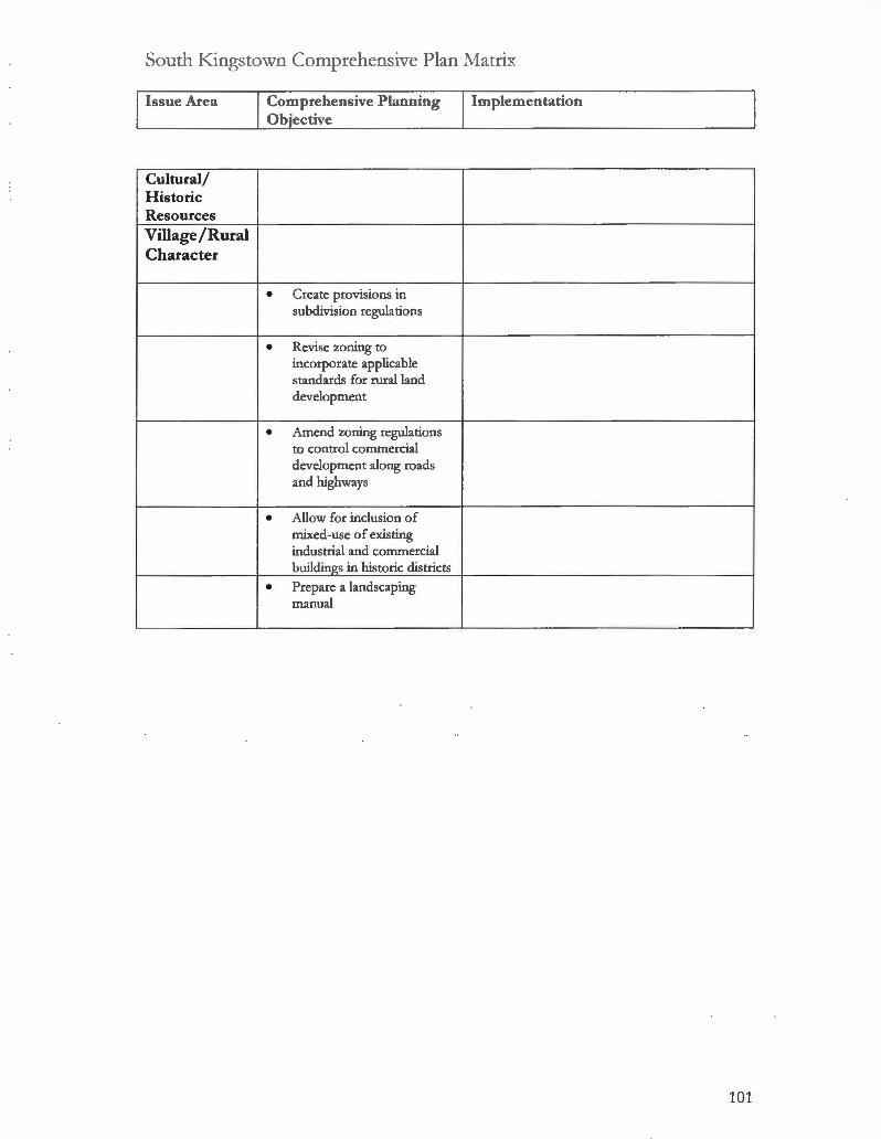
South .Kingstown Comprehensive Plan :Matrix
Issue Area
Cultural/ H istoric Resources Villag e /Rural Character
Comprehensive Planning Ob"ective
• Create provisions in subdivision regulations
• Revise zoning to incorporate applicable standards for rural land development
• Amend zoning regulations to control commercial development along roads and highways
• Allow for inclusion of mixed-use of existing industrial and commercial buildin_g_s in historic districts
• Prepare a landscaping manual
Implementation
101

South Kingstown Municipal Protections
Natural Municipal Protection Implementation Resource Measure Protection
Land Conservation Farmland Preservation Zoning Regulations • R200 Zone (may discourage ~ Planner thinks the zone does
conversion of open space and discourage conversion of large farmlands) parcels.
~ The Town is trying to buy the development rights to a 160 acre farm in town using bonded open space funds from town and DEM ~ant monies.
Site Design • Site Design Standards (may require preservation efforts)
• Lot Development Standards (Minor Subdivision Criteria for Review may include "Preservation of Agricultural Land" through clusterin__g_ rc:g_uirements
Other • Farm stand Ordinance
Open Space Zonin__g_
• Residential uses prohibited except for single and two households farm residences as an accessory use
• Permitted uses "by right" include: crop and livestock farms (pig farms prohibited), fish hatcheries, and boarding animals, outdoor recreation facilities such as golf courses and tennis courts and wildlife refuges
• Museums, libraries, community centers, cemeteries allowed by "~ecial use_E_ermit"
102

South Kingstown Municipal Protections
Natural Municipal Protection Implementation Resource Measure Protection
Open Space Preservation Cluster • Residential cluster developments
Development, and compounds are permitted uses
Residential in the R20, 30,40, 80 and 200
Compounds, Large districts (40% of the gross area must be open space, not including
Lot Zoning stormwater drainage facilities; no more than 50% of the open space can be land unsuitable for development)
• Planning Board can require cluster development for a particular subdivision
Land Unsuitable for • Land Unsuitable for Development ~ Adhered to
Development (shall nor be counred roward rhe minimum !or size requiremenrs--freshwater wetlands, excepr thar area of perimeter wetland within 50 feet of the edge of any bog, marsh, swamp or pond; or any applicable 100 foor or 200 foor riverbank wetlands; coastal wetlands excepr any directly associated contiguous areas; areas within a High Flood Danger zone; land within any publicly or privarely held easement on which above ground utilities, including but not limired ro electrical transmission lines, are consrructe".!2_
Dedication of Land • Dedication of Land for Public ~ As part of the impact fee
for Public Purposes Purposes (land or payment in lieu required for all subdivisions; land dedication is 10.50 acres _E_er 1,00Ql
Site Design • Subdivision and Site Design (see ~ Adhered to
_E_referred areas for preservatiori}_
103

South Kingstown Municipal Protections
N atural Municipal Protection Implementation Resource Measure Protection
Natural Resource Protection
Wetlands
Erosion and • Erosion and Sediment Control );;>- Adhered to
Sediment Control Performance Principles (Plan is );;>- The planning department, the
Plan required for all major subdivisions public works director and the
and land developments and for all town engineers monitor sites
development if construction );;>- 95% compliance
activities are within 100 feet of a wetland or coastal feature)
Protection District • Carrying Capacity Overlay District );;>- Adhered to (SAMP Areas) zo
Setbacks • Special Use Permits, Location of );;>- Strictly adhered to ISDS (no facility designed to leach liquid wastes into the soil shall be located within 150 feet of a freshwater wetland. · l zo
Land Unsuitable for • Land Unsuitable for Development );;>- Strictly adhered to
Develop_ment Environmental • EIS (may be required if land is );;>- Requested for every 30 to 40
Ana/ysis/ Impact located on Map 5.3 of the proposals
Ana/ysis Comprehensive Plan as being within a critical or environmentally sensitive area or by authority of the Planning Board)
Site Design • Site Design Standards (may require );;>- Strictly adhered to preservation efforts)
• Site Analysis required for all major subdivisions
Site P Ian Review • Development Plan Review, Performance Standards
Performance Standards
104

South Kingstown Municipal Protections
Natural Municipal Protection Implementation Resource Measure Protection
Watercourse/ Surface Waters
Erosion and • Erosion and Sediment Control );;- Adhered to
Sediment Control Performance Principles (Required );;- The planning department and
Plan for all major subdivisions and land the town engineers monitor sites developments and for all );;- 95% compliance development if construction activities are within 100 feet of a wetland or coastal featurt}
Protection District • Carrying Capacity Overlay District );;- Adhered to (SAMP Areas) zo
• High Flood Danger Overlay District zo
Environmental • EIS (may be required if land is );;- Requested for every 30 to 40
Anajysis / Impact located on Map 5.3 of the proposals
Anajysis Comprehensive Plan as being within a critical or environmentally sensitive area or by authority of the Plannin_g_ Boarc!l
Setbacks • Hazardous Waste Facility setback );;- Adhered to requirements zo );;- Adhered to
• Special Use Permits, Location of ISDS (no facility designed to leach liquid wastes into the soil shall be located within 150 feet of a river ... ) zo
Site Des!!J! • Site Analysis
Site P Ian Review Performance • Industrial Performance Standards
Standards zo
105

South Kingstown Municipal Protections
N atural Municipal Protection Implementation Resource Measure Protection
Groundwater/ Rechar_g_e Areas Protection District • Groundwater Protection Overlay );;> Strictly adhered to
District zo
Environmental • EIS (may be required if land is );;> Requested every 30 to 40
Ana!Jsis/ Impact located on Map 5.3 of the development proposals
Statement Comprehensive Plan as being within a critical or environmentally sensitive area or by authority of the Planning Boarcil
Setbacks );;>
Site Design • Site Design Standards (siting must );;> Strictly adhered to avoid adverse impacts to groundwater and aquifer recharge)
• Site Analysis
Site Plan Review • Development Plan Review, );;> Strictly adhered to Performance Princi_e!es
Other • Special Requirements (Residential Cluster in R200 may be restricted based on environmental consideration~
Floodplains Protection District • High Flood Danger Overlay
District
• Carrying Capacity Overlay zo
Land Unsuitable for • Land Unsuitable for Development
Develpent Environmental • EIS (may be required if land is
Ana!Jsis/ Impact located on Map 5.3 of the
Statement Comprehensive Plan as being within a critical or environmentally sensitive area or by authority of the Planning Board)
Setbacks • ISDS Siting Restrictions / Setbacks (no facility designed to leach liquid wastes into the soil shall be located within 150 feet of a flood plain . .. ) zo
Site Design • Site Design standards (may require preservation efforts)
• SiteAnapis
Site P Ian Review Other • Hazard Mitigation Plan
106

South Kingstown Municipal Protections
Natural Municipal Protection Implementation Resource Measure Protection
To.E_~r~1!Y_ Erosion and • Erosion and Sediment Control
Sediment Control Performance Principles (Plan is
Plan required for all subdivisions if slopes at the site exceed 10%)
Land Unsuitable for Development
Site Design • Site Design (steep slopes in excess ):> Does not consider steep slopes
of 20% as measured over a 10 foot to be a problem
interval unless appropriate engineering measures concerning slope stability, erosion, and resident safety are taken shall be preserved as open space where feasiblc:2_
Site P Ian Review Rare Species /Critical Habitat Protection District • R200 Zone (intended to protect
environmentally sensitive areas: aquifers, recharge areas, and coastal _E_Ond~
Environmental • EIS (may be required if land is located ):> Requested every 30 to 40
Ana!Jsis/ Impact on Map 5.3 of the Comprehensive Plan development proposals
Statement as being w within a critical or environmentally sensitive area or by authority of the Planning Board)
Setbacks • Hazardous Waste Facility setback n:CJ.uirements zo
Site Design • Site D esign (habitat of endangered ):> Strictly adhered to species shall be preserved as open ):> The Town enforces DEM's space where feasible; site analysis for Natural Heritage Program all major developments and standards subdivisions)
• Site Analysis
Site P Ian Review
107

South Kingstown Municipal Protections
N atural Municipal Protection Implementation Resource Measure Protection
T rees/ Woodlands Erosion and • Erosion and Sediment Control ~ Strictly adhered to
Sediment Control Performance Principles (may
Plan require protection of existing trees and vegetation)
Site Design • Site Design Standards (may require ~ Adhered to preservation efforts)
• Lot Development Standards (may require preservation of existing unique features)
• Site Analysis
Szte Plan Review Other • Tree Ordinance ~ Protects trees along public right-
of-way
Coastal Features Erosion and • Erosion and Sediment Control
Sediment Control Performance Principles (Plan is required for all major subdivisions and land developments and for all development if construction activities are within 100 feet of a wetland or coastal feature}_
Protection District • High Flood Danger Overlay zo
• Carrying Capacity Overlay District _C_SAMP Areas}_ zo
Environmental • EIS (may be required if land is
Anajysis / Impact located on Map 5.3 of the
Statement Comprehensive Plan as being w within a critical or environmentally sensitive area or by authority of the Planning Board)
Setbacks • Special Use Permits, Location of ISDS (no facility designed to leach liquid wastes into the soil shall be located within 150 feet of a coastal wetland or within 150 feet of the line of mean high water of any tidal water body ... ) zo
• Hazardous Waste Facility setback requirements zo
Land Unsuitable for • Land Unsuitable for Development
Development
108

South Kingstown Municipal Protections
Natural Municipal Protection Implementation Resource Measure Protection
Coastal Features
l!__ontinuec!l_ Site Design • Site Design Standards (may require
preservation as open space)
• Site Anal_r;is
Site Plan Review Other • Special Requirements (Residential
Cluster in R200 may be restricted based on environmental considerations) zo
• R200 Zone (intended to protect environmentally sensitive areas: aquifers, recharge areas, and coastal _pond~ zo
Village/Rural Character Over!qy Districts • Architectural Standards of Review
Required (Historic Overlay District; Route 1 Special Management District) zo
• Historic Overlay District (includes an area within the Village of Kin__g_s toaj_ zo
Cluster Development, • R200 Zone Residential Compounds, La_!If Lot Zoni'!!,_
Site Design • Site Design Standards (special provisions for flexible lot size, lot lines, frontage, and setbacks; calls for the placement of dwelling units to take into consideration .. . scenic values)
• Lot D evelopment Standards (may require the preservation of historic features such as trees or stone wall~
Site P Ian Review • Site Plan Review ( required for properties with direct lot frontage or vehicular access on Ministerial Road Scenic Hi__g_hw~
Historic Preservation • Maintenance Standards and procedures for identifying endangered buildings (Building Code:}_
Landsr:tJjJjng_ Standards
Street Design • Shared Common Drives (encouraged for minor 2 lot subdivision~
109

TOWN OF WEST GREENWICH PROFILE
Summary West Greenwich is in the process of significantly changing its development
regulations. The planner interviewed for this study is very new to the Town.
He has not been involved in the Town's development process. Consequently,
this profile is abbreviated in order to minimize the inclusion of misinformed or
biased information.
According to the town planner, there is broad consensus among town officials
on the need to manage (limit) suburban growth, and significantly strengthen
the Town's development regulations. The subdivision and land development
regulations have recently undergone significant revisions. Notably, West
Greenwich shares its town solicitor with South Kingstown. Many of the new
revisions in the subdivision and land development regulations are modeled on
South Kingstown's regulations. The Town is close to adopting an "interior
building envelope" ordinance that will significantly reduce site design
requirements for second homes on existing residential sites.
Planning Department The Town employs one half-time planner (with no background in
environmental management). The Town has not received a subdivision
proposal in over six months. The Town has no in-house GIS capacity, nor
does the town planner desire it. Most of the planning board members have a
background in construction and engineering, and are diligent in their
requirements for high quality development.
Planning capacity limitations are primarily technical in nature, but also include
limited environmental planning expertise. The Town planner was unaware of
the groundwater aquifer that lies beneath the Town's 1-95 corridor.
110

Comprehensive Plan Objectives The Town's comprehensive plan objectives for natural resource protection
and land conservation are limited in comparison to other towns in the study.
However, it appears that a good percentage of the objectives have been
adopted or implemented in some alternative manner. The comprehensive
plan should be updated to provide better standing for new regulatory changes.
Site Analysis The interview with the town planner did not provide information of this topic.
However, the subdivision and land development regulations have been
revised to include a mandatory site analysis for all major subdivision (and for
minor subdivisions on a case-by-case basis). The planning board has the
authority to request an environmental impact statement for any development.
The Town keeps an engineer on retainer for this purpose. According to the
town planner, the planning board is very diligent about deducting "land
unsuitable for development" from the building acreage of the parcel.
Zoning and Subdivision Regulations
Zoning Ordinances
Farmland Zoning-none • Residential Cluster Development-none • Large Lot Residential Zoning-Rural, Farming, Residential (RFR 2) • Overlay Districts-none • Site Plan Review-The Town has very detailed environmental standards
in its site plan review ordinance. • Performance Standards-The Town has a unique 200 feet septic system
setback requirement from water bodies.
Subdivision and Land Development Regulations
• Land Unsuitable for Development-Shall not be counted toward the minimum lot size requirements; it may be included as part of any lot in any subdivision or land development project; provided that land unsuitable for development shall not exceed 30% of the minimum lot size required in the zoning ordinance--freshwater wetlands, except that area of perimeter wetland within 50 feet of the edge of any bog, marsh, swamp or pond; or any applicable 100 foot or 200 foot riverbank wetlands; areas within a 100
111
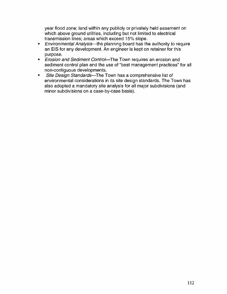
year flood zone; land within any publicly or privately held easement on which above ground utilities, including but not limited to electrical transmission lines; areas which exceed 15% slope.
• Environmental Analysis-the planning board has the authority to require an EIS for any development. An engineer is kept on retainer for this purpose.
• Erosion and Sediment Control-The Town requires an erosion and sediment control plan and the use of "best management practices" for all non-contiguous developments.
• Site Design Standards-The Town has a comprehensive list of environmental considerations in its site design standards. The Town has also adopted a mandatory site analysis for all major subdivisions (and minor subdivisions on a case-by-case basis).
112

\\lest Greenwich Comprehensive Plan l\fatrix
Issue Area Comprehensive Implementation Plaru1ing Objective
Farmland Preservation Open Space Zonin_g_ Open Space Preservation
• Adopt an Interior ~ The town council is in the process of adopting Building Lot (IBL) ordinance that promotes limited development of large tracts of land thereby ensuring preservation of open space in perpetuity
• Institute Greenbelt ~ Not as overlay district Overlay D istrict in RFR-2 ~ 1.4 acres of every 2 acre parcel must be land district to protect open suitable for development space character by guiding development to areas on the property which are appropriate
• The Conservation ~ The conservation commission has been Commission and informally granted strong oversight of Planning Board shall subdivision proposals promote Greenway Corridor Connections through cooperative review of subdivision plans and by identifying select parcels worthy of potential acquisition
• The Conservation ~ Implemented Commission and Planning Board shall work closely with developers to include a Greenway component in the Master Plan st~
113

\\!est Greenwich Comprchcn::>ivc Plan Tvfatrix
Issue Area Comprehensive Implementation Planning Objective
N atural Resource Protection
• Institute performance ~ Not performance standards, but strong siting standards in the Town's considerations zoning and subdivision regulations that account fo r environmental constraints
• Adopt changes to ~ Site design standards include mandatory site zoning/ subdivision analysis fo r all m ajor subdivisio ns o r by regulations to require all request o f the p lanning board development applications to identify the on-site presence of natural resources and constraints to develCJI>_ment
Wetlands Watercourses/ Surface water
• Require 100-foo t wide ~ The T own has a 200 foo t septic setback for all conservation easements water bodies fo r land in new subdivisions bordering water bodies
Groundwater/ Recharge Areas Floodplains
Coastal Features Topography
• Prohibit development in ~ Slopes that exceed 15% are identified as those environmentally unsuitable for development sensitive areas where slopes greater than or <:gual to 15% are_I>resent
Rare Species I Critical H abitat
• Ensure preservation of ~ May no t have been implem ented wildlife habitat and rare species of flora and fauna, as identified in the Natural Resource inventory, through coordinated review of develo_E_ment_E)ans
114

\X1est c;rccnwich Comprehensive Plan Nfatrix
Issue Area Comprehensive Implementation Planning Ob jective
Trees/ Woodlands Cultural/ Historic Resources Village/Rural Character
• Establish a local zoning map based on exis ting and proposed land use patterns, available infrastructure, and those environmental constraints to development as determined by the COMPOSITE constraint map
• Identify and protect natural/ cultural resources through development plan review, design guidelines, and flexible development siting
• Institute in the Zoning Code variable lot standards for all appropriate frontage subdivisions, major subdivisions, and land development projects so as to vary development patterns and the unifo rm look of development along roads
• Promote 'Planned Commercial-Recreational Facilities' that utilize natural resources based economic activities such as farming, wood cutting, native lumber, tree farming, orchards, golf courses, and intensive er~ man~ment.
115

West Greenwich Municipal Protections
Natural Municipal Resource Implementation Resource Protection Protection
Land Conservation Farmland Preservation Zoni'!f,_ R!f,_ulations Site Design • Site Design Standards (calls for );> Not implemented
specific areas to be preserved as open space including agricultural lands)
• Criteria for Review--3 to 5 lot minor subdivision (includes cluster provisions for preservation of prime farmland or farmland of statewide im..E_ortanc<:l_
Open Space • Recreational Facilities allowed by
Zonin_g_ "special use permit"
Open Space Preservation Cluster Development, Residential Com_p_ounds La!f! Lot Zoni'!f,_ • Rural, Farming, Residential (RFR 2)
Land Unsuitable • Lands Unsuitable for D evelopment );> It is subtracted from the buildable
for Development (shall not be counted toward the acreage. 1 1/ 4 acre of a 2-acre lot minimum lot size requirements; it may must be unconstrained land. be included as part of any lot in any subdivision or land development project; provided that land unsuitable for development shall not exceed 30% of the minimum lot size required in the zoning ordinance--&eshwater wetlands, except that area of perimeter wetland within 50 feet of the edge of any bog, marsh, swamp or pond; or any applicable 100 foot or 200 foot riverbank wetlands; areas within a 100 year flood zone; land within any publicly or privately held easement on which above ground utilities, including but not limited to electrical transmission lines; areas which exceed 15% s l~
Dedication of Land • 2,000 square feet per lot
E_r Public Pu~ses Site Design • Site Design Standards (call for );> Not implemented
specific areas to be preserved as O..E_en ~ac':)_
116

West Greenwich Municipal Protections
Natural Municipal Resource Implementation Resource Protection Protection
Natural Resource Protection Wetlands Erosion and • Required for all non-contiguous
Sediment Control parcels
Plan Protection Distn"ct Setbacks • ISDS Setback Requirements ~ The Town has a 200-foot set-
(facilities which are designed to back from any water body. leach liquid wastes into the soil shall be located not less than 200 feet from the edge of any pond or streaml zo
Land Unsuitable for • Land Unsuitable for Development ~ Adhered to
Develop__ment Environmental • EIS (may be required if there is a ~ The Conservation Commission
Anajysis/ Impact reasonable expectation that the reviews
Anajysis proposed development will have a ~ The Town will require an EIS for significant negative impact on large parcels natural systems)
Site Design • Site Design Standards (calls for ~ See "land unsuitable for specific areas to be preserved as development" open space including wetlands)
• Site Analysis
Site P Ian Review • Site Plan Review (development shall ~ All water bodies have a 200-foot result in minimal degradation of unique buffer or irreplaceable land types; minimal ~ The town does not recognize adverse impact upon the critical areas DEM's Natural Heritage Program such as streams, wetlands, areas of (according to the planner) aquifer recharge and discharge, steep slopes, highly erodible soils; areas with a high water table, marure srands of vegetation and extraordinary wildlife nesting, feeding or breeding grounds) zo
Performance • Industrial Site and Performance Standards Standards
117

West Greenwich Municipal Protections
Natural Municipal Resource Implementation Resource Protection Protection
Watercourses I Surface Waters
Erosion and • Required
Sediment Control Plan Protection District Environmental • E IS (may be required if there is a );>- The Conservation Commission
A na!Jsis/ Impact reasonable expectation that the reviews
Statement proposed development will have a );>- The Town will require an E IS for significant negative impact on large parcels natural systems)
Setbacks • ISDS Setback Requirements );>- The Town has a 200-foot setback (facilities which are designed to from any water body. leach liquid wastes into the soil shall be located not less than 200 feet from the edge of any pond or stream) zo
Site Desigtl • Site Analysis
Site Plan Review • Site Plan Review (development shall result in minimal adverse impact upon critical areas such as streams ... )
Performance Standards
Other
118

West Greenwich Municipal Protections
Natural Municipal Resource Implementation Resource Protection Protection
Groundw ater / Rechaix_e Areas Protection District Environmental • EIS may be required );;- The Town Planner is unaware of
Anajysis / Impact groundwater in West Greenwich
Statement Setbacks Site Design • Site Design Standards (state that
development should be laid out to avoid adversely affecting groundwater and aquifer recharge and to avoid unnecessary impervious cover)
• Site Anal_y_sis
Site P Ian Review • Site Plan Review (development shall result in minimum degradation of. . . areas of aquifer recharge and discharge; drainage control should preserve existing natural drainage patterns and wetlands; and enhance
__g£oundwater recha!Ke area~ zo
Other Flood__Q_lains Protection District Land Unsuitable for • Land Unsuitable for Development
Develqp_ment Environmental Anajysis/ Impact Statement Setbacks Site Design • Site Design Standards (call for
specific areas to be preserved as open space including lands in the floodplain)
• Site Analysis
Site P Ian Review Other • Design and Public Improvement
Standards (state that development should be laid out to prevent flooding; also, the Planning Board shall examine each proposed subdivision to ensure that potential flood damage is minimized, public utilities and facilities are elevated and that adequate drainage is _E_rovide<&
119

West Greenwich Municipal Protections
Natural Municipal Resource Implementation Resource Protection Protection
T o_Q_og_raph_y Erosion and Sediment Control Plan Land Unsuitable for • Land Unsuitable for Development
Development (areas that exceed 15% slope)
Site Design • Site D esign Standards ( slopes exceeding 15% preferred ~eservation as ~en ~acc:2._
Site P Ian Review • Site Plan Review (development shall result in minimal degradation of unique or irreplaceable land types; minimal adverse impact upon the critical areas such as .. . steep slopes, highly erodible soils; areas with a high water table, mature stands of vegetation and extraordinary wildlife nesting, feeding_ or breedin_z_~ound~ zo
Rare Species/ Critical Habitat
Protection District Environmental • EIS may be required
Ana/ysis/ Impact Statement Setbacks Site Design • Site Design Standards (call for );> The town does not recognize
specific areas to be preserved as DEM's Natural Heritage Program open space including habitats of endangered wildlife)
• Site Ana_!y_sis
Site P Ian Review • Site Plan Review (development shall result in minimal adverse impact upon . .. areas of extraordinary wildlife nesting, feedin__g_ or breedi~ound~ zo
120

West Greenwich Municipal Protections
Natural Municipal Resource Implementation Resource Protection Protection
Trees/ Woodlands
Erosion and Sediment • Drainage and Erosion and
Control Pian Sediment Control Standards (wherever feasible natural vegetation shall be retained and protected)
Site Design • Lot Development Standards (preservation of unique natural and/ or historic features such as trees or stone walls may be required for 2 lot minor subdivisions)
• Site Design Standards (call for specific areas to be preserved as open space including significant trees or stands of trees, or other vegetative species that are rare to the area or are of particular horticultural or landscape value; development should be laid out to reduce cut and fill)
• Site Ana!f:;is
Site P Ian Review • Site Plan Review (The landscape shall be preserved in its natural state, insofar as environmentally desirable, by minimizing tree and soil removal) zo
Other • Design and Public Improvement Standards (street design standards call for conservation of existing trees where feasible)
121

TOWN OF WESTERLY PROFILE
Summary Westerly is the most urbanized town in the study area. The Town is slowly
modernizing its planning capacity, but is not really focused on the concerns in
this study. For example, the Town is more concerned with locating and
purchasing land for municipal needs, such as schools and recreational areas.
Most residential and commercial development in Westerly is in-fill
development. In regard to natural resource protection, the Town is primarily
concerned with protecting its groundwater resources, whether the
development is in-fill or not. However, the Town needs new maps based on
parcel information to adequately protect local groundwater.
Westerly has not adopted most of its comprehensive plan objectives. The
new town planner will be updating the plan's objectives to better reflect the
unique, urban ecological issues facing the Town. The Town's development
regulations provide very few provisions for the protection of natural resources.
The Town does not require an environmental analysis, and the site design
standards provide minimal guidance for protecting the natural features of the
site. The planning board will encourage cluster design to preserve open
space and protect natural resources. The Town also has a development plan
review ordinance, with strict standards for protecting drinking water supplies
and coastal vegetation. The planning board is in the process of reviewing a
new site analysis provision, which would require developers to address the
environmental impacts of the development proposal.
Planning Department Westerly employs one half-time planner, who is actually new to the Town.
Consequently, the interview for this study resulted in a limited amount of
information. However, the planner does have a background in, and
commitment to, environmental management. He is also a half-time town
planner in Richmond.
122

The town planner spends an equal amount of time consulting with the town
council, planning board, and zoning board of review. He also has a working
relationship with the town manager. The conservation commission also lends
support in reviewing development proposals. The Town can require an
outside environmental consultant to review development proposals. The town
planner is working to increase in-house GIS capacity and site analysis
capabilities, as well as updating the comprehensive plan so that it will be a
useful document for guiding future development.
Primary planning capacity limitations include GIS and site analysis, research
assistance in updating the comprehensive plan, and effective training for
council, board and commission members.
Comprehensive Plan Objectives The majority of the comprehensive plan objectives have not been adopted,
with the exception of the development plan review ordinance and the aquifer
protection overlay district. Plan updates need to focus far more on protecting
the Town's extensive and fragile coastal resources. The plan also needs to
include clear policy objectives on protecting the Town's water resources.
Site Analysis Because the planner was new to the Town, limited information could be
provided on this subject. The Town appears to rely primarily on the developer
to provide important site information. The planning board is working on
adopting a site analysis requirement for more in-depth site information. An
outside consultant also may be requested if the development endangers the
Town's drinking water supplies or coastal environment.
123

Zoning and Subdivision Regulations
Zoning Ordinances
• Farmland Zoning-none • Residential Cluster Development-Residential cluster development is
permitted in the RR-60, LDR-43, LDR-40 and MDR-30 zoning districts. The developer must demonstrate clustering would be a better use of the land than a conventional subdivision, and there is no minimum open space requirement. The planning board may encourage a cluster design.
• Large Lot Residential Zoning-none • Overlay Districts-Aquifer Protection Overlay District. This ordinance is
comprehensive and strictly implemented • Site Plan Review-The Town has a development plan review ordinance
with strict standards for protecting surface and groundwater, coastal vegetation and public access.
• Performance Standards-The Town has a "Hazardous Waste Management Facility Siting Requirement" ordinance with a 1,000 foot setback from environmentally sensitive areas.
Subdivision and Land Development Regulations
• Land Unsuitable for Development-This regulation includes freshwater wetlands, coastal wetlands, land within an easement, areas within the 100 year flood zone and areas with soils that exceed 15% slope.
• Environmental Analysis-The Town has a very non-specific impact statement requirement.
• Erosion and Sediment Control-An erosion and sediment control plan is required for all major subdivisions and land developments, and for all development occurring in environmentally sensitive areas. The town engineer reviews the plans, however, little monitoring is done.
• Site Design Standards-The Town has a fairly comprehensive list of natural resources that should be preserved as open space in the design of the site. However, without a site analysis requirement and without the flexibility of a cluster design, the Town has no real way of implementing these standards.
124

\Vcstcrly Comprcbcnsive Plan l\fatrix
Issne Area Comprehensive Planning Implementation Objective
Farmland Preservation Open Space Zonin_g_ Open Space Preservation
• Wherever possible, link )> Not adopted together key open space parcels to increase their value using a variety of techniques and functional components
• Develop a source of )> O nly for municipal land use needs revenue to acquire and maintain o...E_en ~ace
• Acquire key potential Open )> Not adopted Space Parcels
• Consider establishing a )> Not adopted Natural Resources Department to assist the Conservation Commission address the management of the Town's Natural Resources
• E ncourage the use of cluster )> The planning board encourages cluster zoning to create open space designs where appropriate and recreation areas
• Acquire critical areas for )> Not adopted protection purposes (Capital Im_I>_rovement:}_
125

\Vcstcrly Comprehensive Plan J\!fatri x
Iss ue Area Comprehensive Planning Implementation Objective
Natural Resource Protection Wetlands
• Insure adequate 'vegetated ~ Relies on DEM's standards buffers' (setbacks) are required between upland development and wetland resource areas
• Develop Performance ~ Not adopted Standards for the following: stormwater run-off, erosion and sedimentation controls, vegetated buffers, land clearing activities, ISDS, and wetlands protection
Watercourse/ Surface Waters
• Adopt a River Corridor ~ Reserved in zoning ordinance (needs Overlay constituency to write ordinance)
• Develop Performance ~ Not adopted Standards for the following: stormwater run-off, erosion and sedimentation controls, vegetated buffers, land clearing activities, ISDS, and wetlands protection
• Incorporate a Site Plan ~ Adopted Review process into the ordinance to provide for detailed review of certain types of activities (i.e., those which exceed certain square footage thresholds or parking requirements) and those which occur in "critical areas' such as the Route 1 and Pawcatuck River corridors
126

Westerly Cornprchcnsivc Plan i\fatrix
Issue Area Comprehensive Planning Implementation Objective
Groundwater /Recharge Areas
• Protect the aquifers that ~ Adopted "Aquifer Protection Overlay contribute to the Town District"
wells from potential contamination by strict regulation of threats to
ground water quality and a program of continuous monitoring of these threats to ground water _g_uali_.!Y_
• Adopt an Aquifer ~ Adopted Protection Overlay
• Increase inspection and ~ No enforcement procedures to insure that all development is constructed in accordance with the conditions established at the time of approval
• Make water conservation a ~ The Town hands-out water kits every
high priority for the Town summer and will institute watering bands
• Establish a Wastewater ~ Not adopted Management District to ~ Most of the Town is sewered ensure ISDS performance and maintenance
Floodplains
• Flood Hazard Overlay ~ Adopted
Coastal Features
• Develop land use standards ~ Relies on CRMC to set standards (such as a Salt Ponds Overlay Protection District) that reflect the sensitive nature of the coastal environment including coordination with the policies of SAMP and CRMC for coastal _ll_onds.
• Through a combination of ~ The Town adopted cluster provisions
new density requirements, ~ Maybe rezoned some land performance standards and revisions to the Zoning Map, the Town can achieve greater long-term protection of its coastal resources
127

\X'cstcrly Comprehensive Plan J\fatrix
Issue Area Comprehensive Planning Implementation Objective
Coastal Features
.f!..ontinuedj_ • Develop a water quality ~ Not adopted
monitoring program for inland and coastal waters to gauge the effectiveness of protection measures and serve as an early warning system in the event of contamination
• Integrate the ~ Not adopted recommendations of the Pawcatuck River Estuary Management Project (Harbor Management Plan) into the Town's land use regulations and enforcement/ management
_.E_rO_ll_ams where ~ro....E_riate
T O_Q_O_gr~h_y_ Rare Species / Critical H abitat
• Retain open spaces that are ~ Not adopted
large enough to serve a variety of purposes including recreation, wildlife habitat, pollution abatement and as buffers to existing development
• Insure the protection of rare ~ Not adopted species habitat by monitoring development projects within or adjacent to identified sites and requiring restrictions on activities which may be deemed harmful to these environments
• Strengthen the management ~ Yes programs for Napatree Point and Maschaug beach to control recreation overuse and natural
_ll_redation of rare shorebirds
128

\V'cstcrly Comprehensive Plan JVfatrix
Issue Area Comprehensive Planning Implementation Objective
Trees/ Woodlands
• Maintain and enhance the ~ Regulations adopted for trees in public aesthetic quality of the right of way Town by protecting and caring for existing trees and the planting of new trees along roadways and on other publicly owned property
Cultural and Historic Resources
Village/Rural Character
• Integrate new commercial and residential development within established older neighborhoods in a manner that will preserve and enhance historic and cultural resources
• Maintain and enhance the aesthetic quality of the Town by protecting and caring for existing trees and the planting of new trees along roadways and on other publicly owned property
• Promote less dispersed site design and avoid "sprawl" by encouraging housing development consistent with policies of water resource protection and preservation of the Town's open space and rural character
129

\X'estcrly Comprehensive Plan Matrix
Issue Area Comprehensive Planning Implementation Objective
Village/Rural Character (continued)
• Where site and environmental conditions are favorable, encourage alternative subdivision and building designs which result in compact development, reduced disturbance of natural areas, smaller units, and lower housing costs
• Guide new housing development away from areas which are environmentally sensitive and to those areas best suited for development
• Review existing cluster and PUD ordinances for changes that will encourage their use in a fashion consistent with the goals and policies of the Comprehensive Plan.
• Incorporate appropriate incentive zoning provisions which encourage smaller, affordable housing units and developments with less visual impact
130

Westerly Municipal Protections
Natural Municipal Protection Implementation Resource Measure Protection
Land Conservation Farmland Preservation ZonifZ!,_ Re_g_ulations Site Design • Site Design Standards (preferred
preservation of agricultural land in site design)
Open Space Zoning
• Permitted uses by "special use permit" include: Public Parks and Recreation, Golf Courses. Municipal Buildings and Cemeteries
Open Space Preservation Cluster • Residential cluster development is ~ Planning Board will propose a
Development, permitted in the RR-60, LDR-43, cluster designs
Residential LDR-40 and MDR-30 zoning districts
Compounds, Large (minimum land area is 10 acres; if it includes private roads, 25 acres is
Lot Zoning required) zo
• Residential cluster development (developer must demonstrate clustering would be a better use of the land than a conventional subdivision (no minimum open space r<:9._uirement2_ zo
Land Unsuitable • Land Unsuitable for Development ~ Land unsuitable for
for Development (may be deducted from the minimum development is deducted from building acreage of the parcel-- the minimum buildable acreage freshwater wetlands, coastal wetlands, land within an easement, areas within the 100 year flood zone and areas with soils that exceed 15% slope)
Dedication of Land • Dedication of Public Land and
for Public Purposes Improvements (see comp.plan)
Site Design • Site Design Standards (see preferred areas for _Qreservatiori}_
131

Westerly Municipal Protections
Natttral Municipal Protection Implementation Resource Measure Protection
Natural Resource Protection Wetlands
Erosion and • Erosion and Sediment Control Plan ~ Adhered to
Sediment Control (all major development as well as any ~ Plans are reviewed by town
Plan development activity within 200 feet engineer of any wetland or coastal feature) ~ Not a lot of monitoring
Protection Distnd Setbacks Land Unsuitable • Land Unsuitable for Development
l!!._r Develtp_ment Environmental Ana/ysis/ Impact Anapis Site Design • Site Design Standards (preferred
preservation of wetlands in site design)
Site P Ian Review Performance Standards
132

Westerly Municipal Protections
N atural Municipal P rotection Implementation Resource Measure Protection
Watercourses I Surface Waters
Erosion and • Erosion and Sediment Control ~ Town Engineer reviews
Sediment Control (original boundaries, alignment and
Plan slope of water courses shall be preserved to the greatest extent possible)
Protection District • River Corridor Overlay zo ~ There is no River Corridor
• Salt Pond Overlay zo Overlay ~ CRMC reviews development in
coastal zone
Setbacks • Hazardous Waste Management Facility ~ Adhered to Siting Requirements (prohibited within 1,000 feet of environmentally sensitive areas) zo
Site Design • Site Design Standards (original ~ Adhered to boundaries, alignment and slope of water courses shall be preserved to the greatest extent possible)
Site P Ian Review • Development Plan Review (required ~ Adhered to (see impact rules) for all non-residential uses--a development plan shall not be approved if it would result in water pollution, damage to shoreline vegetation, or inhibition of public access) zo
Performance Standards
Other • Stormwater Easement or drainage right-of-way (required where development is traversed by a water course, drainage way, channel or stream)
133

Westerly Municipal Protections
N atural Municipal Protection In~ple1nentation Resource Measure Protection
Groundwater/ Rechat"g_e Areas Protection District • Groundwater Protection Overlay );>- Comprehensive and strictly
District zo adhered to
Environmental Ana/ysis/ Impact Statement Setbacks • Hazardous Waste Management Facility
Siting Requirements (prohibited within 1,000 feet of environmentally sensitive area~ zo
Site Desjfzz Site P Jan Review • Development Plan Review (required );>- Adhered to (see impact rules)
for all non-residential uses--a development plan shall not be approved if it would result in water pollution, damage to shoreline vegetation, or inhibition of public access) zo
Other
Floodplains
Protection District • Flood Hazard Overlay District (no use );>- Developer and land surveyor shall be approved which would must demonstrate prior to adversely affect the capacity of any approval drainage facility or system or would involve alteration of sand dunes, barrier beaches, and other natural protective barriers) zo
Land U nsuitabie • Land Unsuitable for Development
_Er Deveiqp_ment Environmental Review Impact rules
Ana!Jsis /Impact Statement Setbacks Site Design • Site Design Standards (preferred
preservation as open space in site design)
Site P Jan Review Other
134

Westerly Municipal Protections
Natural Municipal Protection Imple1nentation Resource Measure Protection
Topography
Erosion and • Erosion and Sediment Control Plan
Sediment Control (required for all major land
Plan developments / subdivisions and all subdivisions if slopes are greater than 10%)
Land Unsuitable • Land Unsuitable for Development
for Development (slopes in excess of 15 %)
Site Desif,11 Site P Ian Review Rare Species I Critical Habitat
Protection District Environmental Ana!Jsis /Impact Statement Setbacks Site Design • Site Design Standards (preferred };>- Conservation Commission
preservation of endangered wildlife provides comments to Planning habitat in site des~ Board
Site P Ian Review Trees/ Woodlands
Erosion and • Erosion and Sediment Control (trees
Sediment Control and other existing vegetation shall be
Plan fenced or roped off to protect trees from construction equipment)
Site Design • Site Design Standards (significant trees or stands of trees or other vegetative species that are rare to the area or are of particular horticultural or landscape value are preferred areas of
_J>t:eservation in site design)
Site Plan Review Other • Unlawful Cutting of Trees or Shrubs
(unless authorized in writing by the Public Works Director, trees or other vegetation cannot be removed to
increase the visibility of a sign)
• Public Improvement Standards, Street Trees _£.33
135

Westerly Municipal Protections
N atural Municipal Protection Implem entation Resource Measure Protection
Coastal Features E rosion and • Erosion and Sediment Control Plan ~ T own E ngineer reviews
Sediment Control (required for all development within ~ Little monitoring is done 200 feet of any wetland or coastal fea ture)
Overlqy Protection • Salt Pond Overlay zo ~ CRMC reviews development
District • Flood Hazard O verlay District (no use proposals
shall be approved which would ~ D eveloper and land surveyor
adversely affect the capacity of any must demonstrate before
drainage facility or system or would approval
involve al teration of sand dunes, barrier beaches, and other natural
_J>_rotective barriers) zo
Environmental Anafysis/ Impact Statement Setbacks • Hazardous Waste Management Facility
Siting Requirements (prohibited within 1,000 feet of environmentally sensitive areas) zo
Land Unsuitable • Coastal wetlands and areas within the
for Development 100 year flood zone are considered unsuitable for development
Site Design • Site D esign Standards (preferred preservation of coastal fea tures in site design)
Site P Ian Review • Development Plan Review (required for all non-residential uses--a development plan shall not be approved if it would resul t in water pollution, damage to shoreline vegetation, or inhibition of public access) zo
Other
136

Westerly Municipal Protections
Natural Municipal Protection Implementation Resource M easure Protection
Village/Rural Character
Overlay Districts • Historic Overlay District
• Bed and Breakfast/ Guest House Overlay District
Cluster Development, Residential Compounds, Large Lot Zoni"!J!,_ Site Design • Site Design Standards (historically
significant structures and sites are preferred areas of preservation in site design; to the maximum extent practicable, development shall be located to preserve impacts and alteration of natural features, historic and cultural resources, and areas of scenic value which contribute to the character of town)
• Lot Design Standards (Reasonable landscaping should be provided at entrances, in public areas, and adjacent to buildinJcl
Site P Ian Review • Development Plan Review--required for all uses, other than single family and two family residential and uses accessory thereto Qandscape and architecturalplans rc.:9..uirec!2_
Historic • See Site Design and Overlay Districts
Preseroation above
Landscaping Standards Street Design
137

RFGUT,A'l'OH.Y COi\fPAlUSO BY NATURAL RESO URCE AREA AND PROTECTTO l'v1f ·~ASURE
Natural Resource Protection Charlestown Coven!!Y_ Exeter Ho_E_kinton
Land Conservation Farmland Preservation Zoning Regulations • Agricultural land may serve as open • Residential Cluster Development, • RU-3 and RU-4 (Rural Districts)--The • Rural Farming Residential-SO
space in cluster developments zo Criteria fo r Approval (open space shall, stated purpose of the RU-4 district is District zo
• Protection of farmland is mentioned where applicable, encourage to protect land now used for fo restry, as a public purpose of the Planned agricultural and fo rest management farming, and related activities and the Development District zo activities . . . Areas in which prime natural habitat and wildlife and to
agricultural soils are located shall be preserve the area's rural character. zo preserved to the greatest extent • Raising of animals is allowed either by possible)zo right or by special use permit in all
• Residential Cluster Development, zones except Business (B) zo Common Open Space Requirements • Farming and forestry are allowed by (If the parcel is located in an right o r special use permit in all zones agricultural district, farmland owners except Light Industrial (LI) zo are not required to convey the part of their property which is to become permanent open space, provided that they convey the development rights of that open space) zo
• Special Requirements, Residential Cluster Development (any parcel of land containing Prime Farmland or Farmland of Statewide Importance, and has been under cultivation at any time during the five years immediately preceding the date of subdivision application, shall be designed as a residential cluster development or a residential compound in such a way as to preserve at least 50% of the farmland fo r agricultural uses, provided that the characteristics of the parcel are such that the farmland is capable of being arranged in a lot of at least 5 contiguous acres; a 20% density bonus may be granted for preservation of prime and important farmland on such
_E_arcel~
138
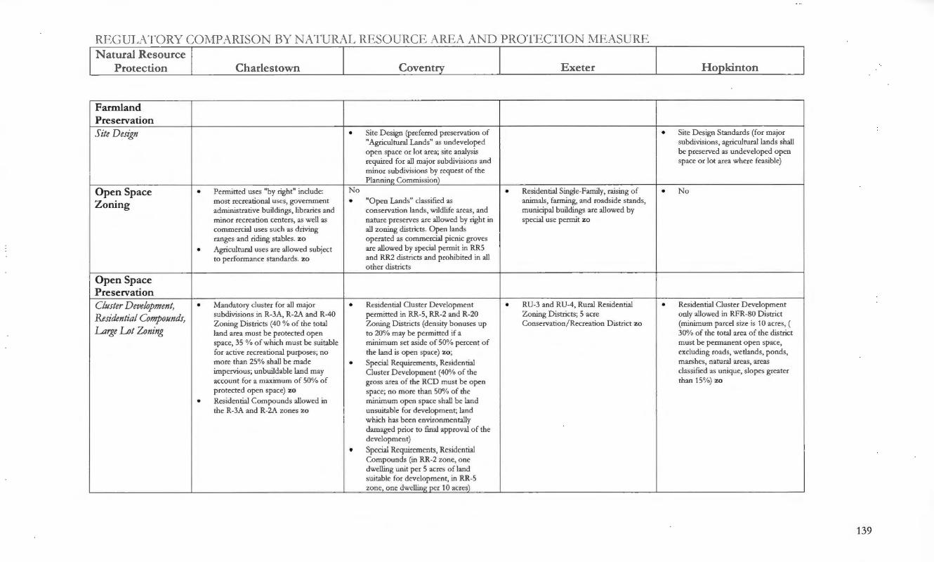
REGULATORY COl\-fPARISON BY NATURAL RESOURCE AREA AND PROTECTION l\fEASURE Natural Resource
Protection Charlestown Coventry Exeter Ho__E_kinton
Farmland Preservation Site Design • Site Design (preferred preservation of • Site Design Standards (for major
"Agricultural Lands" as undeveloped subdivisions, agricultural lands shall open space or lot area; site analysis be preserved as undeveloped open required for all major subdivisions and space or lot area where feasible) minor subdivisions by request of the Planning Commission)
Open Space • Permitted uses "by right" include: No • Residential Single-Family, raising of • No
Zoning most recreational uses, government • "Open Lands" classified as animals, farming, and roadside stands, administrative buildings, libraries and conservation lands, wildlife areas, and municipal buildings are allowed by minor recreation centers, as well as nature preserves are allowed by right in special use permit zo commercial uses such as driving all zoning districts. Open lands ranges and riding stables. zo operated as commercial picnic groves
• Agricultural uses are allowed subject are allowed by special permit in RR5 to performance standards. zo and RR2 districts and prohibited in all
other districts
Open Space Preservation Cluster Development, • Mandatory cluster for all major • Residential Cluster Development • RU-3 and RU-4, Rural Residential • Residential Cluster D evelopment
Residential Compounds, subdivisions in R-3A, R-2A and R-40 permitted in RR-5, RR-2 and R-20 Zoning Districts; 5 acre only allowed in RFR-80 District Zoning Districts (40 % of the total Zoning Districts (density bonuses up Conservation/ Recreation District zo (minimum parcel size is 10 acres, (
Large Lot Zoning land area must be protected open to 20% may be permitted if a 30% of the total area of the district space, 35 % of which must be suitable minimum set aside of 50% percent of must be permanent open space, for active recreational purposes; no the land is open space) zo; excluding roads, wetlands, ponds, more than 25% shall be made • Special Requirements, Residential marshes, natural areas, areas impervious; unbuildable land may Cluster Development (40% of the classified as unique, slopes greater account for a maximum of 50% of gross area of the RCD must be open than 15%) zo protected open space) zo space; no more than 50% of the
• Residential Compounds allowed in minimum open space shall be land the R-3A and R-2A zones zo unsuitable for development; land
which has been environmentally damaged prior to final approval of the development)
• Special Requirements, Residential Compounds (in RR-2 zone, one dwelling unit per 5 acres of land suitable for development, in RR-5 zone, one dwelling per 10 acre~
139

REGUL\TORY C01\{PARISON BY NATURAL RESOURCE AREA AND PROTECTION 1\1IE} .. SURE Natural Resource
P rotection Charlestown Coven~ Exeter H o_£_ kin ton
Open Space Preservation
__{_ continuedl Land Unsuitable for • Land Unsuitable for Development • Land Unsuitable for Development • Land Unsuitable for Development
Development (shall be deducted from the (shall be subtracted from the total (shall be deducted from the developable acreage of the parcel-- parcel in order to determine the minimum building acreage of the resource areas subject to protective maximum number of dwelling units-- parcel--freshwater wetlands, areas se tback distance such as but not wetlands, including perimeter wetlands; within a High Flood Danger zone, limited to, wetlands; areas subject to land located within Zone A on a and land within any publicly or storm flow or flooding; hydric soils FEMA Map; street allowance; all privately held easement on which and inter-tidal sal t marshes; land existing public and private easements; above-ground utilities, including but located in any V zones or floodways; land containing steep slopes in excess not limited to electrical transmission any area of the track proposed to be of 20% within any 10 feet interval on lines, are constructed; land with developed equal to the area of any the contour drawing) slopes in excess of 15 percent) street and / or utility rights-of-way; any unique sites having historical, archeological values or protected species of flora or fauna; any other lands which if developed would cause a threat to public health , or result in irreparable public harm, or loss of irreplaceable resources; any area of ledge and/ or rock outcrops at/or within four feet of the land surface, any area where slopes exceed fifteen ~ercen.!)_
Dedication of Land for • Recreation Facilities and Open Space • Dedication of Land for Public • Dedication of Land for Public • Dedication of Land for Public
Public Purposes Dedication (land dedication, payment Purposes (land dedication, payment in Purposes (minimum amount is 3% of Purposes (may be required; amount in lieu or both are required; amount lieu or both are required; amount of total gross acres of development of land to be dedicated is .01 per of land to be dedicated is land to dedicated is .01 acres per parcel) person) .01 acres/ person) person)
140

REGULATORY COi\flJARJSON BY NATURAL RESOURCE AREA AND PRO'l'l=<',CTION :MEASURE Natural Resource
Protection Charlestown Coventry Exeter Ho_Q_kinton
Open Space Preservation _(continuedl Site Design • Site Design (fhe following areas shall • Site Design (fhe following areas
be preserved as undeveloped open shall be preserved as undeveloped space or lot area, to the extent open space or lot area, to the extent consistent with the reasonable consistent with the reasonable utilization of land-unique and / or utilization of land-unique and/ or fragile areas, including freshwater fragile areas, including freshwater wetlands; significant trees or stands of wetlands; significant trees or stands trees, or other vegetative species that of trees, or other vegetative species are rare to the area or are of particular that are rare to the area or are of horticultural or landscape value; land in particular horticultural or landscape the flood plain; steep slopes in excess value; lands in the flood plain; steep of 20% unless appropriate engineering slopes in excess of 15% unless measures are taken into consideration; appropriate engineering measures habitat of endangered wildli fe; are taken into consideration; habitat historically significant structures and of endangered wildlife; historically sites; agricultural lands) significant structures and sites;
agricultural lands)
Site P Ian Review • Development Plan Review, Criteria (required for any residential project not requiring subdivision approval that exceeds 6 dwellings, construction or expansion of all non-residential sites, applications requiring a special use permit, zoning map change or variance--Building sites shall, to the extent feasible: maximize open space retention ... )
141

RJ ~GUL,\TORY COT\H)AlUSON BY N.\ TURAL Rf ... :SOURCE AREA AND PROTECTION T\·1E/\SURE N atural Resource
Protection Charlestown Coven~ Exeter Ho_e_kinton
Natural Resource Protection
Wetlands
Erosion and Sediment • Erosion and Sediment Control Plan • Erosion and Sediment Control Plan • Erosion and Sediment Control Plan • Erosion and Sediment Control Plan
Control Plan (required for all major subdivisions (required for all land developments and (required for all development) (required for all major subdivisions and land developments as well as any subdivisions prior to any clearing of and land developments as well as development within 200 feet of any land) minor and administrative waterbody, watercourse, wetland or subdivisions if deemed necessary by coastal feature) planning board)
Land Unsuitable for • Wetlands are defined as "land • Wetlands are considered "land • Freshwater wetlands are considered
Development unsuitable for development" unsuitable for development" "land unsuitable for development"
Environmental • Environmental Analysis (for all major • Environmental Review Team Report • General Requirements, Project • Impact Statement ( may be required
Anafysis /Impact applications as well as land (if all or part of the property is description and impact statement if there is reasonable expectation of development occurring on sites with identified in the Natural and Cultural (Narrative description and impact a significant negative environmental
Statement wetlands or high watertables) Resources Element of the report required for all major impact on natural systems) Comprehensive Plan; the Planning subdivisions and land developments; Commission finds that there is an EIS may be required for any reasonable expectation of negative development at the request of the environmental impact ... ) Planning Board)
Site Design • Physical Design and Public • Site D esign (preferred preservation of • Design Standards (freshwater wetlands • Lot Design Standards (easement Improvement Standards (existing freshwater wetlands as undeveloped cannot be excavated, drained, filled nor may be require if property is features such as woodlands, wetlands, open space or lot area; site analysis shall any extraneous materials be traversed by a water course, drainage cemeteries, wildflower sites, required for all major subdivisions and placed into these wetlands) way, channel or stream, there shall archeological sites, areas of unique minor subdivisions by request of the be provided a stormwater easement botanical interest and similar Planning Commission) or drainage right-of-way) irreplaceable assets, shall be preserved • Site Design Standards (Unique in the design of the subdivision) • Site D esign, Site Analysis (required fo r and / or fragile areas, including
all major subdivisions and minor freshwater wetlands shall be subdivisions by request of the Planning preserved as undeveloped open Commission, developer must include space or lot areas where feasible) written and/ or graphic analysis of wetlands and an assessment describing potential effects of the proposed devel~men.2_
142

REGULATO RY CO J\-fi=> ,-\RTSON BY NATURAL RESOURCE ARE A AND PROTECfTON I\tfE"\ SURE Natural Resource
P rotection Charlestown Coven~ E xeter Ho_Qkinton
Wetlands JEontinuedl_ Site P fan Review • Site Plan Review, Standards (sites to • D evelopment Plan Review, Criteria • D evelopment Plan Review , Water • Development Plan Review,
be developed shall alter the natural (Building sites shall, to the extent bodies, (Whenever situated in the Ecological Considerations (rhe topography as minimally as possible feasible: minimize use of wetlands . . . ) whole or in part, within 300 feet of any development insofar as practicable and shall avoid 'Constraints to pond, lake, river or other freshwater shall: result in minimal degradation Development') wetland, the proposed project shall not of unique or irreplaceable land types
adversely effect the quality of such and in minimum adverse impact body of water or unreasonably affect upon the critical areas such as the shoreline of such body of water. streams, wetlands ... ) zo There will be no disturbance of soil within 100 feet of the outer edge of a wetland (as defined by D EM)) zo
Peiformance Standards • Performance Standards, Water bodies • Performance Standards, Hazardous (No facili ty designed to leach liquid Waste Management Facilities, Siting wastes into the soil shall be located Restrictions (shall be prohibited in within 100 feet of a boundary of a environmentally sensitive areas) zo freshwater or coastal wetlancl2_ zo
Other • General Development Regulations, Water Bodies (No disposal trench or bed, cesspool, seepage pit or other facility shall be located: within 75 feet of a fresh water wetland, stream, river, pond or lake ... ) zo
143

REGUL\TORY CO;\.fPARJSON BY N.\ TURAL Rl-.:SOURCE AREA ,\ND PROTECTTON NIEASURE Natural Resource
Protection Charlestown Coven~ Exeter Ho_Q_kinton
Watercourses/ Surface Waters
Erosion and Sediment • Erosion and Sediment Control Plan • Erosion and Sediment Control Plan • Erosion and Sediment Control • Erosion and Sediment Control Plan
Control Plan (for all major applications as well as (required for all land developments and Performance Principles (Development (required for all major subdivisions all development within 200 feet of subdivisions prior to any clearing of plans shall preserve salient natural and land developments as well as any waterbody, watercourse, wetland land) features, keep cut and fill operacions to minor and administrative or coastal feature) a minimum and ensure conformity subdivisions if deemed necessary by
with topography so as to adequately planning board) handle the volume and velocity of surface water runoff, and create the least erosion ....E_oten tia_!l
Protection District • Flood Hazard Areas (Development • Floodplain and Watercourse that alters water-carrying capacity is Protection District zo prohibited pursuant to the flood hazard over!~ district:) zo
Environmental • Environmental Analysis (required • Environmental Review Team Report • General Requirements, Project • Impact Statement ( may be required
Ana/ysis/ Impact where Planning Commission finds a (if all or part of the property is description and impact statement if there is reasonable expectation of reasonable cause that the proposed identified in the Natural and Cultural (Narrative description and impact a significant negative environmental
Statement development will have a negative Resources Element of the report required for all major impact on natural sys tems) environmental impact on the natural Comprehensive Plan; the Planning subdivisions and land developments; or manrnade environment on the Commission find s that there is an EIS may be required for any property or upon nearby properties or reasonable expectation .. . of negative development at the request of the natural systems) environmental impact . .. ) Planning Board)
Setbacks • General Development Regulations, Water Bodies (No disposal trench or bed, cesspool, seepage pit or other facility shall be located: within 75 feet of a fresh water wetland, stream, river,
_JJ_ond o r lake . . J
144

REc;uJ ,ATORY COJ\JPARISON BY NATURAL RESOURCE AREA AND PROTECTION T'vfEASURE N atural Resource
Protection Charlestown Covent_:y Exeter H o_E._kinton
Watercourses/ Surface Waters _{_continuedl Site Design • Lot Design Standards (where a • Lot D esign Standards (easement
subdivision is traversed by a water may be require if property is course, drainage way, channel or traversed by a water course, drainage stream, there shall be provided a way, channel or stream, there shall stormwater easement right-of-way be provided a stormwater easement conforming substantially with the lines or drainage right-of-way) of such water course and of such width as will be adequate for the purpose)
~ Site Design, Site Analysis (required for all major subdivisions and minor subdivisions by request of the Planning Commission, developer must include written and/ or graphic analysis of wetlands and an assessment describing potential effects of the proposed devel<>Q_men!l_
Site P Ian Review • Site Plan Review, Standards • D evelopment Plan Review, Criteria • Development Plan Review, Water • Development Plan Review, (measures shall conform to the (the development plan shall show bodies, (Whenever situated in the Ecological Considerations (fhe minimum standards of the 1993 State adequate measures to prevent pollution whole or in part, within 300 feet of any development insofar as practicable of RI Stormwater Manual) zo of surface or groundwater, to minimize pond, lake, river or other freshwater shall: result in minimal degradation
erosion and sedimentation, and to wetland, the proposed project shall not of unique or irreplaceable land types prevent changes in groundwater levels, adversely effect the quality of such and in minimum adverse impact increased runoff and potential for body of water or unreasonably affect upon the critical areas such as flooding . . . ) zo the shoreline of such body of water. streams, wetlands ... ) zo
• Development Plan Review, Criteria T here will be no disturbance of soil (Building sites shall, to the extent within 100 feet of the outer edge of a feasible: prevent depletion or wetland (as defined by DEM)) zo degradation of public drinking water supplies by employing best management practices for erosion control, storm water management, wastewater di~osal and landsc~in_&
145

REGULATORY CO~·fPARISON BY NAT URAL RJ=<:SOURCE AREA AND PRO'l'ECTION T'vfE.ASURE N atural Resource
Pro tection Charlestown Coven~ Exeter Ho_r_kinton
Watercourses I Surface Waters
_{_continuedl Peiformance Standards • Perfo rmance Standards, Water bodies • Performance Standards for Sewage and
(No facility designed to leach liquid Water-borne Wastes( All industrial wastes into the soil shall be located in uses shall develop a Stormwater that area o f land a) within 100 fee t of Management Plan which is approved the edge of any intermittent stream; by the Planning Commission prior to b) within 200 feet o f the edge of any receiving a building permit) zo flowing body of water having a width of 10 feet or more; c) within 100 feet o f the edge of any flowing body of water having a width of 10 feet or less) except by the granting of a ~ecial use __E_ermit zo
Other • Special Use Permits (the granting of a • Hazardous Waste Management special use permit will not pose a Facilities, Siting Restrictions (shall be threat to public drinking water prohibited in environmentally sensitive s~lie~ area1 zo
146

REC;UJ,ATORY COI'vfPARISO BY l AT URAL RESOURCE AREA AND PROTECTTON i\1fE.ASURE N atural Resource
Protection Charlestown Coven!!Y_ Exeter H o_E_kinton
Groundwater/ Recharge Areas
Protection District • G roundwater Protection Overlay • Groundwater Protection O verlay District (site plan review and an District zo environmental impact statement are ri:g_uire<!2_ zo
Environmental • Environmental Analysis (required for • Hazardous Waste Management • General Requirements, Project • Impact Statement (may be required
A na!Jsis / Impact all development in areas designated Facilities, Siting Restrictions (shall be description and impact statement if there is reasonable expectation of by RIDEM as a groundwater prohibited in environmentally sensitive (Narrative description and impact a significant negative environmental
Statement reservoir, groundwater recharge area, areas) report required for all major impact on natural systems) or wellhead protection area) • Environmental Review Team Report subdivisions and land developments;
( fhe Planning Commission. may an EIS may be required for any require the applicant to pay for an ERT development at the request of the
prepared by the RI Resource Planning Board) Conservation and Development Council, Inc.--if all or part of the property is identified in the Natural and Cultural Resources Element of the Comprehensive Plan; the Planning Commission finds that there is reasonable expectation ... of negative environmental im.J>_act . . J_
Site Design • Site Design Standards (development • Site Design Standards (development • Site D esign standards (development shall be laid out to avoid adversely shall be laid out to avoid adversely shall be laid out to avoid adversely affecting groundwater and aquifer affecting ground water and aquifer affecting ground water and aquifer recharge . . . ) recharge; to reduce cut and fill; to recharge; to reduce cut and fill; to
avoid unnecessary impervious cover avoid unnecessary impervious cover; and to _£rev en t floodin_& . J_ to .J>_revent floodin__g}_
Site P /an Review • Site Plan Review, Standards, • D evelopment Plan Review, Criteria • Development Plan Review (fhe • Development Plan Review, Environmental Constraints (sites to (the development plan shall show project shall be designed to prevent the Ecological Considerations ( fhe be developed shall avoid areas of high adequate measures to prevent pollution pollution of surface or ground water development insofar as practicable groundwater, seasonal or permanent) of surface or groundwater, to minimize resources; the planning board may shall result in minimal degradation zo erosion and sedimentation, and to require specific site designs, best of unique or irreplaceable land types
prevent changes in groundwater levels, management practices, and / or and in minimum adverse impact increased runoff and potential for applicable management measures to upon the critical areas such as flooding . . . ) zo protect surface and ground water streams, wetlands, areas of aquifer
quality) zo recharge and discharge . . . areas with a h!:g_h water table. · 1 zo
Other
147

REGUL\ TORY COi\.fP,-\RTSO ~ BY ' ATURAL RESOURCE AREA AND PROTECTION J'vfEJ\SURE Natural Resource
Protection Charlestown Coven~ Exeter Ho_Q_kinton
Floodplains
Protection District • Flood Hazard Areas (Development • Floodplain and Watercourse that alters water-carrying capacity is Protection District zo prohibited pursuant to the flood hazard overl~ district:) zo
Land Unsuitable for • Areas subject to storm flow or • Land located within Zone A on a • Areas within a High Flood Danger
Development flooding defined as "land unsuitable FEMA Map is considered "land Zone are considered "land for development" unsuitable fo r development" unsuitable for development"
Environmental • Environmental Analysis (required for • ERT (Environmental Review Team • General Requirements, Project • Impact Statement ( may be required
A na!Jsis / Impact all developments partially or wholly Report) may be required by Planning description and impact statement if there is reasonable expectation of located in an area designated as a Commission. (Narrative description and impact a significant negative environmental
Statement floodway, V zone or 100 year report required for all major impact on natural systems) floodplain) subdivisions and land developments;
an EIS may be required fo r any development at the request of the Planning Board)
Site Design • Site D esign (preferred preservation of • Site Design standards Qands in the lands in the floodplain as undeveloped flood plain shall be preserved as open space or lot area; site analysis undeveloped open space where require fo r all major subdivisions and feasible) minor subdivisions by request of the • Lot Design Standards (easement Planning Commission) may be require if property is
• Site Design Standards (development traversed by a water course, drainage shall be laid out to reduce cut and fill ; way, channel or stream, there shall to avoid unnecessary impervious cover; be provided a stormwater easement to prevent flooding ... ) or drainage right-of-way)
148

REGUL\ TORY COi\.fP1\ RIS01 BY NATURA.L RESO URCE 1\ REA ,\ND PROTECTION IvIEASURE N atural Resource
Protection Charlestown Coven~ E xeter H o_Q_kinton
Floodplains (continued)
Site P Ian Review • Site Plan Review, Standards (sites • D evelopment Plan Review, Criteria • Development Plan Review • Development Plan Review, to be developed shall alter the (Building sites shall, to the extent (adherence to the RI Stormwater Ecological Considerations (The natural topography as minimally feasible : minimize use of Runoff and RI Erosion and development insofar as as possible and shall avoid floodplains ... ) Sediment Control Handbooks is practicable shall conform with 'Constraints to Development') required) zo existing geological and
topographical features, to the end that the most appropriate use of land is encouraged) zo
Performance Principles • Performance Standards, Water • Hazardous Waste Management bodies (No facility designed to Facilities, Siting Restrictions (shall leach liquid wastes into the soil be prohibited in environmentally shall be located in that area of sensitive areas) land defined as a 100 year flood hazard boundary Zone A on the official Flood Insurance Rate M~zo
149

REGUL\TORY COl\.fPARISON BY NATUllAL RESOURCE AREA AND PROTECTION J\lE:-\SURE Natural Resource
Protection Charlestown Coven~ Exeter Ho__E__kinton
Topography
Erosion and Sediment • Erosion and Sediment Control Plan • Erosion and Sediment Control Plan • Erosion and Sediment Control • Erosion and Sediment Control
Control Plan (for all major subdivisions and land (required fo r all land developments and Perfo rmance Principles (Development Plan (required for all major land development and fo r all development subdivisions prior to any clearing of plans shall preserve salient natural developments as well as minor and where slope exceeds 15 %) land) features, keep cut and fill operations to a administrative subdivisions if
minimum and ensure conformity with deemed necessary by planning topography so as to adequately handle board) the volume and velocity of surface water runoff, and create the least erosion
_l)_oten tial)_
Land Unsuitable for • Land Unsuitable fo r D evelopment • Land Unsuitable for Development • Land Unsuitable fo r Development
Development (any area of ledge and/or rock Oand containing steep slopes in excess Oand with slopes in excess of 15 outcrops at/ or within four feet of the of 20% within any 10 feet interval on percent) land surface; any area where slopes the contour drawing) exceed 15 °11
Environmental • Environmental Analysis (required for • ERT (Environmental Review Team • General Requirements, Project • Impact Statement ( may be
Anafysis /Impact all major subdivisions and land Report) may be required by Planning description and impact statement required if there is reasonable developments and where slope Commission. (Narrative description and impact report expectation of a significant
Statement exceeds 15 % on greater than 25 % of required for all major subdivisions and negative environmental impact on the development) land developments; an EIS may be natural systems)
required for any development at the reg_ues t of the Plannin_g_ Board}_
Site Design • Design Standards (Development shall • Site D esign (preferred preservation of • Land development and subdivision • Site Design ( fhe following areas minimize adverse effects upon the steep slopes in excess of 20% as design standards, specific, Lots (slopes shall be preserved as undeveloped natural or existing topography and undeveloped open space or lot area; over 12%, and bedrock areas may be a open space or lot area, to the soils conditions to minimize the site analysis require fo r all major determining factor in effecting lot size extent consistent with the potential for erosion; grading and subdivisions and minor subdivisions by due to the effect this has on onsite reasonable utilization of land- steep other site preparation shall be kept to request of the Planning Commission) (proposed) sewage systems) slopes in excess of 15% unless an absolute minimums; excess • Site D esign, Site Analysis (required for appropriate engineering measures cutting, filling or stripping vegetation all major subdivisions and minor are taken into consideration shall not be permitted) subdivisions by request of the Planning
Commission, developer must include written and / or graphic analysis of topography and an assessment describing potential effects of the proposed development)
150

RF.GUL\TORY COi\fPARJSON BY N.\TUlu\L RESOURCE ARE.A .\ND PROTECTION i\fEASURE Natural Resource
Protection Charlestown Coven!!}7 Exeter Ho_Qkinton
Topography f!._ontinuedj_ Site P Ian Review • Site Plan Review, Standards, • Development Plan Review, Criteria • Development Plan Review , • Development Plan Review,
Environmental Constraints (Building sites shall , to the extent Landscaping (fhe landscape shall be Ecological Considerations (fhe (development shall avoid areas of feasible: minimize use of steep preserved in its natural state insofar as development insofar as practicable high groundwater, soils with slopes . . . minimize tree, vegetation and practicable by minimizing tree removal, shall: result in minimum adverse excessively slow or fast percolation, soil removal, grade changes and disturbance of the soil and retaining impact upon the critical areas such ridgelines) subsequent erosion) existing vegetation during and after as ... highly erodible soils; shall
construction; Existing trees and conform with existing geological vegetation shall be preserved to the and topographical features, to the maximum extent possible) zo end that the most appropriate use
of land is encouragec!2_ zo
Rare Species/ Critical H abitat
Land Unsuitable far • Land Unsuitable for Development
Develop_ment Environmental • Environmental Analysis (required) • ERT (Environmental Review Team • General Requirements, Project • Impact State (may be required if
Anafysis / Impact Report) may be required by Planning description and impact statement there is reasonable expectation of a Commission. (Narrative description and impact significant negative environmental
Statement report required fo r all major impact on natural systems) subdivisions and land developments; an EIS may be required for any development at the request of the Planning Board or if site is identified ~ D EM's Natural Herit~ Pro~am_l
151

REGUJ,,\ 'l'ORY COi\Il) ,-\RISO BY NAT Ull,\ L RESOURCE AREA AND PROTECTION ~:Jr ~/\S URE N atural Resource
Protection Charlestow n Coven~ Exeter Ho_Q_kinton
Rare Species/ Critical H abitat i._continued_l Site Design • Physical Design and Public • Site Design (preferred preservation of • Site Design (habitats of endangered
Improvement Standards (existing habitats of endangered wildlife as wildlife, as identified on applicable features such as woodlands, wetlands, undeveloped open space or lot area) federal or state lists shall be cemeteries, wildflower sites, • Site Design (preferred preservation of preserved as undeveloped open archeological sites, areas of unique significant trees or stands of trees, or space where feasible) botanical interest and similar other vegetative species that are rare to irreplaceable assets, shall be preserved the area or are of particular horticultural in the design of the subdivision) or landscape value as undeveloped open
space or lot area; site analysis require for all major subdivisions and minor subdivisions by request of the Planning Commission)
• Site Design, Site Analysis (developer must include written and/ or graphic analysis of wetlands, ecology and existing vegetation and an assessment describing potential effects of the
_E!02_osed devel~men.!2_
Site Plan Review • Site Plan Review, Standards, Historic • Development Plan Review, Criteria • Development Plan Review (states that • Development Plan Review, Design and Archaeological Areas (fhere shall (Building sites shall, to the extent there must not be any undue adverse Standards (fhe development insofar not be any adverse effect on the feasible: minimize tree, vegetation and effect on the scenic or natural beauty as practicable shall result in minimal scenic or natural beauty of the areas. soil removal; preserve unique natural of the project area, aesthetics, historic degradation of unique or Historical sites, specimen vegetation features ... ) sites, or rare and irreplaceable natural irreplaceable land types and in and rare and irreplaceable natural areas) zo minimum adverse impact upon the areas shall not be disturbed) critical areas such as .. . mature
stands of vegetation, and extraordinary wildlife nesting, feedin_& or breedin_g_g:_ound~ zo
Other • Plan approval requires a verification • Master Plan approval requires a letter from OEM's Natural Heritage verification letter from DEM's Pr~amzo Natural Herit~e Pr~am zo
152
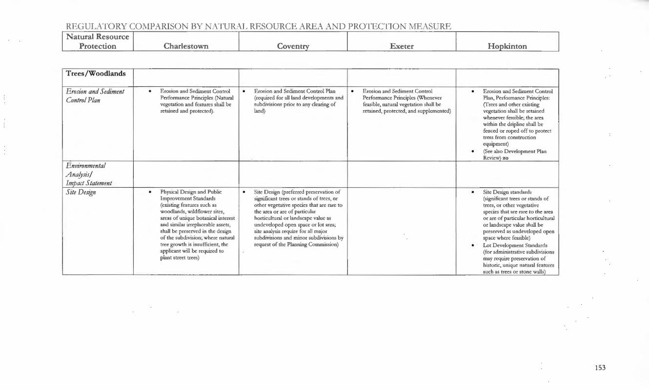
lillGULATORY COl\JPARISO BY 1ATURAL RESOURCE ARJ'.,A AND PROTECTION J\fE~-\SURE
Natural Resource Protection Charlestown Coven!!Y_ Exeter Ho_E_kinton
Trees /Woodlands
Erosion and Sediment • Erosion and Sediment Control • Erosion and Sediment Control Plan • Erosion and Sediment Control • Erosion and Sediment Control
Control Plan Performance Principles (Natural (required for all land developments and Performance Principles (Whenever Plan, Performance Principles: vegetation and features shall be subdivisions prior to any clearing of feasible, natural vegetation shall be (frees and other existing retained and protected). land) retained, protected, and supplemented) vegetation shall be retained
whenever feasible; the area within the dripline shall be fenced or roped off to protect tress from construction equipment)
• (See also Development Plan Reviev:2_ zo
Environmental Ana!Jsis/ Im_p_act Statement Site Design • Physical Design and Public • Site Design (preferred preservation of • Site Design standards
Improvement Standards significant trees or stands of trees, or (significant trees or stands of (existing features such as other vegetative species that are rare to trees, or other vegetative woodlands, wildflower sites, the area or are of particular species that are rare to the area areas of unique botanical interest horticultural or landscape value as or are of particular horticultural and similar irreplaceable assets, undeveloped open space or lot area; or landscape value shall be shall be preserved in the design site analysis require for all major preserved as undeveloped open of the subdivision; where natural subdivisions and minor subdivisions by space where feasible) tree growth is insufficient, the request of the Planning Commission) • Lot Development Standards applicant will be required to (for administrative subdivisions plant street trees) may require preservation of
historic, unique natural features such as trees or stone wall~
153

REGULATORY COT\fPARISON BY r, \TURAL RESOURCE ,\REA AND PROTECTION "MEASURE Natural Resource
Protection Charlestown Covent!Y Exeter Hopkinton
Trees/Woodlands .f!._ontinuedj_ Site P fan Review • Site Plan Review, Standards, • D evelopment Plan Review, Criteria • Development Plan Review • Development Plan Review,
Historic and Archaeological (Building sites shall, to the extent Qandscape plan requirements state Ecological Considerations (fhe Areas--required for all feasible: minimize tree, vegetation that existing trees and vegetation development insofar as nonresidential developments and soil removal; preserve unique shall be preserved to the maximum practicable shall result in (fhere shall not be any adverse natural features . . . ) extent possible; the plan must minimal degradation of unique effect on the scenic or natural include the approximate location or irreplaceable land types and in beauty o f the areas. Historical o f wooded areas, wetlands and minimum adverse impact upon sites, specimen vegetation and coastal features) zo the critical areas such as ... rare and irreplaceable natural mature stands of vegetation, and areas shall not be disturbed) extraordinary wildlife nesting,
feeding, or breeding grounds) zo
• D evelopment Plan Review, Landscape (fhe landscape shall be preserved in its natu.ral state insofar as practicable by minimizing tree removal, disturbance of the soil, and retaining the existing vegetation during and after construction ... ) zo
Other • A 100 foot buffer is required around the perimeter o f a residential cluster devel~ment
154

RJ-<..G UJ ,, \ TORY COi\fPARISO BY Ji\TURAL RESOURCE AR.F.A i\ND PROTECTION l\fEASURE Natural Resource
P rotection Charlestown Coven~ Exeter Ho_1~k:inton
Coastal Features
Erosion and Sediment • Erosion and Sediment Control Plan
Control Plan (for all major subdivisions and land developments as weU as for all land development within 200 feet of any waterbody, watercourse, wetland or coastal featur~
Protection District • In Zones VI-V-30, the al teration of sand dunes and / or undeveloped barrier beaches is prohibited for any purpose zo
Land Unsuitable for • Intertidal salt marshes considered
Develop_ment "land unsuitable for development"
Setbacks • All new construction must be landward of the reach of mean high tide zo
E nvironmental • Environmental Analysis (for all major
A na!Jsis / Impact subdivisions and land developments as weU as fo r land that is entirely or
Statement partially located in an area subject to review under the RI CRMC Special Area Man~ment Plaaj_
Site P Ian Review • Site Plan Review, Environmental Considerations (sites to be developed shall avoid areas witl1 "Constraints to Devel~ment'.1 zo
Performance Standards • Performance Standards, Water bodies (No facility designed to leach liquid wastes into the soil shall be located within 100 fee t of a boundary of a freshwater or coastal wetlanc!l zo
155

REGUJ ,ATORY COl\fPARISON BY NATURAL RESOURCE AREA AND PRO'fECTTON i\fEASURE Natural Resource
Protection Charlestown Coven!!Y_ Exeter Hopkinton
Village I Rural Character
Overlqy Districts • Historic Village Overlay District zo • Conservation-Recreation District (CR-5) zo
• Village Center Districts zo
Cluster, Residential • The Planned Development District • RR-5 Zone--Residential 5 Acres • RU-4 (Rural District)--The stated • Residential Cluster Development zo
Compounds, Planned (rural and natural resource protection (designed to preserve the rural purpose of the district is to protect • Residential Compounds (stated
Unit Developments, is a stated goal) zo character and to protect land now used for forestry, farming, purpose is rural preservation) zo
• Mandatory Cluster zo environmentally sensitive land) zo and related activities and the natural
Low Densiry Zoning • General Requirements, Residential • Planned Unit Development (intended habitat and wildlife and to preserve the
Cluster Subdivision (open space shall to establish multi-family residential and area's rural character. zo
be used to preserve existing features mixed use communities, to promote
of the parcel or structures on the attractive, convenient and efficient
parcel that have ecological, historic, development ... and to preserve open archeological, scenic, or cultural space, historic sites and valuable
value) natural fea tures of the land) zo
• Residential Compounds zo
Land Unsuitable for • Any unique sites having archeological
Development or historic value considered "land unsuitable for development"
Environmental • Environmental Review Team Report • Impact Statement (may be required
A na!Jsis/ Impact (fhe Planning Commission. may to protect historic/ archeological and
Statement require the applicant to pay for an ERT natural heritage sites) prepared by the RI Resource Conservation and D evelopment Council, Inc.--if all or part of the property is identified in the Natural and Cultural Resources Element of the Comprehensive Plan ... )
156

REGULATORY COl\fPAJUSON BY NATURAL RESOURCE AREA AND PROTHCTTON l\·fE.ASURE Natural Resource
Protection Charlestown Coven!!Y Exeter Hopkinton
Village /Rural Character
1£ontinuec!)_ Site Design • Physical Design and Public • Site D esign (preferred preservation of • Site D esign standards (historically
Improvement Standards (existing historically significant structures and significant structures and sites, as features such as woodlands, wetlands, sites as undeveloped open space or lot listed on federal or state lists of cemeteries, wildflower sites, area; significant trees or stands of trees, historic places shall be preserved as archeological sites, areas of unique o r other vegetative species that are rare undeveloped open space where botanical interest and similar t the area or are of horticultural or feasible) irreplaceable assets, shall be preserved landscape value; site analysis require • Lot Development Standards (for in the design of the subdivision) for all major subdivisions and minor administrative subdivisions may
subdivisions by request of the Planning require preservation of historic, Commission) unique natural features such as trees
• Site Design, Landscape Design or stone walls) (Reasonable landscaping should be provided at site entrances, in public areas, and adjacent to buildings . .. )zo
Site P Ian Review • Site Plan Review, Standards, • Development Plan Review, Criteria • Development Plan Review (s tates that • Architectural Standards of Review (proposed developments shall relate (Architectural style shall be in harmony there must not be any undue adverse (within Development Plan Review to the natural terrain and be visibly with the prevailing character and scale effect on the scenic or natural beauty excluding single and two-family compatible with the rural character of of buildings in the neighborhood and of the project area, aesthetics, historic dwellings) the community) zo the town through the use of sites, or rare and irreplaceable natural
• Site Plan Review, Standards, Historic appropriate building materials, areas; see also architectural and
and Archaeological Areas--required screening, breaks in roof and wall lines landscape standards) zo
fo r all nonresidential developments and other architectural techniques;
zo minimize tree, vegetation and soil
• Site Plan Review, Standards, Building removal, grade changes and subsequent
Design and Location (Proposed erosion; preserve unique natural or
structures shall be related historical features; minimize
harmoniously to the terrain and to the obstruction of scenic view from
existing buildings in the vicinity which publicly accessible locations)
have a visual relationship to the proposed buildings) zo
• Site Plan Review (standards call for protection of scenic roadways and vistas)_
157

REGULATORY COi\.fPAlUSON BY NATURAL RESOURCE AREA AND PROTECTION IvfEASURE Natural Resource
Protection Charlestown Covent!)'" E xeter Ho.E_kinton
Village/Rural Charater (continued)
Historic Preseroation • See Site Plan Review Above • H.istoric Sites and Structures must be identified in the prelim.inary plan fo r a minor or major subdivision/ land devel~men t
Landscaping Standards • See Site Plan Review (Landscape) • Landscaping Requirements (shade trees/ shrubs where no natural growth exists within 10 feet of the right-of-way)
S tree! Design • Shared private drives (are • Shared Common Drives (Driveways encouraged) may be combined)
• Street Design Standards (G ridion street patterns are not permitted; alJ streets shalJ be related to population densitie~
158

REGULATORY COMPARISON BY NATURAL RESOURCE AREA AND PROTECTION MEASURE N atural Resource
Protection Richmond South Kin_g_stown Wester!Y_ West Greenwich
Land Conservation
Farmland Preservation Zoning Regulations • Agricultural Overlay District (single • R200 Zone (may discourage conversion of
family development is permitted by open space and farmlands) right: a minimum of 50 gross acres is required for both residential cluster developments and residential compounds) zo
Site Design • Site Design Standards (call for • Site Design Standards (may require • Site D esign Standards (preferred • Site Design Standards (calls for specific agricultural lands to be preserved as preservation efforts) preservation of agricultural land in site areas to be preserved as open space undeveloped open space or lot area) • Lot Development Standards (Minor design) including agricultural lands)
• Criteria for Review for 2 lot Subdivision Criteria for Review may • Criteria for Review--3 to 5 lot minor subdivision (Planning board shall include "Preservation of Agricultural subdivision (includes cluster provisions maximize preservation of Land" through clustering requirements fo r preservation of prime farmland or agricultural lands and Prime farmland of statewide importance) Farmland)
Open Space Zonin_g_
• No • Residential uses prohibited except for • Permitted uses by "special use permit" • Recreational Facilities allowed by single and two households farm residences include: Public Parks and Recreation, "special use permit" as an accessory use Golf Courses. Municipal Buildings and
• Permitted uses "by right" include: crop and Cemeteries livestock farms (pig farms prohibited), fish hatcheries, and boarding animals, outdoor recreation facilities such as golf courses and tennis courts and wildlife refuges
• Museums, libraries, community centers, cemeteries allowed by "special use permit"
159

REGULATORY COMPARJSON BY NATURAL RESOURCE AREA AND PROTECTION MEASURE Natural Resource
Protection Richmond South Kin_g_stown Wester!Y_ West Greenwich
Open Space Preservation Cluster Development, • Cluster required fo r all major • Residential cluster developments and • Residential cluster development is
Residential Compounds, subdivisions (40% of the gross area compounds are permitted uses in the R20, permitted in the RR-60, LDR-43, LDR-must be preserved as open space; no 30,40, 80 and 200 districts (40% of the 40 and MDR-30 zoning districts
La'l'lf,e Lot Zoning more than 25% of the minimum gross area must be open space, not (minimum land area is 10 acres; if it open space can be land unsuitable including stormwater drainage facilities; no includes private roads, 25 acres is for development) zo more than 50% of the open space can be required) zo
land unsuitable for development) • Residential cluster development • Planning Board can require cluster (developer must demonstrate clustering
development fo r a particular subdivision would be a better use of the land than a conventional subdivision (no minimum open space requirement) zo
Land Unsuitable for • Land Unsuitable fo r Development • Land Unsuitable for D evelopment (shall • Land Unsuitable for Development (may • Lands Unsuitable fo r
Development (is deducted from the buildable not be counted toward the minimum lot be deducted from the minimum building Development (shall not be acreage of the parcel--freshwater size requirements-- freshwater wetlands, acreage of the parcel--freshwater counted toward the minimum lot wetlands, except that area of except that area of perimeter wetland wetlands, coastal wetlands, land within size requirements; it may be perimeter wetland within 50 fee t of within 50 feet of the edge of any bog, an easement, areas within the 100 year included as part of any lot in any the edge of any bog, marsh, swamp marsh, swamp or pond; or any applicable flood zone and areas with soils that subdivision or land development or pond; or any applicable 100 foot 100 foot or 200 foo t riverbank wetlands; exceed 15% slope) project; provided that land or 200 foot riverbank wetlands; coastal wetlands except any directly unsuitable fo r development shall areas within a High Flood Danger associated contiguous areas; areas within a not exceed 30% of the minimum zone; land within any publicly or High Flood Danger zone; land within any lot size required in the zoning privately held easement on which publicly or privately held easement on ordinance--freshwater wetlands, above-ground utilities, including but which above ground utilities, including but except that area of perimeter not limited to electrical transmission not limited to electrical transmission lines, wetland within 50 feet of the edge lines, are constructed) are constructed) of any bog, marsh, swamp or
pond; or any applicable 100 foot or 200 foo t riverbank wetlands; areas within a 100 year flood zone; land within any publicly or privately held easement on which above ground utilities, including but not limited to electrical transmission lines; areas which exceed 15% sl~
160

REGULATORY COMPARISON BY NATURAL RESOURCE AREA AND PROTECTION MEASURE N atural Resource
Protection Richmond South Kin_g_s town Wester!Y_ West Greenwich
Open Space Preservation
1Contin11ed)_
Dedication of Land for • Dedication of Land for Public • D edication of Public Land and
Public Purposes Purposes (land dedication, payment Improvements (see comp.plan) in lieu or both are required; amount of land to be dedicated is .01 acres /_per _.E_ersori}_
Site Design • Site Design Standards (see preferred • Site Design Standards (call for specific areas for _Qreservatiori}_ areas to be _£reserved as <:£en ~cq
Natural Resource Protection Wetlands Freshwater wetlands are considered "land
unsuitable for development"
Erosion and Sediment • Erosion and Sediment Control • Erosion and Sediment Control
Control Plan Performance Principles (Plan is required Plan (all major development as well for all subdivisions if construction as any development activity within activities are within 100 feet of a wetland 200 feet of any wetland or coastal or coastal feature) fea ture)
Protection District • Carrying Capacity Overlay District (SAMP Areas) zo
Setbacks • Special Use Permits, Location of ISDS (no facility designed to leach liquid was tes into the soil shall be located within 150 feet of a freshwater wetland . . _l zo
Land Unsuitable for • Land Unsuitable for Development • Land Unsuitable for Development • Land Unsuitable for Development
Develo_p_ment Environmental • An EIS may be required (by • Possible EIS required for development in • EIS (may be required if there is a
A nafysis /Impact authority of the Planning Board) critical/ environmental areas reasonable expectation that the
A nafysis proposed development will have a significant negative impact on natural ~tern~
161

REGULATORY COMPARISON BY NATURAL RESOURCE AREA AND PROTECTION MEASURE Natural Resource
Protection Richmond South Kin__g_stown Wester!Y_ West Greenwich
Wetlands l!_ontin11et!)_
Site Design • Site Design Standards (call for • Site Design Standards (may require • Site Design Standards (preferred • Site Design Standards (calls for unique and/ or fragile areas, preservation efforts) preservation of wetlands in site design) specific areas to be preserved as including freshwater wetlands open space including wetlands) to be preserved as undeveloped open space or lot area)
Site Plan Review • Development Plan Review • Site Plan Review (development Standards (calls for minimal shall result in minimal adverse impact upon critical degradation of unique or areas; natural features of land irreplaceable land types; minimal must be shown on the site adverse impact upon the critical plan) zo areas such as streams, wetlands,
areas of aquifer recharge and discharge, steep slopes, highly erodible soils; areas with a high water table, mature stands of vegetation and extraordinary wildlife nesting, feeding or breeding grounds) zo
Performance Standards • Industrial Site and Performance Standards
Watercourses/ Surface Waters Erosion and Sediment • Erosion and Sediment Control Plan • Erosion and Sediment Control • Erosion and Sediment Control (original
Control Plan (required for all major land Performance Principles (Plan is required boundaries, alignment and slope of developments as well as for minor for all subdivisions if construction water courses shall be preserved to the or administrative subdivisions if activities are within 100 feet of a wetland greatest extent possible) deemed necessary by the Planning or coastal feature--otherwise, plan is not Board) required for minor or administrative
subdivision~
Protection District • Carrying Capacity Overlay District (SAMP • River Corridor Overlay zo Areas) zo • Salt Pond Overlay zo
162

REGULATORY COMPARISON BY NATURAL RESOURCE AREA AND PROTECTION MEASURE N atural Resource
P rotection Richmond South Kingstown Wester!Y_ West Greenwich
Watercourses/ Surface Waters
i!__ontinued)_ Setbacks • 50 foot Sewage Disposal Facility • Hazardous Waste Facility setback • Hazardous Waste Management Facility • ISDS Setback Requirements (facilities
setback (from any waterbody , pond, requirements zo Siting Requirements (prohibited within which are designed to leach liquid stream, brook or river) zo • Special Use Permits, Location of ISDS (no 1,000 feet of environmentally sensitive wastes into the soil shall be located not
facility designed to leach liquid was tes into areas) zo less than 200 feet from the edge of any the soil shall be located within 150 feet of pond or stream) zo a river. .. ) zo
Site Design • Lot D esign Standards (stormwater • Site Design Standards (original easements may be required) boundaries, alignment and slope of
water courses shall be preserved to the greatest extent possible)
Site P Ian Review • Site Plan Review, Standards-- • D evelopment Plan Review (required fo r • Site Plan Review (development shall required for all nonresidential all non-residential uses--a development result in minimal adverse impact upon activities (measures shall conform to plan shall not be approved if it would the critical areas such as streams ... ) the minimum standards of the 1993 result in water pollution, damage to State of RI Stormwater Manual) zo shoreline vegetation, or inhibition of
public access) zo
Performance Standards • Industrial Performance Standards zo
Other • Drainage Plan requirements (must • Stormwater Easement or drainage right-leave existing watercourses open, of-way (required where development is unless approval to enclose is granted traversed by a water course, drainage by the Planning Board) way, channel or stream)
163

REGULATORY COMP ARJSON BY NATURAL RESOURCE AREA AND PROTECTION MEASURE Natural Resource
Protection Richmond South Ki~stown Wester!Y_ West Greenwich
Groundwater/ Rechai:g_e Areas Protection District • Aquifer Protection District zo • Groundwater Protection Overlay District • Groundwater Protection Overlay
• Special Flood Hazard Areas zo District zo (Regulations are in tended to minimize hazards to persons and damage to property from inland and tidal flooding, to protect floodways from encroachment, and to maintain the capacity of floodplains to retain and carry off floodwaters) zo
Environmental • EIS (may be required if land is located on • EIS may be required
A na/ysis/ Impact Map 5.3 of the Comprehensive Plan as being within a critical or environmentally
Statement sensitive area or by au thority of the Plannin__g_ Boardl_
Setbacks • Hazardous Waste Management Facility Siting Requirements (prohibited within 1,000 feet of environmentally sensitive area~ zo
Site Design • Site Design Standards (calls fo r • Site Design Standards (siting must avoid • Site Design Standards (state that development to be laid out to avoid adverse impacts to groundwater and development should be laid out to adversely affecting groundwater and aquifer recharge) avoid adversely affecting groundwater aquifer recharge) and aquifer recharge and to avoid
unnecessary irnp_ervious cover)_
Site Plan Review • D evelopment Plan Review • D evelopment Plan Review (required fo r • Site Plan Review (development shall (standards fo r ecological protection all non-residential uses--a development result in minimum degradation of areas of aquifer recharge and plan shall not be approved if it would of. .. areas of aquifer recharge and discharge) zo result in water pollution, damage to discharge; drainage control should
shoreline vegetation, or inhibition of preserve existing natural drainage public access) zo patterns and wetlands; and enhance
groundwater recharge areas) zo
Other • Residential 3 Acre Zoning District • Special Requirements (Residential Cluster (designation is intended to protect in R200 may be restricted based on
.E:?undwater)_ zo environmental consideration~
164

REGULATORY COMPARISON BY NATURAL RESOURCE AREA AND PROTECTION MEASURE Natural Resource
Protection Richmond South Kin_gstown Wester!Y_ West Greenwich
Flood_l!!ains Protection District • Special Flood Hazard Areas • High Flood Danger Overlay District • Flood Hazard Overlay District (no use
(Regulations are intended to • Carrying Capacity Overlay zo shall be approved which would minimize hazards to persons and adversely affect the capacity of any damage to property from inland and drainage facility or system or would tidal flooding, to protect floodways involve alteration of sand dunes, barrier from encroachment, and to maintain beaches, and other natural protective the capacity of floodplains to retain barriers) zo and carry off fl oodwaters) zo
Land Unsuitable for • Areas within a High Flood Danger • Land Unsuitable fo r Development • Land Unsuitable fo r Development • Land Unsuitable fo r D evelopment
Development Zone are considered "land unsuitable for devel~ment"
E nvironmental • EIS (may be reguired if land is located on
Ana!Jsis / Impact Map 5.3 of the Comprehensive Plan as being within a critical or environmentally
Statement sensitive area or by authority of the Planning Board)
Setbacks • ISD S Siting Restrictions/Setbacks (no facility designed to leach liguid wastes into the soil shall be located within 150 fee t of a flood plain ... ) zo
Site Design • Site Design Standards (call for the • Site Design standards (may reguire • Site Design Standards (preferred • Site Design Standards (call for specific protection of lands in the flood plain preservation efforts) preservation as open space in site areas to be preserved as open space as undeveloped open space) design) including lands in the floodplain)
Site Plan Review Other • D esign and Public Improvement
Standards (state that development should be laid out to prevent flooding; also, the Planning Board shall examine each proposed subdivision to ensure that potential flood damage is minimized, public utilities and facilities are elevated and that adeguate drainage is _E!Ovide~
165

REGULATORY COMPARISON BY NATURAL RESOURCE AREA AND PROTECTION MEASURE Natural Resource
P rotection Richmond South Kin__g_s town Wester!Y_ Wes t Greenwich
Topography
Erosion and Sediment • Erosion and Sediment Control • Erosion and Sediment Control Plan
Control Plan Performance Principles (Plan is required (required for all major land for all subdivisions if slopes at the site developments/ subdivisions and all exceed 10 %--otherwise, plan is not subdivisions if slopes are greater than required for minor or administrative 10%) subdivisions)
Land Unsuitable for • Land Unsuitable fo r Development • Land Unsuitable fo r Development
Development (slopes in excess of 15 %) (areas that exceed 15% slope)
Site Design • Site Design (steep slopes in excess of 20% as measured over a 10 foo t interval unless appropriate engineering measures concerning slope stability, erosion, and resident safety are taken shall be preserved as open space where feas ible)
Site P Ian Review • Development Plan Review, • Site Plan Review (development shall Ecological Considerations (calls result in minimal degradation of unique for minimal adverse impact or irreplaceable land types; minimal upon critical areas such as adverse impact upon the critical areas steep slopes, highly erodible such as . .. steep slopes, highly erodible soils, areas with a high water soils; areas with a high water table, table ... )natural features of land mature stands of vegetation and must be shown on the site extraordinary wildlife nesting, feeding plan) zo or breeding grounds) zo
166

REGULATORY COMP ARJSON BY NATURAL RESOURCE AREA AND PROTECTION MEASURE Natural Resource
Protection Richmond South Kin_g_stown Wester!Y_ West Greenwich
Rare Species/ Critical H abitat
Protection District • R200 Zone (intended to protect environmentally sensitive areas: aquifers, rechar_g_e areas, and coastal _E_Ond~
Environmental • EIS maybe required (including an • EIS (may be required if land is located on • EIS may be required
Anajysis / Impact assessment of short and long term Map 5.3 of the Comprehensive Plan as environmental impacts on natural being w within a critical or environmentally
Statement heritage areas and wildlife) sensitive area or by authority of the Planning Board)
Setbacks • Hazardous Waste Facility setback requirements zo
Site Design • Site Design Standards (require • Site Design (habitat of endangered species • Site D esign Standards (preferred • Site Design Standards (call for specific habitats of endangered wildlife to be shall be preserved as open space where preservation of endangered wildlife areas to be preserved as open space preserved as undeveloped open feasible; site analysis for all major habitat in site design) including habitats of endangered space or lot area) developments and subdivisions) wildlife)
Site P Ian Review • Development Plan Review, • Site Plan Review (development shall Ecological Considerations result in minimal adverse impact (standards for ecological protection upon . .. areas of extraordinary wildlife of unique or irreplaceable land types nesting, feeding or breeding grounds) such as extraordinary wildlife zo nesting, feeding or breeding grounds) zo
167

REGULATORY COMPARISON BY NATURAL RESOURCE AREA AND PROTECTION MEASURE N atural Resource
Protection Richmon d South Kin__g_stown Wester!Y_ West Greenwich
Trees/Woodlands
Erosion and Sediment • Soil Erosion and Sediment Control, • Erosion and Sediment Control • Erosion and Sediment Control (trees • Drainage and Erosion and Sediment
Control Plan Performance Principles (seeks to Performance Principles (may require and other existing vegetation shall be Control Standards (wherever feasible retain trees and other exiting protection of existing trees and vegetation) fenced or roped off to protect trees natural vegetation shall be retained and vegetation whenever feasible, to from construction equipment) protected) protect them during construction and restore all areas damaged during construction)
Site Design • Site D esign Standards (calls for the • Site Design Standards (may require • Site Design Standards (significant trees • Lot Development Standards protection of significant trees or preservation efforts) or stands of trees or other vegetative (preservation of unique natural and / or stands of trees, or other vegetative • Lot Development Standards (may require species that are rare to the area or are of historic features such as trees or stone species that are rare to the area or of preservation of existing unique features) particular horticultural or landscape walls may be required for 2 lot minor particular horticultural or landscape value are prefe.rred areas of preservation subdivisions) value) in site design) • Site Design Standards (call for specific
areas to be preserved as open space including significant trees or stands of trees, or other vegetative species that are rare to the area or are of particular horticultural or landscape value; development should be laid out to reduce cut and fillJ
Site P Ian Review • D evelopment Plan Review (rhe • Site Plan Review (rhe landscape shall landscape shall be preserved in its be preserved in its natural state, insofar natural state, insofar as as environmentally desirable, by environmentally desirable, by minimizing tree and soil removal) zo minimizing tree and soil removal) zo
Other • Residential Cluster (requires • Unlawful Cutting of Trees or Shrubs • Design and Public Improvement easement around perimeter to (unless authorized in writing by the Standards (street design standards call preserve existing trees and Public Works Director, trees or other for conservation of existing trees vegetation) zo vegetation cannot be removed to where feasible)
• A 50 foot perimeter no cut buffer increase the visibility of a sign) required for outer lots adjacent to a public street
168

REGULATORY COMPARISON BY NATURAL RESOURCE AREA AND PROTECTION MEASURE Natural Resource
Protection Richmond South Kin_g_stown Wester!Y_ West Greenwich
Coastal Features
Erosion and Sediment • • Erosion and Sediment Control • Erosion and Sediment Control Plan
Control Performance Principles (Plan is required (required for all development within 200 for all subdivisions if construction feet of any wetland or coastal feature) activities are within 100 fee t of a wetland or coastal feature)
Protection District • • High Flood Danger Overlay zo • Salt Pond Overlay zo
• Carrying Capacity Overlay District (SAMP • Flood Hazard Overlay District (no use Areas) zo shall be approved which would
adversely affect the capacity of any drainage facility or sys tem or would involve alteration of sand dunes, barrier beaches, and other natural protective barriers) zo
E nvironmental • • EIS (may be required if land is located on
A na!Jsis/ Impact Map 5.3 of the Comprehensive Plan as being w within a critical or environmentally
Statement sensitive area or by authority of the Planning Board)
Setbacks • • Special Use Permits, Location of ISDS (no • Hazardous Waste Management Facility facility designed to leach liquid wastes into Siting Requirements (prohibited within the soil shall be located within 150 fee t of 1,000 feet of environmentally sensitive a coastal wetland or within 150 feet of the areas) zo line of mean high water of any tidal water body .. . ) zo
• Hazardous Waste Facility setback rc:g__uirements zo
Land Unsuitable for • • Land Unsuitable for Development
Development
169

REGULA TORY COMPARISON BY NATURAL RESOURCE AREA AND PROTECTION MEASURE Natural Resource
Protection Richmond South Kin_g_stown Westerly_ West Greenwich
Coastal Features (continued)
Site Design • • Site Design Standards (may require • Site Design Standards (preferred preservation as open space) preservation of coastal features in site
design)
Site P Ian Review • Development Plan Review (required for all non-residential uses--a development plan shall not be approved if it would result in water pollution, damage to shoreline vegetation, or inhibition of public access) zo
Other • Special Requirements (Residential Cluster in R200 may be restricted based on environmental considerations) zo
• R200 Zone (intended to protect environmentally sensitive areas: aquifers, recharge areas, and coastal ponds) zo
170

REGULATORY COMPARISON BY NATURAL RESOURCE AREA AND PROTECTION MEASURE N atural Resource
Protection Richmond South Kin_g_stown Wester!Y_ West Greenwich
Village/Rural Character Overlqy Districts • Architectural Standards of Review • Historic Overlay District
Required (Historic Overlay District; Route • Bed and Breakfast/ Guest House 1 Special Management District) zo Overlay District
• Historic Overlay District (includes an area within the Vill~ of Kin~toaj_ zo
Cluster Development, • Planned Development District • R200 Zone
Residential Compounds, (purpose is to fos ter and maintain the rural character of the town) zo
Large Lot Zoning • Residential Compounds (intended to preserve the rural character of the town) zo
• Residential Cluster Develo...E_ment zo
Site Design • Site Design Standards (call for • Site Design Standards (special provisions • Site Design Standards ( to the maximum • Site D esign Standards (call for specific reasonable landscaping at site fo r flexible lot size, lot lines, frontage, and extent practicable, development shall be areas to be preserved as open space entrances, in public areas, and setbacks; calls for the placement of located to preserve impacts and including historically significant adjacent to buildings dwelling units to take into alteration of natural fea tures, historic structures and sites)
consideration .. . scenic values ) and cultural resources, and areas of • Lot Development Standards • Lot Development Standards (may require scenic value which contribute to the (preservation of unique natural and / or
the preservation of historic features such character of town) historic features such as trees or stone as trees or stone walls) • Lot Design Standards walls may be required for 2 lot minor
subdivision~
Site P Ian Review • Development Plan Review • Site Plan Review ( required for properties • Development Plan Review--required for • Site Plan Review (landscape standards; (s tandards call for the protection of with direct lot frontage or vehicu]ar access all uses, other than single family and two preservation and protection of scenic, scenic, historic, archeological, and on Ministerial Road Scenic Highway) family residential and uses accessory historic, and archeological landmark landmark sites) zo thereto (landscape and architectural sites standards) zo
..£!ans r"'.9._uire<&
Historic Preseroation • Maintenance Standards and procedures fo r • See Site Design and Overlay Districts • See Site Design and Site Plan Review identi fying endangered buildings (Building above above Codi:)_
Landscaping Standards • Design and Public Improvement Standards _.0 l andsc~e _.£!an is r~uire<fl_
S tree! Design • Shared Common Drives-- • Shared Common Drives (encouraged fo r encouraged minor 2 lot subdivisions)
171

APPENDIX A
List of Plans, Ordinances, and Land Development Regulations
Town Comprehensive Zoning Subdivision Plan Ordinance Re_g_ulations
With amendments Charlestown Janua_!Y_ 1992 to 1998 October 18, 1995
With amendments Coventry June 2000 through June 26, December 13, 1995
2000 With amendments
Exeter July 1994 through August 3, December 12, 1995 2000
Ho~kinton Se_Qtember 1992 December 19, 1994 November 29, 1995 With amendments
Richmond December 1991 through February February 15, 2000 1998 With amendments
South July 1992 through May 10, November 9, 1999 Kin_g_stown 1999
With amendments West Greenwich December 1995 throug_h Ju_ly_ 1998 November 6, 2000
Westerly January 1992 October 16, 1998 September 11 , 1997
172

APPEND/XS
Municipal Planners
Town Planner Interviewed
Charlestown Nanc_yHess
Covent~ Brent Narkawicz
Exeter Geor_g_e Caldow
Ho~kinton Katherine Maxwell
Richmond Jose_Q_h Lombardo
South Kin_g_stown Anthony_ Lachowicz
West Greenwich John Pa_g_liarini, Jr.
Westerly_ Jose_Q_h Lombardo
173