Embed Size (px)
Citation preview

A Scottish Registered Charity
No. SC 020751
Report No. – RMAD12
An assessment of electrofishing and habitat survey data for a fish barrier removal:
Creamery Weir - Twynholm
For further information on this report please contact:
Name of GFT Project Manager – R McCleary Galloway Fisheries Trust Fisheries House Station Industrial Estate Newton Stewart DG8 6ND Telephone: 01671 403011 E-mail: [email protected]
This report should be quoted as: Galloway Fisheries Trust. September 2017. An assessment of electrofishing and habitat survey data for a fish barrier removal: Creamery Weir - Twynholm Galloway Fisheries Trust Report No. – RMAD12
This report, or any part of it, should not be reproduced without the permission of Galloway Fisheries Trust. This permission will not be withheld unreasonably.
© Galloway Fisheries Trust Year – 2017

i
An assessment of electrofishing and habitat
survey data for a fish barrier removal:
Creamery Weir - Twynholm Report No. RMAD12 Year of publication: September 2017 Keywords Salmon, brown trout, eel, electrofishing, Creamery Weir, Kirk Burn, Old Mill Burn, Tarff Water, River Dee (Kirkcudbright), baseline data collection, post-work fish monitoring. Background In 2012, Galloway Fisheries Trust (GFT) identified a redundant weir 3.5 m high and 13 m wide, associated with a disused creamery situated on the Old Mill Burn (a tributary of the Tarff Water) near Twynholm, Dumfries and Galloway, as impacting significantly on local fish stocks. This weir (constructed >100 years ago) presented a complete barrier to migratory salmonid fish species considered important for economic and conservation reasons and blocked access to 10 km of good quality upstream river habitat and transfer of gravels downstream. Allowing migratory fish access to this habitat was considered by GFT as a priority for action. Through the Rivers and Fisheries Trusts of Scotland (RAFTS) Barrier Easement Project, an opportunity arose to consider the weir, positioned at NGR NX 67410 55106, for easement options using the Scottish Environment Protection Agency (SEPA) managed Water Environment Fund (WEF). Between 2014 and 2016 SEPA WEF provided background environmental information and majority funding for the practical engineering works in 2016 and also the pre-works including: 2014 feasibility study conducted by ARUP, 2015 impact assessment completed by JBA Consulting and 2016 design and build phase of works, in which Royal Haskoning DHV were the design supervisors during works and Ebsford Environmental Limited were the works contractors. RAFTS managed the project programme and contracted engineering works. GFT facilitated and mentored the project and provided essential local knowledge, ran a stakeholder information event, organised the pre-work fish rescues and will continue to monitor the fish populations as they repopulate to the burn in future. To provide fisheries data to support each project phase, GFT have undertaken electrofishing surveys within the Old Mill Burn and in 2017, the first monitoring electrofishing was completed to catalogue recovery of migratory fish to the Old Mill Burn upstream of the Creamery Weir site.
Summary

ii
Main findings • No juvenile salmon were found within six sites surveyed above the weir during pre-work
surveys. Salmon were present in the three sites electrofished downstream of the weir during pre-work surveys completed in 2012, 2013 (as fry in a high density and parr in a low density), 2015 (as parr in a low density) and 2016 (as fry and parr in a low density) within the Old Mill Burn and tributaries thereof. In 2017, during the first year of post-work monitoring, salmon were found in one of the two sites electrofished upstream of the demolished weir site, as fry in a high density (indicating that successful spawning of wild salmon had taken place during the winter of 2016). Salmon were also found as fry within the single electrofishing site fished downstream of the creamery weir site in 2017.
• Juvenile brown trout were found at four of the six sites surveyed above the weir during pre-work surveys completed in 2012 (generally in low to moderate density) and 2016 (in low to high density) and all three sites surveyed downstream of the weir in 2013, 2015 and 2016 (in low to high density of fry and low density of parr).
• Eels were found in five of the six sites surveyed upstream of the weir pre-works (2012
and 2016) from as far up the catchment as the Auchengassel Burn (tributary of the Kirk Burn) to the site at Twynholm. Eels were the only migratory fish found to be able to ascend the creamery weir – by means of mosses covering both sides of the structure. Post-works, eels were found in all sites electrofished upstream and downstream of the creamery weir site.
• Stoneloach were found at five of the six sites surveyed upstream of the Creamery Weir
pre-works. Post-works, stoneloach were found to inhabit both sites electrofished upstream of the creamery weir site and the site electrofished downstream, where minnows were also recorded.
• No site was found to be fishless during pre and post work electrofishing.
• GFT will continue to monitor the fish populations as migratory fish species repopulate to the upper Old Mill Burn in future.
For further information on this project contact:
Name of Project Manager – R McCleary Telephone No. of Project Manager – 01671 403011

3
Table of Contents Page 1. INTRODUCTION 4
2. METHODOLOGY 6 2.1 Data recording 6 2.2 Electrofishing techniques 6 2.3 Electrofishing equipment used 7 2.4 Age determination 7 2.5 Non-salmonid fish species 7 2.6 Site measurement 7 2.7 Bankside / instream habitat assessment 7 2.8 Site selection 8
3. RESULTS 9 3.1 Electrofishing results 9 3.1.1 Figures presented 9 3.1.2 Survey limitations 10 3.1.3 2017 Electrofishing results 10
4. DISCUSSION 11 4.1 Physical works undertaken 11 4.2 Collection of electrofishing data 12 4.2.1 Collection of baseline electrofishing data 12 4.2.2 Collection of monitoring electrofishing data 13 4.2.2.1 Site 1: Old Mill Burn at Twynholm 13 4.2.2.2 Site 2: Old Mill Burn upstream of Creamery Weir site 15 4.2.2.3 Site 3: Old Mill Burn upstream of Creamery Weir site 17 4.2.2.4 Site 4: Old Mill Burn – adjacent to Sandy Brae 17 4.3 Further mitigation 19
5. APPENDIX 1: RESULTS FROM YEAR ONE MONITORING ELECTROFISHING SURVEY COMPLETED ON THE OLD MILL BURN, POST-WORKS, 2017 20
6. APPENDIX 2: RESULTS FROM PRE-WORKS ELECTROFISHING SURVEYS COMPLETED ON THE OLD MILL BURN AND TRIBUTARIES DRAINING INTO, 2012-2016 21

4
1. INTRODUCTION
During the development of the Solway-Tweed River Basin Management Plan, with guidance from Galloway Fisheries Trust (GFT), Scottish Environment Protection Agency (SEPA) identified the creamery weir as being a significant impact on fish accessing available fish habitat and highlighted it as a priority for action and suitable for support from the Water Environment Fund. By removing this barrier, the waterbody would be improved from Moderate Ecological Potential to Good Ecological Potential as classified by the Water Framework Directive. A range of options were considered to solve the fish passage problem but it was decided that full removal would be the most sustainable and cost effective solution, removing maintenance and upkeep issues and future risk of weir failure. In 2015, data to create a design was gathered on utilities, topography and weir structure. The effects of removal on ecology, geomorphology, flood risk and fish passage were considered. The design was taken to the land owner, local Authority, a local Councillor and Scottish Natural Heritage (SNH) for review and comment. All were supportive. A public stakeholder information event was held in January 2016. The design involved adaptive management of groundworks: monitoring the actual removal works and being prepared to modify the approach if necessary during the works. The full removal works were completed over a four week period in September 2016 and involved:
• carefully excavating sediment from upstream of the weir to uncover the original river bed
• building rock steps similar to those that naturally occur just upstream to ensure river stability
• taking the weir down in carefully controlled stages • removal of a sluice a short distance downstream to further aid fish migration • silt control measures within a gorge which created various difficulties that had to be
overcome
The project was a great success and achieved widespread attention from the local community, local press, BBC Radio Scotland and ITV Border News. The Creamery weir was situated upon the Old Mill Burn – a tributary of the Tarff Water, near Kirkcudbright. There is a variety of legislation, regulations and guidance in place relating to fish species that are present in watercourses within the Tarff catchment. Atlantic salmon are an internationally important fish population which is listed under Annex II and V of the European Habitats Directive (1992) (only in freshwater), Appendix III of the Bern Convention (1979) (only in freshwater) and are a local priority species in the Dumfries and Galloway Local Biodiversity Action Plan. Atlantic salmon are also a species of conservation concern on a UK level. The Kirkcudbrightshire Dee and Tarff Water are recognised as category 3 status rivers under The Conservation of Salmon (Scotland) Regulations 2016 with effect that mandatory catch and release of salmon must be undertaken. Brown trout/sea trout are also a UK Biodiversity Action Plan species. Brown trout are present throughout the Old Mill Burn. There have been concerns around Europe over low eel stocks. It is currently unknown why there was such a rapid decline but it is possibly linked to over-exploitation, inland habitat loss, climate and ocean current changes, disease and pollution. European Eel Regulations (EC) No 1100/2007 aim to establish measures to recover eel stocks. One such measure was the production of Eel Management Plans for the Scotland River Basin and the Solway

5
Tweed River Basin District. Fishing or taking eels is illegal (unless licensed) under The Freshwater Fish Conservation (Prohibition on Fishing for Eels) (Scotland) Regulations 2008. Eels are also a UKBAP priority species. To monitor the long-term ecological gain that has resulted from the removal of the creamery weir, GFT will monitor juvenile fish populations by means of electrofishing. This report details the findings from electrofishing surveys undertaken by GFT in summer 2017 and compares these to electrofishing data gathered pre-works between the years of 2012 and 2016 upon the Old Mill Burn and watercourses draining in to it. A range of sites will be surveyed annually for up to 5 years post-works to evaluate the natural recolonisation of the burn upstream of the demolished weir.

6
2. METHODOLOGY
2.1 Data recording The GFT is a partner in the Scottish Fisheries Co-ordination Centre (SFCC), an initiative involving, amongst others, the Scottish Fishery Trusts; Marine Scotland Science; The Tweed Foundation; the Spey Research Trust; the Tay Foundation and the Cromarty Firth Fisheries Trust. This group has, in partnership, developed a set of agreed methodologies and record sheets for use with electrofishing surveys, and an associated database in which to record information gathered from such surveys. The electrofishing surveys undertaken by the GFT have been completed to the standards that are required by the SFCC and recorded using the agreed formats. 2.2 Electrofishing techniques To assess the fish population present within a section of river various techniques have been developed in the recent decades. The main method of determining the health of a fish population is by the use of electrofishing equipment. This technique involves the stunning of fish using an electric current which enables the operator to remove the fish from the water. Once captured, the fish recover in a holding container. They are then anaesthetised using a specific fish anaesthetic, identified to species, measured and recorded, and once recovered, returned unharmed to the area from which they were captured. The method of fishing involves the anode operator drawing stunned fish downstream to a banner net held against the current by an assistant. A hand net operator completes the three-man team. Fish captured are then transferred to a water-filled recovery container. The team works its way across the section and upstream, thereby fishing thoroughly all the water in the surveyed area. To obtain fully quantitative information on the fish populations within the river, each survey site is fished through up to four times consecutively to allow the calculation of a more accurate Zippin estimate of the fish population. A Zippin estimation of a fish population is a calculation carried out using a depletion method (multiple run fishing). This is an estimate of the fish population density per 100 m2 of water, including the 95% confidence limits. When the calculation of a Zippin estimate of the population is not possible, a minimum estimate of the fish population is given for that section of river (this information is presented in Appendix 2). When timed delineated surveys are undertaken, sites are electrofished for a given length of time and the number of fish caught regarded as an index of abundance (catch per unit of effort (time)) rather than determining fish density per unit area. This information is presented in Appendix 1. It is policy to disinfect all relevant equipment both prior to and following work in each river catchment, to ensure that there is no transfer of disease organisms.

7
2.3 Electrofishing equipment used A mobile, battery powered backpack electrofishing kit was used to undertake the survey. GFT employs the use of a 500 WATT E-Fish backpack electrofishing kit set to give a 300 volt output at 0.3 amps. All settings were set to maximise capture of juvenile salmonids. The backpack controller unit is linked to a stationary cathode of braided copper (placed instream) and a mobile, single anode, consisting of a pole-mounted stainless steel ring and trigger switch is used instream to capture the fish. Smooth direct current was used in all survey sites. 2.4 Age determination Electrofishing surveys concentrate on juvenile salmonid species, namely salmon (Salmo salar L.) and trout (Salmo trutta L.). In the majority of cases age determination of the fish present can be made by assessment of their length and scale-sample readings. However, with older fish it is more difficult to clarify age classes by fish length alone and therefore in this survey salmonid fry (0+ fish) were classified alongside salmonid parr (1+ fish and older). Information on juvenile densities can be found in Appendix 1 and 2. 2.5 Non-salmonid fish species At each site the presence of non-salmonid fish species was also noted. Population densities for these species were not calculated. This information is presented in Appendix 1 and 2. 2.6 Site measurement At each site surveyed where fully or semi quantitative techniques were employed, a total site length was recorded and average wet and dry widths calculated. The average wet width was calculated from five individual widths recorded at equidistant intervals from the bottom of the site (0 m) to the top. At each site a final width was noted at the absolute upper limit of the surveyed water. From these site measurements the total area fished was calculated. Where timed electrofishing was undertaken (2017), site measurements were estimated (density of fish present is calculated as catch per unit effort (fish/min) rather than density of fish per 100 m2 of water). 2.7 Bankside / instream habitat assessment At each site an assessment was made of the instream habitat available for older (parr aged) fish. This assessment graded instream cover present as none, poor, moderate, good or excellent. This grading provides an index of instream cover where diverse substrate compositions will score more favourably than areas of uniform substrate providing poorer cover. In accordance with SFCC protocols, percentage estimates of depths, substrate type and flow type were made at each site. Additionally, percentage estimates of the quantity of the bankside features undercut banks, draped vegetation, bare banks and marginal vegetation were made. All of these bankside and instream habitat site features are summarised in Section 4. When reference to left or right bank is made, it is always left and right bank when facing downstream.

8
Specific electrofishing site and habitat information are presented in Section 4 and Appendix 1 and 2. 2.8 Site selection A range of sites were surveyed across the years to cover fish populations residing within the Old Mill Burn upstream and downstream of the creamery weir site. Initially (pre-works), sites were electrofished using semi-quantitative one-run techniques and latterly, timed electrofishing techniques were applied. In total, four sites were surveyed for fish populations in 2017. Surveys were carried out over two days in August and September 2017.
9
3. RESULTS
3.1 Electrofishing results 3.1.1 Figures presented The results of the post-works (monitoring) electrofishing survey are outlined in Section 3.1.3 and presented in detail in Appendix 1 (Results from year one monitoring electrofishing survey completed on the Old Mill Burn, post-works, 2017). These provide information on the population densities of juvenile salmonids at each site (fish per 100 m2 or fish/minute). Site code, watercourse, site location, O.S. Grid reference, survey date, non-salmonid species and area fished (m2) are also shown. With regard to the juvenile salmonid age classes, these are separated into four categories, which are defined in Table 1:
Table 1: Salmonid age classes
Salmon Fry (0+): Refers to young fish less than one year old resulting from spawning at the end of 2016.
Trout Fry (0+): Refers to young fish less than one year old resulting from spawning at the end of 2016.
Salmon Parr (1+ and older):
Refers to young fish of greater than one year and greater than two years old (where present) from spawning years 2015 and 2014.
Trout Parr (1+ and older):
Refers to young fish of greater than one year and greater than two years old (where present) from spawning years 2015 and 2014. If captured, trout of up to three or four years old are also included in this category.
Within the electrofishing results, juvenile salmonid numbers recorded have been classified into several categories. A classification scheme for densities of salmonids was previously generated by the SFCC using data collected from 1,638 Scottish electrofishing survey sites, covering the period 1997 to 2002 (Godfrey, 20051). From this, regional figures were created to allow more accurate local ranges. The categories are based on quintile ranges for one-sample electrofishing surveys in the Solway region (Solway Salmon Fishery Statistical Region), allowing densities of fish observed to be put into a regional context. Table 2 shows these quintile ranges.
Table 2: Quintile ranges for juvenile salmonids (per 100 m2) based on one-sample electrofishing events, calculated on densities >0 over 291 sites in the Solway Statistical
Region
Salmon 0+ Salmon 1++ Trout 0+ Trout 1++ Minimum (Very Low) 0.22 0.38 0.38 0.35 20th Percentile (Low) 5.21 2.86 4.14 2.27 40th Percentile (Moderate) 12.68 5.87 12.09 4.71 60th Percentile (High) 25.28 9.12 26.63 8.25 80th Percentile (Very High) 46.53 15.03 56.49 16.28
1 Godfrey, J. D., 2005; Site Condition Monitoring of Atlantic Salmon SACs: Report by the SFCC to Scottish Natural Heritage, Contract F02AC608.

10
3.1.2 Survey limitations The juvenile salmonid density classification scheme is based solely on data from surveyed sites containing fish in the period 1997 to 2002, and refers to regional conditions at that time; therefore it must only be used as a very relative guide and not be used to draw conclusions. Moreover, the figures for juvenile trout are less reliable for various reasons (e.g. some surveyed populations of trout are isolated; sea trout contributing to stock in some areas etc.) and so can only be used as a relative indication of numbers. Electrofishing and habitat information is discussed, with reference to any specific issues such as sensitivities, in Section 4. 3.1.3 2017 Electrofishing results
• Site 1 (DTK1): Old Mill Burn Grid reference: 266540 554307
Salmon fry and parr were absent at site 1. Trout fry and parr were present in high and low density respectively. Two eels were also found at this site as well as stoneloach.
• Site 2 (DTK2): Old Mill Burn Grid reference: 267380 554982
Salmon fry were present in a high density whilst salmon parr were absent. Trout fry were present in a very high density whilst trout parr were absent. From the non-salmonid fish species, two eels were present at this site.
• Site 3 (DTK3): Old Mill Burn Grid reference: 267370 554970
Salmon fry were found in a low density at this site. Salmon parr were not present. Trout fry were present in a high density. Only a single trout parr was present. From the non-salmonid fish species, a single mature eel and stoneloach were present at this site.
• Site 4 (DTK4): Old Mill Burn Grid reference: 268006 555482 Salmon fry were present in low density. Salmon parr were not present within this site. Trout fry were present in a low density. Trout parr were absent from this site. Of the non-salmonid fish species, two eels, stoneloach and a minnow were found at this site.

11
4. DISCUSSION
4.1 Physical works undertaken
The Creamery Weir and associated sluice gate were removed in September 2016 and the sediment which had built up behind the weir removed to re-profile the river bank and protect the nearby road. Since the removal of the weir, the river has naturally re-profiled itself with erosion and deposition occurring within the work area. The Old Mill Burn runs through a gorge so there is limited room for the river to naturally move but the channel has shown some meandering above the creamery weir site. Seeding of parts of the banksides took place to assist in protecting the road and to ensure excessive levels of silt was not washed into the river. This seeding did not take place right down to the water edge to allow the river to undertake some erosion and realignment if required. The channel width and gradient of the new channel were designed to mimic the burn outside the work area. River sediments are now able to move naturally through the site following the weir and sluice gates removal. This process will create more natural and suitable instream conditions for salmonids downstream, by the creation of pool and riffle sequences and formation of gravel beds. Below are pictures taken pre and post demolition works at the sluice gate (Figure 1) and weir sites (Figure 2).
Figure 1: Creamery sluice gate before (left) and after (right) works
Figure 2: Creamery Weir before (left) and after (right) demolition works A range of native fish species, including Atlantic salmon, sea trout, sea lamprey and river lamprey, can now return and live once again in the 10 km of good habitat available to them

12
upstream of the weir site. Their return will ensure that a more natural ecosystem develops over time in the burn, particularly regarding a range of predator prey relationships. 4.2 Collection of electrofishing data
4.2.1 Collection of baseline electrofishing data Between the years of 2012 and 2016, prior to any physical works taking place at the creamery weir site, nine sites were electrofished to gather baseline data on juvenile fish populations within the Old Mill Burn and watercourses draining into the burn (Kirk Burn and Auchengassel Burn). Appendix 2 details the results of these surveys. Presence/absence of fish species found within these sites can also be seen in Map 1 below. Salmon were found at only three sites (all downstream of the creamery weir site), generally in low fry and parr abundance except for during the 2013 survey when salmon fry were found in very high density a short distance downstream of the Creamery Weir. Trout were found at seven of the nine sites (located upstream and downstream of the creamery weir site), generally in low to moderate density except for trout fry - which were present in a high density a short distance downstream of the weir - in 2015, and trout parr – which were found in a high density upstream of the Creamery Weir within Twynholm - in 2016. Eels were found at six of the nine sites.
Map 1: Location map showing presence/absence of fish species within electrofishing sites
surveyed on the Old Mill Burn prior to the removal of the Creamery Weir

13
4.2.2 Collection of monitoring electrofishing data In 2017, the first year of monitoring electrofishing was undertaken on the Old Mill Burn, to catalogue recovery of wild migratory fish populations to areas of the burn previously excluded by the Creamery Weir. Appendix 1 details the results of these surveys. Presence/absence of fish species found within these sites can also be seen in Map 2 below.
Map 2: Location map showing presence/absence of fish species within electrofishing sites surveyed on the Old Mill Burn following the removal of the Creamery Weir
4.2.2.1 Site 1: Old Mill Burn at Twynholm Site 1 (Figure 3) was electrofished in an area of the burn previously surveyed in 2016 as part of baseline data collection, downstream of a road bridge in the village of Twynholm, adjacent to Hayton Coulthard offices. A site length of approximately 20 m and channel width 3 m, was fished, mostly along the left bankside, beginning beneath some mature ash trees and finishing upon a break downstream of the bridge. Water depth was shallow throughout the site (100% less than 30 cm deep). Substrates were recorded as consisting mostly of cobbles (55%), pebbles (25%) and gravel (10%). Boulders and sand were also placed thinly throughout the site. Although substrates were felt to be mostly stable and uncompacted, some silt was released within the site when the bed was disturbed underfoot. This is likely to have resulted from the outflow of a large road drainage pipe that enters the burn immediately beneath the road bridge. Due to the low gradient nature of the site, shallow glide was the predominant flow type recorded as well as some run and riffle, within the upstream and downstream reaches of the site. Bankside cover was sparse, since both banks were constructed of vertical stone walls. However, some additional rocks overhanging the left bankside provided good cover. A small amount of vegetation (10%) in the form of brambles and ferns were found to overhang both banks. Tree cover was only present in the very lower reach of the site where mature elm branches overhung the site from the left bankside.

14
Figure 3: Site 1, looking upstream towards the bridge A timed electrofishing survey of five minutes was undertaken at this site. Salmon fry and parr remain undetected at this site following the removal of the Creamery weir downstream. A healthy trout population was present within the site and a catch per unit effort (CPUE) of 6.8 (fish/min) trout fry was recorded. Only a single trout parr was recorded measuring 146 mm. Figure 4 shows three trout fry and the single trout parr (fish at top of photo) captured during this year’s timed electrofishing survey. Two eels of 145 and 340 mm (Figure 5) in length were also recorded at this site. Stoneloach were the only other fish species present at this site.
Figure 4: Trout fry and a single trout parr found at site 1

15
Figure 5: The larger of two eels captured at site 1
4.2.2.2 Site 2: Old Mill Burn upstream of Creamery Weir site Site 2 (Figure 6) was situated on the Old Mill Burn, a short distance upstream of the demolished creamery weir. The site was reached through a gateway from the road side. This site was selected due to its holding faster flow types, shallow water depths and varied substrates i.e. being the most likely area to support juvenile salmon if they were at all present in this area of the burn. Two sites were electrofished in this area of the burn – the first site electrofished using a single run semi-quantitative method of electrofishing to provide a density of fry and parr fish present within a small area where salmon fry would be expected to inhabit (faster flowing water beneath a pool section of burn). A channel of water between 2.9 and 6.1 m wide was fished over a distance of 11 m, to give a site area of 56.2 m2. Depth of water was shallow with 70% found to be less than 20 cm deep. Water flow was largely fast-flowing riffle and run flow type. Some shallow glide was also present. Substrates consisted of a good mixture of spawning material (50% cobble, 30% pebble and 15% gravel). Some densely packed silt material was also observed along the left bankside. Until recently, a ford and watering access point for cattle lay immediately upstream of the site. The right bankside is now completely fenced off and no livestock were observed accessing the burn. Vegetation has become established on this bank and now provides overhanging cover for fish across 30% of the right bankside. Land use surrounding the site was recorded as arable on the right bankside. Mature broadleaved trees line the roadside along the left bank, 10 m from the burn. It is possible there is a degree of eutrophication within the burn as a result of the outflow from Twynholm sewage works upstream, which would explain the faint green colouration of the water observed on the day of the survey.
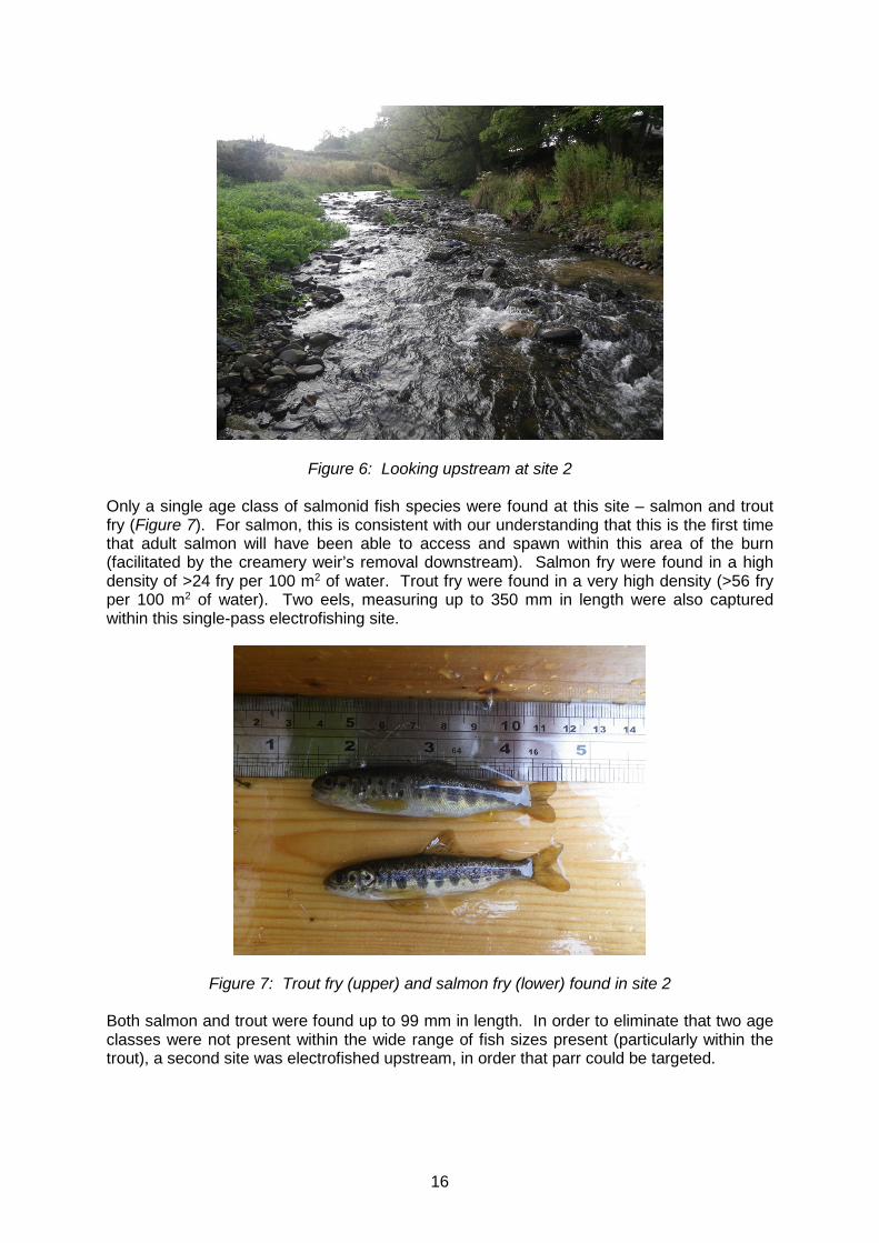
16
Figure 6: Looking upstream at site 2
Only a single age class of salmonid fish species were found at this site – salmon and trout fry (Figure 7). For salmon, this is consistent with our understanding that this is the first time that adult salmon will have been able to access and spawn within this area of the burn (facilitated by the creamery weir’s removal downstream). Salmon fry were found in a high density of >24 fry per 100 m2 of water. Trout fry were found in a very high density (>56 fry per 100 m2 of water). Two eels, measuring up to 350 mm in length were also captured within this single-pass electrofishing site.
Figure 7: Trout fry (upper) and salmon fry (lower) found in site 2
Both salmon and trout were found up to 99 mm in length. In order to eliminate that two age classes were not present within the wide range of fish sizes present (particularly within the trout), a second site was electrofished upstream, in order that parr could be targeted.

17
4.2.2.3 Site 3: Old Mill Burn upstream of Creamery Weir site Using a timed electrofishing survey of five minutes, a channel length of approximately 20 m covering a range of deeper glide flowing water, marginal bankside cover along the right bank, exposed tree roots along the left bankside, as well as a bed rock based pool beneath a minor obstruction, was electrofished to survey for the presence of parr. Only one notable trout parr was found (Figure 8).
Figure 8: A well-fed trout parr (upper) amongst many trout fry found at site 3
Once again, salmon fry and trout fry were gathered in greatest abundance: salmon fry in a CPUE of 2.2 (fish/min) and trout fry in a CPUE of 9.4 (fish/min). Only a single trout parr was recorded measuring 179 mm (providing a CPUE of 0.2 (fish/min). One eel of 290 mm in length were also recorded at this site. Stoneloach were the only other fish species present at this site.
4.2.2.4 Site 4: Old Mill Burn – adjacent to Sandy Brae Site 4 (Figure 9) was electrofished in an area of the burn previously surveyed in 2016 as part of baseline data collection, downstream of a road bridge through a field adjacent to Sandy Brae. This site was located downstream of the Creamery Weir site. A site length of approximately 30 m and channel width 3.5 m, was fished along both banksides, passing through a number of areas with shallow falls beneath overhanging broadleaved trees on the right bankside. Water depth was shallow throughout the site (80% less than 30 cm deep). Substrates were recorded in equal measures of gravel, pebble and cobble (30-35%). Some boulders were also present and provided good instream cover. In general, flow types were recorded as run/riffle (70%) mid-channel and as shallow and deep glide with a small amount of pool (trout habitat) along the banksides. Bankside cover was provided by overhanging vegetation on 70% of the left bankside (mowed grass began over 5 m back from this bankside) and 20% of the right bankside. Broadleaved trees (mostly elm) provided cover across 40% of the right bankside and overall, 15% canopy cover spanned the entire site.

18
Figure 9: Looking upstream at site 4
A timed electrofishing survey of five minutes was undertaken at this site. Salmon fry were found in a CPUE of 3.6 (fish/min). Trout were also present within the site and a CPUE of 2 (fish/min) trout fry was recorded. No salmonid parr were found within the site. Figure 10 shows a sample of healthy salmon fry captured during this year’s timed electrofishing survey of site 4. Two eels of 80 and 195 mm in length were also recorded at this site, as were stoneloach and minnows.
Figure 10: Salmon fry at site 4
19
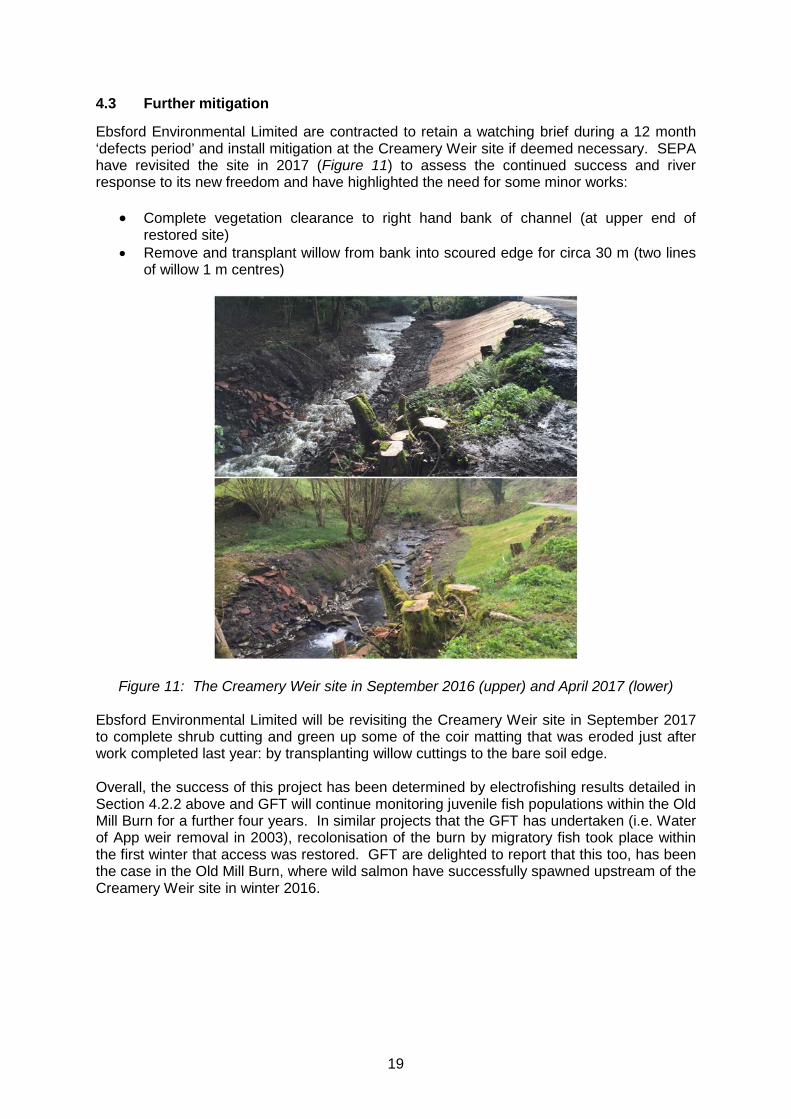
4.3 Further mitigation
Ebsford Environmental Limited are contracted to retain a watching brief during a 12 month ‘defects period’ and install mitigation at the Creamery Weir site if deemed necessary. SEPA have revisited the site in 2017 (Figure 11) to assess the continued success and river response to its new freedom and have highlighted the need for some minor works:
• Complete vegetation clearance to right hand bank of channel (at upper end of restored site)
• Remove and transplant willow from bank into scoured edge for circa 30 m (two lines of willow 1 m centres)
Figure 11: The Creamery Weir site in September 2016 (upper) and April 2017 (lower)
Ebsford Environmental Limited will be revisiting the Creamery Weir site in September 2017 to complete shrub cutting and green up some of the coir matting that was eroded just after work completed last year: by transplanting willow cuttings to the bare soil edge. Overall, the success of this project has been determined by electrofishing results detailed in Section 4.2.2 above and GFT will continue monitoring juvenile fish populations within the Old Mill Burn for a further four years. In similar projects that the GFT has undertaken (i.e. Water of App weir removal in 2003), recolonisation of the burn by migratory fish took place within the first winter that access was restored. GFT are delighted to report that this too, has been the case in the Old Mill Burn, where wild salmon have successfully spawned upstream of the Creamery Weir site in winter 2016.

20
5. APPENDIX 1: RESULTS FROM YEAR ONE MONITORING ELECTROFISHING SURVEY COMPLETED ON THE OLD MILL BURN, POST-WORKS, 2017
Site Code
Watercourse Site Location Grid Ref
Survey Date
Presence Of Other Species*
Area Fished (m²)
Density per 100 m² ** or fish/min (timed electrofishing) Salmon Fry (0+)
Salmon Parr (1+ and older)
Trout Fry (0+)
Trout Parr (1+ and older)
DTK1 River Dee (Kirkcudbrightshire) Tarff Water, Old Mill Burn
Upstream of creamery weir site – in Twynholm
266540 554307
01/09/17 E, SL 0 0 6.8/min 0.2/min
DTK2 River Dee (Kirkcudbrightshire) Tarff Water, Old Mill Burn
Upstream of creamery weir site – through gateway
267380 554982
31/08/17 E 56.2 >24 0 >56 0
DTK3 River Dee (Kirkcudbrightshire) Tarff Water, Old Mill Burn
Upstream of creamery weir site – through gateway
267370 554970
31/08/17 E, SL 2.2/min 0 9.4/min 0.2/min
DTK4 River Dee (Kirkcudbrightshire) Tarff Water, Old Mill Burn
Downstream of creamery weir site – Adjacent to Sandy Brae
268006 555482
01/09/17 SL, M 3.6/min 0 2/min 0
* E = Eel, SL = Stoneloach, M = Minnow
** Where a Zippin calculation could be carried out, 95% confidence limits are shown. Where only the number appears, a Zippin estimation could not be carried out. In these cases the number represents a minimum estimate of fish density per 100 m2 of water.
21
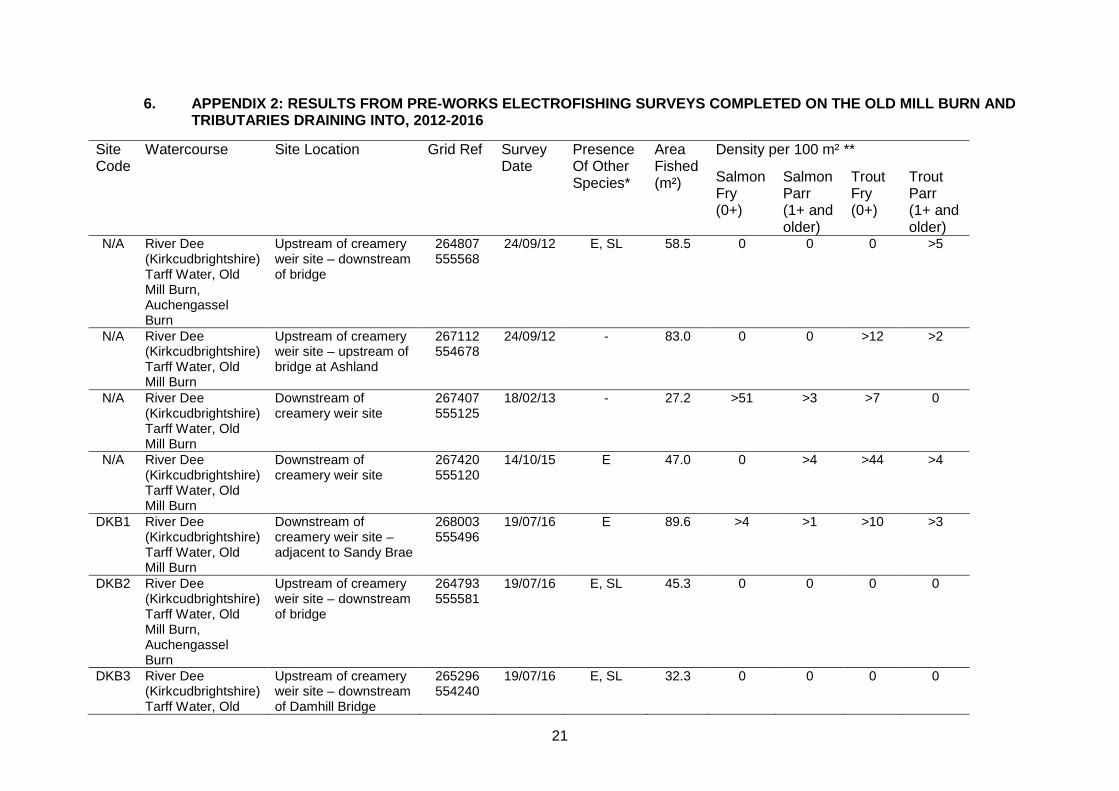
6. APPENDIX 2: RESULTS FROM PRE-WORKS ELECTROFISHING SURVEYS COMPLETED ON THE OLD MILL BURN AND TRIBUTARIES DRAINING INTO, 2012-2016
Site Code
Watercourse Site Location Grid Ref
Survey Date
Presence Of Other Species*
Area Fished (m²)
Density per 100 m² **
Salmon Fry (0+)
Salmon Parr (1+ and older)
Trout Fry (0+)
Trout Parr (1+ and older)
N/A River Dee (Kirkcudbrightshire) Tarff Water, Old Mill Burn, Auchengassel Burn
Upstream of creamery weir site – downstream of bridge
264807 555568
24/09/12 E, SL 58.5 0 0 0 >5
N/A River Dee (Kirkcudbrightshire) Tarff Water, Old Mill Burn
Upstream of creamery weir site – upstream of bridge at Ashland
267112 554678
24/09/12 - 83.0 0 0 >12 >2
N/A River Dee (Kirkcudbrightshire) Tarff Water, Old Mill Burn
Downstream of creamery weir site
267407 555125
18/02/13 - 27.2 >51 >3 >7 0
N/A River Dee (Kirkcudbrightshire) Tarff Water, Old Mill Burn
Downstream of creamery weir site
267420 555120
14/10/15 E 47.0 0 >4 >44 >4
DKB1 River Dee (Kirkcudbrightshire) Tarff Water, Old Mill Burn
Downstream of creamery weir site – adjacent to Sandy Brae
268003 555496
19/07/16 E 89.6 >4 >1 >10 >3
DKB2 River Dee (Kirkcudbrightshire) Tarff Water, Old Mill Burn, Auchengassel Burn
Upstream of creamery weir site – downstream of bridge
264793 555581
19/07/16 E, SL 45.3 0 0 0 0
DKB3 River Dee (Kirkcudbrightshire) Tarff Water, Old
Upstream of creamery weir site – downstream of Damhill Bridge
265296 554240
19/07/16 E, SL 32.3 0 0 0 0

22
Mill Burn, Kirk Burn DKB4 River Dee
(Kirkcudbrightshire) Tarff Water, Old Mill Burn
Upstream of creamery weir site – downstream of bridge in Twynholm
266536 554293
19/07/16 E, SL 64.7 0 0 >3 >13
DKB5 River Dee
(Kirkcudbrightshire) Tarff Water, Old Mill Burn, Kirk Burn
Upstream of creamery weir site – upstream of bridge at Barwhinnock
265586 554960
19/07/16 E, SL 60.5 0 0 0 >1
* E = Eel, SL = Stoneloach, M = Minnow, Pi = Pike, Pe = Perch
** Where a Zippin calculation could be carried out, 95% confidence limits are shown. Where only the number appears, a Zippin estimation could not be carried out. In these cases the number represents a minimum estimate of fish density per 100 m2 of water.