Embed Size (px)
Citation preview

1
American Avalanche Association
Forest Service National Avalanche Center
Avalanche Incident Report: Short Form
Occurrence Date (YYYYMMDD): 20170104 and Time (HHMM): 0 Comments: Estimated date and location of victim in
relation to the start zone based on skin track and
avalanche path. The victim was last seen in the Crystal
Mt Ski area riding the lower lifts (upper lifts on wind
hold) around mid-day 1/4/17 and told a friend she was
going to ski a local run outside the ski area's Southback
boundary known as "Joe's Shoulder".
Reporting Party Name and Address: Peter Dale
Crystal Mt Ski Patrol
33914 Crystal Mt Blvd
Enumclaw, WA 98022
Avalanche Characteristics:
Type: HS (Hard Slab) Aspect: 330 (NNW)
Trigger: ASu
(Skier/unintentional)
Slope Angle: 43 degrees average
in start zone
Size: R 3 \ D 2 Elevation: 6400 m / ft
Sliding surface (check one):
In new New/old In old Ground
Location:
State: WA County: Pierce Forest: Mt Baker Snoqualmie
Peak, Mtn Pass, or Drainage: Crystal Mt area, Silver Basin
Site Name: Joe's Shoulder
Lat/Lon or UTM:
Group Number of
People Time
recovered
Duration
of burial
Depth to
Face
m / ft Caught 1
Partially
Buried—
Not critical
0
Partially
Buried--
Critical
1 10:52
next day
est 18+
hrs/unk
1
Completely
Buried
0
Number of people injured: 0 Number of people killed: 1
Dimensions m / ft
Average Maximum
Height of Crown Face 1-2 3
Width of Fracture 73
Vertical Fall 400
Snow Hardness Grain Type Grain Size (mm)
Slab 1F/P DF/RG .25
Weak
Layer
1F DF/RG .5
Bed
Surface
1F RG .5-1
Thickness of weak layer: See attached profile mm / cm
/ in
Burial involved a terrain trap? no yes → type:
Number of people that crossed start zone before the avalanche: 0
Location of group in relation to start zone during avalanche: high middle low below all unknown
Avalanche occurred during ascent descent
Subject Name Age Gender Address Phone Activity
1 Elizabeth Hampson 64 F Skiing
2
3
4
5
Equipment Carried
1 2 3 4 5
Transceiver
Shovel
Probe
Experience at Activity
1 2 3 4 5
Unknown
Novice
Intermediate
Advanced
Expert
Avalanche Training
1 2 3 4 5
Unknown
None
Some
Advanced
Expert

2
Signs of Instability Noted by
Group
Unknown
None
Recent avalanches
Shooting cracks
Collapse or whumphing
Low test scores
Injuries Sustained
1 2 3 4 5
None
First Aid
Doctor’s care
Hospital Stay
Fatal
Extent of Injuries or Cause of Death
1 2 3 4 5
Asphyxiation
Head Trauma
Spinal Injury
Chest Trauma
Skeletal Fractures
Other: Coroner's
report unavailable
at time of
preliminary
report
Damage Number of Vehicles Caught:0 Number Structures Destroyed: 0 Estimated Loss: $
Accident Summary Include: events leading to accident, group’s familiarity with location, objectives, route, hazard evaluation, etc.
Following an unusually strong east wind event the CMSP observed avalanche debris just outside the ski area boundary on 1/5/17 in Silver
Basin and found the victim upon investigation. Based on the debris, the victim's skin track and the victim's condition it was estimated that
the avalanche occurred the day prior, 1/4/17. Other backcountry skiers in the area reported seeing no tracks or people near the accident
site two days prior, 1/3/17. A natural wind slab avalanche in Silver Basin on a similar aspect/elevation was observed by ski patrol earlier
on 1/4/17 and at that time the crown of the victim's avalanche was not observed. The victim was reportedly very familiar with the area
and was traveling alone. She reportedly had been skiing inbounds earlier that day. The easterly winds on 1/4/17 exceeded 100mph at a
weather station nearby (top of Crystal - see attached weather data).The upper lifts for the ski area did not run due to high winds on 1/4/17.
Upon investigation of the site on 1/6/17, NWAC and CMSP personnel determined the avalanche to be a hard wind slab, with P hard snow
at the top of the slab and 1F hard snow at the bottom of the slab in many places. The slab densities and crown face heights varied widely
across the avalanche. A distinct weak layer and bed surface was not identified. It is estimated that the victim triggered the avalanche low
in the starting zone and it propagated up to just shy of the ridgeline (start zone and likely trigger point classified as near treeline as it
relates to NWAC forecast). If this is true, the slab would have been very shallow where the victim triggered the wind slab, yet much
deeper at the ridgeline.
Rescue Summary Include: description of initial search, report of accident, organized
rescue, etc.
On 1/5/17, two Crystal Mountain ski patrollers discovered the victim (10:52) after
completing avalanche control work in the ski area nearby. The victim was only partially
buried (backpack above snow surface) so an initial beacon search was not needed to locate
the victim. There were a couple pieces of gear on the surface about 15ft downslope of the
victim as well. The ski patrollers determined CPR was not necessary, requested additional
rescue resources (10:57) (dog, recco, medical gear, tobbogan) and then completed a
beacon search of the rest of the burial depth avalanche debris (10:59). They then formed a
probe line and proceeded to probe the rest of the debris. Eventually more ski patrollers
arrived that allowed the probe line to become larger. A paramedic arrived on scene (11:39)
and obtained permission to transport the deceased (11:59). A dog arrived on scene (11:51)
and worked for about an hour without any further findings. The victim was removed from
the scene (12:19) and a Recco search was initiated (12:30). The Recco and dog searches
were completed (12:59) and the avalanche site was deemed clear of any other victims.
Rescue Method
1 2 3 4 5
Self rescue
Transceiver
Spot probe
Probe line
Rescue dog
Voice
Object
Digging
Other:
Attach additional pages as needed. Include weather history, snow profiles, reports from other agencies, diagram of site,
photographs, and any other supporting information
Please send to: CAIC; 325 Broadway WS1; Boulder CO 80305; [email protected]
and to the nearest Avalanche Center.


West Slopes North - Canadian Border to Skagit RiverIssued: 6:00 PM PST Tuesday, January 3, 2017 by Garth Ferber
NWAC avalanche forecasts apply to backcountry avalanche terrain in the Olympics, Washington Cascades and Mt Hood area. These forecastsdo not apply to developed ski areas, avalanche terrain affecting highways and higher terrain on the volcanic peaks above the Cascade crestlevel.
A preliminary incident report completed by the White Pass Ski Patrol and NWAC for the avalanche fatality that occurred on Tuesday, December27th, 2016 is now available on the NWAC accidents page.
The Bottom Line: Further building or new wind slab should be the main avalanche problem on Wednesday. Be sureto read the forecast since wind slab may build on aspects where you don't expect it.
Elevation WednesdayOutlook forThursday
Above Treeline ConsiderableDangerous avalanche conditions. Careful snowpack evaluation, cautiousroute-finding and conservative decision-making essential. Considerable
Near Treeline ModerateHeightened avalanche conditions on specific terrain features. Evaluatesnow and terrain carefully; identify problem features. Moderate
Below Treeline ModerateHeightened avalanche conditions on specific terrain features. Evaluatesnow and terrain carefully; identify problem features. Moderate
Avalanche Problems for Wednesday
Wind SlabWind slabs can take up to a week to stabilize. They areconfined to lee and cross-loaded terrain features and can beavoided by sticking to sheltered or wind scoured areas.
AvalancheProblem
Aspect/Elevation Likelihood Size

Snowpack Analysis
Weather and Snowpack
A low pressure system moved south over western Washington on Saturday night followed by cold Arctic air. NWAC stations along the west slopes had W-SWwinds Saturday and 5-13 inches of snowfall by Sunday morning.
An unusual moist reverse orographic east flow caused snow mainly in the central to south Cascades Sunday afternoon and night. NWAC stations along thewest slopes had a shift to NE winds and another 0-10 inches of snow on Monday morning with the most snow in the central to south part and further cooling.
Fair cold weather with east winds has been seen on Monday and Tuesday with clouds lingering from the Columbia Basin to the Cascade east slopes and theeast side of Mt Hood.
Recent Observations
Consistent observations were received on New Year's Day from three NWAC pro-observer's out enjoying the after champagne, champagne powder! Theirreports from the Mt Baker area, Stevens Pass and the Alpental Valley all indicated deep, low density surface conditions, right side profiles and good skiing.Crusts layers were buried fairly deeply and unreactive in tests (Solstice crust at Snoqualmie buried 90 cm on average).
East winds began to affect some areas by Monday.
The NPS ranger at Paradise on Monday reported low visibility with significant snow transport to SW-W slopes on Monday.
A couple reports area available via the NWAC Observations tab. A report from the Artist Point/Table Mountain area near Mt Baker indicated continued goodstability with some wind slab starting to form on Monday. A skier on Mt Roosevelt at Snoqualmie Pass triggered a 10-20 inch wind slab and was carried but notinjured in a WNW couloir on Monday.
Detailed Avalanche Forecast for Wednesday
Fair cold weather is generally expected to continue over the Olympics and Cascades on Wednesday. Low clouds will probably linger from the Columbia Basinto the Cascade east slopes and the east side of Mt Hood.
But expect locally strong east winds to develop over the Olympics and Washington Cascades Tuesday night and Wednesday. Therefore new or further buildingwind slab should be the main avalanche problem on Wednesday. This new wind slab should be found mainly on NW to SE aspects on Wednesday especially atexposed locations such as around Snoqualmie, Crystal Mountain, Paradise and White Pass. There should be quite a bit of recent snow available fortransport. Watch for firmer wind transported snow and remember that stiffer wind slab has the potential to propagate to larger avalanches.
Although NW to SE aspects will be indicated in the wind slab avalanche problem diagram remember to watch for firmer wind transported snow on all slopeaspects or cross loaded slopes especially in areas with varied terrain and modified wind directions. Older wind slab may also linger on other slope aspects.
Mountain Weather Synopsis for Wednesday & ThursdayAn elongated E-W oriented upper level trough over central Oregon is causing some light snow for Mt. Hood and the far south Washington Cascades thismorning. This trough will drift south during the the day and weaken, allowing for a clearing trend over these areas. Further north, it's clear and very cold. Eastwinds will be moderate to strong at Pass and crest level today. Winds should ease over the north Cascades this morning but stay elevated for the south andcentral Washington Cascades through mid-afternoon. Upper level ridging over the NE Pacific will build into Britsh Columbia overnight turning our flow aloftnortherly and allowing winds to ease over the region. A weak shortwave upstream in NW flow aloft will begin to slide south along the B.C. coastThursday, spreading increasing clouds into the north Cascades and Olympics and producing a few light snow showers through Thursday night. Temperaturesshould slowly moderate on Thursday and Thursday night.

24 Hour Quantitative Precipitation ending at 4 am
Location Thu Fri
Hurricane Ridge 0 lt .10
Mt Baker Ski Area 0 lt .10
Washington Pass 0 0
Stevens Pass 0 0
Snoqualmie Pass 0 0
Mission Ridge 0 0
Crystal Mt 0 0
Paradise 0 0
White Pass 0 0
Mt Hood Meadows 0 0
Timberline 0 0
LT = less than; WE or Water equivalent is the liquid waterequivalent of melted snow in hundredths of inches. As arough approximation 1 inch of snow = about .10 inches WE,or 10 inches of snow = about 1 inch WE.
Snow Level/Freezing Level in feet
Day OlympicsNorthwestCascades
NortheastCascades
CentralCascades
SouthCascades
EasterlyFlow inPasses
Wednesday - Thursday 0' 0' 0' 0' 0' *
Thursday Night 1000' 0' 0' 0' 0' *
Cascade Snow / Freezing Levels noted above refer to the north (approximately Mt Baker andWashington Pass), central (approximately Stevens to White Pass) and south (near Mt Hood).Freezing Level is when no precipitation is forecast.
* Note that surface snow levels are common near the passes during easterly pass flow andmay result in multiple snow / freezing levels.
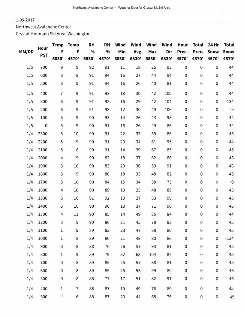
Northwest Avalanche Center — Weather Data for Crystal Mt Ski Area
1-05-2017Northwest Avalanche CenterCrystal Mountain Ski Area, Washington
MM/DDHour
PST
TempF
6830'
TempF
4570'
RH%
6830'
RH%
4570'
WindMin
6830'
WindAvg
6830'
WindMax
6830'
WindDir
6830'
HourPrec.4570'
TotalPrec.4570'
24 HrSnow4570'
TotalSnow4570'
1/5 700 9 9 92 91 11 18 25 93 0 0 0 44
1/5 600 8 8 91 94 16 27 44 94 0 0 0 44
1/5 500 8 9 91 94 16 26 40 81 0 0 0 44
1/5 400 7 9 91 93 18 30 42 100 0 0 0 44
1/5 300 6 9 91 92 16 29 42 104 0 0 0 -134
1/5 200 6 9 91 93 12 30 49 106 0 0 0
1/5 100 5 9 90 93 14 26 43 98 0 0 0
1/5 0 5 9 90 91 16 26 49 86 0 0 0
1/4 2300 5 10 90 91 22 33 59 86 0 0 0
1/4 2200 5 9 90 91 20 34 61 95 0 0 0
1/4 2100 5 8 90 91 14 39 67 85 0 0 0
1/4 2000 4 9 90 82 18 37 62 86 0 0 0
1/4 1900 3 10 90 83 20 36 59 91 0 0 0
1/4 1800 3 9 90 80 18 33 48 82 0 0 0
-9
44
44
45
44
45
46
46
45
1/4 1700 3 10 90 84 15 34 58 73 0 0 0
1/4 1600 4 10 90 89 10 25 48 89 0 0 0
1/4 1500 6 10 91 92 10 27 53 99 0 0 0
1/4 1400 5 10 90 90 13 37 71 90 0 0 0
1/4 1300 4 11 90 85 14 49 85 84 0 0 0
1/4 1200 3 9 90 86 21 45 78 83 0 0 0
1/4 1100 1 9 89 83 23 47 88 80 0 0 0
-9
45
45
46
44
45
45
1/4 1000 1 8 89 80 21 48 80 86 0 0 0 -134
1/4 900 8 88 76 26 57 93 81 0 0 0 45
1/4 800 9 89 79 32 63 104 82 0 0 0 45
1/4 700 8 89 85 25 57 88 81 0 0 0 45
1/4 600
-0
1
0
0 8 89 85 25 53 99 80 0 0 0 46
1/4 500 -0 8 88 77 17 51 82 91 0 0 0 46
1/4 400 -1 7 88 87 19 49 76 80 0 0 0
1/4 300 6 88 87 20 44 68 76 0 0 0
1/4 100
-1
7 89 88 15 35 56 91 0 0 0
1/4 0 -1 6 88 88 18 33 52 93 0 0 0
1/3 2300 -0 7 88 87 15 33 61 93 0 0 0
1/3 2200 6 88 89 21 35 56 89 0 0 0
1/3 2100
-0
0 7 89 87 16 28 43 82 0 0 0
45
45