Embed Size (px)
Citation preview


Alouette River – Habitat Restoration Effectiveness Monitoring 2009 Project Final Report
British Columbia Conservation Foundation 2
Executive Summary
A mainstem fish habitat restoration project was completed in the south Alouette River in the summer of 2006 by BC Conservation Foundation fisheries technicians and biologists. A total of 28 large woody debris (LWD) engineered style log jams were created to improve mainstem, juvenile fish rearing habitatconditions.
This project focused on assessing the biological, and physical, fish, and fish habitat in response to the 2006 habitat restoration project. Using fish habitatrestoration effectiveness monitoring guidelines, constructed LWD structures,and select control sites were evaluated for fish abundance using underwater snorkel survey methodology. The key focus was an enumeration of steelhead trout (Oncorhynchus mykiss) parr, and coho salmon (Oncorhynchus kisutch)fry at treated (restored), control (un-restored), and control (natural wood)sites. Snorkel surveys were conducted on: August 18, 2009 and February 2and 11, 2010 correlating to periods of summer and winter salmonid refuge.Summer swims were conducted in the day time, whereas winter swims were conducted at night.
Overall, underwater snorkel survey observations indicate a high salmonid fish use at wood restored sites, as well as natural wood sites, relative to thecontrols void of wood. A combined coho (fry) and steelhead (parr) abundance of 240/100m2 was seen at the restored sites, compared to 87/100m2 in control sites in the summer survey. During the winter survey combined coho and steelhead accounted for 11/100m2 in restored and 4/100m2 in control sites. Alarge proportion of all fish observed at the wood restored sites were of coho origin. This abundance weighting likely represents the much greater adultrecruitment to the south Alouette River of coho salmon relative to steelhead.
Habitat performance (physical characteristics) was rated using a standardized methodology. Of all 28 restored sites that were evaluated, 89% of woody debris structures were at or above the meets expectations criteria ranking for“pool development and gravel deposition” and “fish habitat cover”. A large amount of fine sediment is accumulating amongst the majority of LWD structures. This accumulation has, for the time, limited the development of maximum habitat capacity.

Alouette River – Habitat Restoration Effectiveness Monitoring 2009 Project Final Report
British Columbia Conservation Foundation 3
Table of Contents
1. Introduction...................................................................................................................................6
2. Goals and Objectives...................................................................................................................7
3. Study Area .....................................................................................................................................8
4. Methods..........................................................................................................................................9
5. Results...........................................................................................................................................11
6. Discussion.....................................................................................................................................20
7. Recommendations ......................................................................................................................22
8. Acknowledgements ....................................................................................................................23
9. References....................................................................................................................................25
Appendices ........................................................................................................................................26I. Financial Statement....................................................................................................................27II. Performance Measures-Actual Outcomes ............................................................................28III. Confirmation of BCRP Recognition .......................................................................................29IV. LWD Evaluation Results...........................................................................................................30V. LWD Photo Documentation ......................................................................................................32

Alouette River – Habitat Restoration Effectiveness Monitoring 2009 Project Final Report
British Columbia Conservation Foundation 4
List of Figures
Figure 1. A Spatial map showing the effectiveness monitoring study area, relative to the lower mainland region. .............................................................................................................8
Figure 2. Standardized locations for measuring water depth at triangulated LWD structures. Measurements are taken in the “inner V” and off of the “Apex”, as well as mean and maximum depths with the area of influence of the structure..........................11
Figure 3. Study area map; illustrating treated, control and natural wood control sites..............................................................................................................................................................12
Figure 4. Alouette River water temperature graph (data recorded from 1999-2008).(Miyazaki, 2008). ............................................................................................................................13
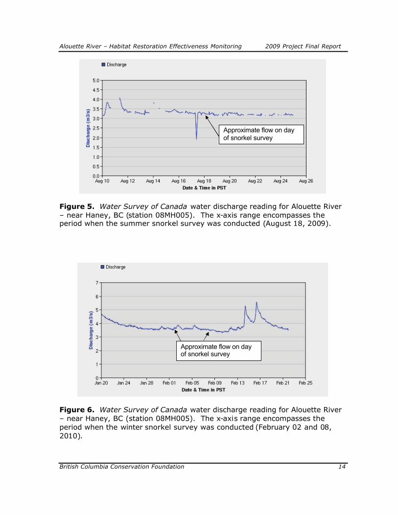
Figure 5. Water Survey of Canada water discharge reading for Alouette River – near Haney, BC (station 08MH005). The x-axis range encompasses the period when the summer snorkel survey was conducted (August 18, 2009). ................................................14
Figure 6. Water Survey of Canada water discharge reading for Alouette River – near Haney, BC (station 08MH005). The x-axis range encompasses the period when the winter snorkel survey was conducted (February 02 and 08, 2010)...................................14
Figure 7 and Figure 8. Summer day time snorkel survey fish abundance estimates (August 2009). Steelhead parr include all 1+, 2+, and 3+ age class. Results are presented per 100m2 unit area. Error bars represent “1” standard error. ......................17
Figure 9 and Figure 10. Winter night-time snorkel survey fish abundance estimates (February 2010). Steelhead parr include all 1+, 2+, and 3+ age class. Results are presented per 100m2 unit area. Error bars represent “1” standard error. ......................18

Alouette River – Habitat Restoration Effectiveness Monitoring 2009 Project Final Report
British Columbia Conservation Foundation 5
List of Tables
Table 1. Coho and steelhead fish abundance results from underwater snorkel surveys conducted during the summer (August), and winter (February) seasons. Results are expressed both as actual observed counts and fish per unit area (100m2). ....................16
Table 2. Summer and winter, coho fry (less than 1 year old) and steelhead parr (1+ and greater age class) abundance results presented per unit area (100m2). Standard error values are presented. The number of sites assessed per “survey site type” is denoted by “n”.................................................................................................................................16
Table 3. Summarized results for two parameters ranked using the Watershed Restoration Program – Forest Investment Account protocol Guidelines for in-streamand off-channel effectiveness evaluation (Anonymous 2003). All 28 LWD restored sites are represented in the summary.......................................................................................19
Table 4. Top two highest steelhead parr production sites (winter survey). Averaged water depths at these sites, as well as the average water depths of all evaluated sites are presented...................................................................................................................................20

Alouette River – Habitat Restoration Effectiveness Monitoring 2009 Project Final Report
British Columbia Conservation Foundation 6
1. Introduction
Since 2002, the Greater Georgia Basin Steelhead Recovery Program (GGBSRP)has focused on determining steelhead trout (Oncorhynchus mykiss)populations, and responding to depressed stocks with recovery actions .Carried-out by the BC Conservation Foundation (BCCF), the GGBSRP emphasizes the recovery of wild salmonids through fish habitat and ecosystem restoration.
In 2005, a seed funding request was made to the BC Hydro - Fish and Wildlife Bridge Coastal Restoration Program (BCRP) to evaluate existing fish habitat in the south Alouette River. The funding request was successfully awarded. In the fall of 2005 a habitat assessment was conducted on a section of the river believed to consist of the greatest habitat deficiencies. The standardized FishHabitat Assessment Procedures (FHAP) inspection provided the opportunity to conduct a reach-by-reach review of existing habitat characteristics, and make recommendations for aquatic ecosystem enhancements. The result was a technical report titled, Habitat Assessments and Restoration Prescriptions for the Corrections Reach of the Alouette River (Slaney et al., 2005), and it set the framework for a fish habitat restoration project in the summer of 2006.
The habitat assessment demonstrated that stable woody debris was lacking as a primary component to the south Alouette River ecosystem. Historically, wood in rivers played a vital role in complexing aquatic habitat and providing refuge for fish to survive and flourish. The assessment also detailed the advantages and methods to re-introduce woody debris to the lower reaches of the south Alouette River (below the Alouette dam), in the form of anchored large woodydebris (LWD) fish habitat structures. The “triangulated” large woody debris structure was the predominant design type selected because of the optimalhabitat they commonly development, and the structural durability it provides.A total of 59 logs/trees were used in the construction of 28 woody debris habitat structures located between Allco Park and a west side tributary, Mike Creek, approximately 1.0 km upstream. The woody debris habitat structures were designed to emulate what is found in a natural, undisturbed ecosystem, and accelerate the natural recovery of fish habitat.
An integral, but often neglected part of habitat restoration projects is a post-construction effectiveness evaluation (Roni 2005). Effectiveness monitoring is essential for ongoing adaptive management, as well as demonstrating the value of habitat restoration investment to the funders and partners involved in the rehabilitation project .
An effectiveness monitoring program was established for the GGBSRP.Prepared by PSlaney Aquatic Science Ltd., the document, EffectivenessMonitoring Guide for Stream Restoration (Slaney 2006) is based on the

Alouette River – Habitat Restoration Effectiveness Monitoring 2009 Project Final Report
British Columbia Conservation Foundation 7
American Fisheries Society’s post-treatment analysis and recommendations in, Monitoring Stream and Watershed Restoration (Roni 2005). The objectives outlined are to measure the structural integrity of LWD structures, prevent future failure, measure physical habitat improvements, and collect essential biological information on fish usage of restored and un-restored (control)habitat sites.
Juvenile abundance estimates are the foundation of the biological effectivenessmonitoring program. Fish counts via snorkel surveys are used to acquire seasonal fish use data of restored (wood treatment) and un-restored (control; void of wood). The surveys have been developed to provide a statistically rigorous evaluation of habitat restoration work (Slaney 2006; based on Roni 2005).
A structural durability and habitat performance evaluation outlines the protocol used to document the status of the LWD habitat structures. The evaluation protocol follows a modified version of the guideline prepared for the BC Watershed Restoration Program – Forest Investment Account; Guidelines forin-stream and off-channel effectiveness evaluation (Anonymous 2003).
This effectiveness monitoring project is a direct evaluation of a projectinvestment of BC Hydro’s – Bridge Coastal Fish and Wildlife Restoration Program. In addition to BCRP funding for this evaluation project, co-fundingwas also provided through the Fraser Salmon and Watersheds Program (FSWP), and the Living Rivers Georgia Basin/Vancouver Island (LRGBVI).Study results derived from the Alouette evaluation will be used to increase thestrength of the data set for a larger; multi-region, multi-river system habitat restoration evaluation project being conducted by the BCCF.
2. Goals and Objectives
The objective is to measure the structural integrity of LWD structures, prevent future project failure, measure physical habitat improvements, and collect essential biological information on fish utilization of restored (wood treatment )and un-restored (control; void of wood) habitat sites. Biological/fishabundance data was collected to make comparisons amongst juvenile salmonid use of various restored and un-restored habitat types, examined both spatially, and temporally.
A physical evaluation component reviews past LWD restoration work, and primarily focuses on ensuring that the newly introduced woody debris is not adversely affecting the river ecosystem (ie. induced bank erosion), or in jeopardy of integrity failure. In addition, physical habitat development is

Alouette River – Habitat Restoration Effectiveness Monitoring 2009 Project Final Report
British Columbia Conservation Foundation 8
evaluated, with site problems being noted and responded to as soon aspossible, post-construction.
The ultimate goal is to produce a scientifically based, statistically rigorous document illustrating the benefits and possible shortfalls to instream LWDhabitat restoration. Through the development of a comprehensive study design, outlined in the Effectiveness Monitoring Guide for Stream Restoration,this is well on its way to being achieved. Although only two years of study has been conducted on the Alouette River, this data will contribute to a study that has been ongoing since 2006 on other key restored river systems throughout the lower mainland and Vancouver Island. Capturing data from a broad geographic range, and temporal scale, was only possible through coordinatedproject planning. Work is being conducted in concert with BCCF - Vancouver Island, using similar techniques to collect data.
3. Study Area
The south Alouette River flows through the districts of Maple Ridge and Pitt Meadows, BC (figure 1). A 1.2 km river section received instream fish habitat restoration treatments in the summer of 2006 with the addition of 28 LWD habitat structures, and boulder habitat (Hryhorczuk, 2006). The juvenileabundance study area extends from the lower end of Allco Municipal Park to a point approximately 200 m above the BC Hydro overhead power lines, totalling an estimated reach length of 2.5 Km. This extended length, relative to the actual restored river section, is due to the inclusion of study control sites (figure 3).
Figure 1. A Spatial map showing the effectiveness monitoring study area, relative to the lower mainland region.

Alouette River – Habitat Restoration Effectiveness Monitoring 2009 Project Final Report
British Columbia Conservation Foundation 9
4. Methods
A post-treatment monitoring design is commonly utilized for effectiveness monitoring of habitat restoration treatments (Roni 2005; Slaney 2006). Both physical and biological inspections were carried-out to evaluate effectiveness.Biological evaluations included summer day-time, and winter night-time snorkelsurvey assessments to capture seasonal variability of habitat use by salmonids.Salmonids emerge from concealment at different diel periods during summer and winter months ; diurnal (summer) and nocturnal (winter). Summersurveys were completed when water temperatures and flows result in typicaldaytime foraging behaviour observed in salmonids . Winter snorkel surveys were completed when flows are moderated by snow-packs, and parr still inhabit over-wintering habitats before spatial re-distribution (Slaney 2006).Winter underwater fish counts are critical, because harsh over-winteringconditions have been shown to cause the highest juvenile mortality rates in coastal streams (Ward and Slaney 1988), and this is a period when steelhead parr maximize use of juvenile mainstem LWD habitat (Roni and Quinn 2001).
Underwater fish enumeration surveys, focusing on size/age classes, were used to evaluate fish abundance within the study site types. Three site categorieswere chosen to reflect the diversity of habitat characteristics, and illustrate theeffects of woody debris at a site monitoring level:
a) Treated: Sites of introduced large woody debris habitat that were installed during the 2006 restoration project;
b) Control: Sites were selected with otherwise good fish habitat characteristics, though void of natural woody debris. These sites are chosen to represent the pre-treatment state of restored sites;
c) Wood Control: Sites were chosen to exhibit prime natural fish habitat conditions, with natural woody debris characteristics.
Site dimensions (per site type), were determined based on river morphologyand visual hydraulic characteristics associated with the site. Treated sites included the entire area that was influenced by the introduced woody debris, on three sides: upstream and downstream limitations of the woody debris structures and off of the apex of the structure. Control, and wood control siteswere selected predominately using longitudinal river reach characteristics to set the upper and lower survey site boundaries. Noticeable scour depth changes in a cross-sectional plane were used to determine the width of the survey site.An upper and lower riffle would typically set the longitudinal site break. Sitedimensions’ were visually estimated. Sites were then randomly selected for

Alouette River – Habitat Restoration Effectiveness Monitoring 2009 Project Final Report
British Columbia Conservation Foundation 10
“test” measurements to ensure that the site estimations determined by competent personnel were acceptable. Site dimensions were later used to express the abundance of fish observed per area (100 m2).
Systematic underwater fish counts, targeted steelhead parr, and steelhead fryand coho fry; however, all species observed were counted. Fish were countedby age class based on length estimations made visually by experienced snorkelers. Because juvenile coho typically reside in the freshwater environment for 1 year before smolting, no age class differentiation was considered. Freshwater residency time for juvenile steelhead is much greater, and it is quite common to be up to three years. The abundance results are presented as coho fry (<1+ age class), and steelhead parr (>1+ age class) per site type, in both summer and winter evaluation periods. Day-time countswere conducted after mid-day when water temperatures increased and fish activity peaked (Slaney 2006). Winter swims were conducted after darkness,or after 2100 hrs, to ensure that day-time sun light would not affect fishconcealment behaviours.
Standard counting lanes were used with the lane width set according to the observers’ visual (fish-detectable) distance. One assistant (recorder) accompanied three monitoring swimmers. To begin, two swimmers positioned themselves so that the one near-shore swimmer is one visual length away from the stream bank, and the outer swimmer is on the site width margin. The third swimmer is positioned in-between. All three swimmers record fish straightahead, and towards the stream bank from them (constitutes their lane); until the next swimmers lane. Winter, night-time enumerations are carried-outidentical to summer day time swims, though sealed underwater LED (light Emitting Diode) dive lights were used. Night-time swims were conducted at a slower pace to ensure complete enumeration of habitat occurred with the dive lights.
Using a modified version of the Watershed Restoration Program – Forest Investment Account protocol Guidelines for in-stream and off-channeleffectiveness evaluation (Anonymous 2003) physical stream bed changes (ie. scour) caused by the interaction of the wood structures with the natural hydraulic processes were assessed. The inspection evaluated: pool development and gravel deposition; stream bank protection; and stream/habitat cover. These three parameters were ranked using a standardized key which gives a rating from 0-4, with 4 being the optimal value.A summary of the habitat rating using this ranking system is provided in table 3. Using a measuring rod, water depths were recorded for: mean, maximum, “apex” (off of the point of the triangulated structure), and “inner v” (within the v formed in the triangulated structure) depths (figure 2). Similarly, the integrity of the structures was evaluated, and any concerns/issues documented for later adaptive response. The LWD integrity component reviews: fastening

Alouette River – Habitat Restoration Effectiveness Monitoring 2009 Project Final Report
British Columbia Conservation Foundation 11
components (epoxy adhesive, cable clamps, “farmers eye”, log staples); sufficient cable attachments to secure tree bases and boulders ballast; sufficient boulder ballast; evidence of structure shifting; and any potential human, or physical hazards.
Due to the natural characteristics of this river system with a narrow river corridor, minimal access points, and moderately steep stream banks, an inflatable river craft was used to access all restoration sites. This transport method made accessing the sites, quite simple, and relatively quick.
Figure 2. Standardized locations for measuring water depth at triangulated LWD structures. Measurements are taken in the “inner V” and off of the “Apex”, as well as mean and maximum depths with the area of influence of the structure.
5. Results
A total of 28 LWD treated sites, 8 control sites (un-restored) and 7 control sites (natural woody debris) were evaluated for fish abundance using underwater snorkel survey methodology (figure 3). Due to a potential danger of accessing certain sites during night-time assessments, only 7 of 8 “controls” and 5 of the 7 “natural wood controls” were evaluated during the winter assessment. Day-time summer snorkel surveys took place on August 18, 2009 and night-timewinter snorkel surveys were conducted on February 2 and 8, 2010.

Alouette River – Habitat Restoration Effectiveness Monitoring 2009 Project Final Report
British Columbia Conservation Foundation 12
Figure 3. Study area map; illustrating treated, control and natural wood control sites.

Alouette River – Habitat Restoration Effectiveness Monitoring 2009 Project Final Report
British Columbia Conservation Foundation 13
Water temperature data, collected from 1999-2008 using an underwater temperature logger is provided in figure 4. Data was provided by BC Hydro, and the temperature logger was located approximately 50m downstream of theAlouette River fish hatchery fish fence. The historical temperature data shows that the underwater snorkel surveys completed on August 18, 2009 and February 02 and 08, 2010 were completed during the coldest and warmest river periods; appropriate to capture salmonid seasonal refuge behaviours.
A water discharge graph is provided to illustrate flows that were experiencedduring the summer and winter swims (figure 5 and 6). Water discharge data has been acquired from the Water Survey of Canada website; http://www.wateroffice.ec.gc.ca/graph/graph_e.html?stn=08MH005(Alouette River near Haney (08MH005)), data has not yet been calibrated by Environment Canada.
Alouette River Water Temperatures 1999-2008
0.00
5.00
10.00
15.00
20.00
25.00
01-Jan
01-Feb
01-Mar
01-Apr
01-May
01-Jun
01-Jul
01-Aug
01-Sep
01-Oct
01-Nov
01-Dec
Day/Month
Tem
p
199920002001
200220032004200520062007
2008
Figure 4. Alouette River water temperature graph (data recorded from 1999-2008). (Miyazaki, 2008).
Alouette River – Habitat Restoration Effectiveness Monitoring 2009 Project Final Report
British Columbia Conservation Foundation 14
Figure 5. Water Survey of Canada water discharge reading for Alouette River – near Haney, BC (station 08MH005). The x-axis range encompasses theperiod when the summer snorkel survey was conducted (August 18, 2009).
Figure 6. Water Survey of Canada water discharge reading for Alouette River – near Haney, BC (station 08MH005). The x-axis range encompasses theperiod when the winter snorkel survey was conducted (February 02 and 08,2010).
Approximate flow on day of snorkel survey
Approximate flow on day of snorkel survey

Alouette River – Habitat Restoration Effectiveness Monitoring 2009 Project Final Report
British Columbia Conservation Foundation 15
In the summer, approximately 73% of juvenile salmonid abundance was associated with LWD treated sites relative to the control sites (not including natural wood control). The majority of this abundance was due to high cohofry abundance. The combined coho fry and steelhead parr abundance was240/100m2 in LWD sites, compared to 87/100m2 in control sites.
Identically, in the winter, 73% of juvenile salmonid abundance was associated with LWD treated sites relative to the control (not including natural wood control). The combined coho and steelhead abundance was 11/100m2 in LWD sites, compared to 4/100m2 in control sites for the winter survey.
A significant difference was experienced between study types of wood restored and both control study types (control and natural wood). Steelhead parrabundance, in the summer months showed a significant difference between the natural wood control, and the wood treated and control sites (table 1 and 2, and figure 7). This indicates a greater preference of natural wood to that of the wood treated and control sites. A significant difference was also experienced with coho preferring wood treated sites to that of the control and natural wood control (table 1 and 2, and figure 8).
The abundance results from the winter survey do not indicate any significant difference amongst the study types for steelhead parr (table 1 and 2, and figure 9). Coho fry production in the control site (winter) was significantly lessthan the fry inhabiting either the wood treated or the natural wood control site;indicating a significant difference (table 1 and 2, and figure 10).

Alouette River – Habitat Restoration Effectiveness Monitoring 2009 Project Final Report
British Columbia Conservation Foundation 16
Table 1. Coho and steelhead fish abundance results from underwater snorkel surveys conducted during the summer (August), and winter (February) seasons. Results are expressed both as actual observed counts and fish per unit area (100m2).
SummerSite Type Total Area
Surveyed (m2)Fish Abundance Co 0+ 1+ 2+ 3+
LWD Sites n=28 2469 Total Count 5285 307 143 52 2Avg. per 100 m2 232 13 6 2 0
Control Sites n=8 669 Total Count 467 127 49 24 1Avg. per 100 m2 76 19 8 3 0
Wood Control Sites n=7 690 Total Count 813 123 67 24 1Avg. per 100 m2 113 17 11 3 0
WinterSite Type Total Area
Surveyed (m2)Fish Abundance Co 0+ 1+ 2+ 3+
LWD Sites n=28 2496 Total Count 179 147 76 33 2Avg. per 100 m2 7 6 3 1 0
Control Sites n=7 583 Total Count 8 20 17 2 0Avg. per 100 m2 1 3 3 0 0
Wood Control Sites n=5 488 Total Count 16 30 14 3 1Avg. per 100 m2 4 7 2 0 0
Steelhead
Steelhead
Table 2. Summer and winter, coho fry (less than 1 year old) and steelhead parr (1+ and greater age class) abundance results presented per unit area (100m2). Standard error values are presented. The number of sites assessedper “survey site type” is denoted by “n”.
Summer AbundanceSite Type Co fry Std error ST Parr Std errorTreated (LWD restored) n=28 232 16 9 2Control n=8 76 20 11 3Control (Natural wood) n=7 113 15 15 6
Winter AbundanceSite Type Co fry Std error ST Parr Std errorTreated (LWD restored) n=28 7 2 4 1Control n=7 1 1 3 2Control (Natural wood) n=5 4 1 3 1

Alouette River – Habitat Restoration Effectiveness Monitoring 2009 Project Final Report
British Columbia Conservation Foundation 17
Alouette River Steelhead Parr - Summer (August 18, 2009)
0
2
4
6
8
10
12
14
16
18
20
Treated (LWD restored) n=28 Control n=8 Control (Natural wood) n=7
Fish
per
un
it ar
ea (1
00m
2 )Age classes included:1+, 2+, and 3+
Alouette River Coho Fry - Summer (August 18, 2009)
0
50
100
150
200
250
300
Treated (LWD restored) n=28 Control n=8 Control (Natural wood) n=7
Fish
per
un
it ar
ea (1
00m
2 )
Figure 7 and Figure 8. Summer day time snorkel survey fish abundance estimates (August 2009). Steelhead parr include all 1+, 2+, and 3+ age class.Results are presented per 100m2 unit area. Error bars represent “1” standard error.

Alouette River – Habitat Restoration Effectiveness Monitoring 2009 Project Final Report
British Columbia Conservation Foundation 18
Alouette River Steelhead Parr - Winter (Feb 02 & 08, 2010)
0.0
1.0
2.0
3.0
4.0
5.0
Treated (LWD restored) n=28 Control n=7 Control (Natural wood) n=5
Fish
per
un
it ar
ea (1
00m
2 )Age classes included:1+, 2+, and 3+
Alouette River Coho Fry - Winter (Feb 02 & 08, 2010)
0
1
2
3
4
5
6
7
8
Treated (LWD restored) n=28 Control n=7 Control (Natural wood) n=5
Fish
per
un
it ar
ea (1
00m
2 )
Figure 9 and Figure 10. Winter night-time snorkel survey fish abundance estimates (February 2010). Steelhead parr include all 1+, 2+, and 3+ age class. Results are presented per 100m2 unit area. Error bars represent “1” standard error.
Alouette River – Habitat Restoration Effectiveness Monitoring 2009 Project Final Report
British Columbia Conservation Foundation 19
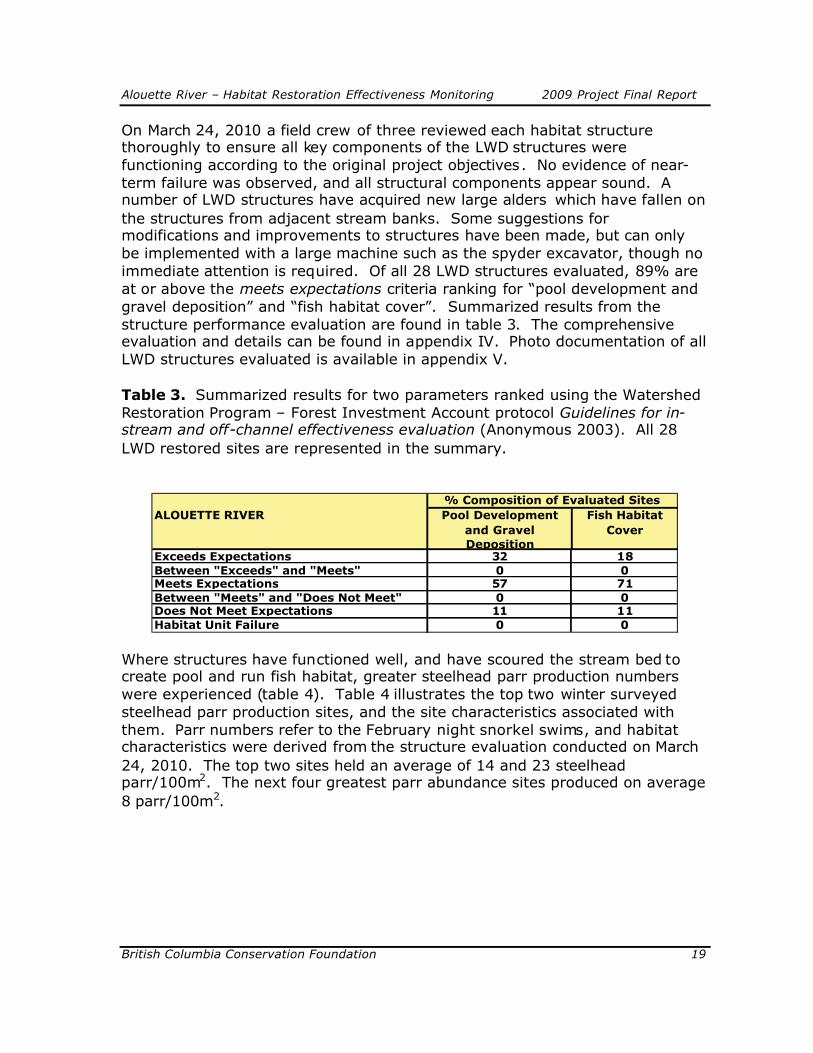
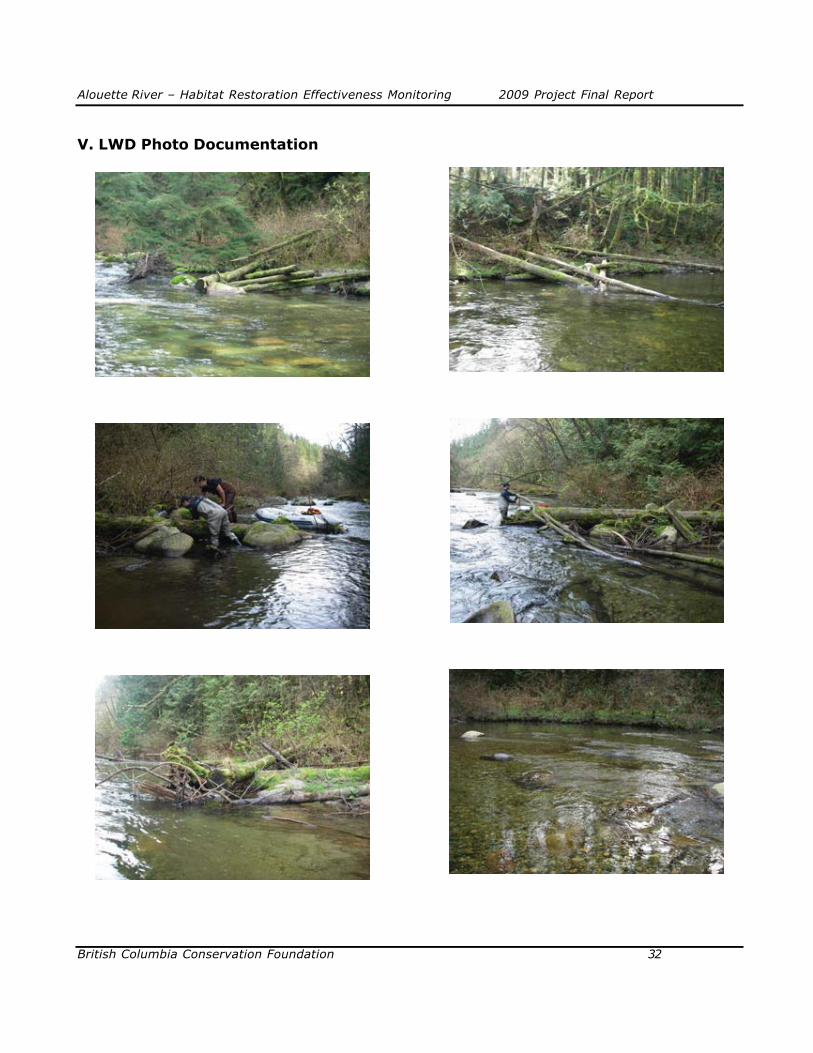
On March 24, 2010 a field crew of three reviewed each habitat structure thoroughly to ensure all key components of the LWD structures were functioning according to the original project objectives. No evidence of near-term failure was observed, and all structural components appear sound. A number of LWD structures have acquired new large alders which have fallen on the structures from adjacent stream banks. Some suggestions for modifications and improvements to structures have been made, but can only be implemented with a large machine such as the spyder excavator, though no immediate attention is required. Of all 28 LWD structures evaluated, 89% are at or above the meets expectations criteria ranking for “pool development and gravel deposition” and “fish habitat cover”. Summarized results from the structure performance evaluation are found in table 3. The comprehensive evaluation and details can be found in appendix IV. Photo documentation of all LWD structures evaluated is available in appendix V.
Table 3. Summarized results for two parameters ranked using the Watershed Restoration Program – Forest Investment Account protocol Guidelines for in-stream and off-channel effectiveness evaluation (Anonymous 2003). All 28 LWD restored sites are represented in the summary.
ALOUETTE RIVER Pool Development and Gravel Deposition
Fish Habitat Cover
Exceeds Expectations 32 18Between "Exceeds" and "Meets" 0 0Meets Expectations 57 71Between "Meets" and "Does Not Meet" 0 0Does Not Meet Expectations 11 11Habitat Unit Failure 0 0
% Composition of Evaluated Sites
Where structures have functioned well, and have scoured the stream bed to create pool and run fish habitat, greater steelhead parr production numbers were experienced (table 4). Table 4 illustrates the top two winter surveyedsteelhead parr production sites, and the site characteristics associated with them. Parr numbers refer to the February night snorkel swims, and habitat characteristics were derived from the structure evaluation conducted on March24, 2010. The top two sites held an average of 14 and 23 steelhead parr/100m2. The next four greatest parr abundance sites produced on average 8 parr/100m2.

Alouette River – Habitat Restoration Effectiveness Monitoring 2009 Project Final Report
British Columbia Conservation Foundation 20
Table 4. Top two highest steelhead parr production sites (winter survey).Averaged water depths at these sites, as well as the average water depths of all evaluated sites are presented.
St Parr/100m2 Mean Max. Apex Inner "V"
14 0.50 0.85 0.85 0.6523 0.40 0.80 0.80 0.40
Avg. of top 2 sites 0.45 0.83 0.83 0.53Avg. measured depths for all 28 restored sites 0.43 0.81 0.76 0.45
Water Depths (m)
6. DiscussionBiological AssessmentResults following this second year of the Alouette River evaluation areencouraging, and show high juvenile salmonid use of the wood restored sitesby salmonids, though more evident for juvenile coho.
In similar effectiveness monitoring studies that BCCF is conducting elsewhere,juvenile steelhead abundance typically increases at restored sites during winter seasons, whereas coho abundance is greatest during the summer months(Bigsby 2009). Therefore, non-response of coho observed in the Alouette study during the winter period is consistent with distribution patterns seen inother systems such as the Seymour River; although the differential between summer and winter abundance for coho is much more pronounced in the Alouette study. This reduction of coho fry presence in the mainstem wasobserved in all survey site types, within the summer and winter periods. A sum of fish presence per 100m2, of all site types, between summer and winter use, showed a reduction from 454/100m2 to 22/100m2, respectively. A steelhead parr abundance of 4/100m2 was less than half of the summer abundance of 9/100m2 accounted for at LWD restored sites. The totalsteelhead production, including all age classes, for treated and control sites during the winter night-time survey, was 10 and 6 steelhead/100m2,respectively. This equates to a 62% preference towards the wood restored sites versus the control.
The lack of recruitment by steelhead in the LWD structures during the winter months is unlike the patterns that have been seen in other studied river systems such as the Seymour River, and Silverhope Creek. Since 2006, both the Seymour River and Silverhope Creek have been surveyed for fish abundance, with identical methodology to that of the Alouette River. Seymour

Alouette River – Habitat Restoration Effectiveness Monitoring 2009 Project Final Report
British Columbia Conservation Foundation 21
River results from a summer 2006 evaluation indicate a steelhead parr preference to wood treated sites of 94% relative to control sites. Similarresults were experienced in the summer of 2007 and 2008. Survey results from summer swims on the Silverhope Creek show a 92% preference of wood treated sites to that of control sites (Bigsby 2009).
In a winter 2006 study on the Seymour River, 53 fish versus 9 fish per unit area were observed in wood treated, and control sites respectively. This equates to an 85% preference towards the wood restored sites versus the control. In a winter 2008 study on the Silverhope Creek, 163 fish versus 95 fish per unit area were observed in wood treated, and control sites respectively.This equates to a 63% preference towards the wood restored sites versus the control. In a winter 2010 study on the Silverhope Creek, 50 fish versus 11 fish per unit area were observed in wood treated, and control sites respectively.This equates to an 82% preference towards the wood restored sites versus the control. Fish abundance estimates in the winter Silverhope study include all steelhead age classes, including fry.
A passive flow regime through dam operations and impoundment of waters from the upper watershed may be playing a significant role in the spatial distribution patterns of juvenile salmonids in the Alouette River.
Physical Assessment
The LWD structural integrity and habitat performance evaluation has providedstrong indications that the wood structures are performing moderately well.Significant “habitat cover” is being produced in the project study areas. Nostructural failure indications were evident.
One issue which was noted during the evaluation was a high degree of fine sediment accumulation amongst the majority of LWD structures. This accumulation has, for the time, limited the development of maximum habitatcapacity. Some suggestions as to why this may be occurring include: upstream stream bank failure, or BC Hydro comptroller flow release regime.Approximately 4 km upstream from this restored reach is a tributary, Mudd Creek, which frequently releases large volumes of sediment from stream bank failure. Sediments from the failure zone flow into the mainstem Alouette River, causing high turbidity and sediment deposition. Both, Fisheries and Oceans Canada and BC Hydro have attempted to curtail this issue by constructing a settling pond that restricts this input from entering the Alouette River during moderate events, though severe events appear to be un-manageable with the current design. Sediment in-filing appears to have detracted from positive fish response results observed on other studied rivers such as, Seymour River, and Silverhope Creek.

Alouette River – Habitat Restoration Effectiveness Monitoring 2009 Project Final Report
British Columbia Conservation Foundation 22
Adverse effects from sediment accumulation amongst the LWD structures mayalso be caused by a non-natural river hydrograph. Regulation of discharge moderates the peak flows that would typically transport the deposited finesfrom the restored sites. We anticipate though, that the fish use results will improve over time as stream characteristics and fish habitat develops due to the exposure to the natural elements, such as large floods . The negative roleof sedimentation on LWD sites, and importance of implementing wood structures that are true representatives of natural log jam templates (ie. situated where stream bed scouring is favourable) should be installed to achieve the greatest fish production results. Conservative LWD structure designs will produce only marginal/moderate fish response results.
As the adverse effects of climate change continue to impair fish habitats through severe flood events, and reduced base flows, the restoration of streamand ecosystem function will play an integral role in sustaining salmonids. Fielddata collected during this project in conjunction with other watershed studies will also help us better understand juvenile salmonid survival strategies which can lead to improved restoration project designs in the future.
7. Recommendations
As stated in the 2006 final completion report for this restoration project, aminimum of three years of LWD evaluation is suggested following theimplementation of the project. That would suggest a final evaluation year, being 2009/2010. In addition to a LWD routine annual inspection, review of the structures should follow a flushing flow release by BC Hydro. Therefore, aline of communication between BC Hydro and the proponent of this project, BC Ministry of Environment - Fish and Wildlife branch staff should remain open to ensure this is accomplished. A simple, standardized contact procedure may be valuable for both interested parties.
Based on findings from the habitat review, obvious fine particulate sediment deposition is occurring amongst the LWD structures. In a gravel rich river system like the Alouette, wood structure placement should have generatedgreater stream bed scouring, and hence improved quality and quantity of pool habitat. This is unfortunately not the case. A review, following flushing flows should be carried-out to determine whether fine sediment is being transported out of the systems effectively and whether modifications are required to the BCHydro flushing flow discharge regime.
A field reconnaissance should be conducted on the tributary Mudd Creek to determine the extent and impact of the sediment input to the Alouette aquatic ecosystem. Currently habitat is being degraded due to heavy fine particulates,

Alouette River – Habitat Restoration Effectiveness Monitoring 2009 Project Final Report
British Columbia Conservation Foundation 23
and a source should be verified, and acted upon. Further steps may involve contracting a geotechnical engineer to review and prescribe treatment to rehabilitate the site entirely.
It is common for restoration projects to receive a second habitat restorationtreatment, or at minimum, structure modifications to improve the habitatperformance. The first phase of a restoration project puts stream habitat development into progression, and in doing so, new opportunities arise for future habitat development. To determine where these new improvementsshould be proposed, a post-construction habitat assessment using the originalFHAP (Fish Habitat Assessment Procedure) stream assessment methodology could be re-applied to the restored reach. Not only will new habitat enhancement opportunity be identified, but a pre and post-comparison of the current restoration work can be made. This is one of the highest levels of habitat restoration effectiveness monitoring, though not overly common by restoration practitioners due to limited time and budgets. Slaney (2006) states, that an efficient means to obtain rigorous routine-level data is to repeat the FHAP survey (Johnston and Slaney 1996), to detect restoration-inducedchanges in percentages of habitat unit types, LWD frequency and cover features. As with the construction of the 2006 restoration project, co-fundingcould be sought to accomplish this activity in the future.
8. Acknowledgements
This project was co-funded through BC Hydro Bridge Coastal Fish and WildlifeRestoration Program ($6000.00).
Other financial and in-kind partners included: Living Rivers GeorgiaBasin/Vancouver Island; Fraser Salmon and Watersheds Program; CanadaSummers Job Subsidy; and the BC Ministry of Environment, totalling $41,202.
All field assessments were conducted by BC Conservation Foundation fisheries technicians, and summer assistance from a summer student co-funded by the Canada Summers Job Subsidy. Thanks to, Geoff Clayton and crew at the Alouette River Management Society (ARMS) for supporting this project. An ARMS staff member, who is also a member of the Katzie First Nations, assisted BCCF with the LWD structural assessment component. This attendance also provided a mentoring opportunity for this individual.
Thanks to Greg Wilson, Ministry of Environment fisheries biologist, for assisting with the acquisition of funds to carry-out this project and technical expertise in the development and implementation of this monitoring program.

Alouette River – Habitat Restoration Effectiveness Monitoring 2009 Project Final Report
British Columbia Conservation Foundation 24
Special thanks to Pat Slaney, fisheries scientist, for his role in developing the effectiveness monitoring program, and assisting in implementation of the field project on the Alouette River and all other river systems that are being studied.
Alouette River – Habitat Restoration Effectiveness Monitoring 2009 Project Final Report
British Columbia Conservation Foundation 25
9. References
Anonymous, 2003. Guidelines for instream and off-channel routine effectiveness evaluation. Province of BC Ministry of Forests Forest Investment Account (FIA), Victoria, BC:34p.
Bigsby, A. 2009. Restoration Effectiveness: monitoring the use of restored large wood habitat by juvenile steelhead (oncorhynchus mykiss) and coho (oncorhynchus kisutch) in four south coast British Columbia rivers. Prepared for: BC Conservation Foundation.
Hryhorczuk, C. 2006. South Alouette River Fish Habitat Restoration Project, 2006. Prepared for BC Hydro – Bridge Coastal Restoration Program.
Miyazaki, K. 2008. Water Temperatures of the Alouette, Capilano, Coquihallaand Seymour Rivers and Silverhope Creek. British Columbia ConservationFoundation. Surrey B.C. Report # 02-2008.
Roni, P., and T.P. Quinn. 2001. Density and Size of Juvenile Salmonids in Response to Placements of Large Woody Debris in Western Oregon and Washington Streams. Canadian Journal of Fisheries and Aquatic Sciences. 58:686-693.
Roni, P. 2005. Monitoring Stream and Watershed Restoration. American Fisheries Society special publication. 350p. 25
Slaney, P.A. 2006. An Effectiveness Monitoring Guide for Stream Restoration Conducted for Greater Georgia Basin Steelhead Recovery. Draft.
Slaney, P.A., C. Hryhorczuk, and A. Bigsby, 2005. Habitat Assessments and Restoration Prescriptions for the Corrections Reach of the Alouette River. BCRP Project #05.AL.01
Ward, B. R. and P.A. Slaney. 1988. Life history and smolt-to-adult survival of Keogh River steelhead trout (Salmo gaidneri) and the relationship to smolt size. Canadian Journal of Fisheries and Aquatic Sciences 44:1110-1122.

Alouette River – Habitat Restoration Effectiveness Monitoring 2009 Project Final Report
British Columbia Conservation Foundation 26
AppendicesI. Financial Statement II. Performance Measures-Actual OutcomesIII. Confirmation of BCRP Recognition IV. LWD Evaluation ResultsV. LWD Photo Documentation

Alouette River – Habitat Restoration Effectiveness Monitoring 2009 Project Final Report
British Columbia Conservation Foundation 27
I. Financial StatementProject #09.ALU.03
BUDGET ACTUALBCRP Other BCRP Other
INCOME
Total Income by Source
6000.00 29500.00 6000.00 35202.04
Grand Total Income(BCRP + other)
35500.00 41202.04
EXPENSESNote: Expenses must be entered as negative numbers (e.g. – 1000, etc.) in order for the formulas to calculate correctly.
Project PersonnelWages 4645.00 21355.00 4906.71 24841.43Consultant Fees 1649.88
Materials & EquipmentEquipment Rental 190.00 810.00 420.00 475.44Materials Purchased 270.00 1325.00 63.71 637.55Travel Expenses 1550.00 59.60 2749.00Permits
Drysuit repair100.00
Fuel 200.00 800.00 0 681.78½ GST 1.48 93.90
AdministrationOffice SuppliesPhotocopies & printing 150.00 630.00 3.50 61.73PostageAdmin fees 545.00 3030.00 545.00 3911.33
Total Expenses 6000.0029500.00 6000.00 35202.04
Grand Total Expenses(BCRP + other)
35500.00 41202.04
BALANCE(Grand Total Income –Grand Total Expenses)
The budget balance should equal $0
0
The actual balance might not equal $0*
0
* Any unspent BCRP financial contribution to be returned to: BC Hydro, BCRP6911 Southpoint Drive (E16)Burnaby, BC V3N 4X8ATTENTION: SCOTT ALLEN

Alouette River – Habitat Restoration Effectiveness Monitoring 2009 Project Final Report
British Columbia Conservation Foundation 28
II. Performance Measures-Actual OutcomesProject #09.ALU.03
Est
uari
ne
In-S
trea
mH
abitat
–
Main
stre
a m
In-s
trea
mH
abitat
–
Tri
buta
ry
Rip
aria
n
Res
ervo
irShore
line
Com
ple
xes
Riv
eri
ne
Low
land
Dec
iduous
Low
land
Conifero
us
Upla
nd
Wetland
Fish passage technologies
Area of habitat made available to target species
Drawdown zone revegetation/stabilization
Area turned into productive habitat
Wildlife migration improvement
Area of habitat made available to target species
Prevention of drowning of nests, nestlings
Area of wetland habitat created outside expected flood level (1:10 year)
Habitat conserved – general
Functional habitat conserved/replaced through acquisition and mgmt
Functional habitat conserved by other measures (e.g. riprapping)
Designatedrare/specialhabitat
Rare/specialhabitat protected
Artificial gravel recruitment
Area of stream habitat improved by gravel plmt.
Artificial wood debris recruitment
Area of stream habitat improved by LWD plcmt
Monitorjuvenile st, and co
1550 m2
Small-scalecomplexing in existing habitats
Area increase in functional habitat throughcomplexing
Monitorjuvenile st, and co
50 m2
Prescribed burns or other upland habitatenhancement for wildlife
Functional area of habitat improved
New Habitat created
Functional area created
Performance Measures – Target OutcomesProject Type Primary Habitat
BenefitTargeted of Project (m
2)
PrimaryTargetSpecies
Habitat (m2)
Impact Mitigation
Habitat Conservation
Maintain or Restore Habitat forming process
Habitat Development

Alouette River – Habitat Restoration Effectiveness Monitoring 2009 Project Final Report
British Columbia Conservation Foundation 29
III. Confirmation of BCRP Recognition
Recently installed project sign on the grounds of the River’s Heritage Centre (Alouette River Management Society).
A future goal is to profile the results of the five year fish response study to LWD placement on interpretative signage at public locations such as at fish hatcheries, and regional parks. Currently, interpretative signs typically express the role of wood in rivers as being “important”, though no quantitative value can be attached to illustrate this relationship. Interim results from this study (2005-08) show that wood availability correlates to an approximately four-fold increase in fish numbers contrasted to sites void of wood. Presenting this technical information in a non-technical manner to the public can be extremely convincing for both young (future stewards of the ecosystem) and old (“old-school mentality”). It may provide an opportunity to influence human perspectives regarding the role of wood in rivers, and have individuals adopt a more environmentally responsible behaviour. We anticipatethat a sign template and sign fabrication will be developed in 2011, following the analysis of the entire spatial and temporal data set which has been collected since 2005.
BCCF crew members attended and presented at two local stakeholder groupworkshops. On September 30, 2009 a public presentation with PowerPoint media specifically addressed the Alouette River juvenile salmonid snorkel survey results toparticipants of the “Lower Fraser Coho Conservation and Enhancement Initiative: Pulling Together II”. In attendance, at the Musqueam Salish Community Hall, were government, First Nations, industry, stewards and community members.
On February 3, 2010, a PowerPoint presentation was developed and presented to the “Kingfishers Rod and Gun Club”. This group has been instrumental in supporting our Steelhead Recovery Program, both in a volunteer capacity, as well as through financial contributions. Effectiveness monitoring data results collected during the juvenile salmonid abundance study component were presented.
Alo
uet
te R
iver
– H
abitat
Rest
ora
tion E
ffect
iveness
Monitori
ng
2009 P
roje
ct F
inal
Rep
ort
Bri
tish
Colu
mbia
Conse
rvation F
oundation
30
IV.LW
D E
valu
ati
on
Resu
lts
Gen
eral
Info
rmat
ion
Proj
ect I
nfor
mat
ion
Page
1 o
f 2M
aint
enan
ce S
ign-
off
Eval
uatio
n In
form
atio
n
Bank side
Site ID #
Structure Type
Site Objective
Pool/deposition
Stream bank Protection
Stream Cover
Mean Depth (m)
Max Depth (m)
Apex Depth (m)
Inner "v" Depth (m)
Adequate Fastening Components (epoxy, clamps, farmers eye,
dogs)
Adequate Cable Attachments
Adequate Ballast/tree support
Evidence of Structure Shifting
Suitable Flow Through
Potential Hazards
MaintenanceRecommendations
RB
0m1
- TrS
Com
plex
ity/d
epth
3--
----
30.
500.
800.
750.
55Y
YY
NY
NN
RB
14m
1 - T
rSC
ompl
exity
/dep
th3
----
--3
0.40
0.85
0.75
0.40
YY
YN
YN
NR
B39
m1
- TrS
Com
plex
ity/d
epth
3--
----
30.
400.
800.
600.
70Y
YY
NY
NN
RB
90m
1 - T
rSC
ompl
exity
/dep
th2
----
--2
0.25
0.85
0.85
0.05
YY
YN
YN
NLB
102m
1 - T
rSC
ompl
exity
/dep
th3
----
--3
0.50
0.85
0.85
0.65
YY
YN
YN
NLB
130m
1 - T
rSC
ompl
exity
/dep
th3
----
--3
0.35
0.90
0.80
0.55
YY
YN
YN
NLB
183m
1 - T
rSC
ompl
exity
/dep
th4
----
--3
0.70
0.95
0.70
0.80
YY
YCN
YN
Yc
LB20
4m1
- TrS
Com
plex
ity/d
epth
4--
----
40.
600.
900.
900.
70Y
YY
NY
NN
RB
325m
1 - T
rSC
ompl
exity
/dep
th3
----
--3
0.40
0.80
0.80
0.20
YY
YN
YN
NR
B35
5m1
- J h
ook
Com
plex
ity3
----
--3
0.40
1.00
1.00
----
--Y
YY
NY
NN
RB
387m
1 - T
rSC
ompl
exity
/dep
th3
----
--3
0.25
0.65
0.65
0.05
YY
YN
YN
NR
B41
3mS
LC
ompl
exity
1--
----
20.
300.
40--
----
----
--Y
YY
NY
NN
RB
457m
PS
Com
plex
ity2
----
--3
0.30
0.60
----
----
----
YY
YN
YN
NLB
519m
1 - T
rSC
ompl
exity
/dep
th3
----
--3
0.40
0.95
0.95
0.10
YY
YN
YN
NLB
636m
1 - T
rSC
ompl
exity
/dep
th4
----
--4
0.40
0.80
0.80
0.60
YY
YN
YN
N
Ref
eren
ce P
t. us
ed fo
r Site
ID#:
Allc
o P
ark
Phys
ical
Ove
rall
Wea
ther
: Sun
ny (n
o re
cent
pre
cipi
tatio
n)W
ater
Gua
ge/le
vel:
Dat
e:N
ame:
REE
Inte
rval
: 3rd
REE
revi
ew (2
010)
Oth
er P
roje
ct C
ompo
nent
s:
Dat
e: M
arch
24,
201
0Su
rvey
Cre
w: C
ory
Hry
horc
zuk/
Dav
e H
arpe
r/Ric
hard
Moo
dy(K
FN)
Wat
ersh
ed: A
loue
tte
Pro j
ect N
ame:
Sou
th A
loue
tte L
WD
and
Bou
lder
Res
tora
tion
Proj
ect D
ate:
Sep
tem
ber,
2006
Asse
ssm
ent/P
resc
riptio
n R
epor
t Ref
eren
ce/D
ate:
Hab
itat A
sses
s an
d R
esto
ratio
n P
resc
riptio
ns fo
r the
Cor
rect
ions
Rea
ch o
f the
Alo
uette
Riv
er /
Oct
200
5Su
b-W
ater
shed
: Sou
th A
loue
tte R
iver

Alo
uet
te R
iver
– H
abitat
Rest
ora
tion E
ffect
iveness
Monitori
ng
2009 P
roje
ct F
inal
Rep
ort
Bri
tish
Colu
mbia
Conse
rvation F
oundation
31
Gen
eral
Info
rmat
ion
Proj
ect I
nfor
mat
ion
Page
2 o
f 2M
aint
enan
ce S
ign-
off
Eval
uatio
n In
form
atio
n
Bank side
Site ID #
Structure Type
Site Objective
Pool/deposition
Stream bank Protection
Stream Cover
Mean Depth (m)
Max Depth (m)
Apex Depth (m)
Inner "v" Depth (m)
Adequate Fastening Components (epoxy, clamps, farmers eye,
dogs)
Adequate Cable Attachments
Adequate Ballast/tree support
Evidence of Structure Shifting
Suitable Flow Through
Potential Hazards
MaintenanceRecommendations
LB85
6m1
- TrS
Com
plex
ity/d
epth
3--
----
30.
250.
650.
600.
10Y
YY
NY
NN
RB
877m
SL
Com
plex
ity4
----
--4
0.35
0.60
0.50
----
--Y
YY
NY
NN
LB88
6m1
- TrS
Com
plex
ity/d
epth
3--
----
30.
350.
800.
800.
60Y
YY
NY
NN
RB
895m
SL
Com
plex
ity4
----
--3
0.45
0.90
----
----
----
YY
YN
YN
NR
B94
2mS
LC
ompl
exity
4--
----
30.
901.
15--
----
----
--Y
YY
NY
NN
LB95
6m1
- J h
ook
Com
plex
ity3
----
--2
0.45
0.80
0.65
----
--Y
YY
NY
NN
RB
956m
1 - T
rSC
ompl
exity
/dep
th3
----
--4
0.50
1.05
1.05
0.50
YY
YCN
YN
NR
B10
16m
1 - T
rSC
ompl
exity
/dep
th3
----
--3
0.30
0.65
0.65
0.40
YY
YN
YN
NM
ID10
16m
BCH
ydra
ulic
var
iabi
lity
Goo
d--
----
Goo
dLB
1016
m1
- J h
ook
Com
plex
ity3
----
--3
0.50
0.65
0.50
----
--Y
YY
NY
NN
LB11
36m
1 - T
rSC
ompl
exity
/dep
th4
----
--3
0.50
0.95
0.95
0.55
YY
YN
YN
NR
B11
39m
1 - T
rSC
ompl
exity
/dep
th3
----
--3
0.35
0.90
0.75
-0.0
4Y
YY
NY
NN
RB
1154
m1
- TrS
Com
plex
ity/d
epth
4--
----
30.
400.
800.
800.
40Y
YY
NY
NN
LB11
72m
1 - T
rSC
ompl
exity
/dep
th4
----
--4
0.50
0.80
0.60
0.60
YY
YN
YN
N12
02m
Mik
e C
k.
Dat
e: M
arch
24,
201
0Su
rvey
Cre
w:
Cor
y H
ryho
rczu
k/D
ave
Har
per/R
icha
rd M
oody
(KFN
)W
ater
shed
: Alo
uette
Pro j
ect N
ame:
Sou
th A
loue
tte L
WD
and
Bou
lder
Res
tora
tion
Proj
ect D
ate:
Sep
tem
ber,
2006
Asse
ssm
ent/P
resc
riptio
n R
epor
t Ref
eren
ce/D
ate:
Hab
itat A
sses
s an
d R
esto
ratio
n P
resc
riptio
ns fo
r the
Cor
rect
ions
Rea
ch o
f the
Alo
uette
Riv
er /
Oct
200
5Su
b-W
ater
shed
: Sou
th A
loue
tte R
iver
Ref
eren
ce P
t. us
ed fo
r Site
ID#:
Allc
o P
ark
Phy
sica
lO
vera
ll
Wea
ther
: Sun
nyW
ater
Gua
ge/le
vel:
Dat
e:N
ame:
REE
Inte
rval
: 3rd
RE
E re
view
(201
0)O
ther
Pro
ject
Com
pone
nts:
Alouette River – Habitat Restoration Effectiveness Monitoring 2009 Project Final Report
British Columbia Conservation Foundation 32
V. LWD Photo Documentation

Alouette River – Habitat Restoration Effectiveness Monitoring 2009 Project Final Report
British Columbia Conservation Foundation 33

Alouette River – Habitat Restoration Effectiveness Monitoring 2009 Project Final Report
British Columbia Conservation Foundation 34

Alouette River – Habitat Restoration Effectiveness Monitoring 2009 Project Final Report
British Columbia Conservation Foundation 35

Alouette River – Habitat Restoration Effectiveness Monitoring 2009 Project Final Report
British Columbia Conservation Foundation 36

Alouette River – Habitat Restoration Effectiveness Monitoring 2009 Project Final Report
British Columbia Conservation Foundation 37