Embed Size (px)
Citation preview

ALOS Global Digital Surface Model (DSM)
ALOS World 3D-30m (AW3D30) Version 2.2
Product Description
April 2019
Earth Observation Research Center Japan Aerospace Exploration Agency
ALOS Global Digital Surface Model (DSM) “ALOS World 3D-30m (AW3D30) Ver.2.2” Product Description
i
Table of Contents
1. Overview ................................................................................................................................ 1
2. AW3D30 dataset .................................................................................................................... 2
2.1. File component ............................................................................................................... 2
2.2. Header information file format ........................................................................................ 3
2.3. Quality assurance information file format ....................................................................... 7
3. GeoTIFF product ................................................................................................................. 10
3.1. TIFF tag settings for GeoTIFF product ........................................................................ 10
3.2. GeoTIFF key settings for GeoTIFF product ................................................................. 11
4. References ........................................................................................................................... 11
5. Related URLs....................................................................................................................... 11
6. Point of contact .................................................................................................................... 12

ALOS Global Digital Surface Model (DSM) “ALOS World 3D-30m (AW3D30) Ver.2.2” Product Description
ii
Revision record
Version Date Chapter/
Table Contents of revision
1 2015/03/31 - First edition
1.1 2017/03/06 Chp.1 Addition of the explanation on the void-filling of DSM values in cloud and snow masked pixels
Chp.2.1/ Table 1
Format definition change of mask (MSK) file
Chp.2.3/ Table 3
Field addition to quality assurance information (QA) file
Chp.5 Chapter addition for references
2.1 2018/04/25 Chp.1 Addition of explanation on the void-filling of DSM
Chp.2.1/ Table1
Clarification of file composition contents of AW3D30
Chp.2.2/ Table 2
Field No.59~64, Clarification of title of the category.
Chp.2.2/ Table 2
Field No.80, Deletion description of MSK details.
Chp.2.3/ Table 3
Clarification of title of the category.
Chp.2.3/ Table 3
Addition of version of source product to QAI file
Chp.3.1/ Table 5
Correction of fluctuation of description
Chp.5 Addition of references
2.2 2019/04/09 Chp.1 Addition of v2.2 description
Chp.2 Correction for v2.2
Chp.5 Addition of reference URLs

ALOS Global Digital Surface Model (DSM) “ALOS World 3D-30m (AW3D30) Ver.2.2” Product Description
1
1. Overview
Since 2014, the Japan Aerospace Exploration Agency (JAXA) has proceeded the project to develop the
precise global digital 3D map “ALOS World 3D” (AW3D) *1 covering the global land areas through the use of
3 million scene archives acquired by the PRISM panchromatic stereo mapping sensor on the Advanced Land
Observing Satellite "DAICHI" (ALOS) operated from 2006 to 2011. The developed digital 3D map consists of
digital elevation model (DEM) or digital surface model (DSM) that can represent land terrains with approx. 5
meters in spatial resolution and orthorectified PRISM nadir look images. The digital 3D map have been utilized
in a wide variety of applications such as map development, damage prediction of natural disasters, and water
resource investigation.
In May 2015, JAXA released “ALOS World 3D-30m (AW3D30)”, that is a free global DSM dataset with a
horizontal resolution of approx. 30 meters mesh (1 arcsecond in latitude and longitude) converted from the
AW3D DSM dataset (5 meters mesh). In the version 1.1, released in March 2017, void values in the cloud and
snow pixels between 60 degrees North and 60 degrees South were filled with existing DEMs using the Delta
Surface Fill *2 method. In the version 2.1, released in April 2018, the source AW3D DSM has been upgraded
to version 2. Masks of the land water and low correlation pixels were also filled with existing DEMs in addition
to the cloud and snow pixels between 60 degrees North and 60 degrees South. In Japan area, filling was
carried out after updating coastline information. Note that only AVERAGE resampling product is provided in
version 2.1 since there is not much difference between AVERAGE and MEDIAN product that were contained
in version 1.1.
Version 2.2 released in April 2019 is an improved version of the northern region over 60 degrees north.
In this version, along with the complement of no-data or low-quality area, updating of coastline was also
performed.
We hope that this dataset will be widely used in scientific research, education, and new services that use
geospatial information.
*1: Chapter 4 References, 1) and 2)
*2: Chapter 4 References, 5)

ALOS Global Digital Surface Model (DSM) “ALOS World 3D-30m (AW3D30) Ver.2.2” Product Description
2
2. AW3D30 dataset
2.1. File component
A tile of this dataset covers the unit area of 1 degree latitude and longitude. The tile ID stands for the latitude
and longitude at lower-left (southwest) corner. For every tile, the set of data shown in Table is stored in a tar
archived and gzip compressed file.
Table 1: File component of AW3D30 dataset
File type Contents and details Notes
DSM file (DSM)
〈GeoTIFF
format〉
Height above sea level Signed 16 bits (Little endian) raster data Equirectangular projection, Spacing: 1 arcsec (approx. 30 m) DSM values are average over the range of 1 arcsec grid pixel
(Round off to the integer) Elevation (in meter) converted from the ellipsoidal height based on
ITRF97 and GRS80, using EGM96†1 geoid model
Value “-9999” is stored in void pixels Value “0m” is stored in sea pixels
†1: 5.URLs 1)
†2: Land water and low
correlation mask indicates the area with low correlation in the calculation of the source 5m resolution DSM. In the AW3D30 v2.1 and v2.2, the value was filled by other data sets. So this mask is applicable for v1.0 and v1.1.
†3: Based on the following
v1.0-v2.1 SWBD, GSHHG PRISM image (Japan area) v2.2 OpenStreetMap 5.URLs 2)-4)
†4: 5.URLs 5)
†5: 5.URLs 6)
†6: 5.URLs 7)
†7: 5.URLs 8)
†8: Inverse Distance
Weighted method 5.References 5)
Mask file (MSK) [GeoTIFF format]
Mask information 8 bits raster data Equirectangular projection, Spacing: 1 arcsec (approx. 30 m) Lower 1-2 bit: Valid/Invalid, Mask Information
(Cloud and snow, Land water and low correlation, Sea) Lower 3-8 bit: Elevation dataset used for the void-filling processing,
filled/not filled by IDW method
Details of the mask 0000 0000 (0x00): Valid 0000 0001 (0x01): Cloud and show mask (invalid) 0000 0010 (0x02): Land water and low correlation mask of the
source 5m DSM†2 (valid)
0000 0011 (0x03): Sea mask†3 (valid)
0000 0100 (0x04): GSI DTM 10m Mesh Data†4 (valid)
0000 1000 (0x08): SRTM-1 v3†5 (valid)
0000 1100 (0x08): PRISM DSM (valid)
0001 1100 (0x1C): ArcticDEM v2†6 (valid)
0001 1000 (0x18): ASTER GDEM v2†7 (valid)
1111 1100 (0xFC): applied IDW method†8 (gdal_fillnodata) (valid)
Stacking number file (STK) [GeoTIFF format]
Stack number of DSM scenes used to produce source AW3D DSM 8 bits raster data Equirectangular projection, Spacing: 1 arcsec (approx. 30 m) STK values are average over the range of 1 arcsec grid pixel
(Round off to the integer)
Header information file (HDR) [Text format]
Meta data about the product Derived from HDR file of the source 5m DSM
Table 2 for details
Quality assurance information file (QAI) [Text format]
Quality assurance information Added the information of 30m DSM to the source 5m DSM
Table 3 for details
List file (LST) [Text format]
List of Scene IDs used to produce source AW3D DSM ID, type, orbit number, RSP path/frame, stereo mode, observation
date
Only v2.1 and v2.2
ALOS Global Digital Surface Model (DSM) “ALOS World 3D-30m (AW3D30) Ver.2.2” Product Description
3
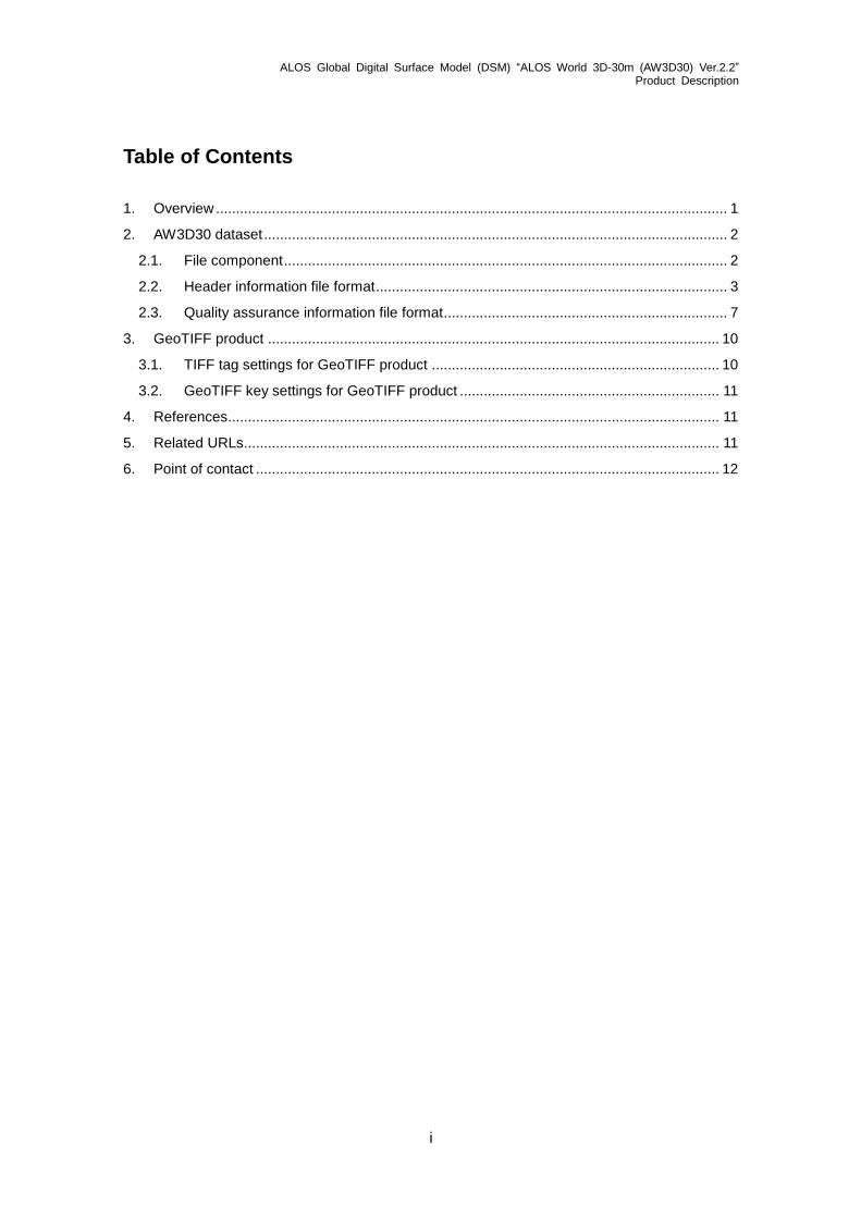
2.2. Header information file format
Table 2 shows the detailed items in the header information (HDR) file included in the AW3D30 dataset.
Table 2: Items in AW3D30 header information (HDR) file
Field No.
Description Number of Bytes
Start Byte
Position Type Note
Product Record Data Identifier
Field No.1-58
Product Information Product Identifier Details
Field No.1-10
1 Mesh ID = 'NNNNNNNNbbbbbbbb' 16 1 A16
2 DSM Product ID = 'AABBBCDEEbbbbbbb' AA : Satellite code = 'AL' BBB : Sensor code = 'PSM':PRISM C : Grid type = 'L': Lat-Lon D : Version of the source 5m DSM = 'A': 1, 'B': 2 EE : DSM grid spacing = '30': 30 m
16 17 A16
3 Product type = 'PSM-DSMbbbbbbbbb' 16 33 A16
4 Mesh code = 'NNNNNNNNbbbbbbbb' 16 49 A16
5 Satellite name = 'ALOSbbbb' (fixed) 8 65 A8
6 Sensor code = 'PSMbbbbb': PRISM 8 73 A8
7 Coordinates = 'LTLNbbbb': Lat-Lon 8 81 A8
8 DSM type = 'Abbb': Absolute 4 89 A4
9 DSM grid spacing (sec) = 'b1.00bbb' 8 93 A8
10 Blank (fixed) 28 101 A28
Subtotal 128
Mesh Information Mesh Identifier
Field No.11-35
11 Mesh upper-left line number = 'bNNNNN.N' 8 129 F8.1 Addresses correspondence to the corner of a pixel, not its center. Since each pixel/line integer value is assigned at pixel center, pixel/line number for four corners is described with real values.
12 Mesh upper-left column number = 'bNNNNN.N' 8 137 F8.1
13 Mesh upper-right line number = 'bNNNNN.N' 8 145 F8.1
14 Mesh upper-right column number = 'bNNNNN.N' 8 153 F8.1
15 Mesh lower-left line number = 'bNNNNN.N' 8 161 F8.1
16 Mesh lower-left column number = 'bNNNNN.N' 8 169 F8.1
17 Mesh lower-right line number = 'bNNNNN.N' 8 177 F8.1
18 Mesh lower-right column number = 'bNNNNN.N' 8 185 F8.1
19 Mesh upper-left latitude (deg.) = 'NNNNNNNN.NNNNNNN' (-90.0000000 - 90.0000000)
16 193 F16.7 Negative value for southern hemisphere
20 Mesh upper-left longitude (deg.) = 'NNNNNNNN.NNNNNNN' (-180.0000000 - 180.0000000)
16 209 F16.7 Negative value for west longitude
21 Mesh upper-right latitude (deg.) = 'NNNNNNNN.NNNNNNN' (-90.0000000 - 90.0000000)
16 225 F16.7 Negative value for southern hemisphere
22 Mesh upper-right longitude (deg.) = 'NNNNNNNN.NNNNNNN' (-180.0000000 - 180.0000000)
16 241 F16.7 Negative value for west longitude
23 Mesh lower-left latitude (deg.) = 'NNNNNNNN.NNNNNNN' (-90.0000000 - 90.0000000)
16 257 F16.7 Negative value for southern hemisphere
24 Mesh lower-left longitude (deg.) = 'NNNNNNNN.NNNNNNN' (-180.0000000 - 180.0000000)
16 273 F16.7 Negative value for west longitude
25 Mesh lower-right latitude (deg.) = 'NNNNNNNN.NNNNNNN' (-90.0000000 - 90.0000000)
16 289 F16.7 Negative value for southern hemisphere
26 Mesh lower-right longitude (deg.) = 'NNNNNNNN.NNNNNNN' (-180.0000000 - 180.0000000)
16 305 F16.7 Negative value for west longitude
27 Mesh upper-left map address X (km) = 'NNNNNNNN.NNNNNNN' (Northing for UTM)
16 321 F16.7 All blank for LTLN product
28 Mesh upper-left map address Y (km) = 'NNNNNNNN.NNNNNNN' (Easting for UTM)
16 337 F16.7
29 Mesh upper-right map address X (km) = 'NNNNNNNN.NNNNNNN' (Northing for UTM)
16 353 F16.7
ALOS Global Digital Surface Model (DSM) “ALOS World 3D-30m (AW3D30) Ver.2.2” Product Description
4
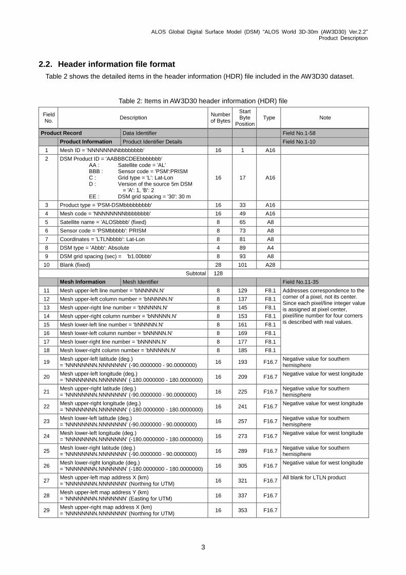
Table 2: Items in AW3D30 header information (HDR) file (continued)
Field No.
Description Number of Bytes
Start Byte
Position Type Note
30 Mesh upper-right map address Y (km) = 'NNNNNNNN.NNNNNNN' (Easting for UTM)
16 369 F16.7
31 Mesh lower-left map address X (km) = 'NNNNNNNN.NNNNNNN' (Northing for UTM)
16 385 F16.7
32 Mesh lower-left map address Y (km) = 'NNNNNNNN.NNNNNNN' (Easting for UTM)
16 401 F16.7
33 Mesh lower-right map address X (km) = 'NNNNNNNN.NNNNNNN' (Northing for UTM)
16 417 F16.7
34 Mesh lower-right map address Y (km) = 'NNNNNNNN.NNNNNNN' (Easting for UTM)
16 433 F16.7
35 Blank (fixed) 16 449 A16
Subtotal 336
Processing Information
Processing Details
Field No.36-58
Map Projection Map Projection Parameters
36 Coordinates = 'LTLNbbbb' 8 465 A8
37 PS origin latitude (deg.) = 'NNNNNNNN.NNNNNNN' 16 473 F16.7 All blank for LTLN product
38 PS origin longitude (deg.) = 'NNNNNNNN.NNNNNNN' 16 489 F16.7 All blank for LTLN product
39 PS reference latitude (deg.) = 'NNNNNNNN.NNNNNNN' 16 505 F16.7 All blank for LTLN product
40 PS reference longitude/ UTM central meridian (deg.) = 'NNNNNNNN.NNNNNNN'
16 521 F16.7 All blank for LTLN product
41 Hemisphere = 'bbbN':North / 'bbbS':South 4 537 A4
42 UTM zone no. = 'bbb1' - 'bb60' 4 541 I4 All blank for LTLN product
43 Angle between vertical axis of coordinates and true north direction (deg) = 'NNNNNNNN.NNNNNNN'
16 545 F16.7 At mesh center All blank for LTLN product
44 Blank (fixed) 32 561 A32
Subtotal 128
Datum Datum Parameters
45 ECR coordinates = 'ITRF97bbbbbbbbbb' 16 593 A16
46 Ellipsoid model = 'GRS80bbbbbbbbbbb' 16 609 A16
47 Equator radius of ellipsoid model (km) = 'NNNNNNNN.NNNNNNN'
16 625 F16.7
48 Polar radius of ellipsoid model (km) = 'NNNNNNNN.NNNNNNN'
16 641 F16.7
49 Inverse flattening (1/f) of ellipsoid model = 'NNNNNNNN.NNNNNNN'
16 657 F16.7
50 Blank (fixed) 48 673 A48
Subtotal 128
DSM Data DSM Data Parameters
51 Coordinates = 'LTLNbbbb' 8 721 A8 Same as field No.7
52 DSM type = 'Abbb': Absolute 4 729 A4 Same as field No.8
53 Vertical grid spacing (m)/(sec) = 'NNN.NNNb' 8 733 A8
54 Horizontal grid spacing (m)/(sec) = 'NNN.NNNb' 8 741 A8
55 Height resolution of DSM (m) = '1bbbbbbb' 8 749 I8
56 Height type = 'Ebbb': Ellipsoidal Height / 'Obbb': Orthometric Height
4 757 A4
57 Geoid data = 'XXXXXXXXXXXXXXXX' 'GSI-2000bbbbbbbb': Japan Geoid 2000 / 'NGA-EGM96bbbbbbb': EGM96
16 761 A16 All blank for height type 'E'
58 Blank (fixed) 8 777 A8
Subtotal 64

ALOS Global Digital Surface Model (DSM) “ALOS World 3D-30m (AW3D30) Ver.2.2” Product Description
5
Table 2: Items in AW3D30 header information (HDR) file (continued)
Field No.
Description Number of Bytes
Start Byte
Position Type Note
Quality Record Quality Information from the 5m DSM
Field No.59-64
59 Mask (00000000) rate = 'bNNN' % 4 785 I4 Right-aligned
60 Mask (00000001) rate = 'bNNN' % 4 789 I4
61 Mask (00000010) rate = 'bNNN' % 4 793 I4
62 Mask (00000011) rate = 'bNNN' % 4 797 I4
63
DSM data quality = 'bbbX' 'G': Good = 100 - 81 % (Rate of valid pixels) 'F': Fair = 80 - 51 % 'P': Poor = 50 - 0 %
4 801 A4
64 Blank 44 805 A44
Subtotal 64
Format Record Data Format Information
Field No.65-82
65 Header record length (byte) = 'bbbbNNNN' 8 849 I8 Variable header file size
66 Data column length (number of pixels for each line) = 'bbbNNNNN'
8 857 I8
67 Data line length (number of pixels for each column) = 'bbbNNNNN'
8 865 I8
68 Byte order = 'MSBbbbbb' / 'LSBbbbbb' (default) 8 873 A8
Subtotal 32
DSM Data Format DSM Data Format Structures
69 Number of bits for DSM 1 pixel (bit) = 'bb16' 4 881 I4
70 Number of pixels for DSM 1 data (pixel) = 'bbb1' 4 885 I4
71 Number of bytes for DSM 1 data (byte) = 'bbb2' 4 889 I4
72 Bit start for DSM 1 pixel (bit) = 'bbb0' 4 893 I4 0-15 bits per data
73
Bit end for DSM 1 pixel (bit) = 'bb15' DSM data settings 2 bytes (signed short) with a vertical accuracy of 1m
4 897 I4
0-15 bits per data
74 Number of DSM files = 'bbb1' (fixed) 4 901 I4
75 Blank (fixed) 8 905 A8
Subtotal 32
MSK Data Format MSK Data Format Structures
76 Number of bits for MSK 1 pixel (bit) = 'bbb8' 4 913 I4
77 Number of pixels for MSK 1 data (pixel) = 'bbb1' 4 917 I4
78 Number of bytes for MSK 1 data (byte) = 'bbb1' 4 921 I4
79 Bit start for MSK 1 pixel (bit) = 'bbb0' 4 925 I4 0-7 bits per data
80 Bit end for MSK 1 pixel (bit) = 'bbb7' 4 929 I4 0-7 bits per data
81 Number of MSK files = 'bbb1' (fixed) 4 933 I4
82 Blank (fixed) 40 937 A40
Subtotal 64
System Record Data Processing System Information
Field No.88-95
83
Processing date (JST) = 'YYYYMMDDbbbbbbbb' YYYY : Year MM : Month DD : Day
16 977 A16
84
Processing time (JST) = 'HHMMSSbbbbbbbbbb' HH : Hour MM : Minute SS : Second
16 993 A16
85 Processing country = 'JAPANbbbbbbbbbbb' 16 1009 A16
86 Processing organization = 'JAXAbbbbbbbbbbbb' 16 1025 A16
87 Processing facility = 'EORC-AGAPbbbbbbb' 16 1041 A16

ALOS Global Digital Surface Model (DSM) “ALOS World 3D-30m (AW3D30) Ver.2.2” Product Description
6
Table 2: Items in AW3D30 header information (HDR) file (continued)
Field No.
Description Number of Bytes
Start Byte
Position Type Note
88
Software version = 'VVV-RRR-YYYYMMDDbbbbbbbb' VVV : Version No. RRR : Release No. YYYY : Release year MM : Release month DD : Release date
24 1057 A24
89 DFCB revision = 'Abbb' - 'Zbbb' (26 types) 4 1081 A4
90 Blank (fixed) 20 1085 A20
Subtotal 128
Reserve Reserve
Field No.91
91 Blank (fixed) 4 1105 I4
Subtotal 4
Total 1108
ALOS Global Digital Surface Model (DSM) “ALOS World 3D-30m (AW3D30) Ver.2.2” Product Description
7
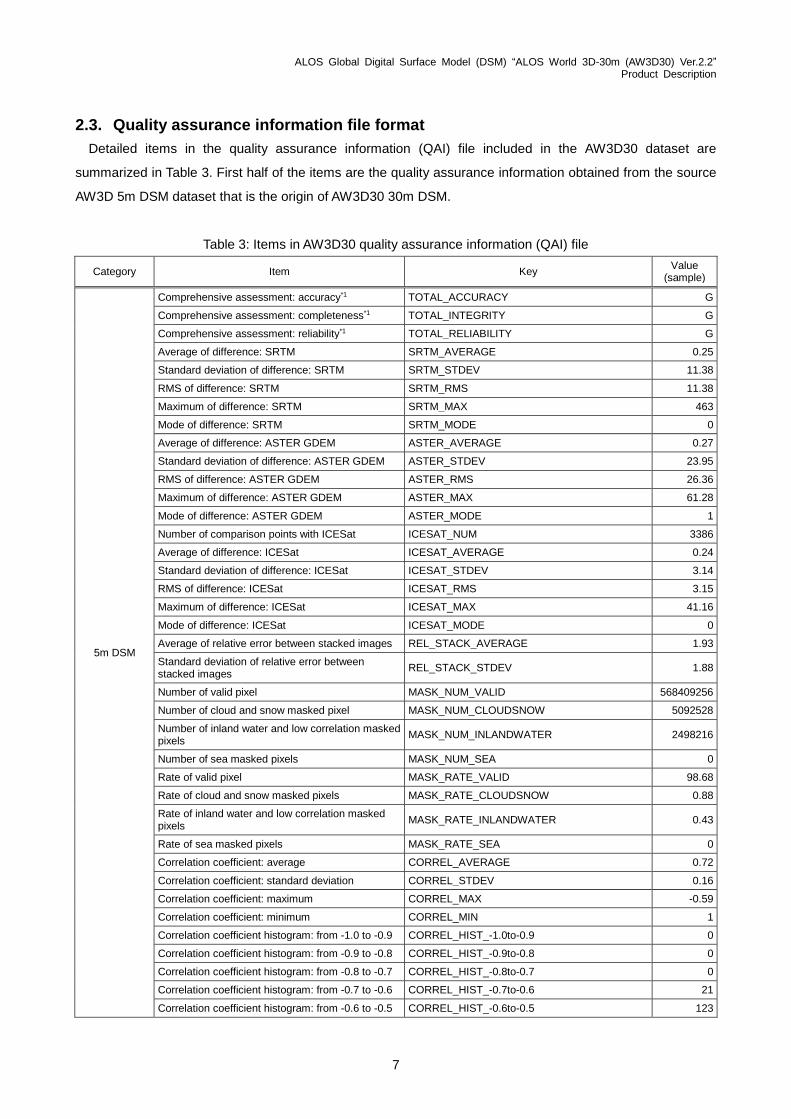
2.3. Quality assurance information file format
Detailed items in the quality assurance information (QAI) file included in the AW3D30 dataset are
summarized in Table 3. First half of the items are the quality assurance information obtained from the source
AW3D 5m DSM dataset that is the origin of AW3D30 30m DSM.
Table 3: Items in AW3D30 quality assurance information (QAI) file
Category Item Key Value
(sample)
5m DSM
Comprehensive assessment: accuracy*1 TOTAL_ACCURACY G
Comprehensive assessment: completeness*1 TOTAL_INTEGRITY G
Comprehensive assessment: reliability*1 TOTAL_RELIABILITY G
Average of difference: SRTM SRTM_AVERAGE 0.25
Standard deviation of difference: SRTM SRTM_STDEV 11.38
RMS of difference: SRTM SRTM_RMS 11.38
Maximum of difference: SRTM SRTM_MAX 463
Mode of difference: SRTM SRTM_MODE 0
Average of difference: ASTER GDEM ASTER_AVERAGE 0.27
Standard deviation of difference: ASTER GDEM ASTER_STDEV 23.95
RMS of difference: ASTER GDEM ASTER_RMS 26.36
Maximum of difference: ASTER GDEM ASTER_MAX 61.28
Mode of difference: ASTER GDEM ASTER_MODE 1
Number of comparison points with ICESat ICESAT_NUM 3386
Average of difference: ICESat ICESAT_AVERAGE 0.24
Standard deviation of difference: ICESat ICESAT_STDEV 3.14
RMS of difference: ICESat ICESAT_RMS 3.15
Maximum of difference: ICESat ICESAT_MAX 41.16
Mode of difference: ICESat ICESAT_MODE 0
Average of relative error between stacked images REL_STACK_AVERAGE 1.93
Standard deviation of relative error between stacked images
REL_STACK_STDEV 1.88
Number of valid pixel MASK_NUM_VALID 568409256
Number of cloud and snow masked pixel MASK_NUM_CLOUDSNOW 5092528
Number of inland water and low correlation masked pixels
MASK_NUM_INLANDWATER 2498216
Number of sea masked pixels MASK_NUM_SEA 0
Rate of valid pixel MASK_RATE_VALID 98.68
Rate of cloud and snow masked pixels MASK_RATE_CLOUDSNOW 0.88
Rate of inland water and low correlation masked pixels
MASK_RATE_INLANDWATER 0.43
Rate of sea masked pixels MASK_RATE_SEA 0
Correlation coefficient: average CORREL_AVERAGE 0.72
Correlation coefficient: standard deviation CORREL_STDEV 0.16
Correlation coefficient: maximum CORREL_MAX -0.59
Correlation coefficient: minimum CORREL_MIN 1
Correlation coefficient histogram: from -1.0 to -0.9 CORREL_HIST_-1.0to-0.9 0
Correlation coefficient histogram: from -0.9 to -0.8 CORREL_HIST_-0.9to-0.8 0
Correlation coefficient histogram: from -0.8 to -0.7 CORREL_HIST_-0.8to-0.7 0
Correlation coefficient histogram: from -0.7 to -0.6 CORREL_HIST_-0.7to-0.6 21
Correlation coefficient histogram: from -0.6 to -0.5 CORREL_HIST_-0.6to-0.5 123

ALOS Global Digital Surface Model (DSM) “ALOS World 3D-30m (AW3D30) Ver.2.2” Product Description
8
Table 3: Items in AW3D30 quality assurance information (QAI) file (continued)
Category Item Key Value
(sample)
5m DSM
Correlation coefficient histogram: from -0.5 to -0.4 CORREL_HIST_-0.5to-0.4 461
Correlation coefficient histogram: from -0.4 to -0.3 CORREL_HIST_-0.4to-0.3 1236
Correlation coefficient histogram: from -0.3 to -0.2 CORREL_HIST_-0.3to-0.2 4193
Correlation coefficient histogram: from -0.2 to -0.1 CORREL_HIST_-0.2to-0.1 15003
Correlation coefficient histogram: from -0.1 to 0.0 CORREL_HIST_-0.1to0.0 646970
Correlation coefficient histogram: from 0.0 to 0.1 CORREL_HIST_0.0to0.1 1699541
Correlation coefficient histogram: from 0.1 to 0.2 CORREL_HIST_0.1to0.2 5350540
Correlation coefficient histogram: from 0.2 to 0.3 CORREL_HIST_0.2to0.3 11789461
Correlation coefficient histogram: from 0.3 to 0.4 CORREL_HIST_0.3to0.4 30902088
Correlation coefficient histogram: from 0.4 to 0.5 CORREL_HIST_0.4to0.5 65110659
Correlation coefficient histogram: from 0.5 to .0.6 CORREL_HIST_0.5to0.6 111734882
Correlation coefficient histogram: from 0.6 to 0.7 CORREL_HIST_0.6to0.7 142957951
Correlation coefficient histogram: from 0.7 to 0.8 CORREL_HIST_0.7to0.8 129144617
Correlation coefficient histogram: from 0.8 to 0.9 CORREL_HIST_0.8to0.9 69039487
Correlation coefficient histogram: from 0.9 to 1.0 CORREL_HIST_0.9to1.0 24940
Number of stacking: average STACK_AVERAGE 3.76
Number of stacking: standard deviation STACK_STDEV 1.19
Number of stacking: Minimum STACK_MIN 0
Number of stacking: Maximum STACK_MAX 11
Pre-processing Information on
void-filling (Japanese
island)
Number of valid pixel InsPSM10M_MASK_NUM_VALID 568409256
Number of cloud and snow mask pixel InsPSM10M_MASK_NUM_CLOUDSNOW 5092528
Number of inland water and low correlation mask pixels
InsPSM10M_MASK_NUM_INLANDWATER 2498216
Number of sea mask pixels InsPSM10M_MASK_NUM_SEA 0
Rate of valid pixel InsPSM10M_MASK_RATE_VALID 98.68
Rate of cloud and snow mask pixels InsPSM10M_MASK_RATE_CLOUDSNOW 0.88
Rate of inland water and low correlation mask pixels
InsPSM10M_MASK_RATE_INLANDWATER 0.43
Rate of sea mask pixels InsPSM10M_MASK_RATE_SEA 0
30m DSM before void-
filling
Number of valid pixel DegradeAVE_MASK_NUM_VALID 15789146
Number of cloud and snow mask pixel DegradeAVE_MASK_NUM_CLOUDSNOW 141459
Number of inland water and low correlation mask pixels
DegradeAVE_MASK_NUM_INLANDWATER 69394
Number of sea mask pixels DegradeAVE_MASK_NUM_SEA 0
Rate of valid pixel DegradeAVE_MASK_RATE_VALID 98.68
Rate of cloud and snow mask pixels DegradeAVE_MASK_RATE_CLOUDSNOW 0.88
Rate of inland water and low correlation mask pixels
DegradeAVE_MASK_RATE_INLANDWATER 0.43
Rate of sea mask pixels DegradeAVE_MASK_RATE_SEA 0
Information on 30m DSM void-filling
Number of cloud and snow mask pixel (after void-filling)
GapFillAVE_MASK_NUM_CLOUDSNOW 0
Number of pixels filled with GSI 10m DEM GapFillAVE_MASK_NUM_FILLED_GSI10 0
Number of pixels filled with SRTM-1 Version 3 GapFillAVE_MASK_NUM_FILLED_SRTM-1_V3 141459
Number of pixels filled with PRISM DSM GapFillAVE_MASK_NUM_FILLED_PSM 0
Number of pixels filled with ArcticDEM_v2 GapFillAVE_MASK_NUM_FILLED_ArcticDEM_v2 0
Number of pixels filled with ASTER GDEM GapFillAVE_MASK_NUM_FILLED_GDEM_v2 0
Number of pixels filled with IDW method GapFillAVE_MASK_NUM_FILLED_FillNoData 0
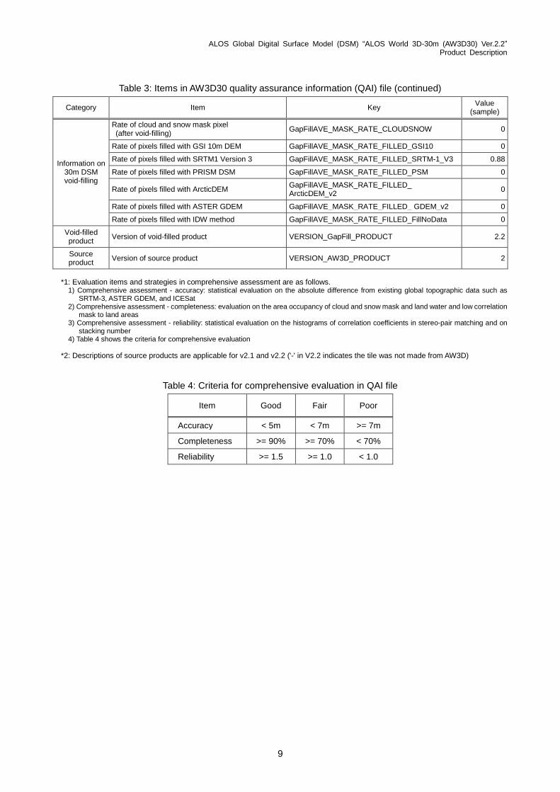
ALOS Global Digital Surface Model (DSM) “ALOS World 3D-30m (AW3D30) Ver.2.2” Product Description
9
Table 3: Items in AW3D30 quality assurance information (QAI) file (continued)
Category Item Key Value
(sample)
Information on 30m DSM void-filling
Rate of cloud and snow mask pixel (after void-filling)
GapFillAVE_MASK_RATE_CLOUDSNOW 0
Rate of pixels filled with GSI 10m DEM GapFillAVE_MASK_RATE_FILLED_GSI10 0
Rate of pixels filled with SRTM1 Version 3 GapFillAVE_MASK_RATE_FILLED_SRTM-1_V3 0.88
Rate of pixels filled with PRISM DSM GapFillAVE_MASK_RATE_FILLED_PSM 0
Rate of pixels filled with ArcticDEM GapFillAVE_MASK_RATE_FILLED_ ArcticDEM_v2
0
Rate of pixels filled with ASTER GDEM GapFillAVE_MASK_RATE_FILLED_ GDEM_v2 0
Rate of pixels filled with IDW method GapFillAVE_MASK_RATE_FILLED_FillNoData 0
Void-filled product
Version of void-filled product VERSION_GapFill_PRODUCT 2.2
Source product
Version of source product VERSION_AW3D_PRODUCT 2
*1: Evaluation items and strategies in comprehensive assessment are as follows. 1) Comprehensive assessment - accuracy: statistical evaluation on the absolute difference from existing global topographic data such as
SRTM-3, ASTER GDEM, and ICESat 2) Comprehensive assessment - completeness: evaluation on the area occupancy of cloud and snow mask and land water and low correlation
mask to land areas 3) Comprehensive assessment - reliability: statistical evaluation on the histograms of correlation coefficients in stereo-pair matching and on
stacking number 4) Table 4 shows the criteria for comprehensive evaluation
*2: Descriptions of source products are applicable for v2.1 and v2.2 ('-' in V2.2 indicates the tile was not made from AW3D)
Table 4: Criteria for comprehensive evaluation in QAI file
Item Good Fair Poor
Accuracy < 5m < 7m >= 7m
Completeness >= 90% >= 70% < 70%
Reliability >= 1.5 >= 1.0 < 1.0
ALOS Global Digital Surface Model (DSM) “ALOS World 3D-30m (AW3D30) Ver.2.2” Product Description
10
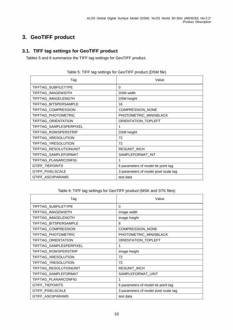
3. GeoTIFF product
3.1. TIFF tag settings for GeoTIFF product
Tables 5 and 6 summarize the TIFF tag settings for GeoTIFF product.
Table 5: TIFF tag settings for GeoTIFF product (DSM file)
Tag Value
TIFFTAG_SUBFILETYPE 0
TIFFTAG_IMAGEWIDTH DSM width
TIFFTAG_IMAGELENGTH DSM height
TIFFTAG_BITSPERSAMPLE 16
TIFFTAG_COMPRESSION COMPRESSION_NONE
TIFFTAG_PHOTOMETRIC PHOTOMETRIC_MINISBLACK
TIFFTAG_ORIENTATION ORIENTATION_TOPLEFT
TIFFTAG_SAMPLESPERPIXEL 1
TIFFTAG_ROWSPERSTRIP DSM height
TIFFTAG_XRESOLUTION 72
TIFFTAG_YRESOLUTION 72
TIFFTAG_RESOLUTIONUNIT RESUNIT_INCH
TIFFTAG_SAMPLEFORMAT SAMPLEFORMAT_INT
TIFFTAG_PLANARCONFIG 1
GTIFF_TIEPOINTS 6 parameters of model tie point tag
GTIFF_PIXELSCALE 3 parameters of model pixel scale tag
GTIFF_ASCIIPARAMS text data
Table 6: TIFF tag settings for GeoTIFF product (MSK and STK files)
Tag Value
TIFFTAG_SUBFILETYPE 0
TIFFTAG_IMAGEWIDTH image width
TIFFTAG_IMAGELENGTH image height
TIFFTAG_BITSPERSAMPLE 8
TIFFTAG_COMPRESSION COMPRESSION_NONE
TIFFTAG_PHOTOMETRIC PHOTOMETRIC_MINISBLACK
TIFFTAG_ORIENTATION ORIENTATION_TOPLEFT
TIFFTAG_SAMPLESPERPIXEL 1
TIFFTAG_ROWSPERSTRIP image height
TIFFTAG_XRESOLUTION 72
TIFFTAG_YRESOLUTION 72
TIFFTAG_RESOLUTIONUNIT RESUNIT_INCH
TIFFTAG_SAMPLEFORMAT SAMPLEFORMAT_UINT
TIFFTAG_PLANARCONFIG 1
GTIFF_TIEPOINTS 6 parameters of model tie point tag
GTIFF_PIXELSCALE 3 parameters of model pixel scale tag
GTIFF_ASCIIPARAMS text data

ALOS Global Digital Surface Model (DSM) “ALOS World 3D-30m (AW3D30) Ver.2.2” Product Description
11
3.2. GeoTIFF key settings for GeoTIFF product
Table 7 shows the Geo key settings for GeoTIFF product.
Table 7: Geo key settings for GeoTIFF product
Key Value
GTModelTypeGeoKey ModelTypeProjected
GTRasterTypeGeoKey RasterPixelIsArea
GeographicTypeGeoKey GCS_WGS_84
GeogAngularUnitsGeoKey Angular_Degree
GTCitationGeoKey text data
PCSCitationGeoKey text data
4. References
1) T. Tadono, H. Ishida, F. Oda, S. Naito, K. Minakawa, and H. Iwamoto, “Precise Global DEM Generation by ALOS PRISM,” ISPRS Annals of the Photogrammetry, Remote Sensing and Spatial Information Sciences, Vol.II-4, pp.71-76, 2014.
2) J. Takaku, T. Tadono, and K. Tsutsui, “Generation of High Resolution Global DSM from ALOS PRISM,” The International Archives of the Photogrammetry, Remote Sensing and Spatial Information Sciences, ISPRS, Vol.XL-4, pp.243-248, 2014.
3) J. Takaku, T. Tadono, K. Tsutsui, and M. Ichikawa, "Validation of 'AW3D' Global DSM Generated from ALOS PRISM," ISPRS Annals of the Photogrammetry, Remote Sensing and Spatial Information Sciences, Vol.III-4, pp. 25-31, 2016.
4) T. Tadono, H. Nagai, H. Ishida, F. Oda, S. Naito, K. Minakawa, and H. Iwamoto, “Initial Validation of the 30 m-mesh Global Digital Surface Model Generated by ALOS PRISM, The International Archives of the Photogrammetry, Remote Sensing and Spatial Information Sciences, ISPRS, Vol.XLI-B4, pp.157-162, 2016.
5) G. Grohman, G. Kroenung, and J. Strebeck, "Filling SRTM Voids: The Delta Surface Fill Method," Photogrammetric Engineering & Remote Sensing, Vol.72, No.3, pp.213-216, 2016.
6) J. Takaku and T. Tadono, “Quality updates of ‘AW3D’ global DSM generated from ALOS PRISM,” Proc. IGARSS2017, IEEE, Fort Worth, TX, USA., pp. 5666-5669, 2017.
5. Related URLs
1) EGM96 (NGA/NASA) https://cddis.nasa.gov/926/egm96/egm96.html
2) SWBD (NASA/JPL) https://dds.cr.usgs.gov/srtm/version2_1/SWBD/
3) GSHHG (former GSHHS) (University of Hawaii/NOAA) https://www.soest.hawaii.edu/pwessel/gshhs/index.html
4) OpenStreetMap Coastlines (Jochen Topf & Christoph Hormann) https://osmdata.openstreetmap.de/data/coastlines.html
ALOS Global Digital Surface Model (DSM) “ALOS World 3D-30m (AW3D30) Ver.2.2” Product Description
12
5) GSI Digital Topographic Map 5m and 10m Mesh Data https://fgd.gsi.go.jp/download/ref_dem.html *Only in Japanese
6) SRTM-1 v3 (NASA/JPL) https://www2.jpl.nasa.gov/srtm/
7) ArcticDEM v2 5m mosaic tile (NGA/NSF) https://www.pgc.umn.edu/data/arcticdem
8) ASTER GDEM v2 (NASA/METI) https://asterweb.jpl.nasa.gov/gdem.asp
6. Point of contact
Please contact to the ALOS Science Project via e-mail to the address below for any questions or inquiries
regarding the use of the dataset. For our future reference, it is highly appreciated sending the offprints and
copies of the research results using the dataset to the following point of contact.
ALOS Science Project Earth Observation Research Center (EORC) Japan Aerospace Exploration Agency (JAXA) E-mail: [email protected]