Embed Size (px)
Citation preview
Hours and Fees The Preserve is open daily, sunrise to sunset. Trail use is free for non-equestrian trail users. Donations are encouraged to defer the cost of trail maintenance.
Accessing The Preserve Explore The Preserve by traversing 37 miles of multi-use trails from three trailheads. The trails are designed for hikers, horseback riders and carriage drivers. Cyclists are welcome, but the trails are not specifically maintained for mountain biking. Parking is available at each trailhead.
Equestrian InformationThe Stable provides trailer parking, boarding, running water and more. Please pay appropriate daily fees in exact cash amount and sign a property usage waiver at the self-registration area. Annual riding passes are available.
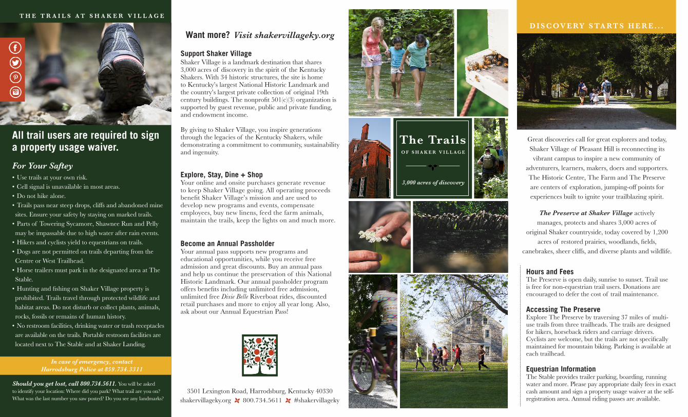
Great discoveries call for great explorers and today, Shaker Village of Pleasant Hill is reconnecting its
vibrant campus to inspire a new community of adventurers, learners, makers, doers and supporters. The Historic Centre, The Farm and The Preserve are centers of exploration, jumping-off points for experiences built to ignite your trailblazing spirit.
The Preserve at Shaker Village actively manages, protects and shares 3,000 acres of
original Shaker countryside, today covered by 1,200 acres of restored prairies, woodlands, fields,
canebrakes, sheer cliffs, and diverse plants and wildlife.
The TrailsO F S H A K E R V I L L A G E
3,000 acres of discovery
Want more? Visit shakervillageky.org
3501 Lexington Road, Harrodsburg, Kentucky 40330 shakervillageky.org 800.734.5611 #shakervillageky
Should you get lost, call 800.734.5611. You will be asked to identify your location: Where did you park? What trail are you on? What was the last number you saw posted? Do you see any landmarks?
D I S C OV E RY S TA RT S H E R E . . .
Support Shaker VillageShaker Village is a landmark destination that shares 3,000 acres of discovery in the spirit of the Kentucky Shakers. With 34 historic structures, the site is home to Kentucky’s largest National Historic Landmark and the country’s largest private collection of original 19th century buildings. The nonprofit 501(c)(3) organization is supported by guest revenue, public and private funding, and endowment income.
By giving to Shaker Village, you inspire generations through the legacies of the Kentucky Shakers, while demonstrating a commitment to community, sustainability and ingenuity.
Explore, Stay, Dine + ShopYour online and onsite purchases generate revenue to keep Shaker Village going. All operating proceeds benefit Shaker Village’s mission and are used to develop new programs and events, compensate employees, buy new linens, feed the farm animals, maintain the trails, keep the lights on and much more.
Become an Annual PassholderYour annual pass supports new programs and educational opportunities, while you receive free admission and great discounts. Buy an annual pass and help us continue the preservation of this National Historic Landmark. Our annual passholder program offers benefits including unlimited free admission, unlimited free Dixie Belle Riverboat rides, discounted retail purchases and more to enjoy all year long. Also, ask about our Annual Equestrian Pass!
All trail users are required to sign a property usage waiver.
T H E T R A I L S A T S H A K E R V I L L A G E
For Your Saftey• Use trails at your own risk. • Cell signal is unavailable in most areas.• Do not hike alone.• Trails pass near steep drops, cliffs and abandoned mine sites. Ensure your safety by staying on marked trails.
• Parts of Towering Sycamore, Shawnee Run and Pelly may be impassable due to high water after rain events.
• Hikers and cyclists yield to equestrians on trails.• Dogs are not permitted on trails departing from the Centre or West Trailhead.
• Horse trailers must park in the designated area at The Stable.
• Hunting and fishing on Shaker Village property is prohibited. Trails travel through protected wildlife and habitat areas. Do not disturb or collect plants, animals, rocks, fossils or remains of human history.
• No restroom facilities, drinking water or trash receptacles are available on the trails. Portable restroom facilities are located next to The Stable and at Shaker Landing.
In case of emergency, contact Harrodsburg Police at 859.734.3311
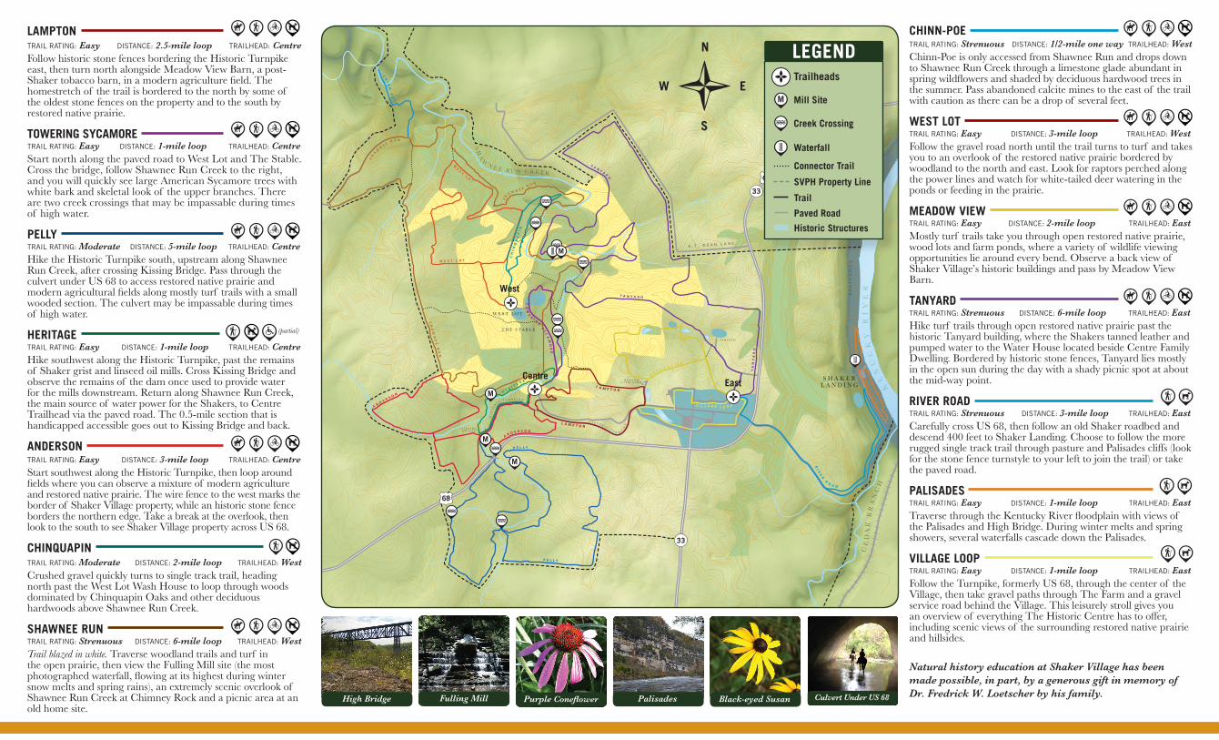
CHINN-POE TRAIL RATING: Strenuous DISTANCE: 1/2-mile one way TRAILHEAD: WestChinn-Poe is only accessed from Shawnee Run and drops down to Shawnee Run Creek through a limestone glade abundant in spring wildflowers and shaded by deciduous hardwood trees in the summer. Pass abandoned calcite mines to the east of the trail with caution as there can be a drop of several feet.
WEST LOT TRAIL RATING: Easy DISTANCE: 3-mile loop TRAILHEAD: WestFollow the gravel road north until the trail turns to turf and takes you to an overlook of the restored native prairie bordered by woodland to the north and east. Look for raptors perched along the power lines and watch for white-tailed deer watering in the ponds or feeding in the prairie.
MEADOW VIEW TRAIL RATING: Easy DISTANCE: 2-mile loop TRAILHEAD: EastMostly turf trails take you through open restored native prairie, wood lots and farm ponds, where a variety of wildlife viewing opportunities lie around every bend. Observe a back view of Shaker Village’s historic buildings and pass by Meadow View Barn.
TANYARD TRAIL RATING: Strenuous DISTANCE: 6-mile loop TRAILHEAD: EastHike turf trails through open restored native prairie past the historic Tanyard building, where the Shakers tanned leather and pumped water to the Water House located beside Centre Family Dwelling. Bordered by historic stone fences, Tanyard lies mostly in the open sun during the day with a shady picnic spot at about the mid-way point.
RIVER ROAD TRAIL RATING: Strenuous DISTANCE: 3-mile loop TRAILHEAD: EastCarefully cross US 68, then follow an old Shaker roadbed and descend 400 feet to Shaker Landing. Choose to follow the more rugged single track trail through pasture and Palisades cliffs (look for the stone fence turnstyle to your left to join the trail) or take the paved road.
PALISADES TRAIL RATING: Easy DISTANCE: 1-mile loop TRAILHEAD: EastTraverse through the Kentucky River floodplain with views of the Palisades and High Bridge. During winter melts and spring showers, several waterfalls cascade down the Palisades.
VILLAGE LOOPTRAIL RATING: Easy DISTANCE: 1-mile loop TRAILHEAD: EastFollow the Turnpike, formerly US 68, through the center of the Village, then take gravel paths through The Farm and a gravel service road behind the Village. This leisurely stroll gives you an overview of everything The Historic Centre has to offer, including scenic views of the surrounding restored native prairie and hillsides.
M E A D O W V I E W B A R N
H I S T O R I C T U R N P
I KE
HI
ST
OR
I C T U R N P I K E
K I S S I N GB R I D G E
W E S T L O T
T H E S T A B L E
KE
NU
CK
Y
RI
VE
R
A . T . D E A N L A N E
CE
DA
R B
RA
NC
H
RI
VE
R R
OA D
TA
NY
AR
D
T A N Y AR
D
T A N Y A R D
L A M P T O N
L A M P T O N
P E L L Y
P E L L Y
A N D E R S O N
A N D E R S O N
SH
AW
NE
E
RU
N
SH
A W N E E R U N
SH
A
WN
E E R U N
W
ES
T L O
T
W E S T L O T
TO
WE
RI N
G S
YC
AM
OR
E
CH
IN
QU
AP
IN
CH
IN
N-
PO
E
PA
LI S
AD
ES
M
P H I L L I P S L A N E
T A N Y A R D
V I L L A G E L O O P
ME A D O W V I E W
S H A K E RL A N D I N G
PA
LI
SA
DE
S
M HE R I T A
G E
M
M
SH
A
WN E E R U N C R E E K
N
E
S
W
Natural history education at Shaker Village has been made possible, in part, by a generous gift in memory of Dr. Fredrick W. Loetscher by his family.
LAMPTON TRAIL RATING: Easy DISTANCE: 2.5-mile loop TRAILHEAD: CentreFollow historic stone fences bordering the Historic Turnpike east, then turn north alongside Meadow View Barn, a post-Shaker tobacco barn, in a modern agriculture field. The homestretch of the trail is bordered to the north by some of the oldest stone fences on the property and to the south by restored native prairie.
TOWERING SYCAMORE TRAIL RATING: Easy DISTANCE: 1-mile loop TRAILHEAD: CentreStart north along the paved road to West Lot and The Stable. Cross the bridge, follow Shawnee Run Creek to the right, and you will quickly see large American Sycamore trees with white bark and skeletal look of the upper branches. There are two creek crossings that may be impassable during times of high water. PELLY TRAIL RATING: Moderate DISTANCE: 5-mile loop TRAILHEAD: CentreHike the Historic Turnpike south, upstream along Shawnee Run Creek, after crossing Kissing Bridge. Pass through the culvert under US 68 to access restored native prairie and modern agricultural fields along mostly turf trails with a small wooded section. The culvert may be impassable during times of high water.
HERITAGE TRAIL RATING: Easy DISTANCE: 1-mile loop TRAILHEAD: CentreHike southwest along the Historic Turnpike, past the remains of Shaker grist and linseed oil mills. Cross Kissing Bridge and observe the remains of the dam once used to provide water for the mills downstream. Return along Shawnee Run Creek, the main source of water power for the Shakers, to Centre Trailhead via the paved road. The 0.5-mile section that is handicapped accessible goes out to Kissing Bridge and back.
ANDERSON TRAIL RATING: Easy DISTANCE: 3-mile loop TRAILHEAD: CentreStart southwest along the Historic Turnpike, then loop around fields where you can observe a mixture of modern agriculture and restored native prairie. The wire fence to the west marks the border of Shaker Village property, while an historic stone fence borders the northern edge. Take a break at the overlook, then look to the south to see Shaker Village property across US 68.
CHINQUAPIN TRAIL RATING: Moderate DISTANCE: 2-mile loop TRAILHEAD: WestCrushed gravel quickly turns to single track trail, heading north past the West Lot Wash House to loop through woods dominated by Chinquapin Oaks and other deciduous hardwoods above Shawnee Run Creek.
SHAWNEE RUN TRAIL RATING: Strenuous DISTANCE: 6-mile loop TRAILHEAD: WestTrail blazed in white. Traverse woodland trails and turf in the open prairie, then view the Fulling Mill site (the most photographed waterfall, flowing at its highest during winter snow melts and spring rains), an extremely scenic overlook of Shawnee Run Creek at Chimney Rock and a picnic area at an old home site.
Culvert Under US 68Palisades Black-eyed SusanHigh Bridge Fulling Mill Purple Coneflower
M
LEGEND
Mill Site
Connector Trail
Creek Crossing
SVPH Property Line
Trail
Paved Road
Historic Structures
Waterfall
Trailheads
East
West
Centre
(partial)