Embed Size (px)
Citation preview
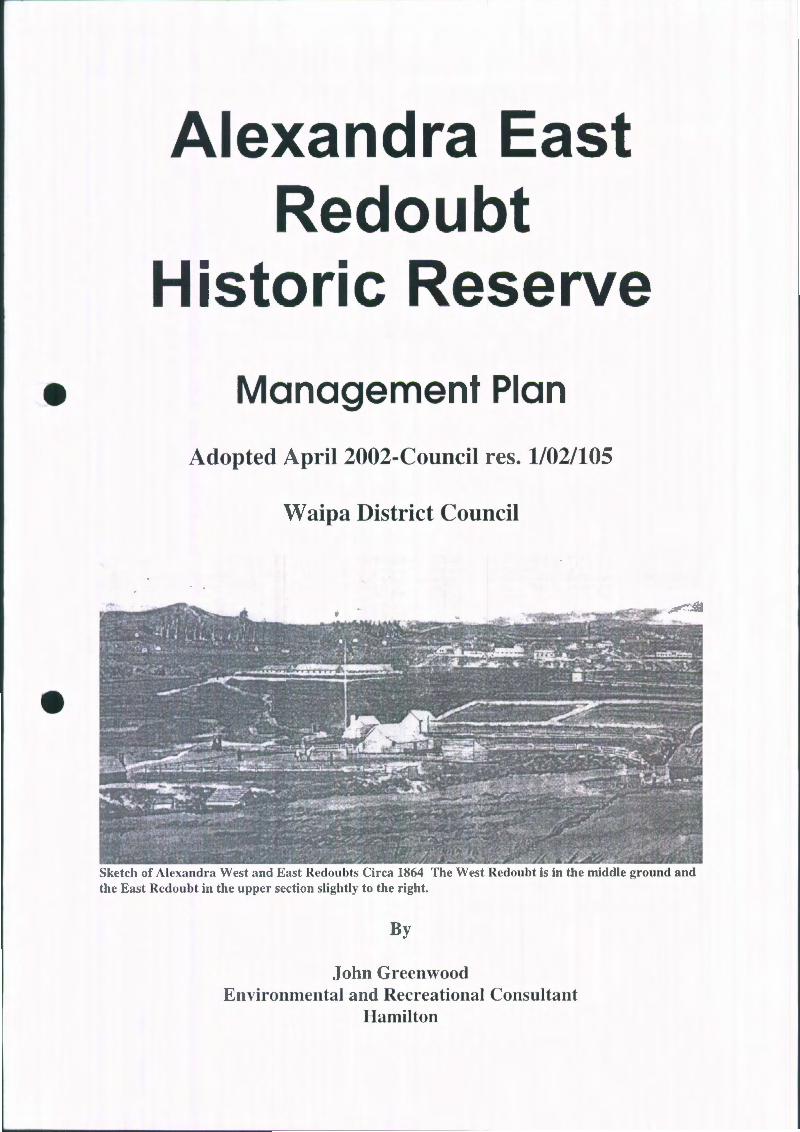
Alexandra East Redoubt
Historic Reserve
Management Plan
Adopted April 2002-Council res. 1/02/105
Waipa District Council
Sketch of Alexandra West and East Redoubts Circa 1864 The West Redoubt is in the middle ground and the East Redoubt in the upper section slightly to the right.
By
John Greenwood Environmental and Recreational Consultant
Hamilton

U>
' ( ... !... '
......., __ ,.,,
. • .. •
. - •
• • • • •
• ..
. ~ c-· :a • • • • .. • a
. t • " .....
• .. -' • .. ...... • a ..
• .. • .. • :».
• • • l; • • • ..
• a .. ...
~· • • ..
• •
·-'
1
I \ .j
•
Alexandra East Redoubt Historic Reserve
Introduction
The establishment of this Reserve took place as the result of the Waipa District Council creating a subdivision on Endowment land west of the Pirongia township centre. In the course of the subdivision the existence of the Alexandra East redoubt site was identified and an archaeological investigation was carried out. This confirmed the presence of the site and identified the general location of the redoubt components. Because of its national significance the general public were prominent in lobbying Council to retain and preserve the redoubt site. This redoubt is one of only 6 in public ownership in New Zealand .
Alexandra East Redoubt Historic Reserve is located on Aubin Close a cul-desac off Crozier Street in Pirongia.
The Reserve is legally described as Lots 6 and 7 DPS 79519 situated in Block IV Pirongia Survey District. The total area of the reserve is 1.0018 ha. (Gazette notice 22"d Feb 2001 pg 402)
It lies above the Waipa River flood plain on the edge of a river escarpment. It is opposite the position of a similar Redoubt site on the western side of the Waipa River, approximately 280 metres in a Nor/Nor westerly direction. This site was known as Alexandra West redoubt. There are no obvious indications of the presence of the West redoubt showing on the earliest Aerial Photography available.
The western end of the Alexandra East Redoubt site allows commanding views of the Waipa River plains as far as Matakitaki Pain the North, and to a lesser extent to the West/southwest.
The site itself has no obvious archaeological remains left on the surface. However the archaeological investigations carried out by Warren Gumbley and associates, resulted in very clear indications of the original Redoubt in the subsurface terrain.
History:
When General Cameron crossed the Mangatawhiri Stream with his forces on 12 July 1863 few could have imagined the ultimate consequences of this action.

•
- 2-
The Waikato War was comparatively short and sharp. It concluded in a practical sense on 2 April 1864 when the defenders of Orakau Pa abandoned the Pa and retreated into the King Country to the south. Or in the case of some supporting warriors, to Rotorua and the Ureweras.
The principal result of the short sharp war was the confiscation of large areas of land and allocation of that land principally to the surviving soldiers who had enlisted in the wars. The confiscation of land following this war are recorded in footnotes to 'The New Zealand Wars and the Pioneering Period" . .. . .. Cowan Vol I Page 412 .
. . .. It embraced the whole of the country on the east side of the Waikato!Waipa basin, from the Mangatawhiri south to the summit (~!"
Mount Pirongia, thence along the Puniu River to the Waikeria , and from there across Puketurua, on the foothills of the Maungatautari , thence northward to the Thames Gu(j:
Both the Alexandra East and West Redoubts were constructed in 1864 to provide protection and a Garrison headquarters for the 2nd Waikato regiment in Pirongia East and Major Gustavus Von Tempsky' s Forest Rangers in the Alexandra West Redoubt.
In 1865, the Government of the day apparently decided that the bulk of the militia forces should be disbanded by the simple expedient of cutting their pay. However in the case of Alexandra, a group of 100 Soldiers was retained as this was, as it were a frontier town to the King Country to where many of the defending Maori had t1ed.
By Circa 1870, it appears that the banks of the two redoubts may have already been dug back into the ditches, thus returning the terrain to what it would have been before the redoubts were constructed. No doubt this had been influenced to some degree by the lack of threat from the warring Maori from the King Country, but also possibly due to the difficulties in maintaining the ditches and banks in the fragile soils of the area. It is illogical to think that the ditches and banks would have been allowed to fall into disrepair if there was any major threat from south of the Puniu river.
Nevertheless there was a reasonably strong military presence maintained on the Alexandra East Site in particular, up until at least the 1880's although by this time it was an armed constabulary rather than a military force.
c\!cmp\a lcxandracas! redoubt managc lllcnl plan - final 10 go.doc ~/22/02 I :23 PM
•
•
~------- ---------------------~~--- ---------
- 3 -
The end of hostilities is recorded by Cowan in "The New Zealand Wars and the Pioneering Period" James Cowan 1922 vol 1 page 412.
South (~f the Frontier most of the Kingites remained in isolation, planning the reconquest of the Waikato, but deterred from a renewal of the war by the presence of strong, and well trained bodies of soldier farmers on the fringes q{ the conquered territory. It was not until 1881, when Tawhiao Laid down his guns at Major Mairs feet, at Alexandra, that Waikato and Ngati Maniapoto definitely and finally made their peace with the government of the Colony".
It is unlikely there would have been any maintenance of a military or constabulary force on this site after that event.
At one period there may have been as many as nine buildings associated with the Alexandra East Redoubt. Only a few of these would have been on the historic reserve and in particular within the redoubt's fortifications.
The strategic importance of the site:
Because it was on the edge of the refuge territory of the Kingite Maori driven from their homelands by Cameron's forces, Alexandra (Pirongia) township would have been an important link in the defence network established by the military following the Battle of Orakau. This responsibility was taken up later by the Armed Constabulary, established following the discharge of the military personnel as they took up the land grants given to them from the confiscations following the war.
There can be no doubt that the maintenance of the garrison at Alexandra with or without the security of a redoubt would have been a strong deterrent to any Maori war party intent on retaking their lands. For this reason the site of this occupation is historically significant. Its proximity to the Puniu River gave added strategic importance to the Garrison.
However the actual redoubt had a much shorter life span. The two redoubt were only maintained in a usable condition for part of the five years following their construction. Neither redoubt were ever under attack from the Maori defenders of their land. It appears that there may have been little threat of such attack as the ditches and banks appear from the early records to have been allowed to fall into disrepair shortly after their construction.
c:\te::mp\alt!xandraeas l redo ubt management pl an - linal lo go.doc
'i/22/02 I 23 PM

- 4 -
The Situation today:
The subsequent archaeological investigation uncovered evidence of the presence of the remnants subsurface. On the restored surface there is no visible evidence of the occupation or the redoubt.
A small section of the Redoubts outer ditch has been destroyed by erosion. The Redoubt is located within the land now reserved for Historic Purposes. This however is essentially a flat grassed paddock.
• Objectives and Policies of management:
•
Objective 1.
To protect and maintain the Archaeological and historical values of the Alexandra East Redoubt site "in perpetuity", for the use, understanding and enjoyment of future generations of New Zealanders as required under section 18 Reserves Act 1977.
1.1 Management Policies.
1.1.1
1.1.2
Alexandra East Redoubt is a Reserve under the Reserves Act 1977 and Classified as an Historic Reserve. Ownership and management of the reserve is within the Waipa District Council.
The Council is committed to allocating sufficient funds annually to ensure the reserve is maintained and developed in accordance with Section 18 (2) Reserves Act 1977.
1.2 Protection Policy.
1.2.1 The Archaeological and Historic features of this Reserve will be protected as provided in Section 18 ( 1) Reserves Act 1977 and under the Historic Places Act 1993 .
c\templalexandraeast redoubt management plan - final to go.doc
'i/22102 I :21 PM
- 5 -
1.2.2 Application:
No act will be done on, in or near the Reserve that would compromise the archaeological or historic values of the Reserve's features (The Archaeological remnants).
1.2.2.1 Any application for permission to carry out archaeological investigations on the Reserve will only be considered after consultation with the Historic Places Trust and their agreement having been obtained. (Historic Places Act 1993 ).
1.2.2.2 No archaeological investigation that involves destruction of the historic features will be permitted unless there are compelling
• reasons to do so and there are no alternatives to obtain the same goal available.
1.2.2.3 Any proposal to reconstruct all or part of the Redoubt will be considered under the provisions of this policy. Such proposals will be prepared by an Archaeologist with experience in the reconstruction of Archaeological and/or historic sites.
Discussion/Explanation:
The key issue confronting any manager of this site is - how to manage an elevated Historic site and allow the public to appreciate its historic and archaeological values and thus support its maintenance long term.
• Archaeological investigations on the site, or restoration of the site can be considered legitimate activity on the reserve. However such investigations should only occur on this site if the information to be gained cannot be obtained in any other way. Applications to carry out archaeological investigations should take cognisance of the fact that the soils on which the redoubt was established are easily eroded.
Residents living in the immediate vicinity of the site were all visited to determine their views on how this site should be managed. There were almost as many views in some aspects of the site's management, as individuals visited. One thing that was consistent however was the need to maintain the site in a clean and tidy condition at all times. Grass mown regularly etc was a universal requirement.
c\lemp\a lexaml raeasl redouhl managemenl plan - tinal lo go.doc 'i/22/02 I :2:l PM
- 6-
1.3. Maintenance Policy:
1.3.1 The reserve should at all times be maintained in a tidy condition.
1.3.2 Application:
!.3.2.1 Grass should be mown regularly on the flat area according to the time of year. The goal of this maintenance is to have well cared for grass that can be walked over by visitors in street shoes
1.3.2.2 Noxious weeds should be cleared and the reserve maintained free t~f these weeds at all times.
• 1.3.2.3 The western escarpment should be planted in low maintenance ground cover native species and be maintained in this condition. Stock will not be allowed access to this escarpment face . Fencing will be erected and maintained as necessary to protect such plantings.
1.3.2.4 Interpretive signs, diorama, paths, or structures of any kind erected or placed on the reserve shall at all times be maintained in a neat and tidy condition.
1.3.2.5 Any vandalism occurring shall be removed or cleaned up at the first opportunity on its coming to the attention of the Reserve Managers.
Discussion/explanation:
The site will need to be mowed on a regular basis at all times. Depending on the amount of interpretive development that is agreed on this should be a variable commitment. The local residents were particularly concerned to see the Reserve maintained in a tidy condition
There are several exotic shrubs located on the edge of the escarpment which obstruct the vision from the redoubt site. These are all Noxious plants and should be removed.
Several respondents suggested the planting of ground cover species on the western escarpment. This is a good proposal that would save considerable effort and funds in long term maintenance. Species such as ground cover Coprosma, Hebe, Native Blueberry, Prostrate manuka and Flax would be appropriate even if some of these are cultivars of the original native species.
c:\tcmp\alexandraeast redoubt management plan · lln'tl to go.cloc
5/22/02 I :2:1 PM
- 7 -
Fencing to ensure stock do not gain access to this escarpment face ts essential.
1.4 Access Policy:
1.4.1 Public access to the reserve will as far as possible be maintained at all times.
1.4.2 Application:
1.4.2. 1 Road access is available from Aubin Close. Pedestrian access is available from Franklin Street via a right of way through to Aubin
• Close.
•
Discussion/explanation:
The only parking available in Aubin Close, is on the road verges. While the general public can be expected to drive to Aubin Close, groups such as schools or coach trips, should be encouraged to park on Franklin Street and walk through the Right of way to the Reserve in order to avoid congestion in Aubin Close.
1.4.2.2 The public will have access to the Reserve at all times except when archaeological or historic investigations are being carried out as provided for in Policy 1.2
Discussion/Explanation:
Archaeological investigations are important in tracking and recording the events of the past. During these investigations or during earthwork reconstruction, it is important that unauthorised personnel are kept clear so that no evidence is destroyed or contaminated either deliberately or accidentally. Appropriate steps would therefore need to be taken to ensure the integrity of any archaeological works taking place. Possibilities include temporary fencing or other barricades.
1.4.2.3 The existing track should be designed and constructed to allow the public access to the Reserve from the Waipa River walkway or vice versa. It should reflect best practice in track construction and will
c\te 111p\akxamlraea' t redoubt managc111t:nt plan - linalto go.doc ){22/02 I :23 PM
•
•
- 8 -
conform generally to the requirements of the Department of Conservation "Track Construction requirements ".
Discussion/explanation:
Waipa District have commenced construction of a walkway around the edges of the Waipa river below the redoubt site. One respondent suggested the creation of a track down the escarpment to link in with this walkway. This is certainly feasible and should be given serious consideration. This could lead to the opportunity for interpretation of the Military links with the Alexandra West redoubt, remnants of which are still visible today.
There are some physical constraints on this proposal in the form of the fragility of the soils in this area. The Land below the Reserve comprises Endowment Land in the name of Waipa District Council. Careful planning will be required, if the track is to be constructed in such a way as to be easily maintained and not cause erosion in the fragile soils of the area.
Objective 2.
2.1
To interpret the Reserve in such a way as to provide the public with an understanding of the events which led to the construction of the Redoubt and the defence of Alexandra .
Interpretation Policy:
2.1.1 Interpretation of the site will be a priority for development work on this Reserve. All Interpretive work will be adequately researched to ensure it is accurate and representative. Interpretive actions should at all times be executed to reflect best practice in interpretive processes.
Discussion/explanation:
Interpretation is the term commonly used to describe the way in which a site is demonstrated to the public so that they can have some understanding of why it is historically and archaeologically important. It includes all the signage and other means of identification of the site.
c :\telllp\alexandraeast redoubt lllanagc.:lllent plan- tina! to go.doc <t/22/02 I :23 PM
•
•
- 9 -
A supportive public is vital if the reserve is to be maintained in perpetuity. Interpretation of the site and the events that lead to its establishment are vital if public support is to be maintained.
Local residents had a variety of suggestions for interpretation of the site, from a simple entrance sign to full reconstruction of the redoubt. There was no consensus on any one particular method of interpretation but all respondents indicated that interpretation in some form was warranted and desirable. (They may not have used the word "Interpretation", but their meaning was clear).
Poorly researched and executed interpretation is actually worse than none. All facts should be verifiable or be left off the interpretation material.
2.1.2 Application:
2.1.3 A major entrance sign should be designed and erected on the Aubin Close edge of the reserve, thus making it obvious to the general public. Design and construction shall as far as possible reflect the architecture of the time.
Discussion/explanation:
A simple location/entrance sign was the minimum requirement suggested by several of the respondents. It has limitations in that visitors are then left to wonder what was so important about an elevated flat site. This therefore has to be considered as part of the interpretation package.
2.1 .4 The Historic events that led to the construction and Garrisoning (~f
this Reserve may be interpreted for the public by the construction/creation of a diorama showing the topography and construction of the two Redoubt sites plus explanatory material to explain the complicated series q{ events which led to the Waikato wars and the consequences of this war.
This display could be housed in a purpose built open sided structure providing protection from the elements and to allow the public ample opportunity to reflect on these events. This structure should as far as practical reflect the architectural style of the period of use of the Redoubt.
c:\ lcmp\:.~lexan d racasl rcdoubl managemenl plan - final 10 go.doc
'\/22/02 I ·2:1 PM
•
- 10-
Discussion/explanation:
One option considered was an interpretive panel with a plan of the redoubt and perhaps some indication of its location from a strategic point of view. This option seems to find favour with several of the respondents. It has advantages as it can be as simple as a series of maps, to full information on the events that led to the construction of the redoubt.
A second and more imaginative option is the construction of a Diorama of the extended site to be placed in an appropriately designed open sided building. This option has much to commend it, but does have the disadvantage of the likelihood of vandalism. There could in fact be a compromise using dioramic paintings of the site as has been done for several sites in the Auckland Regional Council area and housing these as in the first option above.
2.1.5 The position of the redoubt could be defined by the use of cobblestone paths along the lines of the ditches associated with the redoubt.
Discussion/explanation:
Identification of the actual lines of the ditches and banks on the ground was proposed in several ways. One option was to install cobble stone paths in the shape of the redoubt directly over where the ditches were located. Other options were to use wooden markers, or pegs of some form. This later option
• would cause some maintenance difficulties.
2.1.6 A section of the redoubt of 3 - 5 metres in length could be reconstructed to show the scale and style of the physical redoubt. Design and supervision of this work will be carried out by a qualified Archaeologist with experience in restoration of earthen historic sites.
Discussion/explanation:
Full reconstruction of the ditch and bank system has been proposed by some respondents. The advantages of this are that the site would then be a very visual place, easily interpreted and giving some understanding of the limited size and vulnerability of such a defensive construction.
c :\ tclllp\akxa nuraeas t redoubt 111anagement plan - linal to go .uoc 5/22/02 I :23 PM
•
•
- 11 -
1. Disadvantages are, firstly, the difficulty of maintaining the stability of the banks and ditches. (Historic Places Trust are having difficulty maintaining the integrity of Alexandra Redoubt site to the south of this reserve). The original redoubt had stability problems, and these could be experienced again. The underlying soils on this site are very friable sandy silts. This material is very prone to erosion and fretting. (Experience on the construction of the track in the valley to the North of this Reserve demonstrates very clearly the difficulties likely to be associated with this site). Stabilising processes would therefore be necessary to enable this suggestion to be carried out. Secondly, the cost of reconstruction would be high. This would be particularly so if stabilising techniques were to be applied. Thirdly, maintenance would be far more difficult on a reconstructed site than for some other options. In addition part of the western end may have collapsed over the escarpment. Reconstruction of this part would be very difficult if not impossible.
2. Planning of such a reconstruction would need to be done by a qualified Archaeologist with experience in historic site restoration.
3. Partial Reconstruction of a section of the ditch and bank system. This could be done in conjunction with the laying of cobblestone outlining paths as proposed by some of the respondents. Disadvantages are as for full reconstruction but on a more limited scale. A section of perhaps only 3 -5 metres need be reconstructed under this option to give visitors an appreciation of the scale of the redoubt. The location of the Alexandra Redoubt only a short distance to the South gives ample opportunity for members of the public wishing to observe a full redoubt to do so.
2.1. 7 The western. bastion (~f the redoubt may be replicated by the construction. of a lookout pla~form in. the shape of the original section. (~f the ditch and bank. Archaeological advice would need to be sought to advise on. the design. parameters for this structure. Engineering advice would also need to be sought to ensure the structural integrity (~{the design..
Disc us s ion! explanation:
A viewing platform on the edge of the escarpment was proposed by one submitter. This involved the construction of a low viewing platform at the
c:\tcmp\alexanuracast redoubt management plan - final to go. doc 5/22/02 I :2:\ PM
•
•
- 12-
point where the redoubt's North-western bastion was located. (This may have been partly eroded). This low platform would give visitors the opportunity to visualise what a sentry would have been able to observe from that point. The "Plane Table" suggested below, could be located on this platform. This proposal would then link nicely to the cobblestone outline proposal.
2.1.8 A "Plane table" should be designed and constructed in permanent materials such as Stainless steel. It would need to be located at the western extremity of the lookout. This would of necessity, include the location of the Alexandra West Redoubt and Matakitaki Pa to the North.
Disc us sio n/ explanation:
Construction of a "Plane Table" plan showing the location of the various components of the area including the West Alexandra Redoubt and Matakitaki Pa is one way of placing the events in their geographical perspective and adding realism to the interpretation of the site. It gives opportunity for visitors to imagine the site in its original context.
Summary:
Alexandra East Redoubt while not having the emotional impact of a site which has been defended and had blood spilled on it, is nevertheless an important site in maintaining an appreciation of the events of the Waikato Land Wars.
Maintenance and interpretation of this site is a responsibility that needs to be discharged for the benefit of present and future generations of New Zealand Citizens of whatever ethnic origin.
In the event that reconstruction of all or part of the original Redoubt is proposed, a "Conservation Plan", should be prepared by a suitably qualified Archaeologist, with experience in the reconstruction of similar Earthen remnants , in erosion prone soils.
Location Plan:
Historic Plan of the redoubt:
c:\temp\alcxandraeast redoubt management pbn - linalto go.doc 1/22/02 I :23 PM
Bibliography:
Cowan J. 1922
Featon J. 1911
Acknowledgements:
- 13 -
The New Zealand Wars, Vol 1 Pages 408 -413
The Waikato War. As revised by Captain Gilbert Mair.
Tracy Sibson, Curator of Te Awamutu Museum for access to the files of the museum.
• The Pirongia Ratepayers and Residents Association for their considerable knowledge and for sharing their views on the history and site management
Owen Wilks and Dr Neville Ritchie, Department of Conservation for access to the Archaeological records of the site.
Close residents to the site for sharing their views on the site management with me.
Max Ward of Waipa District Council for the opportunity to study this interesting site and for critical comments on the drafts.
My late father William Greenwood for fostering in me an abiding interest in history and historic sites.
c:\lcmp\a lexand raeas l redoubl managcmenl plan - tina! 10 go.doc 'i/22/02 I :21 PM