Embed Size (px)
Citation preview
J U LY 2 0 1 1
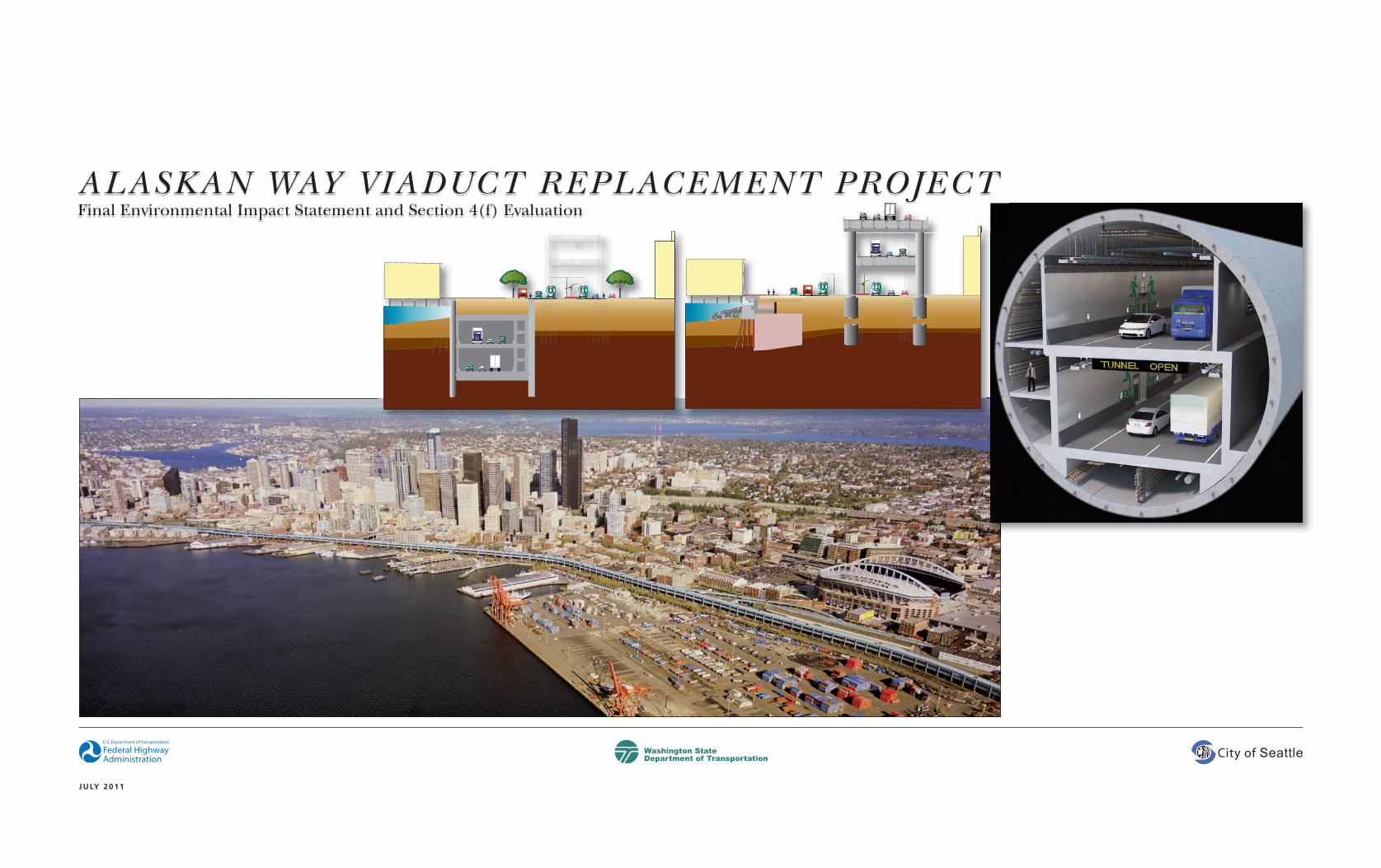
ALASKAN WAY VIADUCT REPLACEMENT PROJECTFinal Environmental Impact Statement and Section 4(f) Evaluation

Alaskan Way Viaduct Replacement Project Final EIS i
Date of Approval
Daniel M. Mathis, P.E.Division Administrator, Washington DivisionFederal Highway AdministrationLead for National Environmental Policy Act (NEPA)
Megan White, P.E.Director of Environmental ServicesWashington State Department of TransportationLead for State Environmental Policy Act (SEPA)
Peter HahnDirectorSeattle Department of Transportation
Date of Approval Date of Approval
FHWA-WA-EIS-04-01-F
ALASKAN WAY VIADUCT REPLACEMENT PROJECTFinal Environmental Impact Statement and Section 4(f) Evaluation
Submitted pursuant to:
The National Environmental Policy Act (NEPA)(42 U.S.C. 4322(2)(C))
and
the State Environmental Policy Act (SEPA)(Ch. 43.21 C RCW)
and Section 4(f) of the Department of Transportation Act,
(49 U.S.C. 303(c))
by the
FEDERAL HIGHWAY ADMINISTRATION
and
WASHINGTON STATE DEPARTMENT OF TRANSPORTATION
and
CITY OF SEATTLE DEPARTMENT OF TRANSPORTATION
AbstractThe existing Alaskan Way Viaduct (SR 99) was built in the 1950s and was damaged in the 2001 Nisquallyearthquake. It is seismically vulnerable and at the end ofits useful life—it must be replaced. The Federal HighwayAdministration, Washington State Department ofTransportation, and City of Seattle plan to replace the
existing facility to provide a structure capable ofwithstanding earthquakes and to ensure that people andgoods can safely and efficiently travel within and throughthe project corridor. The Alaskan Way Viaduct providesvital transportation connections into and throughdowntown Seattle, as well as between various otherregional destinations. Failure of the viaduct would createsevere hardships for the city and region and could possiblycause injury or death.
The 2004 Draft Environmental Impact Statement (EIS)analyzed five Build Alternatives and a No Build Alternativefor their potential effects on the human and naturalenvironment. Based on information presented in the Draft EIS, public comments, and further study and design,the lead agencies reduced the number of alternatives fromfive to two. The two alternatives, the Tunnel (now the Cut-and-Cover Tunnel Alternative) and Elevated Structure,were then evaluated in the 2006 Supplemental Draft EIS
document. In 2009, the Governor, former King CountyExecutive, and former Seattle Mayor recommendedreplacing the central waterfront portion of the AlaskanWay Viaduct with a single bored tunnel. The 2010Supplemental Draft EIS analyzed the new Bored TunnelAlternative, provided information about design changes tothe 2006 build alternatives still under consideration, andcompared 2006 build alternatives to the Bored TunnelAlternative.
This Final EIS evaluates the No Build Alternative inaddition to the Bored Tunnel Alternative, Cut-and-CoverTunnel Alternative, and Elevated Structure Alternative,each with and without tolls, for their potential effects tothe natural and built environments. The lead agencieshave identified the Bored Tunnel Alternative with tolls asthe preferred alternative. No decision will be made on theproposed action until the Record of Decision is published,which is expected in August 2011. If tolling is not
J U LY 2 0 1 1
A Federal agency may publish a notice in the Federal Register,
pursuant to 23 USC §139(l), indicating that one or more federal
agencies have taken final action on permits, licenses, or approvals for
a transportation project. If such notice is published, claims seeking
judicial review of those federal agency actions will be barred unless
such claims are filed within 180 days after the date of publication of
the notice, or within such shorter time period as is specified in the
federal laws pursuant to which judicial review of the federal agency
action is allowed. If no notice is published, then the periods of time
that otherwise are provided by the Federal laws governing such claims
will apply.
Title VI
WSDOT ensures full compliance with
Title VI of the Civil Rights Act of 1964 by
prohibiting discrimination against any
person on the basis of race, color,
national origin or sex in the provision of
benefits and services resulting from its
federally assisted programs and activities.
For questions regarding WSDOT's Title VI Program, you may contact
the Department’s Title VI Coordinator at (360) 705-7098.
Americans with Disabilities Act (ADA) Information
If you would like copies of this document in an alternative format—
large print, Braille, cassette tape, or on computer disk, please call
(360) 705-7097. Persons who are deaf or hard of hearing, please call
the Washington State Telecommunications Relay Service, or
Tele-Braille at 7-1-1, Voice 1-800-833-6384, and ask to be
connected to (360) 705-7097.
authorized by the Washington State Legislature, it coulddirect WSDOT to request a revised Record of Decisionfrom Federal Highway Administration to authorize theconstruction of the Bored Tunnel Alternative as a non-tolled facility.

Alaskan Way Viaduct Replacement Project Final EIS ii
FACT SHEET
Project NameSR 99: Alaskan Way Viaduct Replacement Project
Project DescriptionThe SR 99: Alaskan Way Viaduct Replacement Project proposes to
replace SR 99 between S. Royal Brougham Way and Roy Street in Seattle,
Washington with a facility that has improved earthquake resistance.
Damage sustained by the viaduct during the February 2001 Nisqually
earthquake compromised its structural integrity. This past damage, along
with the age, design, and location of the existing viaduct, makes this
facility vulnerable to sudden and catastrophic failure in an earthquake.
SR 99 and Interstate 5 are the primary north-south access routes
through downtown Seattle, making the Alaskan Way Viaduct a vital link
in the region’s highway and freight mobility system, and thus critical
to the region’s economy. Together with the transit system, light rail and
local streets, SR 99 serves regional and local needs.
This Final EIS analyzes and compares the effects of the No Build
Alternative, and the Bored Tunnel Alternative, Cut-and-Cover
Tunnel Alternative, and Elevated Structure Alternative, each with and
without tolls. The No Build Alternative is evaluated to provide baseline
information. The lead agencies have identified the Bored Tunnel
Alternative with tolls as the preferred alternative. If tolling is not
authorized by the Washington State Legislature, it could direct WSDOT
to request a revised Record of Decision from the Federal Highway
Administration to authorize the construction of the Bored Tunnel
Alternative as a non-tolled facility.
J U LY 2 0 1 1
Joint Lead AgenciesFederal Highway Administration
Washington Division
Evergreen Plaza
711 S. Capitol Way, Suite 501
Olympia, WA 98501 - 1284
Washington State Department of Transportation
Alaskan Way Viaduct Replacement Project Office
Wells Fargo Building
999 Third Avenue, Suite 2424
Seattle, WA 98104 - 4019
City of Seattle Department of Transportation
700 Fifth Avenue, Suite 3900
PO Box 34996
Seattle, WA 98124 - 4996
NEPA Lead AgencyThe Federal Highway Administration is the lead agency for NEPA.
Responsible NEPA OfficialDaniel M. Mathis, P.E.
Division Administrator, Washington Division
Federal Highway Administration
711 S. Capitol Way, Suite 501
Olympia, WA 98501 - 1284
SEPA Lead AgencyThe Washington State Department of Transportation is the nominal lead
agency and the City of Seattle is a co-lead agency for SEPA.
Responsible SEPA OfficialMegan White, P.E.
Director, Environmental Services Office
Washington State Department of Transportation
PO Box 47331
Olympia, WA 98504 - 7331
Document Availability
The Final EIS is available online at:
htttp://www.alaskanwayviaduct.org
Printed copies of this Final EIS and related appendices (discipline
reports) are available at City of Seattle public libraries and neighborhood
service centers (see the Distribution List on page 272). These documents
are also available for purchase at:
Alaskan Way Viaduct Replacement Project Office
999 Third Avenue, Reception desk on the 22ⁿd Floor
Seattle, WA 98104 - 4019
CDs and the Executive Summary are available at no charge.
Prices for printed volumes do not exceed the cost of printing and are as
follows:
Final EIS (17 x 11 color) $50
Set of Appendices $75
Final EIS and Appendices $125
Contact Information
To obtain a copy of the environmental documents, contact:
Angela Angove
Alaskan Way Viaduct Replacement Project Office
999 Third Avenue, Suite 2424
Seattle, WA 98104 - 4019
Phone: 206-805-2832
E-mail: [email protected]

iii Fact Sheet
FACT SHEETcontinued
J U LY 2 0 1 1
Permits, Approvals, and ConsultationsFederal
• National Marine Fisheries Service and U.S. Fish and Wildlife Service –
Section 7 Endangered Species Act (ESA) Consultation and Marine
Mammal Protection Act Consultation
• National Marine Fisheries Service – Magnuson-Stevens Fishery
Conservation and Management Act Consultation
• Federal Highway Administration, in consultation with the
Washington Department of Archaeology and Historic Preservation –
National Historic Preservation Act, Section 106 Consultation
• U.S. Department of Transportation – Section 4(f) Evaluation
State
• Washington State Department of Ecology – Model Toxics Control Act,
Removal of Underground Storage Tanks
• Washington State Department of Ecology – National Pollutant
Discharge Elimination System (NPDES), Construction Stormwater
General Permit
• Washington State Department of Ecology – Coastal Zone Management
Act (CZMA), Consistency Certification
• Washington State Department of Ecology – Underground Injection
Control Registration
• Washington State Department of Ecology – Notice of Intent for
Installing, Modifying, or Removing Piezometers
• Washington State Department of Ecology – Notice of Intent for
Installing, Modifying, or Removing Wells
• Washington State Department of Ecology – Chemical Treatment
Letter of Approval
Local
• King County – Industrial Waste Program Wastewater Discharge Permit,
if required
• Seattle City Light – Clearance Permits
• Seattle Department of Planning and Development – Master Use Permit
• Seattle Department of Planning and Development –
Shoreline Substantial Development Permit
• Seattle Department of Planning and Development – Grading Permit1
• Seattle Department of Planning and Development – Building Permit
• Seattle Department of Planning and Development – Demolition Permit
• Seattle Department of Planning and Development – Side Sewer Permit
• Seattle Department of Transportation – Street Use Permit
• Seattle Department of Neighborhoods and Pioneer Square
Preservation Board – Pioneer Square Historic District Certificate
of Approval
• Seattle Department of Neighborhoods and Pike Place Market Historic
District Commission – Pike Place Market Historic District Certificate
of Approval
• Seattle Department of Planning and Development – Major Public
Project Construction Variance/Temporary Noise Variance
• Seattle Department of Planning and Development – Removal or
Abandonment of Underground Storage Tanks
Other Seattle Permits/Approvals
• Mechanical Permit
• Electrical Permit
• Sign Permit
• Elevator Permit
• Fire Alarm Permit
Other Permits/Approvals
• Puget Sound Clean Air Agency –
Clean Air Act, Air Quality Conformity Review
• Puget Sound Clean Air Agency – Notice of Intent for Demolition
Activities and Notice of Construction for Constructing a Concrete
Batch Plant
Authors and Principal ContributorsPlease see the List of Preparers included at the end of the Final EIS.
Date IssuedJuly 15, 2011
Subsequent Environmental ReviewFHWA intends to issue the Record of Decision (ROD) for this project
30 days after publication of a Federal Register notice announcing
that the Final EIS has been issued, or as soon after that date as
practicable. The Federal Register notice is expected to be published on
July 15; when published, it will be posted on the project website at
www.alaskanwayviaduct.org. While the lead agencies are not required to
request comments on a Final EIS pursuant to 40 CFR 1503.1(b), in order
to be fully informed of the interests of all parties, the lead agencies are
accepting comments on the Final EIS. If any substantive comments are
received prior to the signing of the ROD, FHWA will include responses to
those comments in the ROD. Comments must be received by no later
than 5:00 pm on Monday, August 15, 2011 for consideration in the ROD.
Comments may be submitted by mail to:
Angela Angove
Alaskan Way Viaduct Replacement Project Office
999 Third Avenue, Suite 2424
Seattle, WA 98104 - 4019
or via email at: [email protected]
1 The City and WSDOT may be exempt from
certain permits under some conditions. Even
though this grading work may be exempt, the
City would still perform a project review to
ensure that the project meets City requirements
for grading activities.
Alaskan Way Viaduct Replacement Project Final EIS iv
J U LY 2 0 1 1
ALASKAN WAY VIADUCT REPLACEMENT PROJECTFinal Environmental Impact Statement and Section 4(f) Evaluation
CONTENTS
Cover Sheet iFact Sheet iiIn Memoriam xii
CHAPTERSSUMMARY 1
What is in the Summary? 1
1 What is the Alaskan Way Viaduct Replacement Project? 1
2 What are the project limits and why were they selected? 1
3 Who is leading this project? 1
4 What is the purpose of the Alaskan Way Viaduct Replacement
Project and why is it needed? 1
5 What is the history of this project? 2
6 What is the Preferred Alternative? 3
7 What other alternatives are considered in this Final EIS? 4
8 How does the project relate to the Alaskan Way Viaduct
and Seawall Replacement Program? 4
9 How would the Bored Tunnel Alternative replace
the existing viaduct? 4
10 How would the Cut-and-Cover Tunnel Alternative
replace the existing viaduct? 6
11 How would the Elevated Structure Alternative replace
the existing viaduct? 7
12 How much would the project cost? 8
31 How would SR 99 traffic be affected by restrictions
and detours? 26
32 How would construction affect I-5? 27
33 How would traffic on local streets be affected by
lane restrictions? 27
34 How would area noise levels change during construction? 28
35 How would the economy be affected during construction? 28
36 How would historic resources be affected
during construction? 29
37 How would archaeological resources be affected
during construction? 29
38 What other effects would there be during construction? 30
Mitigation for Temporary Construction Effects
39 How would construction effects be mitigated? 33
40 What temporary construction effects would not be mitigated? 33
41 How would this project, the Alaskan Way Viaduct and
Seawall Replacement Program, and other downtown
projects affect Seattle and surrounding areas? 33
42 What opportunities have we provided for people,
agencies, and tribes to be engaged in the project? 34
43 What comments were made on the 2010 Supplemental
Draft EIS? 34
44 What issues are controversial? 35
45 What issues need to be resolved? 36
Permanent Transportation Effects
13 How would SR 99 access compare? 8
14 Would regional traffic patterns change? 9
15 How would SR 99 volumes change? 10
16 Would conditions on I-5 change? 10
17 Would conditions on area streets change? 11
18 How would travel times change? 12
19 How would conditions for transit compare? 17
Other Permanent Effects
20 Would noise levels permanently change? 18
21 Would views permanently change? 18
22 Would properties or land uses be permanently affected? 18
23 Would the economy be permanently affected? 19
24 Would historic resources be permanently affected? 20
25 What other permanent effects would the alternatives have? 21
26 What permanent adverse effects of the project would
not be mitigated? 22
Temporary Construction Effects
27 How would the alternatives be constructed? 23
28 How would restrictions to SR 99 compare? 23
29 How would traffic be restricted on other roadways
during construction? 23
30 How would travel patterns on SR 99, I-5, and city streets
be affected during construction? 26

v Contents
J U LY 2 0 1 1
CONTENTS (continued) 3 ALTERNATIVES DESCRIPTION 65What is in Chapter 3? 65
Alternatives
1 What alternatives are evaluated in this Final EIS? 65
2 What is the Preferred Alternative? 65
3 What is the Viaduct Closed (No Build Alternative)? 65
4 How would the Bored Tunnel Alternative replace SR 99
and the viaduct? 66
5 How would the Cut-and-Cover Tunnel Alternative replace
SR 99 and the viaduct? 68
6 How would the Elevated Structure Alternative replace
SR 99 and the viaduct? 70
Construction
7 What must happen before construction can begin? 71
8 What construction shifts are proposed? 71
9 Where would construction staging occur? 72
10 What construction haul routes are proposed? 73
11 What construction equipment and activities are
common to the alternatives? 73
12 How would construction of the S. Holgate Street to
S. King Street Viaduct Replacement Project relate
to this project? 75
13 How would the Bored Tunnel Alternative be constructed? 75
14 How would the Cut-and-Cover Tunnel Alternative
be constructed? 80
15 How would the Elevated Structure Alternative
be constructed? 82
4 THE PROJECT AREA 85What is in Chapter 4? 85
1 Where is the Alaskan Way Viaduct Replacement Project? 85
2 What elements of Seattle’s history have shaped the
project area? 85
3 What is the viaduct’s condition today? 87
4 What are key features of Seattle’s downtown
roadway network? 88
5 How are existing conditions evaluated in this EIS? 89
6 How much traffic is estimated to travel on SR 99, in Seattle,
and in the region each day? 90
46 What are the next steps? 36
1 INTRODUCTION 39What is in Chapter 1? 39
1 What is the Alaskan Way Viaduct Replacement Project? 39
2 What are the project limits and why were they selected? 39
3 Who is leading this project? 39
4 Why are the lead agencies preparing this Final EIS? 40
5 What is the purpose of the Alaskan Way Viaduct
Replacement Project and why it is needed? 40
2 ALTERNATIVES DEVELOPMENT 45What is in Chapter 2? 45
1 What is the history of this project? 45
2 What alternatives were evaluated in the 2004 Draft EIS? 47
3 Why were the 2004 Draft EIS alternatives narrowed
from five to two? 47
4 What alternatives were evaluated in the 2006 Supplemental
Draft EIS? 47
5 What’s happened after the 2006 Supplemental Draft EIS
was published? 49
6 What happened after the bored tunnel was recommended? 51
7 What happened after the 2010 Supplemental Draft EIS
was published? 54
8 How has the City of Seattle been involved in the project? 57
9 How does the project relate to the Alaskan Way Viaduct
and Seawall Replacement Program? 58
10 What other projects are included in the Program? 58
Public Involvement
11 What opportunities have we provided for people to be
engaged in the project? 61
12 How have we been engaging businesses and residents
located adjacent to the project? 61
13 How have we been engaging minorities, low-income people,
and social service providers? 62
14 How have we been coordinating with agencies? 62
15 How have we been coordinating with tribes? 63
7 Where are the people using the viaduct coming from
and going to? 90
8 What are typical travel conditions on SR 99? 91
9 How well do local streets and intersections operate? 92
10 What are the existing conditions for specific types of users? 93
11 How many parking spaces exist in the project area? 96
12 How noisy is it in the project area? 96
13 How is the project area affected by vibration from
traffic traveling on the viaduct? 97
14 What visual features are located in the project area? 98
15 What are some of the positive and negative visual
conditions created by the viaduct? 99
16 What is the character of and land use in the project area? 99
17 What is the regional and local economy like now? 99
18 What historic and archaeological resources are
located in the project area? 101
19 What parks and recreational facilities are located in
the project area? 101
20 Who lives in the neighborhoods located in the project area? 101
21 What community and social services serve
these neighborhoods? 103
22 What public services and utilities are located in the
project area? 103
23 Is air quality a concern in the project area? 103
24 Are greenhouse gas emissions a concern in the region? 104
25 How much energy does transportation in the region use? 105
26 What are water quality conditions in the Duwamish River,
Elliott Bay, and Lake Union? 105
27 How is stormwater currently managed in the project area? 106
28 What fish and wildlife species live in or near the
project area? 106
29 What are the groundwater conditions in the project area? 107
30 Are there any potentially contaminated sites in the
project area? 108

Alaskan Way Viaduct Replacement Project Final EIS vi
J U LY 2 0 1 1
CONTENTS (continued) 26 How would effects to low-income and minority
populations compare? 155
27 How would effects to public services (such as police,
fire, and delivery services) and utilities compare? 157
28 How would effects to air quality compare? 157
29 How would effects to greenhouse gas emissions compare? 158
30 How would effects to energy consumption compare? 158
31 How would effects to water resources compare? 159
32 How would effects to fish and aquatic habitat compare? 159
33 How would soil conditions and groundwater be affected? 160
34 What are indirect effects, and would the
build alternatives have any? 161
35 What irreversible decisions or irretrievable resources
would be committed to building the alternatives? 161
36 What are the tradeoffs between short-term uses of
environmental resources and long-term gains
(or productivity)? 161
37 How do the build alternatives meet the project’s
purpose and need? 162
6 CONSTRUCTION EFFECTS 165What is in Chapter 6? 165
Roadway Closures, Restrictions, and Detours
1 How would restrictions to SR 99 compare? 165
2 How would traffic be restricted on other roadways
during construction? 166
Traffic Effects During Construction
3 How would travel patterns on SR 99, I-5, and city streets
be affected during construction? 169
4 How would SR 99 traffic be affected by lane restrictions? 170
5 How would construction affect I-5 traffic? 171
6 How would construction effects compare to traffic on
local streets? 171
7 How would effects to transit compare? 174
8 How would construction affect freight? 176
9 Would ferry traffic be affected? 177
10 How would event traffic be affected during construction? 178
11 How would bicyclists and pedestrians be affected
during construction? 179
5 PERMANENT EFFECTS 111What is in Chapter 5? 111
1 What happens if the viaduct isn’t replaced? 111
Transportation
2 What conditions were modeled for the traffic analysis? 112
3 How do the SR 99 lane configuration and access points
compare among the alternatives? 112
4 How would regional travel patterns compare? 112
5 How would vehicle volumes and person
throughput compare? 114
6 How would SR 99 mainline and ramp volumes compare? 116
7 How would traffic conditions on I-5 compare? 118
8 How would traffic conditions on area streets compare? 118
9 How would conditions compare on city streets
south of S. King Street? 120
10 How would conditions compare for Alaskan Way
and streets north of S. King Street? 122
11 How would conditions compare for streets
from Denny Way north? 124
12 How would SR 99 travel speeds compare? 125
13 How would SR 99 travel times compare? 128
14 How would conditions for transit compare? 132
15 How would access change for drivers, bicyclists,
and pedestrians? 133
Other Permanent Effects
16 How would noise levels compare? 135
17 How would views change for the alternatives? 140
18 What properties would need to be acquired? 144
19 How would land use effects compare? 146
20 How would local and regional economic effects compare? 148
21 How would effects to historic resources compare? 153
22 How would effects to archaeological resources compare? 154
23 How would effects to parks, recreation, and
open space compare? 154
24 How would effects to neighborhoods compare? 155
25 How would effects to community and
social services compare? 155
Other Temporary Construction Effects
12 How would soil and contaminated materials be handled
and removed during construction? 180
13 Would settlement during construction affect
surrounding areas? 182
14 How would construction affect noise levels? 183
15 Would vibration during construction affect
surrounding areas? 184
16 How would views be affected during construction? 185
17 Would temporary construction easements or
relocations be needed during construction? 185
18 How would the local and regional economy be affected
during construction? 186
19 How would historic properties be affected
during construction? 191
20 Would construction affect archaeological resources? 193
21 How would parks, recreation, and open space
be affected during construction? 194
22 How would neighborhoods be affected during construction? 195
23 How would community and social services be affected
during construction? 196
24 How would low-income and minority populations
be affected during construction? 197
25 How would public services and utilities be affected
during construction? 198
26 How would air quality be affected during construction? 199
27 How would greenhouse gas emissions be affected
during construction? 199
28 How much energy would be needed to construct
the project? 200
29 How would water resources be affected during construction? 200
30 How would fish, aquatic, and wildlife species and
habitat be affected during construction? 201
31 Would construction have any indirect effects? 202
32 Would construction have any cumulative effects? 202
vii Contents
CONTENTS (continued)
J U LY 2 0 1 1
7 CUMULATIVE EFFECTS 205What is in Chapter 7? 205
Cumulative Effects Overview
1 What are cumulative effects, and why do we study them? 205
2 How does WSDOT evaluate cumulative effects? 205
3 How did WSDOT evaluate the cumulative effects
for this project? 205
4 What are the results of the cumulative effects analysis? 207
5 What is the cumulative effect on the built environment? 207
Land Use
6 What cumulative effects are anticipated? 208
Visual Quality
7 What cumulative effects are anticipated? 208
Transportation
8 What cumulative effects are anticipated? 209
Noise
9 What cumulative effects are anticipated? 209
Economics
10 What cumulative effects are anticipated? 210
Social and Neighborhood Resources
11 What cumulative effects are anticipated? 210
Historic, Cultural, and Archaeological Resources
12 What cumulative effects are anticipated? 211
13 What is the cumulative effect on the natural environment? 211
Water Quality
14 What cumulative effects are anticipated? 211
Earth and Groundwater
15 What cumulative effects are anticipated? 212
Climate Change
16 How did the project consider future conditions
related to climate change? 212
Mitigation
17 How could the cumulative effect on the resources
be mitigated? 212
8 MITIGATION 215What is in Chapter 8? 215
Mitigation Overview
Mitigation for Permanent Effects
1 What mitigation is proposed for permanent
transportation effects? 215
2 What mitigation is proposed for permanent effects on views? 216
3 What mitigation is proposed for permanent effects on
historic resources? 216
4 What mitigation is proposed for permanent effects on
neighborhoods and community services or resources? 217
5 What mitigation is proposed for permanent effects on
minorities and low-income people? 217
6 What is proposed to minimize long-term
energy consumption? 218
7 What mitigation is proposed for permanent effects on fish,
aquatic, and wildlife species and habitat? 218
8 What mitigation is proposed for permanent effects on
soils and groundwater? 219
Mitigation for Construction Effects
9 What mitigation is proposed for transportation effects
during construction? 219
10 What can be done to minimize traffic effects when
multiple projects are being constructed? 220
11 What mitigation is proposed for noise effects
during construction? 220
12 What mitigation is proposed for vibration effects
during construction? 221
13 What mitigation is proposed for effects on views
during construction? 222
14 What mitigation is proposed for land use effects
during construction? 222
15 What mitigation is proposed for economic effects
during construction? 222
16 What mitigation is proposed for parking effects
during construction? 223
17 What mitigation is proposed for effects on
historic resources during construction? 223
18 What mitigation is proposed for effects on
archaeological resources during construction? 224
19 What mitigation is proposed for effects on parks,
recreation, and open space during construction? 224
20 What mitigation is proposed for effects on
neighborhoods and community services or
resources during construction? 225
21 What mitigation is proposed for effects on minorities
and low-income people during construction? 226
22 What mitigation is proposed for effects on
public services during construction? 226
23 What mitigation is proposed for effects on utilities
during construction? 227
24 What mitigation is proposed for air quality effects
during construction? 228
25 What is proposed to minimize energy consumption
and greenhouse gas emissions during construction? 228
26 What mitigation is proposed for effects on
water resources during construction? 228
27 What mitigation is proposed for effects on fish,
aquatic, and wildlife species and habitat
during construction? 229
28 What mitigation is proposed for effects on soils
and groundwater during construction? 230
29 What mitigation is proposed for effects related to
hazardous materials during construction? 231
Indirect Effects
30 Are mitigation measures proposed for indirect effects? 231
Effects Not Mitigated
31 What permanent project effects would not be mitigated? 231
32 What temporary construction effects would not
be mitigated? 232
9 EIS COMMENTS AND RESPONSES 235What is in Chapter 9? 235
1 How did the public comment on the 2004 Draft,
2006 Supplemental Draft, and 2010 Supplemental
Draft EISs? 235
2 How many comments were received? 235

Alaskan Way Viaduct Replacement Project Final EIS viii
CONTENTS (continued)
J U LY 2 0 1 1
3 What happened to the comments received on the
2004 Draft and 2006 Supplemental Draft EIS? 235
4 What did the lead agencies learn from the comments
received on the 2010 Supplemental Draft EIS, and
how did they respond? 236
FINAL SECTION 4(F) EVALUATION 239Background
1 What is Section 4(f)? 239
2 What is a “Section 4(f) resource”? 240
3 What is a “use” of a Section 4(f) resource? 240
4 How can FHWA approve an alternative that uses a
Section 4(f) resource? 240
5 What factors must FHWA consider when determining
whether an avoidance alternative is “feasible and prudent”? 241
6 What factors must FHWA consider when determining
which alternative causes “least overall harm”? 241
7 What does Section 106 consultation involve, and
how does it relate to this Section 4(f) evaluation? 241
Section 4(f) Evaluation
1 Agencies Involved in Developing This
Section 4(f) Evaluation 243
2 Purpose and Need of the Proposed Action 244
3 Alternatives Considered 244
4 Section 4(f) Resources 245
5 Bored Tunnel Alternative 247
6 Effects of the Cut-and-Cover Tunnel and Elevated
Structure Alternatives on Section 4(f) Properties 253
7 Other Alternatives Considered to Avoid and Minimize Harm 256
8 Conclusion on Search for Feasible and Prudent
Avoidance Alternatives 257
9 Identifying a Least Harm Alternative 257
10 Conclusions 261
LIST OF EXHIBITSSummary
Exhibit S-1 Project Limits 1
Exhibit S-2 Proposed Construction Staging Areas 2
Exhibit S-3 Project Timeline 3
Exhibit S-4 Alaskan Way Viaduct & Seawall Replacement
Program Elements 4
Exhibit S-5 Other Projects Included in the Alaskan Way Viaduct
& Seawall Replacement Program 4
Exhibit S-6 Bored Tunnel Alternative 5
Exhibit S-7 Visual Simulation Inside the Bored Tunnel –
Northbound 6
Exhibit S-8 Cut-&-Cover Tunnel Alternative 7
Exhibit S-9 Elevated Structure Alternative 8
Exhibit S-10 Build Alternatives Costs 8
Exhibit S-11 SR 99 Access to and from Northwest Seattle 9
Exhibit S-12 Screenline Locations 10
Exhibit S-13 2030 Daily Person Throughput at Screenlines 9
Exhibit S-14 Comparison of 2030 SR 99 Volumes 13
Exhibit S-15 I-5 Daily Vehicle Volumes in 2030 11
Exhibit S-16 2030 Congested Intersections – PM Peak Hour 15
Exhibit S-17 Congested Intersections during the AM Peak Hour 11
Exhibit S-18 Congested Intersections during the PM Peak Hour 11
Exhibit S-19 2030 Daily Vehicle Volumes for Screenlines
North of Seneca Street 11
Exhibit S-20 PM Peak Hour Travel Times for the General
Purpose Lanes on Second and Fourth Avenues 11
Exhibit S-21 Daily Vehicle Volumes on Alaskan Way in 2030 12
Exhibit S-22 2030 Travel Time Comparison 16
Exhibit S-23 2030 Transit Travel Time Comparison 17
Exhibit S-24 Range of Noise Effects Compared to
2015 Existing Viaduct 18
Exhibit S-25 Visual Simulations Looking North at
S. Royal Brougham Way 19
Exhibit S-26 Visual Simulations Looking North on
Alaskan Way at Union Street 20
Exhibit S-27 Summary of Surface Parcels Acquired for the
Alternatives 18
REFERENCE PAGES 263ACRONYMS & ABBREVIATIONS 264
INDEX 264
REFERENCES 266
LIST OF PREPARERS 269
DISTRIBUTION LIST 272
LIST OF APPENDICES 273
TECHNICAL INDEX 274
LETTERS 276

ix Contents
CONTENTS (continued)
J U LY 2 0 1 1
Exhibit 4-15 City of Seattle Designated Bike and Pedestrian Routes 96
Exhibit 4-16 Existing Public Parking Spaces in the Project Area 96
Exhibit 4-17 Typical Sound Levels 97
Exhibit 4-18 2015 Existing Noise Levels 97
Exhibit 4-19 Historic Buildings and Districts 100
Exhibit 4-20 Park and Recreation Facilities 102
Exhibit 4-21 Population Characteristics in 2000 102
Exhibit 4-22 Combined Sewer and Stormwater Outfalls 106
Exhibit 4-23 Groundwater Movement in the Project Area 107
Chapter 5 - Permanent Effects
Exhibit 5-1 Alternatives Comparison – SR 99 Ramp Connections 112
Exhibit 5-2 SR 99 Access to and from Northwest Seattle 113
Exhibit 5-3 2030 Daily Vehicle Miles of Travel 112
Exhibit 5-4 2030 Daily Vehicle Hours of Travel 113
Exhibit 5-5 2030 Daily Vehicle Hours of Delay 114
Exhibit 5-6 Screenline Locations 114
Exhibit 5-7 2030 Daily Vehicle Volumes at Screenlines 114
Exhibit 5-8 2030 Person Throughput at Screenlines 115
Exhibit 5-9 2030 SR 99 Mainline Volumes 117
Exhibit 5-10 2030 SR 99 Ramp Volumes 119
Exhibit 5-11 I-5 Daily Vehicle Volumes in 2030 118
Exhibit 5-12 2030 Congested Intersections – AM Peak Hour 121
Exhibit 5-13 2030 Congested Intersections – PM Peak Hour 123
Exhibit 5-14 Congested Intersections during the AM Peak Hour 120
Exhibit 5-15 Congested Intersections during the PM Peak Hour 120
Exhibit 5-16 Screenline Locations on City Streets 124
Exhibit 5-17 2030 Daily Vehicle Volumes for Screenlines
South of S. King Street 120
Exhibit 5-18 Congested Intersections in the South Area 120
Exhibit 5-19 Daily Vehicle Volumes on Alaskan Way in 2030 122
Exhibit 5-20 Daily Vehicle Volumes in 2030 for Screenlines
North of Seneca Street 122
Exhibit 5-21 Congested Intersections in the Central Area 124
Exhibit 5-22 AM Peak Hour Travel Times for the General
Purpose Lanes on Second & Fourth Avenues 124
Exhibit 5-23 PM Peak Hour Travel Times for the General
Purpose Lanes on Second & Fourth Avenues 124
Exhibit 2-11 Daily Vehicle Miles Traveled in 2030 56
Exhibit 2-12 Daily Vehicle Hours of Delay in 2030 57
Exhibit 2-13 Alaskan Way Viaduct & Seawall Replacement
Program Elements 58
Exhibit 2-14 Other Projects Included in the Alaskan Way Viaduct
& Seawall Replacement Program 58
Chapter 3 - Alternatives Description
Exhibit 3-1 Bored Tunnel Alternative 64
Exhibit 3-2 Bored Tunnel South Portal 66
Exhibit 3-3 Bored Tunnel North Portal 67
Exhibit 3-4 Assumed Toll Rates by Time of Day 68
Exhibit 3-5 Cut-&-Cover Tunnel Alternative 69
Exhibit 3-6 Cut-&-Cover Tunnel North Area 70
Exhibit 3-7 Elevated Structure Alternative 71
Exhibit 3-8 Proposed Construction Staging Areas 72
Exhibit 3-9 Compensation Grouting 74
Exhibit 3-10 Construction Activities Chart 76
Exhibit 3-11 Jet Grouting 77
Exhibit 3-12 Bored Tunnel Potential Settlement Mitigation Locations 78
Exhibit 3-13 Temporary Ferry Access Bridge 80
Exhibit 3-14 Rebuilt Seawall 81
Chapter 4 - The Project Area
Exhibit 4-1 Cascadia Subduction Zone and the Juan de Fuca Plate 85
Exhibit 4-2 Seattle Fault and Liquefaction Areas 85
Exhibit 4-3 Regional Roadway Network 88
Exhibit 4-4 SR 99 Existing Lane Configuration 89
Exhibit 4-5 2015 VMT, VHT, and VHD for Seattle Center City
and Region 90
Exhibit 4-6 2015 Estimated Daily Vehicle Volumes 90
Exhibit 4-7 2015 Estimated Daily Person Throughput 90
Exhibit 4-8 2015 SR 99 Existing Daily Ramp and Traffic Volumes 91
Exhibit 4-9 Existing Connections Provided To and From SR 99 91
Exhibit 4-10 Estimated Average Traffic Speeds on SR 99 during Peak
Hours in 2015 91
Exhibit 4-11 Congested Intersections in 2015 92
Exhibit 4-12 SR 99 Existing Bus Routes 93
Exhibit 4-13 Duwamish and BINMIC Industrial Areas 93
Exhibit 4-14 Daily Truck Volumes 94
Exhibit S-28 Public Parking Spaces Removed 20
Exhibit S-29 Species and Critical Habitat Effect Determinations
in the Biological Opinion 22
Exhibit S-30 Mitigation for Permanent Effects 22
Exhibit S-31 Construction Activities Chart 24
Exhibit S-32 Construction Roadway Closures, Restrictions,
and Detours 25
Exhibit S-33 SR 99 Closures and Restrictions 23
Exhibit S-34 WOSCA Detour 26
Exhibit S-35 Alaskan Way Closures and Restrictions 26
Exhibit S-36 Construction-Related Travel Times from
Woodland Park to S. Spokane Street 27
Exhibit S-37 Construction-Related Travel Times from Ballard to
S. Spokane Street 27
Exhibit S-38 Increase in Vehicle Volumes on I-5
during Construction 27
Exhibit S-39 Parking Effects during Construction 29
Exhibit S-40 Number of Properties Needed for Temporary
Tiebacks and Construction Easements 30
Exhibit S-41 Daily CO₂e Emissions Estimates 32
Exhibit S-42 Construction Energy Consumption 32
Exhibit S-43 Excavated and Contaminated Soil Volumes 32
Exhibit S-44 Cumulative Effects by Resource 33
Exhibit S-45 Number of Submitted Items 34
Chapter 1 - Introduction
Exhibit 1-1 Project Limits 39
Exhibit 1-2 Proposed Construction Staging Areas 40
Chapter 2 - Alternatives Development
Exhibit 2-1 Project Timeline 45
Exhibit 2-2 Alternatives Evaluated in the 2004 Draft EIS 44
Exhibit 2-3 2006 Supplemental Draft EIS Alternatives 48
Exhibit 2-4 2006 Updated Project Costs 49
Exhibit 2-5 Partnership Process Leadership Chart 50
Exhibit 2-6 Partnership Process Study Area 50
Exhibit 2-7 Screening Results Summary Table 53
Exhibit 2-8 2030 Travel Time Comparison for the AM Peak Hour 55
Exhibit 2-9 2030 Travel Time Comparison for the PM Peak Hour 56
Exhibit 2-10 Daily Person Throughput at Screenlines in 2030 56

Alaskan Way Viaduct Replacement Project Final EIS x
CONTENTS (continued)
J U LY 2 0 1 1
Exhibit 5-24 Daily Vehicle Volume in 2030 for Screenlines
North of Thomas Street 124
Exhibit 5-25 Congested Intersections from Denny Way North 125
Exhibit 5-26 AM Peak Hour Travel Times on Mercer Street 125
Exhibit 5-27 PM Peak Hour Travel Times on Mercer Street 125
Exhibit 5-28 Average SR 99 Travel Speeds
During Peak Hours in 2030 125
Exhibit 5-29 2030 SR 99 Travel Speeds – AM Peak Hour 127
Exhibit 5-30 2030 SR 99 Travel Speeds – PM Peak Hour 129
Exhibit 5-31 2030 Travel Times Comparison 130
Exhibit 5-32 2030 Transit Travel Times Comparison 132
Exhibit 5-33 2030 Daily Transit Riders at Screenlines 133
Exhibit 5-34 2030 Daily Transit Mode Share To & From
Seattle’s City Center 133
Exhibit 5-35 Change in Noise Levels – Tolled Alternatives 136
Exhibit 5-36 Change in Noise Levels – Non-Tolled Alternatives 137
Exhibit 5-37 Range of Noise Effects Compared to
2015 Existing Viaduct 135
Exhibit 5-38 Visual Simulations Looking Northwest on
First Avenue S. 140
Exhibit 5-39 Visual Simulations Looking North at
S. Royal Brougham Way 141
Exhibit 5-40 Visual Simulation Inside the Bored Tunnel –
Northbound 141
Exhibit 5-41 Visual Simulations Looking North on
Alaskan Way at Union Street 142
Exhibit 5-42 Visual Simulation Looking North Toward
Aurora Avenue at Denny Way 143
Exhibit 5-43 Surface Parcels Acquired for the Alternatives 145
Exhibit 5-44 Summary of Surface Parcels Acquired
for the Alternatives 144
Exhibit 5-45 Parcel Areas Needed for the Alternatives 144
Exhibit 5-46 Acquired Parcel Effects 148
Exhibit 5-47 Public Parking Spaces Removed 149
Exhibit 5-48 Stadium Area Affected Parking Spaces 149
Exhibit 5-49 Central Waterfront Area Affected Parking Spaces 150
Exhibit 5-50 North Area Affected Parking Spaces 151
Exhibit 5-51 Parking Effects of the Bored Tunnel Alternative 150
Exhibit 5-52 Parking Effects of the Cut-&-Cover Tunnel Alternative 152
Exhibit 5-53 Parking Effects of the Elevated Structure Alternative 152
Exhibit 5-54 Permanent Effects to Historic Properties 153
Exhibit 5-55 Daily Greenhouse Gas (CO₂ equivalent)
Roadway Emissions Estimates 158
Exhibit 5-56 Daily Energy Consumption 159
Exhibit 5-57 Species and Critical Habitat Effect Determinations
in the Biological Opinion 159
Chapter 6 - Construction Effects
Exhibit 6-1 Construction Roadway Closures, Restrictions,
and Detours 164
Exhibit 6-2 SR 99 Closures and Restrictions 165
Exhibit 6-3 WOSCA Detour 166
Exhibit 6-4 Broad Street Detour 167
Exhibit 6-5 Alaskan Way S. Traffic Routing 168
Exhibit 6-6 Alaskan Way Surface Street Closures and Restrictions 168
Exhibit 6-7 Construction-Related Travel Times from
Woodland Park to S. Spokane Street 170
Exhibit 6-8 Construction-Related Travel Times from Ballard to
S. Spokane Street 171
Exhibit 6-9 Increase in Vehicle Volumes on I-5
during Construction 171
Exhibit 6-10 AM Peak Hour Travel Times during Construction
Along Major Transit Corridors 174
Exhibit 6-11 PM Peak Hour Travel Times during Construction
Along Major Transit Corridors 174
Exhibit 6-12 AM Peak Hour Construction-Related Travel Times
Along a Major Freight Corridor 176
Exhibit 6-13 PM Peak Hour Construction-Related Travel Times
Along a Major Freight Corridor 176
Exhibit 6-14 Excavated and Contaminated Soil Volumes 180
Exhibit 6-15 Sites with Moderate or High Potential
of Contamination 181
Exhibit 6-16 Excavated Material for the Bored Tunnel Alternative 181
Exhibit 6-17 Excavated Material for the Cut-&-Cover
Tunnel Alternative 182
Exhibit 6-18 Excavated Material for the Elevated
Structure Alternative 182
Exhibit 6-19 Typical Construction Equipment Noise Levels 183
Exhibit 6-20 Demolition Photo 185
Exhibit 6-21 Parking Effects during Construction 188
Exhibit 6-22 Parking Affected during Construction 189
Exhibit 6-23 Bored Tunnel Alternative Parking Effects
during Construction Stages 1 Through 7 188
Exhibit 6-24 Bored Tunnel Alternative Parking Effects
during Construction Stage 8 190
Exhibit 6-25 Cut-&-Cover Tunnel Alternative Parking Effects
during Construction 190
Exhibit 6-26 Elevated Structure Alternative Parking Effects
during Construction 191
Exhibit 6-27 Construction Effects to Historic Properties 191
Exhibit 6-28 Housing and Population Within Two Blocks of
SR 99 Construction Activities 197
Exhibit 6-29 Total Construction CO₂e Emissions Estimates 199
Exhibit 6-30 Daily CO₂e Emissions Estimates 199
Exhibit 6-31 Construction Energy Consumption 200
Chapter 7 - Cumulative Effects
Exhibit 7-1 WSDOT’s Approach for Assessing Cumulative Effects 205
Exhibit 7-2 Study Areas for Cumulative Effects 205
Exhibit 7-3 Current and Reasonably Foreseeable Actions
Considered for Cumulative Effects 206
Exhibit 7-4 Cumulative Effects by Resource 207
Chapter 8 - Mitigation
Exhibit 8-1 Mitigation for Permanent and Construction Effects 215
Chapter 9 - EIS Comments and Responses
Exhibit 9-1 Number of Submitted Items 235

xi Contents
Final Section 4(f) Evaluation
Exhibit 4(f)-1 Section 4(f) Resources Subject to Use
by the Preferred Alternative 238
Exhibit 4(f)-2 Resources Subject to Use Under Section 4(f) 239
Exhibit 4(f)-3 Section 4(f) Resources With Potential
Minor Effects but not Subject to Use by the
Preferred Alternative (map) 254
Exhibit 4(f)-4 Section 4(f) Resources With Potential
Minor Effects but not Subject to Use by the
Preferred Alternative (table) 255
Exhibit 4(f)-5 List of Section 4(f) Resources Evaluated for
Potential Use 259
CONTENTS (continued)
J U LY 2 0 1 1

Alaskan Way Viaduct Replacement Project Final EIS xii
IN MEMORIAM…
This document is dedicated to the memories of Maureen Sullivan (WSDOT),
Roland Benito (WSDOT), and James Leonard (FHWA). Their legacy of
dedication and contributions to the delivery of the Alaskan Way Viaduct and
Seawall Replacement Program is immeasurable. We will carry forward their
spirit and commitment towards delivery of this public safety project in
their memories.