Embed Size (px)
Citation preview

1
AIS Presentation
Head of Inspectorate Jens Peter Hartmann
The Royal Danish Administration ofNavigation and Hydrography

2
6. may 2004The Royal Danish Administration of Navigation and Hydrography
AIS presentation
• AIS and HELCOM
• A Danish Pilot Study (Risk analysis)
• Safety@Sea
• A new AIS pilot study. Online environmental surveillance systems
• Questions

3
6. may 2004The Royal Danish Administration of Navigation and Hydrography
Internet
ONLINE AIS DATA
Nationalserver
Nationalserver
Base stations
Base stations
Base stations
Applications
Nationalserver
Base stations
Applications
Nationalserver
Base stations
Applications
Nationalserver
WWW.HELCOM.
DKAISDB
HELCOM AIS system architecture
Applications
Applications

4
6. may 2004The Royal Danish Administration of Navigation and Hydrography
North South Ferries
• Survey
• Aids to Navigation
• TSS
• Virtual marking
• Pilotage
• Near misses
(Selection oflocations for further analysis)
How can we use AIS informations?

5
6. may 2004The Royal Danish Administration of Navigation and Hydrography
Risk analysis - How to improve safety ?
Analysis of accidents Risk analysis
Others practise
Look backward Look forward
Look aside

6
6. may 2004The Royal Danish Administration of Navigation and Hydrography

7
6. may 2004The Royal Danish Administration of Navigation and Hydrography
A Danish Pilot study
Pilot study FSA of The Navigational Safety
In The Baltic
Technical University Of DenmarkThe Royal Danish Administration of Navigation and Hydrography
Danish Maritime Authority

8
6. may 2004The Royal Danish Administration of Navigation and Hydrography

9
6. may 2004The Royal Danish Administration of Navigation and Hydrography
Steps addressed in the pilot studySteps addressed in the pilot study
Collection of accident statisticsAccidents that have happened during the last two decadesAll available information (time, location, consequences,
costs, …)
Evaluation of ship domain model usingAIS track records
Identification of collision or grounding candidatesCrossing of the ship’s ”safe” domainIdentification of traffic distributions and navigational patterns
Analytical estimation of collision and grounding frequencies
Frequency and related consequences of collisionsEvaluation of risk control option
Phas
e 1
{Phase 2

10
6. may 2004The Royal Danish Administration of Navigation and Hydrography
Accidents in Danish Waters 1997Accidents in Danish Waters 1997--20012001
Collision
Grounding
11
6. may 2004The Royal Danish Administration of Navigation and Hydrography
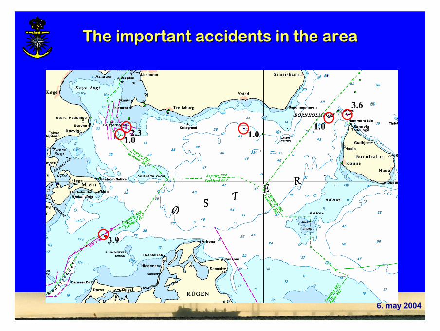
The important accidents in the areaThe important accidents in the area
1.0 1.01.0
2.3
3.6
3.9

12
6. may 2004The Royal Danish Administration of Navigation and Hydrography
2. AIS data and safety ellipse2. AIS data and safety ellipse
Lvessel

13
6. may 2004The Royal Danish Administration of Navigation and Hydrography
Ship domain model (safety ellipse)Ship domain model (safety ellipse)
Ls depends on
size of vessel,
vessel speed,
navigational area,
type of passed objects:
other vessels,permanent objects,
shallow water,
visibility,
current and wind
Lvessel
Ls
Bs
vessels LL 4=
vessels LB 6.1=
Understood as the safety zone with which a navigator intuitively operates when his vessel passes other ships, banks, shallow water, lighthouses and other obstacles

14
6. may 2004The Royal Danish Administration of Navigation and Hydrography
One day in the BalticOne day in the BalticApproximately 20-25% of all ships have AIS implemented

15
6. may 2004The Royal Danish Administration of Navigation and Hydrography
Close encounters (27 days)Close encounters (27 days)
Red: collision riskGreen: grounding risk
243 m
17 m309 m
461 m

16
6. may 2004The Royal Danish Administration of Navigation and Hydrography
Safety@Sea

17
mai 04 RDANH/DS 17
Main Project ComponentsHarmonisation of risk
management strategies
Development of methodologies for selected themes
Development and implementation of demonstration projects
Transnational level
Transnational and Regional level
Regional level
• Time Schedule: June 2004 to June 2007
• Tentative Budget: Total costs around 4 – 5 mill. Euro.
• Submission Date: February 2004
SAFETY AT SEA Interreg IIIB North Sea Programme

18
mai 04 RDANH/DS 18
S&S - Lead Partner (N)
Strand 1 Harmonisation of Risk Management Strategies N
Strand 2Routing and
Safe Seaways
Coordinator: NL
Demo AInventory and Risk Assess-ment of Oil Transport in the
North Sea (NL, N)
Strand 3Risk Management and Coastal Zone
Management
Coordinator: UK
Strand 4Risk Assessment
and
Decision Making
Coordinator: FL
Strand 5 Project Management and Technical Assistance N
Demo BAIS Data and
Risk Assessment(DK, UK, S)
Demo CCoastal Zone Management,
Places of Refuge and
Preparedness (N, FL, G)
Demo DWind farms and
Risk Management
(UK, FL, DK)
Demo ERisk Assessment and
Decision Making (FL,UK,N)
Demo FSafety Awareness
(N,NL,UKFL)

19
6. may 2004The Royal Danish Administration of Navigation and Hydrography
Demonstration Project B:AIS Data and Risk Assessment This demonstration project is lead by the Danish consortium.
The UK consortium and the Swedish consortium and the Norwegian Coastal Administration (Lead Partner) is participatingin the demonstration project.
The project is divided into the following two main tasks:Task 1: Gathering and presenting AIS dataTask 2: Building a fast time numerical navigator
The objective of this demonstration project is to combine the new information that AIS will provide with a proper tool for risk assessment of navigational safety in terms of bouyage and layout of waterways.

20
6. may 2004The Royal Danish Administration of Navigation and Hydrography
Nationalserver
Nationalserver
Base stations
Base stations
Base stations
Applications
Base stations
Applications
Nationalserver
Base stations
Applications
Nationalserver
Safety@Sea AIS system architecture
Applications
Applications
AISDB
Internet
Safety@sea numerical navigator
ONLINE AIS DATA

21
6. may 2004The Royal Danish Administration of Navigation and Hydrography
Gathered AIS
Present / STAT
Current state
New AIS data
New state Compare
Numerical Nav
Nav. RCO's
AtoN
Future state
Nav. Warn.
Compare
Training
Best RCO choice
Present / STAT
Illustration of the interaction between the two tasks
Task 1: Gathering and presenting AIS data
Task 2: Building a fast time numerical navigator

22
6. may 2004The Royal Danish Administration of Navigation and Hydrography
A new AIS pilot study.An online environmental surveillance systems for vessels and offshore structures
During the last 3 years, the Danish company OSIS has designed and manufactured the first sensor with the ability to monitor oil spills from offshore structures, and has completed the initial test phase before entering the final production phase.

23
6. may 2004The Royal Danish Administration of Navigation and Hydrography
Together with the environmental authorities, Danish company OSIS has planned a second development project – OSIS “Marine Transport” –specifically targeted at monitoring emissions from vessels.

24
6. may 2004The Royal Danish Administration of Navigation and Hydrography
Figure - OSIS Sensor system for real-time monitoring ofoil spills from Vessels

25
6. may 2004The Royal Danish Administration of Navigation and Hydrography
OSIS sensor integration to the AIS transponder system

26
6. may 2004The Royal Danish Administration of Navigation and Hydrography
PRESENTATION CONCLUDEDPRESENTATION CONCLUDED
QUESTIONS OR COMMENTS, PLEASEQUESTIONS OR COMMENTS, PLEASE