Embed Size (px)
Citation preview
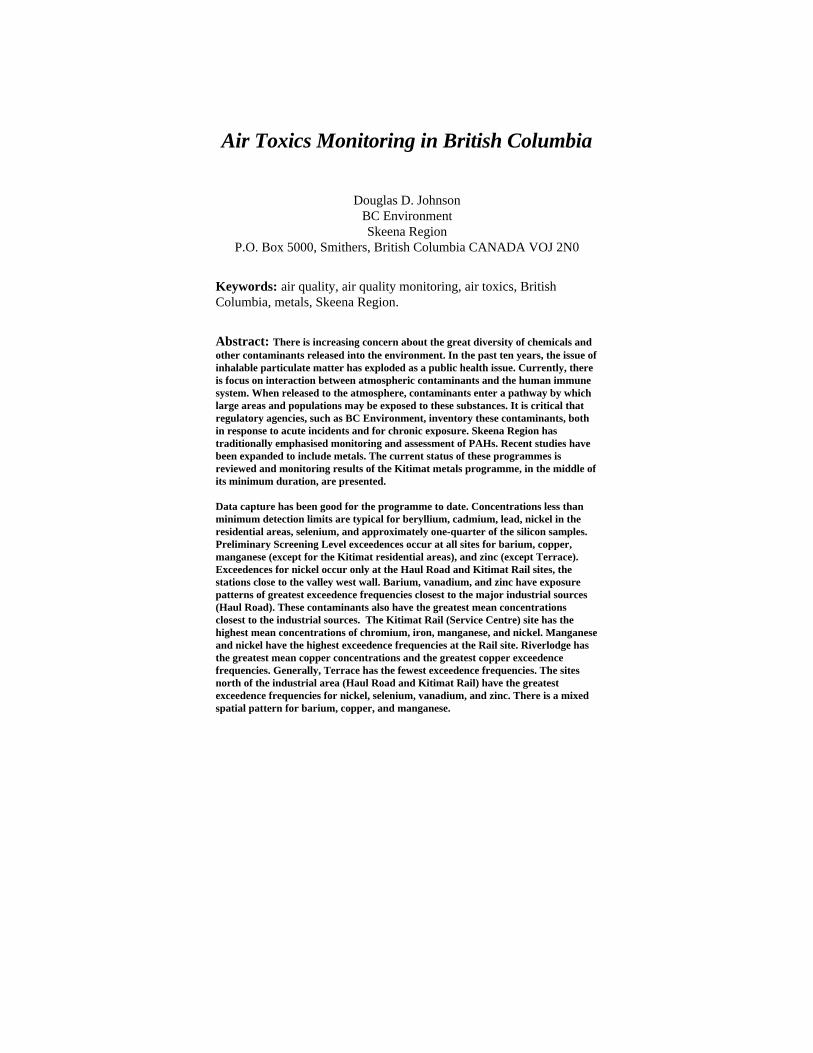
Air Toxics Monitoring in British Columbia
Douglas D. JohnsonBC EnvironmentSkeena Region
P.O. Box 5000, Smithers, British Columbia CANADA VOJ 2N0
Keywords: air quality, air quality monitoring, air toxics, BritishColumbia, metals, Skeena Region.
Abstract: There is increasing concern about the great diversity of chemicals andother contaminants released into the environment. In the past ten years, the issue ofinhalable particulate matter has exploded as a public health issue. Currently, thereis focus on interaction between atmospheric contaminants and the human immunesystem. When released to the atmosphere, contaminants enter a pathway by whichlarge areas and populations may be exposed to these substances. It is critical thatregulatory agencies, such as BC Environment, inventory these contaminants, bothin response to acute incidents and for chronic exposure. Skeena Region hastraditionally emphasised monitoring and assessment of PAHs. Recent studies havebeen expanded to include metals. The current status of these programmes isreviewed and monitoring results of the Kitimat metals programme, in the middle ofits minimum duration, are presented.
Data capture has been good for the programme to date. Concentrations less thanminimum detection limits are typical for beryllium, cadmium, lead, nickel in theresidential areas, selenium, and approximately one-quarter of the silicon samples.Preliminary Screening Level exceedences occur at all sites for barium, copper,manganese (except for the Kitimat residential areas), and zinc (except Terrace).Exceedences for nickel occur only at the Haul Road and Kitimat Rail sites, thestations close to the valley west wall. Barium, vanadium, and zinc have exposurepatterns of greatest exceedence frequencies closest to the major industrial sources(Haul Road). These contaminants also have the greatest mean concentrationsclosest to the industrial sources. The Kitimat Rail (Service Centre) site has thehighest mean concentrations of chromium, iron, manganese, and nickel. Manganeseand nickel have the highest exceedence frequencies at the Rail site. Riverlodge hasthe greatest mean copper concentrations and the greatest copper exceedencefrequencies. Generally, Terrace has the fewest exceedence frequencies. The sitesnorth of the industrial area (Haul Road and Kitimat Rail) have the greatestexceedence frequencies for nickel, selenium, vanadium, and zinc. There is a mixedspatial pattern for barium, copper, and manganese.

Air Toxics Monitoring in British Columbia Page 1
Introduction
Generally, toxic air pollutants (also known as air toxics or hazardous air pollutants) are defined as those
known or suspected to cause serious health problems. A variety of industrial sources and motor vehicles
emit “routine” toxic air pollutants. In addition to routine releases, sudden accidental air releases of toxics
threaten many Canadians. Toxic air pollutants include metals, other particles, and certain vapours from
fuels and other sources.
The emission of toxic substances into the air can cause chronic and acute damage to human health and the
environment. Human exposure to these contaminants at sufficient concentrations and durations can result in
cancer, poisoning, and rapid onset of sicknesses such as nausea or difficulty in breathing. Other less
measurable effects include immunological, neurological, reproductive, developmental, and respiratory
problems. Pollutants deposited onto soil or into lakes and streams affect ecological systems and eventually
human health through consumption of contaminated food. Some researchers (e.g., Colborn 1996) see
evidence that industrial chemicals in the environment, including metals, harm endocrine (regulating)
systems of fish, birds and mammals.
Below is an overview of the definition of air toxics in British Columbia. Subsequently presented are the
interim results of the Kitimat airborne metals monitoring programme. The presentation of the interim
assessment is an example of an application of air toxics monitoring in British Columbia.
Definition of Air Toxics and Hazardous Air Pollutants in British
Columbia
Much of the work on defining air toxics in British Columbia has been done by the Subcommittee for the
Definition of Toxic and Persistent Substances of the Criteria Policy and Regulation Review Committee
(Environmental Protection Department). The committee released a guidance document for the definition of
a “persistent toxic substance” in 1995. This document was prepared to provide guidance to BC
Environment staff regarding the definition of the terms “toxic and persistent” for the development of
programs, regulations, strategies, technical criteria, and other measures necessary for the protection of the
environment. This document by itself, however, does not represent the position or policy of BC
Environment respecting any specific substance or product. Much of this section is drawn from the work of
the subcommittee.

Air Toxics Monitoring in British Columbia Page 2
The definition of toxic substances is usually: (i) a general narrative definition, (ii) impact criteria, and/or
(iii) a list of specified substances. The Canadian Environmental Protection Act (CEPA section 11) uses the
following narrative statement:
a substance is toxic if it is entering or may enter the environment in a quantity orconcentration or under conditions;
a) having or that may have an immediate or long-term harmful effect onthe environment,
b) constituting or that may constitute a danger to the environment onwhich human life depends, or
c) constituting or that may constitute a danger in Canada to human life orhealth.
In order to consistently develop criteria and programs for the protection of the environment, BC
Environment requires a definition for toxic and persistent substances. Definition of these terms may also be
necessary for a number of other regulatory purposes. For example, lists of toxic and persistent substances
may be generated for use in:
• Determining waste discharge permit fees.
• Establishing environmental quality criteria and standards.
• Establishing Provincial "targets" to reduce the production rate of toxic wastes (e.g.,pollution prevention programs).
• Establishing high priority "ban and phase-out" lists for toxic substances.
The Criteria Policy and Regulation Review Committee have recommended the following regarding the
definition of a “persistent toxic substance”:
• The terms toxic and persistent should not be generically defined solely as a simple list of"toxic and persistent" substances. Rather, such definition should be based on both anarrative definition and specific technical criteria, capable of application to anysubstance.
• The recommended definition criteria are to be solely based on toxicological andenvironmental fate characteristics of the substances per se without additionalconsideration of aspects relating to the discharge itself such as the volume or time ofdischarge, location in which the discharge will occur, economic considerations, existenceof regulatory requirements or feasibility of engineering controls, etc.
• An additional specific criteria-based definition is thought to have several advantages. Forexample unlike most narrative definitions, it is relatively precise. Furthermore, it isscientifically defencible, unlike simple lists of substances that are often perceived to bearbitrary. Determination of toxic and persistent substances under a criteria baseddefinition is documentable and thus would lend itself to any consultative process whichBC Environment may wish to use regarding future development or revision ofregulations. Finally, such a definition may allow BC Environment to set priorities

Air Toxics Monitoring in British Columbia Page 3
regarding the urgency for regulatory actions based on the relative ranking of various toxicand persistent substances.
• To be considered for definition as a chronic toxic substance, said substance should eliciteither:
• a) carcinogenic, mutagenic or teratogenic effects, or
• b) provoke other well documented toxic effects of proven etiology following longterm exposure to sub-acute dose.
• Only IARC group 1 and 2A agents be considered for definition as carcinogenicsubstances in humans; in the case of animals, group 2B agents should be consideredpotential carcinogenic substances, subject to confirmation based on review of IARCrationale documents.
• Agents known to be either carcinogenic or teratogenic should also be assumed to bemutagenic.
• Teratogenicity be included only as a supplementary criteria for consideration in thedefinition of toxic substances.
The remainder of this paper contains a report on the application of one of Skeena Region’s air toxic
assessment programmes.
Skeena Monitoring Programmes
In the past, monitoring and
assessment programmes in
Skeena Region (Figure 1) focused
on traditional ‘criteria’ air
contaminants. Increased attention
to inhalable particulate matter
and air toxics has occurred in
recent years. Outlined briefly
below are current monitoring
programmes, largely concentrated
in the Highway 16/37 South
corridor. Figure 2 depicts, in
detail, the communities of the
Highway 16/37 South area
(Bulkley/Skeena and Kitimat
drainage basins).
Figure 1. Skeena Region, British Columbia.Presented is Skeena Region’s location relative to British Columbia’spolitical and coastal boundaries.

Air Toxics Monitoring in British Columbia Page 4
As a result of
confined valleys,
significant
combustion
sources, and
occasionally poor
dispersion
meteorology, there
are episodes of
poor inhalable
particulate air
quality in Skeena
Region’s interior.
As a result, much
of BC
Environment’s
monitoring and
assessment
resources were
allocated to
establish an interior community network of continuous, real-time inhalable particulate (PM10) monitors.
PM10 TEOMs are currently deployed in Burns Lake, Houston, Quick, Smithers, and Terrace. BC
Environment solely supports the Burns Lake and Quick TEOMs; the remainder are partnerships with
industry and local government. Future plans are to have industry fund TEOMs in Telkwa, Kitimat, and
Prince Rupert, leaving the Hazeltons as the only significant gap in the network.
Much of the heavy industrial development (pulp mills, smelter) in Skeena Region occurs in the coastal
communities of Kitimat and Prince Rupert. These have traditionally participated in monitoring of criteria air
contaminants, but have been reluctant to upgrade particulate monitoring to continuous PM10.
A number of monitoring programmes have been implemented to assess the significance of toxic air
contaminants. Presented below is a detailed assessment of the interim results of the Skeena metals
monitoring programme. The Skeena PAH sampling and assessment programme has been presented
elsewhere (Johnson, 1995). Other assessment programmes have included short-duration research into ozone
exposure.
Figure 2. Highway 16/37 South Corridor, Skeena Region, British Columbia.The Highway 16/37 South corridor is the primary geographic focus of air qualitymonitoring and assessment work in Skeena Region. This corridor contains allcommunities depicted below, except for the Nass Valley.
Smithers
Houston Burns Lake
Hazeltons
Kitimat
Prince Rupert
Nass Valley
Terrace

Air Toxics Monitoring in British Columbia Page 5
Kitimat Metals Programme
In response to questions raised regarding the concentrations of toxic metals in the atmospheric environment
originating from Kitimat industrial operations, BC Environment initiated a process to assess this issue. BC
Environment Air Resources Branch (Suzuki, 1994) developed preliminary screening criteria to complement
a sampling and analysis programme negotiated with Alcan Smelters and Chemicals Ltd. This sampling
programme is now approximately half complete.
The focus of Kitimat metals monitoring and assessment programme is the Kitimat-Terrace corridor.
Notable emissions are those associated with the aluminium smelter (Alcan Smelting and Chemicals
Limited), the paper mill (Eurocan Pulp and Paper Company), and the methanol and ammonia plant
(Methanex Corporation). As part of their air emissions permits, these companies are required to monitor
and report to BC Environment air contaminant concentrations in the ambient environment.

Air Toxics Monitoring in British Columbia Page 6
Study Area
The name Kitimaat (“People of the Snow”)
is a Tsimshian name given to the Haisla
native Indians who made their home at the
head of Douglas Channel, a long, broad
fjord that connects to Hecate Strait and the
Pacific Ocean (Figure 2). Today Kitimat is
a municipal district that marks the point
where the Kitimat River drains into Kitimat
Arm fjord (Figure 3).
The Kitimat and Lakelse river valley
bottoms form low and generally simple
terrain anchored by the City of Terrace on
the Skeena River some 60 km north of the
Municipal District of Kitimat. The divide
between the two drainage basins is only 200
m above sea level and occurs approximately
30 km up-valley from Kitimat. The
surrounding terrain is complex post-glacial,
including steep mountainous areas with
peaks in the 1700 m elevation range, as
depicted in Figure 3. Moderately dense to
dense coniferous forest dominates the
landscape, characterised by western
hemlock, amabalis fir, and mountain
hemlock. Closer to the coast, scrub,
western hemlock, western red cedar, yellow cedar, and shore pine are present. (Smith, 1996).
The Kitimat townsite originated to house workers for the Aluminium Company of Canada (now known as
Alcan Aluminium Limited) when construction of its Kitimat Works smelter began in the early 1950s. The
CN Rail line to Kitimat opened in 1954; a highway connection to Terrace was complete in 1957 (Kitimat’s
Tourism Information Directory, 1995).
Figure 3. The Geography of the Kitimat Valley.
Terrace
Kitimat
Lakelse Lake
Skeena River
Kitimat River
Kitamaat Village
Hig
hway
37
Kiti
mat
Arm

Air Toxics Monitoring in British Columbia Page 7
The Municipal District of Kitimat has a current population of approximately 11 700 people. The industrial
sites are at the southern end of the Kitimat River valley, along the west wall of the valley (Figure 4). Figure
5 depicts the industrial setting as viewed from Kitimat Arm just north of Kitamaat Village.

Air Toxics Monitoring in British Columbia Page 8
Figure 4. Kitimat Geography.The main residential areas of Kitimat are in the centre-top portion of the image(only major roads are shown). To the South of Highway 37 (runs North-South intop-right and centre-left and East-West in centre-top) is the Riverlodge subdivision.To the North on the bench are the Whitesail and Nechako subdivisions. Inflow(southerly) winds follow the valley orientation, resulting in industrial emissionspassing over the Sandhill (just north of Eurocan) and the Service Centre (north-northeast of the Sandhill). Monitoring station locations are depicted with associatedcontaminants (HF - hydrogen fluoride, NOx - nitrogen oxides, SO2 - sulphurdioxide, PM10 - inhalable particulate, TRS - total reduced sulphur, and Wx -meteorology). Metals and PAHs, which may be of interim duration, are alsolocated at the four contaminant monitoring sites; ozone is located at the KitimatRail site.
Alcan
Eurocan
Methanex
Whitesail
Riverlodge(Kildala)
(XURFDQ�
'RFN
.LWLPDW�$UP
0LQHWWH%D\
Sandhill
Service Centre
Nechako
+DXO�5RDG�&URVVLQJ
HF, SO2
5LYHUORGJH
HF, TRS,
PM10
:KLWHVDLO
HF, SO2,
PM10, TRS
.LWLPDW�5DLO
HF, SO2, PM10,
TRS, NOx
Wx
Wx
Wx

Air Toxics Monitoring in British Columbia Page 9
In summer, prevailing inflow (southerly) winds blow the industrial area plumes up the Kitimat River valley
towards Terrace. Visible industrial emissions during inflow conditions are frequently observed travelling over
the Sandhill and following a ridge 365 m ASL 1-1½ km west of the Service Centre. On occasion, a lee vortex
draws down visible (primarily Eurocan plume) and other emissions into the Service Centre. In winter, outflow
(northerly) winds from the interior of the province funnel the plume out Kitimat Arm (Figure 3). Atmospheric
conditions also include a variable mixing layer and diurnal wind variation.
Kitamaat Village is located 5 km southwest of the industrial area (on the opposite side of Kitimat Arm from the
industrial sites) and the main residential areas of Kitimat (Whitesail, Nechako, and Kildala (Riverlodge)
subdivisions) are 5 km northeast of the smelter and 2.5 km east-northeast of Eurocan (Figure 4). Thus, the
Kitimat industrial area is geographically and meteorologically well-sited relative to populated areas for
minimising the potential for environmental impacts on human health. The Service Centre, a largely light
industrial-commercial-service area (with some residents in the Kitimat Hotel), is 5 km north of the smelter and
2 km north of Eurocan. Between the Service Centre and the industrial areas is ‘the Sandhill’, a 180 m above sea
level easterly topographic intrusion into the valley. The greatest potential for air emission-related impacts are,
therefore, in the terrestrial and aquatic environments; impacts may occur in the main residential areas only
during calm and fumigation conditions. The Terrace airport recorded calm wind 19% of the time for the 1951-
1980 climate normal averaging period. As a result of probably frequent sea breezes, significantly fewer calms
are expected in Kitimat.
Figure 5. The Kitimat Industrial Setting.Image is looking west from just north of Kitamaat Village. The smelter complex (left) and thevisible point sources emission associated with Eurocan (right) are evident. The Kitimat Riverestuary is in the foreground and the Coast Range mountains are in the background.

Air Toxics Monitoring in British Columbia Page 10
Monitoring Sites
Figure 4 (above) depicts the Kitimat monitoring sites: Haul Road, Kitimat Rail (Service Centre), Riverlodge
(Kildala), and Whitesail. The intent of the Haul Road Crossing site is to capture the near-industrial area
ambient conditions. There are no humans residing, normally working, nor recreating in this area. Kitimat
Rail represents exposures in a commercial sector, however, a small number of people do reside here.
Riverlodge and Whitesail are the two residential stations. A ridge and Highway 37 divide the two
neighbourhoods. Terrace is the intermediate control site1.
Method
A measured volume of ambient air is drawn at a constant flow rate through a high volume sampler. A 0.3
µm Teflon coated borosilicate glass fibre filter collects particulate in the air sample. Particles are collected
on the filter(s) during a 7 day sampling period2. The collected material constitutes total particulate.
The filter is subsequently digested in a nitric/perchloric acid to bring the metals into solution. Following
acid digestion, aqueous solutions of metals are converted to aerosols in a ICP nebulizer and injected directly
into a high temperature plasma (6000 to 8000°K). This highly efficient ionisation produces ionic emission
spectra at wavelengths specific to the elements of interest that can be monitored either simultaneously or
sequentially.
1 It is possible that Kitimat contaminants could reach Terrace. However, a study in the summer of 1994 did not detect
any hydrogen fluoride, sulphur dioxide, or total reduced sulphur compounds at the Terrace-Kitimat airport.Complementary data from Smithers and Quick will be used in the final report to assess the significance of any metalsfound common to the Terrace-Kitimat environment.
2 A seven day collection period, rather than the normal 24 hours, was chosen to ensure that enough particulate werecollected relative to those contained in the filter itself and the analytical method detection limit.

Air Toxics Monitoring in British Columbia Page 11
Metals Assessment Criteria
Table 1 depicts the screening criteria used to assess the
metals data. Provincial objectives are used to derive most
criterion (unshaded). However, no provincial screening
criteria were provided for aluminium, iron, magnesium,
silicon, or titanium. For the purposes of this paper, a
measure of central tendency of impact assessment criteria
from other jurisdictions was used to develop an interim
screening criterion for these contaminants. Magnesium
was the exception for which the provincial Level A total
suspended particulate criterion is used. As such, these
represent neither the most conservative (protective) nor
“official” provincial objectives. When the sampling is
complete (fall 1997), a more comprehensive assessment
will be undertaken of these interim screening criteria. Also
note that the screening levels are for an integration period
of one day. The samples collected have integrations of
approximately seven days. This results in a less
conservative assessment.
Data Capture
This sampling programme is intense as the samplers are
run continuously. Figure 6 depicts the data capture
statistics of the interim metals sampling programme. Note
that most statistics are within the BC Environment data
capture guidelines of 85% of all samples.
Table 1. Preliminary Screening Levels.Shaded boxes depict interim regionalscreening criteria based on a measure ofcentral tendency of regulatory standards drawnfrom a variety of other jurisdictions. Clearboxes represent Provincial PreliminaryScreening levels.
Contaminant
Screening Criterion
(µg m-3 d-1)
Aluminium (Al) 28.5
Barium (Ba) 0.50
Beryllium (Be) 0.005
Cadmium (Cd) 0.05
Chromium (Cr) 0.05
Copper (Cu) 0.25
Iron (Fe) 10.5
Lead (Pb) 1
Magnesium (Mg) 150
Manganese (Mn) 0.05
Nickel (Ni) 0.01
Selenium (Se) 0.1
Silicon (Si) 97
Titanium (Ti) 35
Vanadium (V) 0.05
Zinc (Zn) 1

Air Toxics Monitoring in British Columbia Page 12
Figure 6. Metals Sampling Programme Interim Data Capture Statistics.The BC Environment objective is 85%. Data are current to the most recently available. The X-axisdepicts week sampled. The Y-axis represents samples captured.
Metals Data Capture
0
1
2
3
4
5
6
05-N
ov-9
6
26-N
ov-9
6
17-D
ec-9
6
07-J
an-9
7
28-J
an-9
7
18-F
eb-9
7
11-M
ar-9
7
01-A
pr-9
7
22-A
pr-9
7
13-M
ay-9
7
03-J
un-9
7
24-J
un-9
7
15-J
ul-9
7
05-A
ug-9
7
26-A
ug-9
7
16-S
ep-9
7
07-O
ct-9
7
28-O
ct-9
7
Terrace
Riverlodge
Whitesail
Kitimat Station
Haul RoadData Capture
88% 84%76%
88% 90%
0%
85%
Hau
l Roa
d
Kit
imat
Stat
ion
Whi
tesa
il
Riv
erlo
dge
Ter
race
Objective = 85%
Results
Of primary concern to BC Environment is whether or not observed metals concentrations meet the
screening criteria (Table 1). Figure 7 presents the screening criteria exceedence frequency for each
contaminant at each sample site. As indicated in Figure 7, there are a number of exceedences of the 24 hour
screening criteria, even for the Terrace ‘control’ site.

Air Toxics Monitoring in British Columbia Page 13
Figure 7. Screening Criteria Exceedence Frequencies.
Hau
l Roa
d
Kit
imat
Sta
tion
Riv
erlo
dge
Whi
tesa
il
Ter
race
AlBa
BeCd
CrCu
FePb
MgMn
NiSe
SiTiVZn
0%
10%
20%
30%
40%
50%
60%
Screening Criteria Exceedence Frequencies
Figure 8 summarises the environmental metals exposure in a different manner. The average concentrations
for all sites are summed, by contaminant, and then expressed as a relative frequency between sites (relative
frequencies, as opposed to absolute means, allow plotting of all contaminants on the same chart). Thus, if
metals were equally ubiquitous at all sites, one would expect their proportions to equal 20% at each site
(i.e., one of five sites).

Air Toxics Monitoring in British Columbia Page 14
Figure 8. Contaminant Proportions By Site.
Contaminant Proportions by Site
0%
20%
40%
60%
80%
100%A
l
Ba
Be
Cd
Cr
Cu
Fe
Pb
Mg
Mn Ni
Se Si Ti V Zn
Terrace
Riverlodge
Whitesail
Kitimat Station
Haul Road
Clearly, there is not an even distribution of metals exposure between all sites. The Haul Road appears to
have an abundance of aluminium, barium, vanadium, and zinc relative to other sites. Kitimat (Rail) Station
has more chromium, iron, manganese, and nickel. Riverlodge has a lot of copper. Average concentrations in
Terrace are generally at or less than other sites.
Figure 9 depicts the analytical procedure less than detectable sample frequency (including the metals
contained in the filter). Beryllium, cadmium, lead , nickel (Whitesail and Terrace only), and selenium are
‘absent’ in atmospheric particulate matter.

Air Toxics Monitoring in British Columbia Page 15
Figure 9. Frequencies of Less Than Detectable Observations.
Less Than Detectable Frequencies
0%
25%
50%
75%
100%
Al
Ba
Be
Cd
Cr
Cu
Fe
Pb
Mg
Mn Ni
Se Si Ti V Zn
Haul Road
Kitimat Station
Whitesail
Riverlodge
Terrace
Given the exceedences of the screening criteria (Figure 7) and the differences in metals distribution between
sites (Figure 8), we need to look more closely at these data. Corrections are necessary to account for
sampling and filter error to determine if exceedences are still significant.
Data Correction
Figure 10 depicts the sampling error (filter noise component) relative to the screening criteria. Filter noise
(metal content (µg)) was converted to units comparable to screening criteria (µg m-3) by taking the average
filter metal content (µg, by contaminant) and dividing it by the average high volume sampler flow (m-3).

Air Toxics Monitoring in British Columbia Page 16
Figure 10. Filter Noise Relative to Screening Criteria.
Filter Noise Relative to Screening Criteria
0%
10%
20%
30%
40%
50%
60%
70%
80%
90%
100%A
l
Ba
Be
Cd
Cr
Cu Fe
Pb
Mg
Mn Ni
Se Si Ti V Z
n
Average filter error (µg) /
average flow (m-3
) (all stations) relative to screening criteria.
A number of contaminants are present on the blank sample filters in quantities that are high relative to the
screening criteria. In particular, aluminium, barium, beryllium, chromium, manganese, nickel, selenium,
vanadium, and zinc are present in quantity.
Figure 11 presents the amount of laboratory error (the method error), expressed as a percentage of the filter
error (Figure 10). It is clearly much less significant than the error associated with filter contamination.
Figure 12 explicitly demonstrates this by presenting total error (and the variability about the mean blank
error as one standard deviation error bars). In absolute terms, filters have large quantities of aluminium and
magnesium on them.

Air Toxics Monitoring in British Columbia Page 17
Figure 11. Method Error Relative to Filter Blank.
Method Error Relative to Filter Blank
0%
10%
20%
30%
40%
50%
60%
70%
80%
90%
100%
Al
Ba
Be
Cd
Cr
Cu
Fe
Pb
Mg
Mn Ni
Se Si Ti V Zn

Air Toxics Monitoring in British Columbia Page 18
Figure 12. Total Error.
Total Filter Error
0
10000
20000
30000
40000
50000
60000
70000A
l
Ba
Be
Cd
Cr
Cu Fe
Pb
Mg
Mn Ni
Se Si Ti V Zn
( µg)
Method (ug)
Blank (ug)
As a result of the potentially significant error inherent in the sampling protocol, a bulk error correction is
applied by subtracting, from each individual observation, a bulk error term defined by the equation below:
( ) ( )( )Error g m
TotalFilter Error g
Flow mc
cµµ− =3
3
where total filter error (sum of the filter contamination and method error) and flow are both averages for all
samples. Presented below is the significance of these corrections on Preliminary Screening Level
exceedence frequency for each of the Haul Road (Figure 13), Kitimat Rail (Figure 14), Riverlodge (Figure
15), Whitesail (Figure 16), and Terrace (Figure 17) sample sites.

Air Toxics Monitoring in British Columbia Page 19
Figure 13 Haul Road Exceedence Frequencies.
Haul Road Exceedence Frequencies
0%
10%
20%
30%
40%
50%
60%A
l
Ba
Be
Cd
Cr
Cu
Fe
Pb
Mg
Mn Ni
Se Si Ti V Zn
Uncorrected
Bulk Corrected
The Haul Road site, closest to the industrial sources and downwind of the pulp mill and gas plant during
outflow (but upwind of the smelter), saw its aluminium exceedences drop to zero after correction.
Exceedence frequencies of nickel and zinc dropped slightly. Other exceedence frequencies were unchanged.
After correction, exceedences occur for barium, copper, manganese, nickel, vanadium, and zinc.

Air Toxics Monitoring in British Columbia Page 20
Figure 14. Kitimat Rail Exceedence Frequencies.
Station Exceedence Frequencies
0%
10%
20%
30%
40%
50%
60%
Al
Ba
Be
Cd
Cr
Cu
Fe
Pb
Mg
Mn Ni
Se Si Ti V Zn
Uncorrected
Bulk Corrected
Kitimat Station, directly north of the industrial sites, had chromium exceedence frequencies drop to zero
after correction; nickel declined slightly. Exceedences occur for barium, copper, manganese, nickel, and
zinc.
Air Toxics Monitoring in British Columbia Page 21
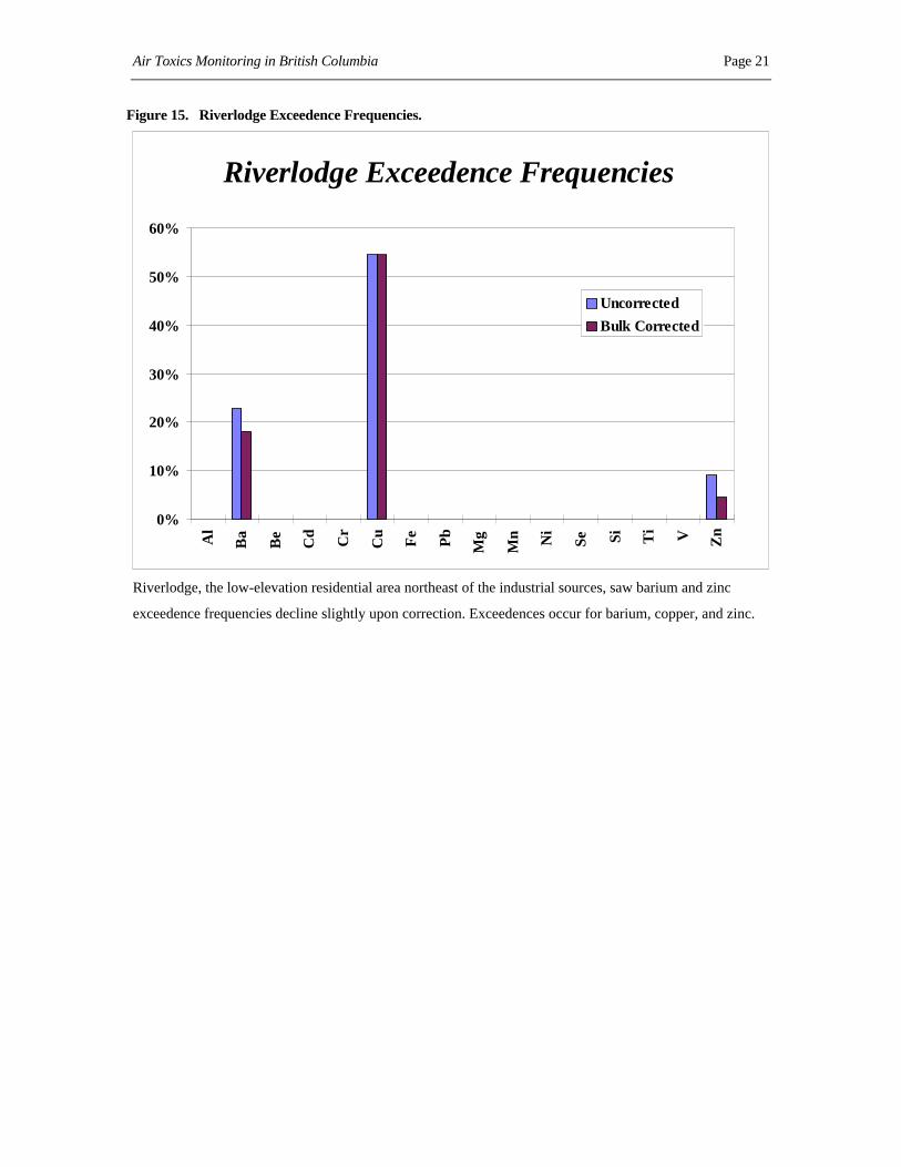
Figure 15. Riverlodge Exceedence Frequencies.
Riverlodge Exceedence Frequencies
0%
10%
20%
30%
40%
50%
60%A
l
Ba
Be
Cd
Cr
Cu
Fe
Pb
Mg
Mn Ni
Se Si Ti V Zn
Uncorrected
Bulk Corrected
Riverlodge, the low-elevation residential area northeast of the industrial sources, saw barium and zinc
exceedence frequencies decline slightly upon correction. Exceedences occur for barium, copper, and zinc.

Air Toxics Monitoring in British Columbia Page 22
Figure 16. Whitesail Exceedence Frequencies.
Whitesail Exceedence Frequencies
0%
10%
20%
30%
40%
50%
60%
Al
Ba
Be
Cd
Cr
Cu
Fe
Pb
Mg
Mn Ni
Se Si Ti V Zn
Uncorrected
Bulk Corrected
Whitesail, the higher-elevation residential area northeast of the industrial sources, had barium exceedence
frequencies decline slightly after correction. Exceedences occur for barium, copper, and zinc.

Air Toxics Monitoring in British Columbia Page 23
Figure 17. Terrace Exceedence Frequencies.
Terrace Exceedence Frequencies
0%
10%
20%
30%
40%
50%
60%
Al
Ba
Be
Cd
Cr
Cu
Fe
Pb
Mg
Mn Ni
Se Si Ti V Zn
Uncorrected
Bulk Corrected
Terrace, the community 60 km north of Kitimat, saw its barium exceedences decline drastically after
correction. Barium, copper, and magnesium exceeded the screening criteria occasionally (approximately
5% of samples).
Figure 18 presents the screening criteria exceedence frequencies corrected for errors by contaminant and
site.

Air Toxics Monitoring in British Columbia Page 24
Figure 18. Screening Criteria Exceedence Frequencies Corrected for Error.
Hau
l Roa
d
Kit
imat
Sta
tion
Riv
erlo
dge
Whi
tesa
il
Ter
race
AlBa
BeCd
CrCu
FePb
MgMn
NiSe
SiTiVZn
0%
10%
20%
30%
40%
50%
60%
Screening Criteria Exceedence Frequencies (Corrected)
Comparing with the uncorrected chart (Figure 7), the pattern for barium and zinc change: the Terrace
barium exceedence frequencies have dropped markedly and Whitesail now has the lowest zinc exceedences
(Terrace had the lowest uncorrected zinc exceedences). Otherwise, the patterns are similar. Generally,
Terrace has the fewest exceedence frequencies. The industrial sites (Haul Road and Kitimat Rail) have the
greatest exceedence frequencies for zinc, vanadium, selenium, and nickel. There is a spatial pattern for
barium and copper.
Meteorology
Generally, Kitimat experiences outflow winds from November to March. October and April are transition
months. Inflow winds dominate May-September. Presented below are windroses for three meteorological
stations are covering the sampling period.

Air Toxics Monitoring in British Columbia Page 25
Figure 19. Terrace Meteorology.
Figure 20. Kitimat (Eurocan Dock) Meteorology.

Air Toxics Monitoring in British Columbia Page 26
Figure 21. Kitimat (Haul Road) Meteorology.
Terrace appeared to have inflow winds most of the sample period. However, given the station siting (north
of the Skeena river), one cannot conclude this represents a vector from Kitimat. It is likely the Skeena River
(east-west orientation, see Figure 3) affects any inflowing emissions from Kitimat. Strong outflow winds,
representing valley-scale meteorology, dominate the Eurocan Dock site. However the site also has a strong
inflow sub-component. Less intense winds characterise the Haul Road site as it is much closer to the valley
wall. It had a strong outflow component.
Summary and Conclusions
Data capture has been good for the programme to date. As such, the samples may generally be considered
representative of their sites. Concentrations less than minimum detection limits are typical for beryllium,
cadmium, lead, nickel in the residential areas, selenium, and approximately one-quarter of the silicon
samples. Preliminary Screening Level exceedences occur at all sites for barium, copper, manganese (except
for the Kitimat residential areas), and zinc (except Terrace). This is significant given that inflow winds do
not dominate the meteorological regime and the Preliminary Screening Criteria represent daily averages
(whereas the samples are weekly averages). Exceedences for nickel occur only at the Haul Road and
Kitimat Rail sites, the stations close to the valley west wall. Barium, vanadium, and zinc have exposure
patterns of greatest exceedence frequencies closest to the industrial sources (Haul Road). These
contaminants also have the greatest mean concentrations closest to the industrial sources. The Kitimat Rail
(Service Centre) site has the highest mean concentrations of chromium, iron, manganese, and nickel.
Manganese and nickel have the highest exceedence frequencies at the Rail site. Riverlodge has the greatest
mean copper concentrations and the greatest copper exceedence frequencies. Generally, Terrace has the
fewest exceedence frequencies. The sites directly north of the industrial area (Haul Road and Kitimat Rail)

Air Toxics Monitoring in British Columbia Page 27
have the greatest exceedence frequencies for nickel, selenium, vanadium, and zinc. There is a mixed spatial
pattern for barium, copper, and manganese.
Future assessment work includes episode analysis to determine the wind vectors which dominated a
screening criteria exceedence. Summer 1997 data may contrast the winter data with respect to more
prevailing inflow winds. If industrial emissions are contributing to metal loadings in the environment, we
would expect to see increases in exposures during the summer months. Examination of the metals data
collected this summer in Smithers and Quick will provide a contrast to the Kitimat and Terrace data. A
more comprehensive emissions inventory is necessary to assess which point sources, if any, are emitting
metals in significant quantities.
References
BC Environment. 1995. Persistent Toxic Substance Definition. Subcommittee for the Definition of Toxicand Persistent Substances. Environmental Protection Department. The EnvironmentalProtection Compendium (http://www.env.gov.bc.ca/epd/cpr/policy/ptsd.html). 25 January1995.
Colborn, T., D. Dumanoski, and J. Peterson Myers. 1996. Our Stolen Future. Dutton. New York, USA.
Johnson, D.D. 1995. PAHs: Ambient Air Quality Monitoring in British Columbia. Presentation toEnvironment Canada Workshop. Simon Fraser University (Downtown Campus),Vancouver, British Columbia. 6 March 1995.
Kitimat’s Tourism Information Directory, 1995. 12 December 1995. http://www.sno.net/tourist.html
Smith, J. 1996. Emissions and Vegetation Monitoring in the Kitimat Valley: A Review With Notes onProposed Biomonitoring Programs. March 1996 Draft. Prepared for Prince Rupert ForestRegion Research Branch. 59 pp.
Suzuki, N. 1994. Sampling and Impact Assessment Criteria for the Kitimat Metals In Air AmbientMonitoring Programme. Memo to Richard Bennett, Air Resources Branch. 3 October1994.