Embed Size (px)
Citation preview

Air Quality Conformity Task Force
Metropolitan Transportation Commission Bay Area Metro Center
Mount Hamilton Conference Room 375 Beale Street, Suite 800
(Note: Visitors must check in with the receptionist on the 7th floor) San Francisco, CA
Conference Call Number: Dial - (415) 655-0002 (Access Code: 926 182 629) Participant ID is # button. Thursday, July 26, 2018
9:30 a.m. –11:00 a.m.
AGENDA 1. Welcome and Introductions 2. PM2.5 Project Conformity Interagency Consultations
a. Consultation to Determine Project of Air Quality Concern Status
i. ITS Improvements in San Mateo County Northern Cities Project
b. Confirm Projects Are Exempt from PM2.5 Conformity i. Projects Exempt Under 40 CFR 93.126 – Not of Air Quality Concern
3. Consent Calendar
a. June 28, 2018 Air Quality Conformity Task Force Meeting Summary
4. Other Items – Information and Updates
a. Downtown Novato SMART Station (Offline Task Force Concurrence) b. MTC/SACOG Air Quality Planning/Conformity MOU c. Conformity Analysis for the 2019 Transportation Improvement Program and the Amended Plan Bay Area
(End of public comment period)
Next Meeting: August 23, 2018
MTC Staff Liaison: Harold Brazil [email protected]
J:\SECTION\PLANNING\AIRQUAL\TSKFORCE\2018\7-26-18\Draft\1_Agenda_072618 (revised).docx

TO: Air Quality Conformity Task Force DATE: July 12, 2018
FR: Harold Brazil W. I.
RE: PM2.5 Project Conformity Interagency Consultation
A project sponsor representing a project seeks interagency consultation from the Air Quality Conformity Task Force (AQCTF) at today’s meeting and the project is as follows:
No. Project Sponsor Project Title 1
City/County Association of Governments of San Mateo County (C/CAG)
ITS Improvements in San Mateo County Northern Cities Project
2ai_ITS_Improvements_in_San_Mateo_County_Northern_Cities_Project_Assessment_Form.pdf (for the ITS Improvements in San Mateo County Northern Cities project) MTC also requests the review and concurrence from the Task Force on the project that a project sponsor has identified as exempt and likely not to be a POAQC. 2b_Exempt List 071218.pdf lists the exempt project under 40 CFR 93.126. J:\SECTION\PLANNING\AIRQUAL\TSKFORCE\2018\7-26-18\Draft\2a_ PM2.5 Interagency Consultation (2).docx

Application of Criteria for a Project of Air Quality Concern Project Title: San Mateo County Smart Corridor Project – South San Francisco Expansion Project Summary for Air Quality Conformity Task Force Meeting: (July 26, 2018) Description The proposed project would be constructed in a 3‐mile corridor in San Mateo County spanning the cities of Brisbane, South San Francisco, and San Bruno (project area). The purpose of the proposed project is to improve and monitor traffic flow within this corridor during normal operations by better integrating freeway and local arterials, and to proactively manage and optimize signal operations along predetermined Smart Corridor Routes in order to improve the balance of traffic flow, reduce congestion, and minimize impacts on local arterials when traffic is diverted from U.S. 101 during major traffic incidents. The proposed project would accomplish this through the installation of tools and systems, including cameras, informational signs, other traffic operation systems elements, and an interconnect between local and state traffic signal systems to and from U.S. 101 and on local streets in South San Francisco. The following Intelligent Transportation System (ITS) features are included in the proposed project:
− Six directional signs (trailblazer signs) to guide traffic through the local network.
− Sixty‐one fixed closed‐circuit television cameras to monitor traffic congestion and end‐of-queue locations.
− Four arterial dynamic message signs, proposed to be installed at Airport Boulevard, Oyster Point Boulevard, Gateway Boulevard, and South Airport Boulevard to provide additional information to motorists at these decision points.
− Twenty traffic signal controllers.
− Seven microwave vehicle detection systems.
− Fiber optic cables. The Smart Corridor Routes were selected by C/CAG’s Traffic Incident Management Committee as streets that are used by motorists during major traffic incidents. These Smart Corridor Routes are Airport Boulevard, Oyster Point Road, Gateway Boulevard, and Grand Avenue. These routes are close to the freeway corridor and consist of major and minor arterials that extend north‐south parallel to U.S. 101 or east‐west arterial‐to‐freeway connectors. Twenty intersections operated and maintained by the City of South San Francisco would require installation of engineering features. The project would include the traffic operation systems and other ITS elements on the identified Smart Corridor Routes. No changes to the mainline of US 101 are proposed under the project. Background − NEPA process for Categorical Exclusion (CE) is expected to be completed in 2018
− Public review not required
− Seeking air quality conformity determination on or before August 1, 2018
− Schedule based on deadline for October 17, 2018 funding allocation Not a Project of Air Quality Concern (40 CFR 93.123(b)(1)) (i) New or expanded highway projects with significant number/increase in diesel vehicles? − Involves the use of traffic control devices and operating assistance (non-signalization project)
− Not a new or expanded highway project
− No additional lanes on US 101 or change in traffic volume or truck percentages on US 101
(ii) Affects intersections at LOS D, E, or F with a significant number of diesel vehicles? − The project would improve and monitor traffic flow within this corridor during normal operations by
better integrating freeway and local arterials, and would proactively manage and optimize signal operations along predetermined Smart Corridor Routes in order to improve the balance of traffic flow, reduce congestion, and minimize impacts on local arterials when traffic is diverted from U.S. 101 during major traffic incidents.
− No project changes to land use that would affect diesel traffic percentage
(iii) New bus and rail terminals and transfer points?—Not Applicable

(iv) Expanded bus and rail terminals and transfer points? —Not Applicable (v) Affects areas identified in PM10 or PM2.5 implementation plan as site of violation? − The project site is not in and does not affect locations, areas, or categories of sites that are
identified in a PM10 or PM2.5 implementation plan.
− The immediate project area is not considered to be a site of violation or possible violation.

RTIP ID# 17-06-0006 TIP ID# SM-170046 Air Quality Conformity Task Force Consideration Date July 23, 2018 Project Description (clearly describe project) The proposed project would be constructed in a 3‐mile corridor in San Mateo County spanning the cities of Brisbane, South San Francisco, and San Bruno (project area). The purpose of the proposed project is to improve and monitor traffic flow within this corridor during normal operations by better integrating freeway and local arterials, and to proactively manage and optimize signal operations along predetermined Smart Corridor Routes in order to improve the balance of traffic flow, reduce congestion, and minimize impacts on local arterials when traffic is diverted from U.S. 101 during major traffic incidents. The proposed project would accomplish this through the installation of tools and systems, including cameras, informational signs, other traffic operation systems elements, and an interconnect between local and state traffic signal systems to and from U.S. 101 and on local streets in South San Francisco. The following Intelligent Transportation System (ITS) features are included in the proposed project:
• Six directional signs (trailblazer signs) to guide traffic through the local network.
• Sixty‐one fixed closed‐circuit television cameras to monitor traffic congestion and end‐of-queue locations.
• Four arterial dynamic message signs, proposed to be installed at Airport Boulevard, Oyster Point Boulevard, Gateway Boulevard, and South Airport Boulevard to provide additional information to motorists at these decision points.
• Twenty traffic signal controllers.
• Seven microwave vehicle detection systems.
• Fiber optic cables. The Smart Corridor Routes were selected by C/CAG’s Traffic Incident Management Committee as streets that are used by motorists during major traffic incidents. These Smart Corridor Routes are Airport Boulevard, Oyster Point Road, Gateway Boulevard, and Grand Avenue. These routes are close to the freeway corridor and consist of major and minor arterials that extend north‐south parallel to U.S. 101 or
east‐west arterial‐to‐freeway connectors. Twenty intersections operated and maintained by the City of South San Francisco would require installation of engineering features. The project would include the traffic operation systems and other ITS elements on the identified Smart Corridor Routes. No changes to the mainline of US 101 are proposed under the project.
Type of Project: Intelligent Transportation System project
County San Mateo
Narrative Location/Route & Postmiles US 101 between PM R20.4 to R23.4 Caltrans Projects – EA# 04-OP860X
Lead Agency: City/County Association of Governments of San Mateo County (C/CAG)
Contact Person John Hoang
Phone# 650-363-4105
Fax# none
Email [email protected]
Federal Action for which Project-Level PM Conformity is Needed (check appropriate box)
X Categorical Exclusion (NEPA)
EA or Draft EIS
FONSI or Final EIS
PS&E or Construction
Other
Scheduled Date of Federal Action: TBD NEPA Delegation – Project Type (check appropriate box)

X Section 326 –Categorical Exclusion
Section 327 – Non- Categorical Exclusion
Current Programming Dates (as appropriate)
PE/Environmental ENG ROW CON
Start Aug 2017 July 2018 April 2018 8/15/2019
End Dec 2018 July 2019 Aug 2018 4/1/2020
Project Purpose and Need (Summary): (please be brief) The purpose of the proposed project is to improve and monitor traffic flow within this corridor during normal operations by better integrating freeway and local arterials, and to proactively manage and optimize signal operations along predetermined Smart Corridor Routes in order to improve the balance of traffic flow, reduce congestion, and minimize impacts on local arterials when traffic is diverted from U.S. 101 during major traffic incidents.
Surrounding Land Use/Traffic Generators (especially effect on diesel traffic) Developed urban residential/industrial area.

Brief summary of assumptions and methodology used for conducting analysis This section summarizes the traffic analysis methodologies and parameters to be applied in the intersection and freeway analyses. The traffic analysis was performed for existing conditions, an opening year of 2020 and a buildout year of 2040. The following analysis scenarios will be used to analyze the conditions with and without the proposed project under normal operating conditions as well as incident conditions on northbound and southbound US-101:
• Existing Conditions
• Opening Year (2020) No Build (non-incident conditions)
• Opening Year (2020) No Build Northbound Incident
• Opening Year (2020) No Build Southbound Incident
• Opening Year (2020) Build Northbound Incident
• Opening Year (2020) Build Southbound Incident
• Buildout Year (2040) No Build (non-incident conditions)
• Buildout Year (2040) No Build Northbound Incident
• Buildout Year (2040) No Build Southbound Incident
• Buildout Year (2040) Build Northbound Incident
• Buildout Year (2040) Build Southbound Incident Traffic operational capacity and delay analysis performed is consistent with Highway Capacity Manual (HCM) methodologies, and in accordance with the methodologies prescribed by Caltrans in the development of the PSR & PA/ED traffic studies. The HCM methodologies allow for the evaluation of vehicle platoons and impacts of upstream and downstream intersections. Level of service standards defined by Caltrans and the City of South San Francisco will serve as the basis for the analysis.

Opening Year: If facility is a highway or street, Build and No Build LOS, AADT, % and # trucks, truck AADT of proposed facility Traffic volume information is provided in Appendix B. LOS information is provided in Appendix A, tables 7 – 9 found on pages 25 – 27 and below. Existing truck percentages based on Caltrans 2015 Annual Average Daily Truck Traffic data at Millbrae Avenue Interchange in Millbrae (the closest US-101 truck count location to the study area). For the 249,000 average daily traffic, 2,978 of it was trucks with three or more axles or 1.2 percent of traffic. The value of 1.2 percent truck traffic was used in the VISSM modeling for all locations.


The value of 1.2 percent truck traffic was used in the VISSM modeling for all locations. The table below summarizes the volume for the year 2015.
2015 Segment
AADT
% Trucks
# Trucks
Gateway Blvd between Oyster Pt Blvd and East Grand Ave
6,972 1.2% 84
Gateway Blvd between East Grand Ave and US101 ramps
6,634 1.2% 80
Oyster Pt Blvd between Airport Blvd and Gateway Blvd
19,448 1.2% 234
Airport Blvd between Oyster Pt Blvd and Mitchell Ave
12,135 1.2% 145

RTP Horizon Year / Design Year: If facility is a highway or street, Build and No Build LOS, AADT, % and # trucks, truck AADT of proposed facility Traffic volume information is provided in Appendix C. LOS information is provided in Appendix A, tables 10 - 12 found on pages 28 – 30 and below. Existing truck percentages based on Caltrans 2015 Annual Average Daily Truck Traffic data at Millbrae Avenue Interchange in Millbrae (the closest US-101 truck count location to the study area). For the 249,000 average daily traffic, 2,978 of it was trucks with three or more axles or 1.2 percent of traffic.


The value of 1.2 percent truck traffic was used in the VISSM modeling for all locations. The table below summarizes the volume for the year 2040.
2040 Segment
AADT
% Trucks
# Trucks
Gateway Blvd between Oyster Pt Blvd and East Grand Ave
18,395 1.2% 221
Gateway Blvd between East Grand Ave and US101 ramps
12,023 1.2% 144
Oyster Pt Blvd between Airport Blvd and Gateway Blvd
28,872 1.2% 346
Airport Blvd between Oyster Pt Blvd and Mitchell Ave
20,660 1.2% 248
Opening Year: If facility is an interchange(s) or intersection(s), Build and No Build cross-street AADT, % and # trucks, truck AADT Not applicable.
RTP Horizon Year / Design Year: If facility is an interchange (s) or intersection(s), Build and No Build cross-street AADT, % and # trucks, truck AADT Not applicable.
Opening Year: If facility is a bus, rail or intermodal facility/terminal/transfer point, # of bus arrivals for Build and No Build, % and # of bus arrivals will be diesel buses Not applicable.
RTP Horizon Year / Design Year: If facility is a bus, rail or intermodal facility/terminal/transfer point, # of bus arrivals for Build and No Build, % and # of bus arrivals will be diesel buses Not applicable.

Describe potential traffic redistribution effects of congestion relief (impact on other facilities) Since the purpose of the proposed project is to improve operations during incident conditions, the analysis of project conditions was conducted under simulated incident conditions that reduce the capacity of US-101 on a single link in the study area. The redistribution of vehicles to the arterial network is analyzed with traffic signal operations optimized to No Project (non-incident) conditions with redistributed incident volume conditions to simulate incident conditions without project elements as a condition without the Smart Corridor Project. Then the analysis was optimized for the incident volume conditions to demonstrate the change in vehicle operations with the implementation of the Smart Corridor project. Appendix A contains the Traffic Study completed in support of this PAED. Tables 7 - 12 located on pages 25 – 30 of Appendix A provide a summary of the impact this project has on the redistribution of vehicles during an incident.

Comments/Explanation/Details (please be brief) The Traffic Study supporting the PAED effort and traffic volume information are provided as appendices to this document.


C/CAG Countywide Carpooling Incentive Pilot Program
MTC TDM Working GroupApril 19, 2018
Smart Corridor South San Francisco Expansion Project
San Mateo County Smart Corridor Program
Metropolitan Transportation Commission Air Quality Conformity Task Force
July 23, 2018

San Mateo County Smart Corridor Program Goals and Objectives• Enable cross jurisdictional traffic coordination
between local cities and Caltrans • Enable inter-jurisdictional cooperation and
interface• Provide technology for enhanced traffic
congestion and management• Install infrastructure to enable management of
transportation infrastructure• Efficient traffic management• Improve travel time reliability• Improve response time for incident management • Implement infrastructure for future applications


San Mateo County Smart Corridor Existing Network

Program Benefits
• Inter-jurisdictional cooperation between cities and Caltrans
• Manage day-to-day traffic congestion on major arterials
• Manage non-recurring traffic during major freeway incidents
• Shared control and operation improving cross jurisdictional traffic management
• Manage arterial traffic during major incidents on freeway

South San Francisco Expansion Objectives
• Expand the San Mateo County Smart Corridor along El Camino Real (SR-82) and San Bruno Avenue to include the city’s arterial system
• Enable the city to proactive manage traffic on local streets • Instrument local streets and provide traffic managers and
operators with the tools to manage diverted traffic • Enhance the communications and coordination between the City
of South San Francisco Public Safety and Public Works, other Smart Corridor cities, Caltrans, and CHP
• Enable the city to share information and control strategies with other Smart Corridor cities

Scope of Work
• 6 directional signs (trailblazer) to guide traffic through the local network
• 61 fixed closed-circuit television cameras to monitor traffic congestion at end-of-que locations
• 4 arterial dynamic message signs (proposed at Airport Blvd., Oyster Pt. Blvd., Gateway Blvd., and South Airport Blvd.) to provide additional information to motorists
• 20 traffic signal controllers • 7 microwave vehicle detection systems • Fiber optic cables
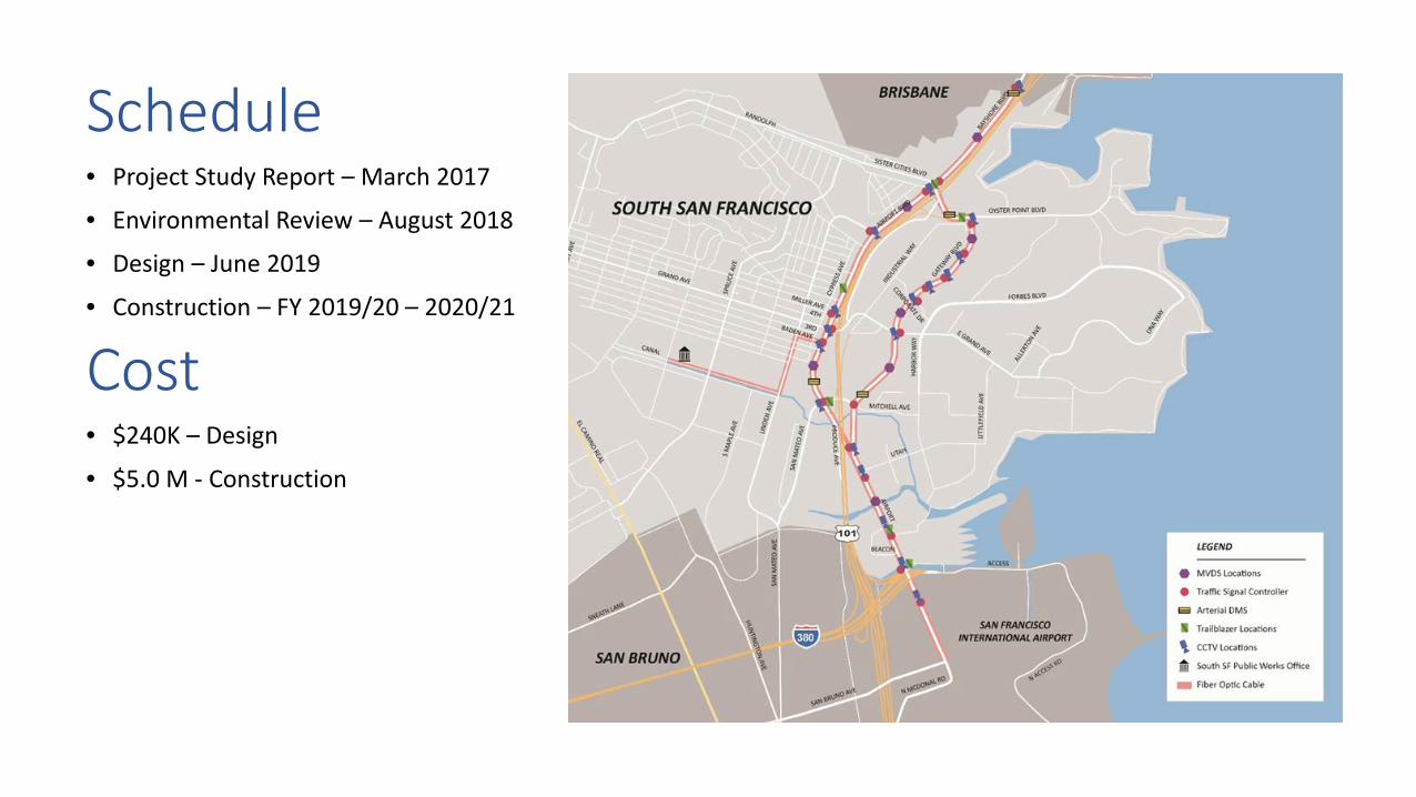
Schedule• Project Study Report – March 2017
• Environmental Review – August 2018
• Design – June 2019
• Construction – FY 2019/20 – 2020/21
Cost• $240K – Design
• $5.0 M - Construction

Questions?

County TIP ID Sponsor Project Name Project Description Expanded Description Project Type under 40 CFR 93.126SON VAR170016 Sonoma County GL: Recreational Trails Program Sonoma County: At Taylor Mountain Park: Construct recreational
bike/ped trailsSonoma County: At Taylor Mountain Park: Construct recreational bike/ped trails Air Quality - Bicycle and pedestrian facilities
40 CFR 93.126 Exempt Projects List

1
Air Quality Conformity Task Force
Summary Meeting Notes June 28, 2018
Participants:Rodney Tavitas – Caltrans Dick Fahey – Caltrans Lucas Sanchez – Caltrans Ken Born – FHWA
Andrea Gordon – BAAQMD Dominique Kraft – FTA Adam Crenshaw – MTC Harold Brazil – MTC
1. Welcome and Self Introductions: Harold Brazil (MTC) called the meeting to order at 9:35 am. 2. Projects with Regional Air Quality Conformity Concerns
a. Review of the Regional Conformity Status for New and Revised Projects
Projects Staff Proposing to Include in the 2017 TIP Adam Crenshaw (MTC) stated that MTC staff had received requests from sponsors to add nine new individually listed projects and 40 new group listed projects to the 2017 TIP. Attachment A includes a list of the projects along with the regional air quality category that staff believes best describes the projects. Ginger Vagenas (EPA) indicated via email the following comments on the proposed list of projects to be added to the 2017 TIP:
• Solano – SOL170017: Noted that this is not exempt from localized impact analysis and the Task Force agreed.
• Napa – VAR170025 Imola Ave express bus: Noted that his project sounds like it might be
increasing service? Maybe non-exempt but not a POAQC?? Adam Crenshaw (MTC) indicated that MTC staff has reached out to the project sponsor and awaiting more information.
• San Mateo – VAR170025 Drive forward program: Is this the right project type? Mr.
Crenshaw contacted the project sponsor and indicated that this program is expecting to provide loans to purchase 125 automobiles in San Mateo County.
• Solano – VAR170026 Dixon Solano express bus stop: Is directional and informational signs the correct project type? Mr. Crenshaw contacted the project sponsor and indicated that the proposed improvements would be at the existing Dixon Park & Ride facility. Mr. Crenshaw went on to add that this project involves more than informational signs and asked if an exemption as a “Reconstruction or renovation of transit buildings and structures (e.g., rail or bus buildings, storage and maintenance facilities, stations, terminals, and ancillary structures)” would be more appropriate?.
• Alameda – ALA170092: Suggested whether this project be listed as should this be purchase
replacement rather than rehabilitate? The Task Force noted the comment.

2
Dominique Kraft (FTA), via email, reviewed and followed up on the list of regional conformity projects and did not have any additional questions. Ms. Kraft, in particular, found the additional information on the San Mateo (VAR170025), the Drive Forward Vehicle Loan Program very helpful. 3. Consent Calendar
a. May 24, 2018 Air Quality Conformity Task Force Meeting Summary With input from all members, the Task Force concluded that the consent calendar was approved. 4. Other Items – Updates
a. Transportation Conformity Guidance for the 2015 Ozone NAAQS On the transportation conformity guidance for the 2015 ozone NAAQS, Ginger Vagenas (EPA) forwarded the Task Force the following highlights: - The one year grace period to show conformity for the 2015 ozone standard starts on the
effective date of designations. Therefore the area must show conformity to the standard by August 3, 2019 (and DOT must approve it) or go into a conformity lapse.
- The guidance does not indicate if the 2008 std will be revoked and references South Coast decision.
- If budgets are available from a SIP from an earlier ozone standard, they must be used in the conformity analysis.
- The attainment year (required analysis year for the budget test) for marginal areas is 2021. It must be modeled.
- Ken Born (FHWA) asked if the pending litigation on the 2015 Ozone NAAQS from the US Chamber of Commerce had been resolved. Harold Brazil (MTC) and other members of the Task Force indicated that they were unaware of this litigation and Mr. Born said he would forward the group information about this issue. Rodney Tavitas (Caltrans) followed up by mentioning that there has been a major new development in the South Coast v. U.S. EPA ozone court case and the court has ordered petitioners to respond – within one week. The tight deadline was unexpected, and it signals urgency and court’s directions to the petitioners also hints at a way to resolve SIP-related issues stemming from the case. Mr. Tavitas shared this court order with the group.
b. Conformity Analysis for the 2019 Transportation Improvement Program (TIP) and the Amended Plan Bay Area (Start of public comment period)
Ken Born (FHWA) asked if the potential repeal of SB 1 would substantially change the projects in MTC’s fiscally constrained TIP. Adam Crenshaw (MTC) responded by indicating that MTC will be submitting its Bay Area region’s portion to the overall federal statewide TIP (or FSTIP) on October 1st, 2018, before the November repeal vote, MTC has not developed alternative lists of projects for

3
the region’s 2019 TIP. Mr. Crenshaw went on to mention that if SB 1 is repealed, MTC would then make the necessary amendments to the 2019 TIP to address the funding level impacts.
c. MTC/SACOG Air Quality Planning/Conformity MOU Harold Brazil (MTC) mentioned that it is anticipated that the revised MTC/SACOG conformity MOU will be approved by MTC’s Planning Committee meeting in July 2018. Rodney Tavitas (Caltrans) stated that he will be on a four month assignment for Caltrans and his current responsibilities to the Task Force will be managed by Lucas Sanchez and Shalanda Christian at Caltrans.