Embed Size (px)
Citation preview

Agriculture, Disaster and Governance
Sustainable and Disaster Resilient Agriculture through Climate and Weather Informatics.
Agriculture, Disaster and Governance
Sustainable and Disaster Resilient Agriculture through Climate and Weather Informatics.
P Goswami
December, 2014

Agriculture and Disaster: Impact (TOI December 12, 2014)
Agriculture and Disaster: Impact (TOI December 12, 2014)
Needs holistic, inclusive and Pro-active ApproachNeeds holistic, inclusive and Pro-active Approach

Impact, intensity and frequency of disasters are increasingImpact, intensity and frequency of disasters are increasing

The Team
P Goswami: Group CoordinatorEVSP Rao (Adviser)S HimeshK V RameshK C GoudaV RakeshG N MahapatraK R BimalaS RayPost DocsPh D Students Project Scientist
www.cmmacs.ernet.in
CSIR C-MMACS (Repositioned 4PI)
Climate and Environmental Modelling Programme

5
Plan of Discussion
• Disaster and Impact Continuum• Pro-active Disaster Management• Critical Components for Pro-active Management and
Mitigation• Actionable Disaster Forecasts• Integrated Disaster Assessment and Forecasting (IDAF)• Science for Integrated Disaster Assessment and
Forecasting (IDAF)• Modelling Issues• Data Optimality and Observation System Design• Preparedness• IDAF: Organization of a Platform• IDAF: Roadmap for a National Initiative• Disaster Simulation and Forecasting: Perspective

6
Disaster and Impact Continuum
Disaster and Society- Loss of Life and Valuables- Medical Emergencies- Epidemic- Loss of working and schooling hours
Disaster and Economy- Loss of property- Loss of Business- Disruption
Disaster and Ecosystem
Disaster and National Security: Some Disaster ScenariosGridlock/Reduced mobility due to extreme rainfall event and flooding:
Foreknowledge available with disruptive forces for planning
Release of toxins/radiological hazards at easy access points (away from target): Knowledge of dispersion paths available with disruptive forces
Extreme rainfall events over strategic and remote locations: Periods of increased vulnerability

The scales of atmospheric motion with the phenomenon’s average size and life span. (Because the actual sizeof certain features may vary, some of the features fall into more than one category.)
The Multi-scale Structure of the Atmospheric Processes and Disasters

8
Pro-active Disaster Management
Event and Disaster: An event by itself is not a disaster; it is the impact of an event on the ecological and the sociological landscapes that determine the nature of a disaster
In the absence of foreknowledge, management is post-event (Reactive)
Emerging technology of weather informatics provides a way of pro-active management of many natural and related (chemical, radiological,..) disasters
Critical Components for Pro-active Management and Mitigation:Actionable ForecastImpact Scenarios and QuantificationMitigation PlanInformation and Communication
Actionable Forecast is the most critical component of a pro-active disaster platform

9
Actionable Disaster Forecasts
Actionable Knowledge: A general warning or a forecast is does not provide actionable information and knowledge
Critical Requirements: Disaster Forecasts need to meet stringent conditions
Precision in location of the eventAccuracy in intensityPrecision in Time of OnsetAccuracy in Duration (Persistence)
Current and standard Meteorological forecasts often do not meet these criteria

10
Integrated Disaster Assessment and Forecasting (IDAF)
• Disaster Assessment: Planning and Design (Redesign)• Disaster Scenarios: Disaster Resilience and Preparedness• Disaster Forecasts: Pro-active Management• Disaster Nowcast: Online Coordination and Management
(Evacuation)• Disaster GIS: Real time and Post-event management
• Assembly Points and Evacuation Plan: Multiple chemical/radiation leaks
• Identification of sites for minimum hazard based on dispersion scenarios
• Recovery time for safe return/operation• Climate Resilience for Worst-case (Least-Regret) Scenarios
Disaster Simulation and Forecasting is a rapidly evolving field; needs national initiative for technological capability

Some Examples of Agricultural Processes (Plant Diseases etc.)
Agricultural Process
Weather Factors Impact
1 Yellow rust of Wheat
Low temperature, foggy weather, recent rainfall
Food Security
2 Mites of Coconut Wind velocity and direction
Commercial Plantation
Crops
3 Spices Disease Temperature,Rainfall, Humidity
International Trade
4 Oil seeds Diseases
Temperature,Rainfall, Humidity
Nutritional Security
5 Aromatic Rice Production, Secondary
Metabolites
Temperature,Rainfall, Humidity
Export Trade,
Pharmaceuticals
6 Soil Health Temperature,Rainfall, Humidity, Wind
Natural Resource
Management, Land use

Extreme is not rare!
The Distribution of “Rare” Extreme Rainfall Events

Challenges and Approaches
Technical Challenges
• Climate-Crop Interface: Model Development
• Data Optimality and Observation System Design
• Model Calibration and Validation
• Reliability of Projections
Approaches
• Multi-source, multi-variable Database on disaster
• Crop-Disaster Interface algorithms
• Modelling and Projection Strategy: Modular System
• Climate Projections over India with Reliability Quantification

Weather forecastWeather forecast
Weather monitoring
Weather monitoring
Moisture adequacy, water stress, …
Moisture adequacy, water stress, …
Plant Disease (Pest
Population) Model
Plant Disease (Pest
Population) Model
Precision AgriculturePrecision Agriculture
Crop viability (Choice)Crop viability (Choice)
Sowing ScheduleSowing Schedule
Irrigation ScheduleIrrigation Schedule
Fertilizer ScheduleFertilizer Schedule
Pesticide SchedulePesticide Schedule
Harvest ManagementHarvest Management
Agro-advisories GIS Platform
Weather Informatics in Agriculture

Meeting Challenges in Forecasting and Projection
• Scope: Process models (disease and weather)
• Accuracy: Forecast for regimes (ranges)
• Reliability: Calibrated model Forecast Configuration
• Relevance: Downscaling to relevant scale
• Applicability: Design of Advisories and ICT

10-km
10-km
30-km 30-
km
Simulation Observation
Choosing the right model configuration and model optimization is critical to forecast extreme events like Mumbai event happened during July 26-27, 2005

Observation No Assimilation Assimilation


Uttarakhand ERE June 2013

Towards Local Climate ProjectionsGeneration of Skillful Forecasts at Station Scale
The raw forecasts (yellow) hardly match the observed values (brown circles)
The debiased forecast (blue line) shows good match
Goswami and Mallick, Weather and Forecasting, 2010, Monthly Weather Review, 2011
Challenge: Typical climate projections provide fields averaged over hundreds or thousands of Km square; not directly applicable at local scale
Solution: From useless raw forecasts to skillful station-scale forecasts through downscaling and Debiasing
These algorithms and the computer codes are developed in-house and validated over multiple locations against observations

The Karnataka Initiative (Operational since July 2010)
Sh. Sharanappa has access to canal water. He prefers not to irrigate …., as canal irrigation
followed by rains will cause insect/pest attack and cost about Rs.1,000/acre to spray
pesticide; he owns 10 acres. The forecast from C-MMACS provided through KSNDMC helps
him to save this amount. (One out of many mails)
October 2010
November 2010
December 2010
Needs Scale-up
Happy Users Message from Dr V S Prakash, Director,
KSNDMC, Govt Karnataka
Message from M N Vidyashankar, Principal Secretary, Govt Karnataka
A Quick Estimate of Economical Benefit
Number of Marginal Farmers: ~ 70 LakhsCost of irrigation/episode/land parcel: Rs 2500
Saving (10% farmers) avoiding one episode of irrigation: Rs 175 Crores
Enhancing Crop Viability through Weather Informatics

Roadmap and Scale up
• From meso-scale to Micro-meteorology (100-10m)
• Model configuration for different locations and validation
• Decision support system for mitigation (Traffic diversion, evacuation etc,.)
• Inclusion of structures in flow simulations (LES)
• Inclusion of Marine and space environment

Integrated Disaster Assessment and Forecast Platform (IDAF)
Organization
Analysis
Initial and Boundary Conditions
Meso-scale Atmospheric ModelDispersion Models
•Release Scenarios• Urban topography
User Interface
•Debiasing•Ensemble Algorithm
•Downscaling Algorithm
•CRM-Meso-scale Interface
Constraints
GIS

White Space in Integrated Assessment
Colors in Spectrum of Research in IndiaColors in Spectrum of Research in India
Current Global Status of Research in Integrated Assessment
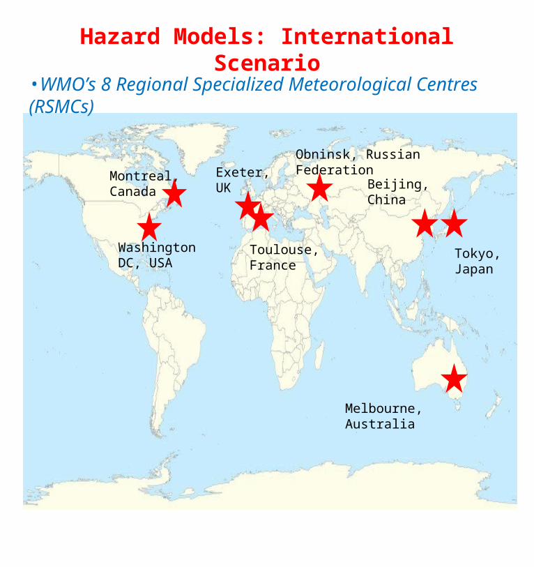
Hazard Models: International Scenario
• Quality– Do the results accurately reflect the event?– Are the limitations of the model clearly stated?– Is information presented in an orderly manner?
• Timeliness– Is the information provided when needed?– Is the information up to date?– If the scenario changes, does the model reflect the
change?• Completeness
– Is the model complete?– Does the user have access to past model runs?– Does the model provide appropriate information?– Does the model give too much information?
Montreal, Canada
Washington DC, USA
Tokyo, Japan
Melbourne, Australia
Exeter, UK
Toulouse, France
Obninsk, Russian Federation
Beijing, China
•WMO’s 8 Regional Specialized Meteorological Centres (RSMCs)

27
Disaster Simulation and Forecasting: PerspectiveKnowledge-based disaster scenarios can help safe design as
well as pro-active mitigation; modern techniques of simulation, forecasting and GIS can help
Strategically, It is likely that disruptive and enemy forces will soon begin to employ these tools to identify vulnerability and plan strikes; an adequate counter measure is necessary
• Development of a quantitative Disaster Assessment and Forecasts Platform should be a National Preparedness
•Because of common drivers and interactive processes, the platform needs to integrate key processes and parameters
Disaster Forecasts need to meet stringent conditions in terms of forecast parameters like time of onset, location, intensity, life cycle and duration for actionable knowledge.

Towards a Disaster-Resilient Green
Revolution
Thank You