Embed Size (px)
Citation preview

AGENDA
NORTHERN BEACHES COUNCIL LOCAL TRAFFIC COMMITTEE MEETING
Notice is hereby given that a meeting of the Northern Beaches Council Local Traffic Committee will be held in the Flannel Flower Room, Civic Centre, Dee Why on
TUESDAY 5 SEPTEMBER 2017
Beginning at 9.30am for the purpose of considering and determining matters included in this agenda.
Ben Taylor Deputy General Manager Environment and Infrastructure

- ii -
Voting Members
Chair – Deputy General Manager Environment & Infrastructure – Northern Beaches Council
Mr Ben Taylor
Member for Pittwater Mr R Stokes MP Representative Mr Andrew Johnston
Member for Davidson Mr J O’Dea MP Representative Mr Phil Corbett
Member for Wakehurst Mr B Hazzard MP Representative Ms Lisa Nagle
Member for Manly Mr J Griffin MP Representative Mr John O’Connor
Roads and Maritime Services Mr Alex Coates
Northern Beaches Police Command, Dee Why Sergeant Nino Jelovic
Non Voting Members
State Transit Authority, Brookvale Depot Mr James Forsyth
Forest Coach Lines Mr Jay Zmijewski
Manly Warringah Cabs Co-operative Society Ltd TBC
Cycling Representative Mr Owen Dunne
Officers
Executive Manager Transport and Civil Infrastructure Mr Andy Davies
Acting Transport Network Manager Mr James Brocklebank
Civil Design & Traffic Engineer Mr Ricky Kwok
Traffic Engineer Mr Sunny Jo
Traffic Engineer Mrs Rezvan Saket
Traffic Engineer Mr John Gill
Traffic Officer Mr Shankar Pandey
Traffic Officer Mr Velsamy Sankaran
Active Travel Officer Ms Michelle Carter
Active Travel Officer Mr Phillip Gray
Road Safety Officer Mrs Karen Menzies
Road Safety Officer Ms Robynann Dixon
Administration Officer Ms Lisa Monk
Visitors
Resident Ms Sue Robertson

- 3 -
Agenda for a meeting of the Northern Beaches Council Local Traffic Committee
to be held on Tuesday 5 September 2017
in the Flannel Flower Room, Civic Centre, Dee Why
Commencing at 9.30am
1.0 APOLOGIES
2.0 CONFIRMATION OF MINUTES OF PREVIOUS MEETINGS AND DECLARATION OF PECUNIARY AND CONFLICTS OF INTEREST
2.1 Minutes of Northern Beaches Council Local Traffic Committee held 1 August 2017
2.2 Declaration of Pecuniary and Conflicts of Interest
3.0 REPORTS TO PROCEED TO COUNCIL FOR APPROVAL
Nil
4.0 REPORTS FOR APPROVAL BY COUNCIL DELEGATION .................................... 2
4.1 Currie Road, Forestville - No Parking ........................................................................ 2
4.2 Rangers Retreat Road, Frenchs Forest - No Parking ............................................... 4
4.3 Wesley Street, Elanora Heights - Proposed 'No Parking 8:00am - 6:00pm' Restrictions ............................................................................................................... 6
4.4 Cross Street and Green Street, Brookvale - Proposed 1P Parking ......................... 10
4.5 Jacksons Road, Warriewood - Proposed 'No Right Turn 8:00am - 9:30am and 2:30pm - 4:00pm School Days' Restrictions ............................................................ 13
4.6 Balgowlah Heights Public School - Pedestrian Crossings ...................................... 18
4.7 Chard Road, Brookvale - Pedestrian Refuge .......................................................... 25
4.8 112 Pacific Parade Dee Why - Changes to Bus Zone ............................................ 27
4.9 Pittwater Road, Mona Vale - Taxi Rank relocation .................................................. 29
4.10 McCarrs Creek Road, Church Point - Traffic Management Measures ..................... 40
4.11 Brookie Show 2017 - Special Event 'No Stopping' Restriction ................................ 47
4.12 The Bloody Long Walk - Sunday 12 November 2017 .............................................. 50
4.13 Work Zone Request at 112 Sydney Road, Fairlight ................................................ 60
5.0 MATTERS FOR NOTATION
NEXT MEETING Tuesday 3 October 2017


CONFIRMATION OF MINUTES OF PREVIOUS MEETINGS AND DECLARATION OF PECUNIARY AND CONFLICTS OF INTEREST
ITEM NO. 2 - 5 SEPTEMBER 2017
- 1 -
2.0 CONFIRMATION OF MINUTES OF PREVIOUS MEETINGS AND DECLARATION OF PECUNIARY AND CONFLICTS OF INTEREST
2.1 MINUTES OF NORTHERN BEACHES COUNCIL LOCAL TRAFFIC COMMITTEE HELD 1 AUGUST 2017
RECOMMENDATION
That the Minutes of the Northern Beaches Council Local Traffic Committee held 1 August 2017, copies of which were previously circulated to all Members, be confirmed as a true and correct record of the proceedings of that meeting.
2.2 DECLARATION OF PECUNIARY AND CONFLICTS OF INTEREST
3.0 REPORTS TO PROCEED TO COUNCIL FOR APPROVAL
Nil

REPORTS FOR APPROVAL BY COUNCIL DELGATION
ITEM NO. 4.1 - 05 SEPTEMBER 2017
- 2 -
4.0 REPORTS FOR APPROVAL BY COUNCIL DELEGATION
ITEM 4.1 CURRIE ROAD, FORESTVILLE - NO PARKING
REPORTING OFFICER TRAFFIC ENGINEER
TRIM FILE REF 2017/292576
ATTACHMENTS 1 Currie Road - Plan
UBD Ref: 176 H9
REPORT
BACKGROUND
Council has received representation from local residents expressing concern about traffic and school children safety in Currie Road, Forestville. They claim that cars turning from Maxwell Parade into Currie Road are blocking traffic travelling west and creating safety issues for children as vehicles take additional risks trying to get around waiting traffic.
A site inspection undertaken by Council has confirmed the residents’ concerns and revealed that cars are taking risks getting around vehicles that are queued in the afternoon to pick up children from the on-site school pick up area at Our Lady of Good Counsel School.
To provide improved safety in this area Council proposes to extend the ‘No Parking’ from 2:30pm -4:00pm school days only by approximately 25m east along on Currie Road to outside the resident of 2 Coolabah Crescent.
The extension of the ‘No Parking’ will allow additional cars to line up to collect their children and still allow vehicles to pass without moving into the opposing traffic lane.
The resident of 2 Coolabah Crescent has been consulted and no objections have been raised in relation to the relocation of the ‘No Parking’ sign.
ISSUES
Vehicles are not able to pass cars that are queuing at the pick up area at Our Lady of Good Counsel School without moving into the opposing traffic lane to overtake.
RECOMMENDATION TO TRAFFIC COMMITTEE
That the Traffic Committee support the extension of the ‘No Parking’ from 2:30pm – 4:00pm school days only by approximately 25m east along Currie Road to outside the resident of number 2 Coolabah Crescent.

ATTACHMENT 1 Currie Road - Plan
ITEM NO. 4.1 - 5 SEPTEMBER 2017
- 3 -

REPORTS FOR APPROVAL BY COUNCIL DELGATION
ITEM NO. 4.2 - 05 SEPTEMBER 2017
- 4 -
ITEM 4.2 RANGERS RETREAT ROAD, FRENCHS FOREST - NO PARKING
REPORTING OFFICER CONTRACTOR - TRAFFIC ENGINEER
TRIM FILE REF 2017/295518
ATTACHMENTS 1 Rangers Retreat Road - No Parking
UBD Ref: 176 L7
REPORT
BACKGROUND
Council has been contacted several times by the resident at No.8 Rangers Retreat Road, Frenchs Forest, to ban parking on one side of Rangers Retreat Road because he says he cannot see when he drives out of his driveway. His driveway is on an uphill grade as it approaches Rangers Retreat Road which further restricts his sight distance along the Rangers Retreat Road.
Rangers Retreat Road is heavily parked out on both sides of the road during the day due to workers at the new Northern Beaches Hospital site and construction works on Warringah Road.
The proposal is to install ‘No Parking’ 8:00am - 6:00pm Mon-Fri opposite No.8 Rangers Retreat Road as shown on the attached plan. The resident has responded that he supports this proposal.
LOCATION
Rangers Retreat Road is an 8m wide two way road with parking on both sides between Garners Avenue and Fitzpatrick Avenue East. Council has resisted banning parking on one side of the road because of potential speeding issues if the parking is removed.
ISSUES
Cars are parked on both sides of Rangers Retreat Road allowing only one lane between the parked cars.
The resident at No.8 complains that his sight distance up and down Rangers Retreat Road is severely restricted because his driveway is on an uphill grade at it approaches Rangers Retreat Road which further restricts his sight distance up and down Rangers Retreat Road.
Restricting parking in front of No.8 Rangers Retreat Road would also allow an extra space for cars to pass each other.
RECOMMENDATION TO TRAFFIC COMMITTEE
Install ‘No Parking’ 8:00am - 6:00pm Mon-Fri on the west side of Rangers Retreat Road from immediately south of the driveway to No.12 Rangers Retreat Road to immediately north of the driveway to No.6 Rangers Retreat Road – with the loss of about 3 parking spaces in front of No.8 Rangers Retreat Road.

ATTACHMENT 1 Rangers Retreat Road - No Parking
ITEM NO. 4.2 - 5 SEPTEMBER 2017
- 5 -
RANGERS RETREAT ROAD,
FRENCHS FOREST
NO PARKING
PROPOSAL
Located Immediately north of Driveway to #6
8am–6pm Mon-Fri
8am–6pm Mon-Fri
Located Immediately south of Driveway to #12

REPORTS FOR APPROVAL BY COUNCIL DELGATION
ITEM NO. 4.3 - 05 SEPTEMBER 2017
- 6 -
ITEM 4.3 WESLEY STREET, ELANORA HEIGHTS - PROPOSED 'NO PARKING 8:00AM - 6:00PM' RESTRICTIONS
REPORTING OFFICER CIVIL DESIGN & TRAFFIC ENGINEER
TRIM FILE REF 2017/293841
ATTACHMENTS 1 Wesley Street - Plan
2 Wesley Street - Site Photographs
UBD Ref: 137 Q11
REPORT
BACKGROUND
Council has received a request from Uniting Venues, located at No.19A Wesley Street, to improve access to the facility at the eastern end of Wesley Street, Elanora Heights.
LOCATION
Wesley Street is a local road with a 50km/h speed limit.
The road pavement width in Wesley Street is approximately 7.2 m between kerbs.
There are no signposted parking restrictions along the section of road under consideration.
Uniting Venues has a number of meeting facilities and conference venues available which can cater for up to 220 people including school camps, bands, choirs, church groups, sports and community groups.
CONSULTATION
Council consulted with properties located within the affected area, sending out letters to eighteen adjacent property owners on 4 August 2017. Submissions from five homes have been received with four of those opposing the introduction of parking restrictions. One of the residents has engaged a traffic consultant and town planner who has lodged detailed submissions opposing the proposal.
ISSUES
The parking of vehicles adjacent to the driveway of No.19A Wesley Street, and on both sides of the narrow road, causes difficulties especially for buses that transport visitors to the site.
Uniting Venues are proposing to widen the existing driveway to improve access; however, parking restrictions were also proposed to improve access due to the narrow road width.
It was observed at a recent site inspection that vehicles parked opposite and close to the driveway while there is available parking nearby.
A swept path analysis showing the turning movements for a long rigid bus entering/exiting the driveway is attached. The plan shows the required ‘No Parking’ restrictions in Wesley Street to allow driveway access when vehicles park near this location. Buses have; however, been accessing the site at low speeds without the aid of driveway widening and parking restrictions until now.
Council has proposed that the restrictions only apply for the period in which the driveway is used by buses and a proposal for ‘No Parking 8:00am-6:00pm’ restrictions has been circulated. Residents are however strongly opposed to any restrictions.
It is considered as a first step that the driveway widening only be introduced. The introduction of parking restrictions will be deferred and the success of the driveway widening monitored.

REPORTS FOR APPROVAL BY COUNCIL DELGATION
ITEM NO. 4.3 - 05 SEPTEMBER 2017
- 7 -
RECOMMENDATION TO TRAFFIC COMMITTEE
That the installation of ‘No Parking 8:00am-6:00pm’ restrictions, for a length of 5m east of the new widened driveway and for a distance of 23m between the driveways of No.10 and 14 Wesley Street be deferred until the approved driveway widening has been completed and the success of the work in improving access to the venue has been monitored.

ATTACHMENT 1 Wesley Street – Plan
ITEM NO. 4.3 - 5 SEPTEMBER 2017
- 8 -

ATTACHMENT 2 Wesley Street - Site Photographs
ITEM NO. 4.3 - 5 SEPTEMBER 2017
- 9 -

REPORTS FOR APPROVAL BY COUNCIL DELGATION
ITEM NO. 4.4 - 05 SEPTEMBER 2017
- 10 -
ITEM 4.4 CROSS STREET AND GREEN STREET, BROOKVALE - PROPOSED 1P PARKING
REPORTING OFFICER TRAFFIC ENGINEER
TRIM FILE REF 2017/208881
ATTACHMENTS 1 Cross Street and Green Street - Signposting Plan
UBD Ref: 177 K11
REPORT
The Traffic Committee on 6 June 2017 considered on-street parking in Cross Street having considered the traffic flow to and from the Warringah Mall Shopping Centre. At the time it was decided to retain the on-street parking on the south side and for Council to undertake further investigation regarding the conversion of existing on-street parking areas to a time limited parking area in Green Street and Cross Street.
The subject parking areas include about fifteen (15) unrestricted parking spaces on the south side of Cross Street between Green Street and the roundabout, seven (7) unrestricted parking spaces between Green Street and Dale Street. A further eight (8) spaces in Green Street south of Cross Street is included for consideration.
Observations indicate that the unrestricted parking areas in Cross Street and Green Street are heavily occupied throughout the day with a low level of parking turnover in these spaces. It was noted that the areas throughout the day were occupied by long term parking, including tow trucks.
Site investigations revealed a No Parking, Emergency Vehicles Excepted zone has been installed without authorisation along the west side of Green Street, south of Cross Street. It is proposed that this zone be removed and replaced with full time No Stopping to aid traffic flow. In addition a temporary Taxi Zone of about three (3) spaces on the east side of Green Street is proposed to be removed and replaced with time limited parking.
The 1P 8:30am-6:00pm Mon-Fri, 8:30am-12:30pm Sat restrictions in Dale and Green Streets were installed in 1996 and 1992 respectively to encourage a fairer utilisation of on-street parking spaces for local businesses and this arrangement has been in place without any issues. For consistency and to support local businesses it is proposed that the subject unrestricted spaces in Cross Street and Green Street, including the unused taxi zone, be replaced with 1P 8:30am-6:00pm Mon-Fri, 8:30am-12:30pm Sat.
Council undertook notification in August 2017 to business operators, including the management of Westfield Warringah Mall and the nearby businesses, with the submission closing date on 1 September 2017. At the time of this report, there have been no objections received regarding this proposal. Warringah Mall’s preferred position on Council’s proposal was for a No Stopping restriction on both sides of Cross Street.
As previously stated in the June 2017 report, the Scentre Group has advised that the redevelopment of the Warringah Mall has resulted in approximately 250 extra parking spaces within the premises for their employees.

REPORTS FOR APPROVAL BY COUNCIL DELGATION
ITEM NO. 4.4 - 05 SEPTEMBER 2017
- 11 -
RECOMMENDATION TO TRAFFIC COMMITTEE
A. That the parking spaces in Cross Street and Green Street be changed to 1P 8:30am-6:00pm Mon-Fri, 8:30am-12:30pm Sat as shown in the attached signposting plan.
B. That the No Parking, emergency vehicles excepted zone on the west side of Green Street,
20m south of Cross Street be replaced with No Stopping. C. That the Taxi Zone on the east side of Green Street, 20m south of Cross Street, be
replaced with 1P 8:30am-6:00pm Mon-Fri, 8:30am-12:30pm Sat zone.

ATTACHMENT 1 Cross Street and Green Street - Signposting Plan
ITEM NO. 4.4 - 5 SEPTEMBER 2017
- 12 -

REPORTS FOR APPROVAL BY COUNCIL DELGATION
ITEM NO. 4.5 - 05 SEPTEMBER 2017
- 13 -
ITEM 4.5 JACKSONS ROAD, WARRIEWOOD - PROPOSED 'NO RIGHT TURN 8:00AM - 9:30AM AND 2:30PM - 4:00PM SCHOOL DAYS' RESTRICTIONS
REPORTING OFFICER CIVIL DESIGN & TRAFFIC ENGINEER
TRIM FILE REF 2017/293732
ATTACHMENTS 1 Jacksons Road - Plan
2 Jacksons Road - Site Photographs
3 Letter of support from Narrabeen North Public School
UBD Ref: 138 E13
REPORT
BACKGROUND
Council has received a request from Narrabeen North Public School to consider the introduction of a ‘No Right Turn’ during School Zone hours to improve traffic flow for vehicles exiting from the access road to the Northern Beaches Indoor Sports Centre onto Jacksons Road in Warriewood.
LOCATION
Jacksons Road is a local sub-arterial road with a reduced 40km/h speed limit between Garden Street and Boondah Road where it is a designated High Pedestrian Activity Area. The section of road under consideration is also located within a School Zone.
The Warriewood Square Shopping Centre is located on the northern side of Jacksons Road and the Warriewood Valley Sportsground including Northern Beaches Indoor Sports Centre (NBISC) is located on the southern side. Public Reserves and a Wetland Reserve abut all other boundaries of the Shopping Centre.
There are existing 1 hour parking (8:30am-6:00pm every day) on the northern side of Jacksons Road fronting the Shopping Centre, and 2 hour parking (8:30am-6:00pm every day) on the southern side.
Namona Street is a local road and cul-de-sac which runs west of Pittwater Road. The western end of the road lies within a School Zone and has a reduced 40km/h speed limit.
Narrabeen North Public School is located on the northern side of Namona Street, while Narrabeen Sports High School and the two existing sports fields are on the southern side.
There are ‘No Stopping’ restrictions in the turning area west of the main gates to both Narrabeen North Public School and Narrabeen Sports High School.
The 182 and L85 are regular bus services which operate along Jacksons Road, while the School bus services operate along Namona Street.
CONSULTATION
Council has consulted with the Principal of Narrabeen North Public School and the P&C who have indicated strong support for the proposed changes.
ISSUES
Jacksons Road is a well trafficked road due to the location of nearby Centro Warriewood Shopping Centre, Schools, sporting facilities and Community Centres.
The access road to the Northern Beaches Indoor Sports Centre (NBISC) runs off Jacksons Road. A gate at the southern end of the site separates the NBISC site and the driveway access to the car park for the sports fields in Namona Street.

REPORTS FOR APPROVAL BY COUNCIL DELGATION
ITEM NO. 4.5 - 05 SEPTEMBER 2017
- 14 -
There is no school drop off and pick up area in Namona Street due to the existing Bus Zones for the School Bus service and many parents park in the NBISC car park due to the availability of parking in close proximity to the schools.
The traffic flow from Jackson Road during the peak periods results in limited number of short gaps in traffic and makes it difficult to exit the access road onto Jacksons Road.
Parents and carers have reported long delays when vehicles try to turn right onto Jacksons Road resulting in queueing along the access road especially during the afternoon peak times. The congestion is exacerbated by the increased traffic volumes along Jacksons Road at these times from school traffic, employees leaving work, and customers of Warriewood Square.
Council proposes to introduce a ‘No Right Turn’ for vehicles exiting the access road which will apply from 8:00am – 9:30am and 2:30pm – 4:00pm during the School Zone hours only.
The School and P&C will be required to work with both parents and carers to inform them of the purpose of the restrictions which will only be successful in easing congestion if drivers adopt the new practices.
It is recommended that the proposal be supported to improve traffic flow for vehicles exiting from the NBISC access road during the morning and afternoon peak periods.
RECOMMENDATION TO TRAFFIC COMMITTEE
That the Traffic Committee supports the introduction of ‘No Right Turn 8:00am – 9:30am and 2:30pm – 4:00pm School Days’ applying to traffic exiting the access road to the Northern Beaches Indoor Sports Centre onto Jacksons Road.

ATTACHMENT 1 Jacksons Road - Plan
ITEM NO. 4.5 - 5 SEPTEMBER 2017
- 15 -

ATTACHMENT 2 Jacksons Road - Site Photographs
ITEM NO. 4.5 - 5 SEPTEMBER 2017
- 16 -

ATTACHMENT 3 Letter of support from Narrabeen North Public School
ITEM NO. 4.5 - 5 SEPTEMBER 2017
- 17 -

REPORTS FOR APPROVAL BY COUNCIL DELGATION
ITEM NO. 4.6 - 05 SEPTEMBER 2017
- 18 -
ITEM 4.6 BALGOWLAH HEIGHTS PUBLIC SCHOOL - PEDESTRIAN CROSSINGS
REPORTING OFFICER MANAGER TRAFFIC TRANSPORT
TRIM FILE REF 2017/293007
ATTACHMENTS 1 Balgowlah Heights Public Crossing Images
2 Support from James Griffin MP
UBD Ref: 197 G13
REPORT
BACKGROUND
At the June Traffic Committee meeting consideration was given to a review of pedestrian crossing facilities around the Balgowlah Heights Public School. This followed the receipt of correspondence and a petition from 121 parents (supported by the school Principal) seeking a review of pedestrian safety around the Balgowlah Heights Public School and in particular for improvements to pedestrian safety on Radio Avenue and at the intersection of Radio Avenue and Ernest Street.
Following concerns raised by the RMS Representative a decision on the proposals for additional pedestrian crossing facilities was deferred. Council and RMS staff have since met on site to discuss options and further liaison has taken place with the school principal and P&C representatives and this report seeks approval for a revised course of action.
LOCATION
The school is situated on Lewis Street, Balgowlah Heights, with the Primary School sited on the west side of Lewis Street and the Infants School located on the east side of Lewis Street. The Infants School also has a frontage to Radio Avenue, which runs parallel to Lewis Street. The request has come from parents of the Infants School.
A children’s crossing is sited midblock on Radio Avenue.
Marked pedestrian crossings are present on Lewis Street (midblock) and on Ernest Street at Woodland Street and Lewis Street.
A school crossing supervisor assists with the safe operation of the pedestrian crossing on Lewis Street.
ISSUES
The parents seek additional crossing facilities on Ernest Street at Radio Avenue and an upgrade of the children’s crossing on Radio Avenue to a full time crossing. A pedestrian crossing on Abbott Street at its intersection with Radio Avenue is also sought.
The Austroads Guide to Traffic Management has established a “warrant” which must be met before a site is considered suitable for a marked pedestrian crossing. Roads & Maritime Services (RMS) has adopted this warrant for use within NSW. For locations used predominantly by school children the warrant requires that for a one hour period before and after school the number of pedestrians must exceed 30 pedestrians crossing the road AND the number of vehicles passing the proposed crossing location must exceed 200 vehicles. Vehicle and pedestrian counts have been undertaken on all legs of the following intersections:
Ernest Street/Radio Avenue

REPORTS FOR APPROVAL BY COUNCIL DELGATION
ITEM NO. 4.6 - 05 SEPTEMBER 2017
- 19 -
Ernest Street/Woodland Street
Abbott Road/Radio Avenue/Adelaide Street
Radio Avenue midblock at existing children’s crossing The traffic counts have revealed the following: Thursday 31st May 2017 – Ernest Street west of Radio Avenue
Time Number of Vehicles Number of Pedestrians
08:15 – 09:15 am 481 39
15:00 – 16:00 pm 414 36
Thursday 31st May 2017 – Abbott Street west of Radio Avenue
Time Number of Vehicles Number of Pedestrians
08:15 – 09:15 am 241 75
14:30 – 15:30 pm 186 90
Thursday 31st May 2017 – Radio Avenue – midblock at children’s crossing
Time Number of Vehicles Number of Pedestrians
08:30 – 09:30 am 132 19
14:30 – 15:30 pm 118 11
Thursday 31st May 2017 – Ernest Street east of Woodland Street
Time Number of Vehicles Number of Pedestrians
08:15 – 09:15 am 500 18
14:30 – 15:30 pm 414 12
The volumes of pedestrians and vehicles meet the warrant for the provision of a new marked pedestrian crossing over Ernest Street, west of Radio Avenue.
At Abbott Road west of Radio Avenue the warrant is comfortably met in terms of pedestrian numbers but falls just short in terms of vehicular traffic numbers in the PM school pick up period. Given that the pedestrian numbers are significantly above the threshold of 30 pedestrians per hour it is considered that the location is appropriate for introduction of a marked crossing.
Despite there being an existing pedestrian crossing over Ernest Street east of Woodland Street the number of pedestrians using the crossing is well below that required for a marked crossing. Site investigations reveal that approach site distance to the crossing from the west is poor and it is considered that safety for pedestrians using the crossing would therefore be poor, particularly given its infrequent use. The School has confirmed that they do not encourage use of this crossing owing to the sight distance issues. It is proposed to remove this crossing.
At all other locations not currently having a marked crossing the volume of pedestrians and/or vehicles was insufficient to support the provision of a marked pedestrian crossing.
The volume of pedestrians and the traffic volume on Radio Avenue at the site of the existing children’s crossing is insufficient to support upgrading that crossing to a full time marked pedestrian crossing.

REPORTS FOR APPROVAL BY COUNCIL DELGATION
ITEM NO. 4.6 - 05 SEPTEMBER 2017
- 20 -
CONSULTATION
As outlined above, liaison has taken place with the school. A number of phone calls and emails have been traded with the head petitioners who are supportive of additional crossings being established on Ernest Street west of Radio Avenue and on Abbott Road west of Radio Avenue. The School is supportive of the introduction of crossings on Ernest Street at Radio Avenue and on Abbott Street at Radio Avenue and is also supportive of the removal of the existing crossing on Ernest Street at Woodland Avenue in view of the safety issues outlined above.
RECOMMENDATION TO TRAFFIC COMMITTEE
A. That support be given for the introduction of marked pedestrian crossings at a) Ernest Street west of Radio Avenue and b) Abbott Road west of Radio Avenue and that designs be prepared for their installation.
B. That the existing marked crossing on Ernest Street east of Woodland Street be removed.

ATTACHMENT 1 Balgowlah Heights Public Crossing Images
ITEM NO. 4.6 - 5 SEPTEMBER 2017
- 21 -

ATTACHMENT 1 Balgowlah Heights Public Crossing Images
ITEM NO. 4.6 - 5 SEPTEMBER 2017
- 22 -

ATTACHMENT 1 Balgowlah Heights Public Crossing Images
ITEM NO. 4.6 - 5 SEPTEMBER 2017
- 23 -

ATTACHMENT 2 Support from James Griffin MP
ITEM NO. 4.6 - 5 SEPTEMBER 2017
- 24 -

REPORTS FOR APPROVAL BY COUNCIL DELGATION
ITEM NO. 4.7 - 05 SEPTEMBER 2017
- 25 -
ITEM 4.7 CHARD ROAD, BROOKVALE - PEDESTRIAN REFUGE
REPORTING OFFICER CONTRACTOR - TRAFFIC ENGINEER
TRIM FILE REF 2017/264550
ATTACHMENTS 1 Chard Road Pedestrian Refuge
UBD Ref: 177 M10
REPORT
BACKGROUND
Council has received complaints from pedestrians crossing Chard Road, Brookvale, at the intersection of Chard Road and Pittwater Road.
Pedestrians say that because Chard Road is very wide they have difficulty watching for vehicles turning to and from Chard Road from Pittwater Road, especially with children.
There is a well-used Bus Stop located on Pittwater Road immediately south of Chard Road which is the reason pedestrians are crossing Chard Road.
LOCATION
Location is at the intersection of Pittwater Road and Chard Road, Brookvale.
ISSUES
Chard Road is 12.5m wide at Pittwater Road with parking on both sides of Chard Road.
Pittwater Road is a wide six (6) lane arterial road with a pedestrian fence in the median.
The kerbside lane on Pittwater Road is a painted red Bus Lane in the AM Peak period.
A review of vehicle Swept paths at the intersection indicates that a Long Rigid Bus (length 14.5m) should be able to turn in and out of Chard Road. However, to turn left into Chard Road the vehicle will need to turn from the right hand land on Pittwater Road to prevent the vehicle overhanging over the pedestrian refuge.
The largest vehicle which can turn left into Chard Road from the centre lane on Pittwater Road without overhanging over the refuge is a Heavy Rigid Vehicle (length 12.5m).
A B99 vehicle can turn left from the bus lane without any difficulty.
RECOMMENDATION TO TRAFFIC COMMITTEE
A. That Traffic Committee support the installation of a Pedestrian Refuge on Chard Road at the Pittwater Road and Chard Road intersection.
B. That the pedestrian refuge be assigned a priority and installed when funds are available.

ATTACHMENT 1 Chard Road Pedestrian Refuge
ITEM NO. 4.7 - 5 SEPTEMBER 2017
- 26 -

REPORTS FOR APPROVAL BY COUNCIL DELGATION
ITEM NO. 4.8 - 05 SEPTEMBER 2017
- 27 -
ITEM 4.8 112 PACIFIC PARADE DEE WHY - CHANGES TO BUS ZONE
REPORTING OFFICER CONTRACTOR - TRAFFIC OFFICER
TRIM FILE REF 2017/282534
ATTACHMENTS 1 Location of Bus Zone Changes
UBD Ref: 178 E7
REPORT
BACKGROUND
Sydney Buses have made a request on behalf of the school parents to change the operating times of the Bus Zone on the north side of Pacific Parade near Wheeler Parade. It is proposed that an extra hour be added to the Bus Zone times in the afternoon from 3:00pm - 4:00pm on weekdays. Currently the Bus Zone is active between 6:00am – 9:00am on weekdays. This proposal will allow a 30m Bus Zone during the afternoon period and should allow students to safely alight at the Bus Stop.
LOCATION
Pacific Parade, Dee Why, near Wheeler Parade (outside of 112 Pacific Parade, Dee Why).
ISSUES
Primary school students are currently using the bus stop in the afternoon. Over a number of years parked vehicles have prevented the bus from stopping at the bus stop. In some cases the bus driver has decided not to stop and service passengers at the next stop which is located about 200m away.
RECOMMENDATION TO TRAFFIC COMMITTEE
That the bus zone on the north side of Pacific Parade, opposite Wheeler Parade, be changed to ‘Bus Zone 6:00am – 9:00am, 3:00pm - 4:00pm, Mon – Fri’.

ATTACHMENT 1 Location of Bus Zone Changes
ITEM NO. 4.8 - 5 SEPTEMBER 2017
- 28 -

REPORTS FOR APPROVAL BY COUNCIL DELGATION
ITEM NO. 4.9 - 05 SEPTEMBER 2017
- 29 -
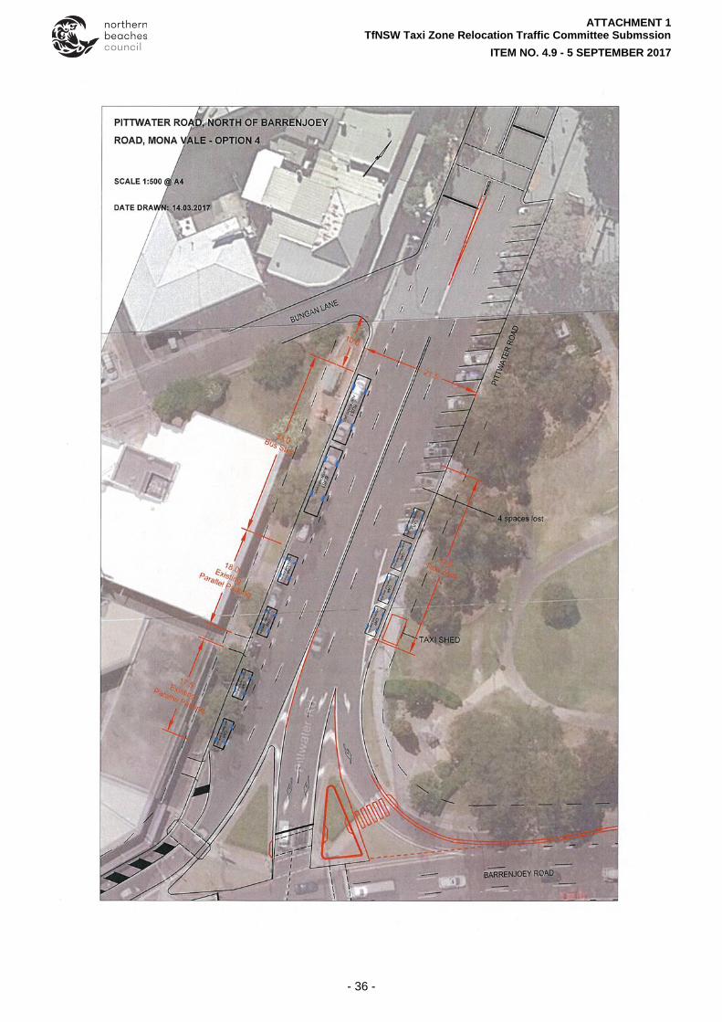
ITEM 4.9 PITTWATER ROAD, MONA VALE - TAXI RANK RELOCATION
REPORTING OFFICER ACTIVE TRAVEL OFFICER
TRIM FILE REF 2017/284184
ATTACHMENTS 1 TfNSW Taxi Zone Relocation Traffic Committee Submssion
UBD Ref: 138 H4
REPORT
The NSW Government is delivering transport improvements for the Northern Beaches which will include the delivery of a new B-Line bus service and the introduction of the Northern Beaches Bus Service Plan.
To improve operational efficiency, and to continue to provide a bus stop in the Mona Vale Town Centre for the 155 and 156 Bayview and Church Point service, it is proposed to relocate bus stop S210397 to the site of the existing taxi zone located in Pittwater Road at the corner of Bungan Lane.
Due to the relocation of outbound bus stop S210397 it is necessary to relocate the existing taxi zone located in Pittwater Road (south side) to a new location in Pittwater Road (north side) and on the boundary of Village Park.
A shelter will be installed at the site of the new taxi zone in Pittwater Road.
The site of the relocated taxi zone in Pittwater Road and the location of the new shelter can be identified in Attachment 1 –TfNSW Taxi Zone Relocation Submission Traffic Committee Submission.
LOCATION
Pittwater Road is a Regional Road with the section between Barrenjoey Road and McCarrs Creek Reserve under the authority of Northern Beaches Council.
The site for the relocation of the taxi zone in Pittwater Road, Mona Vale, was identified in the Review of Environmental Factors (REF) that was paced on public exhibition by TfNSW.
ISSUES
There will be a loss of ten (10) 2P angled car parking spaces in Pittwater Road due to the relocation of the taxi zone.
Four (4) P30 (30 minute) car parking spaces will be reinstated in Pittwater Road in the location of the existing bus stop S210397.
Overall, there will be a net loss of six (6) car parking spaces in the Mona Vale Town Centre.
The location of the shelter at the site of the relocated taxi zone in Pittwater Road has been identified as the preferred location as per the below recommendations by Strategic and Place Planning:
o The shelter should be closer to where the potential future activities are. In this case, we
are talking about activities at the town centre.
o Although we do not expect a high concentration of people to queue for a taxi we should
consider the space required for the queue. As far from the intersection as possible is the better/safer option.
o This site has less visual impact because it is placed amongst the trees and further from
the heritage War Memorial site. There is a potential to upgrade public spaces around the War Memorial site. If the shelter is located near the Memorial site we may reduce our opportunity to create and improve the spaces around the Memorial in the future. We strongly believe this is part of the identity of Mona Vale.

REPORTS FOR APPROVAL BY COUNCIL DELGATION
ITEM NO. 4.9 - 05 SEPTEMBER 2017
- 30 -
o Although the Draft Place Plan is on hold and could change, the intention is always to
activate the south side of the Village Park and Pittwater Road. Café or other uses on this side (closer to the centre) is quite likely in the future. A taxi rank closer to activities such as this will increase opportunity for casual surveillance and maintain the relationship between the activities.
o Will have fewer impediments on the future potential of Village Park as a community
‘hub’ and ‘people’s space’.
Other items to note:
Bus stop S210397, which is proposed to relocate to the site of the existing taxi zone in Pittwater Road, will utilise the current length of the zone (33m) and the 10m draw out area at the corner of Bungan Lane. This will provide the required 40m space for buses to safely draw in and out of the zone.
The six (6) existing 1P (one hour) car parking spaces located on the southern side of Pittwater Road will remain in their current location and will continue to provide short term and high turnover parking to support local business.
The shelter located at the existing taxi zone will remain in place for bus passengers.
COMMUNITY ENGAGMENT
TfNSW undertook community engagement with local businesses, State Transit Authority (STA), NSW Taxi Council and the Mona Vale Chamber of Commerce, who all have provided approval and agreement for the relocation of bus stop S210397 and the relocation of the taxi zone. Copies of their written acceptances are provided in Attachment 1 –TfNSW Taxi Zone Relocation Submission Traffic Committee Submission.
Further support from the Mona Vale Chamber of Commerce relating to the loss of car parking spaces is provided in Attachment 1 –TfNSW Taxi Zone Relocation Submission Traffic Committee Submission.
RECOMMENDATION TO TRAFFIC COMMITTEE
That the Northern Beaches Council Traffic Committee:
A. Supports the relocation of bus stop S210397 to the taxi rank located in Pittwater Road, at the corner of Bungan Lane, Mona Vale.
B. Supports the relocation of the taxi zone to Pittwater Road and the installation of a taxi shelter in location.

ATTACHMENT 1 TfNSW Taxi Zone Relocation Traffic Committee Submssion
ITEM NO. 4.9 - 5 SEPTEMBER 2017
- 31 -

ATTACHMENT 1 TfNSW Taxi Zone Relocation Traffic Committee Submssion
ITEM NO. 4.9 - 5 SEPTEMBER 2017
- 32 -

ATTACHMENT 1 TfNSW Taxi Zone Relocation Traffic Committee Submssion
ITEM NO. 4.9 - 5 SEPTEMBER 2017
- 33 -

ATTACHMENT 1 TfNSW Taxi Zone Relocation Traffic Committee Submssion
ITEM NO. 4.9 - 5 SEPTEMBER 2017
- 34 -

ATTACHMENT 1 TfNSW Taxi Zone Relocation Traffic Committee Submssion
ITEM NO. 4.9 - 5 SEPTEMBER 2017
- 35 -
ATTACHMENT 1 TfNSW Taxi Zone Relocation Traffic Committee Submssion
ITEM NO. 4.9 - 5 SEPTEMBER 2017
- 36 -

ATTACHMENT 1 TfNSW Taxi Zone Relocation Traffic Committee Submssion
ITEM NO. 4.9 - 5 SEPTEMBER 2017
- 37 -

ATTACHMENT 1 TfNSW Taxi Zone Relocation Traffic Committee Submssion
ITEM NO. 4.9 - 5 SEPTEMBER 2017
- 38 -

ATTACHMENT 1 TfNSW Taxi Zone Relocation Traffic Committee Submssion
ITEM NO. 4.9 - 5 SEPTEMBER 2017
- 39 -

REPORTS FOR APPROVAL BY COUNCIL DELGATION
ITEM NO. 4.10 - 05 SEPTEMBER 2017
- 40 -
ITEM 4.10 MCCARRS CREEK ROAD, CHURCH POINT - TRAFFIC MANAGEMENT MEASURES
REPORTING OFFICER MANAGER TRAFFIC TRANSPORT
TRIM FILE REF 2017/308401
ATTACHMENTS 1 McCarrs Creek Road - Traffic Management Plans
UBD Ref: 117 Q6
REPORT
This report seeks support from the Traffic Committee for Council to implement traffic calming measures that will support the establishment of a 40km/h High Pedestrian Activity Zone currently under consideration by the RMS.
BACKGROUND
Council seeks the support of the Traffic Committee for the traffic calming devices that are proposed for introduction to enhance pedestrian safety and amenity for the section of Pittwater Road and McCarrs Creek Road, between the eastern end of the Church Point Reserve car park and the Cargo Wharf. These traffic calming measures will support the 40 km/h High Pedestrian Activity Area (HPAA) currently being considered by the RMS. The 40 km/h HPAA requires traffic calming measures including speed humps, gateway treatment and a median island to reinforce the lower speed limit and enhance pedestrian safety. These works are being introduced in conjunction with the realignment of McCarrs Creek Road in Church Point. The scheme also includes the provision of a raised pedestrian crossing to assist existing pedestrian movements, the relocation of a bus stop and associated signage and linemarking. The Church Point Upgrade includes construction of a new car park with 120 new parking spots, new seawall with suspended timber pedestrian boardwalk (forming part of the recently upgraded commuter wharf), realignment of McCarrs Creek Road between the Commuter Wharf and Rostrevor Reserve, as well as improved landscaping and aesthetics to the area. These works are in accordance with the Church Point Plan of Management and associated Masterplan. Council has submitted an application (including required Traffic Management Plan) to the RMS seeking approval of the 40 km/h HPAA, subject to the traffic calming proposal being supported by the Traffic Committee and Council. Pittwater Road and McCarrs Creek Road between Barrenjoey Road, Mona Vale and the Ku-ring-gai Chase National Park boundary near Church Point (Cicada Glen Creek), was reclassified from a State Road to a Regional Road on the 1st July 2012, with the transfer of care and control to the former Pittwater Council. Pittwater Road changes to McCarrs Creek Road at the northern end of Church Point, providing a link between Barrenjoey Road in Mona Vale, to Mona Vale Road in Terrey Hills. The section of Pittwater Road and McCarrs Creek Road under consideration is a Regional road with a current 50 km/h speed limit, located between the eastern end of the Church Point Reserve car park and the Cargo Wharf. The existing road has a narrow road pavement, no formal footpaths, and generally no kerb and gutter, except for a short section. Dish drains are present on the south-western side.

REPORTS FOR APPROVAL BY COUNCIL DELGATION
ITEM NO. 4.10 - 05 SEPTEMBER 2017
- 41 -
There are a number of steep, skewed and concealed driveways which run off the Pittwater Road section, providing access to single and multiple houses. Existing double separation lines run along the centre of the road, and parking is not permitted except in the P5 minute area fronting the commuter boat tie-up facility, and 90o angle parking areas adjacent to the Cargo Wharf and in front of the commercial development.
The 155 156, L85 and E86 bus services, as well as school bus services, operate along Pittwater Road and McCarrs Creek Road. Existing bus stops are located on both sides of the road to service Church Point Wharf and the eastern end of the Church Point Reserve car park.
COMMUNITY ENGAGEMENT Council has undertaken extensive community engagement relating to the Church Point precinct works. Council has received numerous requests from the community over the last 20 years to address road safety in the precinct and introduce traffic calming measures. Through the Church Point Aesthetics Advisory Group, comprised of the four key on shore and off shore community associations, community engagement was undertaken to introduce traffic calming measures in conjunction with a 40km/h High Pedestrian Activity Area to improve overall road safety. This was supported by the off-shore community in December 2016.
ISSUES
Church Point is a local and regional transport node and tourist destination. Parking in the Church Point area has been a concern for many years for residents of Scotland Island and West Pittwater, Church Point residents, and visitors to the area with demand exceeding the number of available car parking spaces. Council has worked with the Scotland Island, Western Foreshore and Church Point residents and businesses for a number of years on strategies to manage the current and future demand for vehicle parking in the Church Point area. Council has adopted the Church Point Parking Demand Management Strategy which outlines recommendations to manage parking in the existing Church Point Reserve car park, local streets and the new Church Point car park. The Strategy is to be implemented in two stages with Stage 1 recently completed for changes to overnight spaces in the Church Point Reserve Carpark for Church Point permit holders, and safety and access improvements in Eastview Road and Quarter Sessions Road. Stage 2 of the Strategy involves the construction of the new Church Point car park to provide an additional 120 car park spaces and is expected to be operational by March 2018. The construction of the new car park into the existing rock face requires the realignment of a section of McCarrs Creek Road and Council has submitted to the RMS a proposal for a 40 km/h High Pedestrian Activity Area (HPAA). The proposal includes gateway treatments and median, speed humps and raised marked pedestrian crossings. Church Point is a popular tourist location due to its waterfront setting and proximity to boating and recreational facilities. Pittwater Road and McCarrs Creek Road are used by a large number of cyclists as well as walkers along the foreshore area.

REPORTS FOR APPROVAL BY COUNCIL DELGATION
ITEM NO. 4.10 - 05 SEPTEMBER 2017
- 42 -
The community has for many years expressed concerns regarding traffic speed in the area. Pedestrians (especially school children) getting off buses at the outbound stops cross Pittwater Road near the curve where there is little traffic sight distance and so reduced safety. The road realignment is anticipated to necessitate the adjustment of a private driveway servicing several properties in McCarrs Creek Road which will result in the existing indented outbound bus stop having to be relocated. Both these matters could be addressed if the outbound bus stop was relocated to a position further from the curve and opposite the inbound stop. These stops could then be linked with a raised marked pedestrian crossing in Pittwater Road to provide a safe crossing point and to encourage pedestrians not to cross on the apex of the curve, shown on Drawing No.SK63. A speed hump height of 75mm or less and length of at least 3.7m is proposed as recommended on bus routes.
RECOMMENDATION TO TRAFFIC COMMITTEE
That the Traffic Committee support the installation of the proposed traffic calming devices as detailed on Plans 532500 SK61-64 that will support the establishment of a 40 km/h High Pedestrian Activity Area (HPAA) currently under consideration by the RMS for the section of Pittwater Road and McCarrs Creek Road between the eastern end of the Church Point Reserve car park and the Cargo Wharf.

ATTACHMENT 1 McCarrs Creek Road - Traffic Management Plans
ITEM NO. 4.10 - 5 SEPTEMBER 2017
- 43 -

ATTACHMENT 1 McCarrs Creek Road - Traffic Management Plans
ITEM NO. 4.10 - 5 SEPTEMBER 2017
- 44 -

ATTACHMENT 1 McCarrs Creek Road - Traffic Management Plans
ITEM NO. 4.10 - 5 SEPTEMBER 2017
- 45 -

ATTACHMENT 1 McCarrs Creek Road - Traffic Management Plans
ITEM NO. 4.10 - 5 SEPTEMBER 2017
- 46 -

REPORTS FOR APPROVAL BY COUNCIL DELGATION
ITEM NO. 4.11 - 05 SEPTEMBER 2017
- 47 -
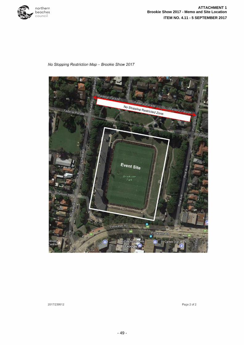
ITEM 4.11 BROOKIE SHOW 2017 - SPECIAL EVENT 'NO STOPPING' RESTRICTION
REPORTING OFFICER CONTRACTOR - TRAFFIC ENGINEER
TRIM FILE REF 2017/293349
ATTACHMENTS 1 Brookie Show 2017 - Memo and Site Location
UBD Ref: 177 L8
REPORT
BACKGROUND
Council is proposing to hold the Brookie Show on Saturday 21 October 2017.
LOCATION
The Brookie Show will be held at Brookvale Oval, on Federal Parade between Alfred Road and Pine Avenue.
ISSUES
Around 15,000 are expected to attend the Brookie Show 2017.
Federal Parade is a narrow 8m wide two-way road with parking on both sides.
At a previous Brookie Show when cars were parked on both sides of Federal Parade the road was reduced to one lane between the parked cars and the cars had difficulty entering Federal Parade from either end.
In 2016 a ‘No Stopping’ restriction was implemented on the south side of Federal Parade from Alfred Road to Pine Avenue. This alleviated the problem and allowed vehicles to move more freely along Federal Parade during the event. It is proposed to re-implement the ‘No Stopping’ restriction for Brookie Show 2017.
RECOMMENDATION TO TRAFFIC COMMITTEE
Install ‘No Stopping’ signs on the south side of Federal Parade from Alfred Road to Pine Avenue from 9:00am to 9:00pm on Saturday 21 October 2017.

ATTACHMENT 1 Brookie Show 2017 - Memo and Site Location
ITEM NO. 4.11 - 5 SEPTEMBER 2017
- 48 -
ATTACHMENT 1 Brookie Show 2017 - Memo and Site Location
ITEM NO. 4.11 - 5 SEPTEMBER 2017
- 49 -

REPORTS FOR APPROVAL BY COUNCIL DELGATION
ITEM NO. 4.12 - 05 SEPTEMBER 2017
- 50 -
ITEM 4.12 THE BLOODY LONG WALK - SUNDAY 12 NOVEMBER 2017
REPORTING OFFICER CIVIL DESIGN & TRAFFIC ENGINEER
TRIM FILE REF 2017/294245
ATTACHMENTS 1 The Bloody Long Walk - Event Route
UBD Ref: Maps 78, 99, 118, 119, 138, 158, 178 & 198
REPORT
BACKGROUND
Council has received a submission from the Australian Mitochondrial Disease Foundation (AMDF) to stage ‘The Bloody Long Walk’ over 35km from Palm Beach to Manly Beach, to be held on Sunday 12 November 2017. All profits from ‘The Bloody Long Walk’ will go to the AMDF to support its research, patient support and education/awareness programs. It is estimated that approximately 3000 participants will take part in the event.
This will be the fifth year that the event will be held and it generally follows the same route as last year except for the change in the section from Myola Road-Bungan Head Road-Bungan Beach to Myola Road-Queens Parade-Barrenjoey Road.
A temporary road closure is necessary in the Governor Phillip Park carpark from 5:00am for public safety as required in previous years.
The Organisers submitted details of the revised route to the RMS who advised that the event has minimal or no impact to State road traffic or transport systems. Approval is required by the Traffic Committee members and Council of the requested road closures. Extracts of the Traffic Management Plan are shown in Attachment 1. A full copy of the documents will be tabled at the Traffic Committee meeting.
CONSULTATION
The Traffic Management Plan (TMP) has been developed in consultation with the Organisers, RMS, the Police and Council.
ISSUES
The proposed starting time is the same as last year’s event commencing at 6:00am; however, walkers will be leaving in groups of 100-120 every five minutes (estimated at 25 groups) to facilitate the earlier movement of participants from the narrow roads of Pittwater and to enable the event to be completed in daylight hours.
‘The Bloody Long Walk’ route will predominantly follow the Bicentennial Coastal Walk.
The route has been changed slightly this year to bypass the section which included the headlands and Bungan Beach due to several instances where participants required medical assistance along this section of the route. The new route along Queens Parade and Barrenjoey Road is flatter and more walker friendly in line with the rest of the walk.
There are no proposed road closures (other than the closure of the Governor Phillip Park carpark) with the TMP designed to include safety controls at key locations such as pedestrian advance warning signs installed along specified sections of road, volunteer marshals to assist participants at road crossing points, and traffic controllers advising drivers of high pedestrian activity when entering narrow roads. Volunteer marshals can only control walkers as they are not accredited to stop traffic. Marshalls should also be provided along sections where participants may be required to walk on the road, especially on narrow sections and bends with reduced sight distances, noting that there is a high likelihood of parked vehicles on local roads during the staging of the event.
Bus stops or routes will not be directly affected by the event; however, notification will be given to Sydney Buses advising of an increased number of walkers along some bus routes.

REPORTS FOR APPROVAL BY COUNCIL DELGATION
ITEM NO. 4.12 - 05 SEPTEMBER 2017
- 51 -
The event organisers will provide an event specific bus service to pick up participants from Central Station and Manly.
A comprehensive marketing and communications program will be undertaken to inform residents of the event (especially those along the event route) through direct letter box drops, flyers, posters, social media, newspaper advertisements and magazine publications.
Support for the proposed road closures by the Traffic Committee is required prior to Council granting approval for the proposed event to proceed.
RECOMMENDATION TO TRAFFIC COMMITTEE
A. That the Traffic Committee note this report.
B. That the Traffic Committee approve the implementation of the Traffic Management Plan for the ‘The Bloody Long Walk’ to take place along the proposed route on Sunday 12 November 2017.
C. That the approval be subject to the following conditions:
(i) that the TCP be prepared in accordance with the RMS Traffic Control at Work Sites Manual and Australian Standards.
(ii) that any traffic control to only be carried out by persons with appropriate Traffic Control qualifications acceptable to the RMS.
(iii) that barriers and signs to be used in the road closures are to be to RMS standards.
(iv) that the road closure be staffed at all times to allow access for emergency vehicles, and to ensure barriers are not moved.
(v) that approvals being granted by Council for the use of the public reserves specified in the application and for the use of the road reserve for drink stations etc.
(vi) that the applicant advises Sydney Buses, Forest Coach Lines and the various emergency services of the closure.
(vii) that the temporary road closure be advertised in Saturday’s edition of the “The Manly Daily” the week prior to the event.
(viii) that the properties in the affected area be notified by a letterbox drop one month in advance of the event with details of access restrictions, followed by a second letterbox drop one week prior to the event. The notification letter must also provide a contact phone number of the organisers should residents have any enquiries.
(ix) that Variable Message Signs (VMS) be used in accordance with RMS guidelines to provide details of the road closure on the day of the event and also give information on upcoming changes to traffic conditions one week prior to the event.
(x) that the organiser promote the use of public transport (advising on route numbers and times) to the event in advertisings and publications to reduce car usage and traffic congestion on the surrounding road network.
(xi) that the approval be subject to any approvals or conditions required by the RMS.
(xii) that the approval is for a maximum of 3000 participants.
That the applicant be advised accordingly.

ATTACHMENT 1 The Bloody Long Walk - Event Route
ITEM NO. 4.12 - 5 SEPTEMBER 2017
- 52 -

ATTACHMENT 1 The Bloody Long Walk - Event Route
ITEM NO. 4.12 - 5 SEPTEMBER 2017
- 53 -

ATTACHMENT 1 The Bloody Long Walk - Event Route
ITEM NO. 4.12 - 5 SEPTEMBER 2017
- 54 -

ATTACHMENT 1 The Bloody Long Walk - Event Route
ITEM NO. 4.12 - 5 SEPTEMBER 2017
- 55 -

ATTACHMENT 1 The Bloody Long Walk - Event Route
ITEM NO. 4.12 - 5 SEPTEMBER 2017
- 56 -

ATTACHMENT 1 The Bloody Long Walk - Event Route
ITEM NO. 4.12 - 5 SEPTEMBER 2017
- 57 -

ATTACHMENT 1 The Bloody Long Walk - Event Route
ITEM NO. 4.12 - 5 SEPTEMBER 2017
- 58 -

ATTACHMENT 1 The Bloody Long Walk - Event Route
ITEM NO. 4.12 - 5 SEPTEMBER 2017
- 59 -
REPORTS FOR APPROVAL BY COUNCIL DELGATION
ITEM NO. 4.13 - 05 SEPTEMBER 2017
- 60 -
ITEM 4.13 WORK ZONE REQUEST AT 112 SYDNEY ROAD, FAIRLIGHT
REPORTING OFFICER TRAFFIC ENGINEER
TRIM FILE REF 2017/293503
ATTACHMENTS 1 Location and Works Zone details
2 Traffic Control Plan when Works Zone in operation
3 Traffic Control Plan for Concrete Pours and Deliveries
UBD Ref: 197 Q9
REPORT
Council has received an application from DreamBuild Pty Ltd for the installation of a 16m Works Zone on the Parkview Road frontage of No. 112 Sydney Road, Fairlight. The Works Zone will facilitate construction of works approved under development application DA0105/2013. The applicant has submitted a Construction Traffic Management Plan (CTMP) and Traffic Control Plan (TCP) to support the application. The CTMP includes a Traffic Management Plan (TMP) and swept path analysis of construction vehicles.
Address Applicant Works Zone length, time & location Requested period
112 Sydney Rd , Fairlight, NSW 2094
DreamBuild Pty Ltd
Length: 16m
Time: 7:00am-6:00pm Mon-Fri and 7:00am-1:00pm Sat. (As per the approved DA hours) Location: Western side of Parkview Rd.
30 Sep 2017 – 30 Sep 2018 (Both days inclusive)
ISSUES
Sydney Road is a State Road with a posted speed limit of 60km/h and Road width of 13m.
Parkview Rd is a local road with a speed limit of 50km/h, road width of 10m and 3T load limit.
Parkview Lane is a 4.5m wide Local Road with a speed limit of 50km/h.
Construction traffic generated by the development is relatively low (about 18 trucks / day) and all vehicles will enter the site either through Parkview Lane or park within the Works Zone.
When the Works Zone is in use Parkview Road will be restricted to one-way (northbound only - traffic from Sydney Road only) to eliminate the queuing back into Sydney Road. Traffic Control will be in place to manage traffic at these times.
Whenever reverse manoeuvres are required (e.g. during concrete pours) into Parkview Lane a temporary road closure of a maximum of five (5) minutes will be required along the eastern and western side of Parkview Lane.
The adjacent residents will be notified in advance of temporary road closures and one-way restrictions.
There will be no impacts on Public transport, emergency vehicles or cyclists.
The vehicle crossing to the site on Parkview Lane will be modified (widened) to accommodate construction vehicles (MRV).

REPORTS FOR APPROVAL BY COUNCIL DELGATION
ITEM NO. 4.13 - 05 SEPTEMBER 2017
- 61 -
RECOMMENDATION TO TRAFFIC COMMITTEE
That the Traffic Committee supports the installation of 16m Works Zone applying 7:00am – 6:00pm Mon – Fri and 7:00am – 1:00pm on the Parkview Road frontage of No. 112 Sydney Road, Fairlight.

ATTACHMENT 1 Location and Works Zone details
ITEM NO. 4.13 - 5 SEPTEMBER 2017
- 62 -
Work Zone at 112 Sydney Road, Fairlight
(1)Install (2) Install
16 m Work Zone Starts on 30/09/2017 and finishes on 30/09/2018
Timing: 7:00AM – 6:00PM (MON – FRI) 7:00AM – 1:00PM (SAT)
Work Site
Install Work Zone signs
Existing ‘No Stopping (Left)’ sign
(1)
(2)

ATTACHMENT 2 Traffic Control Plan when Works Zone in operation
ITEM NO. 4.13 - 5 SEPTEMBER 2017
- 63 -

ATTACHMENT 3 Traffic Control Plan for Concrete Pours and Deliveries
ITEM NO. 4.13 - 5 SEPTEMBER 2017
- 64 -