Embed Size (px)
Citation preview
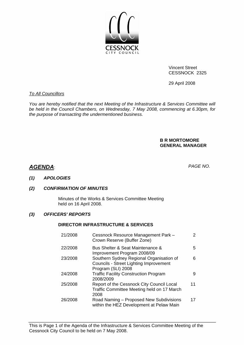
This is Page 1 of the Agenda of the Infrastructure & Services Committee Meeting of the Cessnock City Council to be held on 7 May 2008.
Vincent Street CESSNOCK 2325
29 April 2008
To All Councillors You are hereby notified that the next Meeting of the Infrastructure & Services Committee will be held in the Council Chambers, on Wednesday, 7 May 2008, commencing at 6.30pm, for the purpose of transacting the undermentioned business.
B R MORTOMORE GENERAL MANAGER
AGENDA: PAGE NO. (1) APOLOGIES (2) CONFIRMATION OF MINUTES
Minutes of the Works & Services Committee Meeting held on 16 April 2008.
(3) OFFICERS' REPORTS
DIRECTOR INFRASTRUCTURE & SERVICES
21/2008 Cessnock Resource Management Park – Crown Reserve (Buffer Zone)
2
22/2008 Bus Shelter & Seat Maintenance & Improvement Program 2008/09
5
23/2008 Southern Sydney Regional Organisation of Councils - Street Lighting Improvement Program (SLI) 2008
6
24/2008 Traffic Facility Construction Program 2008/2009
9
25/2008 Report of the Cessnock City Council Local Traffic Committee Meeting held on 17 March 2008
11
26/2008 Road Naming – Proposed New Subdivisions within the HEZ Development at Pelaw Main
17

This is Page 2 of the Agenda of the Infrastructure & Services Committee Meeting of the Cessnock City Council to be held on 7 May 2008.
(3) OFFICERS' REPORTS CONT’D
DIRECTOR INFRASTRUCTURE & SERVICES
27/2008 Urban Resealing Program including Minor Rehabilitation 2008/2009
18
28/2008 Rural Resealing Program including Minor Rehabilitation 2008/2009
22
29/2008 Infrastructure Improvement Program (Rate Increase - Urban & Rural Resealing/Improvement) including Minor Rehabilitation 2008/2009
25
(4) QUESTIONS WITHOUT NOTICE

This is Page 3 of the Agenda of the Infrastructure & Services Committee Meeting of the Cessnock City Council to be held on 7 May 2008.
OFFICER’S REPORTS
DIRECTOR INFRASTRUCTURE & SERVICES REPORT NO. 21/2008
SUBJECT: CESSNOCK RESOURCE MANAGEMENT PARK - CROWN RESERVE (BUFFER ZONE)
Sustainability Coordinator, Ms A Lawrence, and Property Officer, Mr J Lorriman reports:- INTRODUCTION Council is currently finalising the EIS for the proposed extension to Cessnock Waste and Reuse Centre as detailed in previous reports: Report No.’s 70/2004 (commence negotiations); 112/2005 (Planning Focus Meeting looking at whole site); 20/2006 (waste management strategy); 32/2006 (progress on negotiation, valuation and purchase price); and, 99/2006 (landfill gas management) The footprint of the proposed landfill extension area comprises approximately 15 ha of degraded land which was previously owned by the Crown which had no plans for rehabilitation in the short, medium or long term. Approximately 1 Million tonnes (Mt) of waste will be landfilled and form part of the progressive rehabilitation of this area in accordance with the Landfill Environmental Management Plan (LEMP). The proposed Crown Environmental Protection Area (149 Ha) provides an essential environmental buffer to the proposed landfill operations. UPDATE ON PROGRESS OF LANDFILL EXTENSION AT CESSNOCK WASTE AND REUSE CENTRE Property Acquisition In 2004 Council gave approval to commence negotiation with the Department of Lands (DoL) (the Crown) with a view to secure land for the expansion of existing landfill operation. In 2005 Council resolved to continue negotiations with DoL, and in 2006 resolved to acquire the newly created Lot 1 DP 1096161. The land was purchased by compulsory process under the Land Acquisition (Just Terms Compensation) and was gazetted on 18 December 2006. The Environmental Protection Area (buffer area) was excluded from compulsory acquisition on the proviso that it remained Crown land reserved for the purposes of environmental protection Environmental Impact Study (EIS) Assessments of a suite of potential environmental impacts have been undertaken and the EIS which draws together the outcomes and recommendations of each of those assessments is anticipated to be complete by June 2008. Community Consultation During the second phase of community consultation, which will include briefings to Council, community and government agencies, feedback and comments will be sought and considered prior to finalising the EIS and submission of a Development Application. Relocation of leachate and stormwater pond for existing landfill operations Purchase of the Waste Investigation Area has provided the opportunity to relocate the leachate and stormwater ponds at the base of the existing landfill, thereby making additional void space available within the current landfilling operations. It is anticipated that the extra void space will provide an additional four (approx) years of life allowing sufficient lead in time for completion of design and site preparation works for the extension.

This is Page 4 of the Agenda of the Infrastructure & Services Committee Meeting of the Cessnock City Council to be held on 7 May 2008.
Page 2 –Director Infrastructure & Services Report No. 21/2008 REPORT Council will recall that the proposed landfill extension area forms a part of the concept plan for the Cessnock Resource Management Park to be established in conjunction with Department of Lands on land situated between Maitland Road and Old Maitland Road at Cessnock. A Plan of Management has been prepared to define the proposed management areas, the approval processes being undertaken and proposed management principles and procedures. The objectives of the Resource Management Park are:
• To designate the Waste Investigation Area (total area 142 Ha on land owned by Council which includes: - the existing Cessnock Waste and Reuse Centre (25 Ha), - the proposed landfill extension area (approx 15 Ha), - and a potential future waste disposal area (approx 15 Ha) where disturbance from quarrying and mining activities have occurred adjacent to Old Maitland Road, - other than for roads, the remaining 87 hectares will remain undeveloped.
• To retain existing flora/fauna linkages (to be identified in EIS) within the Waste Investigation Area and where necessary rehabilitation undertaken to provide ecological corridors, erosion control and revegetation. It is also proposed that vegetative screening be undertaken along Old Maitland Road and along the northern boundary of the Waste Investigation Area.
• Establishment of a Crown Environmental Protection Area (149 ha) which will provide flora/fauna linkages between Werakata National Park (to the north) and Cessnock State Forest (to the west) in addition to ensuring the continued provision of a suitable environmental buffer area around the proposed landfill extension.
• To set aside land for future subdivision suitable for industrial development (subject to approval) which may reprocess or recycle materials sourced from the Waste and Reuse Centre within the RMP; and to integrate the existing industrial zone on Maitland Road into the RMP.
The existing Waste and Reuse Centre infrastructure and services will continue to be utilised with the addition of a small vehicle receival station, minimising potential conflict with larger vehicles manoeuvring at the active landfill face. All other reuse and recycling activities currently undertaken at the centre would continue as normal and expanded where practicable to minimise the volume of waste to landfill. To facilitate the gazettal of the Crown Environmental Protection Area, and to manage impacts to and from the Environmental Protection Area in conjunction with the Waste Investigation Area, Council must agree to be appointed as the Trust Manager, undertaking management of the site (refer to the Enclosure to this report) in accordance with the requirements of Department of Lands Trust Handbook – managing Crown reserves. In undertaking the role of Trust Manager, similar to for a number of other sites, Council will manage environmental controls and activities, such as access, fire management and the like. This will further assist and complement proposed environmental management activities, ensuring the integrity of the environmental buffer around the proposed landfill operations, and effectively managing any potential impacts to or from either land holding.
This is Page 5 of the Agenda of the Infrastructure & Services Committee Meeting of the Cessnock City Council to be held on 7 May 2008.
Page 3 –Director Infrastructure & Services Report No. 21/2008 CONCLUSION It remains apparent that there will be an ongoing need to have landfill capacity for the foreseeable future. Through negotiation with Department of Lands, Council has secured suitable land, adjacent to existing landfill operations which will meet both the immediate and long term landfill needs. The Environmental Protection Area (buffer area) was excluded from compulsory acquisition on the proviso that it remained Crown land reserved for the purposes of environmental protection. To facilitate the gazettal of that land as a Crown Environmental Protection Area, and to manage impacts to and from the Environmental Protection Area in conjunction with the Waste Investigation Area, Council must agree to appointment as Trust Manager. RECOMMENDATION that 1. Council agree to be appointed as the Trust Manager, undertaking management of the
site (refer to the Enclosure to this report) in accordance with the requirements of Department of Lands Trust Handbook – managing Crown reserves.
2. Council’s Seal be affixed to the necessary documents and plans required in making Council Trust Manager of the site
To: The General Manager L OLDFIELD Infrastructure & Services
Committee – 7 May 2008 DIRECTOR INFRASTRUCTURE &
SERVICES 29 April 2008
This is Page 6 of the Agenda of the Infrastructure & Services Committee Meeting of the Cessnock City Council to be held on 7 May 2008.
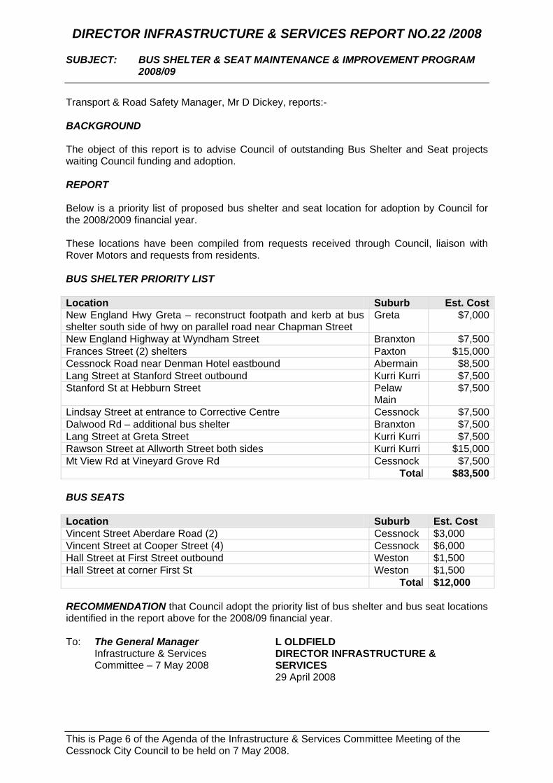
DIRECTOR INFRASTRUCTURE & SERVICES REPORT NO.22 /2008
SUBJECT: BUS SHELTER & SEAT MAINTENANCE & IMPROVEMENT PROGRAM 2008/09
Transport & Road Safety Manager, Mr D Dickey, reports:- BACKGROUND The object of this report is to advise Council of outstanding Bus Shelter and Seat projects waiting Council funding and adoption. REPORT Below is a priority list of proposed bus shelter and seat location for adoption by Council for the 2008/2009 financial year. These locations have been compiled from requests received through Council, liaison with Rover Motors and requests from residents. BUS SHELTER PRIORITY LIST Location Suburb Est. CostNew England Hwy Greta – reconstruct footpath and kerb at bus shelter south side of hwy on parallel road near Chapman Street
Greta $7,000
New England Highway at Wyndham Street Branxton $7,500Frances Street (2) shelters Paxton $15,000Cessnock Road near Denman Hotel eastbound Abermain $8,500Lang Street at Stanford Street outbound Kurri Kurri $7,500Stanford St at Hebburn Street Pelaw
Main $7,500
Lindsay Street at entrance to Corrective Centre Cessnock $7,500Dalwood Rd – additional bus shelter Branxton $7,500Lang Street at Greta Street Kurri Kurri $7,500Rawson Street at Allworth Street both sides Kurri Kurri $15,000Mt View Rd at Vineyard Grove Rd Cessnock $7,500 Total $83,500 BUS SEATS Location Suburb Est. Cost Vincent Street Aberdare Road (2) Cessnock $3,000 Vincent Street at Cooper Street (4) Cessnock $6,000 Hall Street at First Street outbound Weston $1,500 Hall Street at corner First St Weston $1,500 Total $12,000 RECOMMENDATION that Council adopt the priority list of bus shelter and bus seat locations identified in the report above for the 2008/09 financial year. To: The General Manager L OLDFIELD Infrastructure & Services
Committee – 7 May 2008 DIRECTOR INFRASTRUCTURE &
SERVICES 29 April 2008
This is Page 7 of the Agenda of the Infrastructure & Services Committee Meeting of the Cessnock City Council to be held on 7 May 2008.
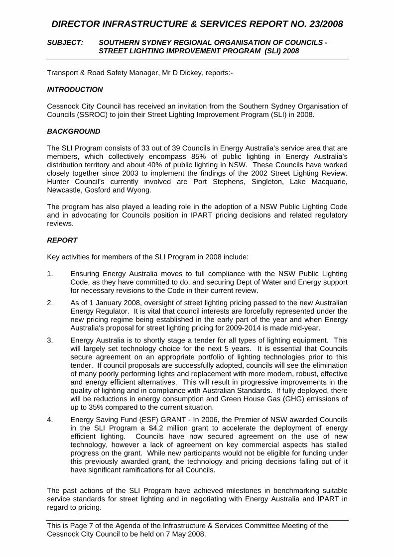
DIRECTOR INFRASTRUCTURE & SERVICES REPORT NO. 23/2008
SUBJECT: SOUTHERN SYDNEY REGIONAL ORGANISATION OF COUNCILS - STREET LIGHTING IMPROVEMENT PROGRAM (SLI) 2008
Transport & Road Safety Manager, Mr D Dickey, reports:- INTRODUCTION Cessnock City Council has received an invitation from the Southern Sydney Organisation of Councils (SSROC) to join their Street Lighting Improvement Program (SLI) in 2008. BACKGROUND The SLI Program consists of 33 out of 39 Councils in Energy Australia’s service area that are members, which collectively encompass 85% of public lighting in Energy Australia’s distribution territory and about 40% of public lighting in NSW. These Councils have worked closely together since 2003 to implement the findings of the 2002 Street Lighting Review. Hunter Council’s currently involved are Port Stephens, Singleton, Lake Macquarie, Newcastle, Gosford and Wyong. The program has also played a leading role in the adoption of a NSW Public Lighting Code and in advocating for Councils position in IPART pricing decisions and related regulatory reviews. REPORT Key activities for members of the SLI Program in 2008 include: 1. Ensuring Energy Australia moves to full compliance with the NSW Public Lighting
Code, as they have committed to do, and securing Dept of Water and Energy support for necessary revisions to the Code in their current review.
2. As of 1 January 2008, oversight of street lighting pricing passed to the new Australian Energy Regulator. It is vital that council interests are forcefully represented under the new pricing regime being established in the early part of the year and when Energy Australia's proposal for street lighting pricing for 2009-2014 is made mid-year.
3. Energy Australia is to shortly stage a tender for all types of lighting equipment. This will largely set technology choice for the next 5 years. It is essential that Councils secure agreement on an appropriate portfolio of lighting technologies prior to this tender. If council proposals are successfully adopted, councils will see the elimination of many poorly performing lights and replacement with more modern, robust, effective and energy efficient alternatives. This will result in progressive improvements in the quality of lighting and in compliance with Australian Standards. If fully deployed, there will be reductions in energy consumption and Green House Gas (GHG) emissions of up to 35% compared to the current situation.
4. Energy Saving Fund (ESF) GRANT - In 2006, the Premier of NSW awarded Councils in the SLI Program a $4.2 million grant to accelerate the deployment of energy efficient lighting. Councils have now secured agreement on the use of new technology, however a lack of agreement on key commercial aspects has stalled progress on the grant. While new participants would not be eligible for funding under this previously awarded grant, the technology and pricing decisions falling out of it have significant ramifications for all Councils.
The past actions of the SLI Program have achieved milestones in benchmarking suitable service standards for street lighting and in negotiating with Energy Australia and IPART in regard to pricing.

This is Page 8 of the Agenda of the Infrastructure & Services Committee Meeting of the Cessnock City Council to be held on 7 May 2008.
Page 2 –Director Infrastructure & Services Report No. 23/2008 The objectives above will realise these member Councils taking a more proactive role in negotiating for infrastructure that will see other benefits to the community such as a reduction in GHG emissions, improved lighting levels and hopefully a realistic pricing regime over the next five years. Cessnock City Council, for the 2007/08 financial year, allocated a budget of $517,000 for street lighting and this amount will rise in the near future with each new development and pricing increases for the supply of energy and infrastructure servicing. At present Council purchases street lighting energy from Energy Australia who is also the service provider. Given this large expenditure it is recommended that Council take an active role in future negotiations with Energy Australia and the best way to do this is to be aligned with other Councils with a similar interest. FINANCIAL IMPLICATIONS The cost to participate as a member Council in the SLI Program is $4,000 pa which if approved would be contained within the street lighting budget. Associated costs would involve staff time attending meetings in Sydney where necessary and this could involve overnight accommodation. SUMMARY Street lighting is a necessary service to Council’s community providing guidance to pedestrians and motorists of a night. Without street lighting road safety would be severely compromised. The cost to supply this service will not decrease over time given the present world market and the large areas identified in Cessnock for future urban development. Given this, it is recommended that Council join the SLI Program as it provides a good option for containing future pricing. RECOMMENDATION that 1. Council accept the membership offer from the Southern Sydney Organisation of
Councils to join their Street Lighting Improvement (SLI) Program; 2. The cost to join the SLI Program and associated staffing costs be contained with the
existing street lighting budget; To: The General Manager L OLDFIELD Infrastructure & Services
Committee – 7 May 2008 DIRECTOR INFRASTRUCTURE &
SERVICES 29 April 2008

This is Page 9 of the Agenda of the Infrastructure & Services Committee Meeting of the Cessnock City Council to be held on 7 May 2008.
DIRECTOR INFRASTRUCTURE & SERVICES REPORT NO.24 /2008
SUBJECT: TRAFFIC FACILITY CONSTRUCTION PROGRAM 2008/2009
Transport & Road Safety Manager, Mr D Dickey, reports:- BACKGROUND Each year the Traffic Facilities Construction program is developed for consideration as part of Council’s budget proposals. These projects are recommended to Council by the Local Traffic Committee. The purpose of this report is to advise Council of outstanding traffic facility projects waiting adoption and funding. TRAFFIC FACILITY PROGRAM Ranking Project Estimate Year
1 Old Maitland Road Cessnock – reconstruct children’s crossing at public school.
$30,000 2008/09
2 Mayfield Street at Aberdare Road Cessnock – construct pedestrian refuge.
$16,000 2008/09
3 McGrane Street Cessnock at Leonard Street – construct pedestrian refuge.
$21,000 2009/2010
4 Boundary St Kurri Kurri at Northcote Street – construct pedestrian refuge.
$25,000 2009/2010
5 Wollombi Rd Bellbird – pedestrian refuge at Hetton Street.
$23,000 2010/2011
6 Boundary Street at Pre-School – carpark widening and signposting. $25,000 2010/2011
7 Leonard Street Cessnock – pedestrian refuge at McGrane St.
$23,000 2011/2012
8 Rawson Street Cessnock – Pedestrian refuge at Brandis Street.
$15,000 2011/2012
9 Lang Street Kurri Kurri – extend the length of the pedestrian refuge immediately west of Alexandra Street to relocate the u-turn movement to a safe distance from the intersection.
$5,000 2011/2012
10 James Street Cessnock – construct pedestrian refuge at Wollombi Road.
$15,000 2012/2013
11 Coulson Avenue Cessnock – install LATM in surrounding street network_INVESTIGATION ONLY.
$15,000 2012/2013
12 Vincent Street Cessnock – upgrade to marked pedestrian crossing near Rover Motors by road narrowing.
$17,000 2012/2013
13 Coulson Avenue Cessnock – install LATM in surrounding street network.
$150,000 2013/2014
14 Leonard Street Cessnock – construct pedestrian refuge at Boomerang Street.
$15,000 2014/2015
15 Edgeworth Street Cessnock – construct pedestrian refuge and marked 90 degree parking spaces at Vincent Street.
$10,000 2014/2015
16 Congewai Street Aberdare – construct pedestrian refuge at Quarrybylong Street.
$15,000 2014/2015
17 Mavis Street Cessnock – construct traffic islands at Lindesay Street.
$15,000 2015/2016
18 Lang Street Kurri Kurri – construct pavement and linemarking works in accordance with the Local Traffic Committee report 07/84 at the pedestrian crossing outside Kurri Kurri Public School.
$25,000 2015/2016

This is Page 10 of the Agenda of the Infrastructure & Services Committee Meeting of the Cessnock City Council to be held on 7 May 2008.
Page 2 –Director Infrastructure & Services Report No. 24/2008 This program will complete all traffic facility projects listed to date. Construction of the first two items, Old Maitland Road and Mayfield Street Cessnock, is proposed in 2008/09. RECOMMENDATION that Council adopt the program works for Traffic Facility construction identified in this report for the 2008/09 financial year. To: The General Manager L OLDFIELD Infrastructure & Services
Committee – 7 May 2008 DIRECTOR INFRASTRUCTURE &
SERVICES 29 April 2008

This is Page 11 of the Agenda of the Infrastructure & Services Committee Meeting of the Cessnock City Council to be held on 7 May 2008.
DIRECTOR INFRASTRUCTURE & SERVICES REPORT NO. 25/2008
SUBJECT: REPORT OF THE CESSNOCK CITY COUNCIL LOCAL TRAFFIC COMMITTEE MEETING HELD ON 17 MARCH 2008
A meeting of the Cessnock City Council Local Traffic Committee was held on 17 March 2008 and reports as follows:- Attendees at the meeting included Councillor C Parsons, Councillor J Maybury, Senior Constable M Bernard, Mr G Warnick, Council Officer Mr D Dickey and Mr C Eddy. In line with new RTA requirements, the items presented for consideration are listed into “Formal Matters” and “Informal Matters”. “Formal Matters” are those items where Council is required to exercise its delegated powers for approval of traffic facility items. “Informal Matters” are those items where Council is not required to exercise this function but are presented to the Council for information.
FORMAL MATTERS ITEM NO: 08/029 HALL STREET CESSNOCK - ROAD SAFETY ATCUMBERLAND
STREET Applicant believes that the intersection of Hall Street and Cumberland Street is hazardous as follows:- • Hall Street, when travelling west, the sight distance is not adequate; • Vehicles in Cumberland Street are parked too close to the corner; • “No Stopping” signs are not fully visible; • Speed of vehicles in Cumberland Street is a problem. The Hall Street approaches are currently controlled by single posted “Stop” signs because of the restricted sight distance at Cumberland Street. Sight distance on the eastern approach (from King Street) is assisted by the longitudinal downgrade as the driver’s eye is higher, relative to the approaching traffic in Cumberland Street. The opposite applies on the western approach and this restricts the available sight distance. The existing “No Stopping” restrictions on Cumberland Street comply with RTA requirements and there were no vehicles parked contrary to these restrictions. No recent traffic count information exists for Cumberland Street to verify the applicant’s claims regarding traffic speeds, however it is subject to a 50 km/h speed limit. Crash history indicates that the last recorded crash at the intersection was a “tow-away” type in April 2005, where a westbound vehicle in Hall Street collided with a northbound vehicle in Cumberland Street. Traffic Facilities Programme works for the intersection include the installation of pedestrian refuges in Hall Street and double posting the “Stop” restrictions, however this project is listed but currently unfunded. Other approved works proposed for Cumberland Street is the installation of edgelines and as part of this work, the holding line for the “Stop” controls could be moved out to the edgeline alignment to improve sight distance. This would not impact on the future construction of pedestrian refuges and would serve as an interim treatment until funding for the pedestrian refuges was available.

This is Page 12 of the Agenda of the Infrastructure & Services Committee Meeting of the Cessnock City Council to be held on 7 May 2008.
Page 2 –Director Infrastructure & Services Report No. 25/2008 RECOMMENDED that:- 1. The proposed installation of edgeline (E1) linemarking in Cumberland Street
Cessnock be carried out as soon as possible; 2. The existing “Stop” holding lines in Hall Street at Cumberland Street be moved
further into the intersection as part of the proposed edgeline treatment for Cumberland Street.
ITEM NO: 08/030 MARGARET STREET CESSNOCK – CONCERNSWITH
SPEEDING TRAFFIC Applicant says that traffic speeds have increased and she believes her safety is at risk when trying to enter and leave her property. She requests speed humps or some other measures. Council recently installed a short length of double unbroken (BB) centreline markings at the junction of Margaret Street with Booth Street and it is recommended that these markings be extended on both approaches. The installation of W1-1 advance warning signs with supplementary speed plates is also supported to confirm the horizontal alignment of the corner and the recommended safe travel speed. Further treatments may be considered after the approved works are installed and the treatments monitored for a suitable period thereafter. The installation of speed humps is not supported as this is a residential area. RECOMMENDED that:- 1. The existing double unbroken (BB) markings at the corner of Margaret Street
and Booth Street Cessnock be extended; 2. W1-1 advance warning signs with supplementary speed advisory plates be
installed on each approach to the corner. ITEM NO: 08/031 LANEWAY 2692 CESSNOCK - PARKING AT REAR OF No.2
YANGO STREET Vehicles parking at the Millfield Street end of the laneway beside Reece Plumbing (which is a rear access to properties fronting Maitland Road and Yango Street) are blocking driveways, especially the rear access to No.2 Yango Street. Applicant states that the resident has rung the Rangers and they have placed warning notices on windscreens but are prepared to issue infringement notices if the practice continues. Applicant would like "No Parking" signs installed. Parking on the eastern side of the laneway beside Reece Plumbing Supplies (in Millfield Street) has steadily increased to the point where vehicles are encroaching over rear accesses to properties fronting Yango Street and Maitland Road. The installation of “No Stopping” restrictions on both sides of the laneway, over the statutory areas at Millfield Street is supported, however the “No Stopping” should be extended to a point 50m east of Millfield Street (on the southern side) and 40m (on the northern side) to permit two way vehicle travel in the laneway and reduce conflict with parked vehicles near the Millfield Street intersection.

This is Page 13 of the Agenda of the Infrastructure & Services Committee Meeting of the Cessnock City Council to be held on 7 May 2008.
Page 3 –Director Infrastructure & Services Report No. 25/2008 RECOMMENDED that:- “No Stopping” restrictions be installed in Laneway 2692 Cessnock (beside Reece Plumbing Supplies) as follows:- 1. On the south side, from Millfield Street to 50m east of Millfield Street; 2. On the north side, from Millfield Street to 40m east of Millfield Street. ITEM NO: 08/032 CESSNOCK ROAD CLIFTLEIGH - REQUEST FOR BUS STOPS Resident would like to see a bus stop near 108 Main Road Cliftleigh on both sides of street. [There is] approximately 1.2 km between bus stops at Heddon Street Heddon Greta and the bus stop at Cliftleigh and customer thinks this is too large. [The applicant] has school age children that could use the requested bus stop. Sight distance for school bus and scheduled service operations in this area of Cessnock Road is good in both directions and there is adequate space on the road shoulders for a bus to stand clear of the travelling lane in safety. Current parking demand does not warrant the installation of “Bus Zone” restrictions and the new bus stops will be marked with a standard ‘J’ post. Rover Motors were consulted in regard to the proposal and have no objections and the proposed bus stop locations will not impact on any future works on the State Road. RECOMMENDED that bus stops be installed on both sides of Cessnock Road Cliftleigh at No.106. ITEM NO: 08/036 PAYNES CROSSING ROAD WOLLOMBI – MISSING GIVE WAY
SIGN AT WILLIAMS BRIDGE The “Give Way” sign for Williams Bridge is missing and it is requested that the signposting on the approaches to the bridge be investigated as well. Council confirms that the bridge currently has a one-lane span and has no priority control at either end, however there are “No Overtaking or Passing” signs on each approach. As the bridge is has a single lane carriageway, it is recommended that the approaches be signposted and pavement marked in accordance with RTA requirements for narrow bridges, as follows:- • Install a “Stop” restriction on the northern approach to the bridge as sight distance
across the bridge is better from the north and the carriageway is able to support queued vehicles;
• Install the associated TF holding line (to support the “Stop” sign) and double unbroken (BB) centreline markings on both approaches to the bridge;
• Install advance warning W4-1 “Narrow Bridge” and supplementary W8-2 “35 km/h” speed advisory signs;
• Retain the existing “No Overtaking Or Passing” condition sign on the southern approach only;
• Install advance warning W3-1 “Stop Sign Ahead” sign on the northern approach.

This is Page 14 of the Agenda of the Infrastructure & Services Committee Meeting of the Cessnock City Council to be held on 7 May 2008.
Page 4 –Director Infrastructure & Services Report No. 25/2008 The proposed chicane and approach filter barrier treatment for the bridgeworks at Cunneens Bridge (to the south) entails the construction of a turn-around area approximately 50m north of Williams Bridge and included in this work is the signposting for those barriers. In order to reduce confusion between the filter barriers signposting and the final signposting associated only with Williams Bridge, it is recommended that the “Give Way” priority control be re-established at the northern end of Williams Bridge and that the signposting and pavement marking detailed in this report be installed after the chicane barriers are removed. RECOMMENDED that signposting and pavement markings be installed on Paynes Crossing Road Wollombi, on both approaches to Williams Bridge, in accordance with RTA requirements for narrow bridges and the Traffic Committee report. ITEM NO: 08/037 PAYNES CROSSING ROAD WOLLOMBI SIGNPOSTING FOR
NARROW SECTION SOUTH OF WILLIAMS BRIDGE Traffic Committee approval of proposed signposting associated with future roadworks on an 800m section of narrow gravel carriageway from Williams Bridge southwards towards Wollombi which has a steep cut and fill embankment (the narrow section above the Wollombi Brook). The proposed plans show the installation of a proposed 40km/h speed limit, temporary double posted “Part Road Closed” signs, advance warning “Road Narrows - One Lane - 120m” signs, “No Overtaking Or Passing” signs, a single posted “Give Way” restriction (with advance warning “Give Way Ahead” sign) on the southern approach, with similar signage and a temporary double posted “Prepare To Stop” signs on the northern approach. With regard to the proposed signposting, it is recommended that the narrow section of road be signposted in accordance with the RTA’s requirements for narrow bridges and in accordance with the following amendments. On the southern approach, all proposed signposting be retained except the following:- • The proposed single posted R6-1 “No Overtaking Or Passing” sign be deleted; • The proposed single posted W3-2 advance warning “Give Way Ahead” sign be
replaced with a W3-1(B) “Stop Sign Ahead” sign; • The proposed single posted R1-2 “Give Way” sign be replaced with a R1-1(B) “Stop”
sign. On the northern approach, all proposed signposting be retained except the following:- • The proposed double posted T1-18 “Prepare To Stop” signs be deleted. Installation of the reduced speed limit will be subject to RTA investigation and will be carried out independently of the other signposting shown on the plans. With these amendments included on the proposed plans, it is recommended that the proposed signposting be approved. RECOMMENDED that the proposed traffic control signposting associated with the re-construction of Paynes Crossing Road Wollombi from Williams Bridge to a point 800m south of Williams Bridge be approved in accordance with the Traffic Committee report and amended Drawing Ref. No.4434 // 07/08/:3898.

This is Page 15 of the Agenda of the Infrastructure & Services Committee Meeting of the Cessnock City Council to be held on 7 May 2008.
Page 5 –Director Infrastructure & Services Report No. 25/2008
INFORMAL MATTERS ITEM NO: 08/027 CESSNOCK ROAD ABERMAIN - SIGHT DISTANCE
AT DOCTORS SURGERY EXIT General Business from Traffic Committee meeting of 18 February 2008. Councillor Parsons raised a concern (on behalf of the Abermain General Practice) about the difficulty staff at the surgery are having when exiting the surgery car park, in particular when there are vehicles parked on street, outside the surgery. As the matter relates to the State Road (MR 588), it is recommended that the request be referred to the RTA for further investigation. RECOMMENDED that the RTA be requested to investigate the existing sight distance on Cessnock Road Abermain at the Abermain doctor’s surgery. ITEM NO: 08/028 CHARLES STREET ABERMAIN – PEDESTRIAN
REFUGE AT WILLIAM STREET Consider the installation of a pedestrian refuge in Charles Street at the William Street intersection The installation of a pedestrian refuge in Charles Street at William Street was not supported by the Traffic Committee as the numbers of pedestrians likely to use the facility was considered to be low. RECOMMENDED that no action be taken. ITEM NO: 08/033 WINE COUNTRY DRIVE NULKABA – CONCRETE
BARRIERS AT CALVARY NURSING HOME General Business from Traffic Committee meeting of 18 February 2008. Councillor Parsons raised a concern on behalf of the Calvary Nursing Home about the existing concrete barriers that are in place on Wine Country Drive outside the Calvary Nursing Home. The concrete barriers were placed on site by Daracon Engineering (who are carrying out roadworks for the nearby service station development) and are restricting available sight distance for drivers exiting Calvary. The junction of the Calvary Nursing Home access road with Wine Country Drive is subject to a “Stop” control and the signs and markings are in good condition. The existing concrete barriers form part of delineation measures associated with road reconstruction on Wine Country Drive (being carried out by Daracon) and are necessary as the road shoulder is being excavated for reconstruction. The barriers are located on the edge of the excavation and cannot be moved away from the adjacent carriageway until the road base on the shoulder is compacted and sealed. As the roadworks are associated with the State Road (MR 220), it is recommended that the RTA be requested to investigate alternate measures to assist sight distance at the access.

This is Page 16 of the Agenda of the Infrastructure & Services Committee Meeting of the Cessnock City Council to be held on 7 May 2008.
Page 6 –Director Infrastructure & Services Report No. 25/2008 RECOMMENDED that the RTA be requested to investigate improved sight distance conditions at the intersection of the Calvary Nursing Home access road with Wine Country Drive Nulkaba. ITEM NO: 08/034 LANEWAY 4691 STANFORD MERTHYR – CLOSURE OF
LANEWAY Laneway behind No.2 Anvil Street Stanford Merthyr is being used by motorcycles all the time. The elderly owner would like Council to block off laneway to stop them travelling on it, like they did at Colliery Road. Noise is upsetting resident. The laneway at the rear of the applicant’s property serves as rear access to properties adjoining the laneway and access is only available from the Seaham Street end. Access from the northern is not available as it abuts bushland. RECOMMENDED that no action be taken. ITEM NO: 08/035 HALL STREET WESTON - PEDESTRIAN REFUGE
AT CESSNOCK ROAD Consider the installation of a pedestrian refuge in Hall Street at the Cessnock Road intersection. The installation of a pedestrian refuge in Hall Street at Cessnock Road was not supported by the Traffic Committee as the numbers of pedestrians likely to use the facility was considered to be low. RECOMMENDED that no action be taken. RECOMMENDATION that Council endorse the report of the Cessnock City Council Local Traffic Committee meeting held on 17 March 2008. To: The General Manager L OLDFIELD Infrastructure & Services
Committee – 7 May 2008 DIRECTOR INFRASTRUCTURE &
SERVICES 29 April 2008

This is Page 17 of the Agenda of the Infrastructure & Services Committee Meeting of the Cessnock City Council to be held on 7 May 2008.
DIRECTOR INFRASTRUCTURE & SERVICES REPORT NO. 26/2008
SUBJECT: ROAD NAMING – PROPOSED NEW SUBDIVISIONS WITHIN THE HEZ DEVELOPMENT AT PELAW MAIN
Roads, Bridges & Drainage Manager, Mr J Booth, reports:- PURPOSE For the concurrence of Council to the proposed names of future new roads in proposed subdivisions within the HEZ Development at Pelaw Main. BACKGROUND HEZ have requested Council’s approval to the new names of “Richie”, “Bottlebrush”, “Wattle”, “Gum Tree”, “Eucalypt” and “Possum” for proposed new roads in the HEZ Development at Pelaw Main. The developers have complied with the principles of the “Guidelines for the Naming of Roads” produced by the Geographical Names Board of New South Wales and provided a document (refer to the Enclosure to this Report) to Council containing a brief description supporting each of the proposed new names. INFORMATION These names were originated and short-listed from submissions received during a competition held by Hunter Economic Zone in 2004 between six primary schools in the vicinity of the HEZ Development. Currently there are no other streets with these names in the Cessnock Local Government Area. RECOMMENDATION that:- 1. Council supports the proposed names of “Richie”, “Bottlebrush”, “Wattle”, “Gum
Tree”, “Eucalypt” and “Possum” for future new roads in proposed subdivisions within the HEZ Development at Pelaw Main.
2. Council proceeds with the provisions of section 162 of the Roads Act 1993 and the provisions of Section 7 of the Roads (General) Regulation 2000 regarding notifications and advertising, at the appropriate time.
To: The General Manager L OLDFIELD Infrastructure & Services
Committee – 7 May 2008 DIRECTOR INFRASTRUCTURE &
SERVICES 29 April 2008
This is Page 18 of the Agenda of the Infrastructure & Services Committee Meeting of the Cessnock City Council to be held on 7 May 2008.
DIRECTOR INFRASTRUCTURE & SERVICES REPORT NO. 27/2008
SUBJECT: URBAN RESEALING PROGRAM INCLUDING MINOR REHABILITATION 2008/2009
Roads, Bridges & Drainage Manager, Mr J Booth, reports:- PURPOSE The following report lists priorities for the 2008/2009 Urban Resealing Program including Minor Rehabilitation. BACKGROUND As set out in the Roads, Bridges & Drainage Manager’s Council Briefing on Wednesday 13 February 2008 the total level of funding for the 2008/2009 Urban and Rural Programs is assumed to be similar to this year with a 2.0% increase allowed for annualised salary/wage increases and CPI increases affecting materials, plant, haulage and contracts. It should be noted that the construction industry CPI was 4.3% over the last 12 months, therefore allocations are falling behind cost rises. Council cannot raise additional revenue due to “rate pegging.” Based on previous allocations to the Urban Reseal Program an amount of $502,900 was proposed for this program under Essential Discretionary Items of the 2008/2009 Program Budget submission. As discussed at the Roads, Bridges & Drainage Manager’s Council Briefing the proposed mix of allocation of funding across urban and rural resealing and Local Roads rehabilitation is to address current infrastructure needs to ensure the greatest long term benefits to Council’s road network are achieved, given the total amount of funding available from all sources. Information supplied in the Roads, Bridges & Drainage Manager’s Council Briefing indicated that Council has approximately 285 kilometres of urban sealed roads in its local road network. In addition there are 13 kilometres of sealed urban Regional Roads for which Council receives some funding from the State Government through the RTA to undertake reseals. ASSESSMENT OF PROJECT PRIORITIES A road resurfacing project is one which requires the application of a bitumen seal or other surface treatment so as to extend the life of the road pavement. The existing wearing surface of any section selected is usually in fair condition and the pavement base is sound. A road rehabilitation project, on the other hand, includes works to strengthen the road pavement and/or improve the road alignment and the width to bring the road up to “as new” condition. Bitumen used as the binder in bitumen seals and asphaltic concrete (AC), ages and becomes brittle due to oxidation. When brittle the bitumen cracks and loses its ability to waterproof the road surface. The effective life of the bitumen binder is a function of the climatic conditions and the traffic volume. It is therefore essential to program resealing before the surface has deteriorated to the point where water is entering the pavement and failures such as potholes have occurred. Industry standards are that road resealing and resurfacing works (in the case of AC wearing surfaces) are carried out at intervals of 7 – 13 years to maintain the asset and defer the need for rehabilitation works. To even achieve a resealing frequency of 15 years Council should be resealing 6.7 percent or 19.1 kilometres of urban roads every year.

This is Page 19 of the Agenda of the Infrastructure & Services Committee Meeting of the Cessnock City Council to be held on 7 May 2008.
Page 2 – Director Infrastructure & Services Report No. 27/2008 Based on current available funding and the cost of these selected works Council is able to achieve approximately 6.61 km of road length (this includes 2.15km of road length under the Infrastructure Improvement Program) for the financial year 2008/2009. This represents 2.3% of total sealed urban local road network (equivalent to reseal cycle of 43.5 years). It should be noted that unit rates are currently high because the present strategy is to address the streets requiring high amounts of pretreatment (minor rehabilitation, pavement widening, heavy patching and edge repairs etc.); however as the program progresses savings are anticipated in the amount of pretreatment required due to earlier intervention. In addition some AC resurfacing will also be carried out, which has higher unit rates. Council’s Intervention Rule Base was updated on the two sets of data collected three (3) years apart. The newer data has provided an indication of the change in network condition (good and bad) over the intervening three (3) years given the construction, rehabilitation and resealing/resurfacing works undertaken and changing age, environment and traffic on the network. Council is now due to call tenders to collect road inventory and condition data and update our data base. Candidate reseal lengths were identified by application of the information collected from Council’s road asset inventory and condition data (IMG 2001 and PMS 2004) and application of Council’s Intervention Rule Base. The rate in deterioration of the various condition indicators (stripping, cracking and defects) relevant to bitumen seal condition were assessed between 2001 and 2004. This ensures that the segments most in need are undertaken using the most appropriate treatment to optimise the allocation of Council’s available funding. Stripping was found to be the lead indicator for seal condition. A priority program for urban road resealing works has been formulated on this reviewed information. All urban segments were assessed on the following criteria applying the Intervention Rule Base developed jointly by Roads, Bridges & Drainage Section and consultant Infrastructure Management Group, as modified in consideration of the PMS 2004 data: • Stripping (loss of aggregate); • Extent of cracking in seal; • Extent of pavement deformation and defects; • Traffic data; and • Age of existing seal (if known). In the case of urban sub arterial and collector roads (i.e. roads having higher status than local roads in the road hierarchy due to greater traffic volumes), roughness counts were also available for use in the assessment. Segments identified for resealing and resurfacing were cross checked against projects listed in Council’s adopted 5 year Urban Construction Program to eliminate segments proposed for rehabilitation or reconstruction. Relevant Works & Services staff were consulted regarding input on issues, such as high cost maintenance problem areas. Prior to final determination of lengths and optimum treatments, detailed inspections of the identified segments will be undertaken. Where seal widths are below 5.0 m the opportunity is being taken to increase to 7 metre minimum, where practical, to reduce shoulder and edge wear and mitigate dust. It should be noted that the extent of pavement deformation due to rutting, shoving, potholing and edge and pavement failures may be such that heavy patching and edge repairs followed by resealing will not restore the pavement surface.
This is Page 20 of the Agenda of the Infrastructure & Services Committee Meeting of the Cessnock City Council to be held on 7 May 2008.
Page 3 – Director Infrastructure & Services Report No. 27/2008 In these cases full pavement rehabilitation/reconstruction is usually the only option; however in some cases the surface can be scarified by grader, additional pavement added and resealed as a minor rehabilitation work. This is a more cost effective treatment than extensive asphalt concrete heavy patching. Due to the cost of preparatory work (such as heavy patching, crack sealing and edge repairs) required prior to the actual application of the bitumen reseal some flexibility must be allowed in the program as to the actual quantity of work to be completed. With this in mind, and as with other adopted Council programs, the works will be implemented with Council being regularly made aware of the progress of the program and subsequently any anticipated variations i.e. either carrying over reseals into the next financial year if costs are higher than estimated, or bringing reseals forward from the following years program if costs are lower than estimated. A number of other projects were reassessed as requiring an excessive amount of costly heavy patching and have been referred for consideration for rehabilitation under the Urban Construction Program. RECOMMENDATION that the following priority list of Urban Resealing Projects be adopted for 2008/2009
URBAN RESEALS & MINOR REHABILITATION 2008/2009
Unique ID Street Name From Street To Street Suburb Ward Length Final Cost
3587,4 Bowden St Heddon St Change Seal Heddon Greta D 90 $15,600.00
4220,1 Reid St Cessnock Dead End North Rothbury C 333 $24,300.00
4460,1 Ellalong St Thornton Tarro Pelaw Main C 210 $34,200.003400,2 Kline St Scott Cessnock Weston C 75 $9,400.004400,1 William St Millfield Blacks Paxton A 215 $13,600.00
400,2 Melbourne St Goulburn Bathurst Abermain C 170 $13,600.00
180,2 Armidale St Orange Grafton Abermain C 152 $14,500.00170,3 Albury St Maitland Lismore Abermain C 380 $30,400.001490,3 Wyndham St Lindsay George East Branxton C 255 $21,700.001080,1 Prince St Sparke Hetton Bellbird A 305 $45,600.001080,2 Prince St Hetton Change Seal Bellbird A 95 $16,500.001080,2 Prince St Change Seal Dead End Bellbird A 120 $11,700.00
This is Page 21 of the Agenda of the Infrastructure & Services Committee Meeting of the Cessnock City Council to be held on 7 May 2008.
Page 4 – Director Infrastructure & Services Report No. 27/2008
URBAN RESEALS & MINOR REHABILITATION 2008/2009
Unique ID Street Name From Street To Street Suburb Ward Length Final Cost
1440,3 Station St Fleet Railway Branxton C 195 $15,600.0060,1 Congewai St Colliery Caledonian Aberdare B 110 $22,000.0060,1 Congewai St Colliery Caledonian Aberdare B 110 $11,600.001950,1 Catherine St James Michael Cessnock B 225 $27,000.00
1700,2 McFarlane St Fifth Houston Cessnock B 270 $52,700.00
1700,3 McFarlane St Houston Vincent Cessnock B 220 $43,000.00
2990,1 Melton Av Ferguson Anzac Cessnock B 200 $18,200.002260,2 Michael St Catherine Daniel Cessnock B 190 $17,200.002260,3 Michael St Daniel Dead End Cessnock B 240 $18,000.002670,1 Davidson St Boomerang Bent Cessnock B 215 $16,200.0010072,1 Helen St Shedden Wollombi Cessnock B 85 $10,300.00 TOTAL 4460 $502,900.00
To: The General Manager L OLDFIELD Infrastructure & Services
Committee – 7 May 2008 DIRECTOR INFRASTRUCTURE &
SERVICES 29 April 2008

This is Page 22 of the Agenda of the Infrastructure & Services Committee Meeting of the Cessnock City Council to be held on 7 May 2008.
DIRECTOR INFRASTRUCTURE & SERVICES REPORT NO. 28/2008
SUBJECT: RURAL RESEALING PROGRAM INCLUDING MINOR REHABILITATION 2008/2009
Roads, Bridges & Drainage Manager, Mr J Booth, reports:- PURPOSE The following report lists priorities for the 2008/2009 Rural Resealing Program including Minor Rehabilitation. BACKGROUND As set out in the Roads, Bridges & Drainage Manager’s Council Briefing on Wednesday 13 February 2008 the total levels of funding for the 2008/2009 Urban and Rural Programs is assumed to be similar to this year with a 2.0% increase allowed for annualised salary/wage increases and CPI increases affecting materials, plant, haulage and contracts. It should be noted that the construction industry CPI was 4.3% over the last 12 months, therefore allocations are falling behind cost rises. Council cannot raise additional revenue due to “rate pegging.” Based on previous allocations to the Rural Reseal Program an amount of $310,300 was proposed for this program under Essential Discretionary Items of the 2008/2009 Program Budget submission. As discussed at the Roads, Bridges & Drainage Manager’s Council Briefing the proposed mix of allocation of funding across urban and rural resealing and Regional Roads rehabilitation is to address current infrastructure needs to ensure the greatest long term benefits to Council’s road network are achieved, given the total amount of funding available from all sources. Information supplied in the Roads, Bridges & Drainage Manager’s Council Briefing indicated that Council has approximately 224 kilometres of rural sealed roads in its local road network. In addition there are 86 kilometres of sealed rural Regional Roads for which Council receives some funding from the State Government through the RTA to undertake reseals. ASSESSMENT OF PROJECT PRIORITIES A road resurfacing project is one which requires the application of a bitumen seal or other surface treatment so as to extend the life of the road pavement. The existing wearing surface of these projects is usually in fair condition and the pavement base is sound. A road rehabilitation project, on the other hand, includes works to strengthen the road pavement and/or improve the road alignment and the width to bring the road up to “as new” condition. Bitumen used as the binder in bitumen seals and asphaltic concrete (AC), ages and becomes brittle due to oxidation. When brittle the bitumen cracks and loses its ability to waterproof the road surface. The effective life of the bitumen binder is a function of the climatic conditions and the traffic volume. It is therefore essential to program resealing before the surface has deteriorated to the point where water is entering the pavement and failures such as potholes have occurred. Industry standards are that road resealing and resurfacing works (in the case of AC wearing surfaces) are carried out at intervals of 7 – 13 years to maintain the asset and defer the need for rehabilitation works. To even achieve a resealing frequency of 15 years Council should be resealing 6.7 percent or 14.6 kilometres of rural roads every year.

This is Page 23 of the Agenda of the Infrastructure & Services Committee Meeting of the Cessnock City Council to be held on 7 May 2008.
Page 2 – Director Infrastructure & Services Report No. 28/2008 Based on current available funding and the cost of these selected works Council is able to achieve approximately 5.93 km of road length (this includes 2.14km of road length under the Infrastructure Improvement Program) for the financial year 2008/2009. This represents 2.65% of total sealed urban local road network (equivalent to reseal cycle of 37.7 years). It should be noted that unit rates are currently high because the present strategy is to address the streets requiring high amounts of pretreatment (minor rehabilitation, pavement widening, heavy patching and edge repairs etc.); however as the program progresses savings are anticipated in the amount of pretreatment required due to earlier intervention. In addition some AC resurfacing will also carry out, which has higher unit rates. Council’s Intervention Rule Base has been updated on the two sets of data collected three (3) years apart (IMG 2001 and PMS 2004). The newer data has provided an indication of the change in network condition (good and bad) over the intervening three (3) years given the construction, rehabilitation and resealing/resurfacing works undertaken and changing age, environment and traffic on the network. Candidate reseal lengths were identified by application of the information collected from Council’s road asset inventory and condition data (IMG 2001 and PMS 2004) and application of the “Intervention Rule Base”. The rate in deterioration of the various condition indicators (stripping, cracking and defects) relevant to bitumen seal condition were assessed between 2001 and 2004. This ensures that the segments most in need are undertaken using the most appropriate treatment to optimise the allocation of Council’s available funding. Stripping was found to be the lead indicator for seal condition. A priority program for rural road resealing works has been formulated on this reviewed information. All rural segments were assessed on the following criteria applying an Intervention Rule Base developed jointly by Roads, Bridges & Drainage Section and consultant Infrastructure Management Group, as modified in consideration of the PMS 2004 data: • Stripping (loss of aggregate); • Extent of cracking in seal; • Extent of pavement deformation and defects; • Traffic data; and • Age of existing seal (if known). In the case of rural sub arterial and collector roads (i.e. roads having higher status than local roads in the road hierarchy due to greater traffic volumes), roughness counts were also available for use in the assessment. Segments identified for resealing and resurfacing were cross checked against projects listed in Council’s adopted 5 year Rural Construction Program to eliminate segments proposed for rehabilitation or reconstruction. Relevant Works & Services staff were consulted regarding input on issues, such as high cost maintenance problem areas. Prior to final determination of lengths and optimum treatments, detailed inspections of the identified segments will be undertaken. Where seal widths are below 5.0 m the opportunity is being taken to increase to 7 metre minimum, where practical, to reduce shoulder and edge wear and mitigate dust. It should be noted that the extent of pavement deformation due to rutting, shoving, potholing, edge and pavement failures may be such that heavy patching and edge repairs followed by resealing will not restore the pavement surface.

This is Page 24 of the Agenda of the Infrastructure & Services Committee Meeting of the Cessnock City Council to be held on 7 May 2008.
Page 3 – Director Infrastructure & Services Report No. 28/2008 In these cases full pavement rehabilitation/reconstruction is the only option; however in some cases the surface can be scarified by grader, additional pavement added and resealed as a minor rehabilitation work. This is a more cost effective treatment than extensive asphalt concrete heavy patching. Due to the cost of preparatory work (such as heavy patching, crack sealing and edge repairs) required prior to the actual application of the bitumen reseal some flexibility must be allowed in the program as to the actual quantity of work to be completed. For example in 2005 to 2007 on Sandy Creek Road at Mt Vincent, 2710 lineal metres of shoulder widening one metre on each side was completed to widen the seal from 6 metres to 8 metres. This is essential due to the increased traffic volume using Sandy Creek Road now that it is sealed from Ellalong to Leggetts Drive, Mount Vincent and to provide a wider pavement for cyclists and pedestrians. The full width of this section was then resealed under the Rural Reseal Program 2006/07. In addition the estimates are concept estimates and will be reviewed on the basis of detailed estimation of each project by Works and Services. The projects are listed in priority order and accordingly any incomplete reseal length will become the highest priority for 2009/2010. With this in mind, and as with other adopted Council programs, the works will be implemented with Council being regularly made aware of the progress of the program and subsequently any anticipated variations i.e. either carrying over reseals into the next financial year if costs are higher than estimated, or bringing reseals forward from the following years program if costs are lower than estimated. A number of other projects were reassessed as requiring an excessive amount of costly heavy patching and have been referred for consideration for rehabilitation under the Rural Construction Program. RECOMMENDATION that the following priority list of Rural Resealing Projects including Minor Rehabilitation be adopted for 2008/2009.
RURAL RESEALS & MINOR REHABILITATION 2008/2009
Unique ID Street Name Start
Chainage End
Chainage Suburb Ward Length Width Final Cost
5085,6 Buchanan Rd 2500.00 3000.00 Buchanan D 500 7.00 $35,000.005085,7 Buchanan Rd 3000.00 3500.00 Buchanan D 500 10.00 $67,500.005085,8 Buchanan Rd 3500.00 4000.00 Buchanan D 500 7.00 $47,400.005085,9 Buchanan Rd 4000.00 4500.00 Buchanan D 500 7.00 $47,400.005145,2 Hermitage Rd 500.00 1000.00 Pokolbin A 500 6.00 $30,000.00
4732,3 Heaton Rd 1000.00 1500.00Quorrobolong A 500 6.00 $30,000.00
5043,3 Hart Rd 655.00 1155.00 Loxford D 500 7.00 $35,000.005155,14 Talga Rd 4664.00 4939.00 Rothbury C 290 6.00 $18,000.00
TOTAL 3790 $310,300.0
0 To: The General Manager L OLDFIELD Infrastructure & Services
Committee – 7 May 2008 DIRECTOR INFRASTRUCTURE &
SERVICES 29 April 2008

This is Page 25 of the Agenda of the Infrastructure & Services Committee Meeting of the Cessnock City Council to be held on 7 May 2008.
DIRECTOR INFRASTRUCTURE & SERVICES REPORT NO. 29/2008
SUBJECT: INFRASTRUCTURE IMPROVEMENT PROGRAM (RATE INCREASE - URBAN & RURAL RESEALING/IMPROVEMENT) INCLUDING MINOR REHABILITATION 2008/2009
Roads, Bridges & Drainage Manager, Mr J Booth, reports:- PURPOSE The following report lists priorities for the 2008/2009 Infrastructure Improvement Program (Rate Increase) – Urban & Rural Resealing/Improvement) including Minor Rehabilitation and Reconstruction/Rehabilitation components. BACKGROUND As set out in the Roads, Bridges & Drainage Manager’s Council Briefing on Wednesday 13 February 2008 the total levels of funding for the 2008/2009 Urban and Rural Programs is assumed to be similar to this year with a 2.0% increase allowed for annualised salary/wage increases and CPI increases affecting materials, plant, haulage and contracts. It should be noted that the construction industry CPI was 4.3% over the last 12 months, therefore allocations are falling behind cost rises. Council cannot raise additional revenue due to “rate pegging.” The “Infrastructure Improvement Program” is funded by a 6.05% rate increase approved by the Minister for Local Government commencing in 2006/2007. In 2008/2009 it is proposed to allocate the total $1, 024, 000 funding set aside for road, bridge and drainage infrastructure as follows: 1. $399,400 to undertake additional resealing & minor rehabilitation/improvement works
on Local Roads: 2. $224,600 to undertake additional resealing & minor rehabilitation/improvement works
on Local Roads: to accelerate Council’s current Urban and Rural Resealing/Minor Rehabilitation Programs: and
3. $400,000 for reconstruction of Paynes Crossing Road to augment Auslink Roads to Recovery “Roads of Regional Significance” funding under the Rural Construction Program.
As discussed at the Roads, Bridges & Drainage Manager’s Council Briefing the proposed mix of allocation of funding across urban and rural resealing and Regional Roads rehabilitation is to address current infrastructure needs to ensure the greatest long term benefits to Council’s road network are achieved, given the total amount of funding available from all sources. Information supplied in the Roads, Bridges & Drainage Manager’s Council Briefing indicated that Council has approximately 285 kilometres of urban sealed roads and 224 kilometres of rural sealed roads in its local road network. In addition there are 13 kilometres of sealed urban Regional Roads and 86 kilometres of sealed rural Regional Roads for which Council receives some funding from the State Government through the RTA to undertake reseals. ASSESSMENT OF PROJECT PRIORITIES Assessment of priorities was as per the Urban and Rural Resealing and Minor Rehabilitation Programs, since the Infrastructure Improvement Program augment these Programs.
This is Page 26 of the Agenda of the Infrastructure & Services Committee Meeting of the Cessnock City Council to be held on 7 May 2008.
Page 2 – Director Infrastructure & Services Report No. 29/2008 Based on current available funding and the cost of these selected works Council is able to achieve approximately 2.15 km of road length for urban and 2.14 km of road length for rural local road network for the financial year 2008/2009. In addition the estimates are concept estimates and will be reviewed on the basis of detailed estimation of each project by Works and Services. The projects are listed in priority order and accordingly any incomplete reseal length will become the highest priority for 2009/2010. With this in mind, and as with other adopted Council programs, the works will be implemented with Council being regularly made aware of the progress of the program and subsequently any anticipated variations i.e. either carrying over reseals into the next financial year if costs are higher than estimated, or bringing reseals forward from the following years program if costs are lower than estimated. A number of other projects were reassessed as requiring an excessive amount of costly heavy patching and have been referred for consideration for rehabilitation under the Urban or Rural Construction Program. RECOMMENDATION that the following Urban & Rural Reseals & Minor Rehabilitation 2008-09 with Rate increase funding be adopted for 2008/2009.
URBAN RESEALS & MINOR REHABILITATION 2008- 09 WITH
RATE INCREASE FUNDING Unique ID Street
Name From Street To Street Suburb Ward Length Final Cost
3910,19 Lang St Boundary Road
Mulbring Street
Kurri Kurri/Weston D
200 $28,500.00
3910,20 Lang St Mulbring Street
Change Seal
Kurri Kurri/Weston D
380 $41,800.00
3910,21 Lang St Change Seal
Change Seal
Kurri Kurri/Weston D
80 $8,800.00
Lang St Change Seal
Change Seal
Kurri Kurri/Weston D
120 $22,800.00
Lang St Change Seal Hospital
Kurri Kurri/Weston D
110 $12,800.00
210,12&30 Cessnock Rd
Hall Street Overhead Weston C 280 $75,600.00
2360,3&4 Sergeant St Hickey Edith
Cessnock B 273 $84,000.00
180,3 Armidale St Grafton Bathurst
Abermain C 170 $34,000.00
4520,1 Millfield St Thornton St
Tarro Street
Pelaw Main C 210 $57,500.00
3840,2 Greta St Aberdare Maitland Kurri Kurri D 125 $19,000.00
3587,1 Bowden St
Dead End West Young
Heddon Greta D 200 $14,600.00
TOTAL 2148 $399,400.00

This is Page 27 of the Agenda of the Infrastructure & Services Committee Meeting of the Cessnock City Council to be held on 7 May 2008.
Page 3 – Director Infrastructure & Services Report No. 29/2008 RURAL RESEALS & MINOR REHABILITATION 2008/2009 WITH RATE INCREASE FUNDING Unique
ID Street Name
Start Chaina
ge
End Chaina
ge Suburb Ward Lengt
h Widt
h Final Cost
3065,1
Old Maitland Rd 0.00 187.00 Cessnock
B 180 8.00 $17,300.00
5395,9 Oakey Creek Rd 2663.00 2851.00 Pokolbin A 190 7.00 $13,300.00
119,1 Sandy Creek Rd 6437.00 6669.00
Mount Vincent A 225 7.00 $15,800.00
2290,20 Mount View Rd 3747.00 3993.00
Mount View A 225 6.50 $14,700.00
8105,1 Richmond Vale Road 0.00 45.00
Richmond Vale D 40
Varies $13,500.00
8105,1 Richmond Vale Road 45.00 305.00
Richmond Vale D 260 7.00 $45,500.00
8200,14
Quorrobolong Rd (From Abernethy St South) 0.00 500.00 Kitchener
A
500 5.50 $62,500.00
486,1
Kearsley Rd (From Bruce St) 0.00 500 Abernethy
A 275 8.00 $22,000.00
5155,6 Talga Rd 2186.00 2339.00 Rothbury C 125 6.50 $9,800.005155,12 Talga Rd 4442.00 4564.00 Rothbury C 120 5.00 $10,200.00 TOTAL 2140 $224,600.00
To: The General Manager L OLDFIELD Infrastructure & Services
Committee – 7 May 2008 DIRECTOR INFRASTRUCTURE &
SERVICES 29 April 2008